manual - welcome | live & learn · 2018-06-22 · manual leadership protecting food security...
TRANSCRIPT

ManualLeadership


ManualLeadership
Protecting food security through adaptation to climate change in Melanesia
Live&Learn Environmental Education
This resource was developed by Live & Learn Environmental Education with funding through AusAID’s International Climate Change Adaptation Initiative – Community-based Adaptation Activity Grants.

List of training sessions 4
List of tables 5
Introduction 6
Section 1: Climate change 91.1 Understanding climate change 11
1.2 Impacts of climate change 12
1.3 Global response 13
1.4 How will climate change affect Melanesia? 14
1.5 Our own climate scientists: in their own eyes 15
1.6 How will climate change affect agriculture and food security? 19
Section 2: Assessing adaptation potential 272.1 Rapid assessment of climate change and food
security in your community 30
Step 1: Where does your food come from? 31Step 2: What food plants are in your community? 34Step 3: Identifying food crop varieties 36Step 4: Climate change risks to agriculture 38
2.2 Community-based climate monitoring 40
Monitoring tool 1: Rainfall recording 41Monitoring tool 2: Tidal measurements 44Monitoring tool 3: Crop yield measurements 45
2.3 Assessing soil fertility 47
Contents

Section 3: Adaptation strategies to strengthen food security 493.1 Adaptation strategy 1: Diversify food crops 51
3.2 Adaptation strategy 2: Increased planting and management of ‘emergency’ foods 59
3.3 Adaptation strategy 3: Grow more trees through agro-forestry 59
3.4 Adaptation strategy 4: Look after the soil 63
Section 4: Developing your action plan 834.1 Developing your community-based action plan to
strengthen food security 85
4.2 Sustaining your action plan 85
Glossary 87
Feedback form 88
Acknowledgements 89

List of training sessions
Training Session 1: What are your traditional seasons? 17
Training Session 2: What is climate change? 18
Training Session 3: Awareness of climate change 26
Training Session 4: Where does your food come from? (Assessing adaptation potential, Step 1) 31
Training Session 5: What food plants are in your community? (Assessing adaptation potential, Step 2) 34
Training Session 6: Identifying food crop varieties (Assessing adaptation potential, Step 3) 36
Training Session 7: Climate change risks to agriculture (Assessing adaptation potential, Step 4) 38
Training Session 8: Monitoring tool 1: Rainfall recording 41
Training Session 9: Monitoring tool 2: Tidal measurements 44
Training Session 10: Monitoring tool 3: Crop yield measurements 45
Training Session 11: Food over time 53
Training Session 12: Community diversity garden (or bulking garden) 56
Training Session 13: Observation of the forest 61
Training Session 14: Soil micro-organisms 65
Training Session 15: Animal manure 66
Training Session 16: Making compost 68
Training Session 17: Legume cover crops 73
Training Session 18: Alley cropping with legume trees 74
Training Session 19: Crop rotation 76
Training Session 20: Mulching 78
Training Session 21: Soil erosion control 80
Training Session 22: Use of vetiver grass for erosion control 81
List of tables
Table 1: Planting and harvest calendar 17
Table 2: Sources of food 35
Table 3: Crop diversity matrix 37
Table 4: Climate change risks to agriculture 39
Table 5: Rain frequency tally 43
Table 6: Rainfall intensity 43
Table 7: Soil organisms 47
Table 8: Measuring soil organic matter 48
Table 9: Food over time 53
Table 10: Community-based adaptation plan 86

6
Introduction
Many of us in Melanesia have heard about climate change and global warming but may not know what these terms mean for our communities. This resource aims to help you understand what climate change will mean for farmers and food production in your community, and to help you to develop an adaptation plan in order to strengthen food security.
Climate change and farming
People from Melanesia rely heavily on their land for their livelihoods. They depend on their environment for food and income from cash crops, for clean water, fertile soil, and forests for building materials, medicine and hunting.
Compared to other countries, most Melanesians have very small ‘carbon footprints’, having contributed very little to global warming and climate change. Unfortunately, their high dependency on their immediate environment and close proximity to the coast mean they will be among those most vulnerable to the impacts of climate change. While the challenges ahead are enormous, farmers’ innovations can make a great starting point for strengthening food security in Melanesia.
Aim of this resource
The key purpose of this document is to support community leaders to develop an action plan that aims to strengthen food security as a response to climate change. It is a step-by-step manual that helps the community:
LEARN how the impacts of climate change will affect food production
IDENTIFY the key risks to food security due to the impacts of climate change
PRIORITISE the key areas that require help
PLAN for the key climate change impacts that will threaten food security
Leaders will be equipped with information and tools to increase awareness of the impacts of climate change, to assess the risks to food production and appropriate adaptation strategies and technologies, and develop a community plan to adapt current and future farming methods to ensure steady food production.
We consider ‘leaders’ to be those who work in the field with farmers and/or have a leadership role in the community. They might be:
• community leaders
• agriculture extension workers
• NGO field workers
• very active and/or formally educated farmers.

7
Manual structure
The manual is organised into four sections:
Section 1: Learning about climate change
This section provides background information on what causes climate change and its impacts in Melanesia, particularly on agriculture and food security.
Section 2: Assessing adaptation potential
This section provides practical tools to assess how climate change might affect a community.
Section 3: Adaptation strategies
This section provides information on four adaptation strategies to strengthen food security: diversification, agriculture biodiversity, agro-forestry and soil management.
Section 4: Taking action
This section facilitates the development of an adaptation plan based on the identified risks of climate change to a community’s food production, and the appropriate strategies and technologies that can strengthen food security.
How to use this manual
Each section of this manual includes practical activities for small groups of farmers to learn more on the topic. You can pick and choose from these Training Sessions and activities to fit your needs. We suggest you plan a training and awareness timetable that suits the community group you are working with.
Some of the exercises and lessons are based on the Participatory Rural Appraisal approach (described more in Section 2), and all the Training Sessions encourage the use of participatory, practical and hands-on approaches to learning and sharing. This is a proven way to successfully work with farmers.
The content of this manual is based largely on experiences from lowland and coastal areas of Melanesia – mostly the Solomon Islands, Vanuatu and Bougainville, Papua New Guinea. While the principles and basic strategies can be applied in most scenarios, the material in this manual may need to be adapted to suit regions such as the highlands in Papua New Guinea and regions with different conditions.
What is community leadership?
Being a community leader means that you represent the needs and wants of the rest of the community. Crucial to this role, is having the abilty to listen to others and consider all participants’ points of view as valid. A leader has to earn the respect of others and show vision, strength, skills and have the ability to give direction.
Here are five key points to help you strengthen your leadership skills:
1. A leader plans
A key leadership skill is having the ability to be able to create a plan. Leaders need to plan ahead to ensure they can achieve the best possible outcomes. Good leaders discuss options with others, analyse the information, and create plans and timelines. Good leaders can adapt their plans to suit new circumstances or opportunities that may arise.
If you fail to plan, you plan to fail.
2. A leader has a vision and sets goals
Leaders need to have a clear vision of what they (and the community) are trying to achieve.
A vision provides direction, and a goal to work towards.
3. A leader shares their vision
Sharing your vision with the community allows others to have input and shape a plan common to all. Involving others in the development of the vision will help it grow and build momentum, therefore you will face less resistance.
4. A leader manages
A leader needs to be able to manage resources, such as people, time and materials. A leader needs to delgate tasks to the right people.
5. A leader inspires through example
We can all list people whom we admire. A good leader acts in the same way they would like others to, that is, they ‘walk the talk’. Listening to others and having genuine concern for their needs will be rewarded with respect. A respected leader has the trust of others. Trust and honesty are the key to motivating others and building relationships.

8
Other resources
There are two other resources in Live & Learn’s current program that work together to support and educate on climate change and food security. They can be used together or separately depending on the needs of the community.
Farm Technology, Protecting food security through adaptation to climate change in Melanesia
This resource aims to provide a range of traditional and innovative technologies that make a positive contribution to strengthening food security in Melanesia in response to climate change. It is written for farmers and field or extension workers, teachers and those who work with farmers. This innovative resource was written by farmers and field workers, who worked alongside local illustrators to develop this guide.
Fact Sheets
The fact sheets promote simple, innovative and low-cost technologies for climate change adaptation and food security. They can be distributed as a set or given out individually to suit farmers’ needs.

99
This section gives an overview of climate change
and how it is expected to affect Melanesia.
Climate change
1

11
1.1 Understanding climate change
Climate change refers to changes in weather patterns such as longer or more frequent wet or dry periods, irregular or unpredictable seasons, frequent extreme weather events such as cyclones or flooding, and very hot temperatures.
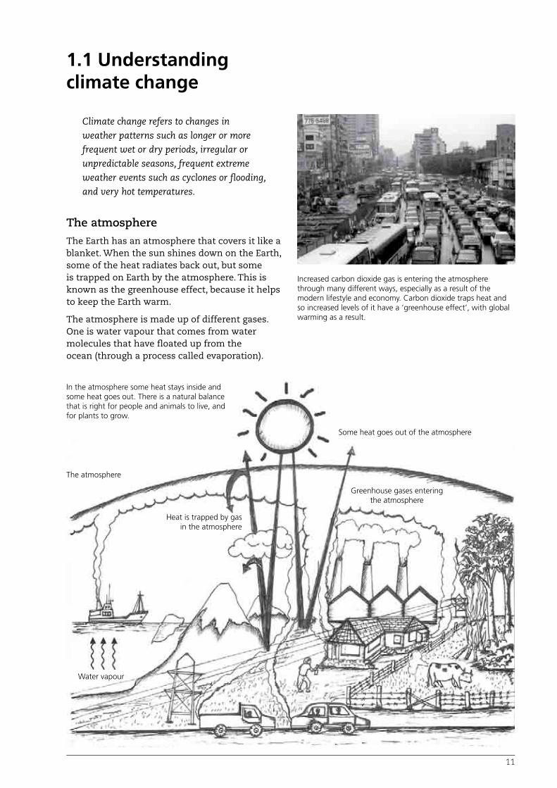
The atmosphere
The Earth has an atmosphere that covers it like a blanket. When the sun shines down on the Earth, some of the heat radiates back out, but some is trapped on Earth by the atmosphere. This is known as the greenhouse effect, because it helps to keep the Earth warm.
The atmosphere is made up of different gases. One is water vapour that comes from water molecules that have floated up from the ocean (through a process called evaporation).
Increased carbon dioxide gas is entering the atmosphere through many different ways, especially as a result of the modern lifestyle and economy. Carbon dioxide traps heat and so increased levels of it have a ‘greenhouse effect’, with global warming as a result.
In the atmosphere some heat stays inside and some heat goes out. There is a natural balance that is right for people and animals to live, and for plants to grow.
The atmosphere
Water vapour
Heat is trapped by gas in the atmosphere
Some heat goes out of the atmosphere
Greenhouse gases entering the atmosphere
12
The atmosphere helps maintain a natural temperature, just right for people and animals to live and plants to grow.
But increased amounts of gases are making the natural blanket of the atmosphere thicker. The main pollutant causing this is carbon dioxide, which comes from burning fuel in fires, cars, planes and industry.
Gases that trap heat
Carbon dioxide and some other gases, such as carbon monoxide and methane, trap heat. That’s why they are known as greenhouse gases. Instead of mentioning them separately as pollutants, we usually talk about them as carbon entering the atmosphere.
Most greenhouse gases are produced when fuels such as diesel or coal are burnt, to power a car or to make electricity. Burning trees also releases greenhouse gases. You cannot see the thicker blanket these gases make, because they are an invisible part of smoke.
Countries like Australia, the United States and China produce much more greenhouse gases than the islands in Melanesia. This is because people in these countries drive more cars, have more factories and use a lot more electricity in their homes and businesses.
Global warming
The gases from cars, factories and aeroplanes float up into the sky and make the atmosphere thicker and denser. This thick blanket lets heat from the sun in, but it also stops heat from escaping. Over time, more heat is trapped between the blanket and the surface of the Earth. This thicker blanket is causing the Earth to become hotter and hotter. This effect is called global warming.
Climate change
The thick blanket of gases in the sky not only makes the Earth hotter. Global warming is also causing normal wind and rainfall patterns to change. For example, in Melanesia, this could change the planting seasons for crops. Cyclones could also become stronger. These changes are called climate change.
1.2 Impacts of climate change
Sea-level rise
Climate change is affecting every country, not just the countries that produce the extra greenhouse gases. People in many Melanesian villages have noticed that the sea-level is rising. This is happening for two reasons. The first reason is melting ice. There is a lot of ice at the bottom and the top ends of the Earth, known as the North and South Poles. As the Earth is warming, more of this ice is melting. The water from the melting ice runs into the sea, and the sea-level rises.
The sea is also getting bigger as it gets warmer, because warm water takes up more space than cold water. This also causes the sea-level to rise. In Melanesia, the rising sea is already washing away beaches and coconut trees, covering graveyards and destroying crops. The salt water is also getting into wells and other places where people usually collect fresh water.
Bad weather
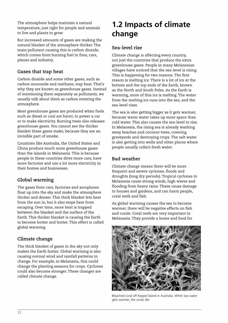
Climate change means there will be more frequent and severe cyclones, floods and droughts (long dry periods). Tropical cyclones in Melanesia cause strong winds, high waves and flooding from heavy rains. These cause damage to houses and gardens, and can harm people, coral reefs and fish.
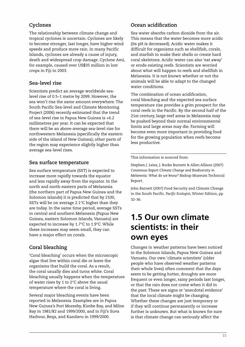
As global warming causes the sea to become warmer, there will be negative effects on fish and corals. Coral reefs are very important in Melanesia. They provide a home and food for
Bleached coral off Keppel Island in Australia. When sea water gets warmer, the corals die.

13
reef fish, which other types of fish need for food. Without the corals, fish cannot survive. Corals also supply sand to beaches and help make reef islands. If the sea becomes too hot, corals will not survive. If corals get too hot for a long period of time, they turn white. This is called bleaching. Bleached corals are sick and sometimes they die, as has happened in some warmer seas. More coral may die if global warming continues.
Ocean acidification
As more carbon dioxide is released into the air, the sea will also absorb some of this. This will make the ocean more acidic. When the ocean is more acidic it makes it difficult for living things such as shellfish and corals to produce their shells or hard coral coating. The result may be further decay of reefs.
• Burning fossil fuels means increased carbon in the atmosphere
• Burning and other destruction of natural carbon stores and sinks (such as forests)
• Increased methane from domestic animals
• Global warming
• Changing weather patterns
• More and stronger extreme weather events
• Rising sea levels
1.3 Global responseThere are global efforts underway to try and bring climate change under control. This can be done by reducing the amount of greenhouse gases that are released into the atmosphere.
Several different approaches are possible:
• Carbon pollution reduction
• Carbon absorption/sequestration
• Climate change adaptation
• Improved climate monitoring and studies.
1. Carbon pollution reduction
• Increase energy efficiency.
• Use less energy and fossil fuels (drive cars less, use less power).
• Improve design of buildings and settlements.
• Increase use of renewable energy (such as solar panels).
• Explore other new technologies.
• Slow down and stop the destruction of carbon sinks (forests), or other places that store a lot of carbon.
Carbon pollution reduction has proven very difficult with growing economies and world populations.
2. Carbon absorption and sequestration (plant more trees to soak up carbon from the atmosphere)
• Develop a carbon trading system.
• Reforestation (replace forests that have been cut down).
• Increase soil carbon by organic farming.
• Explore other new technologies.
3. Climate change adaptation (prepare for the changes that are coming)
• Accept that some climate change is now inevitable – it’s already occurring.
• Help developing countries prepare and adapt – particularly where there are threats to food security.
4. Improved climate monitoring and studies (research how our lives are going to be affected)
• Use global monitoring systems.
• Provide support for local level responses and capacity building.
There are many technologies that farmers and households may use to adapt to the impacts of climate change. These methods can also contribute to reducing carbon pollution and absorbing more carbon – for example, by planting more trees in agriculture.
This guide focuses on the third area, adaptation to the impacts of climate change.
14
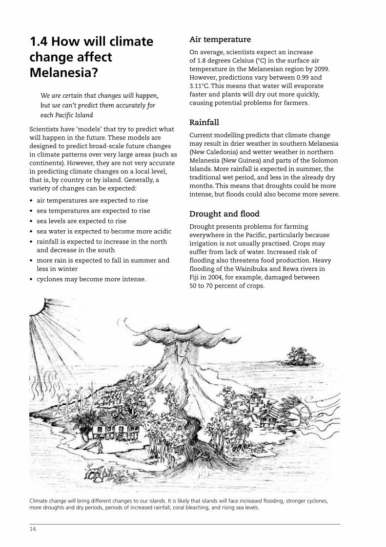
1.4 How will climate change affect Melanesia?
We are certain that changes will happen, but we can’t predict them accurately for each Pacific Island
Scientists have ‘models’ that try to predict what will happen in the future. These models are designed to predict broad-scale future changes in climate patterns over very large areas (such as continents). However, they are not very accurate in predicting climate changes on a local level, that is, by country or by island. Generally, a variety of changes can be expected:
• air temperatures are expected to rise
• sea temperatures are expected to rise
• sea levels are expected to rise
• sea water is expected to become more acidic
• rainfall is expected to increase in the north and decrease in the south
• more rain is expected to fall in summer and less in winter
• cyclones may become more intense.
Air temperature
On average, scientists expect an increase of 1.8 degrees Celsius (°C) in the surface air temperature in the Melanesian region by 2099. However, predictions vary between 0.99 and 3.11°C. This means that water will evaporate faster and plants will dry out more quickly, causing potential problems for farmers.
Rainfall
Current modelling predicts that climate change may result in drier weather in southern Melanesia (New Caledonia) and wetter weather in northern Melanesia (New Guinea) and parts of the Solomon Islands. More rainfall is expected in summer, the traditional wet period, and less in the already dry months. This means that droughts could be more intense, but floods could also become more severe.
Drought and flood
Drought presents problems for farming everywhere in the Pacific, particularly because irrigation is not usually practised. Crops may suffer from lack of water. Increased risk of flooding also threatens food production. Heavy flooding of the Wainibuka and Rewa rivers in Fiji in 2004, for example, damaged between 50 to 70 percent of crops.
Climate change will bring different changes to our islands. It is likely that islands will face increased flooding, stronger cyclones, more droughts and dry periods, periods of increased rainfall, coral bleaching, and rising sea levels.
15
Cyclones
The relationship between climate change and tropical cyclones is uncertain. Cyclones are likely to become stronger, last longer, have higher wind speeds and produce more rain. In many Pacific Islands, cyclones are already a cause of injury, death and widespread crop damage. Cyclone Ami, for example, caused over US$35 million in lost crops in Fiji in 2003.
Sea-level rise
Scientists predict an average worldwide sea-level rise of 0.5–1 metre by 2099. However, the sea won’t rise the same amount everywhere. The South Pacific Sea-level and Climate Monitoring Project (2006) recently estimated that the trend of sea-level rise in Papua New Guinea is +6.2 millimetres per year. It can be expected that there will be an above-average sea-level rise for northwestern Melanesia (specifically the eastern side of the island of New Guinea); other parts of the region may experience slightly higher than average sea-level rises.
Sea surface temperature
Sea surface temperature (SST) is expected to increase more rapidly towards the equator and less rapidly away from the equator. In the north and north-eastern parts of Melanesia (the northern part of Papua New Guinea and the Solomon Islands) it is predicted that by 2100, SSTs will be on average 2.1°C higher than they are today. In the same time period, average SSTs in central and southern Melanesia (Papua New Guinea, eastern Solomon Islands, Vanuatu) are expected to increase by 1.7°C to 1.9°C. While these increases may seem small, they can have a major effect on corals.
Coral bleaching
‘Coral bleaching’ occurs when the microscopic algae that live within coral die or leave the organisms that build the coral. As a result, the coral usually dies and turns white. Coral bleaching usually happens when the temperature of water rises by 1 to 2°C above the usual temperature where the coral is living.
Several major bleaching events have been reported in Melanesia. Examples are in Papua New Guinea’s Port Moresby, Kimbe Bay, and Milne Bay in 1981/82 and 1999/2000, and in Fiji’s Suva Harbour, Beqa, and Kandavu in 1999/2000.
Ocean acidification
Sea water absorbs carbon dioxide from the air. This means that the water becomes more acidic (its pH is decreased). Acidic water makes it difficult for organisms such as shellfish, corals, and starfish to make their shells or create hard coral skeletons. Acidic water can also ‘eat away’ or erode existing reefs. Scientists are worried about what will happen to reefs and shellfish in Melanesia. It is not known whether or not the animals will be able to adapt to the changed water conditions.
The combination of ocean acidification, coral bleaching and the expected sea surface temperature rise provides a grim prospect for the coral reefs in the Pacific. By the second half of the 21st century, large reef areas in Melanesia may be pushed beyond their normal environmental limits and large areas may die. Farming will become even more important in providing food for the growing population when reefs become less productive.
This information is sourced from:
Stephen J. Leisz, J. Burke Burnett & Allen Allison (2007) Consensus Report Climate Change and Biodiversity in Melanesia: What do we know? Bishop Museum Technical Report.
John Barnett (2007) Food Security and Climate Change in the South Pacific. Pacific Ecologist, Winter Edition, pp
32–36.
1.5 Our own climate scientists: in their own eyesChanges in weather patterns have been noticed in the Solomon Islands, Papua New Guinea and Vanuatu. Our own ‘climate scientists’ (older people who have observed weather patterns their whole lives) often comment that the days seem to be getting hotter, droughts are more frequent or even longer, rainy periods last longer, or that the rain does not come when it did in the past. These are signs or ‘anecdotal evidence’ that the local climate might be changing. Whether these changes are just temporary or if they will continue permanently or increase further is unknown. But what is known for sure is that climate change can seriously affect the

16
environment, our communities, food production and economy, and therefore our survival and our way of life.
Story 1: In their own words. Climate change stories from Melanesia.
Obed Mono, Kaonasugu Village, Makira, Solomon Islands
In the last 20 years my village in Makira has experienced environmental changes. In the last 10 years we have started to realise that our weather conditions seem unpredictable. Now we get abnormal rainfall throughout the year, and it gets unusually dry and hot during dry season. During the dry season our streams run dry and it is difficult to collect water for drinking and washing. The changes in weather conditions have impacted the normal seasons for planting and harvesting our yam and pana, and have produced low yield crops. The sea tides are not normal. The high tide goes into the village, which causes coastal erosion that destroyed our seafood such as shells as well as plants, animals and our coconut plantations. My community does not know what has caused these changes and have no committee to plan and address it. The coastal people started to move inland to their registered block of land, which was allocated for each family by the chief in the past.

17
Training Session 1:What are your traditional seasons?
Outcome
Participants have a better understanding of their seasonal knowledge and are able to identify whether these traditional patterns are changing in their communities.
Approach
Create a seasonal calendar and discuss the traditional planting times for five to ten main food crops.
Materials
• A cropping calendar (see example in Table 1) can be drawn on the ground, on a blackboard or on a piece of paper
• Paper/cards
• Pens
• String or small rocks/pebbles to mark lines.
Procedure
1. Share the story from Makira in the Solomon Islands (Story 1, p. 16).
2. Discuss traditional seasons. Draw the cropping calendar matrix (Table 1) on the ground or on a blackboard or piece of paper. The months of the year need to be listed along the top. List five to ten main food crops along the left. Ask the group to share the traditional names for the seasons and then put these next to the months.
3. For each of the crops, go through their seasons – when are they planted and when are they harvested. Mark this on the calendar. Discuss if this pattern is still working well today.
4. Ask the group to list the changes in the environment they have noticed in their village.
Table 1: Planting and harvest calendar This planting and harvest calendar from Takwa in the Solomon Islands is a good example of a Cropping Calendar.
Plant Jan Feb Mar Apr May Jun Jul Aug Sep Oct Nov Dec
Kakama (Swamp Taro)
Alo (Taro)
Karofera (Kang Kong Taro)
Fana (Pana)
Kai (Yam)
Kai Roki (Kumera)
Kaiai (Cassava)
Bou (Banana)
Niu (Coconut)
Edu (Alocassia Tara)
Kusaia (Slippery Cabbage)
Bini (Bean)
Heavy Rain Wet Season
Bad time for vegetables –
best later
Less fruit on Kumera
Good bearing Kumera
Kai Roki good planting
Kai Roki good harvesting
Busy planting Yam, Pana
Dry Season Wet Season
Scoring
Coconut: harvest
Clamshell: planting
Stick: growing time
Leaf: comtinuous planting and harvest

18
Training Session 2: What is climate change?
Outcome
Participants have a basic understanding of the causes of climate change.
Approach
Use the information from this section of the manual to conduct an awareness campaign on climate change.
Materials
You could develop some hand-drawn charts if needed.
Procedure
1. Explain how the atmosphere works like a blanket.
2. Explain greenhouse gases and the activities that these come from.
3. Explain the expected effects of climate change (page 14).
4. Discuss these with the group.

19
Global warming, and the impacts of climate change, may affect agriculture in many ways. This section discusses these likely changes and how they will affect food security.
The following changes are expected to occur as a result of climate change:
• loss or shortage of land suitable for growing food due to the sea level rising
• longer or more frequent dry and/or wet conditions
• irregular seasons
• extreme weather events
• emerging or stronger pest and disease attacks
• increase in the temperature of the environment (which affects production)
• loss of food varieties
• more dependence on imported foods
• coral bleaching that will affect access to fish as a source of food.
1.6 How will climate change affect agriculture and food security?
Storm surges caused by climate change may affect the places we grow our food. Food gardens, coconuts and swamp taros may be affected by an increase in the salinity (saltiness) of the water which will affect their growth.
The effects of climate change will mean that some coastal villages will need to be relocated to new areas inland or, in the case of very small islands or atolls, moved to different islands.

20
Loss or shortage of land suitable for growing food due to the sea level rising
According to scientists, global warming will increase the temperature of the sea, which will cause it to expand and rise up over the coasts. The changing climate will also cause more intense cyclones with more and higher storm surges that will cause the sea to rise up and spill over land areas more often.
This could mean that some of the land we use to grow our food gardens, coconuts and swamp taros today will be underwater or damaged by salt water in the future. Some coastal villages will need to be relocated to new areas inland or, in the case of very small islands or atolls, moved to different islands. This will mean taking up new land for new settlements that could have been used for food production. Therefore, there will be less land available to grow food on the bigger islands. The situation will be worse for smaller and low-lying (without hills or mountains) islands, where land for growing food may disappear altogether.
In some cases, the sea water may not cover the land, but the level of water below the soil surface (the water table) will rise very close to the surface and contaminate the soil with salt water. Many of our plants don’t like to grow in salty or saline soil, and they will die. The salt can also damage the soil structure, making it compacted. This means land may also be lost to salination, which makes the land unsuitable for food production.
As the water table rises (the water below the soil surface), it becomes saltier, therefore affecting the growth of plants.
Longer or more frequent dry and/or wet conditions
Climate change will lead to changes in the amount of rain we receive. It is predicted that we will experience longer-lasting droughts or, in some cases, shorter but more frequent drought periods. When this happens, the change to the amount of water in the soil will have a large impact on food plants, which need the right amount of water to grow. Many plants will die due to long or frequent droughts. These effects are increased because traditionally, most Melanesian farmers don’t water their plants – they rely on the rain to do so. This is called rain fed farming. Also, even when they see the need for watering, they don’t have irrigation systems to bring water to food gardens during the dry periods.
On the other hand, some islands or parts of islands will be experiencing continuous rain or longer wet seasons. This also makes it hard for food crops to grow or bear a good yield. Continuous rainy seasons have been experienced in some parts of Melanesia already – for example, the weather coast of Guadalcanal in the Solomon Islands. In these very wet places it is already difficult to grow sweet potatoes to yield tubers, or for other vegetable crops to grow well. Sweet potato is considered a main food. If other islands and parts of islands start to become as wet as these places, they will not be able to rely on their staple root crops to provide a good yield, and sometimes the crops may produce no yield at all. The wet conditions therefore are a threat to food security.
Irregular seasons
Climate change can result in very unpredictable seasons. When we expect to have a dry season during the year, it may become a rainy season. This makes it difficult to plan cropping seasons and may result in loss of production or crop failure. For instance, many people in the Solomon Islands traditionally do not grow sweet potatoes from January to March because of the wet season – they wait until April or May to start growing them. However, if the wet season becomes unpredictable, scheduling sweet potato growing will become difficult, which could lead to food shortages at some times of the year.

21
Extreme weather events
It is predicted that climate change will result in more frequent or very strong cyclones, leading to strong winds and flooding and increased chance of storm surge. This again will affect agriculture as winds could blow down crops and floodwater from rivers may carry away our food gardens. Already there has been increased frequency and strength of floods in Melanesia in recent years.
Emerging or stronger pest and disease attacks
The loss of biodiversity and the changing weather conditions may lead to new pests and diseases, or much worse attacks by existing pests and disease. Nature uses other species, called ‘natural enemies’, to control the population of species which might harm our crops. However, if these natural enemies disappear due to climate change,
Climate change is making winds stronger and sea levels rise. A coconut plantation at Ngichu the Weathercoast, Guadalcanal, Solomon Islands was destroyed by erosion from sea water.
Extreme weather events could wash away food gardens.

22
then the pest population will increase, which could increase the amount of pests attacking our crops.
New or emerging pests or diseases are also a threat because the new pest may be looking for a new host after its usual food source disappeared due to climate change. This new host may turn out to be one of our important crop plants. Plants under stress from drought, extra heavy rain or flood, or salt in the soil are also more likely to be affected by pests and disease.
Increase in the temperature of the environment affects production
Increased temperature, or very hot conditions, will slow the growth of plants, affecting yield and production of food crops. Very hot conditions will also cause stress to animals, making them restless and uncomfortable. The energy needed for growth or production of milk and eggs will instead be directed to addressing the animal’s stress. Therefore, meat, milk and egg production may also be reduced due to climate change.
Loss of food varieties
The loss of biodiversity due to climate change may include the loss of some food plant varieties as well as animals, fish and even shellfish that
we harvest from the natural environment. This will greatly reduce our choice of food plants, which may need to be tolerant to salt water and low soil fertility as well as being resistant to pests and disease. The loss of animal breeds that are adaptable to changing climate conditions will also affect food production. These situations all affect our ability to produce food, threatening both food and nutritional security as well as our source of income.
More dependence on imported foods
If we do not take the necessary measures, we will be relying completely on imported food for our survival. This may not be good for our economy. In addition, climate change will be experienced globally, so the cost of production and exporting food to other countries may be high. This means we may have to purchase food such as rice at a higher price, putting a lot of pressure on income. The effects of climate change will be greatly felt in regions like the Pacific, so it’s important that Melanesian households are still able to produce much of their own food.
Very hot conditions caused by climate change will slow the growth of plants.

23
Story 2: In their own words. Climate change stories from Melanesia.
Susan Kile, Zuzuao village, Isabel, Solomon Islands
Susan Kile points to where houses used to stand in the 1990s. She had to move her family after sea level rise washed through her village.
Photo: Daisy Gardener
I used to live in Baolo village, about 20 minutes walk from Zuzuao. The sea level started rising when I was 10 years old. When I was 15, I noticed that the coconut trees were being washed away. The sea level rose up on three sides of the village, flooding everything. Because of the sea level rising, we decided to move from Baolo. We started building a new house in Zuzuao village in 1997 while I was still teaching. It took time to build and we only moved into the new house in 2003. There was no support for us to move, we paid for everything ourselves. There is another tribe still living back at Baolo – they do not have any other land to build new houses. Our women
who are married to the other tribe had to stay in Baolo. My relatives find it hard to build a new house at Zuzuao, but they are trying to collect money from logging. We made an agreement with the loggers that they would not log close to shore or close to the rivers. We asked them not to cut down the mangroves. In 2008 we built a stone wall in front of our new house in Zuzuao to stop the sea level rise. We are worried we might need to move from our new home one day because of sea level rise. We can help ourselves by carrying stones from the hills or the sea to build sea walls, but we need help to buy a wire net to hold more stones.

24
Scientists do not know how Melanesian biodiversity will be affected by climate change. In fact, scientists are only just beginning to learn about the biodiversity of Melanesia.
The Bishop Museum attempted to study the effects of climate change on birds in Melanesia. They found that they faced a number of problems:
• Limitations of climate change models. Models of climate change mostly work at very large scales – such as continental or regional. But changes that affect the habitat of different bird species can be very local, such as whether a rain shadow from a mountain range will continue or disappear.
• Limitations to knowing how predicted changes will affect habitats. For example, a certain type of palm might be the food plant for a certain bird in a difficult season. Even with climate change models we still cannot predict how climate change will affect individual species within that ecosystem.
• Limitations to our knowledge of Melanesian-Pacific birds and their ecology. The Melanesian region is perhaps the least studied in the world. Many species of birds are still being named and understood, and we know little about them.
The study found that the most likely threat will be to birds that have a small habitat area. This includes species limited to high altitudes – especially on isolated high mountains – or small
islands, and birds that are not very mobile. Other risks identified include:
• the risk of increased burning during droughts
• spreading grasslands
• changes in available food
• movement of birds bringing new species into contact with each other, with unpredictable results
• increased hunting
• other changes that might occur outside Melanesia which could lead to changes in migration patterns of bird species.
Source: Editors: Stephen J. Leisz and J. Burke Burnett, Predicting the effects of climate change on Melanesian bird populations: the constraints of too many variables and too few data. Climate Change and Biodiversity in Melanesia, Andrew L. Mack Carnegie Museum of Natural History. CCBM Paper 9. Bishop Museum Technical Report 42(9) January 2009
How will climate change affect biodiversity?
Coconuts in the highlands
In Goroka, in the highlands of Papua New Guinea (PNG), coconuts are now fruiting in places where they never did before. This is because it is getting warmer and places in the mountains that used to be cold are warming
up. Malaria is also spreading higher into the highlands in areas where people have never experienced it before, such as in the Tari Basin in the Southern Highlands. The warming climate means that now the malaria mosquito can survive in these higher places.

25
Other problems
Climate change is not the only change affecting our agriculture and food security. There are other challenging issues that we are already facing which are threatening sustainable development in Melanesia.
Population growth: Populations in Melanesia are growing very fast – we have to produce more food for more people on the same area of land. This is causing intensification of agriculture – or the need to grow more on less land than in the past. The increased movement and migration of people is also placing pressure on land use in some areas, especially those close to urban centres.
New pests and diseases: New pests and diseases are spreading much more quickly due to our modern economy and transport systems – for example, cocoa pod borer is spreading fast in PNG and may devastate the incomes of families who rely on this crop.
Decline of soil fertility: Soil fertility is declining in many areas. This is due to population growth, changing fallow periods, too much burning of organic matter and the overuse of chemical fertilisers.
Cash economy: Cash cropping and marketing are becoming much higher priorities. This is often increasing incomes, but much of this money is then spent on imported food. This can lead to worse nutrition and reduced food security.
Climate change will add to these problems and in some cases make them much worse.
Summary
Climate change can seriously affect our agriculture, including fisheries, and therefore our food security. This can happen through the loss of available land, longer droughts or wet seasons, irregular or unpredictable seasons, frequent cyclones, new pest and disease attacks, environmental stress and the death of coral reefs. These events can lead to loss of food varieties or agro-biodiversity and/or low production or crop yields. The impacts of climate change are already being experienced in Melanesia. We must address climate change now or we may end up relying on imported foods, which could become more expensive due to climate change leading to higher production costs. Food could become very expensive, and many households will feel the financial pressure.

26
Training Session 3: Awareness of climate change
Outcome
Participants have a better understanding of how climate change is impacting their community.
Approach
Small group discussions with a list of focus questions
Materials
• Cards/blackboard to list down the questions
• Paper for groups to write down their discussion points
• Pens
Procedure
1. Break up the participants into small groups of 5.
2. Write the questions on a separate piece of paper or on a blackboard so the whole group can see.
3. Give the groups 10–15 minutes to discuss the questions. Ask each group to come up with 2–3 key discussion points.
4. Come back together and ask each group to present their key discussion points. After each presentation, encourage the participants to comment and ask questions.
Discussion questions
1. Is the sea level changing? How do you know this?
2. Is your community experiencing longer droughts, or periods of rain?
3. When was the last big cyclone in your area?
4. Are there new pests and diseases appearing in your area?
5. Have the crops you grow changed? How?
6. How much do you rely on imported food in your diet? Where does this food come from? Do you know how climate change is going to affect the countries that produce the food you eat and whether or not they will be able to keep making these foods in the same way?
7. Where are your coral reefs? Have you noticed the corals die back or any other changes on the reefs?
Feel free to add other questions to the list based on your reading of this section.

2727
Assessing adaptation potential
2This section will provide information and tools to help assess
the risks of climate change in your own area or community.

2828

29
Assessing adaptation potential
The effects of climate change will not be the same everywhere. How will these changes affect agriculture and food security in your community? This section will provide information and tools to help assess the risks of climate change in your own area or community. These tools or methods can also help raise awareness and increase understanding of climate change in your community.
Three key community assessment tools are presented:
1. Rapid assessment of climate change and food security in your community.
2. Community-based climate monitoring.
3. Assessing soil fertility.
The use of each assessment tool is dependent on the needs and expectations of your community.

30
This exercise will focus on four key areas in which communities can assess their adaptation potential:
1. Existing resources for food production
2. Community food plants
3. Food crop varieties
4. Climate change risks to agriculture
The exercises presented here are based on Participatory Rural Appraisal (PRA) methods. These are tools that encourage groups to work together to highlight key elements and issues in their community and identify potential solutions.
The roles of facilitator and note taker
When using the PRA method it’s a good idea to have one person as facilitator and one person who will record the discussion made by the group. The notes can be recorded on large pieces of paper (so all participants can see) or in a notebook. It is important for the PRA process to record all key notes of each step/section/exercise, as these will contribute towards the development of an action plan in Section 4 of this resource.
How to work with small groups
We suggest you do this assessment with interested groups of people in your community.
This could be with:
• a church group
• a farmers’ group
• a women’s group or a youth group
• your extended family, clan or tribe.
Each group discussion should be kept small, between 4–8 people is best as this will allow everybody to participate. It might be an idea to have separate groups of men, women and youth in order to allow them to talk freely and share their different viewpoints and knowledge. Ensure that each group has appointed a leader or facilitator. The groups can undertake the exercises in sequence, or each group can be assigned a different exercise to undertake. This will depend on the knowledge levels and dynamics of each group.
2.1 Rapid assessment of climate change and food security in your community
In order to assess these changes, four key PRA tools will be used.
Area of community assessment
PRA tool Description of tool
Step 1: Where does your food come from?
Resource Mapping
Identifies the different resources used by the community for food production and the areas at risk from impacts of climate change.
Step 2: What food plants are in your community? What environments do they grow in?
Sources of Food
Helps the community identify the range of food plants they have in their community, the different environments they are grown in, and how they contribute to food security.
Step 3: Food crop varieties Crop Diversity Matrix
Helps the community understand the varieties of food crops available and their ’status‘ – from very common through to lost.
Step 4: Climate change risks to agriculture
Priority Climate Change Risk Matrix
Using the findings from each of the exercises above, participants prioritise the climate change risks to agriculture in their community and create a planning matrix.

31
Training Session 4:Step 1: Rapid community assessmentWhere does your food come from?
Outcome
A map of the community showing different resources used for food production and areas at risk from climate change.
PRA tool
Resource Mapping Tool
Approach
The group creates an informal map that highlights the key threats from climate change in the community.
Materials
• Flat, clear soil, sticks, small stones and other objects which can be used to build the map (or paper/blackboard if available)
Procedure
1. On the ground (using a stick to draw in the soil or sand), or on a large sheet of paper placed on the ground, ask the group to draw a map of the community. (NOTE TO FACILITATOR: Do not draw the map yourself.)
2. On the map ask the members of the group to draw:
• houses and village infrastructure (schools, markets, shops, clinic, road, church, water supply, etc)
• gardens – include different areas used for different types of crops. Where is the soil fertile, where is it not so good? Where is soil erosion a problem (steep slopes)?
• plantations
• water sources (e.g. springs, wells and water tanks)
• rivers
• forest
• swamps and mangroves
• the ocean and reefs or fishing grounds.
3. Mark on the map where the community gets its food from.
4. Discuss the following questions with the group. Ask the notetaker to keep a list of the risks and threats identified by the group. This will be used in the prioritising exercise at the end of this section.
Sea: With the sea level rising, which areas could be under threat in the future due to coastal erosion and/or be flooded by saltwater? What infrastructure (such as roads to markets, wharves or schools) could potentially be damaged?
Rivers: Where are the rivers? Do they flood? What land has been affected by floods in the past? If there are even bigger floods in the future which areas might be at risk? Are people living there? Is food grown there? How would the community respond if these areas flooded?
Water sources: How prepared is the community for a long dry season? Are the sources of water likely to be affected by a long dry season? Do the springs and water sources need to be better protected with forest around them to ensure they do not dry up in dry weather?
Food: What foods would be available during a drought? Where are they located? Which crops do well in very dry weather? In the case of a disaster, where would the community go for emergency food? Is there enough to meet the needs of the entire community? Is this resource being maintained? Where is it located? Who looks after it?
Gardens: What different types of gardens exist in your community? What are people growing in their gardens and what will do well in wet and dry weather? How well will these crops produce if there is a very long wet season or if it gets wetter all the time? Which other crops do well in very wet weather?
Coral reefs: Where are the coral reefs located? How important are they for food? How would food sources be affected by coral bleaching? If there is coral die back (bleaching) and resulting loss in the number of fish available in the sea, how will this affect food (and income) for the community?
Forest: Where is the forest cover located? Is it under threat? (e.g. from logging or clearing for gardens or plantations) What will be the effects of losing this forest cover due to the impacts of

32
climate change? Discuss the benefits of forest cover in both very wet and dry times and what uses the forest has for the community.
Cyclones: Discuss how often cyclones affect your community. What are the risks of wind, storm surges (extra big waves and tides) and flooding of rivers?
5. Discuss these questions with the whole group while standing around the map:
• What did you learn from this mapping exercise?
• Where are the main risks or threats from climate change in your area?
While discussing these questions you can mark areas of concern on the map. You do not have to follow the questions in order – you can use them as a checklist and let the conversation of the group and your questions flow more naturally. Just make sure you cover all the topics. If the discussion goes in a different direction, allow the group to present their views. Remember, PRA is a flexible process that aims to encourage community participation, so it is important to value everybody’s contributions, even if they aren’t always related to the discussion topic.
33
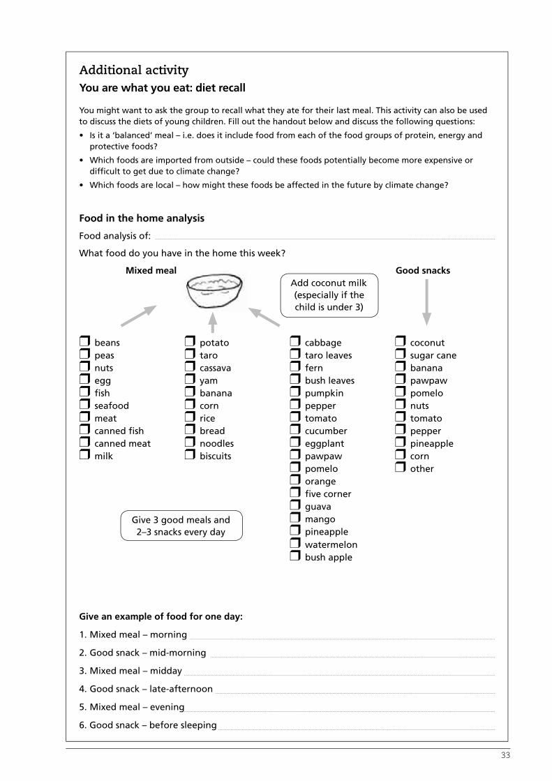
Additional activityYou are what you eat: diet recall
You might want to ask the group to recall what they ate for their last meal. This activity can also be used to discuss the diets of young children. Fill out the handout below and discuss the following questions:
• Is it a ‘balanced’ meal – i.e. does it include food from each of the food groups of protein, energy and protective foods?
• Which foods are imported from outside – could these foods potentially become more expensive or difficult to get due to climate change?
• Which foods are local – how might these foods be affected in the future by climate change?
Food in the home analysis
Food analysis of:
What food do you have in the home this week?
Mixed meal Good snacks
r beans r potato r cabbage r coconutr peas r taro r taro leaves r sugar caner nuts r cassava r fern r bananar egg r yam r bush leaves r pawpawr fish r banana r pumpkin r pomelor seafood r corn r pepper r nutsr meat r rice r tomato r tomator canned fish r bread r cucumber r pepperr canned meat r noodles r eggplant r pineappler milk r biscuits r pawpaw r corn
r pomelo r otherr oranger five cornerr guavar mangor pineappler watermelonr bush apple
Give an example of food for one day:
1. Mixed meal – morning
2. Good snack – mid-morning
3. Mixed meal – midday
4. Good snack – late-afternoon
5. Mixed meal – evening
6. Good snack – before sleeping
Add coconut milk (especially if the child is under 3)
Give 3 good meals and 2–3 snacks every day

34
Outcome
Participants have an improved understanding of the range of food plants they have in their community, the importance of food diversity, the different ecosystems that food comes from, and how this strengthens food security.
PRA tool
Sources of Food diagram
Approach
As a group, identify and discuss the crop diversity in your community. Diversity means all the different types of food plants.
Materials
• Large sheet of paper, or blackboard
• Pens
For background information the facilitator should read Section 3.1 on page 51.
Procedure
1. Prepare a chart similar to Table 2. Make it big enough so the whole group can read it.
2. As a group, review the map that was created in Step 1 and discuss the key places where the community collects their food.
3. Go through each of these food source areas and, on the table, list all the different foods that come out of each of these areas. At this stage you can include plants, trees, nuts, wild food sources, animals and fish.
4. Ask the participants to give a score between 1 and 5 for each of the foods that come from this source (5 is very important and 1 not important). Note the scores on the chart. You can use stones or other markers for the scores.
5. Ask the group to list the reason for each score and write each reason in the table. The group is welcome to change their score after discussion.
6. Highlight the five most important food crops to the community. This information will be used in Step 3.
7. If possible, display this chart in a place where everybody can see it.
Training Session 5:Step 2: Rapid community assessmentWhat food plants are in your community?

35
Table 2: Sources of food
Source of food (in local language or a drawing is OK)
Types of food Score from 1–5 in importance (5 is the most important)
Reason/s for the score given
e.g. Garden Sweet potatoTaroSugar cane
535
Plantation
Swamp
Sea – reef
Store
River etc
Where does the community get its food? Use the information from Step 1 here.
What different kinds of food are found? List all the different foods that come out of these areas.
How important is each food to the community? Score each different food – 5 is very important, 1 not so important. Mark the five most important food crops to the community.
Why did each food receive that particular score?

36
Outcome
Participants understand the range of varieties of food crops in their community and their status (from very common through to lost). With this understanding they will be able to make decisions about looking after certain varieties and possibly looking for new ones or lost ones. They will also have a better understanding of how and why varieties are lost.
PRA tool
Crop Diversity Matrix
Approach
The group identifies the key varieties of food crops to look after.
Materials
• Chart paper or a large clear area on the ground where a matrix/table can be drawn
• Marker pens
Procedure
1. Prepare a chart similar to Table 3. Make it big enough that the whole group can read it.
2. Ask the group to identify the five most important food crops that were discussed in the previous exercise. Write each food crop in the table. These crops will be the focus of this exercise.
3. Ask the group to list the names of each variety of this crop in their gardens. Hopefully they can tell you the name of the variety but if it doesn’t have a name you can describe it – e.g. ‘yellow tuber’. Take notes on the discussion about varieties. Be on the lookout for any mention of varieties that cope well in more difficult conditions.
4. For each of the varieties ask the group if the variety is: very common (VC), common (C), rare (R) or lost (L). Discuss the reasons for the status of the different varieties and ask the notetaker to record these reasons.
5. Ask the group about the growing conditions that each variety needs – does the crop prefer dry weather or wet weather, should it stay for a long time in the soil, is it pest and disease resistant?
Training Session 6:Step 3: Rapid community assessmentIdentifying food crop varieties

37
Table 3: Crop diversity matrix
Food crop Names of varieties Status: Very common (VC), Common (C), Rare (R), Lost (L)
Growing conditions (dry weather, wet weather, stay for long time in the soil, pest and disease resistant)
1. e.g. Sweet potato YellowMalaita3 month Sweet white
VCVCCR
2. Taro
3. Banana
4.
5.
List the five most important food crops identified in Step 2 here.
List the varieties of these crops.
List their status. Are these varieties common, or have they been lost?
What conditions do these varieties grow in?
6. Discuss the following questions
• How has crop diversity changed over time?
• What can be done to increase diversity where it is low or maintain it where it is high?
• How can crop varieties be better shared?
• How could new varieties be accessed and how could old ones that have been lost be found again?
• How would these varieties be recovered if they were lost in a flood or drought or other disaster?
• Why is this diversity of crops and varieties of crops important?
• Discuss both the lists (sources of food and crop diversity) with the group – what did they learn?
• With the group, try to summarise the main risks to crop diversity that you have identified through this process.

38
Outcome
Participants assess the findings from each of the three previous exercises and use these to create a planning matrix prioritising the climate change risks to agriculture in their community.
PRA tool
Priority Climate Change Risk Matrix
Approach
Develop a chart with the priority problems and risks from climate change identified during the exercises
Materials
• Paper
• Marker pens
Procedure
1. As a group, discuss the following questions and list the responses on a large piece of paper where everybody can see them.
• What were the key issues of concern from the mapping exercise (Step 1)?
• What were the key issues of concern from the sources of food exercise (Step 2)?
• What were the key issues of concern from the crop diversity matrix (Step 3)?
2. As a group, prioritise the main 3–5 threats from climate change and place the priority issues into a table (see Table 4 for an example). Discuss this in the context of the key food crops in the community. What current or future risks will affect the growth of these crops? Ask the group to identify the priority of the threat (LOW, MEDIUM OR HIGH). The group also needs to identify which areas in their communities are, or could be, affected.
3. Discuss the main priority actions to prepare for these threats.
Training Session 7:Step 4: Rapid community assessmentClimate change risks to agriculture

39
Table 4: Climate change risks to agriculture
Risk identified Priority (Low, medium, high)
Which areas are affected?
e.g. flooding of food gardens along river edge
High Food gardens next to river
Coastal erosion Medium Coconut plantations
Clearing of mangroves Medium Mangrove areas
Heavy dependence on imported rice Low Most households buy rice from village canteen and in town
Soil fertility is decreasing and erosion is a problem
High Food gardens in sloping areas and close to village
Loss of many staple crop varieties from the past etc
High Food gardens are too dependent on sweet potato
Identify the areas that will be affected
Identify the priority of each threat
List the 3-5 key threats from climate change identified in Steps 1-3
As a follow-up activity, discuss the main priority actions to prepare for these threats.

40
2.2 Community-based climate monitoringIn the assessment activities you have probably identified some risks or problems that are likely to happen. But it is difficult to estimate how big or small some of these risks might be. Community-based climate monitoring is a way to measure or monitor some of these changes. This will be a learning process for those involved but can also help to inform decisions.
In this section we introduce some practical recording activities that you could use in your community to start collecting some basic data on changes to the climate. These include:
• Monitoring tool 1: Rainfall recording
• Monitoring tool 2: Tidal measurements
• Monitoring tool 3: Crop yield measurements
These monitoring activities need to be conducted over a longer period (at least one year or season) in order to see the results. But the results and the planning for the monitoring can involve the whole community.

41
Monitoring rainfall can help us determine the changing patterns of rainfall due to climate change.
Outcome
At the end of this session participants will be able to measure, record and graph the rainfall in their own locations.
Approach
This is a practical exercise based on two approaches to collecting rainfall data:
1. Measuring amount of rainfall (rain gauge or bucket collection)
If possible, visit an installed rain gauge or borrow one for participants to see. Make up some rainfall data or obtain the data from the meteorology services over a couple of years for participants to use in a recording and graphing exercise.
2. Recording frequency and intensity of rainfall (Tallying and scoring system).
Develop some rainfall frequency scenarios or use real rainfall data from the meteorology services so participants can tally the rain days per month. Develop rainfall intensity scenarios so participants can practice scoring rainfall intensity, based on the example provided in this manual.
Materials
• Rain gauge
• Bucket
• Measuring container
• Timber and nails for mounting rain gauge or collecting bucket
• Pen and paper sheets for data entry and recording
Procedure
1. Introduce the subject and objectives of the lesson.
2. Introduce the rain gauge and how it works based on the instruction manual.
3. Carry out a practical activity installing the rain gauge or the improvised rain gauge – the bucket. Show participants how to mount the bucket, transfer the collected rain into a measuring container and then determine the amount transferred.
4. Explain to participants how to record the daily and cumulative rainfall for each month using the recording sheet that comes with the rain gauge (or create one for the bucket system).
5. Carry out a recording and graphing exercise using data from the meteorology services or data made up by the trainer. Explain the usefulness of graphing in transforming the data into visible patterns of rainfall or changes in rainfall patterns. Ensure the graph shows rainfall on the vertical axis and time (months) on the horizontal axis and that it covers at least two years.
Training Session 8:Monitoring tool 1: Rainfall recording

42
6. Using the rainfall data or scenarios, ask participants to tally the number of rain days or frequency of rain per month. Use the example provided in this manual to guide them along.
7. As part of the exercise, also get the participants to score points on developed scenarios about the intensity of rain. Ask participants to multiply the frequency x intensity scores of each month to get a value that represents the amount of rainfall per month. Graph these final values on the vertical axis and the months on the horizontal axis. Emphasise that these calculations are not real measures of rainfall but they are useful for comparative purposes.
8. Ask participants if they can identify the rainy season or the drought season from the graphs. Does the drought (or wet) season fall in the same month for the two years graphed? Can they determine the duration of the drought period? Is the first drought period shorter or longer than the second? Is it likely to be a drought in the same month of the next year?
9. A rain gauge is a simple instrument to measure rainfall. If you have one, assign someone to measure the rainfall each day. This could be school children who could take turns measuring the rainfall. If you don’t have a rain gauge you can use a bucket (make sure it is the same size every time). The bucket will not be an accurate measure of rainfall but it is useful for comparing rainfall over time. Mount the bucket onto a low post, about 50–100 cm high, in an open area. After each rain event, pour the water collected in the bucket into a measuring container for an accurate reading. If the bucket is full and it still rains that day, empty the bucket and start again. Record the total rainfall or number of buckets per month over the year.
Rain tally
The other option is just to keep records of the rain days per month in a table (see Table 5 on page 43).
Rain gauge

43
Table 5: Rain frequency tally
Month Rain frequency tally Total
January √√√√√√√√√√√√√√√√√√√√ 20
February √√√√√√√√√√√√√√√√√ 17
March √√√√√√√√√√√√√√√√√√√√√ 21
April √√√√√√√√ 8
May √√√√√ 5
June √√√√√√ 6
July √√√ 3
August √√ 2
September √√ 2
October √√√√√ 5
November √√√√√√√√√ 9
December √√√√√√√√√√√√√√ 14
You can also note whether it is heavy rain or light rain by assigning a score to the rainfall. An example is given in Table 6. Again, total the scores for each month.
Table 6: Rainfall intensity
Rainfall intensity Score
Heavy rain throughout the day 5
Heavy rain for part of the day 4
Showers through the day 3
Showers part of the day 2
Light showers or drizzles 1
Measure rainfall for the next couple of years and note/compare any changes in the amount of rainfall. Is the rainfall decreasing or increasing? Were there any drought periods? What is the duration of the drought or wet periods? Is the duration of the drought period increasing, the same or decreasing? This kind of monitoring can help us answer a lot of questions and assist us to address the risks of climate change.

44
Monitoring the maximum tidal levels can help you determine changes in sea levels.
Outcome
At the end of this session the participants will be able to measure and record tidal levels in their own location
Approach
Do this as a practical exercise on the shoreline to show how to record tidal levels.
Materials
• A ¾ or 1 inch PVC pipe about 3 metres long
• A permanent marker or a nail to scratch a line around the PVC pipe at the high tide level
• A recording sheet with columns for Date and Water level (height of scratched line above the ground level)
Procedure
1. Introduce the objective and outcome of the session.
2. Ensure the session is carried out during low tide and between the low and high water marks so that it is easy to dig a reasonable-sized hole and pour in some cement mixture to fill up the hole before inserting the pole. The cement will ensure that the pole does not move.
3. At high tide, ask the participants to determine the highest water level and mark the level on the pipe with a permanent marker or scratch a line with a nail. If there is a measuring tape the water level can be determined right away by determining the distance between the scratched mark and the base of the pole.
4. Emphasise to participants that measuring the water level mark is appropriate during the high tide season, when daily or weekly measurements can be conducted.
5. Point out to participants that these measurements and recordings can be graphed and compared each year. Emphasise that sea level monitoring can take up to 10 years before significant changes occur.
A similar approach could be used to measure the level of flood waters if flooding is a problem in your area.
Training Session 9:Monitoring tool 2: Tidal measurements

45
Every time you harvest a crop from your food gardens, always measure the total weight of the crop, in kilograms. If you don’t have a scale, just count the number of bags (each bag must be the same size) of the crop you harvested. For monitoring purposes, it is better to monitor only one particular crop as an indicator of environmental changes. Compare the yield of this crop with the yield of previous harvests on the same land. Is the yield increasing or decreasing? Is the change in the yield related to the rainfall or soil fertility indicators discussed below?
Outcome
At the end of this session participants will be able to sample, measure and record the yield of their crops using three different methods.
Approach
Use only one particular crop to monitor environmental change. Choose sweet potatoes as they are more common and are particularly sensitive to soil fertility changes.
Ideally this session would be carried out during harvesting of a plot of sweet potatoes.
First, work out the size of the plot to decide how many mounds of sweet potatoes will be sampled to determine the yield per mound. Use the 10% rule as a guide. For example, assuming one mound occupies about 1.0 m2, if the size of the plot is about 10 m x 10 m, or 100 m2, you will need to sample 10 mounds for this plot. If it is 10 x 20 m, or 200 m2, you will need to sample 20 mounds. The selected mounds should be evenly distributed within the plot area.
Use a scale to weigh the yield per mound.
If there are no scales, use a bag or a bucket and note if it is full or half or quarter full when potatoes from a mound are placed inside.
Another way to determine the volume of potatoes from a mound is by placing the potatoes in a water-filled bucket and measuring the volume of the water that is displaced.
Materials
• Sweet potatoes
• Scale
• Bucket
• Water
• Dish for collecting displaced water
• Measuring container to measure amount of water displaced
• Recording sheets
Procedure
1. Take participants out to the field with all the materials needed.
2. Introduce the subject and outcomes of the session.
3. Carry out a sampling exercise first. Show participants the size of the plot and ask them to determine the number of mounds they need to sample, based on the 10% rule. If this is not possible, do the sampling size exercise in class using some example garden sizes given by the trainer.
4. Allow participants to select which mounds to sample. Ensure the mounds selected are fairly representative of the plot area. Do not sample all the mounds from one side of the plot only. One way of getting representative samples is to divide the plot into equal quarters and select an equal number of mounds from each quarter.
5. Show participants how to determine the number of kilograms of sweet potatoes per mound.
6. Determine the average weight per mound. For example, if the sample size is 10 mounds, weigh the sweet potatoes in each mound separately then add these figures up to determine the total weight. Divide that total figure by 10 to get the average weight per mound. Use this figure to work out the average yield for that plot.
7. Graph the average yield for each growing season or year over time. Plot the yield on the vertical axis and the time or season on the horizontal axis.
Training Session 10:Monitoring tool 3: Crop yield measurements

46
8. Show participants the alternative methods that can be used to weigh the potatoes when there are no scales. When demonstrating the bucket or bag as a unit of measure, ensure the bucket is marked with lines representing 0.25, 0.5, 0.75 and 1 for simpler measurement.
9. Demonstrate how to determine the volume of sweet potatoes per mound. To do this, ask participants to fill a bucket with fresh water right up to the rim and carefully place it inside a clean, dry dish. Collect all the potatoes from a mound and place them inside the bucket. The potatoes will displace the water in the bucket, which will pour out into the collection dish. Remove the bucket and pour the water from the collection dish into a measuring container to determine the volume of displaced water.
Explain to participants that the volume of sweet potatoes is equal to the volume of water displaced into the collection dish. Refill the bucket to the rim before measuring the volume of potatoes from the next mound. Express the volume in cm3 or per Litre, e.g 200 cm3 or 0.2L/mound
10. For each method, determine the average weight, bucket or volume for each mound and mark this on a graph. Encourage the participants to continue measuring yield over time and to see if they can determine a pattern on the graph. Is the yield decreasing or increasing? Is the yield related to rainfall or to any of the soil fertility indicators? Does a decrease in yield follow a decrease in the number of earthworms?

47
2.3 Assessing soil fertilitySome impacts of climate change will affect soil fertility. High rainfall can affect soil fertility by washing away the topsoil and soil organic matter (SOM). Increasing temperatures will increase the breakdown and loss of SOM and nitrogen from the soil. It is important to assess and monitor soil fertility in order to find ways to improve or maintain the condition of your soil. Below are some factors that we can monitor to assess the fertility of our soils. These are called soil fertility indicators.
Soil fertility indicators
Yield of crops tells us a lot about the status of our soil. Crop yield can be measured as discussed in Training Session 10.
Eroded areas also indicate the quality of soil. These areas are usually bare with no topsoil, which is the fertile part of the soil. Note any erosion and determine the size of eroded areas on your land. Compare this over time from the date that you started monitoring. Have the eroded areas increased in size? Are the existing eroded areas being taken over by bushes?
Compacted soil refers to hard soil surfaces making it hard to hoe or dig. Compacted soil shows that the soil has a poor structure or no structure at all. This means that water and air cannot flow through the soil. When it rains, most of the rainwater will run across the surface, carrying away any topsoil or SOM. It also means that plant roots will have difficulties finding their way through the soil to reach water and nutrients.
The simplest way to measure the level of soil compaction is to note the hard surface and the ease with which you can dig the soil. If it is too hard this means that it is very compacted. Another method is to look for soil crumbs or aggregates (small balls of soil particles sticking together) in the soil layers. The presence of the aggregates gives the soil its structure. Air and water passes through the spaces between the aggregates. The fewer crumbs or aggregates there are, the more compacted the soil is. Is the soil soft or hard on your hand? If it is soft then it has a good structure and is likely to be less compacted.
Presence of soil organisms indicate the fertility of your soil because they break down plant residue debris into SOM. SOM recycles nutrients and helps
to form the structure of the soil. You can measure soil fertility by measuring the presence of soil organisms in your food gardens or farm. To do this, mark out 10 evenly distributed spots in your food garden of approximately 0.50 x 0.50m and using a spade, dig out a 0.30 x 0.30 x 0.30m size sample of soil from each spot. Transfer the soil onto a clean piece of plastic or bag and slowly break it up, looking for earthworms and other visible soil organisms such as those shown in Table 7. Note that the majority of soil organisms cannot be seen with our naked eyes. Draw up a table (such as Table 7 below) and tally each visible organism as you come across it in the sample of soil. Do the same for each sample of soil and determine the average number of soil organisms from the 10 samples.
Table 7: Soil organisms
Soil organisms Tally Total
Earthworms √√√√√ 5
Centipedes √ 1
Millipedes √√√√ 4
Others √√√√√√√√√√ 10
You can convert the soil units to square metres (m2) and determine the average number of organisms per m2 as follows:
Step 1. Work out how many square metres the unit of soil is: 0.3 x 0.3m = 0.09m2.
Step 2. Work out how many earthworms per m2 as follows:
No. of earthworms (per m2) = Average No. of earthworms 0.09 m2
= 5 ÷ 0.09
= 55.55 or 56
This means that in the top 30 cm of soil in your garden there are about 56 earthworms per square metre of land.
Take these measurements every year and note any changes in the number of soil organisms.
Soil organic matter
SOM gives the soil its fertility. The more SOM there is in the soil, the darker the soil will become. We can use this characteristic to monitor the SOM content of our soils. We can assign points to the intensity of the colour of the topsoil as highlighted in Table 8.

48
Table 8: Measuring soil organic matter
Topsoil colour Score
Very dark 4
Dark 3
Slightly dark 2
Brownish/red 1
The thickness of the dark layer also indicates the amount of SOM.
Summary
The impact of climate change will not be the same in every location. Therefore, each community needs to carry out its own risk assessment to help it understand or identify which areas or resources are more likely to be affected by climate change or global warming. Risk assessment is important because it helps us to be prepared and develop strategies for adapting to climate change.
Resource mapping, food source diagrams and crop diversity matrix are important tools in helping us identify potential risks. Our resources, such as water sources, biodiversity and soil fertility, can be very sensitive to climate change and therefore need our attention. PRA is a tool widely used for gathering information from the community. It involves the participation of a wider cross-section of the community in discussing issues, with different ideas, views and experiences that benefit the risk assessment.
Risk assessment involves identifying vulnerable areas and developing methods to assess the risk to them. In order for us to correctly assess the risks of climate change, we need to ask the right questions, get the right answers and develop appropriate methods of assessing or measuring changes which might be related to climate change.

4949
This section will present four key strategies and a range
of tools that can be used to strengthen food security
as a response to the impacts of climate change.
Adaptation strategies to strengthen food security
3


51
Adaptation strategies to strengthen food securityIn the previous section you may have identified risks from climate change to agriculture in your community. You may have also started assessing your community’s potential to deal with or manage these risks. With risks or problems identified, the next step is to decide what you can do to get ready, or adapt, to these changes. This is called adaptation to climate change.
There is very little we can do to stop climate change happening. Whilst the ‘carbon footprints’ of Pacific islanders are relatively small, Pacific communities will be one of the worst affected regions due to their heavy reliance on the natural environment for their livelihoods, and their close proximity to the coast. However, there are a number of ways communities can adapt to minimise the impact of climate change on our agriculture and food security. The main objective of adaptation is to increase community resilience to climate change. The most important adaptation strategies for this manual are the ones we can implement in our villages ourselves.
Four main strategies are presented below for your consideration. The strategies you choose, and how you put them into action in your area, will depend on your local situation and in particular the needs of your community:
Adaptation strategy 1: Diversify food crops
Grow more food crops; diversify food crops and varieties to reduce risks
Adaptation strategy 2: Increased planting and management of ‘emergency’ foods
Grow more emergency foods, and plant them in different locations
Adaptation strategy 3: Grow more trees through agro-forestry
Grow more trees and look after the trees you already have
Adaptation strategy 4: Look after the soil
Soil is where our food comes from! Adding organic matter, controlling erosion or loss of soil and using legumes to add nitrogen to the soil are the main approaches.
All four strategies include practical lessons that you could use as part of a training workshop. These lessons will help communities understand potential adaptation strategies and start to plan practical ways they can put these strategies into practice on their own land.
3.1 Adaptation strategy 1Diversify food crops
Understanding the importance of crop diversity for food security
Diversity of food crops is important for food security. Growing different types of plants to meet your food needs reduces the risk of a food shortage. For example, a serious pest or disease could hit one of your crops in a season, leading to reduced yield. However, your food supply may not necessarily be affected if you can harvest other crops in the same garden or from a different location.
Pests and disease or a low yield may sometimes be a problem for one variety and not for another. You might have a special, best tasting taro, but a virus could kill it, so it is a good idea to grow another taro that’s resistant to the virus. It may not taste as good but it will help your overall food supply.
Understanding biodiversity
‘Biodiversity’ refers to the plants, animals and other living things around us, usually in a particular location or area. Biodiversity provides us with many things, including the food we eat, our building materials, medicine and ‘environmental services’ such as clean air to breathe, water to drink, flowing rivers, fertile soil and insects to pollinate our crops and keep pests and disease in balance. Melanesians (and in fact all people in the world) rely on biodiversity to support our lives. In Melanesia most people rely on their surrounding environment to provide much of their needs. This means that their relationship and interconnectedness with local biodiversity is very strong.

52
Melanesian biodiversity
Melanesia has very high biodiversity. Key parts of Melanesian biodiversity include:
Terrestrial ecosystems: the plants, animals and micro-organisms found on land.
Marine ecosystems: Melanesia is part of the coral triangle which is considered to contain much of the world’s marine biodiversity. It is the best preserved tropical marine ecosystem on Earth.
Agriculture biodiversity: Melanesian agriculture relies on many different plants and some animals. This is a special group of biodiversity called ‘agriculture biodiversity’.
Melanesians have been the managers of this biodiversity for a very long time. They grow many of these plants, and manage others through their use of different ecosystems such as forests or coral reefs. Biodiversity provides many food sources.
Agriculture biodiversity
Agricultural diversity or agriculture biodiversity relates to the plants we grow to eat and sell. This is a special part of biodiversity because the plants have been bred and selected by people (including Melanesian ancestors) over hundreds or even thousands of years which, in some cases, has resulted in their present forms and varieties. These plants cannot survive in the wild and rely on people to replant them. Today there is a crisis in agriculture biodiversity and many varieties have been lost forever.
Climate change only makes agriculture diversity even more important. With changing weather patterns and more severe weather events, farmers may struggle to know which crops to plant at different times of the year. They may not be able to rely on their traditional planting knowledge as they could in the past. Therefore, increased crop diversity is important to reduce risk.
Staple crop diversification
Staple foods are the foods we eat every day which provide the energy we need to sustain us. In most Melanesian households, root crops (or tubers) are eaten daily. These root crops include taro, cassava, sweet potato and yams. Other starchy crops that are important in Melanesia for food security but are not harvested from tubers include bananas and sago.
It is important to grow a range of different root crops. Some will grow well in the wet, others in
the dry times of year. Some need very fertile soil and others can grow in infertile soil. Some are more vulnerable to pest and diseases and others less so. Melanesian farmers know this and have traditionally mixed different root crops in their gardens and grown root crops in different areas.
Because we do not know for certain how climate change will change how our staple foods grow we need to consider diversifying. This will reduce risk and improve our resilience to any crop failure.
Crop diversity, the practice of using many varieties, is one way to protect against climatic uncertainties. For example, one variety may be better adapted to drought while another may produce a better yield when there is better rainfall. By using various types of seed and planting materials, farmers reduce the risk of losing their entire harvest.
Outcome
Participants have a better understanding of their staple food crops and how these have changed over time. Based on this knowledge they may identify trends or gaps in the diversity of staple foods they are eating.

53
Training Session 11:Food over time
Approach
Construct a historical matrix table
Materials
• Chart paper
• Marking pens
Procedure
1. Choose two key historical events in living memory. These events will be used to discuss crops that were grown at those times.
2. Prepare a table (similar to Table 9) and list the two events. You can use pictures instead of words if there are members of the group who cannot read and write.
3. Mark the following areas in the table and discuss the difference since the time of the historical events:
• Main (staple) food crops
• Main pests and disease affecting these crops
• Soil fertility at that time
• Forest cover and condition of forests
4. At the end discuss the changes with the group using the checklist below.
Discussion checklist
• What have been the changes in staple food crops?
• How are the different factors related to the choice of crops? What are the trends or directions for the future?
• Are there are any problems you can see now or in the future?
• Considering the changes ahead with climate change, are there any concerns?
Table 9: Food over time
Historical event (e.g. after WWII)
Historical event (e.g. independence)
Today
Main food crops e.g. Taro, yam Sweet potato, taro, yam, cassava
Sweet potato, cassava
Pest and disease Little More Many
Soil fertility Very fertile Less fertile Poor
Forests Large areas of forest
Much forest cleared Very little forest left

54
Ways to increase crop diversity
Looking after agriculture diversity is very important for adaptation to climate change. Here are three ways to increase crop diversity to strengthen food security in response to the impacts of climate change:
1. Grow different plants
2. Grow different varieties of plants
3. Grow a mix of crops (cultivated seasonal, perennial or long-lived, and tree crops)
1. Grow different plants
An important part of diversification is to collect and grow more staple foods. These could include taro, corn, cassava, sweet potato, beans, tomatoes, aibika/bush spinach and many more. It is particularly important to think about growing plants that are well-suited to the expected impacts of climate change. Having many varieties and staple crops is good for food security as it reduces risk.
Growing more vegetables
Food security is not just about filling up on starchy tubers like sweet potato or yam, or even rice. Food security means having a balanced diet with plenty of vitamins and micronutrients. This means eating enough greens, fruit and vegetables to stay healthy. It’s important to grow lots of vegetables, such as leafy greens, tomatoes, eggplant, beans, snake bean, pumpkin and more. These need to be eaten along with protein from fish, meat or eggs.
2. Grow different varieties of plants
Part of preparing for climate change is safeguarding your existing varieties of staple foods, as well as searching for and collecting new varieties.
Where can you look for new varieties?
• Markets
• Diversity fairs, where farmers come together to share and exchange varieties
• Relatives and friends
• NGOs and government agriculture extension
Crop or variety selection
Another strategy to adapt to the impacts of climate change is to identify, select and grow
crops or varieties that can withstand long drought periods. Here are some ways that you can select drought tolerant crops yourself.
Observation: Observe plants that grow well or have reasonably high yields compared to other crops in your food gardens following a period of drought.
More extensive root systems: Some plant varieties may have a more extensive root system that spreads wider into the soil layer. These plants, because of their extensive roots, are more likely to capture as much limited water as possible from the soil.
Length and depth of root system: Plant varieties with deeper root systems are likely to capture water in deeper layers of soil when the top layer is dry.
Sustainable breeding of root crops
Root crops such as taro and yam have many different varieties. One way to generate new varieties is to collect the seeds of these crops. The seeds will have natural variations and can be used by farmers to select new varieties. The varieties you like can then be grown in the normal way – from suckers and tuber pieces.
Breed your own seeds
The Farm Support Association in Vanuatu has developed simple ways of encouraging taro and yam to produce flowers. Through this method, farmers hand-pollinate these flowers using the male flower from a selected variety. For more information see 5m ‘Sustainable breeding of root crops’ on page 110 of the Farm Technology manual.
Yams growing on a trellis and then left to encourage flowering. Collect seed pods from the yams.

55
We can also select crops that can survive and bear yield under long wet conditions. These are crops such as the giant swamp taro (kakama/kakake) and other water-based taro varieties. As a strategy to ensure food security in a changing climate, we should be enriching our swamps with patches of kakama as ‘food banks’ for periods when other crops don’t grow well. To establish a wider public acceptance of swamp taros, we need to select and grow better-tasting varieties, as well as develop new food preparation techniques.
Another crop that grows well in long rainy seasons is banana. Bananas can be eaten ripe or cooked, and therefore are an ideal substitute for our root crops. Unlike our root crops, the banana bunches are above ground and therefore cannot rot or be washed away during flooded conditions, provided the banana trees are still standing.
Bananas in Makira
Farmers in Makira in the Solomon Islands have been collecting bananas and establishing banana diversity gardens similar to that described in the exercise on page 56. This method encourages collecting and planting all kinds and varieties of bananas.
Steps:
• Make a list of banana species that you don’t have yet
• Ask communities for those varieties
• Collect them and fully label them
• Take them home and plant in your garden
• After planting, make permanent labels showing the variety and where it came from
• Invite farmers to look, observe and share.
For more information see page 97 from the Farm Technology manual produced by Live & Learn Environmental Education.
To improve food security, farmers can exchange banana suckers of other varieties they don’t already have, and plant in their own garden.
Growing salt-tolerant plants
One strategy to adapt to the rising water table along the coast is to grow crops that are salt tolerant, apart from mangroves. We can select salt tolerant crops based on experiences from atolls such as Ontong Java in the Solomon Islands and countries such as Kiribati. What grows well on these low-lying islands can be tested on soils that are suspected of being contaminated with salt water on other larger islands.
The Farm Technology manual produced by Live & Learn Environmental Education is a good reference resource to learn about different technologies to strengthen food security as a response to the impacts of climate change.

56
Outcome
Following this session, farmers in the community will:
• Have access to a collection of varieties from their area.
• Have increased interest in maintaining and collecting new varieties for diversification.
• Be more aware of the loss of varieties over time.
Approach
Establish a community ‘gene bank’ or garden consisting of well-labelled plots of local crop varieties.
Materials
• Land for a bulking plot – usually this is just for one season
• Labelling material – something that can withstand the weather for at least one year
• Paper and pens
Procedure
1. Meet with a group of farmers and decide if there is interest in establishing a community diversity garden.
2. If there is, decide which crop/s they would like to include in their diversity garden. Diversity gardens are well suited to crops that are not grown from seed – i.e. those grown from cuttings and tubers, such as sweet potato, cassava, yam, taro and banana.
3. Explain that the objective of the garden is to collect and share different varieties of the target crops in order to increase diversity in farmers’ gardens and help to maintain the different varieties safely in many hands.
4. Develop a plan to start collecting varieties – from farmers’ gardens and fields, from markets, etc. If you have access you may also want to collect any available new varieties from your local department of agriculture or agriculture NGO.
5. Label the collected varieties at the time of collection. This is known as the ‘plant passport’ and should include at minimum the following information:
• Name of the variety
• Any special qualities of the variety (e.g. colour, taste, how long to harvest, special uses)
• The person who it was collected from and the place collected
6. Plant the varieties in a carefully organised plot in the garden. Each variety should have a label with the name on it. You can also give each variety a code number. This is called an accession number and each one should be unique. Make a map of where you plant this variety. If any of the labels are lost, the map will allow you to locate the varieties.
Once the varieties are planted
The group should come together at different times to weed and care for the diversity garden and also to observe any differences in the varieties’ growth. At the time of harvest you can bring the group back together again to evaluate the varieties. This might include:
• Measuring the yield (see page 45 for methods)
• Cooking and tasting the varieties to determine farmers’ favourites
• Sharing planting materials of different varieties with group members. Records should be kept of who takes which variety.
You might also organise a ‘Diversity Fair’, a gathering for communities to gather to share information about this food crop.
Variety:
Special qualities:
Collected by:
Training Session 12:Community diversity garden (or bulking garden)

57
Seed saving
Saving your own seeds is the best way to ensure food security and a healthy diet.
Why is seed saving important?
Locally saved seed is important because:
• the seed is free
• it adapts to your local environment each time you plant and replant
• it is more resistant to pest and disease and will not require agriculture chemicals, unlike many hybrids bought from the store
• it helps to keep important varieties from being lost
• it is easy to share with other farmers, contributing to their food security
• it tastes good and is more nutritious than many imported hybrid seeds
• having many varieties of your own seeds will help to adapt to changing climates and conditions.
Bucket system of seed bankingKastom Gaden Association, Solomon Islands
Open pollinated seed is easy to keep for replanting. The bucket system is a model to set up a small seed bank. Some basic equipment is needed – buckets, silica gel, paper and plastic bags.
This is a system that can be used by an NGO, a school or a rural based institution. The model
produces high-quality seed for local farmers and helps to preserve open pollinated seed varieties.
For more information see ‘5b Seed saving using the bucket system’ on page 86 of the Farm Technology manual produced by Live & Learn Environmental Education.
The bucket system is a practical way of producing good quality seeds on the local level. This system could be used by women’s groups, schools, or rural training centres or other NGOs or farmer groups.

58
3. Grow a mix of crops (cultivated seasonal, perennial or long-lived, and tree crops)
It’s also a good idea to grow a mixture of long-lived and short-lived crops. This helps to reduce risk. Farmers know this already in Melanesia but it’s good to remind them! Growing three-month sweet potato with nine-month yams and longer-term alocasia taro is a good example. We also suggest you plant some perennial crops. Perennial crops grow for many years. For example, you might have aibika in your garden (a seasonal crop) but also plant a hedge of borneo (a perennial or long-lived plant) that you can harvest green leaves from for many years.
Similarly, it is a good idea to plant some trees that can provide some of your food. Once established, trees grow and produce for a long time. They have deep roots and so are less affected by changes in rainfall or weather on a seasonal basis. Trees like breadfruit can provide staple foods, nuts can provide protein and fruit provides our protective foods.
New types of root crops
There are some new types of root crops that are very hardy and will be well-suited to the lowlands of Melanesia with the expected changes coming. We encourage you to try and get access to these plants if you don’t have them already:
These are:
• African yams
• Wild or bush yams – collect them yourself and look for the sweet varieties (not bitter)
• Cassava
• Giant swamp taro
Where to access these planting materials:
Papua New GuineaNational Agriculture Research Institute (NARI) Kana Aburu Haus, Sir Alkan Tololo Research Centre, Bubia PO Box 4415, LAE 411, Morobe Province, PNG T: +675 475 1444/475 1445 F: +675 475 1450 E: [email protected]
Solomon IslandsPlanting Material Network c/- Kastom Gaden Association PO Box 742, Honiara, Solomon Islands T: +677 39138 F: +677 30840 www.kastomgarden.org
VanuatuVanuatu Farm Support Association Syndicat Agricole & Pastoral de Vanuatu (SAPV) PO Box 17, Port Vila, Vanuatu T: +678 25717 F: +678 25717 E: [email protected]

59
3.2 Adaptation strategy 2Increased planting and management of ‘emergency’ foodsFuture food security in Melanesia will very much depend on access to a wide range of different food sources for many households. Different food sources reduce risk. Food that lasts a long time in the ground and is resilient to pest and disease is ideal to plant for use in emergencies or difficult times. Examples of emergency foods include giant swamp taro and wild yams. These plants, once established, can be harvested over a long period of time as needed.
Both traditional and new methods allow households to have sources of food ready for times of stress. They will prove useful in times of disaster, drought, pest and disease, unusual weather or even during human-caused problems such as civil unrest. Being prepared with diverse food sources promotes and strengthens resilience. However, this process takes time, and farmers need to think ahead and plan for the future. Some questions to guide this process include: What are the emergency foods in your community? Are there enough of them? Do they need to be replanted? Do you need new ones?
3.3 Adaptation strategy 3Grow more trees through agro-forestryOur food comes from trees as well as the plants we grow in gardens. Trees are important for diversification because they live for a long time and are more able to resist changes in weather.
Agro-forestry is generally described as a method where trees are grown with other usual agricultural crops, provided they are happy to grow side by side. In many cases an agro-forestry system is made up mainly of tree crops with food, economic and cultural values. Agro-forestry creates a multi-structured or storey forest ecosystem, similar to a natural forest.
An agro-forestry system is a very useful tool for adapting to climate change because of the following features:
• Trees are long-lived – they have deep roots and so are not as affected by seasonal changes in weather.
• Trees help to hold the soil, protecting it from erosion. This increases the amount of water that infiltrates into the ground, and can also build up the soil fertility over time.
• As trees grow they absorb carbon dioxide out of the air – acting as a mitigating response to climate change. Trees also create a micro-climate – they provide a steady temperature underneath them.
• Trees have many uses – they can provide food, fuel (firewood), building materials, medicine, shelter for animals and habitats for other plants to grow, such as under their shade.
Tree crop diversification can mean:
• Planting more fruit, nut and other useful trees
• Collecting fruit and nut tree varieties – choosing the best varieties of galip/ngali nuts for example, and then replanting them
• Grafting and other methods of ‘improving’ fruit and nut trees to produce better-quality fruit more reliably
Bougainville Integrated Mini Forests
Bruno Idioai has been replanting forests in his homeland Bougainville for much of his adult life. Bruno has replanted hundreds of thousands of trees. Each day he wakes up and plants some young trees growing inside cut pieces of bamboo in his nursery. The trees are planted in a mixed pattern, sometimes under existing trees or cut into secondary bush. Each day as he walks on tracks and in the forest he collects wild seedlings. The trees he chooses are all useful in some way – for building, food, medicine, animal feed and ecological functions. Many of the forests are now mature. The result is that rivers flow better and do not dry up, animals and birds are coming back close to the village and there is plenty of food and materials from the mini forests for people to use.
For more information see ‘3a Bougainville integrated mini-forest’ on page 43 of the Farm Technology manual produced by Live & Learn Environmental Education.

60
Bush foods
Throughout Melanesia there are many foods that are harvested wild from the forest. These include nuts, fruit, greens, tubers and mushrooms. Many of these plants are ‘semi wild’ in that people sometimes plant them and manage them – these
include sanpepa, tulip and ferns in the Solomon Islands.
Have you ever thought about planting these in a garden close to your village to make them easy to access?
Improved Temotu Traditional Agriculture
Improved Temotu Traditional Agriculture (ITTA) is an agro-forestry gardening system based on different tree crops. The trees are planted in a pattern with a boundary line, main line, subline, interline, companion and below canopy species. All the trees are used for food and are carefully planned to be able to provide food all year. The system is similar to a natural forest but is very productive.
Some key points about this system:
• The different plant species within the system leads to increased biodiversity of both animals and plants.
• Most of the crops are trees. Trees are very important components of any ecosystem and play many important roles, including the improvement of soil fertility.
Layers of ITTA
• Its similarity to a natural forest makes it less likely to have major pest and disease incidents. Tree crops are less likely to be infested with pests and disease compared to vegetable crops. Species diversity within the system is also likely to disrupt attacks. An agro-forestry system is likely to survive the intensified or
emerging pest and disease attacks that may occur as a result of climate change.
For more information see ‘3c Improved Temotu Improved Agriculture on page 48 of the Farm Technology manual produced by Live & Learn Environmental Education.
Replanting quana
Quana is the traditional area where nut and fruit trees are planted in Choiseul, Solomon Islands. Salathiel Sore decided to replant more fruit and nut trees, as many of the old quana were being cut down. He mixed together fruit, nut, timber and other trees and today has hundreds of productive trees that he is harvesting from.
For more information see ‘3d Replanting quana’ on page 50 of the Farm Technology manual produced by Live & Learn Environmental Education.

61
Outcome
Participants have an improved understanding of the importance of forests and the lessons we can learn from forests when applying agro-forestry methods.
Approach
Take participants on a walk through nearby forest area.
Materials
None
Procedure
1. Select an area with good forest cover, a range of tree sizes and well-covered deep leaf litter.
2. As you walk into the forest observe and discuss with the group:
• Temperature changes: the forest canopy moderates temperature – it may be cooler than in the open sun .
• Soil quality: observe the soil under the leaf mulch. Observe the temperature, worms and other soil organisms. Discuss the role of mulch in the cycle of replenishing the soil – fallen leaves rot, feeding micro-organisms, who in turn provide nutrients for the trees to grow and drop more leaves.
• Forest layers: observe the different layers of trees – emergent trees, the canopy layer, mid storey and understorey, vines. Discuss the different needs of these plants and how they complement each other.
• Tree roots: observe the mat of tree roots on the ground. Discuss what happens when heavy rain falls in the forest. How does water move?
• Health: observe the health of plants – there are many insects and birds, but no evidence of outbreaks of pest and disease – why is this the case?
• Biodiversity: observe the biodiversity – note the different species you can see.
3. Following the walk, sit down and discuss what you have learned and shared.
• What are the implications for agro-forestry?
• Why are trees important?
• How do trees keep the soil fertile and how do they protect the soil?
• How do trees moderate the climate?
• How do trees help to reduce the effects of drought and flooding?
Training Session 13:Observation of the forest

62
Artificial island gardening using mangrove mud
Mangroves are important for protecting the coastline and providing habitats for fish to breed and many other plants and animals to live in. Farmers in Malaita, Solomon Islands, have also found that they can use mangrove mud to grow food in. The soil is collected and left to be rinsed of salt in the rain. Raised garden beds are constructed and filled with the mangrove soil. Plants grow very well in this soil!
If you have mangroves in your area you could do a similar exercise to the forest walk but adapt it to the mangrove (Training Session 13).
For more information see ‘6d Artificial island gardening using mangrove mud’ on page 123 of the Farm Technology manual produced by Live & Learn Environmental Education.
Mix mangrove soil with grated rotten coconut husks (soft ones that are easy to break in your hand). This makes a very good soil mixture.
Growing mangroves and coastal trees
Mangroves are very important because they link the sea and the land. In many places mangroves play an important role in moderating tidal floods and protecting the coast from erosion by the sea. This role will become even more important with expected sea level rises due to climate change.
At the same time, mangrove forests support numerous forms of wildlife and birds as well as coastal and near-shore fisheries. The clearing of this vital resource will reduce protection of the coastline and coastal fisheries and, more importantly, the environmental stability of coastal forests that provide protection to inland agricultural crops and villages.
The potential shortage of land for agriculture and the sinking of coastal lands, or salination of coastal soils, should motivate us to start growing salt tolerant crops for food security. Farming edible mangroves, a traditional practice in many parts of coastal Melanesia, is therefore an important strategy for adapting to climate change. Mangroves have very high salt
tolerance, making them an ideal food crop for land taken over by rising sea water. In addition, the fruit is very nutritious.
Another tree crop that can be grown in the coastal area in Melanesia is the alite (sea almond). The nut from alite is also very tasty and nutritious.
Both the mangroves and alite can act as barriers to coastal erosion. Mangroves have a root system that traps sediments and accumulates them along the coast. They have been known to extend land mass into the sea over a long period of time. The ability of mangroves to trap and accumulate sediments, therefore, is a useful strategy to counteract rising sea level as a result of global warming and climate change.
There may be other trees you know locally that are either a good source of food and/or a barrier to coastal erosion?
Source: FAO. 1994. Mangrove forest management guidelines. FAO Forestry Paper No. 117. Rome.

63
Soil organisms such as earthworms drive the important natural processes that maintain or improve soil fertility.
3.4 Adaptation strategy 4Look after the soilWith or without the impacts of climate change, looking after soil is very important for food security.
Two major influences on the growth and yield of plants are plant genes (parental inheritance) and the environment. The ‘plant environment’ includes factors such as the climate, sunlight, rainfall, landscape and soil that plants grow in. Growth and yield of a plant can be increased by changing or controlling any of these factors. However, the only factor that we can realistically control is the soil. With the changing climate, controlling or managing soil fertility will be critical to adapt to, or compensate for, the negative impacts of climate change on plant growth. This is because healthy soil will produce strong and healthy plants that can withstand the stresses posed by climate change, such as pest and disease attacks. There are various appropriate, low-cost, natural approaches that
the community can adopt to maintain or improve soil fertility or soil health, some of which are discussed below.
The importance of soil organic matter conservation
Soil organic matter (SOM) is the single most important factor in maintaining soil fertility or soil health. The SOM comes from the rotting dead leaves/animal tissues and debris on the soil surface. This is what gives the black or dark colour to the top layer of the soil (humus). SOM has many benefits. It contains the nutrients that make soil fertile. It also helps to improve or maintain the structure or form of the soil so that water and air can flow through it and so plant roots can find their way easily around the soil. SOM also provides food for soil organisms (animals) such as bacteria, fungi and earthworms. These soil organisms drive the important natural processes that maintain or improve soil fertility. Maintaining SOM is therefore very important for soil fertility.

64
We can maintain or conserve SOM by continuously adding organic matter such as dead leaves, food and animal wastes to our garden soil. This practice naturally happens in our rainforest when dead leaves from trees fall to the ground, continuously supplying the soil with organic matter. We can do this in our food gardens by mulching or covering the soil with any dead plant materials such as dead leaves, grasses or potato/bean vines or chopped up banana stems and branches of legume plants. Keeping the soil covered also encourages the presence of soil organisms that work to improve soil fertility.
This section provides information on key ways to manage SOM:
• Add animal manure to soil
• Composting
• Minimum cultivation of the soil
• Rotate legumes with other crops
• Crop rotation
• Covering the soil (mulching)
• Soil erosion control (Soil conservation).
The role of soil organisms
Soil organisms can be grouped into two groups based on their size:
1. Soil micro-flora or soil micro-organisms (SMO) which are the soil bacteria and fungi that live in the soil.
2. The soil fauna (the large soil organisms such as insects, earthworms, millipedes and even crabs) that live in the soil.
The SMOs cannot be seen by the naked eye but they exist in millions in the soil and on the soil surface. For instance, one teaspoonful of soil can contain 6–7 million bacteria. The SMOs break down dead leaves or animal remains into humus or soil organic matter. They are important in releasing nutrients from dead materials into the soil for plants to use. They also contribute to the formation of soil aggregates, which increase soil aeration and drainage.
Soil fauna greatly improves soil quality or health by:
• shredding large dead plant and animal tissues (through feeding activities) into small bits, which make it easy for soil micro-organisms to decompose and recycle nutrients back to the soil
• burrowing and tunnelling – this increases air and water infiltration into the soil, which is good for plants and also increases the activity of soil micro-organisms in the soil
• channelling – pulling in organic residues from the soil surface, thus distributing organic matter into deeper layers of the soil.
The interactions of soil organisms greatly improve soil fertility See picture left. The crumbs or aggregates are the results of the interaction of the soil organisms. The crumbs give the soil its structure or form.

65
Outcomes
By the end of this session, participants will be able to:
• Understand what soil micro-organisms are
• Explain the importance of soil micro-organisms in maintaining or improving soil fertility.
Materials
• Soil (and teaspoon to measure)
• Small jar (or approx. 500 ml beaker or measuring cup as jar)
• Cup
• Rainwater
• Two small medicine delivery cups as vials
• One teaspoon of calcium hydroxide. You may be able to obtain this from your nearest school science lab. Dissolve or mix in a small cup of rainwater before half filling the two vials.
• Straw
• Flip chart or board for drawing a diagram.
Procedure
1. Introduce the subject and explain the objectives of the session – 5–10 minutes.
2. Define SMOs and then show the participants a spoonful of slightly moist soil.
3. Ask them if they see any soil micro-organisms in the spoon. Ask them how many bacteria or fungi are in that teaspoonful of soil (about 6–7 million).
4. Make some calcium hydroxide solution. Do this by dissolving one teaspoon of calcium hydroxide into the cup of rainwater. Pour half into each of the two vials.
5. Place a vial and two teaspoons of soil into a jar and close the jar overnight. Observe the clear calcium hydroxide solution turning cloudy due to the respiration (breathing) of the soil micro-organisms.
6. Compare by getting a participant to breathe out through their mouth (using a straw) into the other vial of clear calcium hydroxide solution. A cloudy solution is evidence of the presence of living things in the soil.
Alternatively, use illustrations from published books, or mouldy bread, to show what bacteria or fungi look like.
Field discussion: Take participants to the bottom of a tree with large litterfall and ask why dead leaves disappear over time. Link this to the soil micro-organisms.
Introduce the term ‘decomposition’ as the process of the breaking down of organic residue into humus or soil organic matter. Explain how nutrients are released as part of the process of decomposition.
Show participants examples of soil aggregates and how these increase aeration and drainage.
Illustrate the release of nutrients during decomposition and the formation of humus.
nutrient
Dead leaf Humus
Example: illustrating how nutrients are released during decomposition
Training Session 14:Soil micro-organisms

66
Animal manure is an important source of nutrients and organic matter. Chicken manure is the best form due to the combined urine and waste in the manure. Make sure the animal manure is cured or has been left for some time (3 months for chicken manure) before using it in your gardens. Do not apply fresh animal manure, especially chicken manure, to your plants as this will burn the plants.
Sun, rain and wind can decrease the quality of the manure. Rain washes out the nutrients in the manure, while wind and sun dry up the manure, killing the micro-organisms and evaporating nutrients like nitrogen. It is important to keep the manure covered under a shelter and to protect it by covering it with mulch after applying it to garden beds. Always dilute liquid manure before applying it to plants to ensure that you don’t burn the leaves of your plants.
Outcomes
By the end of this session, participants will be able to:
• Understand the importance of animal manure in soil management
• Identify the best animal manure
• Preserve the quality of the animal manure
• Correctly apply animal manure solids or as liquid fertiliser
Approach
1. Discuss the importance or benefits of animal manure with participants. Through group discussion, discuss which kinds of animal manure, and how much, are available in the participants’ villages.
2. Show participants different kinds of manure if possible. Point out that the white paste in chicken manure is the dry urine of the chicken, which contains a high concentration of nitrogen.
3. Discuss how rain, wind and sun can decrease the quality of manure, and ways to protect the quality of manure.
4. Through demonstration in the community, show how to apply animal manure to plants.
5. Demonstrate and practise how to make liquid manure. Point out that liquid manure must always be diluted, especially chicken manure, and as much as possible participants should try not to apply it directly to plant leaves.
Training Session 15:Animal manure
How to make liquid manure: method 1
Materials
• Fresh poultry manure or any animal manure
• 25 kg bag or sack
• Wire
• Piece of wood (longer than the diameter of the drum)
• 200 L drum
• 2–3 medium-sized rocks
• Water
1. Place the rocks at the bottom of the bag then fill it with manure. (Ensure the bag is not too heavy to lift.)
2. Tie the piece of wood to the top of the bag with the wire, so that the wire can sit across the drum.
3. Fill the drum with water. Place the piece of wood across the drum so the bag hangs down into the water.
4. Leave the bag inside the drum for 1 to 2 weeks. Shake the bag frequently so that the concentrated liquid inside the bag is mixed with the rest of the water in the drum.
5. After 1 or 2 weeks you can apply the liquid in the drum to the soil and mulch around the base of the plants. Avoid pouring the liquid onto the leaves because it can burn them and damage the plant.
Source: SAPA: the natural way of growing food for
Solomon Islands

67
How to make liquid manure: method 2
Materials
• Fresh poultry manure
• Water
• 2 containers
1. Fill a quarter of the container with the manure and top up with water.
2. Stir the mixture three times a day for two days, until the contents of the mixture turns a pale yellow colour.
3. Pour the liquid into another container until it is a quarter full, then top it up with fresh water. The liquid is now diluted and ready to be applied to the soil and mulch around the plant.
Source: SAPA: the natural way of growing food for Solomon Islands
Materials
• Samples of animal manure
• A bag of old chicken manure for application demonstration
• Scooping tool such as dipper or coconut shell
• Some growing vegetables to demonstrate the application of animal manure into the beds
• Two 44 gallon drums
• Fresh or old manure in 20 kg bag
• Stick to put across drum and tie the bag of manure for liquid fertilizer
• Stone to sink the bag into the drum
• Bucket
• Watering can
• Water
Procedure
1. Discuss the role and importance of animal manure. Point out that animal manure contains important nutrients for plants, as well as organic matter and soil micro-organisms.
2. Organise participants into groups of 3–5 and ask each group to discuss the manure used in their villages. Point out that chicken manure is the best due to the combined urine and waste (as a result of the chicken having the same outlet for urine and waste).
3. Define manure quality to participants then ask them to discuss factors that increase or maintain the quality of manure. After feedback, point out that the waste of older animals and from free-range animals is good quality manure, compared to young animals and caged animals.
4. Discuss the factors that can decrease the quality of your animal manure.
5. Take participants out to the field to demonstrate how to apply manure. Show participants how to apply chicken manure around the plant by digging shallow trenches and adding about a coconut shell-full of manure. Then ask participants to apply manure to the plants. Ensure the manure is not applied fresh, as it may burn the plant. Also, do not dig trenches too deep – they should not go below the root zone of the plant as the roots may not reach the nutrients from the manure when plants are watered.
6. Demonstrate how to make liquid manure (see ‘How to make liquid manure’ box). Point out that liquid manure must always be diluted if concentrated, especially if made from chicken manure. If some pre-made liquid fertiliser is already available, show participants how to dilute it into the second drum and apply to plants. As a precaution, try not to apply this directly to the plant leaves.
7. Wrap up the session by discussing the key points using the question and answer technique.

68
Compost is the earthy, dark crumbly substance that results from the recycling of green waste. Compost can be used as a plant fertiliser. It is rich in nutrients and organic matter, and provides food for soil micro-organisms. Composting needs micro-organisms, food, air and water in the right amounts to work faster. There are many different ways to make compost. However, one of the general rules is to add more ’green‘ materials and less dead or ‘brown’ materials when making the compost heap. Turn over your compost regularly to increase the rate of decomposition.
Outcomes
By the end of this session, participants will be able to:
• understand the importance of composting
• list the factors that are important for faster composting of organic waste
• practice making their own compost.
This session should be conducted in the field as a practical exercise.
Approach
1. As an introduction, define composting and highlight its importance, and the factors that are important for composting to work, before carrying out the hands-on exercise of building a compost pile.
2. Use the Composting Brochure as a resource to teach this composting session.
3. All materials for composting should be gathered at the site ahead of the session.
Materials
• Bush knives to chop up the large leafy materials
• Composting materials: – green leafy materials – legume leafy
materials are best – brown materials such as dead grass
clippings or leaf litter from under trees – food waste – manure or soil as a source of
micro-organisms – old sawdust – vegetable wastes from the farm, etc.
• An enclosure or containment vessel – a cocoa wire mesh as in the brochure (about 2 metres long)
• Spade or shovel
• Bucket and watering can
• Water
• Old hessian bags
Procedure
1. Introduce the subject and explain the objectives of the session.
2. Explain the theory component from the brochure
3. Discuss the factors needed for successful composting. Define or demonstrate green or brown materials from the materials gathered.
4. Ensure all participants are involved in the practical component: While some can chop up the leafy branches, others can start building the compost pile, alternating green, soil and brown materials. Ensure more green and less brown are added for each layer. Ensure water is sprinkled onto each layer of green or brown materials. Refer to photo A on the next page for alternate green and brown layers.
5. Keep building the pile of compost until it reaches the top end of the containment vessel before covering the sides of the vessel with old hesian bags to trap the heat and creating a channel with the stick or pole at the centre of the pile. Refer to photo B on the next page where a stick or metal bar is inserted at the centre to create an air channel.
6. At the end of building the compost, explain the importance of:
• chopping materials into small pieces
• trapping the heat to activate heat-loving micro-organisms, which increase the rate of decomposition
• adding more green materials than brown
• turning over the compost every four days to increase aeration.
7. Show participants samples of matured compost so that they will know when their compost is ready to use. Refer to photo C on the next page.
Training Session 16:Making compost

69
8. Revisit the last points in the brochure to participants before summarising the session. Hand each participant a copy of the brochure at the end of the session.
For more information, refer to the composting brochure developed by Shane Tutua and colleagues.
A: Using alternating green and brown layers on the compost pile.
B: A stick or metal bar can be inserted at the centre to create an air channel.
C: When the compost is matured it is ready to use. This compost is approximately 4 weeks old.
D: Planting of plants only where soil has been cultivated in the raised beds.
E: Example of strips of cultivated lines where plants are going to be planted.
F: An example of a permanently raised bed.
G: The metal bar used to dig up soil with minimum disturbance.
A B
C
D
F G
E

70
Minimal cultivation of the soil
SOM is continuously lost from the topsoil and needs to be replaced regularly. Cultivation of the soil during crop production also increases the loss of SOM. One way of reducing the loss of SOM is to encourage minimum cultivation of the soil, that is, only cultivate the spot where you want to put the plant. In some cases, you would want to create permanent raised beds to avoid water logging, and then carry out minimum cultivation on the raised beds.
Zai Na Tina Organic Farm uses the minimum tillage principles in its farming operations as a method for soil and organic matter conservation. In this system we combined minimum tillage with the permanent raised beds system. Thus, we do our minimum tillage or cultivation on the permanent beds. With minimum tillage we do not cultivate the whole bed but only break up the soil where we are going to plant using a steel bar as shown in the photo (on the previous page). The rest of the bed remains uncultivated or cultivated at alternative times. In this way we minimise the disturbance to the soil. Increased soil disturbance, such as cultivation, would increase soil aeration and therefore increase microbial activity of breaking down soil organic matter. This would quickly deplete the soil of organic matter over time. In addition, too much disturbance or cultivation breaks up soil aggregates and therefore increase the risk of soil particles being washed away during heavy rains. The minimum tillage on raised beds system worked very well for us with the current crops we are growing.
Rotate legumes with other crops
Another way to improve or maintain soil fertility is to grow or rotate legumes with other crops in your garden. Legumes are special plants that can improve the fertility of soils by trapping nitrogen from the air in special organs called nodules in their roots. This means that legumes are a major source of nitrogen.
Most legumes have the following features. This information should help you to find out whether you have these plants in your garden or in nearby places:
a. Feathery leaf
b. Trifoliate leaves
c. Bean type seed pods
d. Nodules form on the roots
Beans are the most common legumes, however, there are other legumes which exist as creepers or ground cover crops. Others are either little bushes or trees.
Examples of legumes
Beans: cowpea, long bean, velvet bean
Creepers: centro
Bushes: pigeon peas, peanuts
Tree legumes: Gliricidia, Lucaena, casuarinas, acacia, raintree
Nodules on legume tree roots
Long pod cowpea Velvet (mucuna) bean Gliricidia tree

71
Gliricidia
Legumes such as cowpea and mucuna are the best soil improvers because they also act as ground cover crops or live mulches, which provide a thick cover on the ground. This keeps the soil cool and moist, providing an excellent environment for soil organisms to live in. A ground cover crop usually results in a soft, well-structured soil because of the activities of the soil organisms. A legume ground cover crop can also be regarded as a ‘green manure’ – a crop that you grow purposely to cut or slash for dead mulch or compost because of the high concentration of nitrogen contained in the legumes. In order to get maximum benefits out of legumes, grow them in your garden area or plots and slash them down immediately before planting another crop, as shown below.
The nitrogen content of legumes is highest just before flowering, so this would be the best time to slash the legume crop. The resulting slashed materials act as both a source of nutrients and organic matter for the soil. Covering the slashed
green manure under the soil or with another mulch material is even better as this reduces the loss of nutrients from wind, rain or sun.
Using legume trees for cropping
Legume trees are special trees that can fix nitrogen from the air on their roots. Thus, not only do they provide the benefits that other trees do, but they also trap nitrogen from the air and transfer to the leaves. You can inter-crop the legumes between your trees in an agro-forestry system as a source of nitrogen and other nutrients.
Tree legumes can also be used as green manure by harvesting the branches and applying them as mulch to the garden plots (see pictures below). Growing tree legumes such as gliricidia on the edge of the garden or farm can provide enough green manure materials for mulching or composting purposes, similar to an alley cropping system. Alley cropping is a method of gardening which involves planting legume trees in rows and planting your crops between the rows. When the trees produce enough branches and leaves, they are harvested and the branches and leaves are used as mulch for crops every 6 –12 months.
Tree legumes not only fix nitrogen, they also bring up nutrients from below the vegetables’ root zone onto the topsoil when the branches and leaves are cut and used as mulch. This is due to their deep roots, which trap nutrients below the vegetables’ root zones, just like in an agro-forestry system. Just growing a legume tree does not necessarily put nitrogen into the soil – it has to be slashed and mulched or dug into the soil to release the nutrients from within the tissues of the legume.
Slashing down a cowpea cover crop before planting vegetables. All slashed materials remain on the raised bed as dead mulch and a nutrient source.
Growing a legume cover crop (mucuna) produces very good soil conditions, lots of mulch and healthy growth of vegetables after the ground cover has been slashed.

72
Legume cover crops are an important resource
• provide a thick cover on the ground, keeping the soil cool and moist for soil organisms
• fix nitrogen from the air and supply the soil
• release nutrients when slashed and mulched or dug into the ground
• reduce the impact of rain and minimise soil erosion.
For more information on the benefits of legume cover crops see the Farm Technology manual produced by Live & Learn Environmental Education
Alley cropping with legume trees
Alley cropping is the system of planting a crop between two rows of a legume tree or nitrogen fixing tree (NFT). The distance between rows of NFTs should be about 5–10 metres. Most alley cropping systems use glyricidia, as it grows well in Melanesia.
The NFT provides nitrogen to the crop in the system when the trees are harvested of their biomass and mulched onto the plot. The NFTs provide a source of organic matter for the soil within the system when the branches and leaves are harvested. Harvest the branches every six months and mulch the plot. The NFT leaves and branches are also a source of ‘green materials’ for composting. The alley cropping system benefits the crop only when the NFT hedge or branches are harvested and applied to the plot. The NFT trees also provide other nutrients intercepted by their deep roots.
For more information on alley cropping with legume trees see the Farm Technology manual produced by Live & Learn Environmental Education.

73
Outcomes
By the end of this session, participants will be able to:
• identify and use legume cover crops
• explain their importance in maintaining or improving soil fertility
• use legume as a soil improver.
Approach
A practical exercise which helps participants understand the benefits of legume cover crops.
Materials
• Common cover crops
• A farm to see how legume cover crops are used
• Photos
• Gardening tools to slash and mulch a plot of legume cover crop if possible, e.g. knives or brush knives, hoes etc.
Procedure
If possible, hold this session on a farm where legumes are grown.
1. Introduce the subject and explain the objectives of the session.
2. Discuss the various legume cover crops or ask participants if they know of any.
3. Show a photo or illustration of a legume cover crop.
4. Discuss the importance of legume cover crops as green or live mulch.
5. Encourage the participants to feel the soil under the legumes. Ask participants if the soil is cool, moist and soft. Look for any soil organisms such as earthworms in the soil. Observe crop growth in plots previously grown with legume cover crops.
6. If possible, practice slashing and mulching a plot of the legume cover crop.
7. Emphasise that maximum benefit from the legume cover crop is only realised when the cover crop is slashed and mulched or dug into the soil and the plot is planted with a crop immediately.
Training Session 17:Legume cover crops

74
Training Session 18:Alley cropping with legume trees
Outcomes
By the end of this session, participants will be able to:
• understand the alley cropping system
• explain the benefits of an alley cropping system
• practise the principles of an alley cropping system.
Materials
A farm that practises alley cropping (if possible)
• Illustrations/photos (Refer to the Farm Technology Manual produced by Live & Learn Environmental Education)
• Gardening tools to harvest the nitrogen fixing tree hedges and mulch
• Flip charts and pens
Procedure
If possible, undertake this activity on a farm with alley cropping system.
1. Introduce the subject and explain the objectives of the session.
2. Introduce participants to an alley cropping system and ask participants to note the kind of nitrogen fixing tree used.
3. If unable to visit a farm, show an illustration/photo of an alley cropping system.
4. Allow participants to observe how the system is set up, including the type of nitrogen fixing tree and the distance between rows and hedges.

75
Crop rotation
The productivity of the soil can also be maintained by rotating a variety of crops within your farm or food gardens. The two main objectives of crop rotation are to:
1. Replenish used nutrients. Therefore, growing a legume crop at some point in time on the plot of land is important in order to return nutrients to the land.
2. Maximise the use of available nutrients. This is based in the fact that different plants use more or less of some nutrients, leafy/fruiting/rooting (tubers) vegetables use the major plant nutrients in different amounts, and plants have different root lengths so can use nutrients at different soil depths.
An example of a crop rotation schedule is given below. It shows that after growing a legume, a leafy vegetable is grown to make use of the nitrogen released by the legume crop. Leafy
vegetables use a lot of nitrogen to produce the healthy leaves we eat. In this crop rotation schedule, subsequent crops are either fruiting vegetables or root vegetables (tubers), which may not use as much nitrogen as leafy vegetables but also require different nutrients in greater amounts, such as potassium and phosphorus for flowering or tuber production, respectively.
Understanding the nutrient requirements of crops, as well as their root structures, is very important in developing a cropping schedule as a strategy to maintain productive soils.
Crop rotation can also break pest and disease cycles, making it another useful strategy to adapt to emerging or intense attacks as a result of climate change.
For examples of crop rotation, see 4a and 4e of the Farm Technology Manual produced by Live & Learn Environmental Education.
Pak Choi (leafy vegetable) Corn (fruiting vegetable) Tomatoes or potatoes (fruit or tuber vegetable)
Legumes (soil improver)

76
Outcomes
By the end of this session, participants will be able to:
• explain the principles behind crop rotation
• list the benefits of crop rotation
• schedule or sequence crops within their food gardens.
Key points
• Crop rotation with legumes or legume cover crops replenishes the soil with nitrogen.
• Crop rotation can break the disease or pest cycle: planting a different crop on the same plot ‘confuses’ pests/diseases so they’ll die out.
• Crop rotation allows farmers to maximise the use of available nutrients in a plot of land.
• Different plants use more or less of some nutrients. Leafy/fruiting/rooting vegetables use different amounts of each nutrient, e.g. leafy vegetables use more nitrogen, for fruiting vegetables, phosphorus and potassium are more important and for rooting or tuber formation, potassium is very important.
• Different plants have different rooting lengths/depths and therefore can use available nutrients at different soil depths.
Approach
A hands-on approach to learning about the benefits of this method through the production of a crop rotation schedule.
Materials
• Diagram of a crop rotation schedule
• Flipcharts and markers for participants to draw their own crop rotation schedules
Procedure
1. Introduce the subject and explain the objectives of the session.
2. Discuss the importance of crop rotation.
3. Divide the participants into groups of 2–4 and ask each group to draw their own crop rotation schedules based on the key points in the box. Ask each group to present their crop rotation schedules and ask them to explain the sequence of crops in their schedules. Ensure the participants are corrected if their crop rotation schedules do not follow the principles discussed.
4. Wrap up the session with a recap of the main points and key messages using the question and answer method.
Training Session 19:Crop rotation

77
Covering the soil (mulching)
Mulching is the practice of covering the bare soil to protect it from the elements. Mulch is often made up of dead plant materials such as grass clippings, dead leaves and branches. As mentioned above, cover crops can be regarded as live mulch because they provide such excellent cover to the soil. Covering the soil has a number of benefits, including encouraging soil organisms to inhabit the soil and work the soil to improve or maintain its quality. In addition, the dead leaves will decompose and return organic matter, as well as nutrients, to the soil. Therefore mulching contributes towards SOM conservation.
You can use any materials that will rot or decompose to mulch your gardens. The thicker the mulch, the more effectively it will reduce the impacts of heavy rain or hot sunny days. Surface mulch cover protects soil from excess temperatures and evaporation losses and can substantially reduce crop water requirements. Mulching keeps the soil cool and reduces the impact of raindrops, preventing soil particles from splashing about or weakening the soil structure. When soil aggregates disintegrate they are more easily washed away, along with the SOM locked within the aggregates. This process is known as soil erosion.
Soil aggregates
Soil particles group together to form aggregates or crumbs, and different types of aggregates give the soil its form or structure. The more aggregates formed, the more soil pores (spaces) there are for roots and air to move about and for water to infiltrate the soil.
‘Brush and hoe’ method
Many farmers find that it is better to leave organic matter as a mulch on the soil instead of the traditional practice of burning organic matter. This becomes especially important when fallow periods are shortened and soil fertility starts to decline due to lack of organic matter. For more information see 2a ‘Brush and Hoe Method’, on page 15 of the Farm Technology manual produced by Live & Learn Environmental Education.
The bush or fallow vegetation is cleared with a bush knife. The leaves and branches are laid on the ground. The soil is then cultivated into mounds followed by planting. The organic matter from the branches and leaves rots and adds fertility to the soil. The mulch also helps protect the soil from erosion and keeps it moist and cool.
Mulching reduces soil temperature and can reduce the need for watering.

78
Outcomes
By the end of this session, participants will be able to explain the role of mulch in feeding the garden soil.
Key messages
1. Using mulch on a garden helps plants grow stronger.
2. Mulch stops garden soil drying out quickly.
3. Mulch provides more food for plants than slash and burn farming.
4. Mulch reduces soil erosion during heavy rain.
Approach
A hands-on approach to learning about mulching.
Materials
If possible, visit a garden in the community where mulch has been used.
Procedure
1. Discuss the benefits of using mulch on food gardens. Discuss the benefits of using organic materials as mulch.
2. Find a garden where mulch has been used.
– Ask the participants to feel the temperature of the soil.
– Go to the forest (if applicable) and see how the ground is covered in mulch.
– Ask participants to feel the soil under the mulch discuss how the forest builds soil fertility.
3. Find an unmulched garden and ask participants to feel the temperature of the soil.
4. Ask the participants to compare the difference in the soil temperature and ask them which garden would dry out the fastest.
5. Explain that:
– the unmulched garden will dry out faster because the soil is hotter and it is not protected from the sun by mulch
– the soil will erode during heavy rain.
6. Explain how soil organisms are not fed or protected in unmulched gardens. This means that fewer nutrients are available for plants to absorb to help them grow.
Adapted from: Improved Household Gardening Skills—A South Pacific Trainers Manual 37- KASTOM GADEN ASSOCIATION.
Training Session 20:Mulching

79
Soil erosion control (soil conservation)
Growing crops on sloping lands and in high rainfall areas such as most of our islands greatly increases the amount of topsoil lost. The steeper the land, the more soil erosion will take place. Loss of topsoil means loss of fertile soil because most SOM are located in the top 10 cm of the ground. The impacts of soil erosion include the loss of topsoil, organic matter and soil organisms, which can result in lost fertility and crop production, and therefore reduced food security.
When our climate changes and there are longer rainy periods, the exposure of our soils to these conditions will be longer, which will weaken the soil structure, increasing the amount of soil loss. Thus, it is important that we minimise soil erosion as a strategy to adapt to climate change.
Here are some ways to reduce soil erosion:
On flat or gentle sloping land
• Establish rows at a right angle to the direction of the slopes
• Employ minimum tillage or cultivation so that soil is less disturbed. Like our old people did, use a stick or metal bar to dig a hole to plant your crops, ensuring that the angle of the hole
goes straight down rather than being on an angle, to collect any moving topsoil.
• Apply mulch, either dead mulch or live green mulch (cover crops), to reduce the impact of rainfall and therefore soil run-off.
• Grow vetiver grass at right angles to the direction of the slope to trap any moving topsoil. Vetiver grass is a thick grass that will reduce the flow of water during surface run-off. The grass will also stop or trap any moving soil particles and accumulate them along the contours formed by the vetiver hedge. In addition, the vetiver grass can be trimmed and the residue used as mulch to further minimise soil erosion.
On steeper slopes
• Build terraces or strips of flat land on the steeper slopes to reduce movement of topsoil and water.
• Combine terracing with vetiver grass and legume trees on the edge of terraces and employ minimum tillage on the terraces.
Rows of vetiver grass planted across the slope can be used to restore land, reduce soil erosion and increase soil fertility.
Vetiver grass for erosion control
Vetiver grass is a very useful plant for Melanesia. It is mainly used to restore land after erosion (washing away of soil) and to support farming of crops. The grass has straight and vertical blades which also makes a good mulch. Vetiver can be raised in a nursery for use on damaged land, especially land on slopes.
It does not produce seed and so will not spread or become a weed in the garden. It is very deep rooted and will live for a long time as clumps wherever it’s planted.
For more information see 2c ‘Land restoration and farming using vetiver grass’, on page 20 of the Farm Technology manual produced by Live & Learn Environmental Education.

80
Outcomes
By the end of this session, participants will be able to:
• understand the impacts of soil erosion
• explain the factors that increase soil erosion
• apply the methods of controlling soil erosion.
Key messages
• Soil erosion is the loss of topsoil from the surface of land.
• The loss of topsoil can greatly reduce soil fertility and therefore our food security.
• Factors that increase soil erosion include continuous heavy rainfall, steep slopes, intensive cultivation of the land, bare or exposed land.
• Soil erosion can be controlled or minimised by terracing, cover cropping, mulching and planting vetiver grass.
Approach
Group work and presentation on ways to control soil erosion (based on factors that increase soil erosion) and how to identify potential soil erosion sites in your village or community.
If possible, visit a farm or food garden and identify signs of soil erosion as part of the session. Also note whether there are any erosion control methods employed by the farmer.
Materials
• Paper and markers
• Examples of erosion control measures (these can be found on the farm, or explored through pictures)
Procedure
1. Introduce the subject and explain the objectives of the session.
2. By asking questions of the participants, as a group develop a general definition of soil erosion and its causes. (See breakout box for more information.)
3. Divide the participants into groups of 2–4 and ask them to list methods of controlling or minimising soil erosion.
4. Allow time for each group to present their methods.
5. Wrap up the session with a recap of the main points and key messages.
Training Session 21:Soil erosion control

81
Outcome
Participants understand the role of vetiver grass and how to plant it.
Approach
Practical exercise
Materials
• Vetiver grass – 1 or 2 large clumps to divide
• 3 straight bush sticks about 1.5 metres long each
• String and stone
• Rope (this can be bush vine used for building) for the construction of an A-frame from bush materials
• A clear area of land that is either already planted with food crops or ready to be planted (best)
• Small pegs made from bush materials
Procedure
1. Explain soil erosion (see previous Training Session and information in this section).
2. Discuss the case studies on vetiver grass in the Farm Technology manual (2c and 2d pages 20–24).
3. Build an A-frame using the bush sticks and rope to bind it together.
4. Place the A-frame on a level surface such as the floor of a building. Tie the string and stone to the top of the A-frame and mark the level where it hangs with a notch in the cross beam of the ‘A’.
5. Take the A-frame into the field.
6. Ask a group of 2–3 people to walk the A-frame across the slope. Each time the A-frame is turned, put a peg in the ground and then walk the A-frame to the next spot – each time checking the level and adjusting until it is level.
7. Mark lines on the contour about every 5 metres up and down the slope. Plant the vetiver grass along the marked contour lines.
8. Poke a stick in the ground and push the planting material inside, then press the soil around it.
9. Use your hand to mark the space between vetiver grass plantings – it’s important to plant them close together so the space closes up as the vetiver grass grows. Any gaps can be a source of erosion.
10. Explain that crops are planted between the vetiver rows. Vetiver takes about 6–12 months to establish itself.
Training Session 22:Use of vetiver grass for erosion control

82
Summary
Adaptation strategy 1: Diversify food crops
Agricultural biodiversity is a special group of biodiversity that refers to the many different plants (and animals) that we grow to eat and sell. These plants have been bred and selected over hundreds of years and cannot survive in the wild. Unfortunately, many varieties of agricultural crops have disappeared in the recent past, and this threatens our food security and weakens our resilience to climate change. This is because the more diversity of crops we have, the more options or fallbacks we can have if some crops cannot withstand the impacts of climate change. Crop diversity can also tell us which crops can withstand droughts, extreme weather events or emerging pests and diseases. Crop diversity protects us from such uncertainties. Thus, we need to conserve what existing crop diversity we have while also focusing on increasing diversity as important strategies to prepare us for climate change. We can conserve our crop diversity by learning how to save and store seeds and plant materials from our crops, and to diversify our food gardens or farms by actively collecting new varieties and planting them. Understanding and managing how crops grow is also useful in conserving crop diversity. An agriculture system that includes many different kinds of root crops, vegetables, fruits, trees and shrubs grown together can be regarded as having high agricultural biodiversity, and therefore resilience to climate change.
Adaptation strategy 2: Increased planting and management of ‘emergency’ foods
Growing more long living, reliable food plants that can be harvested at times of disaster is important. These include giant swamp taro and cultivated bush yams – both plants have large tubers that do not rot easily in the ground. Assess what emergency foods you have in your community and whether there are enough of them or a need for more.
Adaptation strategy 3: Grow more trees through agro-forestry
Although we can do little to stop climate change, we can make a difference by minimising its impact on our agriculture and way of life. We can do this by encouraging agro-forestry planting, which is a form of diversification, conserving forests, growing legume trees to enhance soil fertility and selecting and growing salt, drought and wet season tolerant crops. In particular, we need to establish ‘live food banks’ of crops such as swamp taros and wild yams for events when we cannot grow other crops. Growing more bananas, and different varieties, should be encouraged as they are not only wet season tolerant, they can occupy areas identified as being at high risk of flooding. These adaptation strategies will greatly enhance our ability to withstand a changing climate and protect our food security and livelihood.
Adaptation strategy 4: Look after the soil
Soil fertility is necessary for the growth and survival of plant communities, and especially our food plants. Therefore it is important to manage our soils in ways that will sustain the productivity of the land. Practices such as conserving or adding SOM, growing legumes, transferring residues or manures from elsewhere into the farm, crop rotation and soil conservation are important for maintaining the fertility of soils. Soil organic matter, however, is the key to maintaining soil fertility. Any soil management practice should focus on increasing and conserving the SOM content of the soil and encouraging soil organism populations. Soil organisms are important for nutrient cycling and soil aeration in our farms or food gardens. Care of the SOM and soil organisms is important for plant growth and for protecting the environment.

83
Developing your action plan
4This section facilitates the development of a community
based action plan to support adaptation to climate change
to strengthen food security.


85
Developing your action plan
This section will help you develop a plan to strengthen food security in your community. This plan is based on the work undertaken by the community to identify risks (discussed in Section 2) and highlighting solutions from the strategies outlined in this manual and the Farm Technology Manual (discussed in Section 3).
If you have been carrying out the lessons and exercises in this book you will have a table with risks prioritised by the community (see Table 4 on page 39). The next step is to look at each risk and decide what to do about it. Start with the highest risks and then make your way down to medium and low risks. In order to plan your actions you need to consider your particular situation, what the risks are, and what options or technologies are available. This section will combine the risks and potential responses, within a specific timeframe, by identified people in the community.
4.1 Developing your community-based adaptation plan to strengthen food securityUse Table 10 on the next page to support the development of an adaptation plan to strengthen food security as a response to climate change. If you have been undertaking the exercises in this manual, you may have already undertaken this work and it might be a matter of rewriting the information into the table here.
Stages to complete your plan
There are four key stages to develop your plan:
Stage 1: List key risks (See Table 4 on page 39 in Section 2)
Stage 2: Identify relevant adaptation strategy (see Section 3)
Stage 3: Highlight relevant actions
Stage 4: Highlight when the actions will be undertaken and by whom
4.2 Sustaining your action planOnce your community develops an action plan to strengthen food security as a response to the impacts of climate change, the next step is to work through the identified actions. Successfully implementing this plan depends on community commitment and support. As a leader within the community, part of your role is to support the implementation of this plan. You might choose to establish some form of group, committee or network to oversee these actions.
Remember – the plan can be changed, improved and updated when needed!

86
Risk (in priority order)
Adaptation strategy (D, EF, T, S)
Technology/key actions When Who
e.g. reliance on sweet potato for almost all the community’s food (This will be a problem if there is too much rain.)
D EF
Action 1: Introduce African yam as a new crop for wet times of year
(there are fact sheets on African yam as part of this resource kit).
Action 2: Contact one of the groups on page 58 to find a source of African yam if it is not already available in your area.
Action 3: Start a bulking garden to evaluate varieties of African yam.
Action 4: Invite farmers to come at harvest time for evaluating yields, tasting and sharing planting materials.
Action 5: Monitor of farmers who take planting materials.
Action 6: Encourage farmers to plant more giant swamp taro and collect African yams.
Stage 3: Highlight relevant actions
A strategy needs to be made up of practical activities to turn it into action. Based on the training sessions you have completed, and the examples in this manual and in the Farm Technology Manual you may be ready to suggest technologies to test in your community.
Stage 4: When and who
Establish when these actions will be undertaken and by whom. This is an important part of your action plan as this determines who will do what.
Stage 1: Key risks
List the key risks identified in your community (see Table 4 on page 39 of Section 2)
Stage 2: Identify relevant adaptation strategy/ies
As discussed in Section 3, the four main adaptation strategies are:
• Adaptation Strategy 1: Diversification (D)
• Adaptation Strategy 2: Increased planting and management of ‘emergency’ foods (EF)
• Adaptation Strategy 3: Planting more useful trees and conservation of existing trees and forests (T)
• Adaptation Strategy 4: Better management of soil fertility and soil conservation (S)
Table 10: Community-based adaptation plan

87
Glossary
Acidification: the process of creating an acidic condition, a condition of water that can affect the chemistry of living organisms or that is corrosive and can ‘burn’ the organisms living in the water.
Agro-biodiversity/agricultural biodiversity: the different kinds of cultivated or domesticated crops grown for food and other purposes, such as medicine or clothes.
Agro-forestry: mixed plantings of different kinds of agricultural and tree crops in a particular location. Agro-forestry increases biodiversity and improves soil fertility.
Biodiversity: the biological diversity or the sum of the different kinds of species or organisms living together, usually in a particular location or area.
Biological adaptation: the process or state whereby living things adjust themselves to the environment they are living in so that they are able to survive.
Climate: the common or average weather pattern(s) over a longer period of time in a particular location. For example, in many parts of Melanesia the wet season is from December to April and the dry season from May to November every year – that is the climate of these parts of Melanesia. Based on this knowledge, it is therefore easy to predict the climate of a month next year, but it is difficult to predict the weather of a particular day of next year.
Coral bleaching: the whitening of corals when they die out.
Diversification: the process of increasing the diversity or varieties of crops grown in your food garden.
Ecosystems: refers to the different communities or groups of organisms living together in an
area and their environment, e.g. a mangrove ecosystem includes the mangrove trees, other organisms, the river mouth, coastal area and warm water conditions.
Food security: having enough food resources to meet a community or country’s daily needs over a long period.
Natural enemies: organisms that eat other organisms as food and therefore keep their population in control. For example, the bird that eats the ladybird insect is a natural ‘enemy’ of the ladybird. Natural enemies help to control pests that might be harmful to our crops.
Organisms: living plants and animals
Resilience: ability to survive environmental stresses or to recover and keep going.
Salination: the increase in the salt content of the soil due to rising water table or contamination from sea surges onto dry land.
Soil aggregates: the grouping of tiny soil particles into larger soil units or crumbs. Soil aggregates or groupings are the basic unit that gives the soil its structure.
Soil organic matter: the dead, rotted plants and animal remains, or the dark-coloured material known as humus, that forms a distinct layer on the surface of the soil or is mixed throughout the top layer of the soil.
Soil structure: the form or shape of the soil, or the level of aggregations. The more aggregates present, the more structure the soil has.
Weather: the condition of the atmosphere or sky over a short period of time, usually a 24-hour period, in a particular location.

88
Feedback form
Please help us to improve this handbook. Let us know what you think by answering the questions below and sending them to us. We suggest you photocopy this form or write/type out the questions and your responses, rather than tearing out this page, so other users of these materials can also tell us what they think. You can fax or mail this form to one of the Live & Learn offices listed on page 90.
Or you can provide feedback via email: [email protected]
Your name and location:
Organisation or community:
Contact details (optional):
1. Briefly explain how you used this handbook. (e.g. are you a farmer, community worker or NGO worker?)
2. Is this guide easy to follow? (if not please tell us what was not clear)
3. Was there information that you think was missing?
4. How could this handbook be improved?
5. Please list any other comments or suggestions below:
Thank you!

89
Acknowledgements
This resource was developed by Live & Learn Environmental Education with funding through AusAID’s International Climate Change Adaptation Initiative – Community-based Adaptation Activity Grants. Protecting food security through adaptation to climate change in Melanesia
© Live & Learn Environmental Education 2011
Lead writers: Tony Jansen and Shane Tutua
Supporting writer: Tamara Logan, Live & Learn Environmental Education
Editor: Vanessa Lanaway
Design and production: Kate Vandestadt and Karen Young, Live & Learn Environmental Education
Illustrations: (in alphabetical order) Brian Feni, Joyce Kotinah, Fred Oge, Frank Saumi, Larence Talo.
Cover made from 100% recycled plastic. Pages printed on 100% recycled paper.
All rights for commercial/for profit reproduction or translation, in any form, reserved. Live & Learn authorises the partial reproduction of this material for scientific, educational or research purposes, provided that Live & Learn and the source document are properly acknowledged. Permission to reproduce the document and/or translate in whole, in any form, whether for commercial or non-profit purposes, must be requested in writing.
Mr Tony Jansen
Tony has lived and worked in the wet tropics, mostly the Solomon Islands, for much of his professional career. He has published numerous manuals on improving small holder agriculture and livelihoods in Melanesia; using organic, sustainable resource management approaches, strengthening farmer and civil society organisations, and strengthening farmer extension and indigenous knowledge.
Tony is passionate about food self reliance, organic farming systems, farmer to farmer extension and knowledge sharing, as well as strengthening local economies. He co-founded, with the late Joini Tutua, the innovative and pioneering Solomon Islands NGO, Kastom Gaden Association (www.kastomgaden.org). Tony initiated the regional NGO network, Melanesia Farmer First Network and is chairperson of a specialist livelihoods and food security consultancy, TerraCircle (www.terracircle.org).
Tony has helped inspire and plant numerous food forests across Melanesia. Tony and his wife, Cynthia, and daughter, Elia, love growing as much as possible in their organic food garden wherever they live – currently on the north coast of NSW, Australia.
Dr Shane Tutua
Shane started his working life as a lecturer at the school of Natural Resources, Solomon Islands College of Higher Education, where he taught soils and environmental sciences to tropical Agriculture and Forestry students. His interests include soil health and sustainable production systems, such as agroforestry and organic farming systems. Shane has a Masters in soil chemistry and biology from Lincoln University, New Zealand, and a PhD in soil carbon and nutrient cycling from Griffith University, Australia. He is currently managing Zai Na Tina Organic Research and Demonstration Farm on the outskirts of Honiara, Solomon Islands. His father, the late Joini Tutua, founded the farm to promote, demonstrate and research organic farming practices.
Shane lives with his wife, Mishella, and two sons, Talena and Irava, on the farm where they grow their own organic vegetables and enjoy the farm view from their balcony.
Live&Learnenvironmental education

90
Additional resources
Kastom Gaden Association Training resources Household Gardening Skills – Training Tools for Pacific islands Communities http://kastomgaden.org/training/improved-household-gardening-skills
Seed Savers’ Network Seeds Blong Uimi – a video about agriculture diversity in Melanesia and other resources on seed saving and sustainable agriculture. www.seedsavers.net
Food and Agriculture Organization of the United Nations (FAO) Various training manuals and materials and information on climate change and agriculture www.fao.org/climatechange/en/
Support organisations
Papua New Guinea National Agricultural Research Institute (NARI) Head Quarters Kana Aburu Haus, Sir Alkan Tololo Research Centre, Bubia PO Box 4415, LAE 411, Morobe Province T: +675 475 1444/475 1445 F: +675 475 1450 E: [email protected]
Solomon Islands Kastom Gaden Association PO Box 742, Honiara, Solomon Islands T: +677 39138 F: +677 30840
Vanuatu Vanuatu Farm Support Association Syndicat Agricole & Pastoral de Vanuatu (SAPV), PO Box 17, Port Vila, Vanuatu T: +678 25717 F: +678 25717 E: [email protected]
Department of Agriculture, Rural Development Division PMB 9040, Tagabe Station Port Vila, Vanuatu T: +678 22525 F: +678 25265
Live & Learn offices:
Australia 247-251 Flinders Lane Melbourne T: +61 3 96501291 F: +61 3 96501391 E: [email protected]
Papua New Guinea Section 35 Allotment 16, Kimbe Town West New Britain Province Papua New Guinea T: +675 983 4716 F: +675 983 4237 E: [email protected]
Solomon Islands DSE Building, Lombi Cresent Street New China Town Honiara, Solomon Islands T: +677 23697 F: +677 24453 E: [email protected]
Vanuatu Fresh Wota Four (opposite Fresh Wota School) Port Vila, Vanuatu T: +678 27448 F: +678 27445 E: [email protected]
Website: www.livelearn.org
Live&Learnenvironmental education

