managing separation of unmanned aerial vehicles using high
TRANSCRIPT

Managing Separation of Unmanned Aerial Vehicles Using High-Integrity GNSS Navigation
EIWAC 2013 Tokyo, Japan 20 February 2013
Sam Pullen Stanford University

2
Outline
• Unmanned Aerial Vehicle (UAV) Networks – Applications – Ground-driven architecture – Local-Area Differential GNSS (DGNSS) Navigation
• Concept of Operations
• Risk Model for Safe Separation
• Error Model for Safe Separation
• Future Work: KAIST flight testing
20 February 2013 Separation for UAV Networks using GNSS
3
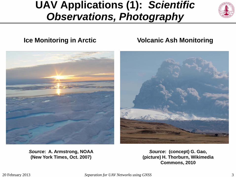
UAV Applications (1): Scientific Observations, Photography
Ice Monitoring in Arctic Volcanic Ash Monitoring
Source: (concept) G. Gao, (picture) H. Thorburn, Wikimedia
Commons, 2010
Source: A. Armstrong, NOAA (New York Times, Oct. 2007)
20 February 2013 Separation for UAV Networks using GNSS
4
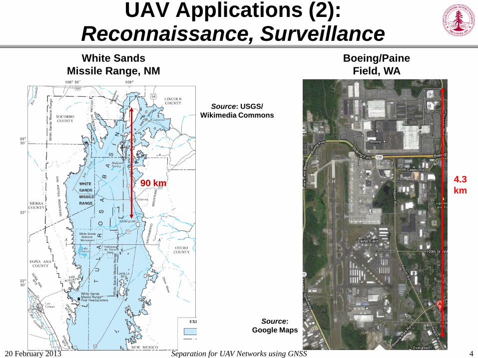
UAV Applications (2): Reconnaissance, Surveillance White Sands
Missile Range, NM
Source: USGS/ Wikimedia Commons
Boeing/Paine Field, WA
90 km
Source: Google Maps
4.3 km
20 February 2013 Separation for UAV Networks using GNSS

20 February 2013 Separation for UAV Networks using GNSS
UAV Applications (3): Reconnaissance, Surveillance
5
Inwood and nearby (gated) subdivisions, San Antonio, TX
Source: Google Maps
4.5 km
1.5 km

Separation for UAV Networks using GNSS
Concerns over Threat to Privacy
6
Source: TIME Magazine (cover), 11 February 2013.
20 February 2013

7
Constraints of Commercial UAV Network Environment
• Service must be cost-effective
• UAV design and flight operations dominate achievable performance – Low-power/weight/cost receiver chipsets
– Airborne dynamics are larger than for manned aircraft.
– Flying (relatively) close to ground objects significant airborne multipath from ground reflections
• Two-way datalink required for guidance ‒ Monitoring separation is a key responsibility of the ground
controller
20 February 2013 Separation for UAV Networks using GNSS

Local-Area UAV Network Concept
8
Upper buffer (bhigh)
Lower buffer (blow)
Data
GNSS
Ctrl
Min. Alt. (Dlow)
Max. Alt. (Dhigh)
Manned aircraft
Ground obstructions
UAV base
UAVs on station
Deployment pathway (bout)
Return pathway (bin)
Pathway sep’tn. (bsep)
20 February 2013 Separation for UAV Networks using GNSS

9
Simplification of GBAS for UAV Networks
20 February 2013 Separation for UAV Networks using GNSS
RR
RR
RR
RR
VDB Xmit.
VDB Mon.
SDM
Ephem.
X-corr.
Accel.
B-Val/µσ
Iono. screen
AR
AR
AR
Ground Facility Aircraft
VDB Rec.
MQM
RFI
VPL
DV
CMC
RFI
CMC » » EXM
»
MLA
MLA
MLA
MLA
VDB
• See: S. Pullen, et al, “LADGNSS Architectures Optimized to Support UAVs” ION ITM 2013, San Diego, CA, Jan. 2013
Add air-to-ground datalink
Ground-to-air datalink
10
Safe Separation: Definitions of Terms
• “In-network” UAVs: UAVs in the same network – Share the same source of guidance
– Share the same LADGNSS differential corrections
• “Out-of-network UAVs”: all other UAVs – May share use of GNSS, but do not share guidance or
differential corrections
– Fly in the same general airspace allocated to UAVs
• “Manned aircraft”: aircraft with human occupants ‒ Assumed to fly in their own airspace (separate from UAVs)
• “Ground obstructions”: the ground and any people, buildings, etc. attached to the ground 20 February 2013 Separation for UAV Networks using GNSS

Components of Separation Budget
11 20 February 2013 Separation for UAV Networks using GNSS
UAV Navigation Error (Unav)
UAV Path-Following Error (Upath)
UAV Guidance Error (Uguidance)
Target Navigation Error (Tnav)
Target Path-Following Error (Tpath)
Target Guidance Error (Tguidance)
Min. Sep. (bx)
“In-network” UAV
Altitude Limit or Other Vehicle (“Target”)

12
Risk Model for Total Separation (example numbers for suburban applications)
20 February 2013 Separation for UAV Networks using GNSS
Scenario Pr (CO|SV) (mean)
Pr (HH|CO) (mean)
Pr(HH|SV) (mean)
Pr(HH|SV) (worst case)
In-network UAV 10-4 10-5 10-9 10-5
Out-of-network UAV 10-5 10-4 10-9 10-4
Upper limit (manned a/c) 10-7 10-2 10-9 10-2
Lower limit (ground) 10-4 10-3 10-7 10-3
Pr(HH | SV) = Pr(HH | CO) × Pr (CO | SV) harm to humans
separation violation
collision
x =

13
Required Prob. of Separation Violation
20 February 2013 Separation for UAV Networks using GNSS
Pr(HH | SV) × Pr(SV) ≤ 10-9 Target level of safety
Solve for Pr(SV) to meet total safety requirement:

14
Preliminary Error Budget (3-D separation between in-network UAVs)
20 February 2013 Separation for UAV Networks using GNSS
Very highly correlated
highly correlated

15
Preliminary Error Budget (vertical separation from manned aircraft)
20 February 2013 Separation for UAV Networks using GNSS
potentially correlated,
but assumed independent

16
Out of Network UAVs: “Sense and Avoid”
• Safe separation from out-of-network UAVs requires some form of “sense and avoid” technology.
• Most practical solution: requirement for UAVs to broadcast position information at regular intervals – “ADS-B-OUT” for UAVs, but with much simpler, miniaturized
components.
– Report aircraft type, position, velocity, and source of navigation (e.g., a variation of GNSS)
– “ADS-B-IN” function may be delegated to ground controller for short-range systems
• Guidance adaptation to out-of-network UAVs, particularly “non-friendly” ones, is a major challenge.
20 February 2013 Separation for UAV Networks using GNSS

17
Future Work: KAIST Experiments
• Test elements of UAV network architecture with flying airborne vehicles.
• Utilize “IMT” GBAS prototype developed by Prof. Jiyun Lee at KAIST (Daejeon, Korea) along with existing commercial DGPS system.
• Key test objectives: – Examine receiver performance of existing UAVs in different
environments (using static “pseudo-user” as control).
– Evaluate correlated errors of UAVs close to each other.
– Map resulting UAV error models to separation standards proposed here.
20 February 2013 Separation for UAV Networks using GNSS

GBAS IMT Reference Receivers at KAIST
18
83 m
73 m
16 m
46 m
79 m
70 m
IMT Antennas/ Receivers (now)
Pseudo-User Antenna/Receiver
IMT Antennas/ Receivers (2013)
44 m
20 February 2013 Separation for UAV Networks using GNSS

Vicinity of KAIST GBAS
19
Existing
Expanded P-User
~ 500 m
20 February 2013 Separation for UAV Networks using GNSS

20
Summary
• A concept for autonomous UAV networks supported by local-area DGNSS has been proposed. – Medium-range photography / data-collection
– Short-to-medium reconnaissance / surveillance
• A model for separation standards between networked UAVs and obstacles/other aircraft (including other aircraft) has been developed. – Based on risk and consequences of potential UAV collisions
• Flight tests to come using KAIST GBAS prototype. – Identify UAV navigation and flight technical errors under
various conditions.
20 February 2013 Separation for UAV Networks using GNSS

21
Summary
• A concept for autonomous UAV networks supported by local-area DGNSS has been proposed. – Medium-range photography / data-collection
– Medium-to-short range reconnaissance / surveillance
• A model for separation standards between networked UAVs and obstacles/other aircraft (including other aircraft) has been developed. – Based on risk and consequences of potential UAV collisions
• Flight tests to come using KAIST GBAS prototype. – Identify UAV navigation and flight technical errors under
various conditions.
20 February 2013 Separation for UAV Networks using GNSS
Ending
• Thank you for your attention。
ご清聴、ありがとうございました。
• Questions are welcome!
ご遠慮なく、英語でも日本語でも質問してください。

22
Backup Slides follow…
20 February 2013 Separation for UAV Networks using GNSS

23
GBAS Architecture Overview (supports CAT I Precision Approach)
Corrected carrier-smoothed -code processing
− VPL, LPL calculations
airport boundary (encloses GBAS Ground Facility)
LGF Ref/Mon Receivers and Processing
VHF Data Broadcast
GPS Antennas
Cat I
VHF Antennas GPS, L1 only
20 February 2013 Separation for UAV Networks using GNSS