managing radioactive waste safely: initial geological ... · the british geological survey carries...
TRANSCRIPT

Managing Radioactive Waste Safely: Initial Geological Unsuitability Screening of West Cumbria
Commissioned Report CR/10/072


BRITISH GEOLOGICAL SURVEY
GEOLOGY AND LANDSCAPE, ENGLAND
COMMISSIONED REPORT CR/10/072
Managing Radioactive Waste Safely: Initial Geological Unsuitability Screening of West Cumbria
J H Powell, C N Waters, D Millward and N S Robins
Contributors: L Hughes and H V Cullen
The National Grid and other Ordnance Survey data are used with the permission of the Controller of Her Majesty’s Stationery Office. Licence No: 100017897/ 2010.
Keywords Report; Sub-surface screening; West Cumbria MRWS Partnership; Managing Radioactive Waste Safely; DECC; geology; hydrogeology; geological disposal
Front cover: Digital terrain model area showing the topography of the Allerdale-Copeland area. NEXTMap Britain elevation data from Intermap Technologies.
Bibliographical reference
POWELL, J.H., WATERS, C.N., MILLWARD, D, and ROBINS, N.S. 2010. Managing Radioactive Waste Safely: Initial Geological Unsuitability Screening of West Cumbria British Geological Survey Research Report, CR/10/072. 73pp. Copyright in materials derived from the British Geological Survey’s work is owned by the Natural Environment Research Council (NERC) and/or the authority that commissioned the work. You may not copy or adapt this publication without first obtaining permission. Contact the BGS Intellectual Property Rights Section, British Geological Survey, Keyworth, e-mail [email protected]. You may quote extracts of a reasonable length without prior permission, provided a full acknowledgement is given of the source of the extract. Maps and diagrams in this book use topography based on Ordnance Survey mapping.
© NERC 2010. All rights reserved
Keyworth, Nottingham British Geological Survey 2010

The full range of our publications is available from BGS shops at Nottingham, Edinburgh, London and Cardiff (Welsh publications only) see contact details below or shop online at www.geologyshop.com
The London Information Office also maintains a reference collection of BGS publications, including maps, for consultation.
We publish an annual catalogue of our maps and other publications; this catalogue is available online or from any of the BGS shops.
The British Geological Survey carries out the geological survey of Great Britain and Northern Ireland (the latter as an agency service for the government of Northern Ireland), and of the surrounding continental shelf, as well as basic research projects. It also undertakes programmes of technical aid in geology in developing countries.
The British Geological Survey is a component body of the Natural Environment Research Council.
British Geological Survey offices BGS Central Enquiries Desk Tel 0115 936 3143 Fax 0115 936 3276 email [email protected] Kingsley Dunham Centre, Keyworth, Nottingham NG12 5GG Tel 0115 936 3241 Fax 0115 936 3488 email [email protected]
Murchison House, West Mains Road, Edinburgh EH9 3LA
Tel 0131 667 1000 Fax 0131 668 2683 email [email protected]
Natural History Museum, Cromwell Road, London SW7 5BD Tel 020 7589 4090 Fax 020 7584 8270 Tel 020 7942 5344/45 email [email protected]
Columbus House, Greenmeadow Springs, Tongwynlais, Cardiff CF15 7NE Tel 029 2052 1962 Fax 029 2052 1963
Maclean Building, Crowmarsh Gifford, Wallingford OX10 8BB Tel 01491 838800 Fax 01491 692345
Geological Survey of Northern Ireland, Colby House, Stranmillis Court, Belfast BT9 5BF Tel 028 9038 8462 Fax 028 9038 8461
www.bgs.ac.uk/gsni/
Parent Body
Natural Environment Research Council, Polaris House, North Star Avenue, Swindon SN2 1EU Tel 01793 411500 Fax 01793 411501 www.nerc.ac.uk
Website www.bgs.ac.uk Shop online at www.geologyshop.com
BRITISH GEOLOGICAL SURVEY

CR/10/072 MRWS: Initial Geological Unsuitability Screening of West Cumbria
i
Acknowledgements We acknowledge with thanks the reviews and constructive comments on a draft of the report carried out on behalf of the West Cumbria MRWS Partnership by Dr J P L Dearlove and Dr F W Smith of FWS Consultants Ltd, and Professor Agust Gudmundsson of the Department of Earth Sciences, Royal Holloway University of London. Additional comments were received from the Department of Energy and Climate Change, the Environment Agency, the Nuclear Decommissioning Authority and the Committee on Radioactive Waste Management. We are grateful to Gavin Thompson of the Environment Agency for providing access to data on groundwater in the Partnership area.
The Environment Agency, CoRWM, NDA and the peer reviewers appointed by the West Cumbria MRWS Partnership were given the opportunity to comment on the draft report as described in the White Paper ‘Managing Radioactive Waste Safely: A framework for implementing geological disposal’ (Defra et al., 2008). As commissioning body, DECC commented on the draft report in terms of presentation and on it meeting the requirements set out in the MRWS White Paper, as well as assisting with the factual background.
We thank Dr Maxine Akhurst, Dr John Bloomfield and Andy Chadwick of the British Geological Survey for internally reviewing the first draft of the report and for their helpful comments on the text and figures. We are grateful to Henry Holbrook and Simon Ward for preparing the figures, and to Leanne Hughes and Hannah Cullen for developing the project Geographic Information System (GIS) from which many of the figures are derived. Thanks go to Tony Myers and Ricky Terrington for their advice and help with the 3D visualisation figures.
CR/10/072 MRWS: Initial Geological Unsuitability Screening of West Cumbria
ii
Contents Acknowledgements................................................................................................................i
Contents................................................................................................................................ ii
Non Technical Summary .....................................................................................................1
1 Introduction ...................................................................................................................7 1.1 Purpose of the report .......................................................................................................7 1.2 Structure of the report .....................................................................................................8 1.3 Geological information used in the report ......................................................................8 1.4 Geological data – spatial distribution and uncertainty....................................................9
2 Summary Description of the Geology and Hydrogeology of the Partnership Area ......... 12 2.1 Introduction ...................................................................................................................12 2.2 Lower Palaeozoic rocks ................................................................................................15 2.2.1 Skiddaw Group .......................................................................................................15 2.2.2 Borrowdale and Eycott volcanic groups .................................................................15 2.2.3 Windermere Supergroup.........................................................................................16 2.2.4 Intrusive igneous rocks ...........................................................................................16 2.3 Carboniferous rocks ......................................................................................................17 2.3.1 Ravenstonedale Group ............................................................................................17 2.3.2 Great Scar Limestone Group ..................................................................................17 2.3.3 Border Group ..........................................................................................................18 2.3.4 Yoredale Group.......................................................................................................18 2.3.5 Pennine Coal Measures Group................................................................................18 2.3.6 Warwickshire Group...............................................................................................18 2.4 Permian, Triassic and Jurassic rocks.............................................................................19 2.4.1 Appleby Group........................................................................................................20 2.4.2 Cumbrian Coast Group ...........................................................................................20 2.4.3 Sherwood Sandstone Group....................................................................................20 2.4.4 Mercia Mudstone Group .........................................................................................22 2.4.5 Penarth and Lias groups..........................................................................................22 2.5 Quaternary superficial deposits.....................................................................................22
3 Geological Sub-surface Screening Criteria...............................................................24 3.1 Introduction ...................................................................................................................24 3.2 Natural Resources .........................................................................................................25 3.3 Groundwater..................................................................................................................25
4 Assessment of the Sub-surface Screening Criteria for Geological Domains in the Partnership Area.........................................................................................................29
4.1 Natural resources...........................................................................................................29 4.1.1 Coal and Coal-Bed Methane...................................................................................29 4.1.2 Oil and Gas .............................................................................................................32 4.1.2.1 Shale Gas..........................................................................................................33 4.1.3 Oil Shale..................................................................................................................34 4.1.4 Metalliferous Ores ..................................................................................................34 4.1.4.1 Iron ore .............................................................................................................35

CR/10/072 MRWS: Initial Geological Unsuitability Screening of West Cumbria
iii
4.1.5 Disposal of wastes/gas storage................................................................................37 4.2 Groundwater..................................................................................................................37 4.2.1 Aquifers...................................................................................................................37 4.2.1.1 Sherwood Sandstone Group aquifer.................................................................41 4.2.1.2 Shallow Permeable Formations and Secondary ‘A’ aquifers...........................42 4.2.2 Specific Complex Hydrogeological Environments ................................................43 4.2.2.1 Karst .................................................................................................................43 4.2.2.2 Thermal Springs ...............................................................................................43
5 Summary......................................................................................................................44
Appendix 1 Glossary of terms .....................................................................................45
References and sources of information ............................................................................55
FIGURES
With the exception of Figures 1 and 2 in the Non Executive Summary, the figures are at the back of the report.
Front Cover. Digital terrain model area showing the topography of the Allerdale-Copeland area. NEXTMap Britain elevation data from Intermap Technologies.
Figure 1. Stages in the site selection process (after Defra et al., 2008); this report addresses Stage 2. Figure 2. The West Cumbria MRWS Partnership area showing areas screened out (exclusion areas) where one or more of the exclusion criteria apply to the whole rock volume between 200 m and 1000 m depth. The Excluded Area is shown overlain on the 1:1 m scale Ordnance Survey base map. All information other than the Excluded Area (shown in pink) and the boundaries of the screened area (shown in blue) is taken from the Ordnance Survey base map and is shown for context only. Dashed blue line indicates the Allerdale-Copeland boundary. Topographical base is OS topography © Crown Copyright. All rights reserved. 100017897/2010. Figure 3. Major place names referred to in the report. The background is a digital elevation model showing the topography and main geographical features of the area using shaded relief illuminated from the north-west. NEXTMap Britain elevation data from Intermap Technologies.
Figure 4. Generalised bedrock geology of the West Cumbria Partnership area, onshore, and up to 5 km offshore. Onshore bedrock geology is based on the BGS 1:625 000 scale bedrock geological map (BGS 2007a); offshore bedrock geology is based on the BGS 1:250 000 scale bedrock geological map (BGS, 1980). The location of geological cross-sections in Figure 5 of this report are shown A-B and C-D, and those for Figure 6 are also shown.
Figure 5. Regional geological cross-sections illustrating the general bedrock geology of the Partnership area and adjacent areas offshore. The 5 km limit of the Partnership area, offshore, is shown by a dashed line. The locations of cross-sections A-B and C-D are shown in Figure 4. After Akhurst et al., (1997, fig. 7) and Nirex (1995).
Figure 6. Three-dimensional ‘fence diagram’ of cross-sections illustrating the generalised regional geology of Cumbria, including the West Cumbria Partnership area. The vertical scale is exaggerated, so that the topography and dip (inclination) of the rocks appear exaggerated. Depth of the sections is approximately 1500 m below Ordnance Datum. Inset map shows the line of the cross-sections in relation to the Partnership area. Based on Schofield et al., (in press).
Figure 7. Key for the geological map (Figure 8) and geological cross-sections (Figure 9) based on BGS DiGMapGB 1:50 000 scale. Letter codes refer to rock units shown in the cross-sections on Figure 9. Full

CR/10/072 MRWS: Initial Geological Unsuitability Screening of West Cumbria
iv
definitions of these rock units are available from the BGS Lexicon of Named Rock Units at www.bgs.ac.uk/lexicon/home.cfm
Figure 8. Geological map of the West Cumbria Partnership area based on BGS DiGMapGB 1:50 000 scale. The lines of cross-sections A-B, C-D, E-F, G-H and I-J (Figure 9) are shown. See Figure 7 for key. For clarity, some small areas of Lower Palaeozoic strata are not shown in the key (Figure 7).
Figure 9. Geological cross-sections illustrating the bedrock geology of the north-west (A-B and C-D), west (E-F) and south (G-H and I-J) of the West Cumbria Partnership area. For clarity, the vertical scale is exaggerated by a factor of 3; consequently, the topography and dip (inclination) of the rocks appear exaggerated. See Figure 8 for the lines of the cross-sections, and Figure 7 for the key.
Figure 10. Map showing the exclusion areas for coal and coal-bed methane (possible intrusion risk at depth). Based on data listed in Section 4.1.1. Contours (relative to OD) on the base of Pennine Coal Measures Group (Chadwick et al., 1995) show the regional dip of the coal-bearing succession. Topographical base is OS topography © Crown Copyright. All rights reserved. 100017897/2010.
Figure 11. Map showing the location of oil and gas boreholes and current (2010) oil and gas licence areas (DECC, 2010) in the north of the Partnership area. Topographical base is OS topography © Crown Copyright. All rights reserved. 100017897/2010.
Figure 12. Map showing the exclusion areas for hematite iron ore (possible intrusion risk at depth). Only known areas of orebodies below 100 m depth are shown excluded, in line with the exclusion criteria (Defra et al., 2008). Inset maps show details of the location of the two hematite ore fields. Based on data listed in Section 4.1.4.1. Topographical base is OS topography © Crown Copyright. All rights reserved. 100017897/2010.
Figure 13. Map illustrating the Principal and Secondary A aquifers (exploitable groundwater resources) in the Partnership area. The Sherwood Sandstone Group (Principal aquifer) is shown where present below 200 m depth OD (west Cumbria coastal aquifer and Solway Basin). Structural contours on the base of the Sherwood Sandstone Group are shown, where known, at -200 m, -500 m and -1000 m OD to indicate the general direction of dip, offshore. The hatched area represents the presence of Carboniferous aquifers (Secondary A aquifers) onshore, between -200 m and -500 m depth. Between -200 m and -500 m OD the Principal and Secondary A aquifer rock volumes are excluded. Below about -500 m OD the groundwater is assumed to be saline and, therefore, is not an exploitable groundwater resource. Offshore, the groundwater (marine) is saline and, therefore, the rock volume is not an aquifer. Selected EA licenced groundwater abstraction wells are shown for Primary and Secondary A aquifers. Based on data listed in Section 4.2 (including EA, 2010 and Nirex, 1995). Topographical base is OS topography © Crown Copyright. All rights reserved. 100017897/2010.
Figure 14. Simplified diagrammatic cross-sections of the Principal and Secondary aquifers in the Partnership area (see Figure 13).
(a) Solway lowlands; A, B, C, D illustrate hypothetical locations, at depth, below -200 m OD. ‘A’ lies within the Sherwood Sandstone Group Principal aquifer above the fresh water-saline interface and, therefore, would be an excluded rock volume. ‘B’ lies within the Carboniferous Secondary A aquifer but above the fresh water-saline interface and, therefore, would be an excluded rock volume. ‘C’ lies within the Sherwood Sandstone Group, but below the fresh-saline water interface and, therefore, is not an aquifer and does not represent an excluded rock volume. ‘D’ lies within the Lower Palaeozoic rocks and, therefore, is not an excluded rock volume. Not to scale.
(b) west Cumbria coastal plain; A, B, C, D illustrate hypothetical locations, at depth, below -200 m OD. ‘A’ lies within the Sherwood Sandstone Group Principal aquifer above the fresh-saline water interface and, therefore, would be an excluded rock volume. ‘B’ is within the Sherwood Sandstone Group but below the fresh water-saline interface and, therefore, is not an aquifer and does not represent an excluded rock volume. ‘C’ lies within the Sherwood Sandstone Group, but the groundwater offshore is likely to be saline or brine, and therefore not does not represent an excluded rock volume. ‘D’ lies within the Lower Palaeozoic rocks and, therefore, is not an excluded rock volume. Not to scale.
TABLES
Table 1. Summary of the initial sub-surface screening criteria

CR/10/072 MRWS: Initial Geological Unsuitability Screening of West Cumbria
v
Table 2. Summary of the main sedimentary and volcanic rock units in the West Cumbria Partnership area, showing their general lithology and thickness. The oldest rocks are at the bottom. (ORD./SILR.= Ordovician and Silurian; JUR = Jurassic).
Table 3. Initial sub-surface screening (exclusion) criteria (from Table B1, Defra et al., 2008) and a summary assessment of the geology and hydrogeology of the Partnership area against these criteria. Blue (bold) text refers to criteria that the White Paper considered to be applied as exclusion criteria; Green (not bold) text refers to criteria that were considered not to be applied as exclusion criteria in the initial sub-surface screening process. Application of the sub-surface exclusion criteria the Partnership area is discussed in more detail in Section 4.
Table 4. Environment Agency designation of aquifers compared to the earlier classification, with examples from the Partnership area.
Table 5. Rock units in the West Cumbria Partnership area, their aquifer potential and application of exclusion criteria. Groups are shown in bold in the Rock Unit column. ORD./SILR. = Ordovician and Silurian.

CR/10/072 MRWS: Initial Geological Unsuitability Screening of West Cumbria
1
Non Technical Summary Background In 2001 the UK Government began the Managing Radioactive Waste Safely1(MRWS) programme with the aim of identifying a long-term solution for the UK’s higher activity wastes that:
• achieved long-term protection of people and the environment
• did this in an open and transparent way that inspired public confidence
• was based on sound science, and
• ensured the effective use of public monies.
In 2003 the independent Committee on Radioactive Waste Management (CoRWM)2was established to consider the available options and make recommendations to Government. In October 2006, the Government accepted CoRWM’s recommendations that geological disposal, preceded by safe and secure interim storage, was the best available approach. Government also accepted that an approach based on voluntarism, and partnership with local communities, was the best way of siting a geological disposal facility (GDF). Geological disposal involves placing radioactive waste within engineered, multi-barrier facilities deep inside a suitable rock formation where the facility and geology provide a barrier against the escape of radioactivity. Internationally it is recognised as the preferred approach - it is being adopted in many countries including Canada, Finland, France and Sweden - and is supported by a number of UK learned societies including the Royal Society, the Geological Society and the Royal Society of Chemistry.
Following further consultation, the White Paper ‘Managing Radioactive Waste Safely (MRWS): A Framework for Implementing Geological Disposal’ was published in 2008; it sets out a staged approach to siting a geological disposal facility. The process starts with local communities initially ‘expressing an interest’ in opening up discussions with Government. At each stage, the process allows all those involved to take stock before deciding whether or not to move to the next stage at a particular site. Up until late in the process, when underground operations and construction are about to begin, the community has a Right of Withdrawal - if it wished to withdraw then its involvement in the process would stop. Figure 1, below, shows the main stages in the process.
The Nuclear Decommissioning Agency (NDA) have since published an additional document ‘Geological Disposal: Steps towards implementation’3 which provides further information on what will be required for the successful implementation of geological disposal.
1 http://mrws.decc.gov.uk/ 2 www.corwm.org.uk 3 www.nda.gov.uk/documents/upload/Geological-Disposal-Steps-Towards-Implementation-March-2010.pdf

CR/10/072 MRWS: Initial Geological Unsuitability Screening of West Cumbria
2
Figure 1. Stages in the site selection process (after Defra et al., 2008); this report addresses Stage 2.
Initial screening out of unsuitable areas Following an expression of interest, the White Paper sets out the second stage, in which the British Geological Survey (BGS) undertakes a high level geological screening of the area using basic geological exclusion criteria that can be applied using existing knowledge. This screening is desk based, uses existing information and will not produce sites that could definitely host a facility, but will rule out areas that definitely could not host a facility for obvious geological reasons. At further stages of the site selection process increasingly detailed assessments would be made of any potential sites, applying more localised geological and other assessments. Areas which are ruled out in this initial sub-surface screening exercise might still be suitable locations for the surface facilities of a GDF.
Geological exclusion criteria The geological exclusion criteria were derived during 2007 by two independent expert groups, each comprising of scientists with high calibre experience, and established following discussion and nominations from the Royal Society, the Geological Society and the Royal Academy of Engineering. One group (Criteria Proposals Group) proposed a suitable set of screening criteria and the other (Criteria Review Panel) then peer reviewed them to ensure that they were workable. The results were consulted on by Government in 2007 and the Chairs of both groups then reconsidered the criteria in light of the responses received before the final publication of the MRWS White Paper in 2008.
It is important to note that the exclusion criteria were derived to provide an initial ‘first cut’, solely to remove any obviously unsuitable geology from further consideration. The criteria could not be area specific and had to be suitable for application to any area of the country that ‘expressed an interest’. The criteria need to recognise the early stage of the site selection process in which they are applied and, as such, have to be applicable across potentially large

CR/10/072 MRWS: Initial Geological Unsuitability Screening of West Cumbria
3
geographical areas using existing information only. They are strictly geology based and, at this stage, they cannot consider detailed site-specific information such as local small scale geological features, the environmental impact of a facility, potential transport routes, population density, etc. Detailed examination and assessment of criteria based on these aspects will necessarily come later in the process if, and when, a community decides it wants to be involved further in the site selection process and actually begins to consider specific sites.
The final exclusion criteria agreed by the expert Chairs of the two groups are summarised4 in Table 1.
Table 1. Summary of initial sub-surface screening criteria
The final exclusion criteria are high level and largely based around two key issues - the need to exclude areas in order to reduce the risk of intrusion into a facility by future generations seeking to investigate and extract resources, and the need to protect the quality of exploitable groundwater.
The criteria groups also considered the case for and against a number of other geological exclusion criteria such as risk of earthquakes, geological faults, specific complex geological environments, erosion, etc. Following detailed consideration, the two expert groups concluded that these characteristics, although absolutely crucial in the investigation and assessment for a geological disposal facility, can only be properly considered later in the process at a site-specific level when more in-depth investigations can take place on the details of a particular site.
4 For the authoritative explanation of the exclusion criteria the CPG/CRP full advice and subsequent review document should be read. Available at http://mrws.decc.gov.uk/en/mrws/cms/Disposal/Site_selection/Initial_screen/Initial_screen.aspx 5 “Shallow”, in this context, means less than 500 metres below the surface. Therefore, “deep” and “at depth” mean more than 500 metres below the surface. 6 Rock mass consisting of carbonate rocks (e.g. limestone) characterised by dissolution through the action of slightly acid surface and groundwater
To be applied as exclusion criteria?
Reasons/explanations and qualifying comments
Natural resources
Coal Yes Intrusion risk to depth, only when resource at >100m depth
Oil and gas Yes Intrusion risk to depth, for known oil and gas fields
Oil shales Yes Intrusion risk to depth
Metal ores Some ores Intrusion risk only where mined at depths of >100m
Disposal of wastes/gas storage
Yes Only where already committed or approved at >100m depth
Groundwater
Aquifers Yes Where all or part of the geological disposal facility host rock is located within the aquifer
Shallow5 permeable formations
Yes Where all or part of the geological disposal facility host rock would be provided by permeable formations that might reasonably be exploited in the future
Specific complex hydro-geological environments
Yes Deep karstic6 formations and known source rocks for thermal springs

CR/10/072 MRWS: Initial Geological Unsuitability Screening of West Cumbria
4
The initial geological unsuitability screening of west Cumbria Since Government’s call for communities to ‘express an interest’ in finding out more about the geological disposal siting process in 2008, three local authorities (Allerdale Borough Council, Copeland Borough Council and Cumbria County Council) have expressed an interest for the areas of Allerdale and Copeland.
The Councils have set up the West Cumbria Managing Radioactive Waste Safely (MRWS) Partnership7 to ensure that people living in the area are involved in making an informed decision about whether or not to proceed with the facility siting process. The Partnership includes a wide range of local organisations and, following initial public engagement, it was content for the Department of Energy and Climate Change (DECC) to commission the British Geological Survey to undertake the application of the sub-surface unsuitability test described above.
This work does not show where a facility might eventually be located. It is at an early stage in the site selection process and simply intends to avoid unnecessary work in areas which are clearly unsuitable for obvious geological reasons. A more rigorous assessment, based on a comprehensive range of criteria will only be undertaken if a ‘decision to participate’ in further stages of site selection process is taken.
The geological sub-surface screening report covers the known geology of Allerdale and Copeland and, at the request of DECC, an adjoining area 5 km offshore. The report considers areas that have clearly unsuitable geology for an underground geological disposal facility for radioactive waste, the depth of which is likely to be somewhere between 200 and 1000 metres below ground surface, but this will depend on the geology at the site in question.
This initial screening out exercise and report is based on the analysis of existing records, reports, BGS ‘memoirs’ and maps, and relevant published scientific literature on the geology of the Partnership area in relation to the recommended high level, sub-surface geological screening (or ‘exclusion’) criteria (Table 1).
The Partnership area has a varied geology including formerly worked mineral resources (e.g. coal and metal ores) and some exploitable groundwater resources. A general account of the geology and hydrogeology of the Partnership area is illustrated with simplified geological maps and cross-sections in order to provide a background for the non-geologist. The sub-surface screening criteria have been systematically applied to the geology and hydrogeology of the West Cumbria Partnership area and are discussed in detail. Figure 2 summarises the outcome of the sub-surface screening exercise and shows the areas that are screened out (‘exclusion areas’) where one or more of the exclusion criteria apply to the whole rock volume between 200 m and 1000 m depth.
Natural resources exclusion criteria (Table 1) most relevant to the Partnership area comprise: (a) coal and coal-bed methane (intrusion risk to depth), (b) oil and gas (intrusion risk to depth), and (c) metalliferous ores (where mined at greater than 100 m depth).
Areas known to be underlain by coal and hematite (iron) ore at greater than 100 m depth are screened out. These areas (Figure 2) comprise parts of the Partnership area extending north-west from Egremont and Whitehaven to Wigton and the Solway coast, and a small area near Millom. The areas represent sub-surface rock volumes where there is a potential risk of inadvertent intrusion into a geological repository by future generations seeking to investigate and extract resources. Other metalliferous ores have been historically worked in the Partnership area, but these lie at shallow depths, less than 100 m, and the areas are not excluded.
Exploration for oil and gas (‘conventional hydrocarbons’) has taken place in the north of the Partnership area, but no resources have been proved. Consequently, although a part of north 7 www.westcumbriamrws.org.uk
CR/10/072 MRWS: Initial Geological Unsuitability Screening of West Cumbria
5
Allerdale is currently licenced for oil and gas exploration, the area has not been screened out at this stage since it does not represent a known oil and gas field. Similarly, gas derived from thick beds of organic-rich shales (known as ‘shale gas’) has not been proved in the Partnership area. Minor amounts of oil have been reported historically from coal-bearing rocks, which are excluded at depth (see above), but there are no known potentially exploitable oil shales resources in the Partnership area. There are no committed or approved areas (rock volumes) for the disposal of waste/gas storage in the Partnership area.
Groundwater exclusion criteria (Table 1) have been applied to exploitable groundwater resources in aquifers (e.g. Sherwood Sandstone Group) and shallow permeable formations, as well as specific complex hydrogeological environments.
Some, but not all, of the rock volume in areas where aquifers and shallow permeable formations are present in the Partnership area are excluded. However, nowhere does the exploitable aquifer rock volume extend over the whole of the depth range between 200 m and 1000 m below ground level and, consequently, the total area is not excluded at this stage. The isolation of a GDF from exploitable water resources will be a major issue for providing the eventual suitability of any proposed GDF. These aquifer rock volumes will need to be considered in more detail at later stages in the MRWS process if, and when, a community decides it wants to be involved further in the site selection process and actually begins to consider specific sites.
From the information available there are no known specific complex hydrogeological environments such as deep karst (extending to hundreds of metres depth) or thermal springs in the Partnership area.
Increasingly detailed regional and site specific geological assessments and other studies will be required at later stages in the MRWS process to establish the potential suitability of any sub-surface areas (rock volumes) for a geological disposal facility. This initial report will provide a background to any potential future studies.
The report includes an extensive glossary of technical terms, together with the sources of information consulted. Information consulted in the report may be obtained via the BGS library service, subject to copyright legislation (contact [email protected] for details).

CR/10/072 MRWS: Initial Geological Unsuitability Screening of West Cumbria
6
Figure 2. The West Cumbria MRWS Partnership area showing areas screened out (exclusion areas) where one or more of the exclusion criteria apply to the whole rock volume between 200 m and 1000 m depth. The Excluded Area is shown overlain on the 1:1 m scale Ordnance Survey base map. All information other than the Excluded Area (shown in pink) and the boundaries of the screened area (shown in blue) is taken from the Ordnance Survey base map and is shown for context only. Dashed blue line indicates the Allerdale-Copeland boundary. Topographical base is OS topography © Crown Copyright. All rights reserved. 100017897/2010.

CR/10/072 MRWS: Initial Geological Unsuitability Screening of West Cumbria
7
1 Introduction 1.1 PURPOSE OF THE REPORT The Managing Radioactive Waste Safely (MRWS) programme is set out and described in the White Paper ‘Managing Radioactive Waste Safely (MRWS) – A Framework for Implementing Geological Disposal’ (Defra et al., 2008). The background to this process is outlined, here, in the Executive Summary.
Following an expression of interest from a volunteer community, the White Paper sets out the second stage, in which the British Geological Survey (BGS) undertakes a high level geological screening of the area using basic geological exclusion criteria that can be applied using existing knowledge. This sub-surface screening is desk based, uses existing information and will not identify sites that could definitely host a facility, but will rule out areas that definitely could not host a facility for obvious geological reasons. At further stages of the site selection process increasingly detailed assessments would be made of any potential sites, applying more localised geological and other assessments.
This report has been prepared for the Department of Energy and Climate Change (DECC) at the request of the West Cumbria MRWS Partnership (the Partnership includes a wide range of local organisations including Allerdale Borough Council, Copeland Borough Council and Cumbria County Council8). The study aims to screen out any areas in Allerdale and Copeland that are clearly unsuitable for geological reasons as a potential location for a geological disposal facility for radioactive waste as set out in the White Paper. It is aimed at informing a decision about whether the Partnership might participate in further stages in the Managing Radioactive Waste Safely (MRWS) process. Geological disposal involves placing radioactive waste within engineered, multi-barrier facilities deep inside a suitable rock formation where the facility and geology provide a barrier against the escape of radioactivity. The depths envisaged are likely to be somewhere between 200 m and 1000 m below ground surface, but this will depend on the geology of the site in question (Defra et al., 2008). Radioactive waste would be placed in an engineered underground facility, which would use natural barriers (i.e. the surrounding rock) and man-made barriers, such as the waste containers and materials placed around the containers, to contain the radioactivity.
This report focuses on the high level, sub-surface screening (‘exclusion’) criteria set out by the Criteria Proposals Group (CPG) and the Criteria Review Panel (CRP) in the Government’s White Paper (Defra, 2007; Defra et al., 2008). Non-geological factors are not considered at this initial stage in the MRWS process. The final exclusion criteria are high level and largely based around two key issues - the need to exclude areas in order to reduce the risk of intrusion into a facility by future generations seeking to investigate and extract natural resources, and the need to protect the quality of exploitable groundwater.
Natural Resources exclusion criteria are based on a potential geological resource that might be the focus of exploration and/or exploitation in the distant future, leading to penetration or ‘intrusion’ by boreholes or mining activities into an ‘unknown’ engineered repository located at between 200 to 1000 m depth. These include:
• The presence of deep coal resources (greater than 100 m depth from the surface);
• The presence of known hydrocarbon (oil or gas) resources;
8 Cumbria County Council expressed an interest for only the Boroughs of Allerdale and Copeland, not the rest of Cumbria

CR/10/072 MRWS: Initial Geological Unsuitability Screening of West Cumbria
8
• The presence of known oil shale resources;
• Past exploitation of, or known, metallic ores where mined at greater than 100 m depth from surface;
• The presence, or committed development, of a deep waste disposal or gas storage facility; only where already committed or approved at greater than 100 m depth from the surface.
Groundwater exclusion criteria comprise:
• Development within an aquifer where all or part of the geological disposal facility host rock is located within the aquifer;
• Shallow permeable formations where all or part of the geological disposal facility host rock would be provided by permeable formations that might reasonably be exploited in the future;
• Specific complex hydrogeological environments such as deep karstic formations (carbonate rocks characterised by dissolution) and known source-rocks for thermal springs.
A Glossary of technical terms is included in Appendix 1. Sources of information consulted are listed in the References at the end of the report. The geospatial data, geological and topographical maps, cross-sections and 3D models used in this the study are held in a Geographical Information System (GIS) in ArcGIS version 9.2 at BGS, Nottingham.
1.2 STRUCTURE OF THE REPORT The background and principal findings of the study are described in the Executive Summary. Section 2 provides a brief introduction to the topography, geology and hydrogeology (groundwater) of the Partnership area. Here the emphasis is on aspects of the geology and hydrogeology most relevant to the assessment of the sub-surface screening criteria in later sections. Section 3 provides a background to sub-surface screening criteria recommended in the joint CPG/CRP report (Defra, 1997) and presented in Table B1 of the White Paper (Defra et al., 2008). In Section 4 the sub-surface screening criteria are assessed in detail against the geology and hydrogeology of the Partnership area. Areas and rock volumes that are considered to be screened out at this initial stage are identified and, where appropriate, shown on separate summary maps. A summary of the results of the study is presented in Section 5. With the exception of Figures 1 and 2 in the Executive Summary, the figures are at the end of the report; tables are included within the text.
1.3 GEOLOGICAL INFORMATION USED IN THE REPORT This report is based on the analysis of existing records, reports, BGS memoirs and maps, and relevant published scientific literature. Throughout the report we refer to published geological maps and cross-sections at various scales, information derived from interpretive reports, BGS regional ‘memoirs’ (summaries of the geology of the area), Nirex reports, scientific papers and books, borehole records, mining information and interpreted geophysical data, including gravity, aeromagnetic and seismic reflection (geophysical sub-surface) data. The report also contains geological map extracts taken from the BGS Bedrock Digital Geological Map of Great Britain at the 1:50 000 scale (DiGMapGB-50), BGS Bedrock Geological Map (offshore) at 1:250 000 scale (BGS, 1980) and the Bedrock Geology UK North map at 1:625 000 scale (BGS, 2007a),

CR/10/072 MRWS: Initial Geological Unsuitability Screening of West Cumbria
9
geological cross-sections, and a generalised three-dimensional model to illustrate the geology of the Partnership area.
1.4 GEOLOGICAL DATA – SPATIAL DISTRIBUTION AND UNCERTAINTY Geological information includes both directly measurable and interpreted data. In this section we provide a brief summary of the levels of uncertainty inherent in geological information, and how it relates especially to the information sources used to compile this report.
Information sources used in this report (see References) are considered to be at the level required for this initial ‘high level’ sub-surface screening. No rigorous assessment of uncertainty has been carried out for this study. However, an assessment of uncertainty (Clarke, 2004; Clarke and Millward, 2004) has been made in association with the construction of a 3-dimensional model of the geology of the Central Fells region of the Lake District, which includes the Lower Palaeozoic rocks in the east of the Partnership area. Throughout this report we have included, where appropriate, qualitative descriptions of the level of uncertainty associated with our interpretations of the information, such as ‘interpreted’ or ‘inferred’. Where seismic reflection information has been used to interpret the geology in the deeper sub-surface we have referred, where available, to borehole information that has been used to corroborate the seismic reflection geophysical interpretation.
Spatial distribution and quality of data
In the Partnership area (Figure 3), the spatial distribution of surface and sub-surface geological data is highly variable. For instance, information on bedrock is sparse in the Solway lowlands (Carlisle Basin) and the area southwards from Seascale to the Duddon estuary where there are few deep boreholes and the area is generally covered by a mantle of superficial (mostly glacial) deposits that obscure the bedrock. This contrasts with a high density of information in parts of the Cumbrian Coalfield where there is a wealth of surface and sub-surface information derived from detailed bedrock mapping, mining information and boreholes associated with the search for, and exploitation of, mineral resources. Similarly, the intensive surface geological surveys, sub-surface geophysical surveys and borehole information in the Sellafield area produced for the UK Nirex Ltd studies (Nirex, 1995) have provided detailed geological information for this region. A review of the borehole and seismic data coverage at the regional, district and site levels for Sellafield area is given in Michie and Bowden (1994). Much of the geological information gathered during the Nirex investigations has subsequently been incorporated in BGS maps and memoirs and published as peer-reviewed scientific papers (e.g. BGS, 1999c; Akhurst et al., 1998; Michie, 1996; Milodowski et al., 1998).
The quality of data is also of fundamental importance. For instance, although information on the bedrock is sparse for the Solway lowlands, a few exploration boreholes have been drilled to depths greater than 1000 m that provide high quality information on the sub-surface at these locations. Similarly, boreholes drilled during the Nirex investigations in the Sellafield-Gosforth area also provide high quality information such as detailed analysis of the cores by geoscientists. Here, direct observations on cores have been supported by a wealth of geophysical log data acquired from the boreholes after they were drilled. Conversely, the many shallow site investigation boreholes drilled in the urban areas and along highway routes may only prove information on near-surface rocks and superficial or man-made deposits recorded by drillers that may not add a great deal to the geological interpretation of the area. Whereas some rock characteristics recorded from cores may be directly measured, it should be understood that some element of expert judgement is always exercised by the geologist, particularly for example in establishing the rock units.
CR/10/072 MRWS: Initial Geological Unsuitability Screening of West Cumbria
10
Geological maps and cross-sections
A geological map is a representation of the distribution of the various bedrock and superficial units at the Earth’s surface and of the extrapolation of these into the sub-surface. The third (depth) dimension is illustrated on BGS 1:50 000 scale maps by one or more cross-sections representing a ‘vertical slice’ through the rock succession. The geological map and cross-sections can thus be regarded as the best interpretation or ‘model’ of the geology at the ground surface and shallow subsurface derived from a variety of types of information available at the time of the survey publication. A review of the accuracy and levels of uncertainty of the geological boundaries between one rock type and another, and of BGS geological maps in general, is given in Smith (2009). The onshore geological maps and cross-sections that form part of the dataset used in this report are based on detailed geological surveying at the 1:10 000 scale. These maps have been simplified, in part, to smaller scale maps such as the 1:50 000 scale series that forms the basis of Figure 8 in this report and, through further simplification, to the 1: 625 000 scale map of the UK (BGS, 2007a) which forms the basis of Figure 4.
It should be noted, however, that the British Geological Survey maps of the UK at 1:10 000 scale and the smaller scale maps derived from these (e.g. the 1: 50 000 scale series) are probably among the most accurate geological maps in the world by virtue of the many re-surveys since the late 19th century for natural resources and land-use planning, and, in parts of the Partnership area, the availability of sub-surface information derived from boreholes and seismic surveys. With the exception of the northern part of the Partnership area, from Silloth to Carlisle, all of the geological maps used in this report result from re-surveys conducted since 1980.
The accuracy of the geological maps and the cross-sections is dependent on a range of factors, such as the degree of surface exposure of the rocks and superficial deposits, the density, quality and availability of borehole, coal and metalliferous mine plans, and geophysical information - and the interpretive skills and experience of the geologist. Since some geological boundaries or features in the sub-surface cannot be observed directly, or accurately measured, there is an inherent degree of uncertainty in the three-dimensional geological ‘model’. In general, uncertainty in the accuracy of geological boundaries increases with depth, especially in the areas where boreholes, mining or seismic reflection information are sparse.
Taking all of the factors discussed above into account for much of the Partnership area, an approximation of the level of uncertainty in the bedrock geological boundaries at the surface is given by the covering of superficial and artificial (man made) deposits, as shown on the published 1:50 000 scale Superficial Deposits (‘Drift’) maps. Where these deposits are extensive, uncertainty is higher than in areas, such as the uplands, where bedrock is extensively shown at or near surface. Uncertainty is also lowest in areas constrained by a large number of good quality boreholes and/or seismic surveys, such as the west Cumbria coastal plain south-east of St Bees, and in the coalfield north of Whitehaven.
Vertical exaggeration in cross-sections
Critical to an understanding of the application of the sub-surface screening criteria in the Partnership area is an appreciation of the third-dimension (depth). This is sometimes a difficult concept for non-geologists. Consequently, cross-sections are used to illustrate the geology, at depth, below the ground surface. In the smaller format necessary for this report the vertical scale of the cross-sections (Figure 9) derived from the component 1: 50 000 scale geological maps have all been exaggerated by a factor of three, and in the generalised cross-sectional ‘fence’ diagram (Figure 6) by a factor of 5. This enables the rock units (formations etc.) to be clearly seen at the A3 paper size. Vertical exaggeration has the effect of increasing the angle of inclination (dip) of planar surfaces such as geological boundaries and faults, and the topographical expression; these factors have to be taken into account when interpreting the sub-

CR/10/072 MRWS: Initial Geological Unsuitability Screening of West Cumbria
11
surface geology. The alternative would be to show the cross-sections at true scale (vertical and horizontal scales the same) but the rock units relevant to this study would be barely visible at the A3 paper size.
CR/10/072 MRWS: Initial Geological Unsuitability Screening of West Cumbria
12
2 Summary Description of the Geology and Hydrogeology of the Partnership Area
2.1 INTRODUCTION In this section an overview of the topography, geology and hydrogeology of the Partnership area provides a background to the application of the Sub-Surface Exclusion Criteria presented in Section 4. More detail is presented here for those aspects of the geology that are considered to be critical to the screening process. The rock succession in the Partnership area is described briefly below, from the oldest through to the youngest, and is summarised in Table 2. Hydrogeological (groundwater) characteristics are included for each of the major rock units.
Topography The Allerdale and Copeland area (Figure 3) includes part of the Lake District mountains which reach an elevation of 977 m on Scafell Pike, the highest point in England. The upland region is cut by deeply dissected, glaciated valleys radiating from the core of the Lake District. Away from the Lake District core, the topography is much more subdued (Figure 3) especially where the bedrock is masked by glacial deposits such as the Solway lowlands and the coastal plain southwards from St Bees to the Duddon Estuary (Akhurst et al., 1997). The southward flowing River Duddon forms the eastern boundary of Copeland; the Esk, Calder and Derwent flow westward to the Irish Sea.
Geology and hydrogeology The Partnership area is founded on a wide variety of rocks (Table 2; Figures 4, 5, 8, 9) with a geological history that spans almost 500 million years. Igneous and sedimentary rocks of Ordovician, Silurian and early Devonian age form the Lake District core of the area. In the low-lying belt around the Lake District these ancient rocks are overlain by younger Carboniferous, Permian, Triassic and Lower Jurassic sedimentary strata which generally thicken towards the Irish Sea and the Solway lowlands. An interval of almost 190 million years elapsed between deposition of the youngest of these rocks, preserved just west of Carlisle, and the onset of the Quaternary Period, during which time unconsolidated glacial and post-glacial sediments were laid down.
This section is based on the detailed systematic descriptions contained in British Geological Survey memoirs, the most significant of which have been published within the last 13 years (Akhurst et al., 1997 – west Cumbria district; Millward et al., 2000a – Ambleside district; Johnson et al., 2001- Ulverston district; Cooper et al., 2004 – Skiddaw Group; Chadwick et al., 1995 - Solway basin) and to the numerous published scientific papers. Much of our current knowledge of the geology of the area is summarised in the recently published Regional Geology guide for Northern England (Stone et al., 2010). A review of the geological framework and hydrogeology of the Sellafield area is given in Michie (1996).
The hydraulic transmissive properties of most of the strata reduce with increasing thickness of overlying rocks, most notably those that rely on fracture flow. As a consequence most of the groundwater circulation takes place at shallow depths with only a small volume of circulation taking place at depths greater than about 100 m below the water table.
In the Partnership area the Triassic Sherwood Sandstone Group is the principal aquifer in the west Cumbria coastal plain and the Solway lowlands. Secondary A and B aquifers (as defined in the Environment Agency (EA) aquifer designation; see Section 4.2.1) are characterised by minor fracture flow and include the Carboniferous and Lower Palaeozoic rocks lying to the south and east of the principal aquifer (Figures 4, 5 and 8; Table 2). The Sherwood Sandstone Group

CR/10/072 MRWS: Initial Geological Unsuitability Screening of West Cumbria
13
aquifer and the groundwater in the Carboniferous and Lower Palaeozoic rocks are unconfined and receive direct rainfall recharge except where the principal aquifer passes beneath the confining cover of the Mercia Mudstone Group along the Solway Coast and where it is locally confined by Quaternary superficial deposits (Black et al., 1981). The poorly permeable Lower Palaeozoic rocks of the Lake District are characterised by steeply sloping ground, but have low hydraulic conductivity values and support only small quantities of groundwater flow. The aquifers of younger strata allow groundwater to flow away from the Lake District fells towards the coast. Avery and Wilkinson (1974) estimated that 1300 cubic metres of groundwater flows per year beneath each kilometre length of beach along the Irish Sea coast from the St Bees Sandstone Formation aquifer, given an effective long term average annual rainfall of 780 millimetres. There is no landward ingress of seawater within the aquifer (Black and Brightman, 1998).

CR/10/072 MRWS: Initial Geological Unsuitability Screening of West Cumbria
14
Table 2. Summary of the main sedimentary and volcanic rock units in the West Cumbria Partnership area, showing their general lithology and thickness. The oldest rocks are at the bottom. (ORD./SILR.= Ordovician and Silurian; JUR = Jurassic).
Age Rock Unit Rock characteristics Thickness
Quaternary superficial deposits Stony and sandy clay (till) ; thin beds of sand and gravel; thin peat and clay
Generally thin (< 10 m ); up to 100 m near the coast
JUR
Lias Group Mudstone with thin beds of limestone, siltstone and sandstone
About 70 m
Penarth Group Mudstone about 13 m
Mercia Mudstone Group Mudstone with thin siltstone and sandstone; thin beds of gypsum and anhydrite locally present; halite locally present
up to 325 m
Sherwood Sandstone Group
Ormskirk Sandstone Formation
up to 140 m onshore (250 m offshore )
Calder Sandstone Formation up to 469 m
T
RIA
SSIC
St Bees Sandstone Formation
Sandstone, fine- to coarse-grained; thin mudstone beds present in the St Bees Sandstone
up to 600 m
Cumbrian Coast Group
St Bees Shale Formation /Eden Shales Formation (Carlisle Basin)
Siltstone and very fine-grained sandstone with thin beds of anhydrite and nodules of gypsum and dolomite
up to 100 m
St Bees Evaporite Formation Limestone, dolomitic limestone, dolostone, anhydrite, sandstone and siltstone
50 m onshore to 200 m offshore
Appleby Group
Penrith Sandstone Formation (in Carlisle Basin only)
Sandstone, fine- to very fine-grained up to 379 m (thins to east and south)
P
ER
MIA
N
Brockram Formation Breccia of assorted rock fragments including volcanic rocks and limestone
Variable thickness, 0 to 150 m;
Warwickshire Group Sandstone interbedded with mudstone and siltstone; locally, thin coals and limestone
280 m
Pennine Coal Measures Group
Mudstone, siltstone, sandstone, ironstone and coal seams
Generally 300-400 m thick onshore; thickens offshore to 1400 m
Yoredale Group Limestone, mudstone, siltstone and thin coal seams
150 m in west Cumbria; 500 m in Solway Basin
Border Group Sandstone, siltstone, mudstone and thin limestone
at least 3000 m
Great Scar Limestone Group Limestone and dolomitic limestone; thin mudstone beds
Variable thickness, 0 to 310 m
C
AR
BO
NIF
ER
OU
S
Ravenstonedale Group Conglomerate and pebbly sandstone with subordinate siltstone and mudstone; locally basaltic and andesitic lavas
up to 191 m
Windermere Supergroup Conglomerate, limestone, mudstone and sandstone
up to 580 m
Borrowdale Volcanic Group and Eycott Volcanic Group
Andesitic lavas and sills; pyroclastic and volcaniclastic rocks
(BVG) at least 6000 m (EVG) at least 3200
OR
D.\S
ILR
.
Skiddaw Group Mudstone, siltstone and sandstone at least 5000 m

CR/10/072 MRWS: Initial Geological Unsuitability Screening of West Cumbria
15
2.2 LOWER PALAEOZOIC ROCKS The Lake District core of the Partnership area is underlain by Lower Palaeozoic rocks, mainly formed during Ordovician and Silurian times from about 490 to 420 million years ago. Five major divisions of the geology are recognised, four of which are disposed in a major arch-like structure formed by two monoclines aligned approximately west to east across the region (Woodcock and Soper, 2006). The oldest division, the Skiddaw Group composed of marine sedimentary rocks, occurs in the centre of this structure (Figure 4). These rocks are succeeded by subaerial volcanic rocks, termed the Eycott and Borrowdale volcanic groups in the north and south respectively. The volcanic rocks in the south are overlain by further marine sedimentary rocks of the Windermere Supergroup.
The fifth division comprises intrusive igneous rocks of the Lake District batholith which occupies the core formed by the two monoclines; the batholith is largely concealed though several of its components are exposed in the area (e.g. the Eskdale Granite Pluton).
The monoclines, along with smaller-scale folds, faults and tectonic cleavage were formed during a mountain-building episode about 400 million years ago (Woodcock and Soper, 2006). During this event, the rocks were uplifted and eroded, forming the unconformity that separates the Lower Palaeozoic sequence from the overlying Carboniferous and later rocks. The Lower Palaeozoic rocks host a wide variety of mineral veins that have been exploited extensively in the past.
2.2.1 Skiddaw Group The oldest rocks within the Partnership area belong to the Skiddaw Group of Ordovician age. These rocks are seen at the surface over a large area in the northern part of the Lake District, around Skiddaw (Figure 9, section A-B), and west of Derwent Water; they have also been proved in boreholes west of Egremont, concealed beneath younger Palaeozoic, Carboniferous and Permo-Triassic rocks. The Skiddaw Group also forms the upland area of Black Combe in the south of the area (Figure 9, section I-J) and a narrow outcrop occurs east of Ravenglass, on the western flanks of Muncaster Fell. The group comprises a succession, at least 5000 m thick, of dark grey mudstone, siltstone and grey sandstone (Cooper et al., 2004).
2.2.2 Borrowdale and Eycott volcanic groups Two thick units of volcanic rocks, both of Ordovician age, overlie the Skiddaw Group unconformably. The Eycott Volcanic Group, at the base, crops out across the northern margin of the Lake District from north-east of Cockermouth to the Caldbeck Fells and comprises a succession of mainly andesitic lavas and sills, locally interbedded with coarse volcaniclastic and pyroclastic rocks, up to 3200 m thick (Millward et al., 2000b). A prominent aeromagnetic anomaly associated with these rocks extends westwards to the coast at Workington, indicating that these rocks also lie concealed beneath Carboniferous strata (Millward et al., 2000b; Millward, 2002).
The Borrowdale Volcanic Group forms the heart of the Lake District, including Borrowdale, Scafell, Wasdale and the Duddon valley. The group comprises lavas and pyroclastic rocks, along with many intercalations of volcaniclastic sedimentary rocks, and is at least 6000 m thick (Millward, 2002; 2004). The lower part of this sequence (up to 2700 m thick) consists mainly of mainly andesitic lavas and sills (Millward et al., 2000a). In Millom Park and in Furness, this lower succession is represented by about 550 m of pyroclastic rocks (Johnson et al., 2001).
The upper part of the group comprises a stratified succession of acid pyroclastic rocks and bedded volcaniclastic sedimentary rocks (Branney and Kokelaar, 1994). A further succession of younger pyroclastic and volcaniclastic sedimentary formations occurs in the south of the

CR/10/072 MRWS: Initial Geological Unsuitability Screening of West Cumbria
16
Partnership area from Seathwaite in the Duddon valley to Millom Park (Millward et al., 2000a; Johnson et al., 2001).
Boreholes in west Cumbria, to the west of the Lake District Boundary Fault Zone (Figure 4) prove that Borrowdale Volcanic Group rocks are concealed beneath Carboniferous and Permo-Triassic strata. The top surface of the volcanic rocks becomes deeper westwards from the boundary fault: for example, just west of Gosforth this surface lies between 400 and 600 m below ground level, but near Calder it is at about 1000 m depth (Nirex, 1993). The volcanic sequence in the region is at least 1100 m thick and comprises units of pyroclastic rock, similar in lithology to those seen within the Scafell area of the Lake District (Millward et al., 1994, 2002) The concealed sequence is displaced down to the west along the boundary fault relative to the Lake District succession and a feature of the volcanic rock in the borehole cores is that they are cut by many subsidiary faults and minor mineral veins (Akhurst et al., 1998; Milodowski et al., 1998).
The depth to the base of the Borrowdale Volcanic Group in this area has not been proved by drilling, though the presence of Skiddaw Group rocks within the Lake District Boundary Fault Zone (Figure 4) at Ravenglass suggests that these rocks lie at depth beneath the volcanic rocks.
2.2.3 Windermere Supergroup Bedded sedimentary rocks of the Windermere Supergroup crop out only in the south of the Partnership area, around and beneath the Duddon estuary. Up to 580 m thickness of conglomerate and overlying limestone and mudstone form the basal Dent Group of latest Ordovician age. These rocks are overlain by Silurian rocks (at least 1600 m thick) containing variable proportions of interbedded mudstone, siltstone and sandstone, forming the Stockdale, Tranearth and Coniston groups (Johnson et al., 2001).
Groundwater (hydrogeology) The Lower Palaeozoic strata generally attain a maximum porosity of only about 2 per cent and then only where they are weathered (Jones et al., 2000, p.224). This allows limited shallow groundwater circulation (typically in the upper 25 m below the water table) via selected and interconnected fractures with local catchment-scale flow paths down valley sides to discharge as springs or flow to streams and rivers at valley bottoms. It is possible to obtain groundwater from shallow boreholes. Small yields, up to 40 cubic metres per day, have been obtained in some parts of the Lake District; the Environment Agency licenced abstractions include two shallow agricultural wells extracting from the Skiddaw Group (EA, 2010).
The Environment Agency classifies these strata as Secondary B Aquifers (formerly non-aquifers) (ESI Ltd., 2006a). These rocks are generally only an effective aquifer in the top few metres of weathered and fractured rock. They are not exploited for public supply and do not represent a major exploitable groundwater resource as defined in the Exclusion Criteria (Defra, 2007).
2.2.4 Intrusive igneous rocks Three large intrusive bodies of granitic rock of Ordovician age crop out in the west of the Lake District (Hughes et al., 1996; Millward and Evans, 2003). These are the Ennerdale Microgranite Pluton around Ennerdale and Wasdale; the Eskdale Granite Pluton centred in Eskdale and on Muncaster Fell; and the Broad Oak Granodiorite Pluton from Waberthwaite to Bootle (Figure 4). The upper levels of another granite mass, the Skiddaw Granite Pluton (Early Devonian in age), is exposed in the Caldew valley, north of Keswick (Rundle, 1992).
Interpretation of gravity data shows that these surface outcrops are linked at depth to a huge mass of granitic rocks that underlies much of the Lake District, and known as the Lake District batholith (Lee, 1986). Interpretation of seismic reflection data in the Gosforth to Wasdale area has revealed that the batholith comprises a stack of tabular-shaped plutons, each 1-2 km thick

CR/10/072 MRWS: Initial Geological Unsuitability Screening of West Cumbria
17
(Evans et al., 1993, 1994). The western margin of the batholith is thought to coincide approximately with the Lake District Boundary Fault Zone (Figures 4 and 9, sections G-H, I-J).
In a zone up to about 3 km wide around the granite plutons, the Skiddaw and Borrowdale Volcanic group rocks have been metamorphosed to hornfels (Eastwood et al., 1968; Millward et al., 2000a).
A wide range of smaller intrusive igneous bodies, including many narrow dykes, crop out within the Lower Palaeozoic massif (Millward et al., 2000a; Millward, 2002). Though these have relatively small outcrop areas, many are inferred to extend to significant depths. The larger of these bodies include the Threlkeld Microgranite and the Carrock Fell Centre (Figure 4), both of which have Ordovician ages (Millward and Evans, 2003), though some of the other intrusions were emplaced during Early Devonian time (Millward et al., 2000a).
Groundwater (hydrogeology) The intrusive igneous rocks are effectively impermeable except for the weathered material close to the surface (ESI Ltd., 2006a) and are classified as Secondary B Aquifers (formerly non- aquifers). Groundwater in these rocks is not exploited for public supply and does not represent an exploitable groundwater resource as defined in the Exclusion Criteria (Defra, 2007).
2.3 CARBONIFEROUS ROCKS Sedimentary rocks of Carboniferous age (359 to 299 million years old) crop out mainly in west Cumbria from Egremont to Maryport and extend eastwards across north Cumbria to Caldbeck, with a further small area around Millom, in south Cumbria (Figure 4). Carboniferous rocks are also present beneath Permo-Triassic rocks in the Solway lowlands of north Cumbria and the Irish Sea coastal area of west Cumbria. Six major rock units are recognised within the Partnership area; in broadly ascending order of deposition these are the Ravenstonedale, Great Scar Limestone, Border, Yoredale, Pennine Coal Measures and Warwickshire groups (Waters et al., 2007; Dean et al., in press).
2.3.1 Ravenstonedale Group The oldest Carboniferous rocks within the Partnership area belong to the Marsett Formation in the Cockermouth and Furness areas (Rose and Dunham, 1977; Mitchell, 1978). The rocks are dominated by conglomerate and pebbly sandstone, with subordinate siltstone and mudstone. They crop out as thin intervals in north Cumbria, from Cockermouth to Maryport, where the formation is typically less than 35 m thick. In the Sellafield area, the formation thickness of up to 2.6 m, comprises sandstone and conglomerate present at depths ranging between 577 m to 999 m (Barclay et al., 1994). In south Cumbria, the formation is present below Quaternary deposits around Millom and beneath the Duddon estuary (Figure 9, section I-J), where it is up to 191 m thick (Dean et al., in press; Johnson et al., 2001). North of Cockermouth, the Marsett Formation is overlain by basaltic and andesitic lavas of the Cockermouth Volcanic Formation, up to 105 m thick (Dean et al., in press) (Figure 9, sections A-B and C-D).
2.3.2 Great Scar Limestone Group
The Great Scar Limestone Group comprises limestone and dolomitic limestone, with thin and subordinate mudstone beds, the latter forming about 10% of the total thickness.
The group crops out in north and west Cumbria, and extends at outcrop from Caldbeck [NY 34 37], where it is about 175 m thick, increasing in thickness westward to about 310 m around Cockermouth [NY 10 32]; it thins southwards to Egremont [NY 02 10], where it is up to 150 m thick. In the sub-surface, beneath the Cumbrian Coalfield, the group extends as far north as the Maryport Fault (Figure 4 and Figure 9, section A-B). The group has also been recorded in the

CR/10/072 MRWS: Initial Geological Unsuitability Screening of West Cumbria
18
Sellafield area, beneath Permo-Triassic strata, where boreholes show that the succession thickens westwards from 12 m to 149 m, with the base of the group showing a concomitant westward increase in depth from 927 m to 1622 m below Ordnance Datum (OD) (Barclay et al., 1994).
In south Cumbria, the group is about 165 m thick and crops out in a small area between Millom [SD 190 800] and Haverigg [SD 162 790] (Figure 9, section I-J) (Rose and Dunham, 1977; Johnson et al., 2001).
The Great Scar Limestone Formation is the principal host rock for hematite ores in the Partnership area (Section 4.1.4.1).
2.3.3 Border Group The Border Group is restricted within the Partnership area to the Carlisle Basin, to the north of the Maryport Fault (Figure 4 and Figure 9, sections A-B and C-D). It is only present in the subsurface, beneath younger Carboniferous and Permo-Triassic strata.
It comprises cyclical sequences of sandstone, siltstone, mudstone and thin limestones (Dean et al., in press). Oil shales may be locally developed within the lower part of the unit, which may also be a potential source of shale gas. The maximum thickness of the Border Group in the Partnership area is in excess of 3000 m, interpreted from seismic reflection data (Chadwick et al., 1995)
2.3.4 Yoredale Group The Yoredale Group comprises repeated cycles of basal limestone, mudstone, siltstone and sandstone, commonly topped with a seatearth and overlying coal. The relative proportion of these lithologies varies both spatially and between formations. The proportion of limestone varies from about 60% thickness in the lower part of the group, decreasing to between 0 – 10% in the upper part. The group is thickest, over 800 m, in the Carlisle Basin located to the north of the Maryport Fault (Figure 4) and is proved in boreholes north of Maryport (Dean et al., in press) beneath Permo-Triassic strata (Figure 9, section A-B).
South of the Maryport Fault, the group thins dramatically (Figure 9, section C-D) to about 105 m in the Lamplugh area of west Cumbria (Young and Boland, 1992). In north and west Cumbria, the group crops out in a thin zone broadly to the north and west, respectively, of the outcrop of the Great Scar Limestone Group (see above and Figure 4). The Yoredale Group has not been proved either at outcrop or in the sub-surface south of Egremont.
2.3.5 Pennine Coal Measures Group The Pennine Coal Measures Group comprises repeated cycles of grey mudstone (locally associated with ironstones), siltstone and pale grey sandstone, commonly with seatearths and coal seams at the top of each cycle. The group is divided for practical purposes by a marine marker bed into the Pennine Lower Coal Measures and Pennine Middle Coal Measures formations, though lithologically there is little to differentiate between them. Coal seams, which can range in thickness from a few centimetres to 4.5 m, can be correlated over the extent of the Cumbrian Coalfield. Although coal seams form a small part of the total thickness of the group, typically less than 10%, their presence has made this group of primary economic importance. The extent of the group is described fully in Section 4.1.1. In the Cumbrian Coalfield the group is typically 300–400 m thick, although in the area around the Solway Firth, a thickness in excess of 1400 m has been interpreted form seismic reflection data (Chadwick et al., 1995).
2.3.6 Warwickshire Group The youngest Carboniferous rocks within the Partnership area belong to the Whitehaven Sandstone Formation (at least 280 m thick) which is limited in extent to Whitehaven and the area immediately east of the town (Figure 9, section E-F). The lower part comprises sandstone

CR/10/072 MRWS: Initial Geological Unsuitability Screening of West Cumbria
19
with interbedded mudstone and siltstone; these beds are overlain by a succession of predominantly mudstone and sandstone with thin beds of coal and limestone (Akhurst et al., 1997; Dean et al, in press).
In the Canonbie district, to the north of the Partnership area, the Warwickshire Group is about 500 m thick (Jones et al., 2010), but it is not known if it extends south-westward beneath the Solway area.
Groundwater (hydrogeology) The Carboniferous rocks are structurally complex with fault zones offering either conduit flow conditions or acting as groundwater flow barriers. Near the surface, the Great Scar Limestone Group and thin limestone beds in the Yoredale Group may exhibit karstic fracture-flow in the near surface, while the mudstone beds are poorly permeable and inhibit vertical groundwater movement. There are no known deep karstic formations. The limestone matrix is poorly permeable and of low porosity, i.e. there is little storage potential in the rock matrix. Groundwater storage and flow are restricted to the near surface zone through solution enhanced fracture systems and tend to focus on larger conduits which discharge to surface via springs or groups of springs. Flow direction may change as the configuration of the water table modifies with the seasons. Borehole yields, typically up to 10 cubic metres per day are possible depending on the intersection of favourable water-bearing conduits.
Groundwater storage and flow in the upper part of the Yoredale Group is limited to the more permeable sandstone beds although fractures encourage some groundwater flow within poorly permeable mudstones. In the area south of Wigton there are seven licenced groundwater wells, used for local supply, extracting from the Pennine Coal Measures Group; another abstraction licence well in this rock unit is located east of Workington (EA, 2010).
The water ingress in the mines of the Cumbrian Coalfield was considerable and much effort was required on dewatering. Water ingress to the iron ore (hematite) mines in the Great Scar Limestone Group and adjacent rocks was also significant, and the Beckermet mine has been pumped on a care and maintenance basis at 10 million litres per day to maintain the groundwater head at about Ordnance Datum (Akhurst et al., 1997). The mine water derives largely from the St Bees Sandstone Formation and can be discharged to surface water drainage. Pumping from the Florence shaft has now ceased and groundwater levels in a nearby monitoring well have recovered (letter EA/BGS/2010/01).
Carboniferous strata in the Partnership area are classified as a Secondary A Aquifers (formerly minor aquifers) (ESI Ltd., 2006a). There is significant fracture permeability in the Great Scar Limestone Group and intergranular permeability in the sandstone beds. Groundwater in the Carboniferous rocks is not exploited for public supply, but may represent a local source. The Pennine Coal Measures Group is the only Carboniferous rock unit currently exploited for groundwater.
2.4 PERMIAN, TRIASSIC AND JURASSIC ROCKS
Sedimentary rocks of Permian to early Jurassic age (Figures 4, 5 and 8) crop out in west Cumbria from St Bees to Haverigg, and in the Carlisle Basin, beneath the Solway lowlands; they extend beneath the Solway Firth and Irish Sea areas where this succession is thick and extensive (Jackson et al., 1987; Holliday et al., 2004). Six major rock units are recognised in the region; from the base these are the Appleby and Cumbrian Coast groups of Permian age, the Sherwood Sandstone, Mercia Mudstone and Penarth groups of Triassic age, and the Lias Group which is late Triassic to Jurassic in age (Akhurst et al., 1997; Ivimey-Cook et al., 1995). Though many of these units have been mapped from the relatively sporadic surface exposures, details of the stratigraphy and variations in lithology have been greatly enhanced from boreholes, particularly in the Sellafield area, and at Silloth in the north (Barnes et al., 1994; Jones and Ambrose, 1994; Holliday et al., 2008).

CR/10/072 MRWS: Initial Geological Unsuitability Screening of West Cumbria
20
2.4.1 Appleby Group In west Cumbria the Appleby Group is represented only by the Brockram (formation), a poorly bedded, coarse, sedimentary breccia composed of angular fragments of volcanic and granitic rocks; where these rocks overlie Carboniferous rocks, the Brockram contains large quantities of limestone fragments. Minor intercalations of mudstone, siltstone and sandstone also occur. The Brockram is up to 150 m thick, but thins abruptly away from the Lake District margin and becomes interdigitated with rocks of the Cumbrian Coast Group (see below).
The Penrith Sandstone Formation is concealed at depth within the Carlisle Basin (Holliday et al., 2004). A thickness of about 379 m was proved in the Silloth 1 borehole (Figure 11), though some strata may be cut out by faulting; seismic reflection data suggest that the formation may be up to 500 m thick to the south-east of the borehole. The formation in this area consists of fine- to very fine-grained sandstone.
2.4.2 Cumbrian Coast Group The St Bees Evaporite Formation at the base of the Cumbrian Coast Group is present in west Cumbria. Only the basal carbonate (limestone and dolostone) unit is well exposed, with the rest of this complex sequence known mainly from boreholes (Arthurton and Hemingway, 1972). The formation comprises cyclic sequences of limestone, dolomitic limestone, dolostone, anhydrite, sandstone, siltstone and mudstone. The thickness of the formation decreases from more than 200 m offshore to around 50 m in boreholes in the Sellafield area and to less than 10 m near Gosforth (Jackson et al., 1987; Akhurst et al., 1997).
In the Partnership area the St Bees Shale Formation is known mostly from boreholes around Sellafield (Akhurst et al., 1997). The formation consists of siltstone and very fine-grained sandstone, with some beds of claystone. Siltstone in the lower part is intercalated with anhydrite layers and there are nodules of gypsum, anhydrite and dolomite. Offshore in west Cumbria the succession is about 100 m thick but this thins abruptly onshore towards the Lake District and is overlapped by the St Bees Sandstone (Jackson et al., 1987). Equivalent rocks within the Carlisle Basin belong to the Eden Shales Formation and about 40-50 m has been proved in boreholes (Holliday et al., 2004).
Groundwater (hydrogeology) The Brockram (formation), where locally present, is a Secondary A Aquifer (formerly minor aquifer). The Penrith Sandstone Formation (Appleby Group) is only present in the Carlisle Basin (Chadwick et al., 1995; Holliday et al., 2004). In the Eden Valley, outside of the Partnership area, this rock unit is an aquifer and has greater permeability than the St Bees Sandstone Formation (Sherwood Sandstone Group), except in silicified horizons, and unlike the St Bees Sandstone Formation borehole yields increase with depth. The Penrith Sandstone Formation is only present below 500 m depth in the west of the Carlisle Basin where the groundwater is likely to be saline (Defra, 2007) and, therefore, does not represent an exploitable groundwater resource in the Partnership area. The St Bees Evaporite, St Bees Shale and Eden Shales formations (Cumbrian Coast Group) are poorly permeable Secondary B Aquifers (formerly non-aquifers).
2.4.3 Sherwood Sandstone Group The Sherwood Sandstone Group in west Cumbria comprises three formations; in ascending order these are the St Bees, Calder and Ormskirk sandstone formations (Figures 8 and 9). Recent British Geological Survey maps of west Cumbria show these divisions, but earlier published maps of the Carlisle Basin do not, though their presence is known in detail from boreholes (Dixon et al., 1926; Eastwood, 1930; Jones and Ambrose, 1994; Holliday et al., 2001, 2004, 2008).
At the base, the St Bees Sandstone Formation crops out both in west Cumbria and in the Carlisle Basin. The sandstone is typically fine-grained with thin mudstone partings, which are

CR/10/072 MRWS: Initial Geological Unsuitability Screening of West Cumbria
21
more common in the lowest part of the formation. The maximum thickness in west Cumbria is about 600 m, and it thickens offshore (Figure 4); 249 m were proved in the Silloth 1 Borehole (Figure 11) in the Carlisle Basin (Holliday et al., 2004).
The St Bees Sandstone Formation is overlain by the fine- to coarse-grained Calder Sandstone Formation which also occurs in both the Carlisle Basin and in west Cumbria. The formation is about 177 m thick in the Silloth 1 Borehole in the former area, whereas in the latter area a thickness of between 529 and 469 m was proved in boreholes around Sellafield (Nirex, 1995).
The uppermost unit, the Ormskirk Sandstone Formation crops out onshore in the Carlisle Basin and around Seascale and Holmrook in west Cumbria, though it is more extensive offshore where it attains a thickness of about 250 m. In the Carlisle Basin, the Ormskirk Sandstone Formation is 73 m thick in the Silloth 1 Borehole, whereas only the lowest 140 m were proved in a borehole at Seascale (Holliday et al., 2008; Jones and Ambrose, 1994). The Ormskirk Sandstone Formation is dominantly medium-grained, typically finer grained than the underlying Calder Sandstone Formation. The Ormskirk Sandstone Formation is the main reservoir rock for oil and gas in the Irish Sea (Jackson et al., 1995) and probably has the greatest potential within the Partnership area for these resources.
Groundwater (hydrogeology) The Sherwood Sandstone Group, principally the St Bees Sandstone Formation, is categorised as a Principal Aquifer (formerly Major Aquifer) (ESI Ltd. 2006b). The Environment Agency has data for 52 observation wells in either the Sherwood Sandstone Group or in Quaternary superficial deposits above this bedrock unit (EA, 2010). The Sherwood Sandstone Group aquifer receives direct rainfall recharge and secondary recharge from rivers and streams passing onto the outcrop from inland, the aquifer drains radially from the Lake District fells to the Irish Sea coast and northwards towards the Solway Firth coast.
Typical values for regional transmissivities in the Sherwood Sandstone Group, specifically the St Bees Sandstone Formation, are 100 to 300 metres squared per day, but values can be greater than 1000 (Ireland and Avery, 1976; Lovelock, 1977). Generally the transmissivity obtained from pumping tests in the west Cumbria area is of the order of hundreds of metres squared per day (Heathcote et al., 1996). The large difference between the intergranular and regional transmissivities reflects the extent that fractures control the rate of flow through the aquifers (at least on a local scale). Generally the transmissivity of the St Bees Sandstone Formation depends on the intersection of fractures, with tighter fractures deeper in the aquifer resulting in progressively smaller increases in yield with depth.
Investigations for water supply were carried out at Calder Bridge [NY042 060] and Brow Top [NY 031 066]. This work (Ireland and Avery, 1976; Monkhouse, 1985) demonstrated the anisotropic nature of the aquifer in which the horizontal hydraulic conductivity can be up to twenty times greater than the vertical conductivity. The transmissivity is locally in the range 1000 to 5000 metres squared per day and the Brow Top wellfield alone can sustain a yield in excess of 10 million litres per day.
The pumping test transmissivities of the St Bees Sandstone Formation in west Cumbria appear to be fairly constant. This suggests that the effective hydraulic conductivity of the aquifer sampled by boreholes is similar throughout the formation. By contrast, in the Carlisle Basin the Sherwood Sandstone Group has a wide range of transmissivities from tens to hundreds of metres squared per day with exceptional borehole transmissivities of up to thousands of metres squared per day (Allen et al., 1997).
Average values of hydraulic conductivity obtained from core samples are generally lower than pumping test and packer test-derived bulk hydraulic conductivities. The poorly cemented, well-sorted, coarse-grained sandstone horizons dominate groundwater flow, and the lower permeability horizons are of less significance. On a local scale (hundreds to a few kilometres) groundwater flow into boreholes via fractures gives much higher transmissivity values.

CR/10/072 MRWS: Initial Geological Unsuitability Screening of West Cumbria
22
The Sherwood Sandstone Group aquifer typically offers moderately mineralised calcium-bicarbonate type waters with total dissolved solids less than 500 milligrams per litre. An increase in calcium, alkalinity and sulphate concentrations has been reported towards the coast, a reflection of the increased dissolution of calcite, dolomite and anhydrite/gypsum as the groundwater flows to the west (Bath et al., 1996). The coastal saline interface offers sodium chloride type water with chloride concentrations inferred to range between 0 and 20 000 milligrams per litre based on a mixture between fresh and sea water. At a depth of 400 m and more in the west coastal zone the groundwater in the St Bees Sandstone Formation becomes a hypersaline sodium chloride type with maximum chloride concentration in excess of 100 000 milligrams per litre due to the dissolution of halite (sodium chloride) in the aquifer rock.
2.4.4 Mercia Mudstone Group Mercia Mudstone Group rocks crop out mainly in the lowland plain west of Carlisle (Figures 8 and 9, sections A-B and G-H), but are also present in west Cumbria, close offshore from Seascale and Haverigg (BGS, 1999c).
The Mercia Mudstone Group consists dominantly of laminated mudstone and subordinate siltstone and calcareous sandstone; dolomitic nodules are present in some layers (Ivimey-Cook et al., 1995). Thick halite-bearing units occur in some areas. Thin beds of gypsum and/or anhydrite are widespread. The thickness of the Mercia Mudstone Group in the east of the Carlisle Basin is not known, but 325 m were proved beneath superficial deposits in the Silloth 1 borehole near the coast.
Groundwater (hydrogeology) The Mercia Mudstone Group is poorly permeable and is classified as a Secondary B Aquifer (formerly a non-aquifer). The transmissivity of the Mercia Mudstone Group is low, in the order of 10 metres squared per day and the borehole specific capacity (yield /drawdown) is greater than 150 cubic metres per day per metre (of drawdown) (Jones et al., 2000).
2.4.5 Penarth and Lias groups Mudstone with beds of limestone, siltstone and sandstone belonging to the Upper Triassic and Lower Jurassic Penarth and Lias groups have been proved in boreholes beneath superficial deposits in the Solway region, west of Carlisle (Ivimey-Cook et al., 1995). The Penarth Group is about 13 m thick and consists of mudstone and siltstone, intercalated with some thin beds of sandstone and a thin bed of sandy, shelly limestone. The youngest bedrock unit in the Partnership area is the Lias Group, comprising up to 70 m of calcareous mudstone and siltstone.
Groundwater (hydrogeology)
The mudstones of the Penarth and Lias groups are poorly permeable are classified as Secondary B Aquifers (formerly a non-aquifer) (ESI Ltd., 2006a).
2.5 QUATERNARY SUPERFICIAL DEPOSITS A wide range of unconsolidated deposits (commonly termed superficial deposits) mantle the bedrock of the region (Stone et al., 2010; Merritt and Auton, 2000; Huddart and Glasser, 2002). These include a widespread covering of stony and sandy clay (till) and spreads of sand and gravel deposited as the ice sheets melted from the area. In post-glacial times (approximately the last 11 500 years) clay, silt, sand and gravel were deposited along the courses of rivers; screes and thin deposits of peat were formed in the Lake District fells; at the coastal margin, mud, silt, sand and gravel are being deposited.
The cover of superficial deposits is generally more widespread and thicker in the coastal region of west Cumbria and in the Solway lowlands, where thicknesses of more than 20 m are not uncommon; locally around Silloth, Holmrook and south of Bootle more than 40 m, 60 m and 100

CR/10/072 MRWS: Initial Geological Unsuitability Screening of West Cumbria
23
m have been proved, respectively, in boreholes (Lawley and Garcia-Bajo, 2009). Within the Lake District the cover of superficial deposits is generally much less than 10 m, though it may be thicker in the valleys, for example between Bassenthwaite Lake and Keswick.
Groundwater (hydrogeology) In the Quaternary superficial deposits of the coastal areas perched water tables are common with discrete water bodies held one above the other and separated by poorly permeable strata, i.e. not all the groundwater in these deposits is in continuum with the underlying St Bees Sandstone Formation aquifer. A wide range of transmissivity values have been reported in the vicinity of the Sellafield works of between 5 and 1770 metres squared per day (Holmes and Hall, 1980).

CR/10/072 MRWS: Initial Geological Unsuitability Screening of West Cumbria
24
3 Geological Sub-surface Screening Criteria 3.1 INTRODUCTION The geological exclusion criteria were derived during 2007 by two independent expert groups, and established following discussion and nominations from the Royal Society, the Geological Society and the Royal Academy of Engineering. The Criteria Proposals Group (CPG) proposed a suitable set of sub-surface screening criteria and the Criteria Review Panel (CRP) then peer reviewed the criteria to ensure that they were workable. The results (here referred to as the CPG/CRP report; Defra, 2007) were consulted on by Government in 2007 and the Chairs of both groups then reconsidered the criteria in light of the responses received before the final publication of the MRWS White Paper in 2008 (Defra et al., 2008)
The exclusion criteria are high level and largely based around two key issues
• the need to exclude areas in order to reduce the risk of intrusion into a facility by future generations seeking to extract resources, and
• the need to protect the quality of exploitable groundwater
The initial sub-surface screening criteria (also termed exclusion criteria) as set out in the Government White Paper, Annex B (Table B1) (Defra et al., 2008) are outlined here in Table 3, together with comments relating to their application to the geology of the Partnership area. The CPG/CRP report (p.3) recognised that: ‘explaining our views on the importance of protecting future generations from the consequences of inadvertent intrusion and of protecting the water supply of both present and future generations is complicated by the three dimensional nature of geology.’
In Section 2 of this report the geology and hydrogeology of the Partnership area is summarised and illustrated using two-dimensional maps (Figures 4 and 8); the third dimension is illustrated by a number of cross-sections (‘vertical slices’) (Figures 5 and 9), and as a three-dimensional ‘fence’ diagram (Figure 6). The third (depth) dimension is often difficult for non-geologists to appreciate, especially when consulting two dimensional geological maps. Consequently, in the discussion of the application of sub-surface screening criteria for the Partnership area we have used simplified, diagrammatic cross-sections, where appropriate, to illustrate the geology and ‘rock volume’ at depth.
The CPG/CRP report groups the main criteria into the following headings: Natural Resources; Groundwater; Geological Stability; Geotechnical Issues; and Other Sub-surface Criteria. The report concluded (p.3) that: ‘factors such as geological stability, other geohazards (for example, flooding) and geotechnical issues have been considered but rejected as initial screening criteria. They should be considered in the subsequent stages of site assessment.’
At this initial sub-surface screening stage, the ‘areas’ as represented on a two-dimensional map, are shown as excluded where one or more of the exclusion criteria apply to the whole rock volume between 200 and 1000 m depth (i.e. the likely repository depth interval). This applies to natural resources exclusion criteria where there is a potential risk of future intrusion. Where groundwater exclusion criteria apply to some, but not all, of the rock volume in an area this is presented separately as an area where the presence of exploitable groundwater resources will need to be considered in later stages of the MRWS process. This is consistent with the CPG/CRG recommendation (Defra 2007, p. 15) that: ‘Areas where a potential host rock volume exists in proximity to an exploitable groundwater resource (laterally or below) could be suitable as long as the thickness and properties of the rock volume provide adequate long-term isolation. Such areas should not be excluded at this stage.’
CR/10/072 MRWS: Initial Geological Unsuitability Screening of West Cumbria
25
Further detailed desk-studies and subsequent site investigation and characterisation of the sub-surface would be required during subsequent stages of the MRWS site assessment process.
In this high-level, initial study we have addressed only the sub-surface (exclusion) criteria that were considered in Table B1 (Defra et al., 2008) to be applicable at this stage of the MRWS process. The background to these criteria, Natural Resources and Groundwater are outlined briefly below.
3.2 NATURAL RESOURCES The presence of known mineral resources or areas with high mineral potential was considered as an exclusion criteria (Defra, 2007). The White Paper (Defra et al., 2008, Annex A.3) notes that: ‘The depth at which the underground vault and disposal tunnels will be located is likely to be somewhere between 200 and 1000 metres, but this will be depend on the geology at the site in question.’ Consequently, the application of the Exclusion Criteria for Natural Resources in this report is based on this likely depth range for the geological disposal facility.
The term ‘risk of intrusion’ (Defra, 2007, p.11) and ‘intrusion risk to depth’ (Defra et al., 2008; Table B1) as applied to the Natural Resources criteria (see Table 3, herein) represents: ‘the risk that inadvertent intrusion by exploratory drilling into a repository during future searches for resources compromises the repository’s isolation capacity.’
Regarding the depth range for Natural Resources criteria the report states (p.11): ‘given that the anticipated repository depth is likely to be significantly greater than 200 metres, resources which have been exploited only at depths of less than 100 metres are less likely to suggest future deep exploration and therefore are not covered by this exclusion criteria.’
The CPG/CRP report indicates that: areas known to be underlain by coal at greater than 100 metres depth should be excluded because the risk of later intrusion is high’ (Defra, 2007, p.12). We understand that rock volumes below mineral resources such as coal should also be excluded as, while they do not themselves contain coal or other mineral deposits, the risk that future mineral exploration would impinge on a disposal facility developed in these areas warrants their exclusion.
The CPG/CRP report’s (p.12) ‘recommendations for exclusion are based on the pattern of distribution of known resources and their economic value because there is a higher risk of intrusion in these areas.’ The report goes on to discuss the meaning of the term ‘area’: ‘for some criteria, it may be straightforward to establish whether an area lies within, for example, a coalfield. However, for isolated deep mineral mines the ‘area’ that might be excluded is not definable without considering the local geological environment.’ The report also recognises that: ‘although some criteria will exclude some areas unequivocally, others may be more difficult to interpret..’
3.3 GROUNDWATER The CPG/CRP report recognised that all geological formations contain water and in practically all cases this groundwater can flow through the rock, albeit in some cases extremely slowly. The report proposed two main hydrogeological (groundwater) conditions that should be considered as exclusion criteria, namely:
• (a) exploitable groundwater resources, and
• (b) specific complex or dynamic hydrogeological environments.

CR/10/072 MRWS: Initial Geological Unsuitability Screening of West Cumbria
26
Relevant excerpts from the CPG/CRP report (Defra, 2007, p.15) outline the background to groundwater exclusion criteria and are included here to provide a background to application of the criteria:
• ‘A primary consideration in siting a repository and in assessing its safety is that its construction, operation and long-term performance should not prejudice usable sources of water including groundwater.’
• ‘Permeable formations that are exploited for groundwater use are described as aquifers.’
• ‘Aquifers would not be suitable rock volumes in which to construct a repository.’
• ‘Areas where a potential host rock volume exists in proximity to an exploitable
groundwater resource (laterally or below) could be suitable as long as the thickness and properties of the rock volume provide adequate long-term isolation. Such areas should not be excluded at this stage.’
The CPG/CRP report goes on to state that:
• ‘Deep permeable formations (i.e., more than 500 metres in depth) are typically saline and have little or no potential for exploitation as water sources because of their poor quality. These formations should not be excluded.’
‘Shallow permeable formations’ (Table 3) are defined as: ‘those present at less than 500 metres from the surface’ (Defra et al., 2008). In applying the initial exclusion criteria we have followed this approximation for depth to saline groundwater in our assessment of aquifers and shallow permeable formations onshore (see Section 4.2). The CPG/CRG report does not provide guidance on marine saline groundwater, offshore, including shallow depths. In this report we consider these rock volumes as non-aquifers and saline (or possibly brine) i.e. they are not exploitable groundwater and, therefore, are not excluded. The CPG/CRP report recommended (p.3) that: ‘Factors such as geological stability, other geohazards (for example, flooding) and geotechnical issues have been considered but rejected as initial screening criteria. They should be considered in the subsequent stages of site assessment.’ The sub-surface screening criteria considered by the CPG/CRP report and the White Paper Table B1) are reproduced, here, in Table 3 under the headings: ‘Natural Resources’, ‘Groundwater’, ‘Geological Stability’, ‘Geotechnical Issues’, and, ‘Other Sub-surface Criteria’ (column 1). The criteria that the CPG/CRP report indicated as to be applied as Exclusion Criteria in this initial study are listed as ‘Yes’ in column 2, and those not to be applied as ‘No’. The third column provides reasons, explanations and qualifying comments from their Table B1. Finally, in column 4 a summary assessment of the geology of the Partnership area judged against the Exclusion Criteria is provided, with a link to the detailed assessments in Section 4.

CR/10/072 MRWS: Initial Geological Unsuitability Screening of West Cumbria
27
Criteria To be applied
as exclusion criteria (Yes/No?)
Reasons/explanations and qualifying comments (from Table B1, Defra et al., 2008)
Assessment of the geology of the Partnership area judged against the Defra et al., (2008) criteria
Natural resources
Coal
Yes
Intrusion risk to depth, only when resource at >100m depth
Includes areas of the Cumbrian Coalfield and Pennine Coal Measures, at depth, in the Solway Basin (See Section 4.1.1)
Oil and gas
Yes
Intrusion risk to depth Known oil and gas fields lie to the south (outside of) the area. In the Carlisle (Solway) Basin some areas of the Sherwood Sandstone Gp., at depth, might be regarded as prospective (See Section 4.1.2)
Oil shales
Yes
Intrusion risk to depth Minor oil occurrences reported in Cumbrian Coalfield; the same criteria apply as for Coal, above. (See Section 4.1.3)
Industrial minerals (except evaporites) No
Low resource value – limiting the potential for economic exploitation at depth
Not considered further in this report
Evaporite minerals No
Wide distribution - insufficient resource loss and intrusion risk to justify exclusion
Not considered further in this report
Metal ores
Some ores
Intrusion risk only where mined at depth, i.e. 100 m depth
Some areas of hematite ore bodies, at depth, in the West Cumbrian Ironstone Orefield and the Hodbarrow Orefield (See Section 4.1.4)
Bulk rock resources No Not exploited at depth Not considered further in this report
Disposal of wastes/ gas storage
Yes
Only where already committed or approved at >100 m depth
No known or approved storage at > 100m depth. Hypothetical potential for carbon dioxide storage in un-mined coal seams, but these areas are already excluded (see Coal above). (See Section 4.1.5)
Geothermal energy: shallow1 ground source heat
No Not exploited at depth Not considered further in this report
Geothermal energy: low grade heat extraction from deep rocks or groundwaters
No
Not an a priori general exclusion - value for development is currently speculative
Not considered further in this report
Continued next page
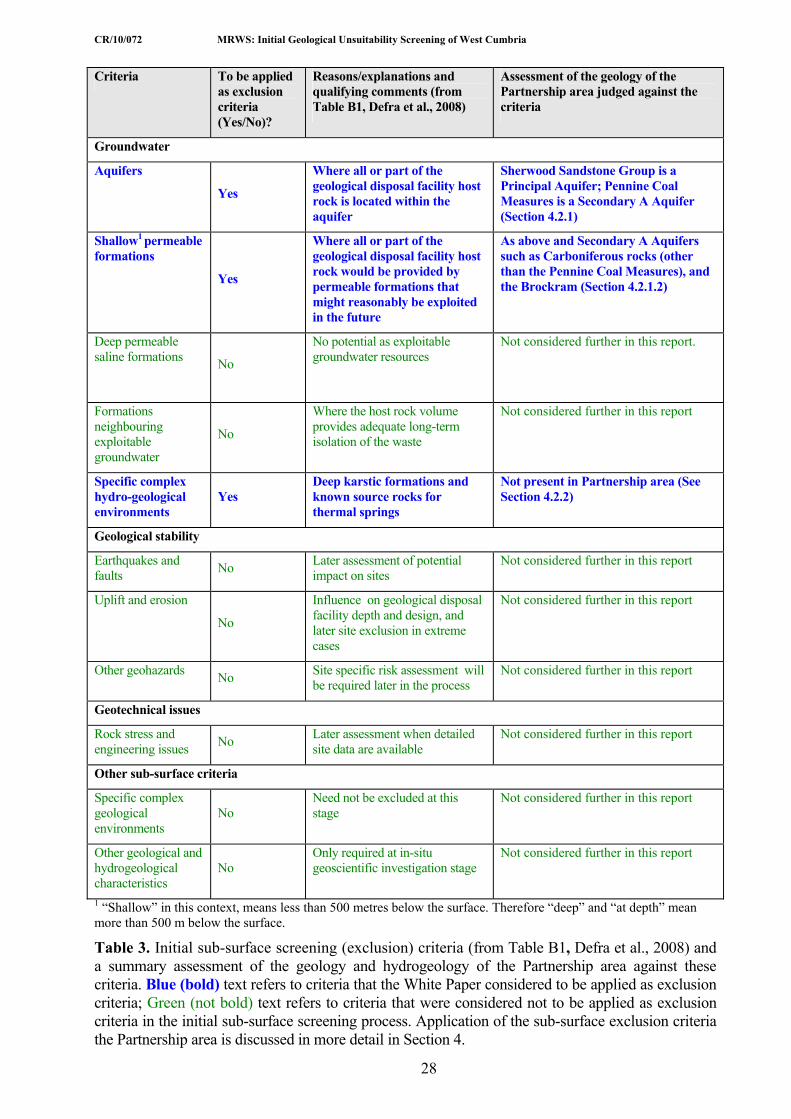
CR/10/072 MRWS: Initial Geological Unsuitability Screening of West Cumbria
28
Criteria To be applied as exclusion criteria (Yes/No)?
Reasons/explanations and qualifying comments (from Table B1, Defra et al., 2008)
Assessment of the geology of the Partnership area judged against the criteria
Groundwater
Aquifers
Yes
Where all or part of the geological disposal facility host rock is located within the aquifer
Sherwood Sandstone Group is a Principal Aquifer; Pennine Coal Measures is a Secondary A Aquifer (Section 4.2.1)
Shallow1 permeable formations
Yes
Where all or part of the geological disposal facility host rock would be provided by permeable formations that might reasonably be exploited in the future
As above and Secondary A Aquifers such as Carboniferous rocks (other than the Pennine Coal Measures), and the Brockram (Section 4.2.1.2)
Deep permeable saline formations No
No potential as exploitable groundwater resources
Not considered further in this report.
Formations neighbouring exploitable groundwater
No
Where the host rock volume provides adequate long-term isolation of the waste
Not considered further in this report
Specific complex hydro-geological environments
Yes Deep karstic formations and known source rocks for thermal springs
Not present in Partnership area (See Section 4.2.2)
Geological stability
Earthquakes and faults No Later assessment of potential
impact on sites Not considered further in this report
Uplift and erosion
No
Influence on geological disposal facility depth and design, and later site exclusion in extreme cases
Not considered further in this report
Other geohazards No Site specific risk assessment will be required later in the process
Not considered further in this report
Geotechnical issues
Rock stress and engineering issues No Later assessment when detailed
site data are available Not considered further in this report
Other sub-surface criteria
Specific complex geological environments
No Need not be excluded at this stage
Not considered further in this report
Other geological and hydrogeological characteristics
No Only required at in-situ geoscientific investigation stage
Not considered further in this report
1 “Shallow” in this context, means less than 500 metres below the surface. Therefore “deep” and “at depth” mean more than 500 m below the surface.
Table 3. Initial sub-surface screening (exclusion) criteria (from Table B1, Defra et al., 2008) and a summary assessment of the geology and hydrogeology of the Partnership area against these criteria. Blue (bold) text refers to criteria that the White Paper considered to be applied as exclusion criteria; Green (not bold) text refers to criteria that were considered not to be applied as exclusion criteria in the initial sub-surface screening process. Application of the sub-surface exclusion criteria the Partnership area is discussed in more detail in Section 4.

CR/10/072 MRWS: Initial Geological Unsuitability Screening of West Cumbria
29
4 Assessment of the Sub-surface Screening Criteria for Geological Domains in the Partnership Area
In this section the sub-surface screening criteria for natural resources and groundwater (Table 3) are assessed against the geology and hydrogeology (groundwater) of the Partnership area.
4.1 NATURAL RESOURCES
4.1.1 Coal and Coal-Bed Methane The coal resource is taken in this report to include both solid coal deposits and the associated methane gas, known as Coal-Bed Methane (CBM). Methane is naturally generated as part of the coal-forming process. The presence of significant thicknesses of low-permeability mudstone and siltstone, above and below the coals, prevents the early escape of methane during coalification, preserving the gas as CBM, either adsorbed in the coal or as free gas in voids (Bailey et al., 1995).
The primary coal and CBM resource in the region is the Carboniferous Pennine Coal Measures Group. The coals, which are present throughout the thickness of the rock unit, are typically bituminous and of high volatile content (Akhurst et al., 1997). In the Cumbrian Coalfield, the group occupies a narrow outcrop from Whitehaven, northwards through Workington and Maryport and eastwards to Aspatria, but also occurs locally in adjacent offshore areas (Figures 4 and 9, sections A-B and C-D). Between Whitehaven and Maryport, the Pennine Coal Measures Group is about 350 m thick, comprising over 30 named coal seams with a combined total thickness of 28 m. The thickest seam, the Main Coal, is up to 4.5 m thick (Young et al., 2001). The Pennine Coal Measures Group also occurs below younger Carboniferous and Permo-Triassic strata within the Cumbrian Coalfield (Figure 9, section A-B, C-D and E-F). Beneath the Solway lowlands (Carlisle Basin), interpretation of seismic reflection data indicates that the Pennine Coal Measures Group is present at depth below Permo-Triassic strata, joining the concealed extents of the Cumbrian Coalfield with the Canonbie Coalfield (BGS, 1999a). However, this interpretation of seismic data is unproven by boreholes and the area is untouched by mining.
CBM levels within the Cumbrian Coalfield (7.5 m3 tonne-1) and Canonbie Coalfield (6.3 m3 tonne-1) are relatively high (Creedy, 1986; 1991) and methane was historically used as a power source at Haig Colliery, Whitehaven. However, in the Cumbrian Coalfield extensive mining of coal and the high density of faulting, have limited any exploitable resource (Young et al., 2001; Stone et al., 2010). Optimum CBM extraction depths are 800–1000 m below ground surface, mostly below the depth of historical deep coal mining (Bailey et al., 1995).
An additional minor coal resource area is associated with thin coal seams in the upper part of the Yoredale Group, including the Little Limestone Coal and Udale Coal. The Little Limestone Coal is up to 0.5 m thick, extensively worked to depths of about 50 m in the Cockermouth area (Eastwood et al., 1968). The coals are too thin to be considered a potential CBM resource. Coal resource areas shown on the mineral plan for the Yoredale Group coals are all at depths less than the 100 m exclusion criteria threshold and so have not been included within the Exclusion Area for Coal and CBM natural resources (Young et al., 2001).
Approach to application of the Exclusion Criteria The ‘intrusion risk to depth’ for coal resources (both coal and CBM) is considered to be relevant where the resource occurs at greater than 100 m depth (Defra, 2007; Defra et al., 2008). Therefore, the application of the exclusion criterion requires the depth of the base of the Pennine
CR/10/072 MRWS: Initial Geological Unsuitability Screening of West Cumbria
30
Coal Measures to be identified to determine whether or not the resource extends below 100 m depth and, therefore, identify the extent of the Exclusion Area.
Initially, consideration was given to the option of using available contoured sub-surface models for the base of the coal-bearing strata (broadly equivalent to the base of the Pennine Coal Measures Group), subtracted from a digital elevation model to generate a depth to base of the resource. It would then be possible to omit from the Exclusion Area areas where the depth is less than 100 m. However, the base Pennine Coal Measures Group sub-surface model, in 200 m contour intervals relative to OD, is sourced from maps at 1:625 000-scale derived largely from seismic reflection interpretation, and is of insufficient accuracy to carry out such an exercise (Kirby et al., 1994; Chadwick et al., 1995) and this approach was therefore discounted.
Consequently, the Exclusion Area for coal and CBM resources has been established from data held in a BGS mineral resource Geographical Information System (GIS) developed in order to produce maps of mineral resources for development plans (Young et al., 2001). This database includes information on the extent of a number of resource categories, and the extent of the following three resource categories have been used to identify the extent of the Exclusion Area:
a) areas identified as “deep coal in excess of 1200m”. Onshore, this is restricted to a small area east of Silloth, between Abbey Town [NY 168 500] and Newton Arlosh [NY 200 556].
b) areas identified as “deep coal between 50 m and 1200 m”. This relates to onshore areas where the Pennine Coal Measures Group occurs beneath Permo-Triassic strata, with the exclusion of area (a), described above. This resource type coincides with the extent of deep coal shown on the coal resources maps for west Cumbria and Canonbie, and less precisely with the Coal Resources map for the UK, which also shows the offshore extent of deep coal resources (BGS, 1999a; BGS 2007b).
c) areas of shallow coal resources, where the “buried coal resource is overlain by up to 50 m overburden” (BGS, 2007b). This “overburden” is typically strata (without coal) of the Warwickshire Group and Brockram (formation), which locally overlie the Pennine Coal Measures Group. The Permian Brockram (formation) rests with a marked angular unconformity on gradually older strata to the east (Figure 9, section E-F). Examination of the Coal Resource Appraisal Map for this study has identified that the map mistakenly shows deep coal resources beneath all areas of Brockram (formation) (BGS, 2007b). However, east of Frizington [NY 050 180] and west of Cleator [NY 000 130] the Brockram (formation) rests unconformably upon the Yordale Group, with the Pennine Coal Measures Group absent through erosion (BGS, 2004). To identify the Exclusion Area as part of this exercise, it has, therefore, been necessary to predict where the coal resource area is present beneath the Brockram (formation); only this area has been included within the Exclusion Area.
For the above three categories, the full thickness of Pennine Coal Measures Group (up to 350 m) is present beneath Upper Carboniferous to Triassic strata. Consequently, the deepest coals within the group must occur at depths greater than the 100 m threshold depth recognised for this exclusion area.
In addition to that identified by the three categories above, the horizontal cross-section for the Kirkbean Sheet (BGS, 1998) (Figure 9, section A-B) shows Pennine Coal Measures appearing beneath Permo-Triassic strata in the coastal area south of Silloth [NY 080 470]. This interpretation is presumed to have been defined from a seismic line (Enterprise E86H-65) which follows the onshore line of the cross-section. This interpretation is not present in the structural contour plot for the Pennine Coal Measures Group (Chadwick et al., 1995) nor in the mineral resources and coal resources plans (BGS, 1999a; Young et al., 2001; BGS, 2007b). Furthermore, the extent of coal resources offshore from the west Cumbria coast is derived from BGS (2007b).

CR/10/072 MRWS: Initial Geological Unsuitability Screening of West Cumbria
31
To identify where the Pennine Coal measures Group occurs at outcrop, and that the base of the resource occurs in excess of 100 m depth, a widely mapped horizon (e.g. a named coal or marine marker band) which occurs approximately 100 m above the base of the Pennine Coal Measures Group was identified. Where this horizon occurs at outcrop it marks a line at which the base of the group, and hence the coal resource, occurs at a depth of 100 m. This interpretation depends on two assumptions:
a) that there is negligible thickness of superficial deposits as significant deposits would result in an underestimation of the exclusion area. A superficial deposit thickness greater than 20 m is uncommon in areas where the Pennine Coal Measures Group occurs at outcrop (Lawley and Garcia-Bajo, 2009) and, therefore, this assumption is considered to be reasonable. It may be a factor in relatively small areas in the Dearham area [NY 080 360] and east of Workington [NY 080 270], where it is conceivable that the Exclusion Area may be a minor underestimate of the area where coal resources exist below 100 m depth;
b) the structural dip is less than 35 degrees. This is because at greater dips the thickness of a succession no longer broadly equates with the true depth. Structural dips, though locally greater than 35 degrees in the proximity of major faults, are typically less than this figure within the Partnership area and, therefore, this assumption is considered to be reasonable.
The following two parameters have been used to identify the widely mapped horizon which occurs approximately 100 m above the base of the Pennine Coal Measures Group referred to above, and which has been used in this study to identify the additional area to be included within the Exclusion Area:
1) In the north outcrop of the Cumbrian Coalfield (Maryport to Wigton) the Pennine Lower Coal Measures Formation is approximately 100 m thick (BGS, 1999a). Consequently, the boundary of the 100 m threshold for the Exclusion Area for Coal and CBM natural resources is thus taken at the base of the overlying Pennine Middle Coal Measures. A departure from this occurs in the extreme east of the coalfield, north-east of Caldbeck [NY 328 450], where coal seams are absent, and, therefore, these areas are not shown within the excluded areas. Coal seams are absent in this area, in part, because of a non-sequence and absence of the lower part of the Pennine Lower Coal Measures, but also because of oxidation of coals within the reddened succession beneath the Permo-Triassic unconformity (Eastwood et al., 1968).
2) In the Maryport and Whitehaven areas the Pennine Lower Coal Measures Formation is approximately 120 m thick (Young and Armstrong, 1989; BGS, 2004). The Six Quarters Coal occurs on average about 75 m above the base of the Pennine Lower Coal Measures Formation, but varies markedly from 105 m in the west [NY 020 330] to about 55 m in the east [NY 050 330] (Eastwood, 1930; Young and Armstrong, 1989). The Six Quarters Coal is, therefore, used as the proxy for the 100 m depth in the west of the Maryport area and the Whitehaven area. In this area, where the Six Quarters Coal is absent on the published map, the overlying Lickbank Coal is used as an alternative proxy. In the east of the Maryport area and extreme west of the Cockermouth area (west of the 130 Easting) the Little Main Coal, which occurs about 90 m above the base of the Pennine Lower Coal Measures Formation represents the most suitable proxy for the 100 m depth, and is used in preference to the Six Quarters Coal in this area.
Application of exclusion criteria Sub-surface screening criteria (Defra, 2007, p.12) state that: Given the fact that deep coal mining in the UK has been undertaken to depths of over 1000 m and that new exploitation techniques, such as in-situ gasification, can be undertaken at depth, areas known to be underlain by coal at greater than 100 metres depth should be excluded because the risk of later intrusion is high.

CR/10/072 MRWS: Initial Geological Unsuitability Screening of West Cumbria
32
The Exclusion Area for coal and coal-bed methane shown on Figure 10 represents the surface area, and the extension in the sub-surface, underlain by coal at depths greater than 100 m. The excluded rock volume extends to 1000 m depth. Sub-surface structural contours on the base of the Pennine Coal Measures Group are shown at 500 m and 1000 m below OD, where known, to illustrate the regional dip (inclination) of these coal-bearing rocks. The Cumbrian Coalfield is not currently mined for coal, but the areas shown on the map might be prospective for coal or coal-bed methane in the future and, therefore, subject to the risk of intrusion by boreholes or deep mining.
4.1.2 Oil and Gas Hydrocarbons (oil and gas) are a prime economic resource in the Irish Sea, although the nearest area of extraction to the Partnership area is within the North and South Morecambe Bay gasfields, which are located at least 25 km to the south-west of the 5 km offshore limit (Jackson et al., 1995). Significant oil finds are mainly from the southern part of the Irish Sea, extending offshore from the coasts of Merseyside and North Wales. The southern margin of the Solway (Carlisle) Basin has attracted exploration interest based on the possibility of hydrocarbon accumulations in structurally closed anticlines at, or near, the basin margin. No area within the 5 km offshore limit is currently under licence (Figure 11). Onshore areas currently under licence include an area between Whitehaven and St Bees, and from the Solway Firth south through Wigton (DECC, 2010). A number of seismic reflection surveys, and some drilling, has been undertaken, though so far without the discovery of viable reserves (Stone et al., 2010).
Minor oil and bitumen occurrences have been reported from sandstone beds of the Pennine Coal Measures Group in the Whitehaven district and at Dovenby, near Dearham, and from mineral veins at Eaglesfield [NY 088 286], Gilcrux [NY 1334 3801], Caldbeck [NY 340 407] in limestones of the Yoredale Group (Smith, 1920). However, these minor occurrences are not considered an exploitable resource, and are covered in Section 4.1.1 on coal and coal bed methane with which they are associated. Oil shows have also been recorded in boreholes in the vicinity of the Canonbie Coalfield, though these are to the north of the Partnership area (Chadwick et al., 1995). Offshore of the west Cumbria coast, gas has been found in a Sherwood Sandstone reservoir, but with insufficient quantities to be produced (Akhurst et al., 1997).
Areas of potential hydrocarbon exploration require the presence of a suitable source rock, a reservoir rock within which the hydrocarbons are stored, an impermeable seal rock and sufficient depths of burial to convert the organic material to gas or oil. These issues in relation to the Partnership area are discussed, in turn, below.
The hydrocarbon source-rocks in the adjacent Irish Sea Basin are entirely of Carboniferous age (Jackson et al., 1995). The prime oil-prone source rocks are Lower Carboniferous shales, in particular the Bowland Shale Formation (Craven Group), which has oil yields of up to 14 kg tonne-1 (Fraser et al., 1990). The northern limit of this formation extends approximately from the Duddon estuary to the southern part of the Isle of Man; the formation is absent at outcrop or offshore within the Partnership area (Dean et al., in press), and strata of equivalent age in west Cumbria and the immediate offshore areas are represented by the Yoredale Group. Minor amounts of oil and gas may originate from bituminous limestone, cannel coal and carbonaceous marine mudstone present within this group. In the offshore area between the Isle of Man and Cumbria, exploration data for strata probably equivalent to the Yoredale Group suggests the succession has low total organic carbon (TOC) ranging up to 0.82 per cent, with the exception of some sporadic thin gas-prone mudstone and coals (Newman, 1999). The absence of suitable source rocks suggests there is nil to poor potential for gas and oil from most of west Cumbria (Fraser et al., 1990). Carboniferous mudstone from the margins of the Solway Basin and Isle of Man contain poor to moderate quantities (TOC of less than 5 per cent) of gas-prone organic matter (Racey et al., 1999). In the Solway Basin of north Cumbria there is a poor to moderate

CR/10/072 MRWS: Initial Geological Unsuitability Screening of West Cumbria
33
potential oil yields of 2–14 kg tonne-1 from mudstone present within the Border and Yoredale groups (Fraser et al., 1990).
In the East Irish Sea Basin, oil and gas occur in reservoirs ranging from Lower Carboniferous strata up to the Mercia Mudstone Group rocks. The main exploration scenarios in the Irish Sea and adjacent onshore areas are where one of the following criteria is present (Jackson et al., 1995):
a) The Ormskirk Sandstone Formation has a top and lateral seal of Mercia Mudstone Group. Most existing discoveries in the Irish Sea have been made in this reservoir. The Ormskirk Sandstone Formation is present onshore along the west Cumbria coast around Seascale and Drigg [NY 014 030 to SD 057 961] and offshore from Seascale to southwest of Millom [SD 115 740]. The Ormskirk Sandstone and Calder Sandstone formations are also interpreted in seismic reflection profiles to occur beneath the Mercia Mudstone Group in the Carlisle Basin (Akhurst et al., 1997). The sandstone formations are interpreted as ranging from 300 to 500 m depth north of Wigton [NY 25 50] to 500 to 1000 m near Angerton [NY 20 60];
b) The Permian Collyhurst Sandstone Formation and/or Upper Permian carbonates (e.g. limestone and dolostone) are sealed by the Manchester Marls Formation/Upper Permian evaporites or juxtaposed against a lateral seal of Mercia Mudstone Group at major faults. The Collyhurst Sandstone and Manchester Marls formations are absent from the Partnership area. However, the equivalent Permian Penrith Sandstone and Eden Shales formations occur, respectively, in the Carlisle (Solway) Basin. The Penrith Sandstone Formation is interpreted in seismic reflection profiles to be present at a depth of 750 m below OD north of Wigton. The formation thickens westwards (from 0 m to 500 m thick), and is present at greater depth, up to 1700 m below OD near Angerton (Holliday et al., 2004).
c) Carboniferous sandstone and some limestone/dolomite rocks retain primary porosity, or have acquired secondary porosity and are sealed by mudstones or at fault contacts. This could include all Carboniferous strata present in the Partnership area. However, intergranular porosities are low (typically 5 per cent, though locally up to 15 per cent), hydrocarbon seals are unlikely to be present and reservoir volumes small and offers little reservoir potential in this region (Newman, 1999; Chadwick et al., 2001).
As described above, the weakly permeable Mercia Mudstone Group, and to a lesser extent the Eden Shales Formation, form the dominant seal rocks. However, to prevent hydrocarbons escaping to the surface these seals need to occur in anticlinal closures or fault blocks, most of which have NE–SW or N–S orientations in the Solway (Carlisle) Basin (Newman, 1999). Identification of suitable trap structures in the Partnership area has not been carried out as part of this exercise. However, two wells: Silloth 1 and West Newton 1 (Figure 11) have been drilled to test for hydrocarbons in potential trap structures and were abandoned as dry holes (Young et al., 2001). A third exploration well, Fisher Gill 1 indicates that the area is still prospective for oil and gas (DECC, 2010).
4.1.2.1 SHALE GAS
There has been recent interest in the UK for the potential exploitation of shale gas. Shale gas differs from conventional hydrocarbon exploration, described above, in that the shale formation is not only the source-rock, but also the reservoir and impermeable seal. Shale typically has low permeabilities, so exploration concentrates on the identification of volumes with enhanced permeabilities, such as coarser grained beds, siltstones or sandstones, and/or fracture systems, particularly in areas associated with the crests of anticlines and geological faults (Selley, 2005). Within the Partnership area the main potential shale-gas source rocks, as with conventional hydrocarbon exploration, are the Carboniferous Border and Yoredale groups present in north Cumbria, north of the Maryport Fault (Figure 9, section A-B).

CR/10/072 MRWS: Initial Geological Unsuitability Screening of West Cumbria
34
Application of exclusion criteria The CPG/CRP report recognises that: ‘It is not feasible to predict possible future exploration areas for exclusion but it is appropriate to exclude areas from consideration based on the extent of known oil and gas fields. It is the risk of intrusion into the repository in conjunction with the loss of future oil and gas resource that is addressed by this exclusion.’ As noted above, the main potential area for oil exploration within the Partnership area is present in north Cumbria, where: (a) there is poor to moderate potential oil yields from a Carboniferous source-rock, and (b) there is a suitable reservoir rock and impermeable seal. This area has already been investigated with exploration wells, but currently without success.
The wording: ‘Known oil and gas fields..’ (Defra, 2007) implies that these resources have been proven, rather than an area or rock volume that is currently prospective, as is the case in the north Allerdale area. Consequently, no areas have been screened out at this stage in the MRWS process. If ‘conventional’ oil and gas resources or shale gas resources were to be confirmed in this area, then this criterion would need to be considered at later stages in the MRWS process as a potential future risk of intrusion and loss of oil and gas resources.
4.1.3 Oil Shale Oil shales are organic-rich mudstone-dominated rocks which contain significant amounts of organic matter (kerogen). Oil shales have been mined in the past in the UK and were retorted for mineral oil and used for lighting. Thin beds of oil shale are present within the Border and Yoredale groups (Chadwick et al., 1995) and also within the Pennine Coal Measures Group (Eastwood et al., 1931) (see Section 4.1.2).
Application of exclusion criteria The CPG/CRP report recommends that: ‘areas in which oil shales are known to occur at greater than 100 metres depth should also be excluded from consideration because of the risk of intrusion’. The small amounts of oil that have been recorded from the Pennine Coal Measures Group in the Whitehaven area are not considered to be a natural resource that might be explored for, or exploited, in the future. Since the minor oil seeps within these coal-bearing rocks is covered by the potential risk of intrusion for coal and coal-bed methane, oil shale in the Pennine Coal Measures Group is also excluded in the area shown in Figure 10.
The thin beds of oil shale in the Border and Yoredale groups are not considered to be a natural resource that might be explored for, or exploited, in the future, and consequently are not excluded.
4.1.4 Metalliferous Ores Lower Palaeozoic rocks of the Lake District and west Cumbria host a wide variety of formerly economic mineral deposits, none of which are worked today. Most significant in terms of their ‘footprint’ are the iron ore deposits and these are discussed separately below. Mention is made here, for completeness, of the many other metalliferous ore deposits scattered throughout the Partnership area, including copper at Black Combe and near Ulpha, lead and zinc in the Caldbeck Fells (Roughton Gill Mines), Force Crag [NY 200 215] and in the Vale of Newlands, and antimony at Robin Hood [NY 228 328] near Bassenthwaite (BGS, 1992). The Caldbeck Fells is one of the most extensively mineralised areas of northern England, and historically has produced significant quantities of metalliferous ores such as lead, zinc and tungsten from veins hosted by Eycott Volcanic Group and intrusive rocks (Cooper and Stanley, 1990).
The metalliferous deposits occur in steeply dipping veins, and workings follow a narrow belt along these. Many of the metalliferous deposits were worked at shallow depths of less than 100 m beneath the surface, and therefore are not excluded at this initial sub-surface screening stage (Defra, 2007). However, some of the veins, notably at the Roughton Gill Mines in the
CR/10/072 MRWS: Initial Geological Unsuitability Screening of West Cumbria
35
Caldbeck Fells and at Force Crag have been worked more than 100 m perpendicularly below the often steep and irregular land surface (e.g. Adams, 1988; Postlethwaite, 1913; Tyler 2003). Further resources may be present at greater depths and their occurrence at other locations in the Partnership area cannot be ruled out, but very little information is currently available to determine their potential (Cooper et al., 1992; Cameron et al., 1993). However, these resources, if they indeed exist, are thought unlikely to be economic at present market prices and, therefore, are also not excluded at this stage in the sub-surface screening process. The potentially economic tungsten-bearing veins at Carrock Fell Mine [NY 323 329] lie just outside the Partnership area, but are also known to extend close to, if not in excess of, 100 m perpendicular to the land surface.
Non-metalliferous ores (industrial minerals) are also present such as baryte in the Caldbeck Fells and at Force Crag, and graphite in Borrowdale [NY 232 125] but these industrial minerals do not meet the sub-surface screening criteria because of their ‘low resource value - limiting the potential for economic exploitation at depth’ (Defra, 2007).
4.1.4.1 IRON ORE
Iron ore (mainly hematite) has been mined in two districts within the Partnership area (Smith, 1924; Rose and Dunham, 1977; Akhurst et al., 1997). The principal hematite orebodies and mined areas occur between Lamplugh [NY 055 200] and Haile [NY 008 058] which forms the West Cumbrian Orefield, and in the south of the area near Hodbarrow [SD 178 785] and at Waterblean [SD 177 824] near Millom. Cumbrian hematite ore was ideally suited to the production of iron for steel making. The largest orebodies in the West Cumbrian Orefield were worked until the late 1970s, but small-scale production for the manufacture of pigment continued to about 2006 from shallow workings in the Florence Mine, near Egremont [NY 017 103]. None of the mines are currently in production. Total reserves at the end of large-scale mining were reported to be about 1 million tons (Shepherd and Goldring, 1993). In the Hodbarrow area adjacent to the Duddon estuary, hematite mining ceased in 1968, and the small Waterblean Mine closed in the late 19th century (Rose and Dunham, 1977). Siderite (clay ironstone) nodules were also mined as a by-product of coal mining, but production ceased around 1900 (Eastwood et al., 1931). In the context of the exclusion criteria these siderite ores are not considered to be a resource, and are covered by the criteria applying to coal (Section 4.1.1) since they occur in association with coal deposits within the Carboniferous Pennine Coal Measures Group.
West Cumbrian Iron (hematite) Orefield Hematite ore was first discovered in the exposed belt between Lamplugh and Egremont where the Carboniferous Great Scar Limestone Group, the main host-rock, is present near the surface. South of Egremont in the ‘concealed’ part of the orefield, the Great Scar Limestone Group passes beneath a cover of younger Permian and Triassic rocks (mostly sandstone).
The west Cumbrian iron orebodies are composed almost exclusively of massive hematite including varieties such as ‘kidney ore’ (a mammillated, fibrous crystalline variety), though compact, massive and crystalline forms also occur (Smith, 1924; Shepherd and Goldring, 1993). Minor amounts of other metalliferous minerals have been recorded in association with the hematite, such as manganese oxides, malachite and galena, but these represent less than 1 percent of the ore. Gangue minerals such as quartz, aragonite, baryte, fluorite and calcite are also present, but are not considered economic (Young, 1987; Goldring and Greenwood, 1990).
Most hematite orebodies occur as replacement of limestone adjacent to faults and joints (Smith, 1924). Orebodies vary in size from small-scale patchy alteration and replacement along joints to irregular bodies or ‘flats’ (tabular ore bodies sub-parallel to bedding in the limestone) that may extend for several hundreds of metres (Akhurst et al., 1997; Rose and Dunham, 1977). Most orebodies occur within (i.e. replacement of) the Great Scar Limestone Group and are associated

CR/10/072 MRWS: Initial Geological Unsuitability Screening of West Cumbria
36
with faults, although a small number of occurrences have been worked in adjacent overlying strata, e.g. the Warwickshire Group at Millyeat Mine near Frizington [NY 024 177] (Smith, 1924). In addition, where the younger Permo-Triassic strata unconformably overlie the orebodies, limestone-rich parts of the Brockram Formation have been locally replaced by hematite (Stone et al., 2010).
Hodbarrow Orefield Similar hematite ores were worked in the Hodbarrow area in the south of the Partnership area, adjacent to the Duddon estuary. All the ore deposits are found associated with faults and joints within the Carboniferous Great Scar Limestone Group, with one exception, that of the Waterblean orebody [SD 175 825] located near Millom, where the ores are hosted as veins in a thin Lower Palaeozoic limestone (Dent Group) (Smith, 1924; Rose and Dunham, 1977). As in the West Cumbrian Orefield, the surface and sub-surface distribution of the Great Scar Limestone Group where it is, or was formerly, overlain by Permian and Triassic sandstones, provides a good proxy for the distribution of workable hematite orebodies. All the vein orebodies occupy fissures which may be faults or, less commonly, joints, sometimes merging to form large irregular masses. Other larger ore bodies occupy ‘flats’ i.e. tabular ore bodies sub-parallel to bedding in the limestone e.g. the main Hodbarrow orebody averaged 20 m thick over an area of 350 000 m2. In the Red Hills area small orebodies occur near the surface below thin Quaternary superficial deposits, but the main Hodbarrow orebodies lie at depths from the surface ranging from about 50 to 100 m, often below a cover of Quaternary superficial deposits (Rose and Dunham, 1977). The deepest workings were at about 150 m below Ordnance Datum (OD) in the Hodbarrow Moorbank South Mine and Whicham Mine, 4 km north-west of Hodbarrow. In an area, about 500 m wide to the west of the known Hodbarrow Orefield, the host-rock limestone dips (is inclined) to the south-west, and it has been tentatively postulated that small orebodies may be present, at depth, on the north side of the Duddon estuary (Rose and Dunham, 1977).
Other minor hematite orebodies A number of fissure (near-vertical) vein deposits are found in Skiddaw Group rocks, such as the Kelton Fell and Knockmurton mines. Here, veins of up to 6 m wide were worked in narrow mines up to about 180 m depth below ground level (Akhurst et al., 1997). Vein-like occurrences of hematite in the Eskdale Granite Pluton and Borrowdale Volcanic Group were also mined near Boot [NY 176 012], mainly in the late 19th century, and briefly 1917 when it closed (Smith, 1924). Neither of these hematite occurrences is likely to be economically viable in the future, and the areas are not excluded at this stage in the sub-surface screening process.
Application of exclusion criteria The strong lithostratigraphical and structural association of mineable west Cumbrian hematite orebodies with the areas of Carboniferous limestone (mainly the Great Scar Limestone Group) especially where the latter is (or was formerly) overlain by permeable Permo-Triassic rocks means that the distribution of potentially economic orebodies at depth is, to an extent, predictable. The sub-surface exclusion criteria recommend that ‘areas underlain by deep (more than 100 metres) known, potentially economic, ore deposits should be excluded’.
At current commodity prices the commercial large-scale mining of the hematite ores is unlikely in the near future. However, this does not rule out potential exploration and exploitation at sometime in the future. The depth of the main known orebodies in west Cumbria ranges from near surface (commonly less than 50 m depth, but often obscured by a thin cover of Quaternary Superficial Deposits) to about 300 m depth in the Florence Mine [NY 017 103] (Smith, 1924; Akhurst et al., 1997). Similarly, in the Hodbarrow orefield the known main orebodies lie at up to 150 m below OD, generally as flat-lying or gently inclined orebodies. Thus, the depth of some of the known orebodies lies within the depth range for a GDF outlined in the exclusion criteria (Defra et al., 2008).

CR/10/072 MRWS: Initial Geological Unsuitability Screening of West Cumbria
37
The delineation of areas greater the 100 m depth (Figure 12) is based on mine and orebody records summarised in a number of publications (Smith, 1924; Rose and Dunham, 1977; Akhurst et al., 1997). Hematite mine areas where workings are known to be less than 100 m depth have not been excluded. Areas between Eskett Quarry and Lampugh where ore bodies occur in the Great Scar Limestone Group are considered to be at shallow depth and have not been excluded. However, ore bodies shown as occurring within the Great Scar Limestone, but beneath a cover of Permo-Triassic rocks are considered to be at sufficient depth (> 100 m) have been excluded. On Figure 12 there has been some rationalisation of small ore bodies to define the mapped extent of these areas.
The orebodies in the Hodbarrow area are shown on a map and cross-sections in Rose and Dunham (1977, figures, 17, 18, respectively). The Red Hills orebody is shown to be everywhere at depths shallower than 100 m. The main orebody dips south-westward to increasingly greater depth. The map published by these authors distinguishes between areas where the orebody occurs immediately below superficial deposits, and the horizontal extension of the orebody which is locally present below 100 m depth. The later category has been used to define the deep orebody shown in Figure 12.
Although hematite is no longer worked economically in west Cumbria, there may be reserves at depth which could potentially be worked economically in the future. We have, therefore, taken the precautionary view that the West Cumbrian and Hodbarrow hematite orefield areas lying at, or greater than, 100 m depth below ground surface are designated as exclusion areas that may represent future potential areas of mining within the Exclusion Criteria threshold (greater than 100 m depth). Further detailed sub-surface studies would be required at later stages of the MRWS process to determine if any of these areas might be suitable repository sites at depth.
4.1.5 Disposal of wastes/gas storage The CPG/CRP report recommends that: ‘areas with current or approved future hazardous waste disposal at depths greater than 100 metres should be excluded’ (Defra, 2007). Disposal of carbon dioxide (‘sequestration’) in un-mined coal seams and deep permeable saline formations is a potential future technology, but there are no current or approved areas in the Partnership area. Coal-bearing rocks (Pennine Coal Measures) are excluded based on the intrusion risk to depth (Section 4.1.1).
Application of exclusion criteria There are no current or approved areas or rock volumes at depths greater than 100 m for the disposal of hazardous waste, carbon dioxide or other gases within the Partnership area.
4.2 GROUNDWATER
4.2.1 Aquifers
Aquifers are defined in the CPG/CRP report (Defra, 2007) as: permeable formations that are exploited for groundwater use. The report goes on to advise that: ‘Aquifers would not be suitable rock volumes in which to construct a repository. Other permeable formations from which groundwater is not currently exploited but which might reasonably be exploited in future, either as a result of treatment of the water or through the use of these formations as water storage reservoirs using aquifer storage recovery methods, should also be protected. Areas where all or part of the repository host rock would be provided by aquifers, or other permeable formations that might reasonably be exploited in the future, should be excluded.’ The CPG/CRP report states that: ‘Areas where a potential host rock volume exists in proximity to an exploitable groundwater resource (laterally or below) could be suitable as long as the thickness and properties of the rock volume provide adequate long-term isolation. Such area should not be excluded at this stage.
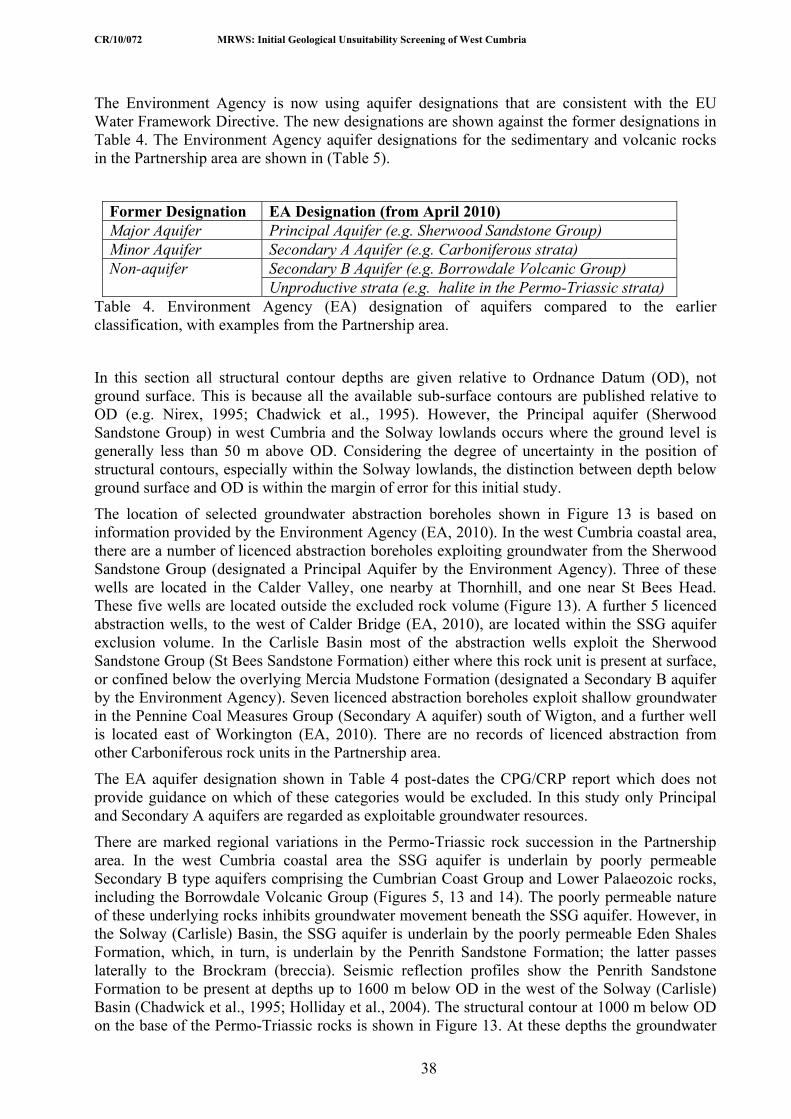
CR/10/072 MRWS: Initial Geological Unsuitability Screening of West Cumbria
38
The Environment Agency is now using aquifer designations that are consistent with the EU Water Framework Directive. The new designations are shown against the former designations in Table 4. The Environment Agency aquifer designations for the sedimentary and volcanic rocks in the Partnership area are shown in (Table 5).
Former Designation EA Designation (from April 2010) Major Aquifer Principal Aquifer (e.g. Sherwood Sandstone Group) Minor Aquifer Secondary A Aquifer (e.g. Carboniferous strata)
Secondary B Aquifer (e.g. Borrowdale Volcanic Group) Non-aquifer Unproductive strata (e.g. halite in the Permo-Triassic strata)
Table 4. Environment Agency (EA) designation of aquifers compared to the earlier classification, with examples from the Partnership area.
In this section all structural contour depths are given relative to Ordnance Datum (OD), not ground surface. This is because all the available sub-surface contours are published relative to OD (e.g. Nirex, 1995; Chadwick et al., 1995). However, the Principal aquifer (Sherwood Sandstone Group) in west Cumbria and the Solway lowlands occurs where the ground level is generally less than 50 m above OD. Considering the degree of uncertainty in the position of structural contours, especially within the Solway lowlands, the distinction between depth below ground surface and OD is within the margin of error for this initial study.
The location of selected groundwater abstraction boreholes shown in Figure 13 is based on information provided by the Environment Agency (EA, 2010). In the west Cumbria coastal area, there are a number of licenced abstraction boreholes exploiting groundwater from the Sherwood Sandstone Group (designated a Principal Aquifer by the Environment Agency). Three of these wells are located in the Calder Valley, one nearby at Thornhill, and one near St Bees Head. These five wells are located outside the excluded rock volume (Figure 13). A further 5 licenced abstraction wells, to the west of Calder Bridge (EA, 2010), are located within the SSG aquifer exclusion volume. In the Carlisle Basin most of the abstraction wells exploit the Sherwood Sandstone Group (St Bees Sandstone Formation) either where this rock unit is present at surface, or confined below the overlying Mercia Mudstone Formation (designated a Secondary B aquifer by the Environment Agency). Seven licenced abstraction boreholes exploit shallow groundwater in the Pennine Coal Measures Group (Secondary A aquifer) south of Wigton, and a further well is located east of Workington (EA, 2010). There are no records of licenced abstraction from other Carboniferous rock units in the Partnership area.
The EA aquifer designation shown in Table 4 post-dates the CPG/CRP report which does not provide guidance on which of these categories would be excluded. In this study only Principal and Secondary A aquifers are regarded as exploitable groundwater resources.
There are marked regional variations in the Permo-Triassic rock succession in the Partnership area. In the west Cumbria coastal area the SSG aquifer is underlain by poorly permeable Secondary B type aquifers comprising the Cumbrian Coast Group and Lower Palaeozoic rocks, including the Borrowdale Volcanic Group (Figures 5, 13 and 14). The poorly permeable nature of these underlying rocks inhibits groundwater movement beneath the SSG aquifer. However, in the Solway (Carlisle) Basin, the SSG aquifer is underlain by the poorly permeable Eden Shales Formation, which, in turn, is underlain by the Penrith Sandstone Formation; the latter passes laterally to the Brockram (breccia). Seismic reflection profiles show the Penrith Sandstone Formation to be present at depths up to 1600 m below OD in the west of the Solway (Carlisle) Basin (Chadwick et al., 1995; Holliday et al., 2004). The structural contour at 1000 m below OD on the base of the Permo-Triassic rocks is shown in Figure 13. At these depths the groundwater

CR/10/072 MRWS: Initial Geological Unsuitability Screening of West Cumbria
39
in the Penrith Sandstone Formation is likely to be saline (Defra, 2007) and is not exploited as an aquifer because of its depth and potential salinity. Consequently, the Penrith Sandstone Formation is not excluded on the groundwater criteria (Defra et al., 2008).
Areas where the base of the SSG aquifer lies at depths greater than 200 m below OD are shown in Figure 13; the structural contour at 500 m below OD indicates the approximate depth of the fresh- saline-water interface as defined by Defra (2007, p.15). In these areas the development of a geological disposal facility would need to take into account the presence to the specified depth of exploitable groundwater resources.

CR/10/072 MRWS: Initial Geological Unsuitability Screening of West Cumbria
40
Table 5. Rock units in the West Cumbria Partnership area, their aquifer potential and application of exclusion criteria. Groups are shown in bold in the Rock Unit column. ORD./SILR.= Ordovician and Silurian.
Age Rock Unit Regional Aquifer Characteristics
Exploitable Groundwater Exclusion Criteria for Rock Unit in the Partnership area
Quaternary superficial deposits
Locally perched aquifers in sand and gravel
Less than 100m thick, so above the minimum depth for a GDF. Not excluded.
Lias and Mercia Mudstone groups
Secondary B Aquifer; poorly permeable strata; essentially non-productive aquifers
Not excluded.
Sherwood Sandstone Group
TR
IASS
IC\J
UR
ASS
IC
Ormskirk Sandstone, Calder Sandstone & St Bees Sandstone formations.
Principal Aquifer; locally exploited, especially St Bees Sandstone Formation Onshore, near the coast, at depths greater than about 500 m below OD, saline groundwater waters and brines are present; saline water and brines are present offshore.
Rock volume to be excluded between -200 m and -500 m depth, but the saline zone below -500 m depth not excluded, due to the presence of saline groundwater and brines. Not excluded where saline marine groundwater is present offshore.
Cumbrian Coast Group
Secondary B Aquifer; poorly permeable strata; essentially non-productive.
Not excluded.
Appleby Group
Penrith Sandstone Formation (Carlisle Basin only)
Principal aquifer, in the Eden Valley (outside of area); not an exploitable groundwater resource (too deep) in the Partnership area.
Not an aquifer in the area; present only in the Carlisle Basin at depths greater than -750 m where groundwater likely to be saline and, therefore, not excluded.
PE
RM
IAN
Brockram Formation
Secondary A Aquifer; not an exploited groundwater resource in the Partnership area.
Where present at outcrop the Brockram is too shallow (<200 m depth) to be excluded; where present at depth in the Carlisle Basin and west Cumbria coastal plain it occurs greater than -500 m depth where groundwater is likely to be saline.
Warwickshire Group
Pennine Coal Measures Group
Border Group
Ravenstonedale Group
Secondary A Aquifer. Only the Pennine Coal Measures is exploited.
Yoredale Group
C
AR
BO
NIF
ER
OU
S
Great Scar Limestone Group
Secondary A Aquifer; minor karstic fracture flow near surface and beneath superficial deposits; fracture flow in limestones (mudstones act as barriers). Not currently an exploited groundwater resource in the Partnership area.
Aquifer excluded between -200 and -500 m depth; the saline groundwater below -500 m depth not excluded. Not excluded offshore where saline marine groundwater is present.
Windermere Supergroup
Borrowdale Volcanic Group
OR
D.\S
ILR
.
Skiddaw Group
Secondary B Aquifer. Poorly permeable strata. Essentially non-productive aquifers, although some flow in weathered zone to c. 25 m depth.
Not excluded.

CR/10/072 MRWS: Initial Geological Unsuitability Screening of West Cumbria
41
In the Partnership area, the Sherwood Sandstone Group (Figures 4 and 8) (see Section 2.4.3 and Table 5) is exploited for public supply, near Aspatria in the Solway (Carlisle) Basin (EA, 2010). The Penrith Sandstone Formation (Appleby Group) is an aquifer in the Eden Valley, outside the Partnership area, but is not exploited in the Solway (Carlisle) Basin because it lies at depth below 500 m and may be saline.
Other permeable rock units listed in Table 5 are either Secondary A Aquifers or Secondary B Aquifers. Of rock units designated Secondary A Aquifers such as the Carboniferous rocks, only the Pennine Coal Measures Group is currently exploited for local supply (EA, 2010) and, therefore, represents excluded rock volumes above the freshwater-saline interface. This area is shown in Figure 13 and illustrated in Figure 14a. Rock units such as the Great Scar Limestone Yoredale, Ravenstonedale, Border and Warwickshire groups, and the Brockram are designated Secondary A aquifers, but are not currently exploited for groundwater resources in the Partnership area.
The Lower Palaeozoic strata, Cumbria Coast, Penarth, Lias and Mercia Mudstone groups are classified as a Secondary B Aquifer (formerly non-aquifers). These rock units do not represent major exploitable groundwater resources as defined both in the Exclusion Criteria (Defra, 2007) and within the spirit of the EU Water Framework directives.
The depth to the base of Quaternary superficial deposits in the Partnership area is variable (Lawley and Garcia-Bajo, 2009) but even where these deposits are thickest on the west Cumbria coastal plain the base is less than 100 m depth below ground surface and, consequently, they do not represent excluded rock volumes within the likely depth of a GDF (i.e. between 200 and 1000 m depth).
4.2.1.1 SHERWOOD SANDSTONE GROUP AQUIFER
The Sherwood Sandstone Group aquifer occurs in the Solway lowlands (Carlisle Basin) and along the west Cumbria coastal plain, south of St Bees Head to the Duddon estuary (Figure 13). Contours at 200 m, 500 m and 1000 m below OD are shown (where known) for the west Cumbria coastal area to illustrate the offshore dip (slope) of the base of the Sherwood Sandstone Group (base SSG aquifer) in Figure 13. In this area, north of Ravenglass, the quality of data is generally good since it is based on numerous boreholes and seismic reflection information (Nirex, 1995).
There are few boreholes in the Solway (Carlisle) Basin so that sub-surface information is less well constrained and is based largely on seismic reflection surveys (Chadwick et al., 1995, map 15). In this area, the structural contour at 500 m below OD is more approximate, and has been extrapolated from the known structural contours on the base of the Permo-Triassic rocks (Chadwick et al., 1995, map 15; figure 38). In the Silloth 1 borehole the base of the SSG aquifer occurs about 400 m above the base of the Permo-Triassic rocks. Based on the thickness in this borehole the position of the structural contour at 500 m below OD on the base of the SSG aquifer is extrapolated in Figure 13.
Fresh water-saline interface
Exclusion Criteria (Defra, 2007) state that: ‘deep permeable formations (i.e. more than 500 metres in depth) are typically saline and have little or no potential for exploitation as water sources because of their poor quality’ and, therefore, should not be excluded. Consequently, the Sherwood Sandstone Group below 500 m depth would not be excluded in the Partnership area (Figures 13 and 14). Data for the depth to the fresh water-saline interface in the Partnership area is sparse. The only information is for a small area (approximately 16 km2) near Gosforth where borehole measurements show the fresh water-saline interface in the SSG aquifer to vary from about 150 m below OD in the east, to 650 m below OD about 2 km inland from the coast, and rising to about 350 m below OD at the coast (Nirex, 1995; Bath, et al., 1996). This interface is
CR/10/072 MRWS: Initial Geological Unsuitability Screening of West Cumbria
42
likely to fluctuate over time depending on a variety of factors such as precipitation trends, change in groundwater abstraction and long-term fluctuation of sea-level. The interface is shown diagrammatically on Figure 14 to illustrate the three dimensional nature of the aquifer rock volumes.
The interface between saline marine and fresh groundwater within the SSG aquifer occurs beneath, or close to, the coast (Black and Brightman, 1996; Bath et al., 2006). The accepted conceptual flow model for the saline interface is upward flow, with saline marine water flowing up and back into the sea and fresh water upwelling against the diffuse zone that forms the saline interface to discharge at or near the coast. Guidance on application of Exclusion Criteria for saline permeable formations offshore is not given in the White Paper. It is assumed that the same criteria apply as for deep saline permeable formations onshore, and therefore that the SSG aquifer, offshore, is not excluded (Figure 13).
The same arguments apply also to hypersaline water, at depth, (see Section 2.4.3) in the Sherwood Sandstone Group as for the saline marine zone. The hypersaline brines, derived from halite dissolution within the Triassic and Permian rocks, are considerably denser than the shallower moderately mineralised groundwater. In the short term, therefore, the hypersaline water is unlikely to be mobilised in an upward direction towards a surface or submarine discharge area. However, as noted above, the hypersaline zone of the Sherwood Sandstone Formation cannot be taken as a stable zone in the longer-term because the hydraulic base level of the sea is liable to change with time.
West Cumbria Coastal Aquifer
For the west Cumbria coastal aquifer (Figure 13) the outcrop of the SSG aquifer to the north-east of the structural contour at 200 m below OD does not represent an excluded rock volume because, here, the SSG aquifer lies above the shallowest depth of the potential GDF (200 m depth). Poorly permeable rocks below the SSG aquifer such as the relatively thin Cumbrian Coast Group and Lower Palaeozoic rocks (Borrowdale Volcanic Group) do not represent excluded rock volumes (Figure 14b). The area between the structural contour at 200 m below OD and the coast is an excluded rock volume above 500 m depth, the presumed saline groundwater interface (Figures 13 and 14b). Underlying poorly permeable rocks are not excluded. Offshore, the Sherwood Sandstone Group is saline and, therefore, also not excluded. This three-dimensional concept for the west Cumbria coastal aquifer is shown diagrammatically in Figure 14b, and is also illustrated in Figures 5, and 7 (section G-H).
Solway (Carlisle) Basin Aquifer
For the Solway (Carlisle) Basin aquifer (Figure 13,) the three-dimensional assessment of the Exclusion Criteria has to take account of rocks underlying the SSG aquifer which, based on other criteria (e.g. coal intrusion risk) may be excluded (see above). Based on groundwater criteria alone, the area of the SSG aquifer rock volume between the structural contour at 200 m below OD and the coast is excluded above 500 m depth (the presumed saline groundwater interface). The rock volume below 500 m OD, where the groundwater is presumed to be saline, is not excluded (Figure 14a).
4.2.1.2 SHALLOW PERMEABLE FORMATIONS AND SECONDARY ‘A’ AQUIFERS
The CPG/CRP report defines shallow permeable formations as: ‘those present at less than 500 metres below the surface’ (Defra, 2007). Shallow permeable formations are considered here as Principal Aquifers and Secondary A Aquifers (Tables 4 and 5), i.e. those with potentially exploitable groundwater. The principal aquifer (Sherwood Sandstone Group) is described above. Other shallow permeable formations listed in Table 5 as Secondary A Aquifers comprise all the Carboniferous rocks and the Brockram. Of these, only the Pennine Coal Measures Group is currently exploited to a limited extent for local supply (EA, 2010).

CR/10/072 MRWS: Initial Geological Unsuitability Screening of West Cumbria
43
The south-east and east boundary (Figure 13) of the main Carboniferous aquifers (including, here, the Permian Brockram which is in continuity with the Carboniferous rocks) is defined by the structural contour at 200 m below OD on the base of the Carboniferous rocks. In west Cumbria coastal area this boundary is constrained by borehole and seismic reflection data (Nirex, 1995). The boundary is less well constrained in the Solway (Carlisle) Basin where there are few boreholes and the boundary is based on interpreted seismic reflection data (Chadwick et al., 1995). In south Cumbria, a small area of Carboniferous rocks is present in the Millom area (Figure 9, Section I-J). The base of these rocks is mainly deeper than 200 m below ground surface (Rose and Dunham, 1977, figs. 17-18). The exception is along the northern margin of the outcrop where steeply dipping Carboniferous rocks may locally be less than 200 m depth. Because of this uncertainty, the entire onshore extent of Carboniferous rocks, taken from BGS (2001) is shown on Figure 13. This represents a small over-exaggeration of the northern extent of this Secondary A Aquifer in the Millom area.
Groundwater is abstracted from seven wells (EA, 2010) in the Pennine Coal Measures south of Wigton, and a further well is located east of Workington (Figure 13). However, all the Carboniferous units and the Brockram are classified as Secondary A Aquifers and may have limited potential for future exploitation.
Application of exclusion criteria Some, but not all, of the rock volume in areas where aquifers and shallow permeable formations (Table 5) are present in the Partnership area at shallower than 500 m depth (presumed saline interface) would be excluded. However, nowhere does the exploitable aquifer rock volume extend over the whole of the 200 to 1000 m depth interval and, consequently, the total area is not excluded at this stage. The isolation of a GDF from exploitable water resources will be a major issue for providing the eventual suitability of any proposed site. These aquifer rock volumes will need to be considered in more detail at later stages in the MRWS process.
4.2.2 Specific Complex Hydrogeological Environments
4.2.2.1 KARST
This criterion includes ‘karst formations (that) occur where channels in soluble rocks, primarily limestone but sometimes chalk, have been developed by dissolution by infiltrating water’ (Defra, 2007). The CPG/CRP report recommends that for karst formations: this unpredictability of groundwater movement and the difficulty of characterisation for reliable modelling make areas with deep karst (extending to hundreds of metres depth) unsuitable and these should be excluded. Karstic aquifer formations should be considered as exploitable groundwater formations.
The limestones comprising part of the Great Scar Limestone and Yoredale groups may have some shallow karst developed near the ground surface or immediately below overlying superficial deposits, where the latter are present. However, there is no information available regarding presence or depth of deep karst in these rocks in the Partnership area. These Carboniferous rock units are designated Secondary A Aquifers in the Partnership area (Section 4.2.1.2). Since there is no evidence of deep karst present at depth in the Partnership area there are no areas that should be excluded at this initial sub-surface screening stage.
4.2.2.2 THERMAL SPRINGS
‘Thermal springs are localised discharges of groundwater at the surface that can indicate deep, typically several hundred metres, groundwater flows to the surface’ (Defra, 2007).
There are no known regional scale aquifer basins, which could offer groundwater flow and groundwater isolation patterns characteristic of thermal springs. Geothermally driven upwelling of deep groundwater cannot generate significant flow in the Lower Palaeozoic strata due to the

CR/10/072 MRWS: Initial Geological Unsuitability Screening of West Cumbria
44
limiting transmissive properties of these rocks. Deep groundwater circulation in the Lower Palaeozoic strata has not been recorded in the area.
Application of exclusion criteria There are no known complex hydrogeological environments, such deep karst or thermal springs, in the Partnership area that represent rock volumes that should be excluded.
5 Summary Natural resources exclusion criteria (Table1) most relevant to the Partnership area comprise: (a) coal and coal-bed methane (intrusion risk to depth), (b) oil and gas (intrusion risk to depth), and (c) metalliferous ores (where mined at greater than 100 m depth).
Areas known to be underlain by coal and hematite (iron) ore at greater than 100 m depth are screened out. These areas (Figure 2) comprise parts of the Partnership area extending north-west from Egremont and Whitehaven, to Wigton and the Solway coast. The areas represent sub-surface rock volumes where there is a potential risk of inadvertent intrusion into a geological repository by future generations seeking to extract resources. Other metalliferous ores have been historically worked in the Partnership area, but these lie at shallow depths, less than 100 m, and the areas are not excluded.
Exploration for oil and gas (‘conventional hydrocarbons’) has taken place in the north of the Partnership area, but no resources have been proved. Consequently, although a part of north Allerdale is currently licenced for oil and gas exploration, the area has not been screened out at this stage since it does not represent a known oil and gas field. Similarly, gas derived from thick beds of organic-rich shales (known as ‘shale gas’) has not been proved in the Partnership area. Minor amounts of oil have been reported historically from coal-bearing rocks, which are excluded at depth (see above), but there are no known potentially exploitable oil shales resources in the Partnership area. There are no committed or approved areas (rock volumes) for the disposal of waste/gas storage in the Partnership area.
Groundwater exclusion criteria (Table 1) have been applied to exploitable groundwater resources in aquifers (e.g. Sherwood Sandstone Group) and shallow permeable formations, as well as specific complex hydrogeological environments.
Some, but not all, of the rock volume in areas where aquifers and shallow permeable formations are present in the Partnership area are excluded. However, nowhere does the exploitable aquifer rock volume extend over the whole of the depth range between 200 m and 1000 m below ground level and, consequently, the total area is not excluded at this stage.
From information available, there are no known specific complex hydrogeological environments such as deep karst (extending to hundreds of metres depth) or thermal springs in the Partnership area.
Increasingly detailed regional and site specific geological assessments and other studies will be required at later stages in the MRWS process to establish the potential suitability of any sub-surface areas (rock volumes) for a geological disposal facility. This initial report will provide a background to any potential future studies.

CR/10/072 MRWS: Initial Geological Unsuitability Screening of West Cumbria
45
Appendix 1 Glossary of terms Terms shown in italics are cross-listed
Acid: describes igneous rocks rich in silica (SiO2 more than 63%)
Aquifer (unconfined, confined and perched) Defined here as: ‘permeable formations that are exploited for groundwater use’ (Defra, 2007, p.15). Under the EU Water Framework Directive (Article 2(11) aquifers are defined as: ‘11. ‘Aquifer’ means a subsurface layer or layers of rock or other geological strata of sufficient porosity and permeability to allow either a significant flow of groundwater or the abstraction of significant quantities of groundwater.’ An unconfined aquifer is one in which the water table defines the upper limit of the groundwater, at atmospheric pressure. A confined aquifer is sealed above and below by impermeable strata/deposits and is under pressure. A perched aquifer may occur where less permeable material supports an aquifer of limited extent above the water table of a generally unconfined aquifer.
Aeromagnetic anomaly Differences in the Earth’s magnetic field as measured from an aircraft, relative to theoretical models for the value of the field; anomalies are interpreted to result from natural variation in the magnetic properties of the rocks beneath the flight line.
Andesitic Describes a fine-grained or glassy igneous rock composed of feldspar and a dark coloured mineral, usually pyroxene or amphibole.
Anhydrite Rock forming evaporite mineral composed of calcium sulphate (CaSO4); often occurs with other evaporite minerals such as gypsum and halite.
Batholith A very large coalesced mass of igneous intrusions that extends to great depth in the Earth’s crust.
Bed The smallest formal sedimentary lithostratigraphical unit of rank lower than Member. The formal subdivision is capitalised (Bed) and is distinguished from the informal term ‘bed’ (e.g. ...the sandstone ‘beds’). Generally, only distinctive (key or marker) beds are given formal lithostratigraphical names.
Bedrock A general term used to denote hard, lithified rocks, as distinct from unconsolidated Superficial Deposits and generally formed prior to the Quaternary Period (the last 2.6 million years). In the West Cumbria Partnership area, examples of Bedrock include sandstone, mudstone, coal, limestone, shales, granite, slate etc. Earlier BGS maps refer to Bedrock as ‘Solid’ and Superficial Deposits Bedrock as ‘Drift’.
Breccia Coarse-grained sedimentary rock made up of angular fragments cemented by finer material.

CR/10/072 MRWS: Initial Geological Unsuitability Screening of West Cumbria
46
British Geological Survey (BGS) The BGS provides expert services and impartial and objective advice in all areas of geoscience; its parent body is the Natural Environment Research Council (NERC). Further information available at www.bgs.ac.uk
Bulk rock resources Mineral substances (bulk minerals) including sand, gravel, crushed rock, stone, and other materials used for industrial purposes in the building and construction industries, such as road-making, ballasts, filter beds or where cemented, as concrete, plaster, mortar etc.
Cannel coal A dull, uniformly textured coal typically with a conchoidal surface, in contrast to most other coals which are bright, layered and closely jointed (cleat).
Carbonate (unit) A general term used for sedimentary rocks consisting of 50 per cent or more of either calcite (calcium carbonate) or dolomite (magnesium carbonate).
Catchment The geographical land area from which surface watercourses or a groundwater system derives its water.
Cleavage A set of fractures along closely spaced parallel surfaces in a rock, caused by the alignment of small mineral grains during intense pressure applied deep beneath in the Earth’s crust.
Coal Carbon-rich mineral deposits formed from the remains of fossil plants. Originally deposited as peat, but through burial and increases in temperature and pressure over geological time chemical and physical changes result in the formation of coal.
Committee on Radioactive Waste Management (CoRWM) CoRWM was set up in 2003 to provide independent advice to Government on the long-term management of the UK’s solid higher activity radioactive waste. In October 2007, CoRWM was reconstituted with revised Terms of Reference and new membership. The Committee will provide independent scrutiny and advice to UK Government and devolved administration Ministers on the long-term radioactive waste management programme, including storage and disposal. Further information available at www.corwm.org.uk
Confined (and unconfined) See Aquifer
Conglomerate
A sedimentary rock composed of rounded pebbles or boulders, greater than 2 mm diameter.
Correlation (correlated) To show correspondence in character and/or in stratigraphical position. Lithostratigraphical correlation covers correspondence in lithological properties and lithostratigraphical position; chronostratigraphical correlation applies to correspondence in age and in chronostratigraphical position; and biostratigraphical correlation demonstrates the similarity in fossil content and biostratigraphical position between two or more rock sections.

CR/10/072 MRWS: Initial Geological Unsuitability Screening of West Cumbria
47
Criteria Proposals Group (CPG) An expert group set up to recommend a set of scientific criteria for the initial sub-surface exclusion of areas of the UK unsuitable for the location of a geological disposal facility.
Criteria Review Panel (CRP) An expert group established to undertake independent peer review and assessment of the GPG’s proposals to ensure that they are sound and workable.
Department of Energy and Climate Change (DECC) Has policy responsibility for radioactive waste within UK Government.
Deep permeable saline formations Rock formations at depth (here taken at greater than 500 m depth) that are permeable and contain saline (high salt content) water in pore spaces or in fissures and fractures. The highly saline nature of the groundwater makes it unsuitable for use as a potable supply.
Department of Environment, Food and Rural Affairs (DEFRA) Had policy responsibility for radioactive waste within UK Government until the creation of the Department of Energy and Climate Change in October 2008.
Dip The angle of inclination of a planar feature, such as bedding, measured from a horizontal datum. True dip is always measured in a vertical plane perpendicular to the strike of the beds in the direction of the plane’s greatest inclination.
Disposal In the context of solid waste, disposal is the emplacement of waste in a suitable facility without intent to retrieve it at a later date; retrieval may be possible but, if intended, the appropriate term is storage.
Dolostone A sedimentary rock composed of more than 90 percent of the mineral dolomite (calcium magnesium carbonate).
Dyke
A tabular body of igneous rock, originally intruded as a vertical or steeply inclined sheet.
Earthquake Motion of the Earth, usually resulting from the sudden release of stress in the Earth’s crust. The magnitude of an Earthquake can be measured by its destructiveness using the Mercalli scale or by the Richter scale, based on the amplitude of seismic waves.
The Environment Agency (EA) The environmental regulator for England and Wales. The Agency’s role is the enforcement of specified laws and regulations aimed at protecting the environment, in the context of sustainable development, predominantly by authorising and controlling radioactive discharges and waste disposal to air, water (surface water, groundwater) and land. The Environment Agency regulates nuclear sites under the Environmental Permitting (England and Wales) Regulations 2010.
Erosion The overall process of denudation that includes the physical breaking down, chemical dissolution, and transportation of Earth materials by agents such as water, wind, moving ice and mass movement down slope by gravity.

CR/10/072 MRWS: Initial Geological Unsuitability Screening of West Cumbria
48
Evaporite minerals (evaporites) General lithological term for sedimentary minerals and rocks that have formed by the precipitation of salts from natural brines during evaporation of surface water bodies (e.g. saline lakes), and deep marine basins. Evaporite minerals include halite = rock salt (sodium chloride); gypsum (hydrated calcium sulphate), anhydrite (calcium sulphate) and potash (potassium chloride).
Fault Approximately planar surface of fracture in a rock body, caused by brittle failure, and along which observable relative shear displacement has occurred between adjacent blocks. Displacement may range from less than a metre to kilometres. Faults are generally classified according to the direction of slip of adjacent block, e.g. normal, reverse, strike-slip and oblique-slip. On BGS geological maps the downthrow side of normal and reverse faults is usually marked by a tick.
Formation The primary formal unit used in lithostratigraphy. Specific features such as lithology, physical properties and stratigraphical position distinguish one rock formation from another. Formations may be subdivided into Members or grouped into a Group, which constitutes several formations. Thickness is unimportant in the definition of a formation. Formal names are capitalised.
Fracture flow Flow of groundwater through open, interconnected fractures in a rock unit.
Galena A grey lead sulphide mineral (PbS).
Gangue (mineral) The part of an ore deposit which is of little or no commercial value, commonly removed as waste; common gangue minerals are: calcite, dolomite and quartz. Some gangue minerals may have commercial value if present in large quantities e.g. baryte.
Geophysical log data A continuous recording of measurements made in a borehole after it has been drilled; some of the parameters recorded may include the borehole diameter, borehole temperature, natural radioactivity of the rocks, resistance of the rocks to electrical current, the velocity of sound propagation in the rocks and reaction of the rocks to bombardment with gamma rays or neutrons.
Geohazard A geohazard can be defined as a geological state that represents or has the potential to develop further into a situation leading to damage or uncontrolled risk. This definition implies that geohazards are widespread phenomena that are related to geological and environmental conditions and involve long-term and/or short-term geological processes. Geohazards can thus be relatively small features (e.g. mine shaft), but they can also attain large dimensions (e.g. landslide;) and have local (e.g. subsidence) and regional impacts (e.g. tsunamis).
Geological disposal A long term management option involving the emplacement of radioactive waste in an engineered underground geological disposal facility or repository, where the geology (rock structure) provides a barrier against the escape of radioactivity and there is no intention to retrieve the waste once the facility is closed.
Geological Disposal Facility (GDF)

CR/10/072 MRWS: Initial Geological Unsuitability Screening of West Cumbria
49
A permanent disposal facility for radioactive wastes.
Geotechnical Geotechnical engineering is the branch of civil engineering concerned with the engineering behavior of earth materials. Geotechnical engineering includes investigating existing subsurface conditions and materials; determining their physical/mechanical and chemical properties that are relevant to the project considered, assessing risks posed by site conditions; designing earthworks and structure foundations; and monitoring site conditions, earthwork and foundation construction.
Geothermal energy Geothermal energy is power extracted from heat stored in the Earth. “Geothermal” can generally refer to any heat contained in the ground.
Granite An igneous rock of acid composition, usually pale in colour and in which the crystals are larger than 3 mm.
Granodiorite An acid igneous rock, intermediate in composition between granite and diorite, usually pale in colour and in which the crystals are larger than 3 mm.
Groundwater Water contained within the void space (pore spaces and fractures) within rocks in the saturated zone, that is, below the water table.
Groundwater quality A measure of the quality of groundwater with respect to dissolved soluble salts (e.g. calcium bicarbonate, sodium chloride), trace elements and metals as well as organic and inorganic pollutants.
Group The formal lithostratigraphical unit of higher rank than formation (e.g. Sherwood Sandstone Group). Groups constitute two or more associated formations.
Gypsum Rock forming evaporite mineral (CaSo4.2H2O); often occurs with other evaporite minerals such as its anhydrated form anhydrite and also with halite.
Halite (rock salt) Mineral consisting of sodium chloride (NaCl) often associated with other evaporite deposit such as gypsum and anhydrite.
Hematite (also spelled haematite)
Iron ore mineral (Fe2O3) formerly mined commercially in Cumbria from Lamplugh to Haile, mostly found in this area within the Carboniferous limestone, but also in adjacent rocks.
Hornfels A well baked, hard, splintery, metamorphic rock adjacent to an igneous intrusion, formed from part or complete recrystallisation by heat from the intrusion.
Host rock
The body of rock in which a sub-surface engineered construction such as a repository might be placed.

CR/10/072 MRWS: Initial Geological Unsuitability Screening of West Cumbria
50
Hydraulic conductivity In essence, the ability of a rock, sediment or soil to permit fluids to flow through it. It is the volume flow rate of water through a unit cross-sectional area of a porous medium under the influence of a hydraulic gradient of unity, at a specified temperature. Usually expressed as cubic metres per day per square metre (m d-1) or metres per second (m s-1)
Hydraulic head General term for the elevation of a water body above a particular datum level. Specifically the energy possessed by a unit of weight of water at any particular point, and measured by the level of water in a borehole or well.
Hydrocarbons A general term used to include oil, natural gas, bitumen and petroleum
Hydrogeological characteristics The physical and chemical characteristics of a rock mass that relate to the flow and storage of groundwater in an aquifer. Factors include transmissivity, specific yield, permeability, porosity and hydraulic conductivity.
Igneous Literally fire formed; describes a rock that has solidified from magma (molten rock beneath the Earth’s surface); includes both intrusive and volcanic rocks.
Impermeable Term applied to rocks, unconsolidated sediments and soils that do not allow water to pass through them. The term ‘weakly permeable’ is used for rocks that allow water to pass through them only with difficulty.
Industrial minerals See bulk rock resources
Intrusive Describes igneous rocks that have been intruded into older rocks beneath the Earth’s surface.
Intrusion risk (resource)
A potential geological resource that might be the focus of exploration and/or exploitation in the future, leading to penetration or intrusion by boreholes/mines etc. into an unknown engineered repository.
Joint(s) A discrete fracture or gap in a rock along which there has been little or no movement parallel to the plane of the joint, but there may be some slight movement normal to it. Joints may be widened due to dissolution of rocks such as limestone, or may subsequently be infilled with other materials.
Karst (karstic) A region underlain by, or rock mass consisting of carbonate rocks (mostly limestone [calcium carbonate] and dolostone [magnesium carbonate]) and characterised by dissolution through the action of slightly acidic surface and groundwater.
Kerogen A mixture of organic chemical compounds formed of fossil organic material that makes up a portion of the organic matter in sedimentary rocks

CR/10/072 MRWS: Initial Geological Unsuitability Screening of West Cumbria
51
Lithology A basic description of the material features of a rock, generally as seen with the naked eye, but also including microscopic features. Commonly occurring sedimentary lithologies are sandstone, siltstone, mudstone and limestone; commonly occurring igneous lithologies are granite, diorite, dolerite and basalt.
Lithostratigraphical unit A body of rock(s) forming a discrete and recognisable unit, of general homogeneity, defined and recognised on the basis of its lithological characteristics and its stratigraphical relations. Defined according to type section or type area. Boundaries are taken at interfaces of lithological change, usually marked, but sometimes gradational. Lithostratigraphical units are ranked in decreasing order: Supergroup, Group, Formation, Member, and Bed(s).
Lithostratigraphy The element of stratigraphy concerned with the description and systematic organisation of rocks in terms of their lithological characteristics and their spatial stratigraphical relationships. It is not concerned with the evolution of life as recorded by fossils contained within the unit (biostratigraphy), although fossils may form a lithological characteristic of the rock (e.g. Clypeus Grit Member).
Malachite A green copper carbonate mineral (Cu2CO3(OH)2.
Managing Radioactive Waste Safely (MRWS) A phrase covering the whole process of public consultation, work by CoRWM, and subsequent actions by Government, to identify and implement the option, or combination of options, for the long term management of the UK’s higher activity radioactive waste. More information is available from http://mrws.decc.gov.uk/
Metal ores Metalliferous mineral deposits (mineral or rock) that may be worked economically. Common metal ores in the Partnership area are: galena (lead); sphalerite (zinc); chalcopyrite (copper) and hematite (iron).
Metamorphosed In this report area, describes rocks that have recrystallised and changed chemically in the solid state as a result of heating of the rocks close to a pluton at the time of its intrusion.
Microgranite
Similar to granite but with crystals between 1 and 3 mm in size.
Monocline A large fold in strata in which there is a steep limb, on either side of which the strata are horizontal or dip uniformly at low angles.
Nuclear Decommissioning Authority (NDA)
The NDA is the implementing organisation, responsible for planning and delivering the geological disposal facility. The NDA was set up on 1 April 2005, under the Energy Act 2004. It is a non-departmental public body with designated responsibility for managing the liabilities at specific sites. These sites are operated under contract by site licensee companies (initially British Nuclear Group Sellafield Limited, Magnox Electric Limited, Springfields Fuels Limited and UK Atomic Energy Authority). The NDA has a statutory requirement under the Energy Act 2004, to publish and consult on its Strategy and Annual Plans, which have to be agreed by the

CR/10/072 MRWS: Initial Geological Unsuitability Screening of West Cumbria
52
Secretary of State (currently the Secretary of State for Trade and Industry) and Scottish Ministers.
Oil and gas General terms to describe naturally occurring liquid and gaseous hydrocarbons formed by the anaerobic decay of organic matter.
Oil Shales Dark grey or black shale (fissile mudstone) containing organic matter that yield liquid hydrocarbons on distillation, but that generally do not contain free (liquid) petroleum.
Oil Window A term used to describe when kerogen in a source rock is heated to temperatures in the range of about 60 to 160 degrees Celsius to release crude oil.
Ordnance Datum (OD) A vertical datum used by the Ordnance Survey as the basis for deriving altitudes (heights) on maps. In Great Britain, the Ordnance Survey Datum is defined as the Mean Sea Level at Newlyn (ODN) in Cornwall between 1915 and 1921. Altitudes on topographical and geological maps and other data (e.g. levels in boreholes) are commonly expressed as heights ‘above’ or ‘below’ Ordnance Datum.
Ore A mineral or rock that can be worked economically
Orebody An accumulation of a mineral or minerals, distinct from the surrounding rocks, that is rich enough to have the potential for commercial exploitation.
Outcrop (also crops out)
In the context of this report it refers to the area of a rock unit which is present at the Earth’s surface or beneath Superficial Deposits, and is shown on conventional geological maps. Sometimes used as a verbal noun in the descriptive sense, e.g. …the sandstone crops out east of the town.
Overlap (overlapped) An unconformable relationship in which progressively younger members of an upper rock unit rest laterally on the underlying (older) rocks.
Permeable (strata)/Permeability Term generally applied to the ease with which rocks and unconsolidated sediments and soils permit fluids to pass through them. See also fracture flow and porosity. Typically measured in metres per second (m s-1), metres per day (m d-1), or in the oil industry as metres squared (m2) or Darcy.
Pluton
An intrusive body of igneous rock with a cylindrical, lenticular or tabular shape and of kilometre scale or larger, emplaced at depth in the Earth’s crust.
Porosity Describes the void spaces within a rock, commonly expressed as a percentage of the bulk volume of the rock.
Pyroclastic Describes rocks that form directly by explosive ejection from a volcano.

CR/10/072 MRWS: Initial Geological Unsuitability Screening of West Cumbria
53
Radioactive waste Any material contaminated by or incorporating radioactivity above certain thresholds defined in legislation, and for which no further use is envisaged, is known as radioactive waste. More information is available from http://mrws.decc.gov.uk/
Radionuclide An atom with an unstable nucleus, commonly known as radioactive isotopes.
Saline interface The diffuse zone at or near the coast that forms the boundary between saline marine and fresh groundwater.
Seatearth A clay-rich fossil soil, typically found immediately beneath a coal seam.
Seismic reflection Seismic waves penetrated below ground may be reflected (rebounded) to the surface with differing intensities by the different layers of rock in the subsurface. The patterns of reflections are interpreted to reveal the depths and structure of the various rock layers passed through.
Shallow permeable formation A rock formation at shallow depth (defined in the MRWS process as less than 500 m below surface) that is permeable (i.e. has the physical/hydrogeological characteristics of an aquifer).
Siderite The grey, grey-brown or yellowish brown mineral, iron carbonate.
Sill A tabular body of igneous rock, originally intruded as a sub-horizontal sheet and generally concordant with the bedding in the country rocks.
Specific Capacity (yield/drawdown) The ratio between the yield of a borehole and the consequent depression of the water level in the borehole – units m3 d-1 m-1, i.e. cubic metres per day per metre drawdown of the water level in the borehole.
Stratum (pl. strata) A term generally applied to sedimentary rocks that form layers or beds characterised by certain lithological properties; the term implies no thickness.
Stratigraphy Branch of geoscience dealing with stratified rocks (generally of sedimentary origin) in terms of time and space, and their organisation into distinctive, generally mappable units.
Structural contour(s)
Line(s) joining points of constant height, above or below sea-level, on the top or base of a rock unit (e.g. bed, formation, group)
Superficial deposits A general term used to denote largely unconsolidated deposits (natural and man-made) mostly laid down during the Quaternary Period (the last 2.6 million years), as distinct from lithified (hard) bedrock geological units. In the West Cumbria Partnership area Superficial Deposits generally comprise glacial and post-glacial deposits laid down during and since the last Ice Age (about 66 000 years ago to the present-day), and include boulder clay (till), sand and

CR/10/072 MRWS: Initial Geological Unsuitability Screening of West Cumbria
54
gravel, peat and undifferentiated river (alluvial) deposits. Earlier BGS maps refer to Superficial Deposits as ‘Drift’ and to Bedrock as ‘Solid’.
Supergroup The highest ranked formal lithostratigraphical unit comprising an assemblage of several associated groups, or groups and formations, with common lithological characteristics.
Thermal springs Loosely defined as the flow of warm or hot water (heated by geothermal energy) to ground level that occurs where the water-table intercepts the ground surface. Generally, thermal spring water temperatures are above average ambient ground temperature.
Transmissivity (T) The rate at which groundwater is transmitted through a unit width of an aquifer under a unit of hydraulic gradient. Generally, it is expressed as the product of the hydraulic conductivity and the full saturated thickness of the aquifer in units of metres squared per day (m2d-1 ).
Unconformity [also, unconformable (adj.); unconformably (adverb.)] In its simplest definition: a surface (geological boundary) of erosion or non-deposition that separates younger strata from older strata; the unconformity surface marks a hiatus in the geological record.
Uplift In the geological sense, a slow crustal process which increases the elevation of the land surface. The opposite of uplift is subsidence, which results in a decrease in elevation. Uplift may be orogenic, the result of tectonic plate collisions and results in mountain ranges or a more modest uplift over a large region, or isostatic, the gradual uplift following rapid erosion of material from the Earth’s surface. The land rises as a result of the removal of the weight. Another example of isostatic uplift is post-glacial rebound following the melting of continental glaciers and ice-sheets.
Volcaniclastic Describes a rock made up of fragments derived from volcanic activity, but without regard for its origin or environment of deposition (i.e. it includes pyroclastic rocks and sedimentary rocks composed of volcanic debris).
Water table The upper surface of groundwater in a rock unit or unconsolidated sediment, corresponding to the level below which an unconfined aquifer is saturated with water.
West Cumbria MRWS Partnership The West Cumbria MRWS Partnership is an advisory body of local interests aiming to "make recommendations to Allerdale Borough Council, Copeland Borough Council and Cumbria County Council on whether they should participate or not in the geological disposal facility siting process, without commitment to eventually host a facility". This Glossary is based, with additions, on:
Powell, J H. 1998. A guide to British stratigraphical nomenclature. CIRIA Special Publication, 149, pp. 106. CIRIA, London.
Defra, BERR and the Welsh and Northern Ireland devolved administrations. “Managing Radioactive Waste Safely: A Framework for Implementing Geological Disposal”, June 2008.
Allaby, A and Allaby, M. (eds). 1990. The Concise Dictionary of Earth Sciences, 419 pp, Oxford University Press.

CR/10/072 MRWS: Initial Geological Unsuitability Screening of West Cumbria
55
References and sources of information British Geological Survey holds most of the references listed below, and copies may be obtained via the library service subject to copyright legislation (contact [email protected] for details). The library catalogue is available at: http://geolib.bgs.ac.uk.
ADAMS, J. 1988. Mines of the Lake District Fells. Clapham (via Lancaster): Dalesman Books.
AKHURST, M C, BARNES, R P, CHADWICK, R A, MILLWARD, D, NORTON, M G, MADDOCK, R H, KIMBELL, G S, and MILODOWSKI, A E. 1998. Structural evolution of the Lake District Boundary Fault Zone in west Cumbria. Proceedings of the Yorkshire Geological Society, Vol. 52, 139-158.
AKHURST, M C, CHADWICK, R A, HOLLIDAY, D W, MCCORMAC, M, MCMILLAN, A A, MILLWARD, D, and YOUNG, B. 1997. Geology of the west Cumbria district. Memoir of the British Geological Survey, England and Wales, Sheets 28, 37 and 47.
ALLABY, A, and ALLABY, M (editors). 1990. The Concise Dictionary of Earth Sciences, 419 pp, Oxford University Press.
ALLEN, D J, BREWERTON, L J, COLEBY, L M, GIBBS, B R, LEWIS, M A, MACDONALD, A M, WAGSTAFF, S J, and WILLIAMS, A T. 1997. The physical properties of major aquifers in England and Wales. BGS Technical Report WD/97/34 (Environment Agency R&D Publication 8.)
ARTHURTON, R S, and HEMINGWAY, J E. 1972. The St Bees Evaporites - a carbonate-evaporite formation of Upper Permian age in West Cumberland, England. Proceedings of the Yorkshire Geological Society, Vol. 38, 565-592.
AVERY, M T, and WILKINSON, W B. 1974. The groundwater resources of the Triassic sandstones of south west Cumberland. Cumberland River Authority unpublished report, 523 pp.
BAILEY, H E, GLOVER, B W, HOLLOWAY, S, and YOUNG, S R. 1995. Controls of coalbed methane prospectivity in Great Britain. 251-265 in European Coal Geology. WHATELEY, M K G, and SPEARS, D A (editors). (Geological Society Special Publication Vol. 82.)
BARNES, R P, AMBROSE, K, HOLLIDAY, D W, and JONES, N S. 1994. Lithostratigraphical subdivision of the Triassic Sherwood Sandstone Group in west Cumbria. Proceedings of the Yorkshire Geological Society, Vol. 50, 51-60.
BARCLAY, W J, RILEY, N J, and STRONG, G E. 1994. The Dinantian rocks of the Sellafield area, west Cumbria. Proceedings of the Yorkshire Geological Society, Vol.50, 37-49.
BATH, A H, MCCARTNEY, R A, RICHARDS, R A, METCALF, R, and CRAWFORD, M B. 1996. Groundwater chemistry in the Sellafield area: a preliminary interpretation. Quarterly Journal of Engineering Geology, Vol. 29, S39-S57.
BATH, A, RICHARDS, H, METCALF, R, MCCARTNEY, R, DEGNAN, P. and LITTLEBOY, A. 2006. Geochemical indicators of deep groundwater movements at Sellafield, UK. Journal of Geochemical Exploration, Vol. 90, 24-44
BLACK, J H and BRIGHTMAN, M A. 1996. Conceptual model of the hydrogeology of Sellafield. Quarterly Journal of Engineering Geology and Hydrogeology; Vol. 29; Supplement 1; p. S83-S93
BLACK, J H, MARTIN, B A, BRIGHTMAN, M A, ROBINS, N S, and BARKER, J A. 1981. The geology and hydrogeology of west Cumbria. Institute of Geological Sciences Technical Report ILWGDS (81) P28.

CR/10/072 MRWS: Initial Geological Unsuitability Screening of West Cumbria
56
BRANNEY, M J, and KOKELAAR, B P. 1994. Volcanotectonic faulting, soft-state deformation and rheomorphism of tuffs during development of a piecemeal caldera, English Lake District. Geological Society of America Bulletin, Vol. 106, 507-530.
BRITISH GEOLOGICAL SURVEY (BGS). 1980. Lake District 54N 04W, Solid Geology, 1:250,000 scale (British Geological Survey: Keyworth, Nottingham.)
BRITISH GEOLOGICAL SURVEY (BGS). 1992. Regional geochemistry of the Lake District and adjacent areas. (British Geological Survey: Keyworth, Nottingham.)
BRITISH GEOLOGICAL SURVEY (BGS). 1995. Maryport. England and Wales Sheet 20. 1:50 000. Keyworth, Nottingham: British Geological Survey.
BRITISH GEOLOGICAL SURVEY (BGS). 1996. Ambleside. England and Wales Sheet 38. 1:50 000. Keyworth, Nottingham: British Geological Survey.
BRITISH GEOLOGICAL SURVEY (BGS). 1997a. Cockermouth. England and Wales Sheet 23. 1:50 000. Keyworth, Nottingham: British Geological Survey.
BRITISH GEOLOGICAL SURVEY (BGS). 1997b. Bootle. England and Wales Sheet 23. 1:50 000. Keyworth, Nottingham: British Geological Survey.
BRITISH GEOLOGICAL SURVEY (BGS). 1998. Kirkbean, Scotland Sheet 6W. Solid Geology. 1:50 000. Keyworth, Nottingham: British Geological Survey.
BRITISH GEOLOGICAL SURVEY (BGS). 1999a. Coal Resources Map of Britain. (NERC and The Coal Authority.)
BRITISH GEOLOGICAL SURVEY (BGS). 1999b. Keswick. England and Wales Sheet 29. 1:50 000. Keyworth, Nottingham: British Geological Survey.
BRITISH GEOLOGICAL SURVEY (BGS). 1999c. Gosforth. England and Wales Sheet 37. 1:50 000. Keyworth, Nottingham: British Geological Survey
BRITISH GEOLOGICAL SURVEY (BGS). 2001. Ulverston. England and Wales Sheet 23. 1:50 000. Keyworth, Nottingham: British Geological Survey.
BRITISH GEOLOGICAL SURVEY (BGS). 2004. Whitehaven, England and Wales, Sheet 28. Bedrock Geology. 1:50 000. Keyworth, Nottingham: British Geological Survey.
BRITISH GEOLOGICAL SURVEY (BGS). 2007a. Bedrock Geology UK North: 1:625 000 scale map, 5th Edition.
BRITISH GEOLOGICAL SURVEY (BGS). 2007b. Coal Resource Appraisal Map: West Cumbria.
CAMERON, D G, COOPER, D C, JOHNSON, E W, ROBERTS, P D, CORNWELL, J D, BLAND, D J, and NANCARROW, P H A. 1993. Mineral exploration in the Lower Palaeozoic rocks of south-west Cumbria. Part 1: Regional Surveys. BGS Technical Report WF/93/4.
CHADWICK, R A, HOLLIDAY, D W, HOLLOWAY, S, and HULBERT, A G. 1995. The Northumberland-Solway basin and adjacent areas. Subsurface Memoir of the British Geological Survey.
CHADWICK, R A, JACKSON, D I, BARNES, R P, KIMBELL, G S, JOHNSON, H, CHIVERRELL, R C, THOMAS, G S P, JONES, N S, RILEY, N J, PICKETT, E A, YOUNG, B, HOLLIDAY, D W, BALL, D F, MOLYNEUX, S G, LONG, D, POWER, G M, and ROBERTS, D H. 2001. The geology of the Isle of Man and its offshore area. British Geological Survey Research Report RR/01/06.
CLARKE, S M, 2004. Confidence in geological interpretation: a methodology for evaluating uncertainty in common two and three-dimensional representations of subsurface geology. British Geological Survey Internal Report IR/04/164
CR/10/072 MRWS: Initial Geological Unsuitability Screening of West Cumbria
57
CLARKE, S M AND MILLWARD, D. 2004. The Lake District DGSM. An overview of the model and best practice guidelines. British Geological Survey Internal Report IR/04/114
COOPER, A H, FORTEY, N J, HUGHES, R A, MOLYNEUX, S G, MOORE, R M, RUSHTON, A W A, AND STONE, P. 2004. The Skiddaw Group of the English Lake District. Memoir of the British Geological Survey (for parts of sheets 22, 23, 28, 29, 30, 31 and 48 England & Wales). HMSO, London.
COOPER, D, CAMERON, D G, YOUNG, B, CHACKSFIELD, B C, and CORNWELL, J D. 1992. Mineral exploration in the Cockermouth area, Cumbria. Part 2: follow-up surveys. BGS Technical Report WF/92/3.
COOPER, M P, and STANLEY, C J. 1990. Minerals of the English Lake District – Caldbeck Fells. (London: British Museum, Natural History).
CORWM: COMMITTEE ON RADIOACTIVE WASTES MANAGEMENT, “MANAGING OUR RADIOACTIVE WASTE SAFELY – CORWM’S RECOMMENDATIONS TO GOVERNMENT”, JULY 2006. CORWM DOCUMENT 700. AVAILABLE AT WWW.CORWM.ORG.UK.
CREEDY, D P. 1986. Methods in the evaluation of seam gas content from measurements on coal samples. Mining Science and Technology, Vol. 3, 141-160.
CREEDY, D P. 1991. An introduction to geological aspects of methane occurrence and control in British deep coal mines. Quarterly Journal of Engineering Geology, Vol. 24, 209-220.
DEAN, M T, BROWNE, M A E, and WATERS, C N. in press. The stratigraphical framework for the Carboniferous rocks of onshore northern Great Britain. British Geological Survey Research Report, XX/00/00.
DEFRA, 2007. Sub-surface exclusion criteria for geological disposal: joint report of the Criteria Proposals Group (CPG) and the Criteria Review Panel (CRP). Defra, May 2007. http://mrws.decc.gov.uk/en/mrws/cms/Disposal/Site_selection/Initial_screen/Initial_screen.aspx
DEFRA, BERR AND THE WELSH AND NORTHERN IRELAND DEVOLVED ADMINISTRATIONS, 2008 “Managing Radioactive Waste Safely: A Framework for Implementing Geological Disposal”, 2008. http://www.defra.gov.uk/environment/radioactivity/mrws/pdf/white-paper-final.pdf
DECC (DEPARTMENT OF ENERGY AND CLIMATE CHANGE). 2010. Petroleum Act 1998 Onshore Licensing, May 2010. https://www.og.decc.gov.uk/information/bb_updates/maps/landfields_lics.pdf
DIXON, E E L, MADEN, J, TROTTER, F M, HOLLINGWORTH, S E, and TONKS, L H. 1926. The geology of the Carlisle, Longtown and Silloth district. Memoir of the Geological Survey of Great Britain, Sheet 17 (England and Wales).
EASTWOOD, T. 1930. The geology of the Maryport District. Memoir of the Geological Survey of Great Britain, Sheet 22 (England and Wales).
EASTWOOD, T, DIXON, E E L, HOLLINGWORTH, S E, and SMITH, B. 1931. The geology of the Whitehaven and Workington district. Memoir of the Geological Survey of Great Britain, Sheet 28 (England and Wales).
EASTWOOD, T, HOLLINGWORTH, S E, ROSE, W C C, and TROTTER, F M. 1968. Geology of the country around Cockermouth and Caldbeck. Memoir of the Geological Survey of Great Britain, Sheet 23 (England and Wales).
ESI LTD. 2006 a. Groundwater Quality Review: The Lake District Groundwater Quality Monitoring Unit. ESI report for Environment Agency 6438A R2, June 2006. ESI LTD. 2006 b. Groundwater Quality Review: The Permo-Triassic Sandstone Aquifers of the Eden Valley and Carlisle Basin Groundwater Quality Monitoring Unit. ESI report for Environment Agency 6438A R1, June 2006.

CR/10/072 MRWS: Initial Geological Unsuitability Screening of West Cumbria
58
EA (ENVIRONMENT AGENCY), 2010. Groundwater abstraction licence information supplied to BGS by the Environment Agency, September 2010.
EVANS, D J, ROWLEY, W J, CHADWICK, R A and MILLWARD, D. 1993. Seismic reflections from within the Lake District batholith, Cumbria, northern England. Journal of the Geological Society of London. Vol. 150, 1043-1046.
EVANS, D J, ROWLEY, W J, CHADWCK, R A, KIMBELL, G S and MILLWARD, D. 1994. Seismic reflection data and the internal structure of the Lake District batholith, Cumbria, northern England. Proceedings of the Yorkshire Geological Society, Vol. 50, 11-24.
FRASER, A J, NASH, D F, STEELE, R P, AND EBDON, C C. 1990. A regional assessment of the intra-Carboniferous play of northern England. 417-440 in Classic Petroleum Provinces. BROOKS, J (editor). (Geological Society Special Publication Vol. 50.)
GOLDRING, D C, and GREENWOOD, D A. 1990. Fluorite mineralization at Beckermet iron ore mine, Cumbria, north England. Transactions of the Institution of Mining and Metallurgy, Section B: Applied earth science, Vol. 99, B113-B119.
HEATHCOTE, J A, JONES, M A and HERBERT, A W. 1996. Modelling groundwater flow in the Sellafield area. Quarterly Journal of Engineering Geology, Vol. 29, S59-S81.
HOLLIDAY, D W, WARRINGTON, G, BROOKFIELD, M E, MCMILLAN, A A, and HOLLOWAY, S. 2001. Permo-Triassic rocks in boreholes in the Annan-Canonbie area, Dumfries and Galloway, southern Scotland. Scottish Journal of Geology, Vol. 37, 97-113.
HOLLIDAY, D W, HOLLOWAY, S, MCMILLAN, A A, JONES, N S, WARRINGTON, G, and AKHURST, M C. 2004. The evolution of the Carlisle Basin, NW England and SW Scotland. Proceedings of the Yorkshire Geological Society, Vol. 55, 1-19.
HOLLIDAY, D W, JONES, N S, and MCMILLAN, A A. 2008. Lithostratigraphical subdivision of the Sherwood Sandstone Group (Triassic) of the northeastern part of the Carlisle Basin, Cumbria and Dumfries and Galloway, UK. Scottish Journal of Geology, Vol. 44, 97-110.
HOLMES, D C, and HALL, D H. 1980. The 1977-1979 geological and hydrogeological investigations at the Windscale Works, Sellafield, Cumbria. Institute of Geological Sciences Report 80/12.
HUDDART, D, and GLASSER, N F. 2002. Quaternary of Northern England. Geological Conservation Review Series, No. 25. (Peterborough: Joint Nature Conservation Committee.)
HUGHES, R A, EVANS, J A, NOBLE, S R, and RUNDLE, C C. 1996. U-Pb chronology of the Ennerdale and Eskdale intrusions supports sub-volcanic relationships with the Borrowdale Volcanic Group (Ordovician, English Lake District). Journal of the Geological Society, London, Vol. 153, 33-38.
IRELAND, R J, and AVERY, M T. 1976. An investigation into the aquifer potential of the St Bees sandstone in the Calder Hall area West Cumbria. North West Water Authority Technical report.
IVIMEY-COOK, H C, WARRINGTON, G, WORLEY, N E, HOLLOWAY, S, and YOUNG, B. 1995. Rocks of Late Triassic and Early Jurassic age in the Carlisle Basin, Cumbria (north-west England). Proceedings of the Yorkshire Geological Society, Vol. 50, 305-316.
JACKSON, D I, MULHOLLAND, P, JONES, S M, and WARRINGTON, G. 1987. The geological framework of the East Irish Sea Basin. 191-203 in Petroleum geology of North West Europe: proceedings of the 3rd Conference. Brooks, J and Glennie, K (editors). London: Graham & Trotman.
JACKSON, D I, JACKSON, A A, EVANS, D, WINGFIELD, R T R, BARNES, R P, and ARTHUR, M J. 1995. United Kingdom offshore regional report: the geology of the Irish Sea. (London: HMSO for the British Geological Survey.)

CR/10/072 MRWS: Initial Geological Unsuitability Screening of West Cumbria
59
JOHNSON, E W, SOPER, N J, BURGESS, I C, BALL, D F, BEDDOE-STEPHENS, B, CARRUTHERS, R M, FORTEY, N J, HIRONS, S, MERRITT, J W, MILLWARD, D, ROBERTS, B, WALKER, A B, and YOUNG, B. 2001. Geology of the country around Ulverston. Memoir of the British Geological Survey, England and Wales, Sheet 48.
JONES, N S, and AMBROSE, K. 1994. Triassic sandy braidplain and aeolian sedimentation in the Sherwood Sandstone Group of the Sellafield area, west Cumbria. Proceedings of the Yorkshire Geological Society, Vol. 50, 61-76.
JONES, H K, MORRIS, B L, CHENEY, C S, BREWERTON, L J, MERRIN, P D, LEWIS, M A, MACDONALD, A M, COLEBY, L M, TALBOT, J C, MCKENZIE, A A, BIRD, M J, CUNNINGHAM, J, and ROBINSON, V K. 2000. The physical properties of minor aquifers in England and Wales. BGS Technical Report WD/00/4 (Environment Agency R&D Publication 68.)
JONES, N S, HOLLIDAY, D W and MCKERVEY, J A. 2010. Warwickshire Group (Pennsylvanian) red-beds of the Canonbie Coalfield, England-Scotland border, and their regional palaeogeographical implications. Geological Magazine
KIRBY, G A, AITKENHEAD, N, ALLSOP, J M, BAILY, H E, CHADWICK, R A, EVANS, D J, HOLLIDAY, D W, HOLLOWAY, S, HULBERT, A, PHARAOH, T C, and SMITH, N J P. 1994. The structure and evolution of the Craven Basin and adjacent areas. British Geological Survey Technical Report, WA/94/59C.
LAWLEY, R S, and GARCIA-BAJO, M. 2009. The National Superficial Deposit Thickness Model. (Version 5). British Geological Survey report OR/09/049.
LEE, M K. 1986. A new gravity survey of the Lake District and three-dimensional model of the granite batholith. Journal of the Geological Society, London, Vol. 143, 425-435.
LOVELOCK, P H.1977. Aquifer properties of Permo-Triassic sandstones in the United Kingdom. Bulletin of the Geological Survey, No. 56.
MERRITT, J W, and AUTON, C.A. 2000. An outline of the lithostratigraphy and depositional history of Quaternary deposits in the Sellafield district, west Cumbria. Proceedings of the Yorkshire Geological Society, Vol. 53, 81-96.
MILLWARD, D. 2002. Early Palaeozoic magmatism in the English Lake District. Proceedings of the Yorkshire Geological Society, Vol.54, 65-93.
MILLWARD, D, and EVANS, J A. 2003. U-Pb chronology and duration of upper Ordovician magmatism in the English Lake District. Journal of the Geological Society, London, Vol. 160, 773-781.
MILLWARD, D, BEDDOE-SEPHENS, B, WILLIAMSON, I T, YOUNG, S R and PETTERSON, M G. 1994. Lithostratigraphy of a concealed caldera-related ignimbrite sequence within the Borrowdale Volcanic Group of west Cumbria. Proceedings of the Yorkshire Geological Society, Vol. 50, 25-36.
MILLWARD, D, JOHNSON, E W, BEDDOE-STEPHENS, B, YOUNG, B, KNELLER, B C, LEE, M K, FORTEY, N J, ALLEN, P M, BRANNEY, M J, COOPER, D C, HIRONS, S, KOKELAAR, B P, MARKS, R J, MCCONNELL, B J, MERRITT, J W, MOLYNEUX, S G, PETTERSON, M G, ROBERTS, B, RUNDLE, C C, RUSHTON, A W A, SCOTT, R W, SOPER, N. J, and STONE, P. 2000a. Geology of the Ambleside district. Memoir of the British Geological Survey, England and Wales, Sheet 38.
MILLWARD, D, MARRINER, G F, and BEDDOE-STEPHENS, B. 2000b. The Eycott Volcanic Group, an Ordovician continental-margin andesitic suite in the English Lake District. Proceedings of the Yorkshire Geological Society, Vol. 53, 129–154.
MILLWARD, D, YOUNG, S R, BEDDOE-STEPHENS, B, PHILLIPS, E R, and EVANS, C. J. 2002. Gamma-ray, spectral gamma-ray and neutron-density logs for interpretation of Ordovician
CR/10/072 MRWS: Initial Geological Unsuitability Screening of West Cumbria
60
volcanic rocks in west Cumbria, England. In: LOVELL, M A, and PARKINSON, N (editors). Geological applications of well logs. AAPG Methods in Exploration, Vol. 13, 251-268.
MILODOWSKI, A E, GILLESPIE, M R, NADEN, J, FORTEY, N J, SHEPHERD, T J, PEARCE, J M. and METCALFE, R. 1998. The petrology and paragenesis of fracture mineralisation in the Sellafield area, west Cumbria. Proceedings of the Yorkshire Geological Society, Vol.52, 215-241.
MICHIE, U MCL, 1996. The geological framework of the Sellafield area and its relationship to hydrogeology. Quarterly Journal of Engineering Geology and Hydrogeology, Vol, 29, S13-S27.
MICHIE, U MCL and BOWDEN, R A, 1994. UK NIREX geological investigations at Sellafield. Proceedings of the Yorkshire Geological Society, Vol, 50, 5-9.
MITCHELL, M. 1978. Dinantian.168–177 in The geology of the Lake District. F. Moseley (editor). Yorkshire Geological Society (Occasional Publication No. 3.
MONKHOUSE, R A. 1985. Results of the test pumping of the Brow Top boreholes Nos. B and C, and a consideration of further boreholes E and F. British Geological Survey Technical Report WD/85/2.
NEWMAN, P J. 1999. The geology and hydrocarbon potential of the Peel and Solway Basins, East Irish Sea. Journal of Petroleum Geology, Vol. 22, 305-324.
NDA (Nuclear Decommissioning Authority) 2010. Geological disposal – steps towards implementation. NDA Report NDA/RWMD/013.
NIREX. 1993. Scientific update 1993: NIREX deep waste repository prospect. UK NIREX Ltd. Report No. 525.
NIREX. 1995. Factual report: compilation of maps and drawings. UK NIREX Ltd. Report, No. SA/95/002.
POSTLETHWAITE, J. 1913. Mines and Mining in the (English) Lake District. 3rd Edition., W. H. Moss, Whitehaven.
POWELL, J H. 1998. A guide to British stratigraphical nomenclature. CIRIA Special Publication, 149, pp. 106. Construction Industry Research and Information Association (CIRIA), London.
RACEY, A, GOODALL, J G S, and QUIRK, D G. 1999. Palynological and geochemical analysis of Carboniferous borehole and outcrop samples from the Isle of Man. Journal of Petroleum Geology, Vol. 22, 349-362.
ROSE, W C C, and DUNHAM, K C. 1977. Geology and haematite deposits of south Cumbria. Memoir of the British Geological Survey.
RUNDLE, C C. 1992. Review and assessment of isotopic ages from the English Lake District. British Geological Survey Technical Report, WA/92/38.
SELLEY, R C. 2005. UK shale-gas resources. 707-714 in Petroleum Geology: North-West Europe and Global Perspectives– Proceedings of the 6th Petroleum Geology Conference. DORÉ, A G, and VINING, B A (editors). (Petroleum Geology Conferences Ltd. Published by the Geological Society, London.)
SCHOFIELD, D I, ET AL. in press. National Fence Diagram. EA Commissioned Research Report. Nottingham, UK, British Geological Survey, 45pp.
SHEPHERD, T J, and GOLDRING, D C. 1993. Cumbrian hematite deposits, north west England. 419-445 in Mineralization in the British Isles. PATRICK, R A D, and POLYNA, D A (editors). (London: Chapman and Hall.)
SMITH, A. 2009. Accuracy of BGS legacy digital geological map data. British Geological Survey Open Report, OR/09/064.

CR/10/072 MRWS: Initial Geological Unsuitability Screening of West Cumbria
61
SMITH, B. 1920. Cumberland. 5-6 in Mineral oil, Kimmeridge oil-shale, lignites, jets, cannel coals, natural gas, England and Wales (2nd Edition). STRAHAN, A. Special Report on the Mineral Resources of Great Britain. Memoir of the Geological Survey of Great Britain, Vol. 7.
SMITH, B. 1924. Iron ores: Haematites of West Cumberland, Lancashire and the Lake District. Special Reports on the Mineral Resources of Great Britain. Memoir of the Geological Survey of Great Britain, Vol. 8.
STONE, P, MILLWARD, D, YOUNG, B, ET AL. 2010. British Regional Geology: Northern England. 5th edition. (Keyworth, Nottingham: British Geological Survey.)
TYLER, I. 2003. Carrock and the Mines of Skiddaw and Blencathra. Blue Rock Publications, 272 pp.
WATERS, C N, BROWNE, M A E, DEAN, M T, and POWELL, J H. 2007. Lithostratigraphical framework for Carboniferous successions of Great Britain (Onshore). British Geological Survey Research Report, RR/07/01, p60.
WOODCOCK, N H, and SOPER, N J. 2006. The Acadian Orogeny: The mid-Devonian phase of deformation that formed slate belts in England and Wales. In: BRENCHLEY, P J, and RAWSON, P F (editors). 2006. The Geology of England and Wales. The Geological Society, London, 131-146.
YOUNG, B. 1987. Glossary of the minerals of the Lake District and adjoining area. (Newcastle upon Tyne: British Geological Survey.
YOUNG, B, and ARMSTRONG, M. 1989. The applied geological mapping of the Dearham and Gilcrux area, Cumbria. British Geological Survey Technical Report WA/89/70.
YOUNG, B, and BOLAND, M P. 1992. Geology and land-use planning: Great Broughton–Lamplugh area, Cumbria. Part 1. Geology. British Geological Survey Technical Report, WA/92/54.
YOUNG, B, HIGHLEY, D E, CAMERON, D G, MILLWARD, D, HARRISON, D J, HENNEY, P J, HOLLOWAY, S, LOTT, G K, AND WARRINGTON, G. 2001. Mineral Resource Information for Development Plans: Phase One Cumbria and the Lake District (Cumbria, Lake District National Park and part of the Yorkshire Dales National Park). British Geological Survey Technical Report WF/01/02.