managing earthwork monuments
DESCRIPTION
A guidance manual for the care of archaeological earthworks under grassland management.TRANSCRIPT
A guidance manual for the care of archaeological earthworks under grassland management.
Compiled by Dr J N Rimmington 2004
Prepared as part of the Proactive Earthwork Management on Hadrian’s Wall WorldHeritage Site (PEMHW) Project. A Heritage Laboratory Project funded by the European Union’s Raphael Programme.
Supported by:The Countryside Agency, Cumbria County Council, English Heritage,The National Trust, Northumberland National Park Authority
For further copies please contact Karen Parker at the Hadrians Wall Co-ordination UnitTel: 01434 605088 E-mail: [email protected]
Managing Earthwork Monuments
Photography for dividers © Roger Clegg www.hadrianswallcountry.com
Figures within text © Hadrians Wall Co-ordination Unit except where otherwise stated.

Part C: Management Issues
Part
C: M
anag
emen
t Issu
es

Page 25
C 1.1 IntroductionThe following section deals with a range of management issues that are often encountered onarchaeological earthworks in grassland management. They are dealt with separately, but it isrecognised that sites often have multiple management issues that either act independently of eachother or are inter-related. Therefore, the final management strategy for the earthwork may involvea tiered programme based on the impact that the management issue is having on its significanceor based on the practicalities of carrying out the work. For example, an earthwork that is coveredby dense scrub growth and subject to extensive rabbit burrowing will probably have to be subjectto a programme of scrub clearance to permit access to the rabbit burrows for control even thoughthe burrowing may be considered the more damaging influence.
As stated earlier (see section A2) an archaeological earthwork does not just have significance forthe archaeological record it preserves or its archaeological interpretation. It may also possesssignificance for its landscape character value and nature conservation value. Management thatfocuses purely on the archaeological value may adversely affect the significance of the earthwork.Effective management comes from understanding the values of the earthworks and ensuring anyaction tries to balance the effects of any management action so that negative effects are minimisedand positive effects are maximised. Throughout the following sections I have tried to highlight someof the impacts that managing for archaeological preservation may have on other values, inparticular those for nature conservation.
Many of the management solutions involve some ground disturbance that may have an influenceon buried archaeological remains, monument form or setting. The potential impact of this shouldbe assessed on each specific site and the proposed management action either modified to accountfor potential impacts or if it goes ahead it must be deemed more beneficial as a whole to themonument than what may be lost. Appropriate archaeological action should be taken to ensurethat wherever possible deposits are preserved in situ, or if this is not possible then they arepreserved by record. On Scheduled Ancient Monuments it will be necessary to obtain scheduledmonument consent from the Department for Culture, Media and Sport and discuss the works withEnglish Heritage. On other archaeological sites the local authority archaeologist should beconsulted.
C 1 Management Issues
Page 26
1.1 IntroductionRecreational use of our rural landscape has increased in the last fifty years, particularly in theremoter areas of the United Kingdom. Much of this increase has been the direct result of ourincreased mobility, particularly through private car ownership. Many of these areas that arecharacterised by a greater proportion of permanent grassland and good archaeological earthworksurvival.
Of equal importance is the seasonality of recreational use of the landscape. Improvements inoutdoor clothing and footwear mean that there is more use in inclement weather when groundconditions make archaeological earthworks more vulnerable to erosion damage.
This section of the guide covers the monitoring and management actions that can be instigated toalleviate the negative influences of recreational use on archaeological earthworks.
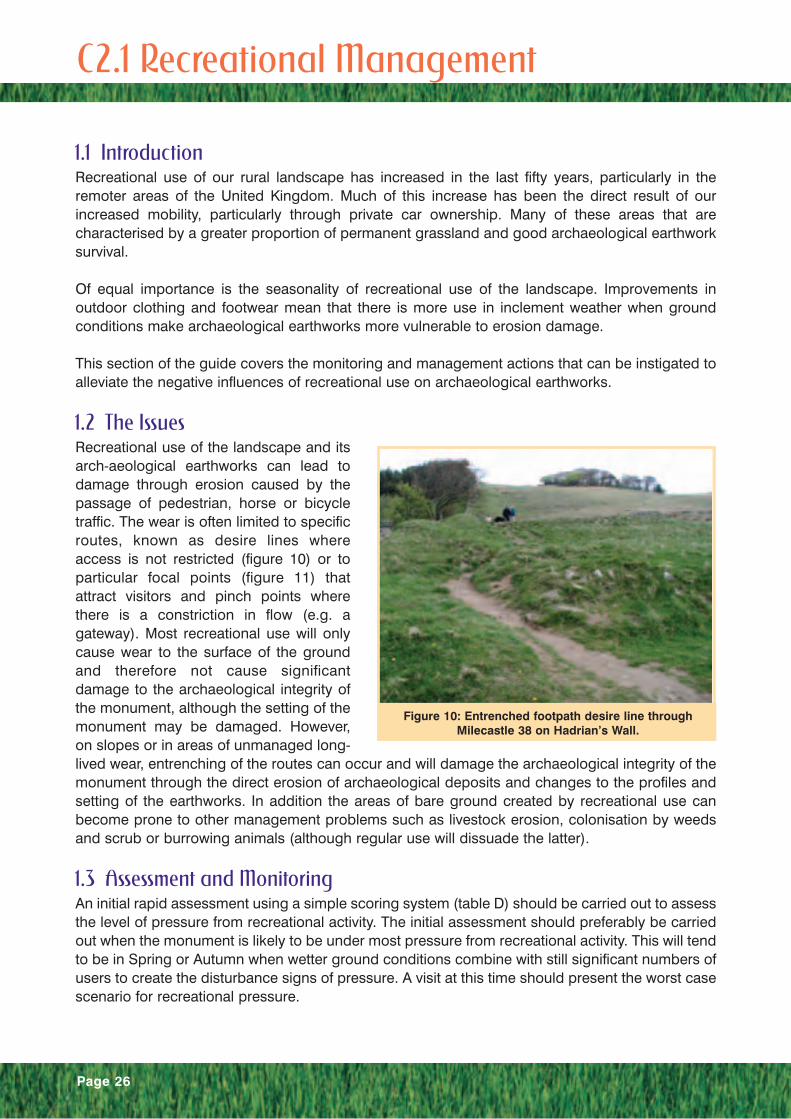
1.2 The IssuesRecreational use of the landscape and itsarch-aeological earthworks can lead todamage through erosion caused by thepassage of pedestrian, horse or bicycletraffic. The wear is often limited to specificroutes, known as desire lines whereaccess is not restricted (figure 10) or toparticular focal points (figure 11) thatattract visitors and pinch points wherethere is a constriction in flow (e.g. agateway). Most recreational use will onlycause wear to the surface of the groundand therefore not cause significantdamage to the archaeological integrity ofthe monument, although the setting of themonument may be damaged. However,on slopes or in areas of unmanaged long-lived wear, entrenching of the routes can occur and will damage the archaeological integrity of themonument through the direct erosion of archaeological deposits and changes to the profiles andsetting of the earthworks. In addition the areas of bare ground created by recreational use canbecome prone to other management problems such as livestock erosion, colonisation by weedsand scrub or burrowing animals (although regular use will dissuade the latter).
1.3 Assessment and MonitoringAn initial rapid assessment using a simple scoring system (table D) should be carried out to assessthe level of pressure from recreational activity. The initial assessment should preferably be carriedout when the monument is likely to be under most pressure from recreational activity. This will tendto be in Spring or Autumn when wetter ground conditions combine with still significant numbers ofusers to create the disturbance signs of pressure. A visit at this time should present the worst casescenario for recreational pressure.
C 2.1 Recreational Management
Figure 10: Entrenched footpath desire line throughMilecastle 38 on Hadrian’s Wall.
Page 27
Where the initial assessment has identifiedthat the earthwork is under or likely tocome under pressure from recreationalactivity it may be necessary to carry outfurther assessment and monitoring works.
Further assessment should evaluate thenature of pressure and makerecommendations for monitoring andmanagement. It should make use ofprevious surveys where available. Theassessment should include:
• Background information on the site –climate, type of soils, type of grasses,nature of archaeological earthwork.
• Previous recreational surveys (where available).
• Identification of the principal areas ofrecreational pressure – desire lines, pinch points, nature of usage (pedestrian, horse, bicyclesetc...)
• Recommendations for management – e.g. opportunities for relief or alternative access routes.
• Recommendations for monitoring – e.g. location of fixed photography points, people counters.
Monitoring will assist in the selection of appropriate management actions. This will be done byenabling a perspective to be developed as to when and where the recreational impactcompromises the values of the archaeological earthwork. Possible monitoring techniques include:
• Regular qualitative or semi-quantitative condition scoring of recreational routes
• Quadrat or transect ground cover assessments
• Fixed point photography
• People counters
• Recreational surveys
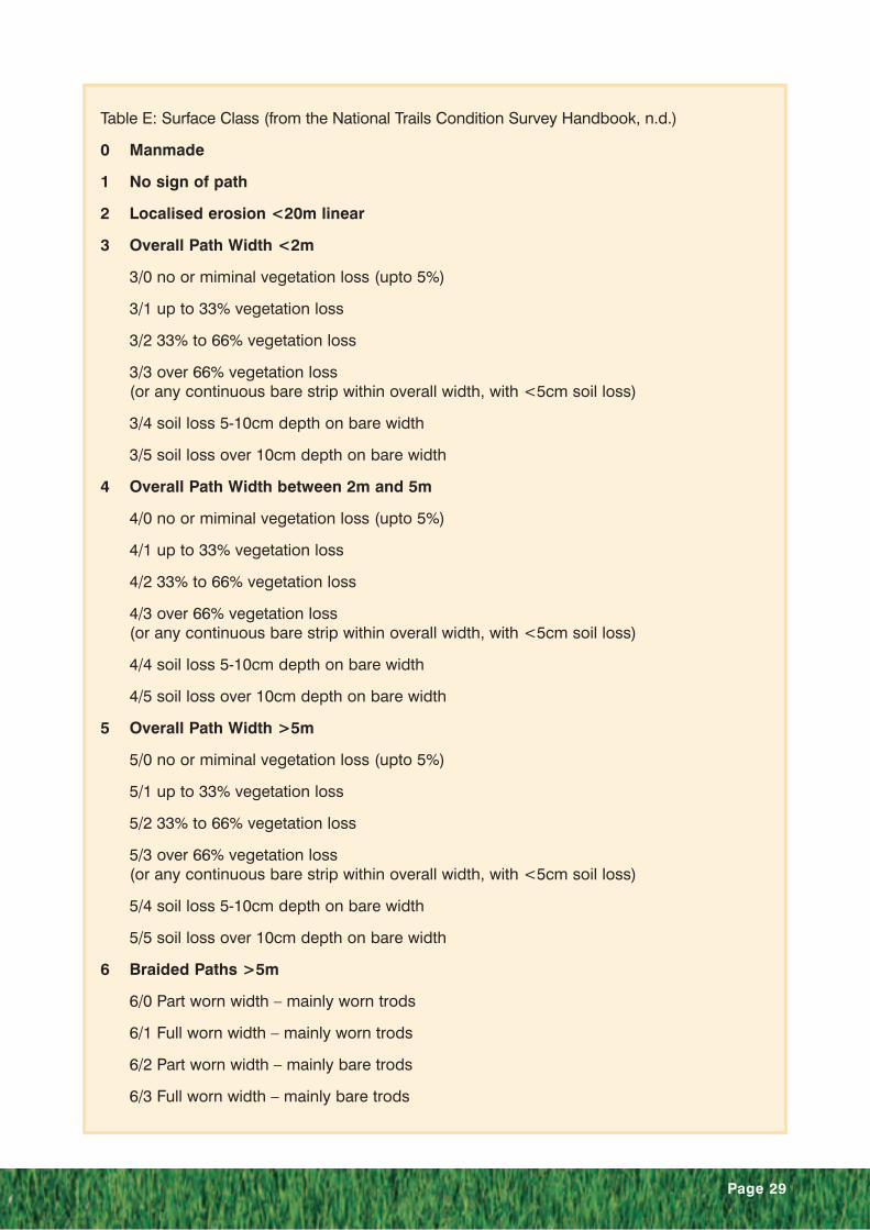
Recreational condition scoring is a method that has been employed in the monitoring of NationalTrails. The National Trails Condition Survey Handbook employs both qualitative and semi-quantitative methods to assess path condition. A qualitative scoring is recommended for man-made paths as shown in Table D. Semi-quantitative methods (Table E) use a combination of pathwidth or pattern and extent of worn bare areas to assess path condition.
Quadrat and transect surveys can provide quantitative data on the path condition and also theinfluence of use on the ground cover. Transects highlight the changing condition of the pathbetween two known points. The assessment can be subdivided into the measured path width(trampled vegetation), measured width where there is >33 % vegetation loss, measured widthwhere there is >66 % vegetation loss and measured width where there is bare ground and soil loss.Quadrats can be used to provide area measurement of ground conditions affected by recreation.As with transects the level of vegetation cover can be used to assess the condition. In addition abotanical survey of the quadrat can elucidate the influences of recreation on the ground covervegetation.
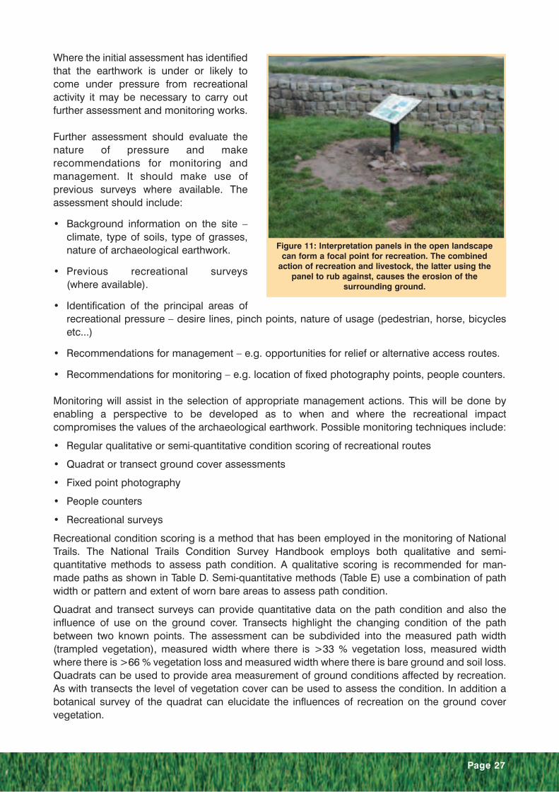
Figure 11: Interpretation panels in the open landscapecan form a focal point for recreation. The combined
action of recreation and livestock, the latter using thepanel to rub against, causes the erosion of the
surrounding ground.

Page 28
Level Score Description Photographic Example
None 0 No evidence of recreationalpressure
Low 1 Evidence of a small amount ofrecreational pressure in thevicinity of the monument and/oron non-sensitive parts of themonument. Characterised bypinch point erosion at siteentrances or desire lines.Also evidence of incipient wearon sensitive pars of themonument characterised byyellowing or trampled grass.
Medium 2 Recreational pressure visible onsensitive parts of the monument.Characterised by incised pathson archaeological features.
High 3 Significant recreational pressureson the monument resulting inextensive areas of wear and/ordamage to key archaeologicalfeatures. Extensive areas of wearare characterised by large bareareas, a number of incised pathsor a wide incised path.
Table D: Indicators of Stress from Recreation
© Hadrian’s Wall Coordination Unit
Page 29
Table E: Surface Class (from the National Trails Condition Survey Handbook, n.d.)
0 Manmade
1 No sign of path
2 Localised erosion <20m linear
3 Overall Path Width <2m
3/0 no or miminal vegetation loss (upto 5%)
3/1 up to 33% vegetation loss
3/2 33% to 66% vegetation loss
3/3 over 66% vegetation loss(or any continuous bare strip within overall width, with <5cm soil loss)
3/4 soil loss 5-10cm depth on bare width
3/5 soil loss over 10cm depth on bare width
4 Overall Path Width between 2m and 5m
4/0 no or miminal vegetation loss (upto 5%)
4/1 up to 33% vegetation loss
4/2 33% to 66% vegetation loss
4/3 over 66% vegetation loss(or any continuous bare strip within overall width, with <5cm soil loss)
4/4 soil loss 5-10cm depth on bare width
4/5 soil loss over 10cm depth on bare width
5 Overall Path Width >5m
5/0 no or miminal vegetation loss (upto 5%)
5/1 up to 33% vegetation loss
5/2 33% to 66% vegetation loss
5/3 over 66% vegetation loss(or any continuous bare strip within overall width, with <5cm soil loss)
5/4 soil loss 5-10cm depth on bare width
5/5 soil loss over 10cm depth on bare width
6 Braided Paths >5m
6/0 Part worn width – mainly worn trods
6/1 Full worn width – mainly worn trods
6/2 Part worn width – mainly bare trods
6/3 Full worn width – mainly bare trods

Photography is an important method ofmonitoring recreational pressure. General orfixed-point photography can provide visualpoint-in-time assessments of the extent anddegree of disturbance through recreationalpressure and if repeated can give a goodindication of change. Monitoring pointsshould be set up for known areas that sufferpressure or those predicted to suffer (e.g.slopes, pinch points)
A wide range of people counting systemsare available for assessing levels of use onrecreational routes. The range has beendeveloped for particular situations, traffictype and path structures (figure 12).Combined with other monitoring informationthese can give a good indication of thecarrying capacity of a site before damageoccurs through usage.
Recreational surveys (also known as visitorsurveys) are targeted questionnairesdesigned to provide information on the useof recreational routes or areas. These havebeen particularly well used at “honey-pot”sites where it is often observed that themajority of use is limited to very shortdistances from a car park and therefore theareas nearest the car park tend to suffergreater deleterious effects from recreation.
The above information can be combinedwith meteorological information to achieve acoherent view of when damage is likely tooccur.
1.4 Methods of RepairMethods of repair for monuments disturbed by recreational usage range from simple resting andreseeding techniques to the establishment of hard surface paths. The type of method used willdepend on the particular circumstances of a site.
Resting involves the temporary removal of recreational use from an area. It can be achieved byerecting temporary fencing (figure 13), guide ropes or brashing to discourage use of a route. Thistechnique is applicable where there is an alternative route that can be used while the temporaryclosure is in affect. It is likely that the resting of the route will need to be implemented at regularintervals.
A resting programme can be carried out in conjunction with a programme to decompact and aeratethe surface of the soil of the area affected to encourage the regeneration of a grass sward. Re-seeding of the surface may be necessary if grass cover has been completely removed. Any resting
Page 30
Figure 12: People Counting Systems.

programme should be carried out inconjunction with information explainingwhy the normal route has been altered.
If small areas of entrenched and erodedroutes have developed then these can beinfilled either by adding soil and then re-seeding or re-turfing.
Larger areas of erosion may need to berevetted with sandbags, boarding orgeotextile fabric to hold soil in place whilstground vegetation cover re-establishes.This may be particularly relevant onsloped areas to minimise soil wash. Thesurface of any scars can be covered witha erosion control fabric.
If the resting of the surface is not practical andrestoration using soil and re-seeding is deemedunlikely to be effective then a sacrificial layermay be used to prevent further ingress into themonument caused by recreational pressure. Asacrificial layer is one that will continue to beremoved by the pressure or decay, but regularreplenishment will mean that no significanterosion will occur on the site. The type ofmaterial used will depend on the site specifics,but options include wood or bark chippings,soil, turf or aggregate in keeping with the settingof the monument.
Where the above methods are not practical thenthe options are limited to the provision ofpermanently improved routes through the usingof traditional or artificial materials.
Methods for the establishment of improvedrecreation routes using traditional materialsinvolve the creation of aggregate paths, stoneflag paths, or pitched paths. In all cases thematerials used in the construction should besympathetic and in keeping with the monumentand its setting. Aggregate paths can be mixedwith soil and grass seed to reduce the time forthe path to blend in to the landscape.
Pitched paths (figure 14) deserve specialmention as these have been used effectivelywithin the central section of Hadrian’s Wall tosolve some long-term erosion problems.
Page 31
Figure 13: Wooden barrier used to discourage use andallow worn area to recover.
Figure 14: Pitched paths have alleviated many of the recreational erosion problems
on Hadrian’s Wall.

Previous recreational routes on slopes in this area had followed the line of Hadrian’s Wall anderosion had exposed it’s foundations. The installation of worn natural stones angled (pitched) intothe slope to form a path up the slopes away from the sensitive archaeology have significantlyimproved the preservation and setting of the monument. As with all hard surface paths they shouldonly be used where a grass sward is unsustainable and all other management options have beentried or are inappropriate. The stone used in the path should be in keeping with the setting of themonument.
A range of artificial materials is available for creating improved routes. These include pavers, root-zone mesh reinforcement and geotextiles. Pavers (figure 15) have a cellular structure that protectsthe growing point of grasses and therefore allows a good grass sward to develop through the cellsblending the paver with its environment. With use the cell of the paver will eventually fill up andneed re-setting or cleaning out. There is a wide range of cell sizes, shapes and materials and it isimportant to consider the application and maintenance in the selection. The smaller cell sizes (1cmwidth) should be avoided as they more readily fill up and therefore will require regular maintenance.Slopes present another problem for this material because the smoothness of the surface meansthat they can become slippery. Some recent examples have overcome this problem as they havebeen made with a roughened surface.
Root-zone mesh reinforcement is designed to relieve compaction of the soil and therefore aid thehealthy growth of a grass sward. They often come pre-blended into a sandy root-zone mixturedesigned to be free draining. The success of these materials is reliant of the development of ahealthy grass sward to prevent soil loss. If use of the area is high then the grass sward will beremoved and the sandy soil will be easily eroded. This leaves the material exposed at the surface.
Geotextiles used near the surface are designed to spread the load of people passing and thereforereduce compaction of the soil. This in turn assists in the maintenance of a healthy grass sward thatis able to withstand higher levels of use than without the textile. It is important to properly installthese materials by ensuring they are sufficiently supported by good sub-bases that are also free-draining. One disadvantage of these materials is that standard grassland management techniquesof aeration and scarification cannot be used with them.
Page 32
Figure 15: Cellular plastic paver used at Housesteads Roman Fort (Before, on installation and after).
Page 33
1. 5 Methods of ManagementMethods of management for recreational use fall into two categories:
• Increasing sustainability
• Altering or influencing routes
Increasing sustainability involves the alteration of ground conditions and/or the grass sward toincrease its ability to withstand the stress created by recreational use. This can involve changingthe species composition of the grass sward, adding fertiliser to improve sward vigour, andincreasing drainage to alleviate waterlogging or artificial watering to compensate for droughtaffects. Some of these methods may be subject to archaeological or nature conservationconstraints and it may be necessary to obtain consents before implementing.
The sward species composition can be altered by seeding or by replacement with turf of higherwear resistant species, such as perennial rye grass (Lolium perenne) and the reduction in thesward of wear susceptible grasses and broad-leaved species. The influence of introduced specieson the ecological value of the site must be considered. In some instances such as a SSSIdesignation for conservation of grass species it may be inappropriate to use introduced species.The appropriate party should be contacted (English Nature when the site is a SSSI) and they willbe able to advise on the suitability of grass species.
Other management actions that have abenefit to the sustainability of the grasssward include:
• the scarification of the surface toremove excessive thatch (dead plantmaterial and mosses). It is important tomaintain a thin layer of thatch as this canhelp reduce soil compaction and willprotect the growth points of the grass.
• pest control and the removal ofmolehills before they spread outsmothering surrounding grass andproviding a seed-bed for competing weedspecies.
• weed-killing to remove broad-leavedweeds, which have a low wear tolerance.
• light harrowing to spread worm-casts and molehills reducing soil contamination of surroundinggrasses (this reduces the grasses vigour through loss of photosynthesis) and to provide a betterseed-bed for grass seeding.
• regular cutting or close grazing to encourage a low, dense sward.
• Surface or shallow depth aeration of the soil using solid, hollow or chisel type tines. This relievescompaction and increases air content of the soil.
Altering or influencing routes involves direct or indirect methods of changing access routes. Directmethods involve the physical alteration of the route normally by the erection of barriers such asguide ropes and timber barriers. Also routes can be mown to create a defined route or permanentpaths can be used to steer users in a specific direction away from sensitive locations. An alternative
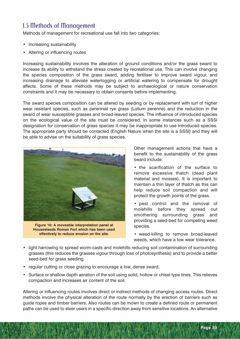
Figure 16: A moveable interpretation panel atHousesteads Roman Fort which has been used
effectively to reduce erosion on the site.

Page 34
or reliever route can be used whilst the normal route is being rested or repaired. Indirect methodsinvolve the influencing of access route direction by the use of focal features, such as fingerposts,stile and gate positions and information/ interpretation panels (figure 16). Moveable interpretationpanels can be particularly useful as these can be regularly moved to change the alignment of thedesire line.
The above methods are all on-site methods of managing recreation. It is also possible to influencethe use of routes by the promotion of alternative routes when conditions are likely to lead to adeleterious effect on the monument. This can be done by marketing strategies, such as promotingother sites to visit or by educating the visitor in the impact they can have. It can also be influencedby controlling ease of access through the availability of transport to the site. Good bus provisioncan influence usage of a monument. On Hadrian’s Wall visitors have been encouraged to do singledirection walks, whereas in the past use of a car has encouraged visitors to use the same route ontheir return thus doubling wear on the ground. Seasonal closure of car parks to discourage accessat vulnerable times of the year is also an option.
References and Further ReadingCathersides, A 2001 The restoration of the grassland setting at Stonehenge.In McGlade, D (Ed.) Erosion Control on Archaeological Earthworks and Recreational Paths.(Northumberland County Council)
Countryside Commission no date National Trails: A Condition Survey Handbook (CountrysideCommission)
McGlade, D (Ed.) 2001 Erosion Control on Archaeological Earthworks and Recreational Paths.(Northumberland County Council)
Wimble, A A 1994 Problems of wear and tear on English Heritage sites. In Berry,A Q and Brown, I W Erosion on Archaeological Earthworks Its Prevention, Control and Repair(Clwyd Archaeology Service, Clwyd County Council)

Page 35
SummaryA resting programme for a well-used section of the Hadrian’s Wall Path National Trail through theuse of an alternative route. The rest period will allow the repair and recovery of the grass swardthrough Milecastle 38 (Hotbank).
IntroductionHotbank Milecastle is Milecastle 38 of theHadrian’s Wall system. It lies on a popular(40,000 people per annum were recordedin the late 1990s) section of footpath thathas recently become part of the Hadrian’sWall Path National Trail. Despite the officialroute of the Hadrian’s Wall Path NationalTrail going around the milecastle the usedroute follows Hadrian’s Wall and cuts overthe earthwork remains of the milecastle.The result has been the destruction of thegrass sward over the milecastle, thegradual erosion of the soil and thedisplacement of the milecastle’s fabric(figure 17). This erosion is most prominentin the west wall of the milecastle, which
has become an entrenched route (figure 18) and serves to re-inforce the effects of erosion byconcentrating walkers in a narrow corridor.
A number of solutions were put forward. Indeed the creation of the National Trail instigated one ofthe solutions, which was to divert the public right of way around the milecastle. However thisdiversion has never been implemented on the ground for a number of reasons.
• The wet ground conditions would have required some surfacing, either an aggregate path orstone flags. Both of these would havebeen intrusive to the setting of themonument.
• The presence of a fence directlyadjacent to the earthwork meant that thediverted route was likely to cause newerosion on the monument.
• Also diverting people onto the diversionwas a problem and it was felt that thiswould require some form of permanentbarrier that would also be intrusive to thesetting of the monument.
The alternative route was initially createdas a legal diversion to give adequate timefor repairs to establish. In future years the
Case Study 2: Creating a Relief Route:Hotbank Milecastle
Figure 17: The soil around the stone of the east wall ofthe milecastle has been eroded making the stones
vulnerable to displacement.
Figure 18: The route through the west wall of themilecastle has become entrenched.

Page 36
route will be a voluntary diversion, whichwill mean no application for an officialdiversion will be required. Temporarybarriers will be erected that will guidewalkers onto the alternative route, but willnot obstruct those who want to visit themilecastle
A further solution was made possible withthe co-operation of the landowner, in thiscase The National Trust and the tenantfarmer. An alternative route was proposedthat diverted the National Trail onto theRoman Military Way for a 300m sectionaround the milecastle. This proposal wasimplemented and is outlined below.
Alternative RouteAt Milecastle 38 the Roman Military Way runs very close to the line of Hadrian’s Wall. The MilitaryWay is used as a public footpath in other nearby areas and due to its dry and firm groundconditions appears to provide a sustainable walking surface. It was felt that this would provide analternative route that could be used periodically to allow the route through the milecastle to rest andbe repaired, whilst also providing public access to a well-preserved section of the Military Way thathad previously not been accessible.
In its first year, the alternative route was to be used from September 2003 until August 2004 to allowthe repairs to the monument to establish. In future years the route will be used between May andAugust as required to allow the route through the milecastle to rest and if necessary be aerated, re-seeded, and top-dressed. This period of use fitted in well with land management practice as itcoincided with the absence of livestock from the alternative route as the land is managed as a haymeadow under the Countryside Stewardship Scheme.
The alternative route was initially created as a legal diversion. In future years the route will be avoluntary diversion, which will mean that no application for an official diversion will be required.Temporary barriers will guide walkers onto the alternative route, but will not obstruct those whowant to visit the milecastle.
RepairsWhilst the alternative route was inoperation repairs were conducted on themonument. Mostly these consisted of thesurface aeration of compacted ground,the filling of any desire lines with asoil/sand mix and grass seeding to re-establish a grass cover. On areas such asthe east wall (figure 20) of the milecastle itwas necessary to dress the bank over thewall with a greater amount of soil so thatthe stones were sufficiently reinforced toprevent their displacement. In addition byrepairing this there was no obvious lowpoint over the east wall and therefore nofocus for future wear.
Figure 19: The alternative route along the military way.The milecastle is immediately in front of the farm house
in the left of the picture.
Figure 20: Repaired section througheast wall of milecastle.
Page 37
The entrenched route through the west wall was also re-profiled. Here, because a large amount ofmaterial was to be added, the present level of the path was defined using a geotextile membranealong its base before filling with soil to act as an interface between the in situ archaeologicaldeposits and the fill material. The membrane was laid flat at the base of the repair and not laid upthe sides or near the edges of the repair as this would have been prone to re-exposure if renewederosion occurred. As with the east wall, reprofiling means that there is no obvious walked route andtherefore it is hoped that wear will be spread.
Grassland Management TrialsIn addition to the repairs, nine trial plots were established to assess the effectiveness of two simplegrassland management regimes. The results of this trial will aid future management of this sectionof the National Trail by informing on the appropriate level of grassland management required tosustain grass cover. The nine trial plots were surface aerated and then given one of threetreatments therefore giving three replicates of each treatment. The treatments were as follows;
• A control,
• an application of a top-dressing mix at a rate of 1kg/m3 and overseeding at a rate of 10g/m2 withDLF Perryfields PRO27 (Ecosward) grass seed,
• and an application of a top-dressing mix at a rate of 2kg/m3 and overseeding at a rate of 10g/m2
with DLF Perryfields PRO27 (Ecosward) grass seed.
The seed mixture used contained 10% small leaf clover, which fixes nitrogen and therefore shouldeliminate the need for fertilisers.
ConclusionsThe opportunity to create an alternative route around the milecastle has allowed the aim ofmaintaining of the National Trail as a green sward to be achieved. In addition it has eliminated theneed to install structures and surfacing that would have been detrimental to the setting of themonument, and prevented further damage to the monument.
The effectiveness of the use of this technique should be assessed after a number of years so that,if successful, it can be encouraged in other situations along Hadrian’s Wall and elsewhere onarchaeological earthworks.
Page 38
SummaryA programme of intensive grassland management at Stonehenge has maintained a grasslandsetting to the monument despite being probably the most visited field monument in the UnitedKingdom.
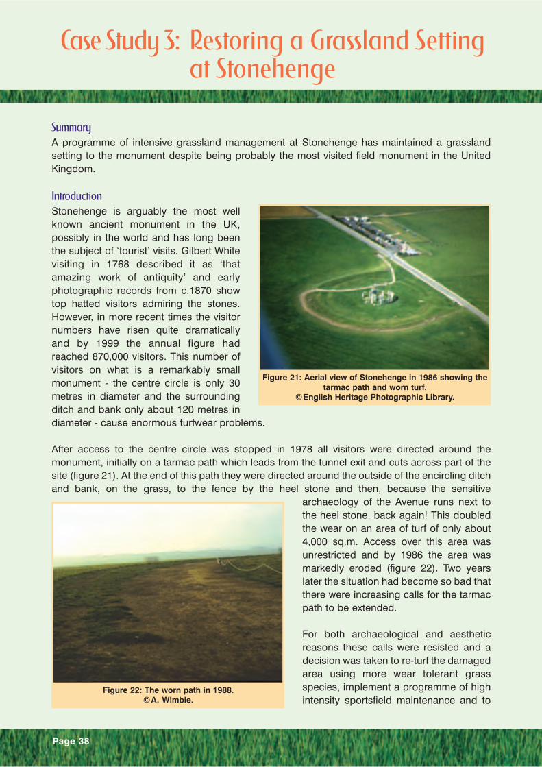
IntroductionStonehenge is arguably the most wellknown ancient monument in the UK,possibly in the world and has long beenthe subject of ‘tourist’ visits. Gilbert Whitevisiting in 1768 described it as ‘thatamazing work of antiquity’ and earlyphotographic records from c.1870 showtop hatted visitors admiring the stones.However, in more recent times the visitornumbers have risen quite dramaticallyand by 1999 the annual figure hadreached 870,000 visitors. This number ofvisitors on what is a remarkably smallmonument - the centre circle is only 30metres in diameter and the surroundingditch and bank only about 120 metres indiameter - cause enormous turfwear problems.
After access to the centre circle was stopped in 1978 all visitors were directed around themonument, initially on a tarmac path which leads from the tunnel exit and cuts across part of thesite (figure 21). At the end of this path they were directed around the outside of the encircling ditchand bank, on the grass, to the fence by the heel stone and then, because the sensitive
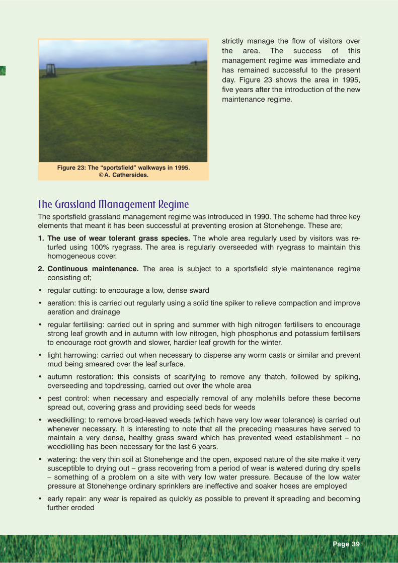
archaeology of the Avenue runs next tothe heel stone, back again! This doubledthe wear on an area of turf of only about4,000 sq.m. Access over this area wasunrestricted and by 1986 the area wasmarkedly eroded (figure 22). Two yearslater the situation had become so bad thatthere were increasing calls for the tarmacpath to be extended.
For both archaeological and aestheticreasons these calls were resisted and adecision was taken to re-turf the damagedarea using more wear tolerant grassspecies, implement a programme of highintensity sportsfield maintenance and to
Case Study 3: Restoring a Grassland Setting at Stonehenge
Figure 21: Aerial view of Stonehenge in 1986 showing thetarmac path and worn turf.
©English Heritage Photographic Library.
Figure 22: The worn path in 1988.©A. Wimble.
Page 39
strictly manage the flow of visitors overthe area. The success of thismanagement regime was immediate andhas remained successful to the presentday. Figure 23 shows the area in 1995,five years after the introduction of the newmaintenance regime.
The Grassland Management RegimeThe sportsfield grassland management regime was introduced in 1990. The scheme had three keyelements that meant it has been successful at preventing erosion at Stonehenge. These are;
1. The use of wear tolerant grass species. The whole area regularly used by visitors was re-turfed using 100% ryegrass. The area is regularly overseeded with ryegrass to maintain thishomogeneous cover.
2. Continuous maintenance. The area is subject to a sportsfield style maintenance regimeconsisting of;
• regular cutting: to encourage a low, dense sward
• aeration: this is carried out regularly using a solid tine spiker to relieve compaction and improveaeration and drainage
• regular fertilising: carried out in spring and summer with high nitrogen fertilisers to encouragestrong leaf growth and in autumn with low nitrogen, high phosphorus and potassium fertilisersto encourage root growth and slower, hardier leaf growth for the winter.
• light harrowing: carried out when necessary to disperse any worm casts or similar and preventmud being smeared over the leaf surface.
• autumn restoration: this consists of scarifying to remove any thatch, followed by spiking,overseeding and topdressing, carried out over the whole area
• pest control: when necessary and especially removal of any molehills before these becomespread out, covering grass and providing seed beds for weeds
• weedkilling: to remove broad-leaved weeds (which have very low wear tolerance) is carried outwhenever necessary. It is interesting to note that all the preceding measures have served tomaintain a very dense, healthy grass sward which has prevented weed establishment – noweedkilling has been necessary for the last 6 years.
• watering: the very thin soil at Stonehenge and the open, exposed nature of the site make it verysusceptible to drying out – grass recovering from a period of wear is watered during dry spells– something of a problem on a site with very low water pressure. Because of the low waterpressure at Stonehenge ordinary sprinklers are ineffective and soaker hoses are employed
• early repair: any wear is repaired as quickly as possible to prevent it spreading and becomingfurther eroded
Figure 23: The “sportsfield” walkways in 1995.©A. Cathersides.

Page 40
3. Management of visitor flow. Individual walkways are marked out using unobtrusive low-levelropes and visitors are encouraged to keep within the designated walkway. There is room forapproximately 10 individual walkways on the maintained area and these are alternated regularly,at the first sign of wear. This may be daily during peak periods or every 2-3 days off-peak.
Taken individually, all these measures will help to reduce wear on turf and delay the onset oferosion to some degree. The success at Stonehenge, with such high visitor numbers, is due to thecombination of all three – on this site any measure taken in isolation would not suffice to controlthe wear.
ConclusionsThe very nature of Stonehenge and the sheer numbers of visitors it attracts cause problems, butalso help with some of the solutions. Staff are required on site to prevent misuse of or damage tothis important monument and because such large numbers of people require a supportinfrastructure – having these site based staff allows us to ensure walkways are used properly androtated regularly. Large numbers of visitors undoubtedly cause wear and tear on the turf, but theirentrance fees help to ensure that funds are more readily available to carry out the intensivemaintenance necessary to reduce this problem. However, every site, like every erosion problem, isdifferent and the regime described above may not be physically or financially possible on othersites, or even desirable in some cases! So what general principles can be suggested for dealingwith turf wear? The following are suggested:
• Always remember the basic requirements for good grass growth – good soil structure,undamaged roots/leaf blades and leaf blades not covered by mud.
• In areas of high wear, spread the wear wherever possible, giving some areas respite before wearbecomes serious, carrying out repairs if necessary
• Where possible introduce more wear tolerant species of grass, such as ryegrass and reducelevels of wear susceptible grass and broad-leaved species. (The ecological value of the site inquestion must be considered here – in a SSSI, the introduction of sportsgrass cultivars might beunacceptable)
• Carry out as much ‘sportsfield’ maintenance as possible on susceptible areas
• Where funds are limited chose the most beneficial maintenance that can be afforded – as aguide spiking which relives compaction and improves aeration and drainage is by far the mostbeneficial operation.
Alan Cathersides, Senior Landscape Manager, English Heritage
Page 41
C 2.2 Livestock Management
2.1 IntroductionGrassland management for livestock pasture or mowing has ensured that many monuments havesurvived into the present day in a good state of preservation. This is particularly true in upland areasof the United Kingdom where land-use as permanent, unimproved pasture has ensured thatarchaeological earthworks survive as upstanding features in good condition and buried remainssurvive relatively undisturbed. Indeed, managing monuments for grazing is often seen as the idealmanagement for ensuring long-term preservation of the monument as it maintains the visibility ofthe monument and deters scrub growth. However, it is important to recognise that whilst grazingcan be a highly beneficial form of management for archaeological conservation, it can also have adetrimental effect on the survival of the archaeological earthworks and their settings. Often this isdue to local factors such as stocking levels, season of stocking, type of livestock, and presence oflivestock focal points.
The goal of livestock management on archaeological monuments is to achieve the right balance ofgrazing for its long-term preservation. In its simplest definition, this lies between an over-grazedlandscape with its characteristic areas of eroded bare earth and an under-grazed landscape thatallows the regeneration of scrub. In reality, it is a far more complex subject that doesn’t just relateto the level of grazing, but also the foci of livestock movement and the selectivity of grazing by theanimals.
2.2 The IssuesAs already mentioned, livestock grazedgrassland management is highlybeneficial to the long-term preservation ofthe archaeological resource. Despite this,livestock grazing can be a damagingactivity. Damage can occur in two ways:
1. The use of an area by livestock abovethat which is sustainable for the soiland vegetation. This leads to areasbeing poached and/or eroded.
2. The under-use of areas for grazing orthe use of grazing animals that arehighly selective in what they graze.These areas can permit theestablishment of root-penetratingvegetation such as scrub species andbracken.
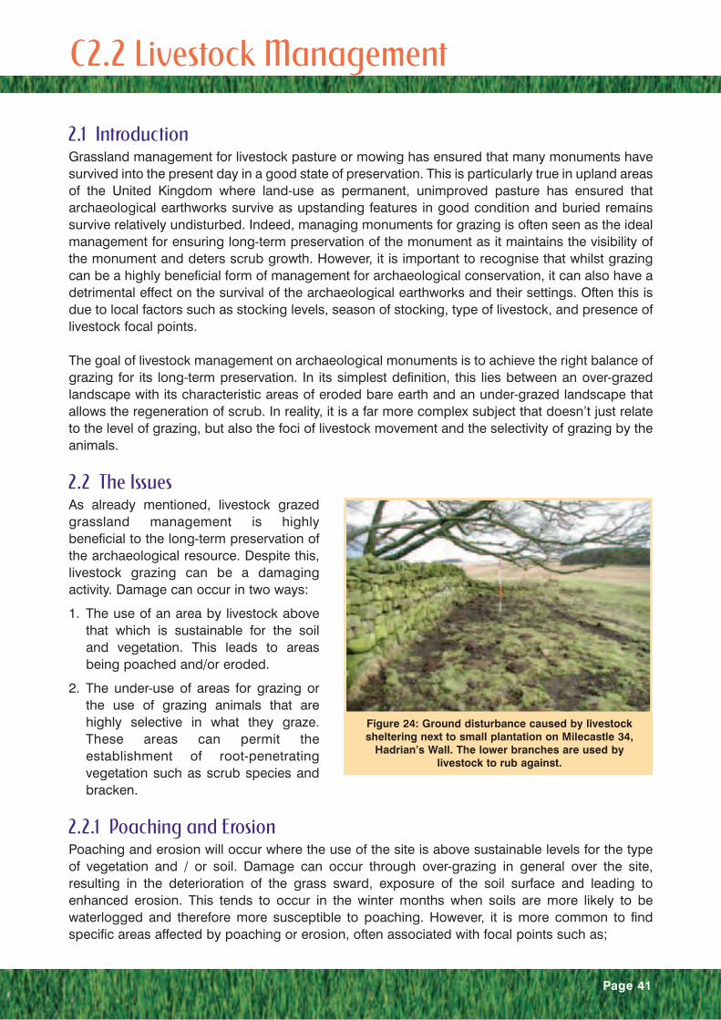
2.2.1 Poaching and ErosionPoaching and erosion will occur where the use of the site is above sustainable levels for the typeof vegetation and / or soil. Damage can occur through over-grazing in general over the site,resulting in the deterioration of the grass sward, exposure of the soil surface and leading toenhanced erosion. This tends to occur in the winter months when soils are more likely to bewaterlogged and therefore more susceptible to poaching. However, it is more common to findspecific areas affected by poaching or erosion, often associated with focal points such as;
Figure 24: Ground disturbance caused by livestocksheltering next to small plantation on Milecastle 34,
Hadrian’s Wall. The lower branches are used bylivestock to rub against.

Page 42
• sheltered areas in the lee of trees, walls, ditches or slopes,
• feeding stations,
• movement pinch points,
• rubbing posts,
• water sources,
• exacerbation of bare areas created by burrowing activity or land slippage,
Sheltered areas in the lee of trees, fieldwalls (figure 24) or slopes providelivestock with a protected environmentfrom adverse weather conditions. Theconcentration of livestock in these areasleads to poaching of the ground surfacewhich if on or close to the monument cancause damage.
Feeding stations (figure 25) are aparticular problem on archaeologicalearthworks. These feeding stations arenormally sited on the driest areas of thefield, often the upstanding earthworks of amonument. If this is a regular location for
the feeding station livestock will congregate prior to the feed being delivered in addition to feedingtime and this can lead to significant poaching and erosion around this location. In addition theroutes to a regular feeding station can also become significantly disturbed.
Pinch points lead to a concentration of moving stock and subsequent poaching and erosion. Thesepinch points tend to be associated with access routes, in particular farm gateways and with thepresence of scrub.
Livestock will often use rubbing posts toscratch against. These can vary in naturefrom boulders (figure 26), low treebranches, the trunks of trees or scrub,fence posts or fence wire. Equally, therubbing post can be part of anarchaeological monument such as astanding stone or it can be aninterpretation panel. Livestock tend tocreate poached or eroded ground aroundthe feature.
As with feeding stations, water sources,be they artificial (e.g. water trough) ornatural (e.g. stream or pond), form a pointof congregation for livestock. They arenormally permanent in their location andtherefore the poaching and erosion around them is cumulative. In addition the livestock willdistribute the water over the surrounding area, which tends to make the soils around the sourcemore vulnerable to damage from livestock activity.
Figure 25: Ground disturbance caused by farm vehiclesandby sheep feeding on the south mound of the vallum,
Hadrian’s Wall. © P. Austen
Figure 26: Livestock poaching associated with an areaof water in the ditch of the vallum, Hadrian’s Wall.
The boulder on the left shows the erosion associatedwith its use by livestock to rub against.
Page 43
Bare soil areas caused by land slippage or burrowing animal activity can form a congregation pointfor livestock. Livestock will lick bare areas for the minerals they contain, they will dust their bodiesin them and will scrape them with their hooves. These actions therefore exacerbate the erosioncaused by the original agent.
The above mentioned focal points should be the target of any management action and by theirremoval, re-siting of the focus or the permanent or temporary exclusion of livestock the rightbalance between grazing and conservation should be achievable.
2.2.2 Development of Damaging VegetationThe establishment of vegetation that is damaging (development of trees, scrub and bracken) to thelong-term preservation of the archaeological resource will occur if an inadequate grazing regime oralternative is employed in its management. Damaging vegetation includes species that will have asignificant impact on the survival of buried archaeological remains through the disruptive activity ofroot development (see section C.2.5). The development of damaging vegetation occurs in threeprinciple ways;
1. Insufficient intensity of grazing.
2. Insufficient variation in grazing animal to prevent areas becoming rank permitting theestablishment of injurious vegetation.
3. Inappropriate timing of grazing when livestock do not graze injurious vegetation.
Insufficient grazing can occur through low stocking densities at the field or area level. At the fieldlevel this is normally due to an absence or lack of livestock. This is most common in areas wherearable cultivation is the dominant land use and archaeological earthworks survive as islands ofpasture. It can also occur where the archaeological earthwork is wholly or partly inaccessible tograzing, such as steep bank sides.
All animals, both wild and domesticated have different grazing pattern. Some animals favourcertain types of vegetation that are eaten first while less desirable plants are left until last, or notgrazed at all. The correct type and combination of grazing animal and the right timing and intensityof grazing are essential to overcome selective grazing. Sheep have narrow mouths, which enablesthem to be more selective in what they eat than species such as cattle, which are considered non-selective due to their broad mouths. Sheep produce a closely cropped grass sward, whereas cattlewill graze the grass to a few centimetres in length. Therefore it is beneficial to have a mixedlivestock practice as this helps achieve the best control of damaging vegetation. Cattle have theadded benefit in that they trample bracken. Timing of grazing can influence the development of injurious vegetation. Grazing animals willcontrol scrub growth in spring or early summer, as the new growth is more palatable than later,when it becomes woody.
More information on the grazing attributes of different types of livestock can be found in The BreedsProfiles Handbook: a guide to the selection of livestock breeds for grazing wildlife sites (Tolhurstand Oates, 2003), which presents the results of the Grazing Animals Project. This can be viewedon the Forum for the Application of Conservation Techniques (FACT) Internet site (www.fact-group.org).

Page 44
Level Score Description Photographic Example
None 0 No evidence of livestockpressure
Low 1 Evidence of a small amount oflivestock pressure in the vicinityof the monument and/or on themonument in non-sensitive areas.The surface of the monumentmay have a pock-markedcharacter from the action of the hooves of livestock, but will not have more extensive poaching ofthe ground or erosion.
Medium 2 Evidence of livestock pressureon sensitive areas of the site.These will be visible as erosionscars on slopes or areas ofminor poaching.
High 3 Extensive lifestock pressure onthe monument characterised by a large number of erosion scarsor extensive areas of poachedground.
Table F: Indicators of Stress from Livestock

Page 45
2.3 Assessment and MonitoringAn initial rapid assessment using a simple scoring system (such as shown in Table F) should becarried out to assess the level of pressure from livestock activity. The initial assessment shouldpreferably be carried out when the monument is likely to be under most pressure. This will tend tobe in the winter season when deteriorating ground conditions make the surface of the monumentmore prone to disturbance from livestock activity.
Where the monument is identified as being under pressure from livestock activity furtherassessment should be used to highlight the causes of this pressure. The assessor should highlightany focal points for stock gathering and any worn routes to the focal point. They should consultwith the landowner or tenant, as they will be able to provide local knowledge on why certain routesand certain locations are used by stock. They will also be able to explain what stocking regime isemployed on the land unit and past land management.
Past land use is an important consideration in prioritising any conservation works, as anunimproved pasture is more likely to have significant archaeological deposits at shallower depthsthan improved pasture which may have been cultivated to 10-25cm depth.
Methods of monitoring livestock disturbance to a monument include:
• Fixed-point and general photography.
• Mapping and measurement of area of disturbed ground.
• Evidence from vegetation.
Photography provides a good point-in-time documentation of the extent and severity of anylivestock disturbance to the monument. Fixed-point photography can be used to provide simpleand effective visual assessments of whether the disturbance is developing or stationary. It is bestto repeat photography in the same season of following years to assess changes in extent.Photography at other times of the year can help highlight how the extent changes in the year. Thisis particularly useful where the disturbance is caused by stock in the winter period, but issustainable in the summer period as this can provide a basis to exclude livestock from the area fora short period of the year.
Mapping and measurement of the area of disturbance will provide exact information on the extentof the disturbance at a given point-in-time and can be repeated to assess change.
Vegetation can give a good indication of the area being disturbed even in the summer monthswhen it can appear deceptively stable. The disturbed area will be characterised by weed speciessuch as nettle and thistle, broad-leaved plants (e.g. docks and plantains) and annual grasses (e.g.annual meadow grass).
2.4 ManagementThe management of livestock on archaeological earthworks can be broken down into two maintypes based on whether the aim should be to control the grazing pressure on a site or to removethe focus of livestock activity.
2.4.1 Livestock ControlLivestock control can be introduced to reduce, alter, or increase grazing pressure. The aim is toachieve greater control over the intensity of grazing. This can be achieved through ascribingstocking levels for the field unit containing the monument and/or by agreeing seasonal restrictionson grazing. This is already a common method used in nature conservation, particularly in schemessuch as Countryside Stewardship. For the conservation of archaeological remains a restriction on

winter grazing is the most common requirement. Livestock can either be removed or reduced to alevel that does not cause significant ground disturbance. Guidance on the appropriate stockinglevel can be drawn from those already published (see appendix B) and these will help inestablishing the initial programme. However, these are only a guide and therefore the situationshould be monitored so that stocking levels can be adjusted to suit local circumstances.
Further control can be achieved by excluding the monument from the field unit by the erection ofpermanent or temporary fencing. This permits control of grazing on the monument itself by themechanisms outlined above. The erection of fencing, particularly permanent fencing can causedamage to buried archaeology and has a significant impact on the setting of the monument andpotentially to the wider landscape character. Therefore permanent fencing should only be usedafter other methods have failed to resolve a problem or where there is no practical alternative.Temporary fencing, such as electric fencing can effectively be used to exclude the monument orparts of the monument from grazing whilst the grass sward recovers or is re-seeded. This is similarto the agricultural practice of rotational grazing whereby the grazing area is divided into units, eachof which is grazed in sequence. The units are rested from grazing for three to four weeks to allowthe grass sward to recover, but not to give sufficient time for the sward to achieve flowering andtherefore become less palatable grazing (Brockman, 1995).
Alternatively, where the area to be excluded is small, brashings of tree branches, wooden hurdles,or chain link attached to battens can be used to keep livestock off while the area recovers. This hasthe advantage that the control method is not as visible in the setting of the monument and althoughpegged down, this will be with tent pegs and will not create significant disturbance. Care should betaken, particularly with brashing that the cover does not encourage rabbit burrowing or exclude toomuch light thus slowing down re-growth.
2.4.2 Focus RemovalIn order to alleviate pressure on a monument the focus of the livestock activity can be completelyremoved, moved, altered or an alternative focus can be provided off the monument. This section isdealt with by the type of management issue as outlined earlier (C2.2.1).
Shelter AreasRemoval or alteration can solve problems of livestock erosion associated with the presence oftrees, either in the form of shelterbelts or individual trees. The removal of low branches that act asrubbing posts may be sufficient. In addition the canopy density and height can be reduced topromote greater light and air movement through the trees assisting in the development of a goodgrass sward beneath the canopy. In some cases where the proximity of a shelterbelt to amonument results in significant livestock erosion then part of the shelterbelt can be removed (seecase study), though this decision will have to be balanced against the ecological, amenity,landscape and cultural value of the shelterbelt. With some sheltered areas such as buildings, walls,ditches and slopes it is not feasible to remove or alter them. In these cases it may be necessary toprovide alternative shelter off the monument and restrict livestock access. This can take the formof modern mobile or fixed shelters, traditional stock shelters or planting of new shelterbelts.
Feeding StationsIt is often possible to re-site a feeding station or mineral lick off a monument. In other situations theground conditions may make the siting of the feeding station off the monument impracticable (i.e.waterlogged ground conditions). In these cases moving the feeding station on a regular basis mayreduce the impact of livestock congregation around a feeding station. Adequate time, usually threeto four weeks in the growing season, should be allowed for the grass sward to recover beforereturning the feeding station to the same site. If neither of the above solutions is practical then theprovision of a permanent feeding station on or off the monument may be necessary. It is preferable
Page 46

Page 47
to site these off the monument, but on occasions gravel over a separation membrane has beenadded to create a permanent feeding area on the monument whilst minimising the destruction ofarchaeological information. It is important to consider the likely movement of livestock towardsfeeding areas as preferred routes, particularly with sheep can start to develop and cause erosion.
Pinch PointsRemoving or altering the causes can solve pinch-point erosion. Where the pinch-point hasdeveloped due to vegetation restricting livestock movement to a narrow corridor it is usuallysufficient to enlarge the corridor by the removal of some vegetation. Where the movement oflivestock through a gateway generates the pinch-point it may be possible to move the gateway toa less sensitive location. If this is not practical then the creation of a more sustainable surfacethrough the gateway should be considered through the use of drainage, improving the soil, oradding a wearing course such as gravel.
Rubbing PostsRubbing posts can either be removed, the ground around them modified or livestock periodicallyexcluded to prevent the formation of a doughnut of erosion around them. Removal is oftenappropriate and achievable for features such low branches, fences or tree trunks. In some casesthe feature is not or not readily removable, such as a boulder that is considered part of themonument fabric or land ownership boundary fence. In these cases in situ management isnecessary. Modification of the area around the rubbing post can be achieved through the additionof a wearing course of gravel or a surface of angular stone that discourages use by livestock.
Water SourcesWater sources such as troughs are moveable and can be re-sited off the monument or in lesssensitive areas of the monument. If re-siting is impractical then the provision of a wearing courseof gravel around the trough will prevent ground disturbance. Permanent water sources such asponds and streams are not moveable and therefore they can only be managed by excludinglivestock with fencing where acceptable to the landscape setting and providing an alternativewatering point or by providing a wearing course over the archaeology.
Exacerbation of Erosion ScarsIn some cases erosion by livestock can be an exacerbated by small land slippage or thedevelopment of disturbance around an animal burrow. In these cases it is normally sufficient toexclude stock temporarily and repair the erosion scar. Management of burrowing animals onmonuments is discussed in section C2.4.
References and Further ReadingBrockman, J S 1995 Grassland. In Soffe, R J (editor) Primrose McConnell’s The AgriculturalNotebook, 19th edition (Blackwell Science)
DEFRA 2001 Controlling Soil Erosion: An advisory leaflet for preventing soil erosion in theuplands (DEFRA, London)
MAFF 1999 Controlling Soil Erosion: An advisory leaflet for preventing erosion caused bygrazing livestock in lowland England (MAFF, London)
MAFF 1999 Controlling Soil Erosion: An advisory booklet for the management of agriculturalland (MAFF, London)
Tolhurst, S and Oates, M (Eds.) 2003 The Breeds Profiles Handbook: a guide to the selectionof livestock breeds for grazing wildlife sites. (Grazing Animals Project).
Page 48
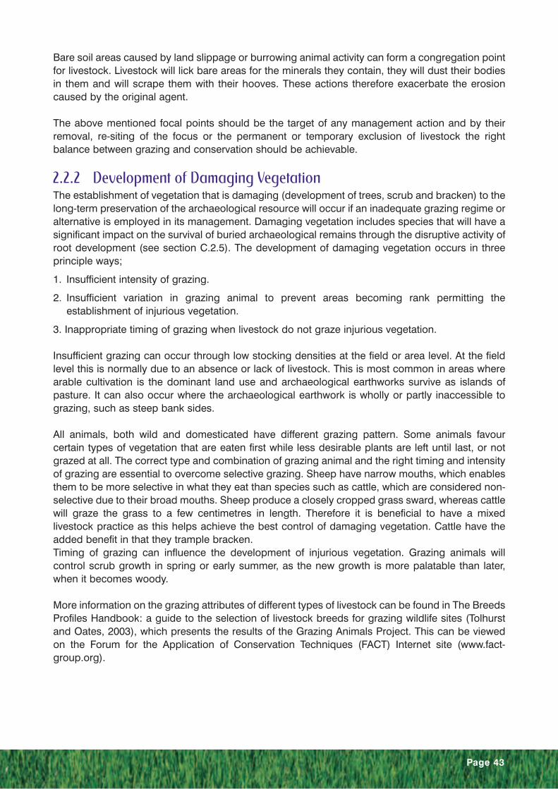
SummaryA shelterbelt adjacent to a set of well-preserved Roman barrows was reduced in size to remove theeffects of livestock erosion from one of the barrows.
IntroductionSituated alongside the Roman strategicroad known as the Stanegate is acollection of well-preserved Romanbarrows. These are a particularly raresurvival and although other Romancemeteries are known to exist within theHadrian’s Wall World Heritage Site theyare the only visible examples. Adjacent tothe barrows is a shelterbelt of coniferoustrees. The shelter provided by these treeshad encouraged live-stock, principallycattle, to gather next to them, which wasalso on top of one of the most prominentbarrows (figure 27). As a result the barrowwas slowly being eroded.
It was decided that the partial removal of the shelterbelt would be a solution to the problem. A shortsection from the end of the shelterbelt was to be removed, which would allow livestrock to continueto shelter by the trees but off the sensitive upstanding earthworks.
An alternative management option would have been to erect a single strand barbed wire fencearound the barrows to exclude cattle from them, but maintain sheep grazing. It was felt that thiswould be intrusive to the setting of the monuments and potentially through its erectionand maintenance cause disturbance to buried archaeological deposits.
PreparationThe first stage, after permission from thelandowner was obtained, was todetermine whether any consents wererequired to remove the trees and whatimpact partial removal may have on therest of the shelterbelt.
Trees may benefit from a Tree ProtectionOrder (TPO), which should always beconfirmed with the local authority.Depending on the amount of timber beingremoved a felling licence from the ForestryCommission may be required. In thisinstance, the shelterbelt was a modernplantation of coniferous trees and was notcovered by a TPO. A felling licence wasnot required due to the small amountbeing removed.
Case Study 4: Reducing Shelter at Four Laws
Figure 28: Works on completion
Figure 27: Erosion of a prominent Roman barrow due tocattle gathering in the lee of the shelterbelt

Page 49
The removal of trees from the edge of shelterbelts can cause further loss, as the newly exposedtrees will be less resistant to windthrow. As this shelterbelt was relatively small it was felt that theremoval would not significantly increase the risk of windthrow above that which was alreadyoccurring. However, this needs careful consideration where falling trees may cause further damageto the archaeological site.
MethodThe following method was employed in the works:
1. The trees were felled. Smaller branches were shredded. Larger branches and the trunk were cutup into manageable sections. In this case all materials were removed from site, but in somecases it may be possible to leave some wood to rot down on site and enhance the wildlife valueof the site. However, this may encourage greater burrowing activity by providing cover.
2. The stumps were ground down to just below the ground surface and covered with soil.
3. The area was raked over to provide a fine tilth and re-seeded with grass seed. The re-seededarea was not fenced as it was felt the stocking rate was sufficiently low to allow recovery of thegrass cover.
4. A new stock proof fence was erected around the modified shelterbelt.
ConclusionThe removal of a section of the shelterbelt has solved the damage being caused to one of the mostprominent barrows on the site. Although more expensive in the short-term than erecting a fencearound the site it is a better solution for the setting of the monument. It will in the long-term be lessexpensive as the fencing would have required continued maintenance.
This method could be applied to the wholesale removal of a shelterbelt, where provision ofalternative shelter away from the site could be incorporated into the scheme.
Page 50
3.1 IntroductionVehicle access on monuments largely occurs as part of the necessary, everyday agriculturalmanagement of the landscape, but in some cases it also occurs for recreation. The latter includesthe use of off-road motorbikes and cars, which can have significant impact on monumentsparticularly where these are located near urban areas. The study area of Hadrian’s Wall used in thedevelopment of this manual does not suffer from recreational vehicle use and therefore this aspecthas not been included in the manual. Future revision of the manual may allow for managementtechniques to be included.
The passage of vehicles can in some instances cause disturbance to the ground surface andtherefore can have a significant impact on the preservation of archaeological earthworks, inaddition to leaving unsightly scars in the setting of the monument. This section of the guidancemanual discusses the problems that can occur through the use of vehicles on earthworks and thepossible management options.
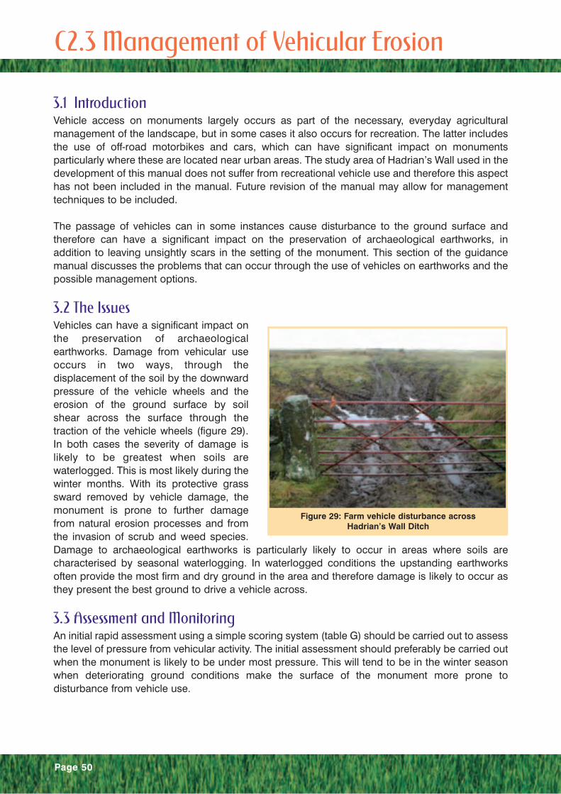
3.2 The IssuesVehicles can have a significant impact onthe preservation of archaeologicalearthworks. Damage from vehicular useoccurs in two ways, through thedisplacement of the soil by the downwardpressure of the vehicle wheels and theerosion of the ground surface by soilshear across the surface through thetraction of the vehicle wheels (figure 29).In both cases the severity of damage islikely to be greatest when soils arewaterlogged. This is most likely during thewinter months. With its protective grasssward removed by vehicle damage, themonument is prone to further damagefrom natural erosion processes and fromthe invasion of scrub and weed species.Damage to archaeological earthworks is particularly likely to occur in areas where soils arecharacterised by seasonal waterlogging. In waterlogged conditions the upstanding earthworksoften provide the most firm and dry ground in the area and therefore damage is likely to occur asthey present the best ground to drive a vehicle across.
3.3 Assessment and MonitoringAn initial rapid assessment using a simple scoring system (table G) should be carried out to assessthe level of pressure from vehicular activity. The initial assessment should preferably be carried outwhen the monument is likely to be under most pressure. This will tend to be in the winter seasonwhen deteriorating ground conditions make the surface of the monument more prone todisturbance from vehicle use.
C2.3 Management of Vehicular Erosion
Figure 29: Farm vehicle disturbance acrossHadrian’s Wall Ditch

Page 51
Level Score Description Photographic Example
None 0 No evidence of vehicularerosion.
Low 1 Evidence of some vehicleerosion on the monument,but not causing significantdisturbance or evidence in thevicinity of the monument thatmay impact on the monumentperiodically.
Medium 2 Evidence of vehicle erosioncausing significant disturbanceover parts of the monument(generally less than 25% of thearea of visible earthworksaffected by vehicle erosion).
High 3 Extensive vehicle erosion overmuch of the monument(Over 25% of the area of visibleearthworks being affected byvehicle erosion).
Table G: Indicators of Stress for Vehicular Erosion

Page 52
Where the monument is identified as being under pressure from vehicle activity further assessmentshould be used to highlight when vehicles are causing disturbance, reasons for using the route,alternative routes, contributing factors and additional threats (e.g. presence of scrub, invasive weedspecies, presence of livestock feeding areas).
Vehicles may not cause damage all the year round and their passage is often sustainable duringdrier periods. The period in which the route shows disturbance should be established throughdiscussion with the landowner and other available information. This can be enhanced by furthermonitoring visits throughout the year.
The reason for using the route will assist in developing the management response. Some routesare primary routes on the farm and have to remain in use throughout the year. Other routes are foraccess to feed stock and therefore are used seasonally when livestock are on the land. Theseroutes present a greater opportunity for reducing pressure.
The presence of alternative routes or the opportunity to use a wider zone for access may assist inpreventing damage. The assessment should identify where the route for vehicle use could bevaried so that the route can be changed when the indicator of pressure has reached its limit ofacceptability.
The presence of contributing factors will affect the sustainability of the route. These factors includesoil drainage, the presence of stock, and the presence of scrub, bracken or other invasive weedspecies. Poor soil drainage will increase the vulnerability of the monument as the soil becomesmore easily displaced when waterlogged. The presence of stock will add to the amount ofdisturbance. The presence of scrub, bracken, or other weed species in the vicinity increases thevulnerability of the monument as they may become established in the disturbed ground causingfurther damage.
Monitoring should be carried out to enhance knowledge before and after any management actionis taken. This should be targeted at identifying the amount of disturbance and its impact, which canbe done in a number of ways:
• visual assessment or fixed point photography to make a rapid and easily repeatable monitoringsystem.
• ground condition survey to accurately record the area and depth being disturbed.
• botanical observations to identify whether the influence of vehicle damage is limited to theobserved disturbed area or whether the surrounding area is subject to periodic disturbance asindicated by the presence of species that characterise disturbed ground such as annualmeadow grass and broad-leaved weed species.

Page 53
3.4 ManagementThe aim of management is to remove the pressure causing the damage or reduce it to acceptableand manageable levels. The options for management can be grouped into two types. Those thatalter the usage of the route (indirect methods) and those that alter the surface of the route to makeit more sustainable for the use (direct methods).
Indirect methodsIndirect methods involve the alteration of the pattern of use for the route. This can be done in anumber of ways that include:
• reducing the load
• changing the route
• altering the time of useIf the access is limited to a single route then the use of vehicles that have less impact on the groundsurface is an option. These are vehicles that either are physically lighter (e.g. All Terrain Vehicles)or have a greater spread of their weight (e.g. tractors with larger load dispersing tyres fitted). Theapplicability of this management technique will depend on the vehicle requirements of the land useand the availability of the appropriate equipment.
Changing the route means that either the existing route is closed to vehicle use or it is periodicallyrested to allow recovery. Closure of an existing access route is feasible where an alternative, moresustainable route over less sensitive ground has been identified. Resting the route will depend onthe availability of at least two access routes that can be alternated or a wide strip in which theaccess route can be altered. In both cases once there is evidence of sward deterioration (areas ofbare ground development) or ground disturbance the access route should be moved to allowrecovery.
The ground is most susceptible to damage from vehicle use when it is waterlogged. Restricting useduring this period will assist in preventing any damage. Limiting the use is best done over aspecified period (e.g. October – March) when damage is likely to occur and when natural recoverythrough grass sward re-growth would not occur.
Direct methodsDirect methods involve the alteration of the surface of the route to provide a surface that can sustainthe level of use. This can be achieved in the following ways:
• provision of hard surfacing
• provision of improved soft surfacing (e.g. re-inforcing the rootzone, improving ground cover)
• improving ground conditions (e.g. improving drainage)
Hard surfacing is the most durable surface for vehicle use. However, its installation can in its ownright have a significant impact on the preservation of the monument and its presence can be anintrusion into the setting and appearance of the monument. The traditional options are tarmacadamor gravel. Alternative synthetic surfaces are available as a loose material to apply in the same wayas gravel (e.g. shredded car tyres) or others as a paver. Some pavers are constructed as a cellularmoulding allowing either additional material (e.g. gravel) to be added in the cells or for grass togrow through it. All methods require the preparation of the ground surface prior to application (e.g.the excavation of a tray) and therefore may require archaeological works prior to or during works(see section C.1).

Page 54
Soft surfacing improvements include the addition of biodegradable materials, the reinforcement ofthe grass sward or the addition of a wearing course into the surface. In woodland pasture settingsthe use of wood-chips as a renewable, biodegradable surface may be appropriate. Re-enforcementof a grass sward can be achieved through the introduction of synthetic materials that relievecompaction. Most common is the use of a plastic mesh that gives the soil elasticity thus preventingwheel rutting and soil compaction. A wearing course of gravel worked into the surface of theground can increase its ability to cope with traffic and if a large aggregate size (75mm) is used willassist with drainage. The addition of materials in conjunction with the movement of vehicles canlead to the added material migrating deeper into the soil profile and potentially into buriedarchaeological deposits. It is therefore appropriate to use this technique in archaeologically non-sensitive areas or lay a geotextile membrane to separate the added material from underlyingarchaeological deposits.
Damage from vehicles often occurs due to the soils being waterlogged. Therefore improvingdrainage and aeration of the soil to reduce the moisture level of the soil may make the surface moresustainable for vehicle use. This can be achieved through a programme of grassland managementsimilar to that used in recreational management (section C2.1). This involves the spiking of theground to improve aeration, addition of sharp sand to improve drainage and the application offertilisers to encourage growth of the grass sward. In addition harder wearing grass species maybe introduced to improve sustainability of the route. Other initiatives to improve the drainageinclude ensuring any existing land drainage is functional and effective and the installation of newland drainage (see section C2.6). Both of these latter options will require significant disturbance inarchaeologically sensitive areas and therefore will require archaeological works prior to or duringimplementation.
Page 55
SummaryThe traditional improvement of an accesstrack across the vallum of Hadrian’s Wallto facilitate farm access on a single routeand to restrict access to other previouslyused parts of this well preserved section.
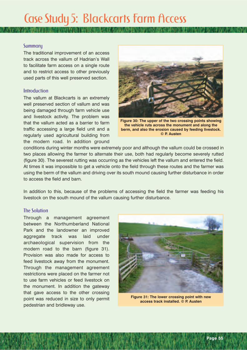
IntroductionThe vallum at Blackcarts is an extremelywell preserved section of vallum and wasbeing damaged through farm vehicle useand livestock activity. The problem wasthat the vallum acted as a barrier to farmtraffic accessing a large field unit and aregularly used agricultural building fromthe modern road. In addition groundconditions during winter months were extremely poor and although the vallum could be crossed intwo places allowing the farmer to alternate their use, both had regularly become severely rutted(figure 30). The severest rutting was occurring as the vehicles left the vallum and entered the field.At times it was impossible to get a vehicle onto the field through these routes and the farmer wasusing the berm of the vallum and driving over its south mound causing further disturbance in orderto access the field and barn.
In addition to this, because of the problems of accessing the field the farmer was feeding hislivestock on the south mound of the vallum causing further disturbance.
The SolutionThrough a management agreementbetween the Northumberland NationalPark and the landowner an improvedaggregate track was laid underarchaeological supervision from themodern road to the barn (figure 31).Provision was also made for access tofeed livestock away from the monument.Through the management agreementrestrictions were placed on the farmer notto use farm vehicles or feed livestock onthe monument. In addition the gatewaythat gave access to the other crossingpoint was reduced in size to only permitpedestrian and bridleway use.
Figure 30: The upper of the two crossing points showingthe vehicle ruts across the monument and along the
berm, and also the erosion caused by feeding livestock.© P. Austen
Figure 31: The lower crossing point with newaccess track installed. © P. Austen
Case Study 5: Blackcarts Farm Access

Page 56
ConclusionsThe creation of a single well-drainedaccess track that provides both accessacross the monument to the barn andfacilitates the feeding of livestock awayfrom the monument has had a significantbenefit to the monument. The previouslydisturbed ground is beginning to recoverwith the annual grass species and weedspecies being replaced by perenial grassspecies (figure 32). It demonstrates thebenefits of working with the landowner tocreate good effective farm access thatminimises disturbance to archaeologicalearthworks.
Figure 32: The upper crossing point one year on (2003).

Page 57
SummaryA farm access route across Hadrian’s Wall was improved using an expanding plastic cellular fabricpart filled with aggregate and finished with soil and grass seed. The cellular material will preventfurther damage to the archaeological significance of the monument by bearing the weight of farmvehicles. The finishing of the route with a grass cover will improve the setting of the monument.
IntroductionGrindon is the local name given to the siteof Milecastle 34 of Hadrian’s Wall. About100m east of the site a farm access routecrosses the line of Hadrian’s Wall, itsnorthern ditch and counterscarp mound.The regular use of this route by farmvehicles and livestock had resulted in theroute becoming entrenched over time.The erosion of the route had beenexacerbated by the flow of surface water.In addition the combined effects of naturalerosion and livestock were causingdisturbance to the well-preserved remainson either side of the route (figure 33).
The route was situated in unimproved grassland and it was felt that an aggregate track would beintrusive to the landscape setting. Therefore, it was proposed to create a sustainable access routewithin the existing entrenched route and to re-establish a grass cover that would maintain thesetting of the monument.
Repair MethodThe repair was carried out as follows:
1. A 100mm deep trench, 300mm wide was excavated down the centre of the route under anarchaeological watching brief. The trench and base of the route were lined with a geotextilemembrane.
2. A drainage pipe was laid in the base of the trench to remove any standing water from thefinished surface of the route. This will prevent future erosion damage to the ground surface byfarm vehicles and livestock.
Figure 33: The farm track prior to works.
Case Study 6: Grindon Farm Access
Figure 34: Plan of method.

Page 58
3. The trench was backfilled with 75mm clean drainage aggregate and the same size aggregatewas used to form a 100mm deep base for the expanding cellular fabric, called “Soil-cell” to rest on.
4. The geotextile mem-brane was wrapped around this aggregate.
5. The “Soil-cell” (75mm- depth specifi-cation) was laid over the route and pegged down using700mm long steel “J” pins. The pins were driven in at 1m intervals down the centre of the routeand at either side.
6. The “Soil-cell” was filled to a depth of 50mm with a 50mm size aggregate to increase its rigidity.A smaller aggregate was used at this stage to assist with retaining moisture near the surface ofthe route to promote good grass growth.
7. The remaining 25mm of the “Soil-cell” was infilled with soil and an additional 25mm laid over thesurface of the route before seeding with an appropriate grass seed mixture to match thesurrounding vegetation.
8. Livestock were kept off the repaired route until a grass sward had established.
ConclusionsA sustainable farm access route acrossthe monument has been created. Themethod employed will re-establish a grasscover on the route that improves thesetting of the monument by blending thefarm access with its surroundinglandscape. It is best used where a 200mmtray can be excavated or an existingentrenched route can be used. This is sothat the finished result does not alter thefield characteristics of the monument.
Although it is predicted that this will be adurable farm access route, as no otherknown examples exist then this remains tobe seen. It will be interesting to re-visit thesite in the future and assess its success.
Figure 35: Farm track after completion of works.

Page 59
4.1 IntroductionBurrowing animals have been recognised as a major cause of damage to the archaeologicalresource. Their damaging impact is the effect of their tunnelling activities, which can disfigure thesurface expression of the monument, destroy stratigraphy and result in the redistribution ofartefacts and the loss of information.
This guide covers those burrowing animal species that are most likely to be encountered in agrassland management setting and have been recognised as causing significant damage toarchaeological deposits. These include the rabbit, badger and mole. The impact of fox, rat, puffinand shearwater has been assessed in the Historic Scotland Technical Advice Note 16, BurrowingAnimals and Archaeology (Dunwell and Trout, 1999) and is not dealt with under this guidancemanual.
Despite the potential severity of their impact there has until recently, been very little intensiveresearch into their archaeological impacts and the effectiveness of control methods inarchaeological settings. The Historic Scotland Technical Advice Note formed the first synthesis ofthe available information and the excavations at Brown Caterthun provided the first investigationsinto the impact of rabbit burrow systems on buried archaeology. Therefore, much of the informationused in this guidance manual has been derived from the fields of nature conservation andagriculture where the management of burrowing animals has a longer and more developed history.
In addition to the Historic Scotland Technical Advice Note this section has principally been drawnfrom the following texts; The Lowland Grassland Management Handbook (Jefferson and Croft,1999), The Handbook of British Mammals (Corbet and Harris, 1991) and Badgers on Historic Sites(English Heritage Landscape Advice Note 16, 2000). These texts contain additional information thatthe reader may find useful.
4.2 IssuesAs the title of this section suggests, it is theburrow or tunnel system that is theprincipal damaging impact of theseanimals. With the exception of moles,these tunnels will be excavatedpreferentially into soft and sloping ground,both for ease of digging and to providewell-drained refuges. Archaeologicalearthworks, which are often earthen banksare therefore a particularly attractivehabitat for burrowing animals. The tunnelling activities of burrowinganimals can cause damage toarchaeological earthworks in a number ofways.
Disfigurement – The collapse of tunnel systems and the spread of excavated material from tunnelentrances is apparent on the surface as a disfigurement in the field characteristics of the earthwork(figure 36). This is detrimental to its visitor appreciation and its research potential by field survey.
Figure 36: Disfigurement of a turf wall section ofHadrian’s Wall by a badger sett.
C 2.4 Burrowing Animals
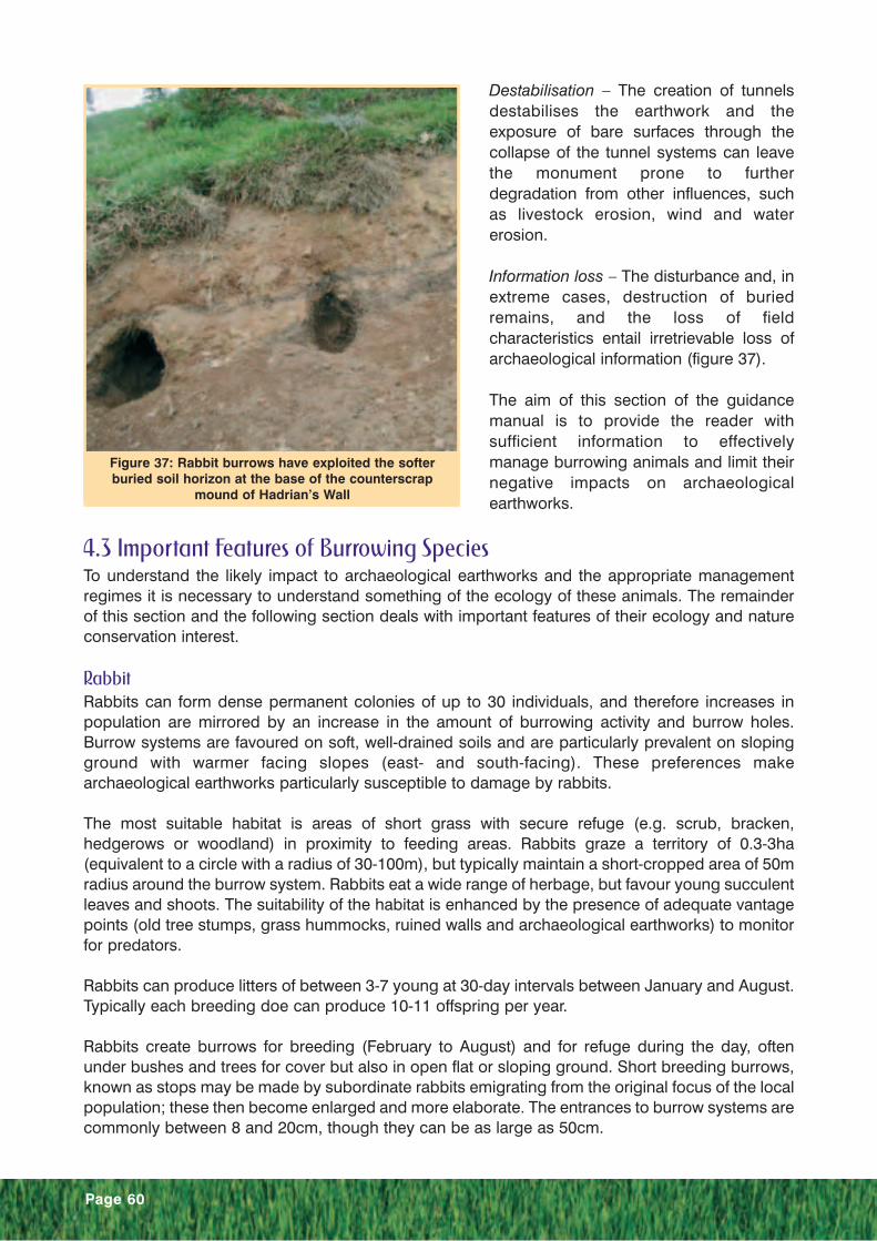
Page 60
Destabilisation – The creation of tunnelsdestabilises the earthwork and theexposure of bare surfaces through thecollapse of the tunnel systems can leavethe monument prone to furtherdegradation from other influences, suchas livestock erosion, wind and watererosion.
Information loss – The disturbance and, inextreme cases, destruction of buriedremains, and the loss of fieldcharacteristics entail irretrievable loss ofarchaeological information (figure 37).
The aim of this section of the guidancemanual is to provide the reader withsufficient information to effectivelymanage burrowing animals and limit theirnegative impacts on archaeologicalearthworks.
4.3 Important Features of Burrowing SpeciesTo understand the likely impact to archaeological earthworks and the appropriate managementregimes it is necessary to understand something of the ecology of these animals. The remainderof this section and the following section deals with important features of their ecology and natureconservation interest.
RabbitRabbits can form dense permanent colonies of up to 30 individuals, and therefore increases inpopulation are mirrored by an increase in the amount of burrowing activity and burrow holes.Burrow systems are favoured on soft, well-drained soils and are particularly prevalent on slopingground with warmer facing slopes (east- and south-facing). These preferences makearchaeological earthworks particularly susceptible to damage by rabbits.
The most suitable habitat is areas of short grass with secure refuge (e.g. scrub, bracken,hedgerows or woodland) in proximity to feeding areas. Rabbits graze a territory of 0.3-3ha(equivalent to a circle with a radius of 30-100m), but typically maintain a short-cropped area of 50mradius around the burrow system. Rabbits eat a wide range of herbage, but favour young succulentleaves and shoots. The suitability of the habitat is enhanced by the presence of adequate vantagepoints (old tree stumps, grass hummocks, ruined walls and archaeological earthworks) to monitorfor predators.
Rabbits can produce litters of between 3-7 young at 30-day intervals between January and August.Typically each breeding doe can produce 10-11 offspring per year.
Rabbits create burrows for breeding (February to August) and for refuge during the day, oftenunder bushes and trees for cover but also in open flat or sloping ground. Short breeding burrows,known as stops may be made by subordinate rabbits emigrating from the original focus of the localpopulation; these then become enlarged and more elaborate. The entrances to burrow systems arecommonly between 8 and 20cm, though they can be as large as 50cm.
Figure 37: Rabbit burrows have exploited the softerburied soil horizon at the base of the counterscrap
mound of Hadrian’s Wall

Page 61
The warren structure is variable according to soil/subsoil characteristics but may have 5-250m oftunnel, typically 0.1-0.15m in diameter and reaching 0.75-4.5m below the ground surface.Estimates for the volume of warrens also vary widely; perhaps 2.5-8m of burrow per hole and 0.02-0.14 cubic metres of soil removed per hole (greater in soft, easily excavated deposits). A guide tothe extent of excavation can be determined from the frequency of burrows and the amount of spoiloutside (except where rabbits are living in cracks in hard ground e.g. rock).
BadgerBadgers are widespread in the UnitedKingdom, only being largely absent fromhigh altitude regions (above 500m) andurban areas. Woodland or scrub, slopedground and more easily dug soils are thefavoured habitats (Neal and Roper, 1991),although they also occur in openmoorland. They are most common insouth-west England. The badgerpopulation has increased significantly inrecent years with a recorded rise from200,000 in 1988 to 310,000 in 1997 (TheMammal Society, 2001).
Badgers live in social groups, known asclans of around 6 (range 2-23) in elaboratetunnel systems known as setts. The settscan be divided into five types according totheir size and importance.
Main sett: large sett, continuously occupied, more than 3 entrances, used for breeding.
Annex sett: smaller than main sett, usually occupied, and connected to main sett by well-wornpathways.
Subsidiary sett: seasonally occupied and some distance from main sett.
Outliers: often single holes, only used occasionally as a sleeping site or as refuge during feeding.
Day nests: above ground, usually in dense vegetation, used as temporary shelters.
The tunnels can extend up to 100m, but are typically 10-20m long. Excavated examples suggestthat tunnel systems are largely two-dimensional, rarely exceeding 2m below the entrance hole.Badger setts can be distinguished from other burrows by the size and shape of the entrance holes,which are typically 25cm in diameter and oval (wider than they are high). Large spoil heaps can befound outside sett entrances containing plant material used for bedding. Foxes produce similarspoil heaps known as earths, but these lack any plant material. Tunnel systems can be used byother mammals such as rabbits and foxes.
The presence of elder, nettle and blackberry (blackberry replaced by raspberry in northern Britain)can be an indication of the presence of a badger sett as these form a major element of their diet(Neal and Roper, 1991).
Figure 38: Spoil heap outside badger tunnel entrancein counterscarp mound of Hadrian’s Wall.

Badger clans are territorial. Under optimal conditions a badger territory is about 30ha, but undermarginal conditions it can be as large as 150ha. The majority of badger latrines are located on theboundaries of the territories.
Badgers mate mainly in February and March producing 1-4 young in the following February, whichemerge from the sett in April. Badgers can live for up to 11 years, but more commonly only live to6 years old.
MoleMoles are present in most habitats where the soil is sufficiently deep to allow tunnel constructionand thrive in land that is in pasture management. They are uncommon on moorland and sand duneareas due to a lack of prey (soil invertebrates, especially earthworms). They spend most of theirlives in extensive and elaborate system of tunnels. These vary in depth from just below the surfaceto well over a metre down and are characterised by the molehills created from the spoil ofexcavating the tunnel system.
Moles live solitary for most of the year and occupy largely exclusive territories. A single territorynormally covers between 0.13 and 0.28ha, which is equivalent to a circle of a radius between 20and 30m. During the short spring breeding season (March – June) male territories can increase toaround 0.73ha (equivalent to a radius of 50m) to find receptive females.
Population growth is more rapid in southern England where two litters of 3-4 moles can commonlybe raised each year. Only one litter is raised in other parts of the United Kingdom.
4.4 Nature Conservation ValueBurrowing animals can be of nature conservation value either in their own right as a valued orendangered species or by virtue of the ecosystem they are part of and assist in maintaining.
Rabbits are not normally considered of nature conservation value and in high population densitiescan lead to the degradation of the conservation value of important semi-natural grasslands.However, in areas where there is insufficient or unreliable grazing then rabbit grazing can beimportant for nature conservation by maintaining a mosaic of grass heights.Badgers are not usually of high nature conservation value as they are generally common. However,in some areas such as urban, upland, intensively farmed or low-lying areas badgers may still beuncommon, and a sett may be of high local importance. Due to their history of persecution theyare legally protected, primarily under the Protection to Badgers Act 1992, which makes it an offenceto kill, injure, capture or cruelly ill-treat a badger or interfere with a badger sett except by licence. Ifbadgers are present on an archaeological earthwork it is essential to consult with the relevantgovernment departments and nature conservation organisations and obtain the appropriatelicence before any action is taken, as an offence may otherwise be committed under the act.
Moles are a native component of grassland ecosystems and therefore requests to control themshould be limited to where there is a justified archaeological conservation need.
Page 62
4. 5 Assessment and MonitoringAssessment and monitoring are key to the accurate evaluation of the present and changing risk toan earthwork, and to the review of the effectiveness of management regimes. They should berepeatable and relatively simple to allow rapid appraisal. This phase can be carried out at mosttimes of year, however it is easiest in late winter or early spring when burrowing animals arebecoming active as they enter their breeding seasons and vegetation is at its lowest makingobservation of burrow holes easier. For badgers, September can also be a good time to observethe level of activity as this is a peak time for burrow digging (Woods, 1995).
The initial phase of the assessment of burrowing activity on and in the vicinity of archaeologicalearthworks should be a rapid survey of the level of pressure the monument is under. The aim ofthis type of assessment is to establish the present condition of, and risk to, the monument byrecording the level and presence of burrowing activity on and in the vicinity of the monument. TableH provides an example of a suitable assessment system.
It is the recognition of the early signs of evidence that is a problem for the surveyor. Therefore it isoften not until burrow entrances are visible and damage is occurring to the monument that theevidence is easy to recognise. The surveyor should look for evidence such as droppings, scrapes,and tracks.
Where the earthwork is under active damage from burrowing animals or is likely to becomedamaged from burrowing animals due to their presence in the vicinity of the monument it may benecessary to carry out more detailed assessment.This additional assessment can include thefollowing;
Level of activity – An assessment of the level of the burrowing animal activity in the area. The areabeing the ground on and around the earthwork where colonisation of the earthwork is most likelyto come from (e.g. for rabbits this is an area 100m around the archaeological earthwork). This canbe done by estimating the percentage of activity on or around the monument (e.g. 25% of themonument area shows evidence of activity), counting holes or identifying individual burrowsystems.
Status of activity – An assessment of whether the burrow systems are active or inactive. Indicatorsof inactive burrow systems include the presence of cobwebs over burrow entrances, vegetationgrowing over spoil, lack of tracks going from the burrow entrance and no evidence of freshdroppings or rabbit grazing. Indicators of active burrows include fresh scrapes and droppings,rabbit grazed areas, and tracks. Inactive burrow entrances can be blocked with turf to confirmabsence before any further management activity is taken, though this will need to be done underlicence for badgers.
Presence of exacerbating factors – An assessment of the presence of habitat favourable to theburrowing species (e.g. for rabbits the presence of a short grass sward that makes suitable grazing,burrow sites and cover) and the presence of factors that would exacerbate any destabilisation ofthe monument (e.g. livestock presence).
Present management or population limiting factors – An assessment of any existing managementof burrowing animal populations and their effectiveness. Presence of disease in burrowing animalpopulation (e.g. myxomatosis).
Significance of impact – An assessment of the impact on the significance of the archaeologicalearthwork. Recording the amount of disfigurement (e.g. loss of form in the monument and thereforeits value as a landscape feature and ease of interpretation by visitors) and evidence of significantinformation loss in burrow spoil (e.g. presence of artefacts, charcoal, variations in soil matrix colour
Page 63

Page 64
and texture, which all indicate disturbed stratification). Also, an assessment of the key componentsof the archaeological earthwork for preservation (e.g. parts of the monument that give keystratigraphic information) to highlight the potential impact of an incursion by burrowing animals.
Monitoring should be carried out at suitable time intervals to assess the changing condition andrisk to the monument and to assess the effectiveness of any management actions taken. It shouldreview earlier assessments, particularly the level and location of any activity and the archaeologicalimpact. Fixed point photographs should be taken to show the change in the monument conditiondue to active management or to assess the developing impact if no action is taken.
Level Score Description Photographic Example
None 0 No evidence of burrowinganimal pressure.
Low 1 Evidence of rabbit activity(droppings, tracks, scrapes)on the site, but no burrows.Burrows may be present inthe adjacent area.
Medium 2 Evidence of rabbit activity on themonument, including burrows.The burrows only occupy a smallarea and have not resulted indisfigurement to the monument.
Table H: Indicators of Stress for Burrowing Activity
High 3 Extensive burrowing activity overmuch of the monument.The monument shows evidencewith the exception of badger settsentrances. Inactive badger settentrances can only be blockedonce disuse of sett has beenconfirmed and agreed by theappropriate licensing body.
4.6 ManagementThe use of chemicals to control burrowing animals will require adherence to COSHH regulationsand other regulations relating to the use of pesticides.
Rabbit ControlUnder Section 1 of the Pests Act 1954, the occupier of any land has a continuing obligation to killor take rabbits on their land to prevent damage being caused by them. Damage as defined underthis act can include archaeological earthworks. Where an occupier is failing to meet theirobligation, agriculture ministers have powers, under section 98 of the Agriculture Act 1947 torequire occupiers of land to take action against rabbits.
Rabbits can be controlled by a variety of means including exclusion and removal. These methodscan be used in conjunction with habitat alteration to reduce recolonisation pressure.
Exclusion MethodsMethods for excluding rabbits from archaeological earthworks involve the creation of barriers. Thebarrier can either be created as a fence surrounding the monument or by laying the barrier on theground over the monument. In both situations the wire netting should comply with British Standard1722 and should have a hexagonal mesh of at least 18 gauge, 31mm (1.25'').
Netting for fencing areas should be a minimum width of 900mm. The netting should be erected sothat 750mm is erected vertically and the bottom 150mm is lapped on the surface of the groundaway from the area being excluded of rabbits. Turves of grass should be placed on the lappednetting at 1m intervals and pegged securely down; after a year vegetation should grow through themesh to hold the netting firmly in place. Two straining wires should be attached to the lappednetting side of the fence (one at the top and one at the base of the fence) and the netting attachedusing connectors. Fence stakes can be placed at 15m intervals if high tensile spring straining wireis used or 4m intervals if mild steel is used. Stakes should be 1.7m long and 50-75mm in diameter.Straining posts should be 2.1m long and 100-120mm in diameter.
Where the netting is laid over the surface of the archaeological earthwork the netting should extendfor a minimum of 300mm beyond the limit of the earthwork’s slope. Where more than one width ofnetting is required the widths should be overlapped. The netting should be pegged down at regularintervals. After about a year vegetation should grow through the mesh and hold it firmly in place.Where it is important to maintain the aesthetics of the monument the netting can be covered withturves or soil.
It is necessary to monitor the excluded area for burrowing activity. In particular, where rabbitpopulations are at high-density exclusion methods will eventually be breached and therefore it willprobably be necessary to use the above methods in conjunction with removal methods. Wherefencing is used multi-catch drop box traps set in the fence-line can be an effective form of control.
The netting will have a finite lifespan and will therefore need periodic repair and replacement. Inaddition the installation of metal wire meshes means that some geophysical prospection methodsare not usable and therefore should be carried out prior to installation if appropriate. Also, if lainover the surface it will limit the options if the grass is cut by machine, as the netting has the potentialto become caught up in the machinery causing it and the netting damage.
Removal MethodsRemoval methods include fumigation, shooting and trapping. The methods vary in their efficacy.Fumigation is the most effective method if eradication of the population is necessary, with an
Page 65
Page 66
average population reduction of 70% following a single treatment. Repeat treatments can increaseefficacy to 90% (CSL, 2000). More traditional methods of management such as ferreting andshooting achieve 30-50% reductions (Corbett and Harris, 1991). The optimum time to carry out allthese methods is between November and March when the population is at its lowest and beforethe breeding season begins.
Fumigation products are based on aluminium phosphide (e.g. Talunex, Phostek and Phostoxin).These are permitted under the Control of Pesticides Regulations 1986 and are subject to thePoisons Act 1972 and the Poisons Rules 1982. They are applied to the rabbit burrows and rely ona reaction with soil moisture to release a toxic gas. The burrow holes are blocked with turf, earth orsand. Care should be taken to chose a material that does not alter the burial environment of thearchaeological deposits. It is recommended that at least one repeat fumigation is necessary, fourto seven days later to achieve optimum reduction. These compounds are extremely toxic tohumans and animals and should only be used by trained professionals.
Shooting using a shotgun or .22 rifle is a widely used method. Night shooting with lights is the mosteffective method but is restricted to authorised persons (owners, occupiers and tenants whopossess shooting rights) under the Ground Game Act 1880. A game licence may be required toshoot rabbits if the person effecting control is not the owner, occupier or tenant. Further advice onshooting can be found in Parkes 1991 and Parkes & Thornley 1994.
Trapping can be used to kill or capture rabbits. Traps include snares, spring traps, drop traps andcage traps. Snares and spring traps are not considered particularly effective or humane and canresult in other animals, including pets, being caught. Therefore they are not recommended for usein rabbit control, particularly on sites open or accessible to the public.
Drop traps are used in conjunction with fencing. The traps consist of a tunnel, trap-door and box.When set, the rabbits fall through the trap-door of the tunnel into the box to await humane disposal.The trap-door in the tunnel can be left set or not, which allows the periodic harvesting of the rabbitpopulation. When set the trap should be inspected daily.
Cage traps are wire mesh cages that are normally baited with carrots. These traps are sited in rabbitgrazed areas in winter when the lack of grazing increases the effectiveness of this type of control.These traps should be inspected twice a day. When in use livestock should be removed from thearea as they, particularly sheep can become caught up in the trap.
Other methods include ferreting and long netting. Ferreting involves the introduction of ferrets intothe burrow system as a means of bolting the rabbits either into nets or to be shot as they emerge.It is common practice to dig out ferrets if they get stuck and therefore this is not a suitable techniquefor archaeological earthworks. Long netting involves the driving of rabbits into a net by dogs. Againdogs may enter burrows, get stuck and require digging out and therefore the method is not highlysuited to archaeological earthworks.
After a phase of removal, burrows should be blocked with turf, earth, sand or gravel. This will allowan assessment of the effectiveness of the removal and the rate of recolonisation at a futuremonitoring visit by the number of re-opened holes. The use of PFA grout in a plastic sleeve tobackfill burrow systems after removal has been shown to be an effective alternative means ofcontrol as the hard substrate discourages re-excavation of burrow systems (Cowan, pers. comm.).Habitat AlterationThe success of a rabbit colony is dependent on the availability of the right habitat. Alteration ofthese factors may assist in rabbit control. The important elements of the habitat are;
Page 67
• suitable sloping ground for the creation of the burrow system,
• availability of existing burrows, particularly nesting chambers,
• cover from natural predators,
• suitable feeding areas of short grass,
• and vantage points to watch for predators.
Although no known example exists for rabbit control, the creation of an artificial burrow mound maybe a method that could assist in rabbit control. The artificial mound should be located at the furthestpoint from the archaeological earthwork where rabbits currently burrow, but within the homefeeding range (30-100m). Equally, non-archaeological sloping ground may be enhanced for burrowprovision by providing cover and suitable short grass grazing nearby to distract activity away fromthe archaeological earthwork. The construction of an artificial mound will be expensive, may beconsidered detrimental to the setting of the monument and potentially confuse interpretation of themonument. Therefore, it would rarely be an appropriate form of management.
Burrow destruction through ploughing is a method that has been used effectively to produce long-term reductions in rabbit activity (McKillop and Dendy, 1999). This reduces the availability ofburrows and therefore the ability of rabbit populations to recover after reduction. This method is notappropriate for archaeological earthworks, but recent research (Cowan, pers. comm.) has shownthat back-filling the burrow system with a hard material such as grout can have a similar long-termeffect on rabbit numbers and therefore rabbit burrowing.
Removal of cover will enhance predator activity and reduce the suitability of the burrow system torecolonisation. This can be combined with the enhancement of cover off the monument to providean alternative colony site.
Creating feeding areas of short grass sward away from the earthworks where the rabbits can becontrolled by shooting.
Altering the grazing regime on the land to favour the development of a long sward (removal oflivestock grazing between February and July) may help in reducing rabbit activity. The long grasshas three effects; it reduces the availability of suitable grazing for the rabbit colony, it increasesinfant rabbit mortality and reduces the effectiveness of vantage points for predator monitoring.However, care should be taken to prevent the development of scrub vegetation on the earthwork,which will encourage rabbit burrowing.
General ManagementRabbit burrow entrances should be blocked as described earlier, after rabbit removal or if disusedto prevent re-use by other burrowing species. Bare areas of ground should be restored to anappropriate grass sward to prevent secondary management problems such as the establishmentof damaging vegetation species and livestock erosion.
Badger ControlBadgers are a protected species under the Wildlife and Countryside Act 1981. This actconsolidated earlier legislation and has in turn been reinforced by the Badgers Act 1992, whichmakes it an offence to kill, injure or take a badger or to interfere with a sett except by licence. Theact makes provision under schedule 10 for licences to be granted ‘for the purpose of thepreservation, or archaeological investigation, of a monument scheduled under section 1 of theAncient Monuments and Archaeological Areas Act 1979, to interfere with a badger sett within anarea specified in the licence by any means so specified’ (section 10.1.e). It also makes provision
Page 68
under section 10.2.b for a licence to be granted ‘for the purpose of preventing serious damage toland, crops, poultry or any other form of property, to kill or take badgers, or to interfere with abadger sett, within an area specified in the licence by any means so specified’. The definition ofproperty extends to ancient monuments.
Due to these laws it is necessary that advice be sought from suitable organisations if badger controlis necessary for the preservation of the archaeological earthwork or if preservation works affect abadger. Two organisations issue licences; DEFRA and English Nature. Under present guidanceDEFRA can issue licences for the purpose of preventing damage by badgers to archaeologicalearthworks. English Nature can issue licences to interfere with badger setts for the purpose of thepreservation or archaeological investigation of a scheduled archaeological earthwork. The distinctionbetween the two aims may at times become blurred and it is always recommended practice todiscuss with these organisations to confirm the appropriateness of the licence being sought.
The first stage of any management is to assess the situation. This may involve the commissioningof a badger study. The study should include some or all of the following;
• an assessment of the type of sett on the earthwork,
• the relationship between the use of this sett and the use of the rest of the badger clan’s territory,
• the suitability of the habitat on the earthwork for sett use and expansion,
• and an assessment of the available options for management of the badger activity.
Badgers can be controlled by methods that include exclusion and removal. The methods permittedto be used for this purpose are restricted to those specified in the Wildlife and Countryside Act,1981 and should be carried out by experienced contractors. Habitat alteration may also be anoption.
RemovalUnder badger licensing legislation it is possible to remove badgers from an archaeologicalmonument by interference with the sett. This can be achieved by installing a badger gate in the settentrance or badger proof fence surrounding the sett. This permits the badger to leave the sett butnot to re-enter. Works for the removal of a badger sett can only be carried out outside the breedingseason (July to October).
ExclusionBadgers can be excluded from a monument by creating a physical barrier to the excavation ofsetts. This can either be done by the laying of wire mesh over the upstanding earthworks or byerecting a badger proof fence around the monument. Chain link or welded mesh should be usedin both cases. Some geophysical survey techniques are affected by the presence of metal andwhere appropriate should be caried out prior to installation.
Where the wire mesh is applied to the surface of the monument then the sections should beoverlapped and it should extend at least 0.5m beyond the upstanding feature to prevent badgersdigging underneath.
If used as a fence then it should be at least 1.25m high and either buried to a depth of 0.6m orlapped outwards for 0.5m to prevent badgers from digging underneath it (MAFF, 1999).
Electric fencing has also been shown to be an effective method of exclusion. However, itscontinued maintenance means that it is a costly method of exclusion.
Renardine, a bone-oil repellent can also be used to deter badger activity.
Habitat AlterationThe suitability for badger activity of the habitat on an archaeological earthwork can be altered. Forexample the removal of scrub and bracken from the earthwork reduces the cover for the sett andthe availability of suitable bedding material. Combined with the enhancement of habitats away fromthe earthwork this may be an effective means of reducing damage by badgers.
General ManagementIf a badger sett is removed from an archaeological earthwork or a sett is identified as unused thenthe sett entrances should be blocked as for rabbit burrows to discourage re-use by badgers orother burrowing species. Any bare ground around them should be restored to grass to preventsecondary management problems such as the invasion of damaging vegetation species andlivestock erosion.
Mole Control
MethodsMole populations can be controlled by chemical or physical means. The methods include:
• poisoning using strychnine hydrochloride treated worms,
• fumigation using aluminium phosphide tablets,
• trapping,
• and non-lethal repellents.
Both the chemical controls, strychnine hydrochloride worms and aluminium phosphide tablets, arehighly toxic. They are subject to the Poison Rules 1982 and Poisons Act 1972 and should only beused by licenced, trained operators familiar with the necessary precautionary measures.
Worms treated with Strychnine hydrochloride powder are a widely used and effective method ofmole control. The treated worms are inserted into the mole tunnels by means of a small (2cm)diameter hole. The worms should be placed in tunnels at depth to minimise the risk to non-targetorganisms.
Aluminium phosphide tablets are used by locating a mole tunnel between molehills with a metalprobe. A small hole is then pierced, the tablet is inserted and the hole plugged. The gas is createdby the reaction of the tablet with the moisture in the soil. This needs to be repeated at sufficientpoints to ensure the entire tunnel system is gassed. The need to create a number of holes inotherwise undisturbed archaeological earthworks in order to locate tunnels and insert the tabletmakes the method less suitable for use on archaeological monuments. An additional disadvantageof this method is that it only works well in damp soil conditions.
Mole traps are a readily available control method and can be performed without the need forspecialist training. However, their use entails digging and therefore they are unsuitable for use onarchaeological monuments. They can be effectively used in conjunction with other control methodsas they can be used in the vicinity of archaeological monuments to create a buffer zone.
Non-lethal repellents are available and include ultrasound and bone-oil. The effectiveness of theserepellent methods is not conclusive. However, bone-oil formulation (Renardine) repels moles for atleast 28 days (Atkinson and Macdonald, 1994) and may be used as a realistic alternative topoisoning and fumigation on archaeological earthworks. The moles once repelled from themonument may then be controlled by conventional trapping methods. Further information on themole as an agricultural pest and available control methods can be found in Atkinson, Macdonaldand Johnson (1994).
Page 69

Page 70
General ManagementMolehills should be removed by raking or harrowing as they can cause secondary managementproblems. These include providing a seed bed for the establishment of weed, invasive scrub andother potentially damaging plant species, and if compacted they can reduce the grass swards’ability to withstand recreational, vehicle and livestock pressures.
References and Further ReadingAtkinson, R P D and MacDonald, D W 1994 Can repellents function as non-lethal means of controlling moles Talpa europea? Journal of Applied Ecology, 31: 731-736.
Atkinson, R P D, MacDonald, D W and Johnson, P J 1994 The status of the European MoleTalpa europea L. as an agricultural pest and its management. Mammal Review, 24: 73-90.
Corbet, G B and Harris, S 1991 The Handbook of British Mammals (3rd edition). (Blackwell, Oxford)
Central Service Laboratory (CSL) 2000 Advice on Rabbit Management for Growers of Short Rotation Willow Coppice. Advisory leaflet produced by CSL.
DEFRA 2003 Badger gates in rabbit-proof fencing. Technical Advisory Note WM11.
DEFRA 2003 Badger problems: use of electirc fencing to prevent agricultural damage.Technical Advisory Note WM15.
DEFRA 2003 Rabbits: use of fencing to prevent agricultural damage. Technical Advisory Note WM16.
DEFRA 2003 Rabbits: use of cage-trapping to prevent agricultural damage. Technical Advisory Note WM17.
Dunwell, A J and Trout, R C 1999 Burrowing Animals and Archaeology. Historic Scotland Technical Advice Note 16.
English Heritage 2000 Badgers on Historic Sites, Landscape Advice Note 16.
Jefferson, R G and Croft, A 1999 The Lowland Grassland Management Handbook, 2nd edition.
The Mammal Society 2001 The Badger, Mammal Society Factsheet.
MAFF 1999 Badger problems: advice to householders. Technical Advisory Note WM7.
McKillop, I G and Dendy, J A 1999 Rabbit problems on recreational grassland andmanagement solutions. Journal of Turfgrass Science, 75, 74-81.
Neal, E G and Roper, T J 1991 The environmental impact of badgers (Meles meles) andtheir setts. In Meadows, P S and Meadows, A The Environmental Impact of BurrowingAnimals and Animal Burrows, Symposia of the Zoological Society of London number 63(Clarendon Press, Oxford)
Parkes, C 1991 Law of the Countryside, 4th edition. (Association of Countryside Rangers,Bakewell).
Parkes, C and Thornley, J 1994 Fair Game: the law of country sports and the protection of wildlife, 3rd edition. (Pelham Books, London).
Woods, M 1995 The Badger. (The Mammal Society, London).

Page 71
SummaryThe rabbit population from a section of Roman fort rampart was eradicated and the burrows back-filled with a grout to prevent re-excavation and to suppress recovery of rabbit population. This studywill assess this method as a long-term means of reducing rabbit damage to archaeologicalearthworks.
IntroductionThe reduction of rabbit burrowing on archaeological earthworks is a desire of archaeologicalearthwork management. Traditional methods of rabbit control techniques such as fumigation,trapping and shooting are an on-going commitment. Exclusion methods such as rabbit fencingneed periodic maintenance and replacement. The aim therefore is to find a management techniquethat can reduce or remove rabbit burrowing activity on a monument with the minimum of long-termcommitment.
Recent research (Cowan, pers.comm.)has shown that by filling the rabbit burrowwith a hard material that cannot be re-excavated by rabbits then a significantreduction in the rabbit activity can beachieved. The theory behind thetechnique is that only a finite number ofsuitable burrow sites (most particularly forthe construction of nesting chambers) areavailable in the landscape. Even in themost suitable circumstances thatarchaeological earthworks often providethere will only be a number of sites wherethe right conditions combine. By backfilling the burrow system these sites areunavailable to the local rabbit populationand as a result rabbit populations arereduced as is burrowing activity on themonument.
The method was tested at Brampton Old Church Roman Fort. This is a Roman fort on theStanegate, the strategic frontier road between the Roman forts at Corbridge and Carlisle.Excavation has shown that there is a wealth of buried archaeological evidence at this site. However,only the south and part of the east rampart are still readily visible as an archaeological earthwork.Rabbit burrowing activity has been causing the erosion and disfigurement of parts of this rampart(figure 39).
It was felt that the site presented a good trial for the technique, as there are significant populationsof rabbits in the area and it would demonstrate the effectiveness of the technique in an area of highre-colonisation pressure.
Figure 39: Rabbit and livestock damage to the rampartof Brampton Old Church Roman Fort.
Case Study 7: Reducing Rabbit Burrowing Activity at Brampton Roman Fort

Page 72
PreparationsPrior to the back filling of the burrow system the burrow entrances were recorded as part of anarchaeological survey. This allowed the assessment of the location of the burrows in relation toother factors such as cover and it also permits the re-assessment in five years time to assess itseffectiveness as a management technique. The re-assessment will record any new burrowentrances, which can then be related to old locations to determine whether any new excavation isinto the old burrow system or previously undisturbed archaeological material. It will also indicatethe level of re-colonisation, which it is believed, will be significantly lower.
After recording the burrows were fumigated with phostoxin to eradicate the rabbit population. Thiswas repeated on the day of back filling to eradicate any rabbits that had re-entered the burrowsystem.
Burrow BlockingThe burrows were lined with plastic sleeving, 180mm diameter and 450 micron thickness. To dothis the length of burrow was assessed using a drain rod with a brass wheel attachment to facilitatemanoeuvring of the rods around tunnel bends. The corresponding length of plastic sleeve was thencut off the roll and a knot tied in one end to form a bag. The grout was inserted under low pressureusing a grouting machine. The surplus plastic sleeve was cut off and the remainder folded over theend of the fill.
After the burrows were blocked they, along with their associated scars were given a top dressingof soil and then finished off with turf to restore the setting of the monument.
ConclusionAt this stage of the study no conclusions can be drawn. However, on the basis of recent researchit is expected that this method will significantly reduce the future level of burrowing activity on themonument and therefore minimise future disturbance to archaeological deposits. In addition it willprevent the collapse and resulting disfigurement of this, the last remaining visible section of fortrampart at this site.

Page 73
SummaryA desktop and sample field survey was undertaken along Offa’s Dyke to develop a detailedunderstanding of patterns of badger activity along the monument, to assess the extent of badgerburrowing damage to the earthwork, and to devise practical management responses.
IntroductionOffa’s Dyke is a remarkable 80 mile long 8th century boundary earthwork in the Welsh Borders. Ittypically consists of a massive bank and western ditch, and parts of it today serve as theEngland/Wales border and the line of the Offa’s Dyke Path (a National Trail). The dyke mainlyoccupies a pastoral context, with substantial lengths also under woodland and scrub, and someurban sections. Despite Scheduled Ancient Monument protection, management problems rangefrom recreational pressure to agricultural practices and the action of burrowing animals, and since1999 English Heritage and Cadw: Welsh Historic Monuments have funded the post of Offa’s DykeArchaeological Management Officer (based with the Clwyd-Powys Archaeological Trust) to developimproved practical care of the earthwork.
Erosion associated with badger burrowing had long been noted on Offa’s Dyke, but little detailedinformation was available on the scale and patterning of activity, or, indeed, the true extent of thethreat to the monument. An introductory ‘Badgers on Offa’s Dyke’ meeting in 2000 with interestedparties (including the Welsh and English natural and historic environment agencies, DEFRA andcounty badger groups) emphasised the different perceptions of the issue held by particular groups,and the need for systematic research before any management approaches could be developed orcollectively agreed. Accordingly English Heritage and Cadw: Welsh Historic Monuments jointlyfunded a survey project undertaken by a specialist badger consultant.
Objectives
• Determine the scale and nature of badger activity on Offa’s Dyke
• Analyse dynamics of badger activity within selected localities
• Suggest practical management approaches against this background
MethodPart 1 – Whole Dyke Desktop AnalysisExisting data were used to attempt a generalised assessment of the overall incidence of badgeractivity along the whole 80 mile length of the monument. Sources were sett records maintained bycounty badger groups, and data gathered during archaeological management surveys variouslyundertaken in the 1990s by English Heritage, Cadw and Gloucestershire County Council.
Part 2 – Sample Field SurveyBadger setts were surveyed along a 13.5 km sample section of Offa’s Dyke north and south ofKnighton, Powys (6 km English northern section, 7.5 km Welsh southern section). Each sett wasphotographed and sketched, and data recorded on the number of entrances, level of entrance
Case Study 8: Surveying Badger Activity Along Offa’s Dyke

Page 74
activity, status (main/annexe/subsidiary/outlier), surrounding habitat and structural condition.Assessment was also made of dyke size, completeness and apparent severity of ongoingburrowing damage. Additional records were made of landscape and habitat within the wider dykecorridor.
ResultsPart 1 – Whole Dyke Desktop Analysis:
• Information was not available/supplied for all areas, and there were significant questions ofconsistency and completeness within and between the data sets obtained. Consequently nofirm conclusions could be drawn.
Part 2 – Sample Field Survey:
• Northern Section: 35 setts (7 main) affecting 83% of dyke, average number of sett entrances 27.Setts found across range of habitat types, with scrub (15.5% of dyke) supporting 28.5% ofrecorded setts. 94% of setts occupy sections of dyke with the bank above 1.5 metres in height(98% of the dyke in this sector).
• Southern Section: 20 setts (4 main) affecting 15% of dyke, average number of entrances 13.Woodland (41% of dyke) supported 85% of setts. 95% of setts occupy sections of dyke withbank above 1.5 metres in height (52% of the dyke in this sector).
General Observations• Levels of badger activity along the surveyed sections of Offa’s Dyke are generally very high. This
is true both in terms of the incidence of setts and sett size (one 60 entrance main sett spreadover 130 metres of dyke is among the biggest recorded anywhere in Britain).
• Setts almost exclusively occupy the best preserved sections of earthwork, and are focused onthe bank crest which is also one of the most archaeologically and cosmetically sensitive partsof the structure.
• Access to setts by stock (especially cattle) is exacerbating erosion, burrowing activity and settsize as the badgers seek to replace burrows repeatedly damaged by poaching.
• A key factor influencing location of setts on the dyke is availability of alternative habitat in thesurrounding locality. The particularly high concentration in the northern survey sector reflects thedearth of suitable habitat elsewhere in that area, and it seems likely that sett density will increasealong the dyke hereabouts until a maximum threshold of a main sett approximately every 550metres is reached. In the southern sector, greater availability of alternative off dyke badgerhabitat reflects the more selective presence of badgers on the dyke only at the most preferredwoodland/high dyke locations.
• In practical terms, management can at best aim to limit existing badger activity on themonument, and prevent expansion to currently untouched areas of high dyke.
Page 75
Management Proposals
Reduce and limit sett numbers:
• Licensed badger exclusion and closure of selected setts (excluding main setts) using exclusiongates and electric fencing or chainlink mat.
• Reduce areas of scrub/bracken/woodland cover on high dyke.
• Monitor sett free areas for preliminary evidence of new burrowing/scrapes and use chainlink matto deter further activity.
• In the long term, develop additional habitat on land surrounding dyke to reduce badger pressureon the monument (multi-agency approach linking with agri-environment schemes).
Reduce and limit sett size:
• Licensed closure and infilling of disused sections of setts.
• In areas of setts, reinforce crest of dyke with combination of chainlink wire and geo-jutemembrane and/or exclude stock from dyke area.
• Use chainlink mat at peripheries of existing setts to limit expansion.
ConclusionsBadger activity is a significant cause of localised erosion on Offa’s Dyke and poses the mostpressing threat to some of the best preserved sections of the monument. An important insight hasbeen that the dynamics and scale of damage closely reflect wider environmental and land-usepatterns in the landscapes surrounding the dyke, and management must address these broaderissues as well as direct measures for control of sett increase and new sett establishment. Theresearch has also generated reliable badger sett record data in the survey areas which will be usedas a comparative base for future monitoring.
The suggested management strategy focuses on stabilising patterns of badger activity on the dyke.While this approach reflects the particular circumstances of Offa’s Dyke (not least its sheer size), itmay nevertheless be appropriate for other monuments where total exclusion is either difficult or notarchaeologically justified. It has also been possible to build some degree of consensus betweendifferent interest groups in support of this strategy, although issues of persuasion do remain – suchas gaining the support of landowners to create new badger habitat elsewhere on their land, orindeed to actively ‘protect’ existing setts. As yet it is too soon to report on implementation andresults, but the research has generated a way forward with a management issue that hadpreviously seemed entirely insoluble.
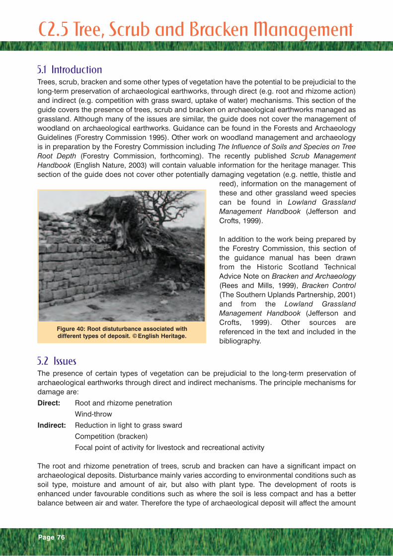
Page 76
5.1 IntroductionTrees, scrub, bracken and some other types of vegetation have the potential to be prejudicial to thelong-term preservation of archaeological earthworks, through direct (e.g. root and rhizome action)and indirect (e.g. competition with grass sward, uptake of water) mechanisms. This section of theguide covers the presence of trees, scrub and bracken on archaeological earthworks managed asgrassland. Although many of the issues are similar, the guide does not cover the management ofwoodland on archaeological earthworks. Guidance can be found in the Forests and ArchaeologyGuidelines (Forestry Commission 1995). Other work on woodland management and archaeologyis in preparation by the Forestry Commission including The Influence of Soils and Species on TreeRoot Depth (Forestry Commission, forthcoming). The recently published Scrub ManagementHandbook (English Nature, 2003) will contain valuable information for the heritage manager. Thissection of the guide does not cover other potentially damaging vegetation (e.g. nettle, thistle and
reed), information on the management ofthese and other grassland weed speciescan be found in Lowland GrasslandManagement Handbook (Jefferson andCrofts, 1999).
In addition to the work being prepared bythe Forestry Commission, this section ofthe guidance manual has been drawnfrom the Historic Scotland TechnicalAdvice Note on Bracken and Archaeology(Rees and Mills, 1999), Bracken Control(The Southern Uplands Partnership, 2001)and from the Lowland GrasslandManagement Handbook (Jefferson andCrofts, 1999). Other sources arereferenced in the text and included in thebibliography.
5.2 IssuesThe presence of certain types of vegetation can be prejudicial to the long-term preservation ofarchaeological earthworks through direct and indirect mechanisms. The principle mechanisms fordamage are:
Direct: Root and rhizome penetration
Wind-throw
Indirect: Reduction in light to grass sward
Competition (bracken)
Focal point of activity for livestock and recreational activity
The root and rhizome penetration of trees, scrub and bracken can have a significant impact onarchaeological deposits. Disturbance mainly varies according to environmental conditions such assoil type, moisture and amount of air, but also with plant type. The development of roots isenhanced under favourable conditions such as where the soil is less compact and has a betterbalance between air and water. Therefore the type of archaeological deposit will affect the amount
C 2. 5 Tree, Scrub and Bracken Management
Figure 40: Root distuturbance associated withdifferent types of deposit. ©English Heritage.

Page 77
of disturbance, with compacted soil orstone structures providing greaterresistance to roots than a less compactedsoil earthwork (figure 40). They will deformaround objects that impede them and takethe path of least resistance (Biddle, 1998).Tree and scrub roots can essentially bedivided into two types, structural and fine,moisture absorbing roots. The relationshipof the root system as a whole to the aboveground form of the tree is represented inFigure 41. Typically the radial spread ofthe roots is about equal to the height ofthe tree and that the majority of roots arewithin 0.5m of the surface. The majority ofthese roots are the fine, moistureabsorbing ones. Most of the
archaeological impact of roots is associated with the disturbance caused by the larger structuralroots. These are normally limited to within 2m of the trunk and are unlikely to penetrate below 1mdepth (Biddle, 1998).
Wind-throw is an issue mainly associatedwith trees, although it can also occur withmature scrub species where there hasbeen disturbance to the root system.Wind-throw is the uprooting and felling oftrees by the natural action of wind. Thearea damaged is dependent on thevolume of soil occupied by the largerstructural roots (figure 42). As statedabove this in turn is dependent on theenvironmental conditions and type of tree.However, as structural roots are limited intheir spread or depth penetration this isunlikely to be more than to a depth of 1mor a radius of 2-3m. This type of damagecan cause significant damage to thearchaeological earthwork and in addition may result in the initiation of other damaging impacts,such as enhanced natural erosion, burrowing activity, and exposure of fresh surfaces to livestockactivity.
5.3 Nature Conservation ValueThe following is a brief summary of the nature conservation value of the different types ofvegetation. When considering the management strategy to be implemented it is important toconsider whether any management actions and whether any changes are acceptable will affect thisvalue. It is recommended that consultation should take place to consider the nature conservationvalue of a site prior to the implementation of works.
Trees: Trees, particularly native species, are an important nature conservation resource, not just intheir own right but in the wealth of other flora and fauna species they support. This is especially
Figure 41: Normal form of tree and root system(from Biddle, 1998).
Figure 42: Wind-thrown Beech tree on the northmound of the vallum.
Page 78
true of veteran trees, which can be present in the land boundaries of grassland managed areas. Inaddition trees form an important aesthetic element of our landscape and for these reasons anymanagement for archaeological benefit should be assessed against its impact on the natureconservation and environmental value of the tree(s). Information on veteran tree management canbe found in Veteran Trees: a guide to good management (Read, 2000).
Scrub: In terms of botanical conservation, many scrub types are considered to have low intrinsicvalue, as they are commonplace, have low species-richness, are often of recent origin and areeasily created. Additionally, scrub has often been seen as a threat to the integrity of more valuablevegetation types including semi-natural grassland, which it can replace in the absence ofmanagement. However, scrub can be an important habitat for birds and invertebrates and itspresence in association with grassland can enhance the nature conservation value of a site. Inaddition, some scrub types are of particular conservation value (e.g. juniper) in that they are rare,support uncommon shrub species or are relatively rich in woody species.
Bracken: In comparison to the nature conservation value of the habitats it is replacing such asheather moorland and semi-improved grassland, bracken is poorer. Generally, plant communitiesassociated with bracken are floristically poor due to its vigorously competitive rhizome system, it’sdense above ground growth and consequent shading out of smaller plants. However, in certainsituations it does have a nature conservation interest that should be considered in any proposedmanagement. Within habitat mosaics it can be important for many forms of wildlife includinginvertebrates, small mammals, some plant species and birds such as whinchat, tree pipit, yellowhammer and nightjar. Patchy stands can support several rare fritillary butterflies which depend onviolets and cow-wheat (often growing under bracken) as their sole food plants and bracken cansupport a woodland ground flora in areas that were once tree-covered (The Southern UplandsPartnership, 2001).
5.4 Assessment and MonitoringAn initial rapid assessment using a simple scoring system (Table I) should be carried out to assessthe level of pressure from damaging vegetation. This can be carried out at most times of the year,but is easiest when both the earthwork and vegetation are visible. Therefore, areas affected by treesand scrub are best visited in winter and those affected by bracken in early summer.
Where an archaeological earthwork has been identified as being under pressure from damagingvegetation then further assessment can be carried out. This additional assessment should reviewthe susceptibility of the monument to damage from the vegetation, any associated factors and thelongevity of the pressure.
As stated in 6.2, the development of the root system is dependent on environmental conditions withroots exploiting softer deposits or lines of weakness. Therefore, an assessment should be made ofthe likelihood that important archaeological features are going to be affected by root development.At most risk are those earthworks composed of un-compacted soil and the interfaces betweendeposits as these act as lines of weakness. At least risk are those earthworks that have stoneworkat their core, particularly if that stonework is mortared.In addition the type of vegetation influences the threat to the monument. Bracken is a relativelyrapid colonizer of ground and has a more destructive root system than scrub and trees, which areslow to develop. Therefore sites under pressure from bracken are at greater risk than those fromscrub and trees.
The length of time that the vegetation has been on the site is important in making a management

Page 79
decision. If the site has only recently been invaded by damaging vegetation then damage is likelyto be fairly limited and removal or reduction is an appropriate management strategy. Where thedamaging vegetation has been long established and damage is likely to be extensive thenmanagement to maintain the present extent and prevent secondary impacts (e.g. providing coverfor burrowing animals, encouraging livestock poaching or wind-throw) is appropriate as an initialmanagement objective, with reduction in extent being the long-term objective. Maps, aerial andground photography, previous site visit reports and ecological surveys are all methods ofidentifying the length of time that damaging vegetation has been on a monument.
An assessment of the associated problems or potential problems connected with the presence ofthe vegetation should also be made. This should include the use of the vegetation for cover byburrowing animals, the presence of ground disturbance by livestock using the vegetation forshelter (figure C.2.5.4), browsing or rubbing and the threat of wind-throw.
Level Score Description Photographic Example
None 0 No evidence of vegitationpressure.
Low 1 Small amount of potentiallydamaging vegetation on themonument or the presence ofdamaging vegetation in thevicinity of the monumentcausing secondary impacts orroot disturbance.
Medium 2 Patches of established potentiallydamaging vegetation on themonument and/or encroachmentover the rest of the monument.
High 3 The monument is mostlycovered with vegetation thatmay have a damaging impacton its long-term preservation.
Table I: Indicators of Stress from Tree, Scrub and Bracken

Page 80
The threat of wind-throw is based on theexposure of the tree to wind both at thepresent time and in its development, andthe nature of the medium into which thetree has developed its structural roots.Trees most at risk of wind-throw are thoserooted in soft sediments that havedeveloped in a sheltered environment butare now exposed to greater windstrengths (e.g. trees adjacent to where ashelterbelt of trees has been removed).
Monitoring of the site should be directedto evaluating the changing spread, densityand maturity of the vegetation. The spreadcan be evaluated from aerial photographs,whereas density and maturity will needfield assessment. Monitoring should alsoreview the associated threats to a site asindicated in the above paragraphs.
5. 5 ManagementTrees:The management of trees on archaeological earthworks involves their removal, the managementof their canopy or, in the event of wind-throw, the restoration of the earthwork.
Removal is the complete removal of the tree from the monument. The tree can be felled as a wholeor felled in sections. This type of management will have advantages, as the monument will be morevisible, root damage and secondary management issues such as disturbance from shelteringlivestock will cease or be reduced. The removal of a tree from an archaeological earthwork cancause significant disturbance and therefore to minimize this the tree should be sectioned on siteand removed when ground conditions permit. The remaining stump and root system should remainin place, but should be ground down or reduced to as close to ground level as possible. Thepresence of a stump can continue to act as a focus for livestock and provides a good vantage pointfor rabbits. All cut stumps of tree species that may re-grow should be treated with a suitableherbicide immediately after cutting. A notch should be cut close to the bark, which will enable theherbicide to get into the cambium cells of the tree and will also allow those that have been treatedto be easily identified.
An alternative to removal is the management of the canopy. This involves actions such as theraising of the canopy, reducing crown height and thinning of branch density. Each of these actionshas a specific management objective. The raising of the canopy removes the focus for livestock oflow branches for rubbing and their use for shelter. Both raising and thinning the canopy improvethe amount of light reaching the ground and therefore improve ground conditions for vegetationgrowth. Reduction in crown height reduces the threat of wind-throw.
Scrub:It is normal when discussing scrub management on archaeological earthworks to prescribe itsremoval or reduction. However, in some case where the scrub is of nature conservation value,enhancement of this value may be an option by removing scrub from archaeologically sensitiveareas and increasing the scrub margin, which is the most biodiversely rich part of the habitat.
Figure 43: Trees can provide a source for associateddamage by other agents. Here livestock is disturbing
a Roman barrow cemetery.

Page 81
Removal and reduction is achieved by cutting with follow-up treatment. The follow-up treatment isan essential part of scrub control as cutting can increase vigour and stimulate re-growth. Cuttingshould be carried out during the winter and should concentrate on scrub with stems over 1 cmthick, cutting as near to the base as possible. A high percentage of smaller stemmed bushes willdie naturally and if they survive they can be treated in follow-up works. Cutting can be carried outusing hand tools (either powered or not) or by using vehicle mounted machinery such as tractormounted flails and swipes, reciprocating knife mowers (often referred to as Allen scythes), forageharvesters or a JCB mounted root fork (known as a drott) or stump lifter. Both the root fork and thestump lifter cause soil disturbance and are not suited to archaeological earthworks. Use of vehiclescan also cause disturbance to the soil, and if they are necessary, should only be used when groundconditions permit. All cut stumps should be treated with a suitable herbicide immediately aftercutting.
Follow up treatment can also include annual cutting of re-growth. This will kill off scrub in about fiveyears if no herbicide is used. Grazing during the spring and early summer can be employed toreduce re-growth and to kill off seedlings. Application of herbicide as a foliar spray or using a weedwipe can be used on scrub less than 1.5 m tall.
Bracken:A range of techniques that can be broadly grouped into physical and chemical methods cancontrol bracken. No technique will eradicate a bracken stand in a single treatment and therefore itis important to have a sustained and planned programme of control if a significant reduction oreradication is desired.
Physical control methods work by damaging or disturbing the bracken frond or root. Ones thatdamage the rhizome involve pulling or cultivation and are therefore not recommended forarchaeological earthworks under grassland management. Cutting and crushing is an effectivemethod of controlling small areas of bracken. The fronds should be cut around the middle of Juneand then again six weeks later for at least three consecutive years. Crushing is best carried out inthe early growth (June and July) period when the stems are still brittle. Hand cutting is the preferredoption as it avoids significant disturbance to the monument and any important flora and fauna.
Physical control can also be carried out using the trampling effect of stock, burning andestablishing tree cover. However, all three of these techniques can have adverse affects onearthworks and their buried archaeology. A sufficient stocking density to control the bracken maylead to ground disturbance. Burning leaves the ground bare and therefore vulnerable to a range offactors including natural erosion. Establishing tree cover is inappropriate on archaeologicalearthworks.
Physical control rarely achieves eradication, but a noticeable reduction in density can be achieved.It can also be effectively used as a follow-up treatment to chemical control.
Chemical control methods involve the application of a herbicide. Two are available for use incontrolling bracken infestation; Asulam and Glyphosate. Both of these are applied to the brackenfronds and are systemic herbicides, which means they are translocated from the frond into all partsof the plant.
Asulam is the recommended treatment as it is reasonably specific to bracken and ferns. However,it cannot be used where rare ferns are present. Asulam has no effect in the year of application butwill cause a 98% reduction in the number of fronds in the following year. The remaining 2% will re-emerge and without follow up management can re-infest the land within five years.

Glyphosate is a broad-spectrum herbicide, this means it affects most forms of vegetation andconsequently it should not be used where it may affect non-target species of importance. It is bestapplied by hand using weed wipe so the impact on other vegetation can be minimized. Glyphosatehas a larger window of application than Asulam and causes fronds to brown, which makesassessment of application easier.
The herbicides can be applied by hand application, vehicle-mounted application or by aerialspraying. In all cases the environmental implications should be carefully considered. The siteshould be visited prior to the application and possible impacts on ferns and other flora, danger ofstock consuming treated bracken, impact on watercourses and groundwater and the need toexclude people and stock during treatment should be considered.
Hand application can be carried out using knapsack sprayers, ultra-low volume drift sprayers orweed wipes (or weed glove). Knapsack sprayers are a useful method for small areas and follow-uptreatment. The herbicide can be applied through a lance or boom and can be applied with a markerdie to assist in even and targeted application. A buffer zone of 10 m from a watercourse and 2 mfrom a site of ecological importance should be maintained. Ultra-low volume drift spraying isextremely useful where the treatment of a large open area of bracken is required. The techniquerequires low wind speeds to avoid excessive drift and the bracken stand is walked in 3 m wideswathes. Due to the greater risk of drift with this technique it is recommended that a buffer zone of100 m be maintained from watercourses and sites of ecological importance. Weed wipers or glovesare excellent in situations where spot treatment is required to avoid damage to important species.
Vehicle-mounted application can be carried out using a boom sprayer or by use of weed wipes.The impact of the vehicle on the archaeological monument should be an additional considerationbefore implementing this method. Both boom sprayers and weed wipes can be mounted on ortrailed behind a tractor or ATV. A 100 m buffer zone should be maintained with boom spraying.
Aerial spraying is carried out by a boom sprayer mounted on a helicopter. It is best suited fortreating large uniform areas of uninterrupted bracken cover. The technique greatly increases therisk of spray drift and consequently appropriate buffer zones should be used (250m for ecologicalsites and 160m for watercourses). It is essential that the area to be sprayed is clearly marked withground markers and the application should only be carried out in low wind speeds. Aerial sprayingis only feasible for large area application and therefore is only suitable for extensive archaeologicalsites or sites within an area being treated as part of a larger bracken control programme.
Page 82
References and Further ReadingBiddle, P.G. 1998 Tree Root Damage to Buildings: Volume 1 Causes, Diagnosis and Remedy(Willowmead Publishing Ltd., Wantage).
English Nature 2003 Scrub Management Handbook (English Nature).
Forestry Commission 1995 Forests and Archaeology Guidelines (Forestry Commission).
Forestry Commission In prep. The Influence of Soils and Species on Tree Root Depth (ForestryCommission)
Read, H 2000 Veteran Trees: a guide to good management (English Nature, Peterborough).
Rees, T and Mills, C 1999 Bracken and Archaeology (Historic Scotland, Edinburgh)
The Southern Uplands Trust 2001 Bracken Control (The Southern Uplands Trust, Galashiels)
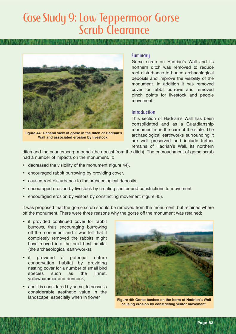
Page 83
SummaryGorse scrub on Hadrian’s Wall and itsnorthern ditch was removed to reduceroot disturbance to buried archaeologicaldeposits and improve the visibility of themonument. In addition it has removedcover for rabbit burrows and removedpinch points for livestock and peoplemovement.
IntroductionThis section of Hadrian’s Wall has beenconsolidated and as a Guardianshipmonument is in the care of the state. Thearchaeological earthworks surrounding itare well preserved and include furtherremains of Hadrian’s Wall, its northern
ditch and the counterscarp mound (the upcast from the ditch). The encroachment of gorse scrubhad a number of impacts on the monument. It;
• decreased the visibility of the monument (figure 44),
• encouraged rabbit burrowing by providing cover,
• caused root disturbance to the archaeological deposits,
• encouraged erosion by livestock by creating shelter and constrictions to movement,
• encouraged erosion by visitors by constricting movement (figure 45).
It was proposed that the gorse scrub should be removed from the monument, but retained whereoff the monument. There were three reasons why the gorse off the monument was retained;
• it provided continued cover for rabbitburrows, thus encouraging burrowingoff the monument and it was felt that ifcompletely removed the rabbits mighthave moved into the next best habitat(the archaeological earth-works),
• it provided a potential natureconservation habitat by providingnesting cover for a number of small birdspecies such as the linnet,yellowhammer and dunnock,
• and it is considered by some, to possessconsiderable aesthetic value in thelandscape, especially when in flower.
Figure 44: General view of gorse in the ditch of Hadrian’sWall and associated erosion by livestock.
Figure 45: Gorse bushes on the berm of Hadrian’s Wallcausing erosion by constricting visitor movement.
Case Study 9: Low Teppermoor Gorse Scrub Clearance
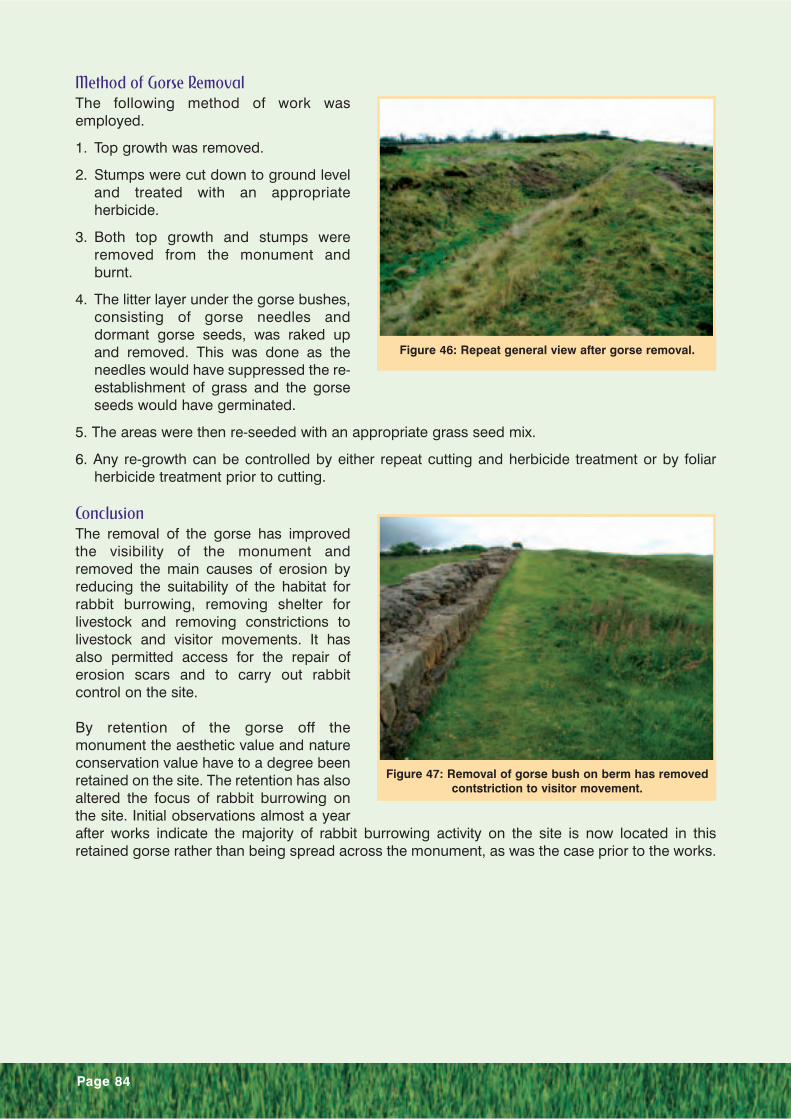
Page 84
Method of Gorse RemovalThe following method of work wasemployed.
1. Top growth was removed.
2. Stumps were cut down to ground leveland treated with an appropriateherbicide.
3. Both top growth and stumps wereremoved from the monument andburnt.
4. The litter layer under the gorse bushes,consisting of gorse needles anddormant gorse seeds, was raked upand removed. This was done as theneedles would have suppressed the re-establishment of grass and the gorseseeds would have germinated.
5. The areas were then re-seeded with an appropriate grass seed mix.
6. Any re-growth can be controlled by either repeat cutting and herbicide treatment or by foliarherbicide treatment prior to cutting.
ConclusionThe removal of the gorse has improvedthe visibility of the monument andremoved the main causes of erosion byreducing the suitability of the habitat forrabbit burrowing, removing shelter forlivestock and removing constrictions tolivestock and visitor movements. It hasalso permitted access for the repair oferosion scars and to carry out rabbitcontrol on the site.
By retention of the gorse off themonument the aesthetic value and natureconservation value have to a degree beenretained on the site. The retention has alsoaltered the focus of rabbit burrowing onthe site. Initial observations almost a yearafter works indicate the majority of rabbit burrowing activity on the site is now located in thisretained gorse rather than being spread across the monument, as was the case prior to the works.
Figure 46: Repeat general view after gorse removal.
Figure 47: Removal of gorse bush on berm has removedcontstriction to visitor movement.

Page 85
6.1 IntroductionLand drainage is an important element of grassland management as it assists in maintaining goodgrass yields. Insufficient drainage can lead to waterlogging of the soil with the result that there is aloss in grazing through poor grass growth and poaching by livestock. The later can have a negativeeffect on the preservation of the monument and its setting. Therefore sufficient drainage can be ofbenefit to monument conservation.
However, the creation and maintenance of drainage systems can also have a damaging impact onthe preservation of archaeological remains as it will disturb below ground deposits and may alsoalter the monuments field characteristics. This section discusses the implications relevant to landdrainage in a grassland management regime.
6.2 IssuesLand drainage can have a damaging impact on the preservation of archaeological remains in anumber of ways:
• The installation of new drainage
• The maintenance of existing drainage
• The form of the drainage
• The lack of maintenance of existing drainage
The installation of new drainage on anarchaeological monument will causedamage to the archaeological remainsand alternatives should be encouragedwherever possible. Installation willnormally mean the creation of an open-cutdrain or the excavation of a trench to layclay tile or plastic pipe drainage. In bothcases this means the physical destructionof archaeological remains. In addition theupcast material from the trench will modifythe field characteristics of the monumentand the modification of the groundwaterregime may adversely influence thepreservation of organic remains. However,in some cases the installation of newdrainage may have conservation benefitssuch as a reduction in poaching. In thesecases the beneficial effect must outweighany potential adverse effect.
Maintenance of existing drains on an archaeological monument is also likely to cause damage. Theclearing out of open-cut drains or the unblocking of pipe drainage requires below grounddisturbance. Clearing out of open-cut drains will produce spoil that may modify the fieldcharacteristics of the monument and over-cutting will intrude into the buried remains of the
C2.6 Land Drainage
Figure 48: Maintenance of an open-cut drain can causedamage to the monument and removed material can
modify the form of the monument.

Page 86
monument (figure 48). Unblocking of pipedrainage normally entails the relocation ofthe course of the drain through excavationat intervals sufficient to allow clearancethrough rodding or sluicing (figure 49).
Both of the forms of drainage have asdiscussed above, an installation andmaintenance impact. In addition the open-cut form of drainage as a source ofdrinking water provides a focus forlivestock activity that can lead to poachingand enhanced erosion.
The lack of maintenance of existingdrainage will lead to the increase in thewater content of the soil and can lead to
waterlogging and the presence of standing water. This increase makes the grass sward more proneto poaching from recreational, vehicular or livestock activity. In addition the presence of standingwater can act as a focal point for livestock activity and thus concentrate their poaching activity.Poaching results in the alteration of the field characteristics of the monument, and causes damageto buried remains by direct disturbance and enhanced erosion due to exposure of the groundsurface.
6.3 Assessment and MonitoringAssessment and monitoring are key to the accurate evaluation of the present and changing risk toan earthwork, and to the review of effectiveness of management regimes. They should berepeatable and relatively simple to allow rapid appraisal. They can be carried out at most times ofyear, however a winter visit when ground conditions are normally at their most waterlogged shouldpresent the worst case situation.
The initial phase of the assessment of land drainage on and in the vicinity of archaeologicalearthworks should be a rapid survey of the level of pressure the monument is under. The aim ofthis type of assessment is to establish the present condition of and risk to the monument byrecording the presence of land drainage and assessing it’s present impact on the monument. TableJ provides an example of a suitable assessment system.
Monitoring will provide information on the changing state of the impact. Monitoring is limited toobservation on the ground surface and therefore to the presence of excess water on the surface,amount of poaching from livestock, vehicles and people and to the amount of erosion. Themonitoring period should be sufficiently regular to observe whether the impact is relatively static orwhether it is developing. For example where the impact is poaching then a repeat visit at the sametime the following year should highlight whether the area under effect is increasing or not.
Figure 49: Investigations for tile drains at the baseof the vallum ditch.

Page 87
Level Score Description Photographic Example
None 0 No land drainage onmonument.
Low 1 Some land drainage on the monument, affects only a small area and there areno plans to renew.
Medium 2 Some land drainage on themonument, affect a significantarea and is regularly maintainedbut not on sensitive areas of themonument.
Poor maintenance is causinglimited disturbance to themonument.
High 3 The monument has a significantamount of land drainage that isregularly maintained and is onsensitive areas of the monument.
Poor maintenance is causingsignificant disturbance to themonument.
Table J: Indicators of Stress from Land Drainage

Page 88
6.4 ManagementThe installation of new drainage on the monument as a management solution should be avoidedwherever possible unless there is a significant conservation benefit. Where it is unavoidable or ofsignificant benefit then a buried pipe drain is preferred as this does not provide a focal point forlivestock activity and does not modify the field characteristics of the monument. The method ofconstruction should allow for future maintenance with minimal disturbance by providing easilyidentifiable and accessible entry points for unblocking.
New drainage outside the monument that replaces drainage on the monument can be of significantbenefit, as it will remove any need for future disturbance on the monument. Consideration shouldbe given to the impact of the new drainage on the burial environment of the monument. If themonument is characterised by naturally waterlogged ground conditions that would be removed bythe new drainage then it is inadvisable to proceed as important waterlogged deposits may bedisturbed.
Where drainage is in existence its management can be improved by various means. As with theinstallation of new pipe drainage, old pipe drainage can be modified to provide easy access pointsfor maintenance.
Open-cut drains can be converted to pipe drains by laying the pipe in the open-cut as for a newpipe drain and covering over. Other options involve the retention of the open-cut, whilst mitigatingthe negative impacts which are principally the re-cutting and the presence of livestock activity.Lining of the sides of the open-cut will prevent over-cutting of the trench and will prevent thecollapse of the sides through livestock activity. A reduction in livestock activity through the limitationof access to the open-cut can be achieved by fencing along its course or the establishment ofvegetation that discourages access. Both of these measures need to be balanced against thenegative impacts that they may have.
In some situations the deterioration of drainage and the subsequent increase in soil moisture maybe desirable (e.g. in nature conservation the restoration of water meadow). In these situations theland management practice will need to change to take account of this (e.g. reduction in stockingdensity and season of use).

Page 89
SummaryThe installation of drainage access points to facilitate future maintenance of a tile drain at the baseof the vallum ditch and therefore eliminate the need to carry out speculative excavation to accessthe drain, which could damage archaeological deposits and spoil the setting of the monument.
IntroductionThe ditches associated with Hadrian’sWall and its vallum are often exploited forland drainage. At times this is as an open-cut, but more frequently it is a buried tiledrain. The renewal and maintenance of tiledrains requires excavation, which canhave an impact both on the preservationof archaeological deposits and the settingof the monument. The vallum ditch at EastBog is no exception (figure 50). It isutilised to drain water from the nearby fell,from the adjacent B-road and from theadjacent houses. The main drain is a 19thcentury 3-inch tile drain. In 2002 it wasrecognised that the drain was not workingadequately as the vallum ditch was attimes flooded. This had resulted in thesome livestock being drowned and it was causing the loss of monument definition through thegradual silting up of the ditch profile. This silting was being enhanced by the presence of an oldsilage bale and some building rubble that had been dumped in the ditch and was acting as a damto water flowing along the ditch.
It was decided that it was appropriate both for agricultural purposes and the preservation ofmonument visibility that the drainage should be investigated, repaired if possible or renewed andthe dumped materials removed. It was also utilised as an opportunity to install access points(known as rodding points) into the tile drain to facilitate future maintenance and eliminate the needfor future excavation unless the drain fails.
Archaeological EvaluationIt was recognised that the repair of the drain or the installation of a new drain could have an impacton the buried archaeological deposits, including palaeoenvironmental evidence. Therefore, twoarchaeological evaluation trenches were excavated across the vallum to assess the potential.The results of the evaluation (see figure 51) confirmed that below a depth of topsoil 30cm thick(context 1) there were deposits of archaeological significance with excellent preservation ofwaterlogged plant remains, pollen and materials suitable for radiocarbon dating. These depositscould provide significant information about the importance of the vallum in the landscape after itsoriginal construction and the changing environmental conditions of the area. It also confirmed thatthere was a distinctive cut for the tile drain (contexts 2 and 3) that could be excavated to permitrepair of the old drain.
Case Study 10: East Bog Vallum Drainage
Figure 50: General view of the vallum at East Bog showinginitial non-archaelogical excavation down to drain.
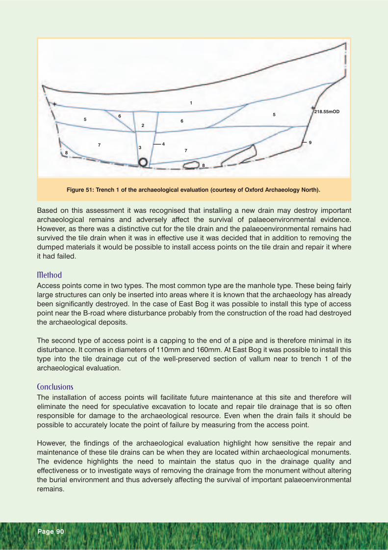
Page 90
Based on this assessment it was recognised that installing a new drain may destroy importantarchaeological remains and adversely affect the survival of palaeoenvironmental evidence.However, as there was a distinctive cut for the tile drain and the palaeoenvironmental remains hadsurvived the tile drain when it was in effective use it was decided that in addition to removing thedumped materials it would be possible to install access points on the tile drain and repair it whereit had failed.
MethodAccess points come in two types. The most common type are the manhole type. These being fairlylarge structures can only be inserted into areas where it is known that the archaeology has alreadybeen significantly destroyed. In the case of East Bog it was possible to install this type of accesspoint near the B-road where disturbance probably from the construction of the road had destroyedthe archaeological deposits.
The second type of access point is a capping to the end of a pipe and is therefore minimal in itsdisturbance. It comes in diameters of 110mm and 160mm. At East Bog it was possible to install thistype into the tile drainage cut of the well-preserved section of vallum near to trench 1 of thearchaeological evaluation.
ConclusionsThe installation of access points will facilitate future maintenance at this site and therefore willeliminate the need for speculative excavation to locate and repair tile drainage that is so oftenresponsible for damage to the archaeological resource. Even when the drain fails it should bepossible to accurately locate the point of failure by measuring from the access point.
However, the findings of the archaeological evaluation highlight how sensitive the repair andmaintenance of these tile drains can be when they are located within archaeological monuments.The evidence highlights the need to maintain the status quo in the drainage quality andeffectiveness or to investigate ways of removing the drainage from the monument without alteringthe burial environment and thus adversely affecting the survival of important palaeoenvironmentalremains.
Figure 51: Trench 1 of the archaeological evaluation (courtesy of Oxford Archaeology North).
1
5
9
6
43
2
65
8
77
8
218.55mOD