management plan of the wreck of vrouw maria
TRANSCRIPT

Management plan of the wreck of Vrouw Maria
The Department of Archaeology / Section for Maritime Archaeology 2004

Management planVrouw Maria
Index
0. Administrative details ................................................................................. 1
0.1. Date 1
0.2. Executed by (contractor) 1
0.3. Approved authorities 1
0.4. Regulations 1
0.5. Central registration number and class 2
0.6. Location research area 2
0.7. Coordinates 2
0.8. Environmental context 2
Coastal Geology 2
Climate 2
Flora and Fauna 2
Human impact 3
0.9. Size of research area 3
0.10. Depth 3
0.11. Owner of the terrain 3
0.12. Reported by 3
0.13. Periods of research 3
0.14. Site definition 3
0.15. Deposition of archives 3
0.16. Legal status 4
0.17. Recognized threats 5
0.18. Date of re-assessment/re-evaluation 5
1. Introduction................................................................................................. 6
1.1. Previous studies 6
1.2. Historical context 8
2. Assessment of the site ............................................................................... 9
2.1. Description of research assignment 9
2.1.1. Reference to working standards 9
2.1.2. Research objectives 9
2.1.3. Expected results 9
2.1.4. Aim / wishes of purchaser 9
2.1.5. Imposed research conditions 9
2.1.6. Evaluations in between 9
2.2. Working procedure 9
2.2.1. Research methods 9
2.2.2. Imposed working conditions 10
2.2.3. Modus operandi 10

Management planVrouw Maria
2.2.4. Natural sciences, applied sciences and other research 10
2.3. Research results 11
2.3.1. Environmental research 11
2.3.2. Physical condition 11
2.3.2.1. Finds visible on surface 11
2.3.2.2. Completeness 11
2.3.2.2.1. Completeness of wreck parts 11
2.3.2.2.2. Stratigraphy intact 12
2.3.2.2.3. Mobilia in situ 12
2.3.2.2.4. Relation between mobilia and wreck parts 12
2.3.2.2.5. Relations between mobilia 12
2.3.2.2.6. Stability of natural environment 12
2.3.3. State of preservation 12
2.3.3.1. Organic wreck parts 12
2.3.3.2. Inorganic wreck parts 13
2.3.3.3. Organic mobilia 13
2.3.3.4. Inorganic mobilia 13
2.3.4. Cultural-historic and archaeological data 13
2.3.4.1. Identification 13
2.3.4.1.1. Cultural context 13
2.3.4.1.2. Century 14
2.3.4.1.3. Exact dating 14
2.3.4.1.4. Function 14
2.3.4.1.5. Type 14
2.3.4.1.6. Operating area 14
2.3.4.1.7. Propulsion 14
2.3.4.1.8. Size 14
2.3.4.1.9. Material 14
2.3.4.1.10. Building tradition 14
2.3.4.1.11. Inventory 14
2.3.4.1.12. Cargo 14
2.3.4.1.13. Personal belongings 15
2.3.4.2. Constructional features 15
2.4. Risk assessment 15
2.4.1. Natural impact 15
2.4.2. Human impact 15
3. Cultural valuation of Vrouw Maria ............................................................. 16
3.1. Experience aspects (quality) 16
3.1.1. Aesthetic values 16
3.1.1.1. Visibility 16

Management planVrouw Maria
3.1.1.1.1. Visibility as a landscape element 16
3.1.1.1.2. Visibility as an exposition element 16
3.1.2. Memory value 16
3.1.2.1. Historical value 16
3.2. Physical quality 16
3.2.1. Structural integrity 16
3.2.1.1. Presence of ship construction 16
3.2.1.2. Completeness of the wreck parts 17
3.2.1.3. Stratigraphical conditions 17
3.2.1.4. Mobilia (portable antiquities) in situ 17
3.2.1.4.1. Relation between mobilia and ship parts 17
3.2.1.4.2. Relations between mobilia 17
3.2.1.5. Stability of the natural environment 17
3.2.2. State of preservation 18
3.2.2.1. Wreck parts 18
3.2.2.1.1. Organic material 18
3.2.2.1.2. Inorganic material 18
3.2.2.1.3. Composite material 18
3.2.2.2. Artefacts 18
3.2.2.2.1. Organic material 18
3.2.2.2.2. Inorganic 18
3.2.2.2.3. Composite 18
3.3. Quality of archaeological information 18
3.3.1. Representative value 18
3.3.1.1. Chronological information 18
3.3.1.2. Regional information 18
3.3.2. Significance of information 19
3.3.2.1. Geographical significance 19
3.3.2.2. Historical or archaeological significance 19
3.4. Conclusion 19
4. Site management ........................................................................................ 21
4.1. Cost-benefit analysis and general conclusion 21
4.2. Site management agenda 21
4.2.1. Safeguarding 21
4.2.1.1. Legal safeguarding 21
4.2.1.2. Physical safeguarding 22
4.2.2. Monitoring 22
4.2.3. Visualizing 22
4.2.4. Finance 23
4.3. Date of re-assessment / re-evaluation 23

Management planVrouw Maria
0. Administrative details
0.1. Date9th June 2004
0.2. Executed by (contractor)The National Board of Antiquities / The Department of Archaeology / Sectionfor Maritime ArchaeologyThe plan is made by:Sallamaria Tikkanen, senior researcher, Section for Maritime ArchaeologyRiikka Alvik, researcher, Section for Maritime ArchaeologyStefan Wessman, researcher, Section for Maritime ArchaeologyMinna Leino, researcher, Section for Maritime ArchaeologyIsmo Malinen,researcher, Maritime Museum of FinlandUlla Klemelä,conservator, Maritime Museum of FinlandAnna Hokkinen, referendary for legal matters, Department of Administration
0.3. Approved authorities- The Ministry of Education and the National Board of Antiquities / Departmentof Archaeology / Section for Maritime ArchaeologyContact information: Section for Maritime Archaeology, Hylkysaari, FIN-00570HelsinkiRole: Responsible for the protection of underwater cultural heritage (AntiquitiesAct 295/1963)
-The National Board of Forestry, The Archipelago National ParkContact information: Metsähallitus, Etelä-Suomen luontopalvelut, Virasto-keskus, FIN-21660 NauvoRole: The owner of the waters
-The Frontier Guard, Archipelago Sea Coast Guard DistrictContact information: Länsi-Suomen merivartiosto, PL 16, FIN-20101 Turku.Phone +358 20 410 7000 Fax +358 20 410 7099Role: Guards the waters as executive assistance to the National Board ofAntiquities
0.4. RegulationsIn May 2000, The National Board of Forestry (the owner of the waters) and theNational Board of Antiquities (responsible for the underwater cultural heritage)agreed on the boundaries of a protected area around the wreck. On the protectedarea, it is forbidden to anchor or dive unless it is due to a sea rescue operation orresearch work conducted by the National Board of Antiquities. Diving on thearea is subject to license. At the National Board of Antiquities, it is the Sectionfor Maritime Archaeology that treats the license applications.
1
Management planVrouw Maria
2
0.5. Central registration number and classRegistration of underwater relics: 1658The Maritime Museum’s registration for wrecks: SMM 25:22First class archaeological site
0.6. Location research areaThe district of Trunsjö in the municipality of Nauvo, in the Archipelago NationalParkRegistration number 533-893-2-1
0.7. CoordinatesTopographical map 1033 01 Smedskären 1:20 000, Helsinki 1993Nautical chart: The Baltic Sea 25, Jurmo-Rosala 1:50 000, Helsinki 1995
0.8. Environmental contextCoastal Geology
The wreck of Vrouw Maria is located in the outer archipelago of Finland. It liesat the edge of the Baltic basin. To the west there is the third Salpausselkälateral moraine, forming islands of sand and pebbles with long reefs. It is difficultto navigate safely on the area because of the changing bottom topography. Thewreck lies in a deep that is surrounded by rocky islets. The maximum depth ofthe sea at the site is 41 meters. The sea bottom consists of clay on which thereis a thin layer of sand and moraine.
Climate
The main factor influencing Finland’s climate is the country’s geographicalposition between the 60th and 70th northern parallels in the Eurasian continent’scoastal zone. The climate shows characteristics of both a maritime and acontinental climate, depending on the direction of airflow and the position andstrength of high and low pressure systems. The average temperature in Finlandis several degrees higher than that of other continental areas in these latitudes.There are four seasons in Finland: spring, summer, autumn, and winter. Icecovers the sea for 0 –3,5 months in a year. In 1961-2001 the sea was covered byice for three months in a year on average. In 1990-2003 there were 60 days ofhigh wind (over 14 m/s) per year on average.
Flora and Fauna
The archipelago is an area of brackish water, the salt content of which is only 6per mill. There are a few species that have adapted there but the number ofindividuals is great. The most important mammal is the seal. In 2003, researchersstarted a survey of the flora and fauna on the site area. According to preliminaryresults there are the bladder wrack (Fucus vesiculosus), the marine bryozoan(Electra crustulenta), and the common mussel (Mytilus edulis).

Management planVrouw Maria
3
Human impact
Because the area is protected, there have not been any unlicensed divers at thesite. It is unlikely that there are any fishing nets either since the wreck lies in adeep that is surrounded by shallows.
0.9. Size of research areaThe area of the site is app. 2000 square meters (app. 40 x 50 m). The area isdetermined by the help of a side-scan sonar and a mini robot camera. Thewreck is approximately 26 meters long and 7 meters wide. Parts of the frameand the rigging lie on the sea bottom around the wreck.
0.10. DepthThe depth of the sea at the site is 41 meters. The masts of the wreck rise to thedepth of 22 - 24 meters.
0.11. Owner of the terrainThe waters on the area are state-owned. The area is managed by Metsähallitus(The National Board of Forestry).
0.12. Reported byRauno Koivusaari / Pro Vrouw Maria Association 1999(The National Board of Antiquities 15/306/1999)
0.13. Periods of researchFrom the 28th of June 1999 on (see chapter 1.1).
0.14. Site definitionThe wreck is located in the Archipelago National Park, in the outer archipelagoof Finland. The wreck lies close to an islet called Namnlösan. Movement withinthe area is limited. The rules of the Archipelago National Park must be obeyedon the area.
0.15. Deposition of archivesStudies and reports concerning the wreck
The National Board of Antiquities / The Department of Archaeology / Sectionfor Maritime Archaeology / the wreck archives at the Maritime Museum ofFinland
Archive material concerning the ship and the shipwreck
The National Archives of Finland, Helsinki
The King’s letters to the provincial offices of Turku (kgl bref, landshöfd. I Åbo)The National Archives of Sweden, Stockholm
Diplomatica, Muscovitica
Management planVrouw Maria
4
Skrivelser till konungenKabinetten, Huvudarkivet, Inkomna handlingar, HuvudserieHandel och sjöfart 37 (National Archives mf 133)Russian State Historical Archives, St. Petersburg
The St. Petersburg port customs (F. 138)Customs transactions (Op. 6) 1771-1772
The Emperor’s Cabinet (F. 468)Imperial ukases (Op. 1, z. 2) 1770-1773
The Danish National Archives, Copenhagen
Sundtoldsregnskabet 1771von Ostens bind
The National Archives of Sweden, Stockholm
Amiralitetskollegium, LotskontoretE VI Dykerihandlingar 1771-72The City Archives of Turku (Information center)
Turun maistraatin pöytäkirjat 1771 (A I a 9)Turun huutokauppakamarin pöytäkirjat 1771-1772 (PI a 17-18).The City Archives of Amsterdam (Gemeentearchief), Amsterdam
Notary Archives, 5075Not. Thierry Daniel de Maroller (inv. 11474)Not. Isaäc Pool, (inv. 12724)Not. Salomon Dorper (inv. 10859-10860)Not. Engelbertus Marinus Dorper (inv. 15696)Not. Abraham Coijmans (inv. 12043)
Board of directors of the Moscow-trade (P.A.6, inv. 60)Registration certificates, 5036 (vv. 1765-1771)Waterschout (P.A. 38)Registration of the 40th penning, 5047Sales of ships through brokers, 5071Court archives, 5061The department of Russian history at the Russian Academy of Science,
The Archives of the Department of St. Petersburg (F. 115)
Collection of manuscripts, op. 1 D.429a. L.10-13
0.16. Legal statusThe wreck of Vrouw Maria is located within the limits of Finland’s territorialwaters and therefore the Finnish law protects the wreck. The wreck is a firstclass archaeological site, that is, a wreck that is significant in the view of culturalhistory. The National Board of Forestry and the National Board of Antiquitiesagreed that the site area is restricted. Diving on the area is subject to license.The Section for Maritime Archaeology treats the license applications.In the district court of Turku there is a pending lawsuit about sea rescue and theownership of the wreck. The parties involved are the State of Finland/TheNational Board of Antiquities and Rauno Koivusaari, Mikael Martikainen andTop Shark Finland Ltd. According to the interlocutory judgement by the Turku

Management planVrouw Maria
5
district court in the autumn of 2002, the maritime law regulations of sea rescueoperations can in this case be applied together with the Antiquities Act. Theinterlocutory judgement is not final. The decision is not appealable until a finaljudgement is made. The trial will continue in the spring of 2004.
0.17. Recognized threatsWhen it comes to human impact, the wreck is very safe because it lies deep onthe sea bottom, there are no shipping routes nearby, and the coast guard has thearea under constant surveillance. The biggest threat now is the diving due tothe research work. The degradation process caused by natural forces is going onall the time. Currents cause the greatest changes and parts of the wreck maycollapse because of them.
0.18. Date of re-assessment/re-evaluationThe Ministry of Education will receive a report on the future of the wreck inDecember 2004.

Management planVrouw Maria
6
1. Introduction
1.1. Previous studiesPrevious archive research
-Christian Ahlström, archive research in Finland, Sweden and Holland from the1970’s to the 1990’s-Pieter Iterzen, archive research in Holland in 1999-Ismo Malinen, archive research in Finland, from 1999 on-Pavel A. Krotov, archive research in St. Petersburg in 2000-Oscar Gelderblom, archive research in Amsterdam in 2002- Philip Kelsall, archive research in Denmark in 2002
Previous field research
-The wreck was found 28th June 1999, The Pro Vrouw Maria Association, byside scan sonar search-The identification of the wreck 28th June – 9th July 1999, Rauno Koivusaarifrom The Pro Vrouw Maria Association and Maija Fast from the MaritimeMuseum of Finland- Field research th June - 7th July 2000, Matias Laitinen, The Maritime Museumof Finland-Control trip 28th May – 30th May 2001 Matias Laitinen, The Maritime Museumof Finland and the Finnish Navy- Field research th June – 6th July 2001, Matias Laitinen, The Maritime Museumof Finland-Soil surveying 2001, Jyrki Rantataro, The Geological Survey of Finland-Topographical surveying 2001, The Finnish Maritime Administration-Control trip 12th – 14th February 2002, Minna Leino, The Maritime Museumof Finland, The Finnish Institute for Marine Research and The Archipelago SeaCoast Guard- Field research st June – 20th June 2002, Minna Leino, The Maritime Museum ofFinland- Field research th September –12th September 2002, Stefan Wessman, TheMaritime Museum of Finland-Control trip 10th December – 14th December 2002, Stefan Wessman and Min-na Leino, The Maritime Museum of Finland, The Finnish Institute for MarineResearch and The Archipelago Sea Coast Guard- Field research th May – 6th June 2003, Stefan Wessman, The Maritime Museumof Finland-Control trip 26th August 2003, Stefan Wessman, The Maritime Museum ofFinland-Control trip 9th October 2003, Stefan Wessman, The Maritime Museum ofFinland, The Finnish Institute for Marine Research and The Archipelago SeaCoast Guard-Control trip 3rd of May – 7th of May 2004, Minna Leino and Stefan Wessman,The Section for Maritime Archaeology, The Finnish Institute for Marine Researchand The Archipelago Sea Coast Guard

Management planVrouw Maria
7
Publications and articles
Ahlström, Christian 1979: Sjunkna Skepp, Lund.Ahlström, Christian 1997: Looking for Leads. Shipwrecks of the past revealedby contemporary documents and the archaeological record. Suomalaisen Tie-deakatemian toimituksia. Humaniora 284. Saarijärvi.Ahlström, Christian 1999: Fru Maria på Östersjöns botten. Skärgård 3/1999.Ahlström, Christian 2000a: Venäjän keisarinna ja hollantilainen koffi-laiva VrouwMaria. Nautica Fennica 2000.Ahlström, Christian 2000b: Viestejä syvyyksien sylistä. Hämeenlinna.Ahlström, Christian 2000c: The Vrouw Maria of 1771: an example ofdocumentary research. The marine archaeology of the Baltic Sea area (III) ed.Carl Olof Cederlund. Newsletter 1/2000, Södertörns högskola, Sweden.Ahlström, Christian 2002: Aspects of Maritime History of Finland and theEastern Baltic. Carol V. Ruppé - Janet F. Barstad (eds.), InternationalHandbook of Underwater Archaeology. Kluwer Academic/Plenum Publishers,New York, 2002. (347-366).Fast, Maija 2000: Vrouw Maria on saanut suoja-alueen. Sukeltaja 4/2000.Gelderblom, Oscar 2003: Coping with the perils of the Sea. International Journalof Nautical History, December 2003.Koivikko, Minna 2001: Kenttätutkimuksia Vrouw Marialla. Sukeltaja 6/2001.Laitinen, Matias 2000a: Vrouw Maria -hylyn suunnitteilla olevat tutkimukset -näkymiä 1700-luvun kauppaan ja merenkulkuun Itämerellä. Uudenkaupunginmerihistoriallisen yhdistyksen vuosikirja 1999-2000.Laitinen, Matias 2000b: Vrouw Maria -hylyn suunnitteilla olevat tutkimukset -uusia näkymiä 1700-luvun kauppaan ja merenkulkuun Itämerellä. Juhani Vai-nio (toim.); Studia Maritima. Lukuvuoden 1999/2000 yleisöluentoja Turussaja Raumalla. Turun yliopiston merenkulkualan koulutus- ja tutkimuskeskuksenjulkaisuja B115.Laitinen, Matias 2000c: Vrouw Maria -hylky ja 1700-luvun hollantilaiset purje-alustyypit kirjallisissa lähteissä. SKAS 4/2000.Leino, Minna 2002: Vedenalaisen ultraäänipaikannuslaitteen Aqua-Metre D100käyttökokemuksia Vrouw Maria -hylyllä vuosina 2001-2002. ICOMOS 4/2002s. 25-32.Leino, Minna 2003: Introduction of the Wreck of Vrouw Maria. MoSS Newsletter1/2003.Leino, Minna and Klemelä, Ulla 2003: The Field Research of the MaritimeMuseum of Finland at the wreck Site Vrouw Maria in 2001-2002. MoSSNewsletter 1/2003.Malinen, Ismo 2003: Research in the history of the Snow Vrouw Maria. MoSSNewsletter 1/2003.Mellanen, Jaana 2003: Clay tobacco pipes from the Vrouw Maria. MoSSNewsletter 1/2003.Verweij, Albert: De laatste reis van de Vrouw Maria. Een geval van zeeschadein 1771. Tijdschrift voor zeegeschiedenis 21 (2002).Wessman, Stefan 2003, The Documentation and Reconstruction of the Wreckof Vrouw Maria. MoSS Newsletter 1/2003.

Management planVrouw Maria
8
Course works
Holappa, Maija. 2003: Sinkki 1700 –luvulla. 15.4.2003 Helsinki University, aseminar on sea historyKarjalainen, Mari 2003: Vrouw Maria –hylyn elohopealasti, 25.4.2003 Helsin-ki University, a seminar on sea historyTulonen, Essi 2003: Vrouw Marian lasti ennen ja nyt, 23.4.2003 Helsinki Uni-versity, a seminar on sea history
1.2. Historical contextVrouw Mariawas a part of the European merchant shipping of the end of the18th century, when the routes for transporting goods, money, and know-howhad established. The ship represents the Dutch trading practices and trade ofworks of art. Dutch merchant vessels transporting miscellaneous goods werevery typical sailing ships at the Baltic Sea at the end of the 18th century eventhough the majority of the vessels already were of English origin. Denmark gotthe customs duties on cargoes. The customs were registered at the Sound CustomsHouse. When Vrouw Maria sank, its cargo consisted, typically, of miscellaneousgoods. In this case, however, the cargo was exceptionally valuable since therewere art treasures that were bought in an auction in Amsterdam and were ontheir way to Catherine the Great.

Management planVrouw Maria
9
2. Assessment of the site
2.1. Description of research assignment2.1.1. Reference to working standards
The working standards of the National Board of Antiquities, the EuropeanCommunity Culture 2000 Programme / The MoSS Project, the general principlesof the UNESCO agreement and the ICOMOS principles for underwater culturalheritage (International Council for Monuments and Sites).
2.1.2. Research objectives
The aim of the research is to get a general view of the wreck and its cargo, thecondition of the wreck and the nature and size of the site area, and to haveboth a proper monitoring system and a safeguarding plan for the wreck.
2.1.3. Expected results
As a result of the research there will be enough information for the experts tofind out the different possibilities relating to the wreck’s future. Furthermore,the aim is to determine the need to protect the wreck physically.
2.1.4. Aims / wishes of the purchaser
There is no purchaser.
2.1.5. Imposed research conditions
The field research is limited by high costs and difficult working conditions. Atthe site there is often hard wind and swell, and diving is not safe if the swell isheavy.
2.1.6. Evaluations in between
The first phase of the research is yet not finished and decisions concerning thefuture of the wreck have not been made.
2.2. Working procedure2.2.1. Research methods
The site area, which is surrounded by rocky islets and rocks, was surveyed witha side-scan sonar, a multi-beam sonar and a robot camera (ROV). In addition tothis, the area around the wreck and some of the interior of the wreck weresurveyed with a smaller robot camera. The site is documented mainly byphotographing and videotaping. The shape of the hull was recorded with aGoniometer. The other parts of the wreck were measured and recorded in manydifferent ways. An ultrasound positioning system (Aqua Metre D100) was alsotried out at the site. There are now several sketches and drawings of the wreckthat are based on the gathered information.Within the MoSS Project, Vrouw Maria has a monitoring strategy the aim of

Management planVrouw Maria
10
which is to monitor the environmental variables that act on the site. Theresearchers use the research methods of physics, chemistry, and biology. Themethods of biology are used when examining the affect of bacteria and marinefungi and the changes caused by wood boring animals and human activity. Themethods of chemistry are used when investigating water quality and thechemistry of the sediment. The physical aspect will focus on sediment andwater movements, and erosion of timbers and artefacts in the wreck. In additionto these, there are data loggers at the site that collect information of the physicalconditions of the surrounding seawater. (See the MoSS Project /The MonitoringTheme.)
2.2.2. Imposed working conditions
The wreck is located in the outer archipelago, that is, by the open sea. Windstend to create a swell that hampers the research work. The fact that the wrecklies at the depth of forty meters shortens the time the divers can be submergedand affects the dive safety, because of nitrogen narcosis, for example. The outsideof the wreck is easy to scrutinise but inside only the top of the cargo and someof the structures related to deck construction can be seen.
2.2.3. Modus operandi
After the identification of Vrouw Maria, all the research work has been donesolely by the research group of the Maritime Museum of Finland. The groupconsists of fourteen persons at a time. The persons are not the same every timebut there are always at least two archaeologists and one conservator in thegroup. The coast guard vessels made the control trips. (See the Vrouw Mariaresearch reports 2000-2001.)
2.2.4. Natural sciences, applied sciences and other research
The composition of loose algae is examined, and the species and number ofspineless animals are defined. Artefacts that were raised from the wreck areanalysed. Archive research has been done in Russia, Holland, Denmark, Swe-den, and Finland.
Scientific analyses:- Element analysis of the metal ingot, 1999, Seppo Hornytzkyj- Bacteria sample 9th July 2001, PhD Harri Kuosa-Analysis of mercury in the sediment 17th June 2002, Hanna Kahelin- Sample of sediment, the MoSS Project 2003, MRAS, unfinished- Wood and textile samples, the MoSS Project 2002 - 2004, The Mary RoseArchaeological Services, unfinished- Preliminary biological survey, 2002, Ari Ruuskanen- Biological survey, 2003, Ari Ruuskanen, Niko Nappu and Veijo Kinnunen,- Data loggers for collecting information about the physical conditions of thewater (ADCP, CTD and Seamon Mini), 2001 – 2004, the MoSS Project and theFinnish Institute for Marine Research

Management planVrouw Maria
11
2.3. Research results2.3.1. Environmental research
A topographical survey was made on the area around the wreck. The wreck liesin the deepest spot of the area, in the middle of rocky shallows. The currents atthe sea bottom have formed a terrace next to the wreck. A soil analysis of thearea reveals that the sea bottom consists of clay and gyttja clay on which thereis a thin layer of sand and moraine.Data loggers were placed at the site to collect information about the physicalconditions of the surrounding seawater (temperature, dissolved oxygen,suspended solids, pH, currents and Redox). We now know-the temperature from 18th June to10th November 2001-the temperature, dissolved oxygen, Redox, pH, suspended solids and currentsfrom12th September to 14th December 2002, from 15th December 2002 to 26th
May 2003, and from 8th June to 26th of August 2003The data collecting goes on (from the 9th October 2003 on).(See the reports made by the Finnish Institute for Marine Research.)At the site, there are both aerobic and anaerobic wooden samples that werekept at the bottom for different monitoring lengths. The samples were analysedin Portsmouth by the Mary Rose Archaeological Services. The results of thosesamples that were at the bottom for three months are analysed. In the samplesthere were bacteria, antinomycetes, and fouling organisms: dinoflagellates anddiatoms. No fungi were found.
2.3.2. Physical condition
2.3.2.1. Finds visible on surface
Approximately 1 – 1,5 meters of the lower part of the hull is within the sedimentbut otherwise the wreck is entirely visible. Most of the parts of the rigging aswell as the missing parts of the escutcheon are lying visible on the sea bottom.Since the sea bottom is hard clay, the wreck parts have not made their way intothe bottom. There are merely some algae that may cover some of the wreckparts at the bottom.
2.3.2.2. Completeness (how much the wreck resembles the original state,quantity)
2.3.2.2.1. Completeness of the wreck parts
The ship is still standing on her keel in a sailing position. It seems as if VrouwMaria had been in the same position from the time she sank. The lower parts ofthe masts are standing up. Other parts of the rigging have fallen down on thedeck and on the sea bottom on the starboard side of the wreck. The downfallenparts of the rigging have crushed the deckhouse behind the main mast. Someof the deck planks are loose or missing. Parts of the roof of the captain’s cabinand the escutcheon are lying behind the wreck and parts of them are missing.Some of the deck beams have fallen down. Thanks to the captain’s protest we
Management planVrouw Maria
12
know that the rudder and a part of the escutcheon fell at the time of theshipwreck.
2.3.2.2.2. Stratigraphy intact
The stratigraphy at the site is intact. To ease the identification of the wreck, afew artefacts from the top of the cargo and the deck were raised. Also a glassbottle was raised because it was in danger of breaking, and a tack block that felldown after the wreck was found was raised as well. In 2000, visual monitoringwas started at the site. Due to the research work and diving, there are someitems that have come off: the arm of the pump from the port side, the tackblock from the starboard side, the remains of metal fasteners of the sternpostand the stool of the windlass.
2.3.2.2.3. Mobilia in situ
A part of the cargo and equipment was salvaged at the time of the shipwreck.The rest of the things are in the wreck, practically in those places were theywere when the ship sank. Almost all mobilia is still in situ (see 2.3.2.2.2.).Excavations have not been made in the wreck.
2.3.2.2.4. Relation between mobilia and wreck parts
See above.
2.3.2.2.5. Relation between mobilia
See above.
2.3.2.2.6. Stability natural environment
The natural environment is stable. The currents may, however, deteriorate thewreck. Because of the currents there is not any protecting layer of sediment onthe wreck. Thanks to the depth of 40 meters, the wreck is protected from iceand wave movement. The temperature in the water is between 0 and +13ºC.There are no wood boring animals on the area, and the fungi and bacterial activityis slow.
2.3.3. State of preservation
According to archive information, there is a many-sided cargo in the wreck.The cargo’s state of preservation is not known. A general evaluation of thestate of preservation is made by plain visual observation. The state ofpreservation is better known when it comes to the raised and conservatedartefacts and the tack block.
2.3.3.1. Organic wreck parts
Vrouw Maria was a wooden ship and therefore the wreck is mainly wood. Thetop layer of the wood is worn but otherwise the wood is hard and it looks as if

Management planVrouw Maria
13
it is in good condition. There seem to be no remains of paint. There are nowood-boring shipworms on the area.
2.3.3.2. Inorganic wreck parts
The iron parts that are visible are mainly bolts that are corroded. There is verylittle metallic iron left in the bolts and it is likely that the bolts are not goodfasteners any more. The ship’s oven, which is made of brick, seems to be intact.
2.3.3.3. Organic mobilia
The wooden artefacts and equipment that are visible lack the original top layerbut otherwise they seem to be in good condition.
2.3.3.4. Inorganic mobilia
In the wreck there are two anchors that have metal arms and palms. A layer ofcrust covers the metal parts but there is some metallic iron left under the crust.The surface of the zinc ingots is corroded but the metal is in good condition (noanalysis of the corrosion has been made). In general, zinc bears well in seawater.The lead seal is badly corroded, probably because there was organic material,such as textile, near the seal. On the deck of the wreck there is a lead thatappears to be in good condition. The clay tobacco pipes on the top of the cargoare in good condition and the majority of them are still whole. The raised glassbottle has glass disease but it is unbroken.
2.3.4. Cultural-historic and archaeological data
2.3.4.1. Identification
The ship is a Dutch Snow-ship that was used as a merchant vessel. On the baseof archive information and the objects that were raised form the wreck it isknown that the ship is the sailing ship Vrouw Maria. The very first documentsabout the history of Vrouw Maria were found by Dr. Christian Ahlström in theFinnish National Archives as early as at the end of the 1970’s. The search forthe wreck was restarted in the 1990’s when researches started systematicallylook for information about the sinking position and the cargo. The wreck wasfound in a side scan sonar search that was organised expressly to find the wreckof Vrouw Maria. The wreck was identified as Vrouw Maria since it lacked therudder and its stern was damaged – just like it was said in the captain’s protest.A metal ingot was raised. It was zinc, which according to the registers of theSound Customs House was a part of the ship’s cargo. Lead seals in the holdindicate that there had been clothes in the cargo. Clothes were also mentionedin the Sound Customs registers.
2.3.4.1.1. Cultural context
Vrouw Maria was a part of Dutch sea trade. The Dutch trading company ofEast India brought goods from the Far East to Holland and from there thegoods were spread to other parts of Europe. A part of traders heading for Russia

Management planVrouw Maria
14
used the Baltic Sea and thus went via the Danish Straits.
2.3.4.1.2. Century
The end of the 18th century.
2.3.4.1.3. Exact dating
The exact year of the building of the ship is not known. The ship sank on 8th -9th of October in 1771.
2.3.4.1.4. Function
A merchant vessel.
2.3.4.1.5. Type
A Snow ship.
2.3.4.1.6. Operating area
Europe.
2.3.4.1.7. Propulsion
A sailing ship.
2.3.4.1.8. Size
The length from the stem to the stern on the main deck is 26,34 meters. Thewidth of the ship at its widest is 7,10 meters from railing to railing. Parts of thewreck can be found on an area that is 40 x 50 meters.
2.3.4.1.9. Material
The wood has not been analysed. It is likely that the hull is of oak and the mastsare of larch.
2.3.4.1.10. Building tradition
A carvel-built ship. The building place or the technique is not known.
2.3.4.1.11. Inventory
A part of the cargo and equipment (the rowing boat and the ship’s bell, forexample) were salvaged at the time of the shipwreck. Some of the equipment isstill in the wreck. On the deck there is for example the lead and its line. One ofthe ship’s anchors is still hanging in its place on the port side of the railing andthe other lies next to the starboard side of the wreck on the bottom of the sea.
2.3.4.1.12. Cargo
According to the list of the salvaged things the cargo consisted of coffee, tea,books, tobacco, figs, brandy, corn, vinegar, flower bulbs, seeds, and mineral

Management planVrouw Maria
15
water. According to the Sound Customs lists the ship had typical trading goodssuch as sugar, pigments, cloths, cotton, and metals. There were codfish, herring,cheese, butter, sewing thread, and paper as well. In addition, there weremiscellaneous goods, the customs duties of which were considerably high. Theupper parts of the cargo are partly visible in the wreck and the following objectshave been identified: clay pipes, zinc ingots, a box of glass lenses, lead sealsand possibly the remains of cloths. Some of the boxes still have the covers intheir place.
2.3.4.1.13. Personal belongings
The ship was kept on the surface for five days after the wrecking and some ofthe objects were salvaged. It is nevertheless probable that some of the crew’spersonal belongings are still in the ship. The divers have not yet seen any suchthings.
2.3.4.2. Constructional features
The site is an 18th century Snow ship with an intact hull. Of a ship of this kindthere are some drawings and paintings left. Ships in these pictures are far moredecorative than Vrouw Maria. Because of a misinterpretation of a document,the wreck was first incorrectly identified as a Koff ship.
2.4. Risk assessment2.4.1. Natural impact
The major changes at the site are caused by currents that erode the wreck. Thisin turn may cause the wreck parts to loosen and collapse.
2.4.2. Human impact
The site is far from human settlement and there are no sailing routes on thearea. In other words, the human impact was practically non-existent until thewreck was found. Because of the protected area, the impact is now minimised.At the moment, the biggest threat is the wearing down that is caused by theresearch diving.

Management planVrouw Maria
16
3. Cultural valuation of Vrouw Maria
3.1. Experience aspects (quality)3.1.1. Aesthetic values
3.1.1.1. Visibility
3.1.1.1.1. Visibility as a landscape element
The wreck is at the depth of forty meters which means that it is not in sight.The shipping route to St. Petersburg went closer to the Estonian coast andtherefore did not use the area in question unless in special circumstances.
3.1.1.1.2. Visibility as an exposition element
Thanks to its completeness, the wreck looks very much like the sailing ship thatsank in 1771. Because of its small size the wreck could be exposed in a museum.It would also make a good site for visualising a wreck in situ (underwater filming,for example). The wreck is very delicate and there are a lot of small items inthere so that for the time being, it cannot be opened for the diving public.
3.1.2. Memory value
3.1.2.1. Historical value
The local people have no oral tradition left that would tell us about the shipwreckbut the number of written documents is great. Based on the documents it isobvious that the wrecking of Vrouw Maria was a notable event. The shiprepresents the lively Dutch trading of the end of the 18th century. It is a reminderof the technological standard and the immensity of trade of its time. It alsotells us about the shipwreck itself, the salvage operations, and art trade.The wreck has a legendary reputation among skin divers. Because of archiveinformation, its story was known for over twenty years before the wreck wasfinally located.
3.2. Physical quality3.2.1. Structural integrity
3.2.1.1. Presence of ship construction
The presence of ship construction can be evaluated only by surveying the outercovering of the wreck because the original building tradition is not known. Sofar it is impossible to try to find out the building tradition since the wreck is fullof various things. From the outside, the deck stringers that work as longitudinalstiffeners are in good condition. Of those parts that provide lateral strengthonly the deck beams can be seen. Some of them have already come off theirplace. It is likely that the iron nails that were originally used contain healthymetal very little and the strength of them is therefore nonexistent. The deckcabin behind the main mast collapsed when parts of the rigging fell over it. Thecover of the captain’s cabin at the stern and the escutcheon are lacking and

Management planVrouw Maria
17
some of the deck beams have twisted out of their place, which weakens thestrength of the stern. In general, the ship construction seems to be whole.
3.2.1.2. Completeness of the wreck parts
The completeness of the wreck parts is evaluated visually. So far there is onlyone wreck part that has been raised: the tack block. The parts of the wreck aremostly whole. The rigging has fallen to pieces but the breaking has taken placein the course of years, when the fasteners have decayed, and the loose parts areon the deck and on the sea bottom on the starboard side of the wreck. Forexample the deck cabin has collapsed when parts of the rigging have fallen onit. Smaller parts have loosened at the joints when falling and for example thehandrail is in many pieces on the deck.
3.2.1.3. Stratigraphical conditions
The stratigraphy is complete since no excavation has been done.
3.2.1.4. Mobilia (portable antiquities) in situ
There are very few objects on the deck. Most of the portable antiquities are inthe hold.
3.2.1.4.1. Relation between mobilia and ship parts
Nothing has been moved in the wreck, which means that the mobilia is in itsoriginal place, in the main hold mostly.
3.2.1.4.2. Relation between mobilia
Thanks to the Sound Customs lists and the catalogue of the salvaged things weknow the main contents of the cargo. Since only the top of the cargo has beensurveyed (with a mini robot camera and a video camera) we do not know muchabout the relation between mobilia. It looks as if the cargo moved when theship sank. At least the zinc ingots have spread all over the hold and some of theingots can be seen on the top of the cargo. However, in the hold there are alsohundreds of unbroken clay pipes, a box of glass lenses in neat piles, and barrelsand packing cases in rows. In other words, all the cargo did not move in thecourse of the shipwreck. None of the objects inside the wreck is separate. Theobjects are closely related to one another.
3.2.1.5. Stability of the natural environment
The currents reach the interior of the wreck mainly through the cabin in thestern. Based on the organic sediment on the top of the cargo we believe that thecurrents inside the wreck are not significant. The interior of the wreck is verystable.

Management planVrouw Maria
18
3.2.2. State of preservation
3.2.2.1. Wreck parts
3.2.2.1.1. Organic material
The wood of the wreck is in good condition. For example, the tack block thatwas raised is hard oak. See chapter 2.3.3.1.
3.2.2.1.2. Inorganic material
The iron parts are corroded and a layer of crust covers them. See chapter 2.3.3.2.
3.2.2.1.3. Composite material
Not yet known.
3.2.2.2. Artefacts
The artefacts in the wreck seem to be in fairly good condition. See chapter2.3.3.3.
3.2.2.2.1. Organic material
There appear to be some cloths in the wreck but the condition of them is notyet known.
3.2.2.2.2. Inorganic
The zinc has worn well except for the top layer. The clay pipes are well preserved.
3.2.2.2.3. Composite
Not yet known.
3.3. Quality of archaeological information3.3.1. Representative value
3.3.1.1. Chronological information
The wreck of Vrouw Maria represents a typical merchant vessel of the end ofthe 18th century. The artefacts in the wreck were manufactured before October1771 (before the ship sank). Because the building year is unknown we do notknow when the ship had been equipped. It is likely that usable equipment wasrecycled, which means that even in a new ship the equipment was not necessarilybrand new. All in all, it can be said that the wreck represents the 18th century uptill the year 1771.
3.3.1.2. Regional information
The wreck represents the European trading tradition and especially the Dutchsea trade. The cargo symbolizes global trading since the goods came fromdifferent colonies and from the Far East, for example. Small merchant vesselstransporting miscellaneous goods were very typical sailing ships at the Baltic

Management planVrouw Maria
19
Sea at the end of the 18th century. The building place of the ship is unknownbut the ship represents Dutch ship building tradition. Based on archiveinformation we know that this is a Snow ship. Of Snow ships, there are only afew drawings left, which means that the wreck of Vrouw Maria gives us newinformation about the ship building history of the end of the 18th century.
3.3.2. Significance of information
3.3.2.1. Geographical significance
The wreck represents European sea trade and global trading. The goods camefirst to Amsterdam from different colonies and the Far East, and then they weretaken to other parts of Europe.
3.3.2.2. Historical or archaeological significance
In the historical sense the wreck is extremely appealing because due to itsexceptional cargo, there is very much information about the ship in variousarchives. By the help of Vrouw Maria we can learn the ways Dutch merchantsorganised transportation and protected the goods against the hazards of transportby sea. In addition, the 18th century shipwreck procedures can be studied. Whatalso makes the events of Vrouw Maria fascinating is the fact that they areconnected to prominent persons of the time, such as Catherine the Great.
Archaeologically the ship is of great interest because of its good condition andintactness. This makes the research work easier. Although a large part of thecargo was salvaged there still are a lot of things in the hold. According to thecustoms documents there is a considerable amount of valuable miscellaneousgoods in the cargo. Only archaeological excavations can help us to solve thenature of the goods. Vrouw Maria represents the typical Dutch merchant vesselof its time but its cargo is a unique combination of different goods. Theknowledge we have on the 18th century procedures of packing and transport arebased solely on different guidelines and directions. The question of how all thiswas done in practise can be answered only by the means of archaeologicalresearch.
The cargo is especially interesting because of its works of art, the art historicalvalue of which is outstanding. Regardless of the state in which the paintingsand pieces of art are after being at the sea bottom for over two hundred years,the mere locating of them is extremely significant. Among the paintings there isfor example a triptych by Gerard Dou (1612-1675). The painting is one ofDou’s masterpieces and its value can be compared to that of Rembrant’sNightwatch.
3.4. ConclusionVrouw Maria represents the technical knowledge and consumer habits of itstime as well as the procedures of trade and salvage operations. The shipwreck

Management planVrouw Maria
20
of Vrouw Maria shows us how information spread in the 18th century and howthe authorities in different countries proceeded in a case like this. In addition,the ship demonstrates the international legal praxis of its time. The wreck ofVrouw Maria is a very complete and intact whole. Its history is very thoroughlyknown. Because of the cultural historical and scientific values, the wreck ofVrouw Maria is globally significant.

Management planVrouw Maria
21
4. Site management
4.1. Cost-benefit analysis and general conclusionThe research funding from the European Union and the National Board ofAntiquities enabled principal scientific research at the wreck during the years2001 - 2004. The results of the project can be presented by visualizing thewreck in a museum, and entrance fees can be collected. The safeguarding ofthe site will ensure that valuable cultural heritage is preserved for the future.
Now that the public has seen the wreck from outside, the next phase is to startthe archaeological diggings inside the wreck and find out what is left of thevaluable cargo. This phase of the investigations is very time consuming and forthat reason expensive as well. Without the engagement of the Ministry ofEducation, this kind of an operation, which can be compared to the investigationof the Mary Rose in the UK, is not possible.
4.2. Site management agendaBecause of the still on-going investigations, the site management plan for VrouwMaria is at the moment only short-term. The National Board of Antiquities willgive its opinion and report on the further studies and the possibility of raisingthe wreck to a museum by the end of the year 2004. The report will be given tothe Ministry of Education in Finland. The future of the wreck depends on thedecision of the Ministry of Education and on the available resources.
4.2.1. Safeguarding
4.2.1.1. Legal safeguarding
According to the Antiquities Act (295/1963), the wrecks of ships and othervessel discovered in the sea or in inland waters, which can be considered to beover one hundred years old, or parts thereof, are officially protected.
The regulations concerning underwater cultural heritage were altered at the endof the year 2002. The section number 20, which is about discovered ships andvessels, was altered by law (941/2002). The law came into force the 1st ofDecember 2002. The first subsection was modified so that, instead of the ageof the wreck or its part, the protected wrecks are defined by the sinking date.According to the altered subsection, the wrecks of ships and other vesselsdiscovered in the sea or in inland waters, which can be considered to have sunkover one hundred years ago, or parts thereof, are officially protected.
The section number 20 got a new subsection at the same time: a wreck or awreck part belongs to the state if in view of the external circumstances it isobvious that the owner of the wreck has abandoned it. The alteration was madein order to specify the definition of protected wrecks. The new subsection wasadded in order to clarify the legal state of affairs that prevailed earlier. Although

Management planVrouw Maria
22
it was not directly said in the law text, the original intention of the legislatorshad been to make sure that historical wrecks belong to the state.
Objects discovered in wrecks or wreck parts or objects evidently originatingfrom such contexts, shall go to the state without redemption. In other respectsthe provisions concerning movable ancient objects shall apply where relevant.
4.2.1.2. Physical safeguarding
In May 2000, The National Board of Forestry (the owner of the waters) and theNational Board of Antiquities (responsible for the underwater cultural heritage)agreed on the boundaries of the protected area. The area is circular and itsdiameter is 1500 meters. On the protected area, it is forbidden to anchor or diveunless it is due to a sea rescue operation or research work conducted by theNational Board of Antiquities. Diving on the area is subject to license. TheSection for Maritime Archaeology treats the license applications.
The Frontier Guard watches the waters as executive assistance to the NationalBoard of Antiquities. The Archipelago Sea Coast Guard monitors the site areaall the time using a surveillance camera that is placed near the site. The wreckis located in the Archipelago National Park and in addition to the regulationsmentioned above, the rules of the National Park must be obeyed on the area.
4.2.2. Monitoring
The wreck and its condition are monitored both by visual means and by theanalysis within the MoSS Project. Since the year 2000, control pictures havebeen taken of certain parts of the wreck. The samples connected to the MoSSmonitoring plan are analysed in Portsmouth by the Mary Rose ArchaeologicalServices. The analysis helps us to find out how the bacteria and microbes act inwooden structures. In co-operation with the Finnish Institute for MarineResearch, the MoSS researchers examine also the environmental factors (ADCP/CTD data) at the site. Researchers from the University of Helsinki examinedthe flora and fauna at the site in 2003. Preliminary plans for the continuing ofthe monitoring will be made by the end of 2004. (The MoSS Project ends 30th
June 2004.) The plans will be defined more closely when the Ministry ofEducation in Finland has made its decision on the future of the wreck.
4.2.3. Visualizing
According to the plans of the MoSS Project, a three-dimensional virtual modelof the wreck will be finished in 2004. There is a lot of picture material that isand will be shown in various exhibitions, on the Vrouw Maria Homepage, andin many publications. In the spring of 2004, a diorama model of the VrouwMaria field research was made. Overview drawings, which are based on slidesand videotapes of the wreck, were made as well. The writing of the book onVrouw Maria goes on. The wreck is shown in the MoSS publications and in a

Management planVrouw Maria
23
publication that is part of an IKUWA series and is expected to be published in2006. The wreck will be presented at the Maritime Museum of Finland, at theMaretarium aquarium in Kotka in the summer of 2004, and in the Post Museumin Helsinki in the autumn of 2004. The wreck will be presented at the newMaritime Museum in Kotka in 2007 or later.
4.2.4. Finance
Decisions on the future financing will be made in the autumn of 2004.
4.3. Date of re-assessment / re-evaluationThe Ministry of Education will be given a report on the future of the wreck bythe end of 2004. The date of re-assessment will be after the Ministry’s response.
Attachments
1. Maps of the research area.2. General views of the wreck3. Objects raised from the wreck of Vrouw Maria
Management planVrouw Maria
Appendix 1
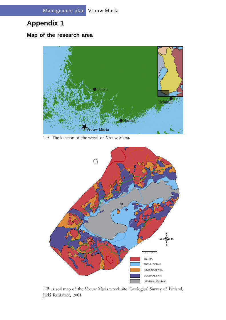
Map of the research area
1 A. The location of the wreck of Vrouw Maria.
1 B. A soil map of the Vrouw Maria wreck site. Geological Survey of Finland,Jyrki Rantataro, 2001.

Management planVrouw Maria
Appendix 2 (1 / 2)
General views of the wreck
2 A. An artist’s impression of the wreck of Vrouw Maria. Drawn by Tiina Miet-tinen, The National Board of Antiquities, 2004.
2 B. 3-D model of the wreck of Vrouw Maria. The reconstructions are based onprecise measurements. Model by Stefan Wessman, The National Board ofAntiquities/The Section for Maritime Archaeology, 2004.

Management planVrouw Maria
Appendix 2 (2 / 2)
General views of the wreck
2C. The interior of the bow of Vrouw Maria. To the right there is the ship’soven. Drawn by Tiina Miettinen, The National Board of Antiquities, 2004.
2 D. The Vrouw Maria cargo hold with clay pipes, zinc ingots and packing cases.Drawn by Tiina Miettinen, The National Board of Antiquities, 2001.

Management planVrouw Maria
Appendix 3 (1 / 2)
Objects raised from the wreck of Vrouw Maria
A clay bottle (SMM 01599:6). Drawnby Tiina Miettinen, The National Boardof Antiquities, 2001.
A glass bottle (SMM 82002:2). Drawnby Tiina Miettinen, The National Boardof Antiquities, 2003.
A tack block (SMM 82002:3). Drawn by Tiina Miettinen, The National Boardof Antiquities, 2003.

Management planVrouw Maria
Appendix 3 (2 / 2)
Objects raised from the wreck of Vrouw Maria
A clay pipe (SMM 01599:3). Drawn by Tiina Miettinen, The National Board ofAntiquities, 2001.
A zinc ingot (SMM 01599:1). Drawn byTiina Miettinen, The National Board ofAntiquities, 2001.
A lead seal from a packing of cloth(SMM 01599:2). Drawn by Tiina Miet-tinen, The National Board ofAntiquities, 2001.
