management of water ways and adjoining land in the mid-goulburn
TRANSCRIPT
Management of water ways and adjoining land in the Mid-Goulburn River: landholder and other stakeholder
actions and perspectives
A report to the Goulburn Broken Catchment Management Authority
Allan Curtis, Digby Race, Royce Sample and Simon McDonald
Institute for Land, Water and Society
Charles Sturt University
June 2008
ILWS Report #40

Mid-Goulburn River stakeholder actions and perspectives: 2007
Research commissioned by: Goulburn Broken Catchment Management Authority
All rights reserved. The contents of this publication are copyright in all countries subscribing to the Berne Convention. No parts of this book may be reproduced in any form or by any means, electronic or mechanical, in existence or to be invented, including photocopying, recording or by any information storage and retrieval system, without the written permission of the authors, except where permitted by law. Cataloguing in Publication provided by the Institute for Land, water and Society (ILWS) – Charles Sturt University, Albury, NSW, 2640. Curtis, Allan, Race, Digby, Sample, Royce and McDonald, Simon (2008). A project in conjunction with the Goulburn Broken Catchment Management Authority, by A. Curtis, D. Race, R. Sample, S. McDonald. Institute for Land, Water and Society, Charles Sturt University, Albury, NSW, 2640. 1v., - (Report / ILWS, No. 40) ISBN: 978-1-86467-201-5 Acknowledgments The research team from the Institute for Land, Water and Society (ILWS) – Charles Sturt University, Albury, thanks Scott Morath and Wayne Tennant, Goulburn Broken Catchment Management Authority (GB CMA), for their considerable assistance in the design and implementation of this research, and valuable comments on a draft report. The GB CMA’s Upper Goulburn Implementation Committee also provided helpful input to the design of this research. The research team would also like to sincerely thank the many landholders, local government representatives, interest group representatives and agency staff who contributed valuable time and effort to completing the survey, participating in interviews, and engaging in the workshops. These people are not identified in this report to preserve their anonymity. Disclaimer The views expressed in this report are solely the authors, and do not necessarily reflect the views of Charles Sturt University, Goulburn Broken Catchment Management Authority or any other individual or organisation consulted during the research.
ii

Mid-Goulburn River stakeholder actions and perspectives: 2007
TABLE OF CONTENTS EXECUTIVE SUMMARY v
1.0 INTRODUCTION 1
1.01 Background 1 1.02 Research objectives 1
2.0 METHODOLOGY 3
2.01 Introduction 3 2.02 The mail survey 3 2.03 Stakeholder interviews and focus groups 5
2.03.1 In-depth interviews with selected stakeholders 5 2.03.2 Workshops with focus groups 5
3.0 FINDINGS 6
3.01 Perception of river and river frontage health/ condition 6 3.01.1 Landholder knowledge 6 3.01.2 Landholder assessment of frontage health/ condition 8 3.01.3 Stakeholder assessment of frontage health/ condition 13
3.01.3.1 The Current Recommended Practices (CRP) 13 3.02 Values landholders attach to river frontages 15
3.02.1 Inroduction 15 3.02.2 Landholder values 15 3.02.3 Stakeholder values 18
3.03 Attitudes about roles and responsibilities 19 3.03.1 Landholder attitudes 19 3.03.2 Stakeholder attitudes 22
3.04 Adoption of current recommended practices 23 3.04.1 Introduction 23 3.04.2 Landholder adoption of current recommended practices 23
3.04.2.1 Factors linked to landholder adoption of current recommended practices 24 3.04.3 Comparisons of current activity with past and future intentions 28 3.04.4 Extent current work is funded by government 29 3.04.5 Confidence in current recommended practices 29
3.04.5.1 Landholder confidence in current recommended practices 29 3.04.5.2 Stakeholder confidence in current recommended practices 31
3.05 Landholder constraints to better management of river frontages 32 3.06 Stakeholders views on constraints to better management of river frontages 34 3.07 Long-term plans for their property 35 3.08 Operating context for "River Health" project 39
4.0 CONCLUSION 40 5.0 REFERENCES 41
iii

Mid-Goulburn River stakeholder actions and perspectives: 2007
6.0 APPENDICES 43 Appendix 1 Questions that guided interviews with stakeholders 43 Appendix 2 Significant variables for landholder adoption of CRP 44 Appendix 3 Age of respondents 48 Appendix 4 Occupation of respondents 49 Appendix 5 Comparison of 2007 respondents' age and occupation 50 Appendix 6 Property size of respondents 50 Appendix 7 2001 survey landholder assessment of river/creek frontage 51
LIST OF FIGURES and TABLES
Figures:
Figure E1 Views about the Current Condition of the Mid-Goulburn River vi Figure E2 Landholder adoption of CRP for 2007 and 2001 surveys ix Figure 1 Location of the Goulburn Broken Catchment 2 Figure 2 Comparison of river frontage condition 2007 & 2001 11 Figure 3 Views about the condition of the Mid Goulburn River 2007 12 Figure 4 The condition of the Mid-Goulburn River during the last 10 years 12 Figure 5 Environment, economic and social values of river frontage: Index scores 17 Figure 6 Views about allocating environmental water 22 Figure 7 Comparison of adoption of CRP in 2007 & 2001 28 Figure 8 Constraints to manage river frontages, comparison of 2001 and 2007 34 Figure 9 Long-term plans for your property within the next 20 years 38
Tables:
Table 1 Survey response rate 4 Table 2 Knowledge of river frontage management 7 Table 3 Assessment of river frontage condition by respondents 9 Table 4 Importance of values attached to river frontage 16 Table 5 Attitudes to stakeholder roles and responsibilities 20 Table 6 Managing an environmental water allocation 21 Table 7 Adoption of current recommended practices 24 Table 8 Work planned on river frontage next 5 years 29 Table 9 Confidence in current recommended practices 30 Table 10 Constraints to better management of river frontage 33 Table 11 5 and 20 year plans for Mid-Goulburn Landholders Properties 36
iv
Mid-Goulburn River stakeholder actions and perspectives: 2007
Executive Summary Background to research The Goulburn Broken Catchment Management Authority (GB CMA) contracted Charles Sturt University’s Institute for Land, Water and Society (ILWS) to explore landholder and wider community values, perceptions, priorities and actions in relation to management of the riparian zone of the Mid-Goulburn River. This research was intended to support the implementation GB CMA’s Regional River Health Strategy. The research team had previously conducted similar research in the GB CMA region in 2001 (Curtis et al. 2001). These data provided an important baseline against which to compare changes over time in aspects of landholder management of river frontages. The research methodology involved collecting quantitative and qualitative data from:
1. a structured questionnaire mailed to all property owners with licensed Crown river frontages in the Mid-Goulburn River (180 questionnaires posted, with a 59% response rate achieved);
2. semi-structured interviews with 12 representatives of key stakeholder groups (eg. recreational fishers, river-based tourist operators) to explore their values, perceptions, priority issues, and preferred management options; and
3. two facilitated workshops with stakeholders (‘agency staff’ and ‘landholders’, involving 6 and 12 people, respectively) to explore their values, perceptions, priority issues and preferred management options.
Key research findings Knowledge and perceptions of river health Survey results indicate a considerable variation among respondent’s self-assessed knowledge of the different indicators of river health. Analysis of survey data established that higher self-assessed knowledge was linked to significantly higher adoption of some CRP. There was only one item (managing ground cover on paddocks to prevent erosion) where most respondents said they had ‘Very sound/ sound’ knowledge. Almost half of the respondents rated their knowledge as “sound” for items exploring knowledge of the effects of unrestricted stock access to water ways and the production benefits of retaining native vegetation. On the other hand, few respondents rated their knowledge as “sound” for items exploring how to access information from government, predicted changes to rainfall and temperature as a result of climate change, how to interpret water quality tests and the proportion of native bush remaining in the area of the Mid-Goulburn River. A substantial minority of survey respondents disagreed with the statement that ‘Removing willows is an important part of work to improve the condition of native vegetation on river frontages’. This response was consistent with the views of some interviewees who reported that the high cost of willow removal and establishment of native vegetation was not justified in terms of providing better erosion control. That is, some landholders felt willows had been satisfactory in terms of minimising the erosion of river banks, and that native vegetation would not offer a significantly better outcome. Survey respondents were asked to respond to two statements seeking their views about the condition of the Goulburn River in their district. The first item related to current condition, the second to change in condition over the past 10 years. Most respondents had a very positive assessment of the current condition of the Goulburn River in the local district [Figure E2]. On balance, positive views outweighed negative views about changes over the past 10 years in the condition of the Goulburn River in the local district.
v

Mid-Goulburn River stakeholder actions and perspectives: 2007
Scientific assessments of the condition of river frontages on the properties of respondents to the 2001 survey showed that most frontages were in a degraded condition (Wilson et al. 2006). Landholder assessments of their frontages reported in the 2001 survey were consistent with these scientific assessments. In the 2007 survey, respondents were almost evenly divided between those providing generally positive and negative assessments of their river frontage condition. Analysis of the 2007 survey data revealed few significant relationships between the index of frontage condition and adoption of CRP. However, there was a significant relationship between negative assessments of frontage condition and length of fencing erected, suggesting that investments through government programs (linked to adoption of CRP) were focussed on more degraded sites. Respondents who provided more positive assessments of frontage condition were significantly more likely to report that they planned to fence to manage stock access to the water way.
Figure E1: Views about the current condition of the Mid Goulburn River
Mid-Goulburn River Crown frontage licence landholder survey, 2007 (N=94) "The Goulburn River is in good condition in this district"
Agree/ Stronglyagree72%
Disagree/stronglydisagree
8%
Not sure18%
N/A2%
vi

Mid-Goulburn River stakeholder actions and perspectives: 2007
Values associated with the Goulburn River A large majority of those interviewed and involved in the workshops accept that the Goulburn River is a modified environment, and needs to be managed to meet multiple objectives. The farmland fronting the Goulburn River has considerable productive potential due to the fertile alluvial soils and access to high-quality water. This productive potential translates into high economic values being attached to such farmland. The Goulburn River also fulfils important functions for local residents and tourists from outside the region, such as with water-based pursuits (eg. canoeing, trout fishing) and as part of ‘rural’ experience (eg. on par with bushwalking). However, managing these different values can be technically challenging and contentious. For example, Goulburn River managers have recently faced a dilemma over an extended period (2006-’07) about how much water to retain in Lake Eildon during the summer months to support the tourism industry, compared to using the water reserves for the downstream irrigation industry. Interview and workshop data suggest that the Goulburn River has iconic status – a focal point in the landscape and community. Interviewees expressed sentiments that reflected both utilitarian and aesthetic values that were inextricably linked. Indeed, for many people the river is the ‘… life-blood of the region’. This information was consistent with the survey data, where almost all respondents gave a high rating to a number of economic, social and environmental values, including;
• ‘Adds to market value of the property’; • ‘Is an attractive area of the property’; and • ‘Vegetation on the frontage holds the banks and stops them crumbling’.
Given this finding, it is important that those attempting to engage landholders and the wider community should include appeals to each of these value sets. Attitudes to river management Most of the respondents to the 2007 survey agreed that prospective new landholders should be informed if government funds have been spent to improve land and water management on a property. There was also general agreement with the proposition that new owners should abide by agreements entered into by previous owners where public funds have been spent on a property. Notwithstanding these generalisations, responses to other survey items suggest there are more widely held reservations about actions likely to diminish landholder autonomy in relation to NRM. For example, only a small minority “agreed” that governments must take more responsibility to ensure that landholders meet their responsibilities; and opinion was evenly balanced about whether in most cases, the public should have the right to access river frontages managed by private landholders. Constraints to further adoption of CRP The cost of materials and equipment to carry out work was the constraint most frequently identified by survey respondents. Concerns about the impacts of fencing river frontages to manage stock access (water access and harbour for pests) were also rated as an important constraint by more than half of the respondents. Around half of the respondents rated access to on-site technical advice and lack of time or access to labour as “important” constraints. These ratings were consistent with those derived from the 2001 survey. Long-term plans for property Most survey respondents said that it was “likely” that ownership of the property would stay within the family for the ‘next 20 years’. Such a high level of intergeneration property transfer would be contrary to current trends in property transfer in other parts of rural Victoria. Given that almost half of the respondents were absentee owners we would expect there to be a lower rate of family
vii

Mid-Goulburn River stakeholder actions and perspectives: 2007
succession in the area of the mid-Goulburn River than for areas where there are a higher proportion of resident owners. Other social characteristics of respondents Our previous study of river frontage owners in the Goulburn Broken established that frontage owners were very different to other landholders in the Goulburn Broken Dryland (Curtis et al. 2001; Curtis et al. 2000) in that they owned smaller properties (36 ha compared to 128 ha), were less likely to be farmers (37% compared to 54%), and slightly older (56 years compared to 55 years). Data from the 2007 survey suggests that licensed Crown land frontage owners in the area of the mid-Goulburn River are mostly non-farmers (63%), operate small properties (60 ha) and in many instances, live-off property (46% absentees). With a median age of 63 years, the survey respondents were much older than most landholders in the Goulburn Broken Dryland. The extent that this is an ‘aged’ cohort is illustrated by the recent finding that only 12.5% of farmers continue working on-property past the official Australian retirement age for men of 65 years (Australian Bureau of Statistics 2007). The extent that mid-Goulburn River licensed Crown land frontage owners are different from others in the GB CMA would appear to have important implications for engagement of these landholders in the River Health program. For example, our research in Corangamite (Mendham and Curtis 2007) established that landholder length of residence, place of residence and occupation are important factors affecting adoption of CRP. NRM agencies often report that it is difficult to engage absentee property owners in NRM programs, as they can be difficult to contact during standard business hours and are less likely to have strong connections to the local social networks. Adoption of CRP Key findings from the landholder surveys, supported by interview data, are that adoption is occurring at low rates and overall, this is unlikely to change in the next five years. For example:
• 24% responded positively to establishing native plants along the river frontage in the past 5 years, with a mean of 80 trees/shrubs;
• a majority of respondents said that stock were able to access the river frontage for grazing and for drinking water for more than a week at a time during 2007 [Figure E2];
• most respondents said they had not undertaken fencing or revegetation work along their river frontage during the past five years;
• while the median length of river frontage on the property of each respondent to the 2007 survey was 970m, the median amount of river frontage fenced was only 141m, suggesting that about 15% of the river frontage in the respondent properties was fenced to manage stock access;
• most respondents reported they were not planning to undertake work on the river frontage in the next five years that involved fencing to manage stock access; and
• most respondents reported they do not intend to install off-stream water supplies over the next five years.
On a positive note, most survey respondents had undertaken pest animal and weed control in the past two years (at an estimated mean cost of $1,526). The only substantial changes over time in the adoption of CRP included in the 2001 and 2007 surveys were for a higher proportion of respondents in 2007 to be involved in pest animal and weed control (up from 55%) and a lower proportion in 2007 involved in planting trees/shrubs over the past five years (down from 40%) [Figure E2].
viii

Mid-Goulburn River stakeholder actions and perspectives: 2007
Figure E2: Landholder adoption of CRP Per cent undertaking CRP for 2007 and 2001 surveys
0%
10%
20%
30%
40%
50%
60%
70%
80%
90%
have frontagefenced to
manage stockaccess to the
waterway
erected fencing(last 5 years) tomanage stockaccess to the
waterway
during theirmanagement
plantingtree/shrubs onriver frontage
engaging in pestanimal and weed
control
controlling stockgrazing on river
frontage
controlling stockaccess to
drinking waterfrom riverfrontage
CRP Statements
Percentage of landholders engaging
in the CRP
20072001
Confidence in CRP While most survey respondents agreed that fencing their frontage would allow them to better manage stock access to the waterway – most survey respondents expressed reservations about fencing of river frontages. The key point here is that there are a number of areas of concern and that these concerns are significantly impacting on adoption. For example, about half of the respondents were concerned that fencing would: make it difficult to water stock, establish harbour for pests, create a fire hazard, increase management time, reduce the area for grazing or cropping, and floods would damage fences. Low levels of confidence in fencing were reinforced by findings that most respondents thought grazing of domestic stock has had little impact on native vegetation on river frontages; and a substantial minority thought set stocking is usually better for retaining native vegetation in river frontage paddocks than intensive grazing for shorter periods. There were significant relationships between adoption of CRP, including fencing erected and number of trees/shrubs planted and involvement in government programs. Given the relatively low rate of implementation of fencing and the low level of confidence in fencing-related CRP, the research team raises the concern that there may be limited implementation of this, and possibly other CRP, outside direct program investment by government. This is an important finding and emphasises the importance of the GB CMA evaluating approaches to landholder engagement. Information in this report about the values landholders attach to river frontages may provide some guidance about how to make effective appeals to landholders.
ix

Mid-Goulburn River stakeholder actions and perspectives: 2007
Comparison of 2001 and 2007 survey data suggest that there is a trend to lower levels of confidence in fencing as a CRP. For example, there were increased levels of concerns that fencing would make it difficult to water stock; create harbour for pests; increase management time and reduce the area for grazing and cropping. Interview and workshop data also revealed mixed acceptance of CRP for river frontages, particularly the removal of willows to establish native vegetation for erosion control and managing livestock access to frontages. However, some interviewees and workshop participants reported that landholders’ confidence in CRP is likely to be affected by the manner information is communicated and the way on-ground work is undertaken. That is, some landholders may accept the CRP but not accept the way it is presented to them or how it is implemented (eg. several landholders reported they were given insufficient notice before work was undertaken by contractors and that there was little negotiation about how the CRP were implemented).
x
Mid-Goulburn River stakeholder actions and perspectives: 2007
1
1.0 INTRODUCTION
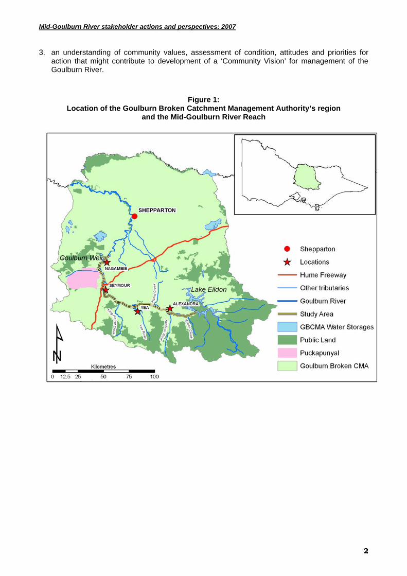
1.01 Background The Goulburn Broken Catchment Management Authority (GB CMA) contracted Charles Sturt University’s Institute for Land, Water and Society (ILWS) to conduct independent research to provide an understanding of landholder and wider community values, priorities and actions in relation to management of the riparian zone of the upper section of the Goulburn River, between Lake Eildon and Goulburn Weir [refer to Figure 1]. This research was phase two of a four-phase research strategy undertaken by the GB CMA, and was intended to provide information to support the GB CMA’s Regional River Health Strategy – which aims to enhance and protect the health of the Goulburn River system. CSU staff involved in this research were also involved in a 2001 study (Curtis et al. 2001) that provides a baseline for comparisons of changes over time in aspects of landholder management of river frontages on the Goulburn River. The Goulburn basin covers 7.1%, or 1.6 million hectares, of Victoria. The south of the catchment experiences average rainfall of 1,600 mm as well as snow. Rainfall decreases towards the north of the catchment to less than 450 mm/a (GB CMA 2005). The Goulburn River runs from Woods Point in the south to Echuca on the Murray in the north, with a total length of 750 km. The towns of Eildon, Yea, Seymour, Nagambie, Murchison and Shepparton are located along the Goulburn River. The catchment includes Victoria’s main water storage, Lake Eildon which is used to store water for hydro electricity, urban use, domestic and stock supply and irrigation. The River is also an important social asset providing a resource for recreational activities such as angling, swimming, canoeing, camping, boating and rowing. The region supports major agricultural (dryland and irrigated), food processing, forestry and tourism industries. The major commodity is food, but wool, timber, tourism and recreation are also vitally important to the region’s economy. The annual economic output of the Shepparton Irrigation Region is $4.5 billion. The major natural resource issues are water quality, dryland salinity, native vegetation decline, biodiversity and pest plants and animals. The Index of Stream Condition (ISC) rates 45% of the Goulburn basin’s river in ‘moderate condition’ and a further 23% in ‘poor condition’. Only 10% of the total rivers in the catchment are classified as being in ‘excellent condition’. All excellent condition rivers were found in the forested, upper Goulburn tributaries in the highlands (ISC 1999). Understanding the land-use practices, issues, values and aspirations of landholders adjacent to the Goulburn River and other key stakeholders (eg. recreational users of the River) is critical for designing and implementing effective strategies for enhancing the health of the Goulburn River. 1.02 Research objectives The objectives of this research project were to provide:
1. a clear understanding of how landholders adjacent to Crown water frontages manage those frontages and what the impediments to improved management are;
2. valuable evaluation data (mix of quantitative and qualitative data) for the GB CMA to compare against previously conducted ‘river health’ research (eg. Curtis et al. 2001) and identify emerging issues that would inform the GB CMA’s future investment to meet catchment management targets; and
Mid-Goulburn River stakeholder actions and perspectives: 2007
3. an understanding of community values, assessment of condition, attitudes and priorities for action that might contribute to development of a ‘Community Vision’ for management of the Goulburn River.
Figure 1: Location of the Goulburn Broken Catchment Management Authority’s region
and the Mid-Goulburn River Reach
2

Mid-Goulburn River stakeholder actions and perspectives: 2007
2.0 METHODOLOGY 2.01 Introduction The ILWS formed a team with extensive socio-economic research experience, particularly in conducting qualitative and quantitative research to explore the adoption of recommended practices for natural resource management (NRM) on private land. The research team had previously investigated the management of river frontages (Curtis et al. 2001) and dryland farm land (Curtis et al. 2000) in the GB CMA region. These were both highly innovative projects and led to a number of peer-reviewed publications. The river frontage survey (Curtis & Robertson 2003a & 2003b) included a section asking respondents to self-assess the condition of a section of their river frontage. A subsequent project involved scientists assessing these frontages and a comparison of landholder and scientist assessments of condition (Wilson et al. 2006). In 2007, the research team again worked closely with the GB CMA Project Managers – Wayne Tennant and Scott Morath, to clarify the research objectives and develop the survey instrument. The research was undertaken during September 2007 – March 2008. In summary, the research team collected quantitative and qualitative data from:
1. a structured questionnaire mailed to all property owners with Crown frontage along the Mid-Goulburn River (180 questionnaires posted, with a 59% response rate achieved);
2. semi-structured in-depth interviews with 12 people who were identified as representatives, or highly informed members, of additional stakeholder groups (eg. recreational fishers, River-based tourist operators) to explore their values, priority issues, and preferred management options; and
3. two facilitated workshops with focus groups to explore in-depth the values, priority issues and preferred management options of selected primary stakeholder groups (‘agency staff’ and ‘landholders’, involving 6 and 12 people in the respective workshops).
Each of these research methods is described in more detail below. 2.02 The mail survey The GB CMA provided the research team with a list of all Crown frontage licence land holders in the Mid-Goulburn (N=184) drawn from the Department of Sustainability and Environment’s data base. Four landholders on this list owned multiple properties, leaving 180 owners to be included in the mail out. So, the 2007 survey was a census of Crown frontage licence landholders in the Mid-Goulburn. The 2007 survey design and the mail out process employed a modified Dillman (1979) approach. The survey was presented as a distinctive booklet and was mailed with an appealing cover letter. Several reminder and thank you notices were posted to respondents and non-respondents. After three reminder notices, a second mail out was made to all non-respondents. The mail out process was closed with 94 useable surveys and a 59% response rate [Table 1]. Twenty surveys were either “returned to sender” (8); had multiple properties (2), returned with a note explaining that the listed owner was incapacitated by illness (1), had died (1), had sold (2) leased the property (1), were travelling overseas (1), claimed not to own a river/ creek frontage (1), was opposed to the North-South pipeline (1), refused to complete the survey (1), or returned the survey but the survey was lost (1). These respondents were all removed prior to calculation of the survey response rate. We acknowledge that there are likely to be differences between respondents and non-respondents to mail surveys. However, the 2007 survey was a census of Crown frontage licence landholders in the Mid-Goulburn and with a 59% response rate we can be confident that data presented is representative of those landholders.
3

Mid-Goulburn River stakeholder actions and perspectives: 2007
While both the 2001 and 2007 research employed a mailed survey of landholders with frontage to the Goulburn River, the 2001 and 2007 mail surveys were directed to slightly different cohorts of river frontage owners. The 2001 survey sample was drawn from all river frontage land owners in the GB CMA region whereas the 2007 survey was to all Crown river frontage licence landholders in the Mid-Goulburn that runs on the Goulburn River from Lake Eildon to the Goulburn Weir. As such, there needs to be some caution in drawing conclusions from comparison of data from the 2001 and 2007 surveys [refer to Table 1, below].
Table 1
Survey response rate Mid-Goulburn River Crown frontage licence landholder survey, 2007
Group Initial mail out
Un-useable surveys
Surveys returned useable
Response rate %
Census of all Crown frontage licence landholders N=94
180 20 94 59%
*2001 survey random sample N=93 203 56 93 63%
*See explanation in text above Survey data analysis included in this report consists of descriptive statistics, correlations, chi-square tests, Fishers exact tests, Z tests for proportions, Kruskal Wallis tests, linear modelling, stepwise multiple linear modelling and stepwise generalised linear modelling. Descriptive statistics such as frequencies, means, medians and percentages were used to summarise the responses to particular survey questions. Correlations, linear models, chi-square tests, Fishers exact tests and Kruskal Wallis tests were used in pairwise analysis to see if the relationships or differences observed by the summary statistics were significant. • Relationship: In the case of correlations, Spearman’s Rho was used to identify if there were
significant relationships between pairs of continuous variables. For example property size and amount of work undertaken on the river frontage. In certain cases, the relationship was explored further using a linear model instead of Spearman’s Rho, in an effort to quantify the structure of the linear trend.
• Difference: The Kruskal Wallis test was used to see if there were any significant differences on a continuous variable based on a grouping variable. For example, fencing along a water frontage based on whether or not the property was the survey recipient’s principal place of residence.
• Dependence: The Chi-squared tests and Fisher’s exact tests were used when comparing two categorical (or grouping) variables depending on the frequencies found in the cross-tabulated counts. These statistics test for dependence in the grouping. For example, farmer/ non-farmer compared to landcare/ non-landcare member.
The statistical tools identified above were used to explore relationships between variables (independent) thought to influence the adoption of Current Recommended Practices (CRP) (dependent variables). For example, the participation in Landcare and the adoption of planting trees and shrubs. If the values were significant, then those variables were considered as possible predictors of each CRP. Each of these possible predictors were then scrutinised for a response rate above 80% to ensure modelling integrity. The final list of predictors was then used in a stepwise modelling process that used Akaike's information criterion as the step criteria. If the dependent CRP variable was continuous then a stepwise linear modelling process was used. If the
4
Mid-Goulburn River stakeholder actions and perspectives: 2007
dependent CRP variable was dichotomous, then a stepwise binomial generalised linear modelling process was used. The modelling process was used to see which variables contributed collectively to CRP adoption. Z tests for proportions were primarily used to test for significant differences between 2001 and 2007 survey findings for particular variables where only percentage scores were available from the 2001 report. All data analysis was performed in the package S-Plus and the Z tests on the following website: http://www.dimensionresearch.com/resources/calculators/ztest.html 2.03 Stakeholder interviews and focus groups
2.03.1 In-depth interviews with selected stakeholders The research team worked with GB CMA Project Managers, and the Upper Goulburn Implementation Committee (UGIC) to identify 12 people with diverse backgrounds and experiences to be interviewed. People interviewed included formal representatives, or highly informed people, of a specific organisation or interest group (eg. farmers with Crown frontage, River-based tourist operator, recreational fisher, local government Councillor, commercial agribusiness operators). The interviews generated qualitative data about values, priority issues, preferred management options and views about responsibilities of a range of stakeholder groups. All interviews were conducted by experienced social science researchers using an in-depth semi-structured approach, guided by an interview schedule [presented in Appendix 1] (Minichello et al. 1996). Interviews were not taped, but the key points and themes were recorded in handwritten notes by the scribe. The research team arranged for the interviews to be conducted at a convenient time and location for the interviewee, and were mainly 1-2 hours in length. The project team notes that ensuring the anonymity of interviewees appeared to be important for most interviewees. Interviewees did not have their identity recorded on the interview notes and statements, and information in the report has not been attributed to specific interviewees. The research team wrote to prospective interviewees about two weeks prior to the anticipated interviews explaining the purpose of the interview, how interviewees had been identified, and that the client for the research was the GB CMA. The letter also assured interviewees that the information they provided would be confidential. All interviews were completed during mid-October to mid-December 2007.
2.03.2 Workshops with focus groups The GB CMA Project Managers and the UGIC identified two important stakeholder groups for the management of the Goulburn River – agency staff (workshop #1) and landholders (workshop #2). There were 6 and 12 participants at the workshops, respectively. The project team recognises the important contribution that community members make to NRM research and management, and offered all self-employed participants in the workshops (eg. farmers) a $100 honorarium for their involvement (this payment was processed by CSU). The workshops were of half-day duration and both were conducted in Yea. The workshops generated in-depth qualitative data about values, priority issues and alternate management options; and explored the extent there was a consensus view that may lead to establishing a ‘Community Vision’ for the management of the Goulburn River. Analysis of the two workshops is integrated into this research report.
5

Mid-Goulburn River stakeholder actions and perspectives: 2007
3.0 FINDINGS
3.01 Perceptions of river and river frontage health/ condition
3.01.1 Landholder knowledge Ecological condition ‘… refers to the degree to which human-altered ecosystems diverge from local semi-natural ecosystems in their ability to support a community of organisms and perform ecological function.’ (Jansen and Robertson 2001:65). According to Naiman and Decamps (1997), river frontages have four key ecological functions:
1 Stabilising bed and banks, 2 Filtering nutrients and sediments, 3 Contributing nutrient to food chains on land and in-stream, 4 Providing habitat for fauna on land and in-stream. Based on their experiences in Australia (Robertson et al. 1996; Robertson 2000; Robertson and Rowling 2000; Jansen and Robertson 2001), the authors identified the set of human induced impacts affecting riparian condition, listed below:
• Clearing of vegetation for grazing or cropping. • Grazing on or close to the river bank. • High summer flows in regulated rivers. • Introduction and spread of carp. • Draining of wetlands. • Introduction and spread of exotic weeds such as willows and blackberries. • Removal of dead trees. • Removal of fallen woody debris on land and water. Given the constraints of space in the survey it was not possible to assess respondent’s knowledge of all aspects of river frontage function and condition. The 2007 survey included a much larger range (13 items) of topics than the 2001 survey (4 items). With only one item included in both surveys there is only limited capacity to make comparisons over time. For the 2007 survey, 11 knowledge items were included in a stand-alone section of the survey and two others were interspersed with other items exploring views about the efficacy of CRP and attitudes about the management of water ways and adjoining land. Self-assessment is a widely accepted approach to gathering information about landholder knowledge of NRM topics. One approach is to ask each respondent to rate their level of knowledge for particular topics (Curtis and De Lacy 1996). Another approach is to ask each respondent to answer questions or respond to statements that test their knowledge of a particular topic (Shindler and Wright 2000). For this study, a combination of both approaches has been used. For the 11 items in the knowledge section, respondents self-rated their knowledge by selecting one of six options that ranged from ‘No knowledge’ to ‘Very sound knowledge (could give a detailed explanation)’ and included ‘Not applicable’. For the additional items, respondents were asked the extent they agreed or disagreed with a statement. Again, six response options were provided, including ‘Not applicable’. To simplify the presentation of data, the six response options have been collapsed into four categories [Table 2]. For the calculation of mean scores per item we have excluded the ‘Not applicable’ option. The knowledge topic included in both the 2001 and 2007 surveys has been shaded in Table 2.
6

Mid-Goulburn River stakeholder actions and perspectives: 2007
Table 2 Knowledge of river frontage management
Mid-Goulburn River Crown frontage licence landholder survey, 2007, N=94
~ Score where 1 = no knowledge/ strongly agree through to 5 = very sound knowledge/ strongly disagree
Topics n
Very Sound
to sound knowledge
Some knowledge
Little/no knowledge
N/A Mean
score~
How to manage ground cover on paddocks used for grazing to minimise soil erosion 90 56% 32% 11%
1% 3.52
The effects of unrestricted stock access to water ways 90 48% 39% 13% 1% 3.42 The production benefits of retaining native vegetation on farms 90 48% 39% 13% 0% 3.36 The ability of perennial vegetation and standing stubble to improve the quality of runoff water
90 37% 42% 19% 2% 3.14
The importance of changes in the volume of water flows in the Goulburn River for maintaining a healthy river system
89 31% 49% 19% 0% 3.13
The contribution of floodplain wetlands towards the health of the Goulburn River 90 31% 39% 29% 1% 3 How to prepare a farm or property plan that allocates land use according to different land classes
90 30% 36% 32% 2% 2.88
How to access information about government support for landholders to better manage Crown Land frontages
89 18% 44% 38% 0% 2.72
Predicted changes to rainfall and temperature for the Goulburn Valley as a result of climate change
89 13% 49% 35% 2% 2.69
How to interpret results from water quality testing 86 15% 30% 52% 2% 2.42 The proportion of native bush (as tree cover) remaining along the Goulburn River from Lake Eildon to Shepparton as a percentage of what existed before European settlement
89 7% 29% 64% 0% 2.1
Statements N Agree/
Strongly agree
Not sure Disagree/ strongly disagree
N/A Mean
Dead trees or timber on the ground in river frontages are important habitat for native birds and animals (in both 2001 & 2007)
90 44% 36% 19% 1% 3.26
Removing willows is an important part of work to improve the condition of native vegetation on river frontages
89 46% 18% 36% 0% 3.01
Survey data indicate that respondent’s self-assessed knowledge varies considerably across the survey items. There was only one item (managing ground cover on paddocks to prevent erosion) where most respondents said they had ‘Very sound/ sound’ knowledge [Table 2]. Almost half of the respondents rated their knowledge as “sound” for items exploring knowledge of the effects of unrestricted stock access to water ways and the production benefits of retaining native vegetation [Table 2]. On the other hand, few respondents (<20%) rated their knowledge as “sound” for items exploring how to access information from government, predicted changes to rainfall and temperature as a result of climate change, how to interpret water quality tests and the proportion of native bush remaining in the Mid-Goulburn [Table 2].
7
Mid-Goulburn River stakeholder actions and perspectives: 2007
Few respondents (19%) disagreed with the statement that Dead trees or timber on the ground in river frontages are important habitat for native birds and animals [Table 2], suggesting a high level of awareness/ knowledge of the importance of this type of habitat. On the other hand, a substantial minority (36%) disagreed with the statement that Removing willows is an important part of work to improve the condition of native vegetation on river frontages [Table 2]. As explained, this view is consistent with the views expressed by many interviewees.
3.01.2 Landholder assessment of frontage health/ condition The 2001 survey included a section where respondents were asked to assess the condition of a section of their river frontage. The 2001 research team included Alistar Robertson (ecologist), Wayne Tennant (program manager) and Allan Curtis (social researcher). Drawing on their previous experience, including the development of rapid appraisal approaches for wetland (Spencer et al. 1998) and riparian habitats (Jansen and Robertson 2001); and the Index of Stream Condition (ISC) (Ladson et al. 1999), the 2001 research team identified eight topics for which survey recipients would be asked to assess the condition of their river frontage [Appendix 7, topics 1-8 in bold]. As with the ISC, a five point rating scale was used to enable respondents to select the description best reflecting the condition of their frontage for a particular topic [Appendix 7]. To the authors’ knowledge, this was the first time that researchers had used a mail survey to undertake a rapid assessment of river frontage condition. As part of the mail survey, respondents were asked if they would allow a scientist from the research group to visit their property and undertake a rapid assessment of the same length of river frontage. The rapid assessment approach and findings from the mail survey and field inspections were published in three peer reviewed papers (Curtis and Robertson 2003a and b; Wilson et al. 2006). An important finding from the 2001 research was that across all sites, there was not a significant difference between landholder and expert assessments of condition. For the 2007 survey, an additional topic exploring linkages between the channel and floodplain [Figure 2, topic 9] was included in the survey rapid assessment instrument. Comparisons between 2001 and 2007 survey findings for the rapid assessment instrument only involve topics 1-8. Managers assessing river frontage condition using the ISC are asked to compare a particular frontage with what they believe is the best and worst in the state of Victoria. Survey recipients were not expected to be familiar with the condition of frontages across Victoria and were asked to compare the condition of their frontage with the condition of examples that they thought were the “best” and “worst” they knew of. There was no attempt to define “best” and “worst” as this might have affected the assessment made by respondents. Respondents were also asked to do their assessment for one section of their frontage and instructed that this section should be no longer than 1km and should only be for one side of the waterway.
8

Mid-Goulburn River stakeholder actions and perspectives: 2007
Table 3 Landholder assessment of river frontage condition
Mid-Goulburn River Crown frontage licence landholder survey, 2007, N=94
TOPICS DESCRIPTION OF CONDITION [response options provided to survey respondents] and SUMMARY OF RESULTS [% response reported]
Condition category ‘very good to good’ ‘moderate’ ‘very poor to poor’
Is there evidence of bank erosion? n=86; mean=4.26***
Bank is stable
50%
Limited erosion
29%
Moderate erosion
17%
Large areas of erosion
3%
Most areas unstable
0% Is the bed filling with sand? n=85; mean=4.25
No sand build up
51%
Limited build up
33%
Moderate build up
9%
Large areas sand build up
5%
Sand build up most areas
2% Are there many snags in the river channel? n=86; mean=3.80
Plenty of snags or timber from native trees
31%
Many snags pr timber from native trees
24%
Moderate snags or timber
37%
Hardly any snags or timber
7%
No snags or timber visible
0% Are there gaps in the tree canopy (sky blocked out) along the bank? n=86; mean=3.16
No gaps in tree canopy along bank
1%
The odd gap in tree canopy
48%
Full canopy cover along about half the bank
19%
Few areas have full canopy
31%
Few trees present along bank
1% How wide is the area where there are no gaps in the tree canopy? n=83; mean=2.53
Full canopy at least 40m wide along all parts
1%
Full canopy 40m wide most parts
16%
About half has canopy cover 40m wide
34%
Small areas full canopy 40m wide
34%
No areas full canopy at least 40m wide
16% What proportion of tree cover along the bank is native? n=85; mean=4.35
All/almost is native
61%
More than half native
20%
About half is native
14%
Over half introduced
2%
All/almost introduced
2% What proportion of ground cover along bank is weeds or introduced pasture?n=86; mean=3.30
All/almost ground cover is native
29%
More than half native
17%
About half is native
23%
Over half introduced
15%
All/almost ground cover is introduced
15% What proportion of ground along the bank is covered by leaves and sticks? n=86; mean=3.15
All/almost has leaves and sticks on ground
22%
More than half the area
21%
About half the area
24%
Less than half
15%
Few areas have leaves or sticks on ground
17% Does water flow from the river across the frontage in normal seasons? n=86; mean=2.80
Seasonal floods across most length of frontage
14%
Seasonal floods across about half the frontage
17%
Seasonal flows into small areas of frontage
22%
Irregular/ rare flows into small areas of the frontage
28%
No record of water flowing across most frontage
19% *** a higher mean score indicates more positive assessment of condition
As in 2001, there was a very high response rate for this section of the survey (from 83 to 86 of 94 respondents) [Table 3]. The validity of the index was confirmed by analysis using Cronbach Alpha with a scale score of 0.732, which is above the commonly accepted level of 0.7, and suggests that the scale items are measuring a single construct.
9

Mid-Goulburn River stakeholder actions and perspectives: 2007
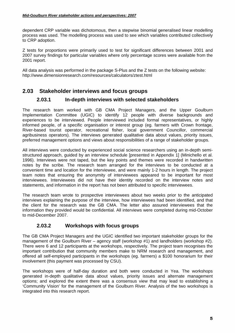
Respondents provided very positive assessments (>4 out of 6) for condition index topics related to bed and bank stability and the proportion of tree and ground cover under native vegetation; and positive assessments (>3) for the extent of snags in the river channel, the proportion of ground cover that is weeds or introduced pasture, the extent of canopy cover and the ground cover that is leaves and sticks. More negative assessments were provided for topics related to the width of the area with full tree canopy and whether water flows from the channel across the frontage in normal seasons [Table 3]. By summing scores for each of the nine items it was possible to calculate an index score for each respondent’s assessment of their river frontage condition. Possible scores ranged from 9 to 45, with a Mid-point of 27. With a median score of 29 it seems that respondents were divided between those who had generally positive and those who had generally negative assessments of the condition of their river frontage. There were significant differences in respondents’ mean scores across the nine topics contributing to the index of frontage condition (χ2 100.851, df=7, p<0.001). A comparison with 2001 survey findings based on the proportion of respondents providing ‘Very good/ Good’ assessments, revealed higher ratings in 2007 for six of the eight topics common to both surveys [Figure 2]. These higher ratings were statistically significant for three topics: bed filling with sand, presence of snags in the channel, and the proportion of tree cover that is native. To simplify the presentation of these data, the response options for condition category have been collapsed into three categories – “very good to good condition” (combining very good to good condition), “moderate condition” (of moderate condition) and “very poor to poor condition” (combining very poor to poor condition) [Figure 2].
10
Mid-Goulburn River stakeholder actions and perspectives: 2007
Figure 2 Comparison of assessments of river frontage condition in 2007 and 2001
Mid-Goulburn River Crown frontage licence landholder survey, 2007, N=94
0% 10% 20% 30% 40% 50% 60% 70% 80% 90% 100%
Is there evidence of bank erosion? (2007)
2001
Is the bed filling with sand?
2001
Are there many snags in the river channel?
2001
Are there gaps in the tree canopy (sky blacked out) along thebank?
2001
How wide is the area where are no gaps in the tree canopy?
2001
What proportion of tree cover along the bank is native?
2001
What proportion of ground cover along the bank is weeds orintroduced pasture?
2001
What proportion of ground along the bank is covered by leavesand sticks?
2001
TopicsPercentage
Very good to good conditionModerate conditionVery poor to poor condition
Note: The condition legend refers to statements describing frontage condition in Table 2. We were also interested in exploring relationships between assessed condition and adoption of CRP. For example, would lower condition assessments, perhaps reflecting more degraded sites, be linked to action or intentions to address degradation? In this study, there were no significant relationships between the index of frontage condition and adoption of CRP up to October 2007. Perhaps counter-intuitively, we did find that respondents providing more positive assessments of frontage condition were significantly more likely to report that they planned to fence to manage stock access to the water way.
11
Mid-Goulburn River stakeholder actions and perspectives: 2007
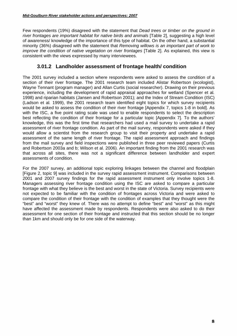
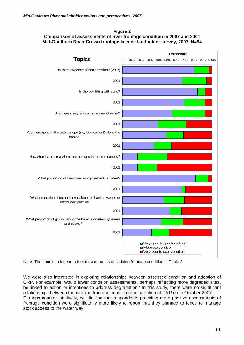
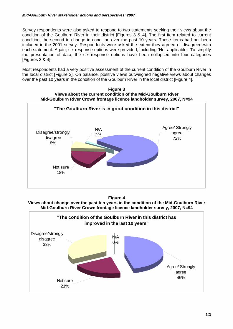
Survey respondents were also asked to respond to two statements seeking their views about the condition of the Goulburn River in their district [Figures 3 & 4]. The first item related to current condition, the second to change in condition over the past 10 years. These items had not been included in the 2001 survey. Respondents were asked the extent they agreed or disagreed with each statement. Again, six response options were provided, including ‘Not applicable’. To simplify the presentation of data, the six response options have been collapsed into four categories [Figures 3 & 4]. Most respondents had a very positive assessment of the current condition of the Goulburn River in the local district [Figure 3]. On balance, positive views outweighed negative views about changes over the past 10 years in the condition of the Goulburn River in the local district [Figure 4].
Figure 3
Views about the current condition of the Mid-Goulburn River Mid-Goulburn River Crown frontage licence landholder survey, 2007, N=94
"The Goulburn River is in good condition in this district"
N/A2%
Not sure18%
Disagree/strongly disagree
8%
Agree/ Strongly agree72%
Figure 4 Views about change over the past ten years in the condition of the Mid-Goulburn River
Mid-Goulburn River Crown frontage licence landholder survey, 2007, N=94
"The condition of the Goulburn River in this district has improved in the last 10 years"
Agree/ Strongly agree46%
Disagree/strongly disagree
33%
Not sure21%
N/A0%
12

Mid-Goulburn River stakeholder actions and perspectives: 2007
3.01.3 Stakeholder assessments of frontage and river health/ condition Most interviewees were of the view that the water quality in the upper reaches of the Goulburn River was of a high standard (i.e. clear water, supported fish species, no evidence of pollution) – and had not demonstrably deteriorated over several decades. Some of the comments made by interviewees that illustrate this include:
‘… you can still drink the water’,
‘… as a fisherman, insects are a great indicator of river health, and it’s easy to find insects in some parts (of the River)’.
One interviewee reported that the River had deteriorated in quality since the construction of Lake Eildon. Interviewees noted that the River can become turbid as a consequence of heavy rainfall, but this clears quickly over a matter of days and did not usually present a problem. The volume of water flows in the River fluctuated – at times widely and at critical times, with some interviewees recalling times of localised flooding – causing damage to farm infrastructure (eg. fences) and loss of productivity (eg. loss of pastures). However, interviewees reported that flooding has not occurred during recent years, and with low storage levels and increased demand for irrigation water – flooding may not present an immediate threat. Some interviewees with an interest in fishing reported that in periods of low water flow the dissolved oxygen levels in the River and tributaries restricted opportunities for fishing. Also, some interviewees reported that the natural wetlands associated with the River have been neglected in favour of a range of other demands, with one interviewee commenting:
‘… the wetlands are the last thing to get any water … when things are tight the wetlands miss out’.
While in-stream debris (eg. snags) as considered important for its ecological values, most interviewees expressed a desire for the River to be kept ‘clean’ of other debris – particularly branches causing blockages and impeding users of the River (eg. causing snags with fishing, impeding boat users) and giving an ‘unkempt’ appearance to the River. Most interviewees expressed a strong desire for the River to be managed and kept ‘clean’ (whether debris from willows or native vegetation). There was also concern that “shingle” banks and major debris deposited in mid-channel were contributing to erosion. The native vegetation in the River’s riparian zone was reported by several interviewees to be under stress (in decline), particularly many of the mature River Red Gum – the River’s ‘signature’ species.
3.01.3.1 The Current Recommended Practices (CRP) All interviewees were aware of on-ground work consistent with the CMA’s current recommended practices (CRP) undertaken over the past three years. There are several components of the GB CMA’s CRP for the Goulburn River [refer to Box 1]. There was less convergence amongst interviewees about the management of river banks, with many of the interviewees who were landholders viewing their riparian frontage as an intrinsic part of their property. The extent CRP created an additional workload (eg. maintaining fences, pest control), increased the risk of fire and (to some extent) limited access to the River for livestock – then the less favourable landholders viewed these changes. Some of the comments made by interviewees that illustrate this point include:
‘… now it’s fenced out, it all takes more time to manage these areas (Crown frontage)’,
‘… I’ve got the real worry that it’s creating a huge fire danger, and now it’s difficult to get to’, ‘… there’s no budget for maintenance (of Crown frontage areas)’,
13

Mid-Goulburn River stakeholder actions and perspectives: 2007
‘… willow removal encourages weed problems due to the approach to revegetation … particularly because of the (large) width of the planted area’,
‘… they should give farmers money for maintenance (of Crown frontage)’. There were differing views amongst interviewees about the need to remove willows and the benefits from their wholesale replacement with native vegetation. Some interviewees felt the cost of willow removal was excessive, and that their replacement with native vegetation delivered few additional benefits (at least what was observable in the short to medium-term), as illustrated by the following comments:
‘… I’m in favour of retaining willows where they’re doing a good job’,
‘… some (willow) species are beneficial … the debate is out of control’. However, other interviewees expressed strong support for the CRP principle of removing willows and replacing this with native vegetation, as illustrated by these comments:
‘… the CMA policy of willow removal is good for safety (of canoeists)’,
‘… I’m happy to see willows removed but on a pragmatic basis’. A majority of those interviewed agreed with a phased approach to the removal of willows. All interviewees expressed views that supported a more gradual and cooperative approach by the GB CMA. Where erosion of riparian banks is active, there was broad support amongst interviewees for the use of rock and other stabilising works. There were mixed views amongst interviewees about allowing livestock direct access to the River, with some saying it presented minor problem while others thought livestock should be excluded. However, most interviewees felt off-stream and designated livestock watering points were a positive development. Most interviewees were also in favour of allowing livestock limited access to riparian areas as a way of managing weeds and excessive grass growth. Several interviewees expressed concern that the health and use of the tributaries of the Goulburn River were being overlooked, and that excessive use of water in these tributaries and surrounding groundwater was beginning to have a considerable negative impact on the River. For example, there were concerns that consumptive use by irrigators and those with ‘stock and domestic’ (S&D) licences may lead to extraction beyond that previously thought, particularly during the summer months of recent years.
Box 1: GB CMA’s CRP for the upper/ mid Goulburn River Removal of willows and revegetation: • Work on riparian lengths of up to 300m at a time • Poison willows (via trunk injection) in year 1 • Trim to stump in year 2 (leave if necessary for bank stability) • Poisoning stumps to prevent re-sprouting • Revegetate site with mix of native shrubs and trees. Fencing of riparian zone: • Crown frontages should be fenced • Management agreement with landholder for 5 years • Crash grazing with livestock allowed for limited periods • Control of pest plants and animals required by landholders (refer management agreement) • 75% of cost of off-stream watering provided
14
Mid-Goulburn River stakeholder actions and perspectives: 2007
3.02 Values attached to river frontages
3.02.1 Introduction Communities are heterogeneous and it is important to identify the range of values attached to river frontages by different stakeholders. We have drawn on a recently developed typology of community types (Harrington et al. 2007) to identify those groups with a stake in the management of river frontages in the Mid-Goulburn. The typology developed by Harrington et al. (2007) identifies place-based (living within and outside a locality), practitioner, identity and interest-based communities. The stakeholder groups engaged in the interviews and workshops included place-based and other interest-based communities and representative of practitioner communities. These stakeholders could be further categorised as members of different River ‘user groups’ or ‘interest groups’, and included commercial farmers and other agribusiness operators, local government staff and a Councillor, State agency staff, water-based tourist operators, recreational fishers, CMA staff and Landcare members.
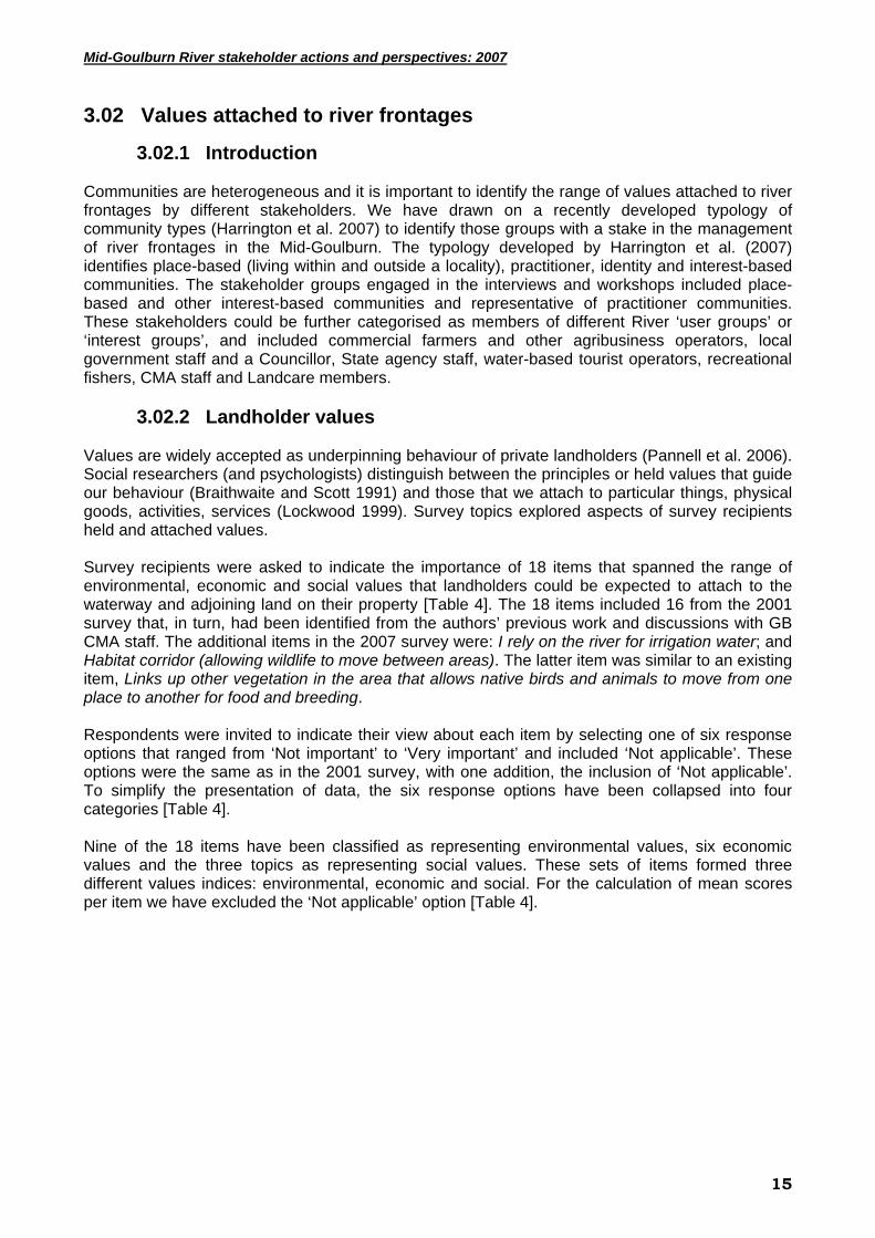
3.02.2 Landholder values Values are widely accepted as underpinning behaviour of private landholders (Pannell et al. 2006). Social researchers (and psychologists) distinguish between the principles or held values that guide our behaviour (Braithwaite and Scott 1991) and those that we attach to particular things, physical goods, activities, services (Lockwood 1999). Survey topics explored aspects of survey recipients held and attached values. Survey recipients were asked to indicate the importance of 18 items that spanned the range of environmental, economic and social values that landholders could be expected to attach to the waterway and adjoining land on their property [Table 4]. The 18 items included 16 from the 2001 survey that, in turn, had been identified from the authors’ previous work and discussions with GB CMA staff. The additional items in the 2007 survey were: I rely on the river for irrigation water; and Habitat corridor (allowing wildlife to move between areas). The latter item was similar to an existing item, Links up other vegetation in the area that allows native birds and animals to move from one place to another for food and breeding. Respondents were invited to indicate their view about each item by selecting one of six response options that ranged from ‘Not important’ to ‘Very important’ and included ‘Not applicable’. These options were the same as in the 2001 survey, with one addition, the inclusion of ‘Not applicable’. To simplify the presentation of data, the six response options have been collapsed into four categories [Table 4]. Nine of the 18 items have been classified as representing environmental values, six economic values and the three topics as representing social values. These sets of items formed three different values indices: environmental, economic and social. For the calculation of mean scores per item we have excluded the ‘Not applicable’ option [Table 4].
15
Mid-Goulburn River stakeholder actions and perspectives: 2007
Table 4 Values attached to the Goulburn River and adjoining water way
Mid-Goulburn River Crown frontage licence landholder survey, 2007, N=94
Why the Goulburn River and adjoining land is important to you? (environmental, economic, and social values)
n Important
/Very important
Some Minimal/
Not important
Not applicable
Mean score
~ Adds to market value of the property 90 90% 3% 6% 1% 4.43 Vegetation on the frontage holds the banks and stops them crumbling 90 83% 8% 6% 3% 4.28
Is an attractive area of the property 84 84% 7% 6% 3% 4.26 Place where native birds live 90 87% 11% 1% 1% 4.22 Provides access to water for stock 89 74% 8% 14% 5% 4.21 I rely on the river for irrigation water 85 48% 9% 9% 33% 4.04 Links up with other vegetation in this area that allows native birds and animals to move from one place to another food and breeding
88 73% 16% 9% 2% 3.97
Provides woody matter such as snags that offer protection for fish and other animals that live in the river/creek
90 64% 19% 16% 1% 3.73
Habitat corridor (allowing wildlife to move between areas) 90 61% 20% 16% 3% 3.72
Where native animals live on land 90 60% 26% 12% 2% 3.69 Provides additional land for grazing stock, particularly in summer 88 58% 16% 19% 7% 3.67
A source of nutrients for in-stream food chains 90 58% 23% 13% 6% 3.67 Provides important shade and shelter for stock 88 59% 8% 28% 5% 3.61
Provides a place for recreation for family and friends 90 50% 23% 23% 3% 3.40
In-stream vegetation traps and stabilises sand/gravel 89 43% 22% 26% 9% 3.36
Acts as a filter catching sediment and/or nutrients in overland flows before they reach the river/creek
89 36% 21% 31% 11% 3.16
Place for me, my family & friends to fish 90 39% 23% 32% 6% 3.07 Harvesting timber for fence posts and fire wood 85 2% 5% 47% 46% 1.54
Stewardship scale item n
Agree/ Strongly
agree
Not sure
Disagree/ strongly disagree
N/A Mean
Reduced production in the short-term is justified where there are long-term benefits to the environment
89 34% 10% 55% 1% 2.66
~ Score where 1 = not important through to 5 = very important Most respondents placed a high value on the waterway and adjoining land on their property. For example, 17 of the 18 items had mean scores above three out of a possible five and there were six items with mean scores above four [Table 4]. As in 2001, the three most highly ranked items on mean scores included one topic from each of the environmental, economic and social value sets. These are important findings in that they suggest most landholders are concerned about or motivated by a range of environmental, economic and social attributes of the waterway and adjoining land on their property. Indeed, there were no significant differences in 2007 between farmers and non-farmers on mean scores for any of the three value sets.
16

Mid-Goulburn River stakeholder actions and perspectives: 2007
In 2001, survey respondents gave significantly higher ratings to items included in the environmental and social values indices compared to the economic index. This was not the case in 2007 where there were no significant differences between the mean scores of the three indices [Figure 5].
Figure 5 Environment, economic and social values of river frontage: Index scores
Mid-Goulburn River Crown frontage licence landholder survey, 2007, N=94
0
0.5
1
1.5
2
2.5
3
3.5
4
Environmental Economic Social
Landholder values grouped
Mean scores2001 Random sample2007 Licence holders
In the 2001 survey the authors employed 9 items from a 12 item scale developed by Dunlap and Van Liere (1978) to measure the New Environmental Paradigm (NEP). Dunlap and Van Liere (1978: 10) argued that ecological problems ‘… stem in large part from … our belief in abundance and progress, our devotion to growth and prosperity, our faith in science and technology, and our commitment to a laissez-faire economy, limited governmental planning and private property rights’ were all part of a Dominant Social Paradigm (DSP) that contributed to environmental degradation. Dunlap and Van Liere (1978: 10) contrasted the DSP with a new paradigm that accepted the ‘… inevitability of “limits to growth”, the necessity of achieving a “steady-state” economy, the importance of preserving the “balance of nature” and the need to reject the anthropocentric notion that nature exists solely for human use.’ The NEP has been widely employed (Steel et al. 1994) but 2001 survey data analysis failed to identify expected differences in NEP scores for Landcare and non-Landcare participants and did not predict the adoption of any conservation behaviours included in the survey. We did not include the NEP scale or any items from that scale in the 2007 survey. In the past, the authors have employed a multi-item land ethic or land stewardship scale that attempted to measure the extent respondents placed the long-term health of the land ahead of short-term economic gain (Vanclay 1992; Curtis and De Lacy 1998). This scale has had mixed success in discriminating between respondents and stewardship has generally not been associated with higher adoption of CRP (Curtis and De Lacy 1998). Nevertheless, we included a single item from that scale in the 2007 survey: Reduced production in the short-term is justified where there are long-term benefits to the environment. Fifty-five per cent of respondents ‘Strongly disagreed/ disagreed’ with this statement, 41% ‘Strongly agreed/ agreed’ and 19% were ‘Not sure’ (mean of 2.66), suggesting that most survey respondents have a bias towards production over conservation. This is a little surprising given that only 36% (n=90) said they were farmers by occupation and farmers typically rate production values higher than environmental values.
17
Mid-Goulburn River stakeholder actions and perspectives: 2007
3.02.3 Stakeholder values For many people living in proximity to the Goulburn River, the river is iconic – a focal point in the landscape and community. The diverse range of interviewees expressed sentiments that reflected values they held of the Goulburn River that were both utilitarian and aesthetic, with these values often inextricably linked for people – as one interviewee commented, to many it’s the ‘… life-blood of the region’. That is, the Goulburn River is an important part of the economy of the Goulburn catchment as well as being central to the desired lifestyle for those interviewed. The farmland fronting the Goulburn River derives considerable productive potential due to the fertile alluvial soils and access to high-quality and, erstwhile, plentiful water. This productive potential translates into the economic value of such farmland. Restrictions on the use of farmland in the riparian zone and the use of water were raised by many interviewees as being in conflict with their farming businesses. All landholders interviewed with adjoining river frontage considered that unrestricted access was ‘as of right’ and viewed any restrictions on their access to those areas as a breach of their entitlement. At the same time, all landholders interviewed accepted that the public should have the right to access the River through their frontage with the proviso that such access did not compromise their agricultural activities or infrastructure. The Goulburn River has important recreational value for local residents and visitors from outside the region, including for water-based pursuits (eg. canoeing, trout fishing) and as part of a ‘rural’ experience (eg. on par with bushwalking). Given the proximity of the River to Melbourne, many interviewees expressed their expectation that tourism would increase in importance over time. Restricting public access to the Goulburn River was cited by some interviewees as a negative aspect of the GB CMA’s River Health project. However, it was acknowledged that as designated access points become better known, then access for water-based pursuits could become less of an issue. Interviewees highlighted the extent of conflict between different values for River management. For example, River managers have faced a dilemma over an extended period about how much water to retain in Lake Eildon during the summer months to support the tourism industry, compared to letting the water reserves flow to downstream irrigators (i.e. the costs and benefits of tourism and irrigated agriculture are experienced equally within the community). These values were in conflict during the dry climatic conditions experienced during 2006-07. This issue also involves conflict between different place-based interests in that the beneficiaries of using the water for tourism are mostly located in the Upper Goulburn around Lake Eildon, whereas the community near the Lower Goulburn and Shepparton tends to receive greater benefit from irrigated agriculture. There has been ongoing and increasing use of the Upper Goulburn River (upstream of Goulburn Weir) – the geographical focus for this research – by people for the past 100 years. There was general acceptance amongst interviewees that the River was a modified environment, much altered from its original or natural state, and that this use has given rise to an important cultural heritage (eg. well-recognised for its productive farming and recreational experiences). The increasing importance of storing water for later release to provide for irrigated agriculture was widely supported. There was also general acceptance of the trade-offs in terms of ”reversing” the season pattern of River flows and that there were now high-volume and cool temperature water releases into the River during summer, compared to the typical natural state of low-volume and warm temperature flows during summer. Our interviewees recognised that these alterations to flow and thermal regimes had disadvantaged most of the native fish, but advantaged the introduced trout – the most popular species for recreational fishing. Changing the River’s flow to its natural state, and the associated economic and social costs, was not seen as achievable or desirable by most interviewees.
18

Mid-Goulburn River stakeholder actions and perspectives: 2007
While tourism is widely promoted as a beneficial outcome from the River, the rubbish left and security risk posed by campers and fishers occasionally created problems for landholders with River frontage. Some interviewees suggested that greater awareness of designated ‘public use’ areas and management and policing by agencies is needed. There was broad recognition of the need, and support, for water in the River to be allocated to ‘environmental flows’, as illustrated by the following comments:
‘… there is good community support for using water for environmental causes, as long as it’s in the catchment’,
‘… environmental water is vital’. However, there was considerable debate as to what priority ‘environmental flows’ should be given, particularly in times of limited water availability. 3.03 Attitudes about roles and responsibilities
3.03.1 Landholder attitudes
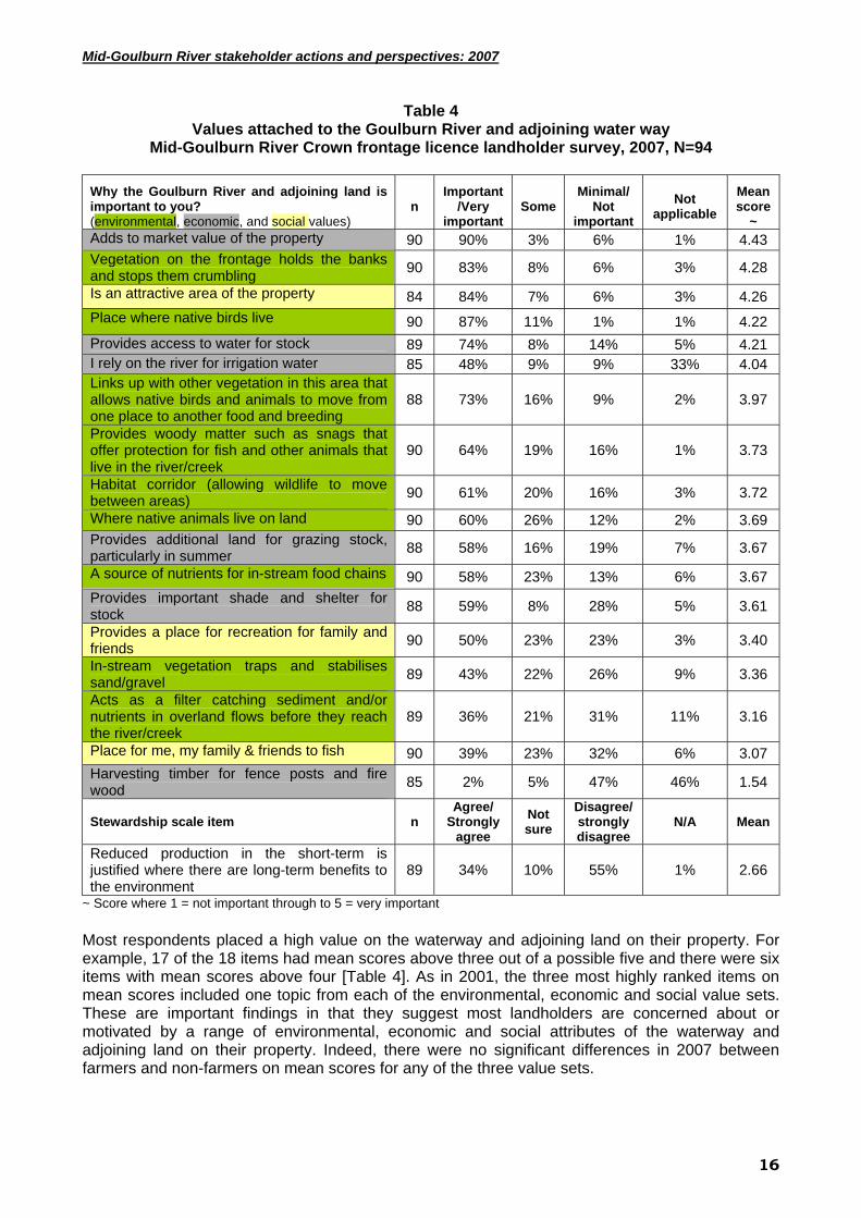
Survey topics explored respondent’s attitudes about the roles and responsibilities of key NRM stakeholders in the management of water ways and adjoining land [Table 5] and how the GB CMA environmental water allocation should be managed [Table 6]. Only two items (public right of access to frontages; and clarity about who is responsible for managing river frontages) had been included in the 2001 survey. For most items, respondents were provided with six response options, ranging from ‘Strongly agree’ to ‘Strongly disagree’, including ‘Not applicable’. To simplify the presentation of data, the six response options have been collapsed into four categories [Tables 5 and 6]. For the calculation of mean scores per item we have excluded the ‘Not applicable’ option.
19
Mid-Goulburn River stakeholder actions and perspectives: 2007
Table 5 Attitudes to stakeholder roles and responsibilities
Mid-Goulburn River Crown frontage licence landholder survey, 2007, N=94
Your views about aspects of land & water management
N
Agree/ Strongly
agree Not sure
Disagree/ strongly disagree
N/A Mean score~
It is a good thing that some water is now held in reserve for the environment 89 76 10 14 0 4.83
The Goulburn River is in good condition in this district 88 72 18 8 2 4.8
Prospective landholders should be automatically advised about funds spent by government to improve land and water management on a property
89 72 16 12 0 4.76
New owners should abide by agreements entered into by previous owners where public funds have paid for land protection or conservation work
89 63 29 6 2 4.66
Landholders should be paid for providing environmental services that benefit the wider community (eg. Managing habitat for native animals)
89 43 38 18 1 4.28
It is unclear who is responsible for managing river frontages 82 40 34 21 5 4.19
The condition of the Goulburn River in this district has improved in the last 10 years 90 46 21 33 0 4.12
In most cases, the public should have the right of access to river frontages that are managed by private landholders
90 41 16 40 3 4.07
Governments must take more responsibility for ensuring landholders meet their responsibilities under Crown Land Frontage leases
89 18 52 30 0 3.78
~ Score where 1 = Strongly disagree through to 5 = Strongly agree
Survey results provide a coherent picture of respondent attitudes in that most agree that prospective landholders should be informed if government funds have been spent to improve land and water management on a property. Most respondents also agree that new owners should abide by agreements entered into by previous owners where public funds have been spent on a property [Table 5]. Responses to other items suggest there are strong reservations about actions likely to diminish landholder autonomy in relation to NRM. For example, only 18% “agreed” that Governments must take more responsibility to ensure that landholders meet their responsibilities; and opinion was evenly balanced about whether in most cases, the public should have the right to access river frontages managed by private landholders [Table 5]. There also seems to be a high level of concern amongst a substantial minority (40%) about the lack of clarity in spelling out who is responsible for managing river frontages [Table 5]. Comparison with 2001 survey data suggests this level of concern has increased over time in that the proportion of respondents expressing ‘Minimal/ no concern’ has decreased from 42% to 21% in 2007.
20
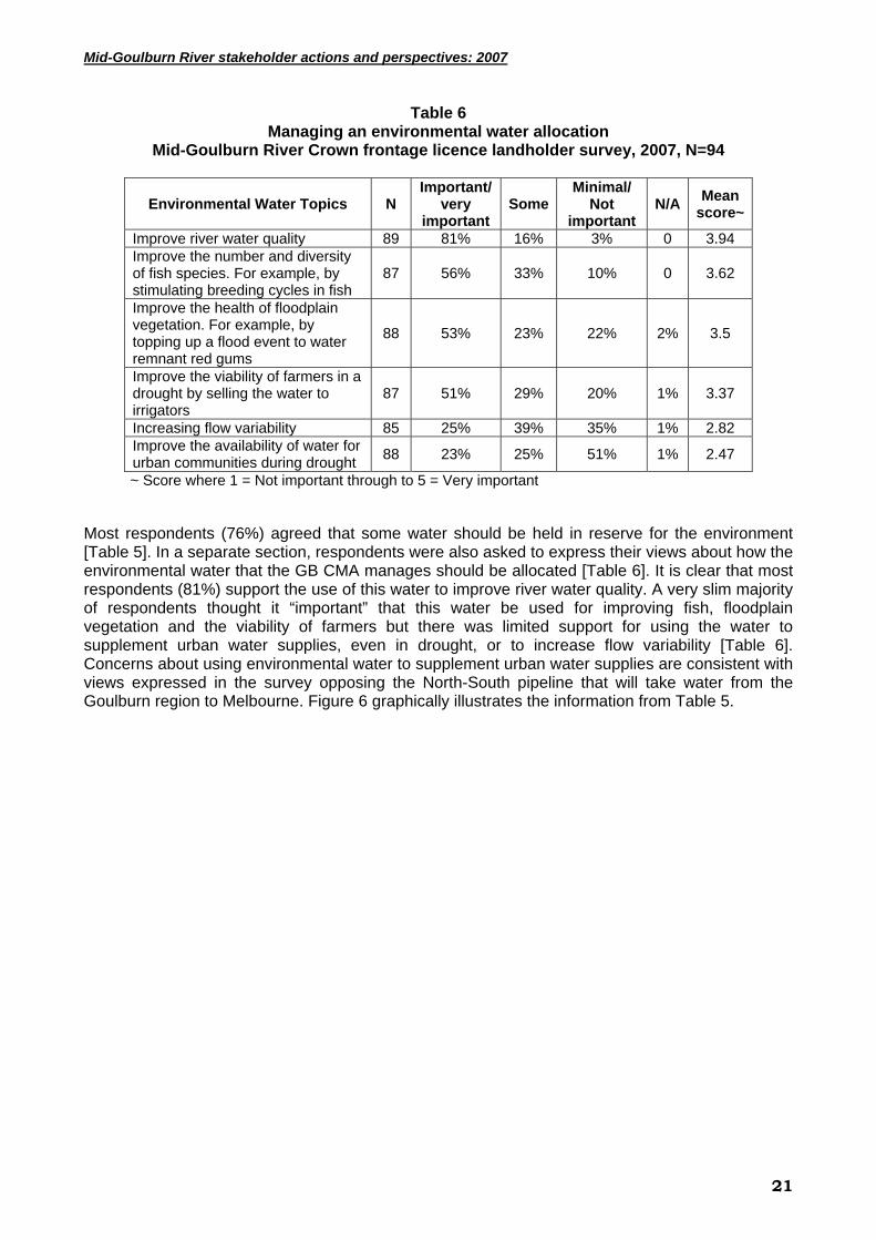
Mid-Goulburn River stakeholder actions and perspectives: 2007
Table 6 Managing an environmental water allocation
Mid-Goulburn River Crown frontage licence landholder survey, 2007, N=94
Environmental Water Topics N Important/
very important
SomeMinimal/
Not important
N/A Mean score~
Improve river water quality 89 81% 16% 3% 0 3.94 Improve the number and diversity of fish species. For example, by stimulating breeding cycles in fish
87 56% 33% 10% 0 3.62
Improve the health of floodplain vegetation. For example, by topping up a flood event to water remnant red gums
88 53% 23% 22% 2% 3.5
Improve the viability of farmers in a drought by selling the water to irrigators
87 51% 29% 20% 1% 3.37
Increasing flow variability 85 25% 39% 35% 1% 2.82 Improve the availability of water for urban communities during drought 88 23% 25% 51% 1% 2.47
~ Score where 1 = Not important through to 5 = Very important
Most respondents (76%) agreed that some water should be held in reserve for the environment [Table 5]. In a separate section, respondents were also asked to express their views about how the environmental water that the GB CMA manages should be allocated [Table 6]. It is clear that most respondents (81%) support the use of this water to improve river water quality. A very slim majority of respondents thought it “important” that this water be used for improving fish, floodplain vegetation and the viability of farmers but there was limited support for using the water to supplement urban water supplies, even in drought, or to increase flow variability [Table 6]. Concerns about using environmental water to supplement urban water supplies are consistent with views expressed in the survey opposing the North-South pipeline that will take water from the Goulburn region to Melbourne. Figure 6 graphically illustrates the information from Table 5.
21
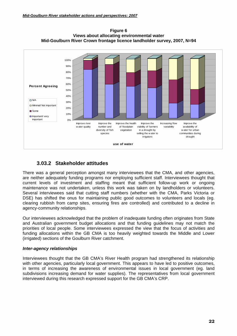
Mid-Goulburn River stakeholder actions and perspectives: 2007
Figure 6 Views about allocating environmental water
Mid-Goulburn River Crown frontage licence landholder survey, 2007, N=94
0%
10%
20%
30%
40%
50%
60%
70%
80%
90%
100%
Percent Agreeing
Improve riverw ater quality
Improve thenumber and
diversity of f ishspecies
Improve the healthof f loodplainvegetation
Improve theviability of farmers
in a drought byselling the w ater to
irrigators
Increasing f lowvariability
Improve theavailability of
w ater for urbancommunities during
drought
use of water
N/A
Minimal/ Not important
Some
Important/ veryimportant
3.03.2 Stakeholder attitudes
There was a general perception amongst many interviewees that the CMA, and other agencies, are neither adequately funding programs nor employing sufficient staff. Interviewees thought that current levels of investment and staffing meant that sufficient follow-up work or ongoing maintenance was not undertaken, unless this work was taken on by landholders or volunteers. Several interviewees said that cutting staff numbers (whether with the CMA, Parks Victoria or DSE) has shifted the onus for maintaining public good outcomes to volunteers and locals (eg. clearing rubbish from camp sites, ensuring fires are controlled) and contributed to a decline in agency-community relationships. Our interviewees acknowledged that the problem of inadequate funding often originates from State and Australian government budget allocations and that funding guidelines may not match the priorities of local people. Some interviewees expressed the view that the focus of activities and funding allocations within the GB CMA is too heavily weighted towards the Middle and Lower (irrigated) sections of the Goulburn River catchment. Inter-agency relationships
Interviewees thought that the GB CMA’s River Health program had strengthened its relationship with other agencies, particularly local government. This appears to have led to positive outcomes, in terms of increasing the awareness of environmental issues in local government (eg. land subdivisions increasing demand for water supplies). The representatives from local government interviewed during this research expressed support for the GB CMA’s CRP.
22
Mid-Goulburn River stakeholder actions and perspectives: 2007
3.04 Adoption of current recommended practices
3.04.1 Introduction
Working with GB CMA staff, the authors’ identified a small number of CRP that are assumed to be linked to improved management of water ways and adjoining land and, in turn, river health. These practices were used as independent variables in analyses seeking to explain landholder adoption of improved practices. CRP included in the survey were selected because they addressed the causes of riparian degradation and were the focus of current efforts to improve the management of water ways and adjoining land in the Mid-Goulburn (ID&A 1997; GB CMA 2001). All of the items included in the 2007 survey were included in the 2001 survey, with the exception of the 2007 item seeking information about the number of trees/ shrubs planted during the landholder’s management of the property along the river frontage [Table 7]. Survey respondents were asked to provide information about their management of their river frontage [Table 7]; the extent any work on their river frontage was supported by government programs or the CMA; and the type and extent of work they planned to carry out in their river frontage over the next five years [Table 8]. Analyses seeking to explain landholder adoption of CRP included five CRP where respondents were asked to provide continuous data (eg, metres of fencing erected). These analyses did not take into account differences in the length of river frontage managed by each respondent.
3.04.2 Landholder adoption of current recommended practices
Information in Table 7 suggests that most respondents to the 2007 were making incremental progress towards the adoption of CRP for improved management of river frontages. The median length of the river frontage in the property of the respondents was 970m (900m in the 2001 survey). The median amount of river frontage fenced as at October 2007 was 150m, suggesting that only 15% of the river frontage in the respondents’ properties was fenced to manage stock access. Most respondents said they had not undertaken fencing (72% no) or revegetation work (76% no) in/ along their river frontage during the past five years and said that stock were able to access the river frontage for grazing (72%) or drinking water (76%) for more than a week at a time during 2007 [Table 7]. On the other hand, most respondents had undertaken pest animal and weed control in the past two years and said that fencing along their frontage allowed them to manage stock access to the water way [Table 7].
23

Mid-Goulburn River stakeholder actions and perspectives: 2007
Table 7 Adoption of current recommended practices (CRP)
Mid-Goulburn River Crown frontage licence landholder survey, 2007, N=94
Topics n %
responding activity done
Situation at Oct. 2007
(mean)
Situation at Oct. 2007
(median) Distance along the river where the frontage is fenced and this allows you to manage stock access to the waterway
81 57% 383 metres 150 metres
Length of fencing erected near the river since the start of 2003 (5 years) to manage stock access to the waterway
81 28% 141 metres 0
Number of tree/shrubs planted during your management of the property along the river frontage (within 40m of each bank)
82 33% 133 tree/shrubs 0
Number of tree/shrubs planted since 2003 (5 years) along the river frontage (within 40m of each bank)
83 24% 80 tree/shrubs 0
Estimated cost of pest animal and weed control carried out in river frontage during 2006 and 2007
86 80% $1526 $500
During 2007, stock grazed some part of my river frontage for more than a week at a timeA
87 72%*
During 2007, stock accessed drinking water from some part of my river frontage for more than a week at a timeA
86 76%*
*Note: figures provided are for the % engaging in each of these activities
A these statements were changed from the original survey to avoid confusion
3.04.2.1 Factors linked to landholder adoption of current recommended practices
Efforts to improve NRM outcomes can focus on changing specific practices or the mix of on-property enterprises. In a widely cited synthesis paper, Pannell et al. (2006) concluded that landholders readily adopt conservation practices that are consistent with them achieving their goals/ objectives. They also noted that a large number of factors can influence adoption. Drawing on their backgrounds in economics, psychology and sociology and extensive research experience, these authors proposed a framework for exploring adoption that has four broad sets of factors. This framework and examples of specific factors is provided below:
1. Nature of the practice; including it’s trialability; observability; complexity and extent of re-skilling; extent it fits with existing farming systems and lifestyle; cost and time for returns to accrue; and whether it is a substantial improvement on what already exists;
2. Personal characteristics of landholder and their immediate family; including education levels; knowledge; skills; length of experience in area/ as a farmer; extent they are risk takers; whether they are introverts/ extroverts; level of income; stage of life; if there is to be farm family succession; and extent of their personal network;
3. Wider social context of the landholder, including, prevailing norms; information flows through networks; the existence and activities of local organisations; and the level of trust in extension agents; and
24

Mid-Goulburn River stakeholder actions and perspectives: 2007
4. Nature of any intervention/ learning process; such as a regulation, market-based instrument, grant program, and group processes.
Drawing on this framework, our experience with the 2001 survey, and given the constraints of a mailed survey, we identified a limited number of topics likely to explain differences in the level of adoption of CRP to be included in the survey. These topics were:
• values attached to river frontages • the extent of a stewardship ethic (one item of a previously published scale) • assessment of river frontage condition • knowledge of river frontage function and factors affecting river frontage condition • attitudes about roles and responsibilities of key stakeholders in water way management • occupation • absentee or resident owner • confidence in CRP • involvement in a short course related to property management • constraints to better management • extent of property and succession planning • Landcare membership • long-term plans for the property, including disposal or acquisition of land through sale,
subdivision or leasing • on and off-property work (available time) • enterprise mix • age (stage of life) • gender Our approach to data analysis has been explained in the Methodology section above. It is important to note that we used a range of methodologies in a pairwise fashion to explore relationships between factors expected to influence the adoption of CRP. We have provided a summary of these analyses in the boxes below and in Appendix 2. Please note that in our discussions in the boxes, we have focused on significant relationships using multiple regression.
Distance along the river where frontage is fenced and this allows you to manage stock access to the water way As might be expected, owners of larger properties reported significantly longer lengths of frontage fenced to manage stock access. Data analysis suggests that the length of frontage fenced is also linked to negative assessments of frontage condition and the Goulburn River, either by respondents or program staff. For example, there was a significant relationship between negative assessments of frontage and Goulburn River condition and length of fencing. There was also a significant relationship between funding through government programs and length of fencing. Until very recently, investment in work on river frontages was mostly focussed on problem areas. It is also encouraging to establish a link between program investments and on-ground work over time. Data analysis also suggests that confidence in recommended practices is important to adoption of this CRP. For example, respondents who thought that fencing would reduce the area available for grazing or cropping and would make it more difficult to water stock were significantly less likely to report longer lengths of frontage fenced. Interestingly, respondents who attached a higher value to their river frontage for recreation reported significantly shorter lengths of frontage fenced. Perhaps those using their frontages for recreation have less time to be involved in fencing water ways or prefer to have stock grazing frontages to maintain ease of access to the river. Another possibility is that these respondents manage shorter lengths of frontage.
25

Mid-Goulburn River stakeholder actions and perspectives: 2007
Length of fencing erected near the river since the start of 2003 (5 years) to manage stock access to the water way Linear regression modelling suggested that higher levels of respondent knowledge (6 items), increased levels of confidence in fencing and involvement in government programs were all linked to significantly longer length of fencing erected in the past five years. Involvement in property planning was also linked to more fencing erected to manage stock access. Interestingly, more off-property work was linked to more fencing in the past five years, but there was not a significant relationship between occupation (farming/ non-farming) or place of residence and fencing erected.
Number of trees/ shrubs planted during your management of the property along the river frontage (within 40m of each bank) Owners of larger properties reported planting significantly larger numbers of trees/ shrubs during the term of their management. Consistent with this finding, longer-term residents and those working longer hours on-farm reported planting more trees/ shrubs during the period of their management.
Number of trees/shrubs planted since the start of 2003 (5 years) along the river frontage (within 40m of each bank) Owners of larger properties reported planting significantly more trees/ shrubs in the past five years. Data analysis also suggests that higher levels of concern for the environment are not critical in motivating landholders to plant on river frontages. For example, there were not the expected links between positive environmental values (attached values or a stewardship orientation) and adoption of this CRP. Indeed, respondents who gave a lower rating for the allocation of environmental water managed by the CMA to improve the health of floodplain vegetation had established significantly more trees/ shrubs over the past five years. It seems that it has been more critical to engage landholders in revegetation programs, regardless of their environmental values or attitudes. Again, there was a significant link between involvement in programs and CRP adoption.
Estimated cost of pest animal and weed control carried out in your river frontage during 2006 and 2007
Having a property plan was linked to higher expenditure on pest animal and weed control in the respondent’s river frontage over the past two years. Again, there were negative links between valuing river frontages for recreation (fishing) and CRP adoption. It may be that fishers are less concerned or have less time to undertake work to control pest animals and weeds.
26

Mid-Goulburn River stakeholder actions and perspectives: 2007
During 2007, did stock access drinking water from any part of your river frontage for more than a week at a time? This question attempted to explore the extent that respondents were watering stock off-stream, the current recommended practice. Respondents with lower levels of confidence in the CRP (floods damage fences; fencing reduce area for grazing/ cropping; fencing leads to problems with pest animals; fencing makes it difficult to water stock) were less likely to adopt the CRP. That is, they were more likely to say that they watered stock from their frontage for more than a week at a time. These non-adoptors were significantly more likely to attach a higher value to river frontages for providing stock access to water. They were also significantly less likely to support propositions that landholders should be paid for environmental services or that new landholders should abide by agreements entered into by previous owners. Again, it seems that non-adoptors have less trust in government or are more concerned about maintaining private property rights. Longer length of residence in the local district and larger property size were also significantly linked to non-adoption of this CRP. Non-adoptors reported lower levels of knowledge about the contribution of floodplain wetlands towards the health of the Goulburn River.
During 2007, did stock graze any part of your river frontage for more than a week at a time? (Circle YES or NO) This question attempted to explore the extent that respondents were engaged in set stocking or crash grazing of river frontages. Crash grazing, where stock are removed from frontages after short periods of grazing, is the current recommended practice. Respondents who reported they set stocked their frontages were less confident in fencing to manage stock access as a CRP (concerned about access to water and land available for grazing/ cropping. As might be expected, those reporting they grazed their frontages for more than a week at a time valued their frontages for grazing and owned smaller properties. Set stockers were also less likely to support propositions that landholders should be paid for environmental services or that new landholders should abide by agreements entered into by previous owners. It seems that set stockers have less trust in government or are more concerned about maintaining private property rights.
27
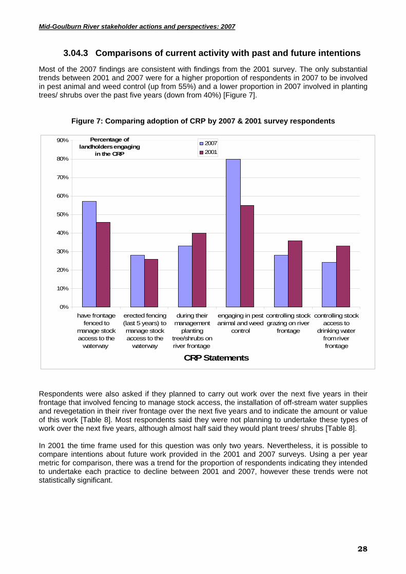
Mid-Goulburn River stakeholder actions and perspectives: 2007
3.04.3 Comparisons of current activity with past and future intentions
Most of the 2007 findings are consistent with findings from the 2001 survey. The only substantial trends between 2001 and 2007 were for a higher proportion of respondents in 2007 to be involved in pest animal and weed control (up from 55%) and a lower proportion in 2007 involved in planting trees/ shrubs over the past five years (down from 40%) [Figure 7].
Figure 7: Comparing adoption of CRP by 2007 & 2001 survey respondents
0%
10%
20%
30%
40%
50%
60%
70%
80%
90%
have frontagefenced to
manage stockaccess to the
waterway
erected fencing(last 5 years) tomanage stockaccess to the
waterway
during theirmanagement
plantingtree/shrubs onriver frontage
engaging in pestanimal and weed
control
controlling stockgrazing on river
frontage
controlling stockaccess to
drinking waterfrom riverfrontage
CRP Statements
Percentage of landholders engaging
in the CRP
20072001
Respondents were also asked if they planned to carry out work over the next five years in their frontage that involved fencing to manage stock access, the installation of off-stream water supplies and revegetation in their river frontage over the next five years and to indicate the amount or value of this work [Table 8]. Most respondents said they were not planning to undertake these types of work over the next five years, although almost half said they would plant trees/ shrubs [Table 8]. In 2001 the time frame used for this question was only two years. Nevertheless, it is possible to compare intentions about future work provided in the 2001 and 2007 surveys. Using a per year metric for comparison, there was a trend for the proportion of respondents indicating they intended to undertake each practice to decline between 2001 and 2007, however these trends were not statistically significant.
28

Mid-Goulburn River stakeholder actions and perspectives: 2007
Table 8 Work planned on river frontage next 5 years
Mid-Goulburn River Crown frontage licence landholder survey, 2007, N=94
Topics n Work planned on frontage next 5 years, % respondents
Yes Unsure No Amount (median)
Fencing to manage stock access to the waterway. (metres)
64 27% 0% 73% 429 metres
Install off-stream water supply in paddocks where stock currently drink from the waterway. ($ value)
66 20% 0% 80% $2000
Trees/shrubs to revegetate the frontage. (number) 63 46% 0% 48% 275
trees/shrubs
3.01.4 Extent current work is funded by government
Twenty-three per cent of respondents said they had received support from government programs or the CMA for work on their river frontage in the past five years compared to 30% of the 2001 survey respondents. The median value of support reported in 2007 was $150 compared to $2,200 reported in 2001. At the same time, there was a significant positive relationship between adoption of a number of CRP and involvement in government funded programs. 3.04.5 Confidence in CRP
3.04.5.1 Landholder confidence in CRP
Respondents were asked to respond to nine statements exploring their level of confidence in fencing river frontages, set stocking compared to intensive grazing and watering stock off-stream. Most statements had also been included in the 2001 survey. The exceptions were the addition of statements exploring concerns about the potential impact of fencing on the threat of fires and views about the impact of stock grazing on native vegetation, and the omission of a statement seeking views about importance of fencing as part of revegetation work. Information was gathered in two sections of the survey. In the first instance, the section was about the importance of possible constraints to the management of frontages. The second section was seeking respondent’s views about the management of water ways and adjoining land in their district. Six response options were provided in both sections. For the constraints section, the options ranged from ‘Not important’ to ‘Very important’ and included a ‘Not applicable’ choice. For the management issues section, the options ranged from ‘Strongly agree’ to ‘Strongly disagree’ and again, included ‘Not applicable’. Apart from the ‘Not applicable’ choice, these options were the same as in the 2001 survey. To simplify the presentation of data, the six response options have been collapsed into four. For the calculation of mean scores per item we have excluded the ‘Not applicable’ option. As in 2001, many respondents were concerned about the efficacy of fencing to manage stock access to river frontages and moving from set stocking to intensive grazing of frontages for short periods. About half of the respondents expressed important reservations about the efficacy of fencing because of concerns about making it difficult to water stock (63% ‘Very important/ important), establishing harbour for pests (60%), creating a fire hazard (49%), increasing management time (44%), reducing the area for grazing or cropping (43%) and floods damaging fences (43%) [Table 9]. Most respondents (56%) also said that grazing of domestic stock has had little impact on native vegetation on river frontages and a substantial minority (43%) said that set- stocking is usually better for retaining native vegetation in river frontage paddocks than intensive
29

Mid-Goulburn River stakeholder actions and perspectives: 2007
grazing for shorter periods. By comparison, there was a high level of confidence in the efficacy of watering stock off-stream in that most respondents (79%) thought that the time and expense of watering off-stream was justified by improvements in bank stability and water quality [Table 9]. As might be expected in a period of drought, there was less concern in 2007 about flood damage to fences (down from 52% to 43% ‘Very important/ important’) and heightened concern about fencing making it difficult to water stock (up from 46% to 63% ‘Very important/ important’). If we ignore these two items, there is a trend to lower levels of confidence in fencing as a CRP with heightened levels of concerns about fencing, including:
• making it difficult to water stock (46% to 63%); • creating harbour for pests (up from 51% to 60%); • increasing management time (39% to 44%); and • reducing the area for grazing and cropping (27% to 43%).
For two of these items, making it difficult to water stock and reducing the area for grazing and cropping, these trends were statistically significant. On a positive note, there were trends to higher levels of confidence in intensive grazing for shorter periods compared to set stocking (‘Strongly agree/ agree’ that set stocking is better down from 60% to 43%); and in the benefits of watering stock off-stream (up from 49% to 79%). In both cases, these trends were statistically significant.
Table 9
Confidence in current recommended practices (CRP) Mid-Goulburn River Crown frontage licence landholder survey, 2007, N=94
Statements N Important/
very important
Some Minimal/
Not important
N/A Mean score~
Fencing out river frontages will make it difficult to water stock 86 63% 14% 16% 7% 3.76
Fencing out river frontages will create harbour for pest animals 86 60% 16% 20% 3% 3.64
Fencing out river frontages will increase the likelihood of fires because of fuel building up
86 49% 20% 28% 3% 3.4
Fencing out river frontages will increase management time 84 44% 26% 24% 6% 3.29
Fencing out river frontages will reduce the area for grazing or cropping 86 43% 24% 28% 5% 3.11
Statements
N
Agree/ Strongly
agree Not sure
Disagree/ strongly disagree
N/A Mean score~
The time and expense involved in watering stock off-stream is justified by improvement in river water quality
90 79% 14% 7% 0% 3.96
Grazing of domestic stock has had little impact on the existence and diversity of native vegetation on river frontages
89 56% 16% 28% 0% 3.34
Set stocking is usually better for retaining native vegetation in paddocks with river frontages than intensive grazing for short periods
90 43% 32% 24% 0% 3.23
In most places, fencing river frontages is not practical because floods will damage fences
87 43% 16% 41% 0% 3.07
~ Score where 1 = Not important/ Strongly disagree through to 5 = Very important/ Strongly agree
30

Mid-Goulburn River stakeholder actions and perspectives: 2007
3.04.5.2 Stakeholder confidence in CRP
While some interviewees supported the GB CMA CRP for the Upper Goulburn River, others expressed strong disagreement – particularly with the removal of willows and fencing of riparian areas (see discussion below). Even when interviewees expressed agreement with the CRP, several disagreed with the approach employed by the CMA for implementation. In some cases it seems that the approach employed by the CMA undermined the agency-community relationship. One interviewee commented:
‘… willows need to come out in principle, but maybe the methods aren’t quite right … more ‘cut and paint’ (with herbicide) instead of ‘pull out’.
Removing willows
Willows were viewed by many interviewees as an effective strategy for erosion control on river banks. These stakeholders therefore feel that the GB CMA is not achieving much gain for considerable expenditure on willow removal. A related concern is that while native vegetation is getting established on control sites, the riparian areas are at risk of erosion during periods of high water flows or flood. Several landholders in our study were actively involved in planting willows during the 1950’s and 1960’s and are reluctant to ‘undo’ previous efforts. For these reasons, many interviewees expressed doubts that the removal of willows should be the highest priority for the CMA. Some interviewees suggested that willows could be retained in high-risk erosion areas (eg. outside bends of the River), and that the CMA should concentrate revegetation efforts with native species on low-risk areas (eg. inside bends and straight sections of the River). However, other interviewees reported that willows growing in the River and with over-hanging limbs created a safety issue for those accessing the River (eg. fishers) and water users (eg. boaters, swimmers). Fishers also expressed concerns that funds raised by the sale of Recreational Fishing Licences might be spent on implementing CRP with doubtful value (eg. removal of willows on all sections of the River) rather than on re-stocking fish. Fencing of riparian areas
Several interviewees who were landholders were concerned that fencing out frontages and establishing native vegetation on these areas made it difficult to control pest plants and animals and created an increased fire risk. In some cases there was the added difficulty that there was no longer easy access for landholders to manage these areas or for the public to use them for recreation. One interviewee commented:
‘… some revegetation is good, but not if it restricts access for fishing … I have big concerns about the loss of access (to the River)’
The risk of damage to fencing by floods was not raised as an important concern. Our interviewees suggested that the CMA should make provision for seasonal grazing of frontages and pay landholders for ongoing management of frontages when they had been fenced out. The package of support offered via the CMA’s ‘drought relief’ program was well supported by those interviewees aware of its availability. There appeared to be stronger support amongst our interviewees for fencing of riparian areas along the tributaries, than along the Goulburn River itself. Several interviewees stressed the importance of CMA staff negotiating the placement of fence lines with landholders so that the most appropriate and effective options were selected. Examples were given where changes in the river channel meant that fencing to the original Crown frontage meant that buffers established were difficult to manage because of narrow access lines.
31

Mid-Goulburn River stakeholder actions and perspectives: 2007
Implementing CRP
Several interviewees reported concerns about how the GB CMA implemented the ‘River Health’ program. A common concern was poor communication between staff, the works contractors and landholders (eg. period of notice too short before works commenced, little negotiation). Some of the comments made by interviewees included:
‘… there were few public meetings explaining the program … I don’t know why they don’t just talk to landholders … I know the (CMA) employees but I don’t have a lot to do with them’,
‘… farmers are more practical, the CMA seems to be ideologically driven’., Recognition of the GB CMA and its programs was strong amongst those actively engaged in the GB CMA communication network. Outside the GB CMA’s network, there was much less awareness of the CMA, its priorities or programs. At a broader level, there was concern by those in community-based advisory groups that community input was being sidelined (i.e. viewed as less important within the CMA). While CMA staff reported an active Landcare network in the district, other interviewees said there was wide variation in the level of activity between the landcare groups in the district. There was strong agreement amongst interviewees that the level of activity of Landcare groups was highly dependent upon having group coordinators. The Landcare network remains an important mechanism for the CMA to engage landholders and leverage up from its investment in work to improve river health. Feedback from interviewees suggests that GB CMA staff need to be more aware of the experience and knowledge of landholders and others stakeholders and to view this expertise as a valuable resource. Building stronger partnerships with landholders and other stakeholders will also enable the CMA to move beyond what seems to be incremental adoption of CRP and build long-term commitment amongst stakeholders to active management of frontage areas. However, while some interviewees were critical of the CMA’s approach, other landholders who had pump sites on the River spoke very positively about the assistance they had received from the CMA to stabilise those sites, illustrated by the comment:
‘… the CMA has an on-ground focus so the community has embraced them ... has a record of achievement’.
3.05 Landholder constraints to better management of river frontages Survey respondents were asked to indicate their views about the importance of 16 possible constraints to the management of water ways and adjoining land in their district. Four items were included in the 2007 survey in addition to all items from this section in the 2001 survey (asterixis in Table 10). Items exploring views about the efficacy of fencing and the clarity of responsibilities for managing frontages have also been discussed in earlier sections of this report. These items have been included here to provide a comparison of the relative importance of each constraint. Six response options were provided, ranging from ‘Very important’ to ‘Not important’, including ‘Not applicable’. Again these options were collapsed to present data in Table 10 and mean scores were calculated without the ‘Not applicable’ option.
32
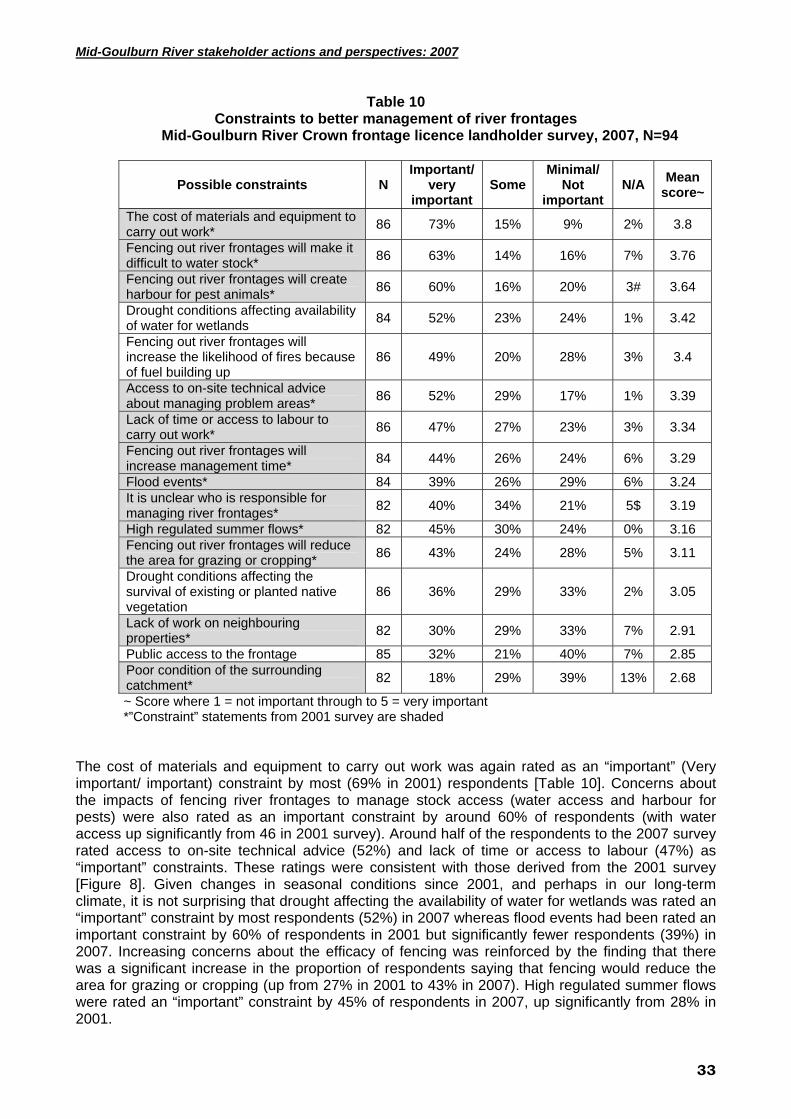
Mid-Goulburn River stakeholder actions and perspectives: 2007
Table 10 Constraints to better management of river frontages
Mid-Goulburn River Crown frontage licence landholder survey, 2007, N=94
Possible constraints N Important/
very important
SomeMinimal/
Not important
N/A Mean score~
The cost of materials and equipment to carry out work* 86 73% 15% 9% 2% 3.8
Fencing out river frontages will make it difficult to water stock* 86 63% 14% 16% 7% 3.76
Fencing out river frontages will create harbour for pest animals* 86 60% 16% 20% 3# 3.64
Drought conditions affecting availability of water for wetlands 84 52% 23% 24% 1% 3.42
Fencing out river frontages will increase the likelihood of fires because of fuel building up
86 49% 20% 28% 3% 3.4
Access to on-site technical advice about managing problem areas* 86 52% 29% 17% 1% 3.39
Lack of time or access to labour to carry out work* 86 47% 27% 23% 3% 3.34
Fencing out river frontages will increase management time* 84 44% 26% 24% 6% 3.29
Flood events* 84 39% 26% 29% 6% 3.24 It is unclear who is responsible for managing river frontages* 82 40% 34% 21% 5$ 3.19
High regulated summer flows* 82 45% 30% 24% 0% 3.16 Fencing out river frontages will reduce the area for grazing or cropping* 86 43% 24% 28% 5% 3.11
Drought conditions affecting the survival of existing or planted native vegetation
86 36% 29% 33% 2% 3.05
Lack of work on neighbouring properties* 82 30% 29% 33% 7% 2.91
Public access to the frontage 85 32% 21% 40% 7% 2.85 Poor condition of the surrounding catchment* 82 18% 29% 39% 13% 2.68
~ Score where 1 = not important through to 5 = very important *”Constraint” statements from 2001 survey are shaded
The cost of materials and equipment to carry out work was again rated as an “important” (Very important/ important) constraint by most (69% in 2001) respondents [Table 10]. Concerns about the impacts of fencing river frontages to manage stock access (water access and harbour for pests) were also rated as an important constraint by around 60% of respondents (with water access up significantly from 46 in 2001 survey). Around half of the respondents to the 2007 survey rated access to on-site technical advice (52%) and lack of time or access to labour (47%) as “important” constraints. These ratings were consistent with those derived from the 2001 survey [Figure 8]. Given changes in seasonal conditions since 2001, and perhaps in our long-term climate, it is not surprising that drought affecting the availability of water for wetlands was rated an “important” constraint by most respondents (52%) in 2007 whereas flood events had been rated an important constraint by 60% of respondents in 2001 but significantly fewer respondents (39%) in 2007. Increasing concerns about the efficacy of fencing was reinforced by the finding that there was a significant increase in the proportion of respondents saying that fencing would reduce the area for grazing or cropping (up from 27% in 2001 to 43% in 2007). High regulated summer flows were rated an “important” constraint by 45% of respondents in 2007, up significantly from 28% in 2001.
33
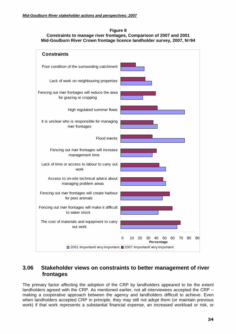
Mid-Goulburn River stakeholder actions and perspectives: 2007
Figure 8 Constraints to manage river frontages, Comparison of 2007 and 2001
Mid-Goulburn River Crown frontage licence landholder survey, 2007, N=94
0 10 20 30 40 50 60 70 80 90
The cost of materials and equipment to carryout work
Fencing out river frontages will make it difficultto water stock
Fencing out river frontages will create harbourfor pest animals
Access to on-site technical advice aboutmanaging problem areas
Lack of time or access to labour to carry outwork
Fencing out river frontages will increasemanagement time
Flood events
It is unclear who is responsible for managingriver frontages
High regulated summer flows
Fencing out river frontages will reduce the areafor grazing or cropping
Lack of work on neighbouring properties
Poor condition of the surrounding catchment
Constraints
Percentage2001 Important/ very important 2007 Important/ very important
3.06 Stakeholder views on constraints to better management of river
frontages The primary factor affecting the adoption of the CRP by landholders appeared to be the extent landholders agreed with the CRP. As mentioned earlier, not all interviewees accepted the CRP – making a cooperative approach between the agency and landholders difficult to achieve. Even when landholders accepted CRP in principle, they may still not adopt them (or maintain previous work) if that work represents a substantial financial expense, an increased workload or risk, or
34
Mid-Goulburn River stakeholder actions and perspectives: 2007
leads to reduced access to the River. This information is consistent with our findings from the analysis of 2007 survey data.
Many interviewees also felt their families had been good long-term custodians of their Crown frontages. For some of these landholders, fencing the Crown frontage represented a substantial change, in some cases, involving a strong sense of a lost entitlement that in turn, reduced the level of their commitment to good stewardship of their river frontage (eg. for pest plant and animal control).
3.07 Long-term plans for their property In earlier research in the GB CMA (Curtis et al. 2000) and other Victorian regions, including recently in Corangamite (Curtis et al. 2006), the authors have used landholder survey data to explore long-term plans and model predicted property turnover (Mendham and Curtis 2007). Some of the key findings from these data have been that about half of all rural properties will change ownership in the next decade; many landholders are looking to sell all or a part of their property; increasing proportions of new land owners have previously lived outside the district where their new property is located; and increasing proportions of new landowners are absentees and non-farmers by occupation. It is also clear that these trends have an important impact on the adoption of CRP, in that new residents, non-farmers and absentee owners are less likely to adopt many CRP. The 2007 survey included a section asking respondents to indicate whether their long term plans included disposal or acquisition of land through family succession, sale/ purchase, leasing or share farming; if their enterprise mix would change; and if they would change the extent of off-property work [Table 11 and Figure 9]. Respondents were asked to indicate the likelihood that they would take up each of the long-term choices offered in the survey in both five years and 20 years time. Again, there were six response options, ranging from ‘Highly likely’ to ‘Highly unlikely’, and including ‘Not applicable’. To present these data we have collapsed the six categories into four [Table 11 and Figure 9]. Mean scores have been calculated without including the ‘Not applicable’ option.
35

Mid-Goulburn River stakeholder actions and perspectives: 2007
Table 11 5 and 20 year Plans for Mid-Goulburn Landholders Properties
Mid-Goulburn River Crown frontage licence landholder survey, 2007, N=94
Long term plans N
Highly likely\ likely
Unsure Highly
unlikely/ unlikely
N/A mean
The property will be sold (within the next 5 years)* 74 14% 8% 73% 5% 1.79
within 20 years 84 27% 24% 42% 7% 2.76 The property will be subdivided and part of the property will be sold* 71 4% 4% 72% 20% 1.4
within 20 years 83 10% 16% 57% 18% 1.9 Ownership of the property will stay within the family* 73 84% 3% 10% 4% 4.37
within 20 years 81 63% 17% 16% 4% 3.73 I will live on the property for as long as possible* 73 70% 8% 5% 16% 4.36
within 20 years 79 61% 11% 13% 15% 3.94 All or most of the property will be leased or share-farmed* 71 10% 8% 61% 21% 1.77
within 20 years 81 12% 12% 54% 21% 1.97 Additional land will be purchased, leased or share-farmed* 72 10% 11% 64% 15% 1.8
within 20 years 82 12% 13% 60% 15% 1.97 The enterprise mix will be changed to reduce my farm workload* 73 14% 12% 58% 16% 2.11
within 20 years 81 17% 20% 48% 15% 2.35 The enterprise mix will be changed to more intensive enterprises* 73 8% 15% 60% 16% 1.89
within 20 years 80 9% 19% 58% 15% 2.01 I will seek additional off-property work* 73 14% 1% 56% 29% 1.96
within 20 years 78 9% 4% 60% 27% 1.7 I will reduce the extent of my off-property work* 74 22% 4% 27% 47% 2.69
within 20 years 79 28% 5% 22% 46% 3.23 All or some part of the property will be placed under a conservation covenant* 75 8% 11% 69% 12% 1.73
within 20 years 80 10% 20% 61% 9% 1.99 ~ Score where 1 = Highly unlikely through to 5 = Highly likely * are statements of landholders intentions within the next 5 years, nonshaded are intentions within 20 years The median age of survey respondents is 63 years, well above the median age of farmers in Australia (51 years in 2001) (Australian Bureau of Statistics 2003). This is surprising given that only 12.5% of farmers continue working on-property past the official Australian retirement age for men of 65 years (Australian Bureau of Statistics 2007). At least part of the explanation for very high median age of survey respondents is that most respondents are not farmers by occupation (37% farmers), with 26% identifying themselves as retirees. On this variable alone, it seems that the cohort of river frontage owners in the Mid-Goulburn is very different from most farmers in Australia. Despite their high median age, 61% of respondents indicated it was “likely” they would live on their property for as long as possible over the next 20 years [Table 11 and Figure 9]. These data reinforce the high level of personal commitment to their property that most respondents expressed in the values section of the survey. Notwithstanding this high level of desire to live on the property long-term, the reality of life expectancy for older males is such that the level of property sales (27% “likely” over next 20 years) will increase beyond that nominated by respondents.
36

Mid-Goulburn River stakeholder actions and perspectives: 2007
Most respondents (61% next 20 years) also said that it was “likely” that ownership of the property would stay within the family [Table 11 and Figure 9]. Given that almost half the respondents (47%) have not started a succession plan and the general pattern for children not to take on family farms, it seems that this high level of intended family succession is unlikely to be realised. Given the age, occupational status and extent of absentee ownership it is not surprising that over the next 20 years very few respondents were “Likely” to seek additional off-farm work (9%), change to a more intensive land use (9%) or purchase, lease or share-farm additional land (12%). There was also very limited interest in subdividing and selling part of the property (10%) over the next 20 years [Table 11 and Figure 9]. These findings suggest that there will be less development pressure on river frontage land in this section of the Goulburn than might be expected for an area with high amenity values and within easy reach of Melbourne. Of course, this might change if new owners are very different from the existing cohort of river frontage owners in the Mid-Goulburn. As might be expected, there were significant differences in the ratings given to a number of topics depending on the time horizon. Respondents were significantly more “likely” to expect to sell, subdivide and sell, change the enterprise mix to reduce their workload, reduce the extent of off-property work and place the property under a conservation covenant in 20 years compared to a five year horizon. On the other hand, they were significantly less “likely” to expect the property would stay in the family or that they would continue to live on the property.
37

Mid-Goulburn River stakeholder actions and perspectives: 2007
Figure 9 Long-term Plans for your property within the next 20 years
Mid-Goulburn River Crown frontage licence landholder survey, 2007, N=94
0% 10% 20% 30% 40% 50% 60% 70% 80% 90% 100%
The enterprise mix will be changed to moreintensive enterprises
I will seek additional off-property work
All or some part of the property will be placed undera conservation covenant
The property will be subdivided and part of theproperty will be sold
Additional land will be purchased, leased or share-farmed
All or most of the property will be leased or share-farmed
The enterprise mix will be changed to reduce myfarm workload
The property will be sold
I will reduce the extent of my off-property work
I will live on the property for as long as possible
Ownership of the property will stay within the family
Intentions
PercentageLikely Unsure Not likely N/A
L
38
Mid-Goulburn River stakeholder actions and perspectives: 2007
3.08 Operating context for ‘River Health’ project
While the interviews and workshops focused on the GB CMA’s River Health program, the nature of in-depth semi-structured discussions allows the broader context of people’s experiences, views and concerns to emerge – giving a picture of the socio-political context or the operating environment for the River Health program. North-south pipeline
A highly contentious topic for almost all interviewees and workshop participants was the State government’s decision to construct a pipeline to supply water to the Melbourne catchment from the Goulburn River (known locally as the ‘North-South pipeline’). There is strong opposition to the transfer of water out of the catchment, particularly during periods of water shortage (drought). Increasing sub-division of rural properties
Most interviewees were also concerned about the scale of property subdivision and the impacts of new residents on the environment, with the scale of change illustrated by one landholder’s comment:
‘… we could only see two houses around here in the 1950’s, now you can see about 20 houses’.
Many interviewees thought an increasing population would lead to more water extracted from the Goulburn River and tributaries, and from groundwater, thereby depleting limited supplies even further. Interviewees were uncertain about the extent new residents would participate in NRM activities. Climate change
Many of the landholders interviewed generally accepted that climate change is occurring, although several interviewees preferred to use the term ‘climate variability’. Most landholders reported they had already made adjustments in their family businesses and were weighing up future decisions – whether to cope with the current drought or to adapt to the long-term changes to the district’s climate. Some interviewees were sceptical about the reality of climate change and preferred to view the current climate as part of the natural variation in climate.
39

Mid-Goulburn River stakeholder actions and perspectives: 2007
4.0 Conclusion This research indicates that the Goulburn River is central to the lives of many people, an important focus for many interest groups and a critical resource for industries within the region – in many respects it is an iconic river. Most people who contributed to this research valued the River highly, and the survey respondents provided high ratings for a mix of environmental, economic and social values. At the same time, it is important to acknowledge that there are competing as well as complementary interests at stake. It is therefore problematic to attempt to describe a cohesive ‘community vision’ for the mid-Goulburn River beyond a description of those values attached to the river. A key finding from our analysis of the 2001 and 2007 survey data is that adoption of current recommended practices (CRP), such as fencing to control livestock access and revegetation with native species are at low levels. For example, 2007 survey suggests that just 15% of the Crown frontage of the mid-Goulburn River has been fenced to control livestock access. Indeed, there is evidence of very limited adoption of CRP outside government programs. It seems unlikely that there will be improvements in resource condition without changes in the level of GB CMA investment. Survey findings and the stakeholder and focus group interviews provide important insights into the reasons for high levels of non-adoption and into ways to improve adoption. In the first instance it is important to highlight the finding that most survey respondents and interviewees believe the River is in good health and that there have been improvements in River health over the past ten years. Efforts to engage landholders in CRP need to acknowledge this perception and the contribution of landholders to that success story. Survey findings about the values landholders attach to their river frontages provides information that could underpin development of effective appeals to landholders to engage in riparian management This research also established that most landholders are concerned about the efficacy of riparian CRP, including fencing and willow removal. In part this lack of confidence reflects knowledge gaps (about the role of willows for example), but also the reality that some CRP, especially fencing, do create management issues for landholders. It is therefore critical that management agencies are able to build strong partnerships with landholders and are able to support landholders as they work through those issues. In the mid-Goulburn it seems that the partnership with some landholders has been affected by the way CRP have been implemented by CMA staff. These concerns run the gamut from negotiating work to be undertaken to making sure that follow-up work occurs. Some landholders seem to be unaware of the support available to them to address some of their concerns about fencing river frontages, including subsidies available for provision of off-stream watering. The GB CMA is committed to building effective partnerships required if landholders are to adopt improved management of frontages or exhibit a long-term commitment to maintaining work funded by the GB CMA. The GB CMA – landholder relationship is therefore critical to achievement of improved riparian and river management outcomes. This research suggests that a substantial number of mid-Goulburn landholders don’t have a positive view of the GB CMA river management program and that their perception of the CMA affects their approach to the management of their frontages. Our view is that the GB CMA should invest in efforts to build stronger relationships with landholders with whom it needs to work. As a first step, there should be training/ re-training of staff in effective approaches to extension. Survey data indicate that landholders with Crown frontage in the mid-Goulburn River differ in their demographic characteristics to the wider population of landholders in the Goulburn Broken catchment, including in terms of their older age, most were not farmers by occupations and almost half were absentee owners. Again, these findings have important implications for the way agencies should attempt to engage the diversity of landholders in river frontage management.
40
Mid-Goulburn River stakeholder actions and perspectives: 2007
5.0 REFERENCES Australian Bureau of Statistics. 2001. 2001 Census Data by Location (local government area).
Commonwealth of Australia, 18 July 2007 [cited 18th July 2007]. Available from http://www.censusdata.abs.gov.au.
Australian Bureau of Statistics. 2007. 2006 Census Community Profile Series: Australia. Australian Bureau of Statistics, 14 November 2007 [cited 13 December]. Available from http://www.censusdata.abs.gov.au
Australian Soil Conservation Council (1991). Decade of Landcare plan. ASCC. Canberra, ACT. Barr, N. and Cary, J. (2000). Influencing improved natural resource management on farms. Bureau
of Rural Sciences, Canberra, ACT. Barr, N., Ridges, S., Anderson, N., Gray, I., Crockett, J., Watson, B., and Hall, N. (2000).`
Adjustment for catchment management. Murray-Darling Basin Commission, Canberra, ACT.
Boulton, A. J. (1999). An overview of river health assessment: philosophies, practices, problems and prognosis. Freshwater Biology 41: 469-479.
Braithwaite, V. A. and Scott, W. A. (1991). Values. In J. P. Robinson, P. R. Shaver & L. S. Wrightsman (Eds.), Measures of Personality and Social Psychological Attitudes. New York: Academic Press.
Curtis, A. (2000). Landcare: approaching the limits of volunteer action. Australian Journal of Environmental Management. 7 (1): 19-27.
Curtis, A. and De Lacy, T. (1996). Landcare in Australia: does it make a difference. Journal of Environmental Management. 46: 119-137.
Curtis, A. and Race, D. (1996). Review of socio-economic factors affecting regional farm forestry development in Australia. The Johnstone Centre, Charles Sturt University, Albury, NSW.
Curtis, A. and De Lacy, T. (1998). Landcare, stewardship and sustainable agriculture in Australia. Environmental Values. 7: 59-78.
Curtis, A. and Lockwood, M. (2000). Landcare and catchment management in Australia: lessons for state-sponsored community participation. Society and Natural Resources. 13: 61-73.
Curtis, A., Lockwood, M., and MacKay, J. (2001). Exploring landholder willingness and capacity to manage dryland salinity in the Goulburn Broken Catchment. Australian Journal of Environmental Management. 8: 20-31.
Curtis, A., and Robertson, A. (2003) Understanding landholder management of river frontages: the Goulburn Broken. Ecological Management and Restoration 4(1):45-54.De Vaus, D. A. (1991). Surveys in social research. Allen and Unwin, Sydney, NSW.
Curtis, A., and Robertson, A. (2003b) Who are program managers working with and does it matter? The experience with river frontage management in the Goulburn Broken. Natural Resource Management, 6(2): 25-32.
Dillman, D.A. (1979). Mail and telephone surveys: the total design method. Wiley, New York, USA. Dunlap, R. E., and Van Liere, K. (1978). The new environmental paradigm. The Journal of
Environmental Education. 9: 10-19. Elix, J. and Lambert, J. (2000). Missed opportunities: harnessing the potential of women in
agriculture. In Proceedings of the International Landcare Conference, March 2-5, 2000. Department of Conservation and Natural Resources, Melbourne, Victoria.
Guerin, T. (1999). An Australian perspective on the constraints to the transfer and adoption of innovations in land management. Environmental Conservation. 26:4, 289-304.
Goulburn Broken Catchment Management Authority. (2001). Regional waterway management strategy: Goulburn Broken interim draft 2001. GB CMA, Shepparton, Victoria.
Haberkorn, G., Hugo, G., Fisher, M. and Aylward, R. (1999). Country matters: a social atlas of rural and regional Australia. Report by the Bureau of Rural Sciences, Canberra, ACT.
Harrington, C., Curtis, A., and Black, R. (In Press) Locating communities in natural resource management. Journal of Environmental Policy and Planning.
Ian Drummond and Associates Pty Ltd. (1997). Mid Goulburn and Broken River, riverine implementation plan. Broken River Management Board. ID&A, Benalla, Victoria.
41

Mid-Goulburn River stakeholder actions and perspectives: 2007
Jansen, A., and Robertson, A. I. (2001) Relationships between livestock management and the ecological condition of riparian habitats along an Australian floodplain river. Journal of Applied Ecology. 38: 63-75.
Ladson, A. R., White, L. J., Doolan, J. A., Finlayson, B. C., Hart, B. T., Lake, S. and Tilleard, J. W. (1999). Development and testing of an index of stream condition for waterway management in Australia. Freshwater Biology. 41: 453-468.
Lockwood, M. (1999). Humans valuing nature: synthesising insights from philosophy, psychology and economics. Environmental Values, 8, 381-401.Murray-Darling Basin Commission. (1990). Natural Resources Management Strategy. MDBC, Canberra, ACT.
Naiman, R. J., and Decamps, H. (1997). The ecology of interfaces: riparian zones. Annual Review of Ecology and Systematics. 28, 621-658.
Pannell, D.J., Marshall, G.R., Barr, N., Curtis, A., Vanclay, F., and Wilkinson, R. (2006) Understanding and promoting adoption of conservation technologies by rural landholders. Australasian Journal of Experimental Agriculture. 46 (11): 1407-1424.
Rendell, R., O’Callagan, P. and Clark, N. (1996). Families, farming & the future. A report to Agriculture Victoria, Bendigo, Victoria.
Robertson, A. I. (2000). The gaps between ecosystem ecology and industrial agriculture. Ecosystems. 3: 413-418.
Robertson, A. I., and Rowling, R. W. (2000). Effects of livestock on riparian zone vegetation in an Australian dryland river. Regulated Rivers: Research and Management. 16: 527-541.
Robertson, A. I., Lee Long, W. J., Coles, R. G., Pearson, R. G., and Hegerl, E. J. (1996). Impacts of land and water use practices on riparian areas, wetlands, estuaries and coastal seagrasses. In, Hunter, H. M. and Rayment, G. E. (eds) Downstream effects of land use. pp. 45-47. Department of Natural Resources, Brisbane, Queensland.
Shindler, B., and Wright, A. (2000). Watershed management in the central cascades: a study of citizen knowledge and the value of information sources. USDA Forest Service Research Report, Pacific Northwest Research Station, Corvallis, Oregon, USA.
Spencer, C., Robertson, A. I., and Curtis, A. (1998). Development and testing of a rapid appraisal wetland condition index in south-eastern Australia. Journal of Environmental Management. 54: 143-159.
Steel, B. S., List, P., and Shindler, B. (1994). Conflicting values about federal forests: a comparison of national and Oregon publics. Society and Natural Resources. 7: 137-153.
Steel, B. S., Lach, D., List, P., and Shindler, B. (2001). The role of scientists in the natural resource and environmental policy process. Journal of Environmental Systems. (In Press).
Stirzacker, R., Lefroy, T., Keating, B. and Williams, J. (2000). A revolution in land use: emerging land use systems for managing dryland salinity. CSIRO Land and Water, Canberra, ACT.
Vanclay, F. (1992). The social context of farmers’ adoption of environmentally-sound farming practices. In Lawrence, G., Vanclay, F. and Furze, B. (eds) Agriculture, environment and society. pp. 94-121. Macmillan, Melbourne, Victoria.
Van Liere, K., and Dunlap, R. (1981). Environmental concern: Does it make a difference, how is it measured? Environment and Behaviour. 13: 651-684.
Walker, G., Gilfedder, M., and Williams, J. (1999). Effectiveness of current farming systems in the control of dryland salinity. CSIRO Division of Land and Water, Canberra, ACT.
Wilson, A., Jansen, A., Curtis, A., and Robertson, A. (2006) Measuring riparian condition: a comparison of assessments by landholders and scientists. Ecological Management and Restoration 7 (2):123-129.
42
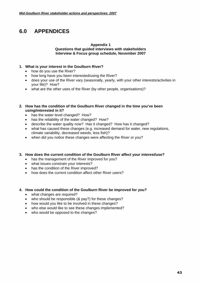
Mid-Goulburn River stakeholder actions and perspectives: 2007
6.0 APPENDICES
Appendix 1
Questions that guided interviews with stakeholders Interview & Focus group schedule, November 2007
1. What is your interest in the Goulburn River?
• how do you use the River? • how long have you been interested/using the River? • does your use of the River vary (seasonally, yearly, with your other interests/activities in
your life)? How? • what are the other uses of the River (by other people, organisations)?
2. How has the condition of the Goulburn River changed in the time you’ve been
using/interested in it? • has the water level changed? How? • has the reliability of the water changed? How? • describe the water quality now? Has it changed? How has it changed? • what has caused these changes (e.g. increased demand for water, new regulations,
climate variability, decreased weeds, less fish)? • when did you notice these changes were affecting the River or you?
3. How does the current condition of the Goulburn River affect your interest/use?
• has the management of the River improved for you? • what issues constrain your interests? • has the condition of the River improved? • how does the current condition affect other River users?
4. How could the condition of the Goulburn River be improved for you?
• what changes are required? • who should be responsible (& pay?) for these changes? • how would you like to be involved in these changes? • who else would like to see these changes implemented? • who would be opposed to the changes?
43

Mid-Goulburn River stakeholder actions and perspectives: 2007
44
Appendix 2 Significant Variables and their relationship to landholder adoption of CRP Mid-Goulburn River Crown frontage licence landholder survey, 2007, N=94
Question asked that related
to Current Recommended Practices ->
Variable Question/Statement
Distance along the river where the frontage is fenced and this allows you to manage stock access to the water way?
Length of fencing erected near the river since the start
of 2003 (5 years) to manage stock
access to the water way?
Number of trees/shrubs planted
during your management of the property along the
river frontage (within 40m of each bank)?
Number of trees/shrubs planted
since the start of 2003 (5 years) along
the river frontage (within 40m of each
bank)?
Estimated cost of pest animal and
weed control carried out in
your river frontage during 2006 and 2007?
During 2007, did stock
graze any part of your river frontage for more than a
week at a time?
During 2007, did stock access
drinking water from any part of
your river frontage for more than a
week at a time? What is the area of your property?
POS POS POS NEG POS
Provides a place for recreation for me, my family and friends
NEG
Since the start of 2003 (past 5
years), did Federal or State government programs or the
Catchment Management Authority support work on your river frontage?
POS POS POS POS
How to interpret results from water
quality testing POS POS The condition of the Goulburn River in this district has improved in the
last 10 years NEG
Improve the number and diversity of
fish species. For example, by stimulating breeding cycles in fish
NEG
Improve the health of floodplain vegetation. For example, by topping up a flood event to water remnant
red gums
NEG NEG
Are there many snags in the river
channel? NEG What proportion of tree cover along
the bank is native? NEG

Mid-Goulburn River stakeholder actions and perspectives: 2007
Distance along the river where the frontage is fenced and this allows you to manage stock access to the water way?
Length of fencing erected near the river since the start
of 2003 (5 years) to manage stock
access to the water way?
Number of trees/shrubs planted
during your management of the property along the
river frontage (within 40m of each bank)?
Number of trees/shrubs planted
since the start of 2003 (5 years) along
the river frontage (within 40m of each
bank)?
Estimated cost of pest animal and
weed control carried out in
your river frontage during 2006 and 2007?
During 2007, did stock
graze any part of your river frontage for more than a
week at a time?
During 2007, did stock access
drinking water from any part of
your river frontage for more than a
week at a time? Fencing out river frontages will reduce the area for grazing or
cropping NEG POS POS
Drought conditions affecting the survival of existing or planted native
vegetation NEG NEG
Fencing out river frontages will make it difficult to water stock
NEG NEG POS POS
How to manage ground cover on paddocks used for grazing to
minimise soil erosion POS
The effects of unrestricted stock
access to water ways
POS
The production benefits of retaining native vegetation on farms POS
How to prepare a farm or property plan that allocates land use according
to different land classes POS
How to access information about
government support for landholders to better manage Crown Land river
frontages
POS
The importance of changes in the
volume of water flows in the Goulburn River for maintaining a
healthy river system
POS
Estimate the number of days you were involved in paid off-property
work in the past 12 months? POS
45

Mid-Goulburn River stakeholder actions and perspectives: 2007
Distance along the river where the frontage is fenced and this allows you to manage stock access to the water way?
Length of fencing erected near the river since the start
of 2003 (5 years) to manage stock
access to the water way?
Number of trees/shrubs planted
during your management of the property along the
river frontage (within 40m of each bank)?
Number of trees/shrubs planted
since the start of 2003 (5 years) along
the river frontage (within 40m of each
bank)?
Estimated cost of pest animal and
weed control carried out in
your river frontage during 2006 and 2007?
During 2007, did stock
graze any part of your river frontage for more than a
week at a time?
During 2007, did stock access
drinking water from any part of
your river frontage for more than a
week at a time? Have you prepared a property plan that involved a map and/or other documents that addressed the
existing farm situation and included future management and development
plans?
POS POS
Estimate the average number of
hours per week that you worked on farming/property related activities
over the past 12 months?
POS
How long have you lived in your local
district? POS POS
A place for me, my family and friends to fish NEG
The time and expense involved in watering stock off-stream is
justified by improvement in river water quality
NEG
How wide is the area where there
are no gaps in the tree canopy? POS Are you male or female?
POS Provides additional land for grazing
stock, particularly in summer POS POS
Provides access to water for stock POS
New owners should abide by agreements entered into by previous owners where public funds have paid for land protection or conservation
work
NEG NEG
46

Mid-Goulburn River stakeholder actions and perspectives: 2007
Distance along the river where the frontage is fenced and this allows you to manage stock access to the water way?
Length of fencing erected near the river since the start
of 2003 (5 years) to manage stock
access to the water way?
Number of trees/shrubs planted
during your management of the property along the
river frontage (within 40m of each bank)?
Number of trees/shrubs planted
since the start of 2003 (5 years) along
the river frontage (within 40m of each
bank)?
Estimated cost of pest animal and
weed control carried out in
your river frontage during 2006 and 2007?
During 2007, did stock
graze any part of your river frontage for more than a
week at a time?
During 2007, did stock access
drinking water from any part of
your river frontage for more than a
week at a time? Landholders should be paid for
providing environmental services that benefit the wider community (e.g. managing habitat for native
animals)
NEG NEG Is the bed filling with sand?
NEG The contribution of floodplain
wetlands towards the health of the Goulburn River
NEG
In most places, fencing river frontages is not practical because
floods will damage fences
POS In most cases, the public should have
the right of access to river frontages that are managed by
private landholders
POS Removing willows is an important part of work to improve the condition of native vegetation on river frontages
POS
Fencing out river frontages will create harbour for pest animals POS
Note: Appendix 2 provides a summary of statistically significant relationships between variables thought to influence (independent variables) the implementation of current recommended practices (CRP) for improved river frontage management. These relationships can be positive (POS) or negative (NEG). For a positive relationship, an increase in one variable is associated with an increase in another. For a negative relationship, an increase in one is associated with a decrease in the other. Tests for significant relationships were undertaken using two approaches: pairwise analyses testing for relationships between a CRP and a single independent variable; and multivariate analyses (highlighted) to find the group of significant variables that were most strongly related to the CRP.
47

Mid-Goulburn River stakeholder actions and perspectives: 2007
48
Appendix 3 Age of respondents
Mid-Goulburn River Crown frontage licence landholder survey, 2007, N=94
% of respondents in each age category n <40 40-55 56-65 >65
Median age
2001 Random sample N=93 87 8% 40% 29% 23% 56
2007 survey N=94 89 3% 21% 31% 44% 63
Age Profile of Mid-Goulburn River Frontage Licence Landholders 2007
3%
21%31%
44%
<40 years 40-55 years 56-65 years >65 years
Age Profile of a Random Sample of Landholders with Goulburn River Frontage 2001
8%
40%
29%
23%
<40 years 40-55 years 56-65 years >65 years

Mid-Goulburn River stakeholder actions and perspectives: 2007
Appendix 4 Occupation of respondents
Mid-Goulburn River Crown frontage licence landholder survey, 2007, N=94
2001 Random sample N=93
2007 Survey participants
N=90 Occupation
% respondents Farmer 37% 37%
Professional 30% 26% Retired 20% 26% Trades 10% 11% Other 5% 1%
Occupation of Mid-Goulburn River Frontage Licence Landholders 2007
Trades, 11%
Professional, 26%
Farmer, 37%
Retired, 26% other, 1%
49

Mid-Goulburn River stakeholder actions and perspectives: 2007
Appendix 5 Comparison of age and occupation of respondents
Mid-Goulburn River Crown frontage licence landholder survey, 2007, N=94
Age Profile of Mid-Goulburn River Frontage Licence Landholders 2007
3%
21%31%
44%
<40 years 40-55 years 56-65 years >65 years
Occupation of Mid-Goulburn River Frontage Licence Landholders 2007
Trades, 11%
Professional, 26%
Farmer, 37%
Retired, 26% other, 1%
Appendix 6
Property size Mid-Goulburn River Crown frontage licence landholder survey, 2007, N=94
Property size by hectares, % of respondents in each category
n <10
10-50 51-100
101-150
151-200
201-250
251-300
>300 Median ha
Random sample N=93
93 34% 23% 8% 7% 11% 1% 1% 16% 36ha
2007 survey N=87
87 3% 38% 26% 8% 1% 5% 0% 18% 60ha
50

Mid-Goulburn River stakeholder actions and perspectives: 2007
51
Appendix 7 Self assessment sheet included in the mail survey
Mid-Goulburn River Crown frontage licence landholder survey, 2001
Assessing the condition of a section of your frontage
TOPICS DESCRIPTION OF CONDITION [Circle your choice]
Is there evidence of bank erosion?
Bank is stable
Limited erosion
Moderate erosion
Large areas of erosion
Most areas unstable
Is the bed filling with sand?
No sand build up
Limited build up
Moderate build up
Large areas sand build up
Sand build up most areas
Are there many snags in the river/creek channel?
Plenty of snags or timber from native trees
Many snags pr timber from native trees
Moderate snags or timber
Hardly any snags or timber
No snags or timber visible
Are there gaps in the tree canopy (sky blocked out) along the bank?
No gaps in tree canopy along bank
The odd gap in tree canopy
Full canopy cover along about half the bank
Few areas have full canopy
Few trees present along bank
How wide is the area where there are no gaps in the tree canopy?
Full canopy at least 40m wide along all parts
Full canopy 40m wide most parts
About half has canopy cover 40m wide
Small areas full canopy 40m wide
No areas full canopy at least 40m wide
What proportion of tree cover along the bank is native?
All/almost is native
More than half native
About half is native
Over half introduced
All/almost introduced
What proportion of ground cover along bank is weeds or introduced pasture?
All/almost ground cover is native
More than half native
About half is native
Over half introduced
All/almost ground cover is introduced
What proportion of ground along the bank is covered by leaves and sticks?
All/almost has leaves and sticks on ground
More than half the area
About half the area
Less than half
Few areas have leaves or sticks on ground