management of aquatic ecosystems through community husbandry
TRANSCRIPT

Management of Aquatic Ecosystems through Community Husbandry
FEASIBILITY REPORT ON
MACH OUTREACH PROGRAM (June, 2004)
Conducted by
Center for Natural Resource Studies House -14, Road 13/c
Block-E, Banani, Dhaka-1213

Table of Contents 1 Introduction ............................................................................................................................ 1 1.1 Background ............................................................................................................................. 1 1.2 Broad outputs .......................................................................................................................... 1 1.3 ToR for Outreach Program .................................................................................................... 1 1.4 Detailed outputs ..................................................................................................................... 2 2. Methodology ........................................................................................................................ 2 3. Description of Site Visited (With Maps) ............................................................................. 2 3.1 Fatki River, Magura, Narail ................................................................................................. 3 3.2 Kumar River & Daduria Beel, Boalmari, Faridpur .............................................................. 6 3.3 Panan- Jalta beel Kishoregong Sadar, Kishoregonj ............................................................. 6 3.4 Gazaria –Baro Beel, Karimgonj, Kishoregonj ..................................................................... 7 3.5 Charan Beel, Kalihati, Tangail .............................................................................................. 8 3.6 Tallai beel Kalihati, Tangail .................................................................................................. 8 3.7 Pagnar Haor, Jamalgonj, Sunamgonj ................................................................................... 9 3.8 Halir Haor, Jamalgonj, Sunamgonj ...................................................................................... 9 3.9 Dehkar Haor, Sunamgonj Sadar, Sunamgonj .................................................................... 10 3.10 Hakaluki Haor, Barolekha & Kulaura, Moulovibazar ....................................................... 10 3.11 Dikshi Beel, Chatmohor, Pabna ........................................................................................ 11 3.12 Ghoradubi Beel, Kalmakanda, Netrokona .......................................................................... 11 3.13 Meda Beel, Kalmakanda, Netrokona ................................................................................. 12 3.14 Jolkeshobroy Beel Sribordy, Sherpur ................................................................................ 13 3.15 Kum of Bangshi River, Mirzapur, Tangail ......................................................................... 13 3.16 Kamar khali khal, Moulvibazar, MACH Project in Hail Haor (Adjacent) ........................ 14 4. Potential Good Practices ...................................................................................................... 17 4.1 Types of Intervention by sites .............................................................................................. 17 4.2 Estimated Costs for proposed intervention .......................................................................... 17 5. Co-Financing possibilities ................................................................................................... 18 5.1 Co-Financing possibilities of CBFM-2 ................................................................................ 18 5.2 Co-Financing possibilities of Fourth Fisheries Project (FFP) ............................................... 18 5.3 Co-Financing possibilities of Sustainable Environmental Management project (SEMP) ... 19 6. Existing Management Modalities ........................................................................................ 19 6.1 Existing Management Modalities of CBFM-2 ...................................................................... 19 6.2 Existing Management Modalities of FFP ............................................................................ 19 6.3 Existing Management Modalities of SEMP .......................................................................... 19 7. Conclusion ............................................................................................................................. 19
List of Table Table 1: Potential sites visited for MACH outreach program .................................................... 16 Table 2: Problems and probable solution from RRA sessions at different locations ...17
Appendix
Appendix 1: Matrix showing proposed sites of MACH Outreach Program with estimated costs

Feasibility Report on MACH Outreach Program
1
1. Introduction 1.1 Background MACH (Management of Aquatic Ecosystems through Community Husbandry) has completed the 5-year phase-1 program in three selected project sites by the end of October 2003. The sites are located in three different floodplain environments viz. deeply flooded haor ecosystem in the Hail Haor in Moulvibazar district, riverine floodplain ecosystem in Turag-Bangshi basin in Gazipur & Tangail districts and Low lying riverine flooded basin under flash-flood zone in Kangsha-Malijhee basin in Sherpur district. The experience of MACH phase-1 has been positive with communities responding positively to sustainable local management of floodplain natural resources. The MACH project has received praise from the concerned government agencies both at the central and local levels. Union parishad has also responded positively to MACH approaches and achievements in the area of developing the local resources keeping the LEBs involved in the processes. In order to achieve sustainable local management of floodplain natural resources (NR), MACH organized RMOs (resource management organizations) comprising of community members from within the local NR users. The RMOs are central in taking all management decisions related to natural resources conservation in their respective area of operations as well as at the site level. With effect from November 2003 the GOB and USAID have agreed to USAID support for a phase II with major focus on further enhancing the capacity of RMOs and RUGs (resource user groups) around sustainable Natural Resource Management (NRM) so that the local management institutions can run the activities after phasing out of MACH. Based on the successful experience in the area of floodplain NRM, the MACH RPTP/PMU (which include the partners, USAID, MoFL & DoF) suggested that MACH take up outreach program in order to disseminate good NRM practices. MACH has taken actions to undertake some activities outside MACH areas as outreach activities mainly to demonstrate and disseminate the good practices, which proved successful in MACH sites. To implement the outreach activities, MACH plans to collaborate with other similar on going projects (viz. SEMP, CBFM2, FFP, etc.) and support their conservation initiatives. To this end, MACH HQ has assigned CNRS and BCAS to conduct a feasibility study and prepare work plan and proposal for selected sites for MACH outreach program. BCAS will develop GIS mapping of the possible sites. This proposal is prepared by CNRS for conducting feasibility and work plans for programs out side MACH areas. 1.2 Broad Outputs The outputs of the study are:
1. Complete feasibility of potential multiple sites for outreach program. 2. Based on the feasibility selected sites for outreach program. 3. Sites identified, work plan and proposal for outreach in selected sites.
1.3 ToR for Outreach Program In the RPT (Result Package Team) meeting of MACH held on 18 December 2003 discussed and approved in general outreach activities. As per the RPT decision, a follow on meeting was held on 22 December 2003 where it was decided to make feasibility study in the Sunamgonj, Brahmanaria and other potential districts for the outreach activities. Accordingly, MACH developed a ToR, which is as under:
1. Decide on activities to be undertaken in outreach areas.

Feasibility Report on MACH Outreach Program
2
2. Identify potential hoar/beels/wetlands for outreach programs 3. Feasibility and selection of sites for actions in the context of: social, biological, technical,
economical, etc. 4. Mapping of the identified wetlands (using GIS tools and satellite images) 5. Work plan and proposal with budget for each selected site. 6. Preparation of report and submission to MACH 7. Working areas: Sunamgonj, Brahmanbaria and other districts adjacent to MACH sites.
1.4 Detailed Outputs The output of the study will include:
• List of sites with description of exiting biophysical and socioeconomic characterization • Site wise matrix indicating socioeconomic, technical, environmental issues • List of potential sites and prioritization for implementing good practices • Preliminary idea of socio-economic and livelihood strategy of the local user communities by
sites • Identify the co-financing possibilities and management modalities • Detailed site maps using GIS tools (BCAS will develop)
2. Methodology The study team members visited several sites as proposed in the study proposal. The team members discussed the objectives of MACH outreach program to the local project staff and explained the purpose of their visits. It is noted that the sites visited where currently fisheries/wetland projects are in operation viz. CBFM2, FFP and SEMP. Existing status of the ongoing project activities were noted down and possibilities of further intervention were explored along with the local project staff. The team also collected available information, which was collected earlier by the respective field staff. Priority was given to those sites for MACH outreach program. The team members physically visited the potential sites and had discussions with local communities regarding the matter. The team members also gathered different information relevant to their livelihood pattern and existing use & practices of wetland Resources. Based on the visits and discussions with project staff, site level DoF officials and local user communities list of potential sites for implementing MACH good practices (interventions) have been drafted. In making the list of type and location of potential interventions, the team strived to be independent without any biases from political, social and religious consideration including the interviewed project staff at sites. Having visited the sites as per the proposal, preliminary findings were reviewed with the National Coordinator of MACH. The NC suggested paying visits to Pabna and Nethorkona area where caritas is operational in implementing CBFM2 project in three beels. Accordingly, the team members visited those sites and incorporated the findings in the report 3. Description of sites visited The out reach team visited several sites covering different ecological zones viz. haor area, beel area, river sections, etc. The sites visited also covered major on-going fisheries/wetland management projects viz. CBFM -2, Fourth Fisheries Project (FFP), Community-based Resource Management Project (CBRMP) and Sustainable Environmental Management Project (SEMP). Table 1 shows the visited sites for MACH outreach program with information on districts and on-going projects.

Feasibility Report on MACH Outreach Program
3
Table 1: Potential sites visited for MACH outreach program
Sites visited Upazila District On-going project(s) Partner NGOs 1. Fatki River Magura Sadar Magura CBFM2 CNRS 2. Kumar River Boalmari Faridpur FFP CNRS 3. Panan-Jalta Beel Kishoregonj sadar Kishoregonj FFP CNRS 4. Gazaria-Boro Beel Karimganj Kishoregonj FFP CNRS 5. Charan Beel Kalihati Tangail CBFM2 CNRS 6. Talli Beel Kalihati Tangail CBFM2 (control) CNRS 7. Pagner Haor Jamalgonj Sunamgonj SEMP CNRS/IUCN 8. Halir Haor Jamalgonj Sunamgonj CBFM2 CNRS 9. Dekhar Haor Sunamgonj sadar Sunamgonj CBRMP/LGED CNRS 10. Hakaluki Haor Kulaura, Baralekha Moulvibazar CBFM2 & SEMP CNRS/IUCN 11. Dikshi Beel Chatmohor Pabna CBFM2 Caritas 12. Ghoradubi Beel Kalmakanda Netrokona CBFM2 Caritas 13. Meda Beel Kalmakanda Netrokona CBFM2 Caritas 14. Jolkeshobroy Beel
Sribordi Sherpur MACH (adjacent) CNRS, Caritas, BCAS
15. Bangshi River Kums
Mirzapur Tangail MACH (adjacent) CNRS, Caritas, BCAS
16. Kamarkhali Khal Moulvibazar sadar Moulvibazar MACH (adjacent) CNRS, Caritas, BCAS
Description of sites and major study findings are briefly described in the following sections. 3.1 Fatki River, Magura Sadar upazila, Magura district, (CBFM-2) Location Fatki is a secondary river originating from outfalls of two small rivers in Patbhora Beel located in the bordering area of Magura sadar, Shalikha upazilas of Magura district and Kaliganj upazila of Jhenaidah district and flows southward through Magura Sadar, Shalikha upazilas and finally merge with Chitra river at the border of Shalikha and Narail sadar upazilas. The reach of Fatki River now under CBFM2 management covers about 35 km divided in to 15 management parts starting from Moshakahli village at the North to Kuatpur village at the south. Biophysical Features Fatki is a Perennial River with tidal effects linked with the Begboti River in the upstream and the Chitra River at the down stream. The river Begaboti and surface run off from Patbhora Beel catchments are the main source of water of Fatki River. There are many beels on both the sides of the river are linked with the canals. The name of the major canals are Balokonar Khali, Vorvoria, Borokhal, Vatiliar Khal, Digal grammer khal, Utter Dorilaxmipur khal, Malir khal, Kapashati khal, Barangar khal, Bais khali khal, Sholkania khal, Voroter khal, Kulliar Khal, Betbarir khal, Kata khal. These khals maintain links with several beels directly or indirectly with Fatki River. The number of swamp trees in the area is limited. The common fish species in the river include Tengra, Puti, Taki, Shol, Chanda, Boal, Rui, Catla, Baim, Pabda, Golda, Deshi Sarputi. Socioeconomic Features There are 45 villages situated on both sides of the 35-km long Fatki River from Moshakhali to Kuatpur village. The communities in the project area are largely dependent on agriculture. The agricultural lands are comparatively fertile. As the area falls under low to moderate flooding in the monsoon, three crops a year. Scope for non-farm employment is limited due to lack of industries. There are also many households subsist on fishing from rivers, khals, beels and seasonally flooded lands. The water-bodies in the area are not under leasing thus access to fishing in water-bodies is open for everybody. The fishers and poor used to make a substantial part of their living out of fishing for

Feasibility Report on MACH Outreach Program
4
most of the time of the year. But currently, the fishers are changing their profession due to decreasing stock of fish. The part time/subsistence and fishers are other wetland resource users live in hardship due to declining fisheries in the area. Environmental Features The connecting canals become almost dry in the dry season and in pre-monsoon. Due to siltation in river and link canals, wetland habitats are degrading with resultant decreased fish production day by day. The drainage systems in the area are poor. The sluice gates are not in good condition and not operated in a fish friendly manner. Most of the land in beel basins are used for boro rice cultivation thus whatever water retains in the dry season are abstracted for irrigating purpose. Therefore, quantity of standing brood stock in insufficient to replenish the Fatki River and beels in its catchments. In the dry season, water level in the river and beels reached to their lowest level. Water quality in the river rapidly falls due to excessive jute retting in rivers. Incidents of oxygen depletion and surfacing of fish is almost common every year.

Feasibility Report on MACH Outreach Program
5

Feasibility Report on MACH Outreach Program
6
3.2 Kumar River, Daduria Beel project, Fourth Fisheries Project (FFP) Location The Kumar River originates from Padma-Kumar off take at Faridpur Sadar upazila and passes through Sadar, Boalmari and Kashiani upazilas towards south. The reach of the Kumar River visited for the outreach program fall under Boalmari upazila under Faridpur district The Fourth Fisheries Project started social mobilization towards fisheries conservation activities in this site to construct Fish Pass at Dadurai Beel polder. Later, the plan for construction of fish pass was dropped but fisheries conservation activities are on going. A sanctuary has been established in Kumar River and proposal for more 3 river-sanctuaries are proposed. Biophysical Features The river Kumar is connected with Daduria Beel (locally called polder) through Kutir Khal. The river is perennial and the Daduria polder is a vast seasonal floodplain with certain perennial portions inside of embankment. The existing 2-vent sluice gate located at the Kuthir Khal. The Beel was connected with the river through seven khals but after empoldering the connectivity is lost. Water retained in only about 30 acres of land in the Beel round the year. However, water area of the beel is shrinking day by day. Socioeconomic Features The communities in the project area depend largely on agriculture and fishing in rivers and beels. The farmers grow varieties of boro paddy in the low lands of Daduria Beel. They cultivate jute in kharip season and onion in rabi season in relatively higher elevations of the beel. More than 50% of the beel area is under single crop, 35% double-cropped and 15% triple cropped area. There are four traditional fishers villages in the area where around 1,200 fishers’ families live. Besides, there are some Muslim fishers in every village in the area. Environmental Features Kuthir khal is the only migratory route of Daduria Beel. The khal is silted up and become dry in the dry season. After construction of the polder and sluice gates, wetland area becomes reduced, silted up and some parts are converted in to croplands. There is no leasing system in the area. Fishing pressure is very high. Use of water for irrigation in the dry season is a common practice in the area. The over all situation of dry season water availability in the Kumar River and in Daduria beel is poor. In dry season water scarcity is a major problem. In post-monsoon fish disease outbreaks within the polder area due to shortage of water coupled with jute retting leaving a situation not suitable for fish to survive. 3.3 Panan-Jalta Beel, Kishoregonj Sadar, Fourth Fisheries Project Location The outreach team members visited the Panan-Jalta Beel in Kishoregonj Sadar upazila of Kishoregonj district. During the visit the team observed the field situation practically and discussed with different people regarding the project activities and identified the scope of work in respect of MACH outreach program. Biophysical Features The Narsunda is the main river in Kishoregonj district. Baraikhali Khal originated from Narsunda River and connected with Panan-Jalta beels including other small beels in the basin. During monsoon the beels and full of water and remain so for more than six months and support a good fishery. However, the beel water started to recede from late monsoon viz. October on wards and become almost dry in the dry season. Almost entire basin is used for boro cultivation, and thus surface water is very common making the fish exposed to natural and fishing mortality due to drying up of dry season fish habitats. The wetlands beds are being raised facilitating dewatering for fishing purposes and as

Feasibility Report on MACH Outreach Program
7
reported this practice is common in the area. As reported by the fishers that diversity of fishes are decreasing day by day. Species like nandil, deshi sarputi and pabda are not observed over the last few years in these beels. Socioeconomic Features The households are engaged mainly in farming and fishing in the area. Boro is the main crop and are grown in the whole beel basin in the dry season. About (60–70)% of the total population in side the project area are involved in boro rice cultivation. However, the socially disadvantaged and poor are dependent on fishing during monsoon and in the dry season they subsist selling wage labor and get involved in other professions. Fishing access is open for everybody. There is no leasing system exist as there is hardly any khas land in the beel. The poor farmers are also engaged in fishing and are depended on fisheries in monsoon for family consumption and maintaining their livelihood. Environmental Features There is no deep area in the beel where water volume is maintained at a depth that can support the parent stock of fish in the dry season. Existing sluice gates are not functioning well and are not fish friendly. The local fishers found positive to any effort leading to wetland conservation and fisheries enhancement. Surface water irrigation observed in the lands around beel and khals. Due to water control dykes, regulators and increased cultivation of boro rice, the water quality within the polder area is very poor particularly in the dry season. Excessive collection of snails for ducks, water hyacinth and grasses, created a type of non-green wetland environment. The fishers reported incidents of fish disease during winter. 3.4 Gazaria Beel and Baro Beel, Karimgonj upazila, Kishoregonj, Fourth Fisheries Project Location The beel is located in Karimgaonj upazila under Kishoregonj district. This is one of the sites of the ongoing Fourth Fisheries Project. Activities of the project include construction of fish friendly regulator on Gozaria Khal beside the existing sluice gate and mobilization of communities around improved water and fisheries including the operation of fish friendly regulator. Biophysical Features The beel is almost dry except some deep ditches. The Gazaria Beel and Baro Beel are located in the catchments of Rarashunda River and are linked by a canal. The river Narsunda is the main source of water for these two beels. Water from Narasunda River comes to the beel through Gazaria khal. The beels remain inundated for more than 6 months in the wet season but in the dry season nearly the whole basin becomes dry and goes under boro cultivation. As learned, some fish species like pabda, deshi sharputi are currently not found in the area. Socioeconomic Features Fishing access to the beel and flooded areas are open for everybody. There is lease system in the beel. Boro rice is the main crop in the area. The fishers and poor are dependent on fishing in monsoon and post monsoon. In the dry season fishers mainly subsist on fish trading and the poor engaged as day laborers. The attitude of local people (fishers and farmers) was found positive towards wetland and fisheries conservation during the fieldwork. Environmental Features Surface water irrigation is severe along the periphery of beels and khals. The pagars are dewatered several times for fishing. Dry season water extent and fishing effort disfavor maintaining any parent stock in the beel. Therefore, the beel fisheries are largely dependent on Annual River flooding for fish to immigrate from the Narasunda River.

Feasibility Report on MACH Outreach Program
8
3.5 Charan Beel Kalihati upazila, Tangail, CBFM-2 Location Charan is the largest perennial beel in Tangail district. The beel is located in Kodahara union of Kalihati upazila and about 3 km long and 1 km wide. The out reach team visit two beel with the help of the project people and talk to the local farmers, Fishers, Fish traders and respective project staff about the target of the visit. During the field visit the team members are collect the information in respect of MACH outreach program. The findings and suggested interventions are as below. Biophysical Features The Charan Beel is a perennial water-body. The Safai and Langulia Rivers are the main source of water in the beel and there is one khal through which the river water enters and drains. There was a sluice gate on the khal constructed by the BWDB. The sluice was non-functional and thus later (about 5 years back) removed. The dyke was converted in to rural road and a bridge constructed at the previous sluice gate point. Surface water irrigation for boro rice is much higer. It is reported that 16 LLPs are in operation. Link canals and beel bed are silted up hampering connectivity with the river. A few swamp trees in the project area. Socioeconomic Features There five villages situated around the beel and a group of traditional Hindu fishing live in Agcharan village. About 60% of the villagers in other villages do fishing in the beel over the year. The farmers/villagers are allowed to catch fish free of cost only for their consumption. Environmental Features Lack of migratory routes due to siltation of link canals resulted gradual decrease in natural fish production. Use of current jal is much higher leading to over fishing. One sanctuary has been established in the beel under CBFM2 project. Leasing system exists and the BMC formed under the project got the lease for 10 years. Use of beel water for boro irrigation is higher. There are incidents of water pollution due to weaving industry adjacent to the beel. The local fishers and farmers are found positive towards wetland and fisheries conservation measures. 3.6 Tallai Beel, Kalihati upazila, Tangail, CBFM2 (control site) Location Tallai is a perennial beel with vast area of seasonally inundated plains located in Kalihati upazila of Tangail district. It is about 2 km long and 1 km wide in dry season. Biophysical Features The beel is linked with Fatikjani River through Noilar khal, which is also linked with the Bangshi River through Awalatoler khal. The water enters in to the beel through Noilar khal from Fatikjani River while the Awalatoler khal is used as the outlet of the beel. Link canals and beel bed are silted up. Limited numbers of swamp trees observed in the beel periphery. Fish species like tatkini and pabda are not found over the last few years. Socioeconomic Features The fishers are live in three villages namely Vandesshawr, Awalatoil and Laskerpur. The local fishers fish in the beel almost around the year. Leasing system exist. Almost entire beel basin is used for boro cultivated in the dry season. Socially disadvantaged people fish in the beel mostly during monsoon months. About 15% of the people are dependent on fishing around the year. The farmers /villagers are allowed to catch fish free of cost only for their consumption. Surface water is used for irrigation in dry season by Low Lift Pumps.

Feasibility Report on MACH Outreach Program
9
Environmental Features Fish production is decreasing day to day due to degradation of habitats and over fishing. Use of current jal and katha jal (fine mesh seine net) is widely used and affecting fish production and species diversity. There is no fish conservation measure in the beel. Incidents of fish disease in winter were reported. The local fishers found positive towards wetland conservation. 3.7 Pagnar Haor, Jamalgjong upazila, Sunamgonj, SEMP Location Pagner Haor is one of the large haor basins in Sunamgonj district. Although the haor becomes fully inundated and gets merged with other adjacent haor systems and look like inland see, but become nearly dry in the dry season except some deep beels in the basin. Biophysical Features There a number of beels and khals in this haor and most of them are perennial. However, many khals are silted up. Flash floods carry huge quantity of silts from Indian Hills and deposits in the haor basin. Water logging in several parts of the basin is a common problem. All the beels are under khas land and regularly leased out by the upazila and district authorities. Like other parts of the haor, leaseholders de-water most of the beels for fishing purposes in the dry season. Patches of degraded swamp forests are visible in this haor basin. New swamp plantation successfully done under SEMP project. There are plenty of khas kandas in the basin suitable for swamp plantation. Socioeconomic Features Although the beels in the haor area leased, the poor and socially disadvantaged people make a part of their livelihood out fishing in the haor during monsoon and in the early monsoon. The farmers/villagers are allowed to catch fish only for their consumption free of cost at certain time of the year. Boro is the only crop in the haor basin. However, farmers often loose a part of their crops every year due to flash floods. Commercial fishing is limited among the traditional fishers and leaseholders. Over fishing is common and use of current jal is still widespread. The local fishers and community shows positive towards wetland and fisheries conservation measures. Environmental Features Fishing by dewatering and clearing of swamp forest degraded the wetland habitats resulted in declining natural resources in the area. Many beels, which were perennial in the past and become seasonal and many small beels have already been converted to croplands. Use of kafri jal (fine mesh seine nets) in the monsoon is very high causing damage to fish fry. The local community showed positive attitude towards wetland and fish conservation during field studies. 3.8 Halir Haor, Jamalgjong upazila, Sunamgonj CBFM-2 Location Halir Haor is located in Jamalgonj upazila under Sunamgonj district. Biophysical Features There are numbers of beels in the Halir Haor basin. Most of the beels in the haor are perennial. Farmer grow boro paddy in the haor basin is the only crop in the area. Fishing by de-watering is a common practice in the area. Most of the beel beds are being raised due to siltation. Some of the beels in the haor are very productive and support good fish production and migratory birds (viz. Shatidhara Beel). There are some patches of swamp forest in the haor and all are highly degraded. There are many khas areas (kanda) in the haor suitable for swamp forest restoration. Socioeconomic Features

Feasibility Report on MACH Outreach Program
10
The government leases the perennial beels in the Haor. Especially the socially disadvantaged and poor fishers about 60% are depending on fishing around the year. The farmers /villagers are allowed to catch fish only for their consumption (free of cost). Boro is the only one crop for the year. Environmental Features The deeper parts of beels inside the haor are perennial. Fishing access limited only within the permanent fishers. Over use of current jal and over fishing is a common practice. No conservation measure for fisheries is in place except some small beels where CBFM2 project is active. Every khas beels are under leasing system. The fishers are not more aware about Government fishing rules. Fish fry die due to use of katha jal/kafri jal. Increased rate of siltation in the beel sands/silts carried in by the flash flood. 3.9 Dekhar Haor, Sunamganj Sadar upazila, Sunamgong, CBRMP, LGED/IFAD Location Dekhar Haor is a resourceful wetland basin located in Sunamgonj sadar upazila. In monsoon the haor is full of water and in dry season and it becomes almost dry except some deeper beels. There are some rivers present in the haor. Boro is the main crop in the area. But the farmers are always in risk position in boro season about flash flood and others natural digester. Limited number of swamp trees in the haor area. The Haor help the community in locally as well as nationally in several ways. Biophysical Features Khas land available in the haor area. Flash flood area results damage of boro crop. There are numbers of beels inside the haor basin and most of them are perennial. Boro paddy is the only crop in the haor area. Most of the link canals are silted up. Fishing by de-watering is a common practice in the project area. Water logging due to rising of beel beds is a problem. Local fishing birds available indicate more fish in the water body. A few swamp trees in the project area. Socioeconomic Features The government leases the perennial beels. Especially the socially disadvantaged and poor fishers about 60% are depending on fishing around the year. The farmers /villagers are allowed to catch fish only for their consumption (free of cost). Boro is the only one crop for the year. Environmental Features Haor is silted up due to flash flood. The local fishers found positive towards wetland conservation. Fishing access limited only with in permanent fishers. Over fishing is a common practice in the area. There is fish no conservation activities in the area. Leasing system exists and all khas beels are under leasing. Extensive use of kafri jal causing damage to fish fry 3.10 Hakaluki Haor, Moulvibazar district, SEMP Location Hakaluki Haor is one of the prominent and large wetlands in the haor basin of the country. The haor covers an area of about 45,000 acres of land and covering the three upazilas of Moulvibazar district and two upazilas of Sylhet district. In monsoon the haor is full of water and in the dry season it becomes almost dry except some deep beels in the haor. For outreach feasibility, beels under Baralekha and Kulaura upazilas of Moulvibazar district were considered as in these areas SEMP and CBFM2 projects are in operation. Biophysical Features There are some rivers namely Juri, flow through the haor. Khas lands available in the haor area. There are numbers of beels inside the haor basin. Most of the beels are perennial. Boro paddy is the only crop in the area. Link canals are silted up day by day. Fishing by de-watering is a common practice in
Feasibility Report on MACH Outreach Program
11
the project area. Permanent fish sanctuaries are not available inside the haor. Beel beds are silted up due to siltation. Local fishing birds available indicate more fish in the water body. A few swamp trees in the project area. Socioeconomic Features The government leases the perennial beels. Especially the socially disadvantaged and poor fishers more 60% are depend on fishing around the year. The farmers /villagers are allowed to catch fish only for their consumption (free of cost). Boro is the only one crop in the year. Environmental Features Boro is the main crop cultivated in the haor basin. But the farmers are always at risk of damage due to flash flood. Only a few swamp trees are present in the haor at the bank of Chatla Beel. The haor is nationally and internally important due fish production and suitable habitat for migratory waterfowl. The local fishers found positive towards wetland conservation. Management committees are formed for management of wetland resources under the project and are found active. Haor is silted up due to flash flood. Fishing access limited only with in permanent fishers. Over fishing is a common practice. Sanctuary is not present. Leasing system exist. Fish is hampered due to due to siltation of link canals. 3.11 Dikshi Beel, Chatmohor upazila, Pabna, CBFM-2 Location Dikshi is a large beel located in Chatmohor upazila under Pabna district. Biophysical Features There is a vast area of seasonally inundated lands around the perennial part of the beel that is khas. The beel becomes almost dry in the dry season except some ditches in the deeper areas. There is a sluice gate but not in operation. One canal is used for inlet and outlet of the beel. Damage of boro crop is common due to heavy rains and insufficient drainage outlet (major damage occurs once in 5 year). One permanent fish sanctuary is established in the beel under the CBFM2 project. Link canals and beel bed are rising up day by day. Upazila administration and Beel Management Committee (BMC) has established one fish sanctuary through re-excavation in the beel (about one acre) under the CBFM-2 project. Socioeconomic Features The villages are situated at the periphery of the beel. The beel is leased out to the Beel Management Committee (BMC) formed under the CBFM2 project. Socially disadvantaged and poor fishers (about 50%) are dependent on fishing for about six to eight months of the year for their livelihood. The farmers/villagers are used to catch fish by bana in post monsoon. Boro is the only one crop for the year. Cultivation of wheat in highland observed during the visit. The BMC, UP Chairman and local communities found positive towards wetland conservation. Environmental Features Varieties of fish species are available in the beel. Local people use to collect various other aquatic resources from the beel like grass, shapla, shaluk and so on. There is over use of current jals and traps. Lack of migratory routes due to siltation of link canal as a result fish production is hampered. Major environmental problems in clued shortage of dry season habitat and indiscriminate use of katha jal in monsoon months affect fish production and species diversity. 3.12 Ghoradubi Beel, Kalmakanda upazila, Netrokona, CBFM-2 Location Ghoradubi Beel is a big beel located in Kalmakanda upazila connected with Meda Beel through a canal. It is perennial water-body with vast area of seasonal floodplain.

Feasibility Report on MACH Outreach Program
12
Biophysical Features There are under flash flood zone. In the dry season, connectivity is lost with rivers. Boro paddy is the only crop in the beel basin. One sluice gate with four vents is operational but not operated in fish friendly manner. Khas land available in the beel. Swamp trees are few in number in the beel area. Only one canal is used as inlet and outlet. Damage of boro crop at varying degrees is reported due to heavy rains coupled with insufficient outlets. Beel Management Committee (BMC) formed under CBFM2 is active. The government to the Beel Management Committee (BMC) through DoF leases the beel out. One permanent fish sanctuary has been established in the beel by the BMC through re-excavation. Link canal and beel bed is rising day by day due to silt carried in by flash floods. Socioeconomic Features The villages are situated high land in the beel. The local fishers and poor are depends their livelihood by fishing around the year. The local community catches the fish for their consumption only. Beside these the communities collect several types of water resources from the beel. The disadvantaged and poor fishers (about 40%) are depends on fishing about Six to eight month of the year for their livelihood. The community other than fishers is engage in fishing in monsoon for their consumption and lively hood also. The beel is leased out to Beel Management Committee (BMC). No work available after boro harvest. Environmental Features Beel Management Committee (BMC) present. The government officials, UP, BMC, and local communities were found positive towards wetland conservation activities. Beel is silted up day by day due to flash flood. As reported, there is over use of current jals and traps in the beel. Sluice gate hampers fish migration between rivers and beels. Less water in the beel during dry season affects fish productivity. The communities are not aware about fishing rules and regulation. 3.13 Meda Beel, Kalmakanda upazila, Netrokona, CBFM-2 Location This is a prominent beel in Kalmakanda upazila under Netrokona district. Biophysical Features The area is under flash flood zone. The beel is khas and perennial with vast area of seasonally flooded plains. Although the beel gets connected to adjacent water-bodies in the monsoon but in the dry season it gets isolated. Boro rice is the only crop grown in the beel basin in winter. The beel is linked with Ghoradubi Beel and Kangsha River through different canals. A few swamp trees are observed along the beel periphery Socioeconomic Features The local fishers and poor are dependent on fishing for their livelihood fro a part of the year. The local community can catch the fish for their consumption only. Local poor also collects other aquatic resources like grass, shapla and shaluk, from the beel. Socially disadvantaged and poor fishers (about 40%) are dependent on fishing for about six to eight months of the year for their livelihood. People other than fishers also catch fish in monsoon for their consumption and selling. The beel is leased out to the Beel Management Committee (BMC) for 10 years. The people report no social conflict. Boro rice is the only crop in the area. Environmental Features Local government officials, UP, BMC, and local communities were found positive towards fisheries and wetland conservation activities. The beel is being silted up rapidly due to flash flood. Over use of current jal and traps is reported. A sanctuary is established under the CBFM2 project. There is a sluice gates but not operated in fish friendly manner. There is shortage of parent stock of fish in the beel due

Feasibility Report on MACH Outreach Program
13
to less water in the dry season. Use of water for irrigation in the dry season is higher making the fish stock vulnerable to both natural and fishing mortalities. 3.14 Jolkeshobroy Beel/Mekri Beel, Sribordi upazila, Sherpur District Location It is one of the largest beel in Sribordi upazila. The beel is located adjacent to Sribordi upazila complex and nearby to MACH KM site. In boro season the beel is almost full of boro paddy except some deep part in the beel. The local communities are also collected the water resources like grass, shapla, shaluk, from the beel. The villagers are collected the fish for their consumption in monsoon without paying any cost. Biophysical Features The beel is located in flash flooded zone. The beel is perennial with vast area of seasonally inundated flooded lands. It is 3km long and 1km wide. There is khas land in the beel and is leased out by the district authority. Currently, no beel management committee exists and the beel is not under any development project. Main source of water of the beel is Kornajhora River and surface run off. There is a linkage between Jolkeshobroy beel and Bailsha beel through Mekri khal. No sluice gate exists in the canal. Boro is the only crop in the dry season. The deeper part of the covers around 1ha retains 5 to 6 feet of water in the dry season. There is restriction in fishing activities. No swamp trees available in the beel area. Beel water is used for irrigation purposes. Socioeconomic Features The over all socioeconomic condition of the people living around the beel is poor. The fishers and local poor communities used to catch fish for their livelihood for about 6-8months in the year. The fishers then engaged in fish trading for rest of the year. After harvest of boro crop, the people become jobless but many do fishing in the beel during monsoon. The location of beel is suitable for easy communication. Environmental Features There is serious lack of dry season refuge area for brood fish due to shortage of water in the dry season resulting in gradual loss of fish production and species diversity Fish production in the beel and flood plain area can be increased by adopting good practices. The government officials and local communities found positive towards implementing interventions aiming at wetland/fisheries conservation and enhancement in the beel. Beel is silted up day by day due to flash flood. No katha was observed in the beel. It was reported that the people use katha jal in monsoon that is damaging for having a sustainable fishery. Incidents of fish disease in the post monsoon are reported. 3.15 Kums in Bangshi River, Mirzapur upazila, Tangail District Location MACH project is working in lower Bangshi and upper Turag river area in 7 unions of Kaliakoir upazila, Gazipur district and one union of Mirzapur upazila of Tangail district. The identified kums are located in the Bangshi River falls in Mirjapur upazila of Tangail district. Biophysical Features The river Bangshi and Turag are the perennial water body and originated from the river Jamuna. The river has a tidal effect. There are numbers of kums (deep scour holes in the river) exist in the river. In dry season, fish and other aquatic animals (viz. river dolphins, turtles) use the kums as their refuge area. The brood fish is the main source for the next year recruitment of fish in the project area. The rivers are connected with beels and floodplain by canals. No restriction on fishing in the river and kums in the dry season.
Feasibility Report on MACH Outreach Program
14
Socioeconomic Features Kaliakoir and Mirzapur are the industrial area and thus there is scope for job for the communities. The over all socioeconomic condition of the people in this area is comparatively better than other parts of the country. The fishers and local poor are depends on fishing for their livelihood round the year. The communities other than permanent fishers are engaged in fishing in monsoon for their household consumptions. Environmental Features The kum areas are most secured place for brood fish in dry season. Foods are available for fish and the fish can re-populate in proper time. So the hatchling can spread from river to beel and floodplains by link canals and enhance the fish production. The local Govt. Officials, UP chairman and local communities found positive towards wetland conservation. It’s a flowing river so leasing system is not exit. The permanent fishers are use Katha jal for fishing. In dry season, water is comparatively less in the river except the kum area. The depth of kum is decreasing due to siltation and river erosion. At present the river water is polluted due to dying industries located at Gorai area. The fishes are died due to polluted water. 3.16 Kamarkhali Khal, Moulvibazar, MACH project in Hail Haor (Adjacent) Location Natural production of fish in the Hail Haor has been reduced substantially due to loss of connectivity with the Kushiyara River. In order to investigate the present status of the stream networks between the Hail Haor and the Kushiayra River and the possibility of reestablishing the connectivity a feasibility study with due emphasis on socio-political and biological issues was conducted by MACH-CNRS team during September-October 00. The area in between Kushiyara River (on the east) and the Hail Haor (Bizna River on the west) including the stream networks, settlements and associated floodplain (Boro Haor) were studies. The area is located at the north of Hail Haor under Moulovi Bazar Sadar Upazila and some down stream area under Nabiganj Upazila of Habiganj district. Biophysical features Out of 10 connecting khals from the Shakha Borak River to the Boro Haor, two khals (Jogi Khal and Nayia Khal) are still flowing with minimum flow and three others (Hari khal, Dewan Nagar khal, Halimpur khal) have been silted up due to less flow of water through Shakha Borak. Kiraona and Phutarchar khal were closed by the downstream people decades back to protect their crop. Paved road, mosque and settlements totally eliminated the possibility of reopening of these two khals. Gopi, Teli and Baitha khals are dead. The possibility of desilting and thereby enhancing and establishing flow exist for five khals, which are Jogi Khal, Halimpur Khal, Naiya khal, Hari khal and Dewan Nagar khal. All these khals are originated from Shakha Borak River and fall in to the Boro Haor (Figure 1). Compared to the closed and larger khals (e.g. Kirona khal, Kamarkhali khal and Phutarchar khal), the openable five khals are tiny and would have minimum water flow to Boro Haor. There are two potential routes through which water flow to Bizna River through Boro Haor. The routes are: Route # 1: Shaka Borak Route: Among the five openable khals originating from Shaka Borak River, water from four khals (Naiya khal, Jogi khal, Halimpur khal and Dewan Nagar khal) flow through Morcha gaang to Boro Haor (Fenlai Beel then to Barki Beel). Then the water flows through Barki Khal to Kanlakhai khal and then finally to Bizna River.

Route # 2: Kamarkhali Khal Route: There is no direct connection of Kamarkhali with Kushiyara
river as the off take is closed long back. Now water from the Kushiyara River enters in to the Shakha Borak River and then flows to Kamarkhali Khal through Katakhal and sluice gate. Then water flows to Ailtajuri Khal and then to Boro Haor. Before falling to Boro Haor, Ailtajuri Khal receives water from Shakha Borak River through another khal named Hari Khal. Then the water flows through three beels in Boro Haor (viz. Katma Beel, Pagla Beel and Sewrakhai Beel) and finally to Bizna River.
Figure 1: Waterways and Potential Routes from Kushiyara River to the Hail Haor
Kushiyara River
Hari Khal
Morcha gaang Shakha Borak
Bizna River
Kanlakhai Khal
Kamarkhali Khal
Ailtajuri khal
Naiya Khal Jogi Khal Halimpur khal Dewannagar khal
Kushiyara River
Hail Haor
Route #2: Kamarkhali Khal Route
Route # 1: Shakha Borak Route
Boro haor (Katma Beel)
Sewrakhai
Boro Haor (Sewrakhai Beel)
Boro haor (Pagla Beel)
Shakha Borak
Kata khal
Boro Haor (Fenlai Beel)
Boro Haor (Barki Khal)
Both the channels are observed 60-70 ft wide and water depth in these khals was observed 10-12 ft. during field visit (September-October 2000). The channel bed is found 6 ft deeper than the bed level of Boro Haor. If these khals were rehabilitated at different desired depths, there would be increased water flow in the khals from Kushiyara River. This enhanced water flow would allow higher volume of water ingress in the Boro Haor and thereby to Bizna and then to Hail Haor. It is assumed that this increased ingress of water from Kushiyara in the system would facilitate immigration of fish from Kushiyara River to Boro Haor and Hail Haor. However, fisheries benefit would be higher and readily measurable in Boro Haor than in the Hail Haor, as the water would first enter in to Boro Haor from Kushiyara River. Social Features A total of 168 participants of different occupations from 19 villages took part in discussion during RRA exercises. Discussion covered wide range of ecological, socio-political and natural resources management aspects. Historically, the people of villages located upstream of Boro Haor (higher elevation) along side the khals used to produce diversified crops (e.g. aus, amon, boro, jute, wheat) in different seasons and enjoyed better production before the closure of the khal. Free flow of water from the Shakha Borak River facilitated agriculture production as well as fisheries. Navigation supported better marketing, farming, cattle rearing and other household works. The community (farmers and fishers) of upstream villages (15 villages) are in favor of reestablishing the connectivity. They believe that the connectivity would enhance agriculture, fisheries, navigation and bring overall environmental improvement. They made it clear that the Harikhal, Nayia khal, Jogi Khal, Halimpur khal and Dewan Nagar khal were not closed to save the boro crop of the Haor basin rather these khals were kept open being silted up over time due to inadequate flow in the Shakha Borak River.
Feasibility Report on MACH Outreach Program
15

Feasibility Report on MACH Outreach Program
16
Community at Boro Haor vicinity villages (low elevation) is (4 villages) also in favor of restoring the connectivity with control structure and demanded a sluice gate on the Shakha Borak River with proper community management. They also proposed de-siltation of Gopla and Bizna River wherever necessary for smooth discharge of floodwater. Reestablished connectivity would benefit villagers of 22 upstream villages. Approximately 14,250 people would be benefited. The fisher dwelling in the Boro Haor vicinity villages would be benefited so as the fisheries. The farmers of the lower basin would also be benefited if boro crop were protected.
Table 1: Problems and probable solution from RRA sessions at different locations
Name of stream & Rivers Covered
Village Covered
No. of participants
Participant's occupation
Problems identified
Possible Solution
Jogi & Halimpur Khal 03 21 Naiya Khal 02 15 Hari Khal 02 11 Shakha Borak 04 47 Boro Haor vicinity villages 04 42 Dewannagar khal 01 10 Kamarkhali khal 03 22
Teachers, farmers, fishers, doctors, service holders, traders, UP chairmen and members, daily laborers, student, Imam
Less crop yield due to scarcity of water in the dry season. Navigation problem. Loss of fish production and species diversity
Re-establish connectivity between the Kushiyara and the Boro Haor
The people are well aware of the fact that following the closure, over all productivity of the area including fish and other aquatic products has been reduced substantially. They believe that productivity and biodiversity could be regained through reestablishing the connectivity. The agriculture at the higher elevation would also be benefited. People of 23 higher elevation villages showed intense urge for the reconnection, mentioning that it is their necessity and promised to extend all out co-operation during implementation. The participants gave their farm support for reestablishing connectivity between the Kushiyara and the Boro Haor and expressed their interest in taking part in designing, implementing, and monitoring of the interventions. They showed their interest in the issue and told that the community of the area would be benefited if the connectivity is established but they suggested keeping a means to control the floodwater. Conclusions and environmental features Boro Haor was open to Kushiyara River before construction of Kamarkhali embankment, paved road between Sarker Bazar and Gopla Bazar and the closure of Phuterchar khal. Main bulk of water used to enter through Kamarkhali, Kironar khal and Phuterchar khal. Despite increased fisheries production, floodwater often caused damage to crops and settlement to varying degrees. To save the area from flooding, these khals were closed. These three khals cannot be reopened as permanent establishments (viz. roads, mosque, and dykes) are built on the khals. On the other hand reopening of these khals would have likely adverse impact on the area as before. It can be concluded that the connectivity cannot be established in full as was before. However, Jogi khal, Halimpur khal, Dewan Nagar khal, Hari khal, Naiya khal were not closed but silted over time due to low flow through the Shakha Borak River. At present Jogi khal and Halimpur Khal carry little water to the Boro Haor. The carrying capacity of these two khals could be increased through desiltation. Besides, Dewan Nagar khal, Hari khal, Nayia khal can be desilted to have increased flow. Cumulative flow through these five khals will still be minimal but will facilitate the migration of fish and other aquatic organisms to the Boro Haor and Hail Haor. The land elevation of the Shakha Borak River off take point, Boro Haor and Bizna point and Water level at Kushiyara River and Bizna river and the carrying capacity of Bizna River reveals that the volume of water would enter through the proposed desilted khals would be discharged through Bizna River without hampering the boro rice.

Feasibility Report on MACH Outreach Program
17
The upper elevation villagers (23 villages) demanded reopening and the Boro Haor vicinity villagers (9 villages) showed their interest to reopen subject to keep provision for control on floodwater. The villagers are interested to take part in the designing, planning, implementing the interventions related to restoring the connectivity. Estimated quantity of earth to be removed from 5 khals including SBR is 223,662cum. Based on the findings it is concluded that there exist potential for restoring and enhancing connectivity between Kushiyara River and Hail Haor. To this end, detailed PAPD (Participatory Action Plan Development) workshops with the community need to be conducted. Besides, an engineering feasibility should also be conducted to assess the likely impact of rehabilitated khals on local environment. Based on the findings of PAPD and engineering feasibility, detailed Participatory Resource Management and Enhancement Plan can be developed for the area. 4. Potential Good practices The outreach team visited several sites of Fourth Fisheries Project (FFP), CBFM-2 Project, CBRMP and SEMP in eight districts. During visits, the team discussed with the implementing project staff, relevant government officials, Union Parishad chairmen and members, teachers, fishers, farmers, local elites and other stakeholders in the project area. Based on the discussions in the field, the team identified the sites where MACH good practices can be implemented. 4.1 Type of Interventions by Sites The types and extent of interventions vary by sites due to different ecological and socioeconomic conditions. The list of the sites and suggested interventions are mentioned in Table 2. Table 2: Site wise potential intervention types
Proposed Sites Potential Interventions Specific Locations Projects Habitat
restoration Establishing Sanctuary
Swamp Plantation
Riparian Vegetation
Alternative rabi crops
1. Fatki River,Shalikha, Magura CBFM2 4 ha (2 Places) 4 ha (6 places). 6 ha(6 places) - 20 ha 2. Kumar River, Boalmari, FFP - 2 ha (3 places) - - 5 ha 3. Panan Jalta, Kishoregonj S FFP 8 km khal (1no) 3 ha (5 places) - - 10 ha 4. Gazaria & Baro beel,Karimgonj FFP 1 .5 km (1 no) 2 ha (2 places) - - 10 ha 5. Charan Beel, Kalihati, Tangail CBFM2 4 ha (2 places 4 ha (2 places) 4 ha - periphery - 20 ha 6. Tallai Beel, Kalihati, Tangail CBFM2 1 ha (2place) 1 ha (2 places) - - - 7. Pagnar Haor, Jamalgonj SEMP 5 ha (4 places) 5 ha (4 places) 20 ha (6places) - 20 ha 8. Halir Haor, Jamalgonj CBFM2 7 ha (5 places) 7 ha (5 places) 20 ha (5places) - 20 ha 9. Dekhar Haor, Sunamgonj S LGED 2 ha (1place) 2 ha (1 places) 20 ha (4 places - 20 ha 10.a.Hakaluki Haor, Kulaura SEMP - - 40 ha (3places) 16km(4 sites) 30 ha 10.b. Hakaluki Haor, Barolekha CBFM2 3.5 ha(4places) 3.5 ha(4places) - - - 10.c. Hakaluki Haor, Barolekha No project 0.5 ha (1place) 0.5 ha (1place - - - 11. Dikshi Beel, Chatmohor CBFM2 2 ha (2 places) 2 ha (2 places) 4 km bothside) - - 12. Ghoradubi Beel, Kalmakanda CBFM2 2 ha (2 places) 2 ha (2 places) 5 km (bothside) - - 13. Meda Beel, Kalmakanda CBFM2 3 ha (2 places) 3 ha (2 places) 2 km (bothside) - - 14. Jolkeshobroy Beel, Sribordi MACH 4 ha (4 places) 4 ha (4 places) 2 ha (4 places) - - 15. Kum in Bangsi River, Tangail MACH - 3 ha (6 places) - - - 16. Kamarkhali Khal, Moulvibazar MACH 5 khals 17. Kamarkhali (fish friendly sluice gate operation)
BCAS - - - - -
Total 38 ha +9.5 km (33 places)
48ha (51 places)
112 ha +11 km (32 places)
16 km (4 places)
155 ha
4.2 Estimated Costs Intervention wise estimated cost are given below (At a glance)

Feasibility Report on MACH Outreach Program
18
Sites visited Re-
excavation Fish Sanctuary
Swamp Plantation
Riparian Vegetation
Alternative rabi crop diversification
Total Taka
1. Fatki River 14,000,000 280,000 375,000 - 500,000 151,155,000 2. Kumar River - 80,000 - 125,000 205,000 3. Panan Jalta beel 6,500,000 120,000 - - 250,000 6,870,000 4. Gazaria and Baro beel 800,000 80,000 - - 250,000 1,130,000 5. Charan 1,500,000 25,000 250,000 - 500,000 2,275,000 6. Talli Beel 500,000 50,000 - - - 550,000 7. Pagnar Haor 3,500,000 250,000 1,250,000 - 500,000 5,500,000 8. Halir haor 4,900,000 350,000 1,250,000 - 500,000 7,000,000 9. Dekhar Haor 1,400,000 100,000 1,250,000 - 500,000 3,250,000 10. Hakaluki Haor 2,450,000 175,000 2,500,000 128,000 750,000 6,003,000 11. Dikshi Beel 1,000,000 80,000 200,000 - - 1,280,000 12. Ghoradubi Beel 1,400,000 100,000 250,000 - - 1,750,000 13. Meda Beel 2,100,000 150,000 100,000 - - 2,350,000 14. Jolkeshobroy Beel 2,000,000 160,000 125,000 - - 2,285,000 15. Kums in Bangshi River - 240,000 - - - 240,000 16. Kamarkhali Khal Need to
estimate - - - - 0
17. Kamarkhali Sluice gate
Need to estimate
- - - - 0
Total Taka 42,050,000
2,240,000
7,550,000
128,000 3,875,000
55,843,000
5. Co-financing Possibilities 5.1 Co-financing possibilities of CBFM-2 As per the agreement with the partner NGOs, DoF and WFC, the Community Based Fisheries Management (CBFM-2) will continue December 2006. The project has its own staff and they are implementing various interventions as per project provisions and scope. The same staff can implement MACH outreach activities in their sites. However, technical staff support will be required while implementation of outreach interventions and in any monitoring activities both on short term and medium term basis. Only the program operational cost is required for implementing the program. Scope of co-financing possibilities Scope of Management modalities Re-excavation System implemented at present Fish sanctuary By Resource Management Committee (BMC) Swamp plantation By related committees Training for crop diversification program DAE, CIMMYT, experts, need field staff (medium term). Resource base training Staff and committee members
5.2 Co-financing possibilities of Fourth Fisheries Project (FFP) The site staffs get salary and other operational costs from the Fourth Fisheries Project up to the tenure of the project viz. up to December 2004. Due to lack of program funds, the proposed interventions were not undertaken from the FFP-Fish pass component. Therefore, the good practices can be implemented and continued with the assistance (program cost) from MACH outreach program up to December 2004. Moreover, It is also proposed that the MACH outreach program should support all costs (program cost including staff salary) from January 2005 onwards as the FFP will end in December 2004. The duration of support is proposed for at least another two years to build up the capacity of organized CBOs so that they can continue the resource management activities after the exit of project team form the site.

Feasibility Report on MACH Outreach Program
19
5.3 Co-financing possibilities of Sustainable Environmental Management Project (SEMP) As per agreement with UNDP the SEMP activities will continue up to December 2004. Up to December’04 the SEMP will bear the staff salary and operational cost only. Therefore, it is proposed that MACH outreach should provide support to implement all interventions relevant to good practices. It is also proposing that the MACH outreach should continue to support all costs for another two year from January’05 onwards. 6. Existing Management Modalities 6.1 Existing Management Modalities of CBFM-2 At present the two-tier CBOs have been organized and are operational at each site. At first the village level Fisheries Sub-Committees and section (or cluster) committees comprising of different stakeholders in each site. Finally, one apex is formed consisting of all representatives from Fishers and Section Committees. The concerned SUFO/UFO, UNO, UP Chairmen and Members are the advisor of each committee. All interventions are planed based on the PAPD workshops conducted in each of the sites with the villagers, which is endorsed at the project level. Based on resource availability and priority, interventions are under implementation at the site level through active participation of CBOs. The funds for physical interventions are placed at the CBO accounts and the PIC regularly monitors the progress and makes payments accordingly. 6.2 Existing management modalities of Fourth Fisheries (FFP) At present the two-tier CBOs have been organized at the site level. The village level Fisheries Sub-Committees (FSCs) are the first tier comprising of different resource users and then a site level organization is formed comprising the representatives from FSCs. The concerned SUFO/UFO, UNO, UP chairmen and members of related union parisad are the advisor of each committee. 6.3 Existing Management Modalities of SEMP At first the PAPD is organize to identify the problem on wetlands. There after village base committees are formed to conduct all the activities as suggested at the PAPD workshops. The village committees are registered with Cooperative Department, Government of Bangladesh. The concerned Union Parisad (UP) plays an advisory role to the CBOs so that they can function well and the physical interventions are executed smoothly. 7. Conclusions There are lots of scopes for implementing wetland/fisheries management good practices as MACH outreach, which have been tested and found effective in MACH sites. It would be wise for MACH to join with other on going project and support the additional physical interventions, which have demand from the communities but project has fund constraints. The implementation of MACH outreach activities would help restore and enhance the environment and natural resources of the country at wider scale as well as involves other stakeholders in the program for raising greater voice for policy change in favor of the poor who depend on natural resources for their livelihood. It is also a good way to disseminate the MACH approach all over the country among others who have commitments in wetland/fisheries conservation.

20
Appendix 1: Matrix showing proposed sites of MACH Outreach Program with estimated costs
Proposed sites of MACH Outreach program with estimated budget Potential Interventions
Specific locations Technical feasibility Social Feasibility Environmental Area (Ha) Rate Estimated Budget (Tk)
1. Fatki River, Magura/Narail, CBFM2 Re-excavation / Habitat Restoration
- Arpara bridge to mouth of Kanudar Khal, Sction no-9 = 2.5 ha - Kanudar Khal =1.5 ha - Batalir khal =1 km -Koi khali Khal =1 km Bhorvoria Khal = 1 km Kapash hati khal = 1 km Nengtir Khal = 1 Km Katakhalir khal = 1 km Poiter Khal = 2 km Total = 4 ha + 8 km
- Feasible, earth cutting possible at dry season, - Earth dumping place available at the river bank/ Khal bank - Manual laborers can be used - Less water in dry season
-Local people are agreeable and provide all support to get the work done - UNO, UFO and UP Chairman & members have positive attitude to this interventions - Section committee agreed
- Connectivity will improve - More water will stay in dry season - Navigation facilities will develop in dry season
4 Ha + 8 km ( 9 places)
500000 / Ha 1500000/ km
14,000,000
Establishment of fish sanctuary
River sections-8, 9, 10, 14, 15 (0.6 ha in each section) = 3 ha Kanudar Khal, Batalir khal, Koikhali Khal , Bhorvoria Khal, Kapash hati khal, Nengtir Khal, Katakhalir khal, Poiter khal, = 4 ha (0.5 ha each khal), Total = 7 ha
-Feasible. Sanctuaries have been established under CBFM2 - Locally available material can be used for sanctuary.
- It is people’s demand, during PAPD local people suggested many sanctuaries
- Fish production will increase. - Increase of fish species.
7 Ha (13 places)
40000 / Ha 280,000
Swamp plantation River Sections= 2, 3,8,9, 14,15 nos. (1 ha in each section) Total = 6 ha
- Plantation place available - Small nos. of swamp trees available
- Section committee and communities will take care. - Local Govt. attitude positive.
- Help for sanctuary and Katha establishment -Positive social impact occurred
6 Ha, (6 places) (15000)
25 tk/ Sap 375,000
Alternate rabi crop diversification (Introduction of less water consumption rabi crop)
Lower basins of both side of Fatki river = 5 ha Patbhora beel = 5 ha Kumorer beel = 5 ha Dhanler beel basin= 5 ha (where boro is the major crop) Total = 20 ha
-The lands are suitable for wheat and winter vegetable cultivation
- Small-scale wheat cultivation occurred at present. - Local communities are agreed if demonstration activities introduce in the area
- More water retain in dry season. - Parent stock of fish would be conserved which would contribute repopulation of natural fish through reproduction
20 Ha 25000 / Ha 500,000
Sub total 15,155,000
21
Potential Interventions
Specific locations Technical feasibility Social Feasibility Environmental Area (Ha) Rate Estimated Budget (Tk)
2. Kumar River & Daduria Beel , Boalmari, Faridpur, FFP Establishment of fish sanctuary.
-In Kumar river = 1.5 ha Up stream and Down stream of Kuthir Khal -In Daduria beel =0.5 ha. Total =2 ha
- One Sanctuary have been established under CBFM2 - Locally available material can be used for sanctuary
- Community demand observed during RRA. - Section committee available to manage it. -Creation of AIG for fishers & poor.
- Fish production will increase. - Biodiversity increase
2 ha (3 places)
40000/ ha 80,000
Introduction of less water consumption crop in dry season
In beel basin = 5 ha -The lands are suitable for wheat and maize and winter vegetable cultivation
- Small scale wheat cultivation occurred at present. - Local communities are agreed if demonstration activities introduce
- More water retain in dry season. - Parent stock of fish will ensure and help to more fish production for the next year.
5 ha 25000 /ha 125,000
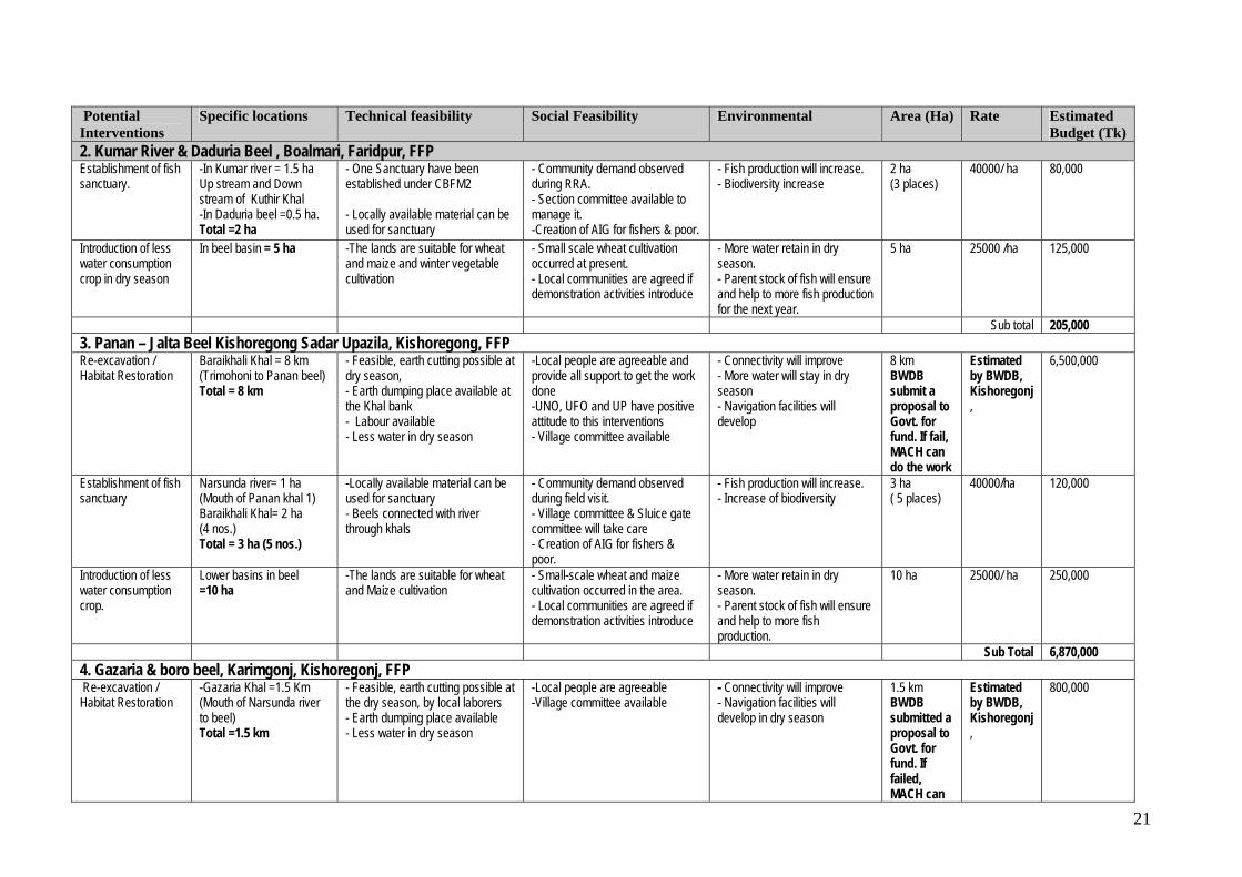
Sub total 205,000 3. Panan – Jalta Beel Kishoregong Sadar Upazila, Kishoregong, FFP Re-excavation / Habitat Restoration
Baraikhali Khal = 8 km (Trimohoni to Panan beel) Total = 8 km
- Feasible, earth cutting possible at dry season, - Earth dumping place available at the Khal bank - Labour available - Less water in dry season
-Local people are agreeable and provide all support to get the work done -UNO, UFO and UP have positive attitude to this interventions - Village committee available
- Connectivity will improve - More water will stay in dry season - Navigation facilities will develop
8 km BWDB submit a proposal to Govt. for fund. If fail, MACH can do the work
Estimated by BWDB, Kishoregonj,
6,500,000
Establishment of fish sanctuary
Narsunda river= 1 ha (Mouth of Panan khal 1) Baraikhali Khal= 2 ha (4 nos.) Total = 3 ha (5 nos.)
-Locally available material can be used for sanctuary - Beels connected with river through khals
- Community demand observed during field visit. - Village committee & Sluice gate committee will take care - Creation of AIG for fishers & poor.
- Fish production will increase. - Increase of biodiversity
3 ha ( 5 places)
40000/ha 120,000
Introduction of less water consumption crop.
Lower basins in beel =10 ha
-The lands are suitable for wheat and Maize cultivation
- Small-scale wheat and maize cultivation occurred in the area. - Local communities are agreed if demonstration activities introduce
- More water retain in dry season. - Parent stock of fish will ensure and help to more fish production.
10 ha 25000/ ha 250,000
Sub Total 6,870,000 4. Gazaria & boro beel, Karimgonj, Kishoregonj, FFP Re-excavation / Habitat Restoration
-Gazaria Khal =1.5 Km (Mouth of Narsunda river to beel) Total =1.5 km
- Feasible, earth cutting possible at the dry season, by local laborers - Earth dumping place available - Less water in dry season
-Local people are agreeable -Village committee available
- Connectivity will improve - Navigation facilities will develop in dry season
1.5 km BWDB submitted a proposal to Govt. for fund. If failed, MACH can
Estimated by BWDB, Kishoregonj,
800,000

22
Potential Interventions
Specific locations Technical feasibility Social Feasibility Environmental Area (Ha) Rate Estimated Budget (Tk)
do the work Establishment of fish sanctuary
Narsunda River=2 ha (2nos.) (Mouth of Gazaria khal)
-Locally available material can be used for sanctuary -River connected with beel through khal
- Village committee & Sluice gate management committee will take care
- Increase of fish production - Increase of biodiversity
2 ha (2 places)
40000/ha 80,000
Introduction of less water consumption crop.
Gazaria beel = 5 ha Boro beel = 5 ha Lower basin In the beel Total = 10 ha
- Lands are suitable for wheat and maize cultivation in rabi season.
- Small scale maize cultivation observed during field visit - Community will agree if demonstration activities introduced
- More water retain in dry season. - Parent stock of fish will ensure and help to more fish production
10 ha 25000/ ha 250,000
Sub Total 1,130,000 5. Charan Beel, Kalihati Upazila, Tangail, CBFM-2 Re-excavation / Habitat Restoration
At Pascharan village=3 ha Total = 3 ha
- Feasible, earth cutting possible at dry season, - Earth dumping place available - Less water in dry season - Laborers available
-Local people are agreeable and provide all support to get the work done - UFO and local communities have positive attitude to this interventions - Beel committee present
- Connectivity will improve - More water will stay in dry season - Navigation facilities will develop in dry season
2 ha (1 place)
500000/ ha 1,500,000
Establishment of fish sanctuary
- At Pascharan = 0.5 ha (At Re-excavated place) Total= .5 ha
- Locally available material can be used for sanctuary - Connectivity will develop.
- Community demand observed during the period of data collection. - Beel management committee will take care. -Creation of AIG for fishers & poor.
- Fish production will increase. - Biodiversity increase
0.5 ha (1Place )
50000 /ha 25,000
Swamp plantation Periphery of Charan beel (both sides) Total = 4 ha
- Plantation place available
- The community and beel management committee will take care. - Local Govt. will involve with these activities.
- Help for sanctuary and Katha establishment in future - Positive social impact.
4 ha (10000)
25 T k/ Sap 250,000
Alternate rabi crop diversification (Introducing of less water consumption crop )
In the beel basins (both sides)
- The land are suitable for wheat, Maize cultivation
- Local communities and farmers are agreed to have demonstration activities -Small -scale demonstration of 14 rabi crops done by CNRS
- More water retain in dry season, - Parent stock of fish will ensure and help to more fish production - Biodiversity increase
20 ha 25000/ ha 500,000
Sub Total 2,275,000 6. Tallai Beel, Kalihati Upazila, Tangail Re-excavation / Habitat Restoration
- Tallai Beel = 1 ha (At Khas area)
- Feasible, earth cutting possible at the dry season, - Earth dumping place available in the beel - Labour available locally - Less water in dry season
- UFO and UP have positive attitude to this interventions -Local people are agreeable and provide all support to get the work done
- Improvement of connectivity - More water will stay in dry season.
1 ha (2 Places.)
500000/ ha 500,000
Establishment of fish Tallai Beel = 1 ha - locally available materials can be - Community demand observe - Fish production will increase. 1 ha 50000/ ha 50,000
23
Potential Interventions
Specific locations Technical feasibility Social Feasibility Environmental Area (Ha) Rate Estimated Budget (Tk)
sanctuary
(At re-excavated place)
used for sanctuary - Beel connected with river through khals.
during field work - Creation of AIG for fishers & poor.
- Biodiversity will increase (2 Places)
Subtotal 550,000 7. Pagnar Haor, Jamalgong Upazila, Sunamgong, SEMP Re-excavation/ Habitat restoration
Matergaon river = 2.5 ha Daulatpur Dayer =1 ha Khagargaon Gang =1 ha Agura Dubi Dayer =0.5 ha (Udaypur dayer) Total = 5 ha
- Feasible, earth cutting possible in dry season, - Earth dumping place available - Labour available - Less water in dry season
-Local people are agreeable and provide all support to get the work done -DC, UNO, UFO and UP have positive attitude - Village committee available.
- More water will stay in dry season - Navigation facilities will develop in dry season
5 ha (4 Places.)
700000/ ha 3,500,000
Establishment of fish sanctuary
Matergaon river= 2.5 ha Daulatpur Gang =1 ha, Khagargaon Gang=1 ha Agura Dubi Dayer =0.5 ha (Udaypur dayer) Total = 5 ha
- Locally available materials can be used for sanctuary
- Community demand observe - Village committee available - Creation of AIG for fishers & poor.
- Fish production will increase. - Fish availability increase - Increase of biodiversity
5 ha (4 Places.)
50000/ha 250,000
Swamp Plantation
Matergaon = 5 ha Daulatpur =3 ha Lalpur =3 ha Kashipur = 3 ha Fenarbug = 3 ha Sonamukhi kandi= 3 ha (Uaypur village) Total = 20 ha
- Plantation place available - Laborers available
- The community and village committee will take care. - The local community will provide all support to get work done.
- Help for sanctuary and Katha establishment in future - Positive social impact
20 ha (50000 nos)
25 tk / Sap 1,250,000
Alternate rabi crop diversification (Introducing of less water consumption crop)
In the Haor basins - Wheat, Maize can be introduce in rabi season
- Local communities and farmers will agree if demonstration of alternative rabi crops are introduced
-More water retain in dry season, -Parent stock of fish will ensure and help to more fish production
20 ha 25000/ ha 500,000
Sub total 5,500,000 8. Halir Haor & Shanir Haor Jamalgong Upazila, Sunamgong, CBFM-2 Re-excavation / Habitat restoration
Kajudoba beel(Halir)=2 ha Baro beel prokashito Khoriar beel (Shanir) =3 ha Dighalia beel(Shanir) =2 ha Total =7 ha
- Feasible, earth cutting possible at the dry season, - Earth dumping place available - Local laborers available - Less water in dry season
-Local people are agreeable and provide all support to get the work done -DC, UNO, UFO have positive attitude to this interventions - Village committee available - Creation of new AIG.
- Connectivity will improve - More water will stay in dry season - Navigation facilities will develop in dry season
7 ha (5 Places.)
700000/ ha 4,900,000
Establishment of fish sanctuary
In re-excavated place Kajudoba beel(Halir)= 1 ha Baro beel prokashito
- Locally available material can be used for sanctuary - Beels are connected with river
- Community demand observe during Data collection period - Village committee available
- Fish production will increase. - Biodiversity increase
7 ha ( 5 Places)
50000/ ha 350,000

24
Potential Interventions
Specific locations Technical feasibility Social Feasibility Environmental Area (Ha) Rate Estimated Budget (Tk)
Khoriar beel (Sonir) = 3 ha Digholia beel (Sonir)=1 ha Harinagar putia river=2 ha Total = 7 ha
through khals - Creation of AIG for fishers & poor.
Swamp plantation
Beheli Nadir Kandi = 5 ha Islampur village = 5 ha Baro beel prokashito Khoriar beel = 5ha Tilkoi village area = 5 ha Total = 20 ha
- Plantation place available
- The community and village committee will take care. - Local Govt. is involve with the activities - Village committee will take care
- Help for sanctuary and Katha establishment -Positive social impact
20 ha (50000 nos.)
25 tk/ Sap 1,250,000
Alternate rabi crop diversification (Introducing of less water consumption crop)
In the beel basins - Wheat and Maize can be introduced.
- Local communities and farmers are agreed to have demonstration activities.
-More water retain in dry season, -Parent stock of fish will ensure and help to more fish production.
20 ha 25000/ ha 500,000
Sub total 7,000,000 9. Dekhar Haor, Sunamgong Sadar upazila, CBRMP, LGED / IFAD Re-excavation/ Habitat restoration
- Modonpur khal and Gobinpur Khal = 2 ha Total = 2 ha
- Plantation place available
- DC, UNO and local UP Chairman and members will involve with the activities.
- Help for sanctuary and Katha establishment -Positive social impact
2 ha (1 place)
700000/ ha 1,400,000
Establishment of fish sanctuary
In re-excavated place = 2 ha
-Locally available material can be used for sanctuary.
- Community demand observed during the visit. - Creation of AIG for fishers & poor.
- Fish production will increase. - Increase of biodiversity
2 ha (1 Place)
5000/ ha 100,000
Swamp Plantation
Modonpur kanda, Gobinpur kanda, Islampur kanda, Dosani kanda = 20 ha Total 20 ha
- Feasible, earth cutting possible at the dry season, - Earth dumping place available at the Khal bank - Less water in dry season
-Local people are agreeable and provide all support to get the work done - DC, UNO, UFO and UP have positive attitude to this interventions. - Creation of new AIG
- Connectivity improve - More water will stay in dry season - Brood stock will available result more fish production
20 ha 25 tk/ Sap 1,250,000
Alternate rabi crop diversification. (Introducing of less water consumption crop)
In the beel basins. - Wheat and Maize can be introduced.
- Local communities and farmers will agree if demonstration activities are introduce in the area.
-More water retain in dry season, -Parent stock of fish will ensure and help to more fish production
20 ha 25000/ ha 500,000
Sub total 3,250,000 10. Hakaluki Haor, Kulaura, Baralekha Upazila, Moulvibazar, SEMP, CBFM-2 Re-Excavation/ Habitat restoration
Padma beel =1 ha Chander beel =1 ha Pabijuri beel =1 ha Ramarkuri beel = 0.5 ha
- Feasible, earth cutting possible at the dry season. - Earth dumping place available at the Khal bank
-UNO and concerned UP will involve with the activities - Village committee will involve with the activities.
- Connectivity improve - More water will stay in dry season - Navigation facilities will
3.5ha (4Places)
700000/ ha 2,450,000

25
Potential Interventions
Specific locations Technical feasibility Social Feasibility Environmental Area (Ha) Rate Estimated Budget (Tk)
Total = 3.5 ha - Less water in dry season
- Creation of new AIG for the poor develop in dry season
Establishment of fish sanctuary
In re-excavated place Padma beel =1 ha Chander beel =1 ha Pabijuri beel =1 ha Ramarkuri beel = 0.5 ha Total = 3.5 ha
-Locally available material can be used for sanctuary setting - Local laborers available
- Local people are agree and provide all support to get the work done -UNO, UFO and UP have positive attitude to this interventions - Village committee available. - Creation of AIG for fishers & poor.
- Fish production will increase. - Biodiversity will increase
3.5 ha (4 Places)
50000/ ha 175,000
Swamp plantation Beside Gourkuri beel = 30 ha Beside Fanai river = 5 ha Beside Dhamai River=5 ha (6 km, both side, 2 row) Total = 40 ha
- Plantation place available - Local laborers available
- Community demand observe during field visit - Village committee will take care
- Help for sanctuary and Katha establishment in future. - Positive social impact will occurred
40 ha (100000 nos.)
25 tk/ Sap 2,500,000
Riparian Plantation
Both side of river bank Bank of Juri River=4 km Anfanai river = 4 km Fanai river =4 km Damai river =4 km Total = 16 km
- Protection of river bank -Place available both bank of the river.
- Community demand observed.
-Positive social impact 16 km 8000 tk/ km 128,000
Alternate rabi crop diversification (Intro ducing of less water consumption crop)
In the beel basins
- The land are suitable for wheat and Maize cultivation
- Local communities and farmers will agree if demonstration activities introduce in the area.
-More water retain in dry season, -Parent stock of fish will ensure and help to more fish production
30 ha 25000/ ha 750,000
Subtotal 6,003,000 11. Dikshi Beel, Chatmohor Upazila, Pabna, CBFM-2 Re-excavation/ Habitat restoration
Dikshi beel = 2 ha (At Khas area) (2 Places)
- Feasible - Earth cutting possible at the dry season, - Local labour can be used - Earth dumping place available - Less water in dry season
-UNO, UFO and UP have positive attitude to this interventions - BMC & Local communities are agreed for the intervention. - Creation of new AIG.
- Connectivity improve - More water will stay in dry season - Navigation facilities will develop in dry season
2 ha (2 Places)
500000/ ha 1,000,000
Establishment of fish sanctuary
-In re-excavated place and other deep part in the beel = 2 ha (2 nos.)
- Locally available material can be used for sanctuary. - Beel is connected with Cheknai river through canal
- Community demand observed during the visit. - Beel Management Committee will take care. -Creation of AIG for fishers & poor.
- Fish production will increase. - Increase of biodiversity
2 ha (2 places)
40000/ ha 80,000
Swamp Plantation - Parshodanga to Folijani village = 3.5 km Parshodanga village to towards beel = 0.5 km Total = 4 km
- Plantation place available
- UNO and concerned UP chairman and members will involve with the activities - Beel Management committee will take care.
- Help for sanctuary and Katha establishment. - Positive social impact
4 km 2 row both side (8000 nos.)
25 tk/ sap 200,000

26
Potential Interventions
Specific locations Technical feasibility Social Feasibility Environmental Area (Ha) Rate Estimated Budget (Tk)
Subtotal 1,280,000 12. Ghoradubi Beel, Kalmakanda Upazila, Netrokona, CBFM-2 Re-excavation/ Habitat restoration
At Khas area = 2 ha. (2 nos.)
- Feasible - Earth cutting possible at the dry season, - Earth dumping place available - Less water in dry season
- UNO and UFO and have positive attitude to this interventions - BMC and Local communities are agreed. - Creation of new AIG for poors
- Improvement of connectivity - More water will stay in dry season - Navigation facilities will develop .
2 ha (2 Places)
700000 / ha 1,400,000
Establishment of Fish sanctuary
In re-excavated place=2ha (2 nos.)
- Locally available material can be used for sanctuary. - Connected with Ubdakhali river through canal.
- Community demand observe during Data collection period - Village committee - Creation of AIG for fishers & poor.
- Fish production will increase. - Biodiversity increase
2 ha ( 2 Places)
50000/ ha 100,000
Swamp Plantation BWDB Embankment=5km (2 rows both side)
- Plantation place available
- UNO and concerned UP chairman and members beel committee will involve with the activities
- Help for setting of sanctuary and Katha establishment -Positive social impact
5 km both side (10000 nos)
25 tk/ Sap 250,000
Subtotal 1,750,000 13. Meda Beel, Kalmakanda Upazila, Netrokona, CBFM-2 Re- Exacavation/ Habitat restoration
At Khas area = 3 ha (2 nos.)
- Feasible, earth cutting possible at the dry season, - Earth dumping place available - Less water in dry season -Local laborers can be used
-UNO and UFO have positive attitude to this interventions - BMC and Local community are agreed. - Creation of new AIG
- Connectivity improve - More water will stay in dry season - Navigation facilities will develop in dry season
3 ha (2 Places)
700000/ ha 2,100,000
Establishment of fish sanctuary
In re-excavated place = 3 ha (2 nos.)
- Locally available material can be used for sanctuary - Connected with Ghoradubi beel through Moraghonai canal.
- Community demand observe during data collection period - Beel Management Committee & villagers will take care. -Creation of AIG for fishers & poor.
- Fish production will increase. - Biodiversity increase
3 ha (2 places)
50000/ ha 150,000
Swamp Plantation Borokhapon to Ranagaon road = 2 km (2 rows both side)
- Plantation place available -Local labour can be used.
- UNO, UFO and concerned UP chairman and members, BMC & local communities will involve with the activities
- Help for sanctuary and Katha establishment in future. -Positive social impact
2 km, both side (4000 nos.)
25 tk/ Sap 100,000
Sub total 2,350,000 14. Jolkeshobroy Beel, Sribordy Upazila, Sherpur Re- Exacavation/ Habitat restoration
At khas area = 4 ha (4 places)
-In dry season earth cutting is possible by local labours - Earth dumping place available
UNO, UFO and local UP chairman have positive attitude for this interventions.
- Wetland habitat will improve - More water stay in dry season
4 ha (4 places)
500000 / ha 2,000,000
Establishment of fish sanctuary
In re-excavated place = 4 ha (4 nos.)
- Feasible - Locally available materials can be
UNO, UFO and local UP chairman & local communities have positive
- Fish production will increase. - More fish will available in the
4 ha (4 places)
40000 / ha 160,000

27
Potential Interventions
Specific locations Technical feasibility Social Feasibility Environmental Area (Ha) Rate Estimated Budget (Tk)
used for sanctuary. - Connected with Balsha Beel through canal
attitude for the interventions. area. - Increase of biodiversity
Swamp Plantation Earth dumping place=2 ha Beside Fish sanctuary -Local community will take care with the help of local government
- Help for sanctuary and Katha establishment in future. - Positive social impact.
2 ha (5000 nos.)
25 tk/ Sap 125,000
2,285,000 15. Kums in Bangshi River, Mirzapur upazila, Tangail Establishment of fish sanctuary.
In the kum area Palashtoli Kum =1 ha Kuripara Kum =1 ha Hatuvanga Kum=1 ha (2 nos. in each kum) Total = 3 ha (6 nos)
-Feasible -Locally available materials can be used for sanctuary establishment
- UNO, UFO and local UP chairman and members & local communities have positive attitude for these interventions.
- Fish production will increase. - Increase of biodiversity - Positive social impact.
3 ha (6 places)
80000 /ha (Investment is double in river sanctuary than beel sanctuary)
240,000
Subtotal 240,000 16. Kamarkhali khal rehabilitation to restore connectivity between Hail Haor and Kushiyara River, Moulvibazar Re-excavation of khals
Khals in Baro haor basins Feasibility study was done in 2001 All concerned agreed Fish production and biodiversity in Baro Haor and Hail Haor will be increased
Need estimation
17. Kamarkhali khal sluice gate, Moulvibazar Fish friendly operation of Kamarkhali sluice
Sluice gate at the mouth of Kamarkhali khal
BCAS is working on this BWDB and other concerned are agreed
Increased in migration of fish from Kushiyara river
Need estimation
Project wise Interventions Sl Project Habitat restoration Establishing Fish
Sanctuary Swamp Plantation Riparian Plantation Introducing of less water
consuming crops in rabi season
1 FFP 9.5 km (2 places) 7 ha (10 places) - - 25 ha 2 CBFM-2 25.5ha+8 km (25 places) 26.0 ha (30 places) 30 ha + 11 km (18 places) 60 ha 3 SEMP 5 ha (4 places) 5 ha (4 places) 60 ha (9 places) 16 km 50 ha 4 CBRMP,
LGED/IFAD 2 ha (1 place) 2 ha (1 place) 20 ha (4 places) - 20 ha
5 New area (Out of Project)
4 ha (4 Places) 7 ha (10 Places) 2 ha (4 Places) - -
Total 36.5ha+17.5 km (36 places) 47 ha (55 places) 112 ha+11 km (35 places)
16 km (4 places) 155 ha

28
Total Taka for implementation of identified Interventions = 55,843,000 TK Total area and number for re-excavation = (36.5 ha+17.5 km) (36 places) Total area and number for Sanctuary = 47 ha (55 places) Total area and number for swamp plantation= 112 ha +11 km (35 Places)/302000 Total area and number for Riparian vegetation= 16 km (4 Places) Total area of Introducing for less water consuming crop = 155 ha