major project assessment: simta intermodal terminal
TRANSCRIPT
MAJOR PROJECT ASSESSMENT: SIMTA Intermodal Terminal Facility Stage 1 Moorebank Avenue, Moorebank (SSD 6766)
Secretary’s Environmental Assessment Report Section 89H of the Environmental Planning and Assessment Act 1979 December 2015
ABBREVIATIONS
ApplicantctvDepartmentEISEP&A ActEP&A RegulationEPIIMEXMD SEPPMrcMinisterMITPACPEARtSSEARSSecretarySIMTASSFLTEU
Sydney lntermodal Terminal Alliance (SIMTA)Capital I nvestment ValueDepartment of Planning & EnvironmentEnvironmental I mpact AssessmentEnvironmental Planning and Assessment Act 1979Environmental Planning and Assessment Regulation 2000Environmental Planning lnstrumentlmporUExportState Environmental Planning Policy (Major Development) 2005Moorebank I ntermodal CompanyMinister for PlanningMoorebank lntermodal TerminalPlanning Assessment CommissionPrelim inary Environmental AssessmentResponse to SubmissionsSecretary's Environment Assessment RequirementsSecretary of the Department of Planning & EnvironmentSydney lntermodal Terminal AllicanceSouthern Sydney Freight LineTwenty Foot Equivalent Units (Containers)
Cover Photograph: simta.com.au
@ Crown copyright 2015Published December 201 5
NSW Department of Planning & Environmentwww. plan n inq. nsw. qov. au
Disclaimer:While every reasonable effort has been made toensure that this document is correct at the time ofpublication, the State of New South Wales, its agentsand employees, disclaim any and all liability to anyperson in respect of anything or the consequencesof anything done or omitted to be done in relianceupon the whole or any part of this document.
NSW GovernmentDepartment of Planning & Environment
EXECUTIVE SUMMARY
Sydney lntermodal Terminal Alliance (SIMTA) seeks approval for a Stage 1 State SignificantDevelopment (SSD) to develop an intermodal terminal facility with a rail link to the SouthernSydney Freight Line (SSFL) at Moorebank, in the Liverpool Local Government Area.
Stage 1 follows the Concept Plan approval by the Planning Assessment Commission(Commission) on 29 September 2Q14 for an intermodal facility including lmporUExport (IMEX)
terminal handling up to 250,000 TEUs per annum with an option of an additional 250,000 TEUssubject to not exceeding the capacity of the transport netwok, warehousing and rail connection tothe Southern Sydney Freight Line (SSFL). The proposal has a capital investment value of $142.5million.
The proposal would provide a port-shuttle freight service between Port Botany and the SIMTAsite, whereby containers would be unloaded from ships at Port Botany, placed on a train and sentto the SIMTA site via the existing SSFL. The train would be unloaded, with freight either beingtemporarily stored on site or loaded directly on to heavy vehicles for distribution to markets via thenearby major road network. The trains would return to Port Botany, ready for further freightshuttling.
Separately, the Moorebank lntermodal Company (MlC), on behalf of the Commonwealthgovernment, recently sought approval for a staged State Significant Development (SSD)(including Stage 1 early works) to develop an intermodal terminal facility with a rail link to theSouthern Sydney Freight Line (SSFL) on an adjacent site. This proposal includes an IMEXterminal that would handle up to 1.05 million TEUs and an interstate terminal that would handle500,000 TEUs. 300,000m2 of warehousing is also proposed.
On 4 June 2014,M|C announced that it had reached an agreement with SIMTA to develop theMoorebank project on a whole of precinct basis and a combined throughput of 1.55 millioncontainers is sought. ln assessing MIC's proposal, the Department recommended conditions toensure that the maximum throughput of a combined site is 1.55 million TEUs. However, in theabsence of a single application for a combined facility, the Department has also carefullyconsidered the cumulative impacts of both proposals in its assessment of the SIMTA application,
The SIMTA proposal is State Significant Development pursuant to the terms of the ConceptPlan approval, which determined 'that approval to carry out the development the subiect ofthe Concept Plan rs fo be subject to Part 4 Division 4.1 of the Act.'The Minister for Planning is
the approval authority for the proposal, however, the Commission may determine the applicationunder delegation as Campbelltown City Council and Liverpool City Council raise objection to theproposal and there have been more than 25 submissions received by way of objection.
The Environmental lmpact Statement (ElS)was publicly exhibited from 28 May 2015 to 26 June2015 (30 days). The Department received 226 submissions from the public during theexhibition period. A total of I submissions were received from public authorities. ln responseto these submissions, the Applicant revised the alignment of the proposed rail link to avoid theneed to enter into the East Hills Passenger Line corridor.
The Department has undertaken a comprehensive assessment of the proposal which focuses onfour key areas:. traffic (Section 5.1);. air quality (Section 5.2);. noise and vibration (Section 5.3); andr contamination (Section 5.4).
ln relation to traffic and transport, the Department acknowledges the proposalwould remain withinthe capacity of the transport netwok, consistent with the terms of the Concept Plan approval and
NSWGovernment iDepartment of Planning & Environment
not require any intersection upgrades. Notwithstanding, the Department has recommended theApplicant pay monetary developer contributions of $393,122.14 to Liverpool Council to offsetincreased pressures on Council's assets and services as a result of the proposal.
The Department notes that the proposal is predicted to meet relevant EPA criteria in relation to airquality and the predicted human health impacts are considered to be low in the context of the site.The Department has recommended stringent conditions to ensure that the intermodal terminal is
designed and operated to achieve best practice emission control.
The Department considers that during operation of the facility some exceedances of relevantnoise goals may occur at sensitive receivers. lmpacts would primarily result from wheelsqueal of wagons using the rail connection to the SSFL. A number of conditions have beenrecommended to address wheel squeal, including requirements for track grinding andlubrication on the rail link. Conditions requiring real time noise monitoring of train passbyevents on the rail link, implementation of best practice container handling equipment and thepreparation and implementation of an Operational Environmental Management Plan havealso been recommended to address concerns.
The Department notes that contaminated land exists on the site and considers the highestrisk of exposure to contaminants would occur when ground or groundwater disturbanceduring excavation occurs. The Department has reviewed the Remedial Action Plan and in
conjunction with recommended conditions of approval is satisfied that contamination impactscan be minimised and mitigated, including those raised by the EPA.
The proposal is also consistent with the NSW Govemment's objective to maximise the haulage offreight by rail. ln as early as 2005, the Freight lnfrastructure Advisory Board reinforced the needfor an intermodal terminal at Moorebank to achieve an increase in the rail mode share of portcontainer freight movements. The Department acknowledges that the proposal is a keycomponent in meeting Sydney's intermodal capacity needs, particularly as SIMTA has thecapability to attract a significant proportion of the freight market thus significantly reducingtrucking demand.
ln balancing the potential impacts of the proposal, the Department notes that, if approved, theproposalwould reduce the number of heavy vehicles on the M5 Motonruay, between Port Botanyand Moorebank and contribute to improving network efficiency by relieving traffic congestion in
the Port Botany area. The proposal would also grow freight network capacity to meet futurefreight requirements.
The Department has concluded that the proposal is consistent with the Concept Plan approvaland on balance, the proposal's benefits outweigh its potential adverse impacts and is therefore inthe public interest. Consequently, the Department considers the Stage 1 proposal should beapproved subject to the recommended conditions of approval.
NSW GovernmentDepartment of Planning & Environment
il
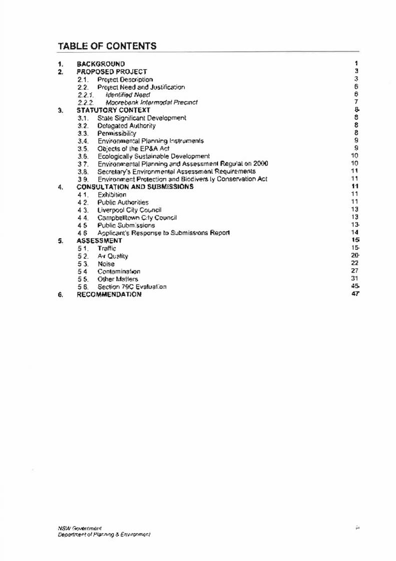
TABLE OF CONTENTS
1
2BACKGROUNDPROPOSED PROJECT2.1. ProjectDescription2.2. Project Need and Justification2.2.1. ldentified Need2.2.2. MoorebanklntermodalPrecinctSTATUTORY CONTEXT3.1. StateSignificant Development3.2. DelegatedAuthority3.3. Permissibility3.4. Environmental Planning lnstruments3.5. Objects of the EP&A Act3.6. EcologicallySustainable Development3.7. Environmental Planning and Assessment Regulation 20003.8. Secretary's Environmental Assessment Requirements3.9. Environment Protection and Biodiversity Conservation ActCONSULTATION AND SUBMISSIONS4.1. Exhibition4.2. PublicAuthorities4.3. Liverpool City Council4.4. Campbelltown City Council4.5. PublicSubmissions4.6. Applicant's Response to Submissions ReportASSESSMENT5.1. Traffic5.2. Air Quality5.3. Noise5.4. Contamination5.5. Other Matters5.6. Section 79C EvaluationRECOMMENDATION
1
33667IIII99
101011
11
1111
11
1313'13
14l51520222731
4547
3
5
4.
6.
NSW GovernmentDepadment of Planning & Environment
ilt
SIMTA lntermodal Terminal Stage 1 Secretary's Envi ron me ntal,Assessmenf Reporl
1. BACKGROUND
Sydney lntermodal Terminal Alliance (SIMTA), a consortium of Qube Holdings and Aurizon, is
seeking approval for the construction and operation of Stage 1 of the SIMTA Moorebanklntermodal Terminal Facility and the associated Rail link as part of the first stage of developmentunder the approved SIMTA Concept Plan (MP 10_0193). The SIMTA Concept Plan wasapproved by the Planning Assessment Commission (the Commission) on 29 August 2014, andallows the following three stages of development:
1. construction of the intermodal terminal facility and associated rail link (the subject of thisproposal);
2. construction of the warehouse and distribution facilities; and3. extension of the intermodal terminal and completion of warehouse and distribution
facilities.
The site is located approximately 27 kilometres south-west of the Sydney CBD, andapproximately 2.5 kilometres south of Liverpool City Centre within the Liverpool LocalGovernment Area (Figure l).
Figure 1: Project Location in Context with Sydney CBD (Base Image Source; Google Maps 2014)
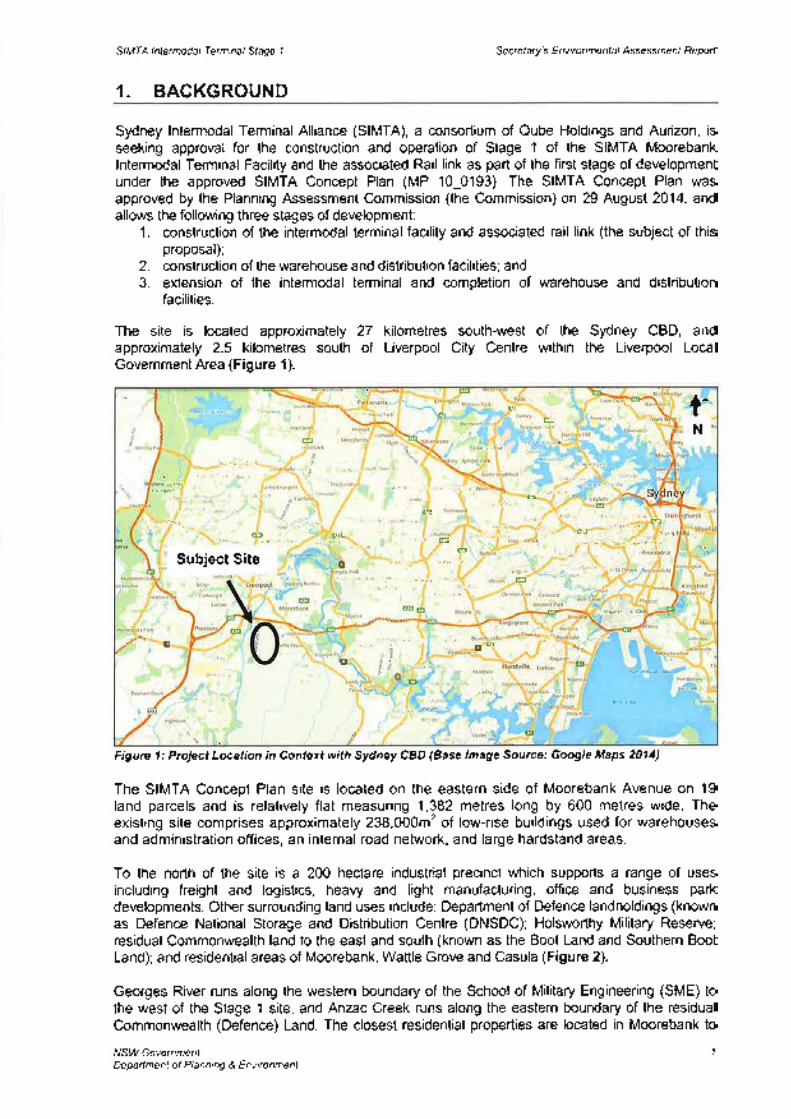
The SIMTA Concept Plan site is located on the eastern side of Moorebank Avenue on 19land parcels and is relatively flat measuring 1,382 metres long by 600 metres wide. Theexisting site comprises approximately 238,000m' of low-rise buildings used for warehousesand administration offices, an internal road network, and large hardstand areas.
To the north of the site is a 200 hectare industrial precinct which supporls a range of usesincluding freight and logistics, heavy and light manufacturing, offlce and business parkdevelopments. Other surrounding land uses include: Department of Defence landholdings (knownas Defence National Storage and Distribution Centre (DNSDC); Holsworthy Military Reserve;residual Commonwealth land to the east and south (known as the Boot Land and Southern BootLand); and residential areas of Moorebank, Wattfe Grove and Casula (Figure 2).
Georges River runs along the western boundary of the School of Military Engineering (SME) tothe west of the Stage 1 site, and Anzac Creek runs along the eastern boundary of the residualCommonwealth (Defence) Land. The closest residential properties are located in Moorebank to
NSW Government 1
Deparlment of Planning & Environment
ct c
N.ah
rta
hiE.r&qíF
!
J
Subject Site
s5rr¡ùf.ld EI
c¡)rtdfnf¡r .. L ,, ;0
o,,.il,r Hrl.¡l
E
EE
E
il"lhc' ll P¡rl
I Cgl
l¡ t.lr"._, . , rtu ,É if¡.F, ¡'sr p1r (¡ , . t,- ! t5
tr¿jl!..| | ., È :lir,l
F;,rr-!
os
P,rnihÞo¿
t'ìi:ë Iltd qr¡"r¡¿t: G|¿LF
Â'ì'\lj tEt ri nhrqii¡n E¡
Sutry
l,v€ Dc.km
r'.re6.âil. H¿rto*nWil.ilÕö
Arburn | ,i.¡. rr" I t."-.0., h
@
D-
fN
oo^
r.,Ê:rr P¿rlrrov/ rìrr.n,û
irlr:r.r ilrDeÈ'Àd
sù¡,.i ?.,
0 E n..,,,,-,,,0..
SIMTA lntermodal Terminal Stage 1 Se cre t a ry's E nv i ro n me nta I Assessmenl Reporf
the north-east (approximately 400 metres), Wattle Grove to the east (approximately 800 metres)and Casula to the west (approximately 850 metres).
The area to which the Stage 1 application applies is located approximately 1,300 metressouth of the intersection of Moorebank Avenue and the M5 Moton¡ray and has a site area ofapproximately '18 hectares. The M5 is the main road link between the Stage 1 site and thekey employment and industrial areas within the West and South Western Sydney Sub-Regions. The Southern Sydney Freight Line (SSFL) is located one kilometre to the west ofthe proposed Stage 1 site.
Moorebank lntermodal Company (MlC), on behalf of the Commonwealth Government, is alsoproposing to construct and operate an intermodal facility on the SME site. This proposal is knownas the Moorebank lntermodal Terminal (MlT) (SSD 5066). The Department has assessed thisproposal and has recommended approval subject to conditions. The MIT proposal includes.. an imporUexport (IMEX)freight terminal with a maximum capacity of 1.05 million twenty-foot
equivalent units (TEU) (containers)a year;. an interstate freight terminal designed to handle up to 500,000 TEU per year;o warehousing facilities;. an upgrade of Moorebank Avenue; and. a rail access connection between the main intermodal site and the SSFL via a bridge over
the Georges River.
Figure 2: Local Context, showing Concept Plan site (Source: Environmental lmpact Assessment 2015)
On 4 June 2014l,AlC released a statement clarifying that an agreement had been reachedwith SIMTA and that only one intermodal facility would proceed across both sites. However,both applicants have continued to pursue approvals for their respective proposals as standalong facilities. Notwithstanding, MIC has updated its proposal by clarifying that thethroughput of 1.55 million containers sought would be shared across both sites.
NSW GovernmentDepartment of Planning & Environment
2
SAJEðSft
lilo
Emã¡EYd!lEdxt
Att€¡oa !Æ ¿ crôfl€7
cmrorvrlnso¡ r
WÀIILÊ qM
LEEEIIÞ
\
utt
il\fi Þe<^b
ML[¡.K¡€
f-'l
SIMTA Intermodal Terninal Stage 1 Secretary's Environme ntal Assessmenf Reporf
2. PROPOSED PROJECT
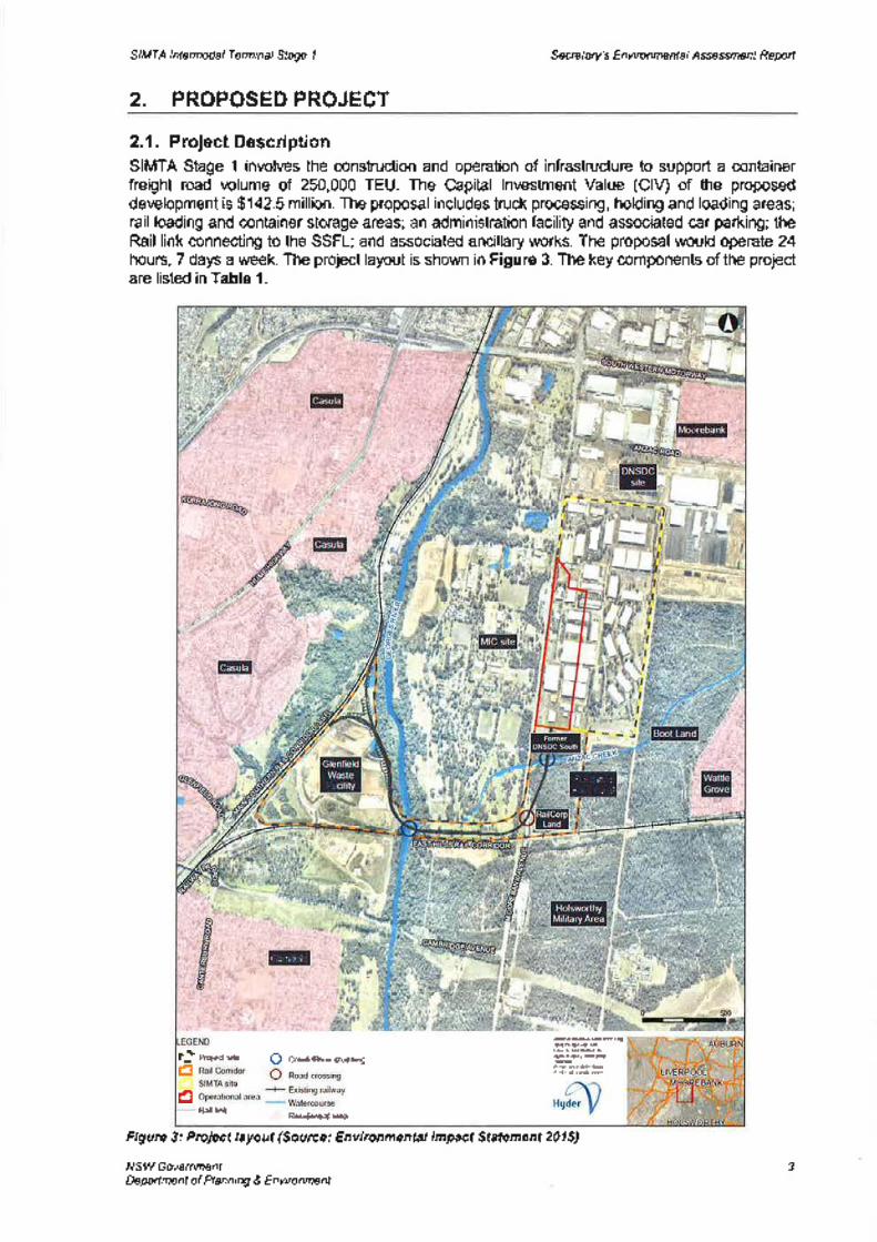
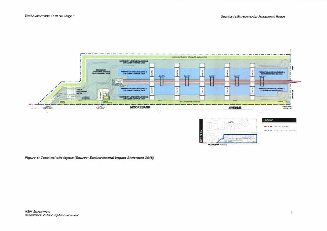
2.1. Proiect DescriptionSIMTA Stage 1 involves the construction and operation of infrastructure to support a containerfreight road volume of 250,000 TEU. The Capital lnvestment Value (ClV) of the proposeddevelopment is $142.5 million. The proposal includes truck processing, holding and loading areas;rail loading and container storage areas; an administration facility and associated car parking; theRail link connecting to the SSFL; and associated ancillary works. The proposal would operate 24hours, 7 days a week. The project layout is shown in Figure 3. The key components of the projectare listed in Table 1.
Flgure 3: Project layout (Source: Environmental lmpact Statement 2015)
NSW GovernmentDepartment of Planning & Environment
3
Prqeds¡le Q CræVniverru*ng
Rail tukRæl(lenùd aH
,.
Æ.@rurßm@
r-tEo
:ìl:rirì d
t
S,rìlll:rÍ:Bcol Laf ìi¡
SIMTA Intermodal Terminal Sfage I
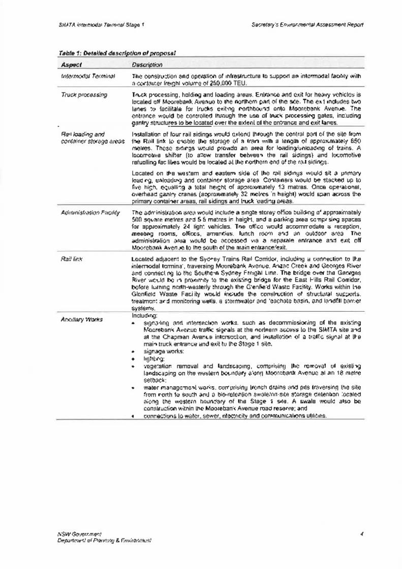
Table 1: Detailed description of proposal
Secretary's Environmental Assessmenf Reporf
Aspect Description
lntermodal Terminal The construction and operation of infrastructure to support an intermodal facility witha container freight volume of 250,000 T
Truck processing Truck processing, holding and loading areas. Entrance and exit for heavy vehicles islocated off Moorebank Avenue to the northem part of the site. The exit includes twolanes to facilitate for trucks exiting northbound onto Moorebank Avenue. Theentrance would be controlled through the use of truck processing gates, includinggantry structures to be located over the extent of the entrance and exit lanes.
Rail loading and lnstallation of four rail sidings would extend through the central part of the site fromcontainer storage areas the Rail link to enable the storage of a train with a length of approximately 650
metres. These sidings would provide an area for loading/unloading of trains. Alocomotive shifter (to allow transfer between the rail sidings) and locomotiverefuelling facilities would be located at the northern end of the rail sidings.
Located on the western and eastern side of the rail sidings would sit a primaryloading, unloading and container storage area. Containers would be stacked up tofive high, equalling a total height of approximately'1 3 metres. Once operational,overhead gantry cranes (approximately 32 metres in height) would span across theprimary container areas, rail sidinqs and truck loadinq areas
Ad mi ni stration Facil ity The administration area would include a single storey office building of approximately500 square metres and 5.5 metres in height, and a parking area comprising spacesfor approximalely 24 light vehicles. The ofüce would accommodate a reception,meeting rooms, offices, amenities, lunch room and an outdoor area. Theadministration area would be accessed via a separate entrance and exit offMoorebank Avenue to the south of the main entrance/exit.
Raillink Located adjacent to the Sydney Trains Rail Corridor, including a connection to theintermodal terminal, traversing Moorebank Avenue, Anzac Creek and Georges Riverand connecting to the Southern Sydney Freight Line. The bridge over the GeorgesRiver would be in proximity to the existing bridge for the East Hills Rail Corridor,before turning north-westerly through the Glenfield Waste Facility. Works within theGlenfleld Waste Facility would include the construction of structural supports,treatment and monitoring wells, a stormwater and leachate basin, and landfill barriersystems.
Ancillary Workslncluding:. signalling and intersection works, such as decommissioning of the existing
Moorebank Avenue traffic signals at the northern access to the SIMTA site andat the Chapman Avenue intersection, and installation of a traffìc signal at themain truck entrance and exit to the Stage 1 site;
. signage works;o lighting;. vegetation removal and landscaping, comprising the removal of existing
landscaping on the western boundary along Moorebank Avenue at an 18 metresetback;
¡ water management works, comprising trench drains and pits traversing the sitefrom north to south and a bio-retention swale/on-site storage detention locatedalong the western boundary of the Stage 1 site. A swale would also beconstruction within the Moorebank Avenue road reserve; and
. connections to water, sewer, electricitv and communications utilities
NSW GovernmentDepartment of Planning & Environment
4
SIMTA lntermodal Terminal Sfage I
ETT¡
-
WEffi
Figure 4: Terminal site layout (Source.' Environmental Impact Statement 2015)
NSW GovernmentDepartment of Planning & Environment
Secrefaryb Environmental Assessmenf Reporf
t.-;:-n.,r-1.-;i
AttEillE
ús
{!dtI
- -
IçÉ
5
SIMTA Intermodal Terminal Stage 1 Secretary's Environmental Assessmenl Reporf
2.2. Project Need and Justification
2.2.l.ldentified Need
An intermodal terminal at Moorebank was first considered by the CommonwealthGovernment in 2004 to promote national productivity in the long term to assist in thedevelopment of Sydney, particularly in attracting employment and investment in South-WestSydney.
ln 2005, the Freight lnfrastructure Advisory Board (FIAB), through its report on intermodal freightrequirements for Sydney, reinforced Moorebank as a critical element for achieving the NSWGovernment's target of an increased rail mode share of port container freight. The FIAB reportproposed a staged development of new intermodal freight capacity within metropolitan Sydney,generally as follows:. development of the Enfield intermodal terminal by 2009/10 with a capacity to handle 300,000
TEUs per annum and servicing the Port Botany container market. This prolect beganoperations in early 2015;
. development of an intermodal terminal at Moorebank by 2013114 with a capacity to handle upto 500,000 TEUs per annum of port freight and additional capacity to service domesticcontainer freight market; and
o ongoing planning for a possible intermodal terminal development within the Eastern Creekprecinct in outer western Sydney towards 2020.
ln 2007, the Commonwealth Government allocated funding towards detailed planning of anintermodal terminal at Moorebank as part of the Nation Building Program and in 2010 theGovernment allocated further funding for a feasibility study.
The National Ports Strategy was developed by lnfrastructure Australia and the National TransportCommission and endorsed by the Council of Australian Governments in July 2012. The Strategyconsiders that ports are critical to productivity and economic growth, and notes that best practicemaster planning would identify locations for inland intermodals and industrial/warehousing lands.
Section 5 of the Strategy considers the increasing freight demand for South West Sydney and theneed for intermodals to maintain the rail modal share of container freight from Port Botany. TheDepartment considers that the proposal would assist in increasing the rail modal share, andtherefore increase the efficiency of Port Botany freight movements.
The Freight Demand Modelling Report undertaken by the Proponent for the SIMTA Concept PlanEnvironmental Assessment has identified the freight demand for the Western and South-WesternSydney regions. By 2016, direct trucking from Port Botany to the Sydney region would deliverover 70o/o of freight task. The report suggests that by 2025, additional intermodal terminal capacitywill be required to deliver the forecast 4.6 million TEUs throughput at Port Botany, with demand forcontainers in the South-West exceeding the current capacity at the Minto intermodalterminal.
ln addition, the Department considers that the proposal is consistent with the followingCommonwealth and State policies:
Transporf Planningo NSW Long Term Transport Masterplan - the SIMTA proposal has the potential to increase
network efficiency by relieving congestion at bottlenecks on road and rail networks; growfreight network capacity to meet future freight requirements; and manage the community andenvironmental impacts of freight to promote sustainability.
. Railing Pori Botany's Containers - prepared by the Freight lnfrastructure Advisory Board in2005, the report recommends that a 4Q% rail share target (since revised to 28o/o) must be met
NSW GovernmentDepartment of Planning & Environment
6
a
SIMTA lntermodal Terminal Sfage I Secretary's Environmental Assessmenl Reporl
or exceeded and that suffìcient intermodal terminal capac¡ty is provided. The report notes thatMoorebank is a key component in meeting Sydney's intermodal capacity needs.NSt/y Freight and Potts Strategy - the proposal would contribute to a number of StrategicAction Areas including increasing freight movement and network demand, managingcongestion, noíse and emission impacts, and prioritising safety of freight transport.
Land Use Planning. NSW 2021: includes targets to enhance railfreight movement and to double the proportion of
container freight movement by rail through NSW ports to 28o/o by 2A20. The proposal wouldcontribute to this freight target.
o A Plan for Growing Sydney 2014 - the proposal would contribute to long term employmentgrowth in the South West Subregion (Liverpool LGA) and address the priorities of protectinginfrastructure of metropolitan significance (intermodal terminals) and protecting land to serveSydney's future transport needs including intermodal sites.
¡ Súafe lnfrastructure Strategy 2012-2032 - identifies the Moorebank lntermodal Terminal as akey project, improving cost competitiveness of rail and road transport and provide for privateinvestment in the rail freight market. The proposed development would also reduce heavyvehicle movements along the M5 and support the State investment in the delivery of theSSFL.
2.2.2. Moorebank lntermodal Preci nctWhile SIMTA sought Concept Plan approvalfor a throughput of 1 million TEUs, the Commission'sapproval limited the initial throughput of the site to 250,000 TEUs. This decision was based on theuncertainty around predicting the potential trafflc impacts and determining the appropriateness ofthe proposed mitigation measures so far into the future.
The Concept approval includes the provision for a future application to increase throughput by afurther 250,000 TEUs to be considered by the consent authority. The Department, in assessingsuch an application, would need to be satisfied that SIMTA has demonstrated through monitoringand modelling of the operational facility that increased TEUs would not exceed the capacity of theroad network.
The key differences between the SIMTA Concept Plan and MIT Concept proposals are explainedin Table 2. Both proposals include 300,000m2 of warehousing:
Table 2: Differences between MIT and SIMTA
* Not included in SIMTA Sfage I
Since the Commission's determination of the SIMTA Concept Plan, SIMTA and MIC have agreedon terms to develop the Moorebank precinct as a single intermodalfacility. While the Departmentacknowledges and supports this position, both Applicants have indicated that their respective siteswould not be combined in a single Development Application at this stage. ln this regard, thereremain two separate applications on two separate sites (by two separate Applicants)that must beconsidered on their merits.
ln addressing concerns raised by the Department and the Commission relating to the hypothetical(and unlikely) outcome of two intermodal terminals operating independently, MIC considered thecumulative impacts of both sites by undertaking a cumulative impact assessment on a number ofdifferent full build scenarios. Cumulative impacts were also assessed in the SIMTA Concept Plan.To understand possible likely scenarios of a combined precinct, MIC developed the scenariospresented in Table 3 below.
NSW GovernmentDepartmenl of Planning & Environment
7
Yes, not publiclyaccessible
1.05 million 500,000
N/A 8,000m'(Publiclv accessible)
250,000 (Stage 1)500,000 (maximum)
1.05 million TEUs IMEX500,000 TEUs interstate300,000m2 warehousinq
a
a
a
300,000m' warehousinga
o 500,000 TEUs interstateo 300,0O0m2warehousinq
¡ 1 million TEUs IMEX. 300,000m2warehousinq
¡ 550,000 TEUs IMEX¡ 500,000 TEUs interstate. 300,00Om2warehousinq
. 500,000 TEUs IMEXo 300,000m2warehousing
SIMTA Intermodal Terminal Stage 1 Secrefa4z's Envi ronme ntal, ssessmenf Reporf
Table 3: Cumulative Scenarios MIC RtS 201
ln the absence of a combined intermodal facility or one application for a single facility, theDepartment, in its assessment of the MIC proposal, has taken into consideration the cumulativeimpacts that may arise should both sites be developed as intermodalfacilities. While the MIC EISexplains a number of scenarios adopted for cumulative impact assessments, these were reflnedas part of the Response to Submissions (RtS) following successful contractual negotiations withSIMTA. Therefore, the scenarios considered for cumulative impact assessments were based onmore realistic possible outcomes across the two sites. The Department supported the adoption ofthese scenarios for assessment purposes.
Notwithstanding, it was necessary to carefully structure the MIC recommended instrument ofapproval in a way that ensures the Commission's intentions and objectives for ensuring thecapacity of the transport network (for any scenario) is not exceeded.
3. STATUTORY CONTEXT
3.1. State Significant DevelopmentThe proposal is State Significant Development under Division 4.1 of lhe EnvironmentalPlanning andAssessment Act 1979 (the Act).
On 9 November 2010 the Minister for Planning declared the SIMTA Project to be a MajorProject under Part 3A of the EP&A Act because it was development for the purpose ofrailway freight facilities or inter-modal terminals under clause 23 of Schedule 1 of the (nowrepealed) State Environmental Planning Policy (Major Development) 2005. Although Part 3Ahas since been repealed, the transitional arrangements deemed the SIMTA Project to be atransitional Part 3A project to which the repealed Part 3A provision of the EP&A Actcontinues to apply.
A Concept Plan Approval was issued for the SIMTA Project by the Planning AssessmentCommission on 29 August 2014. The Concept Plan Approval states that future approvals aresubject to Parl 4, Division 4.1 of the EP&A Act and the environmental assessmentrequirements specified in Schedule 3 of the Conditions of Approval. Therefore, the proposalis State Significant Development under Division 4.1 of the Act.
3.2. Delegated Authorityln accordance with the Minister's delegation dated 14 September 2011, the PlanningAssessment Commission will determine the intermodal facility as Liverpool City Council andCampbelltown City Council have objected to the proposal and more than 25 publicsubmissions have been received objecting to the proposal.
3.3. PermissibilityThe site is located within the Liverpool Local Government Area (LGA). Under the LiverpoolLocal Environmental Plan (LEP) 2008, the Stage 1 site is zoned lN1 General lndustrial andthe Rail link is zoned SP2 lnfrastructure. There are also areas of RE1 Public Recreation
NSW GovernmentDepartment of Planning & Environment
I
SIMTA Intermodal Termínal Sfage I Secretary's Environmental Assessmenf Reporf
zoned land. Freight transport facilities, storage premises (other than offensive storageestablishments or hazardous storage establishments) and warehouse and distributioncentres are permissible in the lN1 lndustrial zone. However, rail infrastructure is prohibited inRE1 Public Recreation zones. ln this case, clause 89E(3) of the EP&A Act ensures that StateSignificant Development consent may be granted despite the development being partlyprohibited by an environmental planning instrument.
Further consideration of the Liverpool LEP is also provided in Appendix B.
3.4. Environmental Planning lnstrumentsThe Department's consideration of relevant EPls (including SEPPs) is provided in AppendixB. The Proposal is consistent with the relevant requirements of the EPls.
3.5. Objects of the EP&A ActDecisions made under the EP&A Act must have regard to the objects of the Act, as set out inSection 5 of the Act. The relevant objects are:(a) to encourage:
(i) the proper management, development and conseruation of natural and artificialresources, including agricultural land, natural areas, foresfs, minerals, water,
cities, towns and villages for the purpose of promoting the social and economicwelfare of the community and a better environment,
(ii) the promotion and co-ordination of the orderly and economic use anddevelopment of land,
(iii) the protection, provision and co-ordination of communication and utility services,(iv) the provision of land for public purposes,(v) the provision and co-ordination of community seruices and facilities, and(vi) the protection of the environment, including the protection and conseruation of
native animals and plants, including threatened species, populations andecological communities, and their habitats, and
(vii) ecologically sustainable development, and(viii) the provision and maintenance of affordable housing, and
(b) to promote the sharing of the responsibility for environmental planning between thedifferent levels of government in the State, and
(c) to provide increased opportunity for public involvement and participation in
environmental planning and assessment.
The Department has given due consideration to the objects of the Act including:. how the proposal would impact on the management, development and conservation of
the area, with reference to the management of air quality, noise and vibration, and soilsand water (refer to Section 5);
o the strategic justification of the proposal in terms of the orderly and economic use anddevelopment of land (refer to Section 2.2), and how the proposal would affect traffic and
access throughout the region (refer to Section 5);. protection of the environment by assessing the effectiveness of proposed management
and mitigation measures. ln particular, the Department has considered the impact of theproposal on traffic, noise, air quality and biodiversity and how the provision of the offsetsfor affected threatened species and communities would contribute to the protection of theenvironment (refer to Section 5);
. the principles of ecologically sustainable development (refer to Section 3.6); ando public involvement and participation in the assessment of the proposal occurred (for the
EIS from May-June 2015) by placing the proposal documents on exhibition at communitylocations in the local area (Council offices and libraries) and on the Department'swebsite.
NSW GovernmentDepañment of Planning & Environment
I
SIMTA lntermodal Terminal Stage 1 Secrefa4y3 Environmental Assessmenf Report
3.6. EcologicallySustainable DevelopmentThe EP&A Act adopts the definition of Ecologically Sustainable Development (ESD) found inthe Protection of the Environment Administration Act 1991 (PoEA Act). Section 6(2) of thePoEA Act states that ESD requires the effective integration of economic and environmentalconsiderations in decision-making processes and that ESD can be achieved through theimplementation of:(a) the precautionary principle,(b) inter-generationalequity,(c) conseruation of biological diversity and ecological integrity,(d) improved valuation, pricing and incentive mechanisms.
One of the key objectives of the project is to reduce traffic congestion around Port Botanyand the M5 Motonruay between the Port and the Moorebank site. This would occur with theoperation of a port shuttle service which would move containers from Port Botany to the sitevia rail.
The Applicant has considered the principles of ESD in its assessment of the proposal. lnparticular, the EIS has considered the precautionary principle through the proposed layout ofthe site and rail link which minimises impacts on ecologically sensitive areas. Further, theproposal minimises impacts to biodiversity, and where impacts cannot be avoided, a
biodiversity offset will be prepared to compensate these impacts in perpetuity. All otherconstraints such as traffic, air quality, noise and vibration, soil and water, urban design,contamination, hazards and risks, and Aboriginal and non-Aboriginal heritage have beentaken into account in the Concept design phase and will be both addressed in theassessment of this application and all Development Applications.
The proposal promotes inter-generation equity by way of supporting ongoing and increasedimport and export through Port Botany, while decreasing the congestion on the road network.The intermodal facility would contribute to improving traffic congestion around Port Botany,as well as the M5 Motoruvay between Port Botany and the Moorebank site. The Departmentis satisfied that the proposal would assist in maintaining and enhancing the health, diversityand productivity of the environment for future generations.
The proposal also conserves biological diversity and ecological integrity by minimisingimpacts on flora and fauna species that inhabit or visit the Moorebank area. This has beenachieved through careful project layout and consideration of appropriate revegetationstrategies. lmpacts that cannot be mitigated have been addressed in the Biodiversity OffsetStrategy.
The proposal promotes improved valuation, pricing and incentive mechanisms byappropriately valuing, mitigating and offsetting environmental impacts. The EIS considers theimpacts associated with the proposal, and provides relevant mitigation measures to minimise'residual' impacts that are unable to be avoided. Further, the proposal provides for a
Biodiversity Offset Strategy to improve or maintain biodiversity outcomes by conservation ofland outside the proposal boundary. Further details of how the costs of environmentalimpacts have been considered are provided in Section 5 of this report.
3.7. Environmental Planning and Assessment Regulation 2000Subject to any other reference to compliance within the Regulation cited in this report, therequirementsforNotification (Part6, Division 6) and Fees (Part 15, Division 1AA) have beencomplied with.
NSW GovernmentDeparfment of Planning & Environment
10
SIMTA lntermodal Terminal Stage 1 Secretary's Environmental Assessmenf Reporf
3.8. Secretary's Environmental Assessment RequirementsThe EIS is compliant with the Secretary's Environmental Assessment Requirements and issufficient to enable adequate consideration and assessment of the proposal fordetermination purposes.
3.9. Environment Protection and Biodivers¡ty Conservation ActOn 23 January 2012, the SIMTA lntermodal project was determined to be a "controlledaction" requiring assessment and approval under the Environment Protection andBiodiversity Conseruation Act 1999 (EPBC Act). The relevant controlling provisions werelisted threatened species and communities (18 and 184) and Commonwealth land (Sections20 and 274). The decision was based on the likely significant impact of the proposal on thePersoonia nutans (Nodding Geebung) and Grevillea parviflora (Small-flowered Grevillea) andthe site being on part Commonwealth land. Approval under the EPBC Act was granted on 6March 2014 subject to conditions.
While the Commonwealth Minister for the Environment maintains an independentassessment and approval role, the Department has consulted with the CommonwealthDepartment of the Environment (DoE) at certain stages of the assessment process.
4. CONSULTATION AND SUBMISSIONS
4.1. ExhibitionUnder section 89F of the EP&A Act and clause 83 of the EP&A Regulation, the Departmentis required to make the EIS publicly available for at least 30 days. The Department exhibitedthe proposal from Thursday 28 May 2015 to Friday 26 June 2015 (a total of 30 days) on itswebsite and at the following exhibition locations:. Department of Planning and Environment: lnformation Centre;. Nature Conservation Council of NSW;¡ Liverpool City Council;¡ Liverpool City Library;. Campbelltown City Council; ando Glenquarie Branch Library.
The Department also advertised the public exhibition in the Sydney Morning Herald, DailyTelegraph, the Liverpool Leader and the Campbelltown Macarthur Advertiser on 27 May2015.
A total of 234 submissions were received during the exhibition period, comprising 6submissions from public authorities, 2 submissions from local government authorities, and226 submissions from the general public.
A summary of the issues raised in submissions is provided below.
4.2. Public AuthoritiesA total of 8 submissions were received from State agencies and local government entities.Liverpool City Council and Campbelltown City Council objected to the proposal. No Stateagencies objected to the proposal; however some raised key issues for consideration. Thekey issues raised in public authority submissions, not including Liverpool City Council, arelisted in Table 4. The key issues raised by Liverpool City Council are discussed in Section4.3.
NSW GovernmentDepartment of Plann¡ng & Environment
11
SIMTA lntermodal Terminal Stage 1
Table 4: Key rssues raised by public author¡ties
Secretary's Environmental Assessmenf Reporf
AuthortU Key lssues Raised
TransporT for NSWadvises that the proposed rail freight line onto the East Hills Rail Line Corridor isnot supported, and that the alignment of the freight rail line should be modifìed toavoid the East Hills Rail Line;requests that the Applicant be conditioned for works that will allow bus servicesto the precinct to be provided;requests that a comprehensive vehicle monitoring regime be developed andimplemented to clearly understand the relationship between shipping containersreceived by the SIMTA intermodal and traffic generated on the road network;anddoes not consider the mitigation measures proposed in the draft Statement ofCommitments as supporting the expansion of the facility from 250,000 to500,000 TEUs. Advises that further work is needed and RMS is currentlydeveloping a traffic model to be used to inform future development applicationson the SIMTA site.
a
Office of Environmentand Heritage (OEH)
a
a
a
a
recommends that a final decision regarding the long term management ofAboriginal objects be made as soon as possible;requires a number of changes to data in the biodiversity credit calculator, inorder to fìnd offsets in accordance with the NSW Biodiversrfy Offsefs Strategy forMajor Projects;recommends additional information be provided on preliminary sizing, underlyingsoil and management arrangement for proposed sediment basins to be usedduring construction;requests further information regarding the sizing and location of drainagesystems for the railway corridor; andadvises that data available to OEH suggests bottom sediment of the GeorgesRiver are high risk acid sulphate soils.
a
Depaftment of Primarylndustries (includingFisheries NSW andNSW Office of Water)
a Fisheries recommends that the staging of in-water works during bridgeconstruction works across the Georges River considers avoidance of migrationseason of Australian Bass (June to January);Fisheries advises that the construction of any new stormwater outlets to theGeorges River will need to include scour protection works;advises that works within the Georges River should be staged so that there isonly one temporary platform in the river at a time, and that visual inspection ofthe river for dead or distressed fish should be undertaken daily during works;andNSW Office of Water considers that only one bridge over the Georges Rivershould be constructed for both the SIMTA Stage I and Moorebank lntermodalTerminal projects. Advises of preferred bridge design in order to minimise
a
a
a
impacts on the creek, riparian corridor and remnant veqetation
Environment ProtectionAuthority
a advises that all feasible and reasonable noise mitigation measures should beimplemented for the rail link, and that detailed design should maximise curveradii where possible;recommends that more mitigation measures should be committed to, noting thatwhere noise level criteria cannot be met, measures such as noise walls orarchitectural treatments should be implemented;holds concern about the proposed routing of the Central and Southern Rail Linksthrough the Glenfield Landfill, until the Applicant can clearly demonstrate that theconstruction and operation of the link will not compromise the effectiveness ofthe landfill pollution control and monitoring systems; andrecommends a number of conditions of approval relating to air quality, the
a
a
a
routinq of the rail link throuoh Glenfield Landfill. and noise.
NSW Health - SoufhWestern Sydney LocalHealth District
a
a
a
a
recommends appropriate mitigation measures are in place to minimise anypotential health risks or impacts from the terminal;notes that health risk is considered low, however the implementation of BestPractice Measures as outlined in the EIS will reduce potential risk to thecommunity;holds concem regarding impacts of noise including sleep disturbance,interference with cognitive tasks for children in affected classrooms; andrecommends a condition requiring all feasible noise mitigation of the southemrail link, includinq lubrication and maintenance of rail and noise barriers to
NSW GovernmentDeparfment of Planning & Environment
12
SIMTA Intermodal Terminal Stage 1 Secretary's E nvi ron me ntal Assessmenf Reporf
Authority Key lssues Rarsedminimise affected receivers in Casula and Glenfield
Rural Fire Service a advises that, at the commencement of works and in perpetuity, the entireproperty (including the rail corridor) shall be managed as an inner protectionarea as outlined within the EIS and RFS' document Standards for assefprotection zones.
4.3. Liverpool Gity CouncilLiverpool City Council engaged Cardno Pty Ltd to prepare a submission on the proposal. TheDepartment notes that Council objected to the proposal and has raised ongoing concernsregarding the use of the Moorebank site for an intermodal terminal.
Council is concerned that the Stage 1 proposal would cause traffic congestion andassoc¡ated impacts to the existing amen¡ty as a result of the increase in vehicles on the roadnetwork. lt also anticipates that these impacts will be greater than those predicted in the EISdue to errors in the traffic data assumptions used. Council advises that, as a result of thetraffic data inaccuracies used in the ElS, noise and air quality impacts on human healthduring both construction and operation of the intermodal are likely to be greater than thosepredicted.
The submission also raised concern regarding potential negative impacts on the functioningof the SSFL as a result of the rail alignment connecting with the intermodal site. Council isconcerned that the design of the rail link appears to be mainly focussed on the northern entryand designed to accommodate 650 m long trains, in contrast to the ARTC request that thelink be able to accommodate trains up to 1800 m in length. Council argues that the loopshould be constructed to provide a clear distance to hold an 1800 m train.
Council also raises concern that the Vegetation Management Plan provided within the EIS isinadequate, as it does not include detailed plans or diagrams and lacks detail regardingriparian vegetation types, condition, proposed areas of disturbance and proposedrehabilitation measures.
Overall, Council considers that other land uses would better suit the Moorebank site. ltargues that the EIS does not demonstrate conclusively that an intermodal facility is thehighest and best use of the site, noting that an alternative use of the site could result in lowerenvironmental impacts and be better integrated with the surrounding area.
4.4. Gampbelltown City GouncilWhile Campbelltown City Council maintains an objection to the proposal, it's submissionstates that Council is encouraged that co-ordinated construction and operation of the SIMTAand Moorebank lntermodal terminals appears to be contemplated, and advises that asatisfactory joint development and operation arrangement should be put into place as acondition of approval for the SIMTA Stage 1 proposal.
Council requests that no heavy vehicles be allowed to approach the site to and fromCambridge Avenue, and that the Applicant be required to enter into a Voluntary PlanningAgreement with the State to address off site traffic impacts in consultation with Council.
Council also recommends that conditions be imposed on any approval requiring that terminaloperations cannot commence until appropriate rail access has been constructed and isoperational.
4.5. Public Submissions226 submissions were received from the public. This included submissions from the followingspecial interest groups:
NSW GovernmentDepartment of Plann¡ng & Environment
13
SIMTA lntermodal Terminal Stage 1 Secrefary's Env i ronme ntal Assessmenf Reporf
. Georges River Environmental Alliance; and¡ RAID Moorebank
Of the 226 public submissions,223 (99%) objected to the project and 3 (1%) did not objectbut raised concerns. There were no submiss¡ons received in support of the proposal. Thekey issues raised in public submissions are listed in Table 5.
Table 5: Summary of lssues Rarsed in Public Submrssions
lssue Proportion of
Traffìc impacts to the surrounding road network
submissions
75
Pollution and air quality - including environmental degradation and diesel exhaust fumes 54
Human health and safety - includinq physical and mental health and road safetv 44
Alternative sites considered more appropriate - commonly Badgerys Creek 33
Land Use Conflict - sitinq of the intermodal too close to residential areas 30
Environmental impacts to Georges River - including water pollution and impacts toriverside parklands
19
Flora and Fauna impacts 13
Consideration that intermodal freight capacity is already adequate 12
Detrimental impacts to propertv values 10
lmpacts to non-Aboriginal heritage - including the Casula Powerhouse 10
Cumulative impacts of both the SIMTA proposal and the Moorebank lntermodal Terminalproposal
o
Lack of community consultation 5
Visual impacts from the intermodal and rail link - includinq imoacts from lioht soill
The Department has considered the issues raised in submissions in its assessment of theproject.
4.6. Applicant's Response to Submissions ReportThe Applicant provided a response to the issues raised in submissions (see Appendix A).The response included a proposal to amend the alignment of the rail link to avoid the use ofthe East Hills Passenger Line (EHPL) corr¡dor. This change was made in response torequests from Sydney Trains that the rail link be relocated outside of the EHPL to ensure thatthere was no impact on existing infrastructure and to not inhibit future improvements orexpansion of the passenger line. The amendment would alter the alignment to the south ofAnzac Creek Crossing, at the intersection with Moorebank Avenue and also on the MIC site.The rail alignment would remain within the rail corridor approved under the Concept Plan.
Two submissions were received from Liverpool City Council and the EPA on the RtS. Thesesubmissions arê discussed below.
Liverpool C itv CouncilLiverpool City Council engaged Cardno Pty Ltd to prepare a submiss¡on to the RtS. Councilis concerned that many of the impacts previously identified its review of the EIS and widersubmission comments are yet to be adequately addressed and mitigated to an acceptablelevel.
Council is concerned that the local amenity would be impacted by traffic congestion andassociated additional vehicles on the road network. lt also anticipates that these impacts willbe greater than those predicted in the EIS due to errors in the traffic data assumptions used.
NSW GovernmentDepaftment of Planning & Environment
5
14
SIMTA lntermodal Terminal Stage I Secrefary's Envi ron me nt al Assessmenf Reporf
Further, Council predicts that noise and air quality impacts during construction and operationof the facility would be greater than identified in the EIS due to the traffic assumptions used.
The submission also raised concern regarding impacts of the ra¡l link to the function of theSSFL. Council also believes that the rail link would have a detrimental impact on localbiodiversity, visual amenity, heritage and existing urban development.
Council is concerned that overall risks, both within the site and beyond the site boundaryassociated with the transport and distribution network, have not adequately been addressed.It advises that the Applicant be required to commit to rigorous ongoing air quality andnoise/vibration impact monitoring programs for both construction and operational phases ofthe project, to ensure the environment and community are protected from potential impactsthat have not yet been addressed. Further, Council believes that the EPA would be the mostappropriate regulatory authority for the proposed development and associated activities, ascouncil is not equipped with the resources to oversee and regulate a facility of this size andoperational capacity.
Overall, Liverpool City Council believes that the RtS has not adequately addressed theissues raised during exhibition of the proposal, and recommends that the SIMTA Stage 1
proposal should not proceed in its current state.
Environment Protection AuthoritvThe EPA notes that the RtS did not provide significant information relating to noise andinconsistencies are evident between the EIS and RtS. The EPA maintains its concerns andstates that its previous recommendations still apply.
The EPA also notes that where impacts on the Glenfield Waste Services Licensed Premiseshave not been investigated and quantified, it is not in a position to assess or support that partof the proposal, however rely on previously recommended conditions to address theseconcerns.
5. ASSESSMENT
The Department considers the key environmental assessment issues for the application toinclude traffic, air quality, noise and contamination.
The Department's consideration of these key issues is provided below. The Department hasalso considered other matters as part of its assessment including: biodiversity; flooding, soiland water; hazards and risks; non-indigenous heritage; Aboriginal heritage; visual amenity;greenhouse gas, developer contributions; and public interest.
5.1. TrafficMethodoloqvThe Applicant's assessment considered the traffic impacts associated with additional vehiclemovements to and from the site. This included the collection of traffic data and modelling oflikely future traffic growth (with and without the proposal) to 2016. An assessment ofcumulative impacts, including the neighbouring MIC site, was also included.
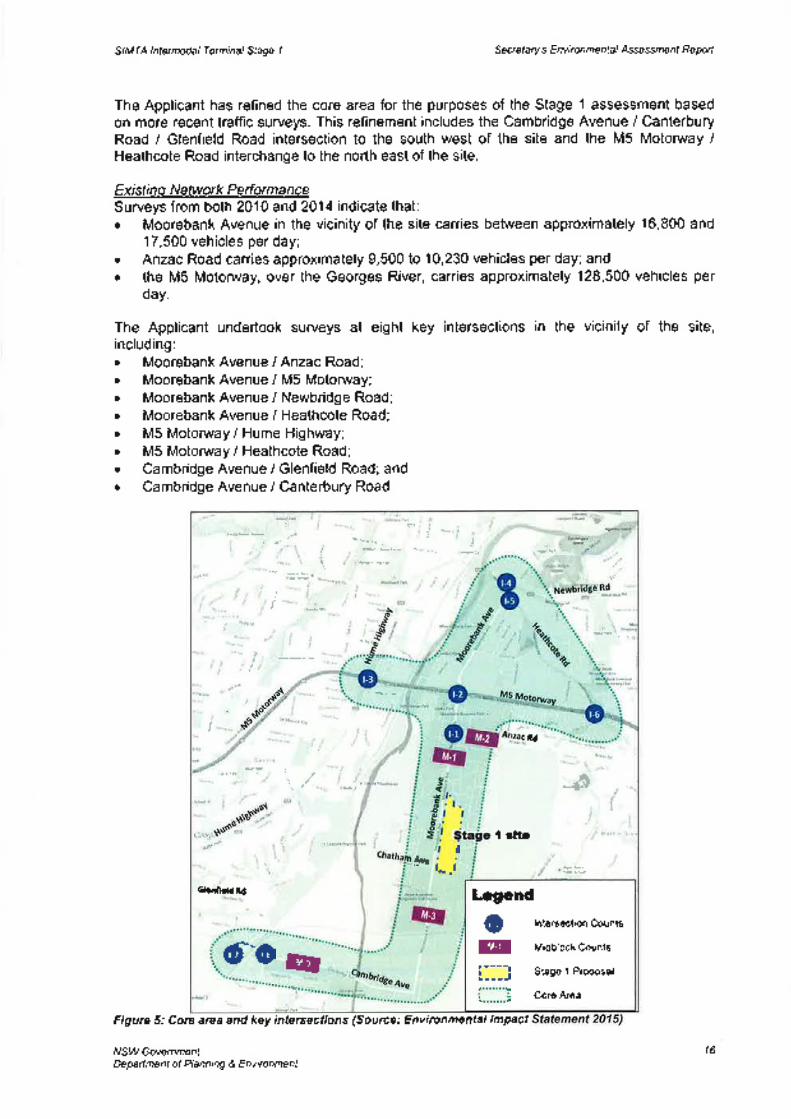
A 'core area' and 'inner area' were identified in the Traffic lmpact Assessment of the ConceptPlan, corresponding to the potential level of impact as a result of the proposal. The core areaincludes Moorebank Avenue between Cambridge Avenue and Newbridge Road, and the M5Motonruay between Heathcote Road and the Hume Highway. The inner area includes thearea generally bounded by Cambridge Avenue to the south, Heathcote Road to the east,Newbridge Road between Copeland Street and Nuwarra Road, the M5 Motonruay to thenorth-west and the Hume Highway to the west (refer Figure 5).
NSW GovernmentDepartment of Planning & Envìronment
15
SIMTA lntermodal Terminal Stage 1 Secretary's Environme ntal Assessmenf Reporf
The Applicant has refined the core area for the purposes of the Stage 1 assessment basedon more recent traffic surveys. This refinement includes the Cambridge Avenue / CanterburyRoad / Glenfield Road intersection to the south west of the site and the M5 Motonruay /Heathcote Road interchange to the north east of the site.
Existing Network PerformanceSurveys from both 2010 and 2014 indicate that:o Moorebank Avenue in the vicinity of the site carries between approximately 16,800 and
17,500 vehicles per day;. Anzac Road carries approximately 9,500 to 10,230 vehicles per day; and. the M5 Motonuay, overthe Georges River, carries approximately 128,500 vehicles per
day.
The Applicant undertook surveys at eight keyincluding:. MoorebankAvenuel Anzac Road;¡ Moorebank Avenue / M5 Motonruay;. Moorebank Avenue / Newbridge Road;. Moorebank Avenue / Heathcote Road;. M5 Motonruay / Hume Highway;. M5 Motonrvay / Heathcote Road;. Cambridge Avenue i Glenfield Road; and. Cambridge Avenue / Canterbury Road.
intersections in the vicinity of the site,
Figure 5: Core area and key intersections (Source: Environmental lmpact
NSW GovernmentDepañment of Planning & Environment
j
¡
tù'
iì
Í
t
q'l Ì'¡
:r
;¡r,\',r"- æo
@@i:::l
lntersect¡on Counts
Midblock Counts
Stage 1 Proposal
Core Area
Legend
I rlt¡
Gl¡rúietd Rd
d"@
nd
-&
åtrI
f-.t
@
16
SIMTA lntermodal Terminal Stage 1 Secretary's Environmental Assessmenf Reporf
Predicted Network PertormanceModels were developed to understand the 'base' and 'future year' traffic issues. During theConcept Plan stage, background traffic growth assumptions of between 1-1 .4% per annumup to 2031 were agreed with TfNSW and RMS. The average peak hour background growthof key intersections is between 1-1.9o/o. The Applicant has used 2016 as its forecast yeargiven that the terminal would be operational in late 2016 I early 2017.
lntersection performance without the proposal shows only a small difference in efficiency.The Moorebank Avenue / Newbridge Road intersection would worsen from LoS C to LoS E
in the AM peak. The Moorebank Avenue / Heathcote Road intersection would also worsenfrom LoS C to LoS D in the AM peak. ln the PM peak, the M5 Motonruay / Hume Highwayintersection would worsen from LoS C to LoS D, and the Moorebank Avenue / HeathcoteRoad intersection would worsen from LoS D to LoS E.
ln assessing the future case with the proposal, the Applicant assumes that the terminalwould generate 670 truck movements per day, or approximalely 25o/o of the movementsassumed under the Concept Plan (at full build). A maximum additional 80 employee carmovements per day are anticipated on the local road network during operation, or 2o/o of themovements assumed under the Concept Plan. The difference in this number is due to therebeing no warehousing proposed as part of this stage.
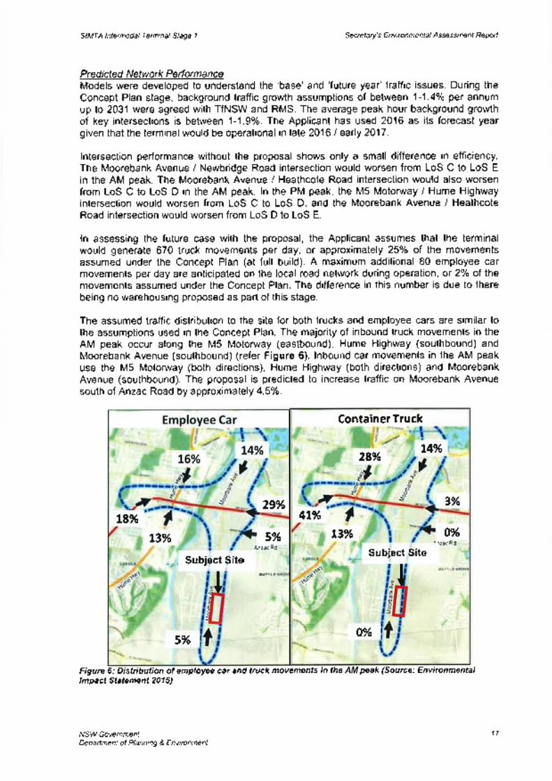
The assumed traffic distribution to the site for both trucks and employee cars are similar tothe assumptions used in the Concept Plan. The majority of inbound truck movements in theAM peak occur along the M5 Motoruuay (eastbound), Hume Highway (southbound) andMoorebank Avenue (southbound) (refer Figure 6). lnbound car movements in the AM peakuse the M5 Motonruay (both directions), Hume Highway (both directions) and MoorebankAvenue (southbound). The proposal is predicted to increase traffic on Moorebank Avenuesouth of Anzac Road by approximately 4.5%.
Figure 6: Distribution of employee car and truck movements in thelmpact Statement 2015)
NSW GovernmentDeparfment of Planning & Environment
ContainerTruck
4t%
',ì¿âc Rd
I 28%tI
o%,
€\
OYo
¡,
t4%
3%
,fiteSSubject
t3%
.- Subiect Site
I
t8%5%
AnræRdiÍrrrt
t\
s%
29%
t3%Ì
pe a k (Sou rce : Env i ron me ntal
17
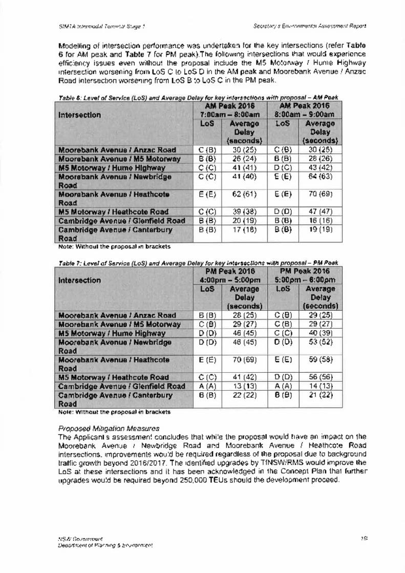
Table 6: Level of Service and A for intersections with
and A for intersections withTable 7: Level of Service
SIMTA Intermodal Terminal Stage 1 Se creta ry's E nv i ro n me nta I Assessmenf Reporf
Modelling of intersection performance was undertaken for the key intersections (refer Table6 for AM peak and Table 7 for PM peak).The following intersections that would experienceefficiency issues even without the proposal include the M5 Motonruay / Hume Highwayintersection worsening from LoS C to LoS D in the AM peak and Moorebank Avenue I AnzacRoad intersection worsening from LoS B to LoS C in the PM peak.
AM Peak 20167:00am - 8:00am
AM Peak 20168:00am - 9:00am
LoS AverageDelay
(seconds)
LoS AverageDelay
(seconds)
lntersection
30 (25)MoorebankAvenue I Anzac Road c (B) 30 (25) c (B)26 (24\ B (B) 28 (26\Moorebank Avenue / M5 Motorway B (B)
c (c) 41 Ø1\ D (C) 43 (42\M5 Motorway / Hume HighwayMoorebank Avenue / NewbridgeRoad
c (c) 41 (40) E (E) 64 (63)
70 (6e)Moorebank Avenue I HeathcoteRoad
E (E) 62 (61) E (E)
D (D) 47 (47\M5 Motonray / Heathcote Road c (c) 3e (38)B (B) 20 (19) B (B) 16 (16)Gambridge Avenue / Glenfield Road
Cambridge Avenue / GanterburyRoad
B (B) 17 (18) B (B) 1e (1e)
Note: Without the proposal in brackets
PM Peak 20164:00pm - 5:00pm
PM Peak 20165:00pm - 6:00pm
LoS AverageDelay
(seconds)
LoS AverageDelay
(seconds)
lntersection
29 (25\MoorebankAvenue I Anzac Road B (B) 28 (25\ c (B)c (B) 29 (27\Moorebank Avenue / M5 Motorway C (B) 2e (27)
D (D) 46 Ø5\ c (c) 40 (3e)M5 Motorway / Hume HighwayD (D) 46 (45) D (D) 53 (52)Moorebank Avenue / Newbridge
RoadMoorebank Avenue / HeathcoteRoad
E (E) 70 (6e) E (E) 5e (58)
D (D) 56 (56)M5 Motonray I Heathcote Road c (c) 41 (42)A (A) 13 (13) A (A) 14 (13\Gambridge Avenue / Glenfield RoadB (B) 22 (22) B (B) 21 (22)Cambridge Avenue / Ganterbury
RoadNote: Without the proposal in brackets
Proposed Mitigation MeasuresThe Applicant's assessment concludes that while the proposal would have an impact on theMoorebank Avenue / Newbridge Road and Moorebank Avenue / Heathcote Roadintersections, improvements would be required regardless of the proposal due to backgroundtraffic growth beyond 201612017. The identified upgrades by TfNSW/RMS would improve theLoS at these intersections and it has been acknowledged in the Concept Plan that furtherupgrades would be required beyond 250,000 TEUs should the development proceed.
NSW GovernmentDepaftment of Planning & Environment
- AM Peak
- PM Peak
1B
SIMTA lntermodal Terminal Stage I Secretary's E nviro nme ntal Assessmenf Reporf
Department's Considerat¡on
The Department recognised that traffic is the key issue for the proposal, particularly given apotential second intermodal on the adjacent MIC site and the subsequent cumulativeimpacts.
For the Department's assessment of the Concept Plan, Aurecon Australia Pty Ltd (Aurecon)was engaged to assist in its assessment of traffic and transport related matters for theproposal. At the time of this assessment, the Department and Aurecon acknowledged thatincreases in background traffic growth without the proposal would result in a number ofintersections (and individual movements) operating at LoS F by 2031. Both the Departmentand Aurecon were however satisfied that the Applicant had adopted a reasonable approachto address traffic impacts at a Concept level, which included staging intersection upgradesdepending on TEU throughput.
The Concept Plan approval included future assessment requirements requiring the Applicantto consult with TfNSW/RMS prior to the submission of any Development Application forsubsequent stages. Since the Commission granted Concept Approval in September 2014,TfNSW and RMS have been developing a mesoscopic and microsimulation transport modelfor the combined MIC/SIMTA intermodal facility. On 10 December 2015, the Departmentconfirmed with RMS that this work is expected to be completed by the end of December2015 and will form the basis for Traffic lmpact Assessments for each subsequent stage ofdevelopment (for both the SIMTA and MIC projects). The Department is advised that thismodel will allow the nature and timing of proposed intersection upgrades to be moreaccurately calculated for subsequent Development Applications.
Notwithstanding, Stage 1 proposes to handle up to 250,000 TEUs per annum, which apartfrom a new signalised entrance to the terminal site from Moorebank Avenue would not triggerthe need for any infrastructure/road upgrades. The Department accepts this position giventhat the predicted impacts on the efficiency of key intersections are not considered to besignificant for this stage. The Department understands that through consultation withTfNSW/RMS in developing the EIS for Stage 1, specific upgrades to intersections wereidentified, however these upgrades are not proposed as part of Stage 1.
The Department also acknowledges that Stage 1 is consistent with the Commission'sdetermination of the Concept Plan, as the instrument requires Stage 1 to be operational (sothat traffic impacts can be monitored) prior to seeking approval of subsequent DevelopmentApplication for Stage 2 (for an additional 250,000 TEUs). ln this regard, the Department hasrecommended a condition of approval requiring the Applicant to monitor vehicle andcontainer movements once the site is operational. This will provide the Applicant, TfNSW andRMS with an opportunity to monitor the network performance and provide more certainty forsubsequent Traffic I mpact Assessments.
The Department has also considered the cumulative impacts of the proposal with theneighbouring MIC site. The Department is satisfied that impacts would not exceed thosepredicted. This was based on the total throughput being shared across both sites due to railcapacity constraints. Further, given the intended timing of development of both sites, it isanticipated that Stage 1 would be under construction/operational during the Early Worksphase of the MIC site. The Department considers that the cumulative impacts of Stage 1 andthe MIC site would not result in an unacceptable impact on the road network.
RailAt the time of the Concept Plan assessment, the Department, in consultation with ARTCnoted that upgrades to the existing SSFL network would be required to ensure sufficientcapacity is available for when operational throughput capacity of 1 million TEUs is reached.The Department also consulted with ARTC during its assessment of the MIC Staged SSD
NSW GovernmentDepartment of Planning & Environment
19

SIMTA Intermodal Terminal Stage 1 Secretary's Environmental Assessmenf Reporf
and was advised that the intermodal terminals have been included in its assumptions forestimating available train paths in draft strategic documents. Given that the subject Stage 1
proposal proposes to handle 250,000 TEUs annually, the SSFL is considered to havesufficient capacity to accommodate the proposal.
The alignment of the rail link between the site and the Glenfield Waste Facility has beenrevised in the RtS due to objections raised by TfNSW with regards to the sharing of the EastHills Passenger Line (EHPL). As a result, the Department acknowledges the new alignmentwould not impact on the EHPL corridor.
Public TransportThe Department acknowledges TfNSW's request for the provision of a future bus stop onMoorebank Avenue adjacent to the terminal site, which would accommodate an extendedRoute 901 bus service. While the Department acknowledges the benefits of this request, dueto the limited number of employees at the site it would be unreasonable to recommend thisbe a condition at this stage. However, the Department has recommended a conditionrequiring the design of the site to not preclude the future provision of a bus stop (includingturn-around facility) for future stages.
ConclusionThe Department is satisfied that the construction and operation of Stage 1 would not result inan unreasonable impact on the efficiency of the local and regional road network. The designof the access points from Moorebank Avenue would operate at an acceptable LoS, ensureheavy vehicles are unable to use Moorebank Avenue (south) and prevent queuing of heavyvehicles onto Moorebank Avenue would be prevented.
Further, the Department considers construction related traffic impacts can be adequatelymanaged subject to recommended conditions requiring the preparation and implementationof relevant construction management plans.
5.2. Air QualityAir quality impacts during construction and operation of the proposal was a key issue raisedby local Councils, government agencies and in public submissions. ln its assessment, theDepartment has taken into account both the potential impacts arising from the proposal, andthe cumulative impacts should SIMTA and MIC operate concurrently.
The Applicant prepared an Air Quality lmpact Assessment which the EPA considers to havebeen conducted in accordance willt Approved Methods for Modelling and Assessment of AirPollutants /n NSl4/(DEC 2005). Sensitive receptors are shown in Figure 7.
ConstructionConstruction air quality impacts relate to airborne dust which would be managed under theProtection of the Environment Operations Act 1997 (administered by the EPA) and through aConstruction Environmental Management Plan.
The EPA raised concern over the potential impacts on the Glenfield Waste Facility duringconstruction, particularly the possible release of odours and uncontrolled landfill gasemissions during construction of the rail link. ln response, conditions of consent have beenrecommended requiring: a detailed impact assessment for the Glenfield Waste Facility;construction drawings to be reviewed by the EPA; and the preparation and implementation ofa construction and operational Air Quality Management Plan.
NSW GovernmentDeparlment of Planning & Environment
20
LZ,
Juewuort\uf g duluued lo luowyedeoluewura^o9 /lAsN
'eroz alBl ur eoJB uElrlodoJlerlloL{} ur oro/v\ }eL[ saruqsnq o] pe]nqu]]e oJo/v\ secuepeecxe eseql 'eur/6r109 Jo lPo6aOeJêAe Jnot4 ÞZ êql lsurpôe pepJoceJ aro/v\ sacuepsecxe Jour,u Je^e/v\or.l '0ry\d roJ lotri se/v\
,u¡6rlgg ¡o Á¡¡¡enb Jre lecol ro¡ ¡eoô ôuryoder eôerene lenuue s,Vdf oql 'Blep stql uo poseg
'lueussesse oql ur osn Jo] loselep e^rlenJesuoc alqelrns e aprnord ol porsprsuoc se/v\ uorlelsstql se 'ezy1d pue or^a '"ON.¡o] uotlels ¡oodlenrl HfO aql uoJJ pouretqo se/v\ Blep eurloseg
'(-Oru) soprxo ueôo.r¡ru pue (y1d) re¡eru e¡e¡ncr¡red euJoqJreopnlcur lsneqxe eur6ue lesorp ur peseoloJ s¡ue¡n¡¡od oql 'luor.udrnbe JoLllo pue 'solcrqon,{neeq 'sonrloruoool loserp Jo esn eql uroJl etüoc plno/v\ s¡cedut ¡tllenb rte ¡euot¡eredg
Wtrcr-oTO
G tOZ Stl :actnog) sto¡daca¿ o .r¡.rsuas Jo uoflecol : ¿ an6¡7lull llEU
-EeiV laÐrËrðdg I "oqS Ee+¡V uor¡¡rusuoC l---l
FUno{ùloC uorpnilîlÐ3 EtuqtBão1 /ûtdæáu äñ¡¡lÉuâs paFâÊs; LJ
rl!r:i I rlnJ ¡srFS,
Ftc,jr¿ ! iúarJ: i rurìj lr0!^ riitr
I ¡' .r ' | :iì ¡ , ¡¡ ¡ f,r'rrr¡6t, ,
I ,. I r 1ì 'qr! I :¡,¡ r¡rrit¡ ¡
i-¡,t. i¡ir¡-, r !.,! rrrnl¡i Ir'lr l'!' "l rrk.,,,.,_f,,al,{.rq,
pl€4r: 1 i ¡r,\i tsÞrr ,qu/Pf
¡ ¡rrr¡rrJ.rrl'L¡rlo,ù¡¡u rtt ¡-r:r'
¡"'r,c àFt!'^ Lrr- !,'ij rÈ¡rt
'..,9 trt)r¡,, rI ir,.,¡ ' l rtr, . - l:r ,è ¡¡iqrt<
lrL(¡,s rlr tr ù. ,i{rrrr r¡r r¡r
åfl
!!rLlrs ¡rrt Jt <l pre l realìrr i/l
' lr'r(¡ ,: r \, I ,i,,:l r:.trr ¡¡t
å,=r' . u*1., ¿ô€ li:r :D¡rl tt,su ¡! r lr r I ,l¡.ti ¡ | ¡,.r'r ir!t ù ¡ir,i:,,, rir'/l
:i f rr ]t I.1, , ,: 'r - !r!_'t_jiictlirI
't l ilÍ 4F :ii ¡¡¡t lt ¡q ¡fr ì ir¡l:-! i'.iì i:oJ:,tLrillEr9€:r
r :É' I ; .¿r1: :,!ún'lr! r(t : ulr.il ¿"fl
r.{r- }r.l ¡tiÉ ¡\ r:¿ui , , j,r [1.t.ì |,,¡¿t d ¿,,q
rrÈ' |
- trrr,¡. irl | .: r.J J
r n.r I .r ! ,< , r1¡rrr¡1 | tr "'', ri, , ì.,jr | Ár ,t l', , ì '.o,,j 'ilt,,t., ,,r|l , , ^,r
LH 1i,.|",ì r!
€ ll!.-' l l;)ç: a pri''!\'J!€l
r - 1.6 '11,¡, r,,r', ¡
f$rr- l-F .l 1s
, "",.' t""nr,'&'
S:""'¡ ìII¡raì:c¡L!
.lr
{ D¡! atr-
lv, r.ì r'rtr d ì-,,¡,,ri,,.:,,¡rl
lt,!
l¡!.;h : rrr ' tóo.?s ]tìqúó rcrxli.:r ì
t
yode¿ ¡uewssessv pluowud!^u3 s,fue¡etceg ¡ e6e¡¡ pulwß! ppowraq VtWtS
SIMTA lntermodal Terminal Stage I Secretary's Environmental Assessmenf Report
ln considering the annual average and 24 hour average concentrations for PMz.s, minorexceedances of the National Environment Protection Measure (NEPM) were recorded. Thiswas also attributable to bushfires in the region. However, taking into account the annualaverage readings between 2005 and 2014, the advisory goal was met. lt should be notedthat the PMz s is an advisory goal and not a reporting goal.
The EIS reports that an assessment of the local air quality impacts for residents in WattleGrove, Moorebank, Casula and Glenfield reveals the following:. there would be no exceedances of the reporting goal or advisory goal for the PMro or
PM2.5 corìcentrations, consistent with the Approved Methods for Modelling (OEH 2005);¡ maximum hourly NOz concentrations at the nearest residential receptors are predicted
to be up to 102.3p9/m', which compares favourably to an ambient air quality standardin the area of 246pgm3 (1 hour maximum); and
. annual average NOz concentrations are predicted to be up to 27.8¡tglm3, whichcompares favourably to an ambient air quality standard of 62¡rgm3.
In summary, the Applicant predicts the overall impact on air quality to be minor consideringthe predictions are well below the impact assessment criteria. While the EPA considers theoutcomes of the assessment to be plausible, a number of conditions have beenrecommended relating to the implementation of best practice container handling equipment.
Department's GonsiderationThe Department acknowledges the EPA's concerns regarding the construction of the rail linkacross the Glenfield Waste Facility and considers the recommended conditions that requirebest practice operations, which would also contribute to improving air quality, to beappropriate in this case. Additionally, the Department considers that the proposed mitigationmeasures to be employed during construction are reasonable.
During operation, a number of mitigation measures are proposed, including implementationof a vehicle booking system and anti-idle policy, use of an electric locomotive shifter, reachstackers (when procured) to meet US EPA Tier 3/Euro Stage lllA standards and use ofelectric gantry cranes (within 7 years or 250,000 TEUs whoever comes first). TheDepartment notes that proposed measures to mitigate noise impacts would also have apositive effect on air quality such as the possible use of electric motors rather than dieselpowered equipment on site.
The Department understands current health advice that there is no established threshold forfine particles below which there are no health effects. lt is noted that relevant reportingcriteria for PM2 5 would be met for Stage 1 . The Department's recommended conditionsreflect the NSW Health submission and require the implementation of best practice containerhandling equipment and locomotives.
The Department also concludes that the cumulative impact for both the SIMTA and MIC sitesis unlikely to result in additional impact when compared to only one of the proposalsproceeding.
5.3. NoiseA Noise and Vibration lmpact Assessment was conducted by the Applicant. The assessmentconsidered potential impacts of all onsite noise and vibration sources on the closestresidential areas and other sensitive land uses. The assessment was conducted in
accordance with the NSt4/ lndustrial Norse Policy (EPA), Assessrng Vibration: A TechnicalGuideline (DEC), NSt/y Road Norse Policy (EPA), the Rail lnfrastructure Norse Guideline(EPA) and lnterim Construction Norse Guidelines (DECC). The assessment identified noiseand vibration impacts due to construction and operation of the project and includedconsideration of road traffic noise and rail noise. Cumulative impacts associated with the MICsite have been also included in this assessment.
NSW GovernmentDepartment of Planning & Environment
22
SIMTA lntermodal Terminal Stage 1 Secretary's E nvi ronme ntal,Assessmenf Reporf
The closest residential properties (receivers) were identified to be located within four mainareas, as shown in Figure 8, as follows:. NCAI - between 600 metres and 770 metres to the east in Wattle Grove (south of
Anzac Road);. NCA2 - between 900 metres and 1.9 kilometres to the east in Wattle Grove (north of
Anzac Road);. NCA3 - between 200 metres and 960 metres to the west in Casula; and. NCA 4 - between 750 metres and 1.7 kilometres to the south-west in Glenfield.
Three other sensitive land uses were identified, including All Saints Senior College (denotedas 51), Casula Powerhouse (denoted as 52) and the DNSDC re-location site (denoted ast1).
The noise and vibration criteria were established under the lndustrial Noise Policy (lNP) aspart of the EIS for the Concept Plan. The INP recommends two sets of criteria, being'intrusiveness' and 'amenity' for the assessment of operational noise. Refer Table 1 andTable 2 of Appendix C. Additionally, sleep disturbance noise goals are provided in Table 4of Appendix C.
Figure 8: Receiver Environmental lmpact 201
Construction NorseThe modelling undertaken considers 5 key construction phases: site preparation; earthworks,drainage and utilities installations; engineering fill; concrete construction and rail alignmentconstruction; and miscellaneous structural construction, utilities, crane installation,commissioning and finishing.
Noise emission levels from the typical equipment that is likely to be used in each phase havebeen considered to determine the most noise intensive plant and machinery sound powerlevels (SWL). These noise levels have been refined from the Concept Plan assessment asmore detailed information is now available regarding the plant and equipment to be used.Modelling was conducted to determine the predicted SWLs at each sensitive receiverlocation and a comparison against the relevant noise goals. The results of this comparison
NSW GovernmentDepaftment of Planning & Environment
- CorEEucñon CompounG
. Operafþnal Area
slMïA Sitec' Coßùucdoí Areæ
- Rail lJnk_
NCA1. NCA2
- NCA3
NCA.I
-Sl*52-lL
Où 0-4 0-t 12kn
¡sp lñ{q: Ew lP¡
23
SIMTA lntermodal Terminal Stage 1 Secre ta ry's E nvi ron me nt a I Assessmenf Reporf
indicate that construction noise levels are predicted to comply with the noise managementlevels at all locations.
ln relation to construction vibration, no human comfort impacts were identified. A program ofconstruction noise and vibration monitor¡ng would be developed for the project and includedin the Construction Noise and Vibration Management Plan.
Operational NoiseDuring operation of the proposal, noise sources are expected to include the use ofequipment for moving containers on-site, warehousing activities and noise generated bytruck and train movements on-site and within the rail corridor. lt is noted that the site wouldoperate 24 hours per day. The predicted operational noise sources and levels are provided inTable 8.
Table I /\lorse Sources
Modelling was undertaken to determine receiver noise levels (amenity and intrusive) duringoperation of the proposal under the lNP. The results in Table 9 and Table 10 demonstratethat operational noise levels are predicted to comply with the established worslcase criteriaat all sensitive receivers at all times.
Table 9 Predicted Ameni onal Noise Levels
Table 10 Predicted lntrusive Noise Levels
Adverse m
ln assessing sleep disturbance impacts, the Applicant has determined that the most likelynoise source from operations would be 'banging' noises associated with the handling ofcontainers which has a predicted SWL of up to 118 dBA. The predictions indicate La."" noiselevels at all receivers to be less than the sleep disturbance screening levels and as such, nofurther assessment has been undertaken (Table 1l).
NSW GovernmentDepartment of Planning & Envíronment
Source SWL (dBA'106Reach stacker - diesel
Truck - idlinq 95103Truck - l0km/h
Locomotive - idlinq 100106Locomotive - lOkmlh
Locomotive shifter 95
Predicted Lreq, per¡od
Noise Level (dBA)Griteria(dBA)
Complies?Receiver
YesNCAl 33 4045 YesNCA2 2040 YesNCA3 33
YesNCA4 25 40Yesst 32 45
45 Yess2 29t1 26 60 Yes
Griteria Gomplies?Receiver Predicted L¡sq, rsmrn
Noise Level (dBA)*YesNCAl 39 42YesNCA2 24 41
39 YesNCA3 38YesNCA4 31 42
24
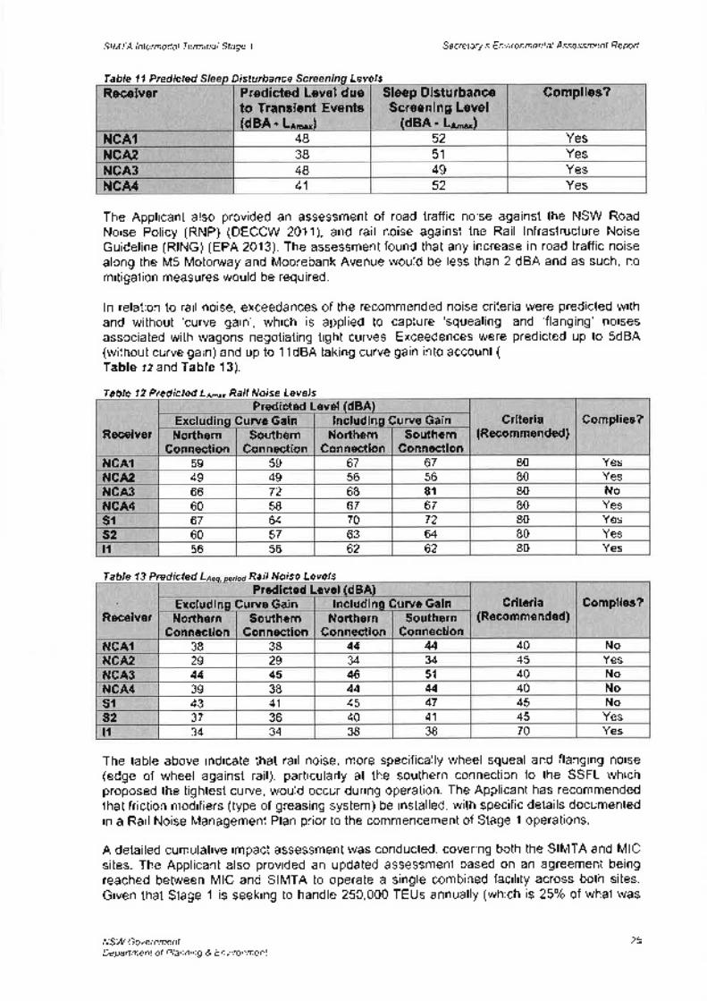
Sleep DisturbanceScreening Level
(dBA - L¡-")
Gomplies?Receiver Predicted Level dueto Transient Events(dBA' Ln-"')
48 52 YesNCAIYesNCA2 38 51YesNCA3 48 49
52 YesNGA4 41
SIMTA lntermodal Terminal Sfage I Secreta ry's E nvi ro n me ntal Assessmenf Report
Table 11 Predicted Disturbance Levels
The Applicant also provided an assessment of road traffic noise against the NSW RoadNoise Policy (RNP) (DECCW 2011), and rail noise aga¡nst the Rail lnfrastructure NoiseGuideline (RING) (EPA 2013). The assessment found that any increase in road traffic noisealong the M5 Motonruay and Moorebank Avenue would be less than 2 dBA and as such, nomitigation measures would be required.
ln relation to rail noise, exceedances of the recommended noise criteria were predicted withand without 'curve gain', which is applied to capture 'squealing' and 'flanging' noisesassociated with wagons negotiating tight curves. Exceedences were predicted up to SdBA(without curve gain) and up to 11dBA taking curve gain into account (
Table tz and Table 13).
Table 12 Predicted La-", Raíl Norse Levels
Table 13 Predicted RarT Norse Levels
The table above indicate that rail noise, more specifically wheel squeal and flanging noise(edge of wheel against rail), particularly at the southern connection to the SSFL whichproposed the tightest curve, would occur during operation. The Applicani has recommendedthat friction modifiers (type of greasing system) be installed, with specific details documentedin a Rail Noise Management Plan prior to the commencement of Stage 1 operations.
A detailed cumulative impact assessment was conducted, covering both the SIMTA and MICsites. The Applicant also provided an updated assessment based on an agreement beingreached between MIC and SIMTA to operate a single combined facility across both sites.Given that Stage '1 is seeking to handle 250,000 TEUs annually (which is 25o/o of what was
NSW GovernmentDepañment of Planning & Environment
Predicted Level(dBAlncludinq Gurve Gainrve Gain Griteria
(Recommended)Complies?
Receiver NorthernGonnection
SouthernGonnection
NorthernGonnection
SouthernConnection
67 80 YesNCAl 59 59 67YesNCA2 49 49 56 56 80
8l 80 NoNCA3 66 72 68Yes60 58 67 67 80NCA4
72 80 Yessl 67 64 70Yes60 57 63 64 80s2
62 80 Yesl1 56 56 62
Predicted Level(dBA)Excludinq Gurve Gain lncludins Curve Gain
NorthernGonnection
SouthernGonnection
Griteria(Recommended)
Complies?Receiver Northern
GonnectionSouthern
Gonnection40 NoNCAI 38 38 44 44
34 34 45 YesNCA2 29 2940 NoNCA3 44 45 46 51
44 44 40 NoNCA4 39 3845 Nosr 43 41 45 47
36 40 41 45 Yess2 3738 70 Yest1 34 34 38
)6

SIMTA lntermodal Terminal Stage 1 Secretary's Environmental Assessmenl Reporf
sought under the Concept Plan), this has concluded that both construction and operationalnoise levels comply with the relevant amenity criteria.
Submissions received from TfNSW, EPA, and Liverpool City Council raised the followingissues relating to operational noise:. only modern rolling stock that incorporate low noise locomotives, steering bogies and
permanently coupled wagons should be allowed access to the site;¡ need to address sleep disturbance impacts;. rail curve should be designed to avoid curve radii of less than 500 metres to prevent
wheel squeal;o use of rail lubrication and top-of-rail friction modifiers to mitigate wheel squeal;. the need to use best practice plant and equipment including automated container
handling equipment and non-tonal reversing alarms;. noise relating to the SSFL should be quantified;
Departme nt's Cons iderati onThe Noise and Vibration lmpact Assessment demonstrates that no exceedances of noisemanagement levels in the construction phase would occur. Notwithstanding, the Departmentconsiders that appropriate mitigation measures are also available to address any potentialconstruction noise impacts such as the use of temporary noise barriers, use of silencers onmachinery and provision of respite periods. The Department also notes that theseconstruction works would be of a temporary nature.
ln relation to the operational phase, the Department acknowledges that noise impacts mayoriginate from: the IMEX terminal; and the rail link connection to the SSFL. lt is noted that theApplicant predicts that the operation of the terminal would comply with relevant noise goals.With regard to the rail link, exceedances have been predicted by up to 11 dBA (includingcurve gain). Based on modelling results, these exceedances would generally occur at WattleGrove, Glenfield and Casula.
The Department understands that wheel squeal is known to occur where curve radii is <300metres. However it is also highly likely to occur with a curve radii of between 300 and 500metres, particularly for older rolling stock without cross braced bogies (wheel sets). TheDepartment has been advised that the smallest curve radius of the tie in to the existing SSFLis approximately 160 metres and as such, there is potential for wheel squeal to occur.
The Department notes the operational noise mitigation measures proposed by the Applicant,including the use of friction modifiers and track grinding (to mitigate wheel squeal), and thepreparation and implementation of a Rail Noise Management Plan and OperationalEnvironmental Management Plan (including requiring container handling equipment to befitted with broadband reversing alarms rather than traditional 'quacker' type alarms). TheDepartment also notes a number of other measures identified in the Best Practice Review,such as 'Gen-set' locomotives, permanently coupled wagons with braced bogies, real timenoise monitoring and hybrid container handling equipment, were either not consideredappropriate for Stage 1 operations or not considered appropriate for any stage by theApplicant.
The Department considers that it would be desirable to implement hybrid/electric containerhandling equipment for Stage 1, however the Applicant has argued that it is not warranted forthis stage due to the relatively limited throughput of containers and lengthy procurementprocess for new equipment. While this position is acknowledged, the Department hasrecommended a condition requiring all new container handling equipment purchased after2019 to meet US EPA Tier 4 or EU Stage lV emission standards. Additionally, this matter willalso need to be considered in subsequent Development Applications to ensure this can bereviewed for future stages, consistent with the Applicant's Best Practice Review.
NSW GovernmentDepañment of Planning & Environment
26
SIMTA lntermodal Terminal Stage 1 Secretary's Environmental Ássessmenf Reporf
However, given the proximity of this new rail connection to residents at Casula and Glenfield,the Department has also considered the predicted impacts from the rail link in the context offeasible and reasonable best practice mitigation measures such as locomotives and wagonsemploying available best practice technologies, and real time noise montioring. TheDepartment considers that with the implementation of appropriate measures, ¡mpacts can bemitigated.
A concern raised by Councils, agencies and residents related to the noise impactsassociated with increased traffic on the SSFL. The Department considers that any increasein rail traffic would come under the existing approval (including noise limits) for the SSFL.ARTC have indicated that the proposed intermodal terminals have been included in itsassumptions for estimating available train paths on the SSFL and noise concerns as a resultof these additional movements have not been raised as a key concern.
The Department also concludes that the cumulative impact for both the SIMTA and MIC sitesis unlikely to result in additional impact when compared to only one of the proposalsproceeding.
The Department is satisfied that with the implementation of recommended mitigationmeasures and conditions, the construction and operation of Stage 1 would not detrimentallyimpact upon the amenity of residents in Wattle Grove, Casula and Glenfield.
5.4. GontaminationContamination concerns have been raised as an issue during the demolition, constructionand operational stages of the proposal.
The Proponent prepared a Preliminary Environmental Site Assessment (Preliminary ESA) ofthe SIMTA site and rail corridor land and a Phase 1 Environmental Site Assessment (ESA) ofthe rail corridor land in addition of a review of previous site investigations to support theConcept Plan for the site and the rail corridor. While, the Preliminary ESA concluded thatcontamination concerns would not preclude the proposed development, further Phase 2intrusive investigations of the areas identified as Areas of Environmental Concern (AEC) wasundertaken.
Operational AreaThe Stage 1 Operational area currently comprises roads, enclosed warehouses, an openstorage area, a refuelling station, administration buildings and car parking. Fuel storage anddispensing facilities are also located on the site and comprise five underground storage tanks(USTs). A canopied fuel dispensing service with several fuel bowsers is also located on thesite, along with remote fill points for the USTs, additional bowsers, buildings used for storageof Dangerous Goods and a building previously used for meat storage.
Contaminations of potential concerns that have been identified on site include: metals,asbestos, organo-chloro pesticides, herbicides, total petroleum hydrocarbons (ïPH),Benzene, toluene, ethylbenzene, and xylenes (BTEX), polycyclic aromatic hydrocarbons(PAHs), volatile organic compounds (VOCs), semi-volatile organic compounds (SVOCs) andPhenols.
Rail CorridorFive areas within the rail corridor have been identified as containing contaminated materialare described below and shown in Figure 9.. Area 1 - Defence National Storage and Distribution Centre - south
This area is currently grassed and sparsely treed. lt is reported through historicinformation notes that landfilling may have occurred in this area and illegally dumpedbuilding waste materials have been observed. ln addition, it has also been identified as
NSW GovernmentDepartment of Plann¡ng & Environment
27

o
a
a
SIMTA lntermodal Terminal Stage 1 Secretary's Environmental Assessmenf Reporf
an area where potential unexploded ordnance (UXO), associated with the formergrenade range may exist.
Area 2 - Southern Boot LandThis land is largely bushland, with a narrow cleared area for a fire trail and overheadpowerline corridor. Evidence has been identified of minor waste materials, includingrusting drums within the area.
Area3-RailcorplandThis land is located to the south of the Southern Boot Land and adjoins the East HillsRail Corridor. A shipping container and demountable office exist on the site. Evidenceof dumping of construction waste and illegal dumping of household waste exists. lt isreported that at least one fragment of suspected asbestos containing material (ACM)was observed in the area during the preliminary inspection.
Area 4 - Golf Course (Southern part of the MIC site)The southern part of the golf course comprises an open, grassed area with scatteredtrees. The area was identified as an AEC in the 2013 investigations due to its previoususe for defence purposes including development of a mock Viet Cong village.
The further Phase 2 ESA noted that artefact finds with the land were explosive ordnancewaste (EOW). All detected items have since been confirmed as inert and based onspecialist advice both the MIC site and the golf course land has a very low potential tocontain remnant UXO or EOW containing high explosive or other energetic material.
a Area 5 - Glenfield Waste FacilityIt is proposed that the rail link through the Glenfield Waste Facility will follow theconstructed levee that follows the eastern boundary of the site, and passing the east ofthe leachate dam. The rail link would then proceed over high ground which has beenformed from natural in situ material and excavated and tipped spoil material. The raillink would then divide and pass an active quarry section to the west and to the northpass adjacent to a stormwater basin.
Contaminants of potential concern in these areas that have been identified include: UXO,Explosive ordnance waste (EOW), Explosive residues, Metals, TPH, BTEX, PAHs,Phenolics, Organo-chloro pesticides (OCP), Polychlorinated buphenyls (PCB), Asbestos,VOCs, herbicides and Landfill Gases.
NSW GovernmentDepaftment of Planning & Environment
2B
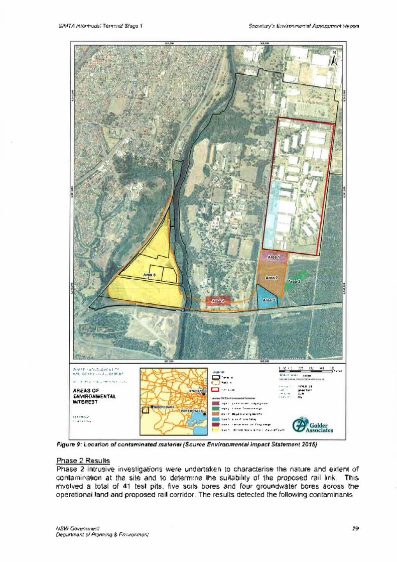
SIMTA lntermodal Terminal Stage 1 Se cretary's E nv i ro n me nta I Assessrnen¡ Reporf
Figure 9: Location of contaminated material (Source Environmental lmpact Statement 2015)
Phase 2 ResultsPhase 2 intrusive investigations were undertaken to characterise the nature and extent ofcontamination at the site and to determine the suitability of the proposed rail link. Thisinvolved a total of 41 test pits, five soils bores and four groundwater bores across theoperational land and proposed rail corridor. The results detected the following contaminants:
NSW GovernmentDeparfment of Planning & Environment
I ñee 1 -Unåutho¡sd Duryh9Æ6a
I Ae. z - Fqn6r Gråndè Rãnw
ffi *ea z ilþgd Dmphg &ilrred
E Æea 3 -Aree or Land F¡|ry
I Æea a - Fdmer uock vÈl coq vlhç
E Æeã 5 - cþn[dd ouary & Wåsle t{6d Fadlily
SALE (I A¡'
0 55 t10 220 330 440 550nêt6L€g€nd
E[-,r'9OCKúNO DEVFI OPUENIS PIY LTO
AREAS OFENVIRONMENTALINTEREST
COPYRIGHT
PHASE 1 ASSESSI¡ENT OFRAIL CORRIDOR ALLOIMENI
ROJECIOAIE
CHECKED
l0?62¡ lat26t00t2011
GS
AGa4
29
a
SIMTA lntermodal Terminal Stage 1 Secretary's Environmental Assessmenf Reporf
Bonded Asbestos Containing MaterialACM was identified on the ground surface of Building 811 (which is located in
operational area of the site), which was assumed to be related to degrading or historicalbuilding materials. ACM detected in fill at a test pit on the golf course site was possiblyrelated to historic burials or fillings activities.
Hydrocarbon impacts soils and Light Non-Aqueous Phase Liquid (LNAPL)LNAPLs were detected in groundwater surrounding the USTs and is most likely a resultof historical leaks during refuelling activities. These impacts on groundwater indicatethat it is likely that the soil surrounding the fuel storage and distribution infrastructure hasalso been impacted by hydrocarbons.
a Heavy metal impacted soilsSeveral samples in the Operational site and the golf course contained concentrations ofexceeding the adopted heavy metal ecological criteria for commercial/ industrial land.
a
NSW GovernmentDepartment of Planning & Environment
. Railcorp LandIt is reported that access to the Railcorp land was not available and as such there maybe potential for unidentified contamination risks. Typical rail-related contaminants ofpotential concern (COPC) in fill materials include heavy metals, asbestos, TPH, PAHs,phenols and OCPs.
The results, although detecting contaminants, were found to be at levels generally below theadopted assessment criteria. As such, the investigations determined that the site is suitablefor ongoing commercial/ industrial use, subject to the implementation of a Remedial ActionPlan (RAP). The findings also concluded that there was no noted gross or widespreadcontamination that would unreasonably restrict development and use of the site.
Since the Phase 2 investigations, the alignment of the rail link has been amended. lntrusiveinvestigations have not been undertaken within this amended area, which is Commonwealthowned land. The Applicant has stated that the area is likely to be in a similar condition to theSouthern Boot Land. The Applicant has proposed and the Department has included into therecommended conditions of approval that appropriate soil and groundwater investigationsare undertaken in this area prior to commencement of any development works.
With regard to the alignment of the rail link through the Glenfield Waste Facility, the EPA hasraised concern that it has not been clearly demonstrated that the construction and operationof this rail link will not compromise the effectiveness of the landfill pollution control,monitoring systems, gas and leachate controls.
Specific concerns raised by the EPA include:. Asbestos - it is likely that Glenfield Waste Facility has buried asbestos within the landfill
cells. The locations of asbestos are not recorded and potential excavation couldencounter and liberate this contaminant.
. Leachate - if a landfill cap is compromised and leachate volumes rise this can impact onsurrounding groundwater and gas production.
. Gas - the impacts of movement, accumulation or release of landfill gases have not beenadequately addressed.
. Exhumed Waste - waste exhumation is prohibited under the existing landfill licence.
. Contaminated Stockpiles - stockpiling of contaminated water piles would not besupported.
. Monitoring Points - the integrity of and access to monitoring points on the landfill siteneeds to be maintained.
30
SIMTA lntermodal Terminal Stage 1 Secretary's Environmental Assessøenf Reporf
As such, the EPA has recommended a series of conditions to ensure that construction andoperation of the rail link would not impact on the existing landfill site. The Department hasincluded these conditions in the recommended conditions of approval.
Department's GonsiderationThe Department notes that the highest risk of exposure to contaminants would occur whenground or groundwater disturbance during excavation occurs. ln particular, it is noted that theEPA raise concern over the routing of the rail link over the Glenfield Waste Facility, andsought assurances that the construction and operation of this rail link will not compromise theeffectiveness of the landfill pollution control, monitoring systems, gas and leachate controls.
It is noted that the disturbance to contaminated material associated with excavation forconstruction would provide opportunities for the release and movements of contaminates,posing a potential risk to human and ecological health. Construction activities may alsocause contamination risks if not managed appropriately.
As ACM has been identified as existing on site, the Applicant has proposed that the soilsimpacted, specifically at the golf course, be excavated and disposed of prior to thecommencement of construction and development works in this area. This would beundertaken by appropriately qualified experts and should any of the materials excavatedexceed the relevant criteria, they would be required to be disposed of as "Special (asbestos)Waste'.
Operational risks would come from the use of oils, fuels, lubricants and other chemicalsubstances required for the operation of vehicles, plant and machinery during operation ofthe intermodal.
Measures to manage the excavation, construction and operation of the site to minimisecontamination risks and identify remedial actions are included in the Remedial Action Plan(RAP) that has been prepared for the proposal. The RAP includes specific methodsproposed to address known site contamination, and details proposed remediationapproaches and technologies that would be used to manage contamination on the site.
The Department has reviewed the RAP and in conjunction with recommended conditions ofapproval and is satisfied that contamination impacts can be minimised and mitigated.
5.5. Other Matters
BiodiversityStage 1 would require clearing of approximately 1.23 hectares of native vegetation,predominantly to enable rail line construction. The area affected comprises four threatenedecological communities being:o Castlereagh Scribbly Gum Woodland in the Sydney Basin Bioregion;. Castlereagh Swamp Woodland;¡ River-flat Eucalypt Forest; and. Freshwater Wetlands.
Two threatened flora species will be affected. These are:¡ Persoonia nutans - removal of 11 individuals; and. Grevillea paruiflora - approximaÍely 20 stems will be removed
ln addition to the 1.23 hectares of native vegetation removal which also provides faunahabitat, an additional 43 hectares of landscaped, cleared and disturbed habitat will be subjectto development of the terminal and any habitat features this provides would be lost. Nothreatened fauna species would be directly affected.
NSW GovernmentDepartment of Planning & Environment
31
SIMTA lntermodal Terminal Sfage I Secretary's Environmental Assessmenl Reporf
The proposed Biodivers¡ty Offset Strategy identifies an offset which includes credits for fourEndangered Ecological Communities (EECs); two threatened flora species (Persoonianutans and Grevillea parviflora subsp. parv¡flora) and two threatened fauna species (EasternPygmy Possum and Southern Myotis). The offset comprises five land parcels in two locationsbeing the Southern Boot Land and the Georges River offsets. These are adjacent to the railriver crossing and the terminal site (Figure 10).
Department's ConsiderationThe Department acknowledges that the changes to the proposed rail alignment to the SIMTAsite have reduced impacts to native vegetation generally and threatened ecologicalcommunities specifically to the greatest extent practicable. Further, the Department issatisfied that measures to avoid or reduce impacts have been appropriately considered.
Precinct-wide OffsefsThe offset (both the Georges River and the Southern Boot land sites) proposed by SIMTA isa subset of the offset put fonruard by MIC to support its concept application. lt is not clear howthe two proposals have taken each other into account in developing the offset packages.There would also appear to be discrepancies between the assessments which may be basedon the inputs to the credit calculator (such as additional actions to increase the value of thecredits), however it is difficult to identify the credits available across the entire precinct andhow these would or could be allocated between the projects.
As currently proposed, it appears that there are insufficient credits across the precinct for allaffected communities and species for both projects and both have assumed use of theavailable credits for their projects. The Department queried SIMTA's authorisation to offer theoffset for its impacts given that the land is owned by the Commonwealth and no agreementto proceed with a single intermodal facility has been finalised. SIMTA advised that the in-principle agreement between SIMTA and MIC made on 5 December 2014 addresses thismatter, however it does not specifically consider allocation of surplus lands for the purposesof offsetting and therefore the offset will not be secured until the agreement between the twoparties are finalised.
While the Department acknowledges that the offset for Stage 1 as a stand-alone projectwould likely address the impacts of that project (see discussion below), given the agreementbetween the MIC and SIMTA to progress a single intermodal facility, further clarification ofthe commitment of the available credits is necessary, in lieu of a consolidated strategy toaddress impacts across the precinct.
As the impacts to threatened species and ecological communities is largely confined to thoseassociated with the rail line east of Moorebank Avenue to the development site boundary, theDepartment recommends a condition requiring that this area not commence constructionuntil a Biodiversity Offset Package is approved, unless the applicant provides evidence thatthe proposed offset locations have been secured. ln this instance, the Applicant has 12months to prepare and implement the offset package. lf, following agreement betweenSIMTA and MIC to progress a single intermodal facility, it is decided to submit a consolidatedBiodiversity Offset Package for the entire precinct, this must be submitted within 12 monthsof the Package for the stand alone Stage 1 project.
SIMTA Offsef StrategyThe applicant's preferred strategy is to secure the additional land to be protected through theestablishment of an offset site under a Biobanking Agreement which may include theretirement of biodiversity credits under the Government's Biobanking scheme. The value ofthe credits has been increased through the proposal to undertake additional weed removal,tree planting and fallen log replacement.
NSW GovernmentDepartment of Planning & Environment
32
SIMTA lntermodal Terminal Stage 1 Se cretary's E nvi ro n me nta I Assessmenf Reporf
It is accepted that the proposed offset strategy described in the Response to Submissionsprovides sufficient credits to offset the impacts of all communities and species to be affectedwith the except¡on of minor shortfalls for:
. Castlereagh Scribbly Gum Woodland (4 credits) ; andc Persoonia nutans (58 credits).
The Department is aware that the Applicant has sought additional credits on the "CreditsWanted" register and that the six month period has expired and no credits have becomeavailable. The Department supports the approach to consult further with the Office ofEnvironment and Heritage on this matter.
The Applicant has identified the credit point shortfall for Castlereagh Scribbly Gum Woodlandmay be sourced from adjacent areas within the Boot Land. This would be subject toavailability, consultation and agreement with Moorebank lntermodal Company (note theCommonwealth Government is the landowner). On the basis that the MIC proposal hasidentified a shortfall in credits for this community and the offset for the SIMTA proposal is asubset of that put forward for the MIC proposal, it is assumed that there are not surpluscredits available for all impacts of both proposals without identification of other offsets forfuture impacts. This would be a matter for the parties to the agreement to resolve how creditsor offsets would be allocated for a combined facility and would need to be included in anyprecinct-wide offset package as referred to above.
Conservation Manaoement of the Proposed Offset SitesThe proposed offset for the SIMTA development comprises five separate parcels of landidentified as two offset sites being the Southern Boot land (between the SIMTA developmentsite and the East Hill Rail Corridor) and the Georges River offset to the north of the proposalrail corridor and between the river and the proposed Moorebank lntermodal Terminaldevelopment site (Figure 10).
The Georges River offset comprises one land parcel of approximately 5.8 hectares and asmall land sliver, estimated to be approximately 1 metre width at its broadest, locatedbetween the existing EHPL corridor and the proposed rail corridor to service the SIMTAdevelopment. The Department considers that as a stand-alone land parcel this small sliverhas extremely limited ecological value. lts location between two operational rail corridorswould at best serve to provide a stepping stone for any fauna movement between the offsetto the north and vegetated land south of the EHPL. lt is considered that while there may besome limited value as a crossing point and that it could be included as part of the offset forthis purpose, it should be not used for the purpose of calculating biodiversity credits. Givenits size, this is not expected to significantly alter the applicant's calculations.
The proposed Southern Boot Land offset comprises three distinct but adjacent parcels ofland supporting three of the four affected Endangered Ecological Communities separated bythe rail alignment and a "future infrastructure" easement running from the rail alignment in anorth-easterly direction. This is in addition to the existing rail access easement from theEHPL which further fragments these land parcels. The Deparlment is concerned thatfragmentation caused by these corridors and the resultant shape of the offset is notconducive to maximising efficient and sustainable biodiversity outcomes.
NSW GovernmentDepartment of Planning & Envìronment
33
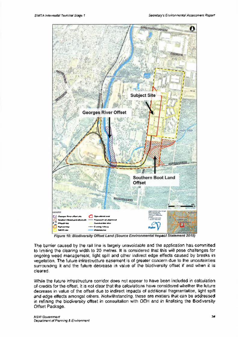
SIMTA lntermodal Terminal Stage I Secretary's Enviranmental Assessmenf Reporf
Impact
The barrier caused by the rail line is largely unavoidable and the application has committedto limiting the clearing width to 20 metres. lt is considered that this will pose challenges forongoing weed management, light spill and other indirect edge effects caused by breaks invegetation. The future infrastructure easement is of greater concern due to the unoertaintiessurrounding it and the future decrease in value of the biodiversity offset if and when it iscleared.
While the future infrastructure corridor does not appear to have been included in calculationof credits for the offset, it is not clear that the calculations have considered whether the futuredecrease in value of the offset due to indirect impacts of additional fragmentation, light spilland edge effects amongst others. Notwithstanding, these are matters that can be addressedin refining the biodiversity offset in consultation with OEH and in finalising the BiodiversityOffset Package.
NSW GovernmentDepartment of Planning & Environment
--ño
.ßvü tur¡.r$atfr** fl on"olr"l*
SoûûÉn EodLdd úrl5ô -
ftapæd rl dgræilFEiéarùe " l co,r*cønæaRÍ qrla --l- EnAhg rkrúgilTAs¡Þ
-wæ
34
SIMTA Intermodal Terminal Stage 1 Secretary's E nvi ron me ntal Assessøenf Reporl
Overall, the Department is satisfied that the impacts of the proposed development can beoffset as nominated by the applicant but that there are a number of further steps that need tobe resolved to ensure the security and long term viability of the offset. The Departmentsupports a precinct-wide approach to preparing the offset package but recognises that this iscontingent on the relevant parties finalising the agreement to proceed to a single intermodalfacility.
Non-lndigenous HeritageA Non-lndigenous Heritage Assessment (NIHA), dated April 2015, was undertaken as part ofthe Stage 1 ElS. The assessment found that Non-lndigenous heritage listings for the site oradjacent lands include:o The Defence National Storage and Distributions Centre (DNSDC) site, is included on the
Commonwealth Heritage Lrsf. The Stage 1 site contains three WWll timber post andbeam store buildings (Buildings no. 6, 10, and 1 1 ) and two WWll crane service compositetimber and steel store buildings (Buildings no. 7 and 9). Each building was constructedwith a concrete slab onto which the timber and steel supports were set. The remainder ofthe structures within the Stage 1 site are modern, constructed in the 1990s;
. the School of Military Engineering (SME) site, to the west of the SIMTA site, is listed onthe State Heritage Register and the Liverpool LEP. This land is subject to the MICproposal and ìncludes the Royal Australian Engineers (RAE) Memorial Chapel, RAEMonument, Major General Sir Clive Steel Memorial Gates, and The CUST Hut. Theproposed Rail link for SIMTA Stage 1 works passes through a small part of the site andalongside the southern boundary of the SME complex; and
o Glenfield Farm, located on the western side of the Georges River, is listed on the StateHeritage Register, State Heritage lnventory and lhe Liverpool LEP. The site is one of thefew surviving rural farm complexes in NSW dating from the original land grant of 1810.The farm contains a 14 room homestead, a dairy, coach house and privy. The curtilage ofthe item is located approximately 50 m from the south-western extent of the proposedRail link.
The demolition of the existing five WWll store buildings would be undertaken as part of theStage 1 proposal. The assessment indicates that these buildings form the only known groupof WWll Defence buildings in NSW, and that the demolition would result in significantimpacts to the collective significance of the DSNDC site. ln addition, the original road, railand open drain alignments running through the Stage 1 site would also be impacts by theproposal. Construction and landscape modification through the installation of water tanks,sewerage, trade waste and power infrastructure is likely to have an impact on the heritagesignificance of the underground water mains and sewerage line, which likely date back to the1 940s.
The NIHA found that there is low potential for archaeological deposits dating to the pre-WWl,WWland intenruar periods to be uncovered on the Stage 1 site.
Construction of the Proposal could temporarily impact the visual, noise and air amenity of theGlenfield Farm site, due to the location and operation of plant and equipment and vehiclemovements. Construction of the rail link would impact a limited portion of the SME site,however would not have any impact on the heritage significance of the site.
During operation, the Proposal would have a visual impact on the remaining heritageelements of the SIMTA site. The view and setting of the Glenfield Farm site may also beimpacted. To mitigate heritage impacts, the Proponent proposes to:. undertake a full photographic record of the entire SIMTA site;r prêpârê a heritage interpretation strategy, including interpretive items such as plaques;e prêpare a Heritage Management Plan as part of a wider CEMP; and
NSW GovernmentDepaftment of Planning & Environment
35
a
SIMTA lntermodal Terminal Stage 1 Secretary's Environ me ntal, ssessøenl Reporf
monitor archaeological deposits during construction for representative sample sites offormer structures which have been assessed as having potential local heritagesignificance.
During operation of the Proposal, the remaining buildings on the SIMTA site would besegregated from the Stage 1 site and not be impacted.
Deoartment's ConsiderationThe Department notes that the NIHA considered the conservation and/or adaptive reuse of atleast one of the five WWll structures on the Stage 1 site. However, the report determinedthat the structures are not suitable for reuse as they would need to have major conversionsto meet safety and engineering requirements. The Department concurs with this assessment.
The Department considers that the other measures proposed would adequately mitigateimpacts to the heritage items on site, and has recommended a condition of approvalrequiring the Proponent to prepare a Heritage Management Plan in adherence to NSWHeritage Council guidelines as part of the CEMP. The Department considers thatimplementation of a heritage interpretation strategy and the preparation of a full photographicrecord, would help manage these impacts by establishing methods of interpreting the formeruse of the site to future users in an effective manner.
Whilst the construction and operation of the Stage 1 intermodal would impact the heritagesignificance of Glenfield Farm, the Department notes that the site has previously beenimpacted by the construction of the Southern Sydney Freight Line, quarrying and landfilloperations. As a result, the proposed Rail link would not significantly further impact upon theheritage item. The Department considers that the indirect impacts from the proposal onheritage impacts outside of the site boundary would be negligible.
Aboriginal HeritageAn Aboriginal Heritage lmpact Assessment was completed as part of the Stage 1 EIS andfound that:o 28 Aboriginal objects were recovered from test pits associated with the Georges River, in
an area known as M414. These objects suggested a low level of past activity on themaximum upper slope and ridge of the area, with undisturbed areas containing deepstratified deposits with at least two periods of past activity. The site is considered to havehigh research potential, meeting the thresholds of local significance; and
. two sites of archaeological concern were identified within the riparian corridor along thewestern bank of the Georges River. One of the sites was identified through the Aboriginalconsultation process as an area of cultural value. The second site is considered to retainhigh research potential, since excavations failed to reach the base of deposits. Both ofthese sites are outside of the Stage 1 proposal site boundary.
The proposed Rail link would directly impact M414, with the alignment traversing through thesouthern portion of the site (impacting approximately 2Oo/o, ot 2,000 m2, of the total site areaof MA14). Construction of the rail link is not expected to impact upon the archaeological siteson the western bank of the Georges River.
The report identified no impacts to Aboriginal heritage from operation of the Proposal.
To mitigate construction impacts on Aboriginal heritage items, the Proponent proposes to:. continue to consult with Aboriginal stakeholders in order to identify long{erm curation and
management of Aboriginal objects recovered through the archaeological program;. implement management measures through the CEMP for the Proposal;. should works impact on M414, mitigation measures to be implemented include open area
salvage excavation up to 100 m2; and
NSW GovernmentDepartment of Planning & Environment
36
SIMTA lntermodal Termínal Stage 1 Secretary's Environmental Assessmenf Reporf
. inform all contractors and relevant personnel of relevant heritage cons¡derations,legislative requirements and recommendations in the AHIA.
Department's ConsiderationThe Department considers that the proposed mitigation strategies to manage impacts toAboriginal heritage items are appropriate, and has recommended a condition of approvalrequiring that these be incorporated into the CEMP for the Stage 1 proposal. Whilst theriparian corridor along the Georges River has been assessed as being of high cultural value,the Department notes that the project's main construction footprint is outside the corridorboundary. The Proponent would use temporary fencing along the Proposal boundary in thisarea. ln the unlikely event that construction works impact these riparian sites, the Proponenthas committed to undertaking appropriate heritage investigations in order to project thecorridor from inadvertent impact.
HydrologyAs part of the Concept Plan ElS, the Proponent prepared a Stormwater and FloodingEnvironmental Assessment, a Flood Study and a Stormwater Management assessment.These reports identified the southern portion of the site and Glenfield Waste Facility land asflood affected by Liverpool Council. lt also identified that the SIMTA site comprises threecatchments and three discharge outlets. As the discharge outlets ultimately end up in eitherthe Georges River or Anzac Creek, the downstream environmental impacts associated withstormwater and flooding in regard to water quantity and water quality for fish passage andhabitat were also addressed.
With regard to stormwater, water quality and flood management, it was identified at theConcept level that impacts may occur during both construction and operational phases of theproject. As such, mitigation measures were required to be stipulated in a ConstructionEnvironmental Management Plan (CEMP) to be prepared at the first stages of development,and would include a Soil and Water Management Plan, an Erosion and Sediment ControlPlan and a spill and emergency response procedures plan for the site.
ln regard to this Stage 1 application, a Stormwater and Flooding lmpact Assessment wasprepared. This addressed the recommendations of the outcomes from the assessment of theConcept Plan approval, which included commitment to the following actions:
. Water quality issues to be managed through a CEMP;¡ lncorporation of stormwater quantity and quality management measures through;
o Preparation of a Soil and Water Management Plan and an Erosion and SedimentControl Plan;
o lmplementation of management strategies prior to commencement of the stagedconstruction phase; and
o Monitoring and review of measures during construction and operation.¡ Designing all flood and stormwater management and mitigation of pollution measures
and waterway crossings to protect fish passage and habitat; and. The preparation and update of a flood emergency response plan as necessary to each
stage of development on the site.
Surface and StormwaterAs previously identified, there are three existing formal stormwater discharge outlets from theSIMTA site. Two points discharge eastward into Anzac Creek and cross under the GreenhillsRd formation via pipes and headwalls. The third discharge point drains surface water fromboth the site and the eastern side of Moorebank Ave and is collected in a formal concretelined channel which runs within the site parallel to Moorebank Ave and drains to the GeorgesRiver.
NSW GovernmentDepartment of Planning & Environment
37
SIMTA lntermodal Terminal Sfage I Secretary's Environmental Assessmenf Reporf
The EIS states that the Stage 1 site sits within the catchment that drains to the GeorgesRiver. The initial modelling undertaken assumed that the catchment is currently 600/o
impervious and that the soils have a slow rate of infiltration, therefore generating a moderaterunoff potential. These existing condition assumptions were then adjusted to represent post-development (operational) site conditions.
Assumptions for the operational conditions included a 10Qo/o impervious surface, reducedflow travel times, changes to sub-catchments and the proposed watenruay and detentionstorages to mitigate flow increase.
The Stormwater and Flooding Report compared the existing and operational peak flows andidentified strategies to mitigate increased flows through on site detention (OSD) storagemeasures. The report further identifies design parameters to mitigate stormwater impactscomprising the design of the OSD structures, incorporation of swales and culverts andinclusion of stormwater treatment devices such as rainwater tanks, gross-pollutant traps,buffer strips, bio-retention and bio-swales. The reporting concludes that surface andstormwater impacts, including water quality, can be minimised and managed by theimplementation of permanent and temporary stormwater management structures beinginstalled during the early stages of construction. The recommended conditions of approvalrequire these works.
FloodinoFloodplain mapping provided by Liverpool City Council indicated that the Georges River floodprone areas extend to the west of the overbank of the Georges River through to the existingGlenfield Waste Facility which the proposed Rail link would traverse.
A floodplain risk management study and plan was commissioned by Liverpool Council forAnzac Creek in 2008. The associated modelling identified impacts on the SIMTA site and railcorridor following a 100 year ARI and larger events along Anzac Creek. However, themodelling also confirmed that the existing culverts beneath the M5 Motonruay couldadequately convey flood waters to the downstream reaches of the catchment withoutsi g nificant retention a nd/or backwater accu m ulation.
Further, the Applicant would design the sections of the rail link along the western bank of theGeorges River to allow extreme event flood flows to spread westward across the floodplain.
Ground WaterIt is reported that regional groundwater flows within the shale and alluvial deposits in northand westerly directions towards the Georges River. Further, both a shallow and deep aquiferhas been reported within the vicinity of the site.
Groundwater flows within the Glenfield Waste Facility site are identified as having beeninfluenced by the extraction and filling activities undertaken on the site. The flows howeverhave been identified to be generally in an easterly direction towards the Georges River.
Other than the Light Non-Aqueous Phase Liquids (LNAPL) contamination, the groundwatersamples taken on the site and within the rail corridor were below the recognition for allanalysts. Heavy metals concentrations in these samples are an exception as they wereabove the ecological investigation areas. This was considered however to be representativeof background concentration in groundwater across urban areas of Sydney.
It is not expected that groundwater impacts would occur during the construction phases asgenerally the site and rail link will require raising of the site, therefore minimal excavation. lthas been identified however that groundwater may be encountered during piling activitiesassociated with construction of the Georges River bridge. The EIS states that the temporarynature of these works and the limited extent of potential disturbance to groundwater during
NSW GovernmentDepaftment of Planning & Environment
38
SIMTA lntermodal Terminal Stage 1 Secretary's Environmental Assessment Reporf
this period means that prolonged impacts on groundwater are not predicted as a result of theproposal.
Glenfield Waste FacilitvWithin the Glenfield Waste Facility stormwater is captured and managed within the site'sstormwater management system. Previous quarrying within the site means that stormwaterwithin the site generally stays within the facility and does not flow to the Georges River.Larger catchment areas to the west of the Glenfield Waste Facility are cut-off and directednorthward to the Georges River.
The Glenfield Waste Facility is located within the Georges River floodplain 'flood planning'and 'flood prone' areas as defined by Liverpool City Council. Ground surveys undertaken forthe Stormwater and Flooding Report confirm that the 100 year ARI mainstream flood flowswould not rise over the banks of the Georges River to flow into the Glenfield Waste Facility oras far west as the proposed Rail link alignment. As previously identified, the Applicantproposes to design the sections of the rail link along the western bank of the Georges Riverto allow extreme event flood flows to spread westward across the floodplain.
Rail Corridor and BridqeThe Rail corridor is located within the mid-Georges River catchment. The Rail link wouldcross both Anzac Creek and the Georges River, therefore having potential impacts on waterquality and the flood regime particularly of the Georges River.
A flood assessment was undertaken with regard to potential flooding of the proposed newrailway bridge crossing of the Georges River. The modelling ultimately indicated that the keyto minimising hydraulic impacts of the proposed rail bridge on the Georges River is thedesign of streamlined bridge piers. The report continues that with streamlined piers therewould be limited difference in flood impacts of a 5 or 6 span bridge. lt will be required at thedetailed design stage that the future bridge incorporates optimum pier alignments to reduceflood impacts.
NSW Fisheries also provided comments with regard to potential impacts from the bridgeconstruction. Specifically their comments focused on measures to protect fish stock andhabitat. lssues raised by NSW Fisheries include considering the staging of works to avoid themigration of Australian Bass, inclusion of scour protection works and maintaining fishpassage by staging the works to limit in water platforms to one at a time and to place culvertswithin these temporary platforms to maintain fish passage.
NSW Fisheries also requested to be consulted during the detailed design of the platformsand that visual inspections be undertaken for dead or distressed fish. These precautionarymeasures are included in the recommended conditions of approval.
Department's ConsiderationThe Department considers that suitable measures have been designed to ensure anyimpacts arising from an increase in surface water volume and velocity can be mitigated. TheEIS outlines the OSD measures, which the Department considers adequate to ensure thatwater quality and quantity does not impact on adjoining properties or the downstream aquaticenvironments.
ln terms of operational impacts, although the proposal would result in changes to thecatchment boundaries and increase the impervious areas on site, suitable OSD measureshave been designed to minimise and mitigate any adverse impacts.
lmpacts associated with the rail corridor and its alignment through Glenfield Waste Facilityhave also been addressed, and subject to further detailed design the Department considersthat any water quality or flood risks can be managed.
NSW GovernmentDepaftment of Planning & Environment
39
SIMTA lntermodal Terminal Sfage I Secretary's Environmental Assessmenf Reporf
Hazards and RisksA Preliminary Risk Screening was prepared to determine the hazard and risk implicationsassociated with the Proposal.
Asbestos is present in three buildings and priority ratings assigned to each asbestos hazardincluded:. Condition Priority A1: lmmediate Elevated Risk Level: friable material presents an
immediate health risk. lmmediate control measures would be required and the areacontaining asbestos should be isolated from personnel. Abatement recommended at theearliest possible time; and
. Condition A4: Negligible Risk Under Present Conditions: non-friable or stable material,unlikely to present a risk unless damaged, tooled, cut, sanded, abraded or machined.
Demolition of the structures has the potential to release asbestos fibres into the atmosphere,potentially causing harm to human health.
During operation of the Proposal, dangerous goods may be transported by road or rail.These potential dangerous goods would be classified in accordance with the Australian Codefor the Transport of Dangerous Goods by Road and Rail (the Australian Dangerous Goods(ADG) Code). These products must be handled correctly, as they may be explosive,flammable, combustible, spontaneously combustible, oxidising, water-reactive, toxic orcorrosive.
Containers would only be stored for a maximum of three days on the Stage 1 site, in thecontainer storage area prior to being transported from the site. The risk of exposure todangerous good would be minimised as unpacking (destuffing) of containers would not beundertaken. However, data taken from Port Botany from 2011 lo 2012 suggests that 96 percent of containers did not contain dangerous goods. The Proponent has decided that theStage 1 Proposal would not receive or store dangerous goods in quantities greater than thescreening thresholds determined by SEPP No. 33; Hazardous and Offensive Development.Therefore, as identified in Applying SEPP 33, a Preliminary Hazard Analysis (PHA) would notbe required.. dangerous goods that are permissible on the SSFL;. dangerous goods that cannot be transported on containers;. storage on site; and. decisions to restrict goods by the operator.
The Proposal also seeks to locate an above ground mobile refuelling tank adjacent to thelocomotive shifter. The tank would store diesel fuel (class C1 combustible liquid), with amaximum capacity of approximately 60,000 litres. This would be stored away from otherflammable materials of class 3PGl, ll or ll. The refuelling of locomotives would occur on thelocomotive shifter, which would catch any spills during the refuelling process.
Emergency response and incident management protocols would also be developed to coverworkplace health and safety, on-site spills or leaks, off-site discharges, hazardousmaterials/dangerous goods, flooding, bushfire, derailment, container fall and any roadincidents on Moorebank Avenue.
Department's ConsiderationThe Department's considers that the identified asbestos would be managed through theimplementation of the mitigation measures proposed in the ElS. The Proponent hascommitted to developing an Asbestos Management Plan prior to construction works. Further,the demolition of the structures would be carried out by an appropriately licensed asbestosremovalist, and undertaken in accordance with Code of Practice How to Safely RemoveAsbesfos (WorkCover NSW, 2011b). The Department has recommended a condition of
NSW GovernmentDepaftment of Planning & Environment
40

SIMTA lntermodal Terminal Stage 1 Secretary's Environmental,4ssessmenf Reporf
approval requiring the preparation of the Asbestos Management Plan as part of theConstruction Environmental Management Plan for the Proposal.
The Department notes that the Proponent has established a set of parameters to restrict thecarriage and storage of goods that would require the preparation of a PHA. As a result of thisrestriction, the Department considers that operational risks could adequately be managedthrough the implementation of the mitigation measures proposed in the ElS. The Proponenthas committed to developing and implementing an operational Hazard and RiskManagement Plan prior to operations. The Operational Environmental Management Plan(OEMP) for Stage 1 would also include procedures to monitor the quantity of dangerousgoods to ensure that they remain below the threshold requiring a PHA.
The Department also notes that the Proponent has committed to handle all dangerous goodsentering and leaving the site in accordance with Maritime Organisation (lMO) and regulationspertaining to the lnternational Convention for the Safety of Life at Sea (SOLAS). Further, alltransport of goods would be in accordance with the Dangerous Goods (Road and RailTransport) Act 2008 and the Dangerous Goods (Road and Transport) Regulation 2012.
To further strengthen the Proponent's commitment in the ElS, the Department hasrecommended a condition of approval requiring the preparation of a Hazard and RiskManagement Plan as part of the OEMP for the Proposal.
BushfireThe site adjoins Vegetation Category 1 bushfire prone land to the east, south and west.However, due to the class of the buildings proposed on the site being Class 5-8 and Class 10(identified in the Building Code of Australia), the proposal is only required to comply with theaims and objectives of Planning for Bushfire Protection 2006 (rather than satisfying theprovisions).
The site layout has considered bushfire risk with a particular focus on habitable buildings. Allsite office locations have been located within construction compounds that are well outsidebushfire prone land. The Rail East Compound is the only exception as the vegetationimmediately to the west is bushfire prone land "Category 1". This vegetation however is notcontiguous with a large area of bushfire prone vegetation.
The Rail link does not fall within land that is required to comply with any bushfire specificperformance requirements.
Department's ConsiderationThe Department has assessed the submitted bushfire risk assessment and taken intoconsideration the comments received from the Rural Fire Service (RFS). ln this respect,subject to the RFS's recommendation to maintain the operational areas as inner protectionareas, which is included in the recommended conditions, it is considered that bushfireimpacts can be minimised.
Visual AmenityThe EIS includes an assessment of the visual amenity implications, including light spillassociated with the Proposal. This assessment took into consideration the existingvegetation and the proposed landscaping and urban design measures that would be includedin the construction and operation of the Proposal.
Overall, visual impacts were assessed against the following criteria:. Visual Adaptation - describes any significant changes to the landscape and visual
amenity.. Visual Sensitivity - refers to the likely duration of views and number of observers from
a given viewpoint.
NSW GovernmentDepartment of Planning & Environment
41
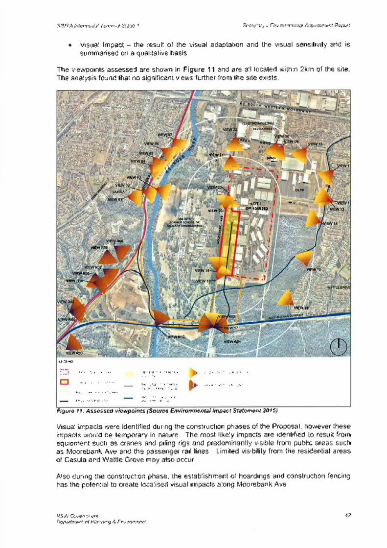
SIMTA lntermodal Terminal Sfage 7 S e cret ary's E nv i ro n m e nt al Assessmenf Reporf
Visual lmpact - the result of the visual adaptation and the visual sensitivity and is
summarised on a qualitative basis.
The viewpoints assessed are shown in Figure 11 and are all located within 2km of the siteThe analysis found that no significant views further from the site exists.
Figure llr Assessed viewpoints (Source Environmental lmpact Statement 2015)
Visual impacts were identified during the construction phases of the Proposal, however theseimpacts would be temporary in nature. The most likely impacts are identified to result fromequipment such as cranes and piling rigs and predominantly visible from public areas suchas Moorebank Ave and the passenger rail lines. Limited visibility from the residential areasof Casula and Wattle Grove may also occur.
Also during the construction phase, the establishment of hoardings and construction fencinghas the potential to create localised visual impacts along Moorebank Ave.
NSW GovernmentDepaftment of Planning & Environment
a
'21VIEU. DXSDL
vlE\rl, t 'fïiI
OLTPtP
iI
LOT 1
vlEw DP 10t8263
I
I\
Rü' lvlEw
;
,
.,
.T,vEwl3
vrE$/
vrÊw
:4vtEw t6
L
E1l.R0l
R03
Þ
LEG END
SII,IIAS]Ë8OUNDÂRY
STAGE ] SITE EOUNDAR'/
RAIL CORRIDOR AOUNDARY
PROPOSED RAIL LINK
V.ÉWPOIilT TO SÌAGE I SITE
VIËWPOINI TO RAIL LINK
INTER¡,4ODAL TERfulINALFACIL TY
RAIL LINE - SOUIHERNSYDNEY FREIGHT LINÉ
RA L LI¡]Ê - DEOICA IEDPASSENGER LINE
42

SIMTA lntermodal Terminal Sfage I Secretary's Envi ron me ntal Assessmenf Reporf
Department's ConsiderationThe Department considers that the impacts from construction activities are acceptable,especially given the temporary nature and also the relative limited visibility, especially fromresidential areas.
With respect to the permanent visual changes during operation of the site, it is expected thatminimal visual impact will occur given the general industrial type developments adjacent tothe proposal to the north and west, and the significant vegetation to the east and south whichacts as a buffer between the site and residential areas.
The rail link and corridor will be located in mostly a heavily vegetated area, adjacent toexisting rail lines or through the Glenfield Waste Facility site and as such is not anticipated tocause any significant impacts to views.
Light spill has been considered in accordance with A544282-1997 'Control of ObtrusiveEffect of Outdoor Lighting', and in these standards the proposal is considered a'commercialarea'. The EIS states the light source type, the luminaire make and model, luminaire aiming,pole positions and heights proposed for the Proposal would ensure minimal direct light spillfrom the static site lighting. Further, the EIS confirms that light spill from the Proposal wouldnot extend to any nearby residential areas.
Greenhouse GasA Greenhouse Gas and Climate Change lmpact Assessment was prepared by HyderConsulting as part of the Stage 1 ElS.
Over an 18 month period, construction activities would generate approximalely 4,262 tCOz-eof greenhouse gas (GHG) emissions. Further, embedded GHG from key constructionmaterials would generate 44,688 tCOz-e during construction, however this figure representsa full life cycle emission generation across the entire operation of the proposal.
A number of alternative materials may be used to reduce the embodied emissionsassociated with the concrete pavement constructed during Stage 1 works. These mayinclude asphalt, pavers or post-tension concrete. Furthermore, emissions figures are basedon a 'worst case' scenario that assumes that the concrete used has a higher embeddedenergy content than alternative concrete mixes.
During construction, the Proponent proposes to implement the following measures tomitigate impacts to GHG emissions:. sourcing local construction materials and recycling demolition waste where possible;. selecting construction equipment with the highest fuel efficiency;. undertake regular maintenance of equipment; and. ensuring that, to the highest degree possible, delivery trucks are filled to the maximum
amount allowable.
The assessment considered two operational scenarios for the Proposal: Scenario One wheretrains and trucks would be loaded/unloaded using forklifts and reach stackers, generating7 ,723 tCOz-e/year; and Scenario Two, where gantry cranes would be operational, generating9,221 t3}z-elyear ('worst case' scenario). During operation, mitigation measure would beimplemented to reduce impacts on GHG. These would include the:¡ incorporation of energy efficiency designs and equipment;. regular maintenance of equipment to maintain good operations;. investigation of abatement opportunities once the facility moves from the use of forklifts to
the operation of gantry cranes; and. review and consideration of mitigation measures where appropriate.
NSW GovernmentDepa¡tment of Planning & Environment
43
SIMTA lntermodal Terminal Stage I Secretary's Environ me ntal Assessmenf Report
The 'worst case' construction and operational GHG emissions from the Proposal wouldrepresent approximately 0.0017 per cent of Australia's total annual GHG emissions. Thereport concludes that this figure is not considered to be significant, in terms of both theconstruction and operational phases of the development.
Deoartment's ConsiderationThe Department considers that impacts from the GHG emissions generated by theconstruction and operation of the Proposal would be negligible. lt is also noted the Proposalwould facilitate a modal shift, from truck to train, in the transportation of freight to theMoorebank freight catchment. The EIS concludes that this would see a net reduction of3,907 tCO2-e/year in GHG emissions.
Developer Contri butionsln accordance with Section 948 of the Act, the Department can levy developer contributions.Liverpool Council does not currently have a developer contributions plan in place for theMoorebank precinct, however has requested that monetary developer contributions besought based on similar industrial developments in the Liverpool Local Government Area(LGA). Liverpool Council has also indicated that Council has recently unanimously passed amotion to seek Ministerial approval to develop and implement a Section 944 scheme for'Established Areas' of the Liverpool LGA to capture developments such as the proposedintermodalterminal. The proposed developer contributions are shown in Table 14.
Table 14 Section 944 Contributions
Applying the above table to the proposal, the Applicant would be required to pay monetarycontributions of $2.85 million. Should the Minister allow only a maximum 1% of the CIV to belevied, the Applicant would be required to pay monetary contributions of $1.425 million.Council argues that these contributions would assist in supporting the future provision ofmaintenance of local infrastructure in the Liverpool LGA.
The Applicant has calculated an alternative contribution using the formula from the LiverpoolContributions Plan 2009 (Hoxton Park Stage 2 lndustrial Release Areas District Facilities):
Cost of capital works and land identified for thecatchment area
X Vehicle trips per day I 6.7Number of equivalent lots in the catchment
area
$64,302,727X (80+670) / 6.7)
18,310
$3,511.89 $111.94
= 5393,122,14
The calculations above have been based on the CIV of the IMEX terminal (excluding railconnection) and both heavy vehicle and light vehicle trips per day. Other figures were basedon those figures found in the Contributions Plan.
X
NSW GovernmentDepartment of Planning & Environment
$0 - <$100,000 jYo
0.5%$100,000 - <$200,0002o/o>$200,000
44
SIMTA Intermodal Terminal Stage 1 Secretary's Environmental Assessmenf Reporf
The Department acknowledges Council's position and agrees that the Applicant should berequired to pay monetary contributions to offset increased pressures on Council's assets andserv¡ces as a result of the proposal. However, the amount sought by Council does not takeinto consideration the scale of the development, predicted traffic generation and proposednumber of employees for this stage.
It is understood that while the total employment numbers generated from the operation of theterminal are forecast to be approximately 150, this is based on all jobs created by theproposal (ie heavy vehicle drivers) rather than the total number of permanent full timeemployees on-site. The Department has been advised that the number of on-site containerhandlers and office workers would be between 20-25 full time equivalent staff for Stage 1,
with greater numbers proposed for subsequent warehousing Development Applications.
Council have argued that the contributions sought would cater for short{erm upgrades to thelocal transport network, such as the implementation of measures to preclude heavy vehiclesfrom using Nuwarra Road and Governor Macquarie Drive. However, the Commission'sapproval of the Concept Plan permitted a Development Application for Stage 1 to be pursuedas it was demonstrated that trafiic generation resulting from the operation of the terminalwould not exceed the capacity of the transport network.
While the Department acknowledges Council's intentions to prepare a S94A ContributionsPlan to capture developments in established areas such as this, in the absence of a
Developer Contributions Plan for the site, the Department concurs with the calculations madeby the Applicant and considers the monetary contributions offered to be fair and reasonable.Further, given the relatively limited number of employees working on-site, impacts on Councilservices and infrastructure are not considered to be significant for Stage 1.
The Department therefore recommends that a condition be included requiring the Applicantpay developer contributions totalling $393,122.00 to Liverpool Council to offset increasedpressures on Council's assets and services as a result of the proposal.
5.6. Section 79C EvaluationTable 15 identifies the matters for consideration under section 79C that apply to SSD, inaccordance with section 89H of the EP&A Act. The table represents a summary for whichadditional information and consideration is provided for in Section 5 and relevant appendicesor other sections of this report and the ElS, referenced in the table.
The EIS has been prepared by the applicant to consider these matters and those required tobe considered in the SEARs and in accordance with the requirements of section 78(84) ofthe EP&A Act and Schedule 2 of the EP& A Regulation.
Table 15: Secfion Matters for Consideration
NSW GovernmentDepañment of Planning & Environment
Section 79C(f ) Evaluation ConsiderationRefer Appendix B(aX¡) any environmental planning instrumentNot applicable(a)(ii) any proposed instrumentNot applicable*(aXiii) any development control plan
There is currently no Voluntary Planning Agreement(VPA) in place, however a VPA may be entered intofor subsequent development applications, dependingon outcomes of consultation with TfNSW/RMS in
relation to infrastructure/road upgrades.
(aXiiia) any planning agreement
45
SIMTA lnternodal Terminal Stage 1
" Under clause 1 1 of the SRD SEPP,
NSW GovernmentDepartment of Planning & Environment
Secretary's Environmental Assessmenf Reporf
apply to state significant development.
(a)(iv) the regulations The development appl¡cation meets the relevantrequirements of the Regulation, including theprocedures relating to development applications (Part6 of the Regulations), public participation proceduresfor SSD's and schedule 2 of the Regulation relatingto environmental impact statements. Refer toSections 3 and 4.
(aXv) any coastal zone management plan Not applicable
Appropriately mitigated or conditioned (refer toSection 5)
(b) the likely impacts of that development
(c) the suitability of the site for thedevelopment
Suitable (refer to Section 2 and Section 5)
Refer to Section 4(d) any submissions(e) the public interest The Department considers the proposal will have
significant economic benefits to the State of NSW,with a $142.5 million direct capital investment into thesouth-western Sydney region and generation of up to250 jobs during construction and 150 jobs duringoperation. Further, the proposal is considered to beconsistent with the NSW Government's objective tomaximise the haulage of freight by rail. A range ofstrategic documents have over the last decadecontinued to support the development of anintermodal terminal at Moorebank including the needto achieve an increase in the rail mode share of portcontainer freight movements.
On balance, the Department acknowledges that theproposalwould contribute to the local economy andsatisfythe long identified need while minimisingenvironmental impact through the implementation ofappropriate mitigation measures. As such, theDepartment considers the proposal to be in the publicinterest.
Not applicableBiodiversity values exempt if:
(a) On biodiversity certified land(b) Biobanking Statement exists
46
SIMTA lntermodal Terminal Stage I Secretary's Environme ntal Assessmenf Reporf
6. RECOMMENDATION
The Department considers the proposal will have significant economic benefits to the Stateof NSW, with a $142.5 million direct capital investment into the south-western Sydney reg¡onand generation of up to 250 jobs during construction and 150 jobs during operation. Further,the proposal is considered to be consistent with the NSW Government's objective tomaximise the haulage of freight by rail. A range of strategic documents have over the lastdecade continued to support the development of an intermodal terminal at Moorebankincluding the need to achieve an increase in the rail mode share of port container freightmovements.
The key environmental impacts associated with this proposal comprise traffic and transport,air quality and operational noise. These issues have been addressed in the Applicant's EISand RtS. The Department has assessed this information and also carefully considered allsubmissions received from public authorities and the community on the proposal. Based onits assessment, the Department is satisfied that the impacts of the proposal, both in isolationand cumulatively with the MIC facility, can be managed and/or mitigated to an acceptablelevel.
The Department considers the Stage 1 proposal is consistent with the terms of the ConceptPlan and should be approved subject to the recommended conditions. Ïhese recommendeddraft conditions would ensure that the mitigation measures included in the RtS areimplemented as well as strengthening the management and mitigation of identified impactsthat the Department, other government agencies, Councils and the general public haveraised.
On balance, the Department acknowledges that the proposal would contribute to the localeconomy and satisfy the long identified need while minimising environmental impact throughthe implementation of appropriate mitigation measures. As such, the Department considersthe proposal to be in the public interest.
It is RECOMMENDED that the Commission:. consider the findings and recommendations of this report;. approve the SIMTA Stage 1 SSD subject to the conditions of approval; and. sign the attached instrument of approval (Appendix D).
T6-t2. t aDirectorTransport Assessments
David Gainsford (g/, L/ t {Executive DirectorPriority Projects Assessments
NSW GovernmentDepañment of Planning & Environment
47
APPENDIX A RELEVANT SUPPORTING INFORMATION
The following supporting documents and supporting information to this assessment reportcan be found on the Department of Planning and lnfrastructure's website as follows.
1. Environmental lmpact Statement
2. Submissions (ElS)
3. Applicant's Response to Submissions
APPENDIX B CONSIDERATION OF ENVIRONMENTAL PLANNINGINSTRUMENTS
The primary controls guiding the assessment of the proposal are:a) State Environmental Planning Policy (Sfafe and Regional Development) 2011b) State Environmental Planning Policy No. 19 - Bushland in Urban Areasc) State Environmental Planning Policy No.33 - Hazardous and Offensive Developmentd) State Environmental Planning Policy No.55 - Remediation of Lande) State Environmental Planning Policy No. 64 - Advertising and Signagef) State Environmental Planning Policy (lnfrastructure) 2007g) Liverpool Local Environmental Plan 2008
State Environmental Planning Policy (State and Regional Development) 2011 (SRDsEPP)The aims of the State Environmental Planning Policy (Sfafe and Regional Development)20ff (SRD SEPP) are to identify State significant development and State significantinfrastructure and provide the necessary functions to joint regional planning panels todetermine development applications.
The proposal is State signifìcant development given it is development for the purpose of anintermodal facility with a capital investment value (ClV) in excess of $30 million under clause 19(Rail and related transport facilities) of Schedule 1 of State Environmental Planning Policy (Stateand Regional Development) 201 1. Therefore the Minister for Planning is the consent authority.
State Environmental Planning Policy No. 19 - Bushland in Urban AreasState Environmental Planning Policy No. 19 - Bushland in Urban Areas (SEPP 79) aims toprotect bushland within urban areas because of its value to the community, aesthetic valueand its value as a recreational, educational and scientific resource.
An assessment of biodiversity impacts was provided as part of the ElS. The Departmentaccepts that vegetation clearing is inevitable for the proposal to proceed and that the clearingof some threatened ecological communities will occur. A biodiversity offset package is
required to be prepared prior to any works on the ecologically significant areas. Thisrequirement has been addressed in the assessment report recommended conditions. TheDepartment considers that with appropriate mitigation measures, the aims and objectives ofSEPP 19 have been met.
State Environmental Planning Policy No.33 - Hazardous and Offensive DevelopmentState Environmental Planning Policy No. 33 - Hazardous and Offensive Developmenf (SEPP33) provides clear definitions of hazardous and offensive industries and aims to facilitatedevelopment defined as such and to ensure that in determining developments of this nature,appropriate measures are employed to reduce the impact of the development and requireadvertisement of applications proposed to carry out such development.
The Department acknowledges that the intermodal facility may handle containers that containhazardous and offensive materials. However, the application does not seek approval fordevelopment involving potentially hazardous and offensive development. The recommendedconditions of consent require that any dangerous goods, as defined by the AustralianDangerous Goods Code, shall be stored and handled strictly in accordance with; all relevantAustralian Standards; bund volume requirements and the Environment Protection ManualforAuthorised Officers: Bunding and Spill Management, technical bulletin (EnvironmentProtection Authority, 1 997).The Department is satisfied that the proposed development is not a hazardous or offensivedevelopment under SEPP 33, and that if required all necessary assessments under theSEPP 33 will be undertaken for future development applications.
State Environmental Planning Policy No. 55 - Remediation of LandState Environmental Planning Policy No 55 - Remediation of Land (SEPP 55) is the primaryenvironmental planning instrument guiding the remediation of contaminated land in NSW.SEPP 55 aims to:. provide a state-wide planning approach to the remediation of contaminated land;. identify when consent is required or not required for a remediation work;. specify certain considerations that are relevant to applications for consent to carry out
remediation works; and. require that remediation work meet certain standards and notification requirement.
Clause 7 of SEPP 55 identifies that a consent authority must not consent to the carrying outof any development on land unless:¡ it has considered whether the land is contaminated;. if the land is contaminated, it is satisfied that the land is suitable in its contaminated state
(or will be suitable, after remediation) for the purpose for which the development isproposed to be carried out; and
. if the land requires remediation to be made suitable for the purpose for which thedevelopment is proposed to be carried out, it is satisfied that the land will be remediatedbefore the land is used for that purpose.
The Department considers that the contaminated lands can be appropriately remediated in
accordance with the measures identified in the ElS. As such, the Department is satisfied thatthe site would be suitable for its future intended use as an intermodal facility subject to theimplementation of the RAP measures and management controls.
State Environmental Planning Policy No. 64 - Advertising and SignageThe aim of Súafe Environmental Planning Policy No 64 - Advertising and Sþnage rs foensure that any signage and advertising; is compatible with the desired amenity and visualcharacter of an area; provides effective communication in suitable locations; and is of highquality design and finish. The proposed signage has been assessed by the Department andis considered to be appropriate for the sign and consistent with the requirements of SEPP 64.
State Environmental Planning Policy (lnfrastructure) 2007The aim of Sfafe Environmental Planning Policy (lnfrastructure) 2007 (lnfrastructure SEPP) is
to improve regulatory certainty, facilitate the effective state wide delivery of infrastructure byproviding greater flexibility in the location of infrastructure and service facilities, allowing thedevelopment of surplus government land, identifying relevant environmental assessmentcategories for development, identifying relevant matters to be considered and providing forconsultation with relevant public authorities.
Clause 81 Development Permitted with Consent includes rail freight terminals, rail freightsidings or rail intermodal facilities. The proposal is for a rail intermodal terminal and wouldrequire a connection into the SSFL which is an ARTC owned/operated line. The proposal isconsistent with this clause as it is considered to be development required with consent.
Clause 104 Traffic-generating development applies to the proposed development as theproposal involves more than 8,000m2 in floor space. ln this regard, and in accordance withclause 104(3) of the lnfrastructure SEPP, TfNSW (including RMS) were given written noticeof the SSD application and due consideration was given to its comments.
Liverpool Local Environmental Plan 2008Consideration of the relevant controls contained within Liverpool LEP is provided below
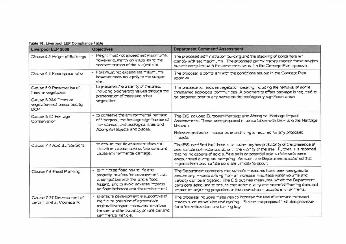
Table 16: LEP Table
The proposal includes measures to increase the use of alternate transportmodes such as walking and cycling. Further the proposal includes provisionfor a future bus stop and turning bay.
The EIS identified that there is an extremely low probability of the presence ofacid sulfate soil materials at, or in the vicinity of the site. Further, it is reportedthat no indications of acid sulfate soils or potential acid sulfate soils wereencountered during soil sampling. As such, the Department is satisfied thatimpacts from acid sulfate soils are unlikely to occur.
The Department considers that suitable measures have been designed toensure any impacts arising from an increase in surface water volume andvelocity can be mitigated. The EIS outlines measures, which the Departmentconsiders adequate to ensure that water quality and potential flooding does notimpact on adjoining properties or the downstream aquatic environments.
The proposed administration building and the stacking of containers willcomply with set maximums. The proposed gantry cranes exceed these heightsbut are compliant with the conditions set out in the Concept Plan approval.
The proposal is compliant with the conditions set out in the Concept Planapproval.
The proposal will require vegetation clearing including the removal of somethreatened ecological communities. A biodiversity offset package is required tobe prepared prior to any works on the ecologically significant areas.
The EIS included European Heritage and Aboriginal Heritage lmpactAssessments. These were prepared in consultation with OEH and the HeritageDivision.
Relevant protection measures or archiving is required for any proposedimpacts.
- to ensure development is supportive ofthe future provision of appropriateregional transport measures to reducethe demand for travel by private car andcommercial vehicle.
to conserve the environmental heritageof Liverpool, the heritage significance ofitems/areas, archaeological sites andAboriginal objects and places.
- to ensure that development does notdisturb or expose acid sulfate soils andcause environmental damage.
- to minimize flood risk to life andproperty, to allow for development thatis compatible with the land's floodhazard, and to avoid adverse impactson flood behavior and the environment.
- Height must not exceed set maximums,however currently only applies to thenorthern portion of the subject site.
- FSR must not exceed set maximums,however does not apply to the subjectsite.
- to preserve the amenity of the area,including biodiversity values through thepreservation of trees and othervegetation.
Clause 7.8 Flood Planning
Clause 7.27 Development ofcertain land at Moorebank
Clause 5.9 Preservation oftrees or vegetation
Clause 5.944 Trees orvegetation not prescribed byDCP
Clause 5.10 HeritageConservation
Clause 7 .7 Acid Sulfate Soils
Clause 4.3 Height of Buildings
Clause 4.4 Floor space ratio


APPENDIX C NOISE TABLES
Operational Noise
Table 1: Operational Noise Criteria - lntrusiveness
Table 2: Operational Noise Criteria - Ame
Table 3: Sleep Disturbance Screenin Levels
Table 4: Rail Noise Criteria
l5 minEvening
(6pm-lOpmlNight
(l0pm-7am)Receiver Daytime
(7am-6pm)42NCAI 47 42
41 41NCA2 4139NCA3 46 42
49 42NCA4 49
l5 minEvening
(6pm-lOpm)Night
(lOpm-7am)Receiver Daytime
(7am-6pm)40NCAI 55 45
50 45NCA2 6040NCA3 55 45
45 40NCA4 55s1. s2 Noisiest 1-hour period when in use - 45DNSDC When in use - 70
Receiver Sleep Disturbance Screening Level (L¡.r.ln / La."r)52NCAI
NCA2 51
49NCA352NCA4
RING Griteria (L¡*. o.6o6L¡-"tTime Period Acceptable Recommended
MaximumReceiver
60 80Day(7am-6pm)
55
80Evening(6pm-1Oom)
45 50
45 80
NCAlNCA3NCA4
Night(lOpm-7am)
40
80DaylTam-6pml
60 65
55 80Evening(6pm-l0pm)
50
50 80
NCA2
Night(10om-7am)
45
45 50sl, s2
Noisiest l-hourperiod when inuse
75n When in use 70

APPENDIX D INSTRUMENT OF APPROVAL