major project 06 0276 vegetation management plan
TRANSCRIPT

P O Box 1258 Nowra NSW 2541 Ph: 0429 05 7575 ♠ Fax: 024422 3316 Email: [email protected] Web: www.planscapes.com.au
Major Project 06_0276 Vegetation Management Plan
& Supplementary Bushfire Report
Lot 1 DP 1087105 & Lot 4 DP 1087106 Off Leo Drive Narrawallee
Proponent & Owner: Hazcorp Pty Ltd

© 2007 PLANSCAPES® - Hazcorp P/L – Supplementary Report Narrawallee – VMP Page 2 of 20
VEGETATION MANAGEMENT PLAN & SUPPLEMENTARY BUSHFIRE REPORT Table of Contents
Page
1.0 Executive Summary - Recommendations 3 2.0 Introduction 4 3.0 Description of Subject Land 6 3.1 Site 6 3.2 Climate 6 3.3 Topography 7 3.4 Geology & Soils 8 3.5 Vegetation 8 3.6 Zoning 9 4.0 Bushfire Assessment in accordance with PBP 9 5.0 Vegetation Management Strategy 13 6.0 Recommendations 16 7.0 References 17 Attachments 1 MP Application Plan 18 2 Site Photos 19 3 Letter to Council re Draft VMP 4 Response to Draft VMP from Shoalhaven City Council 5 Letter to Council re Bush Fire Prone Land Mapping

© 2007 PLANSCAPES® - Hazcorp P/L – Supplementary Report Narrawallee – VMP Page 3 of 20
1.0 Executive Summary – Recommendations This report has been prepared and submitted to the Department of Planning to provide supplementary information in accordance with the Item 13 of the Director – General’s Environmental Assessment Requirements and the adopted SEPP 71 Master Plan, as detailed in Schedule 2 - B2 of the adoption of MP11-5-2003. This report addresses item 13 of the DGRs only regarding the retention of native vegetation in two nominated areas long the north south ridgeline extending through the site. This report also contains an assessment of likely asset protection zones in accordance with the provisions of Planning for Bushfire Protection, 2006 as the retention of the coastal forest remnant within the subdivision will have implications with regard to asset protection and construction standards of adjacent or adjoining future dwellings. A Section 100B Bushfire Safety Authority has previously been issued by the NSW Rural Fire Service for the 168 lot residential subdivision and it is not intended that this report will readdress any other matter raised in the general terms of agreement in that issued S100B. However, the assessment of impacts on lots surrounding or adjoining the retained bushland areas has been undertaken in accordance with the provisions of Clause 46 of the Rural Fires Regulations, taking into consideration the provisions of Planning for Bushfire Protection, 2006.
Subject Land Lot 1 DP 1087105 & Lot 4 DP 1087106 Off Leo Drive Narrawallee
Proposal 168 lot Residential subdivision including retention of native vegetation for two public reserves
Existing Development Vacant vegetated land
Adjoining Development Residential dwellings to the south and east & Public Reserve to the west and north
Zoning Residential 2(c) under the Shoalhaven Local Environmental Plan, 1985
Services Reticulated Water, Sewer & Electricity Available
Roads in vicinity Adequate
Asset Protection Zones 10 metres to northern public reserve area for adjoining and adjacent allotments, 15m for downslope properties from the southern public reserve, and 26m for upslope properties from the southern public reserve.
Level of Construction Dwellings will potentially be within the flame zone and this is outside the requirements of AS3959-1999
Kerry Rourke - MPIA Certified Practising Planner Horticulturist & Bushfire Consultant March 2007

© 2007 PLANSCAPES® - Hazcorp P/L – Supplementary Report Narrawallee – VMP Page 4 of 20
1. Introduction An application has been lodged with the Department of Planning for a Major Project under Part 3A of the Environmental Planning & Assessment Act, for 168 residential allotments and three public reserves, over Lot 1 DP 1087105 and Lot 4 DP 1078106 off Leo Drive Narrawallee in the City of Shoalhaven. The original SEPP 71 Master Plan application was lodged with the Department in 2003, and the Master Plan was adopted in July 2006, the detailed development is now the subject of the Major Project application. The variations required to the Master plan result in two separate areas of existing vegetation being retained along the ridgeline, providing both passive and active open space within the proposed residential subdivision. This open space replaces 30 residential allotments and a proposed public reserve. This report addresses the vegetation management of that area while in the ownership of the current landowner, and the likely asset protection zone provision impacts of that vegetation retention on the proposed adjoining and adjacent allotments. It is not intended that this report will reiterate all of the information, recommendations or strategies of the adopted Conacher Travers Pty Ltd reports being Flora & Fauna report (including the addendum report), Weed Management Plan or the Bushfire Protection Assessment Report. The recommendations of those reports remain valid and will be implemented by the developer over the course of construction and management of the residue lands until completion of the subdivision. The issued Director – General’s Environmental Assessment Requirements Key Issues state that it must be demonstrated that the project application is generally consistent with Master Plan MP 11-5-2003 as approved by the Minister for Planning July 2006. In that regard the following outlines the provisions of the adopted Master Plan. The Master Plan variation states: “Maintenance of Native Vegetation on site 17. In order to better facilitate the satisfaction of objectives 2(1)(e) and 2(1)(g) of State Environmental Planning Policy No. 71 – Coastal Protection relating to visual amenity and the protection and preservation of native coastal vegetation, a minimum of 13% of the total site area will be required for the retention native and other vegetation. The master plan will be reduced from 193 to 163 residential lots. The following lots must remain as vegetation without residential use: ♦ Lots 213-223 inclusive, Lot 312, Lot 422, Lots 522-526 inclusive, Lots 627- 628 inclusive,
and Lots 701-710 inclusive. The retention of vegetation must also satisfactorily consider fire hazard management practices on the site including the provision of Asset Protection Zones in accordance with fire safety best practice including Planning for Bushfire Protection 2001. In this regard a vegetation management plan is required for the areas of retained vegetation. These areas must demonstrate on going maintenance and improvement of these areas.” The Master Plan variation also states:

© 2007 PLANSCAPES® - Hazcorp P/L – Supplementary Report Narrawallee – VMP Page 5 of 20
“Design of Parks
5. A landscape plan is required to be provided for approval with the development application for the two parks. The small park provided at the second (northern) high point (off the elongation of Gemini Way) is to retain healthy existing trees to minimise the visual impact of the subdivision and is to be provided with child play equipment and seating”.
This Vegetation Management Plan (VMP) has been prepared to comply with the requirements of Point 17 only, indicating how the reserves are to be managed while in private ownership throughout the subdivision construction phase in order to provide future asset protection to adjoining and adjacent residential allotments. It is considered that the provision of playground equipment within the northern reserve does not meet the objective of native vegetation retention indicated by the Department of Planning, as it will result in the removal of a substantial amount of trees within that 7,445m2 area - the trees will be considered to be a health and safety hazard and not compatible with the use of the area as a playground. Further, the removal of the trees will not achieve the Department’s aim of maintaining the trees for visual amenity purposes. Further, the Director – General’s Environmental Assessment Requirements also contains the following key issue: “13. Management of Asset Protection Zones and Vegetation 13.1 Demonstrate through a Vegetation Management Plan how the APZs and the bushland
area on open space areas are to be effectively managed and maintained without eroding their integrity.”
This plan aims to demonstrate how the land will be managed while remaining in the current ownership, as this plan will not be applicable to the subject land upon dedication to Council. Council has indicated that they have no obligation to comply with this VMP as Shoalhaven City Council Generic Community Land Plan of Management – Natural Areas will then provide strategic management of the two reserve areas as the land will then be largely categorised as Natural Area under Council’s Community Land Management System. The provision of asset protection zone maintenance areas within the northern reserve has also been discussed with Council staff; a copy of the Draft VMP was supplied to Council for comment in December 2006 (see Attachment Three). Council’s received response indicates that the provision of an APZ within the northern reserve area is not appropriate and the adjoining lots are not to be developed until the whole of the subdivision is completed or until such time as the land is no longer mapped by Council as being bush fire prone land. The received written advice from Council is annexed as Attachment Four and the original draft VMP submitted to Shoalhaven City Council for comment has been amended to reflect Council’s requirements and also the requirements of Planning for Bush Fire Protection 2006. In that regard, Council are reviewing their Bush Fire Prone Land mapping during 2007, and a submission has been made to the Council to consider reducing the vegetation classification for the subdivision or not including the northern public

© 2007 PLANSCAPES® - Hazcorp P/L – Supplementary Report Narrawallee – VMP Page 6 of 20
reserve area as bush fire prone land, so that the allotments can be developed upon completion of the applicable stages – see Attachment Five. 2. Description of the Subject Land 2.1 Site The subject land referred to in this report is the two parcels of bushland, being the southern proposed public reserve of 1.575 hectares, and the northern proposed public reserve of 7,445m2 as identified on the attached plan prepared by Rygate & West Surveyors (Attachment One) and shown on the following aerial photograph. It is currently forested with mainly Blackbutt forest interspersed with Turpentine and Casuarina species. The adjoining public reserve to the north and west of the development site containing areas of Paperbark forest at its margins adjacent to the creek within the 7(d2) zone.
(Google Earth Pro image used under license)
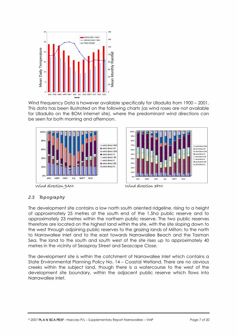
2.2 Climate For the purposes of climate determination for Ulladulla, the Bureau of Meteorology includes Ulladulla data within the Jervis Bay – Point Perpendicular climate averages. In that regard, the following chart illustrates that climate data for Jervis Bay.
Subject Land – boundary approximate
Approximate location of reserves to be retained
Leo Drive
Blake Place
© 2007 PLANSCAPES® - Hazcorp P/L – Supplementary Report Narrawallee – VMP Page 7 of 20
0
5
10
15
20
25
30
JAN FEB MAR APR MAY JUN JUL AUG SEPT OCT NOV DEC
Month
0
20
40
60
80
100
120
140
160
MEAN DAILY MAXMEAND DAILY MINMean Rainfall
Wind Frequency Data is however available specifically for Ulladulla from 1900 – 2001. This data has been illustrated on the following charts (as wind roses are not available for Ulladulla on the BOM internet site), where the predominant wind directions can be seen for both morning and afternoon.
0%
20%
40%
60%
80%
100%
JAN MAR MAY JUL SEPT NOV
wind direct NWwind direct Wwind direct SWwind direct Swind direct SEwind direct Ewind direct NEwind direct N
0%
10%
20%
30%
40%
50%
60%
70%
80%
90%
100%
JAN MAR MAY JUL SEPT NOV
wind direct NWwind direct Wwind direct SWwind direct Swind direct SEwind direct Ewind direct NEwind direct N
Wind direction 9AM Wind direction 3PM
2.3 Topography The development site contains a low north south oriented ridgeline, rising to a height of approximately 25 metres at the south end of the 1.5ha public reserve and to approximately 23 metres within the northern public reserve. The two public reserves therefore are located on the highest land within the site, with the site sloping down to the west through adjoining public reserves to the grazing lands of Milton; to the north to Narrawallee Inlet and to the east towards Narrawallee Beach and the Tasman Sea. The land to the south and south west of the site rises up to approximately 40 metres in the vicinity of Seaspray Street and Seascape Close. The development site is within the catchment of Narrawallee Inlet which contains a State Environmental Planning Policy No. 14 – Coastal Wetland. There are no obvious creeks within the subject land, though there is a watercourse to the west of the development site boundary, within the adjacent public reserve which flows into Narrawallee Inlet.
Mea
n M
onth
ly R
ainf
all
Mea
n D
aily
Tem
pera
ture

© 2007 PLANSCAPES® - Hazcorp P/L – Supplementary Report Narrawallee – VMP Page 8 of 20
2.4 Geology & Soils Geologically, the coastal extent of the Shoalhaven is mostly part of the Sydney Basin, abutting the Molong South Coast Anticlinorial zone and the Budawang Synclinorium to the south and west. The Ulladulla 1:250000 Metallogenic Map (Geological Survey of NSW – McIlveen - Dept of Mines 1975) identifies this Narrawallee development site as being within the Permian Shoalhaven Group – Conjola formation, characterised by conglomerate, sandstone and silty sandstone as evidenced by part of the southern section of the land being used in the past as a ridge gravel quarry by Council for road construction (see following extract).
Extract of Ulladulla 1:250000 Metallogenic Map © Dept Mines 1975
The submitted Navin Officer Archaeological Subsurface Testing Program report (2004) also states that the “Soils consist of grey sands on the low gradient ridgelines, with the underlying gravely orange brown clays being apparent at or near the surface along the more exposed ridge top”. 2.5 Vegetation The submitted Conacher Travers Pty Ltd Flora and Fauna reports and Weed Management Plan describe in detail the vegetation communities and plant species (both endemic and exotic) found on site. Broadly, there are three vegetation communities found within and adjacent to the development site, these were identified in the abovementioned flora and fauna reports as: ♦ Blackbutt Tall Forest (Dense Understorey); ♦ Fresh Treed Swampland; (this EEC is adjacent to the development site not within it) and ♦ Blackbutt Tall Forest (Open Understorey). With regard to the specific public reserve areas nominated for retention, the southern public reserve area has been identified in the abovementioned reports as containing Blackbutt Tall Forest (Dense Understorey) and the northern public reserve contains Blackbutt Tall Forest (Open Understorey). It is noted from the submitted flora and fauna report addendum that the proposed northern park area contains
Cainozoic - Quaternary - Alluvium gravel, swamp deposits, and sand dunes
Palaeozoic – Permian - Shoalhaven Group and Clyde Coal Measures - Conjola formation - sandstones, conglomerate & silty sandstone

© 2007 PLANSCAPES® - Hazcorp P/L – Supplementary Report Narrawallee – VMP Page 9 of 20
Allocasuarina specimens – potential foraging resources for Glossy Black Cockatoos, where there was evidence of foraging via chewed cones (2003). Further the submitted addendum report indicates that removal of the Allocasuarina within the development site “are unlikely to disrupt the life cycle of this species such that a viable local population is likely to be placed at risk of extinction” (Conacher Travers Pty Ltd 2006, P 19). However, the preservation of Allocasuarina specimens is likely as these can be retained within the northern public reserve. Given that the growth habit and lifecycle of this species does not usually lead to limb drop, or dangerous habit, it is unlikely that there will be any requirement for future removal under Council’s Tree Management Policy. The southern area of the development site has been extensively disturbed in the past with the construction of a road / track to gain access to the old gravel quarry, which has in the intervening years been used by local residents as a walking trail and motorbike riding. This continued disturbance of the land has lead to weed invasion along the track as indicated in the submitted Conacher Travers Pty Ltd Weed Management Plan. 2.6 Zoning The development site is zoned Residential 2(c) under the provisions of the Shoalhaven Local Environmental Plan, 1985, where residential subdivision is permissible under that LEP. The land is located within the coastal zone, and being a subdivision creating more than 25 residential allotments it was lodged with the Department of Planning in 2003 under the provisions of State Environmental Planning Policy No. 71 for the adoption of a Master Plan. That Master Plan was adopted in August 2006, but required a number of changes, including the retention of the abovementioned existing vegetation. 3. Bushfire Assessment for the proposed development
i. Extent to which the development is to provide for setbacks including asset protection zones.
For this bushfire assessment, only those lots within the immediate vicinity of both the northern and southern public reserves are assessed for compliance with Planning for Bushfire Protection, 2001, as the RFS has issued a Section 100B Bushfire Safety Authority for the subdivision. Vegetation: The vegetation within the southern public reserve area is classified as Dry Sclerophyll Open Forest as described in Table A2.1 – Planning for Bushfire Protection, 2006 and this area will remain largely intact, with the exception of weed removal as per the Conacher Travers Pty Ltd Weed Management Plan. This vegetation consists of Blackbutt Tall Forest with dense understorey, with a canopy cover of 50% and mature tree height of between 25 and 30 metres. The vegetation within the northern public reserve area currently consists of Tall Blackbutt Forest with open understorey, with 40% canopy cover and a similar mature tree height to the southern public reserve. It is proposed however to manage the

© 2007 PLANSCAPES® - Hazcorp P/L – Supplementary Report Narrawallee – VMP Page 10 of 20
understorey of this public reserve area to reduce fine fuel loadings to 8 tonnes per hectare. The subdivision surrounding both public reserves and within the remainder of the development land will be managed as woodland by the developers during the construction phase of each stage, up to sale of the residential allotments. It is intended to reduce ground level fuels and the density of the understorey during the first stage of the development to provide asset protection to adjoining residential properties. As there will not be contiguous canopy with continuous or dense understorey vegetation within the development site, other than for the southern public reserve area, it is considered that both areas of public reserve be treated as remnant vegetation parcels as described under Appendix 2 – A2.3 of Planning for Bushfire Protection, 2006. This states “Remnant vegetation is a parcel of vegetation with a size of less than 1 hectare or a shape that provides a potential fire run directly towards buildings not exceeding 50m. These remnants are considered a low hazard and APZ setbacks and building construction standards for these will be the same as rainforests. The effective slope is to be determined over the length of the remnant.” It is acknowledged that the southern public reserve is larger than one hectare and potentially closer to the public reserve to the west of the subdivision; however it is surrounded by road and should also be treated as remnant vegetation. Further, there is also a perimeter road between the public reserve to the west of the subdivision and the residential allotments where that road reserve is 30 metres in width and there will be no contiguous canopy with the western public reserve. In the event of fire igniting within either public reserve, the fire is not likely to be of sufficient intensity to result in crowning or spotting due to the lack of understorey and gentle slope of the land. It is considered appropriate that the two areas be considered as remnant vegetation. Similarly, if fire develops within the public reserve areas to the west of the subdivision [the previously dedicated 7(a) & 7(d2) land] the fire behaviour is likely to be significantly altered and intensity reduced as it enters the site as there will be no understorey or contiguous canopy to the proposed public reserve areas within the subdivision. A request has been made to Council to consider the vegetation category of the subject land and particularly the northern public reserve area so that dwellings can be built on adjoining or adjacent lots without high level construction standards or the need for alternate solutions to protect those dwellings from a relatively small area of bushland within the development. Slope: The lots on either side of, and opposite the northern public reserve are located below the hazard vegetation; therefore under the provisions of Planning for Bushfire Protection, the hazard vegetation is located upslope of the residential allotments. The slope of the land to the hazard vegetation is gentle, being less than 5 degrees. This is similarly the case for the allotments surrounding the southern public reserve, as both reserves are located on the ridgeline.

© 2007 PLANSCAPES® - Hazcorp P/L – Supplementary Report Narrawallee – VMP Page 11 of 20
In this particular case, the resultant Asset Protection Zones for adjoining or opposite allotments, with upslope hazard vegetation and based on remnant (Category 3 classification) vegetation parcels as previously described would be 10 metres. Utilising the NSW Rural Fire Service Asset Protection Zone calculator on their internet site indicates the expected radiant heat exposure for the abovementioned APZ distance to be 29 kW/m2 with the resultant level of construction under AS3959 being Level 3. The roads to the east and west of the northern public reserve are 20 metres and 16 metres wide respectively, which will provide the required asset protection for dwellings opposite that reserve. Fine fuel reduction should be undertaken in the northern public reserve so that the area is managed as an outer protection area while in the ownership of Hazcorp Pty Ltd. The southern bushland public reserve is surrounded by public road, with that to the north being 20 metres wide, and to the east, south and west being 16 metres wide. However, if the southern public reserve is not considered to be a remnant as is the northern public reserve, then the APZ will increase to 15 metres (Forest 50 upslope), where the remainder of the APZ can be contained within the front building line for properties opposite the reserve.
ii. Siting and adequacy of water supplies for fire fighting As indicated in the previously submitted Conacher Travers Pty Ltd Bushfire Protection Assessment, the subdivision will be provided with reticulated water supply and in line hydrants which should be adequate for fire fighting purposes. While under the BASIX requirements it is likely that each dwelling house will be provided with a static water supply, it is, at this time, not considered necessary for 5,000 litres of that future supply to be dedicated for fire fighting purposes. That determination should be made at individual Section 79BA development application stage.
iii. Capacity of public roads in the vicinity to handle increased volumes of traffic in the event of a bushfire emergency
The public roads in the vicinity are considered to be adequate to handle increased traffic in the event of an emergency – a perimeter road has been provided within the development to the west to provide a staging area and defensive line for fire fighting. There are therefore, three access roads into the subdivision each to be a minimum pavement width of 8 metres to comply with the requirements of Planning for Bushfire Protection, 2006.
iv. Whether or not public roads in the vicinity link with the fire trail network have two way access
There are no known fire trails within the vicinity of the subject land.
v. the adequacy of arrangements for access to and egress from the development site for the purposes of an emergency response
© 2007 PLANSCAPES® - Hazcorp P/L – Supplementary Report Narrawallee – VMP Page 12 of 20
This has been addressed above and in the submitted Conacher Travers Pty Ltd Bushfire Protection Assessment.
vi. the adequacy of bush fire maintenance plans and fire emergency
procedures for the development site
As the proposal is for a permanent residential subdivision and not a special protection development, it is not necessary to provide maintenance or emergency procedures. Council’s Bushfire Risk Management Plan will apply to all publicly owned land, however, I am not aware of there being any Strategic Fire Advantage Zone surrounding or adjacent to the development site.
vii. The construction standards to be used for building elements in the development
The submitted Conacher Travers Pty Ltd Bushfire Protection Assessment recommended a minimum of Level 2 construction standard in accordance with AS3959 for those dwelling houses at the interface. However, that is not likely to be sufficient for the allotments or proposed dwellings within 30 metres of the proposed public reserves. Due to the required vegetation retention, the allotments adjoining the northern public reserve are likely to be within the flame zone of that hazard vegetation. That however should be reassessed at individual Section 79BA development application stage as PBP 2006 permits performance based approach to dwelling design and bushfire behaviour within the public reserve may not warrant extreme or flame zone construction. Further, a request has been made to Shoalhaven City Council to reconsider the vegetation classification of the reserve.
viii. The adequacy of sprinkler systems and other fire protection measures to be incorporated into the development
It is considered that sprinklers are not necessary for the allotments adjoining or opposite the two public reserves; however that should be reassessed at individual Section 79BA development application stage. Compliance with PBP Chapter 4 The NSW Rural Fire Service issued a Section 100B Bushfire Safety Authority for the overall subdivision based on the Bushfire Protection Assessment report prepared by Conacher Travers Pty Ltd. That report demonstrated the overall subdivision’s compliance with the requirements of Planning for Bushfire Protection, 2001 as it existed at that time, however the matter will be reconsidered by the NSW Rural Fire Service under this Major Project application for its compliance with PBP 2006. The retention the two public reserves within the subdivision introduces a hazard which was not previously assessed in that report, however, Council will not permit any asset protection zones within the public reserve areas to improve protection for future dwelling, but rather recommends that the adjoining lots be managed as inner

© 2007 PLANSCAPES® - Hazcorp P/L – Supplementary Report Narrawallee – VMP Page 13 of 20
protection areas and that the adjoining lots not be built upon until either of the following have occurred: “1. All stages of the subdivision scheme have been completed including the
development and implementation of the Landscape Plan and Arborists report (see 3 below) and the creation of the main western and northern perimeter APZs; or
2. Lots 311, 421, 521 and 527 and / or the reserve are no longer shown as bush fire
prone properties on the Shoalhaven Bushfire Prone Land map.” In that regard, a request has been made to Council to reconsider the bushfire prone land mapping to reduce the vegetation category associated with the subject land and / or to not map the northern bushland reserve as bushfire prone land so that there is not requirement for asset protection given its size and location away from contiguous canopy. However, with regard to the southern public reserve area, there should not be any requirement for significant hazard management as surrounding dwellings will be able to comply with asset protections zones due to road widths and dwelling setbacks. 4. Vegetation Management Strategy 4.1 Vegetation Management Objectives
The objectives of this strategy in regard to the two public reserves are: ♦ To retain and enhance healthy native coastal vegetation within the
subdivision; ♦ To retain where possible feeding resources of the Glossy Black Cockatoo; ♦ To mitigate the likely impact of bushfire on the neighbouring residential
allotments though appropriate vegetation management; ♦ To provide for enhanced public safety. Actions for the achievement of the above objectives are outlined below however the following comments are made. Weed Management - As previously indicated, the southern public reserve area has in the past been highly disturbed and is heavily weed infested, with the road / trial bisecting the area the Department intends to be retained. The northern public reserve has sustained little disturbance and weed invasion, as it is mainly north of the existing track. To enhance both areas of native coastal vegetation to be retained within the subdivision, all weeds within the public reserve areas as identified in the Conacher Travers Pty Ltd Weed Management Plan, shall be removed in accordance with techniques and programming recommendations within that plan. Revegetation - The currently disturbed areas will require rehabilitation and should be permitted to regenerate. The collection of endemic seed and propagation of such is a lengthy process – up to two years to achieve suitable planting stock. The staging

© 2007 PLANSCAPES® - Hazcorp P/L – Supplementary Report Narrawallee – VMP Page 14 of 20
time frame required by the Department would not allow such extensive work to be completed prior to dedication of the reserves to Council. It may be more appropriate for any dangerous trees on the perimeter to be removed during the weed removal phase, and the area then be provided with a security measure to prohibit vehicular access to the land, allowing natural regeneration. It should be noted that under WorkCover practices / guidelines, the whole of the subdivision site will be fenced to restrict unauthorised pedestrian and vehicular access. The track areas through that southern reserve area are heavily compacted due to continued traffic. In order to reduce soil compaction and improve aeration, water infiltration and percolation mechanical intervention will be required which will involve ripping the soil of the track. However, tree removal should be undertaken prior to the ripping of the track, where native trees and shrubs are to be removed for either asset protection purposes or public safety; they should be mulched on site. That mulch will then provide a seed bank resource that can be utilised for natural regeneration and provide a suitable mulch which can be spread to retain soil moisture of the exposed track areas. After ripping and prior to mulching, the ripped track area should be sprayed on several occasions with water so that when the mulch is spread over the ripped track any seed contained therein has contact with soil moisture. The depth of the mulch however should be a maximum of 50mm to permit seedling penetration along with heat and moisture penetration. That mulch will in time also break down to provide soil conditioner. Glossy Black Cockatoo feeding resources - The flora and fauna reports adopted have identified an area of Allocasuarina littoralis within the bounds of the northern public reserve. While the report identified that that species within the site was not critical habitat for Glossy Black Cockatoos or required to be retained for habitat purposes the provision of the northern public reserve area now affords an opportunity for retention of some of those specimens within the subdivision. Public Safety - Council’s Tree Management Policy promotes a “Whole of Life” approach to tree management and as such permits the removal of trees on private land within 450 of the wall of a dwelling house to be removed without consent. There is however a process for similar removal on public lands with consent. As there are going to be new residential allotments adjoining the proposed northern public reserve, it was considered appropriate to remove any trees that would fall within that criterion as part of the subdivision works so that the public reserve can be considered safe when dedicated to Council i.e. trees over 20m tall within 25m of either the northern or southern boundary of the northern bushland public reserve. However, upon review, Council were not satisfied that this approach would meet the Department of Planning’s intent for vegetation retention along the ridgeline, therefore Council has suggested the following approach: “It is therefore recommended that trees over 20m in height within 25m of the northern and southern boundaries of the northern reserve are assessed by a suitably qualified arborist and a full report detailing the condition of each tree and management recommendations that take account of the Department of Planning’s

© 2007 PLANSCAPES® - Hazcorp P/L – Supplementary Report Narrawallee – VMP Page 15 of 20
aims within best practice risk management guidelines is to be submitted with the Landscape Plans for the reserves. The draft Arborists Report and Landscape Plans are to be submitted to Council for review and the developer advised of their approved activities.” Council’s recommendations are acknowledged and it is considered that this will be an appropriate measure to undertake at Construction Certificate Stage for Stages 4 and 6 of the development so that the required Arborist report is prepared in conjunction with the relevant stages of the development. There is no intention to prepare a landscape plan for the northern public reserve as originally provided in the adopted Master Plan as there is no construction work for a children’s playground to be carried out within that area. 4.2 Vegetation Management Actions The following actions are considered appropriate to achieve the specified objectives of vegetation management within the nominated public reserve areas. Objective Action To retain and enhance healthy native coastal vegetation within the subdivision.
During construction of Stage 1 the subdivision the following works should be undertaken to facilitate natural regeneration. ♦ All weeds shall be removed from the site in accordance with the
adopted Conacher Travers Weed Management Plan. ♦ All native trees and shrubs to be removed in accordance with this
plan from the reserve areas for asset protection or public safety purposes (excluding all weed species) shall be mulched and retained on site.
♦ The compacted soil of the track and any disturbed previously
weed infested area shall be ripped and watered. ♦ The stored mulch shall be spread over the ripped areas to a
depth of 50mm to allow seed germination and moisture penetration.
♦ To prevent vehicular access, the public reserve areas shall be
“fenced” in short term by closing the track at each end with logs.
To retain where possible feeding resources of the Glossy Black Cockatoo
Those specimens of Allocasuarina littoralis within the boundary of the northern public reserve are to be retained.
To mitigate the likely impact of bushfire on the neighbouring residential allotments though appropriate vegetation management
♦ The lots adjoining the northern public reserve are to be managed as inner protection areas in order to reduce the bushfire hazard for other near by and adjoining residential allotments.
♦ The adjoining lots not be built upon until such time Stage 7
subdivision construction works are complete or the northern public reserve is no longer mapped as bushfire prone land.
To provide for In order to reduce the likelihood of dangerous trees impacting upon

© 2007 PLANSCAPES® - Hazcorp P/L – Supplementary Report Narrawallee – VMP Page 16 of 20
enhanced public safety
public safety and usage of the future public reserves the following shall be implemented. ♦ All trees (other than Allocasuarina sp.) over 20 metres in height
and within 25 metres of the boundaries of the northern public reserve shall be assessed by a suitably qualified arborist detailing its condition and management recommendations is to be submitted to Shoalhaven City Council with the Construction Certificate for Stages 4 and 6.
♦ Any other large and potentially dangerous tree external to public
reserves (as determined by a suitably qualified Arborist at the time and other than a hollow bearing tree required to be retained) shall be removed, particularly where that tree is within 15 metres of a road boundary at Stage 1 Construction Certificate application.
5. Recommendations The Minister for Planning in the adopted Master Plan for a 163 lot residential subdivision off Leo Drive Narrawallee has required a number of variations to that plan and the Director – General has issued Environmental Assessment Requirements. This report has outlined the response in relation to item 17 and item 13 of the DGR’s. For the retention and enhancement of the native coastal vegetation within the two new public reserves incorporating asset protection measures to mitigate the impact of bushfire on the surrounding by residential allotments, the following is recommended: ♦ Compliance with the Weed Management Plan prepared by Conacher Travers
Pty Ltd 2005. ♦ Fuel management of all land within the development site as an outer
protection area (excluding proposed public reserves) from Stage 1 of the subdivision construction works.
♦ Preparation and submission of an Arborists report to Shoalhaven City Council on
dangerous trees external to the public reserves with the Stage 1 Construction Certificate application, and on the health and management of trees over 20m in height within 25m of the boundaries of the northern public reserve at Stage 4 Construction Certificate application.
♦ Management of lots adjoining the northern public reserve as Inner Protection
Areas from commencement of Stage 4 of the subdivision. ♦ Vegetation management within the public reserves in accordance with the
above Vegetation Management Strategy Actions in order to provide public safety, native vegetation regeneration and retention of Glossy Black Cockatoo feeding resources.
♦ This VMP does not encourage the provision of an urban playground within the
area of the northern public reserve as it does not facilitate the aim of native vegetation and tree retention, which is likely to result in a conflict with public safety.

© 2007 PLANSCAPES® - Hazcorp P/L – Supplementary Report Narrawallee – VMP Page 17 of 20
7. References ♦ Buchanan, R A, 1989 – Bush Regeneration – Recovering Australian Landscapes –
TAFE NSW ♦ Bureau of Meteorology 2006 – Climate data (www.bom.gov.au) ♦ Conacher Travers Pty Ltd 2003 – Bushfire Protection Assessment for the proposed
subdivision and residential redevelopment of Leo Drive Narrawallee ♦ Conacher Travers Pty Ltd 2004 – Flora and Fauna Assessment Report – Part of Lot
4 DP 771597 & Portion 4 off Leo Drive Narrawallee ♦ Conacher Travers Pty Ltd 2005 – Weed Management Plan – Part of Lot 4 DP
771597 & Portion 4 off Leo Drive Narrawallee ♦ Department of Planning, 2006 – Major Project Assessment Report ♦ McIlveen, G R, 1975 – Geological Survey of New South Wales 0 A Metallogenic
Study of the Ulladulla 1:250 000 sheet – Department of Mines ♦ Minister for Planning, 2006 – Adoption of Master Plan No. 11-5-2003 – SEPP 71
Master Plan for Subdivision of land for 188 residential lots and 2 public reserves at Lot 4 DP 771597 and Part Lot 4 DP 755967 off Leo Drive Narrawallee
♦ NSW Rural Fire Service 2006 – Planning for Bushfire Protection ♦ Navin Officer Heritage Consultants, 2004 – Archaeological Subsurface Testing
Program – Proposed Subdivision Lots 1 and 4 Narrawallee NSW ♦ Shoalhaven City Council, 2003 – Tree Management Policy Parts I & II

© 2007 PLANSCAPES® - Hazcorp P/L – Supplementary Report Narrawallee – VMP Page 18 of 20
Attachment One – MP Application Plan

© 2007 PLANSCAPES® - Hazcorp P/L – Supplementary Report Narrawallee – VMP Page 19 of 20
Attachment Two: Site Photos
Vegetation north of the northern east – west track – within the northern public reserve
North – south track to Gemini way & quarry

© 2007 PLANSCAPES® - Hazcorp P/L – Supplementary Report Narrawallee – VMP Page 20 of 20
Southern public reserve and old quarry site
P O Box 1258 Nowra NSW 2541 Ph: 0429 05 7575 ♠ Fax: (02) 44 223316
Email: [email protected] Web: www.planscapes.com.au
General Manager 8th December 2006 Shoalhaven City Council Our Ref: 200643 P O Box 42 NOWRA NSW 2541 Attention: Ms Megan Birmingham Dear Megan Re: Part 3A Major Project Application – 168 Lot Subdivision off Leo Drive
Narrawallee I refer to our recent discussions regarding the Draft Vegetation Management Plan (VMP) I have prepared for the abovementioned subdivision proposal. This proposal is a major project where the Department of Planning is the assessment co-ordinator, and the Minister for Planning is the consent authority. I have also recently discussed this matter and my previous consultation with Council, with Mr David Mutton of the Department of Planning. As you are aware, the issued Master Plan for this subdivision, and the Director General’s Environmental Assessment Requirements have indicated that two areas of natural bushland are to be retained within this subdivision as public reserves. In that regard, the land would require dedication to Council. The Master Plan requires consideration of the on going management of these two reserves, particularly in regard to the provision of asset protection for adjoining residential allotments. I have included here a copy of my draft plan addressing the Master Plan requirements, and I request that you review the VMP with regard to the on going management issue once the land is dedicated to Council. There will be minor amendments made to the plan as it was prepared prior to the issue of the Director General’s requirements. These changes will reflect the major project number and DG’s requirements only and not change the content. The application will be lodged in the near future in any case, and include the VMP, and Council will receive the full application for assessment at that time. However, your comments are considered valuable, and if you do have any concerns with the VMP, please do not hesitate to contact me. Yours faithfully
Kerry Rourke - MPIA Certified Practising Planner


P O Box 1258 Nowra NSW 2541 Ph: 0429 05 7575 ♠ Fax: (02) 44 223316
Email: [email protected] Web: www.planscapes.com.au
Shoalhaven City Council 28th February 2007 P O Box 42 Our Ref: 200643 NOWRA NSW 2541 Attention: Mrs Elizabeth Dixon Re: Review of Bush Fire Prone Land Mapping Dear Elizabeth I am of the understanding that Council will be reviewing the City’s Bush Fire Prone Land mapping this year in accordance with the NSW Rural Fire Service guidelines for such mapping. Further, I understand that the review process will commence in the near future when Council receives the latest orthorectified aerial photography of the City. I wish to make a submission to Council to consider the potential for reviewing the vegetation category of certain land in the Narrawallee area associated with a subdivision proposal where the Director – General of Planning has adopted a State Environmental Planning Policy No. 71 Master Plan, and the DG has also issued the Environmental Assessment Requirements for the associated Part 3A Major Project Application. That Part 3A MP application is to be lodged with the Department in the near future for detailed assessment – where Council will be requested to provide detailed comment on the proposal at that time. Introduction: I am writing on behalf of the owner of Lots 1 DP 1087105 & Lot 4 DP 1087106 – Hazcorp Pty Ltd, where the land is located off Leo Drive & Gemini Way at Narrawallee. The subject land has an area of 21.3 hectares zoned Residential 2(c) in LEP Amendment No. 195 – Milton – Ulladulla LEP. Site History: As a result of that LEP Amendment, the landowner also dedicated 63 hectares of coastal forest to the west of the subject land as public reserve (Lot 2 DP 1087105 & Lot 5 DP 1087106) under Clause 38A & Schedule 8 – Fair Trading Option. The abovementioned SEPP 71 Master Plan was lodged with the Department of Planning in 2003, originally for 213 residential allotments and a public reserve (active space adjoining Council’s existing reserve to the south of the site). This plan was amended however at the Department’s request to 193 residential allotments and two public reserves – one in the north of the subdivision for an additional playground.

PLANSCAPES® 2007 – 200643 – Hazcorp P/L Narrawallee Bushfire Prone Land Mapping Submission Page 2 of 3
The adopted Master Plan however, required further variations to that plan to ensure that 13% of the site was retained as native vegetation – this resulted in the deletion of 30 residential allotments, and an increase in the area of the northern public reserve. The adopted Master Plan in part stated: The following lots must remain as vegetation without residential use: ♦ Lots 213-223 inclusive, Lot 312, Lot 422, Lots 522-526 inclusive, Lots 627- 628
inclusive, and Lots 701-710 inclusive. The retention of vegetation must also satisfactorily consider fire hazard management practices on the site including the provision of Asset Protection Zones in accordance with fire safety best practice including Planning for Bushfire Protection 2001. In this regard a vegetation management plan is required for the areas of retained vegetation. These areas must demonstrate on going maintenance and improvement of these areas.” A key issue of the Director – General’s Environmental Assessment Requirements (DGR’s) is that the project application must generally be consistent with the Master Plan for the site. Further, it is required to “demonstrate through a vegetation management plan (VMP) how the APZs and the bushland area on open space areas are to be effectively managed and maintained without eroding their integrity.” In that regard Planscapes prepared a draft Vegetation Management Plan which the Department advised was to be reviewed by Council prior to submission of the Major Project application. It was proposed in that draft VMP that the northern public reserve has ground level fine fuels removed and managed during the period of development of the subdivision to subdivision plan registration, with removal of trees adjacent to the residential allotment boundaries to provide an Inner Protection Areas within that reserve area. It was also recommended that the public reserve land for a width of 20 metres where adjoining residential allotments, be classified as operation land so that a restriction as to user could be imposed allowing future landowners to manage that part of the reserve adjacent to their land as an asset protection zone. Note however, that a change through PBP 2006 reduces the APZ to 10 metres for remnant vegetation. Ms Megan Birmingham reviewed the Draft VMP and provided Council’s comments on the intended management recommendations particularly for the northern reserve. Council recommends that the VMP be amended to state that the development on the lots adjoining the northern public reserve is deferred until such time as the RFS APZ requirements can be met without impinging upon the adjacent open space reserve. Ms Birmingham advised that this could be achieved in either of two ways (a full copy of Ms Birmingham’s letter is attached for your reference): “1. All stages of the subdivision scheme have been completed including the
development and implementation of the Landscape Plan and Arborists report (see 3 below) and the creation of the main western and northern perimeter APZs; or

PLANSCAPES® 2007 – 200643 – Hazcorp P/L Narrawallee Bushfire Prone Land Mapping Submission Page 3 of 3
2. Lots 311, 421, 521 and 527 and / or the reserve are no longer shown as bush fire prone properties on the Shoalhaven Bushfire Prone Land map.”
Achieving No 1 above would only occur on completion of the subdivision some 7 – 10 years in the future, where the lots are proposed to be released in stages 3, 4 & 5. Achieving No. 2 above would only be possible through a restriction as to user on the title of the lots at the required stages, and with Council’s reconsideration of the bushfire prone land mapping. Request: Our initial request at this time, is that in reviewing the Shoalhaven Bushfire Prone land mapping this year, that Council give consideration to altering the vegetation category that applies to the subject land so that at the completion of Stage 1 of the subdivision (within 1 - 2 years) the land is mapped as Category 2 vegetation to reflect hazard reduction works to be undertaken during the initial construction stage of the development. In that regard it is proposed during Stage 1 to remove ground level fine fuels, remove understorey vegetation (excluding the proposed natural area public reserves) and reduce tree canopy density to achieve a woodland vegetation state and maintain that throughout the development period. Further, it is requested that the northern area remnant vegetation parcel which will be retained as natural area not be mapped as bushfire prone land as it will have an area of less than one hectare and will be in excess of 100 metres from the contiguous tree canopy within the public reserve to the west of the subject land – this would seem to comply with exclusion requirements of the NSW RFS guidelines for bushfire prone land mapping. The application plans are provided to illustrate the proposal. Thank you for your consideration and assistance in this matter, it is greatly appreciated, and if you require any further information in support of our request please do not hesitate to contact me. Yours faithfully
Kerry Rourke - MPIA Certified Practising Planner & Bushfire Consultant Encl: Major Project Application Plan; Major Project Application Staging Plan; Shoalhaven City Council response re VMP