major atmospheric emissions from peat fires in southeast asia
TRANSCRIPT

THINKING beyond the canopy
SOCP/YEL Paul Hilton/SOCP/YEL
Major atmospheric emissions from peat fires in SEA during non-drought years: Evidence from the 2013 Sumatran fires
Salim MA, Hergoualc’h K, Locatelli B, et al David Gaveau
Reuters
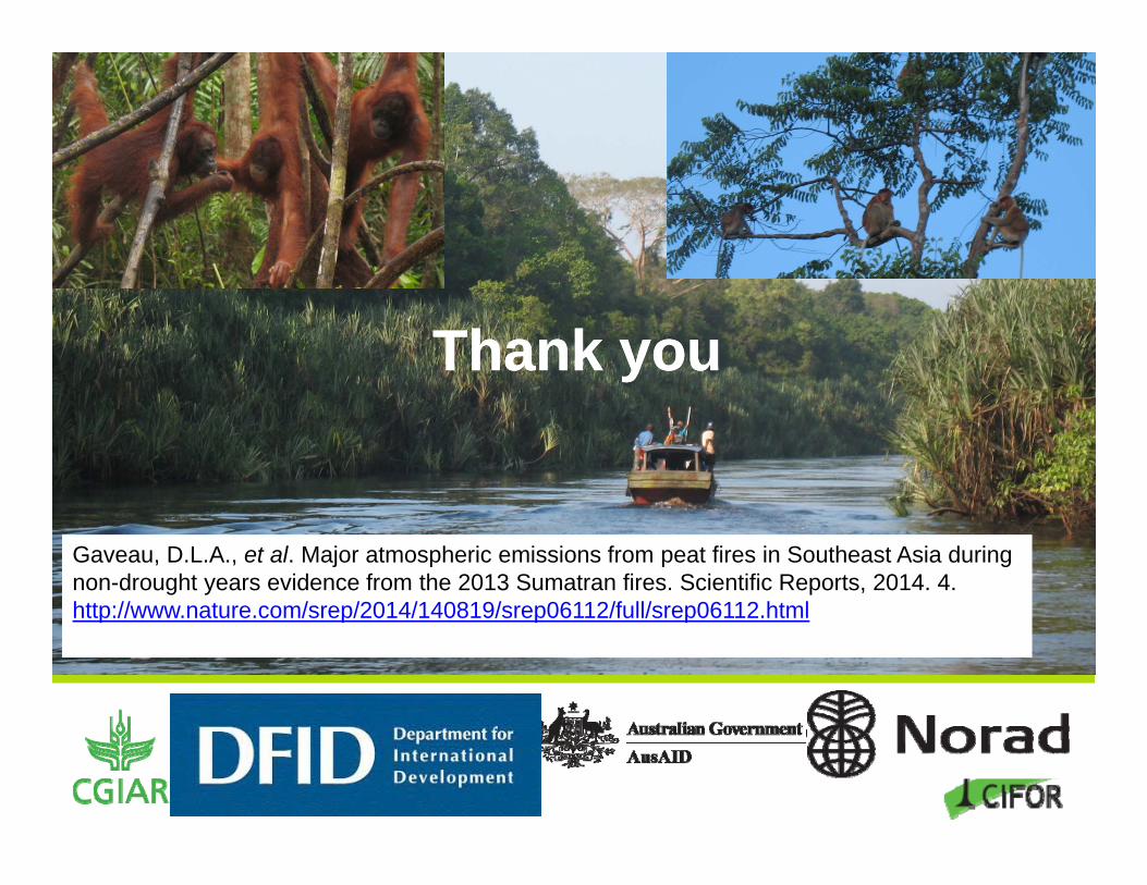
Gaveau, D.L.A., et al. Major atmospheric emissions from peat fires in Southeast Asia during non-drought yearsevidence from the 2013 Sumatran fires. Scientific Reports, 2014. 4. http://www.nature.com/srep/2014/140819/srep06112/full/srep06112.html

THINKING beyond the canopy
IntroductionWhy study the 2013 Indonesian fires?We know that fire is used for land clearing in the dry seasonAll major SEA haze events 1960-2006 occurred during El Niño/IOD years (Field et al. 2009)
But, in 2013, fires generated extreme air pollution over SEA, in particular over Riau, Malaysia and Singapore
2013 was a year without climate anomalies.
Climatic conditions of 2013?Area burned?Land cover burned?Fire‐related GHG emissions?Pollution levels ?

THINKING beyond the canopy
Methods
Atmospheric pollutionSingapore’s 24-h pollutant standards Index (PSI)since 01 Jan. 1997 (NEA)
Location and energy released by fireArea burned across Sumatra (500 m x 500 m), fire hotspots, and Fire Radiative Power (FRP) from TERRA and AQUA (NASA)
Climatic conditions in main burned areaRainfall statistics since 1960 (NOAA)Correlation FRP-Rainfall
Getty images

THINKING beyond the canopy
Methods Land cover mapping in main burned
areaPre- & post-fire LANDSAT images Post-fire high resolution images taken by a DRONE
GHG and C emissions Burned area Fuel load Combustion completeness Gas-specific emission factorPeat soil: Fuel load Combustion completeness taken from IPCC (2013)Emission factors from Andrae & Merlet (2001); Christian et al (2003)Total C emissions are from CO2, CO and CH4
Total GHG emissions are from CO2, CH4 and N2O
THINKING beyond the canopy
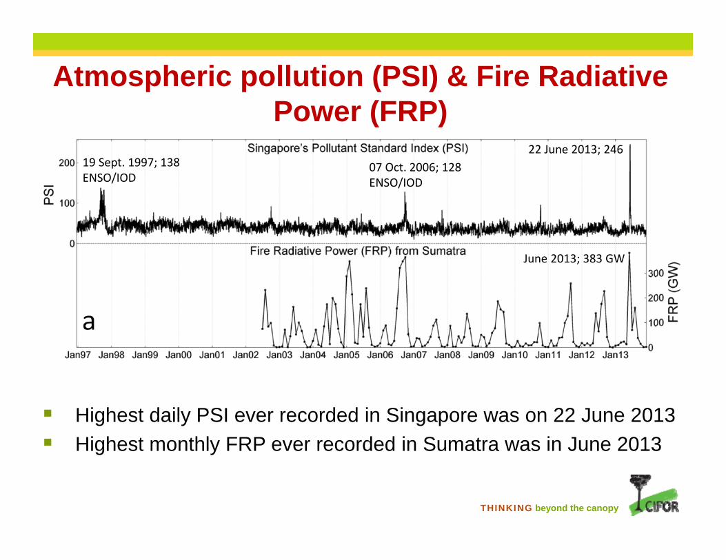
Atmospheric pollution (PSI) & Fire RadiativePower (FRP)
Highest daily PSI ever recorded in Singapore was on 22 June 2013 Highest monthly FRP ever recorded in Sumatra was in June 2013
22 June 2013; 24619 Sept. 1997; 138ENSO/IOD
07 Oct. 2006; 128ENSO/IOD
June 2013; 383 GW

THINKING beyond the canopy
MODIS Fire alerts for timing of fire
Peak in fire activity during 18-24 June: 1 week
THINKING beyond the canopy
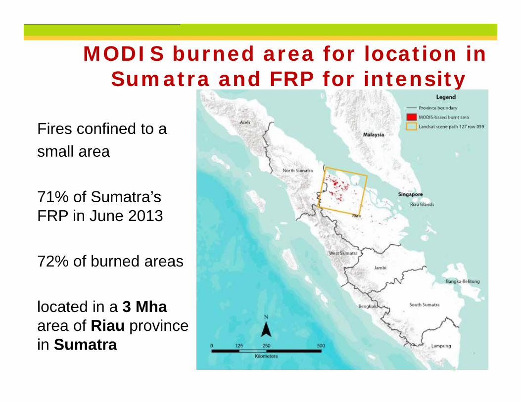
MODIS burned area for location inSumatra and FRP for intensity
Fires confined to asmall area
71% of Sumatra’s FRP in June 2013
72% of burned areas
located in a 3 Mhaarea of Riau province in Sumatra

THINKING beyond the canopy
In Riau 2013 was wetter than average
Climatic conditions
But May and June 2013 registered rainfall deficits compared to monthly means

THINKING beyond the canopy
Climatic conditions Strong correlation between
monthly FRP and rainfall over the month of FRP measurements and the month before.
Correlations over one three and four months were much lower,
Annual rainfall is bimodal in Riau: it never experiences a long dry period.
THINKING beyond the canopy
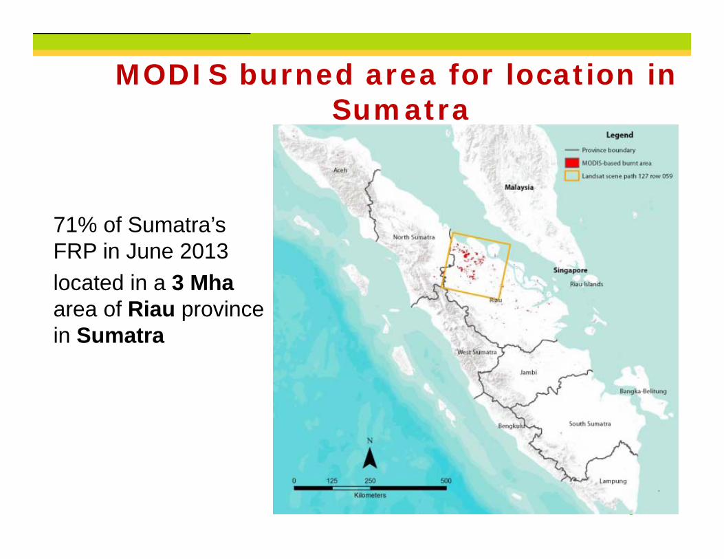
MODIS burned area for location inSumatra
71% of Sumatra’s FRP in June 2013 located in a 3 Mhaarea of Riau province in Sumatra
THINKING beyond the canopy
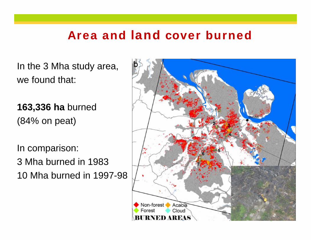
Area and land cover burned
In the 3 Mha study area, we found that:
163,336 ha burned (84% on peat)
In comparison: 3 Mha burned in 198310 Mha burned in 1997-98

THINKING beyond the canopy
Area and land cover burned163,336 ha
Forest Cemeteries
THINKING beyond the canopy
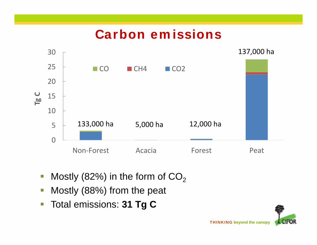
Carbon emissions
0
5
10
15
20
25
30
Non‐Forest Acacia Forest Peat
TgC
CO CH4 CO2
133,000 ha 5,000 ha 12,000 ha
137,000 ha
Mostly (82%) in the form of CO2
Mostly (88%) from the peat Total emissions: 31 Tg C

THINKING beyond the canopy
Greenhouse gas emissions
In the form of CO2 (55%) and CH4 (45%) Mostly (90%) from the peat Total emissions: 171 Tg CO2eq
0
50
100
150
200
Non‐Forest Acacia Forest Peat
TgCO
2eq
N2O CH4 CO2
133,000 ha 5,000 ha 12,000 ha
137,000 ha

THINKING beyond the canopy
Emissions during this brief (1 week) localized event (1.6% of Indonesia land area) were considerable:
GHG emissions = 5-10% of Indonesia’s reported annual emissions for 2000-2005 (MoEF)
C emissions = 26% of average annual C emissions from fires in tropical Asia between 2003-2008 (Kaiser et al. 2012)
CH4 emissions = 4-6% of average annual emissions the whole of Southeast Asia in 2000-2009
Greenhouse gas emissions

THINKING beyond the canopy
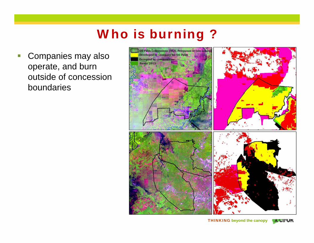
Who is burning ? 52% of total burned area
within concessions of oil palm and pulp&paper
However 30% of concession areas are occupied by smallholders or by large independent under-the-radar land-owners
This presence makes attribution of fires in concessions difficult
THINKING beyond the canopy
Who is burning ? Companies may also
operate, and burn outside of concession boundaries

THINKING beyond the canopy
Main conclusions Extreme air pollution episodes are no longer restricted to
ENSO/IOD-induced drought years.
The briefness (<2 months) of the drought that triggered the fires pose a challenge to forecasting severe haze events several months in advance.
Major haze events are becoming increasingly frequent with ongoing agricultural development (oil palm) on already-deforested peatlands in the region of Riau.
Fire&Haze is a “wicked” environmental problem because...No easy or technical solutions, esp on already deforested peatland. Hotly contested, political issues, multiple actors are burning. Many interdependencies
Focus more on fire prevention and less on fire fighting
THINKING beyond the canopy
Prevention of fires How to address the issue of already-deforested (but not
yet converted to agriculture) peatlands ?
Shall they be converted entirely to plantations ? Because degraded peatlands will never regenerate and established plantations mitigate fire well.
Shall they be restored to their original forested state? because if we block and fill canals, forests will grow back?
Is there a middle ground? Planting of native peat-swamp economically valuable productive trees?
These solutions will require harmonizing spatial plans between local and central government. One possible recommendation to the Minister is to endorse Riau’s spatial plan (RTRWP), which has until now never been approved by MoEF.
THINKING beyond the canopy
CIFOR advances human well-being, environmental conservation, and equity by conducting research to inform policies and practices that affect forests in developing countries.
Thank youThank you
Gaveau, D.L.A., et al. Major atmospheric emissions from peat fires in Southeast Asia duringnon-drought years evidence from the 2013 Sumatran fires. Scientific Reports, 2014. 4. http://www.nature.com/srep/2014/140819/srep06112/full/srep06112.html