magatle filling station development
TRANSCRIPT

GEOTECHNICAL INVESTIGATION Magatle Filling station Development
NKHOPHELE HOLDINGS Director: Ndivhuwo Ratshikhopha | Registration Number: 2015/432441/07
NK-0108
Geotechnical Investigation: Magatle Filling Station Development i
PREPARED FOR:
Executive Petroleum
Address: 3280 Castlebay crescent
Blue Valley Golf Estates,
Centurion
0157
PREPARED BY:
Nkhophele Holdings
MOBILE: +27 (0) 842197473
E MAIL: [email protected]
REF NO.: NK-0108
DATE: 15/08/2019
NKHOPHELE HOLDINGS Director: Ndivhuwo Ratshikhopha | Registration Number: 2015/432441/07
NK-0108
Geotechnical Investigation: Magatle Filling Station Development ii
REPORT DETAILS
Client Name: Pollock Chuene
Document Title: Geotechnical investigation for Magatle Filling station development
File Name: NK-0108 Magatle Filling Station Development Geotechnical
investigation
For and on behalf of Nkhophele Holdings
Prepared by: N. Ratshikhopha
(Geologist)
SACNASP: 117905
Signature(s):
Approved by: Mr. P. Maila
(Engineering Geologist)
SACNASP: 119813
Signature(s):
NKHOPHELE HOLDINGS Director: Ndivhuwo Ratshikhopha | Registration Number: 2015/432441/07
NK-0108
Geotechnical Investigation: Magatle Filling Station Development iii
DISCLAIMER AND TERMS OF USE
This report has been prepared by Nkhophele Holdings (Pty) Ltd using information provided by its client as well as third parties, which information
has been presumed to be correct. Nkhophele Holodings does not accept any liability for any loss or damage which may directly or indirectly result
from any advice, opinion, information, representation or omission, whether negligent or otherwise, contained in this report. Nkhophele Holdigns
does not accept any liability for any loss or damage, whether direct, indirect or consequential, arising out of circumstances beyond the control of
Nkhophele holdings, including the use and interpretation of this report by the client, its officials or their representative agents.
This document contains information proprietary to Nkhophele Holdings and as such should be treated as confidential unless specifically identified
as a public document by law. Nkhophele Holdings owns all copyright and all other intellectual property rights in this report. The document may not
be copied, reproduced in whole or in part, or used for any manner without prior written consent from Nkhophele Holdings. Copyright is specifically
reserved in terms of the Copyright Act 98 of 1987 including amendments thereto. By viewing this disclaimer and by accepting this document, you
acknowledge that you have read and accepted these Terms of Use and undertake to keep the information herein confidential and not to do any
act or allow any act which is in breach of these Terms of Use.
NKHOPHELE HOLDINGS Director: Ndivhuwo Ratshikhopha | Registration Number: 2015/432441/07
NK-0108
Geotechnical Investigation: Magatle Filling Station Development iv
Executive Summary
Nkhophele Holdings conducted a geotechnical investigation in June 2019 for the development of a filling station
and a shopping centre at Magatle, Zebediela. The site investigation was aimed at evaluating engineering
characteristics of near surface soils underlying the site.
Test pitting and laboratory testing were used to conduct the investigation. Nine (9) test pits were excavated which
indicated that the surficial soils comprise residual material occurring as gravelly sand.
The investigation findings suggest that the soils encountered on the site may exhibit low potential expansiveness.
The investigation findings further suggest that the site be classified as soil site class 2/C according to NHBRC
Loading conditions. Overall the geotechnical investigation indicates that the site is developable albeit with
precautionary measures.

NKHOPHELE HOLDINGS Director: Ndivhuwo Ratshikhopha | Registration Number: 2015/432441/07
NK-0108
Geotechnical Investigation: Magatle Filling Station Development v
Contents 1. Introduction ...................................................................................................................... 1 2. Terms of Reference and Scope of work ........................................................................... 1 3. Site Description ................................................................................................................ 1
3.1. Location ..................................................................................................................... 1
3.2. Climate ...................................................................................................................... 3
3.3. Topography and Drainage ......................................................................................... 3
3.4. Geology ..................................................................................................................... 3 4. Investigation Methodology ............................................................................................... 5
4.1. Available Information ................................................................................................. 5
4.2. Field investigation ...................................................................................................... 5 5. field investigaiton results .................................................................................................. 6
5.1. Test Pitting and Profiling ............................................................................................ 6
5.2. Laboratory Testing ..................................................................................................... 6 6. Geotechnical evaluation ................................................................................................. 11
6.1. Expansive Soils ....................................................................................................... 12
6.2. Collapsible Soils ...................................................................................................... 13
6.3. Compressible Soils .................................................................................................. 13
6.4. Groundwater ............................................................................................................ 13
6.5. Drainage and Erodibility ........................................................................................... 14
6.6. Excavatability........................................................................................................... 14
6.7. Slope Instability ....................................................................................................... 14
6.8. Subsidence .............................................................................................................. 14
6.9. Problematic Soils ..................................................................................................... 14 7. Recommendations ......................................................................................................... 15

NKHOPHELE HOLDINGS Director: Ndivhuwo Ratshikhopha | Registration Number: 2015/432441/07
NK-0108
Geotechnical Investigation: Magatle Filling Station Development vi
7.1. Soil Site Classification ............................................................................................. 15
7.2. Foundation recommendations ................................................................................. 15
7.3. Precautions ............................................................................................................. 15
7.4. Pavement Layers ..................................................................................................... 16 8. Conclusion ..................................................................................................................... 16
List of Figures
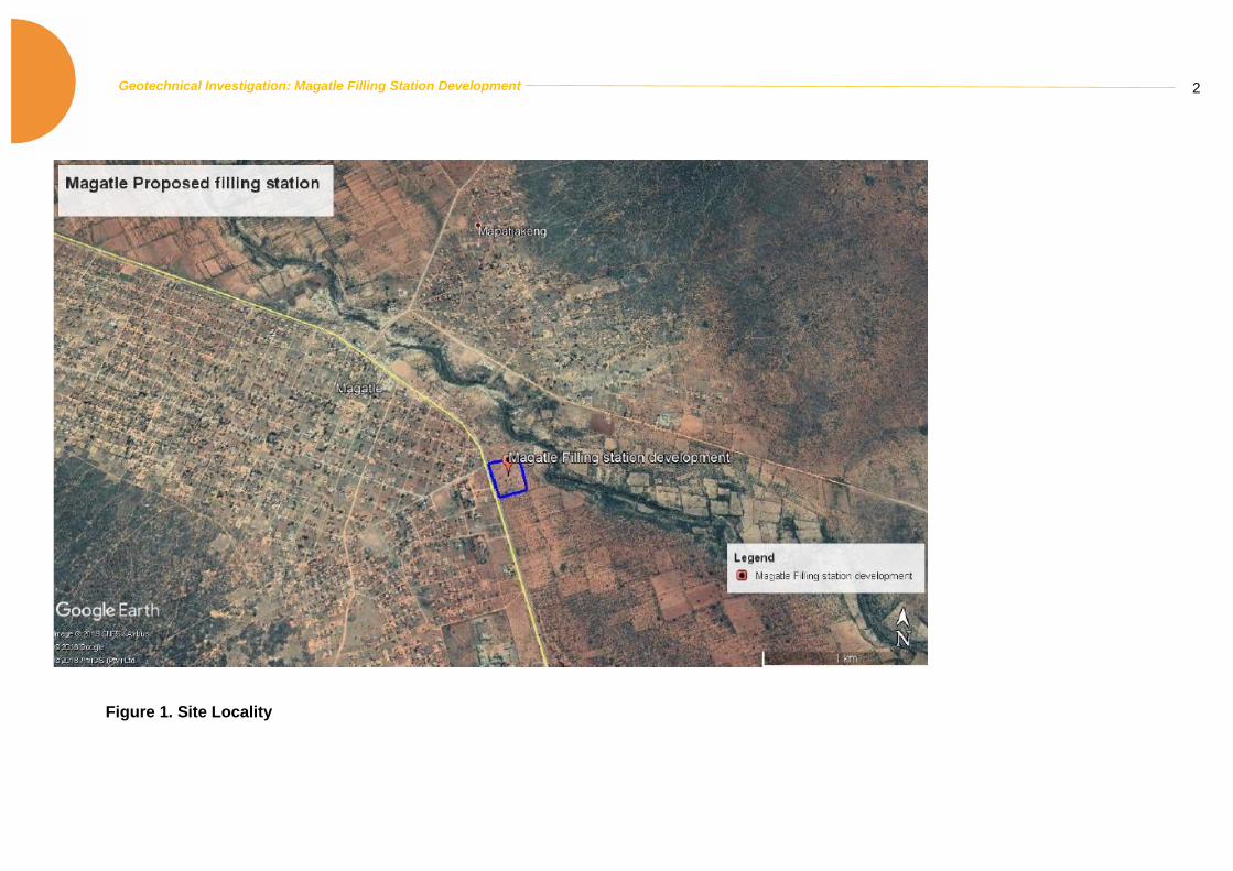
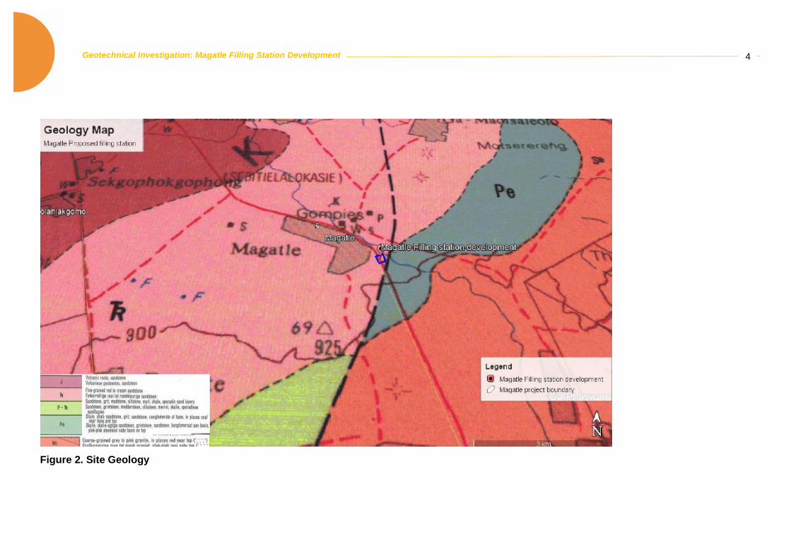
Figure 1. Site Locality .......................................................................................................................... 2 Figure 2. Site Geology ......................................................................................................................... 4
List of Tables
Table 1: Foundation Indicator Test Results ......................................................................................... 9 Table 2: CBR and MOD Test Results ................................................................................................ 10 Table 3: Soil Site Classification (NHBRC Building Manual)................................................................ 11 Table 4: Geotechnical Classification for Urban Development (GFSH-2 Document) ........................... 12
Appendices
Appendix A: Test Pit Location Appendix B: Soil Logs Appendix C: Laboratory Test Results

NKHOPHELE HOLDINGS Director: Ndivhuwo Ratshikhopha | Registration Number: 2015/432441/07
NK-0108
Geotechnical Investigation: Magatle Filling Station Development 1
1. INTRODUCTION
Nkhophele Holdings was appointed in June 2019 by Executive Petroleum to conduct a geotechnical
investigation for the development of a filling station and a shopping centre. Building plans, layout and
structural loads for the proposed structures were not provided. This report presents the findings of a
geotechnical investigation carried out on the site.
2. TERMS OF REFERENCE AND SCOPE OF WORK
The project entails the development of a filling station and shopping centre at Magatle, Zebediela in
Limpopo. The site investigation was carried out in accordance with SAIEG, GFSH-2, TRH14 guidelines,
and all NHBRC Home Building Manuals and included the following:
• Trial pitting, in-situ soil profiling and sampling;
• Laboratory testing;
• Site classification according to GFSH-2 Document and;
• Foundation Recommendations
3. SITE DESCRIPTION
3.1. LOCATION
The site is situated at Magatle, Zebediela, Limpopo, approximately 18 km south west of Lebowakgomo
and directly opposite the Magatle Police Station (Figure 1). The site is rectangular in shape and covers
an area of approximately 5 Ha. The centre coordinates of the site are 24°27'33.32"S, 29°24'49.65"E.
The site is currently undeveloped and occasionally used as a show ground facility. Redundant electrical
concrete poles and remnants on old building structures where observed on site.
Geotechnical Investigation: Magatle Filling Station Development
2
Figure 1. Site Locality

NKHOPHELE HOLDINGS Director: Ndivhuwo Ratshikhopha | Registration Number: 2015/432441/07
NK-0108
Geotechnical Investigation: Magatle Filling Station Development 3
3.2. CLIMATE
The average daily maximum and minimum temperatures of Zebediela are characterised by moderate
fluctuations in seasonal temperature, with a high of 30°C in summer and a low of 6°C in winter.
Precipitation in the study area occurs mainly in the summer, with the maximum rainfall experienced
during November - January. The site is located in an area designated a weinert value less than 5 which
suggests that chemical weathering is the dominant form of weathering.
3.3. TOPOGRAPHY AND DRAINAGE
The site was relatively flat with the elevation ranging between 903 m amsl (above mean sea level) and
908 m amsl. Erosional features such as dongas, and furrows were not observed on site. No
watercourses traverse the site; however, the Nkumpi River is situated 200 m east of the site.
3.4. GEOLOGY
According to the 1:250 000 geological map sheet 2428 Nylstroom Geological Map Series (Figure 2),
the investigated area is underlain by sedimentary rocks of the Karoo Sequence. The Karoo sequence
in the Nylstroom area is made up of the volcanic rocks and sandstones of the Letaba Formation; red
sandstone of the Clarens Formation; sandstone, mudstone, siltstone and shale of the Irrigasie
Formation and shale, sandstone, conglomerate and coal beds of the Ecca Group. The development
site is underlain by the red sandstone of the Clarens Formation.
.
Geotechnical Investigation: Magatle Filling Station Development 4
Figure 2. Site Geology

NKHOPHELE HOLDINGS Director: Ndivhuwo Ratshikhopha | Registration Number: 2015/432441/07
NK-0108
Geotechnical Investigation: Magatle Filling Station Development 5
4. INVESTIGATION METHODOLOGY
The approach to this geotechnical investigation utilizes of a combination of literature review (Desktop
Study) and field investigation. The literature review was conducted to assess the current state of the
environment according to available literature resources.
4.1. AVAILABLE INFORMATION
• Topographic map of the Director of Surveys at a scale of 1: 50 000: Sheet 2429AD Zebediela
(East);
• Geological Map of the GSO: Scale 1: 250 000 Sheet – Geological series 2428 Nylstroom;
• Expansive Roadbed Treatment for Southern Africa: D J Weston (1980) 4th Int. Conf. on
Expansive Soils, Vol. 1, Denver pp 339-360
• National Home Builders Registration Council: Home Builders Manual: Parts 1 and 2, Revision
1, February 1999;
• Technical Recommendations for Highways – TRH14 Guidelines for Road Construction
Materials by the National Institute for Transport and road research of the Council for Scientific
and Industrial Research, (1985);
• SAICE’s Guidelines for Urban Engineering Geological Investigations;
• Schwartz, K. (1985). Collapsible soils. The Civil Engineer in South Africa, July, p379-393 and;
• New, M., Lister, D., Hulme, M. and Makin, I., 2002: A high-resolution data set of surface climate
over global land areas. Climate Research 21:1-25
4.2. FIELD INVESTIGATION
The following methodology was adopted for the field investigation:
Test pitting was conducted using a Tractor-Loader-Backhoe (TLB) and test pits were excavated to the
maximum depth of 2.76 m. The test pits were logged by a registered engineering geologist according
to MCCSSO method prescribed by Jennings et al. (1973). The trial pits were loosely backfilled after

NKHOPHELE HOLDINGS Director: Ndivhuwo Ratshikhopha | Registration Number: 2015/432441/07
NK-0108
Geotechnical Investigation: Magatle Filling Station Development 6
profiling. The location of the test pits is indicated on the test pit locality plan available in Appendix A.
Detailed soil profiles are attached in Appendix B.
5. FIELD INVESTIGAITON RESULTS
5.1. TEST PITTING AND PROFILING
The field investigation was carried out by a Nkhophele holdings engineering geologist on the 27 June
2019. A total of nine (9) test pits were excavated across the site. The test pitting indicates that the site
is underlain by a cover of transported colluvial material occurring as sand with sparse to abundant
fragments of gravel. The material encountered in the test pits is described below and detailed test pit
logs are available in Appendix B.
• Transported – The transported horizon was encountered at depths between ground level and
1.02 m. the transported material is comprised of slightly moist, reddish-brown sandy-silt.
• Pebble Marker– The transported horizon is underlain by a pebble marker comprising sandy-
gravel with round gravel. The pebble marker was encountered at depths between 0.73 m and
1.60 m. The pebble marker is however absent in test pits ZBM 03, ZBM 04, and ZBM 09.
• Residual Sandstone – The site is underlain chiefly by Slightly moist, Light brown to reddish-
brown gravelly-sand from weathered residual sandstone. The residual sandstone was
encountered at depths between 0.88 m and 2.76 m, however at ZBM 09, the sandstone was
unweathered when excavated and the trial pit could only be excavated till 0.98 m. Trial pit ZBM
01, ZBM 04 and ZBM05 residual sandstone had cobbles.
5.2. LABORATORY TESTING
Representative soil samples were taken at specific positions from material encountered in the test pits.
Ten (10) samples were collected and submitted to Civilab Civil Engineering Testing Laboratory for
Foundation Indicator and California Bearing (CBR) testing to determine basic engineering
characteristics including:
• Atterberg Limits (plastic limit, liquid limit and plasticity index);
• Potential Expansiveness;
NKHOPHELE HOLDINGS Director: Ndivhuwo Ratshikhopha | Registration Number: 2015/432441/07
NK-0108
Geotechnical Investigation: Magatle Filling Station Development 7
• Grading analysis and;
• MOD and CBR.
The laboratory tests were conducted to assist with the classification, description, and delineation of
homogenous zones. The results of the foundation indicator, MOD and CBR tests are presented in
Appendix C and are summarized in Table 1 and Table 2. The samples were taken from the test pit
position denoted in the same manner.
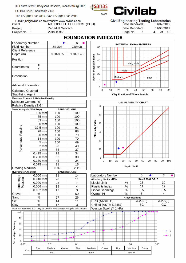
Foundation Indicator – A total of six (6) foundation indicator samples were collected. Two (2) from the
transported horizon, one (1) from the pebble marker horizon and three (3) from the residual sandstone
horizon.
• Transported – The samples collected indicate a Liquid Limit ranging from 21% to 23% with the
Linear Shrinkage ranging between 4% and 5.5%. The samples indicate low to medium plasticity
with the overall Plasticity Index ranging between 7% and 8%. Based on the clay content and
plasticity, the soils underlying the site will exhibit low potential expansiveness.
• Pebble Marker– The sample collected indicate a Liquid Limit of 26% with the Linear Shrinkage
ranging between 4.5%. The samples indicate low plasticity with the overall Plasticity Index of
4%. Based on the clay content and plasticity, the soils underlying the site will exhibit low potential
expansiveness.
• Residual Sandstone – The samples collected indicate a Liquid Limit ranging from non-plastic
to 31% with the Linear Shrinkage ranging between non-plastic and 5.5%. The samples indicate
low to medium plasticity with the overall Plasticity Index ranging between non-plastic and 6%.
Based on the clay content and plasticity, the soils underlying the site will exhibit low potential
expansiveness.
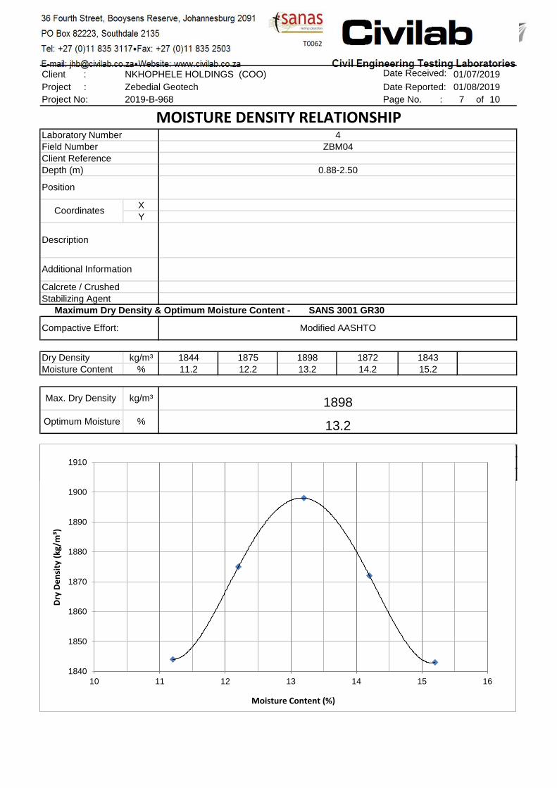
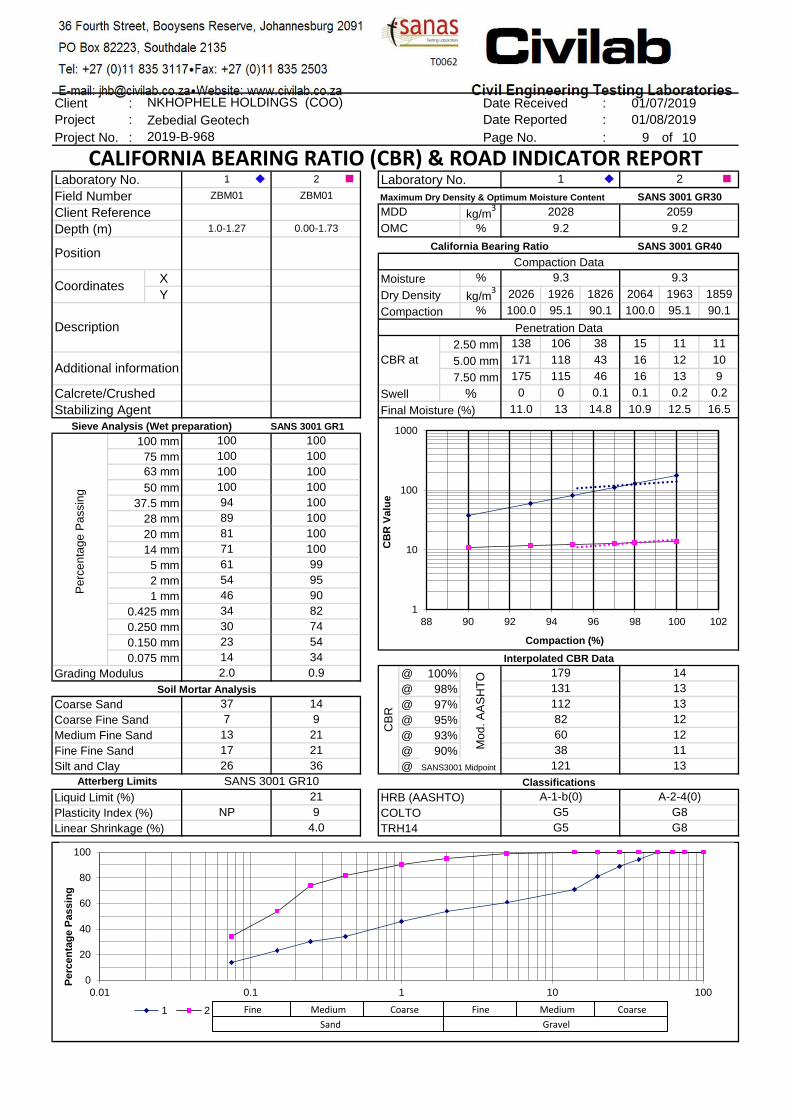
Road Indicators and CBR – Four (4) sample were collected, one (1) transported and three (3) residual
sandstone and submitted for California Bearing Ration (CBR) Testing.
• Transported – The grading modulus of the sample was 0.9 with a Plasticity Index of 21%. The
samples collected indicate a fair CBR with the value of 12% at 95% MOD AASHTO. The sample

NKHOPHELE HOLDINGS Director: Ndivhuwo Ratshikhopha | Registration Number: 2015/432441/07
NK-0108
Geotechnical Investigation: Magatle Filling Station Development 8
indicate a maximum swell of 0.1%. Based on the grading modulus, Atterberg limits and CBR
soils underlying the site may be classified as G8.
• Residual Sandstone – The grading modulus of the samples ranges between 1.5 and 2.1 with
the Plasticity Index ranging between non-plastic and 12%. The samples collected indicate a
good CBR with the values ranging between 43% and 82% at 95% MOD AASHTO. The sample
indicates a maximum swell ranging between 0.1% and 1.1%. Based on the grading modulus,
Atterberg limits and CBR soils underlying the site may be classified as ranging between G5 and
G6.

Geotechnical Investigation: Magatle Filling Station Development
9
Table 1: Foundation Indicator Test Results
Sample No.
Description Depth (m) Atterberg Limit
GM
Grading analysis (%) USC
Potential expansiveness
LL % LS % Overall
PI % Clay Silt Sand Gravel
ZBM01 Transported 0.00-1.73 21 4 7 0.89 16 16 63 5 SC Low
ZBM01 Residual
sandstone 1.00-1.27 NP NP NP 1.98 3 7 44 46 SM Low
ZBM02 Pebble marker 1.02-1.60 26 4.5 4 1.63 4 15 47 34 SC Low
ZBM04 Residual
sandstone 0.88- 2.50 31 5.5 6 1.52 6 16 52 26 SC Low
ZBM08 Transported 0.00-0.85 23 5.5 8 0.99 17 14 67 2 SC Low
ZBM08 Residual
sandstone 1.01-2.40 30 5.5 4 2.11 3 11 26 60 GC Low
LL :Liquid Limit PI :Plasticity Index LS :Linear Shrinkage GM :Grading Modulus NP :Non-Plastic
USC :Unified Soil Classification

Geotechnical Investigation: Magatle Filling Station Development
10
Table 2: CBR and MOD Test Results
Sample No.
Description Depth (m)
CBR @
GM PI (%) Max. Swell (%)
OMC (%)
Max Dry
Density
(kg/m3)
TRH14 Classificatio
n 90% 93% 95% 98% 100%
ZBM01 Transported 0.00-1.73 11 12 12 13 14 0.9 21 0.1 9.2 2059 G8
ZBM01 Residual
sandstone 1.00-1.27 38 60 82 131 179 2.0 NP 0.1 9.2 2028 G5
ZBM04 Residual
sandstone 0.88- 2.50 26 36 45 63 79 1.5 12 0.4 13.2 1898 G6
ZBM08 Residual
sandstone 1.01-2.40 131 38 43 51 58 2.1 12 1.1 11.4 1935 G6
PI :Plasticity Index GM :Grading Modulus OMC :Optimum Moisture Content CBR :California Bearing Ratio NP: Non- Plastic
NKHOPHELE HOLDINGS Director: Ndivhuwo Ratshikhopha | Registration Number: 2015/432441/07
NK-0108
Geotechnical Investigation: Magatle Filling Station Development
11
6. GEOTECHNICAL EVALUATION
The objective of the investigation was to assess geotechnical properties of the surficial soils. The
following geotechnical characteristics relevant to the development were assessed:
• Expansive Potential
• Collapse Potential
• Compressibility
• Groundwater
• Drainage & Erodibility
• Excavatability
• Slope Instability
• Subsidence
• Problematic soils
Table 3 gives the basis of the soil site classification that was applied during the investigation and Table
4 gives the geotechnical classification for urban development.
Table 3: Soil Site Classification (NHBRC Building Manual)
Geotechnical category and site class designation
Geotechnical characteristics
Active soils (heave/shrink) - (H) H H1 H2 H3
Expected range of total movement at surface: < 5 mm 5 – 15 mm 15 – 30 mm > 30mm
Compressible soils (S) S S1 S2
Expected range of total movement at surface: < 5 mm 5 – 15 mm > 15 mm
Collapsible Soils (C) C C1
Expected range of total movement at surface: < 5 mm 5 – 10 mm

NKHOPHELE HOLDINGS Director: Ndivhuwo Ratshikhopha | Registration Number: 2015/432441/07
NK-0108
Geotechnical Investigation: Magatle Filling Station Development
12
C2 > 10 mm
Excavation – (R) r1 r2 r3
sub outcrop scattered outcrop and sub-outcrop outcrop, scattered outcrop and sub-outcrop
P – Problem soils
Dolomitic Areas, marshy areas, contaminated areas, abandoned borrow areas, land fill, mining subsidence and mine waste fill, shallow undermined areas, exploration pits or adits.
Inundation and seepage – (W) Wet area, drainage line, seepage zone
Table 4: Geotechnical Classification for Urban Development (GFSH-2 Document)
Geotechnical Sub-Area Definition
1 Areas recommended or favourable for development
2 Areas where development can be considered with certain
precautionary measures.
3 Areas that are not recommended for development
6.1. EXPANSIVE SOILS
Active/expansive soils are defined as fine grained soils (generally with high clay content) that change
in volume in response to the change in moisture content. These soils may increase in volume
(heave/swell) upon wetting and decrease in volume (shrink) upon drying out. These soils are classified
as (H) according to the SAICE site classes. Depending on the severity of the predicted movement,
expansive soils can be classified as H, H1, H2 or H3 (Table 3).
The site is mainly underlain by sand and gravely sand and the laboratory results of all the samples
analysed indicate low plasticity. Therefore, problems associated with heaving soils are not anticipated
to occur on the site.

NKHOPHELE HOLDINGS Director: Ndivhuwo Ratshikhopha | Registration Number: 2015/432441/07
NK-0108
Geotechnical Investigation: Magatle Filling Station Development
13
6.2. COLLAPSIBLE SOILS
Collapsible soils are defined as soils that have a potential for collapse and are commonly open-textured
(e.g. honey comb and pinhole) with a high void ratio (Brink, 1985). These soils are typically silty sands,
sands, sandy and gravelly soils commonly found in colluvial and aeolian sands. Soils which exhibit
potentially collapsible characteristics are classified with the soil site class ‘C’ according to the SAICE
site classification system (Table 3).
The soils encountered on the site typically sand and gravely sand with no visual open-textured
structures such as voids and pinholes, which indicate collapse potential. The laboratory results indicate
that the site is underlain by moderate sands with a moderate content of gravelly sands. From the site
observations and laboratory testing the site is therefore classified with the soil site class C according to
the SAICE site classification system.
6.3. COMPRESSIBLE SOILS
Compressible soils are soils in which the bulk volume of the soil may gradually decrease with time when
subjected to an applied load. These soils typically comprise fine-grained soils such as clay, clayey sand
and clayey silt with low plasticity, gravelly and sandy soil. According to the SAICE soil site class these
soils are denoted as class ‘S’ and may vary (S, S1, S2) depending on the severity of the bulk volume
change.
The site is generally underlain by silty and sandy gravel. The laboratory results indicate that the samples
comprise low silt and clay content with low plasticity. Therefore, problems associated with compressible
soils are not anticipated to occur on the site.
6.4. GROUNDWATER
Groundwater may negatively affect structures founded on non-cohesive soil (sands and silt). When
non-cohesive soils become saturated, the stiffness, vertical stress and effective confining stress are
reduced resulting in lower bearing pressures of the soil. Furthermore, a shallow/perched groundwater
table normally presents a problem of rising damp on structures. Therefore, appropriate remedial

NKHOPHELE HOLDINGS Director: Ndivhuwo Ratshikhopha | Registration Number: 2015/432441/07
NK-0108
Geotechnical Investigation: Magatle Filling Station Development
14
measures such as damp proofing needs to be incorporated in the construction of structures in areas
where a shallow/ perched water table is anticipated. Various Pedogenic soils (ferricrete/calcrete and
signs of ferruginisation/calcification) may indicate fluctuating or seasonally perched water table
commonly caused by retarded vertical infiltration and percolation rates.
The fieldwork was conducted during the dry season and no groundwater or groundwater seepage was
encountered during the field investigation.
6.5. DRAINAGE AND ERODIBILITY
The site is relatively flat and may promote the ponding of water and a river is located to the east of the
site. Therefore, the site must be shaped to improve stormwater runoff and extensive stormwater
management must be considered. All drainage boundaries near wet areas or drainage lines and
floodlines must be confirmed by the relevant Competent Person (floodline specialist).
6.6. EXCAVATABILITY
Excavatability may be defined as the degree of difficulty at which the ground can be excavated. The
test pits were excavated to depths ranging between 0.98m and 2.76m with no refusal. Excavatability
problems may be anticipated within the vicinity of trial pit ZBM09 where shallow sandstone bedrock was
encountered. Excavations for the proposed development are expected to utilise soft to intermediate
excavation techniques for the removal of the soils underlying the site.
6.7. SLOPE INSTABILITY
The site slopes towards the east with a gradient of less than 6%. Therefore, slope related instability is
not anticipated on the site.
6.8. SUBSIDENCE
No subsidence related problems are anticipated on the site
6.9. PROBLEMATIC SOILS
No problematic soils including dolomite or uncontrolled fill was encountered on the site.

NKHOPHELE HOLDINGS Director: Ndivhuwo Ratshikhopha | Registration Number: 2015/432441/07
NK-0108
Geotechnical Investigation: Magatle Filling Station Development
15
7. RECOMMENDATIONS
7.1. SOIL SITE CLASSIFICATION
The investigation findings indicate that soils with gravelly sand with low expansive potential underlie the
site. Furthermore, based on field observations (geological, hydrogeological, and geomorphological) and
laboratory soil testing of soil samples, the site can be classified as: 2/C
7.2. FOUNDATION RECOMMENDATIONS
Founding conditions are favourable for the proposed development and conventional construction
methods can be implemented. Depending on the design and loads to be applied, the following
foundation recommendations are made:
Strip Footing
• The width of the strip footings must be at least 600 mm in the case of a foundation to a load-
bearing or free-standing masonry wall or to a timber framed wall supporting a roof.
• Where any strip foundation is laid at more than one level, the higher portion of the foundation
shall extend over the lower portion for a distance at least equal to the thickness of the
foundation.
7.3. PRECAUTIONS
The following precautions may be considered during construction on the site:
• The site is relatively flat therefore extensive site drainage and plumbing/service precautions
must be considered.
• Structures to have damp proofing.
• The site must be graded to prevent ponding of storm water.
• 1.5 m apron around the structures to prevent water ingress under the immediate area or the
foundation.
• Walkways and drive ways must be paved to allow easy access to the property during wet
seasons.

NKHOPHELE HOLDINGS Director: Ndivhuwo Ratshikhopha | Registration Number: 2015/432441/07
NK-0108
Geotechnical Investigation: Magatle Filling Station Development
16
• Planting of grass/lawn on the stands may be considered to prevent erosion.
• Roads must be paved or tarred. Specialist advice must be sought for the installation of the
roads.
• Care must be taken with foundation designs where foundations straddle different soil mediums
such as rock and soil.
7.4. PAVEMENT LAYERS
The soils underlying the site exhibit good compaction characteristics for road building and pavement
construction. According to the TRH14 guidelines, the residual sandstone soils underlying the site are
classified as G5 and G6, therefore are suitable for subbase, selected layer and subgrade construction.
8. CONCLUSION
This report documents the findings of a near surface geotechnical investigation conducted for the
development of Magatle filling station and shopping centre. The investigation was carried out by means
of test pitting and laboratory testing of collected samples. Based on the field investigation and laboratory
testing the following conclusions can be drawn:
• The site is typically underlain by transported material, pebble marker and residual sandstone.
The bedrock encountered on the site is dominantly red sandstone.
• Laboratory testing of the collected samples indicates that the underlying soil exhibits low
potential expansiveness.
• The residual sandstone soils underlying the site are classified as G5 and G6, therefore are
suitable for subbase, selected layer and subgrade construction.
• Groundwater seepage was not encountered in all of the test pits excavated.
• The investigated site is relatively flat lying which may lead to poor stormwater drainage. The
site must be shaped to improve stormwater runoff and extensive management must be
considered.
NKHOPHELE HOLDINGS Director: Ndivhuwo Ratshikhopha | Registration Number: 2015/432441/07
NK-0108
Geotechnical Investigation: Magatle Filling Station Development
17
Overall the geotechnical investigation findings suggest that the site is developable albeit with
precautionary measures

NKHOPHELE HOLDINGS Director: Ndivhuwo Ratshikhopha | Registration Number: 2015/432441/07
NK-0108
Geotechnical Investigation: Magatle Filling Station Development
Appendix A: Test Pit Location

NKHOPHELE HOLDINGS Director: Ndivhuwo Ratshikhopha | Registration Number: 2015/432441/07
NK-0108
Geotechnical Investigation: Magatle Filling Station Development

Geotechnical Investigation: Magatle Filling Station Development
NKHOPHELE HOLDINGS Director: Ndivhuwo Ratshikhopha | Registration Number: 2015/432441/07
NK-0108
Appendix B: Soil Logs

Name
Executive PetroleumZebediela Magatle filling station and shops development
LEGENDSheet 1 of 1LEGENDSheet 1 of 1LEGENDSheet 1 of 1LEGENDSheet 1 of 1
JOB NUMBER: NK108JOB NUMBER: NK108
GRAVEL {SA02}
SANDY {SA05}
SILT {SA06}
SILTY {SA07}
SANDSTONE {SA11}
DISTURBED SAMPLE {SA38}
CONTRACTOR :MACHINE :
DRILLED BY :PROFILED BY :
TYPE SET BY :SETUP FILE :
N. RatshikhophaSTANDARD.SET
INCLINATION :DIAM :DATE :DATE :
DATE :TEXT :
11/07/2019 12:21..ofile\ZBProfilesCopy.txt
ELEVATION :X-COORD :Y-COORD :
LEGENDSUMMARY OF SYMBOLS
LEGENDSUMMARY OF SYMBOLS
LEGENDSUMMARY OF SYMBOLS
LEGENDSUMMARY OF SYMBOLS

CBR/FI
CBR/FI
Executive PetroleumZebediela Magatle filling station and shops development
HOLE No: ZBM01Sheet 1 of 1
HOLE No: ZBM01Sheet 1 of 1
HOLE No: ZBM01Sheet 1 of 1
HOLE No: ZBM01Sheet 1 of 1
JOB NUMBER: NK108JOB NUMBER: NK108
0.73
0.00
1.00
2.05
Slightly moist, reddish brown, medium to desnse, intact, sandy SILT withplant roots. TRANSPORTED
Slightly moist, reddish brown, medium to desnse, intact, silty GRAVEL.PEBBLE MARKER
Slightly moist, Light brown, dense, intact, sandy GRAVEL with subangular cobbles. RESIDUAL
End of hole with no refusal, continues as above.
Scale1:10
NOTES1) No water Seepage.
2) Bulk Disturbed sample CBR/FI at 0.00--0.73 m.
3) Bulk Disturbed sample CBR/FI at 1.00--2.05 m.
4) Stable side walls.CONTRACTOR :
MACHINE :DRILLED BY :
PROFILED BY :
TYPE SET BY :SETUP FILE :
TLB
N. RatshikhophaN. RatshikhophaSTANDARD.SET
INCLINATION :DIAM :DATE :DATE :
DATE :TEXT :
0,7m trench
27/06/201911/07/2019 12:21..ofile\ZBProfilesCopy.txt
ELEVATION :X-COORD :Y-COORD :
29,41349-24,46022
HOLE No: ZBM01HOLE No: ZBM01HOLE No: ZBM01HOLE No: ZBM01
FI
Executive PetroleumZebediela Magatle filling station and shops development
HOLE No: ZBM02Sheet 1 of 1
HOLE No: ZBM02Sheet 1 of 1
HOLE No: ZBM02Sheet 1 of 1
HOLE No: ZBM02Sheet 1 of 1
JOB NUMBER: NK108JOB NUMBER: NK108
1.02
0.00
1.60
2.76
Slightly moist, reddish brown, medium to desnse, intact, sandy SILT withplant roots. TRANSPORTED
Slightly moist, reddish brown, medium to desnse, intact, silty GRAVEL.PEBBLE MARKER
Slightly moist, Light brown with bottled black, dense, intact, sandyGRAVEL. RESIDUAL SANDSTONE
End of hole with no refusal, continues as above.
Scale1:15
NOTES1) No water Seepage.
2) Disturbed sample FI at 1.02--1.60 m.
3) Stable side walls.CONTRACTOR :
MACHINE :DRILLED BY :
PROFILED BY :
TYPE SET BY :SETUP FILE :
TLB
N. RatshikhophaN. RatshikhophaSTANDARD.SET
INCLINATION :DIAM :DATE :DATE :
DATE :TEXT :
0,7m trench
27/06/201911/07/2019 12:21..ofile\ZBProfilesCopy.txt
ELEVATION :X-COORD :Y-COORD :
29,41289-24,459311
HOLE No: ZBM02HOLE No: ZBM02HOLE No: ZBM02HOLE No: ZBM02
mottled

Executive PetroleumZebediela Magatle filling station and shops development
HOLE No: ZBM03Sheet 1 of 1
HOLE No: ZBM03Sheet 1 of 1
HOLE No: ZBM03Sheet 1 of 1
HOLE No: ZBM03Sheet 1 of 1
JOB NUMBER: NK108JOB NUMBER: NK108
0.90
0.00
2.40
Slightly moist, reddish brown, medium to desnse, intact, sandy SILT withplant roots. TRANSPORTED
Slightly moist, brown with bottled black, dense, intact, sandy GRAVEL.RESIDUAL SANDSTONE
End of hole with no refusal, continues as above.
Scale1:15
NOTES1) No water Seepage.
2) Stable side walls.
CONTRACTOR :MACHINE :
DRILLED BY :PROFILED BY :
TYPE SET BY :SETUP FILE :
TLB
N. RatshikhophaN. RatshikhophaSTANDARD.SET
INCLINATION :DIAM :DATE :DATE :
DATE :TEXT :
0,7m trench
27/06/201911/07/2019 12:21..ofile\ZBProfilesCopy.txt
ELEVATION :X-COORD :Y-COORD :
29,41258-24,458442
HOLE No: ZBM03HOLE No: ZBM03HOLE No: ZBM03HOLE No: ZBM03

CBR/FI
Executive PetroleumZebediela Magatle filling station and shops development
HOLE No: ZBM04Sheet 1 of 1
HOLE No: ZBM04Sheet 1 of 1
HOLE No: ZBM04Sheet 1 of 1
HOLE No: ZBM04Sheet 1 of 1
JOB NUMBER: NK108JOB NUMBER: NK108
0.88
0.00
2.50
Slightly moist, reddish brown, medium to desnse, intact, sandy SILT withplant roots. TRANSPORTED
Slightly moist, Reddish brown with bottled black, dense, intact, sandyGRAVEL with well rounded cobbles. RESIDUAL SANDSTONE
End of hole with no refusal, continues as above.
Scale1:15
NOTES1) No water Seepage.
2) Disturbed sample CBR/FI at 0.88--2.50 m.
3) Stable side walls.
CONTRACTOR :MACHINE :
DRILLED BY :PROFILED BY :
TYPE SET BY :SETUP FILE :
TLB
N. RatshikhophaN. RatshikhophaSTANDARD.SET
INCLINATION :DIAM :DATE :DATE :
DATE :TEXT :
0,7m trench
27/06/201911/07/2019 12:21..ofile\ZBProfilesCopy.txt
ELEVATION :X-COORD :Y-COORD :
29,4132472-24,458164
dotPLOT 7022IN DEMO MODE!
HOLE No: ZBM04HOLE No: ZBM04HOLE No: ZBM04HOLE No: ZBM04
Executive PetroleumZebediela Magatle filling station and shops development
HOLE No: ZBM05Sheet 1 of 1
HOLE No: ZBM05Sheet 1 of 1
HOLE No: ZBM05Sheet 1 of 1
HOLE No: ZBM05Sheet 1 of 1
JOB NUMBER: NK108JOB NUMBER: NK108
0.86
0.00
1.08
2.50
Slightly moist, reddish brown, medium to desnse, intact, sandy SILT withplant roots. TRANSPORTED
Slightly moist, reddish brown, medium to desnse, intact, silty GRAVEL.PEBBLE MARKER
Slightly moist, brown with bottled black, dense, intact, sandy GRAVELwith rounded cobbles. RESIDUAL SANDSTONE
End of hole with no refusal, continues as above.
Scale1:15
NOTES1) No water Seepage.
2) Stable side walls.
CONTRACTOR :MACHINE :
DRILLED BY :PROFILED BY :
TYPE SET BY :SETUP FILE :
TLB
N. RatshikhophaN. RatshikhophaSTANDARD.SET
INCLINATION :DIAM :DATE :DATE :
DATE :TEXT :
0,7m trench
27/06/201911/07/2019 12:21..ofile\ZBProfilesCopy.txt
ELEVATION :X-COORD :Y-COORD :
29,4136301-24,4592438
HOLE No: ZBM05HOLE No: ZBM05HOLE No: ZBM05HOLE No: ZBM05

Executive PetroleumZebediela Magatle filling station and shops development
HOLE No: ZBM06Sheet 1 of 1
HOLE No: ZBM06Sheet 1 of 1
HOLE No: ZBM06Sheet 1 of 1
HOLE No: ZBM06Sheet 1 of 1
JOB NUMBER: NK108JOB NUMBER: NK108
0.86
0.00
0.94
2.20
Slightly moist, reddish brown, medium to desnse, intact, sandy SILT withplant roots. TRANSPORTED
Slightly moist, reddish brown, medium to desnse, intact, silty GRAVEL.PEBBLE MARKER
Slightly moist, brown with bottled black, medium to dense, intact, sandyGRAVEL. RESIDUAL SANDSTONE
End of hole with no refusal, continues as above.
Scale1:15
NOTES1) No water Seepage.
2) Stable side walls.
CONTRACTOR :MACHINE :
DRILLED BY :PROFILED BY :
TYPE SET BY :SETUP FILE :
TLB
N. RatshikhophaN. RatshikhophaSTANDARD.SET
INCLINATION :DIAM :DATE :DATE :
DATE :TEXT :
0,7m trench
27/06/201911/07/2019 12:21..ofile\ZBProfilesCopy.txt
ELEVATION :X-COORD :Y-COORD :
29,414081-24,460023
HOLE No: ZBM06HOLE No: ZBM06HOLE No: ZBM06HOLE No: ZBM06

Executive PetroleumZebediela Magatle filling station and shops development
HOLE No: ZBM07Sheet 1 of 1
HOLE No: ZBM07Sheet 1 of 1
HOLE No: ZBM07Sheet 1 of 1
HOLE No: ZBM07Sheet 1 of 1
JOB NUMBER: NK108JOB NUMBER: NK108
1.01
0.00
1.20
2.60
Slightly moist, reddish brown, medium to desnse, intact, sandy SILT withplant roots. TRANSPORTED
Slightly moist, reddish brown, medium to desnse, intact, silty GRAVEL.PEBBLE MARKER
Slightly moist, brown, medium to dense, intact, sandy GRAVEL.RESIDUAL SANDSTONE
End of hole with no refusal, continues as above.
Scale1:15
NOTES1) No water Seepage.
2) Stable side walls.
CONTRACTOR :MACHINE :
DRILLED BY :PROFILED BY :
TYPE SET BY :SETUP FILE :
TLB
N. RatshikhophaN. RatshikhophaSTANDARD.SET
INCLINATION :DIAM :DATE :DATE :
DATE :TEXT :
0,7m trench
27/06/201911/07/2019 12:21..ofile\ZBProfilesCopy.txt
ELEVATION :X-COORD :Y-COORD :
29,414565-24,459817
HOLE No: ZBM07HOLE No: ZBM07HOLE No: ZBM07HOLE No: ZBM07

FI
CBR/FI
Executive PetroleumZebediela Magatle filling station and shops development
HOLE No: ZBM08Sheet 1 of 1
HOLE No: ZBM08Sheet 1 of 1
HOLE No: ZBM08Sheet 1 of 1
HOLE No: ZBM08Sheet 1 of 1
JOB NUMBER: NK108JOB NUMBER: NK108
0.85
0.00
1.01
2.40
Slightly moist, reddish brown, medium to desnse, intact, sandy SILT withplant roots. TRANSPORTED
Slightly moist, reddish brown, medium to desnse, intact, silty GRAVEL.PEBBLE MARKER
Slightly moist, brown, dense, intact, sandy GRAVEL with roundedcobbles. RESIDUAL SANDSTONE
End of hole with no refusal, continues as above.
Scale1:15
NOTES1) No water Seepage.
2) Bulk Disturbed sample FI at 0.00--0.85 m.
3) Bulk Disturbed sample CBR/FI at 1.01--2.40 m.
4) Stable side walls.
CONTRACTOR :MACHINE :
DRILLED BY :PROFILED BY :
TYPE SET BY :SETUP FILE :
TLB
N. RatshikhophaN. RatshikhophaSTANDARD.SET
INCLINATION :DIAM :DATE :DATE :
DATE :TEXT :
0,7m trench
27/06/201911/07/2019 12:21..ofile\ZBProfilesCopy.txt
ELEVATION :X-COORD :Y-COORD :
29,4136301-24,4592438
HOLE No: ZBM08HOLE No: ZBM08HOLE No: ZBM08HOLE No: ZBM08

Executive PetroleumZebediela Magatle filling station and shops development
HOLE No: ZBM09Sheet 1 of 1
HOLE No: ZBM09Sheet 1 of 1
HOLE No: ZBM09Sheet 1 of 1
HOLE No: ZBM09Sheet 1 of 1
JOB NUMBER: NK108JOB NUMBER: NK108
0.35
0.00
0.98
Slightly moist, reddish brown, medium to desnse, intact, sandy SILT withplant roots. TRANSPORTED
Slightly moist, Reddish marron, very dense, intact, SANDSTONE. HARDROCK
End of hole with no refusal, continues as above.
Scale1:10
NOTES1) No water Seepage.
2) Stable side walls.
CONTRACTOR :MACHINE :
DRILLED BY :PROFILED BY :
TYPE SET BY :SETUP FILE :
TLB
N. RatshikhophaN. RatshikhophaSTANDARD.SET
INCLINATION :DIAM :DATE :DATE :
DATE :TEXT :
0,7m trench
27/06/201911/07/2019 12:21..ofile\ZBProfilesCopy.txt
ELEVATION :X-COORD :Y-COORD :
29,4132472-24,458164
HOLE No: ZBM09HOLE No: ZBM09HOLE No: ZBM09HOLE No: ZBM09

Geotechnical Investigation: Magatle Filling Station Development
NKHOPHELE HOLDINGS Director: Ndivhuwo Ratshikhopha | Registration Number: 2015/432441/07
NK-0108
Appendix C: Laboratory Test Results


Client :
Address : Client Reference :
: Order No. :
:
Attention : Date Received :
Facsimile : Date Tested :
E-mail : Date Reported :
Project :
Project No. : Report Status :
Page : of
Unless otherwise requested or stated, all samples will be discarded after a period of 3 months.
Deviations in Test Methods: Technical Signatory:
**All results are authorized electronically by approved managers and/or technical signatories.
Signature:
Civilab (Proprietary) Limited. Registration No: 1998/019071/07
All interpretations, Interpolations, Opinions and/or Classifications contained in this report falls outside our scope of accreditation.
Atterberg Limits <0.425mm
Sieve Analysis 0.075mm
California Bearing Ratio (CBR)
Hydrometer Analysis
9-10
2-4
S Pullen
S Pullen/B Mvubu
NKHOPHELE HOLDINGS (COO)
10
Herewith please find the test report(s) pertaining to the above project. All tests were conducted in accordance with
prescribed test method(s). Information herein consists of the following:
Test(s) conducted / Item(s) measured
Moisture Density Relationship
086 565 5359
2019-B-968
Zebedial Geotech
Final
01/08/2019
1
01/07/2019
01/07/2019 - 22/07/2019
UNIT 3, OXFORD OFFICE PARK
3 BAUHINIA STREET
HIGHVELD TECHNO PARK
Ndivhuwo
Qty. Test Method(s) Page(s)Authorized By**
4.000
6.000
6.000
4.000
6.000
SANS 3001 GR30
SANS 3001 GR10
SANS 3001 GR1
SANS 3001 GR40
SANS 3001 GR3
S Pullen
S Pullen/C Petersen
S Pullen/B Mvubu
5-8
2-4, 9-10
2-4, 9-10
This report is completely confidential between the parties (Civilab and Civilab`s client) and shall not be disclosed to anybody else, unless agreed
upon in writing or made publicly available by the client or required to make available by law.
The following parameters, where applicable, were excluded from the classification procedure: Chemical modifications, Additional fines, Fractured
Faces, Soluble Salts, pH, Conductivity, Coarse Sand Ratio, Durability (COLTO: G4-G9).
The following parameters, where applicable, were assumed: Rock types were assumed to be of an Arenaceous nature with Siliceous cementing
material.
Any test results contained in this report and marked with * in the table above are "not SANAS accredited" and are not included in the schedule of
accreditation for this laboratory.
Any information contained in this test report pertain only to the areas and/or samples tested. Documents may only be reproduced or published in
their full context.
While every care is taken to ensure that all tests are carried out in accordance with recognised standards, neither Civilab (Proprietary) Limited nor
its employess shall be liable in any way whatsoever for any error made in the execution or reporting of tests or any erroneous conclusions drawn
therefrom or for any consequences thereof.
Client :
Project :
Project No : 2 of 10
1 2
ZBM01 ZBM01
1.0-1.27 0.00-1.73
X
Y
100 mm 100 100
75 mm 100 100
63 mm 100 100
50 mm 100 100
37.5 mm 94 100
28 mm 89 100
20 mm 81 100
14 mm 71 100
5 mm 61 99
2 mm 54 95
1 mm 46 90
0.425 mm 34 82
0.250 mm 30 74
0.150 mm 23 54
0.075 mm 14 34
1.98 0.89
0.060 mm 10 320.040 mm 7 28 Atterberg Limits -425µ
0.020 mm 6 24 Liquid Limit %
0.006 mm 4 20 Plasticity Index %
0.002 mm 3 16 Linear Shrinkage %
Gravel % 46 5 Overall PI %
Sand % 44 63Silt % 7 16Clay % 3 16Note: An assumed S.G. may be used in Hydrometer Analysis calculations
NKHOPHELE HOLDINGS (COO) Date Received: 01/07/2019
Zebedial Geotech Date Reported: 01/08/2019
Page No. :
FOUNDATION INDICATORLaboratory Number
Field Number
Client Reference
Depth (m)
Position
Coordinates
Description
Aditional Information
2019-B-968
Sieve Analysis (Wet Prep) SANS 3001 GR1
Pe
rce
nta
ge
Pa
ssin
g
Grading Modulus
Calcrete / Crushed
Stabilizing Agent
Moisture Content & Relative Density SANS 3001 GR30
Moisture Content (%)
Relative Density (S.G.)
9
4.0
7
Classifications
Hydrometer Analysis SANS 3001 GR3
Pe
rce
nta
ge
Pa
ssin
g
Laboratory Number 1 2
SANS 3001 GR10
21
NP
Weston Swell @ 1 kPa
HRB (AASHTO) A-1-b(0) A-2-4(0)
Unified (ASTM D2487) SM SC
0
20
40
60
80
100
0.001 0.01 0.1 1 10 100Perc
en
tag
e P
assin
g
1
2
CoarseClay
Silt Sand Gravel
Fine Medium Fine Medium Coarse Fine Medium Coarse
0
10
20
30
40
50
60
0 10 20 30 40 50 60 70 80
Overa
ll P
lasti
cit
y I
nd
ex
Clay Fraction of Whole Sample
POTENTIAL EXPANSIVENESS
LowMedium
High
Very High
0
10
20
30
40
50
60
0 10 20 30 40 50 60 70 80 90 100
Pla
sti
cit
y I
nd
ex
Liquid Limit
USC PLASTICITY CHART

Client :
Project :
Project No : 3 of 10
3 4
ZBM01 ZBM04
1.02-1.60 0.88-2.50
X
Y
100 mm 100 100
75 mm 100 100
63 mm 100 100
50 mm 100 100
37.5 mm 100 100
28 mm 100 100
20 mm 100 100
14 mm 95 96
5 mm 81 86
2 mm 66 74
1 mm 57 64
0.425 mm 48 52
0.250 mm 43 45
0.150 mm 34 34
0.075 mm 23 22
1.63 1.52
0.060 mm 19 220.040 mm 16 19 Atterberg Limits -425µ
0.020 mm 12 16 Liquid Limit %
0.006 mm 7 10 Plasticity Index %
0.002 mm 4 6 Linear Shrinkage %
Gravel % 34 26 Overall PI %
Sand % 47 52Silt % 15 16Clay % 4 6Note: An assumed S.G. may be used in Hydrometer Analysis calculations
2019-B-968 Page No. :
Sieve Analysis (Wet Prep) SANS 3001 GR1
Pe
rce
nta
ge
Pa
ssin
g
Grading Modulus
FOUNDATION INDICATOR
NKHOPHELE HOLDINGS (COO) Date Received: 01/07/2019
Zebedial Geotech Date Reported: 01/08/2019
Aditional Information
Calcrete / Crushed
Stabilizing Agent
Moisture Content & Relative Density
Moisture Content (%)
Relative Density (S.G.)
Laboratory Number
Field Number
Client Reference
Depth (m)
Position
Coordinates
Description
4 6
Classifications
Weston Swell @ 1 kPa
HRB (AASHTO) A-2-4(0) A-2-6(0)
Unified (ASTM D2487) SC SC
Hydrometer Analysis SANS 3001 GR3
Pe
rce
nta
ge
Pa
ssin
g
Laboratory Number 3 4
SANS 3001 GR10
26 31
9 12
4.5 5.5
0
10
20
30
40
50
60
0 10 20 30 40 50 60 70 80
Overa
ll P
lasti
cit
y I
nd
ex
Clay Fraction of Whole Sample
POTENTIAL EXPANSIVENESS
LowMedium
High
Very High
0
10
20
30
40
50
60
0 10 20 30 40 50 60 70 80 90 100
Pla
sti
cit
y I
nd
ex
Liquid Limit
USC PLASTICITY CHART
0
20
40
60
80
100
0.001 0.01 0.1 1 10 100Perc
en
tag
e P
assin
g
3
4
CoarseClay
Silt Sand Gravel
Fine Medium Fine Medium Coarse Fine Medium Coarse
2
Client :
Project :
Project No : 4 of 10
5 6
ZBM08 ZBM08
0.00-0.85 1.01-2.40
X
Y
100 mm 100 100
75 mm 100 100
63 mm 100 100
50 mm 100 100
37.5 mm 100 91
28 mm 100 88
20 mm 100 79
14 mm 100 70
5 mm 100 49
2 mm 98 40
1 mm 88 37
0.425 mm 72 34
0.250 mm 62 30
0.150 mm 45 24
0.075 mm 31 15
0.99 2.11
0.060 mm 31 140.040 mm 28 11 Atterberg Limits -425µ
0.020 mm 25 7 Liquid Limit %
0.006 mm 19 4 Plasticity Index %
0.002 mm 17 3 Linear Shrinkage %
Gravel % 2 60 Overall PI %
Sand % 67 26Silt % 14 11Clay % 17 3Note: An assumed S.G. may be used in Hydrometer Analysis calculations
Sieve Analysis (Wet Prep) SANS 3001 GR1
Pe
rce
nta
ge
Pa
ssin
g
Grading Modulus
2019-B-968 Page No. :
FOUNDATION INDICATOR
NKHOPHELE HOLDINGS (COO) Date Received: 01/07/2019
Zebedial Geotech Date Reported: 01/08/2019
SC GC
Laboratory Number
Field Number
Client Reference
Depth (m)
Position
Coordinates
Description
Aditional Information
Calcrete / Crushed
Stabilizing Agent
Moisture Content & Relative Density
Moisture Content (%)
Relative Density (S.G.)
Hydrometer Analysis SANS 3001 GR3
Pe
rce
nta
ge
Pa
ssin
g
Laboratory Number 5 6
SANS 3001 GR10
23 30
11 12
5.5 5.5
8 4
Classifications
Weston Swell @ 1 kPa
HRB (AASHTO) A-2-6(0) A-2-6(0)
Unified (ASTM D2487)
0
10
20
30
40
50
60
0 10 20 30 40 50 60 70 80
Overa
ll P
lasti
cit
y I
nd
ex
Clay Fraction of Whole Sample
POTENTIAL EXPANSIVENESS
LowMedium
High
Very High
0
10
20
30
40
50
60
0 10 20 30 40 50 60 70 80 90 100
Pla
sti
cit
y I
nd
ex
Liquid Limit
USC PLASTICITY CHART
0
20
40
60
80
100
0.001 0.01 0.1 1 10 100Perc
en
tag
e P
assin
g
5
6
CoarseClay
Silt Sand Gravel
Fine Medium Fine Medium Coarse Fine Medium Coarse

Client : Date Received:
Project : Date Reported:
Project No: Page No. : 5 of 10
X
Y
Dry Density kg/m³
Moisture Content %
Dry Density
0% Air-Voids at SG= 2.65
10% Air-Voids at SG= 2.65
NKHOPHELE HOLDINGS (COO) 01/07/2019
Zebedial Geotech 01/08/2019
2019-B-968
MOISTURE DENSITY RELATIONSHIP
Depth (m) 1.0-1.27
Position
Coordinates
Laboratory Number 1
Field Number ZBM01
Client Reference
Stabilizing Agent
Maximum Dry Density & Optimum Moisture Content - SANS 3001 GR30
Compactive Effort: Modified AASHTO
Description
Additional Information
Calcrete / Crushed
7.2 8.2 9.2 10.2 11.2 #N/A
1973 2002 2028 2005 1972 #N/A
2002 1973 2028 2005 1972
Max. Dry Density kg/m³ 2028
Optimum Moisture % 9.2
1960
1970
1980
1990
2000
2010
2020
2030
2040
6 7 8 9 10 11 12
Dry
De
nsi
ty (
kg/m
³)
Moisture Content (%)

Client : Date Received:
Project : Date Reported:
Project No: Page No. : 6 of 10
X
Y
Dry Density kg/m³
Moisture Content %
Dry Density
0% Air-Voids at SG= 2.65
10% Air-Voids at SG= 2.65
Max. Dry Density kg/m³ 2059
Optimum Moisture % 9.2
7.2 8.2 9.2 10.2 11.2 #N/A
1998 2031 2059 2029
Description
Additional Information
Calcrete / Crushed
1994 #N/A
Stabilizing Agent
Maximum Dry Density & Optimum Moisture Content - SANS 3001 GR30
Compactive Effort: Modified AASHTO
NKHOPHELE HOLDINGS (COO) 01/07/2019
Zebedial Geotech 01/08/2019
2019-B-968
MOISTURE DENSITY RELATIONSHIPLaboratory Number 2
Field Number ZBM01
Client Reference
Depth (m) 0.00-1.73
Position
Coordinates
2059 2031 2029 1998 1994
1990
2000
2010
2020
2030
2040
2050
2060
2070
6 7 8 9 10 11 12
Dry
De
nsi
ty (
kg/m
³)
Moisture Content (%)
Client : Date Received:
Project : Date Reported:
Project No: Page No. : 7 of 10
X
Y
Dry Density kg/m³
Moisture Content %
Dry Density
0% Air-Voids at SG= 2.65
10% Air-Voids at SG= 2.65
11.2 12.2 13.2 14.2 15.2 #N/A
Max. Dry Density kg/m³ 1898
Optimum Moisture % 13.2
Maximum Dry Density & Optimum Moisture Content - SANS 3001 GR30
Compactive Effort: Modified AASHTO
1844 1875 1898 1872 1843 #N/A
Description
Additional Information
Calcrete / Crushed
Stabilizing Agent
NKHOPHELE HOLDINGS (COO) 01/07/2019
Zebedial Geotech 01/08/2019
2019-B-968
MOISTURE DENSITY RELATIONSHIPLaboratory Number 4
Field Number ZBM04
Client Reference
Depth (m) 0.88-2.50
Position
Coordinates
1875 1898 1844 1872 1843
1840
1850
1860
1870
1880
1890
1900
1910
10 11 12 13 14 15 16
Dry
De
nsi
ty (
kg/m
³)
Moisture Content (%)

Client : Date Received:
Project : Date Reported:
Project No: Page No. : 8 of 10
X
Y
Dry Density kg/m³
Moisture Content %
Dry Density
0% Air-Voids at SG= 2.65
10% Air-Voids at SG= 2.65
9.3 10.3 11.3 12.3 13.3 #N/A
Max. Dry Density kg/m³ 1935
Optimum Moisture % 11.4
Maximum Dry Density & Optimum Moisture Content - SANS 3001 GR30
Compactive Effort: Modified AASHTO
1872 1904 1935 1915 1880 #N/A
Description
Additional Information
Calcrete / Crushed
Stabilizing Agent
NKHOPHELE HOLDINGS (COO) 01/07/2019
Zebedial Geotech 01/08/2019
2019-B-968
MOISTURE DENSITY RELATIONSHIPLaboratory Number 6
Field Number ZBM08
Client Reference
Depth (m) 1.01-2.40
Position
Coordinates
1935 1904 1872 1915 1880
1870
1880
1890
1900
1910
1920
1930
1940
8 9 10 11 12 13 14
Dry
De
nsi
ty (
kg/m
³)
Moisture Content (%)
Client : :
Project : :
Project No. : : 9 of 10
Laboratory No. Laboratory No.
Field Number Maximum Dry Density & Optimum Moisture Content
Client Reference
Depth (m)
Calcrete/Crushed
Stabilizing Agent
100 mm
75 mm
63 mm
50 mm
37.5 mm
28 mm ## 95 ## 95
20 mm ## ## 15 11
14 mm
5 mm
2 mm
1 mm
0.425 mm
0.250 mm
0.150 mm
0.075 mm
Grading Modulus @
@
Coarse Sand @
Coarse Fine Sand @
Medium Fine Sand @
Fine Fine Sand @
Silt and Clay @
HRB (AASHTO)
COLTO
TRH14
# # # # # # # # # # # # # # #
NKHOPHELE HOLDINGS (COO) Date Received 01/07/2019
Zebedial Geotech Date Reported 01/08/2019
2019-B-968 Page No.
CALIFORNIA BEARING RATIO (CBR) & ROAD INDICATOR REPORT1 2 1 2
ZBM01 ZBM01 SANS 3001 GR30
MDD kg/m3 2028 2059
PositionCalifornia Bearing Ratio SANS 3001 GR40
Compaction Data
1.0-1.27 0.00-1.73 OMC % 9.2 9.2
9.3 9.3
Y Dry Density kg/m3 2026 1926 1826
X Moisture %
2064 1963 1859
Description
Compaction % 100.0 95.1
Coordinates
90.1 100.0 95.1 90.1
Penetration Data
CBR at
2.50 mm 138 106 38 15 11 11
Additional information 0 05.00 mm 171 118 43 16 12 10
7.50 mm 175 115 46 16 13 9
0.1 0.1 0.2 0.2
Final Moisture (%) 11.0 13 14.8
Swell % 0 0
10.9 12.5 16.5
Sieve Analysis (Wet preparation) SANS 3001 GR1
Pe
rce
nta
ge
Pa
ssin
g
100 100
100 100
106 15 11
100 100 2026 1926 2064 1963
94 100
89 100
81 100
100 100 138
46 90
34 82
30 74
71 100
61 99
54 95
179 14
Soil Mortar Analysis 98% 131 13
23 54
14 34 Interpolated CBR Data
2.0 0.9
CB
R
100%
M
od
. A
AS
HT
O
37 14 97% 112 13
7 9 95% 82 12
26 36 SANS3001 Midpoint 121 13
Atterberg Limits SANS 3001 GR10 Classifications
13 21 93% 60 12
17 21 90% 38 11
Liquid Limit (%) 21 A-1-b(0) A-2-4(0)
Plasticity Index (%) NP 9 G5 G8
Linear Shrinkage (%) 4.0 G5 G8
1
10
100
1000
88 90 92 94 96 98 100 102
CB
R V
alu
e
Compaction (%)
0
20
40
60
80
100
0.01 0.1 1 10 100
Perc
en
tag
e P
assin
g
1 2
Sand Gravel
Fine Medium Coarse Fine Medium Coarse

Client : :
Project : :
Project No. : : 10 of 10
Laboratory No. Laboratory No.
Field Number Maximum Dry Density & Optimum Moisture Content
Client Reference
Depth (m)
Calcrete/Crushed
Stabilizing Agent
100 mm
75 mm
63 mm
50 mm
37.5 mm
28 mm ## 95 ## 95
20 mm 78 46 64 38
14 mm
5 mm
2 mm
1 mm
0.425 mm
0.250 mm
0.150 mm
0.075 mm
Grading Modulus @
@
Coarse Sand @
Coarse Fine Sand @
Medium Fine Sand @
Fine Fine Sand @
Silt and Clay @
HRB (AASHTO)
COLTO
TRH14
# # # # # # # # # # # # # # #
14.9 16.6 18.4
0.4 0.5Swell % 0.2 0.4
58 32
0.6 1.1
Final Moisture (%) 15.9 17.5 19.1
Additional information 0 05.00 mm 59 39 23 28
7.50 mm 45 32 22 54 27 25
95.0 90.8
Penetration Data
CBR at
2.50 mm 78 46 26 64 38 33
Description
Compaction % 100.0 94.9 90.0 100.0
CoordinatesX Moisture % 13.3 11.4
Y Dry Density kg/m3 1903 1806 1712 1940 1843 1761
0.88-2.50 1.01-2.40 OMC % 13.2 11.4
PositionCalifornia Bearing Ratio SANS 3001 GR40
Compaction Data
4 6 4 6
ZBM04 ZBM08 SANS 3001 GR30
MDD kg/m3 1898 1935
NKHOPHELE HOLDINGS (COO) Date Received 01/07/2019
Zebedial Geotech Date Reported 01/08/2019
2019-B-968 Page No.
CALIFORNIA BEARING RATIO (CBR) & ROAD INDICATOR REPORT
Sieve Analysis (Wet preparation) SANS 3001 GR1
Pe
rce
nta
ge
Pa
ssin
g
100 100
100
100 91
100 88
100 79
96 70
86 49
74 40
34 24
64 37
52 34
100
Linear Shrinkage (%) 5.5 5.5 G6 G6
Liquid Limit (%) 31 30 A-2-6(0)
100 100
100 100
45 30
Atterberg Limits SANS 3001 GR10 Classifications
A-2-6(0)
Plasticity Index (%) 12 12 G7 G7
36 38
16 22 90% 26 31
30 38 SANS3001 Midpoint 60 50
1.5 2.1
CB
R
100%
M
od
. A
AS
HT
O 79 58
Soil Mortar Analysis 98% 63 51
30 15 97% 57 48
10 9 95% 45 43
15 17 93%
78 46 64 38
1903 1806 1940 1843
22 15 Interpolated CBR Data
1
10
100
1000
88 90 92 94 96 98 100 102
CB
R V
alu
e
Compaction (%)
0
20
40
60
80
100
0.01 0.1 1 10 100Perc
en
tag
e P
assin
g
4 6
Sand Gravel
Fine Medium Coarse Fine Medium Coarse