mag & vlf surs rpt
TRANSCRIPT
32094588974 8.10882 HEARST 010
MAGNETOMETER S, VLF-EM SURVEYSHEARST TOWNSHIP, ONTARIO
by COLEX EXPLORATION INC.
forGARRISON GOLD INC. February 6, 1988
2.10882RECEIVED
MAR 04 1988
MINING LANDS SECTION
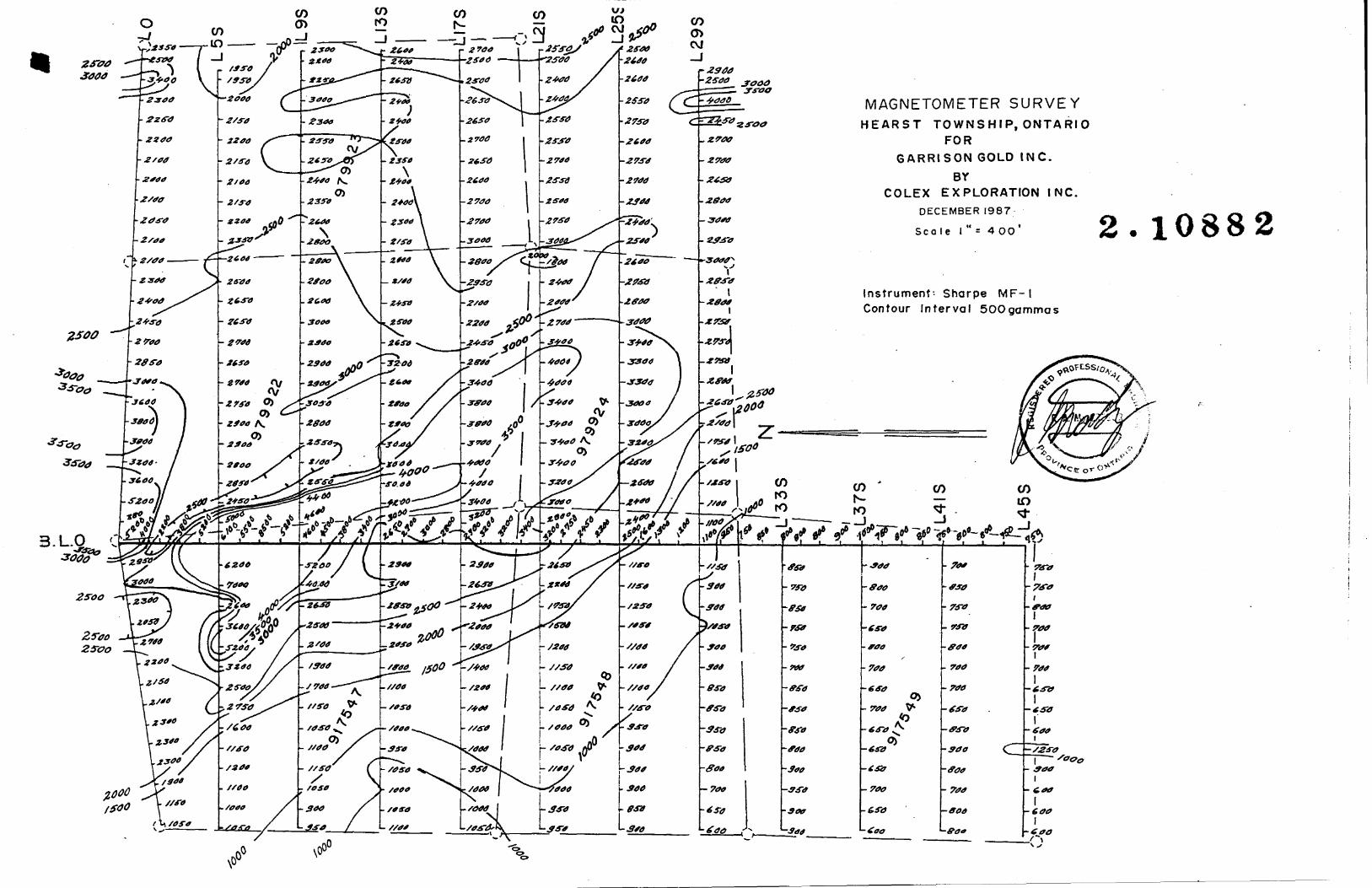
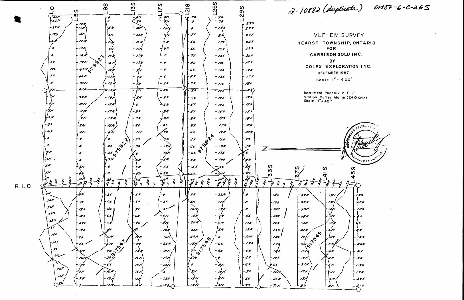
MAGNETOMETER AND VLF-EM SURVEYS
HEARST TOWNSHIP, ONTARIO
by
COLEX EXPLORATION INC.
for
GARRISON GOLD INC.
February 6, 1988

COLEX EXPLORATIONS INC. PAGE NO.
I. INTRODUCTION
Magnetometer and VLF-EM surveys were conducted over cut
lines on 6 claims in Hearst Township during December 1987.
II. LOCATION, ACCESS AND OWNERSHIP
The property is located in the south-central part of
Hearst Township, Larder Lake Mining Division/ District of
Temiskaming, Ontario. The claims are numbered L917547 to 917549
and L979922 to 979924 both inclusive. They are recorded in the
name of Garrison Gold Inc. f c/o Box 1110, Sault Ste. Marie,
Ontario.
Highway 624, a paved secondary highway passes through
the central part of the claims. The claims lie about 5 miles
south of the town of Larder Lake on this highway.
III. PREVIOUS EXPLORATION
There are no records of previous exploration on the
claims, however a number of pits and trenches are in evidence
of past work.
VI. TOPOGRAPHY
Large parts of the claims are covered by swamp or gravel
and clay overburden. The east part of the claims are quite rugged
due to steep outcrops formed of Cobalt sediments.

COLEX EXPLORATIONS INC. PAGE NO. 2
V. MAPPING PROCEDURE
A north-south baseline was laid out starting from a
survey pin defining one of the claim corners on the north boundary.
Crosslines were cut approximately every 400 feet from the baseline,
starting at 500 feet south, as the north boundary (line 0) runs
south-east and south-west from the survey pin. Picket lines were
chained and picketed every 100 feet.
Magnetometer readings were taken with a Sharpe MF-1
Fluxgate magnetometer at 100-foot intervals. The looping method
was used for control of variation. In this method a base station
is selected, and readings taken along lines describing a loop,
arriving back at the starting base station in less than two hours.
A second loop is then started using either the same base station
or another which is tied to the previous loop. Readings are then
corrected for diurnal variation by assuming the time between
readings is the same and distributing any variation equally among
the intervening readings. No correction was applied less than the
accuracy of the base station readings.
A VLF-EM survey was run with a Phoenix VLF-2 instrument
set to the signal from Cutler, Maine (24.0 KHz). Readings were
taken at 100-foot intervals along all lines, using the
procedure outlined in Appendix 1. The looping method was used
for control of variation as in the magnetometer survey.
COLEX EXPLORATIONS INC. PAGE NO.
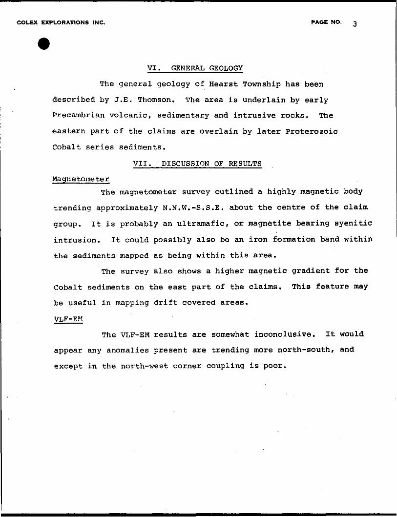
VI. GENERAL GEOLOGY
The general geology of Hearst Township has been
described by J.E. Thomson. The area is underlain by early
Precambrian volcanic, sedimentary and intrusive rocks. The
eastern part of the claims are overlain by later Proterozoic
Cobalt series sediments.
VII. DISCUSSION OF RESULTS
Ma gn e tome te r
The magnetometer survey outlined a highly magnetic body
trending approximately N.N.W.-S.S.E. about the centre of the claim
group. It is probably an ultramafic, or magnetite bearing syenitic
intrusion. It could possibly also be an iron formation band within
the sediments mapped as being within this area.
The survey also shows a higher magnetic gradient for the
Cobalt sediments on the east part of the claims. This feature may
be useful in mapping drift covered areas.
VLF-EM
The VLF-EM results are somewhat inconclusive. It would
appear any anomalies present are trending more north-south, and
except in the north-west corner coupling is poor.
COLEX EXPLORATIONS INC. PAGE NO.
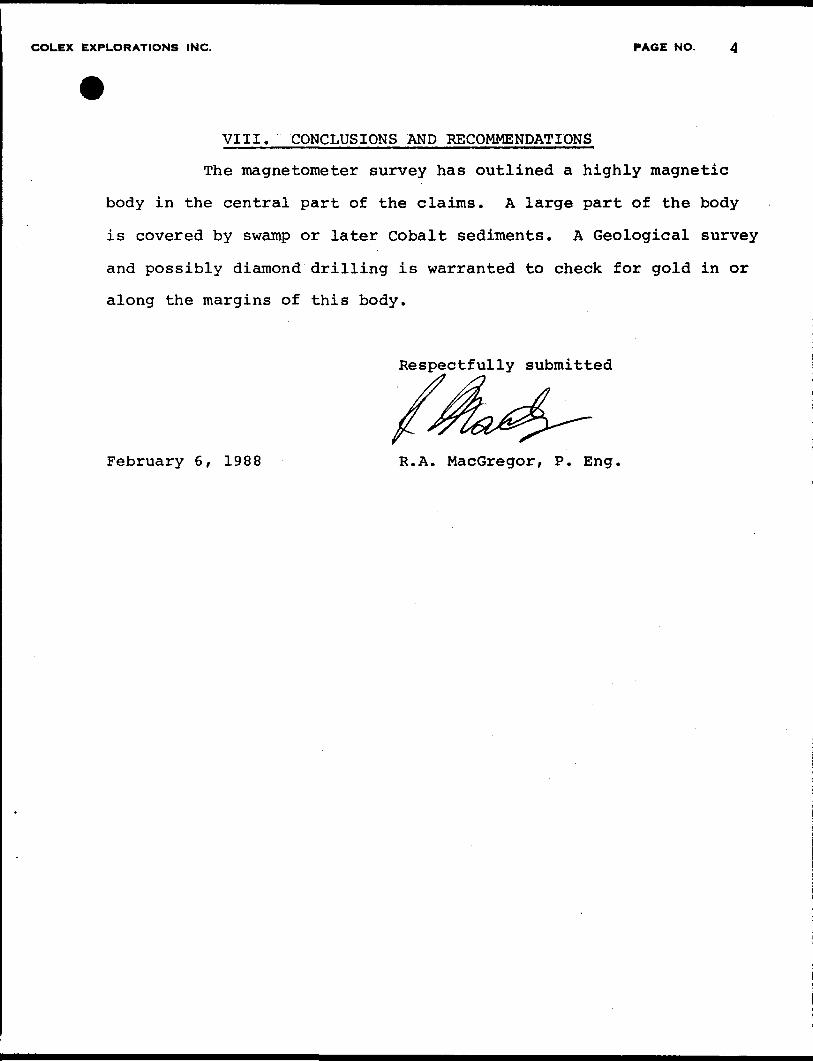
VIII. CONCLUSIONS AND RECOMMENDATIONS
The magnetometer survey has outlined a highly magnetic
body in the central part of the claims. A large part of the body
is covered by swamp or later Cobalt sediments. A Geological survey
and possibly diamond drilling is warranted to check for gold in or
along the margins of this body.
Respectfully submitted
February 6, 1988 R.A. MacGregor, P. Eng,

R. A. MACGREGOR, P.ENG. PAGE NO.
CERTIFICATE
I, Robert A. MacGregor, certify:
1. I am a Mining Engineer residing at 28 FordStreet.Sault Ste. Marie, Ontario. I have worked as a mining engineer and geologist for the past 20 years.
2. I am a member of the Association of Professional Engineers of the Province of Ontario and a member of the Canadian Institute of Mining and Metallurgy,
3. I attended Queen's University for two years in the Mining-Geology course.
4. I personally supervised the field work covered by this report.
DATE
ZfVO 3006
MAGNETOMETER SURVEYHEARST TOWNSHIP, ONTARIO
FOR
GARRISON GOLD INC.
BY COLEX EXPLORATION INC.
DECEMBER 1987-
Scale l " = 4 00*
Instrument; Sharpe MF-I Contour Interval SOOgammas
2.10882
3. L. O
Q.
MAGNETOMETER SURVEYHEARST TOWNSHIP, ONTARIO
FOR
GARRISON GOLD INC.
BY COLEX EXPLORATION INC.
DECEMBER 1987
Scale l " - 4 00*
Instrument-- Sharpe MF- l Contour Interval SOOgammas
o*n-t- G- 16 s

B.L.O
VLF-EM SURVEY
HEARST TOWNSHIP, ONTARIOFOR
GARRISON GOLD INC.
BY COLEX EXPLORATION INC.
DECEMBER 1987
Scale l " - 400'
Instrument Phoenix VLF-2 Station Cutler Maine {24-0 KHz) Scale I"r40 0
^ ' M. ^J O O
*
B.L.O
VLF-EM SURVEY
HEARST TOWNSHIP, ONTARIOFOR
GARRISON GOLD INC.
BY COLEX EXPLORATION INC.
DECEMBER 1987
Scale l" * 400'
Instrument Phoenix VLF-2 Station Cutler Maine (24-0 KHz) Scale l":40 0
Ontario
Ministry ofNorthern Developmentand Mines
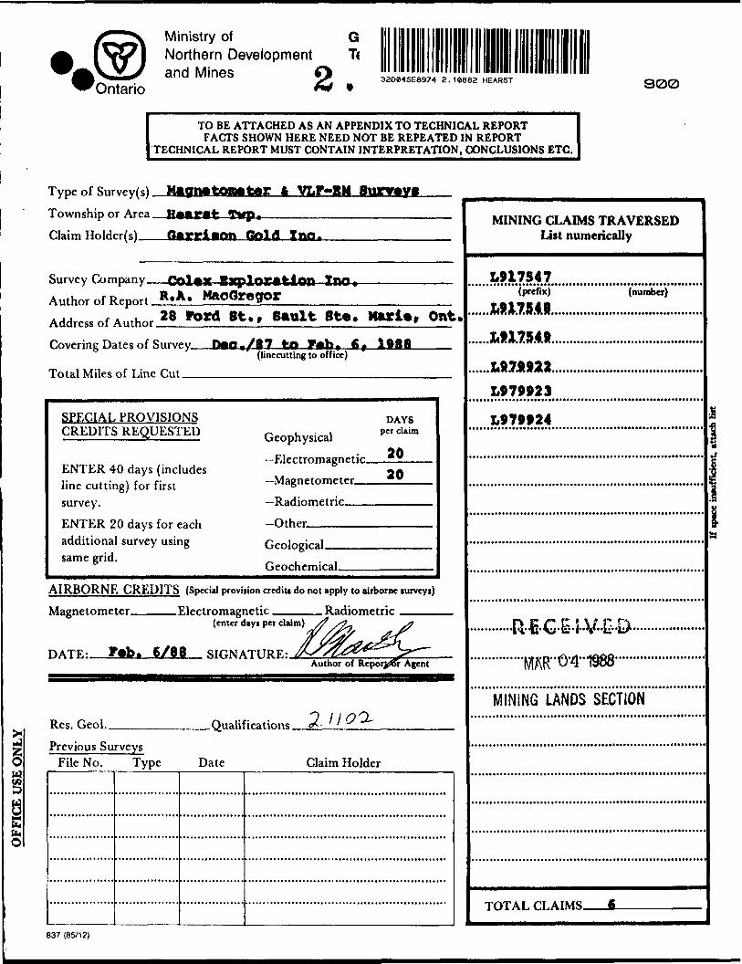
32084SE8974 Z. 10882 HEARST
TO BE ATTACHED AS AN APPENDIX TO TECHNICAL REPORTFACTS SHOWN HERE NEED NOT BE REPEATED IN REPORT
TECHNICAL REPORT MUST CONTAIN INTERPRETATION, CONCLUSIONS ETC.
300
Ia
Type of Survey(s). Township or Area. Claim Holder(s)—
-Sup*Gold Ino.
Survey Company- Author of Report. Address of Author
Exploration InOR,A. MaoQgegor28 Fdrd St. 9 Sault Ste. Hurl*, Ont.
Covering Dates of Survey.
Total Miles of Line Cut_
P0O./87 to fr+frt(linecutting to office)
SPECIAL PROVISIONS CREDITS REQUESTED
ENTER 40 days (includes line cutting) for first survey.ENTER 20 days for each additional survey using same grid.
Geophysical—Electromagnetic.—Magnetometer-——Radiometric———Other————^
DAYS per claim
20
Geological.Geochemical.
AIRBORNE CREDITS (Special provision credits do not apply to airborne turveyi)
Magnetometer. .Electromagnetic. . Radiometric(enter days per claim)
DATF- Fab. 6/68 SIGNATURE:.Author of Repor^r Agent
Res. Geol.. .QualificationsPrevious Surveys
File No. Type Date Claim Holder
MINING CLAIMS TRAVERSED List numerically
.1.917547(prefix)
.MmtJ,(number)
LSI7M23
L979924 i
MINING LANDS SECTION
TOTAL CLAIMS.
837 (85/12)
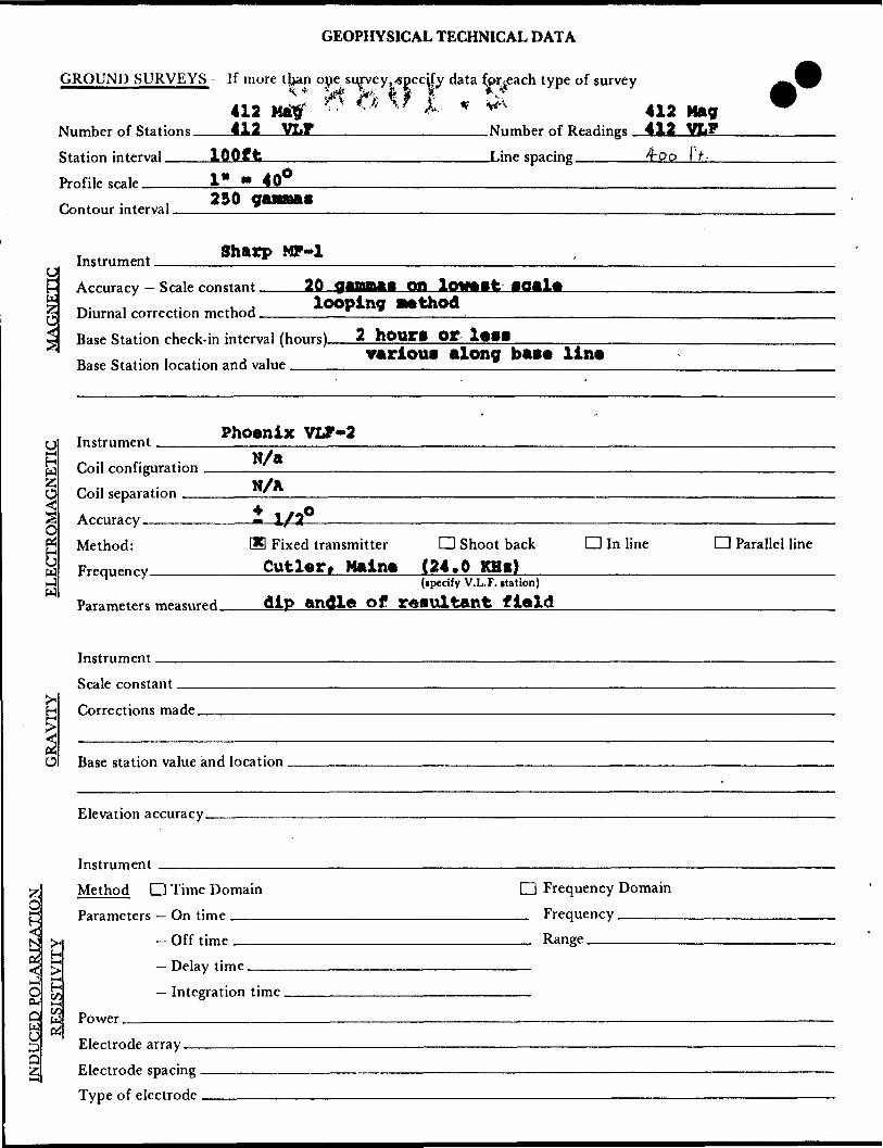
GEOPHYSICAL TECHNICAL DATA
GROUND SURVEYS - If more than one survey,-specify data fprieach type of survey"""~"""""——————""" **'- * Vf 5**' w f * *k412 Ma^ *"' "* " k * ^ 412412 VLF________________Number of Readings 412 VLFNumber of Stations
Station interval —— Profile scale——-—Contour interval.
100ft.Number of Readings
.Line spacing -——.—l* * 40*230 ganna*
H W
Instrument. Sharp MP-1
Accuracy — Scale constant. Diurnal correction method. looping method
Base Station check-in interval (hours). Base Station location and value ,——.
2 houri orvarious along bass lins
Phoenix VLF-2
ECTROMAGNETIC P.nj] rnnfigiiratinn
Coil separation
Accuracy.Method: Freouencv
N/aN/Ail/2035 Fixed transmitter
Cutler, HainsCD Shoot back CD In line
(24.0 KHt)CD Parallel line
Parameters measured. dip andle of resultant flaid
so
InstrumentScale constant.
Corrections made.
Base station value and location.
Elevation accuracy.
2;OH-4
5N t-c4t—i OD-Q b; O
Instrument ^—————--—— Method CD Time Domain Parameters — On time ———
- Off time —-—
CD Frequency Domain _ Frequency ______ Range -—-———.—.
— Integration time.
Power.Electrode array — Electrode spacing . Type of electrode
Ministry ofNorthern Developmentand Mines
Ontario Ministere du Developpement du Nord et des Mines
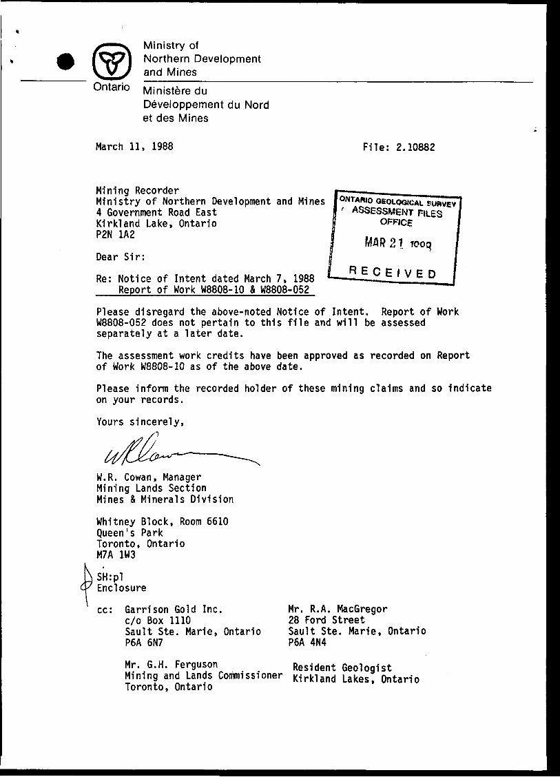
March 11, 1988 File: 2.10882
Mining Recorder ___ Ministry of Northern Development and Mines lONTABIO GEOLOGICAL4 Government Road East Kirkland Lake, Ontario P2N 1A2
Dear Sir:
Re: Notice of Intent dated March 7, 1988 Report of Work W8808-10 A W8808-052
' ASSESSMENT FILES OFFICE
R 21 tooq
RECEIVED
Please disregard the above-noted Notice of Intent. Report of Work W8808-052 does not pertain to this file and will be assessed separately at a later date.
The assessment work credits have been approved as recorded on Report of Work W8808-10 as of the above date.
Please inform the recorded holder of these mining claims and so indicate on your records.
Yours sincerely,
W.R. Cowan, Manager Mining Lands Section Mines S Minerals Division
Whitney Block, Room 6610 Queen's Park Toronto, Ontario M7A 1W3
\SH:pl'7 FnrlnEnclosure
cc: Garrison Gold Inc. c/o Box 1110Sault Ste. Marie, Ontario P6A 6N7
Mr. R.A. MacGregor28 Ford StreetSault Ste. Marie, OntarioP6A 4N4
Mr. G.H. Ferguson Resident Geologist Mining and Lands Commissioner Kirkland Lakes, Ontario Toronto, Ontario
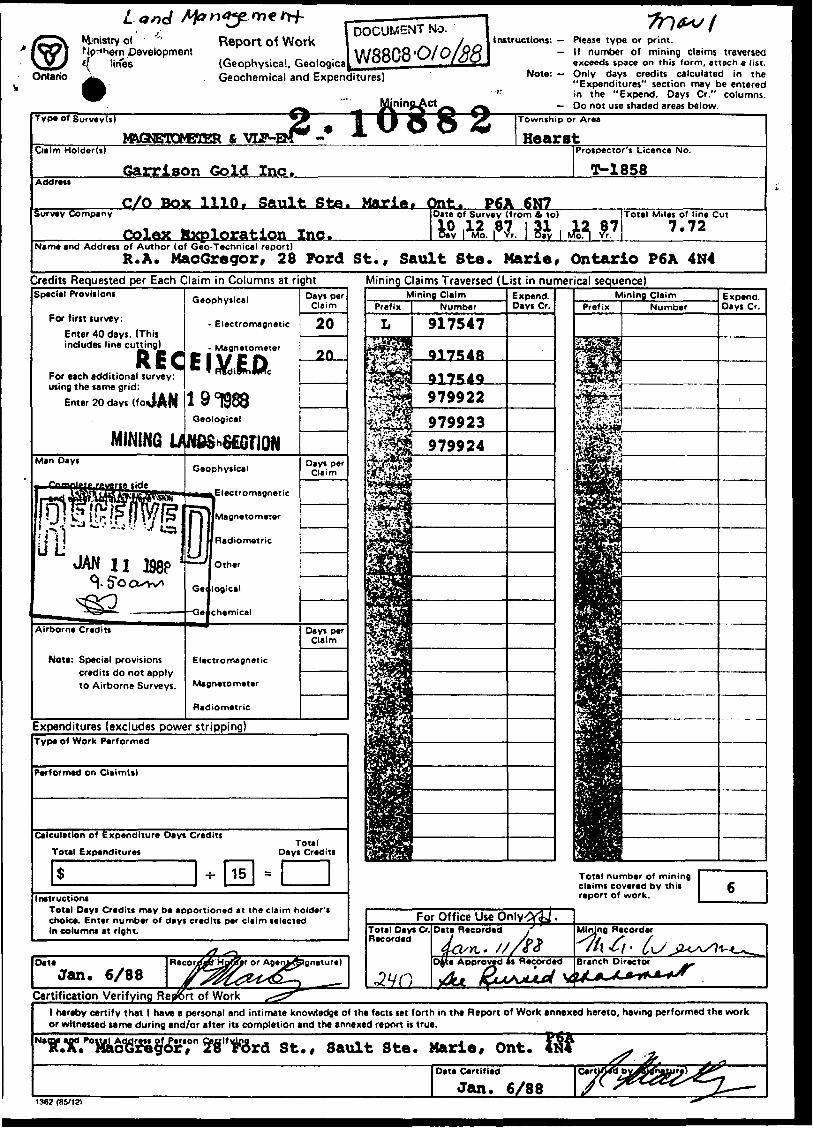
Ministry ofhern Development
Ontariolines
Report of Work(Geophysical, Geologica Geochemical and Expenditures)
DOCUMENT NO.
W88C80/0instructions: Please type or print.
— If number of mining claims traversedexceeds space on this form, attach a list.
Note: Only days credits calculated in the"Expenditures" section may be entered
" in the "Expend. Days Cr." columns. Do not use shaded areas below.
Type of Survey(s)
Claim Holder(i)
Address
Survey Company
Name and Address
M&GNETOM31ER 6 VUHSM^ -
Garrison Gold Inc.
C/0 Box 1110, Sault Ste.
Colex Mxploration Inc.of Author (of Geo-Tecnnical report)R. A. MacGregor, 28 Ford
fl MB J& JK ^^ Township or Area
* Hearst
Marie, Ont.Date o10l Day
P6A 6N7f Survey (from fi to)
tt. ,87, i ft , ,
Prospector's Licence No.
T-1858
H A7 Total Miles of line Cut7.72
St., Sault Ste. Marie, Ontario P6A 4N4Credits Requested per Each Claim in Columns at rightSpecial Provisions
For first survey:
Enter 40 days. (This includes line cutting)
For each additional survey: using the same grid:
Enter 20 days (fon
Geophysical
- Electromagnetic
Magnetometer
Geological
Mining Claims Traversed (List in numerical sequence)
Expenditures (excludes power stripping)Type of Work Performed
Performed on Claim(s)
Calculation of Expenditure Days Credits
Total Expenditures
S -r- |15 | =
Total Days Credits
Instruction! Total Days Credits may be apportioned at the claim holder's choice. Enter number of days credits per claim selected in column* at right.
lOate
Jan. 6/88Certification Verifying Re^rt of Work
Total number of mining claims covered by this report of work.
l hereby certify that l have a personal and intimate knowledge of the facts set forth in the Report of Work annexed hereto, having performed the work or witnessed same during and/or after its completion and the annexed report is true.
r?giflT6rd St., Sault Ste. Marie, Ont.Date Certified
Jan. 6/88Ceri

REFERENCES
AREAS JWITHDRAWN FROM DISPOSITION
M.R.O. -MINING RIGHTS ONLY
S.R.O. -SURFACE RIGHTS ONLY
M.+ S. ~ MINING AND SURFACE RIGHTS
De ion pt J on Order No. Date Diipoiition File
RIGHTS MITHDRAWN FROM STAKING (
SECTION 36/BO ORDER NQ-X
and Mining Rights Withdrawn from , section 36/80 order No.
MINING RIGHTS WITHDRAWN FROM STAKINGSECTION se ; eo ORDER NO. VI
p juriocc and Mining Rights Withdrawn from .Slaking, section 36/80 order Ho.LULLl/RS
O 32/65 OPENS W 17 f 85.
puHace and Mining Rights Withdrawn from .Staking, section 36/80 order No..
O 22/65 OPENS W 36 l 85
l Surface and Mining H*gMi Withdrawn from Staking, section 36/80 ordft* No.^^25
o 24 ; as OPENS PA*T of w aa ; e?O 25 ; 85 OPrNS P**- f O W 38 ; 85 'O 36/85 OPENS P*H l u W 38 ; 85 '
21/ 87 OPFNS PART Of W 38 / 85
Staking, section 36J80.. order
O 74 t Be OPENS PART Of W 7 ; 86 O 96/87 OPENS PART OF W 7/86.
\ Surface ond Mining Rights Withdrawn from ' Slaking, section 36/80 order NoJdVB7fi6
O 64 t a? OPENS PART OF W 8 ; 86 .
vSurfocB ond Mining Rights Withdrawn from 'Slaking, fcdion 36/80 order
Surface ond Mining Right* WlthdrawrMro.rn taking, section 36/80 ord*er No J"
O 75/86 OPENS W 6| l 66 .
y Surface and Mining Rights Withdrawn from ^Stoking, *edlon 36/80 order NoJ^fiZfl^
0-8/88 OPENS PART OF W 50786' jO 60/87 OPENS PART OF W 50 / tib ,
NOTES
Townihip ol Hearst lies tnlirely within the
CORPORATION of Iha TOWNSHIP of
LARDER LAKE . Flit 29282
Staking of mining claims within Ihe Town
of Lard*r Lake shown thus ^v.,,,.^^ *tibj8Ct
to S*c. 37(b) of the Mining Act (RSOI970)
32Da4SE8974 2.10882 HEARST200
MCVITTIE TWPB l/H.S. 802S
54U?64 S4B763 5487*2
522805,Gi.48765 548766*1548787 5*8768
l Ka * 97ME4 l-| ' ^548776 622800 l 322801 irltTQj^^ 822806^ ,
. .^C ^, - -*L
512140 512144 i
IOH740
B122371 l— — flMOItp
rr
l 955124 971297 935368
400B?I ^0034*1 548629 j
.L 636738
L. . \ 31628
31629 \ j 33232 t
^UiV f* ^24849
1522729 J 322730
l522727 [52272BI 522731
l 10.4*72 IOI4Z8*
. —— L - -/-?^t*?*"^
J l ~~" ~~" l L ~VKH4Z74 j K**fr* l 10I4ZM ,
2533824l73**e*o*52i77l &22T7Z l TlS79f—-" —
_ t — .J—— — —-t ~ — ———----—
322774 j 512775
32271* j 522792 545054
522784/322768 |32ZT8Q i
i ! ^JiJ6Q!52^785j.. 398189 3*^? 7*1 '145055 54UO V-.?'!l /, -i * f.* f 'l.tt ,cf dU,rf,aiir————B rf ikv, r.ff.X/.U ij...ir A ' U4i046l 532837 l
SKEAD TWP
L L!
LEGEND
HIGHWAY AND ROUTE No.
OTHER ROADS
TRAILS
SURVEYED LINESTOWNSHIPS, BASt LINES, ETC
LOTS, MINING CLAIMS, PARCELS, ETC
UNSURVEYED LINESLOT LINES
PARCEL BOUNDARY
MINING CLAIMS ETC ^ -
RAILWAY AND RIGHT Of1 WAY
UTILITY LINES
NON PERENNIAL STREAM
FLOODING OR FLOODING RIGHTS
SUBDIVISION OR COMPOSITE PLAN
RESERVATIONS
ORIGINAL SHORELINE
MARSH OR MUSKEG
MINES
TRAVERSE MONUMENT
DISPOSITION OF CROWN LANDS
TYPE OF DOCUMENT SYMBOL
PATENT. SURFACE 4 MINING RIGHTS. —........®. *JL. 0
.SURFACE RIGHTS ONLY............®. SRp^or, O
. MINING RlGHTSONtY^....,................... O
LEASE,SURFACE fc MINING RIGHTS...— ———.—.. H
" .SURFACE RIGHTSONLY......--.-..-.........-.. H
" , MINING RIGHTSONLY...^.......-..-..........-.. Q
LICENCE OF OCCUPATION ............................... T
ORDER-IN COUNCIL ....^....^...............^........,.. OC
RESERVATION .,......................................... (J)
CANCELLED . ———. ———— ———...........—..... —., ®
SAND 8. GRAVEL ..™...................————.....—.. ®
NOTE: MINING RIGHTS IN PARCELS PATENTED PRIOR TO MAY 6. 1B13, VESTED IN ORIGINAL PATENTEE BY THE PUBLIC LANDS ACT. R.S O 1970, CHAP 380. SEC 83, SUBSEC 1
SCALE: 1 INCH ^ 40 CHAINS
O 10UO JOOO 4000 6OOO eooo
O JOGM t T H t S
10OOl 1 KM]
2OOO (2 KM
TOWNSHIP
HEARSTMN R. ADMINISTRATIVE DISTRICT
KIRKLAND LAKEMINING DIVISION
LARDER LAKELAND TITLES/ REGISTRY DIVISION
TIMISKAMING
Ministryof LandNatural Management
Resources BranchOntario
1 FEBRUARr, 1985Nuinbir
G-3213