m5 transport corridor study
TRANSCRIPT

M5 Transport Corridor Study Preliminary overview report
November 2009 RTA Final
RTA/Pub. 09.496 ISBN 978-1-921692-54-3
Additional information February 2010 This document was published in November 2009 and includes a five kilometre link road from the eastern M5 tunnel exit point to the airport and industrial areas close to the airport. The road location shown in this study is not approved and has no status Following discussions with the community the RTA has been requested to look at all options, in partnership with the community, for improving access to the airport and industrial areas close to the airport.

THE PROPOSAL DETAILED IN THIS REPORT IS SUBJECT TO CHANGE FOLLOWING CONSULTATION AND ENVIRONMENTAL ASSESSMENT
Contents
Preface 1
1 Executive summary 2 1.1 Indicative preferred option 2 1.2 Study methodology 5 1.3 Needs assessment 5 1.4 Development of strategic options 6 1.5 Evaluation of strategic options 7 1.6 Refinement of the preferred strategic option 7 1.7 Feasibility assessment 8 1.8 Conclusions and next steps 8
2 Introduction 10 2.1 Context and purpose 10 2.2 Background 10
3 Study methodology 15
4 Needs assessment 17 4.1 Goal definition 17 4.2 Aligning national and state goals 18 4.3 Sydney overview 19 4.4 Existing transport infrastructure and performance 20 4.5 Future drivers of demand on the transport network 25 4.6 Problem statement 31 4.7 Study objectives 32
5 Development of strategic options 33 5.1 Corridor analysis 33 5.2 Identification of strategies and actions 37 5.3 Identification of initiatives 38 5.4 Strategic merit test 40 5.5 Short list of initiatives 45 5.6 Identification of strategic options 51
6 Evaluation of strategic options 57 6.1 Preliminary investigations 57 6.2 Evaluation of strategic options 63 6.3 Preferred strategic option 67
7 Refinement of the preferred strategic option 69 7.1 Interaction with wider road network 69 7.2 Rapid economic appraisal 77 7.3 Tolling 77 7.4 Sensitivity analysis 78 7.5 Conclusion 80
8 Feasibility assessment 82 8.1 Tunnel alignment and western connections 82 8.2 Eastern connection 87 8.3 Southern Sydney connection 89 8.4 Tunnel ventilation 90 8.5 Constructability 92

THE PROPOSAL DETAILED IN THIS REPORT IS SUBJECT TO CHANGE FOLLOWING CONSULTATION AND ENVIRONMENTAL ASSESSMENT
8.6 Operation 95 8.7 Preliminary environmental investigations of the indicative preferred option 96 8.8 Business case 97 8.9 Financial assessment 100 8.10 Procurement and delivery 101 8.11 Risk 102 8.12 Conclusion 103
9 Indicative preferred option 104 9.1 M5 South West Motorway 104 9.2 M5 East Freeway 104
10 Conclusions and next steps 113 10.1 Conclusions 113 10.2 Next steps 114
11 Bibliography 116
List of tables Table 4.1 Synergy between national and state goals 19 Table 5.1 Strategies and actions 37 Table 5.2 Long list of initiatives 39 Table 5.3 Short list of initiatives 45 Table 5.4 Initiative development 47 Table 5.5 Combining initiatives to create strategic options 49 Table 6.1 Existing traffic volumes on Airport Drive, General Holmes Drive and Princes Highway, 2005 57 Table 6.2 Summary of traffic modelling for the strategic options 61 Table 6.3 MCA criteria 64 Table 6.4 Assessment ratings basis 64 Table 6.5 Summary of multi-criteria analysis ratings 65 Table 6.6 Summary of strategic cost estimates 66 Table 6.7 Evaluation of strategic options 68 Table 7.1 Tunnel 1 hour AM and PM peak traffic volumes 2016 and 2026 69 Table 7.2 Surrounding network 1 hour AM and PM peak traffic volumes 2016 and 2026 70 Table 7.3 Traffic volumes 1 hour AM/PM peak 2026 76 Table 7.4 REA outcomes 77 Table 7.5 Impact on public transport 78 Table 7.6 Sydney Airport trip generation for 2006, 2016 and 2026 79 Table 7.7 Comparative traffic volumes with reduced airport growth 79 Table 7.8 Comparative traffic volumes with increased freight movement by rail 80 Table 8.1 Project activity estimated cost. 97 Table 8.2 Economic assessment of the indicative preferred option 98 Table 8.3 Indicative delivery timetables 101 Table 10.1 Addressing national and state goals 114

THE PROPOSAL DETAILED IN THIS REPORT IS SUBJECT TO CHANGE FOLLOWING CONSULTATION AND ENVIRONMENTAL ASSESSMENT
List of figures Figure 1.1 Proposed M5 East Expansion – indicative preferred option 4 Figure 2.1 Study area 12 Figure 3.1 Study methodology 16 Figure 4.1 The Sydney motorway network 21 Figure 4.2 Road congestion levels 2006 AM Peak – volume to lane capacity 23 Figure 4.3 Rail Load Factors 2006 AM Peak – Volume to seat capacity 24 Figure 4.4 Future population and employment drivers of demand 26 Figure 4.5 Distribution of freight from Port Botany throughout Sydney 27 Figure 4.6 Increase in airport passenger and freight movements 28 Figure 4.7 Predicted change in population in key centres 29 Figure 4.8 Predicted change in employment in key centres 30 Figure 4.9 Predicted change in freight movements to and from key centres 2021 and 2031 30 Figure 5.1 M5 Transport Corridor and sub-corridors 35 Figure 5.2 Summary of strategic merit test evaluation of initiatives 43 Figure 5.3 Strategic Option A 52 Figure 5.4 Strategic Option B 53 Figure 5.5 Strategic Option C 54 Figure 5.6 Strategic Option D 55 Figure 5.7 Strategic Option E 56 Figure 6.1 Traffic volume hourly profile eastbound 58 Figure 6.2 Traffic volume hourly profile westbound 58 Figure 6.3 Average link speeds between south-west Sydney and the CBD (2004 and 2007) 59 Figure 6.4 Modelled travel speeds in Option E 62 Figure 7.1 Proposed M5 expansion – indicative preferred option (February 2009) 75 Figure 8.1 Long tunnel alignment 84 Figure 8.2 Slot tunnel alignment 84 Figure 8.3 Northern alignment 85 Figure 8.4 Southern alignment 85 Figure 8.5 Eastern alternative 1 88 Figure 8.6 Eastern alternative 2 88 Figure 8.7 Eastern alternative 3 89 Figure 8.8 Ventilation design for existing M5 East tunnels 91 Figure 9.1 M5 East Freeway – east of King Georges Road 106 Figure 9.2 M5 East Freeway – west of Bexley Road 107 Figure 9.3 M5 East tunnel – east of Bexley Road 108 Figure 9.4 M5 East tunnel – west of Marsh Street 109 Figure 9.5 M5 East tunnel/southern Sydney connection interchange 110 Figure 9.6 Southern Sydney connection – airport to Canal Road 111 Figure 9.7 Southern Sydney connection – Canal Road to Sydney Park Road 112

Preliminary overview report 1
THE PROPOSAL DETAILED IN THIS REPORT IS SUBJECT TO CHANGE FOLLOWING CONSULTATION AND ENVIRONMENTAL ASSESSMENT
Preface
In May 2008 the State and Federal Government’s allocated funds to undertake investigations into the feasibility of potential improvements to the M5 transport corridor. The outcome of the feasibility study is the M5 Transport Corridor Study - Preliminary Overview Report which has also been prepared for inclusion in the NSW Government’s submission to Infrastructure Australia to seek funding for the proposal under the Building Australia Fund. Funding for construction of the proposal contained in the Preliminary Overview Report has not been determined. A mix of government and private sector investment is likely. The preliminary overview report includes traffic forecasts with or without tolls on the project. No decision has been made regarding tolls. The proposal detailed in the Preliminary Overview Report and shown in the attached plans is indicative only. The proposal would be subject to change following further engineering investigations, consultation and environmental assessment as part of the planning approval process.

2 M5 Transport Corridor Study Preliminary overview report
THE PROPOSAL DETAILED IN THIS REPORT IS SUBJECT TO CHANGE FOLLOWING CONSULTATION AND ENVIRONMENTAL ASSESSMENT
1 Executive summary
This report has been prepared to provide the federal and state governments with an overview of the current status of the feasibility study into proposals to improve the M5 Transport Corridor.
The report brings together a number of studies and investigations, which have been undertaken as part of the development and evaluation of potential options to enhance the operational capacity of the corridor.
1.1 Indicative preferred option
The outcome of these studies was the identification of an indicative preferred option for potential improvements to the M5 corridor comprising:
M5 South West Motorway - Widening to provide three lanes in westbound direction between King Georges Road to Camden Valley Way and in the eastbound direction between Camden Valley Way, Prestons and Fairford Road, Padstow.
M5 East Freeway duplication from King Georges Road, Beverly Hills to Cooks River, Mascot:
• Providing a new, four-lane westbound tunnel, provided as either a single four lane tunnel or twin two lane tunnels, with entry and exit portals in the vicinity of the existing tunnel portals.
• Providing four lanes in the eastbound direction by maintaining the existing eastbound tunnel and converting the existing westbound tunnel to eastbound.
• Retaining two lanes in each direction from the Marsh Street portals to General Holmes Drive, the existing eastbound tunnel ramps to Princes Highway and Marsh Street and on-load ramps from Marsh Street to the westbound tunnel.
• Providing two lanes in each direction from the Marsh Street tunnel portals to the new southern Sydney connection.
• Widening to four lanes in each direction the existing M5 East Freeway from the Bexley Road portals to the King Georges Road entry and exit ramps.
• Providing three lanes in each direction under King Georges Road, Beverly Hills.
• Widening Marsh Street to generally three lanes in each direction between the tunnel portals and Airport Drive.
A new southern Sydney connection from the M5 East Freeway, Arncliffe to Euston Road, Qantas Drive and Gardeners Road, Mascot, comprising:
• A new surface and elevated road with two lanes in each direction along the proposed F6 corridor from the eastern side of the M5 East tunnels to north of Tempe Reserve.
• Single lane ramps to provide access between the southern Sydney connection and Airport Drive.
• A signalised intersection at the junction of the southern Sydney connection and Campbell Road to access Gardeners Road via Bourke Road.
Preliminary overview report 3
THE PROPOSAL DETAILED IN THIS REPORT IS SUBJECT TO CHANGE FOLLOWING CONSULTATION AND ENVIRONMENTAL ASSESSMENT
The management of traffic north of Campbell Road will be investigated as part of further concept development and community consultation. Figure 1.1 provides details of the indicative preferred option.
The proposal detailed in this report has been prepared for the feasibility study and is subject to change following engineering investigation, consultation and environmental assessment.

4 M
5 Transport Corridor S
tudy P
reliminary overview
report
Figure 1.1 Proposed M5 East Expansion – indicative preferred option
The proposal shown in these plans is indicative only, prepared for the purposes of the feasibility study, and is subject to change following engineering investigations, consultation and environmental assessment

M5 Transport Corridor Study Preliminary overview report
5
THE PROPOSAL DETAILED IN THIS REPORT IS SUBJECT TO CHANGE FOLLOWING CONSULTATION AND ENVIRONMENTAL ASSESSMENT
=
1.2 Study methodology
An overall study methodology has guided the options development process. The study methodology can be broken down into five components:
• Needs assessment.
• Development of strategic options.
• Evaluation of strategic options (to identify a preferred strategic option).
• Refinement of the preferred strategic option (to identify the indicative preferred option).
• Feasibility assessment of the indicative preferred option.
1.3 Needs assessment
The transport network in Sydney’s inner west and south west plays a key role in the wider metropolitan transport system and in Sydney’s economic productivity. It services both local, regional and national travel demands, providing key connections for freight, commercial and commuter traffic.
While the high volume of traffic using the corridor is an indication of its success as a transport link, current traffic levels and a high percentage of heavy vehicles are resulting in the motorway operating at or near capacity for much of the day and particularly during the morning and evening peaks.
This situation is leading to high levels of congestion on key parts of the transport network, and resulting in significant costs to individuals, businesses and the environment.
There are a number of future drivers of demand that will further intensify levels of congestion in the corridor. These include growth at:
• Sydney Airport and Port Botany.
• The airport to CBD corridor.
• The South West Growth Centre.
• Western Sydney Employment Hub.
• The M5 corridor.
The functionality of airports and ports are critical success factors for all global cities. They are the international gateways for importing and exporting goods, business travellers and tourists.
Sydney Airport passengers are forecast to grow by two and half times (from 31 million to 79 million per year), air freight by more than double (from 471,000 tonnes to 1,077,000 tonnes by 2029) and Port Botany container trade to nearly double (from 1.8 million TEUs (Twenty foot Equivalent Units) to 3 million per year) by the early 2020s.
In 2001–2, more than three quarters of inbound containers were destined for industrial areas in Sydney’s central west including Fairfield, Parramatta, Blacktown, Holroyd and Auburn (NSW Sea Freight Council, 2004). At present, 50–60 per cent of full imported containers and up to 30 per cent of full export containers are delivered to or originate from the inner-western suburbs of Sydney.

6 M5 Transport Corridor Study Preliminary overview report
THE PROPOSAL DETAILED IN THIS REPORT IS SUBJECT TO CHANGE FOLLOWING CONSULTATION AND ENVIRONMENTAL ASSESSMENT
Despite planned growth in the rail mode share, the road transport task will continue to grow for freight and passengers for these key centres. Road will remain the dominant landside transport mode. The quantum of growth will place significant pressure on the road network in both the vicinity of Mascot/Botany and across the broader metropolitan region.
To meet current and future travel needs and demands, continued and targeted investment is required. Investigations into improvements to the M5 corridor is designed to channel this investment where it can deliver the greatest benefit.
1.4 Development of strategic options
To generate, develop and evaluate strategic options for the corridor a detailed assessment methodology has been adopted. The assessment methodology for option development and assessment is comprised of five key steps as follows:
• Step 1 – Corridor analysis.
• Step 2 – Identification of strategies and actions.
• Step 3 – Identification of initiatives.
• Step 4 – Strategic merit test.
• Step 5 – Identification of strategic options.
A range of strategies were considered which focused on potential improvments to the corridor through:
• Surface road improvements.
• Road tunnel options.
• Public transport initiatives.
• Demand management.
Five strategic options were identified as capable of meeting study objectives as follows.
1.4.1 M5 East Freeway – Port Botany and airport to Bexley Road, Earlwood
• Option A – Widen existing tunnels to three lanes between Marsh Street and Bexley Road.
• Option B – New, two lane tidal flow tunnel between Marsh Street and Bexley Road/ King Georges Road.
• Option C – New, twin two lane tunnels between Foreshore Road and Bexley Road/ King Georges Road.
• Option D – New, twin two lane tunnels between Southern Cross Drive and Bexley Road/ King Georges Road.
• Option E – New, three lane westbound tunnel between Marsh Street and Bexley Road/ King Georges Road.
− Convert existing westbound tunnel to eastbound tunnel to access General Holmes Drive.

M5 Transport Corridor Study Preliminary overview report
7
THE PROPOSAL DETAILED IN THIS REPORT IS SUBJECT TO CHANGE FOLLOWING CONSULTATION AND ENVIRONMENTAL ASSESSMENT
=
− Maintain existing eastbound tunnel to provides access to Princes Highway and Marsh Street only.
It should be noted that the following are common to all options:
• Eastern section – M5 East Motorway: Bexley Road, Earlwood and King Georges Road, Beverly Hills
− Widen the existing freeway to provide sufficient lanes in each direction.
• Western section – M5 South West Motorway: King Georges Road, Beverly Hills to Hume Highway, Prestons
− Widen existing motorway to three lanes in each direction.
1.5 Evaluation of strategic options
A number of preliminary investigations have been undertaken to evaluate strategic options and develop a preferred strategic option for feasibility assessment.
The information gained from these investigations was used as the basis for a two-part evaluation process which included:
• Multi-criteria analysis.
• Rapid economic appraisal.
The multi-criteria analysis demonstrated that of the five options, four – options B, C, D and E – could be taken forward for further assessment, with Option E delivering the most non-cost benefits. Option A was excluded at this stage of the evaluation based on constructability.
The rapid economic appraisal identified Option E as providing the greatest economic benefit for the funds expended and therefore the highest benefit cost ratio.
The outcome of the evaluation was the identification of Option E as the preferred strategic option.
1.6 Refinement of the preferred strategic option
The process for refining the preferred strategic option included detailed traffic modelling and an assessment of the ability of the preferred strategic option to integrate with the existing and wider road network.
The refinement process identified that while the preferred strategic option provides additional capacity on the M5 corridor, it also increases demand on the surrounding network, which has limited ability to cater for such increases. To balance demand across the road network and facilitate greater interaction between the preferred strategic option and the existing road network, a number of concepts and refinements to Option E were investigated.
These refinements included the development of a southern Sydney connection and the duplication of the M5 East Freeway to provide a new four lane westbound tunnel. The preferred strategic option with these refinements constituted the indicative preferred option.

8 M5 Transport Corridor Study Preliminary overview report
THE PROPOSAL DETAILED IN THIS REPORT IS SUBJECT TO CHANGE FOLLOWING CONSULTATION AND ENVIRONMENTAL ASSESSMENT
1.7 Feasibility assessment
Feasibility assessment has included the following:
• Tunnel alignment and connections.
• Tunnel ventilation.
• Constructability.
• Operation.
• Environmental assessment.
• Business case.
• Financial.
• Procurement and delivery.
• Risk.
On the basis of the assessments carried out to date, the indicative preferred option is considered to meet the study objectives and represents a feasible solution to improve the operational capacity of the M5 Transport Corridor.
1.8 Conclusions and next steps
The indicative preferred option delivers a number of benefits, which include:
• Improving access to Port Botany and Sydney Airport to cater for increased transport demand and to release the potential economic opportunities created by predicted growth in passenger and freight movements to and from these key centres.
• Increasing capacity along the M5 Transport Corridor to meet existing and future transport demand generated by planned intensification of residential and employment land uses in existing urban areas along and surrounding the M5 corridor.
• Reducing congestion in the M5 corridor and on the surrounding arterial network.
• Improving travel times for individuals and businesses using the corridor, particularly during the AM and PM peaks.
• Delivering a high quality, well integrated and reliable transport network which responds to the diversity and complexity of travel patterns and supports economic development and competitiveness.
• Supporting the prosperity and economic productivity of Sydney as Australia’s only global city.
• Meeting demand for trips that are not well served by public transport and which are dependent on an efficient road network including catering to employment located outside key centres and shift workers.
• Enhancing access to health, education and leisure facilities.
• Reducing greenhouse gas emissions from vehicles.

M5 Transport Corridor Study Preliminary overview report
9
THE PROPOSAL DETAILED IN THIS REPORT IS SUBJECT TO CHANGE FOLLOWING CONSULTATION AND ENVIRONMENTAL ASSESSMENT
=
The study has identified a number of investigations be undertaken to progress the development of the indicative preferred option.
10 M5 Transport Corridor Study Preliminary overview report
THE PROPOSAL DETAILED IN THIS REPORT IS SUBJECT TO CHANGE FOLLOWING CONSULTATION AND ENVIRONMENTAL ASSESSMENT
2 Introduction
2.1 Context and purpose
On 13 May 2008, the Minister for Infrastructure, Transport, Regional Development and Local Government, the Hon. Anthony Albanese, announced $5 million in funding for a feasibility study into potential improvements to the M5 Transport Corridor from Port Botany/Sydney Airport to south west Sydney.
A further contribution of $10 million to investigate the viability of the M5 East duplication was announced by the NSW State Government.
A steering committee – headed by the Co-ordinator General and comprising representatives from the federal Department of Infrastructure, Transport, Regional Development and Local Government; the heads of Department of Planning, Roads and Traffic Authority, Treasury, NSW Transport and Infrastructure (formerly Ministry of Transport) and RailCorp – was set up to oversee the preparation of the feasibility study into improvements in the M5 Transport Corridor.
The purpose of this report is to detail the process and outcomes of a number of studies and investigations, which have been undertaken as part of the development, assessment and evaluation of strategic options for the corridor. The outcome of the report is an indicative preferred option, which will improve the operation of the corridor and meet study objectives.
2.2 Background
The M5 Transport Corridor is the main passenger, commercial and freight route between Port Botany and Sydney Airport and south west Sydney. Refer to Figure 2.1.
The corridor is characterised by an extensive transport network and associated infrastructure. It is highly urbanised, with land use varying from low to high density residential development, commercial and industrial areas, educational institutions, and recreational and open space uses including parks, golf courses and remnant bushland.
The corridor is focussed on the M5 Motorway, which, for ownership and operational purposes, can be divided into two principal sections:
• The M5 South West Motorway – A 22km tolled surface road with two lanes running in each direction between King Georges Road, Beverly Hills and Camden Valley Way, Prestons. It is privately owned and operated by Interlink Roads.
• The M5 East Freeway – A ten kilometre long road connecting the M5 South West Motorway at King Georges Road, Beverly Hills with General Holmes Drive, Kyeemagh. The M5 East Freeway comprises twin, four kilometre, two lane tunnels between Bexley Road, Earlwood and Marsh Street, Arncliffe. It is owned by the NSW Government and operated and maintained by Baulderstone Hornibrook Bilfinger Berger under a contract with the RTA.
The high volume of travel in the corridor is an indication of the corridor’s success as a transport link and its value and wider role in the Sydney region.
M5 Transport Corridor Study Preliminary overview report
11
THE PROPOSAL DETAILED IN THIS REPORT IS SUBJECT TO CHANGE FOLLOWING CONSULTATION AND ENVIRONMENTAL ASSESSMENT
=
Current traffic levels and the high percentage of heavy vehicles using the M5 South West Motorway and the M5 East Freeway result in congestion and high travel times along the corridor, which impact on Sydney’s economic productivity.
This situation is likely to be compounded by significant and planned growth at Port Botany and Sydney Airport as well as planned intensification of population and employment growth along the corridor more generally. Improvements are necessary to accommodate future growth and support state and national economies.

12 M5 Transport Corridor Study Preliminary overview report
Figure 2.1 Study area

M5 Transport Corridor Study Preliminary overview report
13
THE PROPOSAL DETAILED IN THIS REPORT IS SUBJECT TO CHANGE FOLLOWING CONSULTATION AND ENVIRONMENTAL ASSESSMENT

M5 Transport Corridor Study Preliminary overview report
15
THE PROPOSAL DETAILED IN THIS REPORT IS SUBJECT TO CHANGE FOLLOWING CONSULTATION AND ENVIRONMENTAL ASSESSMENT
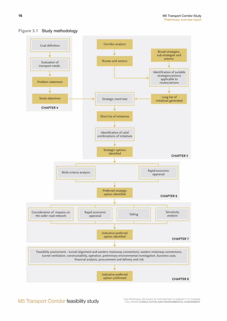
3 Study methodology
The study methodology for the M5 Transport Corridor is consistent with the National Guidelines for Transport System Management In Australia and the Infrastructure Australia (IA) Audit Framework, and aims to identify an indicative preferred option for feasibility assessment.
Central to the overall methodology is a needs based approach to the transport network in Sydney. An assessment of current and future transport needs culminates in a problem statement and study objectives.
The next key step in the methodology involves generating and evaluating strategic options, to address study objectives and the problem statement, to identify a preferred strategic option.
The preferred strategic option is subjected to further investigations and refinement to identify an indicative preferred option for the corridor. A feasibility assessment is undertaken to confirm the indicative preferred option.
The study methodology is presented in Figure 3.1.
16 M5 Transport Corridor Study Preliminary overview report
THE PROPOSAL DETAILED IN THIS REPORT IS SUBJECT TO CHANGE FOLLOWING CONSULTATION AND ENVIRONMENTAL ASSESSMENT
Figure 3.1 Study methodology

M5 Transport Corridor Study Preliminary overview report
17
THE PROPOSAL DETAILED IN THIS REPORT IS SUBJECT TO CHANGE FOLLOWING CONSULTATION AND ENVIRONMENTAL ASSESSMENT
4 Needs assessment
This chapter assesses Sydney’s needs from a strategic transport perspective to support national and state goals focusing on the M5 Transport Corridor. The output of this needs assessment is the development of a problem statement and study objectives.
4.1 Goal definition
4.1.1 National goals
Australia has a long and successful history of economic development and growth. At the same time, Australian residents enjoy a high quality of life when compared to world standards. In 2007, Australia’s quality of life was appraised and rated as first in the Asia Pacific region, and fifth in the world – making the country one of the best places to live, work and raise a family.
While this is an enviable position, it is also one which requires a concerted effort to be sustained. In recognition of this challenge the Australian Government – in its 2008/9 Budget – established three funds designed to invest in Australia’s productive capacity, one of which was the Building Australia Fund (BAF).
IA was subsequently established to guide the allocation of the BAF, and to develop and assess infrastructure priorities and needs which are of significance to national prosperity and productivity.
To guide its decision making, IA has identified Australia’s national goals as follows:
• Increased economic standards of living for Australians.
• Environmental sustainability and reduced greenhouse gas emissions.
• Better social outcomes, quality of life and reduced social disadvantage in our regions.
In addition, and to support national goals, IA has identified a series of strategic priorities, which can be summarised as follows:
• Expand Australia’s productive capacity.
• Increase Australia’s productivity.
• Diversify Australia’s economic capabilities.
• Build on Australia’s global competitive advantages.
• Develop our cities.
• Improve social equity, and quality of life in our cities and our regions.
18 M5 Transport Corridor Study Preliminary overview report
THE PROPOSAL DETAILED IN THIS REPORT IS SUBJECT TO CHANGE FOLLOWING CONSULTATION AND ENVIRONMENTAL ASSESSMENT
4.2 Aligning national and state goals
The NSW Government has also developed a number of goals to guide its future decision making. These goals were outlined in the 2006 State Plan – A New Direction for NSW and included a number of themes:
• Rights, respect and responsibility:
− Keeping people safe.
− Building harmonious communities.
• Delivering better services:
− Healthy communities.
− Students fulfil their potential.
− An effective transport system.
− Customer friendly services.
• Fairness and opportunity:
− Strengthening Aboriginal communities.
− Opportunity and support for the most vulnerable.
− Early intervention to tackle disadvantage.
• Environment for living:
− Securing our water supply.
− Practical environmental solutions.
− Improved urban environments.
• Growing prosperity across NSW:
− NSW: Open for business.
− Stronger rural and regional economies.
It is recognised that achieving national goals and delivering on strategic priorities will require a coordinated effort across all levels of governments. The strong alignment between national and state goals is critical to achieving an infrastructure solution that produces the widest possible economic, social and environmental benefits. The synergy between the national and state goals is summarised in Table 4.1.
M5 Transport Corridor Study Preliminary overview report
19
THE PROPOSAL DETAILED IN THIS REPORT IS SUBJECT TO CHANGE FOLLOWING CONSULTATION AND ENVIRONMENTAL ASSESSMENT
Table 4.1 Synergy between national and state goals
National goals 2006 NSW state goals
Increased economic standards of living for Australians.
• Growing prosperity across NSW: − NSW: Open for business. − Stronger rural and regional economies.
Environmental sustainability and reduced greenhouse gas emissions.
• Environment for living: − Securing our water supply. − Practical environmental solutions. − Improved urban environments.
Better social outcomes, quality of life, and reduced social disadvantage in our regions.
• Rights, respect and responsibility: − Keeping people safe. − Building harmonious communities.
• Delivering better services: − Healthy communities. − Students fulfil their potential. − An effective transport system. − Customer friendly services.
• Fairness and opportunity: − Strengthening Aboriginal communities. − Opportunity and support for the most vulnerable. − Early intervention to tackle disadvantage.
4.3 Sydney overview
Sydney accounts for almost one quarter of Australia's total annual production of goods and services. It is the business hub of Australia, a leading financial centre in the Asia Pacific region and Australia’s only global city.
The transport network in Sydney’s inner west and south west plays a key role in the wider metropolitan transport system and in Sydney’s economic productivity. It services both local, regional and national travel demands, providing key connections for freight, commercial and commuter traffic. Over the last decade, demand for all forms of travel on the network has increased substantially, resulting in the motorway and surrounding arterial network operating at or near capacity for much of the day and particularly during the morning and evening peaks. Heavy flows are increasingly extending into business hours and weekends resulting in significant congestion costs to individuals and businesses along key corridors such as the M5, M4, Parramatta Road, M2, Lane Cove and Warringah Freeway.
The situation is likely to be compounded by significant and planned intensification of residential and employment land uses, a large proportion of which will be in the existing urban areas of south west Sydney.
Future and existing transport demand and anticipated growth therefore presents a significant challenge for Sydney and the NSW Government across all transport modes – road, rail and bus. Continued investment is required to ensure the delivery of high quality, well-integrated and reliable services that support Sydney’s economic development and competitiveness.
Given the prominence of Sydney to national growth and productivity, it can be concluded that the city will continue to play a leading role in achieving Australia’s national goals.

20 M5 Transport Corridor Study Preliminary overview report
THE PROPOSAL DETAILED IN THIS REPORT IS SUBJECT TO CHANGE FOLLOWING CONSULTATION AND ENVIRONMENTAL ASSESSMENT
4.4 Existing transport infrastructure and performance
Sydney has a complex transport network that services an expansive city spreading more than 50 kilometres to the Blue Mountains, the Central Coast and the Illawarra.
Increasingly, travel demands in Sydney are becoming more complex with the diversification of places of employment, the densification of existing areas, and the ongoing spatial expansion of the city’s fringe. Sydney’s transport network already services a population of 4.2 million people with some 15.5 million trips on an average week day. These trips are made up of passenger, commercial and freight trips with a complex variety of trip purposes expanding well beyond the journey to work. Today there is a large diversity in travel purposes with only 25–35 per cent work related. Of these trips, approximately 15–20 per cent are commuter trips and 10–15 per cent are business trips.
4.4.1 Road network
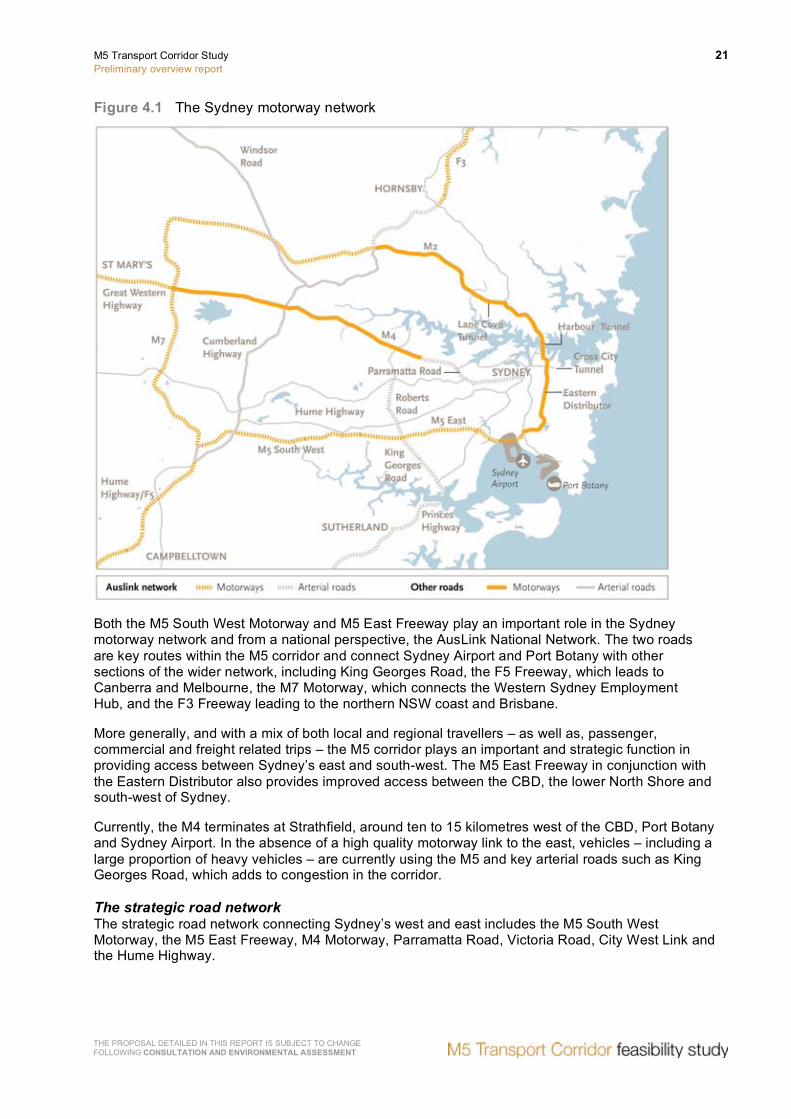
Sydney’s strategic road network operates as a network of motorways, which are supplemented by a number of key arterial routes. The Sydney motorway network is illustrated in Figure 4.1. Radial corridors emanate from around Sydney’s CBD in a number of directions, including to the:
• North (Pacific Highway and F3).
• North-west (Lane Cove Tunnel and M2).
• West (Parramatta Road, City West Link, M4 Motorway and Great Western Highway).
• South-west (M5 East, M5 South West Motorway and F5 Freeway).
• South (Princes Highway and F6 Freeway).
The north-south M7 Motorway links the M2 Motorway and M5 Motorway in the west to form the Sydney Orbital.
M5 Transport Corridor Study Preliminary overview report
21
THE PROPOSAL DETAILED IN THIS REPORT IS SUBJECT TO CHANGE FOLLOWING CONSULTATION AND ENVIRONMENTAL ASSESSMENT
Figure 4.1 The Sydney motorway network
Both the M5 South West Motorway and M5 East Freeway play an important role in the Sydney motorway network and from a national perspective, the AusLink National Network. The two roads are key routes within the M5 corridor and connect Sydney Airport and Port Botany with other sections of the wider network, including King Georges Road, the F5 Freeway, which leads to Canberra and Melbourne, the M7 Motorway, which connects the Western Sydney Employment Hub, and the F3 Freeway leading to the northern NSW coast and Brisbane.
More generally, and with a mix of both local and regional travellers – as well as, passenger, commercial and freight related trips – the M5 corridor plays an important and strategic function in providing access between Sydney’s east and south-west. The M5 East Freeway in conjunction with the Eastern Distributor also provides improved access between the CBD, the lower North Shore and south-west of Sydney.
Currently, the M4 terminates at Strathfield, around ten to 15 kilometres west of the CBD, Port Botany and Sydney Airport. In the absence of a high quality motorway link to the east, vehicles – including a large proportion of heavy vehicles – are currently using the M5 and key arterial roads such as King Georges Road, which adds to congestion in the corridor.
The strategic road network The strategic road network connecting Sydney’s west and east includes the M5 South West Motorway, the M5 East Freeway, M4 Motorway, Parramatta Road, Victoria Road, City West Link and the Hume Highway.
22 M5 Transport Corridor Study Preliminary overview report
THE PROPOSAL DETAILED IN THIS REPORT IS SUBJECT TO CHANGE FOLLOWING CONSULTATION AND ENVIRONMENTAL ASSESSMENT
The M5 South West Motorway is a four lane motorway that extends from Liverpool to Beverly Hills. It is connected to the M5 East Freeway, which is comprised of a four lane surface motorway and a road tunnel that continues from Beverly Hills and extends to Kyeemagh. Weekday traffic volumes routinely exceed 100,000 vehicles per day on the M5 corridor resulting in congestion and delays in peak hours (refer to Figure 4.2). Due to the levels of congestion in the corridor, incidents on this motorway cause high levels of congestion with resultant diversions of traffic putting further pressure on the surrounding road network.
The key operational constraints on the M5 corridor are as follows:
• Key arterial roads on the surrounding road network, including General Holmes Drive and Airport Drive, are operating at or near capacity with limited opportunity for widening.
• Currently a contra flow lane operates on the southbound carriageway of General Holmes Drive through the airport tunnel in the morning peak to cater for the northbound traffic volumes and provides easier access to Foreshore Road.
• The steep grade leading to the exit of the westbound M5 East tunnel impacts on travel speeds, particularly of heavy vehicles, which limits traffic capacity. In the same area, vehicles exiting to Kingsgrove Road generally travel in the right hand lane, further impacting on capacity.
• The merging of traffic entering the M5 Motorway at major interchanges, particularly at Marsh Street, Kingsgrove Road and King Georges Road.
• Incidents on the surrounding road network cause congestion in the M5 East tunnel, occasionally resulting in tunnel closures. Major incidents in the tunnels may also require the closure of one or both tunnels to ensure the safety of the emergency services attending incidents.
Key parallel arterial roads including Newbridge Road/Milperra Road/Canterbury Road/Stanmore Road and Henry Lawson Drive/Stoney Creek Road/Forest Road are also congested for substantial periods of the day, with little capacity to cater for traffic, which may divert from a congested motorway. These roads are typically four and six lane ageing arterial roads, in some cases undivided and without adequate turning lanes. Some sections have poor alignments, narrow lanes and uncontrolled access making them a challenge for heavy vehicles and prone to disruption as a result of incidents.

M5 Transport Corridor Study Preliminary overview report
23
THE PROPOSAL DETAILED IN THIS REPORT IS SUBJECT TO CHANGE FOLLOWING CONSULTATION AND ENVIRONMENTAL ASSESSMENT
Figure 4.2 Road congestion levels 2006 AM Peak – volume to lane capacity
Source: Sydney Travel Model, Transport Data Centre, October 2008.
Further south, the Hume Highway extending from Liverpool to the city is a four and six lane ageing road with frequent at grade intersections and uncontrolled access. It provides an alternative arterial route to both the M4 Motorway and M5 corridor.
4.4.2 Rail network
The rail network in Sydney (while shared) can be divided into two core services: passenger rail and freight rail.
Passenger rail Sydney’s inner west and south-west are serviced by a total of five passenger rail lines – the Western Line, South Line, Inner West Line, East Hills/Airport Line and the Bankstown Line. The rail infrastructure between Strathfield and Redfern is the most heavily used part of the network, with trains required to service both local (stopping) and regional (express) needs. Stations at Parramatta, Blacktown and Mount Druitt are the most patronised stations on the Western Line; Strathfield, Burwood and Ashfield on the Inner Western Line; Liverpool and Cabramatta and Fairfield on the Liverpool Line.
Despite the general perception that Sydney is a city totally reliant on car travel, Sydney in fact has the highest use of public transport of all Australian capital cities. In Sydney, over one in five people use public transport to get to work (22 per cent). The current performance of Sydney’s strategic rail network in the morning peak is shown in Figure 4.3.

24 M5 Transport Corridor Study Preliminary overview report
THE PROPOSAL DETAILED IN THIS REPORT IS SUBJECT TO CHANGE FOLLOWING CONSULTATION AND ENVIRONMENTAL ASSESSMENT
Figure 4.3 Rail Load Factors 2006 AM Peak – Volume to seat capacity
Source: Developed from Sydney Travel Model and Rail Compendium, 2008
Since the early 1990s, the network has been improved with the construction of a new line to the airport with stations Green Square, Mascot, domestic terminal and international terminal, the extension of the East Hills Line to Campbelltown and the quadruplication of the East Hills Line between Turrella and Revesby.
The East Hills quadruplication has resulted in additional capacity on this line, as shown by the lower load factors on the line, thus it can accommodate additional passenger growth. (Refer to Figure 4.3)
Currently, all passenger rail services operating on the rail network from Parramatta to the City Circle are operating over capacity during the AM peak period. It is the most congested part of the rail network as it caters for long-distance commuters from Sydney’s outer west, as well as, passengers joining the line from suburbs in the central and inner west.
The load factor between Parramatta and the CBD is over 120 per cent (refer to Figure 4.3) for the significant majority of its length. Other services with passenger loads exceeding seat capacity include the Illawarra Line, Northern Line and the South Line.
The recently opened Chatswood to Epping Line, which includes 12.5 kilometre twin rail tunnels provides some relief to passenger loads on both the Northern Line and the Western Line and increases the long-term capacity of the network by providing an alternative path to Sydney’s CBD from the north. This serves to free up capacity on the Western Line east of Strathfield, enabling an additional 18,000 passengers to travel on the Western Line each day.
However, while this additional capacity will provide for existing passenger loads it is anticipated that it would not be sufficient to accommodate future population and employment growth.

M5 Transport Corridor Study Preliminary overview report
25
THE PROPOSAL DETAILED IN THIS REPORT IS SUBJECT TO CHANGE FOLLOWING CONSULTATION AND ENVIRONMENTAL ASSESSMENT
Freight rail Along the metropolitan rail lines where freight trains share the network with passenger trains, priority is given to passenger services.
As a result, freight trains do not use the general rail network in Sydney on weekdays from the start of the morning peak to the end of the evening peak. This places a considerable constraint on the capacity and reliability of the freight rail service in the Sydney metropolitan area.
A dedicated rail freight line exists between Port Botany and Enfield/Chullora, a distance of approximately 18 kilometres. There is also a freight line extension to the south-west from Chullora to Sefton Junction (about 2.5 kilometres). From Sefton Junction to Macarthur, freight trains traverse and share the passenger network on the Main South Line.
A further freight line extension to the north runs from Chullora to Flemington Junction, Strathfield and North Strathfield (about five kilometres), where freight trains then use the passenger network on the Main North Line to Hornsby via Epping. Freight trains travelling from Enfield/Chullora to Sydney's west share the passenger rail network on the Main West Line from Lidcombe to Penrith.
This creates a bottleneck not only for Sydney movements but also Melbourne-Sydney-Brisbane movements in the North South Rail Corridor. To alleviate this bottleneck, the Australian Rail Track Corporation has begun construction on the Southern Sydney Freight Line, which will provide a dedicated freight line for a distance of 36 kilometres between Macarthur and Sefton. It will provide a third track in the rail corridor specifically for freight services, allowing passenger and freight services to operate independently. This initiative, when completed, will assist a gradual increase in rail’s mode share of container freight from the current 19 per cent toward the target of 40 per cent by 2011.
4.5 Future drivers of demand on the transport network
There are a number of future drivers of demand that will generate a range of passenger, commercial and freight trips and intensify levels of congestion on the road network. While some of these trips will be suited to travel by rail, the majority will make use of the road network.
The NSW Government’s Urban Transport Statement (2006) and Metropolitan Strategy anticipates that this demand will be driven by a mix of population and employment growth, particularly in the following areas (refer to Figure 4.4):
• Sydney Airport and Port Botany.
• Airport to CBD corridor.
• South West Growth Centre.
• Western Sydney Employment Hub.
• The M5 Transport Corridor.

26 M5 Transport Corridor Study Preliminary overview report
THE PROPOSAL DETAILED IN THIS REPORT IS SUBJECT TO CHANGE FOLLOWING CONSULTATION AND ENVIRONMENTAL ASSESSMENT
Figure 4.4 Future population and employment drivers of demand
Source: Transport Data Centre, Population Forecasts, 2006
4.5.2 Sydney Airport and Port Botany
The functionality of airports and ports are critical success factors for all global cities. They are the international gateways for importing and exporting goods, business travellers and tourists.
Sydney Airport passengers are forecast to grow by two and half times (from 31 million to 79 million per year), air freight by more than double (from 471,000 tonnes to 1,077,000 tonnes by 2029) and Port Botany container trade to nearly double (from 1.8 million TEUs to 3 million per year) by the early 2020s. This quantum of growth will place significant pressure on the road network in both the vicinity of Mascot/Botany and across the broader metropolitan region.
In 2001–2, more than three quarters of inbound containers were destined for industrial areas in Sydney’s central west including Fairfield, Parramatta, Blacktown, Holroyd and Auburn (NSW Sea Freight Council, 2004). At present, 50–60 per cent of full imported containers and up to 30 per cent of full export containers are delivered to or originate from the inner-western suburbs of Sydney.

M5 Transport Corridor Study Preliminary overview report
27
THE PROPOSAL DETAILED IN THIS REPORT IS SUBJECT TO CHANGE FOLLOWING CONSULTATION AND ENVIRONMENTAL ASSESSMENT
Currently, and due to a lack of high quality routes through the inner west and, with the M4 Motorway terminating at Strathfield, these containers are transported on alternative routes including the M5 corridor, adding to this already congested corridor in peak hours. Figure 4.5 below shows the distribution of freight from Port Botany throughout Sydney, which indicates the majority of freight is transported to locations along the M5 Corridor and to the western area of Sydney.
Figure 4.5 Distribution of freight from Port Botany throughout Sydney
Reference: Transport Data Centre Freight Database 2006 (prepared by MWT/Halcrow)
Trips to and from Sydney Airport and Port Botany are dominated by road-based modes with only moderate mode shifts to rail expected to occur in future. In 2003/04, around 960,000 or 80 per cent of containers handled by Port Botany were transported by road. The remaining 20 per cent were transported on rail.
Currently 25,880 freight trips occur during the two hour AM peak – this is predicted to increase to 37,700 (46 per cent) by 2021 and 47,935 (85 per cent) by 2031.
The NSW Government has set a target of doubling the share of containers using rail to 40 per cent by 2011 and intermodal terminals as indentified in the Metropolitan Strategy, such as the potential Moorebank site and the site at Enfield, would support the shift to rail transport. However, and in view of the forecast quantum of growth at Port Botany to around 3,000,000 containers by 2021, even if the targeted mode shift to rail is achieved, the number of containers transported by road will still double to around 1,800,000.

28 M5 Transport Corridor Study Preliminary overview report
THE PROPOSAL DETAILED IN THIS REPORT IS SUBJECT TO CHANGE FOLLOWING CONSULTATION AND ENVIRONMENTAL ASSESSMENT
At Sydney Airport approximately 90 per cent of passengers and meeters/greeters, together with all air freight, access the airport by road. Sydney Airport Corporation (2006) has targeted a modest five per cent mode shift to rail over the next 20 years – the impact of this predicted growth is likely to be felt most on the M5 South West Motorway and the M5 East Freeway. Details of the increase in passenger and freight movements through Sydney Airport to 2029 is summarised in Figure 4.6 below.
Figure 4.6 Increase in airport passenger and freight movements
4.5.3 Urban renewal in the Airport to CBD corridor
To accommodate Sydney's future growth and changes in household size, 60 to 70 per cent of new homes will be in Sydney's existing suburbs and 30 to 40 per cent in new land release areas. The NSW Government’s Metropolitan Strategy targets the Parramatta to City and the City to Airport corridors as areas for urban renewal over the next 25 to 30 years.
Growth in the City to Airport corridor is focussed on enhancing the economic role of this area and its value to Sydney as a global city. In this context, substantial growth is foreseen in the suburbs of Redfern and Waterloo with accommodation for 4,000 new residents and 18,000 jobs planned.
In addition, the Green Square Town Centre is planned to accommodate 5,500 new residents and 8,000 new jobs over the next 25 years. Further urban renewal from Wolli Creek to Bankstown, Liverpool and Campbelltown will see continuing population and employment growth in the corridor.
Supporting infrastructure, including both road and rail enhancements is urgently required to meet travel demands generated by planned growth in these corridors.
4.5.4 South West Growth Centre
The South West Growth Centre (SWGC) which spans the local government areas (LGAs) of Liverpool, Camden and Campbelltown is planned to accommodate around 110,000 new homes in the next 30 years in greenfield areas around Leppington and Oran Park.
It covers approximately 17,000 hectares of land that will require an extensive transport network to support the need for access to education, work, recreation and health facilities. Progressive land release has already commenced at Edmondson Park. Existing roads will be placed under increasing pressure. Growth in the SWGC would rely heavily on access via the M5 corridor to the eastern parts of Sydney.
4.5.5 Western Sydney Employment Hub (M4/M7)
Located at the junction of the M7 and M4 motorways the Western Sydney Employment Hub comprises 1,500 hectares of land for industrial use – with the potential to generate more than 1,000 net hectares of additional employment land.
M5 Transport Corridor Study Preliminary overview report
29
THE PROPOSAL DETAILED IN THIS REPORT IS SUBJECT TO CHANGE FOLLOWING CONSULTATION AND ENVIRONMENTAL ASSESSMENT
Distribution centres for major companies that import goods from overseas are attracted to the site situated at the junction of two motorways and offering a large area of land suitable for major warehousing uses.
LG Electronics is operating on the site and a national distribution centre for Coles Myer is being constructed. At present the most reliable route between Eastern Creek and Port Botany/Sydney Airport is via the M7 Motorway and M5 corridor.
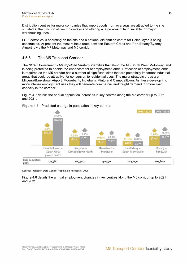
4.5.6 The M5 Transport Corridor
The NSW Government’s Metropolitan Strategy identifies that along the M5 South West Motorway land is being protected to enable the enhancement of employment lands. Protection of employment lands is required as the M5 corridor has a number of significant sites that are potentially important industrial areas that could be attractive for conversion to residential uses. The major strategic areas are Milperra/Bankstown Airport, Moorebank, Ingleburn, Minto and Campbelltown. As these develop into more intense employment uses they will generate commercial and freight demand for more road capacity in the corridor.
Figure 4.7 details the annual population increases in key centres along the M5 corridor up to 2021 and 2031.
Figure 4.7 Predicted change in population in key centres
Source: Transport Data Centre, Population Forecasts, 2006
Figure 4.8 details the annual employment changes in key centres along the M5 corridor up to 2021 and 2031.

30 M5 Transport Corridor Study Preliminary overview report
THE PROPOSAL DETAILED IN THIS REPORT IS SUBJECT TO CHANGE FOLLOWING CONSULTATION AND ENVIRONMENTAL ASSESSMENT
Figure 4.8 Predicted change in employment in key centres
Source: Transport Data Centre, Employment Forecasts, 2006
Figure 4.9 details the predicted change in freight movements to and from key centres along the M5 corridor.
Figure 4.9 Predicted change in freight movements to and from key centres 2021 and 2031

M5 Transport Corridor Study Preliminary overview report
31
THE PROPOSAL DETAILED IN THIS REPORT IS SUBJECT TO CHANGE FOLLOWING CONSULTATION AND ENVIRONMENTAL ASSESSMENT
4.6 Problem statement
It is apparent from an overview of the strategic transport network that there are a number of key challenges facing Sydney.
These challenges are outlined as part of the problem statement and will form the basis upon which initiatives, strategic options and an indicative preferred option will be considered and developed.
• The existing arterial road network around the M5 corridor is operating at or near capacity during peak periods and for much of the day. This is high levels of congestion on key parts of the transport network, which results in significant costs to individuals, businesses and the environment.
• In view of the inextricable link between transport infrastructure and economic development and productivity, these costs are impacting on the NSW and Australian economies, as well as on the prosperity and competitiveness of Sydney as Australia’s only global city.
• It is anticipated that this situation will be compounded by substantial increases in existing and future travel demand generated by:
− Passenger and freight growth at Sydney Airport and Port Botany – a large proportion of which is destined for or originates from western Sydney.
− Planned and significant intensification of residential and employment land uses – particularly in existing urban areas along and surrounding the M5 corridor.
• As a result, it is considered that the M5 corridor cannot meet current or future transport demand without improvement or enhancement.
In this context, and in framing the response to the problem statement, a number of further factors require consideration. These include developing an efficient and sustainable transport solution, which responds to the diversity and complexity of today’s travel patterns and assists in:
• Improving access to Port Botany and Sydney Airport to cater for increased transport demand and release the potential economic opportunities created by predicted growth in passenger and freight movements to and from these key centres.
• Meeting demand for trips that cannot be met by public transport and which are dependent on an efficient road network, for example:
− Work-related business and commercial trips, including shift work, trades, sales, construction activities and services.
− Freight movements across the wider Sydney area and which do not originate from Port Botany.
− Employment located outside key centres.
• Enhancing access to health, education and leisure facilities, for example:
− Prince of Wales Hospital, Randwick.
− Sydney Children’s Hospital, Randwick
− University of NSW, Kensington.
− Randwick Racecourse, Randwick.

32 M5 Transport Corridor Study Preliminary overview report
THE PROPOSAL DETAILED IN THIS REPORT IS SUBJECT TO CHANGE FOLLOWING CONSULTATION AND ENVIRONMENTAL ASSESSMENT
• Enhancing the transport network in a way that is environmentally sustainable and seeks to reduce greenhouse gases.
• Delivering wider, socio-economic benefits, through connecting diverse communities with improved access to a wider range of goods and services.
To meet current and future travel demand, significant investment in improving existing transport infrastructure and developing new transport solutions is urgently required.
The challenges set out in the problem statement are consistent with those identified in the Australian Government’s AusLink Sydney Urban Corridor Strategy and the NSW Government’s City of Cities – Metropolitan Strategy, Inner West, West Central, South West and East Subregional Strategies and Urban Transport Statement.
From a strategic needs perspective, it can therefore be concluded that existing and future transport demand represents a significant problem/challenge to Sydney and NSW across all transport modes and particularly in the M5 corridor. Continued and targeted investment is required to ensure the delivery of high quality, well-integrated and reliable services that support economic development and competitiveness in Sydney, NSW and Australia.
4.7 Study objectives
Study objectives have been developed:
• Support Sydney’s long term growth and global competitiveness by increasing the efficiency of its transport system.
• Improve the capacity and flexibility of the transport system to respond to future change and growth.
• Promote efficient and sustainable urban form by encouraging investment and growth in identified centres.
• Deliver a sustainable transport system that minimises its environmental impact, and contributes to reduction of greenhouse gas emissions.
• Provide better and more equitable access to key centres and activities.
• Contribute to the improvement of quality of life for people in Sydney.

M5 Transport Corridor Study Preliminary overview report
33
THE PROPOSAL DETAILED IN THIS REPORT IS SUBJECT TO CHANGE FOLLOWING CONSULTATION AND ENVIRONMENTAL ASSESSMENT
5 Development of strategic options
This chapter details the process employed to generate and evaluate initiatives to develop the strategic options.
As part of the study methodology identified in Chapter 2, the steps for developing the strategic options are as follows:
• Step 1 – Corridor analysis.
• Step 2 – Identification of strategies and actions.
• Step 3 – Generation of initiatives.
• Step 4 – Strategic merit test.
• Step 5 – Identification of strategic options.
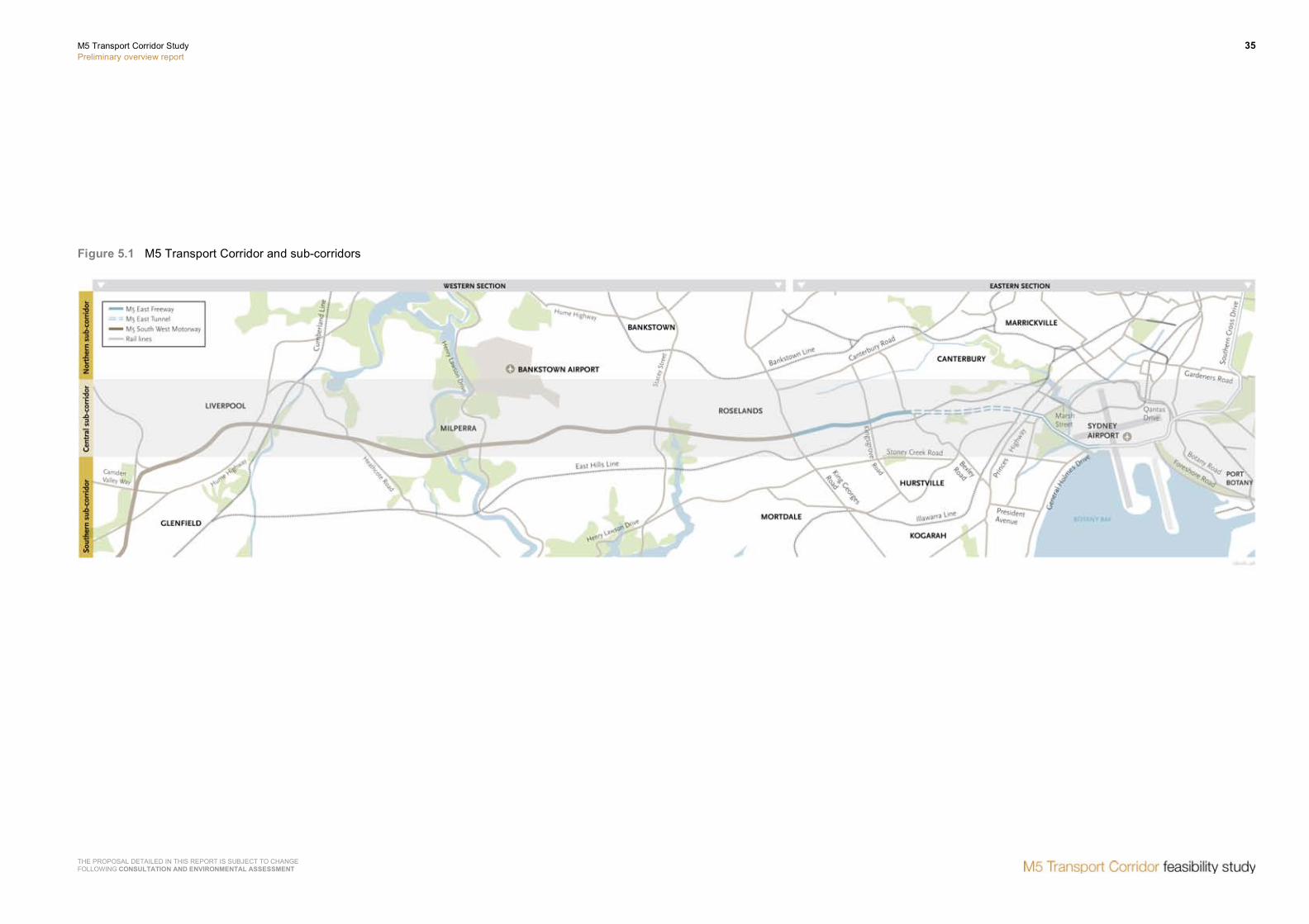
5.1 Corridor analysis
For the purposes of this report, the M5 corridor is defined as the east – west road connection along and surrounding the M5 Motorway between Port Botany/Sydney Airport and Liverpool/Prestons.
In order to enable the development and evaluation of initiatives, the corridor has been divided into three sub-corridors which incorporate the major arterial roads and the rail network within the corridor. In this context, sub-corridors have been defined as follows:
• Central sub-corridor – Generally along the existing route of the M5 corridor between Port Botany/Sydney Airport and Hume Highway at Casula and comprising:
− M5 East Freeway – General Holmes Drive, Mascot and King Georges Road, Beverly Hills.
− M5 South West Motorway – King Georges Road, Beverly Hills and Camden Valley Way, Prestons.
• Northern sub-corridor – Generally to the north and parallel to the M5 corridor comprising:
− Canterbury Road – Bexley Road, Campsie to The River Road, Bankstown.
− Milperra Road – The River Road, Bankstown to Henry Lawson Drive, Milperra.
− Newbridge Road – Henry Lawson Drive, Milperra to Heathcote Road, Moorebank.
− Terminus Road – Heathcote Road, Moorebank to Hume Highway, Liverpool.
− Hume Highway – Terminus Road, Liverpool and Camden Valley Way, Prestons.
• Southern sub-corridor – Generally to the south and parallel to the M5 corridor comprising:
− Marsh Street/Wickham Road – M5 East Motorway, Arncliffe and Princes Highway, Arncliffe.
− Forest Road – Princes Highway, Arncliffe to Stoney Creek Road, Bexley.

34 M5 Transport Corridor Study Preliminary overview report
THE PROPOSAL DETAILED IN THIS REPORT IS SUBJECT TO CHANGE FOLLOWING CONSULTATION AND ENVIRONMENTAL ASSESSMENT
− Stoney Creek Road – Forest Road, Bexley to Forest Road, Beverly Hills.
− Forest Road – Stoney Creek Road, Beverly Hills to Belmore Road, Peakhurst.
The section of the southern sub-corridor, west of Belmore Road to Liverpool travels further south and outside the study corridor. Minor arterial roads connect to the major arterial road within the study corridor (ie M5 Motorway).
Incorporated within and/or across the three corridors are the two main rail lines, the East Hills Line and the Bankstown Line.
Details of the study corridor, including the three sub-corridors is shown in Figure 5.1 below.
In view of the varying operational responsibilities along the corridor, the corridor has been further divided into two sectors defined as follows:
• Eastern sector – Port Botany, Botany to King Georges Road, Beverly Hills.
• Western sector – King Georges Road, Beverly Hills to Camden Valley Way, Prestons.
The corridor has been separated in this way to define the ownership, maintenance and operational responsibilities relating to the motorway/freeway within each sector. The eastern sector (more specifically the M5 East Freeway) is owned by the state government and operated under a design, construct, operate and maintain contract with the private sector; while the M5 South West Motorway within the western sector is owned and operated by a private sector entity, namely, Interlink Roads.
It should be noted that improvements and the development of enhancements to M5 South West Motorway would be the responsibility of Interlink Roads, with the scope and commercial arrangements for the delivery of any such enhancements negotiated between the RTA and Interlink Roads.
M5 Transport Corridor Study Preliminary overview report
35
THE PROPOSAL DETAILED IN THIS REPORT IS SUBJECT TO CHANGE FOLLOWING CONSULTATION AND ENVIRONMENTAL ASSESSMENT
Figure 5.1 M5 Transport Corridor and sub-corridors


M5 Transport Corridor Study Preliminary overview report
37
THE PROPOSAL DETAILED IN THIS REPORT IS SUBJECT TO CHANGE FOLLOWING CONSULTATION AND ENVIRONMENTAL ASSESSMENT
5.2 Identification of strategies and actions
Based on an initial analysis of the corridor and in line with the needs assessment outlined in Chapter 4, a range of broad strategies have been identified – these include a particular focus on the following:
• Surface network.
• Road tunnel options.
• Public transport initiatives.
• Demand management.
Each broad strategy can be further divided into a number of sub-strategies. For example the broad strategy relating to the surface network is comprised of the following sub-strategies:
• Improve operation of the existing road network.
• Increase capacity of the existing arterial road network.
• Increase capacity of the existing motorway network.
In order to implement these sub-strategies a range of strategy actions can be implemented. Examples of actions for the surface network include:
• Change signal operation to increase priority for major routes.
• Install right turn bays at key intersections.
• Implement tidal flow along key routes.
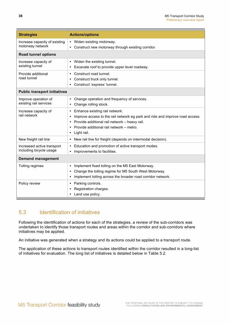
The link between strategies and actions is detailed in Table 5.1 below.
Table 5.1 Strategies and actions
Strategies Actions/options
Surface road network
Improve operation of existing road network
• Grade separation of major intersections. • Change signal operation to increase priority for major route. • Grade separation of major pedestrian crossings. • Install right turn bays at key intersections. • Implement tidal flow along key routes.
Increase capacity of existing arterial road network
• Widen roads on key arterial routes. • Implement parking restrictions on key routes. • Implement changes to lane usage on key routes (bus, transit and
freight lanes). • Depressed road next to existing surface road. • Viaduct over existing surface road. • Construct new surface road.
38 M5 Transport Corridor Study Preliminary overview report
THE PROPOSAL DETAILED IN THIS REPORT IS SUBJECT TO CHANGE FOLLOWING CONSULTATION AND ENVIRONMENTAL ASSESSMENT
Strategies Actions/options
Increase capacity of existing motorway network
• Widen existing motorway. • Construct new motorway through existing corridor.
Road tunnel options
Increase capacity of existing tunnel
• Widen the existing tunnel. • Excavate roof to provide upper level roadway.
Provide additional road tunnel
• Construct road tunnel. • Construct truck only tunnel. • Construct ‘express’ tunnel.
Public transport initiatives
Improve operation of existing rail services
• Change operation and frequency of services. • Change rolling stock.
Increase capacity of rail network
• Enhance existing rail network. • Improve access to the rail network eg park and ride and improve road access. • Provide additional rail network – heavy rail. • Provide additional rail network – metro. • Light rail.
New freight rail line • New rail line for freight (depends on intermodal decision).
Increased active transport including bicycle usage
• Education and promotion of active transport modes. • Improvements to facilities.
Demand management
Tolling regimes • Implement fixed tolling on the M5 East Motorway. • Change the tolling regime for M5 South West Motorway. • Implement tolling across the broader road corridor network.
Policy review • Parking controls. • Registration charges. • Land use policy.
5.3 Identification of initiatives
Following the identification of actions for each of the strategies, a review of the sub-corridors was undertaken to identify those transport routes and areas within the corridor and sub-corridors where initiatives may be applied.
An initiative was generated when a strategy and its actions could be applied to a transport route.
The application of these actions to transport routes identified within the corridor resulted in a long-list of initiatives for evaluation. The long list of initiatives is detailed below in Table 5.2.

M5 Transport Corridor Study Preliminary overview report
39
THE PROPOSAL DETAILED IN THIS REPORT IS SUBJECT TO CHANGE FOLLOWING CONSULTATION AND ENVIRONMENTAL ASSESSMENT
Table 5.2 Long list of initiatives
Broad strategies Sub-corridor Initiatives
Surface road network
Northern • Canterbury Road, Campsie to Hume Highway, Prestons. Improve operation of existing road network Southern • Marsh Street, Arncliffe to Forest Road, Peakhurst.
Northern • Canterbury Road, Campsie to Hume Highway, Prestons. Increase capacity of existing arterial road network Southern • Marsh Street, Forest Road and Stoney Creek Road to
King Georges Road.
Northern • M5 East Freeway – General Holmes Drive to Marsh Street. Increase capacity of existing motorway network Central • M5 East Freeway – General Holmes Drive to Marsh Street.
• M5 East Freeway – Bexley Road, Earlwood to King Georges Road, Beverly Hills.
• New surface motorway – Marsh Street to Bexley Road. • M5 South West Motorway – King Georges Road, Beverly Hills to
Hume Highway, Prestons.
Road tunnel
Increase capacity of existing tunnel
Central • Tunnel between Marsh Street, Arncliffe and Bexley Road, Bexley North.
Northern • General Holmes Drive to Bexley Road/Canterbury Road. • Canterbury Road between Bexley Road and King Georges Road. • General Holmes Drive to King Georges Road/ Canterbury Road.
Central • M5 East Freeway – General Holmes Drive to Marsh Street. • M5 East Freeway – General Holmes Drive to Bexley Road. • M5 East Freeway – General Holmes Drive to King Georges Road. • M5 East Freeway – Marsh Street to Bexley Road. • M5 East Freeway – Marsh Street to King Georges Road. • M5 East Freeway – Bexley Road to King Georges Road. • M5 South West Motorway – King Georges Road to Fairford Road. • M5 South West Motorway – King Georges Road to Henry
Lawson Drive. • M5 South West Motorway – King Georges Road to
Hume Highway. • M5 South West Motorway – Fairford Road to Henry Lawson Drive. • M5 South West Motorway – Fairford Road to Hume Highway. • M5 South West Motorway – Henry Lawson Drive to
Hume Highway.
Provide additional road tunnel
Southern • General Holmes Drive to Forest Road/Stoney Creek Road. • General Holmes Drive to Stoney Creek Road/King Georges Road. • Forest Road/Stoney Creek Road to Stoney Creek Road/King
Georges Road.
40 M5 Transport Corridor Study Preliminary overview report
THE PROPOSAL DETAILED IN THIS REPORT IS SUBJECT TO CHANGE FOLLOWING CONSULTATION AND ENVIRONMENTAL ASSESSMENT
Broad strategies Sub-corridor Initiatives
Public transport initiatives
Improved operation of existing rail services
Southern • East Hills Rail Line.
Increase capacity of existing rail capacity
Southern • East Hills Rail Line.
Increase capacity of rail network
Southern • East Hills Rail Line.
New freight rail line Full corridor • New rail line for freight (depends on intermodal decision).
Increase active transport including bicycle usage
Full corridor • Education and promotion of active transport modes. • Improve facilities at key centres.
Demand management
Tolling regimes Central • Identify potential sections of freeway where tolling may be appropriate.
Policy review Full corridor • Strengthen policies on parking in key centres. • Road user charges on registrations. • Change land use policy to reduce demand.
5.4 Strategic merit test
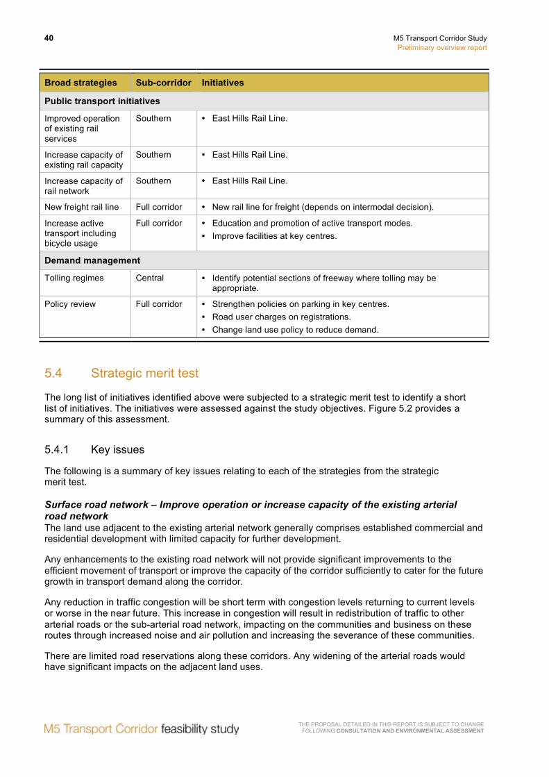
The long list of initiatives identified above were subjected to a strategic merit test to identify a short list of initiatives. The initiatives were assessed against the study objectives. Figure 5.2 provides a summary of this assessment.
5.4.1 Key issues
The following is a summary of key issues relating to each of the strategies from the strategic merit test.
Surface road network – Improve operation or increase capacity of the existing arterial road network The land use adjacent to the existing arterial network generally comprises established commercial and residential development with limited capacity for further development.
Any enhancements to the existing road network will not provide significant improvements to the efficient movement of transport or improve the capacity of the corridor sufficiently to cater for the future growth in transport demand along the corridor.
Any reduction in traffic congestion will be short term with congestion levels returning to current levels or worse in the near future. This increase in congestion will result in redistribution of traffic to other arterial roads or the sub-arterial road network, impacting on the communities and business on these routes through increased noise and air pollution and increasing the severance of these communities.
There are limited road reservations along these corridors. Any widening of the arterial roads would have significant impacts on the adjacent land uses.

M5 Transport Corridor Study Preliminary overview report
41
THE PROPOSAL DETAILED IN THIS REPORT IS SUBJECT TO CHANGE FOLLOWING CONSULTATION AND ENVIRONMENTAL ASSESSMENT
Surface road network – Increase capacity of the existing motorway network The existing freeway/motorway corridor between Bexley Road, Earlwood and Camden Valley Way, Prestons contains sufficient open space surrounding the existing roadway or within the existing median to enable the capacity of the existing motorway to be increased by widening with limited impact on the surrounding land use.
Widening of existing freeway between Marsh Street and General Holmes Drive is achievable with significant encroachment into the wetlands at Marsh Street and Eve Street (which together make up the Rockdale wetlands) and the Cooks River area.
Any increase to the capacity of the motorway in this section will also increase the demand on the airport tunnel which, during peak periods, is operating at or near capacity and has limited capability to cater for additional traffic. This section of the motorway also has significant overall network impacts when incidents or breakdowns occur in the vicinity of the tunnel.
The alternative route for accessing the Port Botany area is via Airport Drive, which is located around the northern perimeter of Sydney Airport. Increasing the capacity of Airport Drive can be achieved generally from Marsh Street through to Joyce Drive, where traffic can connect to General Holmes Drive to access Port Botany.
Through the tunnel section of the corridor, Marsh Street, Arncliffe to Bexley Road, Earlwood a surface road or viaduct construction could be provided through the Wolli Creek area. It is recognised that this proposal would raise significant environmental and community concerns and result in significant severance of the communities on either side of the reserve and the residential areas in the Arncliffe and Bardwell Valley areas.
Road tunnel – Increase capacity of existing road tunnel The enhancements to the existing tunnel involve either:
• Widening the outer side of the existing tunnel, including increasing the height of the tunnel ceiling.
or
• Excavation of the tunnel ceiling to provide a ‘double-decker’ arrangement to provide additional capacity with a second tunnel.
Both these alternatives will reduce the existing congestion in the tunnel and provide increased capacity within the tunnel to cater for the future growth in transport demand.
Improved efficiency of vehicles movement in the tunnel will be reduced by issues relating to connecting the enhanced tunnel with the arterial road, which is operating at or near capacity.
The alternative providing for widening of the tunnel, can be designed such that the additional lanes will be connected to existing on-load and off-load ramps. This reduces the requirement for merging and diverging of traffic in the tunnel and will generally provide additional capacity by providing two free flow lanes in each tunnel.
The ‘double-decker’ alternative has significant issues in relation to connecting the additional traffic lanes, above the existing tunnel traffic lanes, into the surrounding network.
Road tunnel – Provide additional road tunnel The construction of additional tunnels which connect from Port Botany/Airport to the arterial network such as Canterbury Road or Forest Road/Stoney Creek Road may provide greater efficiency in the movement of vehicles through the tunnel, however these improvements in efficiency would be significantly reduced by the congestion resulting from the traffic merging with the existing (and already congested) arterial road network.

42 M5 Transport Corridor Study Preliminary overview report
THE PROPOSAL DETAILED IN THIS REPORT IS SUBJECT TO CHANGE FOLLOWING CONSULTATION AND ENVIRONMENTAL ASSESSMENT
Providing additional tunnels along the existing tunnel route will provide increased capacity. However, consideration should be given to the impact on the surrounding road network.
Truck tunnels will support the increased demand for freight movement but will provide limited capacity for commercial and private transport. As a result of the predicted increase in commercial and private transport demand this would add to the current congestion in the existing M5 East Tunnel.
The provision of ‘express’ tunnels connecting to Foreshore Road and/or Southern Cross Drive will support the predicted growth in freight, commercial and private demand and improve access to key centres such as Port Botany and the CBD. The provision of an express tunnel connecting to General Holmes Drive on the southern side of airport tunnel would impact of the existing congestion which occurs in this tunnel during peak periods.
As noted in section 5.4 the M5 South West Motorway is owned and operated by the private sector, Interlink Roads. Interlink Roads have submitted to the RTA an unsolicited proposal for widening the motorway to three lanes in each direction by construction of additional pavement generally into the median.
Public transport – Improvements to public transport facilities (primarily passenger and rail freight) As noted in Chapter 4, the existing East Hills (passenger) Line is operating at or near capacity on most sections of the corridor. Improvements to the existing rail corridor through changes to signalling, rolling stock and services is not anticipated to have significant increases in the capacity of the line, or result in significant mode shift from private vehicle usage which would be sufficient to meet future transport demand in the corridor.
There are a number of initiatives which support the policy of 40 percent mode shift from road transport to rail, including the South Sydney Freight Line, however, these are unlikely to reduce the overall demand to meet the needs of commuter, commercial and other work-related travel along the corridor.
At present, road based public transport services tend to be limited to supporting interchanges with the rail transport. There are limited services into the key centres of Port Botany, Sydney CBD, Sydney Airport and south-west Sydney and improvements to these services are not considered to assist in meeting the high transport demand between Sydney’s east and south-west.
Demand management – Tolling regimes and policy review The implementation of demand management measures such as variable tolling, road pricing, congestion tolling, road user charges or parking strategies would lead to either a redistribution of traffic to the surrounding road network, or force travellers to shift to rail/public alternatives.
The redistribution of vehicles to alternative routes would provide limited additional capacity for freight movement and would lead to a number of social and environmental impacts on the arterial network surrounding the motorway.
Alternatively the current capacity constraints on the rail network through this corridor limit the opportunities to achieve the efficiency improvements as sufficient mode shift cannot be achieved without significant investment to establish a rail network with a greatly increased capacity.
THE
PR
OP
OS
AL D
ETA
ILED
IN TH
IS R
EP
OR
T IS S
UB
JEC
T TO C
HA
NG
E
FOLLO
WIN
G C
ON
SULTA
TION
AN
D EN
VIRO
NM
ENTA
L ASSESSM
ENT
M5 Transport C
orridor Study
Prelim
inary overview report
43
Figure 5.2 Summary of strategic merit test evaluation of initiatives

44 M5 Transport Corridor Study Preliminary overview report
THE PROPOSAL DETAILED IN THIS REPORT IS SUBJECT TO CHANGE FOLLOWING CONSULTATION AND ENVIRONMENTAL ASSESSMENT
5.4.2 Outcomes
The following are the initiatives that can be applied to the M5 corridor.
Surface road network – Improve operation or increase capacity of the existing arterial road network There are no initiatives when applied to the arterial surface road network that could meet the study objectives.
Surface road network – Increase capacity of the existing motorway network The following are considered sections of the M5 corridor where an increase in the capacity of the existing motorway may form part of an overall project that could meet the study objectives:
• Central sub-corridor (eastern sector), comprising:
− M5 East Freeway – Bexley Road, Earlwood to King Georges Road, Beverly Hills.
• Central sub-corridor (western sector), comprising:
− M5 South West Motorway – King Georges Road, Beverly Hills to Hume Highway, Casula.
Road tunnel – Increase capacity of existing road tunnel The following are considered sections of the M5 corridor where an enhancement to the capacity of the existing tunnel strategies may form part of a project that could meet the study objectives:
• Central sub-corridor (eastern sector), comprising:
− M5 East Freeway – Widen existing road tunnel to provide three lanes in each direction.
Road tunnel – Provide additional road tunnel The following are considered sections of the M5 corridor where an additional road tunnel may form part of a project that could meet the study objectives:
• Central sub-corridor (eastern sector), comprising:
− M5 East Freeway – Marsh Street, Arncliffe to Foreshore Road, Mascot.
− M5 East Freeway – Marsh Street, Arncliffe to Bexley Road, Earlwood.
− M5 East Freeway – Bexley Road, Bexley North to King Georges Road, Beverly Hills.
• Central sub-corridor (western sector), comprising:
− M5 South West Motorway – King Georges Road, Beverly Hills to Fairford Road, Padstow.
− M5 South West Motorway – Fairford Road, Padstow to Henry Lawson Drive, Panania.
− M5 South West Motorway – Henry Lawson Drive, Panania to Hume Highway, Liverpool.
− M5 South West Motorway – Hume Highway, Liverpool to Camden Valley Way, Prestons.

M5 Transport Corridor Study Preliminary overview report
45
THE PROPOSAL DETAILED IN THIS REPORT IS SUBJECT TO CHANGE FOLLOWING CONSULTATION AND ENVIRONMENTAL ASSESSMENT
Public transport – Improvements to public transport facilities (primarily passenger and rail freight) There are no sections of the M5 corridor where improvements to public transport facilities may form part of an overall project that could meet the study objectives.
It should be noted however, that opportunities for improving access to public transport services or the operation of public transport services, should be investigated through the corridor, as part of the detailed development of the project and to improve the social and environmental benefits of any initiative.
Demand management – Tolling regimes and policy review There are no sections of the M5 corridor where demand management strategies may form part of an overall project that could meet the study objectives. However, it is noted that demand management should be investigated.
5.5 Short list of initiatives
Table 5.3 below outlines the short listed initiatives by sub-corridor, route section and potential strategic approach.
Table 5.3 Short list of initiatives
Sub-corridors Initiatives
Central sub-corridor (eastern sector)
M5 East Freeway General Holmes Drive to Marsh Street
• Road tunnel – Additional road tunnel. Tunnel(s) connecting Marsh Street to Foreshore Drive or Southern Cross Drive.
• Road tunnel – Enhancement to existing tunnel. Widen existing tunnel to three lanes in each direction.
M5 East Freeway Marsh Street, Arncliffe to Bexley Road, Bexley North • Road tunnel – Additional road tunnel.
• Surface road – increase motorway capacity. M5 East Freeway Bexley Road, Bexley North to King Georges Road, Beverly Hills • Road tunnel – Additional road tunnel.
Central sub-corridor (western sector)
• Surface road – Increase motorway capacity. M5 South West Motorway King Georges Road to Fairford Road, Padstow • Road tunnel – Additional road tunnel.
• Surface road – Increase motorway capacity. M5 South West Motorway Fairford Road to Henry Lawson Drive • Road tunnel – Additional road tunnel.
• Surface road – Increase motorway capacity. M5 South West Motorway Henry Lawson Drive to Hume Highway • Road tunnel – Additional road tunnel.
• Surface road – Increase motorway capacity. M5 South West Motorway Hume Highway to Camden Valley Way • Road tunnel – Additional road tunnel.
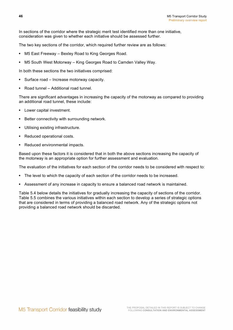
46 M5 Transport Corridor Study Preliminary overview report
THE PROPOSAL DETAILED IN THIS REPORT IS SUBJECT TO CHANGE FOLLOWING CONSULTATION AND ENVIRONMENTAL ASSESSMENT
In sections of the corridor where the strategic merit test identified more than one initiative, consideration was given to whether each initiative should be assessed further.
The two key sections of the corridor, which required further review are as follows:
• M5 East Freeway – Bexley Road to King Georges Road.
• M5 South West Motorway – King Georges Road to Camden Valley Way.
In both these sections the two initiatives comprised:
• Surface road – Increase motorway capacity.
• Road tunnel – Additional road tunnel.
There are significant advantages in increasing the capacity of the motorway as compared to providing an additional road tunnel, these include:
• Lower capital investment.
• Better connectivity with surrounding network.
• Utilising existing infrastructure.
• Reduced operational costs.
• Reduced environmental impacts.
Based upon these factors it is considered that in both the above sections increasing the capacity of the motorway is an appropriate option for further assessment and evaluation.
The evaluation of the initiatives for each section of the corridor needs to be considered with respect to:
• The level to which the capacity of each section of the corridor needs to be increased.
• Assessment of any increase in capacity to ensure a balanced road network is maintained.
Table 5.4 below details the initiatives for gradually increasing the capacity of sections of the corridor. Table 5.5 combines the various initiatives within each section to develop a series of strategic options that are considered in terms of providing a balanced road network. Any of the strategic options not providing a balanced road network should be discarded.

THE
PR
OP
OS
AL D
ETA
ILED
IN TH
IS R
EP
OR
T IS S
UB
JEC
T TO C
HA
NG
E
FOLLO
WIN
G C
ON
SULTA
TION
AN
D EN
VIRO
NM
ENTA
L ASSESSM
ENT
M5 Transport C
orridor Study
Prelim
inary overview report
47
Table 5.4 Initiative development
M5 corridor Strategies Discussion of strategies Initiatives
General Holmes Drive to Marsh Street
Road tunnel – new road tunnel.
• Tunnel connection between eastern tunnel portals at Marsh Street and the key centres of Port Botany and the CBD.
• Provide additional tunnel/s between Marsh Street and Foreshore Drive to Port Botany.
• Provide additional tunnel/s between Marsh Street and Southern Cross Drive to CBD.
General Holmes Drive to Marsh Street corridor on western side of Sydney Airport
‘Do nothing’. • A ‘Do nothing’ strategy is considered due to the limited capability to increase the capacity of General Holmes Drive and Airport Drive.
Marsh Street to King Georges Road
Road tunnel – Increase capacity of existing road tunnel.
• Expand the capacity of the existing M5 East tunnel.
• Tunnel would need to be designed in order not to increase demand on General Holmes Drive and balances with the road network surrounding the road tunnel.
Widen existing tunnel to provide three lanes in each direction: • Additional eastbound lane would connect to
Princes Highway and Marsh Street off-load ramps. Two lanes continue to General Holmes Drive.
• Two lanes from General Holmes Drive to Marsh Street. The additional westbound lane would be formed from the Marsh Street on-load ramp.
M5 East – Marsh Street to Bexley Road
Road tunnel – Additional road tunnel.
• Tunnel would need to be designed in order not to increase demand on General Holmes Drive and balances with the road network surrounding the road tunnel.
• Greater opportunities are provided to connect with key arterial roads along the corridor, such as Fairford Road, River Road, Henry Lawson Drive and Heathcote Road, utilising surface roads rather than tunnels.
Provide incremental increase in the capacity of the corridor by provision of additional tunnel/s: • One additional tunnel configured to operate in the
peak direction as required. • Twin two lane tunnels, one in each direction,
between Bexley Road and Marsh Street or combine with the potential tunnel/s from Marsh Street to Foreshore Drive or Southern Cross Drive.
• One addition tunnel with greater than two lanes capacity in one direction and reconfigure existing tunnel to provide additional capacity in other direction.

TH
E P
RO
PO
SA
L DE
TAILE
D IN
THIS
RE
PO
RT IS
SU
BJE
CT TO
CH
AN
GE
FO
LLOW
ING
CO
NSU
LTATIO
N A
ND
ENVIR
ON
MEN
TAL A
SSESSMEN
T
48 M
5 Transport Corridor S
tudy P
reliminary overview
report
M5 corridor Strategies Discussion of strategies Initiatives
M5 East Motorway – Bexley Road, Bexley North to King Georges Road, Beverly Hills
Surface road – increase freeway capacity.
• Sufficient road corridor available along this section of M5 East Freeway for increasing the capacity along the corridor. Construction of surface road is more economic than a tunnel.
Increase the capacity of the existing surface road within the freeway corridor.
King Georges Road to Camden Valley Way
M5 South West Motorway – King Georges Road, Beverly Hills to Camden Valley Way, Prestons
Surface road – Increase motorway capacity.
• Sufficient road corridor available along this section of M5 South West Motorway for increasing the capacity along the corridor. Construction of surface road is more economic than a tunnel.
• Greater opportunities are provided to connect with key arterial roads along the corridor, such as Fairford Road, River Road, Henry Lawson Drive and Heathcote Road, utilising surface roads rather than tunnels.
Increase the capacity of the existing surface road within the motorway corridor.

THE
PR
OP
OS
AL D
ETA
ILED
IN TH
IS R
EP
OR
T IS S
UB
JEC
T TO C
HA
NG
E
FOLLO
WIN
G C
ON
SULTA
TION
AN
D EN
VIRO
NM
ENTA
L ASSESSM
ENT
M5 Transport C
orridor Study
Prelim
inary overview report
49
Table 5.5 Combining initiatives to create strategic options
(Shading represents valid combinations to be taken forward)
Combinations General Holmes Drive to Marsh Street
Marsh Street to Bexley Road Bexley Road to King Georges Road
King Georges Road and Camden Valley Way
Comments
Combination 1 ‘Do nothing’. Widen existing tunnel to provide three lanes in each direction.
Widen existing motorway.
Widen existing motorway.
Balances traffic flow between the tunnel and east of tunnel portals.
Combination 2 ‘Do nothing’. One additional two lane tunnel capable of operating in peak direction.
Widen existing motorway.
Widen existing motorway.
Balances traffic flow between the tunnel and east of tunnel portals.
Combination 3 ‘Do nothing’. One additional tunnel in one direction with greater than two lane capacity. Both existing tunnels converted to one direction to provide additional capacity.
Widen existing motorway.
Widen existing motorway.
Balances road network.
Combination 4 ‘Do nothing’. Twin two lane tunnels from Bexley Road to Marsh Street.
Widen existing motorway.
Widen existing motorway.
Excess capacity in eastbound tunnel between Bexley Road and Marsh Street will overload the existing road network east of tunnel portals.
Combination 5 Twin two lane tunnels from Marsh Street to Foreshore Road or Southern Cross Drive.
Widen existing tunnel to provide three lanes in each direction.
Widen existing motorway.
Widen existing motorway.
Limited additional capacity in tunnels between Bexley Road and Marsh Street will not feed transport demand into the tunnels to Foreshore Drive.
Combination 6 Twin two lane tunnels from Marsh Street to Foreshore Road or Southern Cross Drive.
One additional two lane tunnel capable of operating in peak direction.
Widen existing motorway.
Widen existing motorway.
Limited additional capacity in tunnels between Bexley Road and Marsh Street will not feed transport demand into the tunnels to Foreshore Drive.
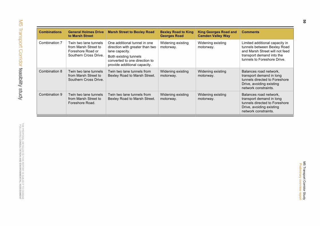
TH
E P
RO
PO
SA
L DE
TAILE
D IN
THIS
RE
PO
RT IS
SU
BJE
CT TO
CH
AN
GE
FO
LLOW
ING
CO
NSU
LTATIO
N A
ND
ENVIR
ON
MEN
TAL A
SSESSMEN
T
50 M
5 Transport Corridor S
tudy P
reliminary overview
report
Combinations General Holmes Drive to Marsh Street
Marsh Street to Bexley Road Bexley Road to King Georges Road
King Georges Road and Camden Valley Way
Comments
Combination 7 Twin two lane tunnels from Marsh Street to Foreshore Road or Southern Cross Drive.
One additional tunnel in one direction with greater than two lane capacity. Both existing tunnels converted to one direction to provide additional capacity.
Widening existing motorway.
Widening existing motorway.
Limited additional capacity in tunnels between Bexley Road and Marsh Street will not feed transport demand into the tunnels to Foreshore Drive.
Combination 8 Twin two lane tunnels from Marsh Street to Southern Cross Drive.
Twin two lane tunnels from Bexley Road to Marsh Street.
Widening existing motorway.
Widening existing motorway.
Balances road network, transport demand in long tunnels directed to Foreshore Drive, avoiding existing network constraints.
Combination 9 Twin two lane tunnels from Marsh Street to Foreshore Road.
Twin two lane tunnels from Bexley Road to Marsh Street.
Widening existing motorway.
Widening existing motorway.
Balances road network, transport demand in long tunnels directed to Foreshore Drive, avoiding existing network constraints.
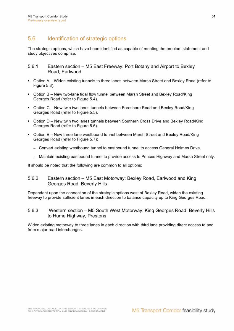
M5 Transport Corridor Study Preliminary overview report
51
THE PROPOSAL DETAILED IN THIS REPORT IS SUBJECT TO CHANGE FOLLOWING CONSULTATION AND ENVIRONMENTAL ASSESSMENT
5.6 Identification of strategic options
The strategic options, which have been identified as capable of meeting the problem statement and study objectives comprise:
5.6.1 Eastern section – M5 East Freeway: Port Botany and Airport to Bexley Road, Earlwood
• Option A – Widen existing tunnels to three lanes between Marsh Street and Bexley Road (refer to Figure 5.3).
• Option B – New two-lane tidal flow tunnel between Marsh Street and Bexley Road/King Georges Road (refer to Figure 5.4).
• Option C – New twin two lanes tunnels between Foreshore Road and Bexley Road/King Georges Road (refer to Figure 5.5).
• Option D – New twin two lanes tunnels between Southern Cross Drive and Bexley Road/King Georges Road (refer to Figure 5.6).
• Option E – New three lane westbound tunnel between Marsh Street and Bexley Road/King Georges Road (refer to Figure 5.7):
− Convert existing westbound tunnel to eastbound tunnel to access General Holmes Drive.
− Maintain existing eastbound tunnel to provide access to Princes Highway and Marsh Street only.
It should be noted that the following are common to all options:
5.6.2 Eastern section – M5 East Motorway: Bexley Road, Earlwood and King Georges Road, Beverly Hills
Dependent upon the connection of the strategic options west of Bexley Road, widen the existing freeway to provide sufficient lanes in each direction to balance capacity up to King Georges Road.
5.6.3 Western section – M5 South West Motorway: King Georges Road, Beverly Hills to Hume Highway, Prestons
Widen existing motorway to three lanes in each direction with third lane providing direct access to and from major road interchanges.

TH
E P
RO
PO
SA
L DE
TAILE
D IN
THIS
RE
PO
RT IS
SU
BJE
CT TO
CH
AN
GE
FO
LLOW
ING
CO
NSU
LTATIO
N A
ND
ENVIR
ON
MEN
TAL A
SSESSMEN
T
52 M
5 Transport Corridor S
tudy P
reliminary overview
report
Figure 5.3 Strategic Option A

THE
PR
OP
OS
AL D
ETA
ILED
IN TH
IS R
EP
OR
T IS S
UB
JEC
T TO C
HA
NG
E
FOLLO
WIN
G C
ON
SULTA
TION
AN
D EN
VIRO
NM
ENTA
L ASSESSM
ENT
M5 Transport C
orridor Study
Prelim
inary overview report
53
Figure 5.4 Strategic Option B
TH
E P
RO
PO
SA
L DE
TAILE
D IN
THIS
RE
PO
RT IS
SU
BJE
CT TO
CH
AN
GE
FO
LLOW
ING
CO
NSU
LTATIO
N A
ND
ENVIR
ON
MEN
TAL A
SSESSMEN
T
54 M
5 Transport Corridor S
tudy P
reliminary overview
report
Figure 5.5 Strategic Option C

THE
PR
OP
OS
AL D
ETA
ILED
IN TH
IS R
EP
OR
T IS S
UB
JEC
T TO C
HA
NG
E
FOLLO
WIN
G C
ON
SULTA
TION
AN
D EN
VIRO
NM
ENTA
L ASSESSM
ENT
M5 Transport C
orridor Study
Prelim
inary overview report
55
Figure 5.6 Strategic Option D

TH
E P
RO
PO
SA
L DE
TAILE
D IN
THIS
RE
PO
RT IS
SU
BJE
CT TO
CH
AN
GE
FO
LLOW
ING
CO
NSU
LTATIO
N A
ND
ENVIR
ON
MEN
TAL A
SSESSMEN
T
56 M
5 Transport Corridor S
tudy P
reliminary overview
report
Figure 5.7 Strategic Option E
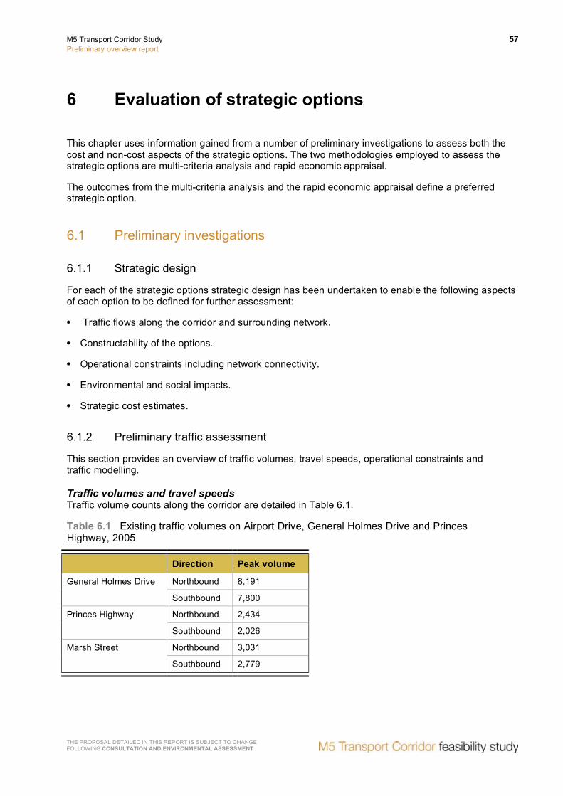
M5 Transport Corridor Study Preliminary overview report
57
THE PROPOSAL DETAILED IN THIS REPORT IS SUBJECT TO CHANGE FOLLOWING CONSULTATION AND ENVIRONMENTAL ASSESSMENT
6 Evaluation of strategic options
This chapter uses information gained from a number of preliminary investigations to assess both the cost and non-cost aspects of the strategic options. The two methodologies employed to assess the strategic options are multi-criteria analysis and rapid economic appraisal.
The outcomes from the multi-criteria analysis and the rapid economic appraisal define a preferred strategic option.
6.1 Preliminary investigations
6.1.1 Strategic design
For each of the strategic options strategic design has been undertaken to enable the following aspects of each option to be defined for further assessment:
• Traffic flows along the corridor and surrounding network.
• Constructability of the options.
• Operational constraints including network connectivity.
• Environmental and social impacts.
• Strategic cost estimates.
6.1.2 Preliminary traffic assessment
This section provides an overview of traffic volumes, travel speeds, operational constraints and traffic modelling.
Traffic volumes and travel speeds Traffic volume counts along the corridor are detailed in Table 6.1.
Table 6.1 Existing traffic volumes on Airport Drive, General Holmes Drive and Princes Highway, 2005
Direction Peak volume
Northbound 8,191 General Holmes Drive
Southbound 7,800
Northbound 2,434 Princes Highway
Southbound 2,026
Northbound 3,031 Marsh Street
Southbound 2,779

58 M5 Transport Corridor Study Preliminary overview report
THE PROPOSAL DETAILED IN THIS REPORT IS SUBJECT TO CHANGE FOLLOWING CONSULTATION AND ENVIRONMENTAL ASSESSMENT
The existing M5 corridor is operating at or near capacity in the peak periods. The unique nature of this corridor is that there is a significant contra-peak traffic flow. More specifically and with respect to the M5 East tunnel, traffic volume counts indicate similar hourly profiles in the AM and PM peaks in both directions. These traffic volumes are contained in Figures 6.1 and 6.2, which shows traffic flows at given times of the day.
Figure 6.1 Traffic volume hourly profile eastbound
Figure 6.2 Traffic volume hourly profile westbound

M5 Transport Corridor Study Preliminary overview report
59
THE PROPOSAL DETAILED IN THIS REPORT IS SUBJECT TO CHANGE FOLLOWING CONSULTATION AND ENVIRONMENTAL ASSESSMENT
Measured travel speeds in 2007 showed that a trip in the morning peak from Camden Valley Way/M5 Motorway at Prestons to Foreshore Road at Mascot via the M5 South West Motorway and M5 East Freeway took more than 48 minutes to cover the 30.2 kilometres, averaging 37.75 km/h. This compares to a sign posted speed of up to 110 km/h.
Figure 6.3 below details the change in travel speed along the M5 corridor between March 2004 and March 2007. The statistics show that in general travel speeds have dropped across all sections of the corridor, particularly in the eastbound AM peak, with the greatest reductions apparent at Southern Cross Drive (Rosebery – Mascot); General Holmes Drive (Mascot) and Camden Valley Way (Casula).
Figure 6.3 Average link speeds between south-west Sydney and the CBD (2004 and 2007)
Note: Westlink M7 was opened to traffic on 16 December 2005 which may have affected the 2004 travel speeds between Moorebank Avenue and Camden Valley Way.

60 M5 Transport Corridor Study Preliminary overview report
THE PROPOSAL DETAILED IN THIS REPORT IS SUBJECT TO CHANGE FOLLOWING CONSULTATION AND ENVIRONMENTAL ASSESSMENT
Operational constraints The M5 corridor, and more specifically the M5 East section, has several operational issues that constrain the corridor from meeting existing and future transport demand. These constraints include:
• General Holmes Drive, which is operating at or near capacity in the AM and PM peak directions.
• The existing tunnel beneath the east-west airport runway. Currently a contra flow lane operates on the southbound carriageway of the tunnel in morning peaks to cater for the northbound traffic volumes.
• Airport Drive, which is the main roadway connecting the domestic and international airports. It provides limited capability for increasing capacity as the existing land use along the eastern section of the roadway abuts directly onto the roadway. Widening of this section of the roadway would involve significant impacts on commercial properties and the airport facilities (jet base and catering) that operate in the vicinity of the roadway.
• Traffic volumes for the existing westbound tunnel are limited by two key constraints:
− The exit grade of the westbound tunnel changes from five per cent to eight per cent in the final 300 metres prior to the tunnel portal. With eight per cent of heavy vehicles travelling in the westbound tunnel, these heavy vehicles often reduce speed as a consequence of the grades impacting on the travel speeds of other vehicles in the tunnel.
− The diversion to the westbound exit ramp at Kingsgrove Road is located on the right side of the carriageway. Heavy vehicles exiting at Kingsgrove Road move into the right hand lane within the tunnel in order to access the exit ramp. This movement, in conjunction with the steeper grades, further adds to the constraints in the westbound tunnel.
• Traffic entering the M5 Motorway/Freeway at major interchanges is required to merge with the traffic on the main through lanes. This friction between the through traffic and merging traffic has the consequence of reducing travel speed and capacity along the corridor.
• Incidents that occur in the morning peak on General Holmes Drive (specifically in the airport tunnel) and the evening peak at the Marsh Street entry ramp have significant impacts on the operation of the corridor. An incident on General Holmes Drive generally causes congestion along the elevated viaduct and Cooks River tunnel into the eastbound M5 East tunnel. Congestion in the eastbound tunnel at times results in tunnel closures to manage air quality causing significant congestion on the surrounding surface arterial routes into the CBD. An incident at the Marsh Street entry ramp can cause significant congestion and delays southbound on General Holmes Drive and Southern Cross Drive.
• Major incidents in the tunnel, particularly accidents and fire incidents, generally require extended closures of one or both tunnels to ensure the safety of emergency services personnel. These closures have a significant impact on the surrounding road network.
Traffic model description and process A base case traffic model was prepared based upon a trip table generated by NSW Transport and Infrastructures (formerly the Ministry of Transport) Transport Data Centre’s Sydney Strategic Travel Model (STM). This model is based on 2001 Census Data and land use predictions from the NSW Government’s Department of Planning.
The trip tables from the STM were entered in the MWT/Halcrow transport model and traffic volumes along key routes were calibrated with actual traffic counts taken by the RTA on key arterial routes.
Traffic volumes were developed for years 2006, 2016 and 2026:
• TDC 2006 trip tables.

M5 Transport Corridor Study Preliminary overview report
61
THE PROPOSAL DETAILED IN THIS REPORT IS SUBJECT TO CHANGE FOLLOWING CONSULTATION AND ENVIRONMENTAL ASSESSMENT
• Value of travel time savings of $14.1/hr (2004 dollars).
• Intersection stop time weighting of 1.5.
• Trips to and from airport based on the draft Sydney Airport Masterplan 2009.
• Preliminary truck trip table from transport consultants, IMIS Pty Ltd.
• Assumed future road projects.
Preliminary traffic modelling outputs Preliminary traffic modelling has been undertaken to assess the change in traffic volumes along the corridor, vehicle kilometres travelled (VKTs) and vehicle hours travelled (VHTs) in 2016 and 2026. The traffic modelling has been undertaken assuming a tolled M5 East tunnel, with any enhancements, for comparison purposes between the options. The tolling regime adopted for the modelling is $0.33 per km for smaller vehicles and $0.87 per km for larger vehicles. These toll amounts do not indicate a proposed toll price, but are used as a basis for this study and are modelled on current M7 toll prices.
The traffic volumes indicate that by 2016 the existing M5 East tunnel will be operating significantly over its theoretical capacity during peak periods, with this situation degrading further by 2026. The outcomes of the high traffic volumes will be increased congestion, which is reflected in an increase in VKTs, reduced travel speeds, an increase in VHTs and a resultant potential for increased incidents in the tunnel potentially requiring closure of the tunnel.
The traffic modelling for the strategic options is summarised in Table 6.2.
Table 6.2 Summary of traffic modelling for the strategic options
Strategic options Summary of outcomes of preliminary traffic assessment
‘Do nothing’ The M5 East is already at capacity and would be operating significantly above theoretical capacity by 2016 (114% and 115%), with performance deteriorating further by 2026 (121% and 120%).
Option A In 2016, the eastbound and westbound tunnels will be operating near their theoretical capacity during peak periods (95% and 94%) and will be operating at capacity during peak periods in 2026 (105% and 102%).
Option B In 2016, during peak periods, both the eastbound and westbound tunnels show an acceptable level of utilisation (90% and 93%) however this option leads to nominally exceeding the theoretical capacity of the tunnels by 2026 (112% and 104%). This option has the best level of contra peak utilisation (at 61% to 68% by 2016 and 51% to 82% by 2026).
Options C and D In 2016 the tunnel capacity in the peak directions are well below the theoretical capacity. In the contra peak direction the tunnels are significantly under utilised with utilisation rates of less than 30% in 2016 and not reaching 50% utilisation by 2026. By 2026 the tunnels are operating at an acceptable utilisation level, with the highest in the AM peak of 95 to 96%. In the mean time the existing tunnels are operating at or near capacity in the peak periods, particularly in 2026.
Option E In 2016, the westbound tunnel in the PM peak is operating near capacity (95%) whilst the eastbound in the AM peak is operating at a much lower utilisation (75%). By 2026, the westbound tunnel is operating nominally over capacity (102%) with the eastbound remaining at acceptable utilisation of 85%. As with Options C and D, both eastbound and westbound tunnels are under utilised in the contra peak direction. However, utilisation levels of the westbound tunnel in the contra peak are higher than in Options C and D (at above 50%).

62 M5 Transport Corridor Study Preliminary overview report
THE PROPOSAL DETAILED IN THIS REPORT IS SUBJECT TO CHANGE FOLLOWING CONSULTATION AND ENVIRONMENTAL ASSESSMENT
The main observations from these results are as follows:
• All options indicate a reduction in travel times in 2016 and 2026 for both the AM and PM peaks.
• When compared to the ‘Do nothing’ modelling, all options indicate a minimal change in VKTs in 2016, in the range between 0.44 per cent and 0.48 per cent for AM peak and between -0.02 per cent and 0.01 per cent in the PM peak.
• Similarly an even smaller change in VKTs is indicated in 2026 with AM peak changing between 0.02 per cent and 0.04 per cent for the AM peak and 0.00 per cent and 0.06 per cent for the PM peak.
Overall the preliminary traffic modelling of the strategic options indicate there is an increase in the volume of traffic travelling on the M5 corridor. There is a minor increase in the VKTs across the Sydney road network and a reduction in the VHTs, which indicate reduced travel times.
Figure 6.2 details the predicted change in the average travel speed on the M5 East Freeway between the 2026 ‘do nothing’ case and Option E. These results indicate a continued reduction in travel speed between 2006 and 2026 under the ‘do nothing’ modelling.
With the introduction of Option E there is a significant improvement in the travel speed over the AM peak, while in the PM peak the proposed improvements prevent further deterioration in travel speeds. These are detailed in Figure 6.4.
Figure 6.4 Modelled travel speeds in Option E
6.1.3 Preliminary environmental investigation of the study corridor
Following the preliminary traffic assessment, a preliminary environment investigation (PEI) of the corridor has been undertaken.
This PEI included constraints mapping along the corridor for the following environmental aspects:
• Land use zoning.
• Biodiversity.
• Heritage.
• Hydrology and flooding.
• Geotechnical and contamination.
• Community issues.
Strategic advice has also been received from specialist advisors on areas that are considered to be areas of key environmental impact, specifically:
M5 Transport Corridor Study Preliminary overview report
63
THE PROPOSAL DETAILED IN THIS REPORT IS SUBJECT TO CHANGE FOLLOWING CONSULTATION AND ENVIRONMENTAL ASSESSMENT
• Air quality assessment.
• Noise assessment.
• Biodiversity.
The conclusions from the PEI are as follows:
• Widening of the M5 South West Motorway, west of King Georges Road, would be confined to the existing corridor. Road traffic noise would be the main potential impact.
• Potential environmental impacts and issues common to all the eastern section options are:
− Effects on traffic during construction as a result of temporary closures and additional construction traffic.
− Effects on traffic during operation as a result of new network connections.
− Noise and vibration impacts during construction.
− Tunnel ventilation.
− Visual impacts in terms of the prominence of surface elements.
− Disturbance of and impacts on areas containing acid sulphate soils/potential acid sulphate soils.
• Existing air quality does not constitute a particular constraint for any of the options. Potential constraints generally relate to the extent of changes to the existing ventilation system for the M5 East Tunnel and/or additional ventilation outlets/inlets associated with each of the options.
In general, any environmental constraints can be avoided or managed via appropriate mitigation measures.
6.2 Evaluation of strategic options
This section provides a summary of the multi-criteria analysis and rapid economic appraisal, which are used to identify a preferred strategic option.
6.2.1 Multi-criteria analysis (MCA) of strategic options
The main aim of a MCA is to evaluate a set of options based on non-monetised criteria to distinguish the most favourable option. For the purposes of this MCA, non-monetised criteria include those that cannot be costed due to complexity or lack of information. These criteria are detailed in Table 6.3.

64 M5 Transport Corridor Study Preliminary overview report
THE PROPOSAL DETAILED IN THIS REPORT IS SUBJECT TO CHANGE FOLLOWING CONSULTATION AND ENVIRONMENTAL ASSESSMENT
Table 6.3 MCA criteria
Criteria Sub-criteria
Environmental • Ambient air quality. • Noise. • Biodiversity. • Heritage/cultural. • Water/hydrology.
Social • Property impacts. • Social cohesion. • Visual/landscape. • Access to community services (health, eduction). • Amenity (parklands).
Delivery • Constructability. • Deliverability (private sector). • Risk.
Transport efficiency • Ability to stage. • Network integration. • Adaptability/flexibility.
Achieving government strategy • Demand management. • Equity. • Unlocking land use potential. • Mode split.
The criteria were rated in line with Australian Land Transport Council Guidelines (ALTC) guidelines as outlined in Table 6.4.
Table 6.4 Assessment ratings basis
Rating level Description
Large –ve Major negative impacts with serious, long-term and possible irreversible effects leading to serious damage, degradation or deterioration of the physical, economic or social environment. Requires a major re-scope of concept, design, location, justification, or requires major commitment to extensive management strategies to mitigate the effect.
Moderate –ve Moderate negative impact. Impacts may be short-, medium- or long-term and impacts will most likely respond to management actions.
Slight –ve Minimal negative impact, probably short-term, able to be managed or mitigated, and will not cause substantial detrimental effects. May be confined to a small area.
Neutral No discernable or predicted positive or negative impact.
Slight +ve Minimal positive impact, possibly only lasting over the short-term. May be confined to a limited area.
Moderate +ve Moderate positive impact, possibly of short-, medium- or long-term duration. Positive outcome may be in terms of new opportunities and outcomes of enhancement or improvement.
Large +ve Major positive impacts resulting in substantial and long-term improvements or enhancements of the existing environment.
Source: Derived from Project appraisal tool for land use – transport projects (Sinclair Knight Merz 2003, for Planning SA).

M5 Transport Corridor Study Preliminary overview report
65
THE PROPOSAL DETAILED IN THIS REPORT IS SUBJECT TO CHANGE FOLLOWING CONSULTATION AND ENVIRONMENTAL ASSESSMENT
A select group of participants with expertise in design, traffic management, construction, delivery, environmental and stakeholder involvement were requested to undertake the ranking of the options against the criteria and a workshop held to review and agree the ratings. (Refer to Table 6.5).
Table 6.5 Summary of multi-criteria analysis ratings
Rating
Hig
hly
bene
ficia
l
Mod
erat
ely
bene
ficia
l
Slig
htly
ben
efic
ial
Neu
tral
Slig
htly
det
rimen
tal
Mod
erat
ely
detr
imen
tal
Hig
hly
detr
imen
tal
Option A – Widen existing tunnel 11 5 4
Option B – New two lane tidal flow tunnel between Marsh Street and Bexley Road
2 9 9
Option C – New twin two lane tunnels from M5 East Freeway at Bexley North to Foreshore Road
1 1 7 3 8
Option D – New twin two lane tunnels from M5 East Freeway at Bexley North to Southern Cross Drive
1 2 5 4 8
Option E – New three lane westbound tunnel between Marsh Street and M5 East Freeway. Convert existing westbound tunnel to second eastbound tunnel
5 7 8
Key issues identified in discussions at the workshop with regards to the ratings are summarised below:
• Option A – The construction methodology required to excavate the existing two-lane tunnel to provide a third lane is extremely complex. These works and the fit-out of the fire and life safety systems for the operation of the widened tunnel cannot be undertaken whilst traffic is in the tunnel. This would necessitate closure of the tunnel for a period of approximately two years necessitating the diversion of traffic to an alternative surface route with consequential congestion, social, economic and environmental impacts along the corridor.
• Option B – The construction of an additional tidal flow tunnel requires additional ventilation inlets and outlets and the establishment and procedures to change the traffic direction in the tunnel. Identified benefits are related to tidal flow operation and increased capacity, allowing for some staging of construction and unlocking land use potential. This option has less negative impacts than other options (apart from Option E) in constructability, deliverability and risk.
• Option C and D – Sydney Airport is located on an area of land reclaimed with consolidated sand. As a consequence soft ground tunnel techniques would be required for the construction of the tunnel. Although, these tunnelling techniques are common overseas they have not been undertaken in Australia on the scale proposed under options C and D. Additionally, with tunnelling through the soft ground the potential changes to the water table in the area increases the potential risk of ground settlement over the tunnel, which would be located beneath runways and taxi areas.

66 M5 Transport Corridor Study Preliminary overview report
THE PROPOSAL DETAILED IN THIS REPORT IS SUBJECT TO CHANGE FOLLOWING CONSULTATION AND ENVIRONMENTAL ASSESSMENT
• Option E – Delivers a number of identified benefits including conventional construction techniques, manageable risks, limited social and environmental impacts and better integrates with the road network. These benefits would result in greater opportunity to unlock land use potential and adapt to future changes in the corridor.
The MCA demonstrates that Options B, C, D and E can be taken forward for further assessment. Option A should be excluded from further assessment as a consequence of:
• The impacts on the road network during construction.
• The difficult construction methodology.
6.2.2 Rapid economic appraisal (REA)
A REA was carried out on Options B, C, D and E. Based upon the strategic option development and the preliminary investigations detailed above a strategic estimate of cost has been prepared for each of the options. A summary of cost estimates is contained in Table 6.6.
Table 6.6 Summary of strategic cost estimates
Option B ($,000) 2008
Option C ($,000) 2008
Option D ($,000) 2008
Option E ($,000) 2008
Project development 27,400 74,200 74,200 29,200
Property acquisition 113,700 54,600 54,600 113,700
Construction 1,067,700 2,893,600 2,893,600 1,137,700
Finalisation 1,100 3,000 3,000 1,200
Project management 24,900 62,700 62,700 26,400
Base strategic cost estimate 1,234,800 3,088,100 3,088,100 1,308,200
Contingency 647,200 1,252,500 1,252,500 663,100
Total strategic cost estimate 1,882,000 4,340,600 4,340,600 1,971,300
The assessment has been undertaken in accordance with the RTA Economic Analysis Manual, which is consistent with the National Guidelines for Transport System Management in Australia. The economic benefits, and disbenefits, of each of the strategic options have been calculated based upon the changes in VKTs and VHTs across the Sydney metropolitan area with and without each of the strategic options.
The REA for all the strategic options is summarised below:
• The higher economic benefits generally arise from higher levels of travel time cost savings.
• The accidents savings for all options are generally low while there is a net cost for all options relating to environmental externalities.
• Option C and D provide significantly higher economic benefits at a higher cost than the other strategic options.
• Option E provides the greatest economic benefit for the funds expended as it has the highest benefit cost ratio (BCR).

M5 Transport Corridor Study Preliminary overview report
67
THE PROPOSAL DETAILED IN THIS REPORT IS SUBJECT TO CHANGE FOLLOWING CONSULTATION AND ENVIRONMENTAL ASSESSMENT
6.2.3 Evaluation outcomes
A summary of the combined outcomes of the MCA and the REA is contained in Table 6.7 (overleaf).
The outcomes of the evaluation using the MCA and REA showed that Option E is the preferred strategic option.
6.3 Preferred strategic option
The preferred strategic option for the M5 corridor is option E, which includes:
• Widening of the existing M5 South West Motorway from King Georges Road, Beverly Hills to the F5 Freeway, Prestons.
• Duplication of the M5 East Freeway from Cooks River, Mascot to King Georges Road, Beverly Hills which comprises:
− A new three lane westbound tunnel with portals in the vicinity of the current portals.
− The existing eastbound tunnel connected to the Princes Highway and Marsh Street only.
− The existing westbound tunnel converted to eastbound and connected to General Holmes Drive only.
− Widening to three lanes each way at the western end from the portals to the King Georges Road ramps.
− Maintaining two lanes each way at the western end under King Georges Road.
− Maintaining two lanes each way at the eastern end from the portals to General Holmes Drive.
It should be noted that improvements and the development of enhancements to M5 South West Motorway would be the responsibility of Interlink Roads, with the scope and commercial arrangements for the delivery of any such enhancements negotiated between the RTA and Interlink Roads. Consequently, this section of the corridor will not be considered further in this report

TH
E P
RO
PO
SA
L DE
TAILE
D IN
THIS
RE
PO
RT IS
SU
BJE
CT TO
CH
AN
GE
FO
LLOW
ING
CO
NSU
LTATIO
N A
ND
ENVIR
ON
MEN
TAL A
SSESSMEN
T
68 M
5 Transport Corridor S
tudy P
reliminary overview
report
Table 6.7 Evaluation of strategic options
Options MCA REA Comparative appraisal
Option A Significant impacts on transport network, due to extended periods of tunnel closure required during construction will limit access to key centres, Port Botany and Sydney Airport. This does not make this option feasible.
N/A Not considered as a feasible option.
BCR 1.22
Estimated capital cost $1.88 B
Direct user benefits $2.33 B
Option B Limited environmental and social impacts. Limited or no benefits for contra peak traffic flows as no increased capacity provided. Significant costs involved in implementation and operation of tidal flow systems.
Travel time savings $2.34 B
Least cost option and provides least benefits of all options. Comparable costs to Option E. Only provides increased capacity in the peak directions, which may result in future limitations as existing contra peak flows are high. Higher on going costs in the operation of the tidal flow management system.
BCR 1.13
Estimated capital cost $4.39 B
Direct user benefits $4.48 B
Option C Limited environmental and social impacts. Higher property impacts than other options and high risk construction through soft soils. Contra peak tunnels are highly under utilised. Travel time savings $4.51 B
The option provides the second highest potential benefits, which is balanced by being the highest cost option, resulting in the lowest BCR. Significant increase in capacity of the corridor although the utilisation of this additional capacity is constrained by the road capacity of the M5 corridor west of Bexley Road and the lack of diversified land use in the south east of Sydney.
BCR 1.20
Estimated capital cost $4.39 B
Direct user benefits $4.79 B
Option D Limited environmental and social impacts. Higher property impacts than other options and high risk construction through soft soils. Contra peak tunnels are highly under utilised. Travel time savings $4.80 B
The option provides the highest benefits as it provides direct link to the CBD. The high cost of this option balances the benefits resulting in the second lowest BCR. This option, similar to Option C, significantly increases the road capacity of the corridor. Utilisation of this capacity is nominally higher than Option C as it provides a connection to the CBD, although traffic flows would be constrained by the capacity of the corridor west of Bexley Road.
BCR 1.63
Estimated capital cost $2.00 B
Direct user benefits $3.33 B
Option E Limited environmental and social impacts, although potential benefits to Wolli Creek floodplain. Provides increased capacity in both peak and contra peak direction. Travel time savings $3.34 B
This option provides the highest BCR. Provides additional capacity in both peak and contra peak direction and utilisation of the tunnels is relatively balanced, although the additional capacity in the eastbound tunnel is under utilised to a degree.

M5 Transport Corridor Study Preliminary overview report
69
THE PROPOSAL DETAILED IN THIS REPORT IS SUBJECT TO CHANGE FOLLOWING CONSULTATION AND ENVIRONMENTAL ASSESSMENT
7 Refinement of the preferred strategic option
This chapter provides an overview of the investigations undertaken to refine the preferred strategic option. The chapter concludes with identifying the indicative preferred option.
7.1 Interaction with wider road network
Traffic modelling has been undertaken on the preferred strategic option to further assess the traffic demand in the tunnel and the interaction of the preferred strategic option with the arterial roads connecting to the freeway and the wider road network. The predicted traffic volumes in the tunnel for the preferred strategic option are detailed in Table 7.1 below.
Table 7.1 Tunnel 1 hour AM and PM peak traffic volumes 2016 and 2026
2016 2026 Direction/Location
‘Do nothing’ Untolled Tolled ‘Do nothing’ Untolled Tolled
1 hour AM peak
M5 East eastbound Princes Highway and Marsh Street
3,840 3,200 4,120 3,610
M5 East eastbound General Holmes Drive
4,540 (Single eastbound tunnel) 3,530 2,930
4,790 (Single eastbound tunnel) 3,720 3,250
M5 East westbound 2,390 4,540 3,340 2,410 4,880 3,950
1 hour PM peak
M5 East eastbound Princes Highway and Marsh Street
2,490 1,460 2,670 1,820
M5 East eastbound General Holmes Drive
3,350 (Single eastbound tunnel) 1,820 1,060
3,590 (Single eastbound tunnel) 2,180 1,340
M5 East westbound 4,170 6,180 5,390 4,340 6,600 5,850
The results of the traffic modelling within the tunnel indicate that:
• In the AM peak, the untolled eastbound M5 East Tunnel accessing Princes Highway and Marsh Street is operating near capacity in 2016 and over capacity in 2026 although the demand decreases to below the theoretical capacity in the tolled scenario.
• In the PM peak, the untolled westbound M5 East tunnel is operating at over the theoretical capacity in 2016 and 2026 although the demand decreases to marginally below the theoretical capacity in the tolled scenario.
The existing road network east of the M5 East Freeway and Marsh Street portals is constrained by the capacity of the airport tunnel on General Holmes Drive and Airport Drive near O’Riordan Street. Additionally, the parallel route to these arterial roads, Princes Highway, also operates at or near capacity during peak periods.

70 M5 Transport Corridor Study Preliminary overview report
THE PROPOSAL DETAILED IN THIS REPORT IS SUBJECT TO CHANGE FOLLOWING CONSULTATION AND ENVIRONMENTAL ASSESSMENT
The existing theoretical capacity of these arterial roads is:
• Airport Drive has two lanes in each direction. The theoretical capacity of the roadway in each direction during peak hours is between 3,000 and 4,000 vehicles per hour.
• The airport tunnel has four lanes in each direction, however in the morning peak period one contra flow lane is provided in the southbound tunnel providing five lanes in the northbound direction to cater for the traffic from the M5 East Freeway and General Holmes Drive from southern Sydney. The theoretical capacity of the roadway is less than 8,000 vehicles per hour in the AM peak direction and less than 6,000 vehicles per hour in the PM peak direction.
• Princes Highway is an arterial road with three lanes in each direction constrained by signalised intersections, turning bays and strip development along its length from Arncliffe to Newtown. The theoretical capacity of the roadway in each direction is in the order of 3,600 vehicles per hour.
Marsh Street between the Giovanni Brunetti Bridge and the M5 East tunnel portals is two lanes eastbound and generally three lanes westbound. The capacity is constrained by the signalised intersection at the Marsh Street intersection with the M5 East tunnel portals. The theoretical capacity of the roadway is in the order of 2,400 vehicles per hour eastbound and 3,600 vehicles per hour westbound.
The predicted traffic volumes on the surrounding road network for the preferred strategic option are detailed in Table 7.2
Table 7.2 Surrounding network 1 hour AM and PM peak traffic volumes 2016 and 2026
2016 2026 Location Direction
‘Do nothing’ Untolled Tolled ‘Do nothing’ Untolled Tolled
1 hour AM peak
Eastbound 8,940 9,270 9,020 9,540 9,780 9,600 General Holmes Drive
Westbound 4,560 4,920 4,600 5,170 5,420 5,240
Eastbound 3,390 3,910 3,860 3,840 4,410 4,380 Airport Drive
Westbound 1,760 2,140 2,00 2,200 2,590 2,470
Eastbound 3,600 4,380 4,290 4,240 5,240 5,140 Marsh Street
Westbound 1,730 2,370 2,270 2,180 2,980 2,800
Eastbound 3,990 4,130 4,070 4,290 4,430 4,380 Princes Highway
Westbound 1,620 1,640 1,620 1,870 1,970 1,910
1 hour PM peak
Eastbound 4,290 4,510 4,000 4,920 5,120 4,640 General Holmes Drive
Westbound 8,510 8,340 8,220 9,210 8,990 8,870
Eastbound 1,800 1,810 1,800 2,240 2,340 2,330 Airport Drive
Westbound 2,230 3,160 3,060 2,850 3,750 3,710
Eastbound 1,800 1,880 1,860 2,160 2,520 2,510 Marsh Street
Westbound 2,560 3,570 3,480 3,340 4,490 4,440
Eastbound 2,060 2,060 1,970 2,390 2,220 2,130 Princes Highway
Westbound 3,120 3,180 3,150 3,360 3,480 3,440
M5 Transport Corridor Study Preliminary overview report
71
THE PROPOSAL DETAILED IN THIS REPORT IS SUBJECT TO CHANGE FOLLOWING CONSULTATION AND ENVIRONMENTAL ASSESSMENT
The results of the traffic modelling on the surrounding road network indicate that:
• In the AM peak:
− The demand for the airport tunnel is marginally over the theoretical capacity in 2016 and significantly exceeds the theoretical capacity in 2026.
− The demand along Airport Drive is greater than the theoretical capacity in both 2016 and 2026.
− The Princes Highway is operating at over capacity in 2016 and 2026 indicating limited capacity to cater for increased demand.
• In the PM peak:
− The demand for the airport tunnel is marginally over the theoretical capacity in 2016 and significantly exceeds the theoretical capacity in 2026.
− The demand for Airport Drive is greater than the theoretical capacity in both 2016 and 2026.
− The Princes Highway is operating at marginally below the theoretical capacity in 2016 and 2026.
7.1.1 Southern Sydney connection
Conclusions from this traffic modelling demonstrate that the existing and predicted future traffic demand on the road network surrounding Sydney Airport and Port Botany is operating at or near capacity in the peak direction and these conditions will continue to deteriorate into the future. The preferred strategic option provides additional capacity on the M5 corridor. However as a consequence it adds to the demand on the surrounding road network, particularly General Holmes Drive and Airport Drive. This limits the opportunities for access to Port Botany, Sydney Airport and the urban renewal areas between the airport and the CBD, such as Alexandria and Green Square.
As discussed previously increasing the capacity of the General Holmes Drive is not feasible due to the constraints of the airport tunnel. The widening of Airport Drive is similarly constrained by surrounding land use, limiting the opportunity for this route to cater for traffic growth.
Improved access to limitations to Port Botany and Sydney Airport is required to deliver the economic benefits which may be accrued from the expansion of these centres. In this context investigations into alternative opportunities to improve access to key centres were considered.
Along the western side of the airport, the F6 corridor has been in place since the 1960s. This corridor travels between Waterfall, in southern Sydney and Euston Road at St Peters. Currently the F6 corridor was included in the Metropolitan Strategy.
In order to reduce the demand on the roads around Sydney Airport a concept has been developed to provide a connection between the M5 East tunnels at Marsh Street, Arncliffe along the eastern section of the F6 corridor to connect to Euston Road, St Peters.
The objectives of this connection are to:
• Reduce the traffic demand on the existing road network specifically General Holmes Drive, Airport Drive, Marsh Street and Princes Highway and provide additional connectivity and capacity to improve access to Port Botany, the international terminal at Sydney Airport, the CBD and surrounding areas.
72 M5 Transport Corridor Study Preliminary overview report
THE PROPOSAL DETAILED IN THIS REPORT IS SUBJECT TO CHANGE FOLLOWING CONSULTATION AND ENVIRONMENTAL ASSESSMENT
• Support the draft Sydney Airport Masterplan 2009 – particularly with regard to airport access and development.
• Support the economic benefits to be gained from the expansion and growth of Sydney Airport and Port Botany.
• Provide an alternative high quality route to improve incident management around the airport.
• Provide for the future expansion of the Sydney motorway network.
The draft Sydney Airport Masterplan 2009 indicates a proposed relocation of Airport Drive, to the western side of the Alexandra Canal, to enable better utilisation of land owned by Sydney Airport Corporation Limited (SACL) for airport operations. The relocation of Airport Drive has been provided for in the development of a connection.
The reduction in traffic on key roads surrounding Port Botany and Sydney Airport, which is achieved through the provision of the southern Sydney connection, is in the order of five to ten per cent or more. This reduction is similar to that which occurs generally during off-peak periods, such as school and Christmas holidays. A direct result of providing the southern Sydney connection is improved access to Sydney Airport. A secondary result of reducing traffic on key arterial roads around the airport and Port Botany, is to further improve access via alternative routes.
The concept for the connection along the F6 corridor called the southern Sydney connection in this report, generally comprises:
• Upgrading Marsh Street from the M5 East Freeway to Cooks River.
• A new four-lane road along the F6 corridor from Marsh Street to Campbell Street.
• Connections via a new road south of Campbell Street to Gardeners Road at Bourke Road.
• Direct connection between the southern Sydney connection and the M5 East tunnels.
The management of traffic north of Campbell Road will be investigated as part of further concept development and in consultation with the community.
Traffic modelling for the combined M5 East duplication and southern Sydney connection indicates a significant reduction in the traffic demand on General Holmes Drive, Airport Drive and Princes Highway. The changes to traffic volumes on these roads and within the wider corridor are detailed in Table 7.3 (Columns 2 and 5).
7.1.2 Qantas Drive Connection
Traffic volumes significantly increase along Marsh Street in the scenarios represented in Columns 2 and 5 even with the inclusion of the southern Sydney connection. In order to reduce demand on Marsh Street, an enhancement was developed to provide a link between Qantas Drive and the southern Sydney connection. It was anticipated that traffic travelling between the M5 East Freeway, the domestic terminal and other centres in the south east of Sydney will use this link. The link would remove further demand on Airport Drive, fronting the internal terminal, and Marsh Street between the international terminal to the M5 East tunnels. The results of traffic modelling are detailed Table 7.3 (Columns 5 and 6)
The results contained in Table 7.3 indicate that the three lane westbound tunnel in all scenarios is operating near or over capacity in the PM peak. Even considering the tolled scenarios the predicted traffic demand is in the order of 6,000 vehicles per hour, where the lane capacity is approximately 1,800 to 2,000 vehicles per lane per hour.
M5 Transport Corridor Study Preliminary overview report
73
THE PROPOSAL DETAILED IN THIS REPORT IS SUBJECT TO CHANGE FOLLOWING CONSULTATION AND ENVIRONMENTAL ASSESSMENT
As a result, a four-lane alternative for the westbound tunnel was considered for traffic modelling. The predicted changes to traffic volumes on key roads when the capacity of the westbound tunnel is increased are detailed in Columns 7 and 8. The results indicate that with a four-lane tunnel the traffic demand will increase to 7,400 vehicles per hour in the PM peak which continues to be a heavily trafficked tunnel but with surplus capacity in 2026. To balance the road network widening of the surface roadway between the western tunnel portals and King Georges Road is required to provide four lanes in each direction.
7.1.3 Conclusions
Interaction with the wider road network requires the following:
• A southern Sydney connection linking the M5 East Freeway with Sydney Airport and nearby industrial areas.
• A link between the southern Sydney connection and Qantas Drive.
• Increasing the capacity of the new westbound tunnel to provide four lanes in each direction, generally distributing traffic as follows:
− Two lanes to General Holmes Drive.
− One lane to Airport Drive.
− One lane to southern Sydney to Campbell Road and Gardeners Road.
• Widening of the surface road between the western tunnel portals and King Georges Road to four lanes in each direction.
The preferred strategic option including the southern Sydney connection and the link to Qantas Drive is detailed in Figure 7.1.


M5 Transport Corridor Study Preliminary overview report
75
THE PROPOSAL DETAILED IN THIS REPORT IS SUBJECT TO CHANGE FOLLOWING CONSULTATION AND ENVIRONMENTAL ASSESSMENT
Figure 7.1 Proposed M5 expansion – indicative preferred option (February 2009)
The proposal shown in these plans is indicative only, prepared for the purposes of the feasibility study, and is subject to change following further engineering investigations, consultation and environmental assessment
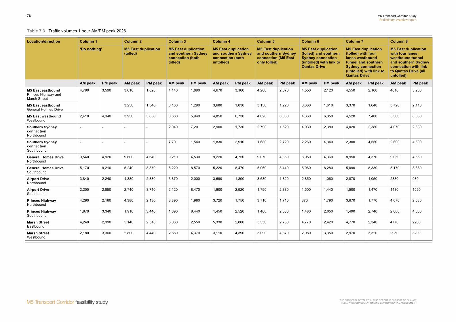
76 M5 Transport Corridor Study Preliminary overview report
THE PROPOSAL DETAILED IN THIS REPORT IS SUBJECT TO CHANGE FOLLOWING CONSULTATION AND ENVIRONMENTAL ASSESSMENT
Table 7.3 Traffic volumes 1 hour AM/PM peak 2026
Column 1 Column 2 Column 3 Column 4 Column 5 Column 6 Column 7 Column 8 Location/direction
‘Do nothing’ M5 East duplication (tolled)
M5 East duplication and southern Sydney connection (both tolled)
M5 East duplication and southern Sydney connection (both untolled)
M5 East duplication and southern Sydney connection (M5 East only tolled)
M5 East duplication (tolled) and southern Sydney connection (untolled) with link to Qantas Drive
M5 East duplication (tolled) with four lanes westbound tunnel and southern Sydney connection (untolled) with link to Qantas Drive
M5 East duplication with four lanes westbound tunnel and southern Sydney connection with link to Qantas Drive (all untolled)
AM peak PM peak AM peak PM peak AM peak PM peak AM peak PM peak AM peak PM peak AM peak PM peak AM peak PM peak AM peak PM peak
M5 East eastbound Princes Highway and Marsh Street
4,790 3,590 3,610 1,820 4,140 1,890 4,670 3,160 4,260 2,070 4,550 2,120 4,550 2,160 4810 3,200
M5 East eastbound General Holmes Drive
3,250 1,340 3,180 1,290 3,680 1,830 3,150 1,220 3,360 1,610 3,370 1,640 3,720 2,110
M5 East westbound Westbound
2,410 4,340 3,950 5,850 3,880 5,940 4,850 6,730 4,020 6,060 4,360 6,350 4,520 7,400 5,380 8,050
Southern Sydney connection Northbound
- - - - 2,040 7,20 2,900 1,730 2,790 1,520 4,030 2,380 4,020 2,380 4,070 2,680
Southern Sydney connection Southbound
- - - - 7,70 1,540 1,830 2,910 1,680 2,720 2,260 4,340 2,300 4,550 2,600 4,600
General Homes Drive Northbound
9,540 4,920 9,600 4,640 9,210 4,530 9,220 4,750 9,070 4,360 8,950 4,360 8,950 4,370 9,050 4,660
General Homes Drive Southbound
5,170 9,210 5,240 8,870 5,220 8,570 5,220 8,470 5,060 8,440 5,060 8,280 5,090 8,330 5,170 8,380
Airport Drive Northbound
3,840 2,240 4,380 2,330 3,870 2,000 3,690 1,890 3,630 1,820 2,850 1,060 2,870 1,050 2880 980
Airport Drive Southbound
2,200 2,850 2,740 3,710 2,120 8,470 1,900 2,920 1,790 2,880 1,500 1,440 1,500 1,470 1480 1520
Princes Highway Northbound
4,290 2,160 4,380 2,130 3,890 1,980 3,720 1,750 3,710 1,710 370 1,790 3,670 1,770 4,070 2,680
Princes Highway Southbound
1,870 3,340 1,910 3,440 1,690 8,440 1,450 2,520 1,460 2,530 1,480 2,650 1,490 2,740 2,600 4,600
Marsh Street Eastbound
4,240 2,390 5,140 2,510 5,060 2,550 5,330 2,800 5,350 2,750 4,770 2,420 4,770 2,340 4770 2200
Marsh Street Westbound
2,180 3,360 2,800 4,440 2,880 4,370 3,110 4,390 3,090 4,370 2,980 3,350 2,970 3,320 2950 3290

M5 Transport Corridor Study Preliminary overview report
77
THE PROPOSAL DETAILED IN THIS REPORT IS SUBJECT TO CHANGE FOLLOWING CONSULTATION AND ENVIRONMENTAL ASSESSMENT
7.2 Rapid economic appraisal
Table 7.4 summarises the outcomes of the REA at key stages in refining the preferred strategic option.
Table 7.4 REA outcomes
M5 East duplication (tolled)
M5 East duplication and southern Sydney connection (M5 East tolled only)
M5 East duplication (four lanes westbound) and southern Sydney connection with link to Qantas Drive (M5 East tolled only)
M5 East duplication (four lanes westbound) and southern Sydney connection with link to Qantas Drive (all untolled)
Estimate capital cost ($million – 2008 dollars)
$2,000 $3,500 $4,000 $4,000
Present value of monetised costs (including periodic maintenance and operating/ maintenance costs)
$2,109 $3,314 $3,642 $3,642
Total direct user benefits ($million)
$3,814.6 $5,158.8 $5,056.4 $4,018
BCR 1.81 1.56 1.39 1.10
The outcomes from the REA indicate that, although the BCR for the project has reduced through the refinement of the preferred strategic option, the direct user benefits have increased.
This increase in user benefits result from improved travel times across the network, although more specifically significant benefits accrue through the improved traffic flow along the M5 corridor and potentially the reduction in traffic congestion on General Holmes Drive, Marsh Street/Airport Drive and Princes Highway.
The reduction in traffic, and subsequent reduction in congestion, assists to improve access to Port Botany and Sydney Airport and provides opportunities to realise the potential economic, social and environmental benefits that can be accrued from the growth of these key centres.
7.3 Tolling
Funding for construction of the proposal contained in this report has not been determined. A mix of government and private sector investment is likely. The preliminary overview report includes traffic forecasts with or without tolls on the project. No decision has been made regarding tolls.
The traffic modelling described in section 7.1 above demonstrates that:
• The southern Sydney connection is sensitive to tolling. The network benefits of the southern Sydney connection would not be realised, were this connection tolled, as traffic would remain on the existing arterial routes.
• Tolling the M5 East duplication and not the southern Sydney connection results in desirable forecast traffic volumes in the corridor and on the wider road network.
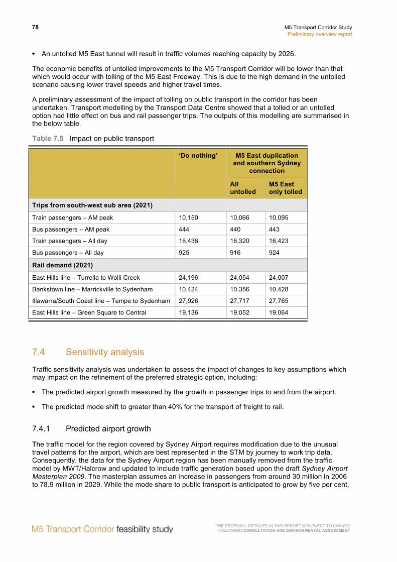
78 M5 Transport Corridor Study Preliminary overview report
THE PROPOSAL DETAILED IN THIS REPORT IS SUBJECT TO CHANGE FOLLOWING CONSULTATION AND ENVIRONMENTAL ASSESSMENT
• An untolled M5 East tunnel will result in traffic volumes reaching capacity by 2026.
The economic benefits of untolled improvements to the M5 Transport Corridor will be lower than that which would occur with tolling of the M5 East Freeway. This is due to the high demand in the untolled scenario causing lower travel speeds and higher travel times.
A preliminary assessment of the impact of tolling on public transport in the corridor has been undertaken. Transport modelling by the Transport Data Centre showed that a tolled or an untolled option had little effect on bus and rail passenger trips. The outputs of this modelling are summarised in the below table.
Table 7.5 Impact on public transport
M5 East duplication and southern Sydney
connection
‘Do nothing’
All untolled
M5 East only tolled
Trips from south-west sub area (2021)
Train passengers – AM peak 10,150 10,066 10,095
Bus passengers – AM peak 444 440 443
Train passengers – All day 16,436 16,320 16,423
Bus passengers – All day 925 916 924
Rail demand (2021)
East Hills line – Turrella to Wolli Creek 24,196 24,054 24,007
Bankstown line – Marrickville to Sydenham 10,424 10,356 10,428
Illawarra/South Coast line – Tempe to Sydenham 27,926 27,717 27,765
East Hills line – Green Square to Central 19,136 19,052 19,064
7.4 Sensitivity analysis
Traffic sensitivity analysis was undertaken to assess the impact of changes to key assumptions which may impact on the refinement of the preferred strategic option, including:
• The predicted airport growth measured by the growth in passenger trips to and from the airport.
• The predicted mode shift to greater than 40% for the transport of freight to rail.
7.4.1 Predicted airport growth
The traffic model for the region covered by Sydney Airport requires modification due to the unusual travel patterns for the airport, which are best represented in the STM by journey to work trip data. Consequently, the data for the Sydney Airport region has been manually removed from the traffic model by MWT/Halcrow and updated to include traffic generation based upon the draft Sydney Airport Masterplan 2009. The masterplan assumes an increase in passengers from around 30 million in 2006 to 78.9 million in 2029. While the mode share to public transport is anticipated to grow by five per cent,

M5 Transport Corridor Study Preliminary overview report
79
THE PROPOSAL DETAILED IN THIS REPORT IS SUBJECT TO CHANGE FOLLOWING CONSULTATION AND ENVIRONMENTAL ASSESSMENT
it should be noted that significant commercial and retail developments are also proposed on Sydney Airport land that adds to the total traffic generation.
The MWT/Halcrow traffic model removes this zone from the trip table and divides the airport trip generation into passenger trips, employment trips and taxi trips. These trips are distributed through the traffic model based upon:
• Passenger trips – The results of a number plate survey undertaken at the airport in 2005 to determine LGA origins/destinations.
• Employment trips – The TDC distribution from an employment zone.
• Taxi trips – An estimated distribution that all trips are generally to the CBD.
Table 7.5 summarises the predicted traffic generation from the growth and development at Sydney Airport.
Table 7.6 Sydney Airport trip generation for 2006, 2016 and 2026
Year AM peak (vehicles/hour) PM peak (vehicles/hour)
Total departures
Total arrivals Total two-way
Total departures
Total arrivals Total two-way
2006 4,500 3,500 8,000 2,600 3,500 6,100
2016 7,500 5,600 13,100 4,800 6,600 11,400
2026 9,700 7,300 17,000 7,000 9,400 16,400
Traffic modelling was undertaken which assumed only 50 per cent of the predicted increase in passenger trips to and from the airport. The results of this modelling, as compared to achieving the full predicted travel demand, are detailed in Table 7.7 below.
Table 7.7 Comparative traffic volumes with reduced airport growth
2026 Predicted passenger growth
50% of predicted passenger growth
AM peak PM peak AM peak PM peak
Eastbound tunnels 7,920 3,810 7,680 (-3.0%) 3,380 (-11.3%)
Westbound tunnels 4,520 7,400 4,180 (-7.5%) 7,070 (-4.5%)
Marsh Street eastbound 4,770 2,340 3,760 (-21.2%) 1,460 (-37.6%)
Marsh Street westbound 2,970 3,320 2,210 (-25.6%) 2,550 (-23.2%)
Airport Drive northbound 2,870 1,050 2,540 (-11.5%) 810 (-22.90%)
Airport Drive southbound 1,500 1,570 1,250 (-16.7%) 1,490 (-5.1%)
Southern Sydney connection northbound
4,020 2,380 3,880 (-3.5%) 2,060 (-13.4%)
Southern Sydney connection southbound
2,300 4,550 1,960 (-14.8%) 4,250 (-6.6%)

80 M5 Transport Corridor Study Preliminary overview report
THE PROPOSAL DETAILED IN THIS REPORT IS SUBJECT TO CHANGE FOLLOWING CONSULTATION AND ENVIRONMENTAL ASSESSMENT
The results of the modelling show that lower than predicted passenger growth would not substantially reduce traffic volumes in the corridor.
7.4.2 Freight movement by rail
The NSW Government’s Metropolitan Strategy provides for an increased movement of freight by rail.
The traffic modelling used in the refinement of the preferred strategic option assumes 20 per cent of containers moved by rail. Further modelling has been undertaken assuming 85 per cent of the containers entering Port Botany are transported by rail.
Table 7.8 below compares the 2016 and 2026 car and truck volumes during the AM and PM peaks for the two scenarios.
Table 7.8 Comparative traffic volumes with increased freight movement by rail
20% by rail 85% by rail
AM peak PM peak AM peak PM peak
Car Truck Car Truck Car Truck Car Truck
2016
M5 East westbound 2,920 760 5,780 710 2,930 680 5,840 630
M5 East eastbound 6,550 680 2,660 400 6,580 650 2,660 380
Southern Sydney connection northbound
3,500 240 1,870 200 3,480 240 1,860 200
Southern Sydney connection southbound
1,520 250 3,940 200 1,520 250 3,930 200
2026
M5 East westbound 3,450 1,070 6,510 890 3,490 950 6,660 780
M5 East eastbound 7,160 760 3,300 510 7,210 730 3,300 490
Southern Sydney connection northbound
3,750 270 2,150 240 3,740 270 2,140 230
Southern Sydney connection southbound
1,930 370 4,310 230 1,910 360 4,310 240
The results indicate a reduction in truck movements through the M5 East tunnel. However, this reduction is not significant and amounts to around 100 trucks in the AM peak. This suggests a significant volume of trucks in the corridor carry freight that is not originating at Port Botany.
The results of the modelling show that higher than predicted movement of freight from Port Botany by rail would not substantially reduce traffic volumes in the corridor.
7.5 Conclusion
As identified, refinement of the preferred strategic option has defined the indicative preferred option for further feasibility assessment generally as:

M5 Transport Corridor Study Preliminary overview report
81
THE PROPOSAL DETAILED IN THIS REPORT IS SUBJECT TO CHANGE FOLLOWING CONSULTATION AND ENVIRONMENTAL ASSESSMENT
• Widening of the surface road between the western tunnel portals and King Georges Road to four lanes in each direction.
• Duplication of the M5 East tunnel providing four new lanes westbound in tunnel.
• A southern Sydney connection linking the M5 East Freeway to Sydney Airport and nearby industrial areas, including a link between the southern Sydney connection and Qantas Drive.
The indicative preferred option is shown in Figure 7.1 above. The proposal detailed in this report has been prepared for the feasibility study and is subject to change following further engineering investigation, consultation and environmental assessment.

82 M5 Transport Corridor Study Preliminary overview report
THE PROPOSAL DETAILED IN THIS REPORT IS SUBJECT TO CHANGE FOLLOWING CONSULTATION AND ENVIRONMENTAL ASSESSMENT
8 Feasibility assessment
This chapter provides an overview of the preliminary concept design and further investigations undertaken to evaluate the feasibility of the indicative preferred option. The details of the proposal contained in the following sections of the report will be subject to change following further detailed engineering investigations, consultation and environmental assessment.
8.1 Tunnel alignment and western connections
There are several key elements that determine the tunnel alignment and portal locations. These include:
• Tunnel grades.
• Emergency egress for tunnel users.
• Adequate access for emergency services.
• Connectivity to the adjacent and surrounding road network.
• Geotechnical conditions along the alignment and at portal locations.
The alignment of the existing M5 East tunnels, specifically at the western end, was determined by:
• The location of Wolli Creek in the vicinity of the western tunnel portals, which is also, the lowest level for the tunnel.
• The geotechnical conditions in the vicinity of the creek.
• The location of the creek in relation to the location for the western portals directly on the western side of Bexley Road.
As a consequence of these constraints on the alignment of the existing tunnel, the gradient of the tunnel at the western end transitions from a five per cent accent grade to eight per cent over the last 500m of the tunnel.
Compounding this situation is the centrally located exit ramp for westbound traffic at the Kingsgrove Road interchange. Trucks exiting at Kingsgrove Road travel in the right hand lane of the tunnel, which combined with the steeper grade at the tunnel exit reduces travel speed and capacity of the westbound tunnel.
For the alignment of the new tunnel, a design standard of a maximum four percent grade has been adopted. In addition, the Kingsgrove Road exit ramp should preferably be relocated to the left-hand side.

M5 Transport Corridor Study Preliminary overview report
83
THE PROPOSAL DETAILED IN THIS REPORT IS SUBJECT TO CHANGE FOLLOWING CONSULTATION AND ENVIRONMENTAL ASSESSMENT
Four alternative concepts for the westbound tunnel alignment and connections to the western end of the M5 East Freeway have been developed to address these issues in the new westbound tunnel. These alternative concepts comprise:
• Long tunnel alignment – Aligns the tunnel on the southern side of the Wolli Creek, following the East Hills Line and providing a longer tunnel, approximately 1.6 kilometres longer than other options, to connect with the freeway between Kingsgrove Road and King Georges Road. This option will maintain the gradient of the tunnel at about four per cent. This alternative will significantly reduce the vehicle usage of the freeway between Bexley Road and Kingsgrove Road. The long tunnel alignment is shown in Figure 8.1.
• Slot tunnel alignment – Generally follows the alignment of the existing tunnel although maintains a four per cent grade from the lowest level of the tunnel, under Wolli Creek, to the new western portals. Maintaining the four per cent gradient in the tunnel would result in the tunnel portal at Bexley Road being at a lower level than the existing portals. As a consequence this would require a long open slot from the driven tunnel portal near Bexley Road to the connection with the freeway just east of Kingsgrove Road. The slot tunnel alignment is shown in Figure 8.2.
• Northern alignment – Aligns the western end of the tunnel on the northern side of the existing tunnel, enabling the tunnel to cross beneath Wolli Creek further from the tunnel portals. The alignment of the tunnel would follow the ridge north of the existing alignment with the driven tunnel portal located east of the existing tunnel portals. A section of cut and cover would be required between the driven tunnel portal and the connection to the freeway directly west of Bexley Road. The northern alignment is shown in Figure 8.3.
• Southern alignment – Locates the tunnel on the southern side of Wolli Creek, providing a shorter tunnel avoiding the need to cross under Wolli Creek. The tunnel portal would reach the surface south east of the existing western portals and on the southern side of the East Hills Line, in Stotts Reserve. The freeway will then traverse over the East Hills Line, Wolli Creek floodplain and Bexley Road in viaduct and then connect with the existing westbound Freeway, east of Kingsgrove Road. The southern alignment is shown in Figure 8.4.
The preliminary design for of all alignments, except the long tunnel alignment, converts the existing westbound exit ramp to Kingsgrove Road to an entry ramp for one of the eastbound tunnels. In order to maintain the existing connectivity with the surrounding road network and key centres, a new exit ramp would be constructed on the southern side of the Kingsgrove Road interchange. With the long tunnel alignment the existing connections to Kingsgrove Road would be retained.
A preliminary assessment of the four alternative alignments for the westbound tunnel and connections to the freeway have been undertaken based upon several criteria including:
• Potential property acquisitions.
• Effects on Wolli Creek floodplain.
• Effects on flora and fauna.
• Effects on communities.
• Provision for emergency access.
• Constructability.
• Indicative capital and operational costs
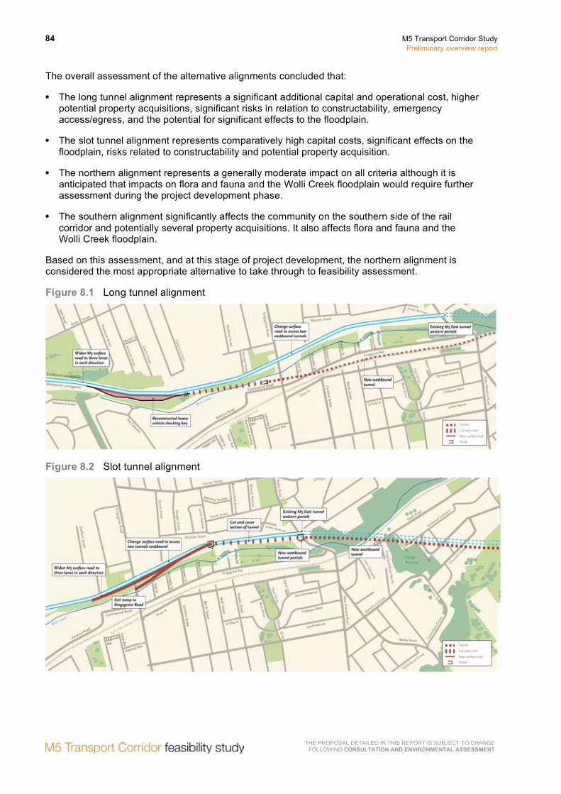
84 M5 Transport Corridor Study Preliminary overview report
THE PROPOSAL DETAILED IN THIS REPORT IS SUBJECT TO CHANGE FOLLOWING CONSULTATION AND ENVIRONMENTAL ASSESSMENT
The overall assessment of the alternative alignments concluded that:
• The long tunnel alignment represents a significant additional capital and operational cost, higher potential property acquisitions, significant risks in relation to constructability, emergency access/egress, and the potential for significant effects to the floodplain.
• The slot tunnel alignment represents comparatively high capital costs, significant effects on the floodplain, risks related to constructability and potential property acquisition.
• The northern alignment represents a generally moderate impact on all criteria although it is anticipated that impacts on flora and fauna and the Wolli Creek floodplain would require further assessment during the project development phase.
• The southern alignment significantly affects the community on the southern side of the rail corridor and potentially several property acquisitions. It also affects flora and fauna and the Wolli Creek floodplain.
Based on this assessment, and at this stage of project development, the northern alignment is considered the most appropriate alternative to take through to feasibility assessment.
Figure 8.1 Long tunnel alignment
Figure 8.2 Slot tunnel alignment

M5 Transport Corridor Study Preliminary overview report
85
THE PROPOSAL DETAILED IN THIS REPORT IS SUBJECT TO CHANGE FOLLOWING CONSULTATION AND ENVIRONMENTAL ASSESSMENT
Figure 8.3 Northern alignment
Figure 8.4 Southern alignment
Construction of the current M5 East tunnel was primarily through Hawkesbury Sandstone. These conditions are favourable for the excavation of tunnels using conventional techniques. The new, four-lane westbound tunnel could be provided as either: • A single four-lane tunnel.
• Twin, two-lane side-by-side tunnels.
• Twin, two-lane ‘double decker’ tunnel.
The key issues in determining the appropriate cross-section and alignment for the new westbound tunnel comprise: • Constructability and tunnel support.
• Program.
• Cost.
86 M5 Transport Corridor Study Preliminary overview report
THE PROPOSAL DETAILED IN THIS REPORT IS SUBJECT TO CHANGE FOLLOWING CONSULTATION AND ENVIRONMENTAL ASSESSMENT
• Emergency access.
• Incident/traffic management.
• Driver behaviour.
The following is a summary of each of these issues with regards to the available construction alternatives. Single four lane tunnel: • Wider tunnel span will require additional ground support
• Greater quantities of spoil and slower excavation rates which will impact on program
• Tunnel alignment will need to follow existing M5 East tunnel to provide emergency egress for motorists during incidents and access for emergency services
• Motorists are unaccustomed to four lane tunnels and may have adverse effect on driver behaviour, including excessive changing of lanes
• New and existing tunnels cannot operate independently when an Incident occurs which may require all tunnels to be closed.
Twin, two-lane side-by-side tunnels: • Two lane tunnels are a conventional span and require typical ground support
• Proven method of construction that simplifies construction programming in terms of equipment utilisation.
• Horizontal and vertical alignment of new tunnel can be independent of the existing tunnels
• Emergency egress can occur between the two new tunnels, independent of the existing tunnels
• New and existing tunnels can operate independently in an incident situation which may provide opportunities for tunnels in one direction to remain open.
• Motorists well accustomed to two lane tunnels
Twin, two-lane ‘double-decker’ tunnel: • Two lane tunnels are a conventional span and require typical ground support
• Proven method of construction that simplifies construction programming in terms of excavation equipment utilisation.
• Constructability is limited due to there being a single working face.
• There is a need for a structural floor (deck) to be constructed that may affect construction program.
• Horizontal and vertical alignment of new tunnel may be independent of the existing tunnels
• New and existing tunnels may operate independently in an incident situation that may provide opportunities for tunnels in one direction to remain open.
• Motorists well accustomed to two lane tunnels
• Emergency egress is difficult as exit is required via stairs.

M5 Transport Corridor Study Preliminary overview report
87
THE PROPOSAL DETAILED IN THIS REPORT IS SUBJECT TO CHANGE FOLLOWING CONSULTATION AND ENVIRONMENTAL ASSESSMENT
• The on / off loading of each deck may present height challenges at each portal.
At this stage of project development progressing with the twin two-lane side-by-side tunnels option provides advantages over the other two tunnel options in programming, costs, incident / traffic management, traffic behaviour and in particular constructability and emergency egress. Consequently the tunnel alignment has been developed based upon an assumed twin two-lane side-by-side tunnel configuration.
8.2 Eastern connection
The link between the new westbound tunnel and the eastern section of the M5 East Freeway is determined by a number of factors including connections to surrounding arterial roads. Three alternative arrangements have been developed:
• Eastern alternative 1 – This alternative involves the construction of a new, three lane, 600m-long structure over Eve Street wetlands to convey westbound traffic emerging from the airport tunnel to the portal for the new westbound tunnel. The portal would be located immediately to the south of the existing Marsh Street exit ramp with a right lane exit to the Marsh Street. Eastern alternative 1 is shown in Figure 8.5.
• Eastern alternative 2 – This alternative sees the westbound carriageway diverging from the existing westbound carriageway to traverse Marsh Street wetlands before entering the portal for the new westbound tunnel. It would use the existing bridge structure. The portal would be located immediately to the south of the existing Marsh Street exit ramp with a right lane exit to the Marsh Street. Eastern alternative 2 is shown in Figure 8.6.
• Eastern alternative 3 – This alternative involves the diversion of the new westbound carriageway to the south of the existing westbound carriageway, but to a lesser extent than the previous alternative. This allows a left lane access to a reconstructed Marsh Street exit ramp. As for the previous alternative, the existing bridge structure would be used. Eastern alternative 3 is shown in Figure 8.7.
The preliminary assessment of the three alternative connections to the M5 East Freeway, at the eastern end of the tunnel, have been informed by the following criteria:
• Constructability.
• Effect on Eve Street and Marsh Street wetlands.
• Location of the Marsh Street exit ramp.
• Geotechnical conditions.
• Indicative cost estimates.
Based on this assessment, Eastern alternative 1 was considered to be unacceptable due to the potential effects on Eve Street wetlands, and the higher cost of the Marsh Street exit ramp, which would be located on the right hand side of the carriageway.
Eastern alternatives 2 and 3 were comparable in terms of cost, and their limited effect on Eve Street wetlands and surrounding communities. Eastern alternative 3 was considered preferable given that the Marsh Street exit ramp could be located in a more conventional arrangement on the left hand side of the carriageway.

88 M5 Transport Corridor Study Preliminary overview report
THE PROPOSAL DETAILED IN THIS REPORT IS SUBJECT TO CHANGE FOLLOWING CONSULTATION AND ENVIRONMENTAL ASSESSMENT
Figure 8.5 Eastern alternative 1
Figure 8.6 Eastern alternative 2

M5 Transport Corridor Study Preliminary overview report
89
THE PROPOSAL DETAILED IN THIS REPORT IS SUBJECT TO CHANGE FOLLOWING CONSULTATION AND ENVIRONMENTAL ASSESSMENT
Figure 8.7 Eastern alternative 3
8.3 Southern Sydney connection
In section 7.1 the need for a southern Sydney connection between the M5 East tunnels and Sydney Airport was identified. This connection generally follows the F6 Corridor through recreational and industrial areas. Two key areas along this corridor which are of interest to the community and other stakeholders are: • Kogarah Golf Club, which is the subject of the proposed Cooks Cove development.
• Tempe Recreation Reserve.
In considering a feasible route through these two areas the following issues were considered: • Limiting impacts to the playing fields within the Tempe Reserve.
• Connectivity to the International Terminal at Sydney Airport.
• Avoiding St George Rowing Club on the southern side of Cooks River.
• Moving into Alexandria Canal, removing the need for reclamation.
• Minimising the effect on residential properties adjacent to the F6 Corridor.
• Eliminating construction within the recently rehabilitated Tempe Wetlands.
• Avoiding overshadowing of the Tempe Wetlands.
• Removing the impact on existing infrastructure and shoreline including the sea wall along Cooks River.
• Minimising the effect on Kogarah Golf Club and Cook Cove development.
• Operation of the interchange at Marsh Street, Arncliffe.
• Avoiding any increases in vehicle kilometers traveled.

90 M5 Transport Corridor Study Preliminary overview report
THE PROPOSAL DETAILED IN THIS REPORT IS SUBJECT TO CHANGE FOLLOWING CONSULTATION AND ENVIRONMENTAL ASSESSMENT
The route for the southern Sydney connection through these sections of the corridor has been developed to meet as far as practicable the issues detailed above.
8.4 Tunnel ventilation
Road tunnels require ventilation systems to manage emissions generated by vehicles. This section describes the existing M5 East ventilation system and considers the integration of the existing system with the proposed M5 East duplication.
Ventilation design for current tunnels A key feature of the M5 East Freeway is Australia's longest road tunnels – twin four-kilometre, two-lane tunnels between Bexley Road, Earlwood and Marsh Street, Arncliffe.
The existing ventilation system operates as a recirculatory system where air is drawn in to the mid-point of the tunnel from the dedicated air intake station at Duff Street (approximately 600m east of the midpoint of each tunnel).
The air at the midpoint is then split to travel down each of the eastern end of the eastbound tunnels and the western end of the westbound tunnels. Near each of the tunnel portals the air is transferred to the opposite tunnel together with additional fresh air drawn in through the tunnel entry portals.
The greater air volume then travels down the eastern end of the westbound tunnel and western end of the eastbound tunnel to the air extraction point. The extracted air then travels along the ventilation exhaust tunnel to the ventilation outlet at Turrella, where all air is released.
A schematic of the tunnel complete with ventilation system is detailed in Figure 8.8.
The ventilation system operates such that no air is released from the tunnel portals. The only situation in which air would be released from the tunnel portals would be if a breakdown or incident in the tunnel (or on the surrounding road network) reduced the in-tunnel air quality to a level that is not suitable for motorists in the tunnel.
Ventilation design for M5 East duplication A preliminary assessment of the ventilation system design has been undertaken incorporating the duplication of the M5 East tunnel with the existing M5 East tunnel.
The preliminary assessment considered the following ventilation criteria, which were the basis for the design of recent Sydney tunnels:
• In-tunnel carbon monoxide levels.
• In-tunnel visibility levels.
• Limiting the release of air from the tunnel portals.

THE
PR
OP
OS
AL D
ETA
ILED
IN TH
IS R
EP
OR
T IS S
UB
JEC
T TO C
HA
NG
E
FOLLO
WIN
G C
ON
SULTA
TION
AN
D EN
VIRO
NM
ENTA
L ASSESSM
ENT
M5 Transport C
orridor Study
Prelim
inary overview report
91
Figure 8.8 Ventilation design for existing M5 East tunnels

92 M5 Transport Corridor Study Preliminary overview report
THE PROPOSAL DETAILED IN THIS REPORT IS SUBJECT TO CHANGE FOLLOWING CONSULTATION AND ENVIRONMENTAL ASSESSMENT
With the introduction of the M5 East duplication there is an opportunity to replace the existing recirculatory system with a more efficient conventional longitudinal ventilation system, which operates in the majority of Sydney road tunnels.
In general, the combined ventilation system could comprise the following:
• Longitudinal ventilation of the two eastbound tunnels with air drawn in from the tunnel entry portal travelling to the midpoint for extraction to the existing Turrella ventilation outlet.
• Replacement of the extracted air with fresh air from the Duff Street air intake into the two eastbound tunnels, which would continue along the eastbound tunnel and be released through a ventilation outlet at the eastern end.
• The new westbound tunnel would operate in a similar manner; air would be drawn in through the westbound entry portals and travel along the westbound tunnel to be extracted at the midpoint and taken to the existing Turrella ventilation outlet.
• The extracted air would be replaced by air drawn in through the existing Duff Street air intake and or an additional air intake in the vicinity of the tunnel midpoint. This air would be drawn along the westbound tunnel to be released through a ventilation outlet at the western end.
Locations for inlets and outlets have not been determined.
In general, the following criteria would be applied in the selection of sites for any ventilation infrastructure:
• Spacing of ventilation infrastructure at regular intervals to ensure efficient fresh airflow.
• Locating ventilation infrastructure in proximity to the tunnel structure to maximise the energy efficiency of the system.
• Locating above ground ventilation infrastructure in industrial areas where practicable.
• Locating above ground ventilation infrastructure on higher ground where practicable.
• Integrating ventilation infrastructure with existing or proposed built structures where practicable.
Additional infrastructure for the operation of the ventilation system would be subject to further development and detailed assessment.
8.5 Constructability
A constructability assessment of the indicative preferred option has been undertaken. The key constructability issues are as follows:
• Widening of the existing M5 East Freeway from King Georges Road to Bexley Road:
− Sufficient land available within the corridor to accommodate the widening.
− Traffic management during construction.
• Construction of a new westbound tunnel generally along the alignment of the existing tunnels:
− Geotechnical conditions.
− Tunnel cross-sections.

M5 Transport Corridor Study Preliminary overview report
93
THE PROPOSAL DETAILED IN THIS REPORT IS SUBJECT TO CHANGE FOLLOWING CONSULTATION AND ENVIRONMENTAL ASSESSMENT
− Tunnelling and spoil disposal.
− Tunnel construction access.
− Construction of tunnel portals.
− Reconfiguring existing westbound tunnel.
• Construction of surface and elevated road between the eastern portal of the M5 East Tunnel at Marsh Street and Campbell Road, St Peters (southern Sydney connection):
− Geotechnical conditions and disturbance of contaminated areas.
− Constraints driven by airport operations.
The following sections discuss these issues and strategies to manage and mitigate potential impacts.
M5 East widening The existing surface roadway between Bexley Road and King Georges Road is constructed on a dedicated freeway corridor. The freeway is generally located in the centre of the corridor with adjacent areas of open space surrounded by residential and commercial/industrial land uses.
With the indicative preferred option the western portals of the new westbound tunnel are located on the southern side of the existing freeway. The four lanes from the portal to the freeway, east of Kingsgrove Road, would be provided on viaduct over the existing open space area between the freeway and Wolli Creek.
Between Kingsgrove Road and King Georges Road, the widening of the existing freeway would be provided wholly within the existing freeway corridor.
The construction works to undertake this widening could be provided outside the existing road surface with the closure of the road shoulder to provide an appropriate construction zone along the length of the freeway.
Construction of the existing M5 East Freeway involved realignment of Wolli Creek and the construction of sections of open concrete lined channel. Wolli Creek is subject to frequent local short term flooding resulting in the closure of Bexley Road.
Infrastructure development near or traversing Wolli Creek needs to consider the obstruction of flows and the potential to exacerbate flooding levels or frequency.
Tunnel construction The construction of the existing tunnels and previous geotechnical studies indicate that the existing M5 East tunnels were driven through predominately Hawkesbury sandstone. The Hawkesbury sandstone is a sedimentary rock of the Triassic Sydney Sedimentary basin.
The conditions expected to be encountered are described as ‘unconfined compressive strength of the rock ranging from less than 5MPa where it is extremely weathered to greater than 60MPa, with an average strength of 30MPa. The interbedded sandstone and siltstone, ranging in rock strength between 10 to 25MPa with an average of 20MPa.

94 M5 Transport Corridor Study Preliminary overview report
THE PROPOSAL DETAILED IN THIS REPORT IS SUBJECT TO CHANGE FOLLOWING CONSULTATION AND ENVIRONMENTAL ASSESSMENT
A preliminary assessment of the construction methodology concluded that tunnelling would be carried out using road headers as it would be more efficient than using tunnel boring machines. This assessment considered that access for road headers would be available from both the eastern and western end of the tunnels, either directly through the new tunnel portals or via access tunnels which may be used as part of the ventilation system.
As part of further design development, an additional tunnel access may be required in the vicinity of the midpoint of the tunnel. This would enable tunnelling to progress on additional faces, providing an additional site for removal of spoil and reducing the overall program time for tunnelling works.
The spoil to be generated by the new tunnels would be in the order of 700,000 cubic metres.
The methodology for the construction of the tunnel portals was investigated. The western portal would be relatively conventional with cut-and-cover construction from the driven tunnel to the tunnel portals west of Bexley Road. The eastern portals would be located beneath Marsh Street, Arncliffe. The methodology involves construction of traffic diversions and the staged crossing of Marsh Street with cut-and-cover construction.
A key aspect of the preferred strategic option is the reconfiguration of the existing westbound tunnel to an eastbound tunnel. A detailed assessment of the work activities would be undertaken, and is anticipated to include:
• Construction of new or adjustments to existing air extraction and intakes within the tunnel.
• Replacement or adjustment of the existing jet fans.
• Adjustments to fire and life safety systems.
• Replacement or adjustment of the existing CCTV and other monitoring equipment.
The reconfiguration of the existing westbound tunnel is anticipated to occur following the opening to traffic of the new westbound tunnel. This will enable traffic to be diverted to the new tunnel leaving the existing tunnel free of traffic. The tunnel must be closed to traffic during these works.
Construction of southern Sydney connection The construction of the southern Sydney connection could comprise both surface road and in some areas a viaduct structure to cross items like Marsh Street and the Cooks River.
The land use along this route has been the subject of a transport corridor zoning since the mid 1900s. As a consequence the route comprises a mix of open space, commercial and industrial developments. One specific area that has previously been used as waste disposal site, which has been capped with a layer of uncompacted fill and topsoil. There are other potential areas of contamination and potential acid sulphate soils along the corridor.
Construction using viaducts could limit the disturbance of contaminated or acid sulphate soils. Further investigations will be required to determine the precise extent of any such material.
As this connection is located in the vicinity of Sydney Airport, the obstacle limitation surface (OLS) needs to be considered during design and construction.
Design investigations and community consultations are required as options are examined in this area.

M5 Transport Corridor Study Preliminary overview report
95
THE PROPOSAL DETAILED IN THIS REPORT IS SUBJECT TO CHANGE FOLLOWING CONSULTATION AND ENVIRONMENTAL ASSESSMENT
8.6 Operation
8.6.1 Tunnel services
Tunnel services refer to the installations provided for the operation of the tunnel and the safety of tunnel occupants. A description of tunnel services generally provided in Sydney road tunnels is presented below. Similar services would be provided for the M5 East duplication.
Fire protection service Tunnel, tunnel control buildings, plant rooms and substations are provided with automatic fire detection and alarm systems. These systems are interconnected with other associated equipment including ventilation and public address systems to provide maximum safety at all times for motorists and operations staff.
Fire hydrants, hose reels and extinguishers are provided at regular intervals along the tunnel. Fire Brigade suction and booster facilities are provided to allow the Fire Brigade to maintain system pressure and flows.
Traffic management and control system A traffic management and control system are provided to monitor and control traffic movement at the approaches to the portals, within the tunnels and at the exit portals and ramps. The system includes:
• Traffic incident detection system.
• Variable message signs.
• Lane usage signals.
• Over height detection.
Communication Tunnels are equipped with communication systems to enable communication between the control centre and tunnel occupants. The communication system includes:
• Emergency telephone system.
• Radio communications system.
• Public address system.
• Radio re-broadcast.
Emergency egress Emergency egress is provided for the tunnel occupants to escape in the event of an incident in the tunnel requiring evacuation. The egress also provides a means of reaching the scene of the incident for emergency services personnel.
8.6.2 Traffic and incident management
Traffic management measures are tools for:
• Alleviating traffic congestion impacts.
• Ensuring the smooth flow of traffic on the road network in the event of an incident in or on the approaches to or departures from the tunnel.
• Ensuring emissions in the tunnel, resulting from congestion within the tunnel, are managed within government requirements.

96 M5 Transport Corridor Study Preliminary overview report
THE PROPOSAL DETAILED IN THIS REPORT IS SUBJECT TO CHANGE FOLLOWING CONSULTATION AND ENVIRONMENTAL ASSESSMENT
Traffic management measures are applied depending on the severity and nature of tunnel congestion or incident. Management measures include ramp metering, partial tunnel closures over a short time for recovering broken down vehicles, or longer term closures when incidents cause damage to tunnels or tunnel services.
The indicative preferred option (Option E) provides opportunities for better traffic management in the event of an incident. It has the potential to allow some lanes in the tunnel to remain open during major incidents.
8.7 Preliminary environmental investigations of the indicative preferred option
A preliminary environmental investigation of the indicative preferred option was undertaken. A summary is provided below.
8.7.1 Preliminary constraints
The following potential environmental constraints have been identified:
• Limitations of the existing road networks.
• Presence of sensitive receivers (air and noise) in the study area.
• Visual amenity and community issues related to any associated infrastructure such as ramps, bridges, ventilation outlets and inlets.
• Areas that contain high biodiversity value including Wolli Creek Regional Park, Bardwell Valley Parklands and Rockdale Wetlands Corridor.
8.7.2 Preliminary environmental impacts
A preliminary overview of potential environmental impacts is provided below.
M5 East duplication In general, potential environmental impacts associated with this element include:
• Effects on traffic during operation as a result of new network connections and resultant changes in local roadside air quality and traffic noise generation.
• Construction traffic and noise and vibration impacts.
• Visual impacts in terms of the prominence of surface elements.
• Limited vegetation clearance.
• Impacts on flooding levels and frequency.
Southern Sydney connection In general, potential environmental impacts associated with this element include:
• Effects on traffic during operation as a result of new network connections and associated road traffic noise impacts.
• Construction traffic and noise and vibration impacts.

M5 Transport Corridor Study Preliminary overview report
97
THE PROPOSAL DETAILED IN THIS REPORT IS SUBJECT TO CHANGE FOLLOWING CONSULTATION AND ENVIRONMENTAL ASSESSMENT
• Visual impacts, particularly for viaduct sections.
• Land acquisition.
• Erosion, sedimentation and water quality impacts.
• Disturbance of contaminated land.
8.7.3 Recommended approval pathway
Part 3A of the NSW Environmental Planning and Assessment Act provides a process for the Minister for Planning to independently determine whether to approve a major infrastructure project, following preparation and public exhibition of an environmental assessment and an independent review and assessment by the Department of Planning.
If the proposal requires works within the Commonwealth land at Sydney Airport, it would also require approval under the Commonwealth Airports Act 1996.
In addition, the Environment Protection and Biodiversity Conservation Act 1999 identifies a number of possible triggers for approval including impacts on threatened species and communities and potentially significant environmental impacts on Commonwealth land. The need for referral of the proposal to the Federal Minister for the Environment, Heritage and the Arts would be considered once detailed flora and fauna surveys and further environmental assessment has been undertaken.
Additional approval requirements would be identified as the development and assessment of the proposal progresses.
8.8 Business case
8.8.1 Strategic cost estimates
A summary of the strategic cost estimate for the indicative preferred option is contained in Table 8.1.
Table 8.1 Project activity estimated cost.
Option E ($,000) 2009
Project development and procurement 78,000
Investigation and design 75,000
Property acquisition 470,000
Construction 3,380,000
M5 East Freeway duplication 2,360,000
New surface road 1,020,000
Finalisation 2,300
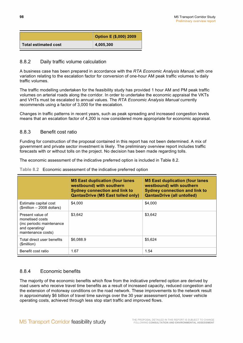
98 M5 Transport Corridor Study Preliminary overview report
THE PROPOSAL DETAILED IN THIS REPORT IS SUBJECT TO CHANGE FOLLOWING CONSULTATION AND ENVIRONMENTAL ASSESSMENT
Option E ($,000) 2009
Total estimated cost 4,005,300
8.8.2 Daily traffic volume calculation
A business case has been prepared in accordance with the RTA Economic Analysis Manual, with one variation relating to the escalation factor for conversion of one-hour AM peak traffic volumes to daily traffic volumes.
The traffic modelling undertaken for the feasibility study has provided 1 hour AM and PM peak traffic volumes on arterial roads along the corridor. In order to undertake the economic appraisal the VKTs and VHTs must be escalated to annual values. The RTA Economic Analysis Manual currently recommends using a factor of 3,000 for the escalation.
Changes in traffic patterns in recent years, such as peak spreading and increased congestion levels means that an escalation factor of 4,200 is now considered more appropriate for economic appraisal.
8.8.3 Benefit cost ratio
Funding for construction of the proposal contained in this report has not been determined. A mix of government and private sector investment is likely. The preliminary overview report includes traffic forecasts with or without tolls on the project. No decision has been made regarding tolls.
The economic assessment of the indicative preferred option is included in Table 8.2.
Table 8.2 Economic assessment of the indicative preferred option
M5 East duplication (four lanes westbound) with southern Sydney connection and link to QantasDrive (M5 East tolled only)
M5 East duplication (four lanes westbound) with southern Sydney connection and link to QantasDrive (all untolled)
Estimate capital cost ($million – 2008 dollars)
$4,000 $4,000
Present value of monetised costs (inc periodic maintenance and operating/ maintenance costs)
$3,642 $3,642
Total direct user benefits ($million)
$6,088.9 $5,624
Benefit cost ratio 1.67 1.54
8.8.4 Economic benefits
The majority of the economic benefits which flow from the indicative preferred option are derived by road users who receive travel time benefits as a result of increased capacity, reduced congestion and the extension of motorway conditions on the road network. These improvements to the network result in approximately $6 billion of travel time savings over the 30 year assessment period, lower vehicle operating costs, achieved through less stop start traffic and improved flows.
M5 Transport Corridor Study Preliminary overview report
99
THE PROPOSAL DETAILED IN THIS REPORT IS SUBJECT TO CHANGE FOLLOWING CONSULTATION AND ENVIRONMENTAL ASSESSMENT
The COAG Report on Urban Congestion in December 2006 forecast urban congestion cost in Sydney to be $7.5 billion per annum by 2020 – an increase of 123 per cent over the estimate for 2005.
Safety and externality benefits are achieved due to lower crash rates, air pollution and traffic noise associated with extended motorway conditions.
Commercial and freight movements in and around Port Botany and Sydney Airport result in both travel time benefits and vehicle operating cost reductions, thereby supporting the predicted growth in these key centres.

100 M5 Transport Corridor Study Preliminary overview report
THE PROPOSAL DETAILED IN THIS REPORT IS SUBJECT TO CHANGE FOLLOWING CONSULTATION AND ENVIRONMENTAL ASSESSMENT
8.8.5 Wider economic benefits
Wider economic benefits include:
• Agglomeration benefits.
• Increased labour force productivity.
• Increased labour force participation.
There are a number of factors indicating that wider economic benefits flowing from the indicative preferred option may be significant, including:
• Increased access for residents of southern and south-western Sydney to higher value employment centres around Sydney Airport, Port Botany, the CBD, North Sydney, Chatswood and Macquarie Park. This would result in a deepening of the labour market, with the impact upon agglomeration, labour productivity and labour participation.
• Increased capacity supporting the long-term sustainability, growth and productivity of highly productive and nationally important industrial areas such as Port Botany and Sydney Airport.
For these reasons, wider economic benefits may be significant and consideration would be given to quantifying wider economic benefits as part of the detailed development of the project, to build a more comprehensive picture of the benefits.
8.9 Financial assessment
Funding has not been determined. A mix of government and private sector investment is likely. Tolling the indicative preferred option and its viability as a public private partnership has been tested and the results are summarised below.
The toll levels used as part of this feasibility analysis were $0.33 per km for smaller vehicles and $0.87 per km for larger vehicles in 2008 dollars. Tolling was assumed to be cashless and distance based. These toll amounts do not indicate a proposed toll price, but are used simply as a basis for this study and are modelled on current M7 Motorway toll prices.
A toll already applies to the M5 South West Motorway.
Financial modelling as part of the submission to Infrastructure Australia indicates that a government contribution of around $3.1 billion or over 75 per cent of the capital cost would be required to deliver the indicative preferred option as a public private partnership.
The financial assessment demonstrates that tolls could be applied to the M5 East duplication primarily as a road pricing mechanism.
Other factors in determining a potential toll level include comparing to existing tolls on other motorways, other tolls on the route, existing upgraded and new infrastructure and the impacts of future motorway proposals.
Consideration could also be given to time of day differential tolling.
M5 Transport Corridor Study Preliminary overview report
101
THE PROPOSAL DETAILED IN THIS REPORT IS SUBJECT TO CHANGE FOLLOWING CONSULTATION AND ENVIRONMENTAL ASSESSMENT
8.10 Procurement and delivery
The following outlines the procurement options suitable for the delivery of the indicative preferred option. These options can be broadly categorised as being either conventional or fast track.
8.10.1 Conventional delivery timetable
Procurement options consistent with a conventional delivery timetable are those where the project scope is defined in detail and planning approval is obtained prior to procurement, which minimise the financial risk to government through transfer of risk to the contractor.
These procurement options include design and construct, design construct and maintain and build own operate transfer (PPP) contracts.
8.10.2 Fast track delivery timetable
Procurement options to provide a fast track delivery are where procurement is undertaken prior to detailed scope definition and obtaining planning approval.
Early procurement would allow the environmental assessment, investigation and design and construction planning to occur at the same time with a single agreement. This can shorten the timeframe required to deliver the project.
The potential risks with this approach are:
• The cost of delays during the project development stage would be borne by government.
• The cost of investigation and design and construction planning which may be wasted if planning approval cannot be obtained, which would be wholly borne by government.
• The cost of the normal project delivery risks, which would be partially transferred to the contractor and partially borne by government.
These options involve government taking a more active role in managing and controlling the project during delivery.
These procurement options include alliance contracts.
8.10.3 Indicative delivery timetables
Indicative conventional and fast track delivery timetables for the indicative preferred option are contained in Table 8.3.
Table 8.3 Indicative delivery timetables
Project stage Conventional timetable Fast track timetable
Scope definition and planning approval(from announcing the project to obtaining planning approval)
Approximately 2 years Approximately 2 years
Finalising procurement, investigation and design and construction planning (from obtaining planning approval to commencing substantial construction)
Approximately 18 months Approximately 3–6 months (but can be less)

102 M5 Transport Corridor Study Preliminary overview report
THE PROPOSAL DETAILED IN THIS REPORT IS SUBJECT TO CHANGE FOLLOWING CONSULTATION AND ENVIRONMENTAL ASSESSMENT
Project stage Conventional timetable Fast track timetable
Construction (from commencing substantial construction to opening to traffic in the final configuration)
Approximately 3.5 years Approximately 3.5 years
8.11 Risk
A list of potential risks for the indicative preferred option was developed based on experience on other Sydney motorway projects.
The following is a summary of contextual risks:
8.11.1 Feasibility
• Obtaining funding sources for the project.
• Private sector reluctance to invest in the project.
• Government and project objectives not realised because a section of the project is not funded.
8.11.2 Development
• Community/council opposition to aspects of the project (such as ventilation stations).
• Consultation fails to capture broader community opinion and community needs.
• Toll unacceptable to the community.
• Uncertain statutory assessment process for proposal (Commonwealth land and application of the Environment Protection and Biodiversity Conservation Act).
• Scope changes which have the potential to cause significant increases in the budget.
8.11.3 Procurement
• Inability of the selected project procurement method to provide value for money, manage complexity, generate innovation and optimise risk transfer.
• Private sector reluctance to invest the project.
8.11.4 Design and construction
• Land cannot be acquired through the usual acquisition process (Commonwealth land).
A key activity during further development of the indicative preferred option would be a detailed risk assessment for the project.

M5 Transport Corridor Study Preliminary overview report
103
THE PROPOSAL DETAILED IN THIS REPORT IS SUBJECT TO CHANGE FOLLOWING CONSULTATION AND ENVIRONMENTAL ASSESSMENT
8.12 Conclusion
Based on the investigations undertaken in this chapter, it is considered that the indicative preferred option is a feasible solution for improving the operational capacity of the M5 corridor.

104 M5 Transport Corridor Study Preliminary overview report
THE PROPOSAL DETAILED IN THIS REPORT IS SUBJECT TO CHANGE FOLLOWING CONSULTATION AND ENVIRONMENTAL ASSESSMENT
9 Indicative preferred option
The conclusions from the investigations to improve the operation of the M5 Transport Corridor have resulted in the identification of the following indicative preferred option. This indicative preferred option will be subject to change following further detailed engineering investigations, consultation and environmental assessment.
9.1 M5 South West Motorway
Widening to provide three lanes in westbound direction between King Georges Road to Camden Valley Way and in the eastbound direction between Camden Valley Way, Prestons and Fairford Road, Padstow.
9.2 M5 East Freeway
Duplication from King Georges Road, Beverly Hills to Cooks River, Mascot:
• Providing a new, four-lane westbound tunnel, provided as either a single four lane tunnel or twin two lane tunnels, with entry and exit portals in the vicinity of the existing tunnel portals.
• Providing four lanes in the eastbound direction by maintaining the existing eastbound tunnel and converting the existing westbound tunnel to eastbound.
• Retaining two lanes in each direction from the Marsh Street portals to General Holmes Drive, the existing eastbound tunnel ramps to Princes Highway and Marsh Street and on-load ramps from Marsh Street to the westbound tunnel.
• Providing two lanes in each direction from the Marsh Street tunnel portals to the new southern Sydney connection.
• Widening to four lanes in each direction the existing M5 East Freeway from the Bexley Road portals to the King Georges Road entry and exit ramps.
• Providing three lanes in each direction under King Georges Road, Beverly Hills.
• Widening Marsh Street to generally three lanes in each direction between the tunnel portals and Airport Drive.
A new southern Sydney connection from the M5 East Freeway, Arncliffe to Euston Road, Qantas Drive and Gardeners Road, Mascot, comprising:
• A new surface and elevated road with two lanes in each direction along the proposed F6 corridor.
• Single lane ramps to provide access between the southern Sydney connection and Airport Drive.
• A signalised intersection at the junction of the southern Sydney connection and Campbell Road to access Gardeners Road via Bourke Road.

M5 Transport Corridor Study Preliminary overview report
105
THE PROPOSAL DETAILED IN THIS REPORT IS SUBJECT TO CHANGE FOLLOWING CONSULTATION AND ENVIRONMENTAL ASSESSMENT
The management of traffic north of Campbell Road will be investigated as part of further concept development and community consultation. Figures 9.1 to 9.7 provide details of the indicative preferred option.

TH
E P
RO
PO
SA
L DE
TAILE
D IN
THIS
RE
PO
RT IS
SU
BJE
CT TO
CH
AN
GE
FO
LLOW
ING
CO
NSU
LTATIO
N A
ND
ENVIR
ON
MEN
TAL A
SSESSMEN
T
106 M
5 Transport Corridor S
tudy P
reliminary overview
report
Figure 9.1 M5 East Freeway – east of King Georges Road
The proposal shown in these plans is indicative only, prepared for the purposes of the feasibility study, and is subject to change following further engineering investigations, consultation and environmental assessment

THE
PR
OP
OS
AL D
ETA
ILED
IN TH
IS R
EP
OR
T IS S
UB
JEC
T TO C
HA
NG
E
FOLLO
WIN
G C
ON
SULTA
TION
AN
D EN
VIRO
NM
ENTA
L ASSESSM
ENT
M5 Transport C
orridor Study
Prelim
inary overview report
107
Figure 9.2 M5 East Freeway – west of Bexley Road
The proposal shown in these plans is indicative only, prepared for the purposes of the feasibility study, and is subject to change following further engineering investigations, consultation and environmental assessment

TH
E P
RO
PO
SA
L DE
TAILE
D IN
THIS
RE
PO
RT IS
SU
BJE
CT TO
CH
AN
GE
FO
LLOW
ING
CO
NSU
LTATIO
N A
ND
ENVIR
ON
MEN
TAL A
SSESSMEN
T
108 M
5 Transport Corridor S
tudy P
reliminary overview
report
Figure 9.3 M5 East tunnel – east of Bexley Road
The proposal shown in these plans is indicative only, prepared for the purposes of the feasibility study, and is subject to change following further engineering investigations, consultation and environmental assessment

THE
PR
OP
OS
AL D
ETA
ILED
IN TH
IS R
EP
OR
T IS S
UB
JEC
T TO C
HA
NG
E
FOLLO
WIN
G C
ON
SULTA
TION
AN
D EN
VIRO
NM
ENTA
L ASSESSM
ENT
M5 Transport C
orridor Study
Prelim
inary overview report
109
Figure 9.4 M5 East tunnel – west of Marsh Street
The proposal shown in these plans is indicative only, prepared for the purposes of the feasibility study, and is subject to change following further engineering investigations, consultation and environmental assessment
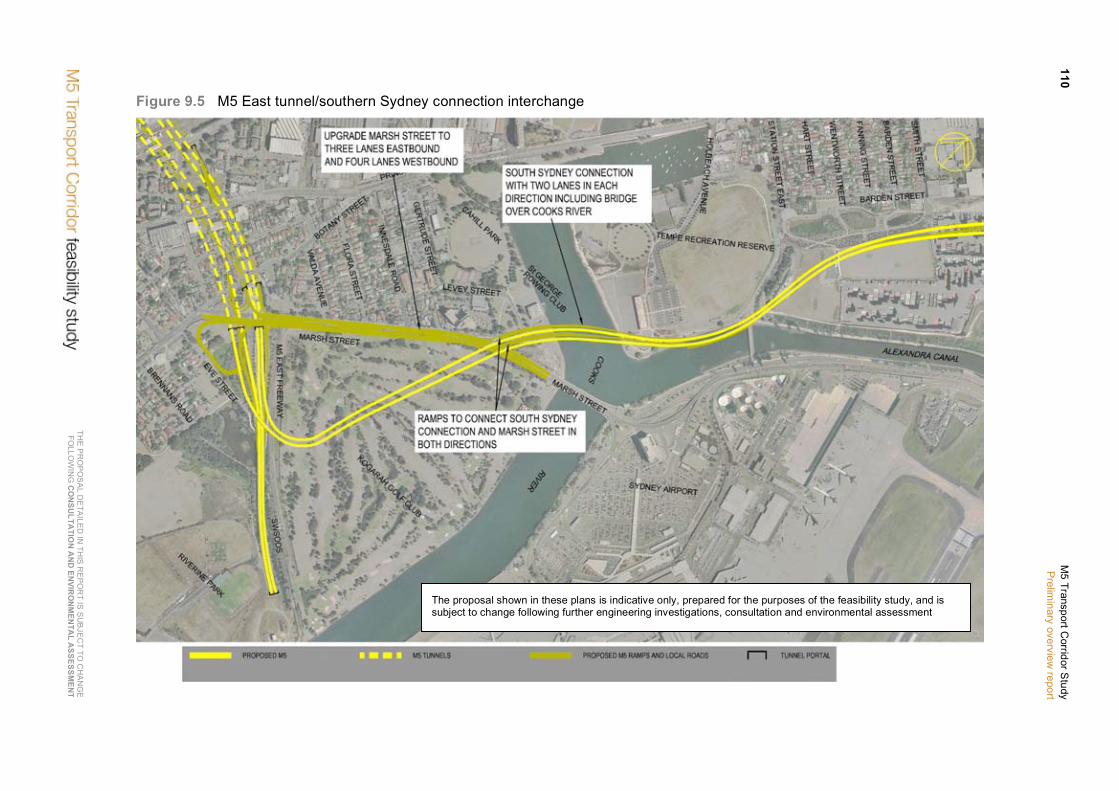
TH
E P
RO
PO
SA
L DE
TAILE
D IN
THIS
RE
PO
RT IS
SU
BJE
CT TO
CH
AN
GE
FO
LLOW
ING
CO
NSU
LTATIO
N A
ND
ENVIR
ON
MEN
TAL A
SSESSMEN
T
110 M
5 Transport Corridor S
tudy P
reliminary overview
report
Figure 9.5 M5 East tunnel/southern Sydney connection interchange
The proposal shown in these plans is indicative only, prepared for the purposes of the feasibility study, and is subject to change following further engineering investigations, consultation and environmental assessment

THE
PR
OP
OS
AL D
ETA
ILED
IN TH
IS R
EP
OR
T IS S
UB
JEC
T TO C
HA
NG
E
FOLLO
WIN
G C
ON
SULTA
TION
AN
D EN
VIRO
NM
ENTA
L ASSESSM
ENT
M5 Transport C
orridor Study
Prelim
inary overview report
111
Figure 9.6 Southern Sydney connection – airport to Canal Road
The proposal shown in these plans is indicative only, prepared for the purposes of the feasibility study, and is subject to change following further engineering investigations, consultation and environmental assessment

TH
E P
RO
PO
SA
L DE
TAILE
D IN
THIS
RE
PO
RT IS
SU
BJE
CT TO
CH
AN
GE
FO
LLOW
ING
CO
NSU
LTATIO
N A
ND
ENVIR
ON
MEN
TAL A
SSESSMEN
T
112 M
5 Transport Corridor S
tudy P
reliminary overview
report
Figure 9.7 Southern Sydney connection – Canal Road to Sydney Park Road
The proposal shown in these plans is indicative only, prepared for the purposes of the feasibility study, and is subject to change following further engineering investigations, consultation and environmental assessment
M5 Transport Corridor Study Preliminary overview report
113
THE PROPOSAL DETAILED IN THIS REPORT IS SUBJECT TO CHANGE FOLLOWING CONSULTATION AND ENVIRONMENTAL ASSESSMENT
10 Conclusions and next steps
10.1 Conclusions
The NSW and Australian governments have provided funds for a feasibility study into improvements to the M5 Transport Corridor linking Port Botany and Sydney Airport with south-west Sydney.
To identify potential areas for improvement within the corridor, a number of studies and investigations have been undertaken. An indicative preferred option has been identified to address the problem statement and study objectives. The indicative preferred option delivers a number of benefits, which include:
• Improving access to Port Botany and Sydney Airport to cater for increased transport demand and releasing the potential economic opportunities created by predicted growth in passenger and freight movements to and from these key centres.
• Increasing capacity along the M5 Transport Corridor to meet existing and future transport demand generated by planned intensification of residential and employment land uses in existing urban areas along and surrounding the M5 corridor.
• Reducing congestion in the M5 corridor and on the surrounding arterial network.
• Improving travel times for individuals and businesses using the corridor, particularly during the AM and PM peaks.
• Delivering a high quality, well integrated and reliable transport network which responds to the diversity and complexity of travel patterns and supports economic development and competitiveness.
• Supporting the prosperity and economic productivity of Sydney as Australia’s only global city.
• Meeting demand for trips that are not well served by public transport and which are dependent on an efficient road network including catering to employment located outside key centres and shift workers.
• Enhancing access to health, education and leisure facilities.
• Reducing greenhouse gas emissions from vehicles.
Table 10.1 summarises how the benefits of the indicative preferred option address the national and state goals.

114 M5 Transport Corridor Study Preliminary overview report
THE PROPOSAL DETAILED IN THIS REPORT IS SUBJECT TO CHANGE FOLLOWING CONSULTATION AND ENVIRONMENTAL ASSESSMENT
Table 10.1 Addressing national and state goals
National goals State goals Indicative preferred option
Increased economic standards of living for Australians.
• Growing prosperity across NSW: − NSW: Open for business. − Stronger rural and regional
economies.
• Improves access to Port Botany and Sydney Airport.
• Caters for existing and future transport demand in the M5 corridor.
• Reduces congestion in the M5 corridor and on surrounding arterial network.
• Improves travel times for individuals and businesses using the corridor.
• Delivers a high quality, well-integrated and reliable transport network which supports economic development.
• Supports the prosperity and economic productivity of Sydney as Australia’s only global city.
Environmental sustainability and reduced greenhouse gas emissions.
• Environment for living: − Securing our water supply. − Practical environmental solutions. − Improved urban environments.
• Reduces greenhouse gas emissions from vehicles.
Better social outcomes, quality of life, and reduced social disadvantage in our regions.
• Rights, respect and responsibility: − Keeping people safe. − Building harmonious communities.
• Delivering better services: − Healthy communities. − Students fulfil their potential. − An effective transport system. − Customer friendly services.
• Fairness and opportunity: − Strengthening Aboriginal
communities. − Opportunity and support for the
most vulnerable. − Early intervention to tackle
disadvantage.
• Enhances access to health, education and leisure facilities.
• Caters for demand for trips that are not well served by public transport.
• Reduces congestion on the road network in the M5 corridor and surrounding arterial network.
• Improves travel times for individuals and businesses using the corridor.
10.2 Next steps
This feasibility study has identified the following investigations be undertaken to progress the development of the indicative preferred option.
10.2.1 Scoping and concept design
• Updating the strategic traffic modelling based on 2006 Census data to confirm the indicative preferred option.
• Undertaking further desktop and site investigations.

M5 Transport Corridor Study Preliminary overview report
115
THE PROPOSAL DETAILED IN THIS REPORT IS SUBJECT TO CHANGE FOLLOWING CONSULTATION AND ENVIRONMENTAL ASSESSMENT
• Further developing the concept design to optimise tunnel alignment, emergency services access and egress, tunnel cross sections and tunnel access.
• Undertaking detailed traffic modelling to assess interchange performance and network integration.
• Undertaking traffic modelling to determine further network improvements that may be required north of Euston Road.
• Developing a preliminary ventilation design.
• Defining urban design criteria and requirements for built features including ventilation structures and tunnel portals.
• Identifying property impacts and preparing acquisitions strategy.
10.2.2 Environment and stakeholders
• Undertaking detailed environmental assessment, including further air quality and noise investigations.
• Preparing community and stakeholder engagement strategy.
10.2.3 Economic and financial
• Preparing a detailed concept estimate of cost.
• Undertaking further economic assessment including consideration of WEBs.
• Preparing a detailed financial assessment including consideration of tolling regimes.
10.2.4 Procurement
• Defining the procurement strategy.
• Developing a strategy to integrate with existing M5 East Freeway and M5 South West Motorway.
10.2.5 Operations
• Preparing a preliminary operation and management strategy.

116 M5 Transport Corridor Study Preliminary overview report
THE PROPOSAL DETAILED IN THIS REPORT IS SUBJECT TO CHANGE FOLLOWING CONSULTATION AND ENVIRONMENTAL ASSESSMENT
11 Bibliography
Australian Transport Council 2006, National Guidelines for Transport System Management in Australia.
Council of Australian Governments 2006, Review of Urban Congestion Trends, Impacts and Solutions.
Department of Planning 2005, Metropolitan Strategy – City of Cities.
Department of Planning 2007, Metropolitan Strategy – East Subregional Strategy.
Department of Planning 2008, Metropolitan Strategy – Inner West Subregional Strategy.
Department of Planning 2007, Metropolitan Strategy – South West Subregional Strategy.
Department of Planning 2007, Metropolitan Strategy – West Central Subregional Strategy.
Department of Transport and Regional Services 2007, Sydney Urban Corridor Strategy.
Infrastructure Australia 2008, Infrastructure Australia Audit Framework.
NSW Ministry of Transport 2008, M5 Transport Corridor Study – Needs Background Paper.
NSW Government 2006, Urban Transport Statement.
NSW Government 2006, State Plan – A New Direction for NSW.
NSW Ministry of Transport 2006, Transport Data Centre, Employment Forecasts.
NSW Ministry of Transport 2006, Transport Data Centre, Population Forecasts.
NSW Ministry of Transport 2008, Transport Data Centre, Sydney Travel Model.
RailCorp 2008, Market Development and Research, Product Development, A Compendium of CityRail Travel Statistics, Sixth Edition.
Roads and Traffic Authority of NSW 1999, Economic Assessment Manual.
Roads and Traffic Authority of NSW 2004 and 2007, RTA Travel Time Surveys.
Roads and Traffic Authority of NSW 2005, Permanent Traffic Counts.
Roads and Traffic Authority of NSW October 2008, Submission to Infrastructure Australia – M5 Expansion.
Roads and Traffic Authority of NSW November 2008, Submission to Infrastructure Australia – M5 Expansion.
Roads and Traffic Authority of NSW January 2009, Infrastructure Australia Priority List – Minimum Information Requirements, M5 Expansion.
Sydney Ports Corporation 2008, Intermodal Logistics Centre at Enfield Project Overview.
Sydney Ports Corporation 2008, Port Botany Container Terminal Expansion – Project Overview.
Sydney Airports Corporation Limited 2009, Sydney Airport Masterplan, Preliminary Draft 2009.