m2 africa – some basic facts (part i) a 5 6 7 4 8 · am2 africa – some basic facts (part i) f...
TRANSCRIPT

M2 Africa – Some Basic Facts (Part I) Africa (Year 7)
1 www.bayern-bilingual.de
Task 1: Take a look in your atlas and find the names of the oceans and seas (numbers 1-8 on the map below) that surround Africa. Write their names in the grid below. 1 5 2 6 3 7 4 8
Task 2: Find out the maximum distances from the North to the South and from the East to the West. Write the distances in the boxes on the map below.
Task 3: Read the short text below and fill in the missing words. You can use your atlas. Compare your results with your neighbour’s results. Africa is a continent. It is surrounded by oceans and seas. The ________________ is on the East
Coast of Africa and the ________________ on the West coast. The ________________ is in the
North. The ________________ divides Africa and Asia. The ________________ divides Europe and
Africa. This passage is _____________ kilometres wide. Africa is ________________ times bigger
than Europe.
trapezium
triangle
2
1
3
8
7
65
4
1
km
km
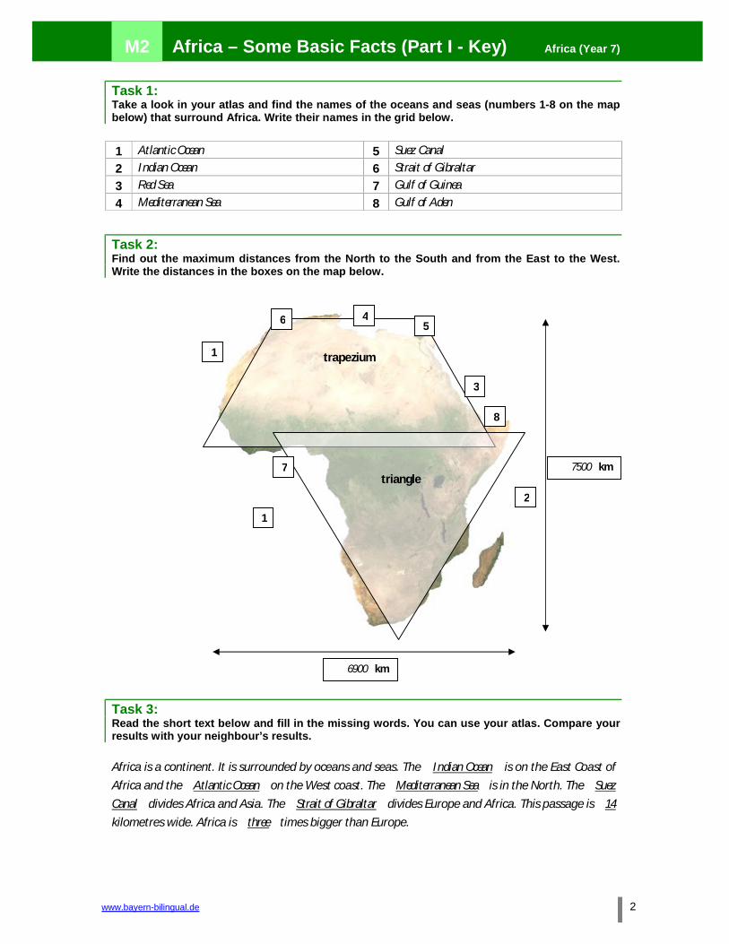
M2 Africa – Some Basic Facts (Part I - Key) Africa (Year 7)
www.bayern-bilingual.de 2
Task 1: Take a look in your atlas and find the names of the oceans and seas (numbers 1-8 on the map below) that surround Africa. Write their names in the grid below. 1 Atlantic Ocean 5 Suez Canal 2 Indian Ocean 6 Strait of Gibraltar 3 Red Sea 7 Gulf of Guinea 4 Mediterranean Sea 8 Gulf of Aden
Task 2: Find out the maximum distances from the North to the South and from the East to the West. Write the distances in the boxes on the map below.
Task 3: Read the short text below and fill in the missing words. You can use your atlas. Compare your results with your neighbour’s results. Africa is a continent. It is surrounded by oceans and seas. The Indian Ocean is on the East Coast of
Africa and the Atlantic Ocean on the West coast. The Mediterranean Sea is in the North. The Suez Canal divides Africa and Asia. The Strait of Gibraltar divides Europe and Africa. This passage is 14
kilometres wide. Africa is three times bigger than Europe.
trapezium
triangle
2
1
3
8
7
65
4
1
7500 km
6900 km

M2 Africa – Some Basic Facts (Part II) Africa (Year 7)
1 www.bayern-bilingual.de
Task: Take a look in your atlas and fill in the missing information in the grid below.
AFRICA – SOME BASIC FACTS
Size: 30 million km2: bigger than Europe
Distances: from Tunis to Capetown (north – south)
from Dakar to Berreda (west – east)
Location in the grid:
Seas and Oceans around Africa:
Gulfs:
Border between Europe and Africa:
Border between Asia and Africa:
Length of African coastline:
Length of European coastline: Rivers that flow into the Atlantic Ocean: Rivers that flow into the Indian Ocean: A river that flows into the Mediterranean Sea:

M2 Africa – Some Basic Facts (Part II - Key) Africa (Year 7)
www.bayern-bilingual.de 2
Task: Take a look in your atlas and fill in the missing information in the grid below.
AFRICA – SOME BASIC FACTS
Size: 30 million km2: three times bigger than Europe
Distances: from Tunis to Capetown (north – south) 7,500 kilometres
from Dakar to Berreda (west – east) 6,900 kilometres
Location in the grid: 37°N – 35° S 17°W- 51° E
Seas and Oceans around Africa: Atlantic Ocean
Indian Ocean
Mediterranean Sea
Red Sea
Gulfs: Gulf of Guinea
Gulf of Aden
Border between Europe and Africa: Strait of Gibraltar
Border between Asia and Africa: Suez Canal
Length of African coastline: 30,000 kilometres
Length of European coastline: 37,000 kilometres
Rivers that flow into the Atlantic Ocean: Niger, Senegal, Oranje, Congo
Rivers that flow into the Indian Ocean: Sambesi, Limpopo
A river that flows into the Mediterranean Sea: Nile

M3 Africa – an Overview Africa (Year 7)
1 www.bayern-bilingual.de
Task 1: What do you know about Africa? Fill in the missing information.
Africa has got the shape of a _____________________ and a _____________________ Africa is one
of the seven _____________________. Its _____________________ is 30 million km². It is three
times _____________________ than _____________________.
The river _____________________ flows into the _____________________ It is the longest river in
the _____________________.The coastline of Africa is shorter than the coastline of
_____________________ because in Africa there aren’t so many peninsulas and bays. If you want to
sail around Africa, you’ll have to travel _____________________ kilometres.” The
_____________________ of the European coastline is _____________________ kilometres. The line
that divides Africa and Asia is called _____________________ and the line that divides
_____________________ is called Strait of Gibraltar. This passage is only _____________________
kilometres wide.
The distance from North to _____________________ is about 7500 kilometres and the distance
from West to East is about _____________________ kilometres.
The Gulf of _____________________ is a very dangerous place for ships and boats, because pirates
often hijack them and kidnap the crew.
Task 2: Match the English and German words and write them in your vocabulary book.
distance Bucht size Mittelmeer location Länge grid Trapez length Welt peninsula Dreieck bay Abstand (Distanz) world Küstenlinie coastline Lage Mediterranean Sea Gradnetz triangle Halbinsel trapezium Größe

M3 Africa – an Overview (Key) Africa (Year 7)
www.bayern-bilingual.de 2
Task 1: What do you know about Africa? Fill in the missing information.
Africa has got the shape of a triangle and a trapezium Africa is one of the seven continents . Its
size is 30 million km². It is three times bigger than Europe.
The river Nile flows into the Mediterranean Sea . It is the longest river in the world . The
coastline of Africa is shorter than the coastline of Europe because in Africa there aren’t so many
peninsulas and bays. If you want to sail around Africa, you’ll have to travel 30,000 kilometres.”
The length of the European coastline is 37,000 kilometres. The line that divides Africa and Asia is
called Suez Canal and the line that divides Europe and Africa is called Strait of Gibraltar. This
passage is only 14 kilometres wide.
The distance from North to South is about 7500 kilometres and the distance from West to East is
about 6,900 kilometres.
The Gulf of Aden is a very dangerous place for ships and boats, because pirates often hijack them
and kidnap the crew.
Task 2: Match the English and German words and write them in your vocabulary book.
distance Bucht size Mittelmeer location Länge grid Trapez length Welt peninsula Dreieck bay Abstand (Distanz) world Küstenlinie coastline Lage Mediterranean Sea Gradnetz triangle Halbinsel trapezium Größe

M4 Landscapes of Africa (Part I: Puzzle) Africa (Year 7)
1 www.bayern-bilingual.de
Task 1: Look at a physical map of Africa and find the correct location for the puzzle pieces below. They all show different African landscapes. Cut the pieces and stick them on the map (Part II). Mark the pieces on the map with the numbers 1-11.
1 Congo Basin 8 Namib Desert
2 Chad Basin 9 Kalahari Desert
3 Drakens Mountains 10 Upper Guinea Highlands
4 Atlas Mountains 11 Lower Guinea Highlands
5 Ahaggar and Tibesti Mountains 12 Asande Hills
6 East African Lakes 13 Luanda Hills
7 Uplands of Ethiopia
(Quelle: Erdkundestunden Topographie, Kapitel 3, Afrika physisch-geografisch; Farbfolien zu den Arbeitsblättern, Horst Purschke, H&P-Verlag, Pfarrkirchen, 3. Auflage 2007)

M4 Landscapes of Africa (Part II: Map) Africa (Year 7)
www.bayern-bilingual.de 2

M4 Landscapes of Africa (Key) Africa (Year 7)
3 www.bayern-bilingual.de
Task 1: Look at a physical map of Africa and find the correct location for the puzzle pieces below. They all show different African landscapes. Cut the pieces and stick them on the map (Part II). Mark the pieces on the map with the numbers 1-11.
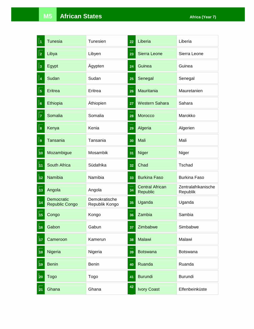
M5 African States Africa (Year 7)
1 Tunesia Tunesien 22 Liberia Liberia
2 Libya Libyen 23 Sierra Leone Sierra Leone
3 Egypt Ägypten 24 Guinea Guinea
4 Sudan Sudan 25 Senegal Senegal
5 Eritrea Eritrea 26 Mauritania Mauretanien
6 Ethiopia Äthiopien 27 Western Sahara Sahara
7 Somalia Somalia 28 Morocco Marokko
8 Kenya Kenia 29 Algeria Algerien
9 Tansania Tansania 30 Mali Mali
10 Mozambigue Mosambik 31 Niger Niger
11 South Africa Südafrika 32 Chad Tschad
12 Namibia Namibia 33 Burkina Faso Burkina Faso
13 Angola Angola 34 Central African Republic
Zentralafrikanische Republik
14 Democratic Republic Congo
Demokratische Republik Kongo 35 Uganda Uganda
15 Congo Kongo 36 Zambia Sambia
16 Gabon Gabun 37 Zimbabwe Simbabwe
17 Cameroon Kamerun 38 Malawi Malawi
18 Nigeria Nigeria 39 Botswana Botswana
19 Benin Benin 40 Ruanda Ruanda
20 Togo Togo 41 Burundi Burundi
21 Ghana Ghana 42
Ivory Coast Elfenbeinküste

M6 A Trip through Africa Africa (Year 7)
1 www.bayern-bilingual.de
Journey 1:
An Arabian salesman is on business in 13 African states, which he visits in alphabetical order. Which countries does he go to? Look at the map below. His journey begins in the state marked “A”.
Task 1: Look up the states in your atlas. Write the first letters of the states in the map below, and then write the names of the states in your exercise book. Journey 2:
A young man has planned a trip across Africa. He wants to visit 15 African capitals (numbers 1-15 on the map) in alphabetical order. The trip starts in Adis Abeba, the capital of …
Task 2: Look up the states in your atlas and write their names in your exercise books.
Quelle: Erdkundestunden Topographie, Kapitel 2, Arbeitsblätter Topographie ‚Kreuz und quer durch Afrika‘, Horst Purschke, H & P-Verlag,
Pfarrkirchen, 3. Auflage 2007

M6 A Trip through Africa (Key) Africa (Year 7)
www.bayern-bilingual.de 2
Journey 1: A Angola B Burundi C Ivory Coast D Democratic Republic Congo E Eritrea G Gabon L Libya M Mauretania N Nigeria R Ruanda T Togo U Uganda Z Zambia Journey 2: 1 Ethiopia 2 Congo 3 Guinea 4 Senegal 5 Sierra Leone 6 Botswana 7 Zimbabwe 8 Sudan 9 Malawi 10 Somalia 11 Kenya 12 South Africa 13 Morocco 14 Tunesia 15 Namibia