lower canning river surface water allocation plan€¦ · your input on our lower canning river...
TRANSCRIPT

Looking after all our water needs
SCT_Online Print_Final_A4.indd 1 31/05/10 11:08 AM
Lower Canning River surface water allocation plan
For public comment (below Canning Dam to Kent Street Weir)


Lower Canning River surface water allocation plan (below Canning Dam to Kent Street Weir)
For public comment
Looking after all our water needs
Department of Water
September 2010
Department of Water 168 St Georges Terrace Perth Western Australia 6000 Telephone +61 8 6364 7600 Facsimile +61 8 6364 7601 www.water.wa.gov.au
© Government of Western Australia 2010
September 2010
This work is copyright. You may download, display, print and reproduce this material in unaltered form only (retaining this notice) for your personal, non-commercial use or use within your organisation. Apart from any use as permitted under the Copyright Act 1968, all other rights are reserved. Requests and inquiries concerning reproduction and rights should be addressed to the Department of Water.
ISBN 978-1-921637-71-1 (print) ISBN 978-1-921637-72-8 (online)
Disclaimer
This document has been published by the Department of Water. Any representation, statement, opinion or advice expressed or implied in this publication is made in good faith and on the basis that the Department of Water and its employees are not liable for any damage or loss whatsoever which may occur as a result of action taken or not taken, as the case may be in respect of any representation, statement, opinion or advice referred to herein. Professional advice should be obtained before applying the information contained in this document to particular circumstances.
Acknowledgements
The Department of Water would like to acknowledge the lower Canning River surface water project team, project board, Laurence Radin, Pat Hart and SERCUL for their contribution to this publication.
For more information about this plan, contact:
Leanne Hartley Swan Avon Region Department of Water 7 Ellam Street Victoria Park Western Australia 61400
Telephone 08 6250 8000 Facsimile 08 6250 8050
This publication is available at our website <www.water.wa.gov.au> or for those with special needs it can be made available in alternative formats such as audio, large print, or Braille.

Lower Canning River surface water allocation plan – draft for public comment
Department of Water iii
Foreword This plan for public comment provides water users and the wider community with an opportunity to comment on the Department of Water’s proposed management approach in the lower Canning River surface water area.
Even though the lower Canning River is a highly modified system, it continues to support important ecological values. It also benefits the community, supports cultural values and influences the health of the Swan River.
This plan is different to other allocation plans because land use along the lower Canning River is changing and water needs are increasingly met using the public water supply. It largely addresses how the limited available water is best used to preserve the river’s ecological values and meet declining direct use needs. The new environmental flow rules have been trialled successfully during the past two summers.
Your input on our lower Canning River surface water allocation plan is important. It will help us achieve the right balance between the remaining productive use of this water and the environmental and other public benefits.
Once you have read this document, we encourage you to send us your comments by 3 December 2010.
We will respond to all the submissions we receive on this draft plan in a statement of response document. This document will be released with the final plan and describe how we have responded to your submissions and where they have been considered in finalising the plan.
Maree De Lacey
Director General, Department of Water


Lower Canning River surface water allocation plan – draft for public comment
Department of Water v
Contents Foreword .................................................................................................................... iii Summary ................................................................................................................... vii 1 Introduction.............................................................................................................. 1
1.1 Purpose of this plan ............................................................................................................ 1 1.2 Scope of the plan ................................................................................................................ 1 1.3 The plan area ...................................................................................................................... 2
1.3.1 Location .................................................................................................................................. 2 1.3.2 Proclamation ........................................................................................................................... 2
1.4 When and for how long will this plan apply? ...................................................................... 4 1.5 Updating legislation and this plan ....................................................................................... 4
2 What we want this plan to achieve and how we will achieve it ................................ 5
2.1 Objectives ........................................................................................................................... 5 2.2 How the plan will achieve its objectives ............................................................................. 5
3 Allocation limits ........................................................................................................ 6
3.1 Setting an allocation limit .................................................................................................... 6 3.2 Components of the allocation limit ..................................................................................... 6
4 Allocation and licensing policies .............................................................................. 7
4.1 Approach to allocating water .............................................................................................. 7 4.1.1 Allocating water in low-rainfall years ....................................................................................... 7 4.1.2 Recouping water entitlements ................................................................................................. 7 4.1.3 Reducing riparian use of surface water .................................................................................. 8
4.2 Surface water licensing ...................................................................................................... 8 4.2.1 Legislative requirements ......................................................................................................... 8 4.2.2 Approach to licensing surface water ....................................................................................... 9
4.3 Licensing policies.............................................................................................................. 10 4.3.1 Policies that apply statewide ................................................................................................. 10 4.3.2 Local licensing policies for the lower Canning River area ..................................................... 10
5 Environmental flow provisions for the lower Canning River ................................... 12
5.1 Why we release water into the lower Canning River ....................................................... 12 5.2 How and when is water released? ................................................................................... 12
5.2.1 The environmental flow regime ............................................................................................. 12 5.2.2 Summer environmental flow provisions ................................................................................ 13 5.2.3 Winter environmental flow provisions ................................................................................... 13 5.2.4 Future climate and maintaining environmental flow provisions ............................................. 13 5.2.5 Quality of environmental flow releases ................................................................................. 14
5.3 What will happen in low-winter-rainfall years? ................................................................. 14 5.3.1 Applying the environmental flow provisions in low- and average-rainfall years .................... 14
5.4 Variations to environmental flows ..................................................................................... 15
6 Monitoring program for the plan area .................................................................... 17
6.1 Current program ............................................................................................................... 17
7 Implementing and evaluating the plan ................................................................... 18
7.1 Implementing the plan ...................................................................................................... 18 7.2 Evaluating the plan’s success .......................................................................................... 19

Lower Canning River surface water allocation plan – draft for public comment
vi Department of Water
Appendices ................................................................................................................ 20
Glossary .................................................................................................................... 32
References and recommended reading .................................................................... 37
Appendices
Appendix A — Flow-ecology linkages and flow considerations for ecological processes in the lower Canning River ................................................................... 21
Appendix B — Environmental water provision regime for average rainfall years....... 27
Appendix C — Summary of community questions ..................................................... 29
Figures
Figure 1 Lower Canning plan area and catchments ................................................. 3
Tables
Table 1 Allocation limit for Lower Canning River surface water resource (February 2010) .......................................................................................................... 6
Table 2 Licensing policies specific to the plan area ............................................... 10 Table 3 Variation to the environmental release arrangements .............................. 15 Table 4 Actions for implementing this plan ............................................................ 18 Table 5 Performance indicators to measure the plan’s success ............................ 19

Lower Canning River surface water allocation plan – draft for public comment
Department of Water vii
Summary The Department of Water uses allocation plans to manage how water is taken from surface water and groundwater systems, taking into account the social and cultural values and ecological needs of those systems. This Lower Canning River surface water allocation plan replaces the Canning River interim allocation policy (WRC 1996). It refers to the section of the lower Canning River from the base of the Canning Dam to the Kent Street Weir in Cannington.
Need for an allocation plan in this area
Since 1940 the flows of the upper Canning River have been stored to provide water for Perth’s Integrated Water Supply Scheme. Water released to the lower Canning River provides for riparian and licensed use and contributes to maintaining some of the highly modified system’s ecological character. This plan describes a new approach to managing the release of available water in the lower Canning River to best meet key ecological needs. A limited amount of water will continue to be made available for use, with a focus on increasing efficiency and recouping water as land uses change.
This allocation plan outlines:
• our approach to managing the flow regime, including supplementing the river flows with scheme water to support ecological values
• our approach to managing the ‘take’ of water
• objectives for surface water in the lower Canning River surface water area
• performance indicators by which we will evaluate the plan.
This allocation plan does not include strategies for addressing water source protection, flooding, drainage or land management. We address these issues in other management plans.
Environmental releases
Since the river system was dammed, water has been released into the lower Canning River through a number of release points, providing water for surface water users. By improving the timing of these releases being turned off and on, and their volume, this plan provides better environmental outcomes, as well as a flow that users can access.
Environmental releases will provide a continual flow of water in the lower Canning River in the summer months to maintain flow connectivity, pool depth and oxygen levels. Occasional additional releases (pulse flows) will allow fish passage in the summer months. During the winter months, flow into the river comes from rainfall and catchment runoff.
In years when winter rainfall is low, less water will be available from the dam. This plan therefore allows for a low-rainfall environmental release regime that maintains oxygen levels and pool connectivity (with a narrower channel width), but cancels fish-

Lower Canning River surface water allocation plan – draft for public comment
viii Department of Water
passage pulse flows. During low-rainfall years, surface water users will also be asked to restrict their water use.
Water availability and use or allocation and licensing approach
The lower Canning River will be managed as an over-allocated system.
The river’s water is used for orchards, gardens, recreation, vegetables, grapes, nurseries, stock watering and public water supply. A number of licensed users also have riparian rights. The new annual limit on water allocation is 650 000 kL, which is below current use. We will carefully manage the take of water through licence conditions to minimise the impact of existing surface water use on the environment and other users. This includes metering and reporting requirements for large users and pumping restrictions for all users during low-rainfall years. Total water use will be reduced through efficiency measures and land use changes.
As of early 2010, approximately 30 landholders have riparian rights to access the lower Canning River for water. This number is likely to decrease over time with changes in land use and new subdivisions – resulting in the creation of a reserve along the river that would remove any previous riparian rights.
How can you have your say?
This is our plan for public comment. We will review and consider your comments before finalising the Lower Canning River surface water allocation plan. We will produce a statement of response, which will be a summary of your views and comments, to release with the plan. We may quote directly from your comments, so please state clearly if you do not wish us to do so.
Please send your comments to <[email protected]> or the address below by 5 pm Friday 3 December 2010.
Water Allocation Planning Branch Department of Water PO Box K822 Perth Western Australia 6842

Lower Canning River surface water allocation plan – draft for public comment
Department of Water 1
1 Introduction Since European settlement, water flows in the lower Canning River have been significantly modified by the building of three public water supply dams (Canning, Churchman Brook and Victoria) and two pumpback stations (Araluen and Bickley); use of water from the river for agricultural and rural residential purposes; as well as significant urbanisation and diminishing rainfall. Water from the dams and pumpback stations form part of Perth’s Integrated Water Supply Scheme (IWSS).
Water from the lower Canning River not only provides significant economic benefits, but also continues to support important ecological, cultural and social values. This plan aims to protect and potentially improve those values.
1.1 Purpose of this plan
This plan is made under the Rights in Water and Irrigation Act 1914 for the allocation and take of water from the environment. It replaces the Canning River interim allocation policy (WRC 1996).
The plan outlines how much surface water can be allocated for various purposes. Because land use changes have reduced the ‘take’ of surface water in the surrounding catchment, the plan will focus on the release of available water to achieve environmental outcomes for the lower Canning River.
The river’s social and cultural values have also been considered and include:
• recreational and tourism activities
• sites of Aboriginal significance
• landscape and aesthetic aspects
• educational and scientific aspects.
This plan aims to protect these values, maintain key ecological needs, and provide for existing water users while gradually reducing the water extracted from the lower Canning River.
At present, scheme water is released to maintain these in-stream values. Ideally in the longer-term, the scheme water will be replaced with fit-for-purpose water as opportunities arise, and optimisation of recycled water becomes more cost-effective.
1.2 Scope of the plan
The Department of Water has developed this plan using surveys of water use and new studies looking at the lower Canning River’s ecological water requirements. We have also considered questions posed during the plan’s community consultation process and the input of the Canning Environmental Flows Steering Committee.
All of this information has been used to:
• set allocation limits

Lower Canning River surface water allocation plan – draft for public comment
2 Department of Water
• set an environmental water regime to protect key ecological assets.
The plan sets out:
• the allocation planning boundary
• the amount of water available for allocation
− our approach to managing environmental water provisions (environmental flows)
− objectives for the allocation of water and its use
− policies for allocating water licence entitlements
• how we will implement, evaluate and review the plan.
It is beyond the scope of this plan to provide a catchment-wide integrated management approach that includes drainage, land planning and water quality condition objectives.
To read about our broader vision and directions for water resource management in the Perth-Peel region, which includes the lower Canning River, refer to the Perth-Peel regional water plan 2010–2030 draft for public comment (DoW 2009). This strategic plan sets out how we will manage the region’s water resources for the next 20 years. It describes the challenges we face and the actions needed to respond to them. The Perth-Peel regional plan should be considered with this allocation plan.
1.3 The plan area
1.3.1 Location
This plan applies to the lower Canning River, which is located in the Perth metropolitan area’s south-east corridor, as shown in Figure 1. It includes the freshwater reach of the Canning River from the base of the Canning Dam to the Kent Street Weir in Cannington.
At present the Department of Water is seeking funding to undertake remedial works to allow the Kent Street Weir to maintain its original design function and uphold its current social, ecological, historic and economic values. However, this plan does not address the management of the Kent Street Weir.
1.3.2 Proclamation
This plan applies to the main Canning River channel only, which is proclaimed under the Rights in Water Irrigation Act 1914.

Lower Canning River surface water allocation plan – draft for public comment
Department of Water 3
Figure 1 Lower Canning plan area and catchments

Lower Canning River surface water allocation plan – draft for public comment
4 Department of Water
1.4 When and for how long will this plan apply?
The Lower Canning River surface water allocation plan will come into effect from the day it is released for public comment.
This plan will be reviewed in seven years, in accordance with the Rights in Irrigation and Water Act 1914 and if necessary replaced at that time. The plan will be reviewed earlier if the plan’s evaluation process recommends it.
1.5 Updating legislation and this plan
The Government of Western Australia is currently updating and reviewing its legislation for the state’s water resources.
The approach and structure of this plan is consistent with the requirements of the Rights in Water and Irrigation Act 1914 and, as far as possible, with the intent and purpose of the new legislation.
Once new legislation is enacted, the subsequent review of this plan will include the appropriate changes and mechanisms for allocating water.
Lower Canning River surface water allocation plan – draft for public comment
Department of Water 5
2 What we want this plan to achieve and how we will achieve it
As the lower Canning River has been highly modified to support the public water supply system, this plan’s main purpose is to manage the limited water available for release to support key ecological needs. The rights of existing licensed and riparian users to take water are maintained, with a focus on improving efficiency and gradually recovering water through land planning opportunities.
Land use along the river is changing from rural to urban and as that happens, fewer landholders will need to meet their water requirements by pumping from the river. The Department of Water has an opportunity to gradually recoup unused water entitlements. This will improve the river’s health with minimal impact on water users.
2.1 Objectives
The water resource objectives of this plan are to: a provide an environmental flow regime which
− maintains summer baseflows
− maintains oxygen levels and pool connectivity
− during summer provides occasional pulse flows through the environmental release points to meet native fish requirements
− has a minimal flow regime during low-rainfall years.
The management objectives of this plan are to: b reduce licensed entitlements and riparian use to within the allocation limits c increase the efficient use of water d temporarily reduce water entitlements and environmental flows during low-
rainfall winters.
2.2 How the plan will achieve its objectives
This plan provides the management approach for water releases and for allocation and licensing, and informs the department’s advice on land use planning processes.
To meet the objectives of this plan we will:
• deliver the environmental flow regime through the actions in Section 5.4
• apply our approach for allocating (Section 4.1) and licensing water (Section 4.2)
• licence water according to the licensing policies in Section 4.3.

Lower Canning River surface water allocation plan – draft for public comment
6 Department of Water
3 Allocation limits An allocation limit is the annual total volume of water that the Department of Water sets aside from a resource. This includes licensed and small-scale riparian use.
This plan sets the total amount of water available for annual use from the lower Canning River surface water resource. This resource is fully allocated.
For inquiries about water use, interested parties are encouraged to contact our Swan Avon regional office in Victoria Park.
3.1 Setting an allocation limit
In this case, the allocation limit is the volume of water that can be extracted from the lower Canning River. The allocation limit for this resource has been set to support some recovery of the system with minimal impact on current users. There is no water available for new allocations.
3.2 Components of the allocation limit
The department allocates water by dividing the allocation limit into components. There are licensable components (e.g. general licensing, public water supply) and unlicensable components (e.g. water for small-scale riparian use). For the lower Canning River surface water resource, the allocation limit by components and the status of water availability for licensing is shown in Table 1.
Table 1 Allocation limit for Lower Canning River surface water resource (February 2010)
Allocation limit kL/yr
Component for unlicensed use kL/yr
Component for general licensing kL/yr
Resource status for licensing
650 000 42 000 608 000 No water available (over-allocated)

Lower Canning River surface water allocation plan – draft for public comment
Department of Water 7
4 Allocation and licensing policies The Department of Water uses water licences as the regulatory instrument under the Rights in Water and Irrigation Act 1914 to manage individual take and use. Allocation plans direct the assessment and conditions of licences and outline our position on the licensing and water allocation issues within the plan area.
We use the local policies set out in the allocation plans, as well as relevant statewide policies, to assess licence applications and guide water take and use where water users legally do not require a licence.
4.1 Approach to allocating water
The objectives in Section 2.1 set the department’s approach to allocating water in the lower Canning River surface water area. They are designed to maintain the key environmental flows while allowing for some water use. We use the licensing process to share the available water, up to the allocation limits set in Section 3.1.
The lower Canning River surface water area’s recovery strategy is to cap allocation at current levels. The allocation limit has been reduced below current use, and no water is available for allocation. As land uses change, riparian use will be reduced. We will continue to encourage efficient water use.
4.1.1 Allocating water in low-rainfall years
Where possible, during periods of low rainfall the department encourages existing users to reduce their take and supplement use with an alternative supply such as rainwater tanks, groundwater or scheme water.
During low-rainfall years, both licensed users and riparian users will be asked to reduce their water use by 50 per cent (see Section 1 for more information). If water is available from other sources (e.g. scheme water), this water must be used in preference to taking water from the river.
We will notify water users if they need to reduce their use during low-rainfall years.
4.1.2 Recouping water entitlements
The department will actively recoup unused water entitlements in the lower Canning River surface water area during licence renewal and auditing. We will not reallocate recouped water entitlements. This will ensure that no additional water is taken from a resource already under pressure from current levels of extraction.
The recovery program has been in place since 2005–06. With land use becoming more urbanised and new subdivisions accessing Perth’s IWSS, licensed use has already reduced by 28 per cent.
Lower Canning River surface water allocation plan – draft for public comment
8 Department of Water
4.1.3 Reducing riparian use of surface water
In line with this plan’s objectives and the river’s environmental flow provisions, the department recommends reducing riparian use of surface water from the lower Canning River area.
We recommend that where a freehold land parcel with a riparian right is subdivided, local government and land planning agencies set aside a zone reserved for public access as part of the subdivision approvals process.
4.2 Surface water licensing
Licensing in the lower Canning River is managed by our Swan Avon regional office in Victoria Park. Any inquiries about surface water licensing or licences should be directed to this office on (08) 6250 8000.
General licensing information and licence application forms are available on our website <www.water.wa.gov.au > Doing business with us > Water licensing>.
4.2.1 Legislative requirements
Water users in the lower Canning River area require a water licence to lawfully take surface water under the Rights in Water and Irrigation Act 1914.
A permit is also required to lawfully interfere with the bed and banks of watercourses, including the installation of pumps or construction of dams, under sections 11, 17 and 21 of the Act.
A water licence provides legal and secure access to water. The department uses water licences to manage water take and use at an individual scale to:
• protect other users
• protect water-dependent ecosystems
• support economic growth.
Clause 15 of Schedule 1 of the Rights in Water and Irrigation Act 1914 enables the department to include terms, conditions and restrictions to licences. Conditions may refer to attachments or other documents that the licence must abide by.
Clause 24 (1) of Schedule 1 of the Act specifies the department’s requirements for altering any licence condition and Clause 26 covers the rights of licensees. Any decision made on a licence application can be appealed through the State Administrative Tribunal.
We have developed the policies in Section 4.3 to provide further detail on and directions associated with licence conditions.

Lower Canning River surface water allocation plan – draft for public comment
Department of Water 9
Riparian rights
Riparian rights normally allow access to water where no scheme water is available. Some landholders on the lower Canning River have the right to take water for limited purposes. They may install a pump on their own land, and use the water in a house or buildings and/or for stock supplies. This right does not guarantee that water will be available. Permission will not be given to install pipes and pumps across a public reserve.
Approximately 30 users potentially have riparian rights along the lower Canning River. As land use changes and become more urbanised, this number will decrease.
If surface water is used for private drinking-water supplies, it is advisable to filter, treat and test the water according to public health advice from the Department of Health. Also see our water quality protection notes, the Australian drinking water guidelines 2004 (Australian Government 2004) and the Australian fresh and marine water quality guidelines (ANZECC & ARMCANZ 2000) for more information.
4.2.2 Approach to licensing surface water
The department develops strategic and operational policies that apply across the state. We have refined specific aspects of these policies so that they are more applicable to the allocation of water resources in this area.
Licensing officers carry out the licensing process in accordance with the requirements of:
• the Rights in Water and Irrigation Act 1914
• the strategic and operational policies that apply statewide
• local policies that apply to the plan area.
Auditing licensed use
The department regularly audits licence compliance to ensure that water use and extraction is in accordance with licences and their conditions. During auditing, we review monitoring and metering data and assess whether any local impacts are occurring. This ensures the licence conditions are appropriate for that particular circumstance.
Water use efficiency
The department encourages all licensees to use water efficiently.
We work with public water suppliers, local government authorities, other government agencies and land developers to ensure that water use in urban areas is in accordance with licensees’ efficiency plans.
Licensees are required to implement efficiency measures to maximise use of a limited amount of water during periods of low flow.

Lower Canning River surface water allocation plan – draft for public comment
10 Department of Water
4.3 Licensing policies
4.3.1 Policies that apply statewide
The department’s statewide strategic and operational policies apply to the lower Canning River area. These policies are available on our website: <www.water.wa.gov.au> Doing business with us > Water licensing>.
4.3.2 Local licensing policies for the lower Canning River area
Where local licensing policies apply, they have precedence over the statewide licensing policies. Those that apply to the lower Canning River area are set out in Table 2.
Table 2 Licensing policies specific to the plan area
Policy group Policy detail 1 Allocating water
1.1 Allocating water for abstraction
1.1.1. The department will refuse applications for new licences or requests for additional water in the lower Canning River surface water area. The exception to this is for trades compliant with Operational policy 5.13 – Water entitlement transactions for Western Australia (DoW 2010).
1.1.2. The department may make exceptions for applications for new surface water entitlements up to 5000 kL/year for the purposes of emergency, health and safety, and community benefit only.
1.2 Recover water entitlements
1.2.1. Where a property is subdivided for urban use, any surface water licence associated with the original property will be audited to recoup unused entitlements to reduce the impact of abstraction on the environmental flows in the river.
1.2.2. We will recoup unused water entitlements as licensees apply for licence renewals, as outlined in Statewide policy no. 11 – Management of unused licensed water entitlements.
2 Licensing rules and requirements
2.1 Licence conditions
2.1.1. Licence conditions may state a maximum daily abstraction rate. 2.1.2. Licence conditions may require a licensee to install a staff gauge
and monitor water levels in the river. 2.1.3. Licence conditions may state periods when pumping is permitted. 2.1.4. Licence conditions may state a minimum water level above which
pumping is permitted. 2.1.5. Licence conditions may state that the take of water must be
reduced by 50 % during low-flow periods. 2.1.6. Licence conditions may state limitations on pumping rates and
pump size 3 Environment 3.1 Environmental
impact management
The department recommends pumping winter flows from a watercourse into off-stream storage, rather than directly pumping from a watercourse in summer.

Lower Canning River surface water allocation plan – draft for public comment
Department of Water 11
Policy group Policy detail 4 Measurement
4.1 Measurement of water take
4.1.1. Licensees with an entitlement greater than or equal to 20 000 kL/yr are required to install and maintain a department-approved meter within three years of the issue of this plan.
4.1.2. Where a transfer of a water licence greater than 10 000 kL/yr occurs, the new licence holder will be required to fit a meter.
5 Trading (water entitlement transactions)
5.1 Trading
An application to trade a surface water entitlement will only be accepted where the applicant can successfully demonstrate that the movement of the draw point will result in better environmental outcomes and improved water efficiencies with regard to the end use in accordance with Operational policy 5.13 – Water entitlement transactions for Western Australia (DoW 2010).
6 Land use planning
6.1 Land use planning Where river frontage land is being rezoned, the department will liaise with land planning and local government agencies to ensure a riparian zone is established as a public reserve.

Lower Canning River surface water allocation plan – draft for public comment
12 Department of Water
5 Environmental flow provisions for the lower Canning River
5.1 Why we release water into the lower Canning River
Limited hydrological data was recorded before the dams and pumpbacks were built. The available hydrological record indicates a strong variation in seasonal spring/summer and winter flow regimes. During the dry summer months, flows would subside but the river did not cease to flow. The winter months were dominated by high channel-forming flows that inundated the lower floodplain during flood events (Radin et al. 2010).
The Noongar name for the Canning River is Dyarlgarro, meaning place of abundance. The river is rich in Noongar culture and history and many significant and sacred sites are embedded within its banks.
More than 80 per cent of annual flow in the lower Canning River occurs between June and October. During the drier months between November and May, streamflows are influenced by the release of treated scheme water through six environmental release points (ERPs) (Figure 1). The ERPs have been operating for decades and were originally designed to compensate water users for the loss of flow after the Canning and Wungong dams were built. The river’s ecology changed in response to this modified flow regime. See Appendix A for details of the key flow-ecology linkages.
The protection of water-dependent ecological values has become a high priority in regulated rivers across Australia. The lower Canning River is a highly regulated river with modified ecological communities. The steps taken to protect water-dependent ecological values in this plan recognise this degree of modification.
The environmental water releases for the lower Canning River are based on the modified ecological attributes, taking into account the existing social and economic uses of the water. The releases (see Appendix B) have been determined using information from observations during a summer field trial and hydrological modelling results.
5.2 How and when is water released?
5.2.1 The environmental flow regime
Before this surface water allocation plan was developed, studies to determine the lower Canning River’s ecological water requirements were conducted. For the details and findings of these studies, see this plan’s supporting document, Ecological water requirements of the lower Canning River (Radin et al. 2010).
The document describes a water-release program that was trialled in summer 2007 by the Department of Water and Water Corporation. Using the trial results and

Lower Canning River surface water allocation plan – draft for public comment
Department of Water 13
information from the other studies, a regime for summer environmental flow provisions was set. The regime aims to meet a range of ecological criteria (see Appendix B for details on how this will be done). The Water Corporation will include the regime in its operating strategy for the IWSS and report on its progress annually.
5.2.2 Summer environmental flow provisions
The objective of the summer environmental flow provisions is to maintain the baseflow at a specific flow rate or level to ensure the river does not stop flowing between the Araluen pumpback and the Kent Street Weir. The provision maintains flow connectivity and pool depth, preventing anoxic conditions and submerging riffles.
The summer environmental flow provisions factor in a ‘25 per cent loss’ rule, which takes into account the loss of water from abstraction, evaporation and infiltration. This figure may need to be altered in the future if evaporation rates increase as a result of climate change or daily abstraction patterns change.
In the summer, scheme water is released from six environmental release points (ERPs) located along the river. The summer base flow requirements represent a cumulative volume from these ERPs for the different reaches of the lower Canning River. The department monitors the mean daily discharge at Seaforth gauging station to ensure these minimum flows are maintained.
Additionally, three pulse flows of five days’ duration each will be provided in summer during an average rainfall year. The purpose is to inundate in-stream obstacles that act as a barrier to fish migration. This is particularly relevant for freshwater cobbler, which migrate and spawn during the summer months.
During the summer of 2009–10, the Department of Water and Water Corporation conducted a further trial. This involved releasing water from the base of the Canning Dam to provide water higher up in the system (above the Araluen pumpback) and to increase the length of river receiving environmental flows. Water released from the dam did not reach the Araluen pumpback, indicating losses well above the 25 per cent experienced below the pumpback. Even though the length of river below the dam has high environmental values, the amount of water that needs to be released is very high and the trial was discontinued.
5.2.3 Winter environmental flow provisions
In winter, the environmental flow needs of the modified system can be met by runoff from rainfall. The ERPs will not be used during winter.
5.2.4 Future climate and maintaining environmental flow provisions
The environmental flow provisions for the lower Canning River established in this plan are based on the rainfall regime experienced since 1975.
The CSIRO has investigated future climate scenarios and their effects on streamflows in the south-west of Western Australia (CSIRO 2009). Under a ‘mid-

Lower Canning River surface water allocation plan – draft for public comment
14 Department of Water
range’ climate future for the region, flows at Seaforth gauging station would be reduced by 20 per cent during winter and 25 per cent during summer.
Reduced winter flows may mean fewer days of bankfull flows during winter and a greater number of years with low-rainfall conditions.
As the summer flows rely completely on environmental releases, reduced summer rainfall would not impact on the baseflows. However, it may reduce the number of natural pulse flows for fish, resulting in a greater proportion of the specified three pulse flows for fish each summer being provided artificially via environmental releases.
5.2.5 Quality of environmental flow releases
The water released to meet the environmental flow regime is chlorinated scheme water. Chlorine breaks down rapidly with aeration and exposure to sunlight. Chlorine in the released water dissipates rapidly, so that 500 m downstream of the release points, chlorine concentrations are within acceptable ANZECC/ARMCANZ levels for freshwater systems.
The lower Canning River has been substantially affected by sedimentation (as a result of catchment clearance and changing land uses). It is not possible to release enough water through the release structures to move built-up sediment. The environmental flow regime will not address sedimentation. Reducing sedimentation will require changes to land management in the catchment.
5.3 What will happen in low-winter-rainfall years?
The ERPs provide summer environmental flows in the lower Canning River. These releases come from Perth’s IWSS, which is sourced from groundwater and surface water (dam) resources. These water resources receive most of their recharge during winter (May to October). This plan’s environmental flow releases will continue to be effective under a mid-range climate future. However, as part of the plan’s annual evaluation, we will assess the effectiveness of the releases each year against any change in climate. If winter recharge volumes are low, less water will be available for use from the IWSS the following summer.
5.3.1 Applying the environmental flow provisions in low- and average-rainfall years
The department has developed a low-rainfall response (Table 3) for years where a serious rainfall deficiency1
1 The Bureau of Meteorology defines a serious rainfall deficiency as being rainfall that is equal to or less than
rainfall in the lowest 10 per cent of years. The period used is 1975–2008.
may lead to reduced water availability from the IWSS. The low rainfall trigger is based on lowest historical rainfall received for the period 1975-2008. For this period, winter rainfall (defined as 1 May to the 30 September) recorded

Lower Canning River surface water allocation plan – draft for public comment
Department of Water 15
at Bickley (Bureau of Meteorology station 9240) in the lowest 10 per cent of years was below 675 mm.
If rainfall from May to end of September is below 675 mm, the low-rainfall summer release schedule will be adopted. If winter rainfall is 675 mm or greater, the standard summer release schedule will apply.
Under the low-rainfall summer release schedule, environmental flow releases will be 50 per cent of the standard summer release schedule and no fish-passage pulse releases will occur. The low-rainfall summer release schedule will reduce by one-third the riffle width covered by 5 cm or more of water, but will still maintain oxygen levels and pool connectivity.
The standard summer release schedule has been designed to meet the requirements of surface water users as well as the environmental objectives (see Section 2). In low-rainfall years, releases will be reduced so that water for the IWSS is prioritised. However, for the low-rainfall summer release schedule to meet the objectives, surface water users will also need reduce their take from the river (see Section 2 and Section 4).
5.4 Variations to environmental flows
See Appendix B for the standard rules for environmental flow releases. In certain circumstances the department will vary the environmental release arrangements and these are outlined in Table 3. These arrangements may be varied from time to time to meet operational and other requirements.
Table 3 Variation to the environmental release arrangements
Trigger Response
Rainfall recorded at Bickley during the winter period (1 May to 30 September) is below the lowest 10 % of historic winter rainfall (675 mm)2
Apply the low-rainfall summer release schedule volumes set at 50 % of the average rainfall regime.
.
Cease fish-passage flows. Announce reduction in volume of take (50 % of licensed entitlement) from all licensees downstream of the Canning Dam.
Over the summer months, baseflow falls below 0.021 m3/sec for five consecutive days or more at Seaforth gauging station.
Survey of water users to determine where over-abstraction is occurring and initiate compliance action. Announce reduction in volume of take (50 % of licensed entitlement) from all licensees.
Over the summer months, flows fall below 0.01 m3/sec at Seaforth gauging station.
Survey of water users to determine where over-abstraction is occurring and initiate compliance action. Announce reduction in volume of take (50 % of licensed entitlement) from all licensees downstream of Canning Dam and upstream of Seaforth.
Water quality falls below baseline levels during summer (see Table 5).
Present measurement date to Swan River Trust and local government for their action.
2 The Bureau of Meteorology defines a serious rainfall deficiency as being rainfall that is equal to or less than
rainfall in the lowest 10 per cent of years. The period used is 1975–2008..

Lower Canning River surface water allocation plan – draft for public comment
16 Department of Water
Trigger Response Water quality decline occurs at the same time as flow declines.
Survey of water users to determine where over-abstraction is occurring and initiate compliance action.
Native fish species are absent in triennial sampling (see Table 5). Discontinue fish pulse-flows for that year.

Lower Canning River surface water allocation plan – draft for public comment
Department of Water 17
6 Monitoring program for the plan area
6.1 Current program
To assess the river’s response to surface water use and evaluate this plan, the Department of Water will continue to monitor flow at the Seaforth gauging station (616027). Water levels and flows are available on the river-level monitoring page of our website <www.water.wa.gov.au>.
Assessment of the lower Canning River will involve two components: management monitoring and condition monitoring.
Management monitoring will focus on the successful implementation of this plan. It will include:
• analysis of the timing and volumes discharged from the environmental release points
• analysis of mean daily flow rates at Seaforth gauging station
• annual volume of water entitlement recouped
• winter rainfall.
Condition monitoring will focus on ecological parameters and assess:
• key water quality and flow parameters
− measured while environmental flow releases are occurring
− water quality monitoring undertaken by the Swan River Trust at Seaforth gauging station
• presence of freshwater fish measured every three years.
Monitoring of key parameters will provide the department with important information on the effectiveness of the environmental water releases. How this monitoring information will be used is discussed in Section 7.

Lower Canning River surface water allocation plan – draft for public comment
18 Department of Water
7 Implementing and evaluating the plan This section sets out how the Department of Water will implement and evaluate the Lower Canning surface water allocation plan to ensure it is successful.
7.1 Implementing the plan
We have committed to a set of actions to implement this plan (Table 4)
Table 4 Actions for implementing this plan
Action Responsibility1 Timelines Environmental flows release regime
1 Manage environmental flows in accordance with rules in Table 3 and Appendix B.
Water Allocation Planning, Swan Avon Region
Annually
2 Develop a process for announcing when environmental flow releases and licensed entitlements will be altered in low-rainfall years (see Section 5.3).
Water Allocation Planning, Swan Avon Region
2010
Licensing
3
Update Water Corporation licence conditions and operating strategy for the Integrated Water Supply Scheme (IWSS) to include the environmental flow regime detailed in this plan.
Swan Avon Region, Water Licensing Branch
2010
4 All licensees with entitlements greater than or equal to 20 000 kL/yr have a department-approved flow meter installed within three years of the plan’s release.
Swan Avon Region Within three years
5 Reduce licensed entitlements to meet the allocation limit. Swan Avon Region On renewal
6 A review of allocation limits will be triggered when recouping results in total use falling below the allocation limit set in this plan.
Water Allocation Planning, Swan Avon Region
Ongoing
Resource assessment
7 Review allocation limit. Swan Avon Region, Water Allocation Planning
2015
Water use efficiency
8 Consider opportunities to use fit-for-purpose water to replace the use of scheme water for in-stream releases.
Local government, community groups Water Corporation and Department of Water
Ongoing
Evaluation statement
9 Produce and publish an annual evaluation statement. Swan Avon Region, Water Allocation Planning
Annually

Lower Canning River surface water allocation plan – draft for public comment
Department of Water 19
7.2 Evaluating the plan’s success
Performance indicators to measure the plan’s success in meeting the objectives are summarised in Table 5.
Table 5 Performance indicators to measure the plan’s success
Performance indicator Objective How the department will assess it? Summer environmental flow releases meet the required thresholds.
a, d Daily flow measurements at Seaforth gauging station remain above 0.021 m3/sec (0.01 m3/sec in low-rainfall periods).
Maintain water quality during the summer low-flow period above the required levels.
a
Measurements of water quality are within an acceptable range of the baseline (in brackets) levels for: • total nitrogen (1.2 mg/L) • total phosphorus (0.065 mg/L) • dissolved oxygen (2.5 mg/L) • pH (6.0).
Presence of freshwater fish species. a Three-yearly fish sampling to determine presence or
absence of native fish species. Volume of licensed entitlements against the allocation limit.
b, c Volumes of licensed entitlements.
Meters installed as per the licensing policy. c
Number of meters fitted. Number of meter reading reports submitted each year.
Number of riparian users. b Three-yearly assessment of the number of riparian users.
We will release an annual evaluation statement each year to identify whether the plan is achieving its objectives and meeting the performance indicators.
The statement will be available on our website or by contacting the Swan Avon regional office in Victoria Park.

Lower Canning River surface water allocation plan – draft for public comment
20 Department of Water
Appendices

Appendix A — Flow-ecology linkages and flow considerations for ecological processes in the lower Canning River
Source: Radin et al. (2010)
Ecological objectives Flow-ecology linkages Reach
Flow considerations Flow component
Season/ timing Flow objective Comparable
linkages Geomorphology
Maintain an active channel
1a) Sufficient flow to scour pools and remove accumulated sediments and organic material All reaches
Active channel flows; bankfull or overbank flows
Winter (June to August)
Sufficient stream power to mobilise sediments <300 µm diameter
3i
1b) Sufficient flow to maintain the shape of the active channel
All reaches*
Active channel flows
Winter (June to August)
Maintain frequency of bankfull flow for the active channel
Part of 7b
Macroinvertebrates
Maintain species richness and composition of macro-invertebrate communities
2a) Maintain water depth of 5-10 cm over gravel runs and riffles as biodiversity 'hotspots' for macroinvertebrates All reaches Low flows
All year (summer critical)
Water depth of at least 5 cm over 50% of riffle width
None
2b) Maintain submerged macrophyte beds as habitat for macroinvertebrates 3† Low flows
All year (summer critical)
Water depth of at least 20 cm in pools containing macrophyte beds
3f, 6d

Ecological objectives Flow-ecology linkages Reach
Flow considerations Flow component
Season/ timing Flow objective Comparable
linkages
2c) Sufficient water depth to ensure marginal reeds and rushes provide habitat for macroinvertebrates All reaches Low flows
All year (summer critical)
Inundate root base of emergent vegetation to 10 cm
3d, 6b
2d) Maintain overbank flows to inundate the floodplain and provide shallow floodplain and backwater areas for habitat and avoidance of high flow
All reaches High flow Winter (June to August)
Sufficient discharge to overtop riverbanks
Floodplain: 3j, 6a, 7a; Backwaters: 3h
2e) Maintain connectivity of pools year-round All reaches Low flows All year (summer critical)
Minimum flow over barriers to maintain permanent flow
3e, 5a
2f) Sufficient flow to prevent anoxia in pools All reaches* Low flows
All year (summer critical)
Maintain dissolved oxygen content of at least 2 mg/L‡
3c, 5b
2g) Maintain typical flow regime to maintain the macroinvertebrate community structure typical of reach location
All reaches
Seasonal and predictable flows
All year
Maintain characteristic flow regime, including permanent flow year-round
5a, Part of 7b
Fish
Maintain species richness and composition of fish communities
3a) Sufficient water depth to provide passage of small-bodied fish for reproductive migration All reaches High flow June to
October
Water depth of at least 10 cm over obstacles
None
3b) Sufficient water depth to provide passage of large-bodied fish for reproductive migration All reaches High flow November
to January
Water depth of at least 20 cm over obstacles
None

Ecological objectives Flow-ecology linkages Reach
Flow considerations Flow component
Season/ timing Flow objective Comparable
linkages
3c) Sufficient flow to prevent anoxia in pools to avoid fish kills
All reaches* Low flow
All year (summer critical)
Maintain dissolved oxygen content of at least 2 mg/L‡
2f, 5b
3d) Inundation of emergent sedges and rushes to provide fish habitat and spawning and recruitment All reaches High flow April to
October
Inundation of emergent vegetation to a depth of at least 10 cm
2c, 6b
3e) Sufficient flow to maintain connectivity of pools year-round All reaches Low flow
All year (summer critical)
Minimum flow over barriers to maintain permanent flow
2e, 5a
3f) Maintain submerged macrophyte riverbed habitat for fish 3† Low flow
All year (summer critical)
Water depth of at least 20 cm in pools containing macrophyte beds
2b, 6d
3g) Maintain pool depth for cobbler nests and as refuge habitat for other fish species
1, 2, 4, 5, 6† Low flow
All year (summer critical)
Water depth of at least 80 cm in pools
4aΩ
3h) Inundate shallow backwaters as nurseries for juvenile fish and provide habitat for smaller-bodied fish during high flows
4, 5, 6† High flow April to October
Begin inundation of backwaters
Part of 2d
3i) Sufficient flow to prevent sediment aggradation and maintain habitat and functionality of pools for fish All reaches High flow
Winter (June to August)
Sufficient stream power to mobilise sediments <300 µm diameter
1a

Ecological objectives Flow-ecology linkages Reach
Flow considerations Flow component
Season/ timing Flow objective Comparable
linkages
3j) Overbank flows to inundate and connect floodplain wetlands and shallow-flooded off-river areas for foraging and spawning habitat for native fish
All reaches High flow April to October
Sufficient discharge to overtop riverbanks
6a, 7a, part of 2d
3k) Undercutting of riverbanks to provide habitat for fish All reaches Low flow to high flow All year
Inundate top of undercut riverbanks
None
3l) Sufficient flow to inundate in-stream benches to provide foraging areas and spawning habitat for fish All reaches High flow April to
October
Water depth of at least 10 cm above in-stream benches
7c
Waterbirds
Maintain habitat to support waterbird communities
4a) Maintain permanent pools as a summer and drought refuge for waterbirds
1, 2, 4, 5, 6† Low flow
All year (summer critical)
Water depth of at least 50 cm in pools
3gΩ
4b) Maintain flows to protect riparian vegetation, particularly seasonally inundated vegetation that may provide breeding habitat
All reaches High flow Winter
As outlined for riparian vegetation flow-ecology linkages
Combination of 6a, 6b and 6c
Water quality
Prevent de-oxygenation of the water column
5a) Sufficient flow to maintain connectivity of pools year-round All reaches Low flow
All year (summer critical)
Minimum flow over barriers to maintain permanent flow
2e, 3e, part of 7b
5b) Prevent anoxia and significant stratification in pools All reaches* Low flow
All year (summer critical)
Maintain dissolved oxygen content of at least 2 mg/L‡
2f, 3c

Ecological objectives Flow-ecology linkages Reach
Flow considerations Flow component
Season/ timing Flow objective Comparable
linkages Riparian vegetation
Maintain the diversity of the riparian zone and bank stability
6a) Sufficient flow to maintain and/or allow restoration in winter-wet floodplain regions and off-channel wetlands. All reaches High flow
Winter (June to August)
Sufficient discharge to overtop riverbanks
3j, 7a, part of 2d, part of 7b
6b) Seasonal inundation of emergent vegetation for survival, germination and recruitment All reaches High flow
Winter (June to August)
Inundate root base of emergent vegetation
3d, 2c
6c) Seasonal inundation of mid-bank vegetation for survival, germination and recruitment 3, 4, 5, 6♣ High flow
Winter (June to August)
Inundate root base of mid-bank vegetation
Part of 7b
6d) Sufficient flows to maintain populations of submerged macrophytes during low flow 3† Low flow
All year (summer critical)
Water depth of at least 50 cm in pools
2b, 3f
Ecosystem processes
Maintain transfer of energy to downstream systems
7a) Seasonal inundation of riparian zones for allochthonous litter transfer All reaches High flow
Winter (June to August)
Sufficient discharge to overtop riverbanks
3j, 6a, part of 2d
7b) Maintenance of flow connectivity between upstream and downstream reaches for energy transfer All reaches High flow
Winter (June to August)
Minimum flow over barriers to maintain permanent flow
Combination of 1b, 5a, 6a, 6c
7c) Seasonal inundation of lower benches for algal production All reaches High flow
Winter (June to August)
Water depth of at least 10 cm over in-stream benches
3l

Notes: * Although these flow-ecology linkages were important in all reaches, they could only be tested in reaches 4, 5 and 6, due to the importance of having a comprehensive
hydrological dataset to determine threshold criteria. Such a dataset was only available for Seaforth gauging station, and was applicable only to the lower management reaches.
† Habitat not found at other reaches during detailed site surveys, but may occur along other unsurveyed sections of the lower Canning River outside of the six management reaches.
‡ Minimum stream velocity to maintain levels of dissolved oxygen above the threshold of 2 mg/L will differ at each site. Ω Flow-ecology linkage 4a (pools for waterbirds) requires a shallower water depth (50 cm) than linkage 3g (pools for freshwater cobbler) at 80 cm water depth. Both
linkages have been tested with the upper criterion of 80 cm pool depth, as the timing for both linkages is the same (summer). ♣ No mid-bank vegetation was surveyed at reach 1 or 2 during detailed site surveys; there may be other examples of mid-bank vegetation in the vicinity.

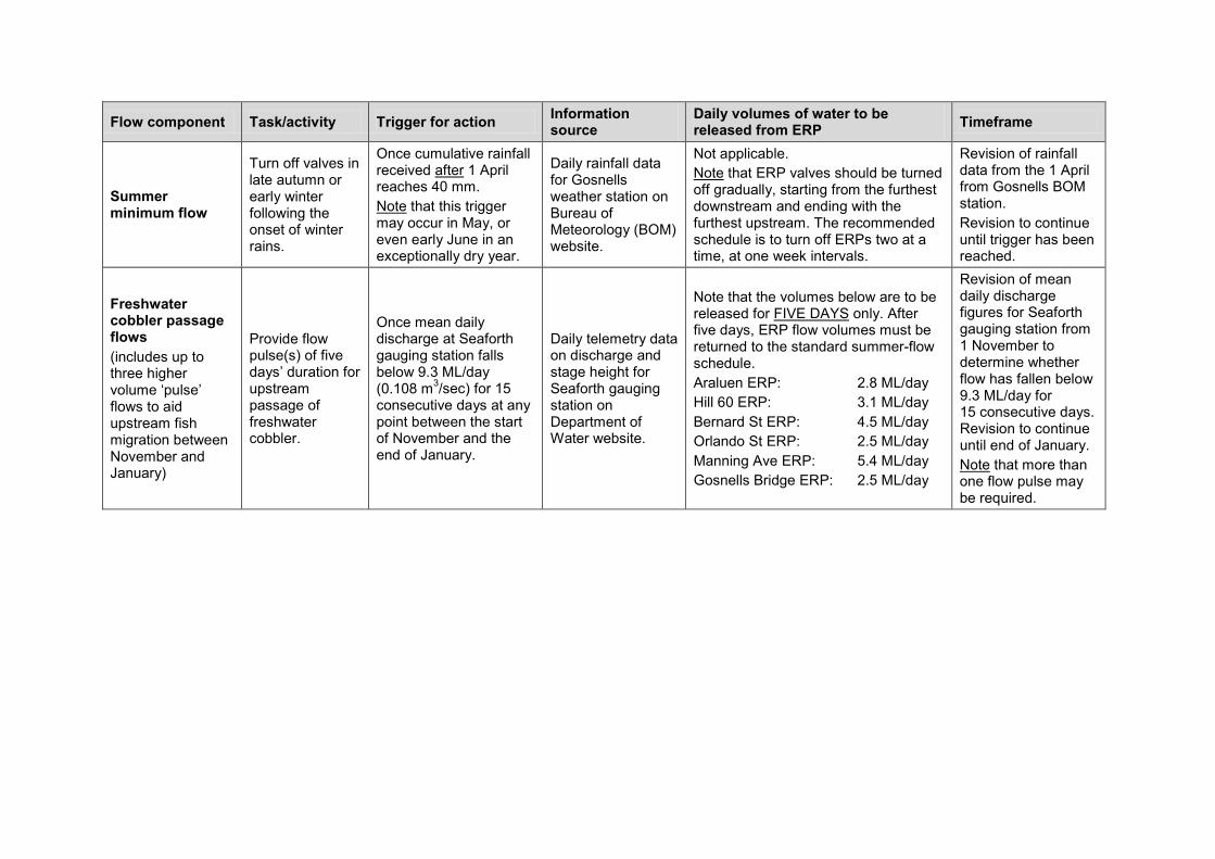
Appendix B — Environmental water provision regime for average rainfall years
Source: Radin et al. (2010)
Note that no additional discharge for sporadic, winter or interannual flows is likely to be required from the environmental release points (ERPs). These volumes may be varied as required to meet operational and other requirements.
Flow component Task/activity Trigger for action Information source
Daily volumes of water to be released from ERP Timeframe
Summer minimum flow (includes discharges required to maintain flow connectivity, maintain pool depth as refuge habitat, maintain minimum flow over riffles for macroinvertebrates and prevent anoxic conditions in pools)
Turn on ERPs in late spring to maintain summer flow.
When discharge at Seaforth gauging station falls below 9.3 ML/day (0.108 m3/sec) for three consecutive days in late spring. ERP valves to be turned on to standard summer-flow schedule within 48 hours
Daily telemetry data on discharge and stage height for Seaforth gauging station on Department of Water website.
of this event.
The volumes listed below are referred to as the ‘standard summer-flow schedule’. • Araluen ERP: 2.8 ML/day • Hill 60 ERP: 2.2 ML/day • Bernard St ERP: 0.7 ML/day • Orlando St ERP: 1.6 ML/day • Manning Ave ERP: 0.2 ML/day • Gosnells Bridge ERP: 1.0 ML/day These volumes are to be maintained until the end of the low-flow period, which will coincide with the onset of substantial late autumn/early winter rains.
Revision of mean daily discharge at Seaforth gauging station to start on 15 October. Revision to continue until mean daily discharge drops below 9.3 ML/day and flows have commenced.
Summer minimum flow
Inform the Department of Water if mean daily discharge at Seaforth gauging station falls below the recommended summer minimum flow.
If mean daily discharge at Seaforth gauging station falls below 1.8 ML/day (0.021 m3/sec) for five consecutive days following the start of summer flow.
Daily telemetry data on discharge and stage height for Seaforth gauging station on Department of Water website.
To be negotiated between the Department of Water and Water Corporation in the event that summer flow consistently falls below 1.8 ML/day at Seaforth gauging station.
Once ERP valves have been turned on, regular revision of mean daily discharge at Seaforth gauging station to ensure sustained minimum flow of at least 1.8 ML/day at Seaforth gauging station.
Flow component Task/activity Trigger for action Information source
Daily volumes of water to be released from ERP Timeframe
Summer minimum flow
Turn off valves in late autumn or early winter following the onset of winter rains.
Once cumulative rainfall received after 1 April reaches 40 mm. Note
Daily rainfall data for Gosnells weather station on Bureau of Meteorology (BOM) website.
that this trigger may occur in May, or even early June in an exceptionally dry year.
Not applicable. Note
Revision of rainfall data from the 1 April from Gosnells BOM station.
that ERP valves should be turned off gradually, starting from the furthest downstream and ending with the furthest upstream. The recommended schedule is to turn off ERPs two at a time, at one week intervals.
Revision to continue until trigger has been reached.
Freshwater cobbler passage flows (includes up to three higher volume ‘pulse’ flows to aid upstream fish migration between November and January)
Provide flow pulse(s) of five days’ duration for upstream passage of freshwater cobbler.
Once mean daily discharge at Seaforth gauging station falls below 9.3 ML/day (0.108 m3/sec) for 15 consecutive days at any point between the start of November and the end of January.
Daily telemetry data on discharge and stage height for Seaforth gauging station on Department of Water website.
Note that the volumes below are to be released for FIVE DAYS
Araluen ERP: 2.8 ML/day
only. After five days, ERP flow volumes must be returned to the standard summer-flow schedule.
Hill 60 ERP: 3.1 ML/day Bernard St ERP: 4.5 ML/day Orlando St ERP: 2.5 ML/day Manning Ave ERP: 5.4 ML/day Gosnells Bridge ERP: 2.5 ML/day
Revision of mean daily discharge figures for Seaforth gauging station from 1 November to determine whether flow has fallen below 9.3 ML/day for 15 consecutive days. Revision to continue until end of January. Note that more than one flow pulse may be required.
Lower Canning River surface water allocation plan – draft for public comment
Department of Water 29
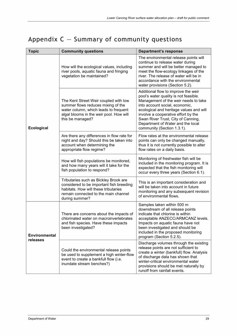
Appendix C — Summary of community questions
Topic Community questions Department’s response
Ecological
How will the ecological values, including river pools, aquatic fauna and fringing vegetation be maintained?
The environmental release points will continue to release water during summer and will be better managed to meet the flow-ecology linkages of the river. The release of water will be in accordance with the environmental water provisions (Section 5.2).
The Kent Street Weir coupled with low summer flows reduces mixing of the water column, which leads to frequent algal blooms in the weir pool. How will this be managed?
Additional flow to improve the weir pool’s water quality is not feasible. Management of the weir needs to take into account social, economic, ecological and heritage values and will involve a cooperative effort by the Swan River Trust, City of Canning, Department of Water and the local community (Section 1.3.1).
Are there any differences in flow rate for night and day? Should this be taken into account when determining the appropriate flow regime?
Flow rates at the environmental release points can only be changed manually, thus it is not currently possible to alter flow rates on a daily basis.
How will fish populations be monitored, and how many years will it take for the fish population to respond?
Monitoring of freshwater fish will be included in the monitoring program. It is expected that the fish monitoring will occur every three years (Section 6.1).
Tributaries such as Bickley Brook are considered to be important fish breeding habitats. How will these tributaries remain connected to the main channel during summer?
This is an important consideration and will be taken into account in future monitoring and any subsequent revision of environmental flows.
Environmental releases
There are concerns about the impacts of chlorinated water on macroinvertebrates and fish species. Have these impacts been investigated?
Samples taken within 500 m downstream of all release points indicate that chlorine is within acceptable ANZECC/ARMCANZ levels. Impacts on aquatic fauna have not been investigated and should be included in the proposed monitoring program (Section 5.2.5).
Could the environmental release points be used to supplement a high winter-flow event to create a bankfull flow (i.e. inundate stream benches?)
Discharge volumes through the existing release points are not sufficient to create a winter (bankfull) flow. Analysis of discharge data has shown that winter-critical environmental water provisions should be met naturally by runoff from rainfall events.

Lower Canning River surface water allocation plan – draft for public comment
30 Department of Water
Is there an option of releasing non-chlorinated water from the Canning Dam or allowing water to pass through the Araluen pumpback station?
There is no scour valve at the base of the Canning Dam to enable discharge of non-chlorinated water. Further investigations would be required to determine if discharge from the Araluen pumpback would sufficiently maintain flow-ecology linkages throughout the river, particularly during summer (Section 5.2.2).
Climate How has the department accounted for the impacts of climate change?
Since 1975, Western Australia has experienced a drying trend, which appears to have become more evident in the past decade. Environmental water provisions have been modelled on rainfall records from 1975–2007.
Catchment management
The catchment is extensively urbanised resulting in ‘flashy’ flows. How can catchment runoff be slowed down to benefit the ecological values?
The use of water sensitive urban design throughout the catchment in new and existing developments would help, as would the construction of intervention techniques such as the Liege Street wetlands.
The quality of catchment runoff may compromise what is trying to be achieved by improving the flow regime: how will this be addressed?
Flow-ecology linkages take into account the flow required to connect pools and prevent anoxia, but declining water quality due to nutrients and pollutants must be addressed through catchment management.
Triggers
Rainfall appears to be higher in the hills of this catchment. Is the Gosnells weather station the most representative to use for rainfall triggers?
The Bureau of Meteorology’s Gosnells weather station is the closest to the Seaforth stream gauging station which is used to measure the trigger levels for the release points.
How will the trigger values relate to the objectives listed in this plan?
Trigger values are related to the volume of flow required to maintain flow-ecology linkages, so relate to Objective a, Section 5.2 and 5.3.
Community input
How will the community be consulted and involved in future planning? How will local knowledge be utilised?
Key stakeholders have been consulted during the plan’s development and the plan itself will be circulated for public comment for a three-month period. Once the plan is finalised, we will provide an annual evaluation.
Surface water use
How will the department reduce licensed use along the river?
We have been working with water users to reduce water use along this river since 1996. This will continue. Our specific policies are outlined in Section 4.3.
How has this plan considered security for surface water users?
There are no proposed changes to existing licensed or riparian use, provided users comply with their obligations under the Rights in Water and Irrigation Act 1914.
Lower Canning River surface water allocation plan – draft for public comment
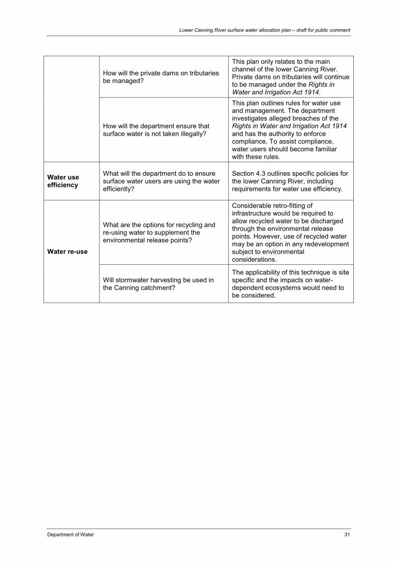
Department of Water 31
How will the private dams on tributaries be managed?
This plan only relates to the main channel of the lower Canning River. Private dams on tributaries will continue to be managed under the Rights in Water and Irrigation Act 1914.
How will the department ensure that surface water is not taken illegally?
This plan outlines rules for water use and management. The department investigates alleged breaches of the Rights in Water and Irrigation Act 1914 and has the authority to enforce compliance. To assist compliance, water users should become familiar with these rules.
Water use efficiency
What will the department do to ensure surface water users are using the water efficiently?
Section 4.3 outlines specific policies for the lower Canning River, including requirements for water use efficiency.
Water re-use
What are the options for recycling and re-using water to supplement the environmental release points?
Considerable retro-fitting of infrastructure would be required to allow recycled water to be discharged through the environmental release points. However, use of recycled water may be an option in any redevelopment subject to environmental considerations.
Will stormwater harvesting be used in the Canning catchment?
The applicability of this technique is site specific and the impacts on water-dependent ecosystems would need to be considered.

Lower Canning River surface water allocation plan – draft for public comment
32 Department of Water
Glossary Abstraction The permanent or temporary withdrawal of water from any
source of supply, so that it is no longer part of the resources of the locality.
Allocation limit Annual volume of water set aside for use from a water resource. Annual water entitlement
Volume of surface water that can be taken from a watercourse during a specified water year.
Baseflow The component of streamflow supplied by groundwater discharge.
Catchment Area of land from which rainfall runoff contributes to a single watercourse, wetland or aquifer.
Climate change A change of climate that is attributed directly or indirectly to human activity that alters the composition of the global atmosphere and which is in addition to natural climate variability observed over comparable time periods.
Commercial use
Water taken from a resource that is directly or indirectly used for commercial purposes. This includes water taken for public and private purposes and water stored in a dam.
Consumptive use
The use of water for private-benefit consumptive purposes including irrigation, industry, urban and stock and domestic use.
Ecological water requirement
The water regime needed to maintain the ecological values (including assets, functions and processes) of water-dependent ecosystems at a low level of risk.
Environment Living things, their physical, biological and social surroundings, and interactions between all of these.
Exempt use Water use that is not required to be licensed under the Rights in Water and Irrigation Act 1914. This is sometimes referred to as stock and domestic use or a riparian right.
Flow Streamflow – may be measured as m3/yr, m3/d or ML/yr. May also be referred to as discharge.
Flow regime A description of the variation of the flow rate over time. Groundwater Water that occupies the pores and crevices of rock or soil
beneath the land surface. Groundwater recharge The rate at which infiltration water reaches the watertable.
Licence A quantity of water specified on a formal permit which entitles the licence holder to ‘take’ water from a watercourse, wetland or underground source, in accordance with the Rights in Water and Irrigation Act 1914.
Licensed use Total (annual) volume of surface water that has been allocated to licensees as entitlements. This may include what is taken for public and private purposes and what can be taken to be stored in a dam.

Lower Canning River surface water allocation plan – draft for public comment
Department of Water 33
Off-stream Storage
Storages (such as farm dams, turkey’s nest dams) that are not on defined waterways or watercourses and primarily store water either extracted from rivers or aquifers, or from flood water emanating from rivers or from local catchment runoff.
On-stream storage
Storages (such as farm dams) that are built on or within a defined waterway or watercourse.
Over-allocated Total water use is greater than the allocation limit for a designated management area.
Proclaimed resource
An area proclaimed under the Rights in Water and Irrigation Act 1914 to enable water licensing, which is used for water allocation planning and management. Surface water is proclaimed as a surface water area, irrigation district or proclaimed river under Part III Division 1B s.6 of the Act.
Recharge Water that infiltrates into the soil to replenish a groundwater aquifer.
Resource See surface water resource. Riparian right Right of a riparian landowner to take water from a watercourse
that flows through their property, unlicensed and free of charge for the purpose of stock and domestic use, without sensibly diminishing the flow of water downstream.
Spring A spring is where water naturally rises to and flows over the surface of land.
Stock and domestic water use
Water that is used for ordinary domestic purposes associated with a dwelling, such as water for cattle or stock other than those being raised under intensive conditions; water for up to 0.2 ha (if groundwater) or 2 ha (if surface water) of garden from which no produce is sold. This take is generally considered a basic right.
Surface water Water flowing over or held in streams, rivers and wetlands on the surface of the land.
Surface water allocation area
An area defined by the Department of Water, used for water allocation planning and management, which is generally a hydrologic basin or part of a basin.
Surface water allocation subarea
An area within a surface water management area defined by the Department of Water, used for water allocation planning and management, which is generally a hydrologic catchment.
Surface water resource
Defined area for allocation and licensing decisions for a particular plan area. For this plan, surface water resource boundaries are the same as surface water allocation subareas.
Sustainability Meeting the needs of current and future generations by integrating environmental protection, social advancement and economic prosperity.

Lower Canning River surface water allocation plan – draft for public comment
34 Department of Water
Take ‘Take’, in relation to water management, means to remove water from, or reduce the flow of water in, a watercourse, wetland or underground water source, including by:
• pumping or siphoning water • stopping, impeding or diverting the flow of water • releasing water from a wetland • permitting water to flow under natural pressure from a well • permitting stock to drink from a watercourse or wetland
and includes storing water during, or ancillary to, any of those processes or activities. (Definition from the Rights in Water and Irrigation Act 1914)
Trade Sale of part or all of a licensed entitlement, by a licensee (vendor) to a second party (purchaser). This involves moving the point of abstraction from one property to another.
Transfer A transfer is a change in ownership of the water licence associated with the sale of the property to which the licence applies. There is no change in the location of the abstraction. Licences can be transferred without recompense.
Transferable (tradeable) water entitlement
The ability to transfer or trade a water entitlement, or a part thereof, to another person within a common water resource.
Unlicensed use Water use that is currently exempt from licensing under the Rights in Water and Irrigation Act 1914. For surface water, this includes water taken:
• for small-scale household purposes and non-intensive stock watering
• from springs and wetlands wholly within a property • from streams arising on a property • in areas not proclaimed • by plantations.
Use Water taken for private-benefit consumptive purposes including irrigation, industry, urban, stock and domestic, aesthetics, lifestyle and storage.
Watercourse A watercourse means: a. any river, creek, stream or brook in which water flows b. any collection of water (including a reservoir) into, through
or out of which any thing coming within paragraph (a) flows
c. any place where water flows that is prescribed by local by-laws to be a watercourse
and includes the bed and banks of any thing referred to in paragraph a, b or c. (Definition from the Rights in Water and Irrigation Act 1914)

Lower Canning River surface water allocation plan – draft for public comment
Department of Water 35
Water-dependent ecosystems
Those parts of the environment which are sustained by the permanent or temporary presence of water.
Water entitlement
Quantity of water that a person is entitled to take annually in accordance with the Rights in Water and Irrigation Act 1914 or a licence.
Water efficiency
Increasing water supply efficiency and water demand efficiency to minimise the taking and use of water.
Water entitlement
The quantity of water that a person is entitled to take on an annual basis in accordance with the Rights in Water and Irrigation Act 1914 through a licence.
Water meter A device for measuring or estimating the volume or flow of water that is approved under the Rights in Water and Irrigation Act 1914.
Waterways All streams, creeks, stormwater drains, rivers, estuaries, coastal lagoons, inlets and harbours.
Volumes of water
One litre 1 litre 1 litre (L)
One thousand litres 1000 litres 1 kilolitre (kL)
One million litres 1 000 000 litres 1 Megalitre (ML)
One thousand million litres 1 000 000 000 litres 1 Gigalitre (GL)
Shortened forms
ANZECC Australian and New Zealand Environment Conservation Council
ARMCANZ Agriculture and Resource Management Council of Australia and New Zealand
BOM Bureau of Meteorology
CSIRO Commonwealth Scientific and Industrial Research Organisation
DoW Department of Water
ERP Environmental release point
IWSS Integrated Water Supply Scheme
WRC Water and Rivers Commission

Lower Canning River surface water allocation plan – draft for public comment
36 Department of Water
Map disclaimer – Figure 1
Datum and projection information
Vertical datum: Australian Height Datum (AHD)
Horizontal datum: Geocentric Datum of Australia 94
Projection: MGA 94 Zone 50
Spheroid: Australian National Spheroid
Project information
Client: R. Rowling
Map Author: B. Huntley, D. Abbott
Filepath: J:\gisproject\project\C2204\330\26610\mxd\
Filename: 100726_Canningv2.mxd
Compilation date: July 2010
Disclaimer
This map is a product of the Department of Water, Water Resource Use Division and was printed as shown.
This map was produced with the intent that it be used for information purposes at the scale as shown when printing.
While the Department of Water has made all reasonable efforts to ensure the accuracy of this data, the department accepts no responsibility for any inaccuracies and persons relying on this data do so at their own risk.
Sources
The Department of Water acknowledges the following datasets and their custodians in the production of this map:
WA Coastline, WRC (Poly) – DoW – 20/07/2006
Hydrography, Linear (Hierarchy) – DoW – 05/11/2007
State Roads – DOLA – 06/01/1999
Population Centres – GA – 13/11/1998

Lower Canning River surface water allocation plan – draft for public comment
Department of Water 37
References and recommended reading ANZECC & ARMCANZ 2000, The Australian and New Zealand guidelines for fresh
and marine water quality, paper no.4, Commonwealth of Australia, Canberra.
Australian Government 2004, National water quality management strategy –Australian drinking water guidelines 6, National Health and Medical Research Council and Natural Resource Management Ministerial Council, Government of Australia, Canberra.
CSIRO 2009, Water yields and demands in south west Western Australia: a report to the Australian Government from the CSIRO South-Western Sustainable Yield Project, available from <www.csiro.au/partnerships/SWSY.html>.
Department of Indigenous Affairs 2008, Aboriginal heritage inquiry system (online), available from < http://www.dia.wa.gov.au/AHIS/> (accessed 26 November 2008), Government of Western Australia, Perth.
Department of Water 2009a, Perth–Peel regional water plan 2010-2030: draft for public comment, Department of Water, Government of Western Australia, Perth.
— 2009b, Strategic policy no. 5.03 – Metering the taking of water, Department of Water, Government of Western Australia, Perth.
— 2009c, Guidelines for water meter installation, Department of Water, Government of Western Australia, Perth.
— 2009d, Operational policy no. 1.2 – Policy on water conservation/efficiency plans: achieving water use efficiency gains through water licensing, Department of Water, Government of Western Australia, Perth.
— 2009e, Operational policy no. 5.11 – Timely submission of further required information, Department of Water, Government of Western Australia, Perth.
— 2010a, Operational policy no. 5.08 – Use of operating strategies in the water licensing process, Department of Water, Government of Western Australia, Perth.
— 2010b, Operational policy no. 5.13 – Water entitlement transactions for Western Australia, Department of Water, Government of Western Australia, Perth.
Indian Ocean Climate Initiative Panel 2002, Climate variability and change in southwest Western Australia, Indian Ocean Climate Initiative Panel, Perth <www.ioci.org.au>
Radin, L, La Spina, K, Braimbridge, M & Malseed, B 2007, Environmental values, issues and flow related objectives for the Canning River, Western Australia, Department of Water, Government of Western Australia, Perth.
Radin, L, Pauli, N, La Spina, K, Braimbridge, M & Malseed, B 2010, Ecological water requirements for the lower Canning River, Department of Water, Government of Western Australia. Perth.

Lower Canning River surface water allocation plan – draft for public comment
38 Department of Water
Storey, A 2000, Baseline monitoring of aquatic macroinvertebrates in the Canning River – summer 1999. Aquatic Research Laboratory, University of Western Australia, report to the Water and Rivers Commission, Western Australia.
Swan River Trust 2002, Caring for the Canning: a plan to revitalise the Canning Southern and Wungong Rivers, Swan River Trust, Government of Western Australia, Perth.
— 2007, Potential impacts of climate change on the Swan and Canning rivers, Swan River Trust, Government of Western Australia, Perth.
— 2009, Swan-Canning water quality improvement plan: draft for public comment, Swan River Trust, Government of Western Australia, Perth.
Water and Rivers Commission 1996, Canning River interim allocation policy, Water and Rivers Commission, Government of Western Australia, Perth.
— 2002, Statewide policy no. 5 – Environmental water provisions policy for Western Australia, Water and Rivers Commission, Government of Western Australia, Perth.
— 2003, Statewide policy no. 11 – Management of unused licensed water entitlements, Water and Rivers Commission, Government of Western Australia, Perth.
Western Australian Planning Commission 2008, Better urban water management, Western Australian Planning Commission, Government of Western Australia, Perth.


Department of Water168 St Georges Terrace, Perth, Western Australia
PO Box K822 Perth Western Australia 6842Phone: 08 6364 7600
Fax: 08 6364 7601www.water.wa.gov.au
SCT_Online Print_Final_A4.indd 2 31/05/10 11:08 AM