low density residential housing guidelines for established ... · pdf filethe low density...
TRANSCRIPT

December 2010

3

3
Low Density Residential Housing Guidelines for Established Communities
Dec
embe
r 201
0

4 5
PUBLISHING INFORMATIONTITLE: LOw dENSITy RESIdENTIAL HOUSING GUIdELINES IN
ESTABLISHEd cOMMUNITIES
AUTHOR: LANDUSEPLANNING&POLICY PLANNING,DEVELOPMENT&ASSESSMENT
STATUS: APPROVEDBYCITYCOUNCILONMAY10,1993
PRINTING dATE: DECEMBER2010
AddITIONAL cOPIES: THE CITY OF CALGARY RECORDS & INFORMATION MANAGEMENT (RIM) DEVELOPMENT & BUILDING APPROVALS P.O. BOX 2100, STN “M”, #8115 CALGARY, ALBERTA T2P 2M5
PHONE: 3-1-1 OR OUTSIDE OF CALGARY 403-268-2489FAX: 403-268-4615
wEB: www.calgary.ca/planning/landusecLIcK ON: Publications
Acknowledgements
Thisdocumentwasoriginallydevelopedinconsultationwiththefollowingparticipants:
• CommunityAssociationswithinthe“EstablishedCommunities”
• Interestedindividuals
• InfillhousingLiaisonCommittee
• FederationofCalgaryCommunities
• CalgaryHomeBuilder’sAssociation
• AlbertaAssociationofArchitects
• AlbertaSocietyofLandscapeArchitects
Amendment Council Agenda Date Description1 LTP 2010-52 2010 July 5 Alignment with Land Use Bylaw
1P2007
2 LTP2010-70 2010 December 6 Existing Front Driveways
NOTE: Administrativeupdate: 1. September2003.Thisadministrativeupdateisfortheconvenienceoftheuserandhas
notbeenapprovedbyCouncil.

5
table of contentsPReface ......................................................................................................................... 7
1.0 IntRoDUctIon ...................................................................................................... 8
2.0 PURPose ................................................................................................................10
3.0 aPPlIcatIon of GUIDelInes ...........................................................................11
4.0 loW DensItY ResIDentIal HoUsInG DesIGn GUIDelInes .....................13
4.1 Introduction ..............................................................................................................................13
4.2 Context ........................................................................................................................................15
4.2.1 Corner Parcel Development ..............................................................................19
4.2.2 Rear Yard Corner Parcel Development .........................................................20
4.3 Parcel Layout .............................................................................................................................21
4.3.1 Building Setback from Front Property Line (Front Setback) ..............21
4.3.2 Front Driveway/Garage ........................................................................................22
4.3.3 Building Setback from Side Property Line (Side Setback)...................25
4.3.4 Building Setback from Rear Property Line (Rear Setback) ..................27
4.3.5 Parcel Coverage .......................................................................................................28
4.3.6 Parking .........................................................................................................................29
4.4 Building Mass ..........................................................................................................................30
4.4.1 Building Height ........................................................................................................32
4.4.2 Building Depth .........................................................................................................34
4.4.3 Semi-Detached Development ..........................................................................35
4.5 Privacy ..........................................................................................................................................36
4.5.1 Placement of Windows/Second Storey Balconies ..................................36
4.5.2 Entry Treatment/Entrances ...............................................................................38
4.5.3 Semi-Detached Development: .........................................................................39
4.6 Landscaping ..............................................................................................................................40

6 7
aPPenDIces ................................................................................................................... a1
I MaP anD lIstInG of tHe establIsHeD coMMUnItIes ........................ a2
II sIte access ReQUIReMents ........................................................................ a4
III loW DensItY ResIDentIal DeVeloPMent UtIlItY seRVIcInG ReQUIReMents anD otHeR RelateD IssUes ............................................ a7
IV sHaDoWInG InfoRMatIon ......................................................................... a12
V lanDscaPInG InfoRMatIon ...................................................................... a15

7
PReface
The Low Density Residential Housing Guidelines for Established Communities (Guidelines) were approved by City Council in May 1993. The Guidelines provide a comprehensive package of information to guide the development of low density residential housing in Established Communities. They are intended to apply to single-detached dwellings, semi-detached dwellings and duplexes requiring a development permit. A map showing the Established Communities is included in Appendix 1.
In July 2007, City Council approved a new Land Use Bylaw 1P2007. The new Bylaw introduced new rules to deal with issues previously addressed by the Guidelines. Consequently, the Guidelines have been updated to eliminate conflict and duplication.
A strong emphasis is placed on encouraging development to respect and enhance the overall quality and character of the street/community in which it takes place. To achieve this objective, the Guidelines deal with the following design elements:
• context
• parcel layout
• building mass
• privacy
• landscaping
It should be noted that the Guidelines apply only to low density residential uses that are not listed as a permitted use and are therefore a discretionary use in the Land Use Bylaw. Also, the Guidelines are to be used as a supplementary guide to the Land Use Bylaw and to any relevant Area Redevelopment Plans.
A set of appendices at the end of this document provides helpfull information in support of low density residential development.

8 9
1.0 IntRoDUctIon
Sensitive and quality redevelopment is vital for the regeneration of established neighbourhoods. The Municipal Development Plan encourages appropriate and sensitive redevelopment for the low density residential areas in the inner city and inner suburban areas for the following reasons:
• it is a cost effective means to optimize underutilized city resources;
• it has been effective in the rejuvenation of declining neighbourhoods within the inner city and inner suburban areas;
• it is an effective way to stabilize/increase the population of established residential areas; and
• it encourages the provision of a variety of housing choices to serve the broadest spectrum of housing needs.
Policies aimed at encouraging a variety of housing choices and promoting sensitive redevelopment that contributes to the community’s character and quality of life have been incorporated into many Area Redevelopment Plans (ARPs) and other community planning documents.
Low density residential housing has become attractive to an increasing number of home buyers and residents and has made a positive contribution to the revitalization of many of the Established Communities in the inner city. However, this form of redevelopment has been the subject of concern in some of the Established Communities. The concern has been focused mainly on significantly larger houses being built on both narrow lots (less than 12 metres in width) and wide lots (12 metres or greater in width).
In response to community concerns, City Council on 1988 February 01 adopted the Single-Detached Infill Housing Guidelines for Established Communities. This document addressed general design issues relating to new narrow lot low density residential housing and established design guidelines to encourage the building of more sensitive redevelopment. Council also recommended that the Development Authority use the Guidelines to judge the merits of proposed development applications.
In May 1993, Council adopted the Low Density Residential Housing Guidelines for Established Communities, which in particular responded to the lack of guidelines for low density residential development on lots 12 metres or greater in width, the processing of development permits, and the public consultation process.

9
In September 2003, some technical administrative updates were introduced to the 1993 Guidelines to eliminate any inconsistencies with changes to the text of Land Use Bylaw 2P80 and various other City planning documents approved since 1993.
With the approval of Land Use Bylaw 1P2007, further revisions to the guidelines were required to keep it consistent with the Bylaw.
This document has incorporated these revisions and has also deleted some sections. For example, information on the development permit process and the public consultation process has been removed and replaced by a reference to other sources, such as the City’s website1 . The intent of this document continues to be the improvement of the calibre of low density residential housing in the Established Communities.
1 The City of Calgary web pages, which may be updated from time to time, provide information on the approval process, fees and requirements for all development permit applications. Refer to www.calgary.ca for information on the following topics:
• Development Permit Application Requirements
• Role of Community Association, Neighbours, Alderman
• Pre-application Meetings
• Development Permit Review, and
• How Long Will it Take?
In addition, an online document “A Community Guide to the Planning Process” provides similar information on the planning process and the roles of the applicant, the community, the Approving Authority and the Ward Alderman. This document was prepared in conjunction with The Federation of Calgary Communities (FCC) as part of its planning education program. Information can be accessed at http://www.calgarycommunities.com/FCCservices/GuidetothePlanningProcessForweb.pdf or by calling (403) 268-5311 for general questions regarding the development permit process.

10 11
2.0 PURPose
The purpose of this document is:
i) to establish general design guidelines, which emphasize respect for community context and the streetscape;
ii) to achieve a high standard of design and development in Calgary’s Established Communities.
iii) to provide an evaluation tool for The City in its discretionary approval process; and
iv) to assist communities and residents in their review of applications.

11
3.0 aPPlIcatIon of GUIDelInes
The City of Calgary relies on the Land Use Bylaw, the Alberta Building Code, and a variety of statutory plans (such as Area Redevelopment Plans) and non statutory policies approved by City Council to review and regulate developments in the city.
These guidelines are to be used in an advisory capacity to supplement the Land Use Bylaw and any applicable statutory plans when reviewing development permit applications for the construction of or addition to a single-detached, semi-detached and duplex dwelling identified as a discretionary use in the Bylaw. Conformity with the requirements of the Land Use Bylaw alone does not necessarily ensure compatibility with the neighbourhood character. Therefore, in the Established Communities, the additional criteria in the Guidelines are used to assess new development. It is not the intent of these guidelines to restrict design flexibility or creativity; rather, the Guidelines are intended to provide design principles that help ensure contextually sensitive development and help avoid potential problems that are commonly associated with developing within an established neighbourhood context. The Guidelines are, of necessity, generic to all the Established Communities and cannot address the uniqueness of each community.
Applications for development in communities with unique architectural or historical significance will be examined in the context of approved community plans. Applicants are advised to familiarize themselves with applicable Area Redevelopment Plans as well as other applicable community planning documents.
For the purpose of this document, “development” or “new development” refers to the construction of or addition to any single-detached, duplex and semi-detached dwellings that are discretionary uses in the low density residential districts of the Land Use Bylaw. As “infill” or “infill development” are popular terms among planners and the general public, they may be used in place of “low density residential development” in some parts of the document.
The Appendices portion of this document provides supplementary information that will be useful in the preparation of a development permit application for low density residential development in the Established Communities. The Appendices are not considered to be a part of the non-statutory Council-approved policy.
Appendix I contains a map of the Established Communities and includes an alphabetical listing of every community within the Established Communities area.

12 13
Appendix II contains information on Transportation requirements that affect:
• driveways
• sites next to bus loading zones
• right of way setbacks and corner cuts
• noise attenuation next to major roads.
Appendix III contains technical information on Engineering requirements that affect:
• utility service connections
• weeping drain tile requirements
• construction damage to sidewalk, curb, etc.
• geotechnical requirements on sloping sites
• special requirements for sites in the floodway or flood fringe areas
• airport vicinity regulations
• disposal of hazardous construction materials.
Appendix IV contains information on how to determine the shadow impact of new development on neighbouring properties.
Appendix V provides supplementary information on landscaping practices for low density residential development sites.

13
4.0 loW DensItY ResIDentIal HoUsInG DesIGn GUIDelInes
... guidelines establish minimum criteria for neighbourhood compatibility, not the maximum expectation for good design1.
4.1 Introduction
The term “design guidelines” is used here in a broad sense to include such matters as site layout, landscaping, and context, rather than focusing narrowly on architectural details. The guidelines have been developed to establish high standards of design and development and to encourage new development and redevelopment which respects and enhances the overall quality and character of the community in which it takes place.
The design guidelines are divided into five main sections, dealing with the following design elements:
• site context
• parcel layout and parking
• building mass (envelope)
• privacy
• landscaping
The guidelines are statements of principle focusing on issues of building compatibility. Each guideline is generally followed by a more detailed explanation of the issue, which the guideline addresses. Where possible, the guidelines have been illustrated with sketch examples and diagrams taken from existing buildings and street scenes that seek to convey those intentions. It is emphasized that the drawings are purely illustrative and are not design examples to be copied and imitated. If the same effect can be achieved in a different way, applicants are encouraged to bring forward such solutions. The design guidelines can form the basis for more detailed guidelines for those communities or areas within the city’s Established Communities that have architectural, historic, or aesthetic importance, through the Area Redevelopment Plan process.
The guidelines are not intended to prescribe rigid rules or propose specific design solutions, which could bring about a homogeneous appearance to Calgary’s
1 San Francisco Planning Department – Introduction to Residential Design Guidelines.

14 15
Established Communities. The reality of Calgary’s established communities is that they represent a mosaic of styles and personal expressions. The guidelines do, however, clearly identify The City’s objectives and expectations regarding design quality and development. The guidelines are developed at a level of generalization intended to assist applicants to respect the neighbourhood context within which they are working and encourage a good design solution, without being restrictive of their architectural skills and creativity. They provide an indication of the standard expected and a framework within which many design solutions are possible.
Meeting the minimum criteria alone will not ensure a successful project. That will require a sensitive design, carefully executed and using quality materials. A thoughtful application of the guidelines will, however, assist in creating a project that is compatible with neighbourhood character and will reduce the potential for conflict and the delay and expense of project revisions.
Since the relative importance of the specific guidelines will vary for each project, and since there are many ways of meeting a particular guideline, individual applications will be evaluated on their own merit. Creative solutions which meet the intent of the guidelines are encouraged.
15
4.2 context
Guideline:
New development should be designed in a manner which is responsive to the local context.
Context refers to the relationship of a new development to its surroundings; that is, to neighbouring housing, the natural characteristics of the site (e.g., escarpment, topography, slope, vegetation), and the surrounding streetscape and community. These guidelines are most concerned with whether the design respects the project’s context, and consciously responds to the street and the broader community with a design that is compatible and that will contribute to the quality of the neighbourhood.
In many areas, a general pattern characterizes the streetscape and the community. Any new development(s) should respect this context. A building which is designed without considering its ability to complement its neighbours and the broader community, may negatively affect the character of an area.
Prior to the initial design phase of a new development, applicants should consider engaging a skilled designer. The design should recognize the neighbourhood context and demonstrate that the relationship of the project to its surroundings has been considered. To enable a review of the development in its context, a development permit application must include a detailed and accurate block plan, showing the parcel and the neighbouring properties, and streetscape plan, showing the front elevation of the proposed house and those of the neighbouring houses (see application requirements on The City website for details). It is imperative that there be no inconsistencies between the site and the streetscape plans
A design which respects its context is based on a careful analysis of the adjacent homes on the street and the broader community. This procedure provides the basis for sensitive design of the new residential development project. Previous insensitive development in the community should not be used as a point of reference. A massive home that ignores the fact that it is a redevelopment project in an older inner city neighbourhood, comprised predominantly of small homes, does not respect its context.

16 17
In some cases, a proposed project is located adjacent to a historically or architecturally significant building. The new development should be designed and sited to respect the importance of the adjacent building.
While new developments must respect the character of their surroundings, they need not necessarily mimic or imitate styles of the past. The emphasis is on responsive design rather than on conformity. Roof lines, facades, windows, elevations, and materials are all examples of elements which can be used singularly or in combination to respond to the context. When assessing a development, it is important not to focus too narrowly on the individual design, but to consider the new project’s contribution to the overall street and community context. Development with design qualities that make a special contribution to the neighbourhood should be encouraged.
New development may reference both the street and the broader community context. The immediate street context represents the most important or primary reference when designing a new development. The community context represents a secondary context and is a useful reference when no consistent streetscape exists.
new Development should Respect existing streetscape
17
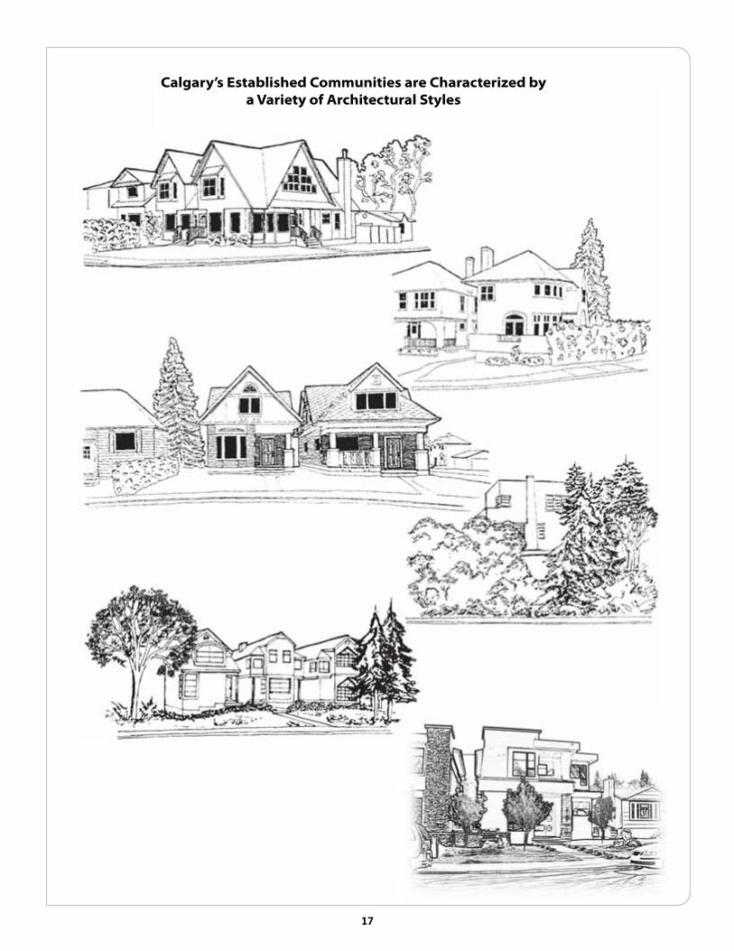
calgary’s established communities are characterized by a Variety of architectural styles

18 19
The street context can be determined through a consideration of the following four elements in relation to the proposed design:
• Design, which refers to the exterior appearance of a building.
• Siting, which refers to the location of a building on a parcel.
• Massing, which refers to the combined effect of the arrangement, size and shape of a building on a parcel and its visual impact in relation to adjacent buildings.
• Landscaping, which refers to the enhancement of a development through the use of vegetation (e.g., trees, shrubs, grass & groundcover) and decorative materials (e.g. brick, stone).
The community context can be viewed as a tapestry of all its individual streets. Typically, there is variation between streets, even between and within individual blocks. It is this variety that gives many of the older neighbourhoods their charm and appeal. Where there is no consistent streetscape and a proposed development represents the first on a block face, an applicant can reference the characteristics and massing of the broader community. A review of the applicable Area Redevelopment Plan or any other community planning documents may assist the applicant in assessing the community context.

19
4.2.1 corner Parcel Development
Corner parcel developments should respond to the fact that they are characterized by two primary contexts - the front street and the flanking street. The design should respond to this dual frontage by incorporating elements such as corner bay windows, wrap-around verandas and decks, or other interesting architectural elements.
corner Parcel Development should address both frontages
With equal treatment Given to both elevations

20 21
4.2.2 Rear Yard corner Parcel Development
Rear yard corner parcel development is generally discouraged as a range of planning problems can occur (e.g., loss of privacy). Where acceptable, special care must be taken to design the project in a manner sensitive to the adjacent properties.
Rear Yard corner Parcel Development
should be sensitive to the adjacent buildings

21
4.3 Parcel Layout
The Land Use Bylaw establishes minimum/maximum standards with respect to setbacks from property lines, building height, parcel coverage, parking and so on. The Bylaw standards may be sufficient for many parcels within the Established Communities. However, there are many situations where the alternative standards recommended in this document may be required to ensure that development fits in.
4.3.1 Building Setback from Front Property Line (Front Setback)
Guideline:
The setbacks of new development should respect the established street pattern.
Building Setback from the Front Property Line (or Front Setback) refers to the distance from the front property line of a parcel to the nearest part of the building. Existing dwellings in older neighbourhoods often have greater front setbacks than the minimum stipulated in the Land Use Bylaw. In order to maintain the established street pattern and limit the visual impact of a new house on existing homes, the depth of the front yard of new development should be consistent with that of other buildings on the street.
The Front Yard Setbacks of New Infill Developments Should Respect Those of Other Houses on the Street

22 23
4.3.2 front Driveway/Garage
TheLandUseBylawestablishesrulesfordriveways,whichincludesthedimensionsofdriveways,wherenewdrivewaysmaylocateandthecircumstancesinwhichlegallyexistingdrivewaysmayberetainedwhenaparcelredevelops.Where a parcel contains a legally existing front driveway, that driveway should be permitted to remain provided it is in the same location and has the same width.
LTP2010-70
TheEstablishedCommunitiesare,forthemostpart,characterizedbycityblocksthathaverearlanes,wherefrontdrivewaysandgaragesdonotpredominate.Frontdrivewaysandfrontgaragesarediscouragedforthefollowingreasons:
i) Frontdrivewayscandetractfromthevisualcharacterofthestreet:
• Thefrontelevationsofhomesinestablishedneighbourhoodsarepredominantlycharacterizedbyverandas,porches,featurewindows,baywindowsanddecorativeelementssuchasgables,columnsandarchitecturaldetailing.Thesefeatureshelpcreateaninteresting,pedestrian-friendlyappearancetofrontfacades.Garagedoorsonafrontfacadecancreateawall-likeeffectanddiscourageinteraction.
• Frontdrivewaysatthebasementlevelrequireslopingdrivewaysthatareoftenvisuallyincongruousonthestreetandoftenrequireretainingwalls.
• Frontdrivewaysmayresultinfrontyardsthatarevisuallycharacterizedbyparkedcarsanddonotpromoteastreet-friendlyappearance.
front Driveways can Disrupt sidewalk continuity and Pedestrian activity

23
ii) Front driveways displace front setback area and boulevard landscaping:
• Natural landscaping such as grass, trees, planter beds, flower gardens and shrubs are replaced with hard-surfaced materials, generally asphalt or concrete.
• Where city boulevards exist along the front of properties, front driveways disrupt the visual continuity of the established boulevards, and can result in the loss of trees. Even where removal of a tree is not required for the driveway construction, the root system of a tree may extend under the driveway and suffer from soil compaction, increasing the likelihood of affecting the health and viability of the tree.
iii) Front driveways can adversely affect placement of the house on the parcel:
• Drive-under garages often require that the main floor of a proposed house be raised, increasing the height out of proportion to that of neighbouring homes.
• Front driveways may necessitate placement of the house further back from the street than the norm to accommodate access to a drive-under garage.
iv) Front driveways reduce on-street parking.
v) Front driveways can adversely affect the pedestrian environment:
• Vehicles reversing into the roadway disrupt pedestrian activity and are hazardous for both pedestrians and on-street traffic.
Existing front driveway crossings that are no longer required should be removed and rehabilitated. For those situations where new front driveways are allowed, the Development Authority should exercise discretion in a manner that mitigates the above possible adverse impacts. The width of the curb cut/driveway and the amount of paving should be minimized and the front drive garage and driveway should be as unobtrusive as possible and not dominate the facade of the building. Garage doors should be designed so that they contribute to the building’s character (e.g., recessed or arcaded doors, embellishments).
Appendix II includes additional requirements affecting driveways.

24 25
If front access is necessary the Garage and Driveway should be Unobtrusive
Where Rear lanes exist, front Driveways and Parking spaces are strongly Discouraged

25
4.3.3 building setback from side Property line (side setback)
Guideline:
One side setback should be kept clear in order to provide an unobstructed exterior access from the front to the rear of the house.
The Land Use Bylaw requires a minimum clear separation between the side of the house and the side property line. For semi-detached residential development, a side setback is required on both sides of the development at grade. In a laneless subdivision, if there is no front or side garage, a side setback is required on one side, or on both sides in the case of a semi-detached dwelling.
The Land Use Bylaw allows portions of the principal building, excluding decks and balconies, to project over or onto one required side setback when the other side setback is free and clear. Projections at the second storey must provide a minimum clearance from grade.
Projections on a side wall can have advantages (e.g., can animate a side wall) and disadvantages (e.g., loss of privacy). In locations where elevations have a high level of public visibility, such as on corner sites, projections, where allowed by the Land Use Bylaw, can be used to animate the side façade and create visual interest. The location of any projections should, therefore, be evaluated carefully to determine which side, if any, is appropriate for a projection.
For larger parcels (e.g., greater than 12 metres in width), side setbacks greater than the bylaw minimum are often more appropriate in order to respect the context of the street. Projections into a minimum side setback area on a larger lot are not encouraged, unless the street context dictates otherwise.

26 27
appropriate Projections can animate a side Wall

27
4.3.4 building setback from Rear Property line (Rear setback)
Guideline:
The rear setback area, in addition to being the garage and/or other accessory building location, is an important amenity space that should allow for outdoor activity and maintain the pattern of rear amenity space typical of the surrounding community.
The Land Use Bylaw requires a minimum setback, measured from the rear property line of a parcel to the rear of the principal building. Often, existing properties adjacent to a proposed development have a rear setback area that is greater than the minimum. Where a development protrudes into the rear setback area beyond the adjacent structures, privacy, overshadowing and access to sunlight are important design considerations.
The enjoyment of the neighbour’s outdoor rear amenity space should not be unduly diminished by new development. Modifications to the length of a building may be required, particularly when new developments are proposed on the north side of an avenue or east side of a street, where significant shadowing can result. Appendix IV contains sun shadow diagrams, which illustrate the impact of shadowing on adjacent development.
In order to provide a separation between a principal building and an accessory residential building (i.e., a garage) and to respect the need for a viable rear amenity area, a space should be maintained between the principal building and the residential accessory building. The Land Use Bylaw requires a minimum separation between the principal building and the accessory building; however a minimum 3 metre separation is recommended to enhance the outdoor amenity area.

28 29
4.3.5 Parcel coverage
Guideline:
Parcel coverage for new development should include all proposed and future accessory buildings.
The Land Use Bylaw provides for maximum parcel coverage. Parcel coverage is the maximum area permitted to be covered by buildings. Soffit and eave overhangs and decks are not included in coverage calculations. All other structures and cantilevers are included.
In order to ensure that the final development on an infill lot does not exceed the parcel coverage maximum, the area of all proposed and future accessory buildings must be calculated at the time the initial development permit is submitted for the principal building. If no garage is proposed at the time of the initial development permit for an infill home, a minimum garage size is included in the calculation for site coverage.
Site Coverage Calculation (Example)
•SiteArea
15.24 m x 30.48 m
(50’ x 100’)
464.5 m2
(5000 ft2)
•PrincipalBuilding
12.8 m x12.19 m
(42’ x 40’)
156.1 m2
(1680 ft2)
•AccessoryBuilding
6.7 m x 6.7 m
(22’ x 22’)
44.9 m2
(484 ft2)
•TotalBuildingFootprint
156.1 m2 + 44.9 m2
(1428 ft2 + 484 ft2)
201 m2
(2164 ft2)
•SiteCoverage
201 m2 = (2164 ft2)
43.3%
464.5 m2 = (5000ft2)

29
4.3.6 Parking
Guideline:
Two on-site parking spaces should be provided for each new dwelling unit.
The provision of two parking spaces is recommended for all new development in Established Communities in order to reduce the potential for parking congestion on the street.
Tandem parking stalls are not considered as meeting Land Use Bylaw requirements. However, for lots less than 12 metre in width, applicants are encouraged to provide any stalls in excess of bylawed requirements in tandem in order to maximize landscaping opportunities.

30 31
4.4 building Mass
Guideline:
New development should respect the existing scale and massing of its immediate surroundings.
The massing of a building is a key factor in the successful integration of a new infill development into its setting. Massing refers to the visual impact of a house in relation to the adjacent buildings. The Land Use Bylaw defines a maximum building envelope within which a building can be constructed, but does not dictate the actual form of the building. This building envelope is a three-dimensional representation of all the provisions within the Land Use Bylaw that combines height, with setbacks and lot coverage. The sketches on the next page illustrate a building envelope in comparison with an actual building form and mass. The combined effect of the arrangement, size (including the length, width and height) and shape of the building on a parcel and its visual impact in relation to adjacent buildings defines building mass.
The majority of situations within the city’s Established Communities require a reduced building mass (including height) in order to respect the adjacent homes and streetscape. Homes built to the maximum bylaw standards are often incompatible and visually disruptive to the street. In some situations reductions in the height, depth, and width of a new development may be required in order to make the project compatible with its context and to reduce substantial loss to adjacent buildings of privacy and sunlight.
Attempts should be made to reduce the contrast between newer, larger buildings and existing, smaller buildings. For example, this can be done by using similar sizes and shapes of building elements and by breaking up a large building into smaller components that are more in scale with its neighbours. This is particularly important in neighbourhoods characterized by smaller houses.
To minimize the potential impact of new development on existing development, some principles have been developed which address two critical elements of the building envelope - building height and building depth. Other elements are discussed elsewhere in the guidelines (e.g., parcel coverage).

31
building Mass and building envelope: comparative examples
The building envelope represents the area in which the actual building can be constructed. However, this envelope often does not ensure compatibility with neighbourhood character. Note that the maximum site coverage regulations still apply.
32 33
4.4.1 building Height
The Land Use Bylaw regulates the height of low density residential development using a contextual building height formula that is based in part on the heights of neighbouring houses. The formula was designed to ensure that new dwellings have a height that is sensitive to the height of the homes on neighbouring properties.
Where the established street is characterized by low profile bungalows, the height of the new infill or an addition must be particularly sensitive. Greater design restrictions on initial infills may be required in order to ensure a more sensitive integration with the existing scale and character of the neighbourhood. Where one or both of the neighbouring homes are lower scale, new development should respect the existing street context. In these circumstances a lower profile development may be warranted.
Another element related to building height and which can help new development respond to its setting is the height of the main floor (exposed basement). Generally, the height of the main floor of a new development should be similar to the floor lines of adjacent homes, thereby respecting the established character of the street.

33
new Development should Respect the existing building Heights

34 35
4.4.2 building Depth
The depth of a new development together with the front setback forms the overall building depth on the parcel. The Land Use Bylaw establishes the maximum building depth for contextual detached dwellings. This should be considered as the maximum. At the same time, the building depth of a new development should respect the building depth of the existing adjacent developments. This is intended to decrease the negative impact of mass on neighbouring homes with respect to privacy and shadowing. The remainder of the parcel forms the minimum rear yard for accessory buildings (e.g. garage) and rear outdoor amenity space.
Where the proposed building depth significantly exceeds that of the neighbouring homes, the applicant may be required to submit a sun shadow study and/or a massing model in order that the development authority can assess how the proposed development will impact neighbouring properties.
Where an attached rear garage is proposed, it should be incorporated within the principal building. The width of the access to an attached rear garage should be kept to a minimum and its impact softened through landscaping. The maximum slope permitted between the lane and an attached garage is 10 percent in order to avoid surface drainage problems. For safety purposes, a lesser slope may be required where the driveway enters the lane.

35
4.4.3 semi-Detached Development
In designing a semi-detached infill, particular attention must be paid to the building mass. The massing of a semi-detached infill should respond to the existing pattern on the street. For example, if the existing homes on the street are on 7.6 metre wide lots, the semi-detached development should be designed to resemble two homes. The intent is to break up the massing of the larger building to make it more responsive to smaller adjacent buildings in the neighbourhood. In addition, individual unit identity is encouraged to provide both visual interest and counteract the massing of the building.
new Development should Respect the existing building Depth

36 37
4.5 Privacy
4.5.1 Placement of Windows/second storey balconies
Guideline:
The privacy of adjacent residences should be respected.
It is important to respect the privacy of adjacent residences and their access to sunlight. When a new infill building extends beyond the rear of adjacent structures, privacy may be affected through overlooking. The excessive loss of the neighbour’s privacy can generally be avoided through sensitive design. Windows and balconies should be carefully placed and oriented to face away from neighbouring yards to help protect their privacy. Second storey balconies, at the rear of a home, if they cause over-viewing problems to neighbouring properties, should be avoided.
Homes on escarpments should be sited and designed sensitively to avoid undue overlooking.

37
Placement of Windows, Doors and entries should Respect the neighbour’s Privacy
Placement of balconies should Respect the Privacy of adjacent Residencies and avoid overviewing

38 39
4.5.2 entry treatment/entrances
Guideline:
The principal entry should be clearly identifiable from the street and located in a manner which respects the privacy of the neighbours.
A development should have its principal entry clearly identifiable from the street. Entries which are not obvious from the street are discouraged. Furthermore, the location of doors should not conflict with the windows of adjacent homes. Side entries should generally not be main entries into new developments. Principal entry from the front is encouraged for reasons of visibility (being able to see the entry from the street), privacy (impact on the neighbouring property), provision of a street-friendly appearance, and safety (e.g., the principles of defensible space). For development on a corner parcel, however, side entry is encouraged on the facade facing the street. Entries should be provided on both street façades to better relate to the public realm.
If the primary entrance cannot be provided from the front of the property, the proposed building should be designed to create a strong sense of entry from the front facade. Where a secondary entrance is in a side elevation adjacent to an existing house, it should be at grade or close to grade, so as to protect the neighbours privacy and avoid overlooking problems.

39
4.5.3 semi-Detached Development:
The same entry principles, identified in Section 4.5.2, apply to semi-detached development. The principal entry to each semi-detached unit should be clearly identifiable from the street.
semi-Detached Developments need clearly Defined entrances Identifiable from the street

40 41
4.6 landscaping
Guideline:
New developments in Established Communities should enhance the streetscape, through the retention of healthy mature trees and planting. Any mature trees which cannot be retained should be replaced at a value consistent with what has been removed.
Neighbourhood amenity space is enhanced through the maintenance of healthy trees and plantings which reflect the established streetscape and also soften the impact of the physical change brought on by a new development. Appendix V contains information on the impact of development on trees, protective measures to consider when developing near trees, and tree and shrub planting details. It is important that new development maintain and enhance the character of the street and surrounding community through the preservation of the existing landscape or, where that is not possible, the replacement at a value consistent with that which has been removed. The value of landscape features (e.g., trees) can be determined using economic as well as other means (e.g., calliper equivalency) and these means should be used in determining the equivalent value of the proposed replacement landscaping. Calliper refers to the diameter of the trunk of a tree measured at 300 millimetres above the ground.
Mature trees are often located within front yards and represent an integral part of the street context. In order to respect that context, an applicant should, where at all possible, attempt to preserve existing mature trees on a site by designing around them. Some planning relaxations may be considered by the Development Authority to ensure that existing mature trees are retained.
Any mature trees that are requested to be removed from the parcel area adjacent to a street should be replaced in value, in order to maintain and enhance the visual quality of the street. Examples of tree replacement formulas for on-site mature trees proposed for removal are included in Appendix V. For example, a mature tree may be replaced by providing a number of smaller trees, whose total callipers are equivalent to what was removed. This replacement should occur in the parcel area adjacent to a street whenever possible. Alternatively, the placement could occur at the rear area of the parcel. If additional trees are proposed for the boulevard, a “line assignment” from Engineering Services is required prior to any boulevard planting to ensure that proposed planting does not conflict with underground utility services. Removal, moving or pruning of trees on City lands is not permitted without the written approval of the General Manager of Parks. If development

41
is proposed near trees on the City boulevard or other City lands, tree protection measures are required.
Where mature trees do not exist on a parcel, the provision of trees, particularly in the front yard or adjoining boulevard, is encouraged. For example, one tree in the front yard and one in the rear yard are recommended as a minimum planting standard.
When planting trees, applicants should consider the hardiness, appropriateness (e.g., space and light demands), as well as the local availability of the species. A brief overview of appropriate species for Calgary’s climate and their characteristics is included in Appendix V.
Gravelled front yards are generally not characteristic of older neighbourhoods. If the use of gravel and/or rocks as landscape material is proposed for the front yard, it must be designed to be responsive to the streetscape.
Where appropriate, retaining walls should be incorporated into the overall landscaping plan for the site, should be low in profile and should be designed in a manner which is compatible with the streetscape. On escarpment lands, where on-site retaining walls or fences are required, they should be designed to be sensitive to the overall character of the escarpment.
Retaining Walls should be Incorporated Into the overall landscaping Plan

A1

A1
aPPenDIces

A2 A3
I MaP anD lIstInG of tHe establIsHeD coMMUnItIes
Map of the established communities
BOW
OGD
ALT
WIN
BRD
ING
HIL
MON
REN
ALB
UOC
FLN
KIL
WLD
RIC
WHL
MAL
GLA
GBK
EPK
MOP
CRE
LPK
SOV
MLI
BNF
SHG
CAP
TUX
GDL
STA
UMR
WND
CFC
HOU
SPR
PKD SSD
NGM
WGTRCK
UNI
SNA
RAM
SOC
EYA
RUT
RDL
BNK
PKH
MIS
MEA
BRT
CLI
POI
SCA
RMT
BEL
RID
MAF
LMR
ROXERL
SSW
Map 1
±
CROWCHILD TR
SAR
CE
E TR
NO
SE H
ILL
DR
TRANS CANADA HI
MEMORIAL DR14 S
T W
CE
NTR
E S
T
COUNT RY HI LLS BV
DE
ER
FOO
T TR
80 AV N
MCKNIGHT BV
BA
RLO
W T
R
36 S
T E 32 AV N
16 AV N
84 ST E (C
ITY LIM
ITS)
144 AV N
101
ST
W (C
ITY
LIM
ITS
)
69 S
T W
S AR
CE
E T
R
BOW T R
17 AV S
37 S
T W
MAC
LEO
D T
R
64 S
T E
17 AV S
52 S
T E
SOUTHLAND DR
ANDERSON RD
GLENMORE TR
144 AV S
BAR
L OW
TR
MARQUIS OF LORNE TR
DEER
FOO
T TR
162 AV S
SPRUCE MEADOWS TR
Map of the Established Communities
CEN
TRE
ST
MEMORIAL DR
GLENMORE TR

A3
established communities
communities (Refer to Map 1)
* ALB Albert Park/
Radisson Heights
* ALT Altadore
* BNF Banff Trail
* BNK Bankview
BEL Bel-Aire
* BOW Bowness
* BRD Bridgeland/Riverside
BRT Britannia
* CAP Capitol Hill
* CFC CFB (Currie)
* CLI Cliff Bungalow
* CRE Crescent Heights/
Regal Terrace
EPK Elbow Park
EYA Elboya
* ERL Erlton
* FLN Forest Lawn
* GLA Glamorgan
* GBK Glenbrook
* GDL Glendale
* HIL Hillhurst
* HOU Hounsfield Heights/Briar Hill
* ING Inglewood
* KIL Killarney / Glengarry
* LPK Lincoln Park
* LMR Lower Mount Royal
MAF Mayfair
MAL Mayland Heights (including Belfast)
MEA Meadowlark Park
* MIS Mission
* MON Montgomery
* MOP Mount Pleasant
* NGM North Glenmore
* OGD Ogden
PKD Parkdale
* PKH Parkhill / Stanley Park
POI Point McKay
* RAM Ramsay
* REN Renfrew
* RIC Richmond
RID Rideau Park
* RDL Rosedale
RMT Rosemont
RCK Rosscarrock
ROX Roxboro
RUT Rutland Park
SCA Scarboro
SSW Scarboro/Sunalta West
SHG Shaganappi
* SOC South Calgary
* SOV Southview
SPR Spruce Cliff
STA St. Andrews Heights
* SNA Sunalta
* SSD Sunnyside
* TUX Tuxedo Park
UOC U of C
UNI University Heights
* UMR Upper Mount Royal
WHL West Hillhurst
WGT Westgate
WLD Wildwood
* WND Windsor Park
* WIN Winston Heights/ Mountview
* Identifies those communities with an approved Area Redevelopment Plan (ARP), Community Plan, Design Brief, Policy Brief, or Special Study.

A4 A5
II sIte access ReQUIReMents
1.0 Introduction
There are a number of transportation and engineering requirements associated with site access, including driveway details, bus zones, right-of-way setbacks and corner cuts, and noise attenuation.
1.1 Driveways
The City of Calgary has developed a set of standards with respect to residential driveway details. These standards address both operational issues (e.g., snow removal, storm water run-off within the road right-of-way), as well as safety issues (e.g., sightlines when backing out).
If the proposed access driveway is located where a “trapped low” catch basin exist on the adjacent right of way, relocating the driveway to an alternate location is recommended. If relocation cannot be achieved, the developer is responsible for costs to construct an additional interceptor catch basin on the side of the driveway flare with the greatest contributing area and removal of the stormback from the existing catch basin at the driveway crossing. The driveway ramp must be designed to ensure a minimum grade difference of 0.3 metres between the top of pond elevation of the “trapped low” catch basin and the elevation of the driveway at the property line as per the Stormwater Management and Design Manual (December 2000).
Drive-under garages in the Flood Fringe require a gravity connection to the storm sewer system complete with a Red Valve located in a separate manhole on public property.
In addition:
a. No sump pumps on dry wells are allowed
b. The first two feet in front of the garage slopes at 2% away from the garage door towards trench drain.
The maximum geometrics ramp grades, trench drain and minimum driveway

A5
length for typical driveways can be obtained from Transportation. It is noted that these grades may create floor levels that are significantly higher than the main floor levels of adjacent development. Where a driveway exceeds 9 metres in length, transitional areas of 4.5 metres may be required to address visibility issues, however, the maximum slope of the driveway in total may not exceed 10%. Contact Transportation for further information.
Maximum driveway widths are limited to 3.0 metres for a single car garage and 6.7 metres for a double car garage, measured at the back of the sidewalk or property line. However, applicants are encouraged to reduce driveway widths, particularly in the case of narrow lots (less than 12 metres in width), in order to maximize landscaping opportunities and reduce the impact of large areas of pavement.
In order to protect sight lines for traffic safety and ensure safe backing out movements onto the residential street or laneway, Transportation requires that the design of any landscaping, retaining walls, and/or raised planters located on private property be low enough (750 mm maximum) to enable a driver when backing out of the driveway to see pedestrians and/or traffic. On corner lots, hedges, trees, shrubs, fences, walls, etc. located on the private property must be not be more than 750 millimetres high within 7.5 metres of the corner of an intersection. The City’s Traffic Bylaw should be consulted for further details.
Note: minimum driveway length to be 6 m, measured from either bylawed property line setback; property line; back of sidewalk; or, back of curb as per the Land Use Bylaw

A6 A7
1.2 bus loading Zones
Bus loading zones are generally located along major and collector roadways. Since these loading areas have already been established within the inner city, they will not be removed. The applicant for an infill development will not be allowed site access through a bus loading area and will therefore have to design around it. Applicants are advised to contact Calgary Transit for the location of any bus loading areas in proximity to their project.
1.3 Right-of-way setbacks and corner cuts
New infill development frequently occurs as a result of a subdivision application. The requirement, if any, for pedestrian space, bicycle lanes, right-of-way setbacks and/or corner cuts will be identified at the time of the subdivision and/or development permit approval.
No encroachments are allowed into bylawed right-of-way setbacks and/or corner cuts, either above or below grade . This is of particular importance as it relates to building setback requirements and driveway location and length. Applicants should consult the Land Use Bylaw for right-of-way property line setbacks.
1.4 noise attenuation
Where a new development is proposed adjacent to a major roadway, the owner/applicant should contact Transportation to review the sound attenuation requirements that may be applicable to the site.

A7
III loW DensItY ResIDentIal DeVeloPMent UtIlItY seRVIcInG ReQUIReMents anD otHeR RelateD IssUes
1.0 Introduction
City of Calgary Engineering and individual utility companies should be contacted regarding their policies and the standard conditions that apply to low density residential development. Planning Implementation requires a grade slip to accompany a development permit application for a low density residential development in the Established Communities. It is important for the applicant to obtain information on the final sanitary sewer grades prior to starting the design process, as the sewer grades may influence the main floor elevation of a new house. Contact the Building Grades Supervisor, Engineering Services to determine the lowest top of footing grade to ensure proper drainage of the sanitary service connection to the public main.
1.1 Utility service connections
If the proposed residential development is a renovation or a minor addition and the service is undersized (less than 20 mm), according to the Canadian Plumbing Code, Water Resources recommends upgrading the existing service. Prior to re-use, contact Water Resources for an assessment of the existing services. The existing services will be reviewed with respect to pipe size, water pressure, material and proximity to adjoining properties.
The service connection installation quote includes the cost of the rehabilitation to the sidewalk, curb and gutter, roadway surface and boulevard landscaping, including grading and seeding to City standards.
The applicant must apply for water and sewer connections as per City Standards. Redundant and undersized services are to be disconnected at the source and new service installed at the owner’s expense.
No trees, shrubs, buildings, permanent structures or unauthorized grade changes are permitted within the utility rights-of-way located within the development site.

A8 A9
1.2 Weeping Drain tile Requirements
1.2.1 Where storm sewer is available
Weeping tile is required to tie up to the storm sewer unless a qualified soils consultant has determined otherwise. The consultant shall use the criteria set out in the Stormwater Management & Design Manual. A letter with the appropriate elevations (in metric geodetic) and information will be required by Water Resources.
1.2.2 Where storm sewer is not available
Weeping tile must be connected to a sump and pump that discharges the flow onto the lots such that it drains away from the house unless a qualified soils consultant has determined otherwise. The consultant shall use the criteria set out in the Stormwater Management & Design Manual. A letter with the appropriate elevations (in metric geodetic) and information will be required by Water Resources.
1.3 Developer’s Responsibility for Damage to existing sidewalk, curb and Gutter, and Pavement
The developer shall be responsible for the cost of public work and any damage during construction in City road right-of-ways, as required by Urban Development. All work performed on public property shall be done in accordance with City standards.
1.4 Geotechnical Requirements
Prior to any land use redesignation, subdivision, and/or development permit approval, a slope stability report may be required when:

A9
a. any slope across the property line is fifteen (15%) per cent or greater; and/or
b. the development is to be located within a zone where an imaginary line, drawn from the toe to the top of an embankment, exceeds a slope of one or three; and/or
c. required by Urban Development.
Two (2) copies of a Geotechnical Design Report, prepared by a qualified Geotechnical Engineer under seal and permit to practice stamp, must be reviewed and approved to the satisfaction of the Materials and Research Engineer of Roads.
Geotechnical Report requirements are outlined in both the Guidelines for Subdivision Servicing and in the Design Guidelines for Development Permits and Development Site Servicing Plans (June 2007). Both publications are available at the Building Grades Counter, 6th Floor Municipal Building. Contact the Materials and Research Engineer of Roads for further details on the scope of the report.
A caveat or agreement may be required prior to release of the Development Permit, and a certification of foundation work by the Soils Consultant may be required prior to the completion.
1.5 floodway and flood fringe Requirements
For developments within the Flood Fringe, see the Calgary River Valleys Plan, approved by City Council on April, 1984. The Plan refers to recommendations for residential development/redevelopment in the floodplain.
General
a. Where it is desirable to have a single-detached dwelling with a basement below the designated flood level, this floor should not contain bedrooms.
b. Basements should not be utilized for storage or immovable or hazardous materials that are flammable, explosive or toxic.
c. Footings and foundation walls should be cast-in-place concrete.
d. The top of basement walls should be a minimum of 12 in/300 mm above the designated flood level.
e. Basement walls should be provided with at least two openable windows located on opposite sides of the building. The window sill should be at least 6 inches/150mm above the designated flood level.
f. Where practical, stable fill may be used to raise the lowest portion of the building above the designated flood level, provided the building is not raised

A10 A11
to a height which is not in keeping with the surrounding buildings or in conflict with the Land Use Bylaw.
g. Where possible, buildings should be constructed with a longitudinal axis parallel to the direction of flood flow.
Anchorage
In order to resist flotation and lateral movement, the basement floor joists should either have the ends embedded in the basement concrete wall or the header joist mechanically fastened to the required anchor bolts for the sill plate, or any other system providing similar protection.
Basement Drainage System
a. A sump pump shall be provided in the basement.
b. The outfall pipe should be looped and discharged above the designated floor level.
c. A separate electrical circuit should be provided for the sump pump with the operating switch located above the designated floor level.
d. Basement walls should be made watertight through the use of paints, membranes and mortars to minimize seepage.
e. Installation of cutoff valves on sewer lines or the elimination of gravity flow basement drains.
Additional Information
For additional information on flood protection and damage reduction alternatives in the Flood Fringe, contact Leader – Development Approvals, Water Resources.
Floodway/Flood Fringe maps may be purchased from the Reproduction Counter, 6th floor, Municipal Building.
Copies of the Land Use Bylaw are available from the Planning Information Centre located on the 3rd floor, Calgary Municipal Building.
1.6 airport Vicinity special Regulations
Both the Provincial and Federal governments have legislation that controls land uses within the vicinity of the Calgary International Airport. These regulations take precedence over the municipal controls and may result in more restrictive

A11
limitations on development within affected low density residential areas. The Land Use Bylaw states that when making a decision on a development permit, the Approving Authority must comply with the requirements of:
a. The Calgary International Airport Vicinity Protection Area Regulation (Provincial); and
b. The Calgary International Airport Zoning Regulations (Federal).
All landowners/developers proposing to redesignate, subdivide, develop, and/or construct infill housing should be aware of the provisions contained in these regulations.
1.7 Hazardous building Materials Warning
Older homes may contain hazardous materials including, but not limited to, asbestos construction material (ACM), lead based paint (LBP), UREA formaldehyde foam insulation (UFFI), mercury containing switches, and/or polychlorinated biphenyls (PCB) within fluorescent light fixtures. A current assessment of the building may be required prior to renovation or demolition of the building(s). Handling and disposal of any hazardous building material must be done in accordance to applicable legislation/guidelines.

A12 A13
IV sHaDoWInG InfoRMatIon
1.0 bungalow/Infill shadow examples
The most significant shadowing occurs after 4 p.m. on the north side of an avenue and on the east side of a street and therefore, these shadows are illustrated. Since the shadows cast on September 21 are similar to those cast on March 21, only the March 21 examples are shown.

A13
A14 A15
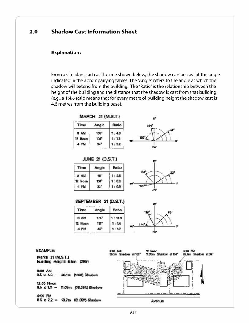
2.0 shadow cast Information sheet
explanation:
From a site plan, such as the one shown below, the shadow can be cast at the angle indicated in the accompanying tables. The “Angle” refers to the angle at which the shadow will extend from the building. The “Ratio” is the relationship between the height of the building and the distance that the shadow is cast from that building (e.g., a 1:4.6 ratio means that for every metre of building height the shadow cast is 4.6 metres from the building base).

A15
V lanDscaPInG InfoRMatIon
1.0 Impacts of Urban Development on trees

A16 A17
2.0 Protective Measures to consider near trees

A17
3.0 tree Planting Detail
The following tree planting detail is recommended for machine dug, either deciduous or coniferous trees which are 50-100 mm calibre, basket or ball and burlap.

A18 A19
4.0 sHRUb PlantInG DetaIl
The following tree planting detail is recommended for machine dug, either deciduous or coniferous trees which are 50-100 mm calibre, basket or ball and burlap.

A19
5.0 tree Replacement
The following examples of tree replacement equivalency are based on guidelines sanctioned by the International Society of Arboriculture, and may be referred to in replacing on site trees which must be removed. Wherever feasible, tree replacement is encouraged on the development site, however where this is not feasible consideration may be given to replacement on the public boulevard or elsewhere in the community.
1. Every 50 mm of existing calliper equates to 50 mm of replacement tree calliper. Example: 1-150 mm (6”) calliper tree to be removed should be replaced with either
3-50 mm calliper trees or
1-100 mm and 1-50 calliper trees
2. Every 50 mm calliper tree equates to 10 shrubs of 600 mm or better height or spread. Example: 1-150 (6”) tree to be removed can be replaced with either
1-100 mm calliper tree and 10 shrubs or
2-50 calliper tree and 10 shrubs
3. Trees are preferred over shrubs. Shrubs should only be considered as replacements if space or utilities preclude the planting trees.
Note:
Calgary’s trees represent a significant investment and are highly valued by Calgarians. The Tree Protection Bylaw and provisions in the Street Bylaw help preserve and protect trees on City land from damage resulting from development and construction.
Under the Street Bylaw, a Tree Protection Plan is required when construction or construction related activities occur on City Lands (including road rights-of-way and boulevards) within 6 metres of a City tree. Guidelines to assist in the preparation of Tree Protection Plans are available on line at www.calgary.ca/parks by following the Urban Forestry links.
To verify tree ownership and/or to inquire about tree protection plans, contact Urban Forestry.

A20 A21
6.0 suitable tree species
The following table identifies a number of the tree species considered suitable for Calgary’s climate and their characteristics (e.g. maximum height). Applicants are referred to the Alberta Horticultural Guide for more comprehensive information.
In addition, information on tree health and yard/garden problems is available through the City of Calgary:
• Call the Hortline at 268-4678
• Browse the Horticultural Information page on the Web or Email specific questions to a Horticulturist at www.calgary.ca/parks
Group 1: Small Trees
Species Common & Botanical Name
Mature Height Planting Distance* Shape Comments and Problems
Young’s Weeping Birtch Betula pendula ‘Youngi’
4 m 4 m Weeping needs good moisture, height variable, needs protective environment
Hawthorns Crataegus sp. & cultivars
5 m 2 m Upright mostly white flowers, most are fireblight?? sensitive, thorny
Flowering crabs and apples
Malus cultivars
5 m 2.5 m Round most are fireblight sensitive, white through red blooms
Pin Cherry
Pirunus pensylvanica
5 m 2 m Conical native, fruit editible
Schubert Chokecherry
Prunus virginiana
‘Schubert’
5 m 2 m Upright mature leaves red brown, fruit editable
Ussurian pear
Pyrus ussuriensis
8 m 3 m Upright heavy white spring blooms, large round fruit in fall, thorny
European Mountain Ash
Sorbus aucuparia
8 m 4 m Round white blossoms, red fruit, red fall colour, likes acid soil, shade tolerant, susceptible to various diseases, borderline hardy
Showy Mountain Ash
Sorubus decora
5 m 2 m Round as above
Japanese Tree Lilac
Syringa reticlulate
5 m 2 m Round large cream blossoms late in spring

A21
Group 2: Tall Trees
Species Common & Botanical Name
Mature Height Planting Distance* Shape Comments and Problems
Manitoba Maple
Acer negundo
14 m 8 m Round brittle wood, seed problem
Paper Birch
Betula papyrifera
12 m 4 m Upright needs good moisture to avoid top dieback, borderline hardy
Cut-leaf Weeping Birch
Betula pendala
‘Gracilis’
20 m 5 m Weeping needs good moisture to avoid top dieback
Manchurian Ash
Fraxinus mandschurica
15 m 6.5 m Round usually no seed, tip kill occasionally, difficult to grow, not chinook tolerant
Black Ash, Fall Gold
Fraxinus nigra & cvs.
10 m 3 m Upright selections are seedless, slow to establish, not chinook tolerant
Green Ash, Patmore
Fraxinus pensylvanica &
cvs.
15 m 6.5 m Upright selections are seedless, not all clones hardy, slow to leaf in spring
Siberian Larch
Larix sibirica
10 m 2.5 m Pyramidal conifer with good gold fall colour
Colorado Spruce
Picea purgens & cvs.
15 m 3 m Pyramidal green to blue sharp needles
Tower Poplar
Populus x canescens
‘Tower’
10 m 1 m Columnar male selection, leaves dark green, glossy above, silver below, some dieback in Calgary
Swedish Columnar Aspen
Populus tremula ‘Erecta’
12 m 1.3 m Columnar male selection, good fall colour, attractive catkins, some dieback
Brooks #6 Poplar
Populus x Brooks #6
20 m 8 m Upright surface roots and suckers, male selection (no cotton)
Northwest Poplar
Populus x ‘Northwest’
20 m 10 m Round surface roots and suckers, male selection (no cotton) susceptible to bud gall mite
Amur Cherry
Prunus Maackii
15 m 6.5 m Upright yellow brown peeling bark, very small black cherries, needs good drainage
May Day Tree
Prunus padus
commutata
10 m 6.5 m Round early white flowers, fragrant, small black cherries in early August
Bur Oak
Quercus macrocarpa
10 m 6.5 m Round tap rooted, acorns in the fall
Laurel Leaved Willow
Salix pentandra
15 m 10 m Round dark shiny green leaves, wood tends to be brittle
American Mountain Ash
Sorbus americana
10 m 3 m Round white blooms, red fruit, red fall colour most years, susceptible to disease

A22
American Elm
Ulmus americana
25 m 13 m Vase-shaped narrow branch angles, aphids and seed problems (use in limited numbers only)
Brandon Elm
Ulmus americana
‘Brandon’
15 m 6.5 m Vase-shaped better selection of elm, few seeds (use in limited numbers only)
Manchurian Elm
Ulmus pumila
12 m 5 m Vase-shaped small branches, easily shed, seed (use in limited numbers only)
FOR PURPOSES OF THIS CHART:
* Planting Distance Represents 2/3 of the Maximum Spread of the Tree

