louisiana state historical land records and their … state historical land records and their...
TRANSCRIPT

Louisiana State Historical Land Records
and Their Relevance to Genealogists
Information and guide to utilizing the Louisiana State Land
Office website for genealogical purposes.
Written by:
Brandi A. Newman
Presented to the St. Tammany Parish Genealogical Society
March 2014

2

3
Preface
This guide to Historical Records on file at the Louisiana State Land Office has been written and
compiled by Brandi A. Newman, Public Land Analyst for the State of Louisiana in the months of
January, February, and March of the year 2014. The purpose of this guide is to impart basic
knowledge of the documents contained in the Louisiana State Land Office Historical Records
Collection as well as provide detailed instructions on how to locate these documents on the State
Land Office website, primarily with genealogical purposes in mind. This guide was presented to the
St. Tammany Parish Genealogical Society on March 8, 2014.
An enormous special thank you is extended to Ms. Marguerite Scully for her generous editing and
continued support while undertaking this publication.
As there are revisions to the website, this publication will be updated as well.

4
Louisiana State Land Office
Physical Address: Claiborne Building
1201 North Third Street
Suite G-150
Baton Rouge, Louisiana 7 0 8 0 2
Mailing Address:
State Land Office
Attn: Historical Records
P.O. Box 44124
Baton Rouge, Louisiana
7 0 8 0 4
Website Address:
http://www.doa.louisiana.gov/slo/

5
Contact information:
Manager: Faith Leroy – [email protected] – 225-342-4579
Supervisor:
Staff: Brandi Newman – [email protected] – 225-219-9537
Staff: Linda Turner – [email protected] – 225-342- 4587
********************
***Please call to schedule an appointment
before planning a visit to our office***
******************
Important Documents to Read
Prior to utilizing our website to search for Historical Land Records, it is recommended that new
users first review the documents that may be found at the following links. These documents
contain a wealth of information about the records on file in the State Land Office and will help
explain land terms and the procedures that were in place when your ancestor first acquired land
from a public entity.
The documents are:
Definitions of Terms frequently used in Historical Land Records can be found here:
http://www.doa.la.gov/slo/forms/doc_definitions.htm
History of Land Titles in Louisiana by Ory G. Poret can be found here:
http://www.doa.la.gov/SLO/PDFs/ORY_PORET_BKLT.pdf

6
About the Historical Land Records at the Louisiana State Land Office
The Louisiana State Land Office has been in operation since 1844 when it was created to
aid in the selection and selling of property which had been transferred from the Federal Government
to the State.
When the United States took ownership of Louisiana, all land in the State of Louisiana was
considered federal property. The Federal Government worked with Louisiana inhabitants who
“owned” property to confirm their claims to their property. When the Federal Government sold or
granted land to a private individual, it was referred to as “severing the property” or “the severance
of the property.” Over time, various Acts of Congress allowed the State of Louisiana to “select”
vacant federal property, and upon approval from the Federal Government, this property would pass
from federal ownership to state ownership. The State could then sell the property to private
individuals, which is also known as “severing” the property. The State Land Office still sells vacant
state land today.
The documents on file in the State Land Office create the severance record of the first sale
of each piece of property within the State of Louisiana. Any subsequent transfers of property
between private individuals are not at the State Land Office but instead are held in the courthouse of
the parish where the land is located. The State Land Office has no private land records or deeds of
any type.

7
U. S. Tract Books, State Tract Books, Land Claim Papers,
and Official Plats
There are numerous types of documents in the Historical Land Records Collection of the State Land
Office. The ones most useful for genealogists are the following: U. S. Tract Books, State Tract
Books, Land Claim Papers and Official Township Plats.
What information is in these documents?
U. S. Tract Book Pages – These are ledger books which are indexed by township, range,
and section, showing to whom the U. S. Government sold or granted property. The pages
in each U.S. Tract Book contain a property description. These pages often also include
names of purchasers, dates of purchase, patent numbers and dates, and certificate
numbers.
State Tract Book Pages – If the Federal Government granted land to the State, these
lands will appear on State Tract Book pages. The State Tract Book pages are similar to U.
S. Tract Book Pages, but show more information. The information provided may include:
the reason the State acquired the property; the names of the purchasers of the state land;
property descriptions; dates of selection, approval, and sale; certificate numbers; and
patent numbers.
Land Claim Papers – When the United States took possession of Louisiana, the Federal
Government worked with Louisiana inhabitants who “owned” property to confirm their land
claims. These land claims included claims from individuals who received French, Spanish,
or British land grants. Some of the papers supplied to the Federal Government for this
purpose are still on file in the State Land Office; these records may include maps, affidavits,
and certificate numbers.
Official Township Plats – Before any vacant land could be sold, it had to be surveyed.
The plat maps were created from surveyors’ field notes. The maps show the dimensions of
the land in Louisiana; they are indexed by township/range/section. Typically these maps do
not show roads, churches, cemeteries, parish boundaries, cities, towns, plantations, etc.,
however, major lakes, rivers, and streams will appear on the Official Plats.
The following pages will provide detailed instructions on how to read
the information on the U. S. Tract Book pages, State Tract Book
pages, Claim Papers, and Official Plats.

8
U. S. Tract Books
The pages in the U. S. Tract Books held at the Louisiana State Land Office provide key information
about Louisiana property. Every parcel of land in the State of Louisiana should have an entry;
however, some land reserved for schools is not listed. The pages in each U. S. Tract Book are in
order by property description, not by name of purchaser. When a piece of property was severed
from the U. S. Government, a clerk would make note of it on the appropriate page. The pages in a
U. S. Tract Book should be read left to right as one single line. Columns are labeled with key
information.

9
Enlargement of left side of page
Enlargement of right side of page

10
State Tract Books
The State Tract Books provide key information about each piece of property in Louisiana. Every
parcel of land which passed from federal ownership to state ownership should have an entry.
When property was severed from the state domain, a clerk would make note of it in a State Tract
Book.
To better understand the information contained on each line of the pages in a State Tract book, it is
best to separate the information on each line into two parts. The first part answers the question:
how did this property become State-owned? The second part answers the question: who did the
State sell it to? The easiest way to keep things straight is to first look at the page as a whole. You
should see the columns “approved” and “purchased” on the left side of the page. Between these
two columns, draw an invisible line. Anything to the left of that line shows how this property came
to the State and anything to the right of the line shows how the property was severed from the
State.

11
With ‘invisible line’ drawn

12
To practice reading the State Tract Books, review the example below
The columns containing information regarding the passing of land from federal ownership to state
ownership are to the left of the “invisible line.” The information provided in this document is as follows:
All of Section 16, Township 15 North, Range 14 East, 271.23 acres, School Land, Selected (for transfer to the
State) on January 10, 1853, and Approved on March 11, 1835.
The columns containing information regarding the transfer of land from state ownership to private
ownership are to the right of the “invisible line.” The information provided is as follows:
John Laidlaw, on July 2, 1860, under certificate 8930 NSH purchased Lot or Section 16 (cancelled & wt. 159,
Act 104 1888 issued in lie hereof), 271.33 acres, at a price of $349.16, with patent no. 10369, recorded in
volume 11 page 272.

13
Land Claims Papers
The Claim Papers refer to the land claims made by some of the inhabitants of Louisiana who
“owned” land before the U. S. Government took possession. Each Claim Papers Book is a
compilation of the paperwork that Louisiana inhabitants submitted to the U. S. Government to prove
title to a particular piece of property. These included individuals holding French, Spanish, or British
land grants. These submitted claims are still on file in the State Land Office. The Claim Paper
Books consist of indexes, township& range title pages, and claims documents.
Index Page

14
Township/Range Separator Page
Land Claim Papers Example

15
Official Plats
The Official Township Plat was created by a draftsman after the lands had been surveyed, using the
surveyor’s field notes as reference. Upon review, the Surveyor General would approve the plat if it
appeared complete and correct. Each plat contains a table of contents listing the acreage for each
public land section, names of claimants and certificate numbers, as well as information about
acreage in Private Land Claim sections. Sometimes descriptions of the character of land and land
features were included. Each township/range, with the exception of a few coastal townships, will
have an Official Plat.
Public Land
Sections &
Acreage
Private Land
Claim Sections &
Acreage
Approval Date & Signature
Township,
Range, &
District
Character
of Land

16
For Genealogists:
Utilizing the State Land Office Website to Find Historical Land Title Documents
Although the State Land Office’s online database was not originally designed for use by
genealogists, researchers can find land information they need by following the steps provided in the
example below.
Known background information
Name of individual: John W. Hanna; in some documents, his surname is spelled Hannah.
Historical Information: John W. Hanna was born in Ireland about 1800. He immigrated to the
United States and was living in Natchitoches around 1850 with his wife Eliza. He died before 1860.
Log on to the State Land Office Historical Records search section of the website found at:
https://wwwslodms.doa.la.gov/HistoricalDocument (There is no period after the www.)
On the main search screen, leave your document type as “unspecified” and scroll down to
the “Original Owner” field. Type in a name. The index of “original owners” is alphabetized
by first name, not surname; so if you type the name Hanna you will only get results
beginning with the first name Hanna. To search by first (given) name or surname, use the
wildcard (*) as follows:
o *Hanna will find results for the last name Hanna,
o Hanna* will find results for the first (given) name Hanna, and
o * Hanna* will find results with any string of the letters such as the first name
Hannah, the last name Hanna, or even the name Hannabal.
Hint: Be sure to check every variation and even initials. Results may vary.
A dropdown box should appear under the “Original Owner” field with a list of names. You
must choose the name of your subject from that list before you can search for records.
Hint: Do not hit “Enter” after you type in a name if you using the wildcard
method. Sometimes it takes a minute for the dropdown menu with the
names to appear. If it doesn’t appear after a few minutes, select “New
Search” and try again. Remember that it is also possible that there is no
one with the name you entered in the database.
Another way one can search by subject name is to type the full name in the “Original
Owner” field and then select “Search Historical Records,” as follows:
o Enter John W Hanna and then select “Search Historical Records.”
Note: This is how John W. Hanna’s name appears in the database: John W
Hanna. His name is also listed in the database as John W. Hanna.
However, had you entered John Hanna, no results would have appeared
under Search Results. For that reason, the wildcard method may be a better
way to search by name of original owner.
Review your results.

17
o Six results are found: two “Claim Papers” results, two “State Tract Book” results,
and two “U. S. Tract Book” results.
Hint: Always choose the results that begin with “U. S. Tract Book” first.
Find the first U. S. Tract Book entry on the list of results.
o Choose “US TRACT BOOK VOLUME 31 PAGE NUMBER 050 (MONROE DISTRICT).”
This will open in a new window.
o In this new window there is a toolbar with several functions. Hold your mouse over
the icons for a description of what each one does. You can zoom, print, or save
each and every document free of charge!
o Familiarize yourself with the way the page is set up. Examine the column titles.
o Look for the name of your subject in the “name of purchaser” field. Visually scan
the page. If you don’t see the name you are looking for, select the yellow cross-
hatched box in the top toolbar to access a typed index of information on the page.
Hint: Names can appear more than once on a page. Be sure to look at the
whole page.
o Once you find the name of your subject, read the information on the line from left to
right. For instance, our example would read: The Southeast Quarter of the
Southeast Quarter of Section 30, Township 17 North, Range 3 East, 39.99 acres,
appraised at $132.00, purchased by John W. Hanna on June 12, 1916, under
certificate 07747, and patented to John W. Hanna on October 20, 1916, Patent
number 551316.
Hint: If a U. S. patent number is provided, check for a copy on the Bureau
of Land Management website. U. S. patents are not on file at the State
Land Office.
o Based on the date of purchase and our knowledge of the date of death of our
subject John W. Hanna, we know this entry does not refer to him. However,
because the name in this entry is the same name as our subject, and it is an
unusual name, this entry may refer to a relative of the subject. Therefore, you might
want to record the township, range, section, portion of section, for future use.
Print or Save.
o Use icons on toolbar.
Close the window and return to Search Results.
Find the second U. S. Tract Book page on the results list.
o Choose “US TRACT BOOK VOLUME 31 PAGE NUMBER 050 (MONROE DISTRICT).”
o Use the same steps recorded above to access the U. S. Tract Book page.
o Once you find the name of your subject, read the line from left to right. Our
example would read: The Northeast Quarter of the Southeast Quarter of Section 17,
Township 15 North, Range 14 East, sold to John W. Hanna on January 17, 1854
under Certificate 83, Swamp, at Baton Rouge. This information is included in a
bracket entitled “State Entries”.

18
Note: Above Mr. Hanna’s entry, you will see another entry that explains the
significance of “State Entries.” The entry is as follows: The whole of Section
17, Township 15 North, Range 14 East, 330.92 acres, granted to the State
as Swamp Lands under Act of March 2, 1849; See list no. 1. This entry
indicates that a State Tract Book page will provide additional information.
Note: Some U. S. Tract Book pages will simply provide the statement
“Selected by the State of Louisiana and Approved” or some variation of that
statement. Most will not mention the person who received the land from the
State.
o Make note of the township, range, section, portion of section, and dates that your
subject acquired the property, for future use.
Print or Save.
o Use icons on toolbar.
Close the window and return to Search Results.
When you have finished reviewing all of the U. S. Tract Book results, find the first State
Tract Book page on the results list.
o Choose a State Tract Book result. First choose “STATE TRACT BOOK VOLUME 18A
PAGE NUMBER 258 (DISTRICT NORTH OF RED RIVER DISTRICT).” This will open in
a new window.
o Familiarize yourself with the way the page is set up. Examine the column titles.
Note: Each line of the State Tract Book page should be divided into two
parts. Draw an invisible line between the columns marked “approved” and
“purchaser” to separate the two parts. The information to the left of the line
will answer the questions: how did this property become state-owned. The
information to the right of the line will answer the question: who did the State
sell it to? Genealogists are typically interested in the information to the right
of the invisible line.
o Look for the name of your subject on the page. If you don’t see it, click on the
yellow cross-hatched box in the top toolbar to access a typed index of information
on the page.
Hint: Names can appear more than once on a page. Be sure to look at the
whole page.
Once you find your subject’s name, read everything to the right of the
column marked “purchaser.” For instance, our example would read: John
W. Hanna, on January 17, 1854, under certificate 83 NS, purchased the
Northeast Quarter of the Southeast Fractional Quarter, 22.90 acres, for a
price of $28.63. The last column is blank, indicating that a state patent was
not issued, which is not abnormal; the certificate would pass the title from
the State to Mr. Hanna.
Hint: All state patents are on file in the State Land Office. Most state
certificates or warrants are also on file.

19
o Make note of township, range, section, portion of section, certificate, warrant, or
patent numbers, and dates that your ancestor acquired the property, for future use.
Print or Save.
o Use icons on toolbar.
Close window and return to Search Results.
Find the second State Tract Book page on the results list.
o Choose “STATE TRACT BOOK VOLUME 18A PAGE NUMBER 259 (DISTRICT NORTH
OF RED RIVER DISTRICT).”
o Use the same steps recorded above to access the State Tract Book page.
o What if, as in this case, the name of your subject does not appear on the page?
Why did this page appear on the results list?
John W. Hanna’s name appears on one State Tract Book page for Township
15 North, Range 14 East, and therefore all State Tract Book Pages
containing that land description will appear on the list of results.
Note: If you do not see your subject’s name on a page, move on.
Close window and return to Search Results.
When you have finished reviewing all of the State Tract Book pages, find the first Claim
Papers on the results list.
o Choose “CLAIM PAPERS N.R.R. T.14N. R.13 & 14 E. & T.15N. R.3, 9, 12-15 E. &
T.16N. R.4, 11, 14, 15 E. & T.17N. R.3E. VOL. 7.”
o Familiarize yourself with the page. The first page that appears in the window is the
first page of the Book’s index. The index contains the names of the claimants and
the sections, townships, and ranges that each was claiming. Search for your
subject on the page and record the township, range, and section of the subject’s
claim(s). You will notice thumbnail images on the left side of the new window. If
your subject does not appear on the first page of the index, you may select other
index pages to search for the subject. The index is in alphabetical order by surname
of the claimant.
o The Claim Papers follow the index. The pages of the Claim Paper Book were
scanned in order by township and range, the same order they are in the bound
Book. Each township and range is separated in the Book, and in the digitized
pages, by a white title sheet containing the name of the township and range. Once
you have found the township/range/section of your subject’s land claim, scroll
through the thumbnail pages until you find the white title sheet containing that
township and range.
o Click on the first page after the township and range title page and read the
document. (The thumbnail for that page will become highlighted.) A name,
property description, field notes, a small map, and sometimes an affidavit, will be
included in these papers.
o If the first result is not yours, click on the thumbnail for the next image and continue
until you find the name of your subject.

20
o Record the number of the first page of these documents for future use.
o On the top right-hand side of the page, there is a little white box with an arrow
above it and an arrow below it. Click on the box, fill in “Page __ of 230.” You can
use this tool to revisit these documents. Enter the page number of the first page, hit
Enter, and the database will jump to that page. You will not have to scroll through
each of the pages as you did when you first searched for the documents.
o What if the name of your subject does not appear in the index, as in this case? Why
did this Claims Papers entry appear on the results list?
John W. Hanna’s name is on one of the U. S. or State Tract Book page for
Township 15 North, Range 14 East and therefore all Claims Papers pages
containing that land description will appear on the list of results.
Note: If you do not see your ancestor’s name on the index page, move on.
Close the window and return to the Search Results.
Find the second Claims Papers entry on the results list.
o Visually search index pages for the name of your subject.
o Use the same steps recorded above to access the Claims Papers index and
documents.
o If the name of your subject does not appear, it is for the same reason mentioned
above.
Print or Save.
o Use icons on toolbar.
Close window and return to the Search Results.
Consult the Louisiana Land District Map to find the location of the property by township and
range. (This map is not provided on the website for copyright reasons. However, a copy
may be purchased from the State Land Office. You may order by phone; the Office will ship
the map to you.)
o Based on your previous research, you should have recorded a specific township,
range and section where John Hanna acquired property. Using Township 15 North,
Range 14 East, Section 17, in the District North of Red River, begin at the Louisiana
Meridian axis in Rapides Parish and count up 15 squares, then count 14 squares to
the right.
o You will find that this property is in Madison Parish near the Louisiana/Mississippi
state line.
o The District Map shows only townships and ranges, not sections. You will need to
consult the Official Government Survey Plats on the website to view the specific
section.
To search for an Official Government Survey Plat showing the section of land, start a New
Search.
o Click the “New Search” button to clear all fields on the main search page.
Find an Official Government Survey Plat.

21
o Choose “Plats, Official” as your document type.
o Type your township in the “Township” field in this format: 15N.
o Type your range in the “Range” field in this format: 14E.
o Choose the land district, if known, in the “Land District” dropdown box.
Note: This is not required in order to complete your search.
o Click the “execute search” button.
Review the plats in the list of results.
o If the results have dates in the title, click the earliest plat first.
Note: Frequently, only one result will appear. This means the U. S.
Surveyor’s General Office only surveyed this township once. However, it is
not uncommon to have more than one result indicating that at least a portion
of the township was surveyed more than once.
Read the earliest plat.
o The plat will open in a new window like all other documents.
Note: These plats were created for the primary purpose of selling public
land. To the right of the image, you will find a table of contents which lists
acreage for the public land sections, and beneath that the names, acreage,
and certificate numbers for the private claims. Only claimed lands will show
names of individuals on the plat. Some plats, like this one, describe the
nature of the land and identify nearby features: “low slashy land” and “cart
road”. Beneath the table of contents, the name of the surveyor(s), the
year(s) surveyed, and lastly the date that the plat was approved by the U. S.
Surveyor General is listed. In our example, the plat was approved in 1846.
o Section 17 is in the top, right-hand corner. It looks like a normal square section.
John Hanna purchased the Northeast Quarter of the Southeast Fractional Quarter of
Section 17.
Print or Save.
o Use icons on toolbar.
Close the window and return to the Search Results.
Find the second plat on the results list.
o Visually scan the image or check the Table of Contents to see if your land section
appears on the plat.
Note: Sometimes Official Plats are really diagrams completed without on-
the-ground surveys. The purpose of a diagram is to clear up judgment or
claim issues that involved certain sections; in this case, claims that were
confirmed on Sections 50 and 51 reduced the size of Section 17.
o The lower diagram is from 1847 and the upper is from 1848.
o Since the latest diagram of Section 17 was from 1848, this is the one that was in
effect when John Hanna purchased his property in 1854. The northeast quarter of
the southeast quarter is reportedly 22.90 acres, as recorded in the Tract Book.
Print or Save.
o Use icons on toolbar.

22
Close the window and return to the Search Results.
Utilize other resources such as a Department of Transportation and Development (DOTD)
road map or Google maps to give you an idea of where the land is located today.

23
Frequently Asked Questions
My ancestor had a Spanish/British/French land grant.
Does the State Land Office have those original land grant papers?
No. Based on State Land Office records, it appears that original land grant papers were given to
the grantee at that time. After the acquisition of Louisiana by the United States, those individuals
holding grants were asked to prove their claims and submit certain paperwork which would be
reviewed by the U. S. Commissioner of Claims. The Commissioner of Claims would assign certain
“degrees of validity” to each submission using an A through D scale. If claims were approved, they
would be confirmed by an Act of Congress, which would be denoted on the U. S. Tract Book Page
for that township, range and section.
What is the difference between an “A” Claim vs. a “B” Claim, etc.?
A description of Land Claims A, B, C, D, etc., summarized from the book entitled,
Abstractions & Certificates of Confirmation, Cosby Reports & Lists, French, British and Spanish, is
on file in the State Land Office, document ID # 501.00085, image page 59. The following
information was generated from information contained in this book.
A Claims – During their reign over part of present-day Louisiana, Spain and Britain issued
land patents. When Spain took over Louisiana after Britain, British patents were “grandfathered in”
as Spanish patents. Because these patents had been issued by the government in power before
the U. S. Government took possession of these lands, Mr. Cosby, the U. S. Commissioner of Land
Claims, recommended that these land claims be confirmed by the U. S. Government.
B Claims – For these claims, the claimants had Orders of Survey that were issued by the
Spanish authorities. These Orders of Survey followed all Spanish rules and regulations. Some of
these claims exceeded normal quantity of acreage. Mr. Cosby recommended that these claims be
confirmed; he recommended that claims with excess acreage be given additional scrutiny.
C Claims – After France gained control of Louisiana from Spain, the Spanish Government
continued to sell land in Louisiana. These sales were invalid because the Spanish no longer had the
right to sell property they didn’t own. In most cases these properties were large tracts with no
cultivation or inhabitants. In instances where small tracts had claimants that actually cultivated and
inhabited the land, and followed all Spanish guidelines for getting a patent, Mr. Cosby agreed to
consider these claims for approval. However, most of these were not recommended for approval
by Crosby.
D Claims – These were claims for land that had been surveyed, but the claimants had not
paid for the land. Mr. Cosby did not recommend confirmation of these claims.
Anomalous Claims – These were claims where the title papers had been lost or destroyed.
If the papers were found, these claims would then be reclassified under the above criteria. Mr.
Cosby had no comment regarding these claims. (Note: these claims are never referenced in Tract
Books or plats.)
24
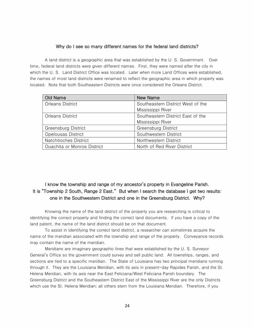
Why do I see so many different names for the federal land districts?
A land district is a geographic area that was established by the U. S. Government. Over
time, federal land districts were given different names. First, they were named after the city in
which the U. S. Land District Office was located. Later when more Land Offices were established,
the names of most land districts were renamed to reflect the geographic area in which property was
located. Note that both Southeastern Districts were once considered the Orleans District.
Old Name New Name
Orleans District Southeastern District West of the
Mississippi River
Orleans District Southeastern District East of the
Mississippi River
Greensburg District Greensburg District
Opelousas District Southwestern District
Natchitoches District Northwestern District
Ouachita or Monroe District North of Red River District
I know the township and range of my ancestor’s property in Evangeline Parish.
It is “Township 2 South, Range 2 East.” But when I search the database I get two results:
one in the Southwestern District and one in the Greensburg District. Why?
Knowing the name of the land district of the property you are researching is critical to
identifying the correct property and finding the correct land documents. If you have a copy of the
land patent, the name of the land district should be on that document.
To assist in identifying the correct land district, a researcher can sometimes acquire the
name of the meridian associated with the township and range of the property. Conveyance records
may contain the name of the meridian.
Meridians are imaginary geographic lines that were established by the U. S. Surveyor
General’s Office so the government could survey and sell public land. All townships, ranges, and
sections are tied to a specific meridian. The State of Louisiana has two principal meridians running
through it. They are the Louisiana Meridian, with its axis in present-day Rapides Parish, and the St.
Helena Meridian, with its axis near the East Feliciana/West Feliciana Parish boundary. The
Greensburg District and the Southeastern District East of the Mississippi River are the only Districts
which use the St. Helena Meridian; all others stem from the Louisiana Meridian. Therefore, if you

25
know that your ancestor’s property is tied to the Louisiana Meridian, the property would be in the
Southwestern District.
My great-great-great grandfather had a plantation and I’m looking for those records.
Does the State Land Office have those records?
No. The State Land Office does not have any personal records of individuals, nor any
deeds or evidence of property transfers between private individuals. If you know the township,
range and section of the property where the plantation was located, the State Land Office has the
record of who first owned that land, but no records of subsequent property transfers.
Where can I find federal patents?
The Bureau of Land Management has federal patents. The BLM houses all U. S. patents as
well as copies of plats and surveyors’ field notes. These are available online at their website:
http://www.glorecords.blm.gov/.

26
First Edition
March 2014