losses of lowland heath through succession at four sites in breckland, east anglia, england
TRANSCRIPT

Biological Conservation 36 (1986) 19-38
Losses of Lowland Heath through Succession at Four Sites in Breckland, East Anglia, England
R. H. Marrs, M. J. Hicks & R. M. Ful ler
Institute of Terrestrial Ecology, Monks Wood Experimental Station, Abbots Ripton, Huntingdon, Cambs PEI7 2LS, Great Britain
A B S T R A C T
Although it has been generally accepted that plagio-climax communities, such as lowland heaths, mar' be lost through successional processes, there have been few attempts to document the scale of these losses. This paper, therefore, attempts to assess the loss of open heathland habitat at four sites in the Brecklands of East Anglia, and discusses successional change in relation to site management. Colonisation by scrub (birch and Scots pine) rather than bracken was found to be the major threat.
I N T R O D U C T I O N
The conservation of heathlands in lowland England has been the subject of much concern in recent years. This has mainly been because of the massive loss of heathland habitat brought about through changing patterns of land use, such as changing agricultural practices allowing profitable cultivation of poorer soils, afforestation, mineral extraction and building developments (Moore, 1962; Sheail, 1979). The extent of this loss of heathland area has been clearly demonstrated for both the Dorset and East Suffolk heaths (Moore, 1962; Armstrong, 1975; Webb & Haskins, 1980). In Dorset, for example, Webb & Haskins (1980) estimated that 40 000 ha of heathland present in 1750 had been reduced to less than 6000 ha in 1978. Accompanying this loss was an increase in fragmentation, from 10 large blocks to 767 smaller units. In the Brecklands of East Anglia, the area studied in this paper, similar effects
19
Biol. Conserv. 0006-3207/86/$03"50/~ Elsevier Applied Science Publishers Lid, England, 1986. Printed in Great Britain
20 R. H. Marrs, M. J. Hicks, R. M. Fuller
have been noted: uncultivated semi-natural habitats (including sheep walks and rabbit warrens) have been reduced from over 60000ha to less than 10 000 ha divided between 19 sites of varying size (Ratcliffe, 1977).
In addition to this serious loss in absolute area of heathland, there have also been further losses of open heath communities through successional change. In most parts of lowland England, heathlands are plagio-climax communities, created and maintained by man. Unless succession is prevented by man's influence, changes in the species composition occur from open heath to either bracken-dominated com- munities or woodland (Gimingham, 1972). In the past, succession was prevented by positive management: by burning heathland vegetation, by cutting bracken Pteridium aquilinum (L.) Kuhn and scrub, and by grazing rabbits (on warrens), sheep and cattle (Moore, 1962; Crompton & Sheail, 1975; Sheail, 1979). Where there was no positive management, there was a natural grazing pressure from rabbits (Farrow, 1925), and on some sites there was also disturbance associated with military training (Crompton & Sheail, 1975). However, during the last 30-40 years, positive management of the heaths has almost disappeared, and even the natural grazing pressure from rabbits was drastically reduced following the introduction ofmyxomatosis in the 1950s. The consequence of this reduction in management has been to allow succession to proceed, with open heath communities being invaded by bracken and scrub species (mainly birch Betula spp. L. and Scots pine Pinus sylvestris L.).
Although generally accepted that lowland heath communities are threatened by successional processes, there has been little attempt to estimate the seriousness of this loss. This paper attempts to assess the significance of successional change at four sites in Breckland, its importance for the conservation of these sites, and to identify particular areas most in need of urgent vegetation management.
MATERIALS AND METHODS
The four sites studied were Knettishall Heath, Cavenham Heath, Weeting Heath and Lakenheath Warren, the first two dominated by Calluna vulgaris (L.) Hull and the last two, grass heaths, dominated by Festuca ovina L. and Agrostis spp. L. At all four sites there was thought to be a management problem caused by bracken and/or scrub invasion. A time series of vegetation maps, based on aerial photographs, was

Losses o f lowland heaths through succession 21
produced for each site. At three of the sites the photographic cover spanned approximately 30 years (1940s-1970s), but at Lakenheath Warren 60 years of cover were available (1918-1979). Details of the source of the aerial photographs are given in Table 1, and copies of the original maps are available for inspection from the senior author.
The vegetation maps were produced using a Bausch and Lomb Stereo- Zoom Transfer Scope. This instrument allows the photographs and a base map (in this study, Ordnance Survey maps at 1:10000 and 1:10 560 were used) to be viewed simultaneously and, moreover, corrected for distortion on the photograph caused by tilt and relief variations (Fuller, 1983). Checks of planimetric accuracy, in a similar mapping study with this instrument, have shown displacements of fixed features to average 0-4-0.7 mm (p = 0-05) (Fuller, 1984). There is no reason to expect greater levels of inaccuracy in the present study. Moreover, minor, non- systematic errors cannot produce the sorts of trends that are evident in the heathland data discussed here. The scale of changes observed is far
TABLE 1 Details of the Aerial Pho t og r aphs used in this Study
Heathland Grid Date q[" aerial Collection ~ Sortie site rE~ference photography
Knettishall TL 955805 1946 (June) DOE 106G/UK/1589 Heath 1951 (June) DOE 58/RAF/651
1967 (June) DOE 543/RAF/3851 1976 (February) DOE 39/RAF/4871
Cavenham TL 755725 1946 (June) DOE 106G/UK/1589 Heath 1968 (May) DOE OS/68/134
1973 (November~ DOE 543/RAF/7184 1981 (August) CUC RCS/KT14
Weeting TL 757885 1947 (March) DOE CPE/UK/[952 Heath 1943 (September) DOE 543/RAF/7086
1979 (July) DOE 13/T/RAF/1938
Lakenheath TL755805 1918 (September) Elveden Estates Lakenheath Live Warren Bombing Ground,,
39th Wing 1922 (?) Royal Commission Crawford Collection
on Historical TL 7582;1 Monuments
1946 (June) DOE 106G/UK/1557 1968 (September) CUC RCS/DN 1-39 1979 (June) CUC RC8-C2/102-143
"DOE, Department of Environment: CUC, Cambridge University Collection.

22 R. H. Marrs, M. J. Hicks, R. M. Fuller
greater than could be explained by errors in planimetry. In all cases the most up-to-date maps were verified by ground survey between 1982 and 1984.
At Lakenheath Warren, maps based on the 1979 aerial photographs were updated by intensive field survey in 1984. The 1968 bracken map of this site was verified against Rymer's interpretation of the same aerial photographs plus field survey in 1971 (Rymer in Crompton, 1972), and there was good agreement between the studies. The distribution map of mature Scots pine was taken from the 1968 photographs, but updated to 1971 to include the small Scots pines which were not visible in the photographs, but were detected and mapped by intensive field survey (Crompton, 1972; Crompton & Sheail, 1975). The earliest maps (l 918/22) are composites, produced by combining photographs of different parts of the Warren (with some overlap) taken in 1918 and 1922.
It is impossible to measure the accuracy of mapping an historical series of aerial photographs. Nevertheless, the general findings of this study can be justified in three ways:
(1) The maps for each time series were all prepared in the same way, with the general textural and tonal appearance for each vegetation type consistent through time.
(2) The latest maps were verified on the ground and found to give an accurate representation. The earlier photographs were usually of equally good quality, so interpretations made from them should be as reliable.
(3) Independent checks on the size of sub-areas were done at two sites, Cavenham Heath and Lakenheath Warren. When compared with map estimates, errors of 2.2% and 4.5% were found respectively.
Estimates of the area occupied by the different plant communities were made either using a 50 × 50m dot grid overlay, and calculating percentage cover, or by carefully cutting, and weighing the areas, and interpolating area from a calibration curve.
RESULTS AND DISCUSSION
Knettishall Heath
Six main types of community were distinguished: (1) Disturbed ground; (2) woodland (mainly birch with some oak Quercus robur L. and Scots

Losses of lowland heaths through succession 23
pine with a bracken understorey); (3) Calluna-dominated heathland; (4) Calluna/bracken-grass striped communities; (5) grass/bracken communi- ties; and (6) dense bracken communities (1976 only).
At this site, it was not possible to distinguish between grass and scattered bracken communities, al though it was possible to identify an area of dense bracken on the 1976 maps. Three main changes in vegetation were noted (Fig, 1; Table 2); these were changes in (1) woodland, (2) bracken and (3) Calluna communities.
Woodland communities There has been a massive increase in woodland cover from 22ha in 1946 to 60 ha in 1976; woodland now covers more than 50% of the area. Indeed, the 1976 estimate is probably an underestimate of the maximum extent reached because some trees have been removed (Point A, Fig. 1), and small birch and Scots pine have started to invade some of the open heathland at Point B (Fig. 1) and were not visible on the photographs. The increase in woodland has been at the expense of all three open heath communities, viz. Calluna heath, striped communities and grass/bracken
1946 1951
® m m i__J Woodland Dense Calluna Striped Grass/ Disturbed
~,~e~re,~2~ ° Bracken Heath Communities Bracken Ground
Fig. 1. Changes in vegetation between 1946 and 1976 at Knettishall Heath.

24 R. H. Marrs, M. J. Hicks, R. M. Fuller
T A B L E 2 Es t imated Area (ha) and Percentage Dis t r ibu t ion of Different P lant
Communi t i e s at Knet t ishal l Hea th between 1946 and 1976
Year
1946 1951 1967 1976
Area (ha) W o o d l a n d 22.4 23.1 34.8 60.3 Calluna heath 10"2 32'9 29.0 12"8 Grass /b racken 55. I 22.2 40-6 30.2 Bracken - - - - - - 4-6 Striped vegetat ion 10.2 6.2 7-0 3-5 Dis turbed g round 4. I 4.4 4-6 4.6
Total 102.0 88'8 116-0 116.0
% Distribution W o o d l a n d 22 26 30 52 Calluna heath 10 37 35 1 ! Gras s /b racken 54 25 35 26 Bracken - - - - - - 4 Striped vegetat ion 10 7 6 3 Dis turbed g round 4 5 4 4
communities. Some of this woodland has been planted (Point C, Fig. 1), but much has been from natural invasion.
Bracken communities There has also been an apparent increase in dense bracken communities; indeed, prior to 1976 dense bracken could not be detected. Now it covers over 4ha (4% of the area), but this estimate does not include either scattered bracken present in grassland and Calluna or the ubiquitous bracken found in the birch understorey.
Open Calluna heathlands There have been marked changes in the amount of open Calluna heath, being highest in 1951 and 1967. These increases may relate to site disturbance: in 1951 perhaps through wartime use, as has been shown for Lakenheath Warren (Crompton & Sheail, 1975), and in 1967 through a severe fire in the early 1960s. In 1983, a small study was made of the Calluna populations, with between 10-20 random 1 m 2 quadrats in three areas of open Calluna heath (Points B1, B2, B3, Fig. 1). The Calluna within each area was relatively even-aged (Table 3). In area B2, the

Losses of lowland heaths through succession 25
TABLE 3 Cover and Age of Different Phases of Calluna at Knettishall Heath
in 1983 (mean values + standard errors are presented)
Area Cover (%)
Pioneer Building Mature Degenerate
Bi (n = 20) 5+2 13_+7 35_+9 27+7 B2 (n = 20) < 1 0 92 -+ 3 4 _ 3 B3 (n= 10) <1 0 30+ 15 57-+ 16
Area Age
Pioneer Building Mature Degenerate
BI (n = 20) 1.8_+0-2 9-0_+0.7 13.7_+0.4 18-7+0.4 B2 (n = 20) 2 -- 1 4 . 8 - + 0 . 6 17-3_+0.3 B3 (n= 10) 2 - - 15 .5_+0 .3 19.0+0.5
majority of Calluna was in the mature phase (sensu Gimingham, 1972) with a mean age of 15 years. In this area, only a small proport ion of Calluna was in the pioneer or degenerate phases, with no building phase Calluna being found. In areas B1 and B3 most of the Calluna was either in the mature (age 14-15 years) or the degenerate (age 19 years) phase, although some pioneer and building phase Calluna was found in BI. Of the 50 quadrats sampled, pioneer and building phase Calluna was found in only four and six quadrats respectively, indicating little recruitment of new individuals in the last 14 years. Moreover, at one quadrat there was observational evidence to suggest that degenerate Calluna may form early building phase Calluna directly by layering. This phenomenon has been observed elsewhere in Breckland (R. H. Marts, unpublished).
The status of the Calhma-dominated heathland is, therefore, giving concern. The overall area has declined since 1951, and the remaining Calluna populat ion is both even-aged and approaching the degenerate phase. Indeed, in some areas some of the degenerate plants have already died, creating large gaps, and increasing the probabil i ty of colonisation by birch and Scots pine (Miles & Kinnaird, 1979a).
Management Some vegetation management has already been done, for example birch and Scots pine have been removed by cutting in 1979 (Point B2, Fig. 1).

26 R. H. Marrs, M. J. Hicks, R. M. Fuller
Fig. 2. Invasion of wavy hair grass, birch and bracken on open Calluna heath at Knettishall Heath.
However, because no herbicide was applied to the stumps at cutting, regrowth from birch has been prolific. In addition, various areas of bracken invading open heath have been sprayed with asulam between 1980 and 1984. Although initially successful in reducing bracken infestation, the treated areas were invaded quickly by wavy hair grass Deschampsia flexuosa (L.) Trin. and in the years following treatment there has been reinvasion by bracken. Some of these problems now present at Knettishall Heath are shown in Fig. 2, and further manage- ment is clearly required.
C a v e n h a m H e a t h
Only part of the site was mapped (48 ha), and two main aspects of vegetation change were studied: changes in birch woodland and bracken communities.
Birch woodland (Fig. 3; Table 4) There has been a massive increase in birch woodland development since 1946: from 3-5ha, reaching a peak in 1973 (14ha), and a present level of 13 ha, an increase from 7% to 27% of the area in 35 years. The apparent reduction between 1973 and 1981 is probably the result of felling birch scrub around the woodland/heathland margin. Nevertheless, the measured increases in birch are probably gross underestimates of the potential scale of the birch encroachment problem. Small birches

Losses of lowland heaths through succession 27
have been removed frequently from the open heath area during the last 20 years, and observations since 1980 have shown that birch invasion in some parts of the heath has become prolific (Fig. 4).
Bracken (Figs 3 and 5; Table 4) The area of the bracken-dominated community has also increased from 4.1 ha in 1946 to 6.1 ha in 1981, a 48% increase (< 1-5% year-I). Most of this increase is accounted for by southward spread towards the path, and the area reclaimed to agriculture (Point A, Fig. 5), but there has also been some advance into open Calluna heath. For example, at the point of maximum advance into heathland (Point B, Fig. 5), bracken encroachment of 30m was estimated between 1946 and 1981 (0.9m year-~), but over most of the front encroachment was less than this value, and in some areas no apparent encroachment was noted. Measurement of bracken encroachment along the front (Point C, Fig. 5) between 1980 and 1983, when the Calluna heath was in the degenerate phase, showed a mean annual encroachment of 0.4m year -~ (J. E. Lowday, pers. comm.).
1 9 4 6
. . °
Fig. 3.
l l 0 500 i J , I - - ~
B i rch B r a c k e n melres
W o o d l a n d
Changes in distribution of birch woodland and bracken between 1946 and 1981 at Cavenham Heath.

28 R. H. Marrs, M. J. Hicks, R. M. Fuller
TABLE 4 Estimated Area (ha) and Percentage Distribution of Different Plant
Communities at Cavenham Heath between 1946 and 1981
Year
1946 1968 1973 1981
Area (ha) Birch woodland 3.5 12.7 14.0 13-0 Bracken 4-1 5.1 5.9 6.1 Open heath s 40.4 30.2 28.1 28.9
Total 48.0 48-0 48.0 48.0
% Distribution Birch woodland 7.3 26.5 29.2 27.1 Bracken 8-5 10.6 12.3 12'7 Open heath 84.2 62.9 58-5 60.2
a Includes an area which has been 'improved' for agriculture.
Management Clearly birch invasion is the major immediate concern for heathland conservation at this site, and continued birch control treatments are inevitable. Bracken, although expanding, does not pose such a serious threat. Nevertheless, experiments to design management techniques for
Fig. 4. Prolific birch invasion in open Calluna heath at Cavenham Heath.

Losses of lowland heaths through succession 29
Fig. 5.
( B
1981 c ~ 1946
A
~i~ 0 3 0 O m e t r e s L I I J
Increase in bracken between 1946 and 1981 at Cavenham Heath. Shaded area, 1946; dark line, 1981.
the control of bracken (along invading fronts and in dense stands) and the restoration of heathland vegetation are currently in progress at this site (Marts & Lowday, 1983; J. E. Lowday, pers. comm.).
Weeting Heath
At this site only bracken-dominated communities were mapped (Fig. 6). Between 1947 and 1973 an apparent increase in area of 10.8 ha to 12.7 ha was found, an increase of 1.9ha (18% or < 1"0% year-I). However, this increase is almost certainly an underestimate as bracken in the extreme south-west of the site was not clearly visible in 1973 photographs and was therefore not mapped. In 1979, the entire bracken area was visible and was estimated to be 14-4ha, an apparent increase between 1947 and 1979 of 3.6ha (33% or c. 1% year 1). However, during the 1970s, some bracken was managed on Weeting Heath: in the early 1970s the bracken front and the large patch of scattered bracken in the south of the site (Point A, Fig. 6) was cut regularly, and since 1976 emergent fronds have been sprayed with asulam annually. This estimated increase of 3.6ha, therefore, probably underestimates potential bracken encroachment in the absence of control treatments.
Inspection of the bracken fronts present in 1947 and 1973 show encroachment along the entire length, with a maximum spread of 37 m (1-4m year -~) found at Point B (Fig. 6). However, between 1973 and 1979 there have been both apparent advance and retreat along the front with no major loss of grass heath. This has almost certainly been brought

30 R. H. Marrs, M. J. Hicks, R. M. Fuller
Fig. 6.
~ 73 - 1979
S iln~e i 119~ 'kk~ if~7/,~ L,,~ / Line-1979 ~ ~ / S h a d e - 197~ ~
/d ) 0 500 " ~ I ~ L ~ k I metres
Changes in bracken boundaries at Weeting Heath between 1947 73 and 1973-79.
about by the bracken management programme, although it is possible that natural retreat of bracken may also have occurred (Watt, 1954). It appears, therefore, that the bracken management is successful at least in the short term and should be continued. However, if it is decided to try and reduce the areas of dense bracken (for example, Point C, Fig. 6), intensive management, both to control bracken and to restore grass heath vegetation, is needed (Lowday, 1984a,b; Marrs & Lowday, 1983, 1984).
Lakenheath Warren
In this study, the distribution of Scots pine and bracken was investigated. The results for both species will be discussed separately, although in some places they occur together.
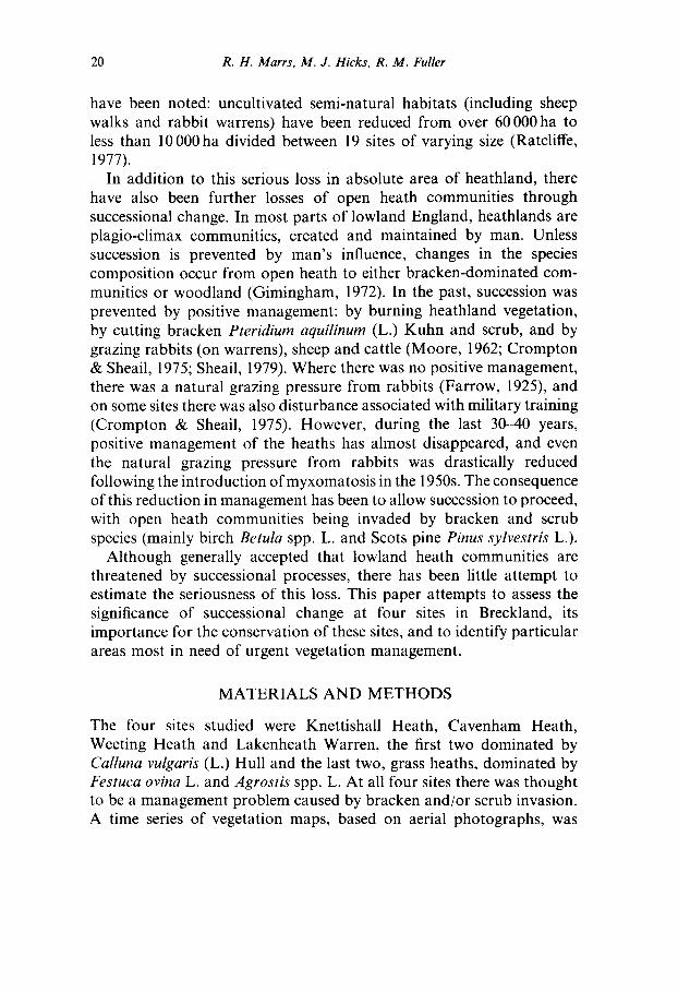
Scots pine Apart from a few trees planted around the Lodge (Point A, Fig. 7), there were no other mature trees on the Warren in 1946. However, by 1971 there had been substantial natural invasion with 183 ha, or 36%
Losses of lowland heaths through succession 31
o3
.o
co
.=.
e .
dT~ ¢..
c.,
©
©
©
e-
G
e~
tz
32 R. H. Marrs, M. J. Hicks, R. M. Fuller
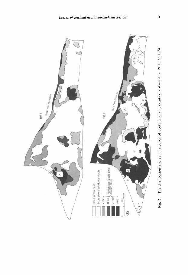
TABLE 5 Estimated Area (ha) of Lakenheath Warren (512 ha) covered by Scots Pine and Other Scrub Communities in 1971 and 1984
Community 1971 1984
Open 329 226 Scots pine + deciduous scrub a nd 39 Scots pine---canopy cover class ~
< 10% 141 95 11-30 % 18 6 31-60% 10 89
> 60% 14 57 Total woodland 183 286
a Mainly oak and hawthorn Crataegus monogyna Jacq. h A few specimens of Corsican pine Pinus nigra Arnold are also present.
of the site, having some degree of Scots pine invasion (Table 5). By 1984, there had been a further increase to 286ha, or 56% of the site. This figure for 1984 is an underestimate of the maximum extent reached as it does not include a small area cleared in 1983 (Point B, Fig. 7). Included in both of these estimates are areas which have a few scattered mature trees, but have abundant small seedlings and saplings; these areas are included in the < 10% canopy cover class (Table 5).
However, it is not just the increase in absolute area of pine that is of concern. The values for the different canopy classes (Table 5) show a rapid increase in the areas occupied by the denser canopy classes between 1971 and 1984. Most of the areas classified as < 10% in 1968 now have a canopy cover of > 3 0 % or even >60% (Fig. 8). Scots pine grows particularly well on Lakenheath Warren with annual leader increments of c. 0.5 m year- 1.
Thus, Scots pine is a major problem in Lakenheath Warren, and for management purposes three aspects can be identified:
(1) Present problem--areas where dense Scots pine is already present. (2) Short-term problem--areas where small pines are already present,
but these will probably grow quickly and cause major problems in 10-20 years.
(3) Long-term problem--open heath at present free from invasion; these areas must be considered at risk unless management to prevent invasion is implemented.

Losses of lowland heaths through succession 33
Fig. 8. Natural Scots pine invasion showing good growth increment at Lakenheath Warren.
Bracken Only the changes in the boundaries of the bracken communities are shown (Fig. 9). These maps show that there has been relatively little apparent increase in bracken area between 1918/22 and 1984, with a measured increase of only 24ha (Table 6). Moreover, as part of the south-west edge of the bracken was not clearly visible in 1918/22, this may be an overestimate of bracken increase. Between the two years when reliable full cover was available (1968 and 1984) there was an apparent increase of only 10ha (Table6), i.e. only 4.5% (<0"5%
TABLE 6 Estimated Areas of Bracken-dominated Communities at Lakenheath Warren between 1918/1922 and 1981
Date Area (ha J
1918/1922 206 1946 213 1968 220 1984 230

34 R. H. Marrs, M. J. Hicks, R. M. Fuller
V " - - - - . . Increase / ~ . 1968- 1984
I ] Decrease /1#"~ X~ " ~ ~- o 50°m res
Fig. 9. Changes in bracken boundaries between 1918/22-84and 1968 84 at Lakenheath Warren.
year-l). Nevertheless, there have been fluctuations around the margin, showing both advance and retreat of the front. The only place where bracken has been shown to encroach into areas previously free of bracken has been across Shaker's Road (Point A, Fig. 9).
It is apparent from these data that there has been relatively little bracken encroachment on this site. Moreover, this cannot be attributed to recent vegetation management. Cutting and removing bracken and its litter was common in the past (Crompton & Sheail, 1975), and some bracken was cut in 1935 and during the Second World War (Watt, 1954). In addition, during the war years the bracken area was overrun by tanks and was burnt at least twice, followed by a further fire in 1947 (Watt, 1954). However, since that time there has been no serious attempt

Losses of lowland heaths through succession 35
to manage bracken, except for a few small asulam trials, until a bracken- cutting programme, designed to increase the area of grass heath, was started in 1983 by the Suffolk Trust for Nature Conservation. Moreover, there has been no positive grazing management since 1956 (Crompton & Sheail, 1975). As it is unlikely that bracken is limited by management, natural factors such as frost and soil type may well be enough to check major bracken encroachment at this site (Watt, 1954, 1964).
Management Scots pine, rather than bracken, invasion is the major problem at Lakenheath Warren, and management is required to (1) control Scots pine invasion, (2) prevent further invasion and (3) improve the conser- vation value of the remaining grass heath which, in many places, is rank and overgrown. Some areas of the bracken and grass heath have been cut (1983 and 1984) and the cut material removed from the site. It is hoped to follow up this initial treatment with sheep grazing. These management treatments can only help to reduce the pine problem, especially from those areas considered as under threat in the short and medium term. Where dense pine is already present, more ruthless action is needed, with felling and removing of timber, following up with management to restore and maintain the heathland vegetation. Some felling has already been done but more is urgently needed.
CONCLUSIONS
The results from this paper show clearly that, in addition to absolute losses of lowland heath area (Moore, 1962: Armstrong, 1975), there have also been serious losses of open heathland habitat through successional processes in Breckland over the last 3(P40 years. The main problem for conservation is not so much that some losses occur, rather it is their magnitude that poses problems for the long-term future of these sites as heathlands. Two main types of successional loss were studied: loss to woodland (birch and Scots pine) and loss to bracken- dominated communities. The former problem is by far the more serious with massive woodland encroachment over the last 35 years, with increases in woodland in the mapped areas of 19% to 52% at Knettishall, 7% to 27% at Cavenham and 0% to 50% at Lakenheath. Bracken, although expanding slightly, is a less serious problem, mainly because
36 R. H. Marrs , M . J. H i ck s , R. M . ~ Fuller
most of the spread occurs around the margin of existing patches. Moreover, the results from Weeting Heath indicate that bracken can be held in check by minimal management along invading fronts.
Scrub encroachment, therefore, is the main problem that must be tackled for the conservation of these sites. The success of birch and Scots pine can be attributed to four main factors:
(1) Presence of an abundant, viable seed source. Birch woodland was present at Knettishall and Cavenham Heaths in 1946, and Scots pine plantations adjoin both Weeting Heath and Lakenheath Warren. Although seed production has not been measured at these sites, it is likely to be high. Estimates for seed production in birch woodlands range from 500-43 300 seeds m -2, with viabilities of 2-5-76% for birch and 2-90% for Scots pine (Miles & Kinnaird, 1979a).
(2) Seed dispersal. Although most seed falls near the parent (40- 50m for birch; 100m for Scots pine), establishment at greater distances has been recorded (Miles & Kinnaird, 1979a). Most lowland heaths are relatively small, and once parent trees are established, further rapid invasion occurs.
(3) Number of ~safe-sites' for germination and establishment. Most seed germinates and establishes in bare patches produced either by physical disturbance or by the death of mature plants. No information is available about the 'safe-site' requirements for birch and Scots pine in Breckland, but clearly there are enough to enable rapid encroachment!
(4) Grazing pressure. On lowland heaths the grazing pressure is very low, but in upland areas a high grazing pressure is one of the main factors preventing tree and shrub regeneration (Miles & Kinnaird, 1979a,b; Miller et al., 1982). Although the invasion of scrub species on lowland heaths has often been attributed to the low grazing pressure (Crompton & Sheail, 1975; Harrison, 1976), no attempt has been made to define the optimum levels of grazing required to maintain heathland without inducing deleterious change, such as from Calluna-dominated heathland to grass heath (Jones, 1967; Miles, 1979).
For practical conservation management, it is obvious that prevention is better than cure. Management to restrict further losses through succession should be implemented immediately; by mechanical treat-

Losses of lowland heaths through succession 37
ment, by increasing the grazing pressure, and by managing the Calluna heathland to maintain it in a young and vigorous condition (building and mature phases), by a combination of burning and cutting. Moreover, where mature seed-bearing trees are present on open heath, they should be felled immediately. If dense stands of trees (or bracken) are allowed to develop, intensive and costly management to restore the heath vegetation may be needed (Lowday, 1984b; Marrs & Lowday, 1983, 1984).
Although scrub invasion has been identified as a major factor in reducing open heathland at these four sites, it is impossible from these data to estimate the loss of the lowland heath resource through succession on a national basis. However, heathland loss through succession has been reported in other areas of Britain (Surrey--Harrison, 1976; Deeside--Marren, 1983); a more extensive study to estimate actual and potential losses of lowland heath is clearly needed.
A C K N O W L E D G E M E N T S
We would like to thank Elveden Farms (Lakenheath Warren), the Nature Conservancy Council (Cavenham Heath), the Norfolk Natural- ists' Trust (Weeting Heath) and Suffolk County Council (Knettishall Heath) for permission to work on their land, Mrs G. Crompton for help in interpretation of the aerial photographs from Lakenheath Warren, and Ms S. Ide for drawing the final maps. M.J.H. would like to thank the Suffolk Trust for Nature Conservation and the Nature Conservancy Council for financial support.
REFERENCES
Armstrong, P. (1975). The changing landscape. Lavenham, Dalton. Crompton, G. (1972). History of Lakenheath Warren: an historical study for
ecologists. Report to the Nature Conservancy, London (typescript). Crompton, G. & Sheail, J. (1975). The historical ecology of Lakenheath Warren
in Suffolk, England: a case study. Biol. Conserv., 8, 299-313. Farrow, E. P. (1925). Plant life on East Anglian heaths. London, Cambridge
University Press. Fuller, R. M. (1983). Aerial photographs of changing vegetation patterns. In
Ecological mapping from ground, air and space, ed. by R. M. Fuller, 57 69. Cambridge, Institute of Terrestrial Ecology.

38 R. H. Marrs, M. J. Hicks, R. M. Fuller
Fuller, R. M. (1984). Vegetation mapping of Broadland using aerial photographs. Institute of Terrestrial Ecology final report to Broads Authority. Cambridge, Institute of Terrestrial Ecology.
Gimingham, C. H. (1972). Ecology ofheathlands. London, Chapman & Hall. Harrison, C. M. (1976). Heathland management in Surrey, England. Biol.
Conserv., 10, 211-20. Jones, L. I. (1967). Studies on hill land in Wales. Tech. Bull. Welsh Plant Breed.
Sta., no. 2. Lowday, J. E. (1984a). The effects of cutting and asulam on the frond and
rhizome characteristics of bracken (Pteridium aquilinum (L.) Kuhn). Aspects of Applied Biology, 5, 275 82.
Lowday, J. E. (1984b). The restoration of heathland vegetation after control of dense bracken by asulam. Aspects of Applied Biology, 5, 283-90.
Marten, P. (1983). Heathland management and research at the Muir of Dinnet NNR. In Heathlandmanagement, ed. by L. Farrell, 103-7 (Focus on Nature Conservation, no. 7). Banbury, Nature Conservancy Council.
Marrs, R. H. & Lowday, J. E. (1983). Management of lowland heaths (CST Report, no. 491). Banbury, Nature Conservancy Council.
Marrs, R. H. & Lowday, J. E. (1984). Herbicidal control of weeds on nature reserves with special reference to lowland heaths. Annu. Rep. Inst. terr. Ecol., 1983, 3(~5.
Miles, J. (1979). Vegetation dynamics. London, Chapman & Hall. Miles, J. & Kinnaird, J. W. (1979a). The establishment and regeneration of
birch, juniper and Scots pine in the Scottish Highlands. Scott. For., 33, 103-19.
Miles, J. & Kinnaird, J. W. (1979b). Grazing: with particular reference to birch, juniper and Scots pine in the Scottish Highlands. Scott. For., 33, 280-90.
Miller, G. R., Kinnaird, J. W. & Cummins, R, P. (1982). Liability of saplings to browsing on a red deer range in the Scottish Highlands. J. appl. Ecol., 19, 941-51.
Moore, N. W. (1962). The heaths of Dorset and their conservation. J. Ecol., 50, 369 91.
Ratcliffe, D. A. (ed.) (1977). A nature conservation review, 1 and 2. Cambridge, Cambridge University Press.
Sheail, J. (1979). Documentary evidence of the changes in the use, management and appreciation of the grass-heaths of Breckland. J. Biogeogr., 6, 277- 92.
Watt, A. S. (1954). Contributions to the ecology of bracken (Pteridium aquilinum), VI. Frost and the advance and retreat of bracken. New Phytol., 53, 117-30.
Watt, A. S, (1964). Some factors affecting bracken in Breckland. J. Ecol., 52, 63 77.
Webb, N. R. & Haskins, L. E. (1980). An ecological survey of heathlands in the Poole Basin, Dorset, England, in 1978. Biol. Conserv., 17, 281-96.