los angeles county beach history
TRANSCRIPT

1
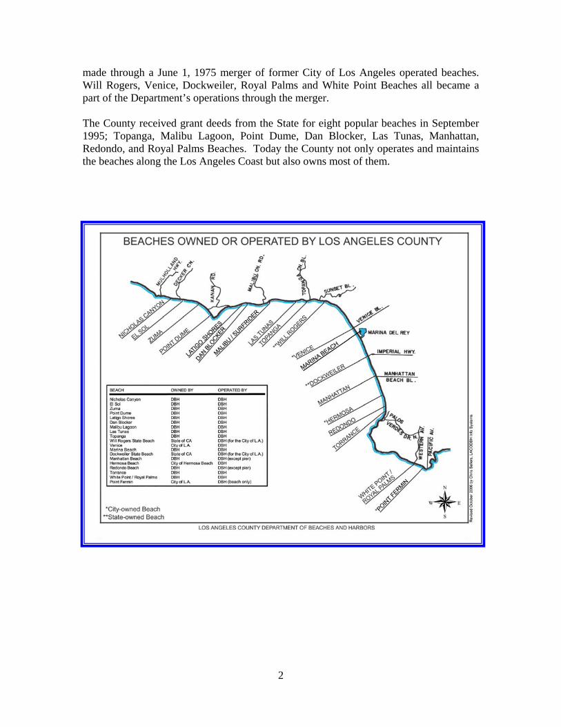
LOS ANGELES COUNTY BEACH HISTORY Los Angeles County beaches are some of the most recognizable and most popular beaches in the world. Malibu and Venice alone conjure up visions of surfers and eccentric sidewalk performers. Each year Los Angeles County beaches attract more than 50 million visitors, both tourists and locals alike. Over 25 miles of scenic sandy beaches and an abundance of ocean activities keep visitors entertained and coming back year after year. Los Angeles County owned or operated beaches stretch from Nicholas Canyon in Malibu to White Point/Royal Palms in San Pedro. Our beach facilities offer plenty of ample parking, clean restrooms, concession stands, fire pits, volleyball areas, picnic tables and playground equipment. All of our Los Angeles County beaches are patrolled by County Lifeguards, ensuring the safety of all beachgoers. Los Angeles beaches are full of history and culture and are as plentiful and diverse as the city itself. The following is an attempt to showcase the rich history associated with Los Angeles County beaches, as well as all they currently have to offer the average beachgoer. Beach Operations Most of the beaches located in Los Angeles are either owned and/or operated by Los Angeles County. The Department of Beaches and Harbors is responsible for the operation and maintenance of all County owned and operated beaches. The Department of Beaches, as it was first called, was created May 1, 1969 by the County Board of Supervisors. Prior to 1969, beach operations and activities were handled by the Department of Parks and Recreation. The newly formed Department of Beaches dedicated itself to the expansion of public beaches and the preservation of Los Angeles County coastal areas. Prior to the creation of the Department of Beaches, public access to local beaches was limited. New beaches had not been opened since 1945. The new Department of Beaches opened public access ways in Malibu and new beaches throughout the County for public use, thus quickly expanding its operations from 9.4 miles to 36.6 miles in its first seven years. Nicholas Canyon County Beach was the first beach acquired by the Department. The acquisition was made possible through a Federal Conservation Program Grant with $1.4 million in County matching funds. The beach was officially opened for public use July 1, 1973. In 1970, the Department entered into agreements to operate Hermosa City Beach and Malibu Lagoon State Beach. On July 1, 1971 the Department began to operate and maintain Las Tunas State Beach and on September 1, 1973 Topanga County Beach was also added to the Department’s operations. A major portion of the beach additions were
2
made through a June 1, 1975 merger of former City of Los Angeles operated beaches. Will Rogers, Venice, Dockweiler, Royal Palms and White Point Beaches all became a part of the Department’s operations through the merger. The County received grant deeds from the State for eight popular beaches in September 1995; Topanga, Malibu Lagoon, Point Dume, Dan Blocker, Las Tunas, Manhattan, Redondo, and Royal Palms Beaches. Today the County not only operates and maintains the beaches along the Los Angeles Coast but also owns most of them.

3
MALIBU BEACHES-Nicholas Canyon to Topanga The City of Malibu has the largest stretch of beaches in Los Angeles County. Malibu encompasses Nicholas Canyon, Zuma, Point Dume, Dan Blocker, Las Tunas, Topanga, and of course Malibu Surfrider and Malibu Lagoon. Today Malibu has some of the most expensive real estate in Los Angeles County and is home to the rich and famous. However, Malibu’s residents have not always been synonymous with fame and wealth. The Native American Chumash were the first group of people to reside in Malibu. The Chumash named the beach at the mouth of Malibu Creek “Humaliwo,” which means the surf sounds loudly. Humaliwo was one of the Chumash villages located along the California coast. The Chumash had settlements along the coast from Malibu to San Luis Obispo. Some of their village names can still be seen on current day maps such as Mugu, Ojai, and Zuma. Spanish settler Jose Bartolome Tapia made the first legal claim to land in Malibu in 1802. Tapia established a ranch, which became known as Rancho Topanga Malibu Simi Sequit. The land was passed down by inheritance until 1891 when the 13,330-acre ranch was sold to Frederick Hastings Rindge for $300,000. The sum, although large at the time, would not even buy a small vacant lot in Malibu today. The Rindge family later expanded the ranch to 17,000 acres. Frederick Rindge was a cultured and wealthy New Englander seeking an idyllic country home for his family. Rindge and his wife May turned the 17,000 acres into working cattle and grain-raising ranch that eventually became one of the most valuable real estate holdings in the United States. Frederick Rindge dies in 1905 and his wife May took over the management of the Malibu Ranch. May Rindge wanted to administrate her ranch in peace and fiercely guarded her family’s privacy. In 1904 the Southern Pacific Railroad applied to the Interstate Commerce Commission to build tracks right through the Malibu Ranch. In response May Rindge built her own 15 miles of tracks and successfully kept Southern Pacific away from her land. Her battle against the State of California was not as successful. The State obtained a right of way to build the Pacific Coast Highway through the ranch. This forced May Rindge to begin leasing property in Malibu to help pay for her extensive legal and tax bills. Today whenever rock and mud slides close Pacific Coast Highway, locals call it “Rindge’s revenge.” May Rindge established Malibu as a desirable location by leasing beach lots to movie stars of the day. Leases were made for 30 feet of ocean frontage at $30 per month on a 10-year lease. Studio carpenters were brought in to build cottages, averaging a cost of $2,600. The Malibu Beach Motion Picture Colony was born. Once the leases expired residents were able to purchase their lots. This led to the construction of larger, more
Frederick Rindge
4
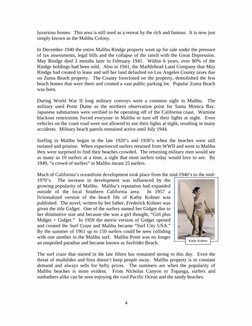
luxurious homes. This area is still used as a retreat by the rich and famous. It is now just simply known as the Malibu Colony. In December 1940 the entire Malibu Rindge property went up for sale under the pressure of tax assessments, legal bills and the collapse of the ranch with the Great Depression. May Rindge died 2 months later in February 1941. Within 6 years, over 80% of the Rindge holdings had been sold. Also in 1941, the Marblehead Land Company that May Rindge had created to lease and sell her land defaulted on Los Angeles County taxes due on Zuma Beach property. The County foreclosed on the property, demolished the few beach homes that were there and created a vast public parking lot. Popular Zuma Beach was born. During World War II long military convoys were a common sight in Malibu. The military used Point Dume as the northern observation point for Santa Monica Bay. Japanese submarines were verified to be operating off of the California coast. Wartime blackout restrictions forced everyone in Malibu to turn off their lights at night. Even vehicles on the coast road were not allowed to use their lights at night, resulting in many accidents. Military beach patrols remained active until July 1944. Surfing in Malibu began in the late 1920’s and 1930’s when the beaches were still isolated and pristine. When experienced surfers returned from WWII and went to Malibu they were surprised to find their beaches crowded. The returning military men would see as many as 10 surfers at a time, a sight that most surfers today would love to see. By 1949, “a crowd of surfers” in Malibu meant 25 surfers. Much of California’s oceanfront development took place from the mid-1940’s to the mid-1970’s. The increase in development was influenced by the growing popularity of Malibu. Malibu’s reputation had expanded outside of the local Southern California area. In 1957 a fictionalized version of the beach life of Kathy Kohner was published. The novel, written by her father, Frederick Kohner was given the title Gidget. One of the surfers named her Gidget due to her diminutive size and because she was a girl thought, “Girl plus Midget = Gidget.” In 1959 the movie version of Gidget opened and created the Surf Craze and Malibu became “Surf City USA.” By the summer of 1961 up to 150 surfers could be seen colliding with one another in the Malibu surf. Malibu Point was no longer an unspoiled paradise and became known as Surfrider Beach. The surf craze that started in the late fifties has remained strong to this day. Even the threat of mudslides and fires doesn’t keep people away. Malibu property is in constant demand and always sells for hefty prices. The summers are when the popularity of Malibu beaches is more evident. From Nicholas Canyon to Topanga, surfers and sunbathers alike can be seen enjoying the cool Pacific Ocean and the sandy beaches.
Kathy Kohner

5
Nicholas Canyon County Beach: 33850 Pacific Coast Hwy., Malibu, CA 90265
Nicholas Canyon is usually less crowded than most Malibu beaches. Surfers refer to this beach as “Zeros” or “Point Zero” and it is one of the few perfect point
breaks left in Los Angeles County. Nicholas Canyon is a great beach for surfing, body surfing, body boarding, swimming, windsailing, and scuba diving. With almost a mile of beach frontage and 23 acres of property it is also a great place to take the whole family. There are several picnic tables, upper and lower parking for 151 cars, restroom facilities, stairs to the beach, and plenty of room for sun bathing and other beach activities. For a more educational and cultural experience, visitors will be able to see an outdoor working Native American village. Located on a four-acre site at Nicholas Canyon County Beach, the Wishtoyo Foundation’s Chumash Village is open for guided tours and presentations, by appointment. The village showcases a typical day in the life of the Chumash people using replicas of Chumash homes, canoes, tools and handicrafts, ceremonies and celebrations. This offers the public and schoolchildren a unique and multi-sensory experience of what living in a Chumash Village was really like. Zuma County Beach: 30000 Blk of Pacific Coast Hwy., Malibu, CA 90265
Zuma is the ultimate Southern California beach: wide, extends for miles. Zuma Beach has 1.8 miles of beach frontage with 105 acres of property. There are eight parking lots with approximately 2000 parking spaces. Food stands are located at each end of the beach. Other amenities include restrooms, restaurants, showers, volleyball nets, and a bus stop. Beach wheelchairs are also available. The water at Zuma is a little colder than at other Los Angeles beaches but with its ample amenities and white sand it continues to be a perennial favorite with
residents and visitors alike. This beach has become popular for both swimming and body surfing; however, it is also known for its rough surf and riptides. Zuma also has

6
fishing, surfing, and windsurfing. Zuma is also a great place to watch grey whales make their winter migration. Point Dume County Beach: 7103 Westward Beach Rd., Malibu, CA 90265
Point Dume has over one mile of ocean frontage with 34 acres of sand. It is surrounded by headlands, cliffs, rocky coves, and vast beach access. Amenities include restrooms, showers, restaurants, 373 parking spaces, and a hiking trail. Popular activities include swimming, diving, surfing, fishing, and scuba diving. The hiking trail leads to an ancient coastal bluff sand dune. On a clear day visitors can enjoy
an incredible view encompassing the entire Santa Monica Bay and distant Catalina Island. A stairway from the east side of the bluff-top gives access to a more isolated beach with fine tide-pooling opportunities. Point Dume, just like Zuma is also a great place to watch grey whales during their December-March migration. Dan Blocker County Beach: 26000 Block of Pacific Coast Hwy., Malibu, CA 90265 This beach was originally donated to the State of California by Lorne Greene and Michael Landon of the TV series Bonanza in memory of Dan Blocker. Mr. Blocker played Eric Haas Cartwright, affectionately known as “Hoss” on the popular TV series. The State then transferred the property over to Los Angeles County in September 1995. With 15.2 acres of bluff and beach property and over one mile of ocean frontage, Dan Blocker State Beach draws surfers, divers, and scuba enthusiasts. Other activities at this beach include swimming and fishing. This beach has remained largely undeveloped, but Los Angeles County is currently in the process of creating additional public parking and access improvements. The project includes the development of the unimproved westerly portion of the beach to include a small paved parking lot, stairs to the beach, bluff-top ADA-compliant improvements, bluff-top trail development with protective railing, benches and picnic area with protective railing, a concrete pad and enclosure for chemical toilets on the bluff, new perimeter fencing, erosion control landscape for the bluff-top and slopes, an irrigation system, and interpretive signage for the tidepools.

7
Malibu Lagoon State Beach: 23050 & 23200 Pacific Coast Hwy., Malibu, CA 90265 What is known as Malibu Beach is comprised of the Malibu Lagoon, the Malibu Pier, and the area that is referred to by locals as “Surfrider” Beach. Although all of these areas are adjacent to each other, each element of Malibu Beach offers visitors a totally unique beach experience. Malibu Lagoon is comprised of 22 acres of wetlands, gardens, and sandy beach, while Malibu “Surfrider” Beach has almost a mile of ocean frontage with 0.7 acres of property, and famous Malibu Pier is a great place for saltwater fishing. For an educational experience, Malibu Lagoon State Beach is the place to go. The State-operated Malibu Lagoon is a resting and feeding estuary for more than 200 species of migrating and native birds, making this an ideal location for bird watching enthusiasts. There is also the saltwater marsh for those that want to study an ecosystem that is greatly diminished in Southern California. The Adamson House, a National Historic Site, houses many Malibu historical artifacts. The Malibu Lagoon Museum which adjoins the Adamson House, allows visitors to walk through the history of the area from the days of the Chumash tribe, to the gentlemen ranchers, and finally to the birth of the surfing era. Popularized by surfing movies in the 1950’s and 1960’s, “Surfrider” Beach is the place to go for the ideal Southern California surfing experience. This beach offers 90 parking spaces, restrooms and picnic facilities. Although this beach has some of the best surfing and swimming conditions in Los Angeles, swimming areas are limited. Las Tunas County Beach: 19444 Pacific Coast Hwy., Malibu, CA 90265 Las Tunas Beach is the southernmost beach in Malibu. It is far less populated and easier to access than some of its neighbors. This beach is more popular with fishermen and scuba divers. However, activities like swimming, surf fishing, and surfing are also practiced here. This beach is narrow and is located beneath the bluffs. Even though it is more private than other beaches it can get quite noisy due to the proximity of the road. There are restrooms available and parking is available on the street. The beach itself is partly sandy and partly rocky.
Malibu “Surfrider” Beach

8
Topanga County Beach: 18700 Pacific Coast Hwy., Malibu, CA 90265 With over an acre of ocean frontage and 21.5 acres of property Topanga Beach is the first real beach in Malibu. This is one of the most popular surfing spots in the area. The waves here break over cobblestones and reef so this is not an ideal swimming spot. Aside from surfing, many visit this beach to scuba dive, fish, and sunbath. This beach offers 96 parking spaces and beach wheelchairs are also available. There are also restrooms, a picnic area, and showers on site. Will Rogers State Beach: 17700 Pacific Coast Hwy., Pacific Palisades, CA 90272 This beach was named after Will Rogers, actor, philosopher, and cowboy. In the early 1930’s, Will Rogers was the most popular and highest paid actor in Hollywood. Despite the country’s economic hardships of the Great Depression, in 1930 Will Rogers was earning $300,000 a picture. He was also a radio star and his syndicated column was carried in more newspapers than that of any other writer. Will Rogers was killed in a plane crash in 1935. Ten thousand mourners filled the Hollywood Bowl to honor him, including virtually every movie star and studio executive in Hollywood. At the time of his death, he was still the number one star of 20th Century Fox Studios.
During the 1920’s Will Rogers bought land in Santa Monica, where he developed a ranch. Eventually he owned more than 300 acres overlooking the Pacific Ocean, in what is now known as Pacific Palisades. The ranch became the place where Rogers could relax with friends and family. The Rogers’ ranch consisted of a 31-room ranch house, a stable, corrals, riding ring, roping arena, polo field, golf course, and hiking trails. Will Rogers State Historic Park was created in 1944 when his widow, Betty, donated the family ranch house, stables, and land in Santa Monica to the State of California. Will Rogers State Beach was also donated by Betty from family-owned land.
Will Rogers State Beach has been operated by the County of Los Angeles since 1975. The beach has had numerous television shows and movies filmed on its shores, including the hit television show “Baywatch.” The beach also has over 3 miles of beach frontage and about 103 acres of beach. This beach is not as hectic with crowds as
Will Rogers

9
its neighboring beaches in Malibu and Santa Monica, but it does get its fair share in the summer. This beach is nice and sandy, perfect for sunbathing and it is also a great place to swim. The beach is great for families as well, since it is lined with plenty of volleyball courts and picnic tables. Surfing, surf fishing, sailing, and wind surfing are also popular activities at this beach. Beach wheelchairs are also available here. In its efforts to improve beach facilities, Los Angeles County has various capital projects in the works. The general improvements at Will Rogers State Beach were dedicated on July 23, 2007. The improvements at this beach included four new mission-style restrooms, a new lifeguard lookout and garage facility, parking lots, new landscaping, and the construction of new ADA-compliant access improvements as well as the redesign of the parking lot entrance at Temescal Canyon Road. VENICE BEACH HISTORY Venice of America was founded in 1905 as a beach resort town by tobacco millionaire Abbot Kinney. Before 1900 Venice Beach was nothing but marshland. Abbot Kinney had the vision of turning the desolate marshland into a renaissance resort and amusement park. Kinney envisioned a resort town culturally reminiscent of Venice, Italy, complete with canals, gondolas, amusement piers, hotels and Venetian-styled structures. On July 4, 1905, Kinney hosted the grand opening of his resort town featuring yacht racing, swimming races in the lagoon, band concerts, fireworks at the 2500 seat amphitheatre, and of course the 16 miles of newly built canals. He even brought a dozen gondoliers from Europe to pole through his shiny new paradise. Tourists were able to ride Venice’s miniature railroad and gondolas to tour the town. However, the biggest attraction was the mile-long gently sloping beach. Cottages and housekeeping tents were available for rent. Kinney also built a 1200-foot long pleasure pier with an auditorium, ship restaurant, and dance hall. Another main attraction of the pier was the salt-water plunge where visitors were given the choice of heated or ocean temperature bathing. The population grew quickly and drew 50,000 to 150,000 tourists on weekends, earning Venice the name “Playland of the Pacific.”
Venice Canal 1906 Photo Courtesy of Venice Historical Society

10
On November 4, 1920, Abbot Kinney died, leaving his eldest son to take over the business. One month later, his amusement pier burned to the ground, sparing only a couple of attractions. It was rebuilt and operating six months later. However, in 1924 the pier suffered another devastating fire that destroyed the entire complex. By 1925, Venice’s politics became unmanageable. The roads, water, and sewage systems were in need of much repair and expansion to
keep up with its growing population. That same year Venice was annexed to Los Angeles through a special election and officially became a part of the city in October 1925. The City of Los Angeles began to dismantle the amusement industry that Venice was known for. It removed the miniature railroad and filled the majority of the canals to accommodate increased automobile traffic. In 1929, oil was discovered and within two years 450 oil wells covered the area. The drilling waste clogged the remaining waterways. Only the canals south of Venice Boulevard remained intact. The city also wanted to close Venice’s three amusement piers but had to wait until the leases expired in 1946. World War II affected Venice and its seaside amusement centers. Blackouts were instituted, which only allowed daytime use of the piers and their attractions. National Guardsmen frequently patrolled the beaches in search of enemy submarines and ships. During the day, Venice became a major draw for sailors and soldiers on weekend leave. Life at Venice Beach did not return to normal until 1944, when the curfews were finally lifted. The City of Los Angeles had neglected Venice so long that by the 1950’s it had become known as the “Slum of the Sea.” With the exception of new police and fire stations in 1930, the city spent little on improvements after annexation. Cheap rents for run-down bungalow housing attracted predominantly European immigrants, young counterculture artists, poets, and writers. By the end of the 1950’s pawnshops and liquor stores had replaced the souvenir shops and bingo parlors that had attracted tourists to the area. Venice was in a severe state of decay and in need of redevelopment. In the early 1960’s the city instituted a policy of code enforcement, which required the upgrading of all buildings to the current building standards. The city made it impossible for owners to
Venice Pier 1928 Photo Courtesy of Venice Historical Society

11
obtain loans, and eventually 550 buildings were demolished paving the way for new construction. Venice always attracted whatever the counterculture of the decade was, be it the 50’s Beat generation, the hippies of the 60’s or the New Agers of the 70’s and 80’s. Despite its ups and downs throughout the years, Venice Beach is once again a magnet for tourists. Venice is the place that generates the image of the freewheeling, laid-back, eccentric and slightly crazed, yet creative and cutting edge city that many people envision Los Angeles to be. Venice City Beach: 2700-3100 Ocean Front Walk, Venice, CA 90291 Venice Beach has almost 3 miles of coastline with 238 acres of beach and 3 parking lots with over 1200 spaces. Venice Beach is understood to include the promenade that runs parallel to the beach (Ocean Front Walk), Muscle Beach, the tennis courts, Skate Dancing plaza, numerous volleyball courts, the bike trail, and of course the beach itself.
Venice Beach is one of the most interesting and popular sights in Los Angeles. Venice hosts artists, palm readers, bikini-clad roller skaters, belly dancers, vendors, street performers and of course bodybuilders. Legendary Muscle Beach is where now-Governor Arnold Schwarzenegger and others bulked up in the workout pit. The area is great for people watching as well as shopping and eating. There are various eateries along Ocean Front Walk. For those that are more inclined to actual beach activities,
swimming, beach volleyball, fishing, and surfing are popular at this beach. The Venice Breakwater is actually an acclaimed local surf spot. Bike and skate rentals are also available along Ocean Front Walk.

12
On August 2, 2007, Los Angeles County celebrated the completion of newly renovated and refurbished Venice Beach facilities. The improvements included new restrooms, refurbished and expanded parking lots, and three permanent concession buildings. The new improvements will enhance the experience of more than 5.5 million visitors who come from around the world to enjoy this popular beach. Marina County Beach: 4135 Admiralty Way, Marina del Rey, CA 90292
Marina County Beach or “Mother’s Beach” as it is referred to by local residents, is a family-friendly, kid-friendly, man-made beach in Marina del Rey. Developed as a part of Marina del Rey in 1957 and officially dedicated in 1965, this beach provides a safe
environment for kids because there is no surf in the swimming area. The area is comprised of almost a half-mile of sandy beach with volleyball courts, picnic areas, barbeques, showers, and restrooms. This is a great location for family outings, with playground equipment available for young children. Windsurfing and kayaking are popular activities at this beach. Beach wheelchairs are also available here, as is an ADA ramp down into the water. If a picnic is not your thing, there are plenty of restaurants within walking distance. “Mother’s Beach” is also a favorite place to watch the yearly New Year’s Eve and Fourth of July fireworks shows put on by the Los Angeles County Department of Beaches and Harbors.
DOCKWEILER STATE BEACH HISTORY Dockweiler State Beach is named after Isidore B. Dockweiler, a native son of California who lived from 1867 to 1947. Isidore was the youngest of four sons born to Henry and Margaretha Dockweiler. His father established the Dockweiler reputation in Los Angeles religious, political, and civic life. Isidore’s life mirrored that of his father: he was active in faith and political interests. He also received the first B.A. degree from St. Vincent’s College, which later became Loyola University. Isidore Dockweiler became a prominent Los Angeles
Mr. & Mrs. Isidore B. Dockweiler

13
lawyer, civic leader, and personage of the California Democratic Party. By the 1910’s, the Dockweiler law firm was powerful in Los Angeles, eventually counting among its many clients John Paul Getty, various Hollywood celebrities, the government of the Mexican state of Baja California, and corporations like Security-First National Bank. Intertwined with Isidore’s legal practice was his participation in Democratic Party politics. In 1902 Isidore was placed as lieutenant governor on Franklin Lane’s gubernatorial ticket. He even ran for senator in the Democratic primary in 1926, which he eventually lost. Isidore also served on the Democratic National Committee from 1916 to 1932. As a lawyer and as a Democrat, Isidore Dockweiler was influential resulting in his membership on numerous corporate boards. He also served as trustee of the State Normal School in San Diego and of St. Vincent’s College. Isidore was also instrumental in the growth of the Los Angeles Public Library, holding office as its president (1901-1911). He even served on the State Board of Parks and Beaches. In national politics, his relationship with President Woodrow Wilson led to his appointment to the Board of Indian Commissioners. The beach now known as Dockweiler State Beach was referred to as Moonstone Beach up until the 1930’s. It was leased to the City of Los Angeles by the State of California in 1946. The official name was Venice-Hyperion Beach State Park and it was renamed Isidore B. Dockweiler State Beach in January 1955 in honor of the prominent lawyer and civic leader. On May 24, 1955, the Men of Old St. Vincent’s made it official by placing a plaque at the newly renamed beach. The beach has been operated by the Los Angeles County Department of Beaches and Harbors for the City of Los Angeles since 1976. Dockweiler State Beach: 8255 Vista del Mar, Playa del Rey, CA 90293
Dockweiler State Beach has almost 4 miles of ocean frontage and 288 acres of beach. Amenities include restrooms, showers, picnic facilities, beach wheelchairs, fire rings, and volleyball nets. This beach also has a Recreational Vehicle Park with 117 full hook-up spaces. It is the only beachfront RV Park in Los Angeles County. The bicycle path is readily accessible, which many visitors use for roller-blading, jogging, and of course bicycling. At the north
end of the beach, jetties provide ideal fishing opportunities. The beach is quite expansive with lots of sand. In the summer it can get quite busy, especially towards the evening when everyone is trying to gather around one of the various fire rings. The only drawback here is its proximity to Los Angeles International

14
Airport; the noise can get quite loud for some. The nearby parking lots have over 1,200 spaces and there are so many activities available and plenty of room to do them in, that the jet noise above can be easily tolerated. In addition, the County has just renovated the beach facilities. On May 2, 2007, the County celebrated the renovations with a dedication ceremony. The improvements include the replacement of four restroom buildings, an entry kiosk, a renovated maintenance and lifeguard building, concession building, utility upgrades to the RV Park, new phone lines, signage, and landscaping and infiltration trenches to filter storm water runoff from parking lots to the beach. There are also plans to construct a youth center at the beach to serve as the southern headquarters of the County’s Water Awareness, Training, Education and Recreation (W.A.T.E.R.) Youth Program. Construction has already begun on this project and is scheduled to be complete in the spring of 2009. The building will consist of multi-purpose meeting and training facilities, a community room, administrative space, storage facilities and restroom and locker facilities. This program offers inner-city and at-risk children the opportunity to increase their awareness of ocean and beach safety through organized activities that provide skills, knowledge, and positive personal experiences.
MANHATTAN COUNTY BEACH HISTORY The first known inhabitants of present day Manhattan Beach were the Engnovangas Rancheria Indians. They survived off of corbina fish they harvested in the shallows along with other species of surf fish. In 1784 the Spanish government established ranchos (land parcels) along the South Bay. These land grants did not convey titles to the land; they simply gave permission to migrant farmers to use the land as they wished. What is now known as Manhattan Beach was part of the original Spanish land grant for Rancho Sausal Redondo. In the 1800’s the rancho extended from Playa del Rey to the north, Inglewood to the east, and Hermosa Beach to the south and consisted of nearly 25,000 acres of land. By the late 1880’s the land had already been divided and sold off to developers. Developers were plentiful but they agreed that the area should be given one name. George Peck, who owned the northern section of the area including Rosecrans, called his area Shore Acres and John Merrill, who owned the southern section called his area Manhattan. According to Frank Daugherty, another owner/developer, a half dollar coin was flipped to determine whose name would win. In 1902, with the toss of a coin “Manhattan” won and Manhattan Beach was born. Most of the early structures on the beach consisted of wooden beach cottages ranging from 300 to 1,100 square feet. They all appeared to be very alike and most were painted a rusty red. There was no gas, electricity, or indoor plumbing available. Water flowed in across the dunes through a pipe that frequently broke. Families would come from Pasadena and Los Angeles on the train or trolley and a real estate agent would greet them

15
as they stepped off. The area was promoted as a place to vacation, although some people stayed year-round. By the time of incorporation on December 7, 1912, there were approximately 600 permanent residents in Manhattan Beach.
Manhattan Beach was actually built on sand. Walkways disappeared into the sand and small structures would slide. Sand dunes were 50 to 70 feet high, creating a major problem. Leveling them off became a long and laborious task. In
the late 1920’s developers from Hawaii made a deal with the Kuhn Brothers Construction Company to supply Waikiki Beach with Manhattan Beach sand. The sand was loaded onto Santa Fe Railroad cars and transported to the harbor in San Pedro and then onto ships or barges. This process continued for almost 10 years, although Manhattan Beach is by no means flat. The area still has some sand dunes left, which are particularly obvious in the north end of Manhattan Beach where Sand Dune Park is located. So there’s no need to go all the way to Hawaii to walk on the same sand that’s right here in sunny Southern California. After World War II the desirability of the area for year-round living increased and a large number of people moved to Manhattan Beach as a result. Servicemen visiting during the war returned to live there. The development of the defense industry brought many people to the South Bay to reside and work. As a result much of the land east of Sepulveda Blvd. was developed to house the influx of people. Manhattan County Beach: 400-4500 The Strand, Manhattan Beach, CA 90266
Manhattan Beach has over 2 miles of ocean frontage and 115 acres of beautiful sandy beach. Parking is sufficient with over 450 public parking spaces. A 900-foot long pier, located at the end of Manhattan Beach Blvd, bisects the area. Fishing is permitted all year on the pier. Other activities include swimming, and surfing. There are also plenty of volleyball nets that extend all the way to
Manhattan Beach 1900’s

16
Hermosa Beach. The AVP Manhattan Beach Open is held every year in the summer, which also brings out a big crowd. The north end of the beach, referred to as El Porto, is an extremely popular surf spot where you can even take lessons. Beach wheelchairs are also available at this beach.
HERMOSA CITY BEACH HISTORY Hermosa Beach was originally part of the 1784 Rancho San Pedro Spanish land grant that later became the 10-mile ocean frontage of Rancho Sausal Redondo. In its early days, Hermosa Beach was one vast sweep of rolling hills covered with fields of grain. During certain seasons of the year large herds of sheep were grazed over the land. In 1900 a tract of 1,500 acres was purchased by real estate developers for $35 an acre. The development was named “Hermosa” (Spanish for beautiful). The development came courtesy of the Hermosa Beach Land and Water Co. When Hermosa Beach came into being, there was no Manhattan Beach and Redondo Beach was a busy seaport. The 2-mile stretch of white sandy beach mainly consisted of sand dunes and harsh winds. These conditions made living so close to the beach miserable for the first hardy pioneers. The first official survey was made in 1901 for the boardwalk on the Strand. A short time afterward, 500,000 feet of Oregon pine was installed along a mile and one-half of the Strand. Although most residents saw the project as a major achievement, high tides kept washing away portions of the boardwalk and the majority of it was replaced by cement in 1914. The first pier was also constructed entirely out of wood and extended 500 feet out into the ocean. The pier, constructed in 1904 by the Hermosa Beach Land and Water Company was partially washed away just like the boardwalk on the Strand. A new concrete pier, twice the size of the first, was built in 1913. Hermosa Beach was mainly a resort town up until the 1920’s. Most people attracted to the area during the summer had little interest in becoming full-time residents. Most of the full-time residents were elderly, retired persons. By 1930 the city had about 3,000 residents, but because of the stock market crash, growth came to a halt. Hundreds of foreclosures took place and an estimated 1,000 lots were taken back through tax default. Fishing off of the pier was no longer done for recreation but rather out of desperation. It was said that people were fishing for their supper. By 1940 the population had more than doubled to over 7,000 residents. World War II brought the expansion of the aircraft industry and with it a building boom and real estate price increases. By the mid 1950’s the population had again doubled in size. The fear that the city would revert back to economic hardships after World War II failed to materialize. By this time the thousands of new residents carried in by the economic boom had realized that Hermosa was not just a resort town but a great place to live and

17
raise their families. To this day Hermosa Beach continues to be a desirable and expensive place to live. Hermosa City Beach: Hermosa Ave. & 33rd St., Hermosa Beach, CA 90254 Hermosa Beach has almost 2 miles of ocean frontage with 94 acres of public beach. The city-owned beach runs along the Santa Monica Bay before running into King Harbor in Redondo Beach. Metered street parking is available and amenities include restrooms, nearby restaurants, showers, and playground equipment. Hermosa Beach is one of the most popular beaches in Los Angeles County due to the excellent surf, good swimming areas, and the various volleyball nets along the sand. Volleyball tournaments and surf festivals also take place throughout the year for visitors and residents to enjoy.
REDONDO COUNTY BEACH HISTORY The written history of the Redondo Beach area began in 1542 when Spanish explorer, Juan Rodriguez Cabrillo discovered Santa Monica Bay. Despite its discovery, the area remained a sleepy Indian village for more than 200 years. By 1784 Redondo Beach was a part of the 75,000 acre Spanish land grant named Rancho San Pedro. In 1837 the original San Pedro Land Grant was altered and a new land grant was issued to Antonio Ygnacio Avila consisting of 22,500 acres of land. On June 19, 1856, the U.S. District Court issued a decree of confirmation of title to Mr. Avila for Rancho Sausal Redondo. It was a rich farming and grazing area until the late 1800’s. In 1889, 433 acres of coastal tract was sold for $12,000 to the Redondo Beach Improvement Company. The owners Robert Thompson and John Ainsworth, promoted, developed, and sold the land that eventually became the nucleus of the city of Redondo Beach. By 1892 Redondo Beach became an incorporated city and served as an early Port of Los Angeles.

18
Redondo Beach was also the home of California’s first modern surfer. In 1907, Henry Huntington brought the ancient art of Hawaiian surfing to the California coast. He owned most of the properties in Redondo Beach and was eager to sell them to visiting Angelenos looking for a break from the heat of the greater Los Angeles basin. Huntington had seen Hawaiian beach boys surfing and decided to hire one of them; a young Hawaiian-English athlete named George Freeth to demonstrate the art of surfing for the entertainment of Redondo Beach visitors. George wanted to revive the art of surfing that he had seen depicted in old Polynesian paintings but found it difficult and had little success using the typical 16-foot hardwood boards. He cut them in half and unwittingly created the original long board which worked exceedingly well and made him the talk of the Hawaiian Islands. George exhibited his surfing prowess for Redondo Beach visitors twice a day in front of the Hotel Redondo. He was eventually made the official Redondo Beach lifeguard and the first lifeguard in Southern California. George organized and trained professional lifeguard corps and was also credited with inventing the torpedo rescue can, which is still used by modern lifeguards. From 1907 to 1915, George spread a surfing revolution that would eventually become a stable phenomenon on the California Coast. A memorial bronze statue of George Freeth was placed at the Redondo Beach Pier and it is often decorated with leis as tribute from surfers who visit from around the world. Other attractions such as sport fishing and amusements such as games, rides, and the largest salt water plunge in the world added to the excitement and appeal of Redondo Beach. However, with the completion of the San Pedro Harbor, Redondo’s popularity started to decline. Prohibition also caused the closure of popular Hotel Redondo. The $250,000 hotel closed its doors in 1925 and was sold for scrap lumber for a mere $300. During the Great Depression, gambling, complete with mobsters and shooting incidents found its way to Redondo Beach. Bingo parlors, chip games, and a casino were run in full view of the law between 1936 and 1940. A water-taxi was available for 25 cents per person to take visitors to the gambling ship Rex, which operated 3 miles off shore. In 1956, work began on the marina that Redondo Beach has today. King Harbor was named after United States Congressman Cecil R. King. Redondo experienced a population boom during this time. In 1940 the population was 13,092 and by 1965 it had increased to 54,772 residents. Today Redondo Beach is still considered and known as a tourist and resort destination.
George Freeth
19
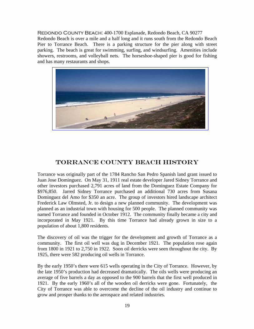
Redondo County Beach: 400-1700 Esplanade, Redondo Beach, CA 90277 Redondo Beach is over a mile and a half long and it runs south from the Redondo Beach Pier to Torrance Beach. There is a parking structure for the pier along with street parking. The beach is great for swimming, surfing, and windsurfing. Amenities include showers, restrooms, and volleyball nets. The horseshoe-shaped pier is good for fishing and has many restaurants and shops.
TORRANCE COUNTY BEACH HISTORY Torrance was originally part of the 1784 Rancho San Pedro Spanish land grant issued to Juan Jose Dominguez. On May 31, 1911 real estate developer Jared Sidney Torrance and other investors purchased 2,791 acres of land from the Dominguez Estate Company for $976,850. Jarred Sidney Torrance purchased an additional 730 acres from Susana Dominguez del Amo for $350 an acre. The group of investors hired landscape architect Frederick Law Olmsted, Jr. to design a new planned community. The development was planned as an industrial town with housing for 500 people. The planned community was named Torrance and founded in October 1912. The community finally became a city and incorporated in May 1921. By this time Torrance had already grown in size to a population of about 1,800 residents. The discovery of oil was the trigger for the development and growth of Torrance as a community. The first oil well was dug in December 1921. The population rose again from 1800 in 1921 to 2,750 in 1922. Soon oil derricks were seen throughout the city. By 1925, there were 582 producing oil wells in Torrance. By the early 1950’s there were 615 wells operating in the City of Torrance. However, by the late 1950’s production had decreased dramatically. The oils wells were producing an average of five barrels a day as opposed to the 900 barrels that the first well produced in 1921. By the early 1960’s all of the wooden oil derricks were gone. Fortunately, the City of Torrance was able to overcome the decline of the oil industry and continue to grow and prosper thanks to the aerospace and related industries.

20
The beach itself has been widely popular among local residents and was even used in one of the 1960’s Batman TV series episodes. From 1931 to 1958 Torrance Beach was the home of the Hollywood Riviera Beach Club. When the building mysteriously burned down the beach was given the nickname, “Burn Out Beach.” In 1959 an access path, restrooms and a snack shack were built on the southern end of the beach. In 2002, Torrance Beach underwent a huge construction makeover. The snack shack was torn down for a new, more modern concession stand. Ramps and stairs providing access to the beach were built and/or upgraded. The parking lots at the top of the bluff were repaved and a new restroom and shower facility was also built. Torrance Beach is also part of a bluff restoration project which replaces all ice plants with native plants. Torrance County Beach: 387 Paseo de la Playa, Torrance, CA 90501 Torrance Beach lies between Redondo Beach and Malaga Cove. The region shared by Torrance and Redondo Beaches is often called “Rat Beach” (short for “Right After Torrance” Beach or “Redondo and Torrance Beach”). This beautiful, soft sand beach has
40 acres of beach and is at the foot of cliffs which extend to the Palos Verdes Peninsula. There are over 300 parking spaces and amenities include restrooms, a concession stand, showers, bike path, beach wheelchairs, and volleyball nets. Torrance Beach is great for swimming, fishing, scuba and skin diving, and surfing.
WHITE POINT/ROYAL PALMS COUNTY BEACH
HISTORY The area known today as White Point/Royal Palms Beach was discovered by Spanish explorers around 1770. They encountered a group of native people later known as the Gabrielino. They were named after the San Gabriel Mission founded by the Spanish. The Gabrielino were a hunter/gather group who lived in small sedentary groups of 50 to 100 people. They relied heavily on plant foods and meat from marine resources. With the Spanish colonization at the end of the 18th century, this native culture disappeared.

21
In 1784, the area became part of California’s first private land concession when a Spanish soldier named Juan Jose Dominguez received 75,000 acres in recognition for his service to the Crown. The land grant was named Rancho San Pedro. In 1827, Manuel Dominguez, the nephew of Juan Jose Dominguez, sold about two-thirds of the Rancho to Jose Dolores Sepulveda. Sepulveda named it Rancho de los Palos Verdes and used it primarily as a cattle ranch. By the 1860’s flood and drought had ravaged the Rancho’s cattle and crops.
In 1898, 12 fishermen arrived from what was the small town of Los Angeles and discovered the abundance of lobster and abalone at the reef. The current owner, Ramon Sepulveda, built housing for them and leased the beachfront land to the fishermen. Soon they were harvesting two tons of abalone a day. They also harvested lobster, octopus, red crab, sea urchins, and sea snails. In 1906, with the stocks of abalone close to depletion, the state legislature restricted the take of abalone and the operation folded.
The discovery of geothermal sulfur hot springs soon revived the area. In 1917, Tojuro Tagami and his brother Tamiji, in partnership with Ramon Sepulveda, built a bathhouse and resort around the natural sulfur spring. They blasted roads and dug out the sulfur hot spring. By 1925 the resort was
completed and consisted of a 2-story hotel and restaurant, three salt water plunges, an enclosed boating area and the bathhouse. The White Point Hot Spring Hotel, as it was called, was highly popular in the 1920’s and 1930’s. It was a favorite place for Japanese-Americans to come for picnics and entertainment. Then in 1933 the Long Beach earthquake closed the vent from which the sulfur water was pumped out to the baths. This, along with the economic depression, forced the resort to close in the late 1930’s. The Japanese farmers at White Point were forced to leave following the bombing of Pearl Harbor. On February 7, 1942, federal agents raided the community and by April the families had been moved to internment camps. During World War II, White Point was taken by the federal government and incorporated into the Coastal Defense system of Fort MacArthur. The spa and resort were demolished. After the war, Fort MacArthur still served as a training base and eventually became an antiaircraft missile site. By 1974, the missile sites had become obsolete and were shut down. In 1978 the Federal Government transferred the 30-acres that comprise White Point Beach over to Los Angeles County under the “Federal Lands to Parks” program. On June 5, 1997, a new park complex was dedicated on the site. Palm-shaded picnic tables, new restroom facilities, and a new children’s play area were built by the Department of Beaches and Harbors with $2 million in bond funds. The dedication’s guests included descendants of the Tagami family, who built and operated the hotel and spa that had made the area so popular decades before.
Japanese Fishermen San Pedro Bay
Historical Society

22
White Point/Royal Palms County Beach: 1799 Paseo del Mar, San Pedro, CA 90732 This beach, with its colorful history, is a great place for a family outing. The bluff
portion of this beach has metered parking, ample restrooms, children’s play area, picnic tables, and outstanding panoramic views that include Catalina Island. There are also 12 brass plaques placed throughout the bluff describing the area’s rich history. The paved road below leads to the actual beach and more parking below. The large patio to the right is what is left of the Royal Palms Recreation Center. Benches
shaded by palm trees make this spot perfect for picnics. To the left of the road, White Point offers some of the most diverse tidepools in Southern California. The area itself is great for fishing, surfing, and scuba diving. Swimming is not recommended due to the rocky shore. With over a mile and a half of rocky beach, 30-acres of park area, and plenty of parking, this beach is one of the County’s hidden gems.
White Point County Beach
Royal Palms County Beach
White Point County Beach