loomis lake report i may, 2013 - interbasin...
TRANSCRIPT

Loomis Lake Report
May, 2013
i


Loomis Lake Report
May, 2013
access the Lake because it would have to navigate its way up the headwaters of Crooked Creek to the twin 24-inch (61 cm) diameter outfall pipes from Flint Lake, jump the roughly one foot (30 cm) difference in elevation from the creek into one of the discharge pipes, swim up the pipe into Flint Lake, and then swim up a primary spillway conduit from Loomis Lake during a time when it is fully inundated and the water velocity is estimated to be 7.5 feet per second (2.3 meters per second). Also, the ANS would need to pass through primary and secondary trash racks to access Loomis Lake. Consequently, the viability of the Loomis Lake aquatic pathway to facilitate the interbasin spread of ANS was deemed to be low by an interagency team because it was found to be unlikely for any of the species of concern to this location to be able to reach Loomis Lake solely through the aquatic pathway.
However, should an ANS be introduced into Loomis Lake or Spectacle Lake, it would then likely be able to spread into either basin through the primary spillway from Loomis Lake into Flint Lake, or during larger flood events from Loomis Lake through the auxiliary spillway into the headwaters of Damon Run. One way ANS could be introduced to either Spectacle Lake or Loomis Lake is through the release of live bait, which may inadvertently contain ANS. Another is by ANS attachment to recreational boats and other portable marine equipment while in one basin, which are then transported over land and placed in either lake. Direct human release of imported aquaria fish or other exotic species into Loomis or Spectacle Lakes could also result in the spread of ANS into the Mississippi
Executive Summary
The divide between the Great Lakes and the Mississippi River Basins extends north-south just to the east of Loomis Lake, located north of the city of Valparaiso, Indiana. However, Loomis Lake drains into both basins through a culverted primary spillway (to the Mississippi River Basin) and through an auxiliary spillway at Proffitts Dam (to the Great Lakes Basin). The auxiliary spillway at Proffitts Dam is used periodically to discharge excessive lake water into the headwaters of Damon Run, which is part of the Salt Creek Watershed draining to the Little Calumet River. The lake’s drainage to the Mississippi River Basin is through an underground 900-foot (274 m) long culvert to the adjacent Flint Lake which then empties into Crooked Creek through two 24-inch (61 cm) diameter corrugated metal pipes. Crooked Creek is a tributary of the Kankakee River.
This site was determined capable of conveying water across the basin divide toward the Mississippi River Basin continuously for multiple days from a ten percent annual recurrence interval storm event through the underground culvert from Loomis Lake to the adjacent Flint Lake. However, it is unlikely if not impossible for water to flow in the opposite direction from Flint Lake into Loomis Lake because Loomis Lake is perched approximately 17-feet (5.2 m) higher in elevation than Flint Lake. The probability of a flow connection from the Great Lakes Basin to the Mississippi River Basin was rated as “medium” and the probability of a flow connection from Mississippi River Basin to Great Lakes Basin was rated “low”.
As a result of this medium rating for the existence of a pathway at Loomis Lake, the viability of the aquatic pathway for specific ANS of concern was then evaluated by looking at the biological requirements and capabilities of the nine ANS listed in the adjacent table.
That evaluation concluded that any ANS from the Great Lakes that made its way up the headwaters of Damon Run to the base of Proffits Dam would be unable to then scale the auxiliary spillway and enter Loomis Lake during the brief periods when water flows through the auxiliary spillway. Likewise, the evaluation concluded that any ANS attempting to access the Loomis Lake aquatic pathway from the Mississippi River Basin would be unable to
Aquatic Nuisance Species of Concern
Species Common Name
Hypophthalmichthys molitrix Silver Carp
Hypophthalmichthys nobilis Bighead Carp
Mylopharyngodon piceus Black Carp
Channa argus Northern Snakehead
Gasterosteus aculeatus Threespine Stickleback
Gymnocephalus cernua Ruffe
Proterorhinus semilunaris Tubenose Goby
Neoergasilus japonicus Parasitic Copepod
Novirhabdovirus sp Viral Hemorrhagic Septicemia Virus (VHSv)

Loomis Lake Report
May, 2013
River Basin and perhaps the Great Lakes Basin. So while the viability of the aquatic pathway at Loomis Lake to facilitate the interbasin spread of ANS is low, it is in a unique geographic location where development and implementation of some site specific measures may be appropriate.
Loomis Lake Report
May, 2013
i
Table of Contents1 Introduction . . . . . . . . . . . . . . . . . . . . . . . . . . . . . . . . . . . . . . . . . . . . . . . . . . . . . . . . . . . . . . . . . . . . . . . . . . . . . . 1 1.1 Study Purpose . . . . . . . . . . . . . . . . . . . . . . . . . . . . . . . . . . . . . . . . . . . . . . . . . . . . . . . . . . . . . . . . . . . . . . . 1 1.2 Summary of 2010 Preliminary Risk Characterization for Loomis Lake, Indiana.. . . . . . . . . . . . . . . . . . . . . 3 1.3 Aquatic Pathway Team . . . . . . . . . . . . . . . . . . . . . . . . . . . . . . . . . . . . . . . . . . . . . . . . . . . . . . . . . . . . . . . . 42 Study Methodology . . . . . . . . . . . . . . . . . . . . . . . . . . . . . . . . . . . . . . . . . . . . . . . . . . . . . . . . . . . . . . . . . . . . . . . . 5 2.1 Coordination . . . . . . . . . . . . . . . . . . . . . . . . . . . . . . . . . . . . . . . . . . . . . . . . . . . . . . . . . . . . . . . . . . . . . . . . 5 2.2 Identification of Potential Pathways. . . . . . . . . . . . . . . . . . . . . . . . . . . . . . . . . . . . . . . . . . . . . . . . . . . . . . . 5 2.3 Aquatic Nuisance Species of Concern . . . . . . . . . . . . . . . . . . . . . . . . . . . . . . . . . . . . . . . . . . . . . . . . . . . . 6 2.3.1 Lists of Non-indigenous Species in Great Lakes and Mississippi River Basins . . . . . . . . . . . . . . . . . . 6 2.3.2 List of ANS of Concern for GLMRIS . . . . . . . . . . . . . . . . . . . . . . . . . . . . . . . . . . . . . . . . . . . . . . . . . . . 6 2.3.3 List of ANS of Specific Concern at the Loomis Lake Location . . . . . . . . . . . . . . . . . . . . . . . . . . . . . . . 7 2.3.4 Key Attributes of Selected Organisms. . . . . . . . . . . . . . . . . . . . . . . . . . . . . . . . . . . . . . . . . . . . . . . . . 12 2.4 Pathway Assessment Process . . . . . . . . . . . . . . . . . . . . . . . . . . . . . . . . . . . . . . . . . . . . . . . . . . . . . . . . . 12 2.5 Example Calculation of Overall Aquatic Pathway Viability. . . . . . . . . . . . . . . . . . . . . . . . . . . . . . . . . . . . . 143 Aquatic Pathway Characterization. . . . . . . . . . . . . . . . . . . . . . . . . . . . . . . . . . . . . . . . . . . . . . . . . . . . . . . . . . . . 14 3.1 Location . . . . . . . . . . . . . . . . . . . . . . . . . . . . . . . . . . . . . . . . . . . . . . . . . . . . . . . . . . . . . . . . . . . . . . . . . . . 16 3.2 Climate . . . . . . . . . . . . . . . . . . . . . . . . . . . . . . . . . . . . . . . . . . . . . . . . . . . . . . . . . . . . . . . . . . . . . . . . . . . 20 3.3 Location Specific Surface Water Features . . . . . . . . . . . . . . . . . . . . . . . . . . . . . . . . . . . . . . . . . . . . . . . . 20 3.4 Groundwater . . . . . . . . . . . . . . . . . . . . . . . . . . . . . . . . . . . . . . . . . . . . . . . . . . . . . . . . . . . . . . . . . . . . . . . 31 3.5 Aquatic Pathway Temporal Characteristics . . . . . . . . . . . . . . . . . . . . . . . . . . . . . . . . . . . . . . . . . . . . . . . . 31 3.6 Probability Aquatic Pathway Exists . . . . . . . . . . . . . . . . . . . . . . . . . . . . . . . . . . . . . . . . . . . . . . . . . . . . . . 32 3.7 Aquatic Pathway Habitat . . . . . . . . . . . . . . . . . . . . . . . . . . . . . . . . . . . . . . . . . . . . . . . . . . . . . . . . . . . . . . 33 3.7.1 Terrestrial and Riparian Plants and Land Use. . . . . . . . . . . . . . . . . . . . . . . . . . . . . . . . . . . . . . . . . . . 33 3.7.2 Aquatic Resources . . . . . . . . . . . . . . . . . . . . . . . . . . . . . . . . . . . . . . . . . . . . . . . . . . . . . . . . . . . . . . . 33 3.7.3 Water Quality. . . . . . . . . . . . . . . . . . . . . . . . . . . . . . . . . . . . . . . . . . . . . . . . . . . . . . . . . . . . . . . . . . . . 36 3.7.4 Aquatic Organisms . . . . . . . . . . . . . . . . . . . . . . . . . . . . . . . . . . . . . . . . . . . . . . . . . . . . . . . . . . . . . . . 36 3.8 Connecting Streams to Great Lakes and Mississippi or Ohio River . . . . . . . . . . . . . . . . . . . . . . . . . . . . . 374 Aquatic Pathway Viability for ANS of Concern. . . . . . . . . . . . . . . . . . . . . . . . . . . . . . . . . . . . . . . . . . . . . . . . . . . 38 4.1 Probability of Target ANS being within Either Basin . . . . . . . . . . . . . . . . . . . . . . . . . . . . . . . . . . . . . . . . . 39 4.2 Probability Target ANS Survives Transit to Reach Aquatic Pathway . . . . . . . . . . . . . . . . . . . . . . . . . . . . . 41 4.2.1 Probability of ANS Surviving Transit to Aquatic Pathway Through Connecting Streams . . . . . . . . . . 41 4.2.2 Probability of ANS Surviving Transit to Aquatic Pathway through Other Means . . . . . . . . . . . . . . . . . 43 4.3 Probability of ANS Establishment in Proximity to the Aquatic Pathway. . . . . . . . . . . . . . . . . . . . . . . . . . . 44 4.4 Probability of ANS Spreading Across Aquatic Pathway into New Basin . . . . . . . . . . . . . . . . . . . . . . . . . . 435 Overall Aquatic Pathway Viability . . . . . . . . . . . . . . . . . . . . . . . . . . . . . . . . . . . . . . . . . . . . . . . . . . . . . . . . . . . . 456 Conclusions. . . . . . . . . . . . . . . . . . . . . . . . . . . . . . . . . . . . . . . . . . . . . . . . . . . . . . . . . . . . . . . . . . . . . . . . . . . . . 46 6.1 Loomis Lake Opportunity Statements . . . . . . . . . . . . . . . . . . . . . . . . . . . . . . . . . . . . . . . . . . . . . . . . . . . . 467 References . . . . . . . . . . . . . . . . . . . . . . . . . . . . . . . . . . . . . . . . . . . . . . . . . . . . . . . . . . . . . . . . . . . . . . . . . . . . . 48Appendix A: Evaluation Forms

Loomis Lake Report
May, 2013
ii
List of TablesTable 1: ANS of Concern for GLMRIS . . . . . . . . . . . . . . . . . . . . . . . . . . . . . . . . . . . . . . . . . . . . . . . . . . . . . . . . . . . 8Table 2: ANS of Concern Threatening the Mississippi River Basin . . . . . . . . . . . . . . . . . . . . . . . . . . . . . . . . . . . . . 9Table 3: ANS of Concern Threatening the Great Lakes Basin . . . . . . . . . . . . . . . . . . . . . . . . . . . . . . . . . . . . . . . . . 9Table 4: ANS of Greatest Concern at Loomis Lake. . . . . . . . . . . . . . . . . . . . . . . . . . . . . . . . . . . . . . . . . . . . . . . . . 12Table 5. Example calculation of pathway viability for ANS spreading from Mississippi River Basin to the Great
Lakes Basin . . . . . . . . . . . . . . . . . . . . . . . . . . . . . . . . . . . . . . . . . . . . . . . . . . . . . . . . . . . . . . . . . . . . . . . 16Table 6. Example calculation of pathway viability for ANS spreading from Great Lakes Basin to the Mississippi
River Basin.. . . . . . . . . . . . . . . . . . . . . . . . . . . . . . . . . . . . . . . . . . . . . . . . . . . . . . . . . . . . . . . . . . . . . . . . 16Table 7: Obstacles in Connecting Streams to ANS Movement. . . . . . . . . . . . . . . . . . . . . . . . . . . . . . . . . . . . . . . . 38Table 8: Overall Pathway Viability Rating (Mississippi River Basin to Great Lakes Basin) . . . . . . . . . . . . . . . . . . 45Table 9: Overall Pathway Viability Rating (Great Lakes Basin to Mississippi River Basin) . . . . . . . . . . . . . . . . . . 45
List of FiguresFigure 1: Potential Other Aquatic Pathway Locations Identified in GLMRIS . . . . . . . . . . . . . . . . . . . . . . . . . . . . . . 2Figure 2: Map of known ANS occurrences near Loomis Lake (site number 7) (Source: USGS, 2011) . . . . . . . . . 10Figure 3: Map of ANS Occurrences Near Lake Michigan. . . . . . . . . . . . . . . . . . . . . . . . . . . . . . . . . . . . . . . . . . . . 11Figure 4. Diagram of the derivation of the GLMRIS Focus Area 2 Aquatic Pathway Assessment Model . . . . . . . 15Figure 5. Loomis and Flint Lakes USGS topographic map, north of the City of Valparaiso, Indiana . . . . . . . . . . . 17Figure 6. Aerial Photo of Loomis and Flint Lakes Location . . . . . . . . . . . . . . . . . . . . . . . . . . . . . . . . . . . . . . . . . . 18Figure 7. Surface Water Features and Watershed Boundaries in Proximity to Loomis Lake. . . . . . . . . . . . . . . . . 19Figure 8. Enlarged Plan View Map of Loomis and Flint Lakes . . . . . . . . . . . . . . . . . . . . . . . . . . . . . . . . . . . . . . . . 21Figure 9. Proffitts Dam on Loomis Lake, Looking West . . . . . . . . . . . . . . . . . . . . . . . . . . . . . . . . . . . . . . . . . . . . . 22Figure 10. Proffitts Dam on Loomis Lake, Looking Southwest. . . . . . . . . . . . . . . . . . . . . . . . . . . . . . . . . . . . . . . . 22Figure 11. Location of Cross-Section through Basin Divide between Loomis Lake and Flint Lake . . . . . . . . . . . . 24Figure 12. Location of Loomis Lake Auxiliary Outflow to Damon Run . . . . . . . . . . . . . . . . . . . . . . . . . . . . . . . . . . 25Figure 13. Location of Profile along Crooked Creek Downstream from Flint Lake. . . . . . . . . . . . . . . . . . . . . . . . . 26Figure 14. Loomis Lake Grated Drop Box Inlet Structure. . . . . . . . . . . . . . . . . . . . . . . . . . . . . . . . . . . . . . . . . . . . 27Figure 15. Loomis Lake Concrete Channel Auxiliary Spillway to Damon Run . . . . . . . . . . . . . . . . . . . . . . . . . . . . 29Figure 16. Damon Run Downstream from Proffitts Dam. . . . . . . . . . . . . . . . . . . . . . . . . . . . . . . . . . . . . . . . . . . . . 29Figure 17: View of Outflow from Flint Lake into Crooked Creek. . . . . . . . . . . . . . . . . . . . . . . . . . . . . . . . . . . . . . . 30Figure 18: Bathometry Map of Loomis Lake. . . . . . . . . . . . . . . . . . . . . . . . . . . . . . . . . . . . . . . . . . . . . . . . . . . . . . 34

Loomis Lake Report
May, 2013
Acronyms
ANS . . . . . . Aquatic Nuisance SpeciesANSTF . . . . Aquatic Nuisance Species Task ForceCAWS . . . . Chicago Area Waterway SystemCEQ . . . . . . Council on Environmental QualityDEM . . . . . . Digital Elevation ModelFEMA . . . . . Federal Emergency Management AgencyGIS . . . . . . Geographic Information SystemGLFC . . . . . Great Lakes Fishery CommissionGLMRIS . . . Great Lakes and Mississippi River Interbasin StudyHUC . . . . . . Hyrdologic Unit CodesIBI . . . . . . . Index of Biological IntegrityIDEM . . . . . Indiana Department of Environmental ManagementITSI . . . . . . Indiana Trophic State IndexINDNR . . . . Indiana Department of Natural ResourcesNAS . . . . . . Nonindigenous Aquatic SpeciesNEPA . . . . . National Environmental Policy ActNOAA. . . . . National Oceanic and Atmospheric AdministrationNRCS . . . . Natural Resources Conservation ServiceQHEI . . . . . Qualitative Habitat Evaluation IndexTP . . . . . . . Total PhosphorusUSACE . . . U.S. Army Corps of EngineersUSFWS . . . U.S. Fish and Wildlife ServiceUSGS . . . . U.S. Geological SurveyVLACD. . . . Valparaiso Lakes Area Conservation DistrictWRDA . . . . Water Resources Development Act
iii

Loomis Lake Report
May, 2013
1
GLMRIS. These two locations are the CAWS in Chicago, Illinois and Eagle Marsh in Fort Wayne, Indiana. To help accelerate completion of the feasibility study, the Great Lakes and Ohio River Division split management of the GLMRIS into two separate focus areas. Focus Area 1 is managed by the USACE, Chicago District and addresses the CAWS that open to Lake Michigan. Focus Area 2 is managed by the USACE, Buffalo District and evaluates all other potential aquatic pathways that exist or are likely to form across the basin divide separating runoff that flows into the Mississippi River and its tributaries from runoff that flows into the Great Lakes and its tributaries.
1.1 Study Purpose The preliminary report from 2010 and the subsequent analysis contained in this report have been produced for a broad audience ranging from the scientific community to the general public, and are specifically intended to identify any locations where an aquatic pathway exists or may form between the basins from up to a one percent annual recurrence interval flood event, and to evaluate the probability that specific ANS would be able to arrive at that pathway and cross into the new basin. The information in this and the other Focus Area 2 reports are intended to provide a sound scientific basis for helping to prioritize future funding of GLMRIS and/or other actions at these potential aquatic pathway locations.
A recurrence interval relates any given storm, through statistical analysis, to the historical records of rainfall and runoff for a given area. The recurrence interval is based on the statistical probability that a given intensity storm event will be equaled or exceeded in any given year. For instance, a one percent annual recurrence interval storm is a rainfall event that has a one percent probability, one chance in 100, of being equaled or exceeded in any given year. This level of storm event was commonly referred to as a 100-year storm event, but this term has led people to incorrectly conclude that a 100-year storm event is one that only occurs once in any given 100 year period. A ten percent annual return frequency storm (formerly referred to as a ten year event) is a smaller event that has a one in ten chance of being exceed during any given year, and a 0.2 percent
1 Introduction
The Great Lakes and Mississippi River Interbasin Study (GLMRIS) was authorized in Section 3061(d) of the Water Resources Development Act of 2007, and therein, it prescribes the following authority to the Secretary of the Army and the U.S. Army Corps of Engineers (USACE) (WRDA, 2007):
“(d) FEASIBILITY STUDY. - The Secretary, in consultation with appropriate Federal, State, local, and nongovernmental entities, shall conduct, at Federal expense, a feasibility study of the range of options and technologies available to prevent the spread of aquatic nuisance species between the Great Lakes and Mississippi River Basins through the Chicago Sanitary and Ship Canal and other aquatic pathways.”
This GLMRIS Focus Area 2 Aquatic Pathway Assessment report addresses the Loomis Lake location in Porter County, Indiana. This location is one of 18 locations identified in the Great Lakes and Mississippi River Interbasin Study Other Pathways Preliminary Risk Characterization as a potential aquatic pathway spanning the watershed divide between the Great Lakes and Mississippi River Basins outside of the Chicago Area Waterway System (CAWS) (USACE, 2010). This report is downloadable from the GLMRIS web site (glmris.anl.gov/).
The dashed line in Figure 1 depicts the nearly 1,500-mile (2,414 kilometer) basin divide from the New York - Pennsylvania state line to north eastern Minnesota, and it depicts each of the 18 potential aquatic pathway locations that were previously identified. The Loomis Lake location is shown as site number 7 in northeast Indiana (Figure 1).
The GLMRIS is a very large and complicated task involving multiple USACE Districts and Divisions. Program Management of the study is conducted by the Great Lakes and Ohio River Division. The study considers several ANS of concern, however, the proximity of Asian carp in the Mississippi River Basin to the basin divide near two locations lends a sense of urgency and national significance to completion of the

2 Loomis Lake Report
May, 2013
1
11
12
15
14
2
5
3
134
8
9
6
7
10
18
16
17
NAME COUNTY STATE
East Mud Lake Chautauqua NY
Mosquito Lake - Grand River Trumbull OH
Ohio-Erie Canal at Long Lake Summit OH
Little Killbuck Creek Medina OH
Grand Lake-St Marys Mercer OH
Eagle Marsh, Fort Wayne Allen IN
Loomis Lake Porter IN
Parker-Cobb Ditch Porter IN
Portage (Upstream) Columbia WI
NAME COUNTY STATE
Portage (Downstream and Canal) Columbia WI
Jerome Creek Kenosha WI
Menomonee Falls Waukesha WI
Rosendale - Brandon Fond du Lac WI
Hatley-Plover River Marathon WI
S. Aniwa Wetlands Marathon-Shawano WI
Brule Headwaters Douglas WI
Swan River Itasca MN
Libby Branch of Swan River Aitkin MN
1
11
12
15
14
2
5
3
13
48
9
6
7
10
1816
17
Figure 1. Potential aquatic pathway locations identified in the GLMRIS Preliminary Risk Characterization Study (USACE, 2010).

Loomis Lake Report
May, 2013
3
1.2 Summary of 2010 Preliminary Risk Characterization for Loomis Lake, Indiana
The Great Lakes and Mississippi River Interbasin Study Other Pathways Preliminary Risk Characterization was designed as the first step of a tiered approach to rapidly conduct a study intended to accomplish two objectives (USACE, 2010). The first and primary objective was to determine if there were any locations within the GLMRIS, aside from the CAWS, where a near term risk for the interbasin spread of ANS exists. Near term, in this case, indicates that implementation of some measure(s) might be warranted to reduce the potential for ANS transfer at that particular location in the short term versus setting that site aside for further analysis. The second objective was to refine the scope of the other aquatic pathways portion of the GLMRIS by developing a list of potential aquatic pathways that could form anywhere along the divide separating the Great Lakes and Mississippi River Basins, and help provide a basis for prioritizing future feasibility study efforts based upon relative risk.
The USACE solicited the input and collaborated with the U.S. Geological Survey (USGS), Natural Resources Conservation Service (NRCS), U.S. Fish and Wildlife Service (USFWS), National Oceanic and Atmospheric Administration (NOAA), Great Lakes Fishery Commission (GLFC), and the natural resource agencies in the states of Minnesota, Wisconsin, Indiana, Ohio, Pennsylvania, and New York. A total of 36 potential locations were initially identified along the divide where it appeared that interbasin flow could occur. These were locations situated in a mixture of rural, forested, suburban, and urban areas, and included locations where surface water flow patterns have been modified through the building of navigation canals, excavation of ditches, and construction of sewers to facilitate storm water management for agricultural, flood damage reduction, or other water management purposes. Also, many of the potential aquatic pathways identified in 2010 were locations where extensive natural wetlands exist in close proximity to, and in some instances appear to span, the basin divide. The lack of prior hydrologic studies and the level of uncertainty in the
annual return frequency storm (formerly referred to as a 500-year event) is a larger event that has a one in 500 chance of being exceeded in any given year.
This report is part of a tiered approach to assess the likelihood of ANS spreading between the Great Lakes and Mississippi River Basins via aquatic pathways, and it was prepared in accordance with the detailed procedures and criteria specified in the GLMRIS Focus Area 2 Study Plan (USACE, 2011a). The primary purpose of this report is to present the evidence and explain the procedures used to qualitatively estimate the likelihood that a viable aquatic pathway exists at the Loomis Lake location that will enable the interbasin spread of ANS. It is also intended to contribute to the accomplishment of each of the four objectives identified in the plan by including the following:
A definitive determination of whether the Loomis Lake, Indiana location should be included in the inventory of locations where a viable surface water connection between headwater streams on both sides of the drainage divide exists or is likely to form between the Great Lakes and the Mississippi River basins;
A standalone report that characterizes the probability of aquatic pathway formation and the probability that a viable aquatic pathway exists at the Loomis Lake, Indiana location and will enable the interbasin spread of ANS;
Identification of the means, constraints, and likelihood of the interbasin spread of ANS via the potential aquatic pathway at the Loomis Lake location; and
Development of clear opportunity statements that illustrate how the collective authorities, resources and capabilities of USACE and other applicable Federal, state, local and non-governmental stakeholder organizations may best be coordinated and applied to prevent the interbasin spread of ANS through the Loomis Lake location.

4 Loomis Lake Report
May, 2013
An evaluation of the dams on the connecting streams to the Mississippi River relative to the potential for ANS passage through, around, or over each in-stream structure in both directions.
An evaluation of habitat and abiotic conditions in proximity to the location relative to the needs and preferences of ANS in proximity to the Loomis Lake, Indiana location.
Revise ANS transfer ratings for each location based upon a more detailed evaluation of ANS transfer potential via the aquatic pathway in both directions.
Identify measures that could be implemented at the local or state level to mitigate significant potential associated with the interbasin spread of ANS.
1.3 Aquatic Pathway Team
Due to the large amount of unknowns and natural variability associated with the hydrology and the biology of such a large geographic area, the Study Plan specified formation of a “team of teams,” combining the best available local, state, and national hydrologists and biologists to assess conditions at each potential aquatic pathway. The results of this assessment reflect the collective experience, expertise, and focused effort of these biologists and hydrologists from USACE, NRCS, INDNR, and the city of Valparaiso. The results also reflect the guidance, input, review comments, and concurrence of the multi-organizational Agency Technical Review (ATR) of experts from USFWS and Illinois Department of Natural resources. In addition, the Michigan Departments of Natural Resources and Environmental Quality participated on the ATR team and jointly concluded their reviews by stating that “we have reviewed the Loomis Lake pathway report and we don’t have any objections to it moving forward.”
hydrology information led to a conservative approach in assigning the individual qualitative aquatic pathway risk ratings.
At 18 of these locations the interagency group determined that it would likely require an epic storm and flooding event for an aquatic pathway to ever form across the basin divide. These were not recommended for further investigation because this was considered a tolerably low level of risk. However, at the remaining 18 locations the group did recommend that a more detailed assessment be conducted (Figure 1). Only one location, Eagle Marsh in Fort Wayne, Indiana, was determined to pose a near term risk for the potential spread of Asian carp into the Great Lakes Basin, and this led to the installation of a temporary barrier by Indiana Department of Natural Resources (INDNR) until a more complete assessment and remedy could be implemented.
Although the preliminary risk characterization did not identify the Loomis Lake pathway as a location where there is a near term risk for the interbasin spread of ANS, there was some uncertainty with this rating. This was mainly due to the interconnected nature of the Valparaiso Lakes, the presence of a culvert between Loomis and Flint Lakes, and lack of readily available hydrological evidence found during the preliminary study effort to discern the relative frequency and potential magnitude of a potential aquatic pathway at this location. The preliminary effort therefore recommended that a more detailed assessment be conducted at this location. This was subsequently done in collaboration with the County Surveyors, INDNR, USFWS, USGS, and other government agencies. The following actions were taken:
Federal, State, and local stakeholders (i.e., USGS, INDNR, County Surveyor, and local NRCS representatives) were briefed on the preliminary risk characterization results. Detailed site visits were conducted to observe the location and the available modeling,
Meeting with stakeholders at Loomis Lake to observe conditions and compile and review available information on the design, relationship, and operations of Loomis and Flint Lake.

Loomis Lake Report
May, 2013
5
2.2 Identification of Potential Pathways
At 18 of the potential aquatic pathways identified during the 2010 Preliminary Risk Characterization, it was determined it would likely require an epic storm and flooding event (i.e., greater than a one percent annual recurrence interval storm event) for an aquatic pathway to ever form across the basin divide. These locations were not recommended for further investigation because areas that might require a flooding event in excess (greater magnitude, less frequency) of the one percent annual recurrence interval flood are less likely, and therefore present a tolerably low level of risk. This one percent threshold criterion was established through collaboration with the USGS, USFWS, NRCS, GLFC, and the departments of natural resources in the states of MI, MN, WI, IL, IN, OH, PA, and NY. This threshold is also widely used in flood risk management and is typically aligned with most readily available hydrologic information. The one percent annual recurrence interval threshold only indicates at what level event an aquatic connection can begin to form and would indicate a location that should then be subjected to a more labor intensive evaluation of the probability of ANS being able to utilize that pathway. At the remaining 18 locations, it was recommended that a more detailed assessment be conducted (Figure 1). This was subsequently done in 2011-2012 in collaboration with USGS, NRCS, USFWS, state natural resource agencies, and county surveyors (where applicable), and the results for the Loomis Lake location are presented in this report.
Although the focus of this assessment is on aquatic pathways, it should also be mentioned that there are other non-aquatic pathways that may enable ANS to transit across the aquatic pathway or across the basin divide. Although these other pathways do not influence the overall pathway rating outlined in this report, they are included to point out potential other pathways (e.g., anthropogenic) and their potential influence on the same list of ANS as evaluated in Section 4 of this report. Any further analysis of these non-aquatic pathways outside of this study should develop a separate list of ANS that will likely differ from the list of ANS evaluated as part of this aquatic pathway report
2 Study Methodology
The GLMRIS risk analysis process is an adaptation of the generic model and process described in the Generic Nonindigenous Aquatic Organisms Risk Analysis Review Process (For Estimating Risk Associated with the Introduction of Nonindigenous Aquatic Organisms and How to Manage for that Risk) (ANSTF, 1996). The Aquatic Nuisance Species Task Force (ANSTF) defines the first step in this process as identification of interested parties and solicitation of input.
2.1 CoordinationThe USACE identified interested parties and solicited input early in the process for Focus Area 2 and has included individual visits and discussions with the state agencies responsible for water resources, and fish and wildlife management in the eight states bordering the Great Lakes. The process used for the Focus Area 2 assessments has also been discussed in meetings with representatives of the Council on Environmental Quality (CEQ), USGS, USFWS, NOAA, NRCS, and GLFC. Development of this plan also included input from the public and interested non-governmental organizations received during formal National Environmental Policy Act (NEPA) public scoping meetings which were held at 12 locations across the region in both basins between December 2010 and March 2011. The USACE requested the support and participation of the best available experts from the State and Federal agencies responsible for water resources, and fish and wildlife management in the states along the Great Lakes and Mississippi River Basin divide to address the critically important issue of preventing interbasin transfer of ANS. The USGS, NRCS, and each state DNR assigned personnel to assist each USACE pathway assessment team. In addition, a technical review team comprised of 16 senior level experts from the USACE and these external partner agencies, including NOAA and GLFC, was assembled to review and guide the work of these teams. Overall, extensive collaboration among partner agencies, the review team, and other subject matter experts has led to detailed Focus Area 2 pathway assessments.

6 Loomis Lake Report
May, 2013
of the plan. This USACE white paper included a review of 254 aquatic species that are either nonindigenous to either basin or native species that occur in one basin or the other. The list of 254 aquatic species were iteratively screened to identify all potential ANS that could be of concern in either basin and to systematically focus the study toward those species judged to pose the highest potential risk of ecological impacts if they became established in the other basin.
In the first screening iteration, 119 of the 254 aquatic species reviewed were determined to pose a potential threat of infiltrating the other basin and were carried into the second iteration of the analysis. The other 135 species were rejected for further analysis for several reasons. Initially, 104 species were dropped from further consideration because they were determined to already be established in both basins. Another 31 species were removed from further analysis because they were not yet located in either basin, could bypass any aquatic control mechanism by terrestrial movement, or had no potential to cause adverse affects to the invaded ecosystem.
2.3.2 List of ANS of Concern for GLMRIS
To determine species of concern that are pertinent for the GLMRIS from the list of 119 species, the USACE natural resources team compiled, reviewed, and analyzed the best available information. Literature reviews, species proximity to aquatic interbasin connections (in particular the CAWS), ecological tolerances and needs, and vagility of the species were all included in the analysis. The team ranked each species as high, medium, or low risk according to these parameters. The result was the establishment of a list of 39 species, each identified as having both a high level of potential risk for both transferring from one basin to another, and potentially a high risk in that if they do disperse, and the invaded ecosystem could be moderately to severely affected by their colonization (Table 1). A fact sheet was developed for each of these species of concern detailing morphological characteristics useful for identification, including color photographs of the species, information on their ecology, habitat, distribution, and current status in the Mississippi River or Great Lakes Basins.
2.3 Aquatic Nuisance Species of Concern
This report addresses the problem of ANS invading, via surface-water pathways, the Great Lakes Basin from the Mississippi River Basin and vice versa. ANS is defined by the ANSTF as “… nonindigenous species that threaten the diversity or abundance of native species or the ecological stability of infested waters, or commercial, agricultural, aquacultural or recreational activities dependent on such waters.” The USGS Nonindigenous Aquatic Species (NAS) information resource http://nas.er.usgs.gov/about/faq.aspx defines NAS as “…a species that enters a body of water or aquatic ecosystem outside of its historic or native range.” (USGS, 2012). Based on discussions between the USACE, USGS, and USFWS the following definitions were established for the purposes of the GLMRIS. All nonindigenous aquatic species (per the USGS definition above), that are present in the Great Lakes but not known to be present in the Mississippi River and its tributaries are defined as ANS of concern for GLMRIS. Likewise, all nonindigenous aquatic species present in the Mississippi River or its tributaries but not known to be present in the Great Lakes are also considered as ANS of concern for the GLMRIS. Therefore, the term ANS is synonymous with the term nonindigenous aquatic species in this report.
2.3.1 Lists of Nonindigenous Species in Great Lakes and Mississippi River Basins
The list of ANS of concern for a particular location was developed by first consulting the USACE white paper titled, Non-Native Species of Concern and Dispersal Risk for the Great Lakes and Mississippi River Interbasin Study released in September 2011 (USACE, 2011b). This technical paper, prepared by a multi-disciplinary USACE natural resources team, took a broad look at the potential range of species that could be of concern to the GLMRIS. The paper is Appendix C of the GLMRIS Focus Area 2 Study Plan and it is an integral component

Loomis Lake Report
May, 2013
7
under the grouping of species which could potentially threaten the Mississippi River Basin.
Each of the three subgroups (i.e., fish, virus, copepod) in Table 4 was evaluated based on the dispersal mechanisms and general mobility of the species within each group. Since this location is positioned on the basin divide, well upstream of any know ANS listed here, any organism that moves solely through this aquatic pathway must possess either self-propelled mobility or the ability to “hitchhike” on other organisms to travel upstream. This eliminates organisms that rely on current for dispersal such as plants and algae
Based on the evaluation by subgroups, only fish, or fish pathogens, were considered to have the requisite means of reaching Loomis Lake from either direction, independent of barriers being present. To facilitate determination of the ANS transfer potential via this site, the team of biologists then selected a smaller group of representative species for focused assessment. The species selected may be those most likely to arrive at the divide, pose the greatest possibility of ecological damage, and/or exhibit a broad range of biological characteristics that provides a more thorough and conservative evaluation of potential probability that ANS could spread between the basins at this location. Of all species considered, the Loomis Lake aquatic pathway team determined four of these possible future invaders as ANS of potentially significant threat to the Great Lakes Basin, and five of these ANS of potentially significant threat to the Mississippi River Basin (Table 4).
2.3.4 Key Attributes of Selected Organisms
Excluding the information for VHSv, a significant amount of ANS information was obtained from the USACE White Paper listing the non-native species of concern and dispersal risk for GLMRIS and other relevant scientific literature (USACE, 2011b). The VHSv was not identified as a species of concern in this white paper. However, during interagency coordination VHSv was identified as a species of concern for Indiana. Additional information was obtained from the USGS Non-indigenous Aquatic Species (NAS) website (USGS, 2011).
2.3.3 List of ANS of Specific Concern at the Loomis Lake Location
The Loomis Lake aquatic pathway team then subdivided the set of species listed in Table 1 into two groups: ANS threatening the Great Lakes, and ANS threatening the Mississippi River and its tributaries. Each of these two lists was then sorted into subgroups in accordance with taxonomy and common dispersal mechanism. Table 2 and Table 3 reflect these groupings of species that were found to pose a significant risk to the Mississippi River and its tributaries, and to the Great Lakes and its tributaries, respectively (USACE, 2011b).
Additionally, the Loomis Lake aquatic pathway team reviewed the information on the initial 119 species to assess if any were in close enough proximity to the Loomis Lake location to be of concern. In addition, the team reviewed information on the NOAA Watchlist of species threatening the Great Lakes from international waters, and information on other species cited by the Agency Technical Review as high risk potential invaders not yet in either basin (NOAA, 2011). Mapping was produced, using available USGS occurrence data, to show the relative known location of any ANS to Loomis Lake. Any occurrences of ANS within a 25-mile (40 km) radius of Loomis Lake are shown on Figure 2. All of the ANS in close proximity are currently in the Lake Michigan watershed. All locations of ANS occurrences in Lake Michigan are detailed in Figure 3.
Each aquatic pathway team was granted flexibility in determining whether to add additional species to their assessment based on their review of available information, and the actual location of the potential pathway relative to the known location of those ANS being considered. Based on concerns from local agencies in several states about the potential for spread of viral hemorrhagic septicemia virus (VHSv, Novirhabdovirus spp), the project team elected to include it on the list of species of concern for this study at Loomis Lake. Although VHSv has been found in both basins (though infrequently and very localized in the Mississippi River Basin), minimizing the spread of VHSv remains a priority for local stakeholders (Great Lakes Commission, 2011; USGS, 2011). It is therefore included

8 Loomis Lake Report
May, 2013
Table 1: ANS of Concern for GLMRIS.
Taxon Scientific Name Common Name Basin Interbasin Dispersal Mechanism
fish Alosa aestivalis blueback herring GL swimmer
fish Alosa chrysochloris skipjack herring MS swimmer
fish Alosa psuedoharengus Alewife GL swimmer
crustacean Apocorophium lacustre a scud MS ballast water
algae Bangia atropupurea red macro-algae GL ballast / rec. boating
annelid Branchuris sowerbyi tubificid worm GL sediment transport
crustacean Bythotrephes longimanus spiny waterflea GL ballast water/sediment transport
plant Carex acutiformis swamp sedge GL recreational boating & trailers
crustacean Cercopagis pengoi fish-hook water flea GL ballast / rec. boating
fish Channa argus northern snakehead MS swimmer
algae Cyclotella cryptica cryptic algae GL unknown / any water
algae Cyclotella pseudostelligera cylindrical algae GL unknown / any water
crustacean Daphnia galeata galeata water flea GL ballast water
crustacean Echinogammarus ischnus a European amphipod GL ballast water
algae Enteromorpha flexuosa grass kelp GL ballast / rec. boating
fish Gasterosteus aculeatus threespine stickleback GL swimmer
plant Glyceria maxima reed sweetgrass GL recreational boating & trailers
fish Gymnocephalus cernua Ruffe GL swimmer
crustacean Hemimysis anomala bloody red shrimp GL ballast water
fish Hypophthalmichthys molitrix silver carp MS swimmer
fish Hypophthalmichthys nobilis bighead carp MS swimmer
plant Landoltia (Spirodela) punctata dotted duckweed MS recreational boating & trailers
bryozoan Lophopodella carteri bryozoans GL with aquatic plants
fish Menidia beryllina inland silverside MS swimmer
plant Murdannia keisak marsh dewflower MS recreational boating & trailers
fish Mylopharyngodon piceus black carp MS swimmer
crustacean Neoergasilus japonicus a parasitic copepod GL parasite to fish
plant Oxycaryum cubense Cuban bulrush MS recreational boating & trailers
fish Petromyzon marinus sea lamprey GL swimmer
mollusk Pisidium amnicum greater European pea clam GL ballast water
fish Proterorhinus semilunaris tubenose goby GL swimmer
protozoan Psammonobiotus communis testate amoeba GL ballast water
protozoan Psammonobiotus dziwnowi testate amoeba GL ballast water
protozoan Psammonobiotus linearis testate amoeba GL ballast water
crustacean Schizopera borutzkyi parasitic copepod GL ballast water
mollusk Sphaerium corneum European fingernail clam GL ballast water
algae Stephanodiscus binderanus Diatom GL ballast water
plant Trapa natans water chestnut GL recreational boating & trailers
mollusk Valvata piscinalis European stream valvata GL ships

Loomis Lake Report
May, 2013
9
Table 2: ANS of Concern Threatening the Mississippi River Basin.
Taxa Species Common Name Interbasin Dispersal Mechanism
fish Alosa aestivalis blueback herring swimmer
fish Alosa psuedoharengus Alewife swimmer
fish Gasterosteus aculeatus threespine stickleback swimmer
fish Gymnocephalus cernua Ruffe swimmer
fish Petromyzon marinus sea lamprey swimmer
fish Proterorhinus semilunaris tubenose goby swimmer
crustacean Neoergasilus japonicus a parasitic copepod parasite to fish
crustacean Bythotrephes longimanus spiny waterflea ballast water/sediment
crustacean Cercopagis pengoi fish-hook water flea ballast / rec. boating
crustacean Daphnia galeata galeata water flea ballast water
crustacean Echinogammarus ischnus a European amphipod ballast water
crustacean Hemimysis anomala bloody red shrimp ballast water
crustacean Schizopera borutzkyi parasitic copepod ballast water
mollusk Pisidium amnicum greater European pea clam ballast water
mollusk Valvata piscinalis European stream valvata ships
mollusk Sphaerium corneum European fingernail clam ballast water
protozoan Psammonobiotus communis testate amoeba ballast water
protozoan Psammonobiotus dziwnowi testate amoeba ballast water
protozoan Psammonobiotus linearis testate amoeba ballast water
annelid Branchuris sowerbyi tubificid worm sediment transport
plant Carex acutiformis swamp sedge recreational boats & trailers
plant Glyceria maxima reed sweetgrass recreational boats & trailers
plant Trapa natans water chestnut recreational boats & trailers
bryozoan Lophopodella carteri bryozoans with aquatic plants
algae Bangia atropupurea red macro-algae ballast / rec. boating
algae Cyclotella cryptica cryptic algae unknown / any water
algae Cyclotella pseudostelligera cylindrical algae unknown / any water
algae Enteromorpha flexuosa grass kelp ballast / rec. boating
algae Stephanodiscus binderanus Diatom ballast water
Table 3: ANS of Concern Threatening the Great Lakes.
Taxa Species Common Name Interbasin Dispersal Mechanism
fish Alosa chrysochloris skipjack herring swimmer
fish Channa argus northern snakehead swimmer
fish Hypophthalmichthys molitrix silver carp swimmer
fish Hypophthalmichthys nobilis bighead carp swimmer
fish Menidia beryllina inland silverside swimmer
fish Mylopharyngodon piceus black carp swimmer
crustacean Apocorophium lacustre a scud ballast water
plant Landoltia (Spirodela) punctata dotted duckweed recreational boats and trailers
plant Murdannia keisak marsh dewflower recreational boats and trailers
plant Oxycaryum cubense Cuban bulrush recreational boats and trailers

10 Loomis Lake Report
May, 2013
Fig
ure
2.
Map o
f kn
ow
n A
NS
occ
urr
ence
s near
Loom
is L
ake
(si
te n
um
ber
7)
(Sourc
e:
US
GS
, 2011
).

Loomis Lake Report
May, 2013
11
Fig
ure
3:
Map o
f AN
S o
ccurr
ence
s in
and a
round L
ake
Mic
hig
an (
Sourc
e:
US
GS
2011
). L
oom
is L
ake
is s
ite n
um
ber
7 o
n t
he m
ap.

12 Loomis Lake Report
May, 2013
which describe the basic events that must occur for an ANS to establish in the new environment:
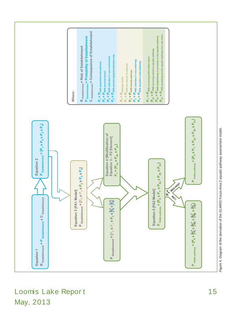
Equation 2P Establishment = [P1 x P2 x P3 x P4]
Where:P1 = P ANS associated with pathwayP2 = P ANS survives transitP3 = P ANS colonizes in new environment P4 = P ANS spreads beyond colonized area
Each of the four elements of Equation 2 is qualitatively rated a High (H), Medium (M), or Low (L) based on the available evidence. They are also qualitatively assigned a level of certainty [Very Certain (VC), Reasonably Certain (RC), Moderately Certain (MC), Reasonably Uncertain (RU), Very Uncertain (VU)]. The overall probability rating is the rating of the element with the lowest probability. Thus, in a quartet of HLHH the overall probability rating is “L”. The multiplicative nature of the function assures this is actually a somewhat conservative estimate. With actual numbers the overall probability would always be smaller than the smallest of the four factors. These elements have been modified for use in GLMRIS (Equation 3) to describe the basic sequence of events that must occur for an ANS to successfully cross the basin divide through an aquatic pathway and establish in the new basin:
2.4 Pathway Assessment Process
The GLMRIS risk analysis process is an adaptation of the generic model and process described in the Generic Nonindigenous Aquatic Organisms Risk Analysis Review Process (For Estimating Risk Associated with the Introduction of Nonindigenous Aquatic Organisms and How to Manage for that Risk) (ANSTF, 1996). ANSTF defines the risk associated with an ANS as:
Equation 1 R Establishment = P Establishment x C Establishment
Where:R Establishment = Risk of Establishment P Establishment = Probability of Establishment C Establishment = Consequence of Establishment
Note the risk is defined as a multiplicative function. That means, if either of these components is zero or low, the overall risk will also be zero or low. In order to work most efficiently given the large number of potential pathways, the GLMRIS Other Aquatic Pathways Team (Focus Area 2) concentrated its effort on characterizing the probability of establishment, while the GLMRIS Focus Area 1 Team for the CAWS is focusing on both components. An estimate of the consequences of any ANS establishment from the Focus Area 2 aquatic pathways will be deferred until possible future study by USACE or others.
ANSTF divides the probability of establishment component shown in Equation 1 into four basic elements
Table 4: Species of Greatest Concern at Loomis Lake.
Taxa Species Common Name Basin Interbasin Dispersal Mechanism
fish Hypophthalmichthys molitrix silver carp MS swimmer
fish Hypophthalmichthys nobilis bighead carp MS swimmer
fish Mylopharyngodon piceus black carp MS swimmer
fish Channa argus northern snakehead MS swimmer
fish Gasterosteus aculeatus threespine stickleback GL swimmer
fish Gymnocephalus cernua ruffe GL swimmer
fish Proterorhinus semilunaris tubenose goby GL swimmer
crustacean Neoergasilus japonicus parasitic copepod GL parasite to fish
Virus Novirhabdovirus sp VHSv GL Pathogen to Fish/Water Column

Loomis Lake Report
May, 2013
13
Equation 4 [Modification of Equation 3 – P2 Element]P2 = [P2a x P2b x P2c]
Where:P2 = P ANS transits pathway P2a = P ANS surviving transit to aquatic pathway P2b = P ANS establishing in proximity to the aquatic pathwayP2c = P ANS spreading across aquatic pathway into new basin
Delaying consideration of the last two elements of Equation 3 and substituting the more detailed consideration of the third element as expressed in Equation 4 yields the following model used in the GLMRIS Focus Area 2 assessments:
Equation 5 [FA2 Modified]P Viable pathway = [P0 x P1’ x P2a x P2b x P2c]
Where:P0 = P Pathway exists P1’ = P ANS occurring within either basinP2a = P ANS surviving transit to aquatic pathway P2b = P ANS establishing in proximity to the aquatic pathwayP2c = P ANS spreading across aquatic pathway into new basin
Notice the overall probability is now the “probability a viable pathway exists” (PViable pathway) and is no longer the original “probability of establishment” (PEstablishment) from Equation 3. The probability of establishment for certain aquatic pathways may be assessed in future studies by USACE or others, but likely only for those pathways with an unacceptable rating for the “probability of a viable pathway” existing. Note also that (P1), ANS has access to pathway from Equation 3 has been renamed (P1’), ANS occurring within either basin”. This did not change the element being evaluated but made it clearer to team members what “access to the pathway” actually meant.
This model remains consistent with the overall GLMRIS risk assessment approach and the ANSTF methodology, and the refinements enabled the assessors to focus more appropriately on the relevant evidence. At those locations along the basin divide where the first element in Equation 5 (i.e., likelihood that an aquatic pathway exists at up to a one percent annual recurrence interval event) was estimated to be low, no further assessment of that location was necessary. The low rating of this initial element assures that the overall probability of a viable
Equation 3 [FA1 Model]P Establishment = [P0 x P1 x P2 x P3 x P4]
Where:P0 = P Pathway existsP1 = P ANS has access to pathwayP2 = P ANS transits pathway P3 = P ANS colonizes in new waterwayP4 = P ANS spreads in new waterway
This model works well in areas where a viable pathway is already known to exist, such as the CAWS. However, for many of the 18 locations identified in GLMRIS Focus Area 2, it was uncertain at the outset whether or not an aquatic pathway does in fact ever form. The team recognized that formation of a pathway at these locations would likely be infrequent, and with a limited duration and magnitude (width, depth, and rate of surface water flow across the basin divide). Consequently, the model in Equation 3 was modified further for Focus Area 2.
Greater efficiency in analysis can be gained by modifying Equation 3 by eliminating evaluation of the last two elements because if a pathway does not exist there is no reason to collect data on colonization (P3) and spread (P4) in the new basin. In addition, the third element of Equation 3, ANS transits pathway (P2), is broken down into its own sequence of necessary events to characterize in greater detail those variables being evaluated to determine whether or not a viable pathway exists. In setting aside the last two elements in Equation 3 (P3 and P4) no attempt is therefore made in this report to assess the probability that an ANS will colonize in or spread through the receiving waterway or basin. USACE or others may assess the last two elements of Equation 3 in the future when evaluating specific measures that could be taken to eliminate the probability of transfer at certain aquatic pathways.
Once again, in order to work efficiently in assessing ANS risk for Focus Area 2, the initial assessment focuses narrowly on the question of whether or not a viable aquatic pathway exists. Equation 4 shows how the third element of Equation 3 has been broken down to provide greater resolution for evaluating the pathway itself:

14 Loomis Lake Report
May, 2013
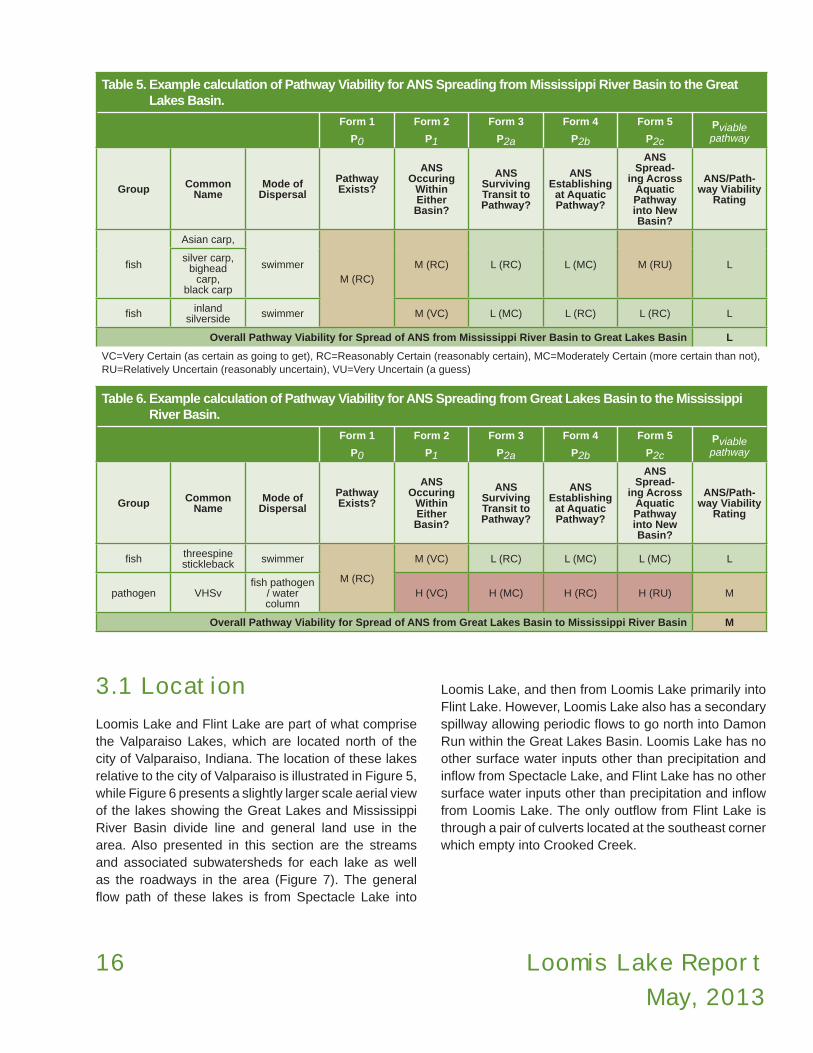
Table 6. In this example, the overall pathway viability for transferring species from the Great Lakes Basin to the Mississippi River Basin is “medium”.
The last calculation is to determine the overall pathway viability for interbasin spread of ANS which is calculated by taking the highest of the overall ANS ratings for unidirectional transfer which were calculated in Tables 5 and 6. Thus, in Table 6, the overall probability that a viable aquatic pathway exists is “medium”. The ratings given for each element as well as the overall pathway viability ratings shown in Tables 5 and 6 were coordinated amongst the members of the pathway team regarding the probability rating (H, M, or L) and the level of certainty (VC, RC, MC, RU, or VU). Final agreement was reached on team ratings for each element through collaboration and sharing of applicable information with all team members. The level of certainty in these ratings was modified during these discussions to reflect the range of opinion.
3 Aquatic Pathway Characterization
This section describes and illustrates the topography and features in the vicinity of the potential pathway at Loomis Lake, Indiana, and is intended to help inform the biological evaluations contained later in this report with a compilation of readily available and applicable information for this area as it may influence local hydrology. Maps, photographs, and figures are included to aid understanding of the hydrologic and hydraulic conditions near the drainage divide. Also, this section identifies any significant data gaps and uncertainties related to the topographic and hydrologic information in the area of interest.
pathway existing (Equation 5), the overall probability of establishment (Equation 3), and the ANS risk potential (Equation 1), will all be low because of the multiplicative nature of the model. This approach assured a more prudent use of public resources in data collection and assessment by minimizing the collection of unnecessary data and the conduct of unnecessary analyses. It should also be understood that a low rating for probability of a pathway existing (P0) is not necessarily the same as there being no probability of a pathway existing. At those locations where the probability of a pathway existing (P0) was determined to be medium or high which includes the Loomis Lake pathway, the remaining four elements in Equation 5 were evaluated for each ANS of concern specific to that particular location over a 50 year period of analysis..
2.5 Example Calculation of Overall Aquatic Pathway Viability
As described in Section 2.2, a list of ANS of concern for the Loomis Lake pathway was developed with input from Federal, State, and local agencies responsible for water resources, and fish and wildlife management in the state of Indiana and neighboring states along the Great Lakes and Mississippi River Basin divide. ANS of concern were grouped according to which basin they were currently established in to determine the viability of the aquatic pathway to transfer species across the divide in either direction. The determination of the likelihood of a viable aquatic pathway for each ANS of concern is the product of five probability elements (Equation 5). Thus, the probability of a viable pathway for a particular ANS of concern is equal to the lowest rating determined for each of the five probability elements (Table 5 and Table 6). The overall pathway viability for transferring ANS of concern from the Mississippi River Basin to the Great Lakes Basin was equal to the highest probability of a viable pathway for each ANS of concern in Table 5. In this example, all were rated low and thus the overall pathway viability for transferring species from the Mississippi River Basin to the Great Lakes Basin is “low”. The overall pathway viability for transferring species from the Great Lakes Basin is calculated the same way and is shown in
Loomis Lake Report
May, 2013
15
Eq
uat
ion
1
R E
stab
lish
men
t = P
Est
ablis
hm
ent x
C E
stab
lish
men
t
Eq
uat
ion
5 [
FA2
Mo
del
]
P V
iab
le p
ath
way
= [
P0
x P
1’ x
P2a
x P
2b x
P2c
]
Eq
uat
ion
2
P E
stab
lish
men
t = [
P1
x P
2 x
P3
x P
4]
Eq
uat
ion
3 [
FA1
Mo
del
]
P E
stab
lish
men
t = [
P0
x P
1 x
P2
x P
3 x
P4]
Eq
uat
ion
4 [
Mo
dif
icat
ion
of
Eq
uat
ion
3 –
P2
Ele
men
t]
P2
= [
P2a
x P
2b x
P2c
]
Eq
uat
ion
4 [
Mo
dif
icat
ion
of
Eq
uat
ion
3 –
P2
Ele
men
t]
P2
= [
P2a
x P
2b x
P2c
]P
Est
ablis
hm
ent =
[P
0 x
P1
x P
2 x
P3
x P
4]P
3P
3P
4P
4
Wh
ere:
R E
stab
lish
men
t =
Ris
k o
f E
stab
lish
men
t
P E
stab
lish
men
t =
Pro
bab
ility
of
Est
ablis
hm
ent
C E
stab
lish
men
t =
Co
nse
qu
ence
of
Est
ablis
hm
ent
P1
= P
AN
S a
sso
ciat
ed w
ith
pat
hw
ay
P2
= P
AN
S s
urv
ives
tra
nsi
t
P3
= P
AN
S c
olo
niz
es in
new
en
viro
nm
ent
P4
= P
AN
S s
pre
ads
bey
on
d c
olo
niz
ed a
rea
P0
= P
Pat
hw
ay e
xist
s
P1
= P
AN
S h
as a
cces
s to
pat
hw
ay
P2
= P
AN
S t
ran
sits
pat
hw
ay
P3
= P
AN
S c
olo
niz
es in
new
wat
erw
ay
P4
= P
AN
S s
pre
ads
in n
ew w
ater
way
P1’
= P
AN
S o
ccu
rrin
g w
ith
in e
ith
er b
asin
P2a
= P
AN
S s
urv
ivin
g t
ran
sit
to a
qu
atic
pat
hw
ay
P2b
= P
AN
S e
stab
lish
ing
in p
roxi
mit
y to
th
e aq
uat
ic p
ath
way
P2c
= P
AN
S s
pre
adin
g a
cro
ss a
qu
atic
pat
hw
ay in
to n
ew b
asin
P V
iab
le p
ath
way
= [
P0
x P
1’ x
P2a
x P
2b x
P2c
]P
Via
ble
pat
hw
ay =
[P
0 x
P1’
x P
2a x
P2b
x P
2c]
MED-H
IGH
LOW
P0=
Fig
ure
4.
Dia
gra
m o
f th
e d
eriva
tion o
f th
e G
LM
RIS
Focu
s A
rea 2
aquatic
path
way
ass
ess
ment
model.
16 Loomis Lake Report
May, 2013
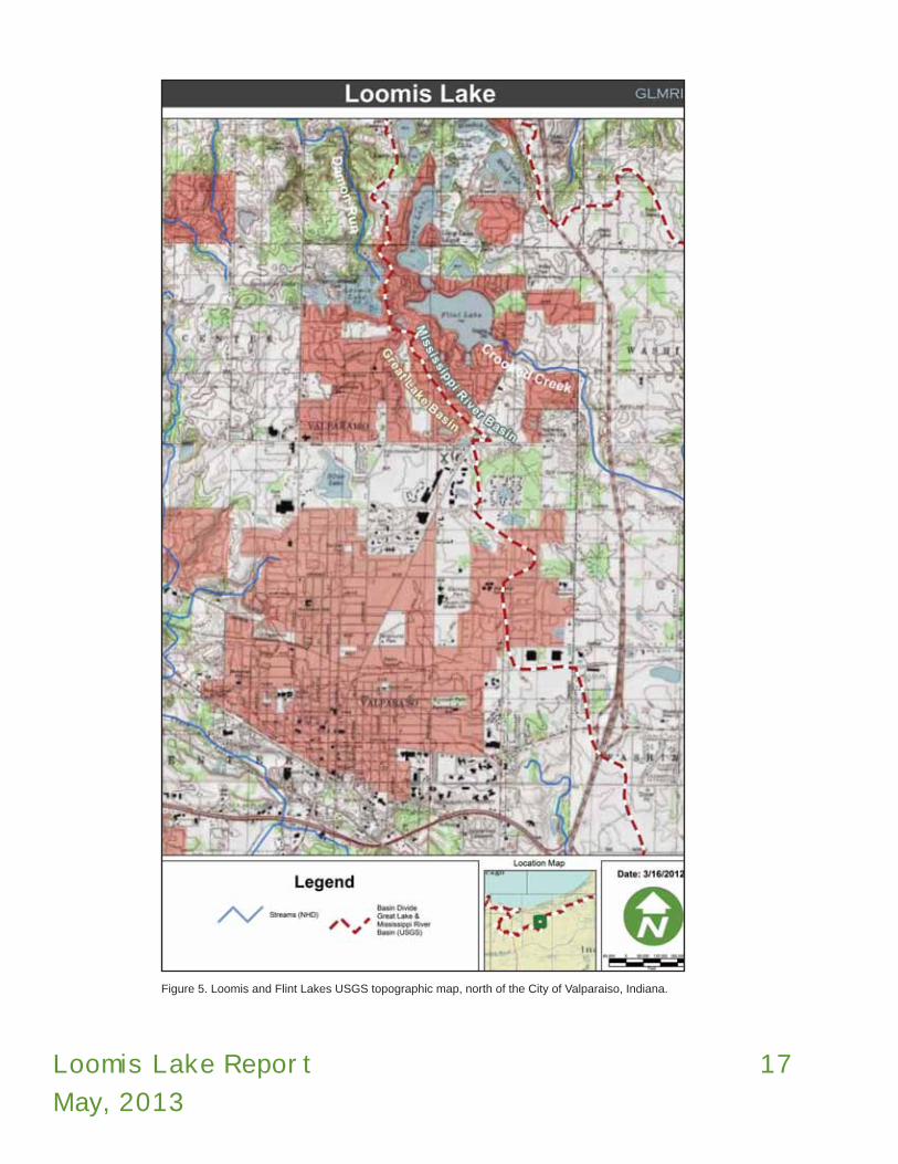
3.1 Location
Loomis Lake and Flint Lake are part of what comprise the Valparaiso Lakes, which are located north of the city of Valparaiso, Indiana. The location of these lakes relative to the city of Valparaiso is illustrated in Figure 5, while Figure 6 presents a slightly larger scale aerial view of the lakes showing the Great Lakes and Mississippi River Basin divide line and general land use in the area. Also presented in this section are the streams and associated subwatersheds for each lake as well as the roadways in the area (Figure 7). The general flow path of these lakes is from Spectacle Lake into
Loomis Lake, and then from Loomis Lake primarily into Flint Lake. However, Loomis Lake also has a secondary spillway allowing periodic flows to go north into Damon Run within the Great Lakes Basin. Loomis Lake has no other surface water inputs other than precipitation and inflow from Spectacle Lake, and Flint Lake has no other surface water inputs other than precipitation and inflow from Loomis Lake. The only outflow from Flint Lake is through a pair of culverts located at the southeast corner which empty into Crooked Creek.
Table 5. Example calculation of Pathway Viability for ANS Spreading from Mississippi River Basin to the Great Lakes Basin.
Form 1
P0
Form 2
P1
Form 3
P2a
Form 4
P2b
Form 5
P2c
Pviable pathway
Group Common Name
Mode of Dispersal
Pathway Exists?
ANS Occuring
Within Either Basin?
ANS Surviving Transit to Pathway?
ANS Establishing
at Aquatic Pathway?
ANS Spread-
ing Across Aquatic Pathway into New Basin?
ANS/Path-way Viability
Rating
fish
Asian carp,
swimmerM (RC)
M (RC) L (RC) L (MC) M (RU) Lsilver carp,
bighead carp,
black carp
fish inland silverside swimmer M (VC) L (MC) L (RC) L (RC) L
Overall Pathway Viability for Spread of ANS from Mississippi River Basin to Great Lakes Basin L
VC=Very Certain (as certain as going to get), RC=Reasonably Certain (reasonably certain), MC=Moderately Certain (more certain than not), RU=Relatively Uncertain (reasonably uncertain), VU=Very Uncertain (a guess)
Table 6. Example calculation of Pathway Viability for ANS Spreading from Great Lakes Basin to the Mississippi River Basin.
Form 1
P0
Form 2
P1
Form 3
P2a
Form 4
P2b
Form 5
P2c
Pviable pathway
Group Common Name
Mode of Dispersal
Pathway Exists?
ANS Occuring
Within Either Basin?
ANS Surviving Transit to Pathway?
ANS Establishing
at Aquatic Pathway?
ANS Spread-
ing Across Aquatic Pathway into New Basin?
ANS/Path-way Viability
Rating
fish threespine stickleback swimmer
M (RC)
M (VC) L (RC) L (MC) L (MC) L
pathogen VHSvfish pathogen
/ water column
H (VC) H (MC) H (RC) H (RU) M
Overall Pathway Viability for Spread of ANS from Great Lakes Basin to Mississippi River Basin M
Loomis Lake Report
May, 2013
17
Figure 5. Loomis and Flint Lakes USGS topographic map, north of the City of Valparaiso, Indiana.

18 Loomis Lake Report
May, 2013
Fig
ure
6.
Loca
tion o
f Loom
is a
nd F
lint
Lake
s ove
rlaid
on a
erial p
hoto
gra
ph s
how
ing b
asi
n d
ivid
e (
red-w
hite
line)
and g
enera
l land u
se in
the a
rea.
Blu
e li
nes
indic
ate
nearb
y st
ream
s. B
ase
map c
ourt
esy
of
Bin
g M
aps.

Loomis Lake Report
May, 2013
19
Figure 7. Surface water features and watershed boundaries in proximity of Loomis Lake, Indiana. Spectacle Lake drains to Loomis Lake, which then drains primarily to Flint Lake in the Mississippi River Basin. Base imagery courtesy of Bing Maps.

20 Loomis Lake Report
May, 2013
3.2 Climate
Climate is looked at in this section just in terms of identifying any applicable elements of climate (e.g., temperature, rainfall) and how they may influence the likelihood of an aquatic connection forming at the subject pathway that could be utilized by ANS to spread between basins. This area of northern Indiana is classified as temperate continental with warm summers and cold winters that typically provide enough precipitation, in the form of snow, to supply the soil with sufficient moisture to minimize drought conditions when the hot summers begin (INDNR, 2006). Temperatures in winter average 27ºF (-2.7ºC), while summers are mild, averaging 71ºF (21.6ºC). The average temperatures in June, July, and August range from highs in the low 80’s (ºF) (26-28ºC) to lows in the high 50’s to low 60’s (ºF) (14-17ºC). Combined with the lack of available shade, surface water temperatures could elevate substantially on hot summer days. Conversely, the average temperature in December, January, and February range from highs in the low to mid 30’s (ºF) to lows in the teens to low 20’s (ºF).
The average annual precipitation is approximately 40-inches (101 cm), with the driest times of the year generally occurring between October and March (JFNew, 2006). Precipitation data also indicate that the wettest times of the year occur between April and September (Frankenberger and Carroll, 2011). Area records indicate that especially intense storms are most likely to occur during the spring, and modeling indicates that a one percent annual recurrence interval storm would be expected to produce approximately eight inches (20 cm) of rainfall in a 24 hour period (Frankenberger and Carroll, 2011). The climate of Porter County could therefore limit the quality and quantity of surface water in the small streams leading away from Loomis and Flint Lakes during the hottest summer months (e.g., low levels of dissolved oxygen). Substantial drying of the Damon Creek and Crooked Creek headwaters near these lakes could also occur during summer months and freezing of certain reaches downstream may also occur in the winter.
3.3 Location Specific Surface Water Features
The information contained in this section is meant to present and interpret the readily available information for this location as it pertains to surface water conditions and any aspects that may influence the behavior of surface water. There are three primary areas in the Loomis Lake vicinity that collectively form the Loomis Lake Aquatic Pathway (Figure 8).
The watershed draining Loomis Lake historically drained north to Damon Run and then to Lake Michigan roughly 12 miles (30.5 km) downstream to the north. Loomis Lake was formed in 1924 by the construction of Proffitts Dam, a small earthen dam at the headwater of Damon Run (Figure 8 - Figure 10). The legal lake level of Loomis Lake is set to 813.7 feet (NAVD88), with a surface area of 49.7 acres (20.1 ha), and a normal storage of 317 acre-feet but with a capacity of 485 acre-feet.
As a result of human modification of drainage patterns in the early 1900’s, all of the Valparaiso Lakes now drain to Flint Lake as a means of augmenting the former use of Flint Lake as a primary water supply during dry months. However, Flint Lake is no longer used as a primary water supply in the area but still may be used as a back-up water source. All of these lakes are therefore within the Kankakee River Watershed, which is a tributary of the Illinois River, and of the Mississippi River. The legal lake level of Flint Lake is a stage of 17.66 feet, or an approximate elevation of 797.4 feet NAVD88. As of 2002, the maximum water surface recorded was elevation 800.9 feet NAVD88, occurring on July 2, 1983 (USGS, 2003). The topography of the area was also evaluated to see what barrier the slope of the land itself might offer to the formation of an aquatic pathway, as well as possibly the spread of ANS between the basins. Representative surface elevations of the three connection points are shown in Figure 11 - Figure 13 which also depict representative cross-sections through the flow path between Loomis and Flint Lakes (Figure 11), Loomis Lake to Damon Run (Figure 12), and Flint Lake to Crooked Creek (Figure 13), based on the best available Geographic Information System (GIS) data.

Loomis Lake Report
May, 2013
21
Fig
ure
8.
Enla
rged p
lan v
iew
map o
f Loom
is a
nd F
lint
Lake
s are
a s
how
ing n
etw
ork
of
thre
e c
onnect
ion p
oin
ts b
etw
een F
lint
and L
oom
is L
ake
s and t
heir r
esp
ect
ive d
rain
age
basi
ns:
(1)
Loom
is L
ake
to D
am
on R
un,
(2)
Loom
is L
ake
to F
lint
Lake
, and (
3)
Flin
t Lake
to C
rooke
d C
ree
k at
bottom
rig
ht
corn
er. B
ase
imagery
court
esy
of
Bin
g M
aps.

22 Loomis Lake Report
May, 2013
Figure 9. Proffitts Dam on Loomis Lake, looking west. Photo taken June 20, 2011 by USACE.
Figure 10. Proffitts Dam on Loomis Lake, looking southwest. Photo taken June 20, 2011 by USACE.

Loomis Lake Report
May, 2013
23
Loomis Lake to Flint Lake:
A profile along the basin divide (hydrologic unit code (HUC)-12) depicts the ‘saddle point’ along the divide and is the location along the basin divide where a hydrologic connection exists between the basins (Figure 11). Also shown is a cross-section through the basin divide to depict the typical ground elevation along the flow path from Loomis Lake to Flint Lake. As can be seen in Figure 11 and Figure 13, flow from Loomis Lake would only occur from the Great Lakes Basin toward the Mississippi River Basin.
There is also a small wetland area on the west end of Flint Lake that is connected with Flint Lake, and is surrounded by a mixture of thick vegetation and residential development. This wetland does not connect with Loomis Lake. The approximate boundaries of this wetland area are shown as the shaded area on Figure 11. These boundaries are only approximate and a wetland delineation was not performed as part of the site investigation.
For this pathway, the elevations in Figure 11 through Figure 13 are based on the USGS 10m Digital Elevation Model (DEM) with a vertical accuracy of +/- five feet (1.5 m). This level of accuracy may lead one to conclude that there is a high degree of uncertainty regarding the use of this elevation data. However, the absolute vertical accuracy (specific elevation) is not nearly as important as the relative, or point-to-point, vertical accuracy (terrain) when evaluating terrain at the divide location to try and predict hydrology. Point-to-point accuracy has been shown to be much greater than this margin of error regarding absolute elevation would indicate. Although the absolute elevation values may vary from the true value (e.g., 600 feet (183 m) above sea level), they tend to vary a comparable amount at adjacent points so that the terrain of the area is actually depicted relatively well. The grid size used to create the DEM can also affect the accuracy of the DEM. The larger the grid cell size (10 m squares vs. 30 m squares), the more block-like and less detailed the terrain appears and thus the less accurately the DEM depicts the actual terrain. The largest grid size used at any of the pathway locations is 10 m squares with some areas having more detailed information. Even though the 10 m cell size does not depict every hummock or hollow in the terrain, it does
provide sufficient detail regarding general terrain and relative elevations to provide useful data in evaluating the potential for a hydrologic connection forming across the basin divide.
Loomis Lake drains through an underground culvert (called the “principal spillway”) out the southeast end of the lake which runs approximately 900 feet (274 m) to the east and then empties into Flint Lake. The cross section in Figure 11 is along the surface profile at this culvert location. This culvert connects Loomis Lake, which is in the Great Lakes Basin, with Flint Lake in the Mississippi River Basin. The inlet to the principal spillway is a drop structure with an outer and secondary trash rack constructed of vertical bars with approximately three inch (7.6 cm) wide openings (Figure 14). As shown in Figure 11, Loomis Lake is approximately 17 feet (5.2 m) higher in elevation than Flint Lake. The grated opening of the culvert inlet is about three feet wide and 2 feet (61 cm) tall. Flow drops vertically several feet into the culvert. The vertical drop inside the inlet structure could not be measured accurately, but is greater than four feet (1.2 m) and is estimated to be eight feet (2.4 m) or greater based on visual inspection. The downstream invert of the pipe is approximately at elevation 796.4 NAVD88 (PTGR, Inc., 1991). The diameter of the culvert is reported in different sources as either a 24 inch (61 cm) pipe or a 48 inch (122 cm) corrugated metal pipe (INDNR, 2006; PTGR, Inc., 1991). According to drawings with the Valparaiso Lakes Area Conservancy District, it is a 24-inch (61 cm) clay tile pipe (Minarich et al., 2011). During the site investigation it was not possible to confirm which of the above diameters is accurate since it was submerged.

24 Loomis Lake Report
May, 2013
Fig
ure
11.
Loca
tion o
f cr
oss
-sect
ion t
hro
ugh b
asi
n d
ivid
e b
etw
een L
oom
is L
ake
(le
ft)
and F
lint
Lake
(right)
, base
d o
n 1
0m
DE
M,
with
a v
ert
ical a
ccura
cy o
f +
/- 5
feet
(1.5
m).
The
purp
le li
ne in
the a
erial p
hoto
gra
ph a
nd t
he g
raph o
n t
he t
op le
ft is
the p
rofil
e a
long t
he b
asi
n d
ivid
e. T
he y
ello
w li
ne t
hat
inte
rsect
s th
e p
urp
le li
ne in
the p
hoto
gra
ph
and g
raph o
n t
he b
ottom
left is
the c
ross
sect
ions
thro
ugh t
he b
asi
n d
ivid
e a
long f
low
path
betw
een t
he t
wo la
kes.
Shaded a
rea r
epre
sents
pote
ntia
l wetla
nd a
rea c
on
-nect
ed w
ith F
lint
Lake
(appro
xim
ate
boundaries)
. B
ase
imagery
court
esy
of
Bin
g M
aps.

Loomis Lake Report
May, 2013
25
Fig
ure
12.
Loca
tion o
f Loom
is L
ake
auxi
liary
outflo
w t
o D
am
on R
un b
ase
d o
n 1
0m
DE
M w
ith a
vert
ical a
ccura
cy o
f +
/- 5
feet
(1.5
m).
The y
ello
w li
ne in
the a
erial p
hoto
gra
ph a
nd
the g
raph o
n t
he t
op le
ft is
the p
rofil
e a
long D
am
on R
un. T
he p
urp
le li
ne t
hat
inte
rsect
s th
e y
ello
w li
ne in
the p
hoto
gra
ph a
nd
gra
ph
on
th
e b
ott
om
left
is t
he
cro
ss s
ec-
tions
thro
ugh t
he D
am
on R
un p
rofil
e.
Base
imagery
court
esy
of
Bin
g M
aps.

26 Loomis Lake Report
May, 2013
Fig
ure
13.
Loca
tion o
f pro
file a
long C
rooke
d C
reek
dow
nst
ream
fro
m F
lint
Lake
base
d o
n 1
0m
DE
M w
ith a
vert
ical a
ccura
cy o
f +
/- 5
feet
(1.5
m).
The p
urp
le li
ne o
n t
he m
ap a
nd
the g
raph o
n t
he b
ottom
left is
the p
rofil
e a
long C
rooke
d C
reek.
The y
ello
w li
ne t
hat
inte
rsect
s th
e p
urp
le li
ne o
n t
he m
ap a
nd
gra
ph o
n t
he t
op le
ft is
the c
ross
sect
ion
thro
ugh C
rooke
d C
reek.
Base
imagery
court
esy
of
Bin
g M
aps.

Loomis Lake Report
May, 2013
27
Fig
ure
14.
Loom
is L
ake
gra
ted d
rop b
ox
inle
t st
ruct
ure
for
culv
ert
to F
lint
Lake
. This
is t
he in
let
to t
he 9
00-f
oot
(274m
) lo
ng
underg
round c
ulv
ert
, fa
cing e
ast
. P
hoto
by
US
AC
E.

28 Loomis Lake Report
May, 2013
Loomis Lake to Damon Run:
An approximately three foot (0.9 m) square concrete channel through Proffitts Dam serves as an auxiliary spillway for Loomis Lake, with an invert elevation of 813.6 feet, and top of spillway weir at elevation 814.5 feet (Figure 15). Water level in Loomis Lake must rise 0.8 feet (24 cm) to overtop the low weir. The frequency, depth, or duration of discharge to the Great Lakes Basin through this auxiliary spillway is not known. However, based on input from city officials during the site visit in June 2011, it is believed that overtopping of the low weir (not the dam itself) into the approximate three foot square concrete channel occurs on more than one occasion every year. Proffitts Dam itself has overtopping protection for any excessive flows leaving Loomis Lake that cannot be accommodated by both the principle and auxiliary spillways. City officials believe that overtopping does sometimes occur, but only during what they termed as “rare events.” The top of the steel grate of the Proffitts Dam emergency spillway conduit is at 816.6 feet, which is at an elevation approximately equal to top of dam. The dam is approximately 17 feet (5.2 m) high on the downstream side and 200 feet (61 m) wide, resulting in high velocity discharges through the spillway. Downstream of the dam, Damon Run is a heavily vegetated channel contained in a much wider valley (Figure 16). The profile of Damon Run downstream from the dam is shown on Figure 12 The profile line (yellow) on this figure does not match perfectly over the top of the stream line, and some downstream areas on Damon Run are actually shown as being higher in elevation than locations closer to the dam. This phenomenon is attributed to error in the data used for mapping and was not the situation as observed in the field. Accordingly, this figure should be utilized for gaining only a general understanding of the downstream profile trends away from Loomis Lake and not actual elevations.

Loomis Lake Report
May, 2013
29
Figure 15. Loomis Lake 3 foot (0.9 m) square (approx.) concrete channel auxiliary spillway to Damon Run, looking downstream; (Inset) Entrance to concrete channel of this auxiliary spillway at Loomis Lake. Photos by USACE
Figure 16. Damon Run downstream from Proffitts Dam. Photo by USACE.

30 Loomis Lake Report
May, 2013
Flint Lake to Crooked Creek:
Flint Lake drains to Crooked Creek by way of two 24-inch (61 cm) diameter corrugated metal pipes (Figure 17). The downstream end of these pipes is approximately one foot (30 cm) higher than the Crooked Creek channel bottom, thereby likely precluding most if not all aquatic species from being able to swim from Crooked Creek into Flint Lake via these two pipes. In addition, since Flint Lake is the primary source of water for Crooked Creek at this point with no other tributaries nearby, it would be highly unlikely for any backwater flow conditions to develop that could reduce or eliminate this one-foot vertical drop between the pipe and the stream.
Figure 13 presents the approximate ground elevations in the vicinity of the Flint Lake outflow as well as downstream in Crooked Creek. The profile along Crooked Creek in this figure (graph at bottom left) indicates the general downhill path for water exiting from Flint Lake as it descends approximately five feet (1.5 m) over about 2,000 feet (610 m) horizontally.
Although some downstream areas appear to be at an equal or slightly higher elevation than the lake itself. This phenomenon was not observed in the field and is attributed to error in the vertical accuracy of the mapping data. What is more important than the actual elevations on this map is the overall trend in the stream profile as it descends away from Flint Lake. This helps to confirm that backflow from the creek into Flint Lake is not possible during high water events.
Figure 17. View of outflow from Flint Lake (left photo) into Crooked Creek (right photo), taken June 20, 2011by USACE during site investiga-tion. Arrows in left photo indicate direction of flow.

Loomis Lake Report
May, 2013
31
3.4 Groundwater
A groundwater section is included in this report since groundwater can sometimes be a source of base flow for streams. Water levels in aquifers normally fluctuate seasonally in response to variations in groundwater recharge and discharge. Groundwater levels commonly rise in spring, when areal recharge is greatest because of snowmelt, spring rain, and minimal evapotranspiration losses. This means that heavier rainfall events, when they coincide with snowmelt and higher groundwater conditions, might result in higher volumes of water discharging from Loomis Lake to Flint Lake, from Flint Lake into Crooked Creek, and possibly from Loomis Lake to Damon Run through the auxiliary spillway.
With the exception of Loomis Lake, the Valparaiso Lakes are glacial features. The lakes are a series of kettle lakes that were formed by ice blocks trapped in the end moraine of retreating glaciers. As these ice blocks melted the resulting meltwater created kettle shaped lakes dotting the landscape. Based on this origin, the lakes are likely fed by both surface runoff and groundwater inputs (JFNew, 2006).
Water levels in Loomis Lake are the key driver in the amount of flow between Loomis Lake and Flint Lake, as well as whether or not the auxiliary spillway is used. These water levels appear to be influenced predominantly by precipitation amounts and inflow from Spectacle Lake to the west. However, groundwater may help to maintain the lake levels and flow duration through the principle spillway during periods of little to no precipitation. As the hydraulic connection between Loomis Lake and Flint Lake is an intermittent surface water connection (i.e., primary spillway to a 900-foot (274m) long culvert), groundwater conditions within the area are not likely to be a significant factor influencing Loomis Lake water levels and were therefore not further evaluated for this site
3.5 Aquatic Pathway Temporal Characteristics
Characterizing the temporal variability of the site’s hydrology is potentially an important aspect of understanding the likelihood of an ANS being able to traverse the basin divide as certain flood events may coincide with species dispersal, reproductive patterns, and abilities to survive and establish populations in various areas. For example, given that the area is subjected to freezing temperatures on an annual basis for several months, biological activity and water flow would be somewhat restricted on a temporal basis since water (at least on the surface) would be frozen and the movement of any ANS would be restricted.
At the time of this report, detailed information such as high water marks, gage records, or similar data regarding storm events were not available that could be used to obtain the frequency for flooding events; therefore, quantifying the exact frequency and volume of the hydraulic connection between the basins is not possible at this time. It was communicated that flow is generally perennial from Loomis Lake into Flint Lake except during long periods of hot dry weather (Minarich, 2011).
Flows from Loomis Lake over the Proffitts Dam weir are likely to occur several times per year, but flows overtopping the crest of Proffitts Dam are rare. The most recent event that this occurred was during the September 2008 floods that were caused by the remnants of Hurricane Ike. Approximately 13 inches (33 cm) of rain fell on the Valparaiso area over several hours during this event and it was indicated by city officials that the dam was overtopped by three feet (0.9 m) or more at that time (Minarich et al., 2011). The precipitation for this event was reported as a 327-year event (0.3 percent annual recurrence interval) according to staff for the Valparaiso Lakes Area Conservation District (VLACD). More detailed information is not available, and there are no gages or other sources for such information. The roadways to the dam area were also reported as being impassable during this event. The likelihood of backwater flooding in the opposite direction, from Damon Run across Proffitts Dam into Loomis Lake, is also low. This is based upon findings during the site investigation
32 Loomis Lake Report
May, 2013
and visual inspection of the Damon Run channel which is relatively wide compared to the expected flows, and tailwater depths would be expected to be much less than the 17-foot (5.2 m) dam height under all flood frequencies. Actual elevations and probabilities cannot be calculated with the available data, but it if the dam was not inundated by backwater during the September 2008 flood event then the probability for inundation from this direction is extremely small.
Based upon available information for the primary spillway in Loomis Lake, analysis conducted by the USACE indicates that the connection from Loomis Lake to Flint Lake does appear to receive water from relatively small flows leaving the lake (Bentley Systems Incorporated, 2012). However, in order to provide a complete connection between the lakes it is estimated that the pool of Loomis Lake must increase at least 1.75 feet (53 cm) to initiate a sustained connection. During such a condition, the velocity in the culvert would be moderately high at roughly 7.5 feet per second (2.3 meters per second). Velocity of water in the culvert would increase as the height of water above the top of the pipe at the upstream end increases
3.6 Probability Aquatic Pathway Exists
The rating discussed in this section is only for the likelihood of an aquatic connection existing at this potential pathway (P0) up to a one percent annual recurrence interval storm. A perennial surface water connection does exist between Loomis Lake within the Great Lakes Basin and Flint Lake in the Mississippi River Basin, based on the following
Testimony of local area watershed managers and city officials that only small flows occur through the Proffitts Dam on an annual basis, linking Loomis Lake with the rest of the Great Lakes Basin;
There is a permanent open spillway in Loomis Lake to allow headwater flooding in the Lake to flow toward Flint Lake through a 900-foot (274 m) long underground culvert when water levels in Loomis Lake rise at least 1.75 feet (53 cm).
This flow is only from Great Lakes Basin to the Mississippi River Basin due to approximate 17-foot (5.2 m) elevation difference between the lakes over this 900-foot (274 m) culvert;
Although small flows will periodically leave Loomis Lake through the Proffitts Dam toward the Great Lakes, flow in the opposite direction is deemed not possible due to the dam’s height;
Analysis of topographic and flow path GIS data shows there to be an obvious flow direction from Loomis Lake toward Damon Run in the Great Lakes Basin, from Loomis Lake toward Flint Lake, and from Flint Lake to Crooked Creek.
Due to the above evidence, the probability of a pathway existing from the Great Lakes to the Mississippi River Basins at Loomis Lake is rated as “medium” since it meets the criteria of an intermittent stream (in this case the 900-foot (274 m) culvert) that is capable of maintaining a surface water connection with both basins continuously for multiple days from a ten percent annual recurrence interval storm (Appendix A). This was not rated as high since there was uncertainty on the exact volume, frequency, and duration of flows going across this pathway. The rating for flow from the Mississippi River Basin toward the Great Lakes Basin was “low” as it is unlikely that water would be able to flow from Flint Lake toward Loomis Lake due to the approximate 17-foot (5.2 m) elevation difference between the two lakes, even though they are in fairly close proximity. However, if water from Flint Lake were somehow able to flow into Loomis Lake, there could at that point be an intermittent connection with the rest of the Great Lakes Basin via the outflow through the Proffitts Dam.
This rating for flow into the Mississippi River Basin is considered reasonably certain, and the rating for flow into the Great Lakes Basin is considered very certain because of the following:
The exact volumes, frequency, and duration of flows through the 900-foot culvert are not known;
Flint Lake is approximately 17 feet (5.2 m)

Loomis Lake Report
May, 2013
33
lower in elevation than Loomis Lake, with only about 900 feet (274 m) horizontally between the two lakes, making backflow from Flint Lake to Loomis Lake essentially impossible;
There is some uncertainty related with the ground elevations as shown in the plan and profile figures for the three areas which have vertical accuracies of +/- five feet (1.5 m). This could be a contributing element to part of the Crooked Creek profile downstream of Flint Lake showing a slightly higher elevation than Flint Lake itself; and
Proffitts Dam is about 17 feet (5.2 m) above the bed elevation of Damon Run, making any backflow from Damon Run (if it ever exists) unlikely to overtop this dam and reach Loomis Lake.
3.7 Aquatic Pathway Habitat
3.7.1 Terrestrial and Riparian Plants and Land Use
Loomis Lake provides 62 acres (25 ha) of various types of fish and wildlife habitat. The lake supports many different species of fish, birds, reptiles, amphibians, and invertebrates. The eastern and southern shores of Loomis Lake are mostly characterized as high to medium-density residential areas. The rest of the land surrounding the lake is mix of forest and open field. In some cases, there is little or no riparian habitat around the lake, especially in the residential areas on eastern shore.
3.7.2 Aquatic Resources
Loomis Lake would likely provide adequate food sources to harbor most of the invasive species of concern for this pathway. A variety of habitat types and a range of depths are also available in Loomis Lake, with most of the lake between five (1.5 m) and 20 feet (6 m) in depth, and a
maximum depth of approximately 50 feet (15 m) (Figure 18). Habitat quality throughout the watershed would not likely be a deterrent for most ANS establishment requirements, as nuisance species are generally resilient, aggressive, and adaptable. Water quality in the Salt Creek Watershed within the Great Lakes Basin, of which Damon Run is a part, is considered to be impaired according to the Indiana Department of Environmental Management (IDEM) and is on the 303(d) list for E coli, biotic community impairment, and nutrient loading (e.g., nitrates, phosphorus, and sediment loading) (INDNR, 2011).
Aside from the principle spillway at the east end of Loomis Lake, Damon Run also periodically drains Loomis and Spectacle Lakes. According to the Salt Creek Water Management Plan, in 2000 the IDEM gave Damon Run a Qualitative Habitat Evaluation Index (QHEI) score of 61 (out of a possible score of 100), a ten point drop compared to its 1990 score (Salt Creek Management Plan, 2008). A decrease in substrate quality encompassed the most substantial distinction between the two sampling events. The poor substrate and lack of riffle development limits stream habitat quality in Damon Run. The Salt Creek Water Management Plan stated the following regarding habitat quality in the watershed:
“During the 2006 biotic community assessment/intensive survey, QHEI scores ranged from 22 to 69, with a geometric mean of 43. Most of the sites (25 of 43 assessed) rated scores lower than the threshold (51) at which Indiana considers stream habitat to be poor. Common limitations for habitat quality included poor substrate, lack of instream cover, and lack of riffle development.”
When assessed in August 2006, physical habitat was good in Damon Run compared to other areas within the Salt Creek Watershed. The site rated a QHEI score of 55. Fish communities were also good compared to other sites, but still did not meet state standards. Eleven fish species were collected at Damon Run. However, tolerant species comprised 57.9 percent of the sample. The site rated an Index of Biological Integrity (IBI) score of 30, which placed the stream in the poor integrity class for the Central Corn Belt Region and was less than the value (36) at which IDEM considers streams to be non-supporting of its aquatic life use designation.

34 Loomis Lake Report
May, 2013
Fig
ure
18:
Bath
ymetr
y m
ap o
f Loom
is L
ake
pro
vided b
y IN
DN
R.

Loomis Lake Report
May, 2013
35
From Loomis Lake to the Mississippi River
Flint Lake is very similar to Loomis Lake and contains similar flora and fauna. The lake has a mean depth of 20 feet (6.1 m) and covers 86 acres (35 ha). Concentrations of mean total phosphorus in Flint Lake remain high enough to support substantial algal productivity and eutrophic conditions. Data from 2004 suggest that Flint Lake falls within the mesotrophic category according to the Indiana trophic state index (ITSI). However, using 2001 data Flint Lake falls within the hypereutrophic category of Carlson’s TSI for total phosphorus (Save the Dunes Conservation Fund, 2008).
Water from Flint Lake empties into the West Branch of Crooked Creek which flows into Crooked Creek. Water then flows through Heinold Ditch before reaching the Kankakee River. These small tributaries of the Kankakee are generally shallow and exhibit poor habitat quality due to channelization and agricultural and urban run-off. The Kankakee River is an approximately 133-mile (214 km) long tributary of the Illinois River. Like many Midwestern basins, most of the Kankakee River Basin has been extensively drained. The natural flow-path of the Kankakee has been replaced by a series of canals and ditches. The main branch of the river lacks pools and riffles and is instead a continuous glide. A number of bayous are found along the river. Some remain connected to the river throughout the year while others are connected only during high water or not at all. Fish and wildlife figures indicate that of the 1,200 miles (1,931 km) of stream presently comprising the Kankakee and its minor tributaries, only 16 miles (26 km) remain in the natural state (Robertson, 1972).
The INDNR sampled the Kankakee River for habitat quality in 2001. Qualitative Habitat Evaluation Index scores for 11 stations sampled ranged from a high of 50 to a low of 30.5. Scores between 45 and 60 indicate fair aquatic habitat, and scores below 45 are poor habitat. The scores indicate that habitat is poor at five of 11 Kankakee River stations.
The Illinois River supports a diverse fishery, but is currently threatened by pollution and invasive species like Asian carp. The deposition of sediments into the basin’s rivers has resulted in a loss of flow capacity, the filling of adjacent bottomland lakes and associated
wetlands which are essential fish production areas, and has caused the smothering of valuable bottom-dwelling organisms and plants thus degrading quality habitat areas. The loss of depth and increased turbidity from the sedimentation threatens the present aquatic habitat and fisheries resources. In addition, the increased production of row crops and the practice of monoculture have resulted in a greater use of herbicides, insecticides and fertilizers. Many of the agricultural chemicals used are toxic to fish. Habitat quality is also diminished by numerous discharges from industrial and manufacturing operations within the basin, some of which have heavy metals, inorganic and organic chemicals, and oxygen demanding organic waste such as wood pulp fibers, canning, and dairy and food processing wastes.
From Loomis Lake to Lake Michigan
Upon exiting Loomis Lake through the Proffitts Dam outflow, an ANS would then enter Damon Run, which is a small tributary of Salt Creek. The water quality of Damon Run is moderately poor when compared to other streams in the Salt Creek Watershed. However, temperature, dissolved oxygen, pH, and conductivity measurements do not exceed Indiana water quality standards (Save the Dunes Conservation Fund, 2008).
After traversing Damon Run, an ANS would then enter Salt Creek. Land uses within the Salt Creek Watershed include agricultural, forest, grassland, residential, commercial, industrial, and recreational. The section of Salt Creek between Damon Run and the East Arm of the Calumet River has no listed impairments (Save the Dunes Conservation Fund, 2008). The section of Salt Creek upstream of the junction of Damon Run and Salt Creek is listed by the state of Indiana as having impaired biotic communities. Habitat in the reach of Salt Creek downstream of Damon Run is generally poor with low quality biological communities (IDEM, 2011). However this stretch of Salt Creek contains some of the highest quality habitat in the Salt Creek Watershed, and the Salt Creek mainstream is considered a cold water fishery (Save the Dunes Conservation Fund, 2008).
Salt Creek drains into the East Arm of the Little Calumet River. This river is largely protected as part of the Indiana Dunes National Lakeshore. Despite this designation, the East Arm of the Little Calumet River has several

36 Loomis Lake Report
May, 2013
advisories, including: Mercury Fish Consumption Advisory, PCB Fish Consumption Advisory, and Pathogens (USEPA, 2012). Some sections of the river contain habitat suitable for salmonids and the INDNR stocks the river with several species of salmonids (INDNR, 2012). Beaver have been detected in the river which may lead to improvements in habitat for a variety of aquatic organisms via the construction of beaver dams and the creation of ponds behind the dams (Whitaker, 1999; Pollock et al., 2003). The section of the East Arm of the Little Calumet River between Salt Creek and the Burns Ditch is approximately 1.5 miles (2.4 km) in length.
Upon exiting the East Arm of the Little Calumet River, an ANS would then need to travel through Burns Ditch which is a constructed diversion of the Little Calumet River into Lake Michigan near Portage, Indiana. Construction of the ditch drained most of the wetlands in the area leading to extensive development (Chicago Historical Society, 2005). Burns Ditch has poor water quality with unsafe levels of E. coli. The Indiana Geological Survey conducted an E. coli forecasting and modeling study at Burns Ditch and stated that “the Burns Ditch location was chosen because it is the outfall point for the largest watershed (Little Calumet drainage) contributing contaminated streamflow to Indiana’s southern Lake Michigan” (Harper and Olyphant, 2010). Burns Ditch also has several impairments including Mercury Fish Consumption Advisory, PCB Fish Consumption Advisory, and Pathogens (IDEM, 2011). The distance between Burns Ditch and Lake Michigan is approximately 1.5 miles (2.4 km).
3.7.3 Water Quality
According to the Valparaiso Lakes Watershed Management Plan, there has been a general increase in the lake’s total phosphorus (TP) concentrations since baseline measurements were first taken in 1972 (JFNew, 2006). The data show a consistent pattern of lower TP concentrations in the surface, or epilimnetic waters, and higher concentrations in the bottom, or hypolimnetic waters. This suggests that phosphorus may be released from the sediments. Plankton density did not reflect the increases in TP concentrations, suggesting that the phosphorus entering the lake is mainly in the insoluble
form rather than soluble forms which can be utilized by the phytoplankton. Though the ITSI score for 2001 places Loomis Lake in a mesotrophic category, the Carlson Trophic State Index for total phosphorus concentration in the same year places the lake in a hypereutrophic category. Hypereutrophic lakes are very nutrient-rich lakes that can be characterized by frequent and severe algal blooms and low transparency. These algal blooms can significantly reduce oxygen levels and prevent life from functioning at lower depths creating dead zones beneath the surface. Hypereutrophic lakes can be the most biologically productive lakes, and support large amounts of biodiversity (JFNew, 2006).
Lakeshore and stream bank erosion was identified as a problem in Loomis Lake by the Valparaiso Lakes Watershed Management Plan. Soil erosion is known to cause sediment and nutrient pollution and increase TP concentrations. Other types of non-point source pollution impacts indentified by the plan include septic systems, which can lead to toxic and bacterial pollution, in addition to nutrient loading.
The IDEM sampled Damon Run in 1990, twice in 2000, 2003, and again in 2006. Concentrations of E. coli were consistently high, exceeding the Indiana state standard (i.e., 235 CFU/100 ml) during each sampling event, and conductivity measurements were similarly high (IDEM, 2012). Flint Lake suffers from many of the same water quality issues like run-off and erosion that affect Loomis Lake. Both lakes suffer from anoxia in the hypolimnion (bottom layer of water), and since the lakes are connected, water quality parameters are also similar. Degraded water quality alone will likely not deter the establishment of ANS. One reason most invasive species are successful is the fact that they are able to tolerate a wider range of environmental parameters than native species occupying the same niche.
3.7.4 Aquatic Organisms
Loomis Lake supports a diverse plant community structure with thriving emergent, floating, and submerged zones. In portions of the lake, shoreline development has impaired the lake’s emergent communities, limiting the emergent zone’s size. While Loomis Lake does not suffer from severe algal blooms as many ultra-fertile

Loomis Lake Report
May, 2013
37
lakes, the abundant vegetation in the lake has been known to cause problems. Loomis Lake supports a warm water fishery that has been historically dominated by bluegill (Lepomis macrochirus). This skewing of the fish community structure toward bluegill (especially small bluegill) may be caused by the copious aquatic vegetation that persists in the lake. Abundant vegetation can make it difficult for predators, like the largemouth bass (Micropterus salmoides), to feed on the bluegill, and consequently cause overpopulation issues such as the stunted growth witnessed in Loomis Lake. It can also result in an unconsolidated lake bottom where only invertebrate and plant species that are very tolerant near anoxic conditions area able to survive.
Invasive plant species already established within and around Loomis Lake are partly to blame for the vegetation issues. Problematic exotic species found around and in the lake include purple loosestrife (Lythrum salicaria), reed canary grass (Phalaris arundinacea), Eurasian water milfoil (Myriophyllum spicatum), and curly leaf pondweed (Potamogeton crispus), which is likely the most prolific exotic aquatic species in Loomis Lake. As in Loomis Lake, Flint Lake supports large beds of Eurasian water milfoil and curly leaf pondweed.
The Indiana Natural Heritage Data Center database lists five state endangered animal species as occurring in Porter County, Indiana. These include the least bittern (Ixobrychus exilis), black-crowned night heron (Nycticorax nycticorax), king rail (Rallus elegans), spotted turtle (Clemmys guttata), and Blanding’s turtle (Emydoidea blandingii). There are also two plant species listed as state endangered: the forget-me-not (Myosotis laxa) and Vasey’s pondweed (Potamogeton vaseyi). The database also lists Richardson’s pondweed (Potamogeton richardsonii), a state threatened plant species, and pale duckweed (Lemna valdiviana), a state extirpated species, as occurring in the watershed.
The establishment of ANS within or around Loomis Lake may affect some listed species, even though some listed species in the area are terrestrial. Aquatic nuisance species are known to upset the balance of an ecosystem’s food web dynamics, and sensitive species are usually the first to be affected. Aquatic nuisance species can ultimately negatively affect higher trophic levels in the food chain, by preying on lower level
species or by outcompeting them for food or habitat.
3.8 Connecting Streams to Great Lakes and Mississippi or Ohio River
The connecting streams and/or water bodies downstream in both directions from Loomis Lake are as follows:
From Loomis Lake to Great Lakes: Damon Run Salt Creek East Arm Little Calumet River Little Calumet River Lake Michigan.
From Loomis Lake to Mississippi River: Flint Lake Crooked Creek Heinold Ditch Kankakee
River Illinois River Mississippi River.
The Preliminary Risk Characterization included a compilation of the known potential obstacles to ANS movement via streams connected to the pathway at Loomis Lake (Table 7). From left to right, the table summarizes the impediments along the connecting streams from Lake Michigan up to the basin divide and down to the Mississippi River, then back up the connecting streams from the Mississippi River to the Basin Divide and back to Lake Michigan. In addition to the probable barriers listed below, the outlet structures for both Flint Lake and Loomis Lake likely serve as a barrier to the spread of ANS. Both Flint Lake and Loomis Lake drain into their receiving streams through culverts, or similar structures, through which it would be difficult for ANS to spread.

38 Loomis Lake Report
May, 2013
4 Aquatic Pathway Viability for ANS of Concern
The likelihood that a viable aquatic pathway exists at Loomis Lake, Indiana that would allow transfer of aquatic nuisance species (ANS) between the Great Lakes and Mississippi Rivers Basins was evaluated in accordance with the procedures outlined in the Methodology Section of this report. This potential was characterized as high, medium or low for the following categories:
Probability that pathway exists (Section 3)
Probability of the target ANS occurring within either basin
Probability target ANS survive transit to reach aquatic pathway
Probability of ANS establishment in proximity to the aquatic pathway
Probability of ANS spreading across aquatic pathway into new basin
The criteria for designating probabilities of high, medium or low are provided under each category. In addition, a certainty rating is also assigned with each probability assessment. Certainty ratings associated with any given probability ratings include:
Very Certain (As certain as we will get with this effort)
Reasonably Certain
Moderately Certain (More certain than not)
Reasonably Uncertain
Very Uncertain (An educated guess)
A team rating is provided based on the professional collaboration of the interagency team of biologists
A team probability and certainty rating is provided for each species for each category, as appropriate, and the rating represents the most conservative probability assessment for each category considered. Just as important as the subjective estimates of probability are the remarks that summarize the key data that supports the estimates, which were made by an interagency team of biologists for each ANS of concern to the Loomis Lake location. The completed forms, which include the probability and certainty ratings and the remarks from all agency professionals participating in this assessment, are included in Appendix A.
4.1 Probability of the ANS being within either basin
General Considerations for Assigning Probability Ratings:
High - Target ANS exists on connected waterways in close enough proximity to be capable of moving to the aquatic pathway within 20 years.
Medium - Target ANS exists on connected
Table 7: Obstacles in connecting streams to ANS movement (NID, 2010; USACE, 2010).
Dispersal Difficulty from Great Lakes to Location
Dispersal Difficulty from Location to Mississippi or Ohio River
Dispersal Difficulty from Mississippi or Ohio River to Location
Dispersal Difficulty from Location to Great Lake s
Loomis Lake
Partially obstructed. NID show no dams, but completion of water column into Lake Loomis appears unlikely.
Minimally obstructed by 2 multi-purpose dams on Kankakee River and 7 locks and dams on the Illinois River w/max dam height of 30 feet.
Partially obstructed by 2 multi-purpose dams on Kankakee River and 7 locks and dams on the Illinois River w/max dam height of 30 feet.
Unobstructed. NID show no dams, but completion of water column out of Lake Loomis is likely very rare.

Loomis Lake Report
May, 2013
39
waterways, but based on current proximity and mobility, is considered incapable of moving to the aquatic pathway within 20 years.
Low - Target ANS is not known to exist on a connected waterway.
Certainty ratings were applied as outlined above.
Asian Carp
Silver carp and bighead carp are established throughout the middle and lower Mississippi River Basin. Both silver carp and bighead carp have been recorded in significant numbers in the Illinois River. In the spring of 2011, an adult bighead carp was taken from the Kankakee River near Channahon, Illinois (CBS Chicago, 2011). Black carp may be established in portions of the lower Mississippi River Basin. The known distribution of black carp is not as extensive as that of the silver and bighead carp.
Team Rating: HighCertainty rating: Very Certain
Northern Snakehead
The northern snakehead was found in 2008 in Arkansas, and has since established a reproducing population in the area. This population is within the Mississippi River Basin and represents a population that could spread throughout the basin. Although in a different basin, this species is also established in the Potomac River in Maryland and Virginia (USGS, 2011). While this species is within the Mississippi River watershed, its population does not seem to be spreading at a high rate at this time and it is unlikely that it would reach the Loomis Lake divide location within the next 20 years without the assistance of some non-aquatic vector.
Team Rating: Medium Certainty rating: Very Certain
Parasitic Copepod
The parasitic copepod has a life cycle in which the female adopts a parasitic phase on several fish species, including members of the minnow, sunfish, and catfish
families, and potentially other fish species. The common carp (Cyprinus carpio) is a frequent host of this parasite (Hudson and Bowen, 2002). The females can detach and re-attach to host species. The invasive copepod has been detected in Lake Huron and Lake Erie, and is likely found throughout the Great Lakes. The common carp is established in Lake Michigan as well as the rivers and streams leading to Loomis Lake from Lake Michigan. While other host fish species are known to exist in the pathway system, the common carp was selected as the most likely host species because of the life cycle capabilities of the common carp and the likelihood it would use, and survive within, the pathway habitats. The parasitic copepod and a necessary host species are in the Great Lakes Basin. The males are free living but do not have the capability of dispersal upstream. The parasitic copepod is small and relatively easy to miss in field surveys, even by trained biologists. Therefore, the parasitic copepod may be much more prevalent than the distribution maps depict.
Team Rating: MediumCertainty rating: Reasonably Certain
Viral Hemorrhagic Septicemia Virus
Viral hemorrhagic septicemia virus can infect a wide range of host fish species causing a variety of external and internal pathology, including death of the host fish. Variables such as the species of host fish and water temperature can impact the pathology of the virus. Seemingly healthy individuals that have been previously infected with VHSv can have chronic infections and be carriers of the disease (Skall et al., 2005). This virus has been reported from throughout the Great Lakes Basin (USGS, 2011).
Viral hemorrhagic septicemia has been found in many species of fish including common carp. The common carp is established in Lake Michigan, as well as the rivers and streams leading to Loomis Lake from Lake Michigan. While other host fish species are known to exist in the pathway system, the common carp was selected as the most likely host species because of the life cycle capabilities of the common carp and the likelihood the common carp would use and survive in the pathway habitats. Viral hemorrhagic septicemia and a necessary host species are both within the Great Lakes

40 Loomis Lake Report
May, 2013
Basin. It should also be noted that VHSv has been found in 28 different host fish species in the Great Lakes Basin and that it can survive without a host in the water column (WDNR, 2012).
Team Rating: High Certainty rating: Very Certain
Ruffe and Tubenose Goby
The ruffe and tubenose goby are located within the Great Lakes and are associated with river mouths and estuaries of large river systems entering the Great Lakes. The ruffe exists in northern Lake Michigan in Green Bay, but is not widespread and there are no high density populations in Lake Michigan (Bowen and Goehle, 2011). The ruffe prefers deep waters of lakes and pools of rivers, usually over sand and gravels but has a tolerance for different habitats and environmental conditions (Gray and Best, 1989). The ruffe has a high reproductive rate and spawns in clean water. Females produce up to 200,000 eggs in the first batch, and up to 6,000 eggs per subsequent batch (Global Invasive Species Database, 2012). The ruffe is an aggressive species that possesses the ability to feed in darkness, cold temperatures and turbid conditions. The ruffe has extended its range rapidly and modeling predicts it will find suitable habitat in all five Great Lakes (USGS, 2012). Literature reviews and actual fish survey data have not documented the collection of the ruffe in smaller upstream tributaries. The tubenose goby’s introduced range includes Lake St. Clair, Erie, Huron, Superior, and Ontario and is a benthic species that consumes a wide variety of invertebrates (USGS, 2011). They are found in the open waters and estuaries of slow flowing rivers and are often quite abundant in backwaters and lakes and seem to prefer dense vegetation. It has been collected in the lower reaches of larger Great Lakes rivers and estuaries, but no tubenose goby have been collected locally in upper Great Lakes river tributaries to date. Tubenose gobies have exhibited a much slower rate of expansion in the Great Lakes than the round goby (Neogobius melanostomus), also an invasive species in the Great Lakes and now located within both the Great Lakes Basin and the Mississippi River Basin. The tubenose goby’s nearest locations are in Lake Superior and Lake Huron (USGS, 2011).
Team Rating: High Certainty rating: Very Certain
Threespine Stickleback
The threespine stickleback is found in each of the Great Lakes (Lake Ontario HUC 8 records are within native range) and has been collected in some inland river systems (USGS, 2011). This species prefers to live in smaller streams but may occur in a variety of habitat including lakes and large rivers. The threespine stickleback was first encountered in lower Green Bay about 25 years ago, but has never been seen upstream from this area. Great Lakes populations of this species tend to be potamodromous (truly migratory but within fresh water only) and only enter the lower reaches of streams briefly during spring spawning.
Team Rating: HighCertainty rating: Very Certain
4.2 Probability ANS surviving transit to aquatic pathway
4.2.1 Probability of ANS Surviving Transit to Aquatic Pathway through Connecting Streams.
High - Target ANS are established in relatively close proximity to location and have ample opportunity, capability and motivation to successfully navigate through the connecting streams to arrive at the subject pathway within 10 to 20 years.
Medium - Target ANS are established at locations in close enough proximity to location and have limited capability to survive passage through the connecting streams to arrive at the subject pathway within 20 to 50 years.
Low - Target ANS are not in proximity to the

Loomis Lake Report
May, 2013
41
pathway, and/or it is highly unlikely that they could survive transit from current locations through the connectin streams to arrive at the subject pathway within next 50 years.
Asian Carp
While silver and bighead carp are highly opportunistic on their diet, bighead carp are primarily zooplanktivorous, whereas silver carp primarily consume smaller phytoplankton and fine particulate organic matter (Dong and Li, 1994; Jirasek et al., 1981; Williamson and Garvey, 2005). Adult black carp are primarily molluscivores. However, they will opportunistically consume a wide variety of food items (USFWS, 2002). Juvenile black carp have a diet more similar to silver and bighead carp, consisting primarily of zooplankton (USACE, 2011b). The diet of juvenile black carp may allow them to survive in areas unsuitable for adults. The habitat of black carp is very similar to the grass carp (Ctenopharyngodon idella) (Nico et al., 2005). It is believed that black carp should be able to colonize the same areas of the United States where the grass carp have established (USFWS, 2002).
However, the exact dispersal capability of these species remains unknown. Juvenile, sexually immature Asian carp have been observed in the upmost reaches of small tributaries to large rivers attempting to pass over barriers, such as dams, to continue their upstream movement (D. Chapman, personal communication, September 12, 2011; N. Caswell, U.S. Fish and Wildlife Service, September 12, 2011). The gradient needed to prevent juvenile fish from moving upstream is unknown. It is important to note that young Asian carp tend to move laterally away from the river in which they were spawned and not back upstream (D. Chapman, personal communication, September 12, 2011). It has also been observed that Asian carp, as small as advanced fingerlings, have traveled up to 37 miles (60 km) though tributaries of the lower Missouri River. These tributaries were located laterally to the Missouri river segment in which these fish hatched (D. Chapman-USGS, personal communication, September 12, 2011). Adult, sexually mature Asian carp have occasionally been found in very small streams, which appear scarcely large enough to support the fishes at low water (D. Chapman, personal communication, September 12, 2011). The age of these
fish when they arrived at these locations is unknown. While ongoing research by Indiana Department of Natural Resources and Purdue University may suggest that tagged Asian carp have no interest in ascending some of the smaller rivers, more long term studies are needed, and even these may not help explain the seemingly random movements of juveniles that have been witnessed in Midwestern rivers and their tributaries (Coulter and Goforth, 2012; D. Chapman, personal communication, September 12, 2011).
If Asian carp were able to arrive close to Flint Lake, the hydrologic connection at Loomis Lake is only from the Great Lakes Basin toward the Mississippi River Basin. Due to the obstructions of the Flint and Loomis Lake control structures, even the strongest swimmers could not spread into either lake on their own. There are also several in-stream dispersal obstructions within the Mississippi River Basin that provide a range of potential ANS dispersal obstructions. Therefore, there is a low probability that Asian carp would be able to find their way into Flint Lake or Loomis Lake solely through the aquatic pathway.
Team Rating: LowCertainty rating: Very Certain
Northern Snakehead
The northern snakehead utilizes specialized structures (suprabranchial organ and a bifurcate ventral aorta) that permits aquatic and aerial respiration (Ishimatsu and Itazaw 1981, Graham 1997). This species thrives in stagnant, oxygen depleted back-waters and marshes (Courtenay, Jr. and Williams, 2004). The northern snakehead’s preferred habitat is not flowing water, which may slow its spread up the Mississippi River and larger streams leading to the tributaries and eventually to Loomis Lake. Despite this information, the northern snakehead has been consistently caught by anglers in the Potomac River near Great Falls Virginia during spring high flow events (J. Newhard-USFWS, personal communication, December 22, 2011). Based on data from external tags recaptured by anglers, in rare instances northern snakehead have been found to move as far as 50 river miles (80 km) upstream at a rate of approximately one mile (1.5 km) per day. This extensive movement typically occurs in the spring with the fish returning back downstream to slower moving water in the

42 Loomis Lake Report
May, 2013
summer (J. Newhard-USFWS, personal communication, December 22, 2011). If the Arkansas population does begin to expand into and up the Mississippi River, the locks and dams within the Mississippi River Basin and the control structures in Flint and Loomis Lakes would prevent even the strongest swimmers from reaching the pathway. Therefore, there is a low probability that northern snakehead would be able to find their way into the pathway from the Mississippi River Basin.
Team Rating: Low Certainty rating: Very Certain
Parasitic Copepod
The parasitic copepod has been found on the common carp, and the common carp was therefore used as the surrogate species potential host for the parasitic copepod for the evaluation of the likelihood of the copepod to reach the Mississippi River Basin through the Loomis Lake aquatic pathway. During spring run-off events typically in April and May, common carp move into the shallow waters of bays and river systems to spawn. Within the rivers, common carp move upstream to spawn in suitable habitat such as marshes and even drainage ditches with as little as a one foot or less of water depth. Common carp are strong swimmers and though they cannot jump like members of the salmon family, they can move upstream during moderate flow events. The only obstruction for a potential host fish to reach Loomis Lake is the Proffitts Dam at the head of Damon Run. As there is an approximate 17-foot (5.2 m) elevation difference between the bed of Damon Run and the top of the dam, back flooding and subsequent overtopping of the dam into Loomis Lake would be highly unlikely. Accordingly, a rating of low was assigned.
Team Rating: Low Certainty rating: Very Certain
Viral Hemorrhagic Septicemia Virus
In addition to the parasitic copepod, common carp is also a potential host for viral hemorrhagic septicemia (USGS, 2011). The common carp was therefore used as a surrogate potential host to estimate the probability of VHSv moving from its current location in the Great Lakes Basin to the Loomis Lake aquatic pathway. During spring
run-off events in April and May, common carp move into the shallow waters of bays and river systems to spawn. Within the rivers, common carp move upstream to spawn in suitable habitat such as marshes and even drainage ditches with as little as one foot or less of water depth. Common carp are strong swimmers and though they cannot jump like members of the salmon family, they can move upstream during moderate flow events. The only obstruction for a potential host fish to reach Loomis Lake is the Proffitts Dam at the head of Damon Run. As there is an approximate 17-foot (5.2 m) elevation difference between the bed of Damon Run and the top of the dam, back flooding and subsequent overtopping of the dam into Loomis Lake would be highly unlikely. Accordingly, a rating of low was assigned.
Team Rating: Low Certainty rating: Very Certain
Ruffe and Tubenose Goby
The ruffe prefers deep waters of lakes and pools of rivers, usually over sand and gravel, but has a tolerance for different habitats and environmental conditions (Gray and Best, 1989). Ballast water transport has been the key means for the spread of ruffe in the Great Lakes (USFWS, 1996). The ruffe has a high fecundity rate and spawns in clean water. Natural rates of dispersion are not well known and ruffe have not spread beyond Green Bay in the nine years since its detection in that area, and populations have been trending down (Bowen and Goehle, 2011). The ruffe’s ability to swim upstream during high flow events and move over dams is questionable, especially since it prefers still or slow moving water (Fishbase, 2011). The tubenose is found in the open waters and estuaries of slow flowing rivers. The tubenose goby appears to be more capable of living in more diverse types of riverine habitat than the ruffe (Dopazo et al., 2008; Jude and DeBoe, 1996). Sufficient forage ranging from zooplankton to fish may be available throughout the Great Lakes side of the connection. However, suitable habitat for the ruffe and tubenose goby in Salt Creek may be limited or even nonexistent.
The only obstruction for either of these species to reach Loomis Lake is the Proffitts Dam at the head of Damon Run. As there is an approximate 17-foot (5.2 m) elevation

Loomis Lake Report
May, 2013
43
difference between the bed of Damon Run and the top of the dam, back flooding and subsequent overtopping of the dam into Loomis Lake would be highly unlikely. Accordingly, a rating of low was assigned.
Team Rating: LowCertainty rating: Very Certain
Threespine Stickleback
The only obstruction for this species to reach Loomis Lake is the Proffitts Dam at the head of Damon Run. As there is an approximate 17-foot (5.2 m) elevation difference between the bed of Damon Run and the top of the dam, back flooding and subsequent overtopping of the dam into Loomis Lake would be highly unlikely. Accordingly, a rating of low was assigned.
Team Rating: Low Certainty rating: Very Certain
4.2.2 Probability of ANS Surviving Transit to Aquatic Pathway through Other Means
This section does not influence the overall pathway rating outlined in this report and is only included to point out other potential pathways (e.g., anthropogenic) that may be important to different audiences. Any further analysis of non-aquatic pathways outside of this study should develop a separate list of ANS that will likely differ from those which may exploit the aquatic pathway.
General considerations for assigning probability ratings:
High - Target ANS are established in relatively close proximity to location and have ample opportunity, capability and motivation to successfully navigate through a non-aquatic pathway to arrive at the subject pathway within 10 to 20 years.
Medium - Target ANS are established at locations in close enough proximity to the location and have limited capability to survive passage
through a non-aquatic pathway to arrive at the subject pathway within 20 to 50 years.
Low - Target ANS are not in proximity to the pathway, and/or it is highly unlikely that they could survive transit from current locations through a non-aquatic pathway to arrive at the subject pathway within next 50 years.
Asian Carp, Northern Snakehead, Parasitic Copepod, VHSv, Threespine Stickleback, and Ruffe/Tubenose Goby
It is likely that most of the ANS of concern could become established in, and spread from Loomis Lake if they were introduced from sources such as aquaculture operations or exotic pet trade, bait bucket transfer, bilge releases, contaminated tackle, wading birds, and other natural and anthropogenic vectors. Loomis and Flint Lakes provide a variety of habitat types that are suitable for most of the ANS considered in this evaluation. One reason most invasive species are successful is the fact that they are able to survive and reproduce in a wide range of environmental conditions. The motivation for anthropogenic introductions range from accidental to intentional and malicious. Public education regarding the detrimental impacts of ANS and how to prevent their spread are likely the best tools to prevent anthropogenic transfer from occurring. Because of the recreational use of the Valparaiso Lakes, including Loomis and Flint Lakes, there is some residual probability associated with the interbasin transfer of ANS due to it their location along the basin divide.
Team Rating: MediumCertainty rating: Reasonably Certain
4.3 Probability of ANS Establishment in Proximity to the Aquatic Pathway
General Considerations for Assigning Probability Ratings:
High - Sources of food and habitat suitable

44 Loomis Lake Report
May, 2013
to the ANS are plentiful in close proximity to support all life stages from birth to adult, abiotic conditions align with native range, and there are no known predators or conditions that would significantly impede survivability or reproduction.
Medium - Limited and disconnected areas and sources of food and habitat suitable to the ANS are available in proximity, abiotic conditions are within latitude limits of native range, but only a portion of the healthy individuals arriving at location can be expected to effectively compete and survive.
Low - Habitat and abiotic conditions in proximity are outside the range where the target ANS has been known to survive; there is very limited availability habitat area suitable for ANS cover, sustainable food supply and reproduction; or native predators or competition with native species would likely prevent establishment of a sustainable population.
Team Rating: Species-specific ratings for this section were not completed because the ratings for the likelihood that any of the ANS of concern for Loomis Lake would be able to survive transit from their current locations in either basin to the pathway were all low.
4.4 Probability of ANS Spreading Across Aquatic Pathway into the New Basin
General Considerations for Assigning Probability Ratings:
High - Sources of food and habitat suitable to the ANS are available, and the species has demonstrated capabilities to significantly expand range from locations where initially introduced.
Medium - There are limited sources of food and suitable habitat, and/or the species has
demonstrated limited ability to spread significant distances beyond areas where it has been introduced.
Low - There are severely limited sources of food and suitable habitat, and/or the species has demonstrated very limited ability to spread beyond areas where it has been introduced.
Team Rating: Species-specific ratings for this section were not completed because the ratings for the likelihood that any of the ANS of concern for Loomis Lake would be able to survive transit from their current locations in either basin to the pathway were all low.

Loomis Lake Report
May, 2013
45
5 Overall Aquatic Pathway Viability
As discussed in Sections 2.4 and 2.5, the determination of the likelihood of a viable aquatic pathway occurring at the Loomis Lake location for each ANS of concern is the product of five probability elements (Equation 5). Thus,
the probability of a viable pathway for a particular ANS of concern is equal to the lowest rating determined for each of the five probability elements (Table 8 and Table 9). The overall pathway viability for transferring ANS of concern from the Mississippi River Basin to the Great Lakes Basin was equal to the highest probability of a viable pathway for each ANS of concern in Table 8. At the Loomis location, all four species were rated “low”
Table 8. Summary of individual probability elements and overall pathway viability rating (Mississippi River Basin to Great Lakes Basin). Certainty ratings for each element are in parentheses.
Form 1 (P0)
Form 2 (P1)
Form 3a (P2a)
Form 4 (P2b) Form 5 (P2c) PViable pathway
Group Common Name
Mode of Dispersal
Pathway Exists?
(Sect. 3.6)
ANS Occurring
Within Either Basin?
(Sect. 4.2.1)
ANS Surviv-ing Transit
to Pathway? (Sect. 4.2.1)
ANS Establishing in Proximity to Pathway?
(Sect. 4.3)
ANS Spread-
ing Across Aquatic Pathway into New Basin?
(Sect. 4.4)
Aquatic Pathway Viability Rating
fish
Asian Carp
swimmerL (VC)
L (VC) L (VC) NN1 NN Lsilver carp,
bighead carp,
black carp
fish northern snakehead swimmer M (VC) L (VC) NN NN L
Overall Pathway Viability for Spread of ANS from Mississippi River Basin to Great Lakes Basin: L
Note: 1: Not Necessary
Table 9. Summary of individual probability elements and overall pathway viability rating (Great Lakes Basin to Mississippi River Basin). Certainty ratings for each element are in parentheses.
Form 1 (P0)
Form 2 (P1)
Form 3a (P2a)
Form 4 (P2b) Form 5 (P2c) PViable pathway
Group Common Name
Mode of Dispersal
Pathway Exists?
(Sect. 3.6)
ANS Occur-ring Within
Either Basin?
(Sect. 4.1)
ANS Surviv-ing Transit
to Pathway? (Sect. 4.2.1)
ANS Establishing in Proximity to Pathway?
(Sect. 4.3)
ANS Spread-
ing Across Aquatic Pathway into New Basin?
(Sect. 4.4)
Aquatic Pathway Viability Rating
fish threespine stickleback swimmer
M (RC)
H (VC) L (VC) NN NN L
fish
Benthic fish
swimmer H (VC) L (VC) NN NN Lruffe and tubenose
goby
copepod parasitic copepod parasite M (RC) L (VC) NN NN L
virus VHSv
fish pathogen/
water column
H (VC) L (VC) NN NN L
Overall Pathway Viability for Spread of ANS from Great Lakes Basin to Mississippi River Basin: L
46 Loomis Lake Report
May, 2013
and thus the overall pathway viability for transferring species from the Mississippi River Basin to the Great Lakes Basin is “low”. The overall pathway viability for transferring species from the Great Lakes Basin is calculated the same way and is shown in Table 9. At the Loomis Lake location, the overall pathway viability for transferring species from the Great Lakes Basin to the Mississippi River Basin is “low”. The last calculation is to determine the overall pathway viability for interbasin spread of ANS which is calculated by taking the highest of the overall ANS ratings for unidirectional transfer which were calculated in Tables 8 and 9. Thus, the overall probability that a viable aquatic pathway exists at the Loomis Lake Pathway is “low”
6 ConclusionsThe overall viability of the Loomis Lake aquatic pathway to facilitate the interbasin spread of ANS was determined to be low by an interagency team because no species was found capable of being able to reach Loomis Lake solely through the aquatic pathway. However, should an ANS be introduced into Loomis Lake or Spectacle Lake, it would likely then be able to spread into the Mississippi River Basin through the primary spillway from Loomis Lake into Flint Lake. Once in Loomis Lake, it may also be possible for ANS to then spread into the Great Lakes Basin through the auxiliary spillway (Proffits Dam) to the headwaters of Damon Run, but only during more significant flooding events when the spillway might be used. One way ANS could be introduced to either Spectacle Lake or Loomis Lake is through the release of live bait, which may inadvertently contain ANS. Another is by ANS attachment to recreational boats and other portable marine equipment while in one basin, which are then transported over land and placed into either lake. Direct human release of imported aquaria fish or other exotic species into Loomis or Spectacle Lakes could also likely result in the spread of ANS into the Mississippi River Basin and perhaps the Great Lakes Basin. So while the viability of the aquatic pathway at Loomis Lake to facilitate the interbasin spread of ANS is low, it is at a unique geographic location where development and implementation of some site specific measures may be appropriate.
6.1 Loomis Lake Opportunity Statements
While it is not the purpose of this assessment to produce and evaluate an exhaustive list of potential actions to prevent ANS transfer at this location, some opportunities were still identified that, if implemented, could prevent or reduce the probability of ANS spreading between the basins at the Loomis Lake site. The opportunities listed below are not necessarily specific to the Loomis Lake location and they are also not specific to the USACE authorities, but incorporate a wide range of possible applicable authorities, capabilities, and jurisdictions at the Federal, State, and local levels and include some more regional opportunities:
Prevent introductions of additional ANS by exploring legislative prevention measures, and for prohibiting the establishment of drainage ways that would connect the Mississippi River tributaries with Great Lakes tributaries.
There are broad categories of technology for potential active measures to prevent ANS transfer at this locations, such as:
Chemical deterrents in order to reduce habitat suitability at or near the pathway
Biological control measures that prevent ANS reproduction or prevent the ability of ANS to establish a sustainable population in the vicinity
Physical removal of ANS at their current locations
Increase commercial and recreational harvest, specifically of bighead and silver carp
Public education to:
Prevent bait bucket transfers of ANS

Loomis Lake Report
May, 2013
47
Prevent transfer via boating and recreational equipment
Prevent transfer due to religious or cultural ceremonies
Improve identification and reporting of ANS to the appropriate authorities
Support research on the biology of ANS so transfer potential can be better understood:
Life history
Habitat requirements and tolerances
History of invasiveness
Take ANS transfer potential into account for proposed water resource projects (e.g., ecosystem restoration, dam removal, stream restoration, water management).
Improve and increase field sampling and monitoring for the presence of ANS to support better informed water resource management decisions within the state and region:
Develop integrated ANS sampling and analysis plan utilizing eDNA and conventional biological sampling events at times when ANS would be expected to be present in an area, such as during flood events
Target, encourage, and train recreational fishermen, boaters and other direct users of the surface waters of the state of Indiana to identify, report, collect, and deliver ANS to the appropriate agencies
Prevent introductions of additional ANS by exploring prevention measures:
Improve or new regulations for bilge releases
Improve or new regulations on the pet industry
Improve or new regulations on the live bait industry
Improve or new regulations on the aquaculture industry
None of the opportunities identified above are exclusive of the others. In fact, any single measure to prevent ANS transfer through the Loomis Lake location would likely benefit from corresponding development and implementation of one or more of the other types of opportunities identified. The results of this assessment may also aid in the implementation of, and future updates to, the Indiana Aquatic Nuisance Species (ANS) Management Plan.

48 Loomis Lake Report
May, 2013
7 References:
ANSTF. (1996). Aquatic Nuisance Species Task Force. Generic Nonindigineous Aquatic Organisms Risk Analysis Review Process for Estimating Risk Associated with the Introduction of Nonindigineous Aquatic
Organisms and How to Manage for that Risk. Report to the Aquatic Nuisance Species Task Force. Risk Assessment and Management Committee, Aquatic Nuissance Species Task Force.
Bentley Systems Incorporated. (2012). CulvertMaster® (v.3.1) (computer software). Exton: Pennsylvania.
Bowen, A.K. and M.A. Goehle. (2011). Surveillance for ruffe in the Great Lakes, 2011. http://www.fws.gov/ midwest/alpena/documents/2011-GL-Ruffe-Report.pdf
CBS Chicago. (2011). Fifty Pound Asian Carp Caught Near Joliet Considered Moderate in Size. Retrieved from http://chicago.cbslocal.com/2011/04/15/50-pound-asian-carp-caught-near-joliet-considered-moderate-in-
size/
Chicago Historical Society. (2005). Electronic Encyclopedia of Chicago. Retrieved from http://www.encyclopedia. chicagohistory.org/pages/300076.html
Coulter, A. and R.R. Goforth. (2012). An assessment of silver and bighead carp (Hypopthalmichthys spp.) movements and spawning activities in the Wabash River Watershed, Indiana – Phase I Annual
Report. Department of Forestry and Natural Resources, Purdue University, Indiana.
Courtenay, W.R. and J.D. Williams. (2004). Snakeheads (Pisces, Channidae)— A Biological Synopsis and Risk Assessment. USGS Circular 1251.
Dong, S., and D. Li. (1994). Comparative studies of the feeding selectivity of silver carp, Hypophthalmichthys molitrix, and bighead carp, Aristichthys nobilis. Journal of Fish Biology 44:621-626.
Dopazo, S.N., L.D. Corkum, and N.E. Mandrak. (2008). Fish Assemblages and Environmental variables associated with Gobiids in Nearshore Areas of the Lower Great Lakes. Journal of Great Lakes Research,
34(3): 450-460.
Fishbase. (2011). Froese, R. and D. Pauly. (2012). Editors. World Wide Web electronic publication: www.fishbase.org.
Frankenberger, J.R. and N. Carroll. (2011). Water Resources of Porter County, Indiana. Retrieved from https://engineering.purdue.edu/SafeWater/watershed/porter.pdf
Global Invasive Species Database. Accessed May 24, 2012: http://www.issg.org/database/species/ecology.asp?si =544&fr=1&sts=sss&lang=EN.
Graham, J.B. (1997). Air-breathing fishes: evolution, diversity, and adaptation. Academic Press. San Diego, California. xi +. 299 pp.
Gray, J.A.B., and A.C.G. Best. (1989). Patterns of excitation of the lateral line of the ruffe. Journal of the Marine Biological Association of the United Kingdom 69:289-306.

Loomis Lake Report
May, 2013
49
Great Lakes Commission. (2011). Retrieved from http://www.great-lakes.net/envt/flora-fauna/invasive/pdf/vhs_ glc_factsheet_2011.pdf
Harper, D. and G. Olyphant. (2010). Monitoring and Forecasting Outfalls of Streamflow Contaminated by E. Coli at Burns Ditch, Lake Michigan, Indiana. Indiana Geological Survey (IGS). Retrieved from http://igs.
indiana.edu/WatershedHydrology/BurnsDitch.cfm?sublogo=CGDA.shoreline.http://igs.indiana.edu/WatershedHydrology/BurnsDitch.cfm?sublogo=CGDA
Hudson, P.L. and C.A. Bowen II. (2002). First record of Neoergasilus japonicus (Poecilostomatoida: Ergasilidae), a parasitic copepod new to the Laurentian Great Lakes. Journal of Parasitology 88(4):657-663.
IDEM. (2011). Indiana Department of Environmental Management. Total Maximum Daily Loads. Retrieved from http://www.in.gov/idem/nps/2853.htm
IDEM. (2012). Indiana Department of Environmental Management. Total Maximum Daily Load for Escherichia coli (E. coli) and Impaired Biotic Communities (IBC) in the Salt Creek Watershed in Porter County. Office
of Water Quality Total Maximum Daily Load Program.
INDNR. (2006). Indiana Department of Natural Resources. Salt Creek Watershed Management Plan (DRAFT)
INDNR. (2011). Indiana Department of Natural Resources. Salt Creek Watershed Fact Sheet. Retrieved from http://www.in.gov/dnr/lakemich/files/lm-Satl_Creek.pdf
INDNR. (2012). Indiana Department of Natural Resources. Stocking Schedule. Retrieved from http://www.in.gov/ dnr/fishwild/3626.htm
Ishimatsu, A. and Y. Itazaw. (1981). Ventilation of the air-breathing organ in the snakehead Channa argus. Japanese Journal of Ichthyology 28(3): 276–282.
JFNew. (2006). Valparaiso Lakes Watershed Management Plan. Walkerton, IN.
Jirasek, J., A. Hampl and D. Sirotek. (1981). Growth morphology of the filtering apparatus of silver carp (Hypophthalmichthys molitrix). Gross anatomy state. Aquaculture 26:41-48.
Jude, D.J. and S.F. DeBoe. (1996). Possible impact of gobies and other introduced species on habitat restoration efforts. Canadian Journal Fisheries and Aquatic Sciences. 53:136-141.
Minarich, R., M. Zhou and D. McGuire. (2011). Valparaiso Lakes Area Conservancy District. Personal Communucation. June 20, 2011.
Minarich, R. (2011). Valparaiso Lakes Area Conservancy District. Personal Communucation. August 3-4, 2011.
Nico, L.G., J.D. Williams and H.L. Jelks. (2005). Black Carp: biological synopsis and risk assessment of an introduced fish. American Fisheries Society, Special Publication 32. Bethesda, Maryland.
NID. (2010). U.S. Army Corps of Engineers, 2010 National Inventory of Dams: http://nid.usace.army.mil.

50 Loomis Lake Report
May, 2013
NOAA. (2011). National Oceanic and Atmospheric Administration. Great Lakes Nonindiginous Aquatic Species Information System (GLANSIS). Retrieved from http://www.glerl.noaa.gov/res/Programs/glansis/watchlist.
html.
PTGR, Inc. (1991). Feasibility Study on Water Quality and Sedimentation in Flint Lake, Porter County, Indiana. Produced for Valparaiso Lakes Area Conservancy District.
Pollock, M.M., M. Heim and D. Werner. (2003). Hydrologic and Geomorphic Effects of Beaver Dams and Their Influence on Fishes. American Fisheries Society Symposium 37.
Robertson, R.N. (1972). Kankakee River Basin Stream Survey Report. Indiana Division of Fish and Wildlife. Indianapolis, Indiana.
Save the Dunes Conservation Fund. (2008). Salt Creek Water Management Plan Porter County, Indiana. Retrieved from http://www.savedunes.org/water_program/salt_creek/SCWMP.pdf
Skall, H.F, N.J. Oleson and S. Mellergaard. (2005). Viral hemorrhagic septicemia virus in marine fish and its implications for fish farming - a review. Journal of Fish Diseases 28:509-529.
USACE. (2010). United States Army Corps of Engineers. Great Lakes and Mississippi River Interbasin Study Other Pathways Preliminary Risk Characterization. Great Lakes and Ohio River Division. November 9,
2010. United States Army Corps of Engineers.
USACE. (2011a). United States Army Corps of Engineers. GLMRIS Focus Area 2 Study Plan. Great Lakes and Ohio River Division. United States Army Corps of Engineers.
USACE. (2011b). United States Army Corps of Engineers. Non-Native Species of Concern and Dispersal Risk for the Great Lakes and Mississippi River Interbasin Study.
USEPA. (2012). United States Environmental Protection Agency. USEPA Watershed Assessment, Tracking & Environmental Results for Indiana, Little Calumet-Galien Watershed. Retrieved from http://iaspub.epa.
gov/tmdl_waters10/attains_watershed.control?p_huc=04040001&p_state=IN&p_cycle=&p_report_type=T
USFWS. (1996). Ruffe control plan. Submitted to the Aquatic Nuisance Species Task Force by the Ruffe Control Committee. Available at: http://www.fws.gov/midwest/ashland/ruf_cont.html
USFWS. (2002). Black Carp Invasive Species Program Fact sheet. United States Fish and Wildlife Service. Retrieved from: http://www.fws.gov/southeast/hotissues/Black_Carp_FS.pdf
USGS. (2003). United States Geological Survey. U.S. Geological Survey Water Resources Data, Indiana. Water Year 2002. Retrieved from (http://pubs.usgs.gov/wdr/wdr-in-02/pg474-518.pdf).
USGS. (2011). United States Geological Survey. Nonindigenous Aquatic Species (NAS) website. Retrieved from http://nas.er.usgs.gov.
USGS. (2012). Nonindigenous Aquatic Species (NAS) website, ruffe. http://nas.er.usgs.gov/queries/factsheet. aspx?SpeciesID=7 Accessed 13 June 2012.

Loomis Lake Report
May, 2013
51
WDNR. (2012). VHS 101 Fact Sheet. Wisconsin Department of Natural Resources. Website accessed April 10, 2012: http://dnr.wi.gov/fish/vhs/vhsfacts.html#3a
WRDA. (2007). Water Resources Development Act of 2007 [Section 3061(d): P.L. 110-114; amends Section 345: P.L. 108-335; 118 Stat. 1352].
Whitaker, J.O. (1999). Mammals of the Grand Calumet River Region. Proceedings of the Indiana Academy of Science: 122–143.
Williamson, C.J. and J.E. Garvey. (2005). Growth, fecundity, and diets of newly established silver carp in the middle Mississippi River. Transactions of the American Fisheries Society, 134: 1423–1430.

Loomis Lake Report
May, 2013

Loomis Lake Report
May, 2013
Appendix A
Evaluation Forms for each ANS of Concern Selected for Loomis Lake

1. P
roba
bilit
y of
aqu
atic
pat
hway
exi
sten
ce
Ratin
g Fl
ow
into
GLB
Cert
aint
y Ra
ting
Flow
in
to M
RBCe
rtai
nty
Med
ium
RCLo
wRC
Low
VCLo
wRC
Low
RCLo
wRC
Med
ium
RCLo
wVC
Med
ium
RCLo
wVC
Qua
litat
ive
Ratin
g
High
Med
ium
Low
Sym
bol
Very
Cer
tain
VC
Reas
onab
ly C
erta
in
RC
Mod
erat
ely
Cert
ain
MC
Reas
onab
ly U
ncer
tain
RU
Reas
onab
ly u
ncer
tain
Very
Unc
erta
in
VU
Loom
is L
ake,
Por
ter C
ount
y, IN
- As
ian
Carp
Aqua
tic P
athw
ay T
eam
Expe
rtis
e
Po
sitio
n tit
le o
r tea
m ro
le
USA
CE, D
etro
it - H
ydra
ulic
Eng
inee
rU
SACE
, Lou
isvill
e - H
ydra
ulic
Eng
inee
rU
SGS
- Hyd
rolo
gist
Team
Rat
ings
Indi
ana
DNR
- Eng
inee
ring
Geol
ogist
As ce
rtai
n as
I am
goi
ng to
get
.Re
ason
ably
cert
ain.
Mor
e ce
rtai
n th
an n
ot.
A gu
ess
Rem
arks
: Flo
w is
regu
larly
con
nect
ed to
bot
h w
ater
shed
s, b
ut it
is p
rofe
ssio
nal j
udgm
ent t
hat f
low
is li
kely
in d
owns
trea
m d
irect
ion
only
. T
he
prob
abili
ty o
f bac
kwat
er in
unda
tion
to p
erm
it tr
ansf
er o
f spe
cies
into
Loom
is La
ke a
ppea
rs h
ighl
y un
likel
y fr
om th
e Gr
eat L
akes
. Su
rcha
rge
of th
e co
ndui
t int
o Fl
int L
ake
will
infr
eque
ntly
cre
ate
a co
nnec
tion,
and
vel
ociti
es in
the
cond
uit a
re e
xpec
ted
to b
e hi
gh. F
low
is v
ery
occa
siona
lly (l
ess t
han
1% fr
eque
ncy)
con
nect
ed fr
om Lo
omis
Lake
to D
amon
Run
trib
utar
y th
roug
h th
e sp
illw
ay a
cros
s the
dam
. Th
e slo
pe a
nd sh
allo
w d
epth
of t
he n
arro
w
spill
way
wou
ld im
pede
tran
sfer
of A
NS
upst
ream
from
the
GLB
and
up th
e sp
illw
ay to
Loom
is La
ke.
Flow
is re
gula
rly c
onne
cted
from
Loo
mis
Lake
to
Flin
t Lak
e. T
he o
bser
ved
drop
at t
he o
utle
t str
uctu
re fr
om L
oom
is La
ke to
Flin
t Lak
e is
an im
pedi
men
t to
adul
t AN
S sw
imm
ing
upst
ream
from
Flin
t La
ke in
to Lo
omis
Lake
, mak
ing
it a
low
pro
babl
ility
con
nect
ion
from
the
MRB
to th
e GL
B. T
he p
ossib
ility
of b
ackw
ater
inun
datio
n fr
om F
lint L
ake
to
perm
it tr
ansf
er o
f AN
S in
to L
oom
is La
ke a
ppea
rs h
ighl
y un
likel
y ex
cept
und
er v
ery
high
wat
er le
vels
in L
ake
Loom
is du
ring
cond
ition
s of p
ipe
full
flow
--co
nditi
ons n
eces
sary
to a
chie
ve th
at fl
ow c
ould
hap
pen
only
und
er th
e ve
ry h
ighe
st p
ossib
le la
ke le
vels
if at
all.
The
3-in
ch tr
ash
rack
is n
ot a
n im
pedi
men
t to
ANS
tran
sfer
exc
ept f
or l
arge
r adu
lt ca
rp. F
low
from
Flin
t Lak
e in
to d
owns
trea
m tr
ibut
arie
s of t
he K
anka
kee
Rive
r wou
ld b
e su
ffici
ently
fr
eque
nt to
est
ablis
h an
occ
asio
nal c
onne
ctio
n du
ring
sprin
g m
onth
s. (r
evise
d 8/
5/11
, bas
ed o
n cu
lver
t flo
w c
ompu
tatio
ns b
y K.
Lam
kin)
. Agr
ee.
In
addi
tion:
* If
the
Basin
bou
ndar
y w
ere
appr
opria
tely
dra
wn,
the
risk
wou
ld b
e ba
sed
on o
nly
the
nort
hern
out
let s
truc
ture
with
a lo
w ra
ting
for
tran
sfer
into
the
MRB
.
See
Sect
ion
1.3
and
2.3
of th
e at
tach
ed re
port
. Lo
omis
Lake
is a
man
-mad
e la
ke o
n th
e ba
sin b
ound
ary.
Con
stru
ctio
n of
Loo
mis
Lake
dec
ades
ago
tech
nica
lly sh
ifted
th
e Ba
sin B
ound
ary,
shift
ing
the
pere
nnia
l dra
inag
e an
d th
eref
ore
the
wat
ersh
ed fo
r the
lake
into
the
Miss
issip
pi R
iver
Bas
in (M
RB).
Thi
s rat
ing
has
been
bas
ed o
n kn
owle
dge
of th
e ac
tual
flow
cha
ract
erist
ics a
s doc
umen
ted
in th
e at
tach
ed re
port
des
crib
ing
the
inte
rmitt
ent c
onne
ctio
n of
Loo
mis
Lake
to th
e Gr
eat L
akes
Bas
in v
ie th
e da
m a
nd sp
illw
ay (P
roffi
tts D
am) o
n th
e no
rth
side
of th
e la
ke.
Flow
from
the
GLB
into
Loo
mis
Lake
(MRB
) ove
r th
e Pr
offit
ts D
am i
s hig
hly
unlik
ely,
ther
efor
e a
Low
ratin
g (V
C).
Flow
from
Loom
is La
ke (M
RB) i
nto
GLB
as a
disc
harg
e ov
er th
e sp
illw
ay a
t Pro
ffitt
s Da
m is
inte
rmitt
ent a
nd th
eref
ore
the
H& H
ratin
g w
ill b
e M
ediu
m (R
C) e
ven
thou
gh sp
ecie
s tra
nsfe
r wou
ld b
e ve
ry lo
w d
ue to
the
conn
ectin
g dr
op
stru
ctur
e an
d pi
pe fo
r the
per
enni
al d
ischa
rge
from
Loo
mis
Lake
.
1. H
ow d
o yo
u ra
te th
e lik
elih
ood
of th
e ex
iste
nce
of a
via
ble
aqua
tic p
athw
ay a
t the
subj
ect l
ocat
ion?
Ass
ume
a vi
able
aqu
atic
pat
hway
is a
ny
loca
tion
whe
re u
ntre
ated
surf
ace
wat
er fl
ow a
cros
s the
div
ide
is d
eem
ed li
kely
to o
ccur
and
conn
ect h
eadw
ater
stre
ams i
n bo
th b
asin
s fro
m a
ny
stor
m u
p to
the
1% a
nnua
l ret
urn
freq
uenc
y st
orm
.
Qua
litat
ive
Ratin
g Ca
tego
ry C
riter
ia
Pere
nnia
l str
eam
s and
wet
land
s or i
nter
mitt
ent s
trea
m k
now
n/do
cum
ente
d to
con
vey
signi
fican
t vol
umes
of w
ater
ac
ross
the
basin
div
ide
for d
ays t
o w
eeks
mul
tiple
tim
es p
er y
ear.
In
term
itten
t str
eam
cap
able
of m
aint
aini
ng a
surf
ace
wat
er c
onne
ctio
n to
stre
ams o
n bo
th si
des o
f the
bas
in d
ivid
e co
ntin
uous
ly fo
r mul
tiple
day
s fro
m a
10%
ann
ual r
etur
n fr
eque
ncy
stor
m; o
r, lo
catio
n of
wet
land
span
ning
bas
in d
ivid
e w
hich
mai
ntai
ns si
gnifi
cant
pon
ds th
at a
re li
kely
to b
ecom
e in
ter c
onne
cted
and
con
nect
with
stre
ams o
n bo
th si
des o
f th
e ba
sin d
ivid
e fr
om a
10%
ann
ual r
etur
n fr
eque
ncy
stor
m.
Inte
rmitt
ent s
trea
m o
r mar
sh fo
rmin
g a
surf
ace
wat
er c
onne
ctio
n be
twee
n st
ream
s on
eith
er si
de o
f the
bas
in d
ivid
e fr
om la
rger
than
a 1
.0%
ann
ual r
etur
n fr
eque
ncy
stor
m.

2. P
roba
bilit
y of
AN
S oc
curr
ing
with
in e
ither
bas
inRa
ting
Cert
aint
y
High
VCHi
ghVC
High
RCM
ediu
mVC
Med
ium
VCHi
ghVC
Qua
litat
ive
Ratin
g
High
Med
ium
Low
Sym
bol
Very
Cer
tain
VC
Reas
onab
ly C
erta
in
RCM
oder
atel
y Ce
rtai
n M
CRe
ason
ably
Unc
erta
in
RUVe
ry U
ncer
tain
VU
Loom
is L
ake,
Por
ter C
ount
y, IN
- As
ian
Carp
2. H
ow d
o yo
u ra
te th
e pr
obab
ility
of A
NS
occu
ring
with
in e
ither
bas
in?
Qua
litat
ive
Ratin
g Ca
tego
ry C
riter
ia
Targ
et A
NS
exist
s on
conn
ecte
d w
ater
way
s in
clos
e en
ough
pro
xim
ity to
be
capa
ble
of m
ovin
g to
the
aqua
tic p
athw
ay
with
in 2
0 ye
ars.
Targ
et A
NS
exist
s on
conn
ecte
d w
ater
way
s, b
ut b
ased
on
curr
ent p
roxi
mity
and
mob
ility
, is c
onsid
ered
inca
pabl
e of
m
ovin
g to
the
aqua
tic p
athw
ay w
ithin
20
year
s.
Targ
et A
NS
is no
t kno
wn
to e
xist
on
a co
nnec
ted
wat
erw
ay.
Aqua
tic P
athw
ay T
eam
Expe
rtis
e
Po
sitio
n tit
le o
r tea
m ro
leU
SACE
, Lou
isvill
e - B
iolo
gist
NRC
S - B
iolo
gist
Team
Rat
ing
Indi
ana
DNR
- AIS
Coo
rdin
ator
As c
erta
in a
s I a
m g
oing
to g
et.
Reas
onab
ly c
erta
in.
Mor
e ce
rtai
n th
an n
ot.
Reas
onab
ly u
ncer
tain
A gu
ess
Rem
arks
: Si
lver
car
p an
d bi
ghea
d ca
rp a
re e
stab
lishe
d th
roug
hout
the
mid
dle
and
low
er M
ississ
ippi
Riv
er B
asin
. Bo
th si
lver
car
p an
d bi
ghea
d ca
rp
have
bee
n re
cord
ed in
sign
ifica
nt n
umbe
rs in
the
Illin
ois R
iver
. In
the
sprin
g of
201
1, a
n ad
ult b
ighe
ad c
arp
was
take
n fr
om th
e Ka
nkak
ee R
iver
nea
r Ch
anna
hon,
Illin
ois (
CBS
Chic
ago,
201
1).
Blac
k ca
rp m
ay b
e es
tabl
ished
in p
ortio
ns o
f the
low
er M
ississ
ippi
Riv
er B
asin
. Th
e kn
own
dist
ribut
ion
of
blac
k ca
rp is
not
as e
xten
sive
as th
at o
f the
silv
er a
nd b
ighe
ad c
arp.
USA
CE, L
ouisv
ille
- Bio
logi
stU
SACE
, Det
roit
- Bio
logi
st

3. P
roba
bilit
y of
AN
S su
rviv
ing
tran
sit t
o aq
uatic
pat
hway
3A R
atin
g Ce
rtai
nty
3B R
atin
gCe
rtai
nty
Low
VCM
ediu
mRC
Low
VCM
ediu
mRC
Low
RCM
ediu
mM
ULo
wVC
Med
ium
RCLo
wVC
Med
ium
RCLo
wVC
Qua
litat
ive
Ratin
gQ
ualit
ativ
e Ra
ting
Cate
gory
Crit
eria
High
Med
ium
Low
Sym
bol
Very
Cer
tain
VC
Reas
onab
ly C
erta
in
RCM
oder
atel
y Ce
rtai
n M
CRe
ason
ably
Unc
erta
in
RUVe
ry U
ncer
tain
VU
Loom
is L
ake,
Por
ter C
ount
y, IN
- As
ian
Carp
Aqua
tic P
athw
ay T
eam
Expe
rtise
Posi
tion
title
or t
eam
role
USA
CE, L
ouisv
ille
- Bio
logi
st
NRC
S - B
iolo
gist
Team
Rat
ings
Indi
ana
DNR
- AIS
Coo
rdin
ator
As c
erta
in a
s I a
m g
oing
to g
et.
Reas
onab
ly c
erta
in.
Mor
e ce
rtai
n th
an n
ot.
Reas
onab
ly u
ncer
tain
A gu
ess
Rem
arks
: 3A
. Pro
babi
lity
of A
NS
Surv
ivin
g Tr
ansit
to A
quat
ic P
athw
ay T
hrou
gh C
onne
ctin
g St
ream
s.
3A.
How
do
you
rate
the
prob
abili
ty o
f AN
S su
rviv
ing
tran
sit t
o aq
uatic
pat
hway
thro
ugh
conn
ectin
g st
ream
s?3B
. How
do
you
rate
the
prob
abili
ty o
f AN
S su
rviv
ing
tran
sit t
o aq
uatic
pat
hway
thro
ugh
othe
r mea
ns?
Targ
et A
NS
are
esta
blish
ed in
rela
tivel
y cl
ose
prox
imity
to lo
catio
n an
d ha
ve a
mpl
e op
port
unity
, cap
abili
ty a
nd m
otiv
atio
n to
succ
essf
ully
nav
igat
e th
roug
h th
e aq
uatic
pat
hway
and
/or t
hrou
gh o
ther
mea
ns to
arr
ive
at th
e su
bjec
t pat
hway
with
in
10-2
0 ye
ars.
Targ
et A
NS
are
esta
blish
ed a
t loc
atio
ns in
clo
se e
noug
h pr
oxim
ity to
loca
tion
and
have
lim
ited
capa
bilit
y to
surv
ive
pass
age
thro
ugh
the
aqua
tic p
athw
ay o
r thr
ough
oth
er m
eans
to a
rriv
e at
the
subj
ect p
athw
ay w
ithin
20-
50 y
ears
.
Targ
et A
NS
are
not i
n pr
oxim
ity to
the
path
way
, and
/or i
t is h
ighl
y un
likel
y th
at th
ey c
ould
surv
ive
tran
sit fr
om c
urre
nt
loca
tions
by
aqua
tic p
athw
ay o
r oth
er m
eans
to a
rriv
e at
subj
ect p
athw
ay w
ithin
nex
t 50
year
s.
As st
ated
in S
ectio
n 2.
6, o
f the
pat
hway
ass
essm
ent,
ther
e is
a de
finite
hyd
rolo
gic
conn
ectio
n th
at o
ccur
s at L
oom
is La
ke, b
ut o
nly
from
the
Grea
t Lak
es
Basin
tow
ard
the
Miss
issip
pi R
iver
Bas
in.
Due
to th
e ob
stru
ctio
ns o
f the
Flin
t and
Loo
mis
Lake
con
trol
stru
ctur
es, e
ven
the
stro
nges
t sw
imm
ers c
ould
no
t spr
ead
into
eith
er la
ke.
As m
entio
ned
in S
ectio
n 2.
7, o
f the
pat
hway
ass
essm
ent,
ther
e ar
e al
so se
vera
l in-
stre
am o
bstr
uctio
ns w
ithin
the
Miss
issip
pi R
iver
Bas
in th
at p
rovi
de a
rang
e of
pot
entia
l AN
S m
igra
tory
obs
truc
tions
. Th
eref
ore,
ther
e is
a lo
w p
roba
bilit
y th
at A
sian
carp
wou
ld b
e ab
le
to fi
nd th
eir w
ay in
to F
lint L
ake
or Lo
omis
Lake
sole
ly th
roug
h th
e aq
uatic
pat
hway
. Re
mar
ks:
3B. P
roba
bilit
y of
AN
S Su
rviv
ing
Tran
sit to
Aqu
atic
Pat
hway
Thr
ough
Oth
er M
eans
It is
likel
y th
at m
ost o
f the
AN
S of
con
cern
cou
ld b
ecom
e es
tabl
ished
in, a
nd sp
read
from
Loom
is La
ke if
they
wer
e in
trod
uced
from
sour
ces s
uch
as
aqua
cultu
re o
pera
tions
or e
xotic
pet
trad
e, b
ait b
ucke
t tra
nsfe
r, ec
o-te
rror
ism, b
ilge
rele
ases
, con
tam
inat
ed ta
ckle
, wad
ing
bird
s, a
nd o
ther
nat
ural
an
d an
thro
poge
nic
sour
ces.
Loo
mis
and
Flin
t Lak
es p
rovi
de a
var
iety
of h
abita
t typ
es th
at a
re su
itabl
e fo
r mos
t of t
he A
NS
cons
ider
ed in
this
eval
uatio
n. O
ne re
ason
mos
t inv
asiv
e sp
ecie
s are
succ
essf
ul is
the
fact
that
they
are
abl
e to
surv
ive
and
repr
oduc
e in
a w
ide
rang
e of
env
ironm
enta
l co
nditi
ons.
The
mot
ivat
ion
for a
nthr
opog
enic
intr
oduc
tions
rang
e fr
om a
ccid
enta
l to
inte
ntio
nal a
nd m
alic
ious
. Pu
blic
edu
catio
n re
gard
ing
the
detr
imen
tal i
mpa
cts o
f AN
S an
d ho
w to
pre
vent
thei
r spr
ead
are
likel
y th
e be
st to
ols t
o pr
even
t ant
hrop
ogen
ic tr
ansf
er fr
om o
ccur
ring.
The
re
crea
tiona
l use
of t
he V
alpa
raiso
Lake
s, in
clud
ing
Loom
is an
d Fl
int L
akes
, pos
es so
me
resid
ual r
isk a
ssoc
iate
d w
ith th
e in
terb
asin
tran
sfer
of A
NS
due
to it
thei
r loc
atio
n al
ong
the
basin
div
ide.
The
resid
ual r
isk o
f AN
S tr
ansf
er b
y su
ch “
othe
r mea
ns” d
id n
ot in
fluen
ce th
e ov
eral
l pat
hway
via
bilit
y ra
ting
in th
is Lo
omis
Lake
Pat
hway
Rep
ort.
USA
CE, L
ouisv
ille
- Bio
logi
stU
SACE
, Det
roit
- Bio
logi
st

4. P
roba
bilit
y of
AN
S es
tabl
ishi
ng in
pro
xim
ity to
the
aqua
tic p
athw
ay
Ratin
g Ce
rtai
nty
Qua
litat
ive
Ratin
gQ
ualit
ativ
e Ra
ting
Cate
gory
Crit
eria
High
Med
ium
Sym
bol
Very
Cer
tain
VC
Reas
onab
ly C
erta
in
RCM
oder
atel
y Ce
rtai
n M
CRe
ason
ably
Unc
erta
in
RUVe
ry U
ncer
tain
VU
USA
CE, L
ouisv
ille
- Bio
logi
st
NRC
S - B
iolo
gist
Team
Rat
ings
4. H
ow d
o yo
u ra
te th
e pr
obab
ility
of A
NS
esta
blis
hing
in p
roxi
mity
of t
he a
quat
ic p
athw
ay?
Loom
is L
ake,
Por
ter C
ount
y, IN
- As
ian
Carp
Aqua
tic P
athw
ay T
eam
Expe
rtis
e
Po
sitio
n tit
le o
r tea
m ro
le
Indi
ana
DNR
- AIS
Coo
rdin
ator
Reas
onab
ly c
erta
in.
Mor
e ce
rtai
n th
an n
ot.
Reas
onab
ly u
ncer
tain
A gu
ess
Rem
arks
: Sp
ecie
s-sp
ecifi
c ra
tings
for t
his s
ectio
n w
ere
not c
ompl
eted
bec
ause
the
ratin
gs fo
r the
like
lihoo
d th
at a
ny o
f the
AN
S of
con
cern
for
Loom
is La
ke w
ould
be
able
to su
rviv
e tr
ansit
from
thei
r cur
rent
loca
tions
in e
ither
bas
in to
the
path
way
wer
e al
l low
(Ste
p 3)
.
Sour
ces o
f foo
d an
d ha
bita
t sui
tabl
e to
the
ANS
are
plen
tiful
in c
lose
pro
xim
ity to
supp
ort a
ll lif
e st
ages
from
birt
h to
ad
ult,
abio
tic c
ondi
tions
alig
n w
ith n
ativ
e ra
nge
and
ther
e ar
e no
kno
wn
pred
ator
s or c
ondi
tions
that
wou
ld si
gnifi
cant
ly
impe
de su
rviv
abili
ty o
r rep
rodu
ctio
n.
Lim
ited
and
disc
onne
cted
are
as a
nd so
urce
s of f
ood
and
habi
tat s
uita
ble
to th
e AN
S ar
e av
aila
ble
in p
roxi
mity
, abi
otic
co
nditi
ons a
re w
ithin
latit
ude
limits
of n
ativ
e ra
nge,
but
onl
y a
port
ion
of th
e he
alth
y in
divi
dual
s arr
ivin
g at
loca
tion
can
be e
xpec
ted
to e
ffect
ivel
y co
mpe
te a
nd su
rviv
e.
Low
Habi
tat a
nd a
biot
ic c
ondi
tions
in p
roxi
mity
are
out
side
the
rang
e w
here
AN
S ha
s bee
n kn
own
to su
rviv
e; th
ere
is ve
ry
limite
d av
aila
bilit
y ha
bita
t are
a su
itabl
e fo
r AN
S co
ver,
sust
aina
ble
food
supp
ly a
nd re
prod
uctio
n; o
r nat
ive
pred
ator
s or
com
petit
ion
with
nat
ive
spec
ies w
ould
like
ly p
reve
nt e
stab
lishm
ent o
f a su
stai
nabl
e po
pula
tion.
As c
erta
in a
s I a
m g
oing
to g
et.
USA
CE, L
ouisv
ille
- Bio
logi
stU
SACE
, Det
roit
- Bio
logi
st

5. P
roba
bilit
y of
AN
S sp
read
ing
acro
ss a
quat
ic p
athw
ay in
to th
e ne
w b
asin
Ratin
g Ce
rtai
nty
Qua
litat
ive
Ratin
gQ
ualit
ativ
e Ra
ting
Cate
gory
Crit
eria
High
Med
ium
Low
Sym
bol
Very
Cer
tain
VC
Reas
onab
ly C
erta
in
RCRe
ason
ably
cer
tain
.M
oder
atel
y Ce
rtai
n M
CRe
ason
ably
Unc
erta
in
RURe
ason
ably
unc
erta
inVe
ry U
ncer
tain
VU
Loom
is L
ake,
Por
ter C
ount
y, IN
- As
ian
Carp
Indi
ana
DNR
- AIS
Coo
rdin
ator
Mor
e ce
rtai
n th
an n
ot.
A gu
ess
Rem
arks
: Spe
cies
-spe
cific
ratin
gs fo
r thi
s sec
tion
wer
e no
t com
plet
ed b
ecau
se th
e ra
tings
for t
he li
kelih
ood
that
any
of t
he A
NS
of c
once
rn fo
r Lo
omis
Lake
wou
ld b
e ab
le to
surv
ive
tran
sit fr
om th
eir c
urre
nt lo
catio
ns in
eith
er b
asin
to th
e pa
thw
ay w
ere
all l
ow (S
tep
3).
USA
CE, L
ouisv
ille
- Bio
logi
st
5. H
ow d
o yo
u ra
te th
e pr
obab
ility
of A
NS
spre
adin
g ac
ross
aqu
atic
pat
hway
into
the
new
bas
in?
Sour
ces o
f foo
d an
d ha
bita
t sui
tabl
e to
the
ANS
are
avai
labl
e, a
nd th
e sp
ecie
s has
dem
onst
rate
d ca
pabi
litie
s to
signi
fican
tly e
xpan
d ra
nge
from
loca
tions
whe
re in
itial
ly in
trod
uced
.
Ther
e ar
e lim
ited
sour
ces o
f foo
d an
d su
itabl
e ha
bita
t, an
d/or
the
spec
ies h
as d
emon
stra
ted
limite
d ab
ility
to sp
read
sig
nific
ant d
istan
ces b
eyon
d ar
eas w
here
it h
as b
een
intr
oduc
ed.
Ther
e ar
e se
vere
ly li
mite
d so
urce
s of f
ood
and
suita
ble
habi
tat,
and/
or th
e sp
ecie
s has
dem
onst
rate
d ve
ry li
mite
d ab
ility
to
spre
ad b
eyon
d ar
eas w
here
it h
as b
een
intr
oduc
ed.
As c
erta
in a
s I a
m g
oing
to g
et.
Aqua
tic P
athw
ay T
eam
Expe
rtis
e
Po
sitio
n tit
le o
r tea
m ro
leU
SACE
, Lou
isvill
e - B
iolo
gist
NRC
S - B
iolo
gist
Team
Rat
ings
USA
CE, D
etro
it - B
iolo
gist

1. P
roba
bilit
y of
aqu
atic
pat
hway
exi
sten
ce
Ratin
g Fl
ow
into
GLB
Cert
aint
y Ra
ting
Flow
in
to M
RBCe
rtai
nty
Med
ium
RCLo
wRC
Low
VCLo
wRC
Low
RCLo
wRC
Med
ium
RCLo
wVC
Med
ium
RCLo
wVC
Qua
litat
ive
Ratin
g
High
Med
ium
Low
Sym
bol
Very
Cer
tain
VC
Reas
onab
ly C
erta
in
RC
Mod
erat
ely
Cert
ain
MC
Reas
onab
ly U
ncer
tain
RU
Reas
onab
ly u
ncer
tain
Very
Unc
erta
in
VU
Loom
is L
ake,
Por
ter C
ount
y, IN
- N
orth
ern
Snak
ehea
d (C
hann
a ar
gus)
Aqua
tic P
athw
ay T
eam
Expe
rtis
e
Po
sitio
n tit
le o
r tea
m ro
le
USA
CE, D
etro
it - H
ydra
ulic
Eng
inee
rU
SACE
, Lou
isvill
e - H
ydra
ulic
Eng
inee
rU
SGS
- Hyd
rolo
gist
Indi
ana
DNR
- Eng
inee
ring
Geo
logi
stTe
am R
atin
gs
As ce
rtai
n as
I am
goi
ng to
get
.Re
ason
ably
cert
ain.
Mor
e ce
rtai
n th
an n
ot.
A gu
ess
Rem
arks
: Flo
w is
regu
larly
con
nect
ed to
bot
h w
ater
shed
s, b
ut it
is p
rofe
ssio
nal j
udgm
ent t
hat f
low
is li
kely
in d
owns
trea
m d
irect
ion
only
. T
he
prob
abili
ty o
f bac
kwat
er in
unda
tion
to p
erm
it tr
ansf
er o
f spe
cies
into
Loom
is La
ke a
ppea
rs h
ighl
y un
likel
y fr
om th
e Gr
eat L
akes
. Su
rcha
rge
of th
e co
ndui
t int
o Fl
int L
ake
will
infr
eque
ntly
cre
ate
a co
nnec
tion,
and
vel
ociti
es in
the
cond
uit a
re e
xpec
ted
to b
e hi
gh. F
low
is v
ery
occa
siona
lly (l
ess t
han
1% fr
eque
ncy)
con
nect
ed fr
om Lo
omis
Lake
to D
amon
Run
trib
utar
y th
roug
h th
e sp
illw
ay a
cros
s the
dam
. Th
e slo
pe a
nd sh
allo
w d
epth
of t
he n
arro
w
spill
way
wou
ld im
pede
tran
sfer
of A
NS
upst
ream
from
the
GLB
and
up th
e sp
illw
ay to
Loom
is La
ke.
Flow
is re
gula
rly c
onne
cted
from
Loo
mis
Lake
to
Flin
t Lak
e. T
he o
bser
ved
drop
at t
he o
utle
t str
uctu
re fr
om L
oom
is La
ke to
Flin
t Lak
e is
an im
pedi
men
t to
adul
t AN
S sw
imm
ing
upst
ream
from
Flin
t La
ke in
to Lo
omis
Lake
, mak
ing
it a
low
pro
babl
ility
con
nect
ion
from
the
MRB
to th
e GL
B. T
he p
ossib
ility
of b
ackw
ater
inun
datio
n fr
om F
lint L
ake
to
perm
it tr
ansf
er o
f AN
S in
to L
oom
is La
ke a
ppea
rs h
ighl
y un
likel
y ex
cept
und
er v
ery
high
wat
er le
vels
in L
ake
Loom
is du
ring
cond
ition
s of p
ipe
full
flow
--co
nditi
ons n
eces
sary
to a
chie
ve th
at fl
ow c
ould
hap
pen
only
und
er th
e ve
ry h
ighe
st p
ossib
le la
ke le
vels
if at
all.
The
3-in
ch tr
ash
rack
is n
ot a
n im
pedi
men
t to
ANS
tran
sfer
exc
ept f
or l
arge
r adu
lt ca
rp. F
low
from
Flin
t Lak
e in
to d
owns
trea
m tr
ibut
arie
s of t
he K
anka
kee
Rive
r wou
ld b
e su
ffici
ently
fr
eque
nt to
est
ablis
h an
occ
asio
nal c
onne
ctio
n du
ring
sprin
g m
onth
s. (r
evise
d 8/
5/11
, bas
ed o
n cu
lver
t flo
w c
ompu
tatio
ns b
y K.
Lam
kin)
. Agr
ee.
In
addi
tion:
* If
the
Basin
bou
ndar
y w
ere
appr
opria
tely
dra
wn,
the
risk
wou
ld b
e ba
sed
on o
nly
the
nort
hern
out
let s
truc
ture
with
a lo
w ra
ting
for
tran
sfer
into
the
MRB
.
See
Sect
ion
1.3
and
2.3
of th
e at
tach
ed re
port
. Lo
omis
Lake
is a
man
-mad
e la
ke o
n th
e ba
sin b
ound
ary.
Con
stru
ctio
n of
Loo
mis
Lake
dec
ades
ago
tech
nica
lly sh
ifted
th
e Ba
sin B
ound
ary,
shift
ing
the
pere
nnia
l dra
inag
e an
d th
eref
ore
the
wat
ersh
ed fo
r the
lake
into
the
Miss
issip
pi R
iver
Bas
in (M
RB).
Thi
s rat
ing
has
been
bas
ed o
n kn
owle
dge
of th
e ac
tual
flow
cha
ract
erist
ics a
s doc
umen
ted
in th
e at
tach
ed re
port
des
crib
ing
the
inte
rmitt
ent c
onne
ctio
n of
Loo
mis
Lake
to th
e Gr
eat L
akes
Bas
in v
ie th
e da
m a
nd sp
illw
ay (P
roffi
tts D
am) o
n th
e no
rth
side
of th
e la
ke.
Flow
from
the
GLB
into
Loo
mis
Lake
(MRB
) ove
r th
e Pr
offit
ts D
am i
s hig
hly
unlik
ely,
ther
efor
e a
Low
ratin
g (V
C).
Flow
from
Loom
is La
ke (M
RB) i
nto
GLB
as a
disc
harg
e ov
er th
e sp
illw
ay a
t Pro
ffitt
s Da
m is
inte
rmitt
ent a
nd th
eref
ore
the
H& H
ratin
g w
ill b
e M
ediu
m (R
C) e
ven
thou
gh sp
ecie
s tra
nsfe
r wou
ld b
e ve
ry lo
w d
ue to
the
conn
ectin
g dr
op
stru
ctur
e an
d pi
pe fo
r the
per
enni
al d
ischa
rge
from
Loo
mis
Lake
.
1. H
ow d
o yo
u ra
te th
e lik
elih
ood
of th
e ex
iste
nce
of a
via
ble
aqua
tic p
athw
ay a
t the
subj
ect l
ocat
ion?
Ass
ume
a vi
able
aqu
atic
pat
hway
is a
ny
loca
tion
whe
re u
ntre
ated
surf
ace
wat
er fl
ow a
cros
s the
div
ide
is d
eem
ed li
kely
to o
ccur
and
conn
ect h
eadw
ater
stre
ams i
n bo
th b
asin
s fro
m a
ny
stor
m u
p to
the
1% a
nnua
l ret
urn
freq
uenc
y st
orm
.
Qua
litat
ive
Ratin
g Ca
tego
ry C
riter
ia
Pere
nnia
l str
eam
s and
wet
land
s or i
nter
mitt
ent s
trea
m k
now
n/do
cum
ente
d to
con
vey
signi
fican
t vol
umes
of w
ater
ac
ross
the
basin
div
ide
for d
ays t
o w
eeks
mul
tiple
tim
es p
er y
ear.
In
term
itten
t str
eam
cap
able
of m
aint
aini
ng a
surf
ace
wat
er c
onne
ctio
n to
stre
ams o
n bo
th si
des o
f the
bas
in d
ivid
e co
ntin
uous
ly fo
r mul
tiple
day
s fro
m a
10%
ann
ual r
etur
n fr
eque
ncy
stor
m; o
r, lo
catio
n of
wet
land
span
ning
bas
in d
ivid
e w
hich
mai
ntai
ns si
gnifi
cant
pon
ds th
at a
re li
kely
to b
ecom
e in
ter c
onne
cted
and
con
nect
with
stre
ams o
n bo
th si
des o
f th
e ba
sin d
ivid
e fr
om a
10%
ann
ual r
etur
n fr
eque
ncy
stor
m.
Inte
rmitt
ent s
trea
m o
r mar
sh fo
rmin
g a
surf
ace
wat
er c
onne
ctio
n be
twee
n st
ream
s on
eith
er si
de o
f the
bas
in d
ivid
e fr
om la
rger
than
a 1
.0%
ann
ual r
etur
n fr
eque
ncy
stor
m.

2. P
roba
bilit
y of
AN
S oc
curr
ing
with
in e
ither
bas
inRa
ting
Cert
aint
y
Med
ium
RCM
ediu
mRC
Med
ium
RCM
ediu
mVC
Med
ium
VCHi
ghVC
Qua
litat
ive
Ratin
g
High
Med
ium
Low
Sym
bol
Very
Cer
tain
VC
Reas
onab
ly C
erta
in
RCM
oder
atel
y Ce
rtai
n M
CRe
ason
ably
Unc
erta
in
RUVe
ry U
ncer
tain
VU
Loom
is L
ake,
Por
ter C
ount
y, IN
- N
orth
ern
Snak
ehea
d (C
hann
a ar
gus)
Aqua
tic P
athw
ay T
eam
Expe
rtis
e
Po
sitio
n tit
le o
r tea
m ro
leU
SACE
, Lou
isvill
e - B
iolo
gist
USA
CE, L
ouisv
ille
- Bio
logi
stU
SACE
, Det
roit
- Bio
logi
stN
RCS
- Bio
logi
stIn
dian
a DN
R - A
IS C
oord
inat
or Team
Rat
ing
As c
erta
in a
s I a
m g
oing
to g
et.
Reas
onab
ly c
erta
in.
Mor
e ce
rtai
n th
an n
ot.
Reas
onab
ly u
ncer
tain
A gu
ess
Rem
arks
: Th
e no
rthe
rn sn
akeh
ead
was
foun
d in
200
8 ne
ar M
onro
e, A
rkan
sas,
and
has
sinc
e es
tabl
ished
a re
prod
ucin
g po
pula
tion
in th
e ar
ea.
This
popu
latio
n is
with
in th
e M
ississ
ippi
Riv
er B
asin
and
repr
esen
ts a
pop
ulat
ion
that
cou
ld sp
read
thro
ugho
ut th
e ba
sin.
Alth
ough
in a
diff
eren
t bas
in,
this
spec
ies i
s also
est
ablis
hed
in th
e Po
tom
ac R
iver
in M
aryl
and
and
Virg
inia
(USG
S, 2
011)
. W
hile
this
spec
ies i
s with
in th
e M
ississ
ippi
Riv
er
wat
ersh
ed, i
ts p
opul
atio
n do
es n
ot se
em to
be
spre
adin
g at
a h
igh
rate
at t
his t
ime
and
it is
unlik
ely
that
it w
ould
reac
h th
e Lo
omis
Lake
div
ide
loca
tion
with
in th
e ne
xt 2
0 ye
ars w
ithou
t the
ass
istan
ce o
f som
e no
n-aq
uatic
vec
tor.
2. H
ow d
o yo
u ra
te th
e pr
obab
ility
of A
NS
occu
ring
with
in e
ither
bas
in?
Qua
litat
ive
Ratin
g Ca
tego
ry C
riter
ia
Targ
et A
NS
exist
s on
conn
ecte
d w
ater
way
s in
clos
e en
ough
pro
xim
ity to
be
capa
ble
of m
ovin
g to
the
aqua
tic p
athw
ay
with
in 2
0 ye
ars.
Targ
et A
NS
exist
s on
conn
ecte
d w
ater
way
s, b
ut b
ased
on
curr
ent p
roxi
mity
and
mob
ility
, is c
onsid
ered
inca
pabl
e of
m
ovin
g to
the
aqua
tic p
athw
ay w
ithin
20
year
s.
Targ
et A
NS
is no
t kno
wn
to e
xist
on
a co
nnec
ted
wat
erw
ay.

3. P
roba
bilit
y of
AN
S su
rviv
ing
tran
sit t
o aq
uatic
pat
hway
3A R
atin
g Ce
rtai
nty
3B R
atin
gCe
rtai
nty
Low
VCM
ediu
mRC
Low
RCM
ediu
mRC
Low
RCLo
wRU
Low
VCM
ediu
mRC
Low
VCM
ediu
mRC
Low
VC
Qua
litat
ive
Ratin
gQ
ualit
ativ
e Ra
ting
Cate
gory
Crit
eria
High
Med
ium
Low
Sym
bol
Very
Cer
tain
VC
Reas
onab
ly C
erta
in
RCM
oder
atel
y Ce
rtai
n M
CRe
ason
ably
Unc
erta
in
RUVe
ry U
ncer
tain
VU
Loom
is L
ake,
Por
ter C
ount
y, IN
- N
orth
ern
Snak
ehea
d (C
hann
a ar
gus)
Aqua
tic P
athw
ay T
eam
Expe
rtis
e
Po
sitio
n tit
le o
r tea
m ro
leU
SACE
, Lou
isvill
e - B
iolo
gist
USA
CE, L
ouisv
ille
- Bio
logi
stU
SACE
, Det
roit
- Bio
logi
stN
RCS
- Bio
logi
stIn
dian
a DN
R - A
IS C
oord
inat
or Team
Rat
ings
As c
erta
in a
s I a
m g
oing
to g
et.
Reas
onab
ly c
erta
in.
Mor
e ce
rtai
n th
an n
ot.
Reas
onab
ly u
ncer
tain
A gu
ess
Rem
arks
: 3A
. Pro
babi
lity
of A
NS
Surv
ivin
g Tr
ansit
to A
quat
ic P
athw
ay T
hrou
gh C
onne
ctin
g St
ream
s.
3A.
How
do
you
rate
the
prob
abili
ty o
f AN
S su
rviv
ing
tran
sit t
o aq
uatic
pat
hway
thro
ugh
conn
ectin
g st
ream
s?3B
. How
do
you
rate
the
prob
abili
ty o
f AN
S su
rviv
ing
tran
sit t
o aq
uatic
pat
hway
thro
ugh
othe
r mea
ns?
Targ
et A
NS
are
esta
blish
ed in
rela
tivel
y cl
ose
prox
imity
to lo
catio
n an
d ha
ve a
mpl
e op
port
unity
, cap
abili
ty a
nd
mot
ivat
ion
to su
cces
sful
ly n
avig
ate
thro
ugh
the
aqua
tic p
athw
ay a
nd/o
r thr
ough
oth
er m
eans
to a
rriv
e at
the
subj
ect
path
way
with
in 1
0-20
yea
rs.
Targ
et A
NS
are
esta
blish
ed a
t loc
atio
ns in
clo
se e
noug
h pr
oxim
ity to
loca
tion
and
have
lim
ited
capa
bilit
y to
surv
ive
pass
age
thro
ugh
the
aqua
tic p
athw
ay o
r thr
ough
oth
er m
eans
to a
rriv
e at
the
subj
ect p
athw
ay w
ithin
20-
50 y
ears
.
Targ
et A
NS
are
not i
n pr
oxim
ity to
the
path
way
, and
/or i
t is h
ighl
y un
likel
y th
at th
ey c
ould
surv
ive
tran
sit fr
om c
urre
nt
loca
tions
by
aqua
tic p
athw
ay o
r oth
er m
eans
to a
rriv
e at
subj
ect p
athw
ay w
ithin
nex
t 50
year
s.
In a
dditi
on to
the
lock
s and
dam
s with
in th
e M
ississ
ippi
Riv
er B
asin
side
of t
he p
athw
ay (S
ectio
n 2.
7), t
he c
ontr
ol st
ruct
ures
in F
lint a
nd L
oom
is La
kes
wou
ld p
reve
nt e
ven
the
stro
nges
t sw
imm
ers f
rom
reac
hing
the
path
way
. Th
eref
ore,
ther
e is
a lo
w p
roba
bilit
y th
at a
ny o
f the
AN
S ev
alua
ted
for t
his
stud
y w
ould
be
able
to fi
nd th
eir w
ay in
to th
e pa
thw
ay fr
om th
e M
ississ
ippi
Riv
er B
asin
. Re
mar
ks:
3B. P
roba
bilit
y of
AN
S Su
rviv
ing
Tran
sit to
Aqu
atic
Pat
hway
Thr
ough
Oth
er M
eans
It is
likel
y th
at m
ost o
f the
AN
S of
con
cern
cou
ld b
ecom
e es
tabl
ished
in, a
nd sp
read
from
Loo
mis
Lake
if th
ey w
ere
intr
oduc
ed fr
om so
urce
s suc
h as
aq
uacu
lture
ope
ratio
ns o
r exo
tic p
et tr
ade,
bai
t buc
ket t
rans
fer,
eco-
terr
orism
, bilg
e re
leas
es, c
onta
min
ated
tack
le, w
adin
g bi
rds,
and
oth
er n
atur
al
and
anth
ropo
geni
c so
urce
s. L
oom
is an
d Fl
int L
akes
pro
vide
a v
arie
ty o
f hab
itat t
ypes
that
are
suita
ble
for m
ost o
f the
AN
S co
nsid
ered
in th
is ev
alua
tion.
One
reas
on m
ost i
nvas
ive
spec
ies a
re su
cces
sful
is th
e fa
ct th
at th
ey a
re a
ble
to su
rviv
e an
d re
prod
uce
in a
wid
e ra
nge
of e
nviro
nmen
tal
cond
ition
s. T
he m
otiv
atio
n fo
r ant
hrop
ogen
ic in
trod
uctio
ns ra
nge
from
acc
iden
tal t
o in
tent
iona
l and
mal
icio
us.
Publ
ic e
duca
tion
rega
rdin
g th
e de
trim
enta
l im
pact
s of A
NS
and
how
to p
reve
nt th
eir s
prea
d ar
e lik
ely
the
best
tool
s to
prev
ent a
nthr
opog
enic
tran
sfer
from
occ
urrin
g. T
he
recr
eatio
nal u
se o
f the
Val
para
iso L
akes
, inc
ludi
ng L
oom
is an
d Fl
int L
akes
, pos
es so
me
resid
ual r
isk a
ssoc
iate
d w
ith th
e in
terb
asin
tran
sfer
of A
NS
due
to it
thei
r loc
atio
n al
ong
the
basin
div
ide.
The
resid
ual r
isk o
f AN
S tr
ansf
er b
y su
ch “
othe
r mea
ns”
did
not i
nflu
ence
the
over
all p
athw
ay v
iabi
lity
ratin
g in
this
Loom
is La
ke P
athw
ay R
epor
t.

4. P
roba
bilit
y of
AN
S es
tabl
ishi
ng in
pro
xim
ity to
the
aqua
tic p
athw
ay
Ratin
g Ce
rtai
nty
Qua
litat
ive
Ratin
gQ
ualit
ativ
e Ra
ting
Cate
gory
Crit
eria
High
Med
ium
Sym
bol
Very
Cer
tain
VC
Reas
onab
ly C
erta
in
RCM
oder
atel
y Ce
rtai
n M
CRe
ason
ably
Unc
erta
in
RUVe
ry U
ncer
tain
VU
USA
CE, L
ouisv
ille
- Bio
logi
stU
SACE
, Lou
isvill
e - B
iolo
gist
USA
CE, D
etro
it - B
iolo
gist
NRC
S - B
iolo
gist
Indi
ana
DNR
- AIS
Coo
rdin
ator Te
am R
atin
gs
Loom
is L
ake,
Por
ter C
ount
y, IN
- N
orth
ern
Snak
ehea
d (C
hann
a ar
gus)
Aqua
tic P
athw
ay T
eam
Expe
rtis
e
Po
sitio
n tit
le o
r tea
m ro
le
As c
erta
in a
s I a
m g
oing
to g
et.
Reas
onab
ly c
erta
in.
Mor
e ce
rtai
n th
an n
ot.
Reas
onab
ly u
ncer
tain
A gu
ess
Rem
arks
: Sp
ecie
s-sp
ecifi
c ra
tings
for t
his s
ectio
n w
ere
not c
ompl
eted
bec
ause
the
ratin
gs fo
r the
like
lihoo
d th
at a
ny o
f the
AN
S of
con
cern
for
Loom
is La
ke w
ould
be
able
to su
rviv
e tr
ansit
from
thei
r cur
rent
loca
tions
in e
ither
bas
in to
the
path
way
wer
e al
l low
(Ste
p 3)
.
4. H
ow d
o yo
u ra
te th
e pr
obab
ility
of A
NS
esta
blis
hing
in p
roxi
mity
of t
he a
quat
ic p
athw
ay?
Sour
ces o
f foo
d an
d ha
bita
t sui
tabl
e to
the
ANS
are
plen
tiful
in c
lose
pro
xim
ity to
supp
ort a
ll lif
e st
ages
from
birt
h to
ad
ult,
abio
tic c
ondi
tions
alig
n w
ith n
ativ
e ra
nge
and
ther
e ar
e no
kno
wn
pred
ator
s or c
ondi
tions
that
wou
ld si
gnifi
cant
ly
impe
de su
rviv
abili
ty o
r rep
rodu
ctio
n.
Lim
ited
and
disc
onne
cted
are
as a
nd so
urce
s of f
ood
and
habi
tat s
uita
ble
to th
e AN
S ar
e av
aila
ble
in p
roxi
mity
, abi
otic
co
nditi
ons a
re w
ithin
latit
ude
limits
of n
ativ
e ra
nge,
but
onl
y a
port
ion
of th
e he
alth
y in
divi
dual
s arr
ivin
g at
loca
tion
can
be e
xpec
ted
to e
ffect
ivel
y co
mpe
te a
nd su
rviv
e.
Low
Habi
tat a
nd a
biot
ic c
ondi
tions
in p
roxi
mity
are
out
side
the
rang
e w
here
AN
S ha
s bee
n kn
own
to su
rviv
e; th
ere
is ve
ry
limite
d av
aila
bilit
y ha
bita
t are
a su
itabl
e fo
r AN
S co
ver,
sust
aina
ble
food
supp
ly a
nd re
prod
uctio
n; o
r nat
ive
pred
ator
s or
com
petit
ion
with
nat
ive
spec
ies w
ould
like
ly p
reve
nt e
stab
lishm
ent o
f a su
stai
nabl
e po
pula
tion.

5. P
roba
bilit
y of
AN
S sp
read
ing
acro
ss a
quat
ic p
athw
ay in
to th
e ne
w b
asin
Ratin
g Ce
rtai
nty
Qua
litat
ive
Ratin
gQ
ualit
ativ
e Ra
ting
Cate
gory
Crit
eria
High
Med
ium
Low
Sym
bol
Very
Cer
tain
VC
Reas
onab
ly C
erta
in
RCRe
ason
ably
cer
tain
.M
oder
atel
y Ce
rtai
n M
CRe
ason
ably
Unc
erta
in
RURe
ason
ably
unc
erta
inVe
ry U
ncer
tain
VU
Loom
is L
ake,
Por
ter C
ount
y, IN
- N
orth
ern
Snak
ehea
d (C
hann
a ar
gus)
Aqua
tic P
athw
ay T
eam
Expe
rtis
e
Po
sitio
n tit
le o
r tea
m ro
leU
SACE
, Lou
isvill
e - B
iolo
gist
USA
CE, L
ouisv
ille
- Bio
logi
stU
SACE
, Det
roit
- Bio
logi
stN
RCS
- Bio
logi
stIn
dian
a DN
R - A
IS C
oord
inat
or Team
Rat
ings
Mor
e ce
rtai
n th
an n
ot.
A gu
ess
Rem
arks
: Spe
cies
-spe
cific
ratin
gs fo
r thi
s sec
tion
wer
e no
t com
plet
ed b
ecau
se th
e ra
tings
for t
he li
kelih
ood
that
any
of t
he A
NS
of c
once
rn fo
r Lo
omis
Lake
wou
ld b
e ab
le to
surv
ive
tran
sit fr
om th
eir c
urre
nt lo
catio
ns in
eith
er b
asin
to th
e pa
thw
ay w
ere
all l
ow (S
tep
3).
5. H
ow d
o yo
u ra
te th
e pr
obab
ility
of A
NS
spre
adin
g ac
ross
aqu
atic
pat
hway
into
the
new
bas
in?
Sour
ces o
f foo
d an
d ha
bita
t sui
tabl
e to
the
ANS
are
avai
labl
e, a
nd th
e sp
ecie
s has
dem
onst
rate
d ca
pabi
litie
s to
signi
fican
tly e
xpan
d ra
nge
from
loca
tions
whe
re in
itial
ly in
trod
uced
.
Ther
e ar
e lim
ited
sour
ces o
f foo
d an
d su
itabl
e ha
bita
t, an
d/or
the
spec
ies h
as d
emon
stra
ted
limite
d ab
ility
to sp
read
sig
nific
ant d
istan
ces b
eyon
d ar
eas w
here
it h
as b
een
intr
oduc
ed.
Ther
e ar
e se
vere
ly li
mite
d so
urce
s of f
ood
and
suita
ble
habi
tat,
and/
or th
e sp
ecie
s has
dem
onst
rate
d ve
ry li
mite
d ab
ility
to
spre
ad b
eyon
d ar
eas w
here
it h
as b
een
intr
oduc
ed.
As c
erta
in a
s I a
m g
oing
to g
et.

1. P
roba
bilit
y of
aqu
atic
pat
hway
exi
sten
ce
Ratin
g Fl
ow
into
GLB
Cert
aint
y Ra
ting
Flow
in
to M
RBCe
rtai
nty
Med
ium
RCLo
wRC
Low
VCLo
wRC
Low
RCLo
wRC
Med
ium
RCLo
wVC
Med
ium
RCLo
wVC
Qua
litat
ive
Ratin
g
High
Med
ium
Low
Sym
bol
Very
Cer
tain
VC
Reas
onab
ly C
erta
in
RC
Mod
erat
ely
Cert
ain
MC
Reas
onab
ly U
ncer
tain
RU
Reas
onab
ly u
ncer
tain
Very
Unc
erta
in
VU
Loom
is L
ake,
Por
ter C
ount
y, IN
- Pa
rasi
tic C
opep
od (N
eoer
gasi
lus j
apon
icus
)
Aqua
tic P
athw
ay T
eam
Expe
rtis
e
Po
sitio
n tit
le o
r tea
m ro
le
USA
CE, D
etro
it - H
ydra
ulic
Eng
inee
rU
SACE
, Lou
isvill
e - H
ydra
ulic
Eng
inee
rU
SGS
- Hyd
rolo
gist
Indi
ana
DNR
- Eng
inee
ring
Geo
logi
stTe
am R
atin
gs
As ce
rtai
n as
I am
goi
ng to
get
.Re
ason
ably
cert
ain.
Mor
e ce
rtai
n th
an n
ot.
A gu
ess
Rem
arks
: Flo
w is
regu
larly
con
nect
ed to
bot
h w
ater
shed
s, b
ut it
is p
rofe
ssio
nal j
udgm
ent t
hat f
low
is li
kely
in d
owns
trea
m d
irect
ion
only
. T
he
prob
abili
ty o
f bac
kwat
er in
unda
tion
to p
erm
it tr
ansf
er o
f spe
cies
into
Loom
is La
ke a
ppea
rs h
ighl
y un
likel
y fr
om th
e Gr
eat L
akes
. Su
rcha
rge
of th
e co
ndui
t int
o Fl
int L
ake
will
infr
eque
ntly
cre
ate
a co
nnec
tion,
and
vel
ociti
es in
the
cond
uit a
re e
xpec
ted
to b
e hi
gh. F
low
is v
ery
occa
siona
lly (l
ess t
han
1% fr
eque
ncy)
con
nect
ed fr
om Lo
omis
Lake
to D
amon
Run
trib
utar
y th
roug
h th
e sp
illw
ay a
cros
s the
dam
. Th
e slo
pe a
nd sh
allo
w d
epth
of t
he n
arro
w
spill
way
wou
ld im
pede
tran
sfer
of A
NS
upst
ream
from
the
GLB
and
up th
e sp
illw
ay to
Loom
is La
ke.
Flow
is re
gula
rly c
onne
cted
from
Loo
mis
Lake
to
Flin
t Lak
e. T
he o
bser
ved
drop
at t
he o
utle
t str
uctu
re fr
om L
oom
is La
ke to
Flin
t Lak
e is
an im
pedi
men
t to
adul
t AN
S sw
imm
ing
upst
ream
from
Flin
t La
ke in
to Lo
omis
Lake
, mak
ing
it a
low
pro
babl
ility
con
nect
ion
from
the
MRB
to th
e GL
B. T
he p
ossib
ility
of b
ackw
ater
inun
datio
n fr
om F
lint L
ake
to
perm
it tr
ansf
er o
f AN
S in
to L
oom
is La
ke a
ppea
rs h
ighl
y un
likel
y ex
cept
und
er v
ery
high
wat
er le
vels
in L
ake
Loom
is du
ring
cond
ition
s of p
ipe
full
flow
--co
nditi
ons n
eces
sary
to a
chie
ve th
at fl
ow c
ould
hap
pen
only
und
er th
e ve
ry h
ighe
st p
ossib
le la
ke le
vels
if at
all.
The
3-in
ch tr
ash
rack
is n
ot a
n im
pedi
men
t to
ANS
tran
sfer
exc
ept f
or l
arge
r adu
lt ca
rp. F
low
from
Flin
t Lak
e in
to d
owns
trea
m tr
ibut
arie
s of t
he K
anka
kee
Rive
r wou
ld b
e su
ffici
ently
fr
eque
nt to
est
ablis
h an
occ
asio
nal c
onne
ctio
n du
ring
sprin
g m
onth
s. (r
evise
d 8/
5/11
, bas
ed o
n cu
lver
t flo
w c
ompu
tatio
ns b
y K.
Lam
kin)
. Agr
ee.
In
addi
tion:
* If
the
Basin
bou
ndar
y w
ere
appr
opria
tely
dra
wn,
the
risk
wou
ld b
e ba
sed
on o
nly
the
nort
hern
out
let s
truc
ture
with
a lo
w ra
ting
for
tran
sfer
into
the
MRB
.
See
Sect
ion
1.3
and
2.3
of th
e at
tach
ed re
port
. Lo
omis
Lake
is a
man
-mad
e la
ke o
n th
e ba
sin b
ound
ary.
Con
stru
ctio
n of
Loo
mis
Lake
dec
ades
ago
tech
nica
lly sh
ifted
th
e Ba
sin B
ound
ary,
shift
ing
the
pere
nnia
l dra
inag
e an
d th
eref
ore
the
wat
ersh
ed fo
r the
lake
into
the
Miss
issip
pi R
iver
Bas
in (M
RB).
Thi
s rat
ing
has
been
bas
ed o
n kn
owle
dge
of th
e ac
tual
flow
cha
ract
erist
ics a
s doc
umen
ted
in th
e at
tach
ed re
port
des
crib
ing
the
inte
rmitt
ent c
onne
ctio
n of
Loo
mis
Lake
to th
e Gr
eat L
akes
Bas
in v
ie th
e da
m a
nd sp
illw
ay (P
roffi
tts D
am) o
n th
e no
rth
side
of th
e la
ke.
Flow
from
the
GLB
into
Loo
mis
Lake
(MRB
) ove
r th
e Pr
offit
ts D
am i
s hig
hly
unlik
ely,
ther
efor
e a
Low
ratin
g (V
C).
Flow
from
Loom
is La
ke (M
RB) i
nto
GLB
as a
disc
harg
e ov
er th
e sp
illw
ay a
t Pro
ffitt
s Da
m is
inte
rmitt
ent a
nd th
eref
ore
the
H& H
ratin
g w
ill b
e M
ediu
m (R
C) e
ven
thou
gh sp
ecie
s tra
nsfe
r wou
ld b
e ve
ry lo
w d
ue to
the
conn
ectin
g dr
op
stru
ctur
e an
d pi
pe fo
r the
per
enni
al d
ischa
rge
from
Loo
mis
Lake
.
1. H
ow d
o yo
u ra
te th
e lik
elih
ood
of th
e ex
iste
nce
of a
via
ble
aqua
tic p
athw
ay a
t the
subj
ect l
ocat
ion?
Ass
ume
a vi
able
aqu
atic
pat
hway
is a
ny
loca
tion
whe
re u
ntre
ated
surf
ace
wat
er fl
ow a
cros
s the
div
ide
is d
eem
ed li
kely
to o
ccur
and
conn
ect h
eadw
ater
stre
ams i
n bo
th b
asin
s fro
m a
ny
stor
m u
p to
the
1% a
nnua
l ret
urn
freq
uenc
y st
orm
.
Qua
litat
ive
Ratin
g Ca
tego
ry C
riter
ia
Pere
nnia
l str
eam
s and
wet
land
s or i
nter
mitt
ent s
trea
m k
now
n/do
cum
ente
d to
con
vey
signi
fican
t vol
umes
of w
ater
ac
ross
the
basin
div
ide
for d
ays t
o w
eeks
mul
tiple
tim
es p
er y
ear.
In
term
itten
t str
eam
cap
able
of m
aint
aini
ng a
surf
ace
wat
er c
onne
ctio
n to
stre
ams o
n bo
th si
des o
f the
bas
in d
ivid
e co
ntin
uous
ly fo
r mul
tiple
day
s fro
m a
10%
ann
ual r
etur
n fr
eque
ncy
stor
m; o
r, lo
catio
n of
wet
land
span
ning
bas
in d
ivid
e w
hich
mai
ntai
ns si
gnifi
cant
pon
ds th
at a
re li
kely
to b
ecom
e in
ter c
onne
cted
and
con
nect
with
stre
ams o
n bo
th si
des o
f th
e ba
sin d
ivid
e fr
om a
10%
ann
ual r
etur
n fr
eque
ncy
stor
m.
Inte
rmitt
ent s
trea
m o
r mar
sh fo
rmin
g a
surf
ace
wat
er c
onne
ctio
n be
twee
n st
ream
s on
eith
er si
de o
f the
bas
in d
ivid
e fr
om la
rger
than
a 1
.0%
ann
ual r
etur
n fr
eque
ncy
stor
m.

2. P
roba
bilit
y of
AN
S oc
curr
ing
with
in e
ither
bas
inRa
ting
Cert
aint
y
High
RCHi
ghRC
Med
ium
MC
Med
ium
RCM
ediu
mRC
Med
ium
RC
Qua
litat
ive
Ratin
g
High
Med
ium
Low
Sym
bol
Very
Cer
tain
VC
Reas
onab
ly C
erta
in
RCM
oder
atel
y Ce
rtai
n M
CRe
ason
ably
Unc
erta
in
RUVe
ry U
ncer
tain
VU
Loom
is L
ake,
Por
ter C
ount
y, IN
- Pa
rasi
tic C
opep
od (N
eoer
gasi
lus j
apon
icus
)
Aqua
tic P
athw
ay T
eam
Expe
rtis
e
Po
sitio
n tit
le o
r tea
m ro
leU
SACE
, Lou
isvill
e - B
iolo
gist
USA
CE, L
ouisv
ille
- Bio
logi
stU
SACE
, Det
roit
- Bio
logi
stN
RCS
- Bio
logi
stIn
dian
a DN
R - A
IS C
oord
inat
or Team
Rat
ing
As c
erta
in a
s I a
m g
oing
to g
et.
Reas
onab
ly c
erta
in.
Mor
e ce
rtai
n th
an n
ot.
Reas
onab
ly u
ncer
tain
A gu
ess
Rem
arks
: Th
e pa
rasit
ic c
opep
od h
as a
life
cyc
le in
whi
ch th
e fe
mal
e ad
opts
a p
aras
itic
phas
e on
seve
ral f
ish sp
ecie
s, in
clud
ing
mem
bers
of t
he
min
now
, sun
fish,
and
cat
fish
fam
ilies
, and
pot
entia
lly o
ther
fish
spec
ies.
The
com
mon
car
p (C
yprin
us c
arpi
o) is
a fr
eque
nt h
ost o
f thi
s par
asite
(H
udso
n an
d Bo
wen
, 200
2).
Fem
ales
can
det
ach
and
re-a
ttac
h to
hos
t spe
cies
. Th
e in
vasiv
e co
pepo
d ha
s bee
n de
tect
ed in
Lak
e Hu
ron
and
Lake
Erie
, an
d is
likel
y fo
und
thro
ugho
ut th
e Gr
eat L
akes
. Th
e co
mm
on c
arp
is es
tabl
ished
in L
ake
Mic
higa
n as
wel
l as t
he ri
vers
and
stre
ams l
eadi
ng to
Loo
mis
Lake
from
Lak
e M
ichi
gan.
Whi
le o
ther
hos
t fish
spec
ies a
re k
now
n to
exi
st in
the
path
way
syst
em, t
he c
omm
on c
arp
was
sele
cted
as t
he m
ost l
ikel
y ho
st sp
ecie
s bec
ause
of t
he li
fe c
ycle
cap
abili
ties o
f the
com
mon
car
p an
d th
e lik
elih
ood
it w
ould
use
, and
surv
ive
with
in, t
he p
athw
ay h
abita
ts.
The
para
sitic
cop
epod
and
a n
eces
sary
hos
t spe
cies
are
in th
e Gr
eat L
akes
Bas
in.
The
mal
es a
re fr
ee li
ving
but
do
not h
ave
the
capa
bilit
y of
mig
ratio
n up
stre
am.
The
liter
atur
e in
dica
tes t
hat t
he p
aras
itic
cope
pod
is sm
all a
nd re
lativ
ely
easy
to m
iss in
fiel
d su
rvey
s, e
ven
by tr
aine
d bi
olog
ists.
Th
eref
ore,
the
para
sitic
cop
epod
may
be
muc
h m
ore
prev
alen
t tha
n th
e di
strib
utio
n m
aps d
epic
t.
2. H
ow d
o yo
u ra
te th
e pr
obab
ility
of A
NS
occu
ring
with
in e
ither
bas
in?
Qua
litat
ive
Ratin
g Ca
tego
ry C
riter
ia
Targ
et A
NS
exist
s on
conn
ecte
d w
ater
way
s in
clos
e en
ough
pro
xim
ity to
be
capa
ble
of m
ovin
g to
the
aqua
tic p
athw
ay
with
in 2
0 ye
ars.
Targ
et A
NS
exist
s on
conn
ecte
d w
ater
way
s, b
ut b
ased
on
curr
ent p
roxi
mity
and
mob
ility
, is c
onsid
ered
inca
pabl
e of
m
ovin
g to
the
aqua
tic p
athw
ay w
ithin
20
year
s.
Targ
et A
NS
is no
t kno
wn
to e
xist
on
a co
nnec
ted
wat
erw
ay.

3. P
roba
bilit
y of
AN
S su
rviv
ing
tran
sit t
o aq
uatic
pat
hway
3A R
atin
g Ce
rtai
nty
3B R
atin
gCe
rtai
nty
Low
VCM
ediu
mRC
Low
RCM
ediu
mRC
Low
MC
Low
MC
Low
VCM
ediu
mM
CLo
wVC
Med
ium
MC
Low
VC
Qua
litat
ive
Ratin
gQ
ualit
ativ
e Ra
ting
Cate
gory
Crit
eria
High
Med
ium
Low
Sym
bol
Very
Cer
tain
VC
Reas
onab
ly C
erta
in
RCM
oder
atel
y Ce
rtai
n M
CRe
ason
ably
Unc
erta
in
RUVe
ry U
ncer
tain
VU
Loom
is L
ake,
Por
ter C
ount
y, IN
- Pa
rasi
tic C
opep
od (N
eoer
gasil
us ja
poni
cus)
Aqua
tic P
athw
ay T
eam
Expe
rtis
e
Po
sitio
n tit
le o
r tea
m ro
leU
SACE
, Lou
isvill
e - B
iolo
gist
USA
CE, L
ouisv
ille
- Bio
logi
stU
SACE
, Det
roit
- Bio
logi
stN
RCS
- Bio
logi
stIn
dian
a DN
R - A
IS C
oord
inat
or Team
Rat
ings
As c
erta
in a
s I a
m g
oing
to g
et.
Reas
onab
ly c
erta
in.
Mor
e ce
rtai
n th
an n
ot.
Reas
onab
ly u
ncer
tain
A gu
ess
Rem
arks
: 3A
. Pro
babi
lity
of A
NS
Surv
ivin
g Tr
ansit
to A
quat
ic P
athw
ay T
hrou
gh C
onne
ctin
g St
ream
s.
3A.
How
do
you
rate
the
prob
abili
ty o
f AN
S su
rviv
ing
tran
sit t
o aq
uatic
pat
hway
thro
ugh
conn
ectin
g st
ream
s?3B
. How
do
you
rate
the
prob
abili
ty o
f AN
S su
rviv
ing
tran
sit t
o aq
uatic
pat
hway
thro
ugh
othe
r mea
ns?
Targ
et A
NS
are
esta
blish
ed in
rela
tivel
y cl
ose
prox
imity
to lo
catio
n an
d ha
ve a
mpl
e op
port
unity
, cap
abili
ty a
nd
mot
ivat
ion
to su
cces
sful
ly n
avig
ate
thro
ugh
the
aqua
tic p
athw
ay a
nd/o
r thr
ough
oth
er m
eans
to a
rriv
e at
the
subj
ect
path
way
with
in 1
0-20
yea
rs.
Targ
et A
NS
are
esta
blish
ed a
t loc
atio
ns in
clo
se e
noug
h pr
oxim
ity to
loca
tion
and
have
lim
ited
capa
bilit
y to
surv
ive
pass
age
thro
ugh
the
aqua
tic p
athw
ay o
r thr
ough
oth
er m
eans
to a
rriv
e at
the
subj
ect p
athw
ay w
ithin
20-
50 y
ears
.
Targ
et A
NS
are
not i
n pr
oxim
ity to
the
path
way
, and
/or i
t is h
ighl
y un
likel
y th
at th
ey c
ould
surv
ive
tran
sit fr
om c
urre
nt
loca
tions
by
aqua
tic p
athw
ay o
r oth
er m
eans
to a
rriv
e at
subj
ect p
athw
ay w
ithin
nex
t 50
year
s.
The
com
mon
car
p is
bein
g us
ed a
s the
surr
ogat
e sp
ecie
s (po
tent
ial h
ost)
for t
he p
aras
itic
cope
pod
for t
he e
valu
atio
n of
the
likel
ihoo
d of
the
cope
pod
to re
ach
the
Miss
issip
pi R
iver
Bas
in th
roug
h th
e Lo
omis
Lake
aqu
atic
pat
hway
. Th
e on
ly o
bstr
uctio
n fo
r a p
oten
tial h
ost f
ish to
reac
h Lo
omis
Lake
is
the
Prof
fitts
Dam
at t
he h
ead
of D
amon
Run
. As
ther
e is
an a
ppro
xim
ate
17-fo
ot e
leva
tion
diffe
renc
e be
twee
n th
e be
d of
Dam
on R
un a
nd th
e to
p of
th
e da
m, b
ack
flood
ing
and
subs
eque
nt o
vert
oppi
ng o
f the
dam
into
Loo
mis
Lake
wou
ld b
e hi
ghly
unl
ikel
y. A
ccor
ding
ly, a
ratin
g of
low
was
ass
igne
d. Re
mar
ks:
3B. P
roba
bilit
y of
AN
S Su
rviv
ing
Tran
sit to
Aqu
atic
Pat
hway
Thr
ough
Oth
er M
eans
It is
likel
y th
at m
ost o
f the
AN
S of
con
cern
cou
ld b
ecom
e es
tabl
ished
in, a
nd sp
read
from
Loo
mis
Lake
if th
ey w
ere
intr
oduc
ed fr
om so
urce
s suc
h as
aq
uacu
lture
ope
ratio
ns o
r exo
tic p
et tr
ade,
bai
t buc
ket t
rans
fer,
eco-
terr
orism
, bilg
e re
leas
es, c
onta
min
ated
tack
le, w
adin
g bi
rds,
and
oth
er n
atur
al
and
anth
ropo
geni
c so
urce
s. L
oom
is an
d Fl
int L
akes
pro
vide
a v
arie
ty o
f hab
itat t
ypes
that
are
suita
ble
for m
ost o
f the
AN
S co
nsid
ered
in th
is ev
alua
tion.
One
reas
on m
ost i
nvas
ive
spec
ies a
re su
cces
sful
is th
e fa
ct th
at th
ey a
re a
ble
to su
rviv
e an
d re
prod
uce
in a
wid
e ra
nge
of e
nviro
nmen
tal
cond
ition
s. T
he m
otiv
atio
n fo
r ant
hrop
ogen
ic in
trod
uctio
ns ra
nge
from
acc
iden
tal t
o in
tent
iona
l and
mal
icio
us.
Publ
ic e
duca
tion
rega
rdin
g th
e de
trim
enta
l im
pact
s of A
NS
and
how
to p
reve
nt th
eir s
prea
d ar
e lik
ely
the
best
tool
s to
prev
ent a
nthr
opog
enic
tran
sfer
from
occ
urrin
g. T
he
recr
eatio
nal u
se o
f the
Val
para
iso L
akes
, inc
ludi
ng L
oom
is an
d Fl
int L
akes
, pos
es so
me
resid
ual r
isk a
ssoc
iate
d w
ith th
e in
terb
asin
tran
sfer
of A
NS
due
to it
thei
r loc
atio
n al
ong
the
basin
div
ide.
The
resid
ual r
isk o
f AN
S tr
ansf
er b
y su
ch “
othe
r mea
ns”
did
not i
nflu
ence
the
over
all p
athw
ay v
iabi
lity
ratin
g in
this
Loom
is La
ke P
athw
ay R
epor
t.

4. P
roba
bilit
y of
AN
S es
tabl
ishi
ng in
pro
xim
ity to
the
aqua
tic p
athw
ay
Ratin
g Ce
rtai
nty
Qua
litat
ive
Ratin
gQ
ualit
ativ
e Ra
ting
Cate
gory
Crit
eria
High
Med
ium
Sym
bol
Very
Cer
tain
VC
Reas
onab
ly C
erta
in
RCM
oder
atel
y Ce
rtai
n M
CRe
ason
ably
Unc
erta
in
RUVe
ry U
ncer
tain
VU
USA
CE, L
ouisv
ille
- Bio
logi
stU
SACE
, Lou
isvill
e - B
iolo
gist
USA
CE, D
etro
it - B
iolo
gist
NRC
S - B
iolo
gist
Indi
ana
DNR
- AIS
Coo
rdin
ator Te
am R
atin
gs
Loom
is L
ake,
Por
ter C
ount
y, IN
- Pa
rasi
tic C
opep
od (N
eoer
gasi
lus j
apon
icus
)
Aqua
tic P
athw
ay T
eam
Expe
rtis
e
Po
sitio
n tit
le o
r tea
m ro
le
As c
erta
in a
s I a
m g
oing
to g
et.
Reas
onab
ly c
erta
in.
Mor
e ce
rtai
n th
an n
ot.
Reas
onab
ly u
ncer
tain
A gu
ess
Rem
arks
: Sp
ecie
s-sp
ecifi
c ra
tings
for t
his s
ectio
n w
ere
not c
ompl
eted
bec
ause
the
ratin
gs fo
r the
like
lihoo
d th
at a
ny o
f the
AN
S of
con
cern
for
Loom
is La
ke w
ould
be
able
to su
rviv
e tr
ansit
from
thei
r cur
rent
loca
tions
in e
ither
bas
in to
the
path
way
wer
e al
l low
(Ste
p 3)
.
4. H
ow d
o yo
u ra
te th
e pr
obab
ility
of A
NS
esta
blis
hing
in p
roxi
mity
of t
he a
quat
ic p
athw
ay?
Sour
ces o
f foo
d an
d ha
bita
t sui
tabl
e to
the
ANS
are
plen
tiful
in c
lose
pro
xim
ity to
supp
ort a
ll lif
e st
ages
from
birt
h to
ad
ult,
abio
tic c
ondi
tions
alig
n w
ith n
ativ
e ra
nge
and
ther
e ar
e no
kno
wn
pred
ator
s or c
ondi
tions
that
wou
ld si
gnifi
cant
ly
impe
de su
rviv
abili
ty o
r rep
rodu
ctio
n.
Lim
ited
and
disc
onne
cted
are
as a
nd so
urce
s of f
ood
and
habi
tat s
uita
ble
to th
e AN
S ar
e av
aila
ble
in p
roxi
mity
, abi
otic
co
nditi
ons a
re w
ithin
latit
ude
limits
of n
ativ
e ra
nge,
but
onl
y a
port
ion
of th
e he
alth
y in
divi
dual
s arr
ivin
g at
loca
tion
can
be e
xpec
ted
to e
ffect
ivel
y co
mpe
te a
nd su
rviv
e.
Low
Habi
tat a
nd a
biot
ic c
ondi
tions
in p
roxi
mity
are
out
side
the
rang
e w
here
AN
S ha
s bee
n kn
own
to su
rviv
e; th
ere
is ve
ry
limite
d av
aila
bilit
y ha
bita
t are
a su
itabl
e fo
r AN
S co
ver,
sust
aina
ble
food
supp
ly a
nd re
prod
uctio
n; o
r nat
ive
pred
ator
s or
com
petit
ion
with
nat
ive
spec
ies w
ould
like
ly p
reve
nt e
stab
lishm
ent o
f a su
stai
nabl
e po
pula
tion.

5. P
roba
bilit
y of
AN
S sp
read
ing
acro
ss a
quat
ic p
athw
ay in
to th
e ne
w b
asin
Ratin
g Ce
rtai
nty
Qua
litat
ive
Ratin
gQ
ualit
ativ
e Ra
ting
Cate
gory
Crit
eria
High
Med
ium
Low
Sym
bol
Very
Cer
tain
VC
Reas
onab
ly C
erta
in
RCRe
ason
ably
cer
tain
.M
oder
atel
y Ce
rtai
n M
CRe
ason
ably
Unc
erta
in
RURe
ason
ably
unc
erta
inVe
ry U
ncer
tain
VU
Loom
is L
ake,
Por
ter C
ount
y, IN
- Pa
rasi
tic C
opep
od (N
eoer
gasi
lus j
apon
icus
)
Aqua
tic P
athw
ay T
eam
Expe
rtis
e
Po
sitio
n tit
le o
r tea
m ro
leU
SACE
, Lou
isvill
e - B
iolo
gist
USA
CE, L
ouisv
ille
- Bio
logi
stU
SACE
, Det
roit
- Bio
logi
stN
RCS
- Bio
logi
stIn
dian
a DN
R - A
IS C
oord
inat
or Team
Rat
ings
Mor
e ce
rtai
n th
an n
ot.
A gu
ess
Rem
arks
: Spe
cies
-spe
cific
ratin
gs fo
r thi
s sec
tion
wer
e no
t com
plet
ed b
ecau
se th
e ra
tings
for t
he li
kelih
ood
that
any
of t
he A
NS
of c
once
rn fo
r Lo
omis
Lake
wou
ld b
e ab
le to
surv
ive
tran
sit fr
om th
eir c
urre
nt lo
catio
ns in
eith
er b
asin
to th
e pa
thw
ay w
ere
all l
ow (S
tep
3).
5. H
ow d
o yo
u ra
te th
e pr
obab
ility
of A
NS
spre
adin
g ac
ross
aqu
atic
pat
hway
into
the
new
bas
in?
Sour
ces o
f foo
d an
d ha
bita
t sui
tabl
e to
the
ANS
are
avai
labl
e, a
nd th
e sp
ecie
s has
dem
onst
rate
d ca
pabi
litie
s to
signi
fican
tly e
xpan
d ra
nge
from
loca
tions
whe
re in
itial
ly in
trod
uced
.
Ther
e ar
e lim
ited
sour
ces o
f foo
d an
d su
itabl
e ha
bita
t, an
d/or
the
spec
ies h
as d
emon
stra
ted
limite
d ab
ility
to sp
read
sig
nific
ant d
istan
ces b
eyon
d ar
eas w
here
it h
as b
een
intr
oduc
ed.
Ther
e ar
e se
vere
ly li
mite
d so
urce
s of f
ood
and
suita
ble
habi
tat,
and/
or th
e sp
ecie
s has
dem
onst
rate
d ve
ry li
mite
d ab
ility
to
spre
ad b
eyon
d ar
eas w
here
it h
as b
een
intr
oduc
ed.
As c
erta
in a
s I a
m g
oing
to g
et.

1. P
roba
bilit
y of
aqu
atic
pat
hway
exi
sten
ce
Ratin
g Fl
ow
into
GLB
Cert
aint
y Ra
ting
Flow
in
to M
RBCe
rtai
nty
Med
ium
RCLo
wRC
Low
VCLo
wRC
Low
RCLo
wRC
Med
ium
RCLo
wVC
Med
ium
RCLo
wVC
Qua
litat
ive
Ratin
g
High
Med
ium
Low
Sym
bol
Very
Cer
tain
VC
Reas
onab
ly C
erta
in
RC
Mod
erat
ely
Cert
ain
MC
Reas
onab
ly U
ncer
tain
RU
Reas
onab
ly u
ncer
tain
Very
Unc
erta
in
VU
Loom
is L
ake,
Por
ter C
ount
y, IN
- Vi
ral H
emor
rhag
ic S
eptic
emia
viru
s (VH
Sv)
Aqua
tic P
athw
ay T
eam
Expe
rtis
e
Po
sitio
n tit
le o
r tea
m ro
le
USA
CE, D
etro
it - H
ydra
ulic
Eng
inee
rU
SACE
, Lou
isvill
e - H
ydra
ulic
Eng
inee
rU
SGS
- Hyd
rolo
gist
Indi
ana
DNR
- Eng
inee
ring
Geo
logi
stTe
am R
atin
gs
As ce
rtai
n as
I am
goi
ng to
get
.Re
ason
ably
cert
ain.
Mor
e ce
rtai
n th
an n
ot.
A gu
ess
Rem
arks
: Flo
w is
regu
larly
con
nect
ed to
bot
h w
ater
shed
s, b
ut it
is p
rofe
ssio
nal j
udgm
ent t
hat f
low
is li
kely
in d
owns
trea
m d
irect
ion
only
. T
he
prob
abili
ty o
f bac
kwat
er in
unda
tion
to p
erm
it tr
ansf
er o
f spe
cies
into
Loom
is La
ke a
ppea
rs h
ighl
y un
likel
y fr
om th
e Gr
eat L
akes
. Su
rcha
rge
of th
e co
ndui
t int
o Fl
int L
ake
will
infr
eque
ntly
cre
ate
a co
nnec
tion,
and
vel
ociti
es in
the
cond
uit a
re e
xpec
ted
to b
e hi
gh. F
low
is v
ery
occa
siona
lly (l
ess t
han
1% fr
eque
ncy)
con
nect
ed fr
om Lo
omis
Lake
to D
amon
Run
trib
utar
y th
roug
h th
e sp
illw
ay a
cros
s the
dam
. Th
e slo
pe a
nd sh
allo
w d
epth
of t
he n
arro
w
spill
way
wou
ld im
pede
tran
sfer
of A
NS
upst
ream
from
the
GLB
and
up th
e sp
illw
ay to
Loom
is La
ke.
Flow
is re
gula
rly c
onne
cted
from
Loo
mis
Lake
to
Flin
t Lak
e. T
he o
bser
ved
drop
at t
he o
utle
t str
uctu
re fr
om L
oom
is La
ke to
Flin
t Lak
e is
an im
pedi
men
t to
adul
t AN
S sw
imm
ing
upst
ream
from
Flin
t La
ke in
to Lo
omis
Lake
, mak
ing
it a
low
pro
babl
ility
con
nect
ion
from
the
MRB
to th
e GL
B. T
he p
ossib
ility
of b
ackw
ater
inun
datio
n fr
om F
lint L
ake
to
perm
it tr
ansf
er o
f AN
S in
to L
oom
is La
ke a
ppea
rs h
ighl
y un
likel
y ex
cept
und
er v
ery
high
wat
er le
vels
in L
ake
Loom
is du
ring
cond
ition
s of p
ipe
full
flow
--co
nditi
ons n
eces
sary
to a
chie
ve th
at fl
ow c
ould
hap
pen
only
und
er th
e ve
ry h
ighe
st p
ossib
le la
ke le
vels
if at
all.
The
3-in
ch tr
ash
rack
is n
ot a
n im
pedi
men
t to
ANS
tran
sfer
exc
ept f
or l
arge
r adu
lt ca
rp. F
low
from
Flin
t Lak
e in
to d
owns
trea
m tr
ibut
arie
s of t
he K
anka
kee
Rive
r wou
ld b
e su
ffici
ently
fr
eque
nt to
est
ablis
h an
occ
asio
nal c
onne
ctio
n du
ring
sprin
g m
onth
s. (r
evise
d 8/
5/11
, bas
ed o
n cu
lver
t flo
w c
ompu
tatio
ns b
y K.
Lam
kin)
. Agr
ee.
In
addi
tion:
* If
the
Basin
bou
ndar
y w
ere
appr
opria
tely
dra
wn,
the
risk
wou
ld b
e ba
sed
on o
nly
the
nort
hern
out
let s
truc
ture
with
a lo
w ra
ting
for
tran
sfer
into
the
MRB
.
See
Sect
ion
1.3
and
2.3
of th
e at
tach
ed re
port
. Lo
omis
Lake
is a
man
-mad
e la
ke o
n th
e ba
sin b
ound
ary.
Con
stru
ctio
n of
Loo
mis
Lake
dec
ades
ago
tech
nica
lly sh
ifted
th
e Ba
sin B
ound
ary,
shift
ing
the
pere
nnia
l dra
inag
e an
d th
eref
ore
the
wat
ersh
ed fo
r the
lake
into
the
Miss
issip
pi R
iver
Bas
in (M
RB).
Thi
s rat
ing
has
been
bas
ed o
n kn
owle
dge
of th
e ac
tual
flow
cha
ract
erist
ics a
s doc
umen
ted
in th
e at
tach
ed re
port
des
crib
ing
the
inte
rmitt
ent c
onne
ctio
n of
Loo
mis
Lake
to th
e Gr
eat L
akes
Bas
in v
ie th
e da
m a
nd sp
illw
ay (P
roffi
tts D
am) o
n th
e no
rth
side
of th
e la
ke.
Flow
from
the
GLB
into
Loo
mis
Lake
(MRB
) ove
r th
e Pr
offit
ts D
am i
s hig
hly
unlik
ely,
ther
efor
e a
Low
ratin
g (V
C).
Flow
from
Loom
is La
ke (M
RB) i
nto
GLB
as a
disc
harg
e ov
er th
e sp
illw
ay a
t Pro
ffitt
s Da
m is
inte
rmitt
ent a
nd th
eref
ore
the
H& H
ratin
g w
ill b
e M
ediu
m (R
C) e
ven
thou
gh sp
ecie
s tra
nsfe
r wou
ld b
e ve
ry lo
w d
ue to
the
conn
ectin
g dr
op
stru
ctur
e an
d pi
pe fo
r the
per
enni
al d
ischa
rge
from
Loo
mis
Lake
.
1. H
ow d
o yo
u ra
te th
e lik
elih
ood
of th
e ex
iste
nce
of a
via
ble
aqua
tic p
athw
ay a
t the
subj
ect l
ocat
ion?
Ass
ume
a vi
able
aqu
atic
pat
hway
is a
ny
loca
tion
whe
re u
ntre
ated
surf
ace
wat
er fl
ow a
cros
s the
div
ide
is d
eem
ed li
kely
to o
ccur
and
conn
ect h
eadw
ater
stre
ams i
n bo
th b
asin
s fro
m a
ny
stor
m u
p to
the
1% a
nnua
l ret
urn
freq
uenc
y st
orm
.
Qua
litat
ive
Ratin
g Ca
tego
ry C
riter
ia
Pere
nnia
l str
eam
s and
wet
land
s or i
nter
mitt
ent s
trea
m k
now
n/do
cum
ente
d to
con
vey
signi
fican
t vol
umes
of w
ater
ac
ross
the
basin
div
ide
for d
ays t
o w
eeks
mul
tiple
tim
es p
er y
ear.
In
term
itten
t str
eam
cap
able
of m
aint
aini
ng a
surf
ace
wat
er c
onne
ctio
n to
stre
ams o
n bo
th si
des o
f the
bas
in d
ivid
e co
ntin
uous
ly fo
r mul
tiple
day
s fro
m a
10%
ann
ual r
etur
n fr
eque
ncy
stor
m; o
r, lo
catio
n of
wet
land
span
ning
bas
in d
ivid
e w
hich
mai
ntai
ns si
gnifi
cant
pon
ds th
at a
re li
kely
to b
ecom
e in
ter c
onne
cted
and
con
nect
with
stre
ams o
n bo
th si
des o
f th
e ba
sin d
ivid
e fr
om a
10%
ann
ual r
etur
n fr
eque
ncy
stor
m.
Inte
rmitt
ent s
trea
m o
r mar
sh fo
rmin
g a
surf
ace
wat
er c
onne
ctio
n be
twee
n st
ream
s on
eith
er si
de o
f the
bas
in d
ivid
e fr
om la
rger
than
a 1
.0%
ann
ual r
etur
n fr
eque
ncy
stor
m.

2. P
roba
bilit
y of
AN
S oc
curr
ing
with
in e
ither
bas
in
Ratin
g Ce
rtai
nty
High
VCHi
ghVC
High
RCM
ediu
mVC
Med
ium
VCHi
ghVC
Qua
litat
ive
Ratin
g
High
Med
ium
Low
Sym
bol
Very
Cer
tain
VC
Reas
onab
ly C
erta
in
RCM
oder
atel
y Ce
rtai
n M
CRe
ason
ably
Unc
erta
in
RUVe
ry U
ncer
tain
VU
Loom
is L
ake,
Por
ter C
ount
y, IN
- Vi
ral H
emor
rhag
ic S
eptic
emia
viru
s (VH
Sv)
Aqua
tic P
athw
ay T
eam
Expe
rtis
e
Po
sitio
n tit
le o
r tea
m ro
leU
SACE
, Lou
isvill
e - B
iolo
gist
USA
CE, L
ouisv
ille
- Bio
logi
stU
SACE
, Det
roit
- Bio
logi
stN
RCS
- Bio
logi
stIn
dian
a DN
R - A
IS C
oord
inat
or Team
Rat
ing
As c
erta
in a
s I a
m g
oing
to g
et.
Reas
onab
ly c
erta
in.
Mor
e ce
rtai
n th
an n
ot.
Reas
onab
ly u
ncer
tain
A gu
ess
Rem
arks
: Vi
ral H
emor
rhag
ic S
eptic
emia
viru
s (N
ovirh
abdo
viru
s sp)
can
infe
ct a
wid
e ra
nge
of h
ost f
ish sp
ecie
s cau
sing
a va
riety
of e
xter
nal a
nd
inte
rnal
pat
holo
gy, i
nclu
ding
dea
th o
f the
hos
t fish
. Va
riabl
es su
ch a
s the
spec
ies o
f hos
t fish
and
wat
er te
mpe
ratu
re c
an im
pact
the
path
olog
y of
the
viru
s. S
eem
ingl
y he
alth
y in
divi
dual
s tha
t hav
e be
en p
revi
ously
infe
cted
with
VHS
v ca
n ha
ve c
hron
ic in
fect
ions
and
be
carr
iers
of t
he d
iseas
e (S
kall
et
al.,
2005
). T
his v
irus h
as b
een
repo
rted
from
thro
ugho
ut th
e Gr
eat L
akes
Bas
in (U
SGS,
201
1).
Vira
l Hem
orrh
agic
Sep
ticem
ia (V
HSv)
has
bee
n fo
und
in
man
y sp
ecie
s of f
ish in
clud
ing
com
mon
car
p. T
he c
omm
on c
arp
is es
tabl
ished
in L
ake
Mic
higa
n, a
s wel
l as t
he ri
vers
and
stre
ams l
eadi
ng to
Loo
mis
Lake
from
Lak
e M
ichi
gan.
Whi
le o
ther
hos
t fish
spec
ies a
re k
now
n to
exi
st in
the
path
way
syst
em, t
he c
omm
on c
arp
was
sele
cted
as t
he m
ost l
ikel
y ho
st sp
ecie
s bec
ause
of t
he li
fe c
ycle
cap
abili
ties o
f the
com
mon
car
p an
d th
e lik
elih
ood
the
com
mon
car
p w
ould
use
and
surv
ive
in th
e pa
thw
ay
habi
tats
. Vi
ral H
emor
rhag
ic S
eptic
emia
(VHS
v) a
nd a
nec
essa
ry h
ost s
peci
es a
re b
oth
with
in th
e Gr
eat L
akes
Bas
in.
2. H
ow d
o yo
u ra
te th
e pr
obab
ility
of A
NS
occu
ring
with
in e
ither
bas
in?
Qua
litat
ive
Ratin
g Ca
tego
ry C
riter
ia
Targ
et A
NS
exist
s on
conn
ecte
d w
ater
way
s in
clos
e en
ough
pro
xim
ity to
be
capa
ble
of m
ovin
g to
the
aqua
tic p
athw
ay
with
in 2
0 ye
ars.
Targ
et A
NS
exist
s on
conn
ecte
d w
ater
way
s, bu
t bas
ed o
n cu
rren
t pro
xim
ity a
nd m
obili
ty, i
s con
sider
ed in
capa
ble
of
mov
ing
to th
e aq
uatic
pat
hway
with
in 2
0 ye
ars.
Targ
et A
NS
is no
t kno
wn
to e
xist
on
a co
nnec
ted
wat
erw
ay.
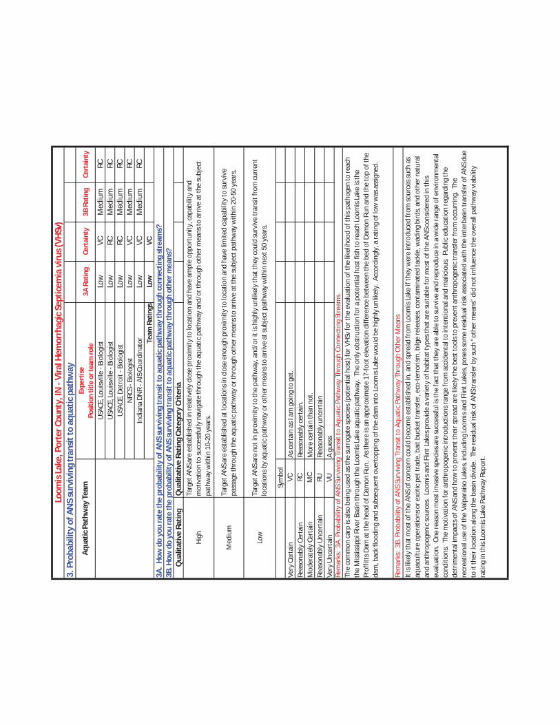
3. P
roba
bilit
y of
AN
S su
rviv
ing
tran
sit t
o aq
uatic
pat
hway
3A R
atin
g Ce
rtai
nty
3B R
atin
gCe
rtai
nty
Low
VCM
ediu
mRC
Low
RCM
ediu
mRC
Low
RCM
ediu
mRC
Low
VCM
ediu
mRC
Low
VCM
ediu
mRC
Low
VC
Qua
litat
ive
Ratin
gQ
ualit
ativ
e Ra
ting
Cate
gory
Crit
eria
High
Med
ium
Low
Sym
bol
Very
Cer
tain
VC
Reas
onab
ly C
erta
in
RCM
oder
atel
y Ce
rtai
n M
CRe
ason
ably
Unc
erta
in
RUVe
ry U
ncer
tain
VU
Loom
is L
ake,
Por
ter C
ount
y, IN
- Vi
ral H
emor
rhag
ic S
eptic
emia
viru
s (VH
Sv)
Aqua
tic P
athw
ay T
eam
Expe
rtis
e
Po
sitio
n tit
le o
r tea
m ro
leU
SACE
, Lou
isvill
e - B
iolo
gist
USA
CE, L
ouisv
ille
- Bio
logi
stU
SACE
, Det
roit
- Bio
logi
stN
RCS
- Bio
logi
stIn
dian
a DN
R - A
IS C
oord
inat
or Team
Rat
ings
As c
erta
in a
s I a
m g
oing
to g
et.
Reas
onab
ly c
erta
in.
Mor
e ce
rtai
n th
an n
ot.
Reas
onab
ly u
ncer
tain
A gu
ess
Rem
arks
: 3A
. Pro
babi
lity
of A
NS
Surv
ivin
g Tr
ansit
to A
quat
ic P
athw
ay T
hrou
gh C
onne
ctin
g St
ream
s.
3A.
How
do
you
rate
the
prob
abili
ty o
f AN
S su
rviv
ing
tran
sit t
o aq
uatic
pat
hway
thro
ugh
conn
ectin
g st
ream
s?3B
. How
do
you
rate
the
prob
abili
ty o
f AN
S su
rviv
ing
tran
sit t
o aq
uatic
pat
hway
thro
ugh
othe
r mea
ns?
Targ
et A
NS
are
esta
blish
ed in
rela
tivel
y cl
ose
prox
imity
to lo
catio
n an
d ha
ve a
mpl
e op
port
unity
, cap
abili
ty a
nd
mot
ivat
ion
to su
cces
sful
ly n
avig
ate
thro
ugh
the
aqua
tic p
athw
ay a
nd/o
r thr
ough
oth
er m
eans
to a
rriv
e at
the
subj
ect
path
way
with
in 1
0-20
yea
rs.
Targ
et A
NS
are
esta
blish
ed a
t loc
atio
ns in
clo
se e
noug
h pr
oxim
ity to
loca
tion
and
have
lim
ited
capa
bilit
y to
surv
ive
pass
age
thro
ugh
the
aqua
tic p
athw
ay o
r thr
ough
oth
er m
eans
to a
rriv
e at
the
subj
ect p
athw
ay w
ithin
20-
50 y
ears
.
Targ
et A
NS
are
not i
n pr
oxim
ity to
the
path
way
, and
/or i
t is h
ighl
y un
likel
y th
at th
ey c
ould
surv
ive
tran
sit fr
om c
urre
nt
loca
tions
by
aqua
tic p
athw
ay o
r oth
er m
eans
to a
rriv
e at
subj
ect p
athw
ay w
ithin
nex
t 50
year
s.
The
com
mon
car
p is
also
bei
ng u
sed
as th
e su
rrog
ate
spec
ies (
pote
ntia
l hos
t) fo
r VHS
v fo
r the
eva
luat
ion
of th
e lik
elih
ood
of th
is pa
thog
en to
reac
h th
e M
ississ
ippi
Riv
er B
asin
thro
ugh
the
Loom
is La
ke a
quat
ic p
athw
ay.
The
only
obs
truc
tion
for a
pot
entia
l hos
t fish
to re
ach
Loom
is La
ke is
the
Prof
fitts
Dam
at t
he h
ead
of D
amon
Run
. As
ther
e is
an a
ppro
xim
ate
17-fo
ot e
leva
tion
diffe
renc
e be
twee
n th
e be
d of
Dam
on R
un a
nd th
e to
p of
the
dam
, bac
k flo
odin
g an
d su
bseq
uent
ove
rtop
ping
of t
he d
am in
to L
oom
is La
ke w
ould
be
high
ly u
nlik
ely.
Acc
ordi
ngly
, a ra
ting
of lo
w w
as a
ssig
ned.
Rem
arks
: 3B
. Pro
babi
lity
of A
NS
Surv
ivin
g Tr
ansit
to A
quat
ic P
athw
ay T
hrou
gh O
ther
Mea
nsIt
is lik
ely
that
mos
t of t
he A
NS
of c
once
rn c
ould
bec
ome
esta
blish
ed in
, and
spre
ad fr
om L
oom
is La
ke if
they
wer
e in
trod
uced
from
sour
ces s
uch
as
aqua
cultu
re o
pera
tions
or e
xotic
pet
trad
e, b
ait b
ucke
t tra
nsfe
r, ec
o-te
rror
ism, b
ilge
rele
ases
, con
tam
inat
ed ta
ckle
, wad
ing
bird
s, a
nd o
ther
nat
ural
an
d an
thro
poge
nic
sour
ces.
Loo
mis
and
Flin
t Lak
es p
rovi
de a
var
iety
of h
abita
t typ
es th
at a
re su
itabl
e fo
r mos
t of t
he A
NS
cons
ider
ed in
this
eval
uatio
n. O
ne re
ason
mos
t inv
asiv
e sp
ecie
s are
succ
essf
ul is
the
fact
that
they
are
abl
e to
surv
ive
and
repr
oduc
e in
a w
ide
rang
e of
env
ironm
enta
l co
nditi
ons.
The
mot
ivat
ion
for a
nthr
opog
enic
intr
oduc
tions
rang
e fr
om a
ccid
enta
l to
inte
ntio
nal a
nd m
alic
ious
. Pu
blic
edu
catio
n re
gard
ing
the
detr
imen
tal i
mpa
cts o
f AN
S an
d ho
w to
pre
vent
thei
r spr
ead
are
likel
y th
e be
st to
ols t
o pr
even
t ant
hrop
ogen
ic tr
ansf
er fr
om o
ccur
ring.
The
re
crea
tiona
l use
of t
he V
alpa
raiso
Lak
es, i
nclu
ding
Loo
mis
and
Flin
t Lak
es, p
oses
som
e re
sidua
l risk
ass
ocia
ted
with
the
inte
rbas
in tr
ansf
er o
f AN
S du
e to
it th
eir l
ocat
ion
alon
g th
e ba
sin d
ivid
e. T
he re
sidua
l risk
of A
NS
tran
sfer
by
such
“ot
her m
eans
” di
d no
t inf
luen
ce th
e ov
eral
l pat
hway
via
bilit
y ra
ting
in th
is Lo
omis
Lake
Pat
hway
Rep
ort.

4. P
roba
bilit
y of
AN
S es
tabl
ishi
ng in
pro
xim
ity to
the
aqua
tic p
athw
ay
Ratin
g Ce
rtai
nty
Qua
litat
ive
Ratin
gQ
ualit
ativ
e Ra
ting
Cate
gory
Crit
eria
High
Med
ium
Sym
bol
Very
Cer
tain
VC
Reas
onab
ly C
erta
in
RCM
oder
atel
y Ce
rtai
n M
CRe
ason
ably
Unc
erta
in
RUVe
ry U
ncer
tain
VU
USA
CE, L
ouisv
ille
- Bio
logi
stU
SACE
, Lou
isvill
e - B
iolo
gist
USA
CE, D
etro
it - B
iolo
gist
NRC
S - B
iolo
gist
Indi
ana
DNR
- AIS
Coo
rdin
ator Te
am R
atin
gs
Loom
is L
ake,
Por
ter C
ount
y, IN
- Vi
ral H
emor
rhag
ic S
eptic
emia
viru
s (VH
Sv)
Aqua
tic P
athw
ay T
eam
Expe
rtis
e
Po
sitio
n tit
le o
r tea
m ro
le
As c
erta
in a
s I a
m g
oing
to g
et.
Reas
onab
ly c
erta
in.
Mor
e ce
rtai
n th
an n
ot.
Reas
onab
ly u
ncer
tain
A gu
ess
Rem
arks
: Sp
ecie
s-sp
ecifi
c ra
tings
for t
his s
ectio
n w
ere
not c
ompl
eted
bec
ause
the
ratin
gs fo
r the
like
lihoo
d th
at a
ny o
f the
AN
S of
con
cern
for
Loom
is La
ke w
ould
be
able
to su
rviv
e tr
ansit
from
thei
r cur
rent
loca
tions
in e
ither
bas
in to
the
path
way
wer
e al
l low
(Ste
p 3)
.
4. H
ow d
o yo
u ra
te th
e pr
obab
ility
of A
NS
esta
blis
hing
in p
roxi
mity
of t
he a
quat
ic p
athw
ay?
Sour
ces o
f foo
d an
d ha
bita
t sui
tabl
e to
the
ANS
are
plen
tiful
in c
lose
pro
xim
ity to
supp
ort a
ll lif
e st
ages
from
birt
h to
ad
ult,
abio
tic c
ondi
tions
alig
n w
ith n
ativ
e ra
nge
and
ther
e ar
e no
kno
wn
pred
ator
s or c
ondi
tions
that
wou
ld si
gnifi
cant
ly
impe
de su
rviv
abili
ty o
r rep
rodu
ctio
n.
Lim
ited
and
disc
onne
cted
are
as a
nd so
urce
s of f
ood
and
habi
tat s
uita
ble
to th
e AN
S ar
e av
aila
ble
in p
roxi
mity
, abi
otic
co
nditi
ons a
re w
ithin
latit
ude
limits
of n
ativ
e ra
nge,
but
onl
y a
port
ion
of th
e he
alth
y in
divi
dual
s arr
ivin
g at
loca
tion
can
be e
xpec
ted
to e
ffect
ivel
y co
mpe
te a
nd su
rviv
e.
Low
Habi
tat a
nd a
biot
ic c
ondi
tions
in p
roxi
mity
are
out
side
the
rang
e w
here
AN
S ha
s bee
n kn
own
to su
rviv
e; th
ere
is ve
ry
limite
d av
aila
bilit
y ha
bita
t are
a su
itabl
e fo
r AN
S co
ver,
sust
aina
ble
food
supp
ly a
nd re
prod
uctio
n; o
r nat
ive
pred
ator
s or
com
petit
ion
with
nat
ive
spec
ies w
ould
like
ly p
reve
nt e
stab
lishm
ent o
f a su
stai
nabl
e po
pula
tion.

5. P
roba
bilit
y of
AN
S sp
read
ing
acro
ss a
quat
ic p
athw
ay in
to th
e ne
w b
asin
Ratin
g Ce
rtai
nty
Qua
litat
ive
Ratin
gQ
ualit
ativ
e Ra
ting
Cate
gory
Crit
eria
High
Med
ium
Low
Sym
bol
Very
Cer
tain
VC
Reas
onab
ly C
erta
in
RCRe
ason
ably
cer
tain
.M
oder
atel
y Ce
rtai
n M
CRe
ason
ably
Unc
erta
in
RURe
ason
ably
unc
erta
inVe
ry U
ncer
tain
VU
Loom
is L
ake,
Por
ter C
ount
y, IN
- Vi
ral H
emor
rhag
ic S
eptic
emia
viru
s (VH
Sv)
Aqua
tic P
athw
ay T
eam
Expe
rtis
e
Po
sitio
n tit
le o
r tea
m ro
leU
SACE
, Lou
isvill
e - B
iolo
gist
USA
CE, L
ouisv
ille
- Bio
logi
stU
SACE
, Det
roit
- Bio
logi
stN
RCS
- Bio
logi
stIn
dian
a DN
R - A
IS C
oord
inat
or Team
Rat
ings
Mor
e ce
rtai
n th
an n
ot.
A gu
ess
Rem
arks
: Spe
cies
-spe
cific
ratin
gs fo
r thi
s sec
tion
wer
e no
t com
plet
ed b
ecau
se th
e ra
tings
for t
he li
kelih
ood
that
any
of t
he A
NS
of c
once
rn fo
r Lo
omis
Lake
wou
ld b
e ab
le to
surv
ive
tran
sit fr
om th
eir c
urre
nt lo
catio
ns in
eith
er b
asin
to th
e pa
thw
ay w
ere
all l
ow (S
tep
3).
5. H
ow d
o yo
u ra
te th
e pr
obab
ility
of A
NS
spre
adin
g ac
ross
aqu
atic
pat
hway
into
the
new
bas
in?
Sour
ces o
f foo
d an
d ha
bita
t sui
tabl
e to
the
ANS
are
avai
labl
e, a
nd th
e sp
ecie
s has
dem
onst
rate
d ca
pabi
litie
s to
signi
fican
tly e
xpan
d ra
nge
from
loca
tions
whe
re in
itial
ly in
trod
uced
.
Ther
e ar
e lim
ited
sour
ces o
f foo
d an
d su
itabl
e ha
bita
t, an
d/or
the
spec
ies h
as d
emon
stra
ted
limite
d ab
ility
to sp
read
sig
nific
ant d
istan
ces b
eyon
d ar
eas w
here
it h
as b
een
intr
oduc
ed.
Ther
e ar
e se
vere
ly li
mite
d so
urce
s of f
ood
and
suita
ble
habi
tat,
and/
or th
e sp
ecie
s has
dem
onst
rate
d ve
ry li
mite
d ab
ility
to
spre
ad b
eyon
d ar
eas w
here
it h
as b
een
intr
oduc
ed.
As c
erta
in a
s I a
m g
oing
to g
et.

1. P
roba
bilit
y of
aqu
atic
pat
hway
exi
sten
ce
Ratin
g Fl
ow
into
GLB
Cert
aint
y Ra
ting
Flow
in
to M
RBCe
rtai
nty
Med
ium
RCLo
wRC
Low
VCLo
wRC
Low
RCLo
wRC
Med
ium
RCLo
wVC
Med
ium
RCLo
wVC
Qua
litat
ive
Ratin
g
High
Med
ium
Low
Sym
bol
Very
Cer
tain
VC
Reas
onab
ly C
erta
in
RC
Mod
erat
ely
Cert
ain
MC
Reas
onab
ly U
ncer
tain
RU
Reas
onab
ly u
ncer
tain
Very
Unc
erta
in
VU
Loom
is L
ake,
Por
ter C
ount
y, IN
- Ru
ffe
(Gym
noch
epha
lus c
ernu
us) /
Tub
enos
e Go
by (P
rote
rorh
inus
sem
iluna
ris)
Aqua
tic P
athw
ay T
eam
Expe
rtis
e
Po
sitio
n tit
le o
r tea
m ro
le
USA
CE, D
etro
it - H
ydra
ulic
Eng
inee
r
USA
CE, L
ouisv
ille
- Hyd
raul
ic E
ngin
eer
USG
S - H
ydro
logi
st
Indi
ana
DNR
- Eng
inee
ring
Geol
ogist
Team
Rat
ings
As c
erta
in a
s I a
m g
oing
to g
et.
Reas
onab
ly c
erta
in.
Mor
e ce
rtai
n th
an n
ot.
A gu
ess
Rem
arks
: Flo
w is
regu
larly
con
nect
ed to
bot
h w
ater
shed
s, bu
t it i
s pro
fess
iona
l jud
gmen
t tha
t flo
w is
like
ly in
dow
nstr
eam
dire
ctio
n on
ly.
The
pr
obab
ility
of b
ackw
ater
inun
datio
n to
per
mit
tran
sfer
of s
peci
es in
to L
oom
is La
ke a
ppea
rs h
ighl
y un
likel
y fr
om th
e Gr
eat L
akes
. Su
rcha
rge
of th
e co
ndui
t int
o Fl
int L
ake
will
infr
eque
ntly
cre
ate
a co
nnec
tion,
and
vel
ociti
es in
the
cond
uit a
re e
xpec
ted
to b
e hi
gh. F
low
is v
ery
occa
siona
lly (l
ess t
han
1% fr
eque
ncy)
con
nect
ed fr
om L
oom
is La
ke to
Dam
on R
un tr
ibut
ary
thro
ugh
the
spill
way
acr
oss t
he d
am.
The
slope
and
shal
low
dep
th o
f the
nar
row
sp
illw
ay w
ould
impe
de tr
ansf
er o
f AN
S up
stre
am fr
om th
e GL
B an
d up
the
spill
way
to L
oom
is La
ke.
Flow
is re
gula
rly c
onne
cted
from
Loo
mis
Lake
to
Flin
t Lak
e. T
he o
bser
ved
drop
at t
he o
utle
t str
uctu
re fr
om L
oom
is La
ke to
Flin
t Lak
e is
an im
pedi
men
t to
adul
t AN
S sw
imm
ing
upst
ream
from
Flin
t La
ke in
to L
oom
is La
ke, m
akin
g it
a lo
w p
roba
blili
ty c
onne
ctio
n fr
om th
e M
RB to
the
GLB.
The
pos
sibili
ty o
f bac
kwat
er in
unda
tion
from
Flin
t Lak
e to
pe
rmit
tran
sfer
of A
NS
into
Loo
mis
Lake
app
ears
hig
hly
unlik
ely
exce
pt u
nder
ver
y hi
gh w
ater
leve
ls in
Lak
e Lo
omis
durin
g co
nditi
ons o
f pip
e fu
ll flo
w--
cond
ition
s nec
essa
ry to
ach
ieve
that
flow
cou
ld h
appe
n on
ly u
nder
the
very
hig
hest
pos
sible
lake
leve
ls if
at a
ll. T
he 3
-inch
tras
h ra
ck is
not
an
impe
dim
ent t
o AN
S tr
ansf
er e
xcep
t for
lar
ger a
dult
carp
. Flo
w fr
om F
lint L
ake
into
dow
nstr
eam
trib
utar
ies o
f the
Kan
kake
e Ri
ver w
ould
be
suffi
cien
tly
freq
uent
to e
stab
lish
an o
ccas
iona
l con
nect
ion
durin
g sp
ring
mon
ths.
(rev
ised
8/5/
11, b
ased
on
culv
ert f
low
com
puta
tions
by
K. La
mki
n). A
gree
. In
ad
ditio
n: *
If th
e Ba
sin b
ound
ary
wer
e ap
prop
riate
ly d
raw
n, th
e ris
k w
ould
be
base
d on
onl
y th
e no
rthe
rn o
utle
t str
uctu
re w
ith a
low
ratin
g fo
r tra
nsfe
r in
to th
e M
RB.
Se
e Se
ctio
n 1.
3 an
d 2.
3 of
the
atta
ched
repo
rt.
Loom
is La
ke is
a m
an-m
ade
lake
on
the
basin
bou
ndar
y. C
onst
ruct
ion
of L
oom
is La
ke d
ecad
es a
go te
chni
cally
shift
ed th
e Ba
sin B
ound
ary,
shift
ing
the
pere
nnia
l dra
inag
e an
d th
eref
ore
the
wat
ersh
ed fo
r the
lake
into
the
Miss
issip
pi R
iver
Bas
in (M
RB).
Thi
s rat
ing
has b
een
base
d on
kno
wle
dge
of th
e ac
tual
flow
cha
ract
erist
ics a
s doc
umen
ted
in th
e at
tach
ed re
port
des
crib
ing
the
inte
rmitt
ent c
onne
ctio
n of
Loo
mis
Lake
to
the
Grea
t Lak
es B
asin
vie
the
dam
and
spill
way
(Pro
ffitt
s Dam
) on
the
nort
h sid
e of
the
lake
. Fl
ow fr
om th
e GL
B in
to L
oom
is La
ke (M
RB) o
ver t
he
Prof
fitts
Dam
is h
ighl
y un
likel
y, th
eref
ore
a Lo
w ra
ting
(VC)
. Fl
ow fr
om L
oom
is La
ke (M
RB) i
nto
GLB
as a
disc
harg
e ov
er th
e sp
illw
ay a
t Pro
ffitt
s Dam
is
inte
rmitt
ent a
nd th
eref
ore
the
H& H
ratin
g w
ill b
e M
ediu
m (R
C) e
ven
thou
gh sp
ecie
s tra
nsfe
r wou
ld b
e ve
ry lo
w d
ue to
the
conn
ectin
g dr
op st
ruct
ure
and
pipe
for t
he p
eren
nial
disc
harg
e fr
om L
oom
is La
ke.
1. H
ow d
o yo
u ra
te th
e lik
elih
ood
of th
e ex
iste
nce
of a
via
ble
aqua
tic p
athw
ay a
t the
subj
ect l
ocat
ion?
Ass
ume
a vi
able
aqu
atic
pat
hway
is a
ny
loca
tion
whe
re u
ntre
ated
surf
ace
wat
er fl
ow a
cros
s the
div
ide
is d
eem
ed li
kely
to o
ccur
and
con
nect
hea
dwat
er st
ream
s in
both
bas
ins f
rom
any
st
orm
up
to th
e 1%
ann
ual r
etur
n fr
eque
ncy
stor
m.
Qua
litat
ive
Ratin
g Ca
tego
ry C
riter
ia
Pere
nnia
l str
eam
s and
wet
land
s or i
nter
mitt
ent s
trea
m k
now
n/do
cum
ente
d to
con
vey
signi
fican
t vol
umes
of w
ater
acr
oss
the
basin
div
ide
for d
ays t
o w
eeks
mul
tiple
tim
es p
er y
ear.
In
term
itten
t str
eam
cap
able
of m
aint
aini
ng a
surf
ace
wat
er c
onne
ctio
n to
stre
ams o
n bo
th si
des o
f the
bas
in d
ivid
e co
ntin
uous
ly fo
r mul
tiple
day
s fro
m a
10%
ann
ual r
etur
n fr
eque
ncy
stor
m; o
r, lo
catio
n of
wet
land
span
ning
bas
in d
ivid
e w
hich
mai
ntai
ns si
gnifi
cant
pon
ds th
at a
re li
kely
to b
ecom
e in
ter c
onne
cted
and
con
nect
with
stre
ams o
n bo
th si
des o
f the
ba
sin d
ivid
e fr
om a
10%
ann
ual r
etur
n fr
eque
ncy
stor
m.
Inte
rmitt
ent s
trea
m o
r mar
sh fo
rmin
g a
surf
ace
wat
er c
onne
ctio
n be
twee
n st
ream
s on
eith
er si
de o
f the
bas
in d
ivid
e fr
om
larg
er th
an a
1.0
% a
nnua
l ret
urn
freq
uenc
y st
orm
.

2. P
roba
bilit
y of
AN
S oc
curr
ing
with
in e
ither
bas
inRa
ting
Cert
aint
y
High
VCHi
ghVC
High
VCM
ediu
mVC
Med
ium
VCHi
ghVC
Qua
litat
ive
Ratin
g
High
Med
ium
Low
Sym
bol
Very
Cer
tain
VC
Reas
onab
ly C
erta
in
RCM
oder
atel
y Ce
rtai
n M
CRe
ason
ably
Unc
erta
in
RUVe
ry U
ncer
tain
VU
Loom
is L
ake,
Por
ter C
ount
y, IN
- Ru
ffe (G
ymno
chep
halu
s cer
nuus
) / T
uben
ose
Goby
(Pro
tero
rhin
us se
milu
naris
)
Aqua
tic P
athw
ay T
eam
Expe
rtis
e
Po
sitio
n tit
le o
r tea
m ro
leU
SACE
, Lou
isvill
e - B
iolo
gist
USA
CE, L
ouisv
ille
- Bio
logi
stU
SACE
, Det
roit
- Bio
logi
stN
RCS
- Bio
logi
stIn
dian
a DN
R - A
IS C
oord
inat
or Team
Rat
ing
As c
erta
in a
s I a
m g
oing
to g
et.
Reas
onab
ly c
erta
in.
Mor
e ce
rtai
n th
an n
ot.
Reas
onab
ly u
ncer
tain
A gu
ess
Rem
arks
: Th
e ru
ffe a
nd tu
beno
se g
oby
are
loca
ted
with
in th
e Gr
eat L
akes
and
ass
ocia
ted
with
rive
r mou
ths a
nd e
stua
ries o
f lar
ge ri
ver s
yste
ms
ente
ring
the
Grea
t Lak
es, a
nd th
e ru
ffe h
as b
een
iden
tifie
d in
Lak
e Su
perio
r, th
e Gr
een
Bay
port
ion
of L
ake
Mic
higa
n an
d La
ke H
uron
. Li
tera
ture
re
view
s and
act
ual f
ish su
rvey
dat
a ha
ve n
ot d
ocum
ente
d th
e co
llect
ion
of th
e ru
ffe in
smal
ler u
pstr
eam
trib
utar
ies.
The
tube
nose
gob
y's i
ntro
duce
d ra
nge
incl
udes
Lak
e St
. Cla
ir, E
rie, H
uron
, Sup
erio
r, an
d O
ntar
io U
SGS,
201
1).
It ha
s bee
n co
llect
ed in
the
low
er re
ache
s of l
arge
r Gre
at L
akes
rive
rs
and
estu
arie
s.
2. H
ow d
o yo
u ra
te th
e pr
obab
ility
of A
NS
occu
ring
with
in e
ither
bas
in?
Qua
litat
ive
Ratin
g Ca
tego
ry C
riter
ia
Targ
et A
NS
exist
s on
conn
ecte
d w
ater
way
s in
clos
e en
ough
pro
xim
ity to
be
capa
ble
of m
ovin
g to
the
aqua
tic p
athw
ay
with
in 2
0 ye
ars.
Targ
et A
NS
exist
s on
conn
ecte
d w
ater
way
s, b
ut b
ased
on
curr
ent p
roxi
mity
and
mob
ility
, is c
onsid
ered
inca
pabl
e of
m
ovin
g to
the
aqua
tic p
athw
ay w
ithin
20
year
s.
Targ
et A
NS
is no
t kno
wn
to e
xist
on
a co
nnec
ted
wat
erw
ay.

3. P
roba
bilit
y of
AN
S su
rviv
ing
tran
sit to
aqu
atic
pat
hway
3A R
atin
g Ce
rtai
nty
3B R
atin
gCe
rtai
nty
Low
VCM
ediu
mRC
Low
VCM
ediu
mRC
Low
RCLo
wM
CLo
wVC
Med
ium
RCLo
wVC
Med
ium
RCLo
wVC
Qua
litat
ive
Ratin
gQ
ualit
ativ
e Ra
ting
Cate
gory
Crit
eria
High
Med
ium
Low
Sym
bol
Very
Cer
tain
VC
Reas
onab
ly C
erta
in
RCM
oder
atel
y Ce
rtai
n M
CRe
ason
ably
Unc
erta
in
RUVe
ry U
ncer
tain
VU
Loom
is La
ke, P
orte
r Cou
nty,
IN -
Ruffe
(Gym
noch
epha
lus c
ernu
us) /
Tub
enos
e Go
by (P
rote
rorh
inus
sem
iluna
ris)
Aqua
tic P
athw
ay T
eam
Expe
rtis
e
Posi
tion
title
or t
eam
role
USA
CE, L
ouisv
ille
- Bio
logi
stU
SACE
, Lou
isvill
e - B
iolo
gist
USA
CE, D
etro
it - B
iolo
gist
NRC
S - B
iolo
gist
Indi
ana
DNR
- AIS
Coo
rdin
ator Te
am R
atin
gs
As c
erta
in a
s I a
m g
oing
to g
et.
Reas
onab
ly c
erta
in.
Mor
e ce
rtai
n th
an n
ot.
Reas
onab
ly u
ncer
tain
A gu
ess
Rem
arks
: 3A
. Pro
babi
lity
of A
NS
Surv
ivin
g Tr
ansit
to A
quat
ic P
athw
ay T
hrou
gh C
onne
ctin
g St
ream
s.
3A.
How
do
you
rate
the
prob
abili
ty o
f AN
S su
rviv
ing
tran
sit t
o aq
uatic
pat
hway
thro
ugh
conn
ectin
g st
ream
s?3B
. How
do
you
rate
the
prob
abili
ty o
f AN
S su
rviv
ing
tran
sit t
o aq
uatic
pat
hway
thro
ugh
othe
r mea
ns?
Targ
et A
NS
are
esta
blish
ed in
rela
tivel
y cl
ose
prox
imity
to lo
catio
n an
d ha
ve a
mpl
e op
port
unity
, cap
abili
ty a
nd
mot
ivat
ion
to su
cces
sful
ly n
avig
ate
thro
ugh
the
aqua
tic p
athw
ay a
nd/o
r thr
ough
oth
er m
eans
to a
rriv
e at
the
subj
ect
path
way
with
in 1
0-20
yea
rs.
Targ
et A
NS
are
esta
blish
ed a
t loc
atio
ns in
clo
se e
noug
h pr
oxim
ity to
loca
tion
and
have
lim
ited
capa
bilit
y to
surv
ive
pass
age
thro
ugh
the
aqua
tic p
athw
ay o
r thr
ough
oth
er m
eans
to a
rriv
e at
the
subj
ect p
athw
ay w
ithin
20-
50 y
ears
.
Targ
et A
NS
are
not i
n pr
oxim
ity to
the
path
way
, and
/or i
t is h
ighl
y un
likel
y th
at th
ey c
ould
surv
ive
tran
sit fr
om c
urre
nt
loca
tions
by
aqua
tic p
athw
ay o
r oth
er m
eans
to a
rriv
e at
subj
ect p
athw
ay w
ithin
nex
t 50
year
s.
The
ruffe
pre
fers
dee
p w
ater
s of l
akes
and
poo
ls of
rive
rs, u
sual
ly o
ver s
and
and
grav
el, b
ut h
as a
tole
ranc
e fo
r diff
eren
t hab
itats
and
env
ironm
enta
l co
nditi
ons (
Gray
and
Bes
t, 19
89).
The
ruffe
has
a h
igh
fecu
ndity
rate
and
spaw
ns in
cle
an w
ater
. Th
e ru
ffe's
abili
ty to
swim
ups
trea
m d
urin
g hi
gh
flow
eve
nts a
nd m
igra
te o
ver d
ams i
s que
stio
nabl
e. T
he tu
beno
se is
foun
d in
the
open
wat
ers a
nd e
stua
ries o
f slo
w fl
owin
g riv
ers.
The
tube
nose
go
by a
ppea
rs to
be
mor
e ca
pabl
e of
livi
ng in
mor
e di
vers
e ty
pes o
f riv
erin
e ha
bita
t tha
n th
e ru
ffe (D
opaz
o, e
t al,
2008
; Jud
e an
d De
Boe,
199
6).
Suffi
cien
t for
age
rang
ing
from
zoop
lank
ton
to fi
sh m
ay b
e av
aila
ble
thro
ugho
ut th
e Gr
eat L
akes
side
of t
he c
onne
ctio
n. H
owev
er, s
uita
ble
habi
tat f
or
the
ruffe
and
tube
nose
gob
y in
Sal
t Cre
ek m
ay b
e lim
ited
or e
ven
none
xist
ent.
The
only
obs
truc
tion
for e
ither
of t
hese
spec
ies t
o re
ach
Loom
is La
ke is
the
Prof
fitts
Dam
at t
he h
ead
of D
amon
Run
. As
ther
e is
an a
ppro
xim
ate
17-
foot
ele
vatio
n di
ffere
nce
betw
een
the
bed
of D
amon
Run
and
the
top
of th
e da
m, b
ack
flood
ing
and
subs
eque
nt o
vert
oppi
ng o
f the
dam
into
Loo
mis
Lake
wou
ld b
e hi
ghly
unl
ikel
y. A
ccor
ding
ly, a
ratin
g of
low
was
ass
igne
d. Re
mar
ks:
3B. P
roba
bilit
y of
AN
S Su
rviv
ing
Tran
sit to
Aqu
atic
Pat
hway
Thr
ough
Oth
er M
eans
It is
likel
y th
at m
ost o
f the
AN
S of
con
cern
cou
ld b
ecom
e es
tabl
ished
in, a
nd sp
read
from
Loo
mis
Lake
if th
ey w
ere
intr
oduc
ed fr
om so
urce
s suc
h as
aq
uacu
lture
ope
ratio
ns o
r exo
tic p
et tr
ade,
bai
t buc
ket t
rans
fer,
eco-
terr
orism
, bilg
e re
leas
es, c
onta
min
ated
tack
le, w
adin
g bi
rds,
and
oth
er n
atur
al
and
anth
ropo
geni
c so
urce
s. L
oom
is an
d Fl
int L
akes
pro
vide
a v
arie
ty o
f hab
itat t
ypes
that
are
suita
ble
for m
ost o
f the
AN
S co
nsid
ered
in th
is ev
alua
tion.
One
reas
on m
ost i
nvas
ive
spec
ies a
re su
cces
sful
is th
e fa
ct th
at th
ey a
re a
ble
to su
rviv
e an
d re
prod
uce
in a
wid
e ra
nge
of e
nviro
nmen
tal
cond
ition
s. T
he m
otiv
atio
n fo
r ant
hrop
ogen
ic in
trod
uctio
ns ra
nge
from
acc
iden
tal t
o in
tent
iona
l and
mal
icio
us.
Publ
ic e
duca
tion
rega
rdin
g th
e de
trim
enta
l im
pact
s of A
NS
and
how
to p
reve
nt th
eir s
prea
d ar
e lik
ely
the
best
tool
s to
prev
ent a
nthr
opog
enic
tran
sfer
from
occ
urrin
g. T
he
recr
eatio
nal u
se o
f the
Val
para
iso L
akes
, inc
ludi
ng L
oom
is an
d Fl
int L
akes
, pos
es so
me
resid
ual r
isk a
ssoc
iate
d w
ith th
e in
terb
asin
tran
sfer
of A
NS
due
to it
thei
r loc
atio
n al
ong
the
basin
div
ide.
The
resid
ual r
isk o
f AN
S tr
ansf
er b
y su
ch “
othe
r mea
ns”
did
not i
nflu
ence
the
over
all p
athw
ay v
iabi
lity
ratin
g in
this
Loom
is La
ke P
athw
ay R
epor
t.

4. P
roba
bilit
y of
AN
S es
tabl
ishi
ng in
pro
xim
ity to
the
aqua
tic p
athw
ay
Ratin
g Ce
rtai
nty
Qua
litat
ive
Ratin
gQ
ualit
ativ
e Ra
ting
Cate
gory
Crit
eria
High
Med
ium
Sym
bol
Very
Cer
tain
VC
Reas
onab
ly C
erta
in
RCM
oder
atel
y Ce
rtai
n M
CRe
ason
ably
Unc
erta
in
RUVe
ry U
ncer
tain
VU
USA
CE, L
ouisv
ille
- Bio
logi
stU
SACE
, Lou
isvill
e - B
iolo
gist
USA
CE, D
etro
it - B
iolo
gist
NRC
S - B
iolo
gist
Indi
ana
DNR
- AIS
Coo
rdin
ator Te
am R
atin
gs
Loom
is L
ake,
Por
ter C
ount
y, IN
- Ru
ffe (G
ymno
chep
halu
s cer
nuus
) / T
uben
ose
Goby
(Pro
tero
rhin
us se
milu
naris
)
Aqua
tic P
athw
ay T
eam
Expe
rtis
e
Po
sitio
n tit
le o
r tea
m ro
le
As c
erta
in a
s I a
m g
oing
to g
et.
Reas
onab
ly c
erta
in.
Mor
e ce
rtai
n th
an n
ot.
Reas
onab
ly u
ncer
tain
A gu
ess
Rem
arks
: Sp
ecie
s-sp
ecifi
c ra
tings
for t
his s
ectio
n w
ere
not c
ompl
eted
bec
ause
the
ratin
gs fo
r the
like
lihoo
d th
at a
ny o
f the
AN
S of
con
cern
for L
oom
is La
ke w
ould
be
able
to su
rviv
e tr
ansit
from
thei
r cur
rent
loca
tions
in e
ither
bas
in to
the
path
way
wer
e al
l low
(Ste
p 3)
.
4. H
ow d
o yo
u ra
te th
e pr
obab
ility
of A
NS
esta
blis
hing
in p
roxi
mity
of t
he a
quat
ic p
athw
ay?
Sour
ces o
f foo
d an
d ha
bita
t sui
tabl
e to
the
ANS
are
plen
tiful
in c
lose
pro
xim
ity to
supp
ort a
ll lif
e st
ages
from
birt
h to
ad
ult,
abio
tic c
ondi
tions
alig
n w
ith n
ativ
e ra
nge
and
ther
e ar
e no
kno
wn
pred
ator
s or c
ondi
tions
that
wou
ld si
gnifi
cant
ly
impe
de su
rviv
abili
ty o
r rep
rodu
ctio
n.
Lim
ited
and
disc
onne
cted
are
as a
nd so
urce
s of f
ood
and
habi
tat s
uita
ble
to th
e AN
S ar
e av
aila
ble
in p
roxi
mity
, abi
otic
co
nditi
ons a
re w
ithin
latit
ude
limits
of n
ativ
e ra
nge,
but
onl
y a
port
ion
of th
e he
alth
y in
divi
dual
s arr
ivin
g at
loca
tion
can
be e
xpec
ted
to e
ffect
ivel
y co
mpe
te a
nd su
rviv
e.
Low
Habi
tat a
nd a
biot
ic c
ondi
tions
in p
roxi
mity
are
out
side
the
rang
e w
here
AN
S ha
s bee
n kn
own
to su
rviv
e; th
ere
is ve
ry
limite
d av
aila
bilit
y ha
bita
t are
a su
itabl
e fo
r AN
S co
ver,
sust
aina
ble
food
supp
ly a
nd re
prod
uctio
n; o
r nat
ive
pred
ator
s or
com
petit
ion
with
nat
ive
spec
ies w
ould
like
ly p
reve
nt e
stab
lishm
ent o
f a su
stai
nabl
e po
pula
tion.

5. P
roba
bilit
y of
AN
S sp
read
ing
acro
ss a
quat
ic p
athw
ay in
to th
e ne
w b
asin
Ratin
g Ce
rtai
nty
Qua
litat
ive
Ratin
gQ
ualit
ativ
e Ra
ting
Cate
gory
Crit
eria
High
Med
ium
Low
Sym
bol
Very
Cer
tain
VC
Reas
onab
ly C
erta
in
RCRe
ason
ably
cer
tain
.M
oder
atel
y Ce
rtai
n M
CRe
ason
ably
Unc
erta
in
RURe
ason
ably
unc
erta
inVe
ry U
ncer
tain
VU
Loom
is L
ake,
Por
ter C
ount
y, IN
- Ru
ffe (G
ymno
chep
halu
s cer
nuus
) / T
uben
ose
Goby
(Pro
tero
rhin
us se
milu
naris
)
Aqua
tic P
athw
ay T
eam
Expe
rtis
e
Po
sitio
n tit
le o
r tea
m ro
leU
SACE
, Lou
isvill
e - B
iolo
gist
USA
CE, L
ouisv
ille
- Bio
logi
stU
SACE
, Det
roit
- Bio
logi
stN
RCS
- Bio
logi
stIn
dian
a DN
R - A
IS C
oord
inat
or Team
Rat
ings
Mor
e ce
rtai
n th
an n
ot.
A gu
ess
Rem
arks
: Spe
cies
-spe
cific
ratin
gs fo
r thi
s sec
tion
wer
e no
t com
plet
ed b
ecau
se th
e ra
tings
for t
he li
kelih
ood
that
any
of t
he A
NS
of c
once
rn fo
r Lo
omis
Lake
wou
ld b
e ab
le to
surv
ive
tran
sit fr
om th
eir c
urre
nt lo
catio
ns in
eith
er b
asin
to th
e pa
thw
ay w
ere
all l
ow (S
tep
3).
5. H
ow d
o yo
u ra
te th
e pr
obab
ility
of A
NS
spre
adin
g ac
ross
aqu
atic
pat
hway
into
the
new
bas
in?
Sour
ces o
f foo
d an
d ha
bita
t sui
tabl
e to
the
ANS
are
avai
labl
e, a
nd th
e sp
ecie
s has
dem
onst
rate
d ca
pabi
litie
s to
signi
fican
tly e
xpan
d ra
nge
from
loca
tions
whe
re in
itial
ly in
trod
uced
.
Ther
e ar
e lim
ited
sour
ces o
f foo
d an
d su
itabl
e ha
bita
t, an
d/or
the
spec
ies h
as d
emon
stra
ted
limite
d ab
ility
to sp
read
sig
nific
ant d
istan
ces b
eyon
d ar
eas w
here
it h
as b
een
intr
oduc
ed.
Ther
e ar
e se
vere
ly li
mite
d so
urce
s of f
ood
and
suita
ble
habi
tat,
and/
or th
e sp
ecie
s has
dem
onst
rate
d ve
ry li
mite
d ab
ility
to
spre
ad b
eyon
d ar
eas w
here
it h
as b
een
intr
oduc
ed.
As c
erta
in a
s I a
m g
oing
to g
et.

1. P
roba
bilit
y of
aqu
atic
pat
hway
exi
sten
ce
Ratin
g Fl
ow
into
GLB
Cert
aint
y Ra
ting
Flow
in
to M
RBCe
rtai
nty
Med
ium
RCLo
wRC
Low
VCLo
wRC
Low
RCLo
wRC
Med
ium
RCLo
wVC
Med
ium
RCLo
wVC
Qua
litat
ive
Ratin
g
High
Med
ium
Low
Sym
bol
Very
Cer
tain
VC
Reas
onab
ly C
erta
in
RC
Mod
erat
ely
Cert
ain
MC
Reas
onab
ly U
ncer
tain
RU
Reas
onab
ly u
ncer
tain
Very
Unc
erta
in
VU
As ce
rtai
n as
I am
goi
ng to
get
.Re
ason
ably
cert
ain.
Mor
e ce
rtai
n th
an n
ot.
A gu
ess
Rem
arks
: Flo
w is
regu
larly
con
nect
ed to
bot
h w
ater
shed
s, b
ut it
is p
rofe
ssio
nal j
udgm
ent t
hat f
low
is li
kely
in d
owns
trea
m d
irect
ion
only
. T
he
prob
abili
ty o
f bac
kwat
er in
unda
tion
to p
erm
it tr
ansf
er o
f spe
cies
into
Loom
is La
ke a
ppea
rs h
ighl
y un
likel
y fr
om th
e Gr
eat L
akes
. Su
rcha
rge
of th
e co
ndui
t int
o Fl
int L
ake
will
infr
eque
ntly
cre
ate
a co
nnec
tion,
and
vel
ociti
es in
the
cond
uit a
re e
xpec
ted
to b
e hi
gh. F
low
is v
ery
occa
siona
lly (l
ess t
han
1% fr
eque
ncy)
con
nect
ed fr
om Lo
omis
Lake
to D
amon
Run
trib
utar
y th
roug
h th
e sp
illw
ay a
cros
s the
dam
. Th
e slo
pe a
nd sh
allo
w d
epth
of t
he n
arro
w
spill
way
wou
ld im
pede
tran
sfer
of A
NS
upst
ream
from
the
GLB
and
up th
e sp
illw
ay to
Loom
is La
ke.
Flow
is re
gula
rly c
onne
cted
from
Loo
mis
Lake
to
Flin
t Lak
e. T
he o
bser
ved
drop
at t
he o
utle
t str
uctu
re fr
om L
oom
is La
ke to
Flin
t Lak
e is
an im
pedi
men
t to
adul
t AN
S sw
imm
ing
upst
ream
from
Flin
t La
ke in
to Lo
omis
Lake
, mak
ing
it a
low
pro
babl
ility
con
nect
ion
from
the
MRB
to th
e GL
B. T
he p
ossib
ility
of b
ackw
ater
inun
datio
n fr
om F
lint L
ake
to
perm
it tr
ansf
er o
f AN
S in
to L
oom
is La
ke a
ppea
rs h
ighl
y un
likel
y ex
cept
und
er v
ery
high
wat
er le
vels
in L
ake
Loom
is du
ring
cond
ition
s of p
ipe
full
flow
--co
nditi
ons n
eces
sary
to a
chie
ve th
at fl
ow c
ould
hap
pen
only
und
er th
e ve
ry h
ighe
st p
ossib
le la
ke le
vels
if at
all.
The
3-in
ch tr
ash
rack
is n
ot a
n im
pedi
men
t to
ANS
tran
sfer
exc
ept f
or l
arge
r adu
lt ca
rp. F
low
from
Flin
t Lak
e in
to d
owns
trea
m tr
ibut
arie
s of t
he K
anka
kee
Rive
r wou
ld b
e su
ffici
ently
fr
eque
nt to
est
ablis
h an
occ
asio
nal c
onne
ctio
n du
ring
sprin
g m
onth
s. (r
evise
d 8/
5/11
, bas
ed o
n cu
lver
t flo
w c
ompu
tatio
ns b
y K.
Lam
kin)
. Agr
ee.
In
addi
tion:
* If
the
Basin
bou
ndar
y w
ere
appr
opria
tely
dra
wn,
the
risk
wou
ld b
e ba
sed
on o
nly
the
nort
hern
out
let s
truc
ture
with
a lo
w ra
ting
for
tran
sfer
into
the
MRB
.
See
Sect
ion
1.3
and
2.3
of th
e at
tach
ed re
port
. Lo
omis
Lake
is a
man
-mad
e la
ke o
n th
e ba
sin b
ound
ary.
Con
stru
ctio
n of
Loo
mis
Lake
dec
ades
ago
tech
nica
lly sh
ifted
th
e Ba
sin B
ound
ary,
shift
ing
the
pere
nnia
l dra
inag
e an
d th
eref
ore
the
wat
ersh
ed fo
r the
lake
into
the
Miss
issip
pi R
iver
Bas
in (M
RB).
Thi
s rat
ing
has
been
bas
ed o
n kn
owle
dge
of th
e ac
tual
flow
cha
ract
erist
ics a
s doc
umen
ted
in th
e at
tach
ed re
port
des
crib
ing
the
inte
rmitt
ent c
onne
ctio
n of
Loo
mis
Lake
to th
e Gr
eat L
akes
Bas
in v
ie th
e da
m a
nd sp
illw
ay (P
roffi
tts D
am) o
n th
e no
rth
side
of th
e la
ke.
Flow
from
the
GLB
into
Loo
mis
Lake
(MRB
) ove
r th
e Pr
offit
ts D
am i
s hig
hly
unlik
ely,
ther
efor
e a
Low
ratin
g (V
C).
Flow
from
Loom
is La
ke (M
RB) i
nto
GLB
as a
disc
harg
e ov
er th
e sp
illw
ay a
t Pro
ffitt
s Da
m is
inte
rmitt
ent a
nd th
eref
ore
the
H& H
ratin
g w
ill b
e M
ediu
m (R
C) e
ven
thou
gh sp
ecie
s tra
nsfe
r wou
ld b
e ve
ry lo
w d
ue to
the
conn
ectin
g dr
op
stru
ctur
e an
d pi
pe fo
r the
per
enni
al d
ischa
rge
from
Loo
mis
Lake
.
1. H
ow d
o yo
u ra
te th
e lik
elih
ood
of th
e ex
iste
nce
of a
via
ble
aqua
tic p
athw
ay a
t the
subj
ect l
ocat
ion?
Ass
ume
a vi
able
aqu
atic
pat
hway
is a
ny
loca
tion
whe
re u
ntre
ated
surf
ace
wat
er fl
ow a
cros
s the
div
ide
is d
eem
ed li
kely
to o
ccur
and
conn
ect h
eadw
ater
stre
ams i
n bo
th b
asin
s fro
m a
ny
stor
m u
p to
the
1% a
nnua
l ret
urn
freq
uenc
y st
orm
.
Qua
litat
ive
Ratin
g Ca
tego
ry C
riter
ia
Pere
nnia
l str
eam
s and
wet
land
s or i
nter
mitt
ent s
trea
m k
now
n/do
cum
ente
d to
con
vey
signi
fican
t vol
umes
of w
ater
ac
ross
the
basin
div
ide
for d
ays t
o w
eeks
mul
tiple
tim
es p
er y
ear.
In
term
itten
t str
eam
cap
able
of m
aint
aini
ng a
surf
ace
wat
er c
onne
ctio
n to
stre
ams o
n bo
th si
des o
f the
bas
in d
ivid
e co
ntin
uous
ly fo
r mul
tiple
day
s fro
m a
10%
ann
ual r
etur
n fr
eque
ncy
stor
m; o
r, lo
catio
n of
wet
land
span
ning
bas
in d
ivid
e w
hich
mai
ntai
ns si
gnifi
cant
pon
ds th
at a
re li
kely
to b
ecom
e in
ter c
onne
cted
and
con
nect
with
stre
ams o
n bo
th si
des o
f th
e ba
sin d
ivid
e fr
om a
10%
ann
ual r
etur
n fr
eque
ncy
stor
m.
Inte
rmitt
ent s
trea
m o
r mar
sh fo
rmin
g a
surf
ace
wat
er c
onne
ctio
n be
twee
n st
ream
s on
eith
er si
de o
f the
bas
in d
ivid
e fr
om la
rger
than
a 1
.0%
ann
ual r
etur
n fr
eque
ncy
stor
m.
Loom
is L
ake,
Por
ter C
ount
y, IN
- Th
rees
pine
Stic
kleb
ack
(Gas
tero
steu
s acu
leat
us)
Aqua
tic P
athw
ay T
eam
Expe
rtis
e
Po
sitio
n tit
le o
r tea
m ro
le
USA
CE, D
etro
it - H
ydra
ulic
Eng
inee
rU
SACE
, Lou
isvill
e - H
ydra
ulic
Eng
inee
rU
SGS
- Hyd
rolo
gist
Indi
ana
DNR
- Eng
inee
ring
Geo
logi
stTe
am R
atin
gs

2. P
roba
bilit
y of
AN
S oc
curr
ing
with
in e
ither
bas
inRa
ting
Cert
aint
y
High
VCHi
ghVC
High
RCM
ediu
mVC
Med
ium
VCHi
ghVC
Qua
litat
ive
Ratin
g
High
Med
ium
Low
Sym
bol
Very
Cer
tain
VC
Reas
onab
ly C
erta
in
RCM
oder
atel
y Ce
rtai
n M
CRe
ason
ably
Unc
erta
in
RUVe
ry U
ncer
tain
VU
Loom
is L
ake,
Por
ter C
ount
y, IN
- Th
rees
pine
Stic
kleb
ack
(Gas
tero
steu
s acu
leat
us)
Aqua
tic P
athw
ay T
eam
Expe
rtis
e
Po
sitio
n tit
le o
r tea
m ro
leU
SACE
, Lou
isvill
e - B
iolo
gist
USA
CE, L
ouisv
ille
- Bio
logi
stU
SACE
, Det
roit
- Bio
logi
stN
RCS
- Bio
logi
stIn
dian
a DN
R - A
IS C
oord
inat
or Team
Rat
ing
As c
erta
in a
s I a
m g
oing
to g
et.
Reas
onab
ly c
erta
in.
Mor
e ce
rtai
n th
an n
ot.
Reas
onab
ly u
ncer
tain
A gu
ess
Rem
arks
: Th
e th
rees
pine
stic
kleb
ack
is fo
und
in e
ach
of th
e Gr
eat L
akes
(Lak
e O
ntar
io H
UC
8 re
cord
s are
with
in n
ativ
e ra
nge)
and
has
bee
n co
llect
ed
in so
me
inla
nd ri
ver s
yste
ms (
USG
S, 2
011)
. Li
tera
ture
indi
cate
s th
is sp
ecie
s pre
fers
to li
ve in
smal
ler s
trea
ms b
ut m
ay o
ccur
in a
var
iety
of h
abita
t in
clud
ing
lake
s and
larg
e riv
ers.
2. H
ow d
o yo
u ra
te th
e pr
obab
ility
of A
NS
occu
ring
with
in e
ither
bas
in?
Qua
litat
ive
Ratin
g Ca
tego
ry C
riter
ia
Targ
et A
NS
exist
s on
conn
ecte
d w
ater
way
s in
clos
e en
ough
pro
xim
ity to
be
capa
ble
of m
ovin
g to
the
aqua
tic p
athw
ay
with
in 2
0 ye
ars.
Targ
et A
NS
exist
s on
conn
ecte
d w
ater
way
s, b
ut b
ased
on
curr
ent p
roxi
mity
and
mob
ility
, is c
onsid
ered
inca
pabl
e of
m
ovin
g to
the
aqua
tic p
athw
ay w
ithin
20
year
s.
Targ
et A
NS
is no
t kno
wn
to e
xist
on
a co
nnec
ted
wat
erw
ay.

3. P
roba
bilit
y of
AN
S su
rviv
ing
tran
sit t
o aq
uatic
pat
hway
3A R
atin
g Ce
rtai
nty
3B R
atin
gCe
rtai
nty
Low
VCM
ediu
mRC
Low
VCM
ediu
mRC
Low
RCM
Ediu
mRC
Low
VCM
ediu
mRC
Low
VCM
ediu
mRC
Low
VC
Qua
litat
ive
Ratin
gQ
ualit
ativ
e Ra
ting
Cate
gory
Crit
eria
High
Med
ium
Low
Sym
bol
Very
Cer
tain
VC
Reas
onab
ly C
erta
in
RCM
oder
atel
y Ce
rtai
n M
CRe
ason
ably
Unc
erta
in
RUVe
ry U
ncer
tain
VU
Loom
is L
ake,
Por
ter C
ount
y, IN
- Th
rees
pine
Stic
kleb
ack
(Gas
tero
steu
s acu
leat
us)
Aqua
tic P
athw
ay T
eam
Expe
rtis
e
Po
sitio
n tit
le o
r tea
m ro
leU
SACE
, Lou
isvill
e - B
iolo
gist
USA
CE, L
ouisv
ille
- Bio
logi
stU
SACE
, Det
roit
- Bio
logi
stN
RCS
- Bio
logi
stIn
dian
a DN
R - A
IS C
oord
inat
or Team
Rat
ings
As c
erta
in a
s I a
m g
oing
to g
et.
Reas
onab
ly c
erta
in.
Mor
e ce
rtai
n th
an n
ot.
Reas
onab
ly u
ncer
tain
A gu
ess
Rem
arks
: 3A
. Pro
babi
lity
of A
NS
Surv
ivin
g Tr
ansit
to A
quat
ic P
athw
ay T
hrou
gh C
onne
ctin
g St
ream
s.
3A.
How
do
you
rate
the
prob
abili
ty o
f AN
S su
rviv
ing
tran
sit t
o aq
uatic
pat
hway
thro
ugh
conn
ectin
g st
ream
s?3B
. How
do
you
rate
the
prob
abili
ty o
f AN
S su
rviv
ing
tran
sit t
o aq
uatic
pat
hway
thro
ugh
othe
r mea
ns?
Targ
et A
NS
are
esta
blish
ed in
rela
tivel
y cl
ose
prox
imity
to lo
catio
n an
d ha
ve a
mpl
e op
port
unity
, cap
abili
ty a
nd m
otiv
atio
n to
succ
essf
ully
nav
igat
e th
roug
h th
e aq
uatic
pat
hway
and
/or t
hrou
gh o
ther
mea
ns to
arr
ive
at th
e su
bjec
t pat
hway
with
in
10-2
0 ye
ars.
Targ
et A
NS
are
esta
blish
ed a
t loc
atio
ns in
clo
se e
noug
h pr
oxim
ity to
loca
tion
and
have
lim
ited
capa
bilit
y to
surv
ive
pass
age
thro
ugh
the
aqua
tic p
athw
ay o
r thr
ough
oth
er m
eans
to a
rriv
e at
the
subj
ect p
athw
ay w
ithin
20-
50 y
ears
.
Targ
et A
NS
are
not i
n pr
oxim
ity to
the
path
way
, and
/or i
t is h
ighl
y un
likel
y th
at th
ey c
ould
surv
ive
tran
sit fr
om c
urre
nt
loca
tions
by
aqua
tic p
athw
ay o
r oth
er m
eans
to a
rriv
e at
subj
ect p
athw
ay w
ithin
nex
t 50
year
s.
The
only
obs
truc
tion
for t
his s
peci
es to
reac
h Lo
omis
Lake
is th
e Pr
offit
ts D
am a
t the
hea
d of
Dam
on R
un.
As th
ere
is an
app
roxi
mat
e 17
-foot
ele
vatio
n di
ffere
nce
betw
een
the
bed
of D
amon
Run
and
the
top
of th
e da
m, b
ack
flood
ing
and
subs
eque
nt o
vert
oppi
ng o
f the
dam
into
Loo
mis
Lake
wou
ld b
e hi
ghly
unl
ikel
y. A
ccor
ding
ly, a
ratin
g of
low
was
ass
igne
d.
Rem
arks
: 3B
. Pro
babi
lity
of A
NS
Surv
ivin
g Tr
ansit
to A
quat
ic P
athw
ay T
hrou
gh O
ther
Mea
nsIt
is lik
ely
that
mos
t of t
he A
NS
of c
once
rn c
ould
bec
ome
esta
blish
ed in
, and
spre
ad fr
om L
oom
is La
ke if
they
wer
e in
trod
uced
from
sour
ces s
uch
as
aqua
cultu
re o
pera
tions
or e
xotic
pet
trad
e, b
ait b
ucke
t tra
nsfe
r, ec
o-te
rror
ism, b
ilge
rele
ases
, con
tam
inat
ed ta
ckle
, wad
ing
bird
s, a
nd o
ther
nat
ural
an
d an
thro
poge
nic
sour
ces.
Loo
mis
and
Flin
t Lak
es p
rovi
de a
var
iety
of h
abita
t typ
es th
at a
re su
itabl
e fo
r mos
t of t
he A
NS
cons
ider
ed in
this
eval
uatio
n. O
ne re
ason
mos
t inv
asiv
e sp
ecie
s are
succ
essf
ul is
the
fact
that
they
are
abl
e to
surv
ive
and
repr
oduc
e in
a w
ide
rang
e of
env
ironm
enta
l co
nditi
ons.
The
mot
ivat
ion
for a
nthr
opog
enic
intr
oduc
tions
rang
e fr
om a
ccid
enta
l to
inte
ntio
nal a
nd m
alic
ious
. Pu
blic
edu
catio
n re
gard
ing
the
detr
imen
tal i
mpa
cts o
f AN
S an
d ho
w to
pre
vent
thei
r spr
ead
are
likel
y th
e be
st to
ols t
o pr
even
t ant
hrop
ogen
ic tr
ansf
er fr
om o
ccur
ring.
The
re
crea
tiona
l use
of t
he V
alpa
raiso
Lak
es, i
nclu
ding
Loo
mis
and
Flin
t Lak
es, p
oses
som
e re
sidua
l risk
ass
ocia
ted
with
the
inte
rbas
in tr
ansf
er o
f AN
S du
e to
it th
eir l
ocat
ion
alon
g th
e ba
sin d
ivid
e. T
he re
sidua
l risk
of A
NS
tran
sfer
by
such
“ot
her m
eans
” di
d no
t inf
luen
ce th
e ov
eral
l pat
hway
via
bilit
y ra
ting
in th
is Lo
omis
Lake
Pat
hway
Rep
ort.
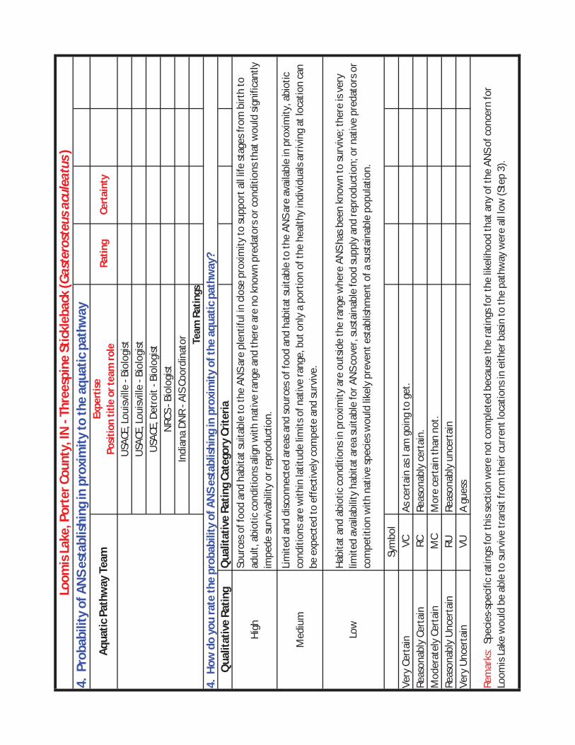
4. P
roba
bilit
y of
AN
S es
tabl
ishi
ng in
pro
xim
ity to
the
aqua
tic p
athw
ay
Ratin
g Ce
rtai
nty
Qua
litat
ive
Ratin
gQ
ualit
ativ
e Ra
ting
Cate
gory
Crit
eria
High
Med
ium
Sym
bol
Very
Cer
tain
VC
Reas
onab
ly C
erta
in
RCM
oder
atel
y Ce
rtai
n M
CRe
ason
ably
Unc
erta
in
RUVe
ry U
ncer
tain
VU
USA
CE, L
ouisv
ille
- Bio
logi
stU
SACE
, Lou
isvill
e - B
iolo
gist
USA
CE, D
etro
it - B
iolo
gist
NRC
S - B
iolo
gist
Indi
ana
DNR
- AIS
Coo
rdin
ator Te
am R
atin
gs
Loom
is L
ake,
Por
ter C
ount
y, IN
- Th
rees
pine
Stic
kleb
ack
(Gas
tero
steu
s acu
leat
us)
Aqua
tic P
athw
ay T
eam
Expe
rtis
e
Po
sitio
n tit
le o
r tea
m ro
le
As c
erta
in a
s I a
m g
oing
to g
et.
Reas
onab
ly c
erta
in.
Mor
e ce
rtai
n th
an n
ot.
Reas
onab
ly u
ncer
tain
A gu
ess
Rem
arks
: Sp
ecie
s-sp
ecifi
c ra
tings
for t
his s
ectio
n w
ere
not c
ompl
eted
bec
ause
the
ratin
gs fo
r the
like
lihoo
d th
at a
ny o
f the
AN
S of
con
cern
for
Loom
is La
ke w
ould
be
able
to su
rviv
e tr
ansit
from
thei
r cur
rent
loca
tions
in e
ither
bas
in to
the
path
way
wer
e al
l low
(Ste
p 3)
.
4. H
ow d
o yo
u ra
te th
e pr
obab
ility
of A
NS
esta
blis
hing
in p
roxi
mity
of t
he a
quat
ic p
athw
ay?
Sour
ces o
f foo
d an
d ha
bita
t sui
tabl
e to
the
ANS
are
plen
tiful
in c
lose
pro
xim
ity to
supp
ort a
ll lif
e st
ages
from
birt
h to
ad
ult,
abio
tic c
ondi
tions
alig
n w
ith n
ativ
e ra
nge
and
ther
e ar
e no
kno
wn
pred
ator
s or c
ondi
tions
that
wou
ld si
gnifi
cant
ly
impe
de su
rviv
abili
ty o
r rep
rodu
ctio
n.
Lim
ited
and
disc
onne
cted
are
as a
nd so
urce
s of f
ood
and
habi
tat s
uita
ble
to th
e AN
S ar
e av
aila
ble
in p
roxi
mity
, abi
otic
co
nditi
ons a
re w
ithin
latit
ude
limits
of n
ativ
e ra
nge,
but
onl
y a
port
ion
of th
e he
alth
y in
divi
dual
s arr
ivin
g at
loca
tion
can
be e
xpec
ted
to e
ffect
ivel
y co
mpe
te a
nd su
rviv
e.
Low
Habi
tat a
nd a
biot
ic c
ondi
tions
in p
roxi
mity
are
out
side
the
rang
e w
here
AN
S ha
s bee
n kn
own
to su
rviv
e; th
ere
is ve
ry
limite
d av
aila
bilit
y ha
bita
t are
a su
itabl
e fo
r AN
S co
ver,
sust
aina
ble
food
supp
ly a
nd re
prod
uctio
n; o
r nat
ive
pred
ator
s or
com
petit
ion
with
nat
ive
spec
ies w
ould
like
ly p
reve
nt e
stab
lishm
ent o
f a su
stai
nabl
e po
pula
tion.

5. P
roba
bilit
y of
AN
S sp
read
ing
acro
ss a
quat
ic p
athw
ay in
to th
e ne
w b
asin
Ratin
g Ce
rtai
nty
Qua
litat
ive
Ratin
gQ
ualit
ativ
e Ra
ting
Cate
gory
Crit
eria
High
Med
ium
Low
Sym
bol
Very
Cer
tain
VC
Reas
onab
ly C
erta
in
RCRe
ason
ably
cer
tain
.M
oder
atel
y Ce
rtai
n M
CRe
ason
ably
Unc
erta
in
RURe
ason
ably
unc
erta
inVe
ry U
ncer
tain
VU
Loom
is L
ake,
Por
ter C
ount
y, IN
- Th
rees
pine
Stic
kleb
ack
(Gas
tero
steu
s acu
leat
us)
Aqua
tic P
athw
ay T
eam
Expe
rtis
e
Po
sitio
n tit
le o
r tea
m ro
leU
SACE
, Lou
isvill
e - B
iolo
gist
USA
CE, L
ouisv
ille
- Bio
logi
stU
SACE
, Det
roit
- Bio
logi
stN
RCS
- Bio
logi
stIn
dian
a DN
R - A
IS C
oord
inat
or Team
Rat
ings
Mor
e ce
rtai
n th
an n
ot.
A gu
ess
Rem
arks
: Spe
cies
-spe
cific
ratin
gs fo
r thi
s sec
tion
wer
e no
t com
plet
ed b
ecau
se th
e ra
tings
for t
he li
kelih
ood
that
any
of t
he A
NS
of c
once
rn fo
r Lo
omis
Lake
wou
ld b
e ab
le to
surv
ive
tran
sit fr
om th
eir c
urre
nt lo
catio
ns in
eith
er b
asin
to th
e pa
thw
ay w
ere
all l
ow (S
tep
3).
5. H
ow d
o yo
u ra
te th
e pr
obab
ility
of A
NS
spre
adin
g ac
ross
aqu
atic
pat
hway
into
the
new
bas
in?
Sour
ces o
f foo
d an
d ha
bita
t sui
tabl
e to
the
ANS
are
avai
labl
e, a
nd th
e sp
ecie
s has
dem
onst
rate
d ca
pabi
litie
s to
signi
fican
tly e
xpan
d ra
nge
from
loca
tions
whe
re in
itial
ly in
trod
uced
.
Ther
e ar
e lim
ited
sour
ces o
f foo
d an
d su
itabl
e ha
bita
t, an
d/or
the
spec
ies h
as d
emon
stra
ted
limite
d ab
ility
to sp
read
sig
nific
ant d
istan
ces b
eyon
d ar
eas w
here
it h
as b
een
intr
oduc
ed.
Ther
e ar
e se
vere
ly li
mite
d so
urce
s of f
ood
and
suita
ble
habi
tat,
and/
or th
e sp
ecie
s has
dem
onst
rate
d ve
ry li
mite
d ab
ility
to
spre
ad b
eyon
d ar
eas w
here
it h
as b
een
intr
oduc
ed.
As c
erta
in a
s I a
m g
oing
to g
et.

Loomis Lake Report
May, 2013