london's street family chapters 1-2 - transport for...
TRANSCRIPT

London’s street family: Theory and case studies
This document accompanies the Roads Task Force report, ‘The vision and direction for London’s streets and roads’


London’s street family: Theory and case studies
Contents
1. Introduction ..................................................................................................... 1
2. Theory behind the use of street-types .......................................................... 2
2.1. The movement axis .................................................................................... 5
2.2. The place axis ............................................................................................ 7
2.3. Bringing them together: London’s street family .......................................... 9
3. Case studies and priorities for street-types ............................................... 13
3.1. Arterial roads ............................................................................................ 16
3.2. High roads ................................................................................................ 49
3.3. City hubs/boulevards ................................................................................ 72
3.4. Connectors ............................................................................................. 103
3.5. High streets ............................................................................................ 118
3.6. City streets ............................................................................................. 136
3.7. Local streets ........................................................................................... 153
3.8. Town squares/streets ............................................................................. 156
3.9. City places .............................................................................................. 159
4. Implications of the street-types ................................................................. 162
4.1. The speed environment .......................................................................... 162
4.2. Development of service standards ......................................................... 163
4.3. Implementing the street-types ................................................................ 165
London’s street family: Theory and case studies
Summer 2013

London’s street family: Theory and case studies 1
1. Introduction
This document provides a summary of the work done to help the Roads Task Force (RTF) develop the street-types contained in its main report. This document accompanies the RTF report, ‘The vision and direction for London’s streets and roads’. It sets out the theory behind the development of the street-types, and case studies of specific locations in London which exemplify how they could be applied.
The text in Chapters 1, 2 and 4 of this report is taken from Chapters 1 and 2 of the RTF report, and is included in this document for ease of reference.
One of the biggest challenges identified by the RTF is balancing the different demands on London’s streets and roads and supporting the different functions and priorities in each location. This must be done in a way that can be explained to and understood by local communities and stakeholders.
In order to achieve the ambition and tackle the challenges set out in Chapter 1 of its report, the RTF proposes a framework for managing and developing London’s roads that enables TfL, the boroughs and stakeholders to:
Identify user needs in different circumstances and set priorities/make trade-offs accordingly
Reflect changing functions and aspirations as particular streets change
Identify the types of tools that may be appropriate locally
Balance place-specific needs with the overall function of the network
Understand the need for intervention at a strategic level
This new framework is intended to mediate between the different demands on London’s roads, and to clarify the balance between different functions and users for different types of streets.
The street-type is then linked to a set of service standards and a toolkit of potential interventions, namely the right solution in the right place.
But this is firmly set within the network context and recognises the need for strategic and network-level interventions to enable the aspirations, both locally and London-wide, to be met.
London needs great places and streets for its residents. But, conversely, not all streets can be pedestrianised nor can there be ever-worsening conditions for motor vehicle journeys on vital routes, or the city simply won’t work.
London’s street family: Theory and case studies 2
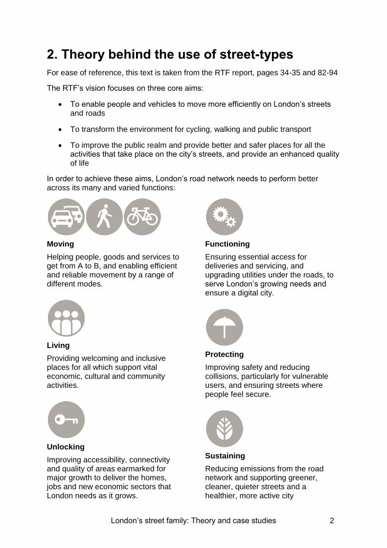
2. Theory behind the use of street-types
For ease of reference, this text is taken from the RTF report, pages 34-35 and 82-94
The RTF’s vision focuses on three core aims:
To enable people and vehicles to move more efficiently on London’s streets and roads
To transform the environment for cycling, walking and public transport
To improve the public realm and provide better and safer places for all the activities that take place on the city’s streets, and provide an enhanced quality of life
In order to achieve these aims, London’s road network needs to perform better across its many and varied functions:
Moving
Helping people, goods and services to get from A to B, and enabling efficient and reliable movement by a range of different modes.
Living
Providing welcoming and inclusive places for all which support vital economic, cultural and community activities.
Unlocking
Improving accessibility, connectivity and quality of areas earmarked for major growth to deliver the homes, jobs and new economic sectors that London needs as it grows.
Functioning
Ensuring essential access for deliveries and servicing, and upgrading utilities under the roads, to serve London’s growing needs and ensure a digital city.
Protecting
Improving safety and reducing collisions, particularly for vulnerable users, and ensuring streets where people feel secure.
Sustaining
Reducing emissions from the road network and supporting greener, cleaner, quieter streets and a healthier, more active city
London’s street family: Theory and case studies 3
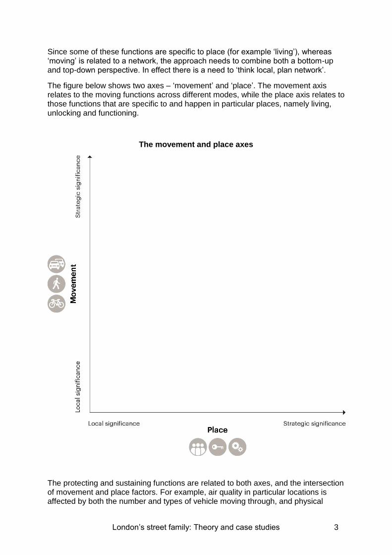
Since some of these functions are specific to place (for example ‘living’), whereas ‘moving’ is related to a network, the approach needs to combine both a bottom-up and top-down perspective. In effect there is a need to ‘think local, plan network’.
The figure below shows two axes – ‘movement’ and ‘place’. The movement axis relates to the moving functions across different modes, while the place axis relates to those functions that are specific to and happen in particular places, namely living, unlocking and functioning.
The movement and place axes
The protecting and sustaining functions are related to both axes, and the intersection of movement and place factors. For example, air quality in particular locations is affected by both the number and types of vehicle moving through, and physical

London’s street family: Theory and case studies 4
factors such as the layout of streets, while safety is linked to the speed and mix of vehicles and people, the layout of streets and quality of crossings in different places.
The two axes show that both the movement functions and the place functions are on a continuum. The different functions will be of more or less strategic importance depending on the position on the axes.

London’s street family: Theory and case studies 5
2.1. The movement axis
Streets perform a wide range of movement functions from roads carrying very high volumes and mixes of vehicular traffic and people, to streets which only have a local movement function.
Streets are also part of corridors and the overall road network. A corridor is a series of roads and streets that work together to facilitate longer distance movement in a given direction. Efficient corridors are vital to support movement.
Many streets and roads also support more specialised transport networks, for example:
The bus network
The cycle network, including Quietways and superhighways
Freight and delivery networks, including the London Lorry Control Scheme-exempt route
Others, for example coach routes, tram networks, green ways
Strategic road corridors for longer distance journeys and freight are different to bus corridors for example, and it is important when considering specific locations and street-types, that their role as part of particular corridors and networks is recognised and understood.
Regardless of the mode of travel, people share similar objectives in terms of direct, safe, quick journeys with minimum disruption. But they often compete for the same space and can conflict with each other, particularly where roads are narrow or crowded and at junctions. This can cause specific issues for particular modes, such as safety concerns for cyclists and powered two-wheelers.
The position of a street along the movement axis is determined by the strategic importance of that route (its impact on the overall resilience/performance of the network, the proportion of longer distance trips and the overall volume of people movement, as well as its role in particular networks as outlined above).
Movement includes pedestrian movement. Streets in some areas will be high on the movement axis owing to the intensity and strategic importance of pedestrian flows, for example, near stations and in the West End. Pedestrians are often the majority mode at different times of the day on particular streets, including many high streets.
Ensuring the effective functioning of the strategic road network is fundamental for London. But the approach must still be as responsive as possible to local impacts (for example, reducing emissions and noise for communities adjacent to a major road).
The figure on the next page shows London’s strategic road network, made up of roads managed by the Highways Agency, TfL and the boroughs.

London’s street family: Theory and case studies 6
There may be some roads in the TLRN that may not be at the top of the axis, alternatively there may be some not in the TLRN that perform genuinely strategic roles for the network.
At the lower end of the axis, the streets perform more local functions and have less effect on overall network functioning.
London’s strategic roads within the M25

London’s street family: Theory and case studies 7
2.2. The place axis
Streets perform a wide variety of functions which are specific to place. These include living, unlocking and functioning, and are equally important to movement. They have an impact economically as well as on quality of life, with place-making an increasingly important element of successful cities.
Streets and roads are also the foreground to a specific built environment, and the most successful streets are those that respect and refer to it.
As with movement, the level along the place axis is determined by the strategic significance of these aspects. At the strategic end of the axis are those with a London-wide (or national and international) role and the widest catchment areas. This includes many areas of central London (for example, the West End and South Bank) and metropolitan centres.
In the context of London’s growth, this also includes major development areas, with the potential to create new city quarters and drivers of economic growth. These are shown in the figure on the next page.
The mid-range of the axis includes the many major and district centres across London as well as high streets with a range of community and commercial facilities.
At the other end of the axis are streets that have less significance strategically but are still important to the people there, for example, a suburban residential street is very important to those people who live on it but of limited interest to others
.

London’s street family: Theory and case studies 8
Centres of activity across London
London’s street family: Theory and case studies 9
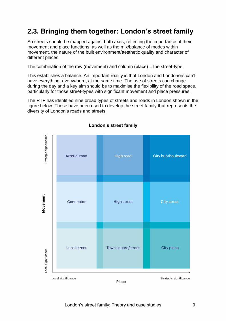
2.3. Bringing them together: London’s street family
So streets should be mapped against both axes, reflecting the importance of their movement and place functions, as well as the mix/balance of modes within movement, the nature of the built environment/aesthetic quality and character of different places.
The combination of the row (movement) and column (place) = the street-type.
This establishes a balance. An important reality is that London and Londoners can’t have everything, everywhere, at the same time. The use of streets can change during the day and a key aim should be to maximise the flexibility of the road space, particularly for those street-types with significant movement and place pressures.
The RTF has identified nine broad types of streets and roads in London shown in the figure below. These have been used to develop the street family that represents the diversity of London’s roads and streets.
London’s street family

London’s street family: Theory and case studies 10
Aims of London’s street family
This recognises that a well-functioning and successful city needs a variety of street-types that serve different roles and functions in different places. All these street-types are needed. The different functions will be more or less important depending on the type of road or street in question. The definitions of successful street-types are shown in the matrix above.
This relatively simple categorisation aims to make it practical to use for TfL and the boroughs. It should also help involve developers, community groups and other stakeholders in a structured way in relation to particular proposals.
At the same time, the RTF recognises the variety within a given street-type – there should therefore be some flexibility within the relevant parameters.
There may also be some particular needs that must be taken into account when applying the framework and designing any interventions. For example, the safety of vulnerable users (pedestrians, powered two-wheeler riders, cyclists), and for those with physical limitations, street layout can have a major impact on their mobility and enjoyment of an area. Road and street design must also ensure that every road in

London’s street family: Theory and case studies 11
London, including traffic-calmed streets and pedestrian areas, must be accessible by the emergency services.
This street family aims to establish a definition of the roles played by different street-types and the priorities and ‘service standards’ associated with them. This will provide a framework for making decisions about how to balance the competing demands and guide proposals.
Ideally, major place and streetscape schemes can succeed in delivering improvements for many different users at the same time, for example the Piccadilly two-way re-working and the Britannia Junction and Exhibition Road schemes.
In other cases, this will not be possible, but it’s important to recognise that there are already trade-offs now – they’re just often not explicit or ‘conscious’ and tend to be made on an ad hoc basis.
For each street-type the framework should enable TfL and boroughs (working with user groups and other stakeholders) to:
Agree the movement and place roles and priority functions
Agree key service standards associated with these priorities
Agree minimum provision/mitigation for other users
Develop a toolkit of the types of measures to help deliver this
Agree variations by time of day and day of week
A key starting point is therefore particular locations. This framework will enable the mapping of existing conditions and an assessment of the ‘change potential’ of a street or a local area in order to better meet the defined aims for that street-type.
For street-types along the bottom row, there should be a light-touch approach given their lower significance in network terms.
For an arterial road, that is one in the top left hand corner of the matrix, the focus will be on supporting reliable and efficient movement for motorised vehicles while seeking to mitigate the impacts on communities that live alongside (for example, noise, air pollution and severance) as far as possible.
This may be linked to network management strategies, for example, these roads should be a key focus for the roll-out of real-time traffic management, reducing delays by minimising or optimising signals, and implementing lane rental with the highest charges.
There will also be a focus on the corridor that these roads form part of and the aim to provide a reasonably congestion-free route. But this route will also go through areas of varying importance, which will change the balance in different places.
The A10 Corridor (shown in the figure on the next page) illustrates this, for example. Along its length it changes from an arterial to a high road and finally to a city hub – its street-type shifts along the top row of the matrix.

London’s street family: Theory and case studies 12
A10 corridor: example of changing street-type
Where this route goes through a strategic place, the aims for a better quality urban realm, unlocking development, and supporting walking and cycling, will more strongly come to the fore, while still seeking to maintain a relatively high degree of movement function.
The next chapter of this report sets out some further detail about the different street-types and the suggested priorities and potential measures associated with them.
It is the combination of the movement and place levels that defines the street-type.
The movement level typically remains the same while the place level changes along the corridor.
Therefore the street-type changes as you move along the corridor.