loe pool sssi macrophyte survey 2012 · 05/07/2012 · loe pool sssi macrophyte survey 2012 report...
TRANSCRIPT

Loe Pool SSSI Macrophyte Survey 2012
Report Date: February 2013
Author: Dr Jan Dinsdale
Survey Dates: 26/28 June 2012;
09/19/21 September 2012
Dive contractor: Kennack Diving
Ecologist: Dr Jan Dinsdale

Contents
1. Introduction
1.1 Monitoring Sites of Special Scientific Interest
1.2 Loe Pool SSSI
1.3 Addressing water quality at the catchment scale
1.4 Existing records of the Loe macrophyte community and associated habitats
1.4.1 Boat and grapnel survey
1.4.2 Shoreline and inundation community bathyscope survey
1.5 Aims and objectives of the survey
2. Methodology
2.1 Boat and grapnel survey
2.2 Qualitative survey using scuba-diving
2.3 Detailed quantitative survey of permanent transects
3. Results
3.1 Boat and grapnel transect survey
3.2 Deep water dive survey
3.3 Dive and bathyscope shoreline survey 2012 and comparison to Stewart (2000)
3.4 Detailed permanent transect survey
3.5 Summary of macrophyte community in 2012 and changes 1999-2012
4. Publicity
5. Lake and Catchment Management Recommendations
5.1 Further survey recommendations
5.2 Macrophyte translocation trials
5.3 Working at the catchment scale
5.4 In-lake management
5.4.1 Water level management
5.4.2 Shoreline scrub and reed management
6. References
APPENDIX 1: SSSI citation and excerpt from SSSI condition statement
APPENDIX 2: Risk assessments: scuba-diving and permanent transect survey
APPENDIX 3: Dive computer read-outs
APPENDIX 4: Overview of boat and grapnel survey 2011
APPENDIX 5: Media coverage of this study

List of Figures
Figure 1: Loe Pool SSSI
Figure 2: The Loe Pool Catchment
Figure 3: Loe Pool boat transects survey
Figure 4: Loe Pool dive routes location map 2012
Figure 5: Loe Pool permanent transect location map 2012
Figure 6: Loe Pool dive and bathyscope shoreline survey: Qualitative recording of the inundation
community
Figure 7: Variation of species abundance within the inundation community with water depth and
distance from shore along four permanent transects within Loe Pool SSSI
List of Photos
Photo 1: The Loe (National Trust)
Photo 2: Diver entering lake from shore to commence dive in Carminowe Creek (Jan Dinsdale)
Photo 3: Kennack Divers undertaking survey within Carminowe Creek with GPS on the surface (Jan
Dinsdale)
Photo 4: Underwater image showing very poor visibility, less than 0.5m (Des Glover, Kennack Diving)
Photo 5: Checking GPS data collected by scuba-divers (Tim Walker, University of Exeter)
Photo 6: Permanent transect survey equipment: Bathyscope, 0.5m quadrat and weighted rope (Jan
Dinsdale)
Photo 7: Surveying with bathyscope. Wearing a dry suit was very useful when surveying the deep end of
the permanent transect (Jan Dinsdale)
Photo 8: Plumatella fungosa on reed (Des Glover, Kennack Diving)
Photo 9: Stony substrate supporting green algae (Des Glover, Kennack Diving)
Photo 10: Mobile benthic sediments (Des Glover, Kennack Diving)
Acknowledgements
David Roberts, Des Glover, Rebecca Morton-Clarke and Milo Lekic (Kennack Diving) who carried out
scuba-dive survey work;
Rob Hunt (National Trust) for digital mapping;
Nick Stewart (independent aquatic plant surveyor) for discussion and guidance on survey methodologies
and long-term management aims to benefit Loe Pool macrophyte communities.

Loe Pool SSSI Macrophyte Survey 2012 Dr Jan Dinsdale
Executive Summary
This report details macrophyte survey work undertaken by Dr Jan Dinsdale, Independent Ecological
Consultant, and Kennack Diving from June to September 2012. The work was carried out on behalf of the
National Trust and funded by Natural England’s Conservation Enhancement Scheme.
Loe Pool Site of Special Scientific Interest (SSSI) in Southwest Cornwall, is currently eutrophic and in
unfavourable condition. The Loe fails to meet Natural England’s conservation objectives for the
macrophyte community composition and associated habitat conditions; failures include the paucity of
aquatic vegetation coverage and the Lake’s elevated nutrient status.
The 2012 macrophyte survey work included: A broad qualitative search for macrophyte communities
using scuba-diving; and setting up new permanent transects to permit repeated quantitative recording at
an appropriate scale.
These surveys established that:
• There are no additional unrecorded macrophyte beds in the lake.
• The long-term boat and grapnel monitoring technique employed since 1999, is an adequate
method for recording macrophytes at present.
• The inundation plant community (comprising Shoreweed Littorella uniflora, Needle Spike Rush
Eleocharis acicularis and Six-stamened Waterwort Elatine hexandra) has been relatively stable
since 1999. This community appears to have extended into deeper water from 0.6m in 1999 to
around 1.7m in 2012, though variations in accuracy of the survey methods must be taken into
account.
• The majority of the suitably stable benthic substrates within the Lake support aquatic vegetation.
The lack of macrophytes round northern shores of the Lake, including the Cober arm and Penrose
Inlet, can be attributed to the extremely unstable benthic sediments in these locations.
Recommendations for future macrophyte monitoring include:
• Repeating the long-term boat and grapnel monitoring biannually, with the next survey in 2013.
• Non-destructive quantitative monitoring of the permanent transects. These 4 transects are now
in place and the baseline survey has been undertaken. The transects will be surveyed biannually,
with the next survey in 2014. This survey will require scuba-dive support in order to survey plant
abundance at depths greater than 1.0m.
Based on the findings of the scuba-diving survey, macrophyte translocation experiments are not
recommended until the Lake’s benthic sediments become more stable.
Successful lake rehabilitation from a eutrophic algal dominated condition relies heavily upon the re-
establishment of submerged vegetation. It is critical that the Loe Pool Forum continues to take a
collaborative multi-agency approach to addressing external sources of nutrients and sediment to the Lake.
Alongside this catchment approach, two in-lake management recommendations are proposed to help
‘kick-start’ the growth of macrophytes within Loe Pool. These comprise:
• Adopting a water level management regime that provides an extensive seasonal drawdown zone
around the margins of the Pool
• Control of Willow Salix scrub along southern shores of the lake.

Loe Pool SSSI Macrophyte Survey 2012 Dr Jan Dinsdale 1
1. Introduction
1.1 Monitoring Sites of Special Scientific Interest
One of the key responsibilities of the statutory nature conservation agencies in the UK is the
identification and protection of a series of sites intended to conserve important wildlife and
earth sciences features. Under the Environmental Protection Act 1990, Natural England and the
Joint Nature Conservation Committee (JNCC) are required to establish common standards in
England for the monitoring of nature conservation, thus enabling consistent reporting to UK
Government (JNCC, 2005).
Under the JNCC framework the procedure for monitoring is as follows:
• Identify each notified interest feature within the Special Scientific Interest (SSSI).
• For each notified feature set a conservation objective, thus providing a ‘formulated
standard’ for monitoring.
• Assess each feature condition against its conservation objective. If the objective has
been achieved, the feature condition will be described as ‘favourable’.
• Assess whether management activities will enable the feature to attain or retain
‘favourable condition’.
• Report the condition of all notified interests to JNCC within each reporting cycle.
1.2 Loe Pool Site of Special Scientific Interest
Loe Pool is located within the Penrose Estate near Helston, Southwest Cornwall SW649247
(Figure 1; Photo 1). The Loe is the largest natural freshwater lagoon in Cornwall. The SSSI
extends over 122 ha, and includes: The lake with an area of 56 ha, a coastal shingle bar and
other associated wetland and coastal habitats (including BAP Wet Woodland, Reedbeds and
Maritime Cliff and Slopes). The Loe provides a winter refuge for nearly 80 species of wildfowl
including high counts of Shoveler Anas clypeata, Pochard Aythya farina and Tufted Duck Aythya
fuligula. The coastal shingle bar that separates the Loe from the sea is of importance for
geomorphology, flora and fauna; it is the only known British site for the Cornish subspecies of
the Sandhill Rustic Moth Luperina nickerlii leechi. Other relevant SSSI information is provided in
Appendix 1.
The condition of the standing open water habitat at Loe Pool SSSI is currently defined as
unfavourable (no change) (Natural England, 2009). The conservation objectives for the open
water feature of Loe Pool SSSI, in terms of the macrophyte community composition and
associated habitat conditions, are as follows:
a. There should be no loss of characteristic species recorded from the site. Six out of
ten sample spots should include at least one characteristic plant species.
[The full national list of characteristic plant species for a lake of this type comprises
35 species (see Appendix 1). The Loe SSSI citation sheet, however, lists just 3 of

Loe Pool SSSI Macrophyte Survey 2012 Dr Jan Dinsdale 2
these 35 characteristic species, namely: Littorella uniflora, Elatine hexandra and
Potamogeton perfoliatus].
b. At this site, occurrence of non-native species should be no more than 50%
frequency.
c. Characteristic zones of vegetation should be present, maximum depth distribution
should be maintained and at least the present structure should be maintained.
d. Mean annual total phosphorus concentration less than target for appropriate lake
type, namely 20µg P lˉ¹ (as total phosphorus).
e. Stable pH/ANC values appropriate to lake type: pH 7.00 (circumneutral between
6.00 and 8.00); adequate dissolved oxygen levels for health of characteristic fauna
f. No excessive growth of cyanobacterial or green algae.
g. There should be a natural hydrological regime.
h. No loss of marginal vegetation and maintain the natural shoreline of the lake
with no more than 5% of lakeshore being heavily modified.
i. Maintain natural and characteristic substrate and maintain natural sediment load.
Natural England (2009)
Photo 1: The Loe (National Trust)
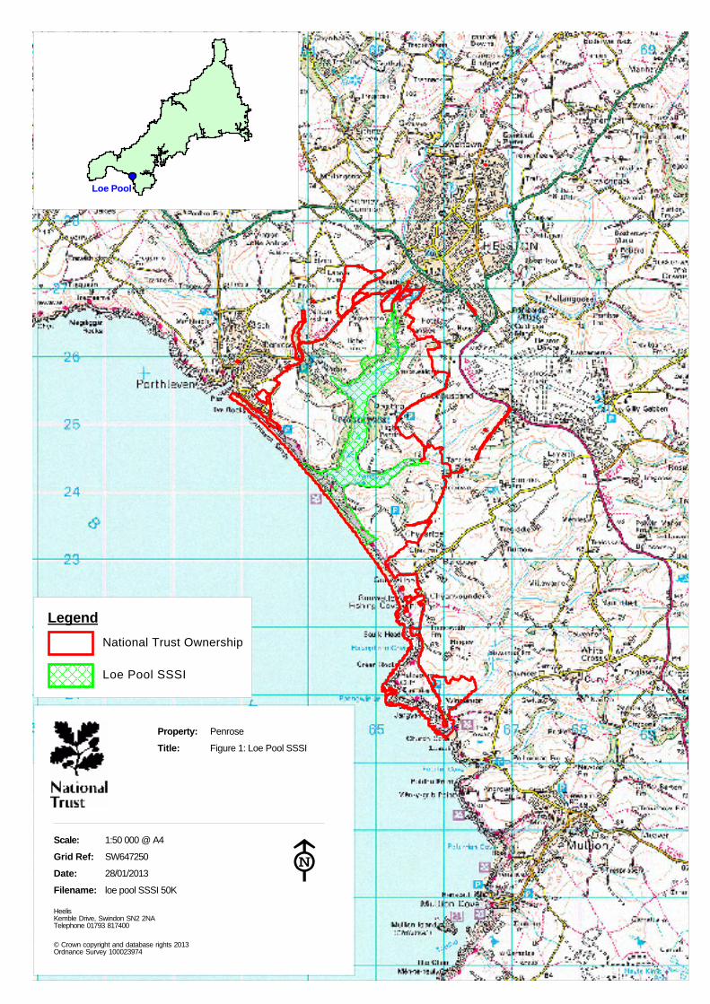
Property: Penrose
Title: Figure 1: Loe Pool SSSI
Scale: 1:50 000 @ A4
Grid Ref: SW647250
Date: 28/01/2013
Filename: loe pool SSSI 50K
HeelisKemble Drive, Swindon SN2 2NATelephone 01793 817400
© Crown copyright and database rights 2013Ordnance Survey 100023974
#
Legend
Loe Pool SSSI
National Trust Ownership
Loe Pool

Loe Pool SSSI Macrophyte Survey 2012 Dr Jan Dinsdale 3
1.3 Addressing water quality at the catchment scale
Loe Pool has suffered from the effects of elevated nutrient levels, eutrophication, and excess silt
deposition over many decades (Wilson and Dinsdale, 1998; Dinsdale 2003; Dinsdale, 2009). The
Loe Pool Forum continues to take a collaborative multi-agency approach to addressing external
sources of nutrients and sediment to the Lake. The Forum’s Catchment Group (which includes
representatives from Natural England, the Environment Agency, South West Water, the Rural
Payments Agency and Catchment Sensitive Farming) is working to deliver an integrated
programme of regulation, advice and capital grant incentives, at the catchment scale, in order to
bring about the necessary improvements in water quality for the Lake (Clitherow and Dinsdale,
2012).
The SSSI target condition is for a mean annual total phosphorus concentration less than 20µg P
lˉ¹ (listed as objective d above). In-lake total phosphorus concentrations have reduced by 75%
since 2000 (Dinsdale, 2009; EA unpublished data). This
huge improvement in water quality can largely be
attributed to the installation of tertiary phosphorus
stripping at South West Water’s Helston Water Water
Treatment Works. With current in-lake phosphorus levels
stabilised at around 80µg P lˉ¹ (Dinsdale, 2009; EA
unpublished data), the Loe Pool Forum continue to
working towards further reductions in nutrient inputs
from both point and diffuse sources, including:
● RNAS Culdrose Sewage Treatment Works
● Helston Waste Water Treatment Works
● Agricultural and domestic diffuse nutrient sources
across the catchment
(Hambrook and Dinsdale, 2012; Clitherow and Dinsdale,
2012).
Figure 2: The Loe Pool Catchment
1.4 Existing records of the Loe macrophyte community and associated habitats
Both boat-based grapnel surveys and shore-based bathyscope surveys of the macrophyte
communities within Loe Pool have been undertaken on a regular basis since 1998 (Wilson and
Dinsdale, 1998; Stewart, 2000; 2003; 2006; Dinsdale, 2007-2011).
1.4.1 Boat and grapnel survey
The deep-water macrophyte communities within Loe Pool have been monitored using a repeat
boat-based grapnel survey along 14 fixed transects across the lake since 1999. This survey has

Loe Pool SSSI Macrophyte Survey 2012 Dr Jan Dinsdale 4
been undertaken annually since 2006. The locations of the 14 fixed boat transects within the
lake are shown in Figure 3.
The main observations over this thirteen-year monitoring period have been:
• The annual algal blooms, which had been a feature of the lake’s ecology for many years,
ceased in 2006. The last bloom of both of the previously abundant algal species, Water
Net Hydrodictyon reticultum and the blue-green alga Microcystis aeruginosa, occurred in
that same year, 2006.
• There has been a single boom-and-bust of the Nuttall's Waterweed Elodea nuttallii
population. Elodea nuttallii was prolific across the lake between 1999 and 2006. At its
peak in 2006, the population extended to both the Penrose inlet and the Cober inlet and
occurred in 60% of the boat survey sample stations across the lake. The population of
this non-native Waterweed crashed in 2007 and has not been observed within the lake
or recorded in any of the boat survey’s 14 transects since that time.
• Perfoliate Pondweed Potamogeton perfoliatus, one of the old inhabitants of Loe Pool, is
still present in the Pool. Potamogeton perfoliatus was recorded from 2003-2007
(Stewart, 2003; Knight, 2003). Loe Pool is its only Cornish locality and this native
pondweed was present here in large quantities in the mid-nineteenth century (Johns,
1848) and was still abundant in 1964 (Turk and Turk, 1976). Potamogeton perfoliatus
was then not recorded until 1983 (record: RJ Murphy) and subsequently was not seen
again until 2003, when a small number of plants were recorded in Carminowe Creek.
Stewart (2003) suggested that the reappearance of Potamogeton perfoliatus ‘must be
due to local stabilisation of conditions by the abundant growth of the Elodea nuttallii’.
Following the decline of Elodea nuttallii only small amounts of drift material of
Potamogeton perfoliatus were recorded during the annual macrophyte surveys of 2006
and 2007, both within Carminowe Creek. The Pondweed has not been recorded more
recently, despite a thorough search with the help of Cornwall BSBI plant recorder Ian
Bennallick (Dinsdale, 2010).
• The water clarity has improved steadily since 2005 from less than 1.0m to 1.4m.
• Overall, there has been very little measurable change to the macrophyte communities in
response to the dramatic improvements seen in the nutrient status in of the lake water
in 2003-2004 and the cessation of algal blooms in 2006.
It is clear from this repeat boat and grapnel monitoring that the Loe currently supports a
severely impoverished macrophyte community. While the Elodea nuttallii population was at its
peak, this species was present in more than 6 out of 10 sample stations, but it is non-native
species. Since 2007 macrophytes have been recorded in less than 1 out of 10 samples spots;
indeed some years the only plant growth recorded by the boat-based grapnel survey has been
the planted water lily Nymphaea sp..
The boat and grapnel survey is not deemed to be suitable to record the response elicited in the
inundation community because:
• This community is very sparsely distributed and not adequately sampled by the 14 boat
survey transects.

Loe Pool SSSI Macrophyte Survey 2012 Dr Jan Dinsdale 5
• The grapnel, constructed of two rakes back-to-back, is too coarse to capture the
diminutive plant species which make-up the inundation community.
• The destructive nature of the grapnel sampling method is not appropriate within this
rare and fragile plant community.
A summary of the most recent results of the boat and grapnel survey is provided within
Appendix 4.
1.4.2 Shoreline and inundation community bathyscope survey
The first botanical shoreline survey of Loe Pool was undertaken October 1999 (Stewart, 2000).
This study included detailed mapping of both the shoreline and aquatic inundation communities.
In 1999, the inundation community comprised Shoreweed Littorella uniflora, Needle Spike Rush
Eleocharis acicularis and Six-stamened Waterwort Elatine hexandra. These three species were
described as ‘frequently occurring together …although in some areas there also seems to be a
zonation with Littorella uniflora more frequent in the shallows and Eleocharis acicularis more
frequent in slightly deeper water. Elatine hexandra is less widespread than Eleocharis acicularis
and tends to be occur in small quantity but it is sometimes locally frequent (e.g. on the headland
west of Lower Pentire Farm)’ (Stewart, 2000).
Stewart (2000) goes on to state ‘In normal situations this [inundation] community would occur
in water up to about 1.0m deep extending upwards into the draw down zone exposed by falling
summer water levels. There is no shortage of shallowly shelving shores in the Loe Pool which
ought to be suitable but there are two factors working against this; the dense algal blooms make
it very difficult for any submerged aquatic species to survive and in many places results in a
covering of soft decaying algal ooze over the firmer substrates that this community prefers. In
addition the higher water levels in summer reduce the light penetration further during the main
growing season. As a result, in most areas where this community occurs in the Loe Pool it is
terrestrial occurring just above the water level. However, in a few places the community does
extend into the water up to 60cm depth’.
Elatine hexandra is Nationally Scarce (found in only 16-100 10km grid squares nationally) and
the Eleocharis acicularis is only known from about 125 10km grid squares. Both species are also
rare in Cornwall. This must, therefore, be considered the most important aquatic community in
the Loe Pool. This community is not described in the National Vegetation Classification.
This botanical shoreline survey was repeated in 2003; there had been no detailed survey of the
Loe Pool inundation community since that time.
1.5 Aims and objectives of the survey
The aim of this study was to refine the long-term strategy for monitoring the macrophyte
communities within Loe Pool SSSI in order to best inform the future management of both the
Lake and its catchment, and therefore to enable the waterbody, and the wider SSSI, to move
towards recovering condition.

Loe Pool SSSI Macrophyte Survey 2012 Dr Jan Dinsdale 6
The three objectives of the survey work were:
• To continue to build a long-term record of the changes in the macrophyte beds within Loe
Pool using existing methods.
• To ensure that these methods are appropriate for sampling deep water species, i.e. that
no deep water macrophyte beds are being overlooked by the current survey techniques.
• To extend survey methods in order to gain a better understanding of the changes to the
distribution and abundance of the Lake’s inundation community with water depth and
over time.

)
)
)
)
)
TL
Pma Often Sparse
Some TL
Pma 43
43
Pma
42
Thin Pma
C2
C2
44
Transect 14
41
Pma
40
39
Thin Pma
Sparse Ea
39
Pma
TL
C1TL46
45
43
TL & Pma
BareSandBank
Pma
Transect C1
Pma
Transect 13
Pma
37
Pma
Post
Transect 12
RareTL
46
Pma
47
Ea
37
46
Pma
Gone!
Transect 2
Pma
11
11
Pma
Transect 1
1Psa
9
10
Pma
8
Na
PsaSd4
72
3
5
Pma
6
Property: Penrose
Title: Figure 3a: Loe Poolboat transects survey;commenced 1999
Scale: 1:2500 @ A3
Date: 04/02/2013
Filename: loe 1999 survey A
South West: Exeter Consultancy HubKillerton House, Broadclyst, Exeter, Devon EX5 3LETelephone 01392 881691
#
© Crown copyright and database rights 2013Ordnance Survey 100023974
Legend
Boundaries of communities
Boundaries betweenshore sections
Lines of transects
Abbreviations
Eh =Ea =Ep =Lu =Na =Pla =Pma =Psa =Sd =Se =St =Tl =
Elatine hexandraEleocharis acicularisEleocharis palustrisLittorella unifloraNymphaea albaPhalaris arundinaceaPhragmites australisPersicaria amphibiaSolanum dulcamaraSparganium erectumSchoenoplectus tabernaemontaniTypha latifolia

(
35
Transect 11
35
Pma
35
Na
Transect 3
13
Na
Na
14
Na
Pma
14
37
37
Pma
Sd
36
Transect 2
Pma
11
11
Na
12
12
Sd
Property: Penrose
Title: Figure 3b: Loe Poolboat transects survey;commenced 1999
Scale: 1:2500 @ A3
Date: 04/02/2013
Filename: loe 1999 survey B
South West: Exeter Consultancy HubKillerton House, Broadclyst, Exeter, Devon EX5 3LETelephone 01392 881691
#
© Crown copyright and database rights 2013Ordnance Survey 100023974
Legend
Boundaries of communities
Boundaries betweenshore sections
Lines of transects
Abbreviations
Eh =Ea =Ep =Lu =Na =Pla =Pma =Psa =Sd =Se =St =Tl =
Elatine hexandraEleocharis acicularisEleocharis palustrisLittorella unifloraNymphaea albaPhalaris arundinaceaPhragmites australisPersicaria amphibiaSolanum dulcamaraSparganium erectumSchoenoplectus tabernaemontaniTypha latifolia

Pma
30
Transect 7
Lu & Some Ea
Lu & Local EaOccasional Eh
31
Sparse Lu
Pma
Psa Ep
Intermittent Ep
33
Intermittent Ep
Psa
Psa
32
20
19
Pma
Pma
35
34
PmaPsa
33
Transect 10
LuSomeEaEh
14Pma
14
14
Transect 4
Pma
Transect 6
19
18
15
14
18
En
Transect 5
1617
ShoreLine
Pma
Property: Penrose
Title: Figure 3c: Loe Poolboat transects survey;commenced 1999
Scale: 1:2500 @ A3
Date: 04/02/2013
Filename: loe 1999 survey C
South West: Exeter Consultancy HubKillerton House, Broadclyst, Exeter, Devon EX5 3LETelephone 01392 881691
#
© Crown copyright and database rights 2013Ordnance Survey 100023974
Legend
Boundaries of communities
Boundaries betweenshore sections
Lines of transects
Abbreviations
Eh =Ea =Ep =Lu =Na =Pla =Pma =Psa =Sd =Se =St =Tl =
Elatine hexandraEleocharis acicularisEleocharis palustrisLittorella unifloraNymphaea albaPhalaris arundinaceaPhragmites australisPersicaria amphibiaSolanum dulcamaraSparganium erectumSchoenoplectus tabernaemontaniTypha latifolia

25
25
24Pma & Pla
Se
26
Exposed SandBank
23
27
Pma
PsaEp
Psa
28
Psa
Se
Transect 9
Ea/Lu
Psa
Ep
PmaEp
Ep
Ea/Lu
23
28
PsaPma
28
EpEp
21
22
Pma
Ep
29Pma
Ea
Ep
Small Areaof Open Shore
Transect 8
21
Pma
30
Transect 7
Lu & Some Ea
Lu & Local EaOccasional Eh
31
Sparse Lu
Pma
Psa Ep
Intermittent Ep
33
Intermittent Ep
Psa
Psa
32
20
19
Pma
35
34
Psa
Property: Penrose
Title: Figure 3d: Loe Poolboat transects survey;commenced 1999
Scale: 1:2500 @ A3
Date: 04/02/2013
Filename: loe 1999 survey D
South West: Exeter Consultancy HubKillerton House, Broadclyst, Exeter, Devon EX5 3LETelephone 01392 881691
#
© Crown copyright and database rights 2013Ordnance Survey 100023974
Legend
Boundaries of communities
Boundaries betweenshore sections
Lines of transects
Abbreviations
Eh =Ea =Ep =Lu =Na =Pla =Pma =Psa =Sd =Se =St =Tl =
Elatine hexandraEleocharis acicularisEleocharis palustrisLittorella unifloraNymphaea albaPhalaris arundinaceaPhragmites australisPersicaria amphibiaSolanum dulcamaraSparganium erectumSchoenoplectus tabernaemontaniTypha latifolia

Loe Pool SSSI Macrophyte Survey 2012 Dr Jan Dinsdale 7
2. Methodology
Three separate survey techniques were adopted to meet the project aim and objectives:
i. Continuation of the long-term ‘boat and grapnel’ monitoring technique employed since
1999 (Stewart, 2000)
ii. A broad qualitative search of macrophyte communities using scuba-diving
iii. New permanent transects to permit repeated quantitative recording of the macrophyte
inundation community at an appropriate scale.
2.1 Boat and grapnel survey
The fourteen fixed-location boat survey transects at Loe Pool were first surveyed in 1999 and
repeated in 2003, 2006, 2007, 2008, 2009, 2010, 2011 (Dinsdale, 2011). The location of these 14
transects are shown on Figure 3. This survey is undertaken in September; a date originally
selected as all current species of the inundation community are in a vegetative state and also
the risk of poor water clarity due to algal blooms is low. Each transect commences at the shore
and runs either out into deep water or across the entire lake, creek or inlet. Along the length of
each transect, survey points are located at regular 5m intervals from the shore and, once the
depth is greater than 2m, at quarterly intervals across the waterbody. At each survey point
along the 14 transects, two grapnel trawls are thrown approximately 4m from the boat. The
grapnel is constructed of two rake heads, wired together back-to-back. The total catch for each
trawl is weighed in situ to the nearest 5g. Weights are wet weights with excess water shaken
off. The proportion of the catch occupied by each species is assessed visually. These must be
considered very approximate, particularly since density varies between species.
2.2 Qualitative survey using scuba-diving
Scuba-diving was proposed as a more accurate, non-destructive and benign method of searching
for plant growth which had not been detected during the on-going boat and grapnel surveys.
The aims of the scuba-diving survey were as follows:
i. To survey the three main arms of the lake (Carminowe Creek; Penrose Inlet and Cober
arm) from the shore out into the deep lake centre.
ii. To provide GPS position mapping of each macrophyte beds identified.
iii. To carry out a thorough search in the vicinity of recently recorded macrophytes in Loe
Pool, i.e. the stonewort Nitella flexilis (ENSIS, 2003) and Potamogeton perfoliatus
(Stewart, 2003).
iv. To cover as much of the lake as possible in allotted time.
v. To survey all sections of the lake shore where the inundation community has been
recorded since 1998 and undertake qualitative mapping of this community to:
• enable comparisons to be drawn with previous Loe Pool shoreline surveys (Stewart
2000; 2003).
• inform the positioning of the new permanent transects (see Section 2.3 below)

Loe Pool SSSI Macrophyte Survey 2012 Dr Jan Dinsdale 8
vi. To photograph the plants and lake benthic substrates for interpretation and
communication purposes.
A team of four qualified scuba-diving staff (David Roberts, Des Glover, Rebecca Morton-Clarke
and Milo Lekic) worked on the 3 dive survey days (26 June 2012; 28 June 2012; 9 September
2012) alongside the project ecologist, who remained on the shore. Entry into the lake was from
the shore (Photo 2). Divers worked in buddy pairs at all times to comply with The Diving at
Works Regulations 1997 (HSE 1997). Pairs were always physically connected via a buddy line
due to very turbid conditions and unstable benthic sediments. A Diving Risk Assessment was
produced prior to the dive operations in accordance with the Scientific and Archaeological
Approved Code of Practice (HSE, 1998) (Appendix 2).
When surveying in deep water away from the shore, diving buddy pairs were followed by the
GPS operator; a third team member floating on the surface (Photo 3). The GPS recorded
positions at 5 second intervals. Water depth was recorded using a Suunto Dive Computer
(Appendix 3).
Photo 2: Des Glover entering lake from shore Photo 3: Kennack Divers undertaking survey within Carminowe Creek with
to commence dive in Carminowe Creek GPS on the surface
(Jan Dinsdale) (Jan Dinsdale)
Photo 4: Underwater image showing very poor visibility , Photo 5: Checking GPS data collected by scuba-divers
less than 0.5m ( Des Glover, Kennack Diving) (Tim Walker, University of Exeter)

Loe Pool SSSI Macrophyte Survey 2012 Dr Jan Dinsdale 9
Visibility was extremely poor on all three survey dates, less than 1.0m (Photo 4). Divers needed
to be within 0.5m of the lake floor, in order to carry out a thorough search for macrophytes.
Any contact with the unstable benthic sediments that were present across much of the lake
rapidly reduced visibility to 0m. The need for accurate and careful movement underwater
combined with poor visibility made the scuba-divers progress very slow at times.
Non-consecutive dive dates were chosen to represent different periods of the plant growing
season. July and August were avoided due to risk of poor visibility during potential peak algal
bloom periods.
The extent of the scuba-diving survey is shown on Figures 4 and 6. The dive team carried out six
deep water dive routes covering a total of 1052m; and 2269m of shoreline search at a depth of
1-4m. They spent a total of 10 hours and 40 minutes in the water over the three days.
The shoreline-search method combined bathyscope and scuba techniques. The shoreline was
surveyed in 100-200m sections, following Stewart 2000. The diver and ecologist team worked
alongside each other, in a smaller group of three, to undertake this element of the survey work:
• The ecologist surveyed 0.0m to 0.75m depth with bathyscope
• Diver One surveyed across the main plant growth zone, recording presence/absence and
abundance of each species
• Diver Two mapped the outer limit of the plant communities and recorded water depth
at this limit at regular intervals.
2.3 Detailed quantitative survey of permanent transects
A programme of quantitative monitoring along permanent transects was proposed as a more
accurate and non-destructive method of searching for plant growth within the inundation
communities. This new permanent transect survey aimed to:
i. Provide a long-term monitoring technique suitable for the inundation plant community
ii. Quantitatively record changes in plant abundance with water depth and over time.
The locations of the four transects were selected systematically, based on the qualitative
observations of dive survey (Section 3.3). The location of each transect was chosen with an aim
to fulfilling the following criteria:
• To sample existing inundation communities and, ideally with representations each of
the three inundation species (Eleocharis acicularis; Elatine hexandra and Littorella
uniflora)
• To represent the full geographic range of the community around the Lake margins
• To represent the widest range of shore profiles, i.e. steeply sloping to shallow

Loe Pool SSSI Macrophyte Survey 2012 Dr Jan Dinsdale 10
The DOMIN scale
10 = 91-100% cover
9 = 76-90% cover
8 = 51-75% cover
7 = 34-50% cover
6 = 26-33% cover
5 = 11-25% cover
4 = 4-10 % cover
3 <4% many individuals
2 <4% several individuals
1 <4% few individuals
Each transect was positioned perpendicular to the shore, in order to sample a linear transition
from the shore out into deep water. The four chosen locations for permanent repeat transects
were:
• Transect 1: Carminowe Creek north shore (SW65232432-SW652332432)
• Transect 2: Carminowe Creek south shore (SW6520024211-SW6519124220)
• Transect 3: Pentire Point (SW64734824347-SW6475024327)
• Transect 4: Penrose Inlet (SW6460925571-SW6473824339)
The botanical survey of these permanent transects were undertaken over two days, the 19th
and
21st
September 2012. A September survey date was chosen to coincide with the timing of the
boat and grapnel survey, and for the same reasons, see section 2.1. A Garmin GPS was used to
record the position of each permanent transect and at this site operated with an accuracy of
±1.0m. The locations of the four transects are shown in Figure 5. For the duration of the survey,
a weighted rope was used to indicate the location of the transects. A 0.5m x 0.5m quadrat was
positioned along the linear transect, with sampling either side of the rope to record a
continuous belt transect of 1.0m in width.
The 0.5m x 0.5m quadrat size was chosen as the most
appropriate sampling scale, based on:
• The scale of individual plants to be sampled
• The distribution pattern of inundation plant
communities to be sampled
• The benthic area visible through the bathyscope.
Vegetative cover for individual species in each 0.5m x 0.5m quadrat was recorded quantitatively
using the DOMIN scale. Periodic checks and comparisons were carried out between the two
surveyors (Dr Jan Dinsdale, Ecologist and Rebecca Morton-Clarke, Assistant) conferring on cover
estimates to ensure consistency of recording. The depth of water was measured at 0.5m
intervals using a metre rule.
Photo 6: Permanent transect survey equipment: Bathyscope, Photo 7: Surveying with bathyscope. Wearing a dry suit 0.5m
quadrat and weighted rope was very useful when surveying the deep end of the transect
(Jan Dinsdale) (Jan Dinsdale)

(
)
)
)
)
)
(
(((
Dive Route 5Dive Route 5Dive Route 5Dive Route 5Dive Route 5Dive Route 5Dive Route 5Dive Route 5Dive Route 5276m276m276m276m276m276m276m276m276m
Dive Route 6Dive Route 6Dive Route 6Dive Route 6Dive Route 6Dive Route 6Dive Route 6Dive Route 6Dive Route 6197m197m197m197m197m197m197m197m197m
Diver Route 4Diver Route 4Diver Route 4Diver Route 4Diver Route 4Diver Route 4Diver Route 4Diver Route 4Diver Route 4168m168m168m168m168m168m168m168m168m
Dive Route 3Dive Route 3Dive Route 3Dive Route 3Dive Route 3Dive Route 3Dive Route 3Dive Route 3Dive Route 3136m136m136m136m136m136m136m136m136m
Dive Route 1Dive Route 1Dive Route 1Dive Route 1Dive Route 1Dive Route 1Dive Route 1Dive Route 1Dive Route 1174m174m174m174m174m174m174m174m174m
Dive Route 2Dive Route 2Dive Route 2Dive Route 2Dive Route 2Dive Route 2Dive Route 2Dive Route 2Dive Route 2101m101m101m101m101m101m101m101m101m
© Crown copyright and database rights 2013 Ordnance Survey 100023974
Property: Penrose
Title: Figure 4: Loe Pool Dive Routes 2012
Scale: 1:5000 @ A3
Grid Ref: SW647250
Date: 04/02/2013
Filename: loe pool dive routes
South West: Exeter Consultancy HubKillerton House, Broadclyst, Exeter, Devon EX5 3LETelephone 01392 881691
#

Transect 3Transect 3Transect 3Transect 3Transect 3Transect 3Transect 3Transect 3Transect 3SW 64748,24347SW 64748,24347SW 64748,24347SW 64748,24347SW 64748,24347SW 64748,24347SW 64748,24347SW 64748,24347SW 64748,24347 Transect 1Transect 1Transect 1Transect 1Transect 1Transect 1Transect 1Transect 1Transect 1
SW 65232,24323SW 65232,24323SW 65232,24323SW 65232,24323SW 65232,24323SW 65232,24323SW 65232,24323SW 65232,24323SW 65232,24323
Transect 2Transect 2Transect 2Transect 2Transect 2Transect 2Transect 2Transect 2Transect 2SW 65200,24211SW 65200,24211SW 65200,24211SW 65200,24211SW 65200,24211SW 65200,24211SW 65200,24211SW 65200,24211SW 65200,24211
© Crown copyright and database rights 2013 Ordnance Survey 100023974
Property: Penrose
Title: Figure 5: Loe Pool Permanent Transects 2012
Scale: 1:2500 @ A3
Grid Ref: SW647250
Date: 04/02/2013
Filename: loe pool perm transects
South West: Exeter Consultancy HubKillerton House, Broadclyst, Exeter, Devon EX5 3LETelephone 01392 881691
#
)
)
)
Transect 4Transect 4Transect 4Transect 4Transect 4Transect 4Transect 4Transect 4Transect 4SW 64609,25571SW 64609,25571SW 64609,25571SW 64609,25571SW 64609,25571SW 64609,25571SW 64609,25571SW 64609,25571SW 64609,25571
Transect 4Transect 4Transect 4Transect 4Transect 4Transect 4Transect 4Transect 4Transect 4SW 64609,25571SW 64609,25571SW 64609,25571SW 64609,25571SW 64609,25571SW 64609,25571SW 64609,25571SW 64609,25571SW 64609,25571

)
)
)
)
)
Section 12Section 12Section 12Section 12Section 12Section 12Section 12Section 12Section 12
Section 11Section 11Section 11Section 11Section 11Section 11Section 11Section 11Section 11
Ea REa REa REa REa REa REa REa REa REh REh REh REh REh REh REh REh REh R
Section 10Section 10Section 10Section 10Section 10Section 10Section 10Section 10Section 10
Property: Penrose
Title: Figure 6a: Loe Pool Dive &Bathyscope Shoreline SurveyQualitative recording of theinundation community
Scale: 1:2500 @ A3
Grid Ref: SW646255
Date: 04/02/2013
Filename: loe shoreline survey A
South West: Exeter Consultancy HubKillerton House, Broadclyst, Exeter, Devon EX5 3LETelephone 01392 881691
#
© Crown copyright and database rights 2013Ordnance Survey 100023974
Legend
Common ReedPhragmites australis
Littorella uniflora
Eleocharis acicularis
Elatine hexandra
Lu
Ea
Eh
Plant abundanceD = DominantA = AbundantF = FrequentLF = Locally FrequentO = OccasionalR = Rare

Section 7Section 7Section 7Section 7Section 7Section 7Section 7Section 7Section 7
Lu RLu RLu RLu RLu RLu RLu RLu RLu REa R/LAEa R/LAEa R/LAEa R/LAEa R/LAEa R/LAEa R/LAEa R/LAEa R/LAEh REh REh REh REh REh REh REh REh R
Sparganum erectum
Section 6Section 6Section 6Section 6Section 6Section 6Section 6Section 6Section 6
Lu F/LALu F/LALu F/LALu F/LALu F/LALu F/LALu F/LALu F/LALu F/LAEa F/LAEa F/LAEa F/LAEa F/LAEa F/LAEa F/LAEa F/LAEa F/LAEa F/LAEh R/OEh R/OEh R/OEh R/OEh R/OEh R/OEh R/OEh R/OEh R/O
Nitella
flexilis
ENSIS 2003
Section 4Section 4Section 4Section 4Section 4Section 4Section 4Section 4Section 4
Section 5Section 5Section 5Section 5Section 5Section 5Section 5Section 5Section 5
Lu R/LFLu R/LFLu R/LFLu R/LFLu R/LFLu R/LFLu R/LFLu R/LFLu R/LFEa REa REa REa REa REa REa REa REa R
Lu OLu OLu OLu OLu OLu OLu OLu OLu OEa OEa OEa OEa OEa OEa OEa OEa OEa OEh OEh OEh OEh OEh OEh OEh OEh OEh O
Section 8Section 8Section 8Section 8Section 8Section 8Section 8Section 8Section 8
Section 3Section 3Section 3Section 3Section 3Section 3Section 3Section 3Section 3
Lu RLu RLu RLu RLu RLu RLu RLu RLu REa REa REa REa REa REa REa REa REa R
Section 9Section 9Section 9Section 9Section 9Section 9Section 9Section 9Section 9
Lu OLu OLu OLu OLu OLu OLu OLu OLu OEa OEa OEa OEa OEa OEa OEa OEa OEa O
Section 2Section 2Section 2Section 2Section 2Section 2Section 2Section 2Section 2
Potamugetan
perfoliatus
Stewart 2003
Section 1Section 1Section 1Section 1Section 1Section 1Section 1Section 1Section 1
Lu LF/ALu LF/ALu LF/ALu LF/ALu LF/ALu LF/ALu LF/ALu LF/ALu LF/AEa OEa OEa OEa OEa OEa OEa OEa OEa OEh R/OEh R/OEh R/OEh R/OEh R/OEh R/OEh R/OEh R/OEh R/O
Property: Penrose
Title: Figure 6b: Loe Pool Dive &Bathyscope Shoreline SurveyQualitative recording of theinundation community
Scale: 1:2500 @ A3
Grid Ref: SW650241
Date: 04/02/2013
Filename: loe shoreline survey B
South West: Exeter Consultancy HubKillerton House, Broadclyst, Exeter, Devon EX5 3LETelephone 01392 881691
#
© Crown copyright and database rights 2013Ordnance Survey 100023974
Legend
Common ReedPhragmites australis
Littorella uniflora
Eleocharis acicularis
Elatine hexandra
Lu
Ea
Eh
Plant abundanceD = DominantA = AbundantF = FrequentLF = Locally FrequentO = OccasionalR = Rare
Loe Pool SSSI Macrophyte Survey 2012 Dr Jan Dinsdale 11
3. Results
3.1 Boat and grapnel survey
The boat and grapnel survey was not undertaken during 2012. This survey was last undertaken
in 2011 and will be repeated biannually, with the next survey due in September 2013. A
summary of the findings of the previous boat and grapnel surveys is provided as Appendix 4.
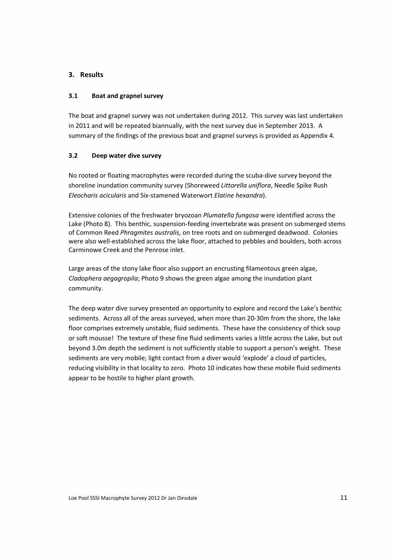
3.2 Deep water dive survey
No rooted or floating macrophytes were recorded during the scuba-dive survey beyond the
shoreline inundation community survey (Shoreweed Littorella uniflora, Needle Spike Rush
Eleocharis acicularis and Six-stamened Waterwort Elatine hexandra).
Extensive colonies of the freshwater bryozoan Plumatella fungosa were identified across the
Lake (Photo 8). This benthic, suspension-feeding invertebrate was present on submerged stems
of Common Reed Phragmites australis, on tree roots and on submerged deadwood. Colonies
were also well-established across the lake floor, attached to pebbles and boulders, both across
Carminowe Creek and the Penrose inlet.
Large areas of the stony lake floor also support an encrusting filamentous green algae,
Cladophera aegagropila; Photo 9 shows the green algae among the inundation plant
community.
The deep water dive survey presented an opportunity to explore and record the Lake’s benthic
sediments. Across all of the areas surveyed, when more than 20-30m from the shore, the lake
floor comprises extremely unstable, fluid sediments. These have the consistency of thick soup
or soft mousse! The texture of these fine fluid sediments varies a little across the Lake, but out
beyond 3.0m depth the sediment is not sufficiently stable to support a person’s weight. These
sediments are very mobile; light contact from a diver would ‘explode’ a cloud of particles,
reducing visibility in that locality to zero. Photo 10 indicates how these mobile fluid sediments
appear to be hostile to higher plant growth.

Loe Pool SSSI Macrophyte Survey 2012 Dr Jan Dinsdale 12
Photo 8: Plumatella fungosa on reed Photos 9 and 10: Stony substrate supporting green algae and
(Des Glover, Kennack Diving) mobile benthic sediments (Des Glover, Kennack Diving)
3.3 Dive and bathyscope shoreline survey 2012 and comparison to Stewart (2000)
The abundance of the three plant species which currently comprise the inundation community
at Loe Pool (Elatine hexandra, Eleocharis acicularis and Littorella uniflora) is mapped on Figure 6.
The corresponding descriptions of each surveyed section of the shore, with comparisons drawn
to the previous, similar survey of the site, Stewart (2000) are given below. There are notes on
the nature of the substrate and the variation in species distribution with water depth. The
Lake’s water-level at the time of survey would have an impact on this measure of plant
abundance compared to water depth. Therefore the water level Above Ordnance Datum (AOD)
at the time of survey must be provided. There was in fact only a small difference in the Lake’s
water level across the survey dates:
• 3.6m AOD in October 1999
• 3.7m AOD in June 2012
• 3.5m AOD during September 2012
(Environment Agency, unpublished data made available to the Loe Pool Forum Dec 2012).
Section 1 (Stewart:33)
2012 description: A shore of stones and gravel backed by 1-2 metre band of Phalaris
arundinacea. Below this is an open community including Ranunculus flammula, Juncus
articulatus, Mentha aquatica, Eleocharis palustris and Persicaria amphibia.
Underwater the stony substrate extends to a maximum of 35m from the shore to where, at the
time of survey, the water was 3m deep. Beyond this the substrate changes quite rapidly to soft

Loe Pool SSSI Macrophyte Survey 2012 Dr Jan Dinsdale 13
fluid mud. The extent of this stony substrate is greatest to toward the south of this stretch,
being only 10m wide to the north. At the northern end there is an area where shelving bedrock
replaces the stone shore.
Littorella uniflora is locally frequent to abundant across this entire section to a depth of 0.5m.
Elatine hexandra is present but mainly within slightly deeper water, 0.5-1.2m, where it is
rare/occasional and rather patchy. Eleocharis acicularis is also present, rare to locally
occasional, mainly towards the north of this stretch in water up to 1.0m deep. There was no
evidence of plants growing in water deeper than 1.7m.
Stewart (2000) described: ’Frequent patches of Littorella uniflora on this shore above the water
and scattered to locally frequent Littorella uniflora in a band around 0.4m deep. Eleocharis
acicularis and Elatine hexandra are also present mainly towards the north of this stretch; both
are rare to locally occasional’
Change to shoreline and inundation plant communities: Abundance and extent of these species
appears to be similar in 1999 and 2012. The inundation community appears to have extended
into deeper water, but this recorded change may be due in part to increased accuracy in the
dive observation in 2012 compared to the bathyscope survey in 1999.
Section 2 (Stewart:32)
2012 description: This section of shore supports continuous Reed bed, Phragmites australis,
which extends out into the water to 1.0m depth. There are scattered Willows Salix behind the
reeds; no inundation community present here.
Stewart (2000) described: ‘A rocky and stony shore with patches of Phragmites australis.
Outside the reed beds, the open rocks and stones are more or less unvegetated. In the stonier
parts there are occasional patches of Littorella uniflora at the shoreline and sparse Eleocharis
acicularis and Littorella uniflora in the water to a depth of 0.4m. There are scattered willow
bushes at the back of the shore but these do not extend to the water’s edge.’
Change to shoreline and inundation plant communities: The inundation community here was
sparse in 1999, Phragmites australis has expanded here, apparently excluding the inundation
community.
Section 3 (Stewart:31)
2012 description: This rocky and stony shore supports small patches of Phragmites australis
within an open shore community including Ranunculus flammula and Persicaria hydropiper. In
the water are occasional, sparse patches of Littorella uniflora and Eleocharis palustris which
extend to a depth of 0.5m.

Loe Pool SSSI Macrophyte Survey 2012 Dr Jan Dinsdale 14
Stewart (2000) described: similar to Section 2, with willow abundant at the back of the shore,
but the shore zone generally open with sparse Littorella uniflora, Ranunculus flammula and
Persicaria hydropiper. There are also occasional small patches of Eleocharis palustris and
Persicaria amphibia at the water’s edge and very sparse Eleocharis acicularis extending to 0.4m
depth.
Change to shoreline and inundation plant communities: The abundance and extent of these
species appears to be similar in 1999 and 2012, although plants may have extended slightly into
deeper water by 2012.
Section 4 (Stewart:30)
2012 description: Stony gravely shore is backed by dense willow scrub. Littorella uniflora and
Eleocharis acicularis are both rare, but with patches where Littorella is locally frequent to 0.6m
depth.
Stewart (2000) described: ‘Scattered Littorella uniflora and Eleocharis palustris where the
substrate is not too stony. Near the headland below Lower Pentire Farm the substrate
underwater contains more sand among the stones and Littorella becomes quite extensive in
depths up to 60cm. Eleocharis palustris is also locally frequent and there is occasional Elatine
hexandra. There are also some open areas above the water here which contain Littorella
uniflora and Eleocharis acicularis.
Change to shoreline and inundation plant communities: The abundance and extent of Littorella
uniflora and Eleocharis acicularis appears to be similar in 1999 and 2012. Elatine hexandra was
occasional in 1999 but not recorded here in 2012.
Section 5 (Stewart:29)
2012 description: A Phragmites australis bed extends into the water to a depth of 1.5m, in front
of this the lake floor comprises extremely fluid, unstable mud. No inundation species present.
Stewart (2000) described: ‘Phragmites australis bed ... the substrate on the lake-ward side of
the Phragmites is soft mud which seems to be too soft for the Littorella/Eleocharis acicularis
community.’
Change to shoreline and inundation plant communities: No change apparent to either plant
communities or substrates.
Section 6 (Stewart:28)
2012 description: Stony/gravel shore backed by willow with the shoreline dominated by Phlaris
arundinacea with abundant Eleocharis palustris and occasional patches of Persicaria amphibia.
In the water there are sandy patches at a depth of 0.6-1.0m. Littorella uniflora and Eleocharis
acicularis are thriving, being frequent to locally abundant in the south-western half of this

Loe Pool SSSI Macrophyte Survey 2012 Dr Jan Dinsdale 15
stretch, particularly where the substrate is sandier. Littorella is most frequently seen to a depth
of 0.5m while Eleocharis acicularis prevails in slightly deeper water; to 1.75m depth at the far
west of this section, and generally to a depth of 0.7m along the entire south-western half.
Elatine hexandra is rare; being present only in occasional sparse patches. This inundation
community is absent from the north-eastern half of this stretch, where the substrate in the
shelving shallows is finer sand and mud. No sign of the evergreen stonewort, Nitella flexilis,
recorded in this locality in 2003 (ENSIS, 2003).
Stewart (2000) described: Shore backed by scrub and willows leaving just 0-1 m of unshaded
shore in the north-east of this section, broadening to 1-3m in the south-western half. This is
dominated by the Phlaris arundinacea community with occasional patches of Persicaria
amphibian and Eleocharis palustris at the water’s edge together with rare patches of
Schoenoplectus tabernaemontani and Sparagnum erectum near the head of the inlet. In the
water the substrate is stony/gravely at the shore becoming sandier offshore particularly towards
the head of the inlet.... Littorella uniflora and Eleocharis acicularis are locally frequent in the
shallows in the south-western half of this stretch, particularly where the substrate is more
sandy, with Littorella preferring the shallower water and Eleocharis acicularis more frequent in
the slightly deeper water up to c 60cm. Elatine hexandra is also occasional but rather patchy.
These species are however absent in the water from the north-eastern half of this stretch,
despite the extensive area of shelving sandy shallows which ought to be suitable. Littorella and
Eleocharis acicularis do however, occur at the shoreline.
Change to shoreline and inundation plant communities:
The abundance and extent of these species appears to be similar in 1999 and 2012. The
inundation community appears to have extended into deeper water, but this apparent change
may be due in part to increased accuracy in the dive observation in 2012 compared to the
bathyscope survey in 1999.
Section 7 (Stewart:23)
2012 description: A Phragmites australis bed extends across much of this section into 0.5m
water depth. Inundation species are confined to areas which do not support reeds. Littorella
uniflora, Eleocharis acicularis and Elatine hexandra are all rarely present to the north-east of this
section. In addition, Eleocharis acicularis is locally abundant to the western end of this section
on a fairly steeply shelving stone and gravel bank, where this species forms dense patches of
turf up to 1.0m in diameter and out to a depth of 2.0m. Elatine hexandra is also present here
but no Littorella.
Stewart (2000) described: ‘Mostly Phlaris arundunacea dominated shore with some Mentha
aquatica, Persicaria hydropiper, Lotus pedunculatus on a firm stony or gravely base. Frequent
open strip at the water’s edge with Persicaria hydropiper type community. Occasional patches
of Persicaria amphibia up to 2m wide ... and rare, small patches of Eleocharis palustris and
patches of Phragmites at the south-western and north-eastern ends. In the south-western part,

Loe Pool SSSI Macrophyte Survey 2012 Dr Jan Dinsdale 16
Littorella uniflora and Eleocharis acicularis are occasional to locally frequent from just above the
water to c.80cm depth, the Littorella tending to prefer shallower water than the Eleocharis.
However, these are absent below the water towards the head of the inlet despite the more
gradually shelving sandy substrate there’
Change to shoreline and inundation plant communities:
The abundance and extent of these species at the western end of this section appears to have
increased and extended into deeper water. While some of this change could be due to
increased accuracy in the dive observation in 2012 compared to the bathyscope survey in 1999,
it is worthy of note that previous surveys have not observed Eleocharis acicularis growing to
such depth, 2m.
Section 8 (Stewart:21)
2012 description: The substrate here includes some larger cobbles. Littorella uniflora,
Eleocharis acicularis and Elatine hexandra are all occasional along this stretch of shore, with
Littorella extending out to 0.7m depth of water; with Eleocharis acicularis and Elatine hexandra
generally present further from the shore, to a depth of 1.7m.
Stewart (2000) described: …. very scattered patches of Littorella uniflora up to 50 cm in
diameter at the shoreline but not extending into the water. Also rare Eleocharis acicularis.
Onshore now 40% cover of Persicaria hydropiper, Agrostis stolonifera, Sagina procumbens with
Urtica dioica, Potentilla anserina, Epilobium obscurum and weeds.
Change to shoreline and inundation plant communities:
The abundance and extent of these species appears to have increased and extended into deeper
water within Section 8.
Section 9 (Stewart:20)
2012 description: Gently shelving stony shore backed by continuous willow scrub. Littorella
uniflora and Eleocharis acicularis present in very small quantities – rare. Despite a thorough
search Potamogeton perfoliatus was not found in this section or the reed bed to the west. It
was last recorded in Loe Pool, in this location in 2003 (Stewart, 2003).
Stewart (2000) described: Inflow seepage with Phragmites australis and Phalaris arundinacea
along it with Lythrum salicaria, Persicaria hydropiper, Eupatorium cannabinum etc. It emerges
from this just above the water’s edge and there are patches of Ranunculus hederaceus and
prostrate Apium nodiflorum at the edges of the seepage. There are a few plants of Ranunculus
hederaceus and Callitriche stagnalis along the water’s edge to the north-east of the seepage.
Change to shoreline and inundation plant communities: The willow at the back of this shore is
more established than in previous surveys; the inundation community appears to have

Loe Pool SSSI Macrophyte Survey 2012 Dr Jan Dinsdale 17
expanded into this area; substrates and water depth are suitable for further population
expansion.
Section 10 (Stewart: 2- 10)
2012 description: Gently shelving stony shore shaded by continuous willow scrub. The
substrate here appears to be suitable for the inundation community but has not been recorded
in this location.
Stewart (2000) described: Inundation community not present.
Change to shoreline and inundation plant communities: No change.
Section 11 (Stewart: 1)
2012 description: An open shore of gently shelving gravel and stones with a 0.5m bank behind,
which is eroding. The shore supports Agrostis stolonifera with Lotus pedunculatus, Lythrum
salicaria and Juncus effusus. Eleocharis acicularis and Elatine hexandra are both present, but
rare, and only to a depth of 0.5m, which is the full extent of the stony substrate. Beyond this
the substrate rapidly changes to mobile silts. Littorella is absent.
Stewart (2000): Did not record the inundation community present in this locality but Stewart
(2003) recorded small patches of all 3 species.
Change to shoreline and inundation plant communities: It is likely that this community has
expanded in recent years but is limited by the extent of suitable stony substrate.
Section 12 (Stewart: 47)
2012 description: An open stony shore, immediately in front of the bird hide, and within a short
gap in the reed fringe. No inundation community present.
Stewart (2000): The shore is mostly unvegetated or has scattered Persicaria hydropiper and
Urtica dioica. The shallow water is unvegetated but as the substrate becomes more sandy,
Eleocharis acicularis becomes locally frequent at c.60 cm depth. Further offshore the substrate
becomes softer and there are only Hydrodictyon reticulatum masses.
Change to shoreline and inundation plant communities: Stewart (2003) did not refind
Eleocharis acicularis within this area. Inundation community absent.

Loe Pool SSSI Macrophyte Survey 2012 Dr Jan Dinsdale 18
0
2
4
6
8
10
0 2 4 6 8 10 12 14
Pla
nt
ab
un
da
nce
(D
OM
IN)
Distance from shore (m)
Transect 1: North Shore Carminowe
0
2
4
6
8
10
0 0.2 0.4 0.6 0.8 1
Pla
nt
ab
un
da
nce
(D
OM
IN)
Water depth (m)
Transect 1: North Shore Carminowe
0
2
4
6
8
10
0 0.2 0.4 0.6 0.8 1
Pla
nt
ab
un
da
nce
(D
OM
IN)
Water depth (m)
Transect 2: South Shore Carminowe
0
2
4
6
8
10
0 2 4 6 8 10 12 14
Pla
nt
ab
un
da
nce
(D
OM
IN)
Distance from shore (m)
Transect 2: South Shore Carminowe
3.4 Detailed permanent transect survey
The survey results of the four permanent transects are shown in Figure 7 below.
The locations of the four permanent transects were chosen following the qualitative dive and
bathyscope survey outline above, to best fit the criteria outline in Section 2.3. In practice,
however, the southern half of the lake, particularly Carminowe Creek, was well represented in
the survey while the inundation communities were absent from the Cober arm. One transect
was positioned in the Penrose Inlet to represent the northern lake, despite of the weak
inundation community present at this location. At this location only two of the three inundation
species were present (Eleocharis acicularis and Elatine hexandra).

Loe Pool SSSI Macrophyte Survey 2012 Dr Jan Dinsdale 19
0
2
4
6
8
10
0 0.2 0.4 0.6 0.8 1
Pla
nt
ab
un
da
nce
(D
OM
IN)
Water depth (m)
Transect 3: Pentire Point
0
2
4
6
8
10
0 2 4 6 8 10 12 14
Pla
nt
ab
un
da
nce
(D
OM
IN)
Distance from shore (m)
Transect 3: Pentire Point
0
2
4
6
8
10
0 0.2 0.4 0.6 0.8 1
Pla
nt
ab
un
da
nce
(D
OM
IN)
Water depth (m)
Transect 4: Penrose Inlet
0
2
4
6
8
10
0 2 4 6 8 10 12 14
Pla
nt
ab
un
da
cne
(D
OM
IN)
Distance from shore (m)
Transect 4: Penrose Inlet
Figure 7: Variation of species abundance within the inundation community with water
depth and distance from shore along four transects within Loe Pool SSSI

Loe Pool SSSI Macrophyte Survey 2012 Dr Jan Dinsdale 20
3.5 Summary of macrophyte community composition in 2012 and changes 1999-2012
In 2012, the extent of established macrophyte beds within Loe Pool remained pitifully low: No
rooted macrophytes were recorded beyond a water depth of 2m.
There has been little overall change then in the macrophyte community since 1999, despite
dramatic improvements to water quality since 2003-2004 (Dinsdale, 2009), the cessation of
decline of algal blooms within the lake in 2006 and corresponding improvements to water clarity
(Dinsdale, 2011). Within this period, however, an extensive population of Nuttall’s waterweed
Elodea nuttalli was present within the lake from 1999 until 2007; small amounts of Perfoliate
Pondweed Potamogeton perfoliatus and the stonewort Nitella flexilis were recorded in 2003.
These species were not recorded within the lake in 2012 despite a thorough search.
Macrophyte growth is currently limited to the inundation community which comprises three
species: Littorella uniflora, Eleocharis acicularis and Elatine hexandra. This community generally
occupies the drawdown zone, exposed by falling summer water levels.
Littorella uniflora, Eleocharis acicularis and Elatine hexandra frequently occur together on sandy
and stony substrates but do not extend onto the mobile silts. Littorella alone was also recorded
in areas of larger cobbles.
In many areas of the shore a community zonation is present, with Littorella more frequent in the
shallows to a depth of 0.3m and Elatine hexandra found in deeper water, 0.5m-0.6m. Eleocharis
acicularis, Needle Spike Rush, occurs across the full range of both other species.
The Elatine hexandra continues to be less widespread than Eleocharis acicularis, as observed by
Stewart (2000) but is more abundant in the two Carminowe Creek transects.
Large areas of apparently suitable habitat, firm stony substrates, out to water depths of up 1.0m
depth at Penrose Inlet, 2.0m around the shore of Carminowe Creek and to 3.0m depth at
Pentire Point, are currently unpopulated by macrophytes. On some of these southern shores,
shading by willow growing at the back of the shore is limiting macrophyte growth. In some
areas of Carminowe Creek the inundation community has been lost to the expansion of reed
bed along the shore.
The inundation community appears to have extended into deeper water over the period 1999 to
2012. In 1999, Stewart observed that ‘in most areas where this community occurs in the Loe
Pool it is terrestrial occurring just above the water level. However, in a few places the
community does extend into the water up to 60cm depth’. In 2012, Eleocharis acicularis and
Elatine hexandra were both frequently recorded to depths of 1.7m. Of course the water-level at
the time of survey would have an impact on water depth, however, there was only a small
difference in the Lake’s water level across the survey dates. This recorded change is likely to be
due, at least in part, to the increased accuracy in the dive observation in 2012 compared to the
bathyscope survey in 1999. It was observed in 2012 that accuracy of plant recording using the
bathyscope was limited beyond 0.6m.

Loe Pool SSSI Macrophyte Survey 2012 Dr Jan Dinsdale 21
4. Publicity
There was considerable media interest in this Loe Pool 2012 macrophyte survey using scuba-
diving. An interview with the survey team and National Trust staff at the lake during the survey
was shown on local BBC and ITV news:
BBC Spotlight Monday 25 July 2012- Divers survey Loe Pool, Cornwall's largest lake:
http://www.bbc.co.uk/news/uk-england-cornwall-18579540
ITV Westcountry: Friday 29 July 2012 – Cornwall’s largest natural freshwater lake surveyed by
divers for first time:
http://www.itv.com/news/westcountry/update/2012-06-29/cornwalls-largest-natural-
freshwater-lake-surveyed-by-divers-for-first-time/
There was also media coverage in:
• the local newspaper http://www.thisiscornwall.co.uk/Polluted-pool-showing-signs-
life/story-16482707-detail/story.html
• the Devon and Cornwall National Trust members’ magazine
• the National Trust South West blog http://www.ntsouthwest.co.uk/2012/06/loe-pool-
dive-survey/
• the National Trust local property blog
http://lizardandpenrose.blogspot.co.uk/2012/06/scuba-divers-explore-depths-of-loe-
pool.html
The study also featured in a presentation given at the UK and Ireland Lakes Network annual
symposium http://www.ukandirelandlakes.org/uploader/pdf/Loe_SWW_Presentation_v2.pdf
Examples of these articles are included with this report as Appendix 5. This was very positive
publicity for Natural England and for their work, as part of the Loe Pool Forum, towards
delivering favourable condition status for the SSSI, both within the Lake and across the its
catchment.

Loe Pool SSSI Macrophyte Survey 2012 Dr Jan Dinsdale 22
5. Lake and Catchment Management Recommendations
This section outlines recommendations for further survey work and for management both
within the SSSI and across the catchment, based on the findings of the survey.
5.1 Further survey recommendations
The boat and grapnel survey method is adequate to record rooted macrophytes in deep water
within Loe Pool; no additional records were found during this 2012 scuba-dive survey. It is,
therefore, recommended that the boat survey is repeated bi-annually in September and it is
considered that there is no need to repeat the full deep-dive survey for the foreseeable future.
Scuba-diving was an accurate method of recording abundance of the inundation community at
all water depths.
In view of current water clarity in the Loe, a bathyscope provides a reliable method for surveying
this community type up to a maximum depth of 1.0m. Scuba-diving is therefore recommend as
part of the permanent transect survey, in order to survey the quadrat location at more than
1.0m water depth on each of the 4 transects. It is recommended that this survey is repeated
biannually and also in September; this frequency is selected to be sufficient to measure change
while minimising physical disturbance to the vegetation in the location of the permanent
transects. This would require 1 day of the dive team biannually in future years.
5.2 Macrophyte translocation trials
Translocation experiments for Littorella uniflora and Potamogeton spp were outlined as part of
this Conservation Enhancement Scheme funded study. The aim of this element of the research
programme was to provide further information on the suitability of the shoreline for
macrophyte colonisation and establishment and help to elucidate any factors currently limiting
plant growth.
Based on the information gathered as part of this scuba-dive survey. It is clear that the physical
texture of the benthic sediments continues to be unsuitable for rooted plant growth and
therefore the macrophyte translocation trials are not recommended at present.
5.3 Working at the catchment scale
The work of the Loe Pool Forum to reduce both sediment and nutrient inputs from diffuse and
point sources across the Lake’s catchment is considered to be critical to the successful
rehabilitation of Loe Pool. In particular, the work of the Loe Pool Point Sources Group to reduce
nutrient inputs from the two water treatment works within the catchment and the work of the

Loe Pool SSSI Macrophyte Survey 2012 Dr Jan Dinsdale 23
Loe Pool Catchment Group to address agricultural inputs through farm advisory and grant
assistance will be invaluable, working to deliver improvements to water quality and benthic
sediment structure within the Lake SSSI.
5.4 In-lake management
Delivery of improvements to water quality and sediment inputs towards the SSSI target levels
may alone, in time, provide the required conditions for recovery of the macrophyte
communities within the SSSI, in order to meet the conservation objectives listed in Section 1.3.
Great progress towards these macrophyte conservation objectives has been seen to date with a
huge reduction in phosphorus inputs, a decline in algal blooms and corresponding improvement
in water clarity. The low occurrence of non-native plant species is also favourable but the extent
of established submerged vegetation remains very low.
In terms of the Lake’s broader ecology, successful lake rehabilitation from a eutrophic algal
dominated condition relies heavily upon the re-establishment of submerged vegetation. The
importance of extensive beds of submerged vegetation for water clarity, and the numerous
mechanisms by which rooted vegetation exerts positive effects on the lake rehabilitation
process, are well documented (Moss, 1990; Jeppesen et al., 1990; Meijer, 2000; Jeppesen, 1998;
Phillips, 2005). It is therefore worth considering in-lake management techniques which could
‘kick-start’ the growth of macrophytes within Loe Pool. The options available could include:
• exclusion of wildfowl from discrete areas to improve plant establishment
• disturbance of the shore sediments to stimulate emergence of plants from the seed bed
• physical stabilisation of the benthic sediments.
Each of these options would require in-situ trials before being undertaken as a management
measure within the SSSI. They are not recommended for consideration at present, but should
perhaps be considered in the long-term, if there continues to be no improvement to the extent
of macrophyte growth in Loe Pool. Based on the findings of this 2012 Macrophyte Survey, two
management recommendations that should be considered immediately, to improve habitat
conditions for the establishment of macrophytes in Loe Pool are given below.
5.4.1 Water level management
One of the key conservation objectives for Loe Pool SSSI states that ‘There should be a ‘natural’
hydrological regime’ (Natural England, 2009) A wholly ‘natural’ lake hydrology is considered
unrealistic:
• Water levels in Loe Pool have been artificially controlled for over 200 years (Wilson and
Dinsdale, 1998)
• The current water level regime is controlled using an engineered outlet structure at Loe
Bar.
• The town of Helston has a history of high flood risk linked to water levels within the
lake.

Loe Pool SSSI Macrophyte Survey 2012 Dr Jan Dinsdale 24
Perhaps then, rather than a ‘natural lake hydrology’ it would be more appropriate to set an
objective to deliver ‘a hydrological regime that best serves both the lake’s ecology and flood risk
management’.
Historic shoreline flora data strongly indicate the presence of a summer drawdown zone at Loe
Pool (Stewart, 2000). An increased summer drawdown zone would improve both the extent and
quality of habitat for macrophytes: Elatine hexandra, for example, does not flower beneath the
water (Stace, 1997); Littorella uniflora can tolerate extreme inter-annual fluctuations in water
levels and long periods of exposure (Natural England, 2009). Generative reproduction occurs
during dry periods, on the emerging sediments or in extremely shallow water (Brouwer et al.,
2002). Additionally, periodic emergence of the sediment of shallow lakes stimulates
germination from the seed bank (Brouwer et al., 1999). Most softwater macrophytes produce
long-lived seeds and re-establishment from the seed bank often occurs in large amounts
(Bellemakers et al., 1996). The macro-invertebrate communities would also benefit from an
increased area of seasonally inundated shore (Knight, 2003).
Using bathymetric data collected by Mason Survey in 2000, Haycock (2000) calculated that the
current normal range of water level (approximately 3.5 to 4.1 mAOD) exposes 7.6 ha of littoral
edge. These calculations can be extrapolated to predict that a winter 3.5m AOD and summer
3.05mAOD would increase the littoral shore by up to 3.5 ha, giving a total littoral area of 11.1
ha. This extended drawdown zone would benefit of both the plant and the macro-invertebrate
communities and would be consistent with Natural England’s Conservation Objectives for the
site (Natural England, 2009).
5.4.2 Shoreline scrub and reed management
Willow shading on southern shores Carminowe and Penrose inlet is likely to be limiting the
establishment of the macrophyte community in these otherwise suitable areas. Controlling the
growth of these willows would help to provide good habitat conditions to promote macrophyte
growth in these areas. It is recommended that the willows in these priority areas are cut back
and the stumps treated with a Glyphosate-based herbicide. Use of this systemic, low-toxicity
compound will reduce regrowth considerably but follow-up cutting will still be required. The
use of any herbicide in or close to a waterbody requires written approval from the Environment
Agency.
Lower summer water levels will have an impact on shoreline reed communities (Haycock, 2000).
This could also have a positive impact on the inundation communities as in some areas around
Carminowe Creek these macrophytes have been lost to competition from the expanding reed
bed.

Loe Pool SSSI Macrophyte Survey 2012 Dr Jan Dinsdale 25
6. References
Bellemakers, M.J.S., Maessen, M.,Verheggen, G.M., Roelofs, J.G.M. (1996) Effects of liming on
shallow acidified moorland pools: a culture and a seed bank experiment. Aquatic Botany, 54,
37–50.
Brouwer, E., Soontiëns, J., Bobbink, R., Roelofs, J.G.M. (1999) Sulphate and bicarbonate as key
factors in sediment degradation and restoration of Lake Banen. Aquatic Conservation, 9, 121–
132.
Brouwer, E, Bobbink, R, Roelofs, J.G.M. (2002) Restoration of aquatic macrophyte vegetation in
acidified and eutrophied softwater lakes: an overview. Aquatic Botany, 73, 405–431.
Clitherow, J. and Dinsdale, J. (2012) Loe Pool Catchment Forum: Catchment Group Activity List
2012/13. Unpublished.
Dinsdale, J. (2009) Loe Pool Catchment Management Project: 2009 Review. Report to the
National Trust, South West Cornwall Office.
Dinsdale, J. (2007-2011) Loe Pool Annual Botanical Surveys 2007-2011: Annual Brief Summary
of Findings. Reports to the National Trust South West Cornwall Office.
Ensis (2003) Common Standards Monitoring for Standing Waters: Macrophyte Survey Loe Pool
SSSI. Joint Nature Conservation Committee. Ensis Ltd, September 2003.
Flory, J.E. and Hawley, R.W. (1994) A Hydrodictyon reticulatum Bloom at Loe Pool, Cornwall.
European Journal of Phycology 29, 17-20.
Hambrook, D. and Dinsdale, J. (2012) Loe Pool Catchment Forum: Point Sources Group Activity
List 2012/13. Unpublished.
Haycock, N.E. (2000) Loe Pool Water Level Management Plan (Revised). Report to National
Trust. Haycock Associates, St. Albans, Hertfordshire.
HSE (1997) Health and Safety - The Diving at Work Regulations 1997. SI 1997 No. 2776.
HSE (1998) Scientific and Archaeological Diving Projects. The Diving at Work Regulations 1997.
Approved Code of Practice and Guidance – L107. HSE Books 1998.
JNCC [Joint Nature Conservation Committee](2005) Common Standards Monitoring Guidance
for Standing Waters. Joint Nature Conservation Committee. March 2005, ISSN 1743-8160
(online).

Loe Pool SSSI Macrophyte Survey 2012 Dr Jan Dinsdale 26
Jeppesen, E. (1998) The ecology of shallow lakes – trophic interactions in the pelagial. Doctorate
dissertation, Technical Report No. 247, National Environmental Research Institute.
Jeppesen, E., Søndergaard, M., Sortkjær, O., Mortensen, E. & Kristensen, P. (1990) Interactions
between phytoplankton, zooplankton and fish in a shallow, hypertrophic lake: A study of
phytoplankton collapses in Lake Søbygård, Denmark. Hydrobiologia, 191, 149-64.
Knight, L.R.F.D (2003) A survey of the aquatic macro-invertebrate fauna of Loe Pool and its
feeder watercourses. Report to the National Trust, South West Cornwall Office.
Meijer, M.-L. (2000) Biomanipulation in the Netherlands. 15 years of experience. PhD Thesis,
Wageningen University
Moss, B. (1990) Engineering and biological approaches to restoration from eutrophication of
shallow lakes in which aquatic plant communities are important components. Hydrobiologia,
200/201, 367-77.
Natural England (2009) Conservation Objective Loe Pool. Consultation Draft v1.2. Natural
England, Cornwall.
Olosundé, J. (2002) Sediment Phosphorus in Loe Pool, Cornwall. Unpublished Post-Graduate
Report, University of Leicester.
Phillips, G.L. (2005) Eutrophication of Shallow Temperate Lakes. In: The Lakes Handbook. Lake
Restoration and Rehabilitation (P.E. O’Sullivan and C.S. Reynolds ed.), pp. 261-278. Blackwell
Publishing, Oxford.
Stace, C. (1997) New Flora of the British Isles. 2nd
Ed. Cambridge University Press, Cambridge.
Stewart, N.F. (2000) Survey of the Botany and Vegetation of Loe Pool, Helston 1999. Report to
National Trust.
Stewart, N.F. (2003) Survey of the Botany and Vegetation of Loe Pool, Helston 2003. Report to
National Trust.
Stewart, N.F. (2006) Survey of the Botany and Vegetation of Loe Pool, Helston 2006. Data and
brief notes provided to Jan Dinsdale/National Trust.
Wilson, H. and Dinsdale, J. (1998) Loe Pool Catchment Management Project. Final Report. Report
to the Loe Pool Management Forum. Environment Agency, Bodmin, Cornwall.

Loe Pool SSSI Macrophyte Survey 2012 Dr Jan Dinsdale
APPENDIX 1
Natural England SSSI citation and excerpt from SSSI condition statement
SSSI Citation
COUNTY: CORNWALL SITE NAME: LOE POOL
DISTRICT: KERRIER
Status: Site of Special Scientific Interest (SSSI) notified under Section 28 of the Wildlife
and Countryside Act 1981 (as amended)
Local Planning Authority: KERRIER DISTRICT COUNCIL; CORNWALL COUNTY
COUNCIL
National Grid Reference: SW 647250 Area: 128.7 (ha) 318.0 (ac)
Ordnance Survey Sheet 1:50,000: 203 1:10,000: SW 62 SW SE NW NE
Date Notified (Under 1949 Act): 1951 Date of Last Revision: 1973
Date Notified (Under 1981 Act): 1986 Date of Last Revision: –
Other Information:
Cornwall Area of Outstanding Natural Beauty and Cornwall Heritage Coast. Site
boundary amended by extension and deletion. Mainly National Trust owned.
Description and Reasons for Notification:
Loe Pool, located south of Helston on the South Cornish coast, is the largest freshwater
lagoon in Cornwall covering an area of approximately 50 hectares and with maximum
depth of 6 metres. The underlying rock is composed of Devonian shales and siltstones,
locally overlain by head deposits. Soils developed over the surrounding area are mainly
acidic brown earths. Both the pool and the shingle bar provide scarce habitat not found
elsewhere in Cornwall, with rare species of higher plants, bryophytes, and algae, together
with many rare and local insect species. The area is also important to wintering birds.
The pool supports several locally rare aquatic plant species including Six-stamened
Waterwort Elatine hexandra, Perfoliate Pondweed Potamogeton perfoliatus, Shoreweed
Littorella uniflora, Horned Pondweed Zannichellia palustris, and Amphibious Bistort
Polygonum amphibium. One noteworthy species of alga, Stonewort Alga Nitella hyalina,
has also been recorded. The shingle bar supports local plant species including Sea Holly
Eryngium maritimum, Sea Fern-grass Catapodium marinum, Yellow Horned-poppy
Glaucium flavum, Sea Sandwort Honkenya peploides, Sea Mayweed Tripleurospermum
maritimm, and the very rare Strapwort Corrigiola litoralis.
At the northern inflow area is an extensive area of willow carr, mainly Grey Willow Salix
cinerea, with Common Reed Phragmites australis locally dominant within the willow.
There is a wide fringe of Reed around the northern border of the lake. An area of
relatively undisturbed ancient oakwood, mainly Pedunculate Oak Quercus robur, occurs
in the west of the site. Areas of maritime grassland occur along the cliff edge with Red
Rescue Festuca rubra forming an extensive mat. Other species include Thrift Armeria
maritima, Wild Carrot Daucus carota, Wild Thyme, Thymus drucei, Spring Squill Scilla
verna, and Western Clover Trifolium occidentale.

Loe Pool SSSI Macrophyte Survey 2012 Dr Jan Dinsdale
Loe Pool is the only known site in Britain for the Cornish subspecies of the Sandhill
Rustic Moth Luperina nickerlii leechi, which feeds on Sand Couch Grass Agropyron
junceiforme. Nine species of Odonata, including the Keeled Skimmer Orthetrum
coerulescens have been recorded here. The nutrient rich status of the pool has encouraged
an abundance of benthic invertebrates, and there are also many rare or local species of
Coleoptera and Hymenoptera. Loe Pool has the only recent record in Cornwall of the rare
woodlouse, Porcellio dilatatus.
Loe Pool supports nearly 80 species of wintering birds with up to 1,200 wildfowl.
Numbers of Shoveler Anas clypeata can reach nationally important levels and regionally
important counts of Teal Anas crecca are not unusual.
There are also high counts for Pochard Aythya ferina, Tufted Duck Aythya fuligula,
Mallard Anas platyrhynchos, Goldeneye Bucephala clangula, Cadwall Anas strepera,
and Coot Fulica astra. Several rare birds have been recorded here in winter and on
autumn migration. There is a breeding colony of about 20 pairs of Sand Martins Riparia
riperia a species not well represented in Cornwall.
Loe Bar encloses a lagoon occupying part of a former ria, and forms an integral part of a
beach system extending from Porthleven to Gunwalloe. The site is important for coastal
geomorphology on two accounts. First, Loe Bar is a classic coastal landform; and second,
the beach system is an essential member of a suite of major beaches formed and
maintained by predominantly south-west wave regimes. The beach is formed mainly of
flint shingles and coarse sand. Current inputs from adjacent cliffs are small, and overall,
the beach is in deficit. The Bar is washed-over during periods of high wave energy as
demonstrated by a series of washover fans. The annually laminated sediments composed
of classic material are unique in Great Britain.

Loe Pool SSSI Macrophyte Survey 2012 Dr Jan Dinsdale
SSSI condition statement excerpt
Box 1. Characteristic species of oligotrophic to mesotrophic standing waters with vegetation of the
Littorelletea uniflorae and/or of the Iseoto-Nanojuncetea. ** mesotrophic species only
Characteristic species:
Littorelletea flora: Other characteristic species: Associates:
Littorella uniflora Pilularia globulifera Callitriche hamulata
Isoetes lacustris Elatine hexandra Callitriche brutia
Isoetes echinospora Baldellia ranunculoides Myriophyllum alterniflorum
Lobelia dortmanna Carex rostrata Potamogeton polygonifolius
Subularia aquatica Utricularia spp. Potamogeton berchtoldii
Sparganium angustifolium ** Nitella spp. Potamogeton natans
Luronium natans **Sparganium natans Nymphaea alba
Potamogeton rutilis **Broadleaved Potamogeton species: Juncus bulbosus
P. alpinus Eleogiton fluitans
P. praelongus Equisetum fluviatile
P. perfoliatus Nuphar lutea
P. gramineus Menyanthes trifoliata
P x nitens (and any other established hybrid of these species)
Eleocharis acicularis
**Najas flexilis **Persicaria amphibia

Loe Pool SSSI Macrophyte Survey 2012 Dr Jan Dinsdale
APPENDIX 2
Risk assessments: scuba-diving
Dive Project Plan + Risk Assessment for Underwater Plant survey with Jan
Dinsdale/National Trust at Loe Pool/Carminowe Creek (Lower Pentire)
Date_____________
Type of site/ Dive…Rock/pebble beach shore dive. FRESH WATER!
Type of Diving - Trial Dives €
Guided dives €
Open Water Course Training €
Adv O/w Training €
Rescue Diver Course Training €
Dive master Training €
Other € Details……………………………
………………………………............
All Courses to be conducted according to PADI General Standards And Procedures and using the
PADI RDP dive table ,general guidelines HSE Diving at Work ACOP’S 1997
ALL DIVERS TO CARRY OUT BUDDY CHECK BEFORE EVERY DIVE
ALL PERSONS TO SIGN THIS SHEET AT THE END OF DIVING ACTIVITIES
Personnel -
Dive Contractor …… Des Glover € ………. David Roberts €
Supervisors - Des Glover € ………..David Roberts €

Loe Pool SSSI Macrophyte Survey 2012 Dr Jan Dinsdale
DIVERS / SHORE SUPPORT
NAME QUALIFICATION ROLE SIGNED
David Roberts MI 609353 Instructor/DIVER
Des Glover MSDT 632321 Instructor/DIVER
Rebecca-Morton
Clark
Divemaster Divemaster/DIVER/
Shore & surface
Jan Dinsdale Ecologist/on shore at
all times
Chris Cattlin Divemaster Shore/logistics
support
Milo Lekic Instructor Instructor/Diver
Equipment - Full PADI Standard Scuba Equipment Inc SMB, Whistle / Signalling device, Knife/
cutting tool.
EXTRA EQUIPMENT -50 metres of 11mm Rope – Large fishing buoy for GPS attachment, 20metre
rescue throw line,
Gas Mix - All Air Unless specified on Diver Log
Safety Equipment - The First Aid Kit and O2 are located in the large orange O2 box on site at all
times!! ALL DIVERS ON THIS DIVE are First Aid, Emergency Oxygen and Diver Rescue trained!!
Communication Equipment …… Emergency Phone – Helston Cottage Hospital
ORANGE/VODAFONE mobiles checked at site and work ok!
In event of accident …. Call 999 ask for Coastguard. Give details of Accident and
location….
Lower Pentire . Grid reference 243652-Carminowe Creek
Nearest Decompression Chamber - Derriford Hospital - Plymouth - Emergency contact
Number 01752 209999.
If Coastguard Rescue Delayed - Navy Diving Doctor - 07831 151523 for advice

Loe Pool SSSI Macrophyte Survey 2012 Dr Jan Dinsdale
HAZARDS & ACTIONS
WALKING DOWN SLOPE TO SHORE…………Please ensure good footwear etc
BOAT TRAFFIC & POSSIBLE ANGLERS…….. None anticipated SMB AT ALL TIMES
FISHING LINE UNDERWATER……………….. All divers to carry knife / cutting tool
WATER TEMP’ ……………………………….....Appropriate exposure to be worn
Wet/dry suit Gloves, Hood etc
HAZARDS SPECIFIC TO TODAY ……None anticipated, no untoward currents , thermoclines are
anticipated also no specific threat of hazardous marine life.
Advise all divers of need for VERY close buddy contact at all times due to anticipated poor
visibility and to be aware of potential underwater obstructions eg: Tree branches…………………
Be aware of any water ingestion and observe correct hygiene procedures, alcohol wash
available at all times.
Tide
High Water …………N’A……………Low Water………N/A…………….
Weather Present………………………………....................Forecast………………………………......................
Water conditions
Sea State Present…………………………......... …Expected Future………………………
Expected Viz…ZERO -…1/2 METRES………Expected Temperature ……19 Degrees C……………
This action plan and risk assessment has been agreed by the appointed contractor and
supervisor. They have both agreed to their roles as laid down in the diving at work HSE
regulations. The action plan and risk assessment have been relayed to all divers by the
contractor and all points explained and understood.
Signed ………………………………..............DIVING CONTRACTOR
Signed………………………………...............DIVING SUPERVISOR

Loe Pool SSSI Macrophyte Survey 2012 Dr Jan Dinsdale
ACTIVITY:
Transect survey – wading and snorkling in lake
LOCATION:
Loe Pool, Helston
DATE OF ASSESSMENT:
17/09/2012
ASSESSED BY:
Jan Dinsdale
PROJECT NAME:
Loe Pool CES Transect Survey
SURVEYORS:
Janet Dinsdale
Rebecca Morton-Clarke
Risk assessments: transect survey
Key:
RISK RATING - L = Likelihood (Low,
Medium, High), S = Severity (Low,
Medium, High), R = Risk (Likelihood
x Severity)
RISK LEVEL - L = Low; M =
Medium; H = High; N/A = Not
applicable
LIKELIHOOD
H Certain or near certain to occur
M Reasonably likely to occur
L Very seldom or never occurs
SEVERITY
H Fatality, major injury or illness
causing long-term disability
M Injury or illness causing short-term
disability
L Other injury or illness
PLOT ASSESSMENT OF SEVERITY v LIKELIHOOD AND
HIGHLIGHT VALUE OBTAINED
H/H 100% avoid whenever possible
L/L 0% may be ignored
For all other values, control or minimise risk

Loe Pool SSSI Macrophyte Survey 2012 Dr Jan Dinsdale
KEY:
Hazard (something with potential to cause harm)– this list is not exhaustive, consider
and select relevant actions, and add any additional hazards identified
Risk (chance or likelihood of harm being caused
Who is at risk – staff, general public, landowners, people with special needs, other
Risk Level – write down whether Low, Medium or High
Precautions – List the safety measure to be put in place to lower risk level
Risk Level – following precautions what is risk level
Continue with activity? – Is risk level too high to continue?
Further action – consider and list other action to be taken to permit activity to continue
Action by whom – yourself, landowner, group leader, etc
Action done – date and initial
HAZARD
Potential for
harm
Who is at
risk and
might be
harmed?
RISK
LEVEL:
Low
Medium
High
PRECAUTIONS
To reduce the risk level
RISK LEVEL
Following
precautions
Continue
with activity
or too
hazardous?
Hazards –
general
Surveyors L 1. Ensure mobile phone battery is charged
2. Take first aid kit with up to date
contents.
L
Litter, metal,
glass,
hypodermic
needles, etc
Surveyors
L
1. Wear appropriate footwear on site and
be watchful L
Slips, trips,
falls
Surveyors
L
1. Take care of slippy rocks
2. Wear waders/appropriate footwear
3. Work closely with buddy and be vigilant
at all times for fall in water
L
Deep water Surveyors
M
1. Do not wader out in chest waders
beyond waist deep
2. Buddy to stay on shore close to snorkel
surveyor at all times
L
Entanglement Surveyors
M
1. Check for ropes and trees along route
before surveying
2. Remove hazards of relocate transect to
avoid risk
L
Toxins in
water
Surveyors
M
1. Do not ingest water
2. Use alcohol gel before eating L

Loe Pool SSSI Macrophyte Survey 2012 Dr Jan Dinsdale
HAZARD
Potential for
harm
Who is at
risk and
might be
harmed?
RISK
LEVEL:
Low
Medium
High
PRECAUTIONS
To reduce the risk level
RISK LEVEL
Following
precautions
Continue
with activity
or too
hazardous?
Deep mobile
sediment
Surveyors M
1. Only wade on rocky substrates not
on mobile mud
2. Do not put feet down when
snorkling over mud
3. One buddy to remain shore on safe
sediment at all times
4. Carry a 30m rope
L
Weather
Surveyors L
1. Wear protective clothing and sun
block.
2. Cease work if inadequately
prepared or extreme weather conditions are
encountered.
L
Signed ……………………………………………….. Date ……………
GENERAL SAFETY PROCEDURES
Office-Field Contact Safety Procedure
At least one mobile phone should be carried per field group.
First Aid kit with up to date contents to be taken.
Office staff or buddy should be informed of field destination, approximate working time and
mobile phone number.
If expected departure time is outside working hours a buddy must be informed of your expected
time of departure from site.
Field workers should report to office (or buddy if outside office hours) upon departure of the
field site.
The office or buddy must be informed of changing circumstances.
N.B. A buddy can be a member of staff, a family member, partner or friend, and must be aware
of the system.

Loe Pool SSSI Macrophyte Survey 2012 Dr Jan Dinsdale
FORM 2 - RISK ASSESSMENT Site specific record
SITE: Loe Pool Transect survey
DATE: 17 Sept for survey on 19 and 21/09/2012
ASSESSED BY: Jan Dinsdale
EMERGENCY INFORMATION:
In the event of an incident call 999 IMMEDIATELY.
Stay with the injured party and administer first aid.
Mobile signal good
Tell the emergency services where you are.
Location description:
Loe Pool, Helston
Either Carminowe Creek where best vehicle access is from Lower Pentire
Grid Reference: SW652243
Or Penrose Estate, The Stables/boathouse
Grid Reference:SW646256
The nearest casualty department is (please indicate):
Helston Cottage Hospital

Loe Pool SSSI Macrophyte Survey 2012 Dr Jan Dinsdale
APPENDIX 3
Dive computer read-outs
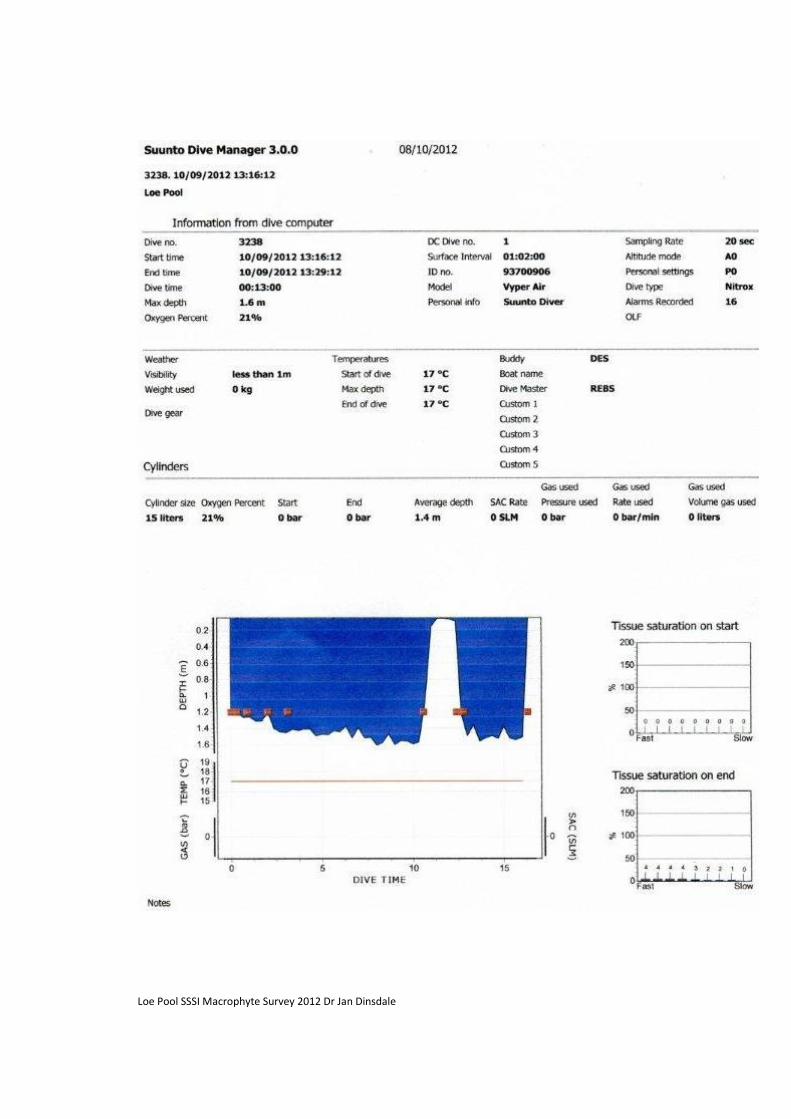
Loe Pool SSSI Macrophyte Survey 2012 Dr Jan Dinsdale

Loe Pool SSSI Macrophyte Survey 2012 Dr Jan Dinsdale
APPENDIX 4
Overview of Boat and Grapnel Survey 2011
Loe Pool Annual Botanical Survey 2011 Brief Summary of Findings 1. Results Summary
• The 2011 Loe Pool annual botanical survey was undertaken on September 21st. The methodology was a repeat of the 14 boat transects first surveyed in 1999. This survey was repeated in 2003 and has been carried out each year since 2006.
• There was no evidence of the two previously abundant algal species, Water Net Hydrodictyon reticultum and the blue-green alga Microcystis aeruginosa during the 2011 survey. These species have not been recorded within Loe Pool since 2006. Helston’s Coronation Lake, which is located less than 2km upstream and is hydrologically connected to the Pool, continues to exhibit blooms of Water Net and blue-green algae each year (2007- 2011). However, there is some indication that the extent of the bloom here is also reducing in magnitude and period.
• Secchi Disc Transparency, a measure of water clarity, is recorded as part of the annual botanical survey. With the absence of algal blooms, water clarity within Loe Pool has been gradually improving across the majority of the lake and in 2011 was ca. 1.35m. The transparency in the Cober arm, to the north of the lake remains poor at 1.24m in 2011. There is a long way to go to reach the Loe Pool forum’s target Secchi depth of 3.0m (Wilson and Dinsdale, 1998; Dinsdale, 2009)
• The general paucity of submerged, rooted aquatic vegetation recorded during the transect survey within Loe Pool continued in 2011, this pattern has been in place since the loss of Nuttall’s water weed in 2007: o The population of Nuttall's Waterweed, which increased so prolifically between 1999 and 2006, crashed in 2007 and has not been observed within the lake nor recorded in any of the transects since then. At its peak in 2006, the population extended to both the Penrose inlet and the Cober inlet and occurred in 60% of the sample stations across the lake. o Perfoliate Pondweed Potamogeton perfoliatus is one of the old inhabitants of the Pool; it was present in large quantities in the mid-nineteenth century (Johns, 1848) and was still abundant in 1964 (Turk and Turk, 1976). Perfoliate Pondweed was then not recorded until 1983 (record: RJ Murphy) and subsequently was not seen again until 2003, when a small number of plants were recorded in Carminowe Creek by both Stewart (2003) and Knight (2003). At the time Nick Stewart suggested that the reappearance of Perfoliate Pondweed ‘must be due to local stabilisation of conditions by the abundant growth of the Nuttall's Waterweed’. Following the decline of Nuttall’s Waterweed only small amounts of drift material of Perfoliate Pondweed were recorded during the annual macrophyte surveys of 2006 and 2007, both within Carminowe Creek. Loe Pool is its only Cornish locality. The Pondweed has not been recorded more recently, despite a thorough search in both May and September 2010 with the help of Cornwall BSBI plant recorder Ian Bennallick.

Loe Pool SSSI Macrophyte Survey 2012 Dr Jan Dinsdale
o The inundation community, which includes the three diminutive plant species Needle Spike Rush Eleocharis acicularis, Six-stamened Waterwort Elatine hexandra and Shoreweed Littorella uniflora has apparently expanded in both 2010 and 2011. It is thought that the increase in cover and extent of this plant community could be in response to the increased drawdown zone seen within the Lake due to relatively low summer rainfall levels in the past two summers. There was a good sward of Needle Spike Rush on the rocky shores of both Carminowe and Penrose Creeks. Both Needle Spike Rush and Shore Weed were observed to a depth of 200-250mm beneath the water in 2010. In 2011 Natural England Freshwater Specialist Genevieve Madgwick observed patches of Eleocharis acicularis and Elatine hexandra growing deeper into the lake on sandier substrates, to 0.75–1m depth. o There was no recorded for these inundation species within the survey transects; these observations of an increased extent and vegetative cover in 2010 and 2011 come from an additional visual assessment only.
• There were no non-native invasive aquatic plant species noted in the Pool this year.
Carminowe Creek: Inundation community with Needle Spike Rush and six-stamened waterwort. Photo: Gen Madgwick
• The freshwater bryozoan Plumatella fungosa has been recorded in Loe Pool each year since 2009. Relatively large colonies of this benthic, suspension-feeding invertebrate were also present this year, on submerged tree roots and floating deadwood within the central neck of the lake and Carminowe Creek; smaller colonies were also attached to rocks on the lake floor within Carminowe Creek. Plumatella fungosa flourishes in warm, eutrophic waters and is among the most tolerant of all freshwater bryozoans to organic pollution. The colonies are capable of prolific growth when not overgrown by algae (Sládeček, 1980).
Plumatella fungosa Photo: M. Hardy, NT, 2009

Loe Pool SSSI Macrophyte Survey 2012 Dr Jan Dinsdale
2. Discussion
• It is very positive to have a five consecutive years without substantial algal blooms within the Loe.
• Despite dramatic improvements to in-lake phosphorus levels, and generally to water clarity as well, the re-establishment macrophyte beds within Loe Pool remains poor.
• Visual walk-over assessments suggest that there has been some increase in the percentage cover and extent of the inundation communities in Carminowe Creek and Penrose creek during 2010 and 2011. However, the current survey method is not appropriate for recording these discrete plant population changes. Genevieve Madgwick, Natural England Fresh-water Lakes specialist, visited Loe Pool in September 2011 and suggested an additional, more intense, fixed transect survey methodology, in order to monitor changes to the existing macrophyte beds. If possible, this detailed fixed transect survey should commence in 2011 and run alongside the current whole lake boat survey, which remains useful for recording gross plant population changes across the lake.
• Successful lake rehabilitation relies heavily upon re-establishment of submerged vegetation. Results of multi-lake studies have shown that where macrophytes are slow to respond to clear water conditions, lake rehabilitation becomes a longer process and is less likely to be ultimately successful (e.g. Moss, 1990; Jeppesen et al., 1990; Meijer, 2000; Jeppesen, 1998; Hosper et al., 2005; Phillips, 2005; Broads Authority, 2009). The positive effect of submerged rooted vegetation on lake rehabilitation is the result of a number of mechanisms including: o providing refuge for phytoplankton-grazing zooplankton o structural complexity promotes piscivorous perch promoting top-down control on algal growth o reducing availability of nutrients for phytoplankton reducing wind- and fish- induced
resuspension of sediments (Hosper et al. 2005)
• Natural England’s condition statement for Loe Pool sets specific macrophyte community composition targets which include an overall site total of at least 8 characteristic species with a quantification target of six out of ten sample spots should include at least 1 characteristic species (Natural England, 2010). Loe Pool needs to see a substantive improvement to macrophyte communities in order to move towards these targets.
• It is now also 5 years since the decline of the last population boom within the Loe’s macrophyte communities. With continued improvements to water quality and a decline in algal blooms, other environmental factors could be limiting the re-establishment of these plant communities: o Year-round relatively static water levels, without an adequate summer drawdown is likely to
have had a deleterious effect on the inundation community. Some of the inundation species, including the nationally scarce Six-stamened waterwort, do not flower beneath the water (Stace, 1997). That said, generative reproduction of both Needle Spike Rush and shorweed occurred during the dry summer period of 2011, on the emerging sediments. Further dry years, or adopting an artificial lowering of summer water levels are likely to benefit these inundation communities.
o Dense growth of willow along the lake shore and overhanging into the water has developed in recent years and this has also reduced the extent of the open shore habitat favoured by these aquatic plant communities.
o Lack of stimulation of the seedbank may also be a contributing factor. Most softwater macrophytes produce long-lived seeds and re-establishment from the seed bank often occurs in large amounts (Bellemakers et al., 1996). Periodic emergence of the sediment of shallow lakes generally stimulates germination from the seed bank (Brouwer et al., 1999). Much of the shoreline of Loe Pool, however, has seen significant amounts of sediment laid down and disturbance of the substrate may be required to activate significant germination from the seedbank. A re-introduction of shoreline grazing could provide suitable sediment disturbance.
o The high metal content of the Lakes’ floor substrate is well documented (Coard, 1987). While this has brought water quality benefits in recent years, by locking up historic phosphorus loading within the sediments (Olosundé, 2002), these same metals may inturn inhibit the next stage of lake rehabilitation, the re-establishment of macrophyte beds.
o Lack of external vegetative and seed sources may also be a contributing factor.

Loe Pool SSSI Macrophyte Survey 2012 Dr Jan Dinsdale
• In order to elucidate which of these factors are contributing to the slow re-establishment of macrophytes in Loe Pool, it is recommended that consideration is given to undertaking some plant translocation trials including: o Re-locating Littorella from Carminowe to the Cober arm. o Introducing Potamogeton species from local populations to the Loe shores. o Growing Littorella from the Loe population and from nearby reservoir populations in sediment
from both Carminowe Creek, the Cober arm of Loe Pool and a control reservoir sediment. o In each case these re-located plants would require careful monitoring of both growth and
establishment for a 24 month period. 3. References Bellemakers, M.J.S., Maessen, M.,Verheggen, G.M., Roelofs, J.G.M. (1996) Effects of liming on shallow
acidified moorland pools: a culture and a seed bank experiment. Aquatic Botany, 54, 37–50.
Broads Authority (2009) The Broads Projects. Avail. at: www.broads-authority.gov.uk
Brouwer, E., Soontiëns, J., Bobbink, R., Roelofs, J.G.M. (1999) Sulphate and bicarbonate as key factors in
sediment degradation and restoration of Lake Banen. Aquatic Conservation, 9, 121–132.
Brouwer, E, Bobbink, R, Roelofs, J.G.M. (2002) Restoration of aquatic macrophyte vegetation in acidified
and eutrophied softwater lakes: an overview. Aquatic Botany, 73, 405–431.
Coard, M.A. (1987) Palaeolimnological Study of the History of Loe Pool, Helston, and its Catchment.
Unpublished PhD Thesis, Plymouth Polytechnic.
Dinsdale, J. (2007) Loe Pool Annual Botanical Survey 2007: Brief Summary of Findings. Report to the
National Trust South West Cornwall Office
Dinsdale, J. (2008) Loe Pool Annual Botanical Survey 2008: Brief Summary of Findings. Report to the National Trust South West Cornwall Office. Dinsdale, J. (2009) Loe Pool Catchment Management Project: 2009 Review. Report to the National Trust,
South West Cornwall Office.
Hosper, S.H., Meijer, M-L., Gulati, R.D. & van Donk, E. (2005) Biomanipulation in Shallow Lakes:
Concepts, Case Studies and Perspectives. In: The Lakes Handbook. Lake Restoration and Rehabilitation (P.E.
O’Sullivan and C.S. Reynolds ed.), pp. 462-482. Blackwell Publishing, Oxford.
Jeppesen, E. (1998) The ecology of shallow lakes – trophic interactions in the pelagial. Doctorate
dissertation, Technical Report No. 247, National Environmental Research Institute.
Jeppesen, E., Søndergaard, M., Sortkjær, O., Mortensen, E. & Kristensen, P. (1990) Interactions between
phytoplankton, zooplankton and fish in a shallow, hypertrophic lake: A study of phytoplankton collapses in
Lake Søbygård, Denmark. Hydrobiologia, 191, 149-64.
Johns, C.A (1848) A Week at the Lizard.
Knight, L.R.F.D (2003) A survey of the aquatic macro-invertebrate fauna of Loe Pool and its feeder
watercourses. Report to the National Trust, South West Cornwall Office.
Meijer, M.-L. (2000) Biomanipulation in the Netherlands. 15 years of experience. PhD Thesis,
Wageningen University
Moss, B. (1990) Engineering and biological approaches to restoration from eutrophication of shallow lakes
in which aquatic plant communities are important components. Hydrobiologia, 200/201, 367-77.
NE [Natural England] (2009) Conservation Objective Loe Pool. Consultation Draft v. 1.2. Natural
England, Cornwall.
Olosundé, J. (2002) Sediment Phosphorus in Loe Pool, Cornwall. Unpublished Post-Graduate Report, University of Leicester. Phillips, G.L. (2005) Eutrophication of Shallow Temperate Lakes. In: The Lakes Handbook. Lake Restoration
and Rehabilitation (P.E. O’Sullivan and C.S. Reynolds ed.), pp. 261-278. Blackwell Publishing, Oxford.
Sládeček, V. (1980) Indicator value of freshwater Bryozoa. Acta Hydrochimica and Hydrobiologica.

Loe Pool SSSI Macrophyte Survey 2012 Dr Jan Dinsdale
Stace, C. (1997) New Flora of the British Isles. 2nd Ed. Cambridge University Press, Cambridge.
Stewart, N.F. (2000) Survey of the Botany and Vegetation of Loe Pool, Helston 1999. Report to National
Trust.
Stewart, N.F. (2003) Survey of the Botany and Vegetation of Loe Pool, Helston 2003. Report to National
Trust.
Turk, F.A. and Turk, S.M. (1976) A Handbook to the Natural History of the Lizard Peninsula. University of
Exeter.
Wilson, H. and Dinsdale, J. (1998) Loe Pool Catchment Management Project. Final Report. Report to the Loe Pool Management Forum. Environment Agency, Bodmin, Cornwall.

Loe Pool SSSI Macrophyte Survey 2012 Dr Jan Dinsdale
APPENDIX 5
Media coverage of this study
1. National Trust Members Magazine Devon and Cornwall Autumn Winter 2012-13

Loe Pool SSSI Macrophyte Survey 2012 Dr Jan Dinsdale
2. West Briton Local Newspaper June 28 and July 5 2012