local project administration manual & resource guide ... · xpectations for preliminary design...
TRANSCRIPT
Local Project Administration Manual & Resource Guide
2018 EditionIntegrity - Competence - Service
Project Design

Chapter 3
Local Project Administration Manual, 2018 Update – Chapter 3 3-1
Project Design
uccessful projects begin with practical designs that reflect sound engineering judgment.
Well-developed construction plans and specifications enable contractors to understand what
they are to build and how the work should be done, minimizing change orders. Most municipalities
and non-profit agencies hire engineering consultants. In larger cities, such as Bangor and Lewiston,
municipal engineers commonly perform design work.
Chapter 3 of this Manual is set up to guide communities and consultants in meeting MaineDOT’s
expectations for design work on locally administered projects. It covers the following topics:
� Design requirements (page 3-1);
� Expectations for Preliminary Design Report and Plan Impacts Complete (page 3-2);
� Scales for design plans (page 3-3);
� Americans with Disabilities Act (page 3-3);
� Practical design (page 3-4);
� Design exceptions (page 3-5);
� Design review requirements (page 3-6);
� Public process, environment, utilities, and traffic (pages 3-7 and 3-8);
� Appendix 3A: Design submittal guidance (page 3-9); and
� Appendix 3B: Electronic exchange of CADD data (page 3-16).
MaineDOT engineering and design guidance is online: https://www1.maine.gov/mdot/edi/
3.1 Design Requirements
Engineering work on a locally administered project must be supervised by an
engineer licensed in Maine. If a highway, bridge or bicycle/pedestrian project
has federal or state money, MaineDOT expects the design to reflect
appropriate sections of its Engineering Instructions, Highway Design Guide,
Standard Specifications, and Standard Details.
Additionally, MaineDOT encourages use of the following standard references:
• AASHTO: A Policy on Geometric Design of Highways and Streets.
• AASHTO: Guide for the Planning, Design, and Operation of Pedestrian Facilities.
• AASHTO: Guide for the Development of Bicycle Facilities.
• AASHTO: LRFD Bridge Design Specifications.
• Federal Manual on Uniform Traffic Control Devices (MUTCD).
S
Local Project Administration Manual, 2018 Update – Chapter 3 3-2
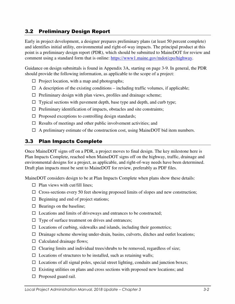
3.2 Preliminary Design Report
Early in project development, a designer prepares preliminary plans (at least 50 percent complete)
and identifies initial utility, environmental and right-of-way impacts. The principal product at this
point is a preliminary design report (PDR), which should be submitted to MaineDOT for review and
comment using a standard form that is online: https://www1.maine.gov/mdot/cpo/highway.
Guidance on design submittals is found in Appendix 3A, starting on page 3-9. In general, the PDR
should provide the following information, as applicable to the scope of a project:
� Project location, with a map and photographs;
� A description of the existing conditions – including traffic volumes, if applicable;
� Preliminary design with plan views, profiles and drainage scheme;
� Typical sections with pavement depth, base type and depth, and curb type;
� Preliminary identification of impacts, obstacles and site constraints;
� Proposed exceptions to controlling design standards;
� Results of meetings and other public involvement activities; and
� A preliminary estimate of the construction cost, using MaineDOT bid item numbers.
3.3 Plan Impacts Complete
Once MaineDOT signs off on a PDR, a project moves to final design. The key milestone here is
Plan Impacts Complete, reached when MaineDOT signs off on the highway, traffic, drainage and
environmental designs for a project, as applicable, and right-of-way needs have been determined.
Draft plan impacts must be sent to MaineDOT for review, preferably as PDF files.
MaineDOT considers design to be at Plan Impacts Complete when plans show these details:
� Plan views with cut/fill lines;
� Cross-sections every 50 feet showing proposed limits of slopes and new construction;
� Beginning and end of project stations;
� Bearings on the baseline;
� Locations and limits of driveways and entrances to be constructed;
� Type of surface treatment on drives and entrances;
� Locations of curbing, sidewalks and islands, including their geometrics;
� Drainage scheme showing under-drain, basins, culverts, ditches and outlet locations;
� Calculated drainage flows;
� Clearing limits and individual trees/shrubs to be removed, regardless of size;
� Locations of structures to be installed, such as retaining walls;
� Locations of all signal poles, special street lighting, conduits and junction boxes;
� Existing utilities on plans and cross sections with proposed new locations; and
� Proposed guard rail.

Local Project Administration Manual, 2018 Update – Chapter 3 3-3
3.4 Scales for Design Plans
If a project is located on a state or state-aid highway, design plans are likely to be shared with
MaineDOT staff for use in the right-of-way process. For this reason, project designers should use
the U.S. customary scales listed below for full-sized plan sheets.
� Plan View: 1 inch = 25 feet
� Profiles: 1 inch = 25 feet
� Geometrics: 1 inch = 25 feet
� Cross Sections: 1 inch = 5 feet
� Typical Sections: 1 inch = 4 feet
Additionally, designers are expected to follow MaineDOT’s Policy on Electronic Exchange of
CADD Data, if electronic files will be shared with MaineDOT for use in the right-of-way process.
The policy is found in Appendix 3B, on page 3-16 of this chapter.
3.5 Americans with Disabilities Act
The Americans with Disabilities Act (ADA) prohibits discrimination against people with disabilities
in all aspects of life. In the context of locally administered projects, the ADA requires that many
highway improvements address deficiencies in ADA compliance to the maximum extent feasible,
regardless of cost or funding source.
� ADA requirements are covered in depth in Chapter 10 of this Manual, “Civil Rights.”
Under the ADA, highway projects that alter the usability of roadways must improve
access to existing pedestrian facilities to the maximum extent feasible. This applies to
new construction, reconstruction, rehabilitation and “pavement alteration” treatments
such as overlay, mill-and-fill, in-place recycling, micro-surfacing and cape seals.
Within the limits of these projects, ADA compliant curb ramps must be built where barriers such as
curbs restrict access to sidewalks and other pedestrian facilities. The law also requires installation of
detectable warnings, where warranted, and upgrades to pedestrian signals.
Many locally administered projects involve construction of sidewalks. Listed below are common
standards for such facilities funded through MaineDOT.
• New Sidewalks: With some exceptions, new sidewalks must be at least 5 feet wide, with
cross-slopes of less than 2 percent.
• Curb ramps: Ramp slope cannot exceed 8.3 percent; cross-slope cannot exceed 2 percent;
new ramps must be 6 feet clear width across; detectable warning fields must extend the full
length of the ramp; flared side should not be more than 10 percent; and ramps must be flush
with the street.
If curb ramps cannot be built to comply fully with the ADA, they should be made compliant to the
maximum extent feasible, with deficiencies explained and documented.

Local Project Administration Manual, 2018 Update – Chapter 3 3-4
3.6 Practical Design
MaineDOT has developed highway corridor priorities to highlight the hierarchy of road needs.
Under this system, designers are encouraged to consider the context of a highway corridor location
and to develop an acceptable range of solutions. This is the backdrop of MaineDOT’s practical
design philosophy. One size, it is clear, does not fit all.
Practical design emphasizes purpose and need – getting the best value for the least cost. This model
encourages designers to consider the surroundings of each project when making decisions. Whether
a project is on the interstate system or a low-volume local road, for example, may lead to different
design decisions. Having sensitivity to context helps to develop design criteria that address the
specific needs along a particular corridor.
The three tenets listed below must be followed for this practical design approach to succeed.
1. Safety: Projects completed using the practical design philosophy must improve safety.
2. Quality: Purpose and need must be achieved without shifting the burden to maintenance.
3. Communication: Frequent and open communication fosters the collaboration that is
necessary to reach the solution.
Practical design emphasizes the flexibility within the design standards and focuses on use of good
engineering judgment. Decisions about lane and shoulder widths, clear zone offsets, horizontal and
vertical alignment and cross-slopes are driven by the context of the roadway or bridge, as well as
the true purpose and need of the project.
Under this approach, MaineDOT’s design guides, Engineering Instructions and other references
should not be viewed as strict standards but rather as tools to help create consistency. MaineDOT
expects and encourages deviation from some standards when considering the context of a project’s
location, as long as designers use good engineering judgment and adhere to the three tenets above.
When a decision is made to deviate from a design standard based on sound engineering judgment,
MaineDOT has a Design Exception process that requires review either by the Engineering Council
or a delegated authority. The Design Exception process is covered in section 3.7 of this chapter,
“Design Exceptions.”
Consider an example. If the bridge over a stream can no longer convey traffic safely, the purpose
and need would be to provide for a safe crossing. In the past, strict adherence to design standards
dictated that the replacement bridge would be wider, higher and longer. There also was a tendency
to upgrade other highway features in the general vicinity.
Practical design points out that, in many cases, the existing bridge had performed well for decades.
Replacing the bridge with a larger and more expensive one would not be prudent when the only
deficiency is the poor structural condition. This philosophy allows for good solutions over a broader
range of the system, rather than ideal solutions for isolated sections of it.

Local Project Administration Manual, 2018 Update – Chapter 3 3-5
3.7 Design Exceptions
Designers and engineers face tradeoffs. A good design balances cost, safety, mobility, social and
environmental impacts, and the needs of a variety of users. When it isn’t practical to meet standard
design criteria, an appropriate solution may be to use a design value outside the standard range – if
the designer has analyzed the potential effects upon safety and operations.
A design exception is a documented decision to design an element of the transportation system
to criteria outside of established guidelines. For projects along state highways, exceptions to the
criteria in the matrix below must be highlighted on the design plans, with a memo describing the
controlling values and the nature of each proposed exception.
A design exception request form is online: https://www1.maine.gov/lpa/lpadocuments/
Requests for design exceptions on locally administered projects must go initially to the manager of
the MaineDOT Multimodal Program. From there, a design exception request may be elevated to the
MaineDOT Engineering Council, as warranted and shown below.
Scope Controlling Criteria Approval Level
Preservation
CS, GR, LW, SE, SW, VC MaineDOT
Program Manager
Rehabilitation BR, BW, CS, CZ, DS, GR, HA, LO, LW,
MG, SC, SE, SSD, SW, VA, VC
MaineDOT
Program Manager
New Construction,
Reconstruction
BR, BW, CS, CZ, DS, GR, HA, LO, LW,
MG, SC, SE, SSD, SW, VA, VC
MaineDOT
Engineering Council
• BR Bridge Rail
• BW Bridge Width
• CS Cross Slopes (Crown)
• CZ Clear Zone
• DS Design Speed
• GR Guardrail
• HA Horizontal Alignment
• LO Lateral Offset (to structures)
• LW Lane Width
• MG Maximum Gradient
• SC Structural Capacity
• SE Superelevation
• SSD Stopping Sight Distance
• SW Shoulder Width
• VA Vertical Alignment
• VC Vertical Clearance

Local Project Administration Manual, 2018 Update – Chapter 3 3-6
3.8 Design Reviews
Quality-control (QC) checks are vital to the design process. Accordingly, MaineDOT requires
consultants and municipal engineers working on locally administered projects to perform and
document QC design checks at the following stages:
• At 50-60 percent design, with the preliminary design report (PDR); and
• At 95-100 percent design – with final plans, specifications & estimate (PS&E).
The QC process will consist of checking all calculations and design assumptions, and reviewing the
PDR, contract provisions, plan set, cost estimates and all other relevant documents. The design
checker shall be a qualified individual other than the originator of the documents.
The established QC design checks should include the following items:
� Summarizing the design-checking process. This will include the checklists used, the
standard checking and back-checking processes, and other QC tools that were utilized.
� Documenting all design checks: initials of the checker, the date on
which checks were performed, comments by the checker, and any
other documentation.
� Checking all documents and calculations developed for each
design element.
� Complying with all legal, regulatory and contractual requirements,
including but not limited to the Americans with Disabilities Act (ADA) and the Manual on
Uniform Traffic Control Devises (MUTCD).
� Assuring both that the design is of high quality and that it conforms to all applicable
MaineDOT standards, policies and practices.
� Reviewing the cost estimate, including quantity and unit price analysis with comparison to
established budget and project scope.
� Analyzing constructability and maintainability if the proposed design.
� Risk assessment (based on public safety, funding, scope, site specific conditions, and/or
other project specific condition that could elevate risk level.)
MaineDOT will verify the design checks through its quality-assurance reviews of project plans at
the milestones PDR and final PS&E. MaineDOT staff will not review plan submittals that lack
evidence of design checks until they receive such documentation.
NOTE: If a community intends to hire an engineering consultant, quality control must be a scope
item in a consultant’s technical proposal and subsequent contract.

Local Project Administration Manual, 2018 Update – Chapter 3 3-7
3.9 Public Involvement
During design, a local agency must give the public an opportunity to learn about potential impacts
and comment on a project. An agency should determine an appropriate level of public involvement
based on a project’s size and its effect on the community and natural environment. A curb-to-curb
paving project, for example, will require a less extensive public process than a highway
reconstruction or shared-use path with multiple impacts.
Public meetings are the primary means of informing people
about proposed projects. An agency overseeing a project
should notify all abutters by registered mail and publicize
meetings using its standard public notification procedures.
Advertisements typically are required. Sample notifications
are found on MaineDOT’s website under Public Participation:
https://www1.maine.gov/lpa/lpadocuments/.
Additional events may be needed for complicated or controversial projects – including outreach to
affected populations with limited ability to read, speak, write or understand English – to be sure that
all customers and stakeholders have opportunities to influence the decision-making process.
After the public process, the agency managing a project must review all comments and include a
summary in the preliminary design report, covered in Section 3.2. Additionally, the agency must
provide MaineDOT with a public process certification (Communication 10) certifying that public
involvement was conducted and noting significant comments or opposition.
Businesses potentially affected by projects must be notified and given opportunity to express
concerns during the preliminary phases of project design.
3.10 Environmental Review
During design, all locally administered projects with federal money must be reviewed for possible
impacts to natural and cultural resources such as wetlands, wildlife habitats, historic properties, and
public parks and recreation areas. Federal laws – notably the landmark National Environmental
Policy Act (NEPA) – mandate such reviews.
Survey and other field work should identify environmentally sensitive areas along the proposed
route of a project, along with public parks or recreation areas. Further research will determine if a
project may affect historic properties or habitat for endangered species, such as the Atlantic salmon
and the northern long-eared bat, as covered in Chapter 4 of this Manual, “Environmental Review.”
MaineDOT’s Environmental Office handles NEPA review on locally administered projects.
Municipalities and other local agencies must provide MaineDOT with Communication 11 and the
NEPA Documentation Checklist, answering a series of questions necessary to complete the NEPA
process. A project cannot proceed to right-of-way negotiations or to final plans, specifications &
estimate (PS&E) – the last stage before advertise – until NEPA is completed.

Updated July 2018
Local Project Administration Manual, 2018 Update – Chapter 3 3-8
3.11 Utility Coordination
Early and continuing coordination with utilities is critical to keeping things on schedule. Utility
facilities consist of public or private lines or equipment, such as utility poles, power lines, telephone
lines, cable television lines, underground water, sewer and gas lines, and railroad tracks. Utility
companies often will need extensive lead time to schedule their work and obtain the materials
needed to move lines and other equipment.
As design work begins, a project engineer or designer should consider the following questions:
• What utility facilities exist in the right of way?
• How much room is there for clearing?
• Is the project abutting another project? What was done there?
• Can relocations be reduced and still meet the project need?
• What are the concerns of the utilities?
The designer or utility coordinator should take the preliminary alignment to an initial meeting with
the utilities. If utilities cannot be accommodated without severely affecting the scope of a project,
this needs to be explained early. (Utility coordination is covered in Chapter 6 of this Manual.)
3.12 Traffic Analysis and Management Evaluation (TAME)
MaineDOT uses a system of Traffic Analysis Management and Evaluation (TAME) to address
traffic delays from construction projects. During the TAME review process, traffic engineers
analyze traffic counts and other data to establish appropriate lane closures in work zones.
Upon completing the preliminary design report for a project, a local agency or its design consultant
must submit to MaineDOT’s project manager a completed TAME Request Form, which can be
downloaded using the link below. The form provides basic information such as average daily traffic
volumes and known traffic generators that MaineDOT will use in determining whether to restrict
lane closures during construction.
TAME guidance is found on MaineDOT’s engineering and design website: https://www1.maine.gov/mdot/edi/docs/GuidelinesTAMEINGforPDprojects.pdf
MaineDOT traffic engineering staff will consider potential traffic impacts and develop draft TAME
criteria. At the end of the TAME review, MaineDOT may issue a special provision for the contract
book for a project stipulating restrictions on lane closures. MaineDOT will not approve the final
plans, specifications and estimate package (PS&E) for a project without a signed certification from
the State Traffic Engineer that the TAME process was completed.
Most projects on roads with average daily traffic volumes of less than 10,000 are unlikely to cause
traffic issues. However, municipalities with projects on roads with average daily traffic volumes of
greater than 10,000 or with heavy seasonal traffic should expect some restrictions on lane closures.
Local Project Administration Manual, 2018 Update – Section 3 3-9
Appendix 3A: Design Submittal Guidance
� Electronic versions of the forms in this section are available online:
https://www1.maine.gov/mdot/cpo/highway/

Local Project Administration Manual, 2018 Update – Chapter 3 3-10
DESIGN SUBMITTAL FORM
Project Name: WIN:
PRELIMINARY DESIGN REPORT (PDR)
� SUBMITTALS
� Completed draft PDR, including Highway Design Report Form, if this is a highway project
� PDR Estimate, including calculations and MaineDOT item numbers
� Approved Pavement Design
� Design Exceptions approved by MaineDOT
� 1 Half Size set of plans including:
o Preliminary Typical Sections
o Plans
o Profiles
o Cross-sections (include critical drive sections)
o Preliminary Drainage Scheme
� Under-drain, Basins, Culverts, Ditches, Outlet locations
o Guardrail and Retaining Wall locations
� TYPICAL SECTION
HMA Depth
Base Type
Base Depth
Sub-base Type
Sub-base Depth
Curb Type
Loam Depth
COMMENTS:
� TRAFFIC
Turning Movements
Location Signal
(Y/N)
Design Vehicle Encroachment
(Y/N)
COMMENTS:

PDR SUBMITTAL
Local Project Administration Manual, 2018 Update – Chapter 3 3-11
Turning Lanes
Location Design
Speed
Lane Width Taper
Length
Storage
Length
COMMENTS:
Other Auxiliary Lanes
Location Design
Speed
Shift
Width
Taper
Length
Out
Shift
Length
Taper
Length
In
COMMENTS:
� ADA
Indicate existing or new pedestrian facilities. The ADA section in the PDR should be completed.
Sidewalks
(Y/N)
Ramps
(Y/N)
Crosswalks
(Y/N)
Pedestrian
Signals
(Y/N)
Existing Facility
Proposed Facility
COMMENTS:
� CLEAR ZONE
The required clear zone should be listed in the HDR form.
COMMENTS:

PDR SUBMITTAL
Local Project Administration Manual, 2018 Update – Chapter 3 3-12
� GUARDRAIL
Location Obstacle within Clear
Zone (Y/N)
Embankment steeper
than 3H:1V (Y/N)
COMMENTS:
� DRAINAGE
Provide drainage scheme as indicated in Submittals section.
COMMENTS:
� DRIVES AND ENTRANCES
List critical drive locations and whether Design Exceptions will be needed.
Location Existing Grade Proposed Grade Design
Exception (Y/N)
COMMENTS:
� RETAINING WALLS
Provide locations as indicated in Submittals section.
COMMENTS:

PLAN IMPACTS SUBMITTAL
Local Project Administration Manual, 2018 Update – Chapter 3 3-13
PLAN IMPACTS COMPLETE (PIC)
� SUBMITTALS
� Design Submittal Form Checklist, with supporting documentation
� Approved Pavement Design (if not submitted at PDR)
� Approved Design Exceptions (if not submitted at PDR)
� Retaining Wall Design approved by Geotechnical Engineer
� Guardrail Length of Need Worksheets (if applicable)
� Half-size set of plans (.pdf format) including:
o Typical Sections
o Plans
o Profiles
o Cross-sections
o Final Drainage Design
� TYPICAL SECTION
COMMENTS:
� GUARDRAIL
Identify areas where guardrail is warranted and what hazard is. Provide guardrail length of need
worksheets as indicated in Submittals section.
Location Obstacle within Clear
Zone (Y/N)
Embankment steeper
than 3H:1V (Y/N)
COMMENTS:
� DRAINAGE
Provide Final Drainage Design as indicated in Submittals section.
COMMENTS:

PLAN IMPACTS SUBMITTAL
Local Project Administration Manual, 2018 Update – Chapter 3 3-14
� DRIVES AND ENTRANCES
List critical drive locations and Design Exception Approval date if applicable.
Location Existing Grade Proposed Grade Design
Exception Date
COMMENTS – provide additional discussion to help the review/check team.
� RETAINING WALLS
Provide design as indicated in Submittals section.
COMMENTS – provide additional discussion to help the review/check team.

FINAL PS&E SUBMITTAL
Local Project Administration Manual, 2018 Update – Chapter 3 3-15
PLANS, SPECIFICATIONS, & ESTIMATE (PS&E)
SUBMITTALS
� Half-size set of plans (.pdf format) including:
o Title Sheet
o Typical Sections
o Earthworks Summary, if applicable to the project
o General Notes
o Plans
o Profiles
o Cross-sections
o All supplemental sheets (Drainage, Geometric, Grading, Striping, etc.)
� Engineer’s Estimate (including calculations)
� Special provisions

Local Project Administration Manual, 2018 Update – Chapter 3 3-16
Appendix 3B: Electronic Exchange of CADD Data
Local Project Administration Manual, 2018 Update – Chapter 3 3-17
Electronic Exchange of CADD Data
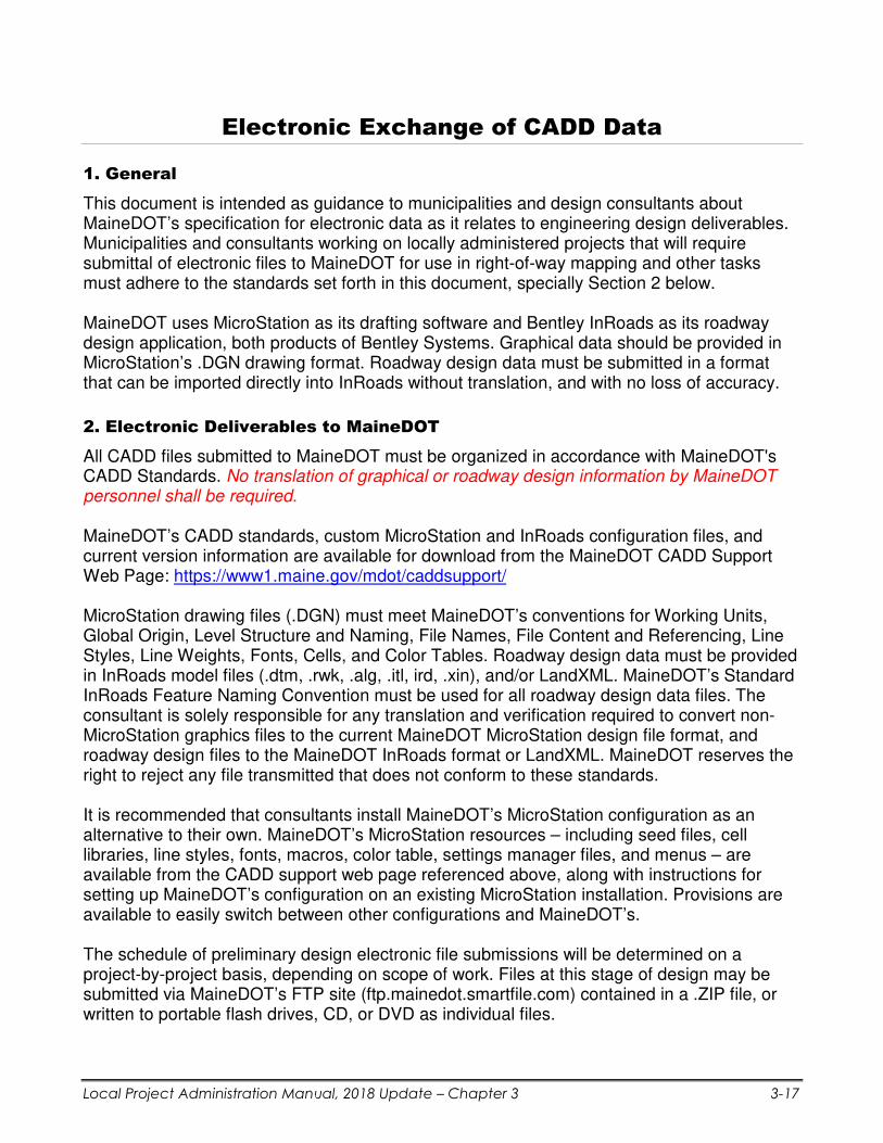
1. General
This document is intended as guidance to municipalities and design consultants about MaineDOT’s specification for electronic data as it relates to engineering design deliverables. Municipalities and consultants working on locally administered projects that will require submittal of electronic files to MaineDOT for use in right-of-way mapping and other tasks must adhere to the standards set forth in this document, specially Section 2 below.
MaineDOT uses MicroStation as its drafting software and Bentley InRoads as its roadway design application, both products of Bentley Systems. Graphical data should be provided in MicroStation’s .DGN drawing format. Roadway design data must be submitted in a format that can be imported directly into InRoads without translation, and with no loss of accuracy.
2. Electronic Deliverables to MaineDOT
All CADD files submitted to MaineDOT must be organized in accordance with MaineDOT's CADD Standards. No translation of graphical or roadway design information by MaineDOT personnel shall be required. MaineDOT’s CADD standards, custom MicroStation and InRoads configuration files, and current version information are available for download from the MaineDOT CADD Support Web Page: https://www1.maine.gov/mdot/caddsupport/ MicroStation drawing files (.DGN) must meet MaineDOT’s conventions for Working Units, Global Origin, Level Structure and Naming, File Names, File Content and Referencing, Line Styles, Line Weights, Fonts, Cells, and Color Tables. Roadway design data must be provided in InRoads model files (.dtm, .rwk, .alg, .itl, ird, .xin), and/or LandXML. MaineDOT’s Standard InRoads Feature Naming Convention must be used for all roadway design data files. The consultant is solely responsible for any translation and verification required to convert non-MicroStation graphics files to the current MaineDOT MicroStation design file format, and roadway design files to the MaineDOT InRoads format or LandXML. MaineDOT reserves the right to reject any file transmitted that does not conform to these standards. It is recommended that consultants install MaineDOT’s MicroStation configuration as an alternative to their own. MaineDOT’s MicroStation resources – including seed files, cell libraries, line styles, fonts, macros, color table, settings manager files, and menus – are available from the CADD support web page referenced above, along with instructions for setting up MaineDOT’s configuration on an existing MicroStation installation. Provisions are available to easily switch between other configurations and MaineDOT’s. The schedule of preliminary design electronic file submissions will be determined on a project-by-project basis, depending on scope of work. Files at this stage of design may be submitted via MaineDOT’s FTP site (ftp.mainedot.smartfile.com) contained in a .ZIP file, or written to portable flash drives, CD, or DVD as individual files.

Local Project Administration Manual, 2018 Update – Chapter 3 3-18
Upon MaineDOT’s approval and acceptance of the final signed and stamped plans, consultants must provide to MaineDOT the final electronic versions of all MicroStation files, roadway design files, and associated resource files on portable data storage device. Consultants must provide copies of final plan sheets in Adobe Portable Document Format (PDF) at MaineDOT’s discretion. The PDF files will serve as the electronic, read-only record plans for the project, and must match all aspects of the final hardcopy signed and stamped plans. These electronic delivery items DO NOT replace any hardcopy delivery items. A Project Journal File must accompany all electronic files submitted to MaineDOT, both those written to a portable data storage device, and those transmitted via MaineDOT’s FTP site. This document must contain the Town Name, State Work Identification Number (WIN), date, and a list of the files being transmitted with a brief description of each file. Portable flash drives, CD’s or DVD’s used to transmit electronic files to MaineDOT must, at a minimum, be labeled with the Town Name, State Work Identification Number (WIN), and date. If more than one data storage device is required to transmit the files, the disc label must also include the device number and total devices of the set transmitted, (ex: Disk 1 of 5).
3. MaineDOT Furnished Services and Information
MaineDOT will provide copies of the latest files used to configure, customize, and utilize MicroStation and InRoads in its own project development process to the consultant through the MaineDOT CADD Support page on the Internet. MaineDOT will provide access to Engineering Applications Group personnel for information and answers to questions on MaineDOT CADD standards, MicroStation and InRoads setup, configuration, customization, and documentation. Contact information is available on the web site. MaineDOT’s Survey Section will determine the horizontal and vertical datum to be used for each project. Files exchanged between MaineDOT and the consultant will reflect these datums. MaineDOT will provide separate drawings for existing topographic information, text, contours, and a Digital Terrain Model (DTM) of existing surfaces in MicroStation DGN format. Consultants using InRoads software can request the original MaineDOT InRoads Survey model. A variety of standard reports created during the processing of survey data for input into InRoads are also available to the consultant from MaineDOT. Examples of these reports can be found on the InRoads portion of the MaineDOT CADD Support web site. It is the responsibility of consultants to translate this data into other formats required for use in their design software.

- END OF CHAPTER 3 -
INTENTIONAL BLANK PAGE

INTENTIONAL BLANK PAGE

INTENTIONAL BLANK PAGE