local plan 2031 part 1 - welcome to vale of white horse ... a...the february 2014 local plan 2031...
TRANSCRIPT

Consultation Draft February 2014
Housing Delivery Update
Local Plan 2031Part 1
Strategic Sitesand Policies
Appendix ADevelopment Site
Templates

1
2
1. INTRODUCTION................................................4
2. ABINGDON-ON-THAMES AND OXFORD FRINGE SUB AREA...............................................6
North Abingdon-on-Thames .........................................................................6 North West Abingdon-on-Thames ..............................................................10 South Cumnor ............................................................................................14 South Drayton ............................................................................................18 South Kennington.......................................................................................22 South Marcham..........................................................................................26 North West Radley .....................................................................................30 North Radley ..............................................................................................34 East Wootton..............................................................................................38 East Sutton Courtenay ...............................................................................42
3. SOUTH EAST VALE SUB AREA....................45
Harwell and Milton Parishes east of the A34 adjoining Didcot Town, Valley Park............................................................................................................45 East Harwell Oxford Campus (Harwell and Chilton Parishes) ....................50 Land North West of East Challow...............................................................54 Milton Parish west of the A34, Milton Heights ............................................58 Land East of East Hanney..........................................................................62 West of Harwell ..........................................................................................66
4. WESTERN VALE SUB AREA .........................70
Great Coxwell Parish, South Faringdon .....................................................70 South West of Faringdon............................................................................74 South Shrivenham......................................................................................78 North Shrivenham ......................................................................................81 West Stanford-in-the-Vale ..........................................................................85
5. ANNEX 1: PROPOSED CORE POLICIES 18 AND 21 ............................................................88
Core Policy 18: Affordable Housing............................................................88 Core Policy 21: Housing Mix ......................................................................89

3
This page is intentionally blank.
4
1. INTRODUCTION The February 2014 Local Plan 2031 Part 1 (LPP1) consultation document (Housing Delivery Update) provides an update to our housing target and proposes new development sites. This appendix sets out development site templates for each of the 21 sites identified in the February 2014 consultation document. The development site templates identify key objectives for each site and set out requirements relating to issues such as infrastructure provision, urban design, landscaping, ecology, and flood risk and drainage. The proposed core policies 6 (Spatial Strategy for Abingdon-on-Thames and Oxford Fringe Sub-Area), 12 (Spatial Strategy for South East Vale Sub-Area) and 17 (Spatial Strategy for Western Vale Sub-Area) explain that the proposed strategic site allocations will be brought forward through a master planning process involving the community, local planning authority and the developer. The proposed core policies go on to state that the sites should meet any requirements set out in the development site templates. In bringing forward the proposed sites the Council will expect to see high quality developments which are sustainable in the long term, and which connect with and contribute to the adjacent towns and villages. In order to achieve this we will expect every application to be accompanied by:
A detailed Design and Access Statement that sets out the vision for the site and demonstrates a commitment to creating a great place, with well-designed new homes and supporting infrastructure.
An Infrastructure Schedule that sets out the planned infrastructure for the scheme and how it will be delivered through either a section 106 agreement or another method.
A Development Delivery Agreement which shows the proposed programme of house building, and demonstrates the number of homes the development will contribute to the district’s five year housing land supply.
A Statement of Involvement that sets out how the Parish Council and other local organisations have been involved in the master planning process.
The development site templates highlight some of the key requirements for development at each site at the time of writing and do not preclude other requirements coming forward at a later date. The Infrastructure Delivery Plan (IDP) is a live document that will capture this detail and should be read in conjunction with the site templates. Where there is conflict, the IDP will be taken to provide the most up to date evidence. Development must comply with all relevant policies in the Development Plan.

5
Oxfordshire County Council has responsibility for some of the infrastructure or services identified, such as schools and transport. Detailed requirements for these elements will need to be developed and agreed with the county council. The development site templates refer to the proposed core policies 18 (affordable housing) and 21 (housing mix). These proposed core policies were set out in the February 2013 Local Plan Part 1 consultation document1, and are copied in Annex 1 for ease of reference.
1 The February 2013 Local Plan Part 1 consultation document can be accessed online at: http://www.whitehorsedc.gov.uk/services-and-advice/planning-and-building/planning-policy/new-local-plan-2029
6
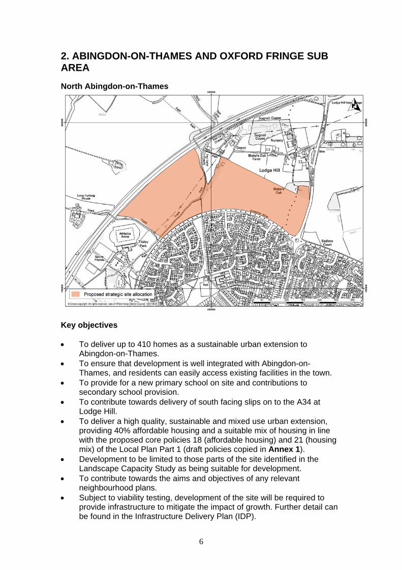
2. ABINGDON-ON-THAMES AND OXFORD FRINGE SUB AREA
North Abingdon-on-Thames
Key objectives To deliver up to 410 homes as a sustainable urban extension to
Abingdon-on-Thames. To ensure that development is well integrated with Abingdon-on-
Thames, and residents can easily access existing facilities in the town. To provide for a new primary school on site and contributions to
secondary school provision. To contribute towards delivery of south facing slips on to the A34 at
Lodge Hill. To deliver a high quality, sustainable and mixed use urban extension,
providing 40% affordable housing and a suitable mix of housing in line with the proposed core policies 18 (affordable housing) and 21 (housing mix) of the Local Plan Part 1 (draft policies copied in Annex 1).
Development to be limited to those parts of the site identified in the Landscape Capacity Study as being suitable for development.
To contribute towards the aims and objectives of any relevant neighbourhood plans.
Subject to viability testing, development of the site will be required to provide infrastructure to mitigate the impact of growth. Further detail can be found in the Infrastructure Delivery Plan (IDP).
7
Physical requirements Liaise with the gas provider to ensure that off-site works to facilitate a
new gas supply are carried out if needed. Liaise with the electricity provider to ensure that any necessary upstream
reinforcement work is carried out. Retain overhead power lines traversing the western portion of the site. Upgrade the sewer network. A Drainage Strategy will be required. Liaise with Thames Water to ensure adequate water resources are
available. Access and highways Provide contributions towards an upgrade to the A34 junction at Lodge
Hill to provide full south access. Provide access off Dunmore Road and not Oxford Road. Retain the existing bridleway and footpath through the site or divert as
appropriate. Provide a network of footpaths and cycle ways to the town centre, the
countryside and the existing network. This should include appropriate provision for pedestrians to cross Dunmore Road.
Contributions will be required towards bus services. To make appropriate contributions towards any necessary mitigation
measures identified through the ongoing Local Plan transport modelling work.
Social and community Provide public open space and recreational facilities in accordance with
the requirements of the Infrastructure Delivery Plan. Provide a new primary school on site. Contributions will be required towards expansion of secondary education
provision. A police presence to be provided on site either through a neighbourhood
office or as part of a community hub. Appropriate contributions to be provided towards health care and leisure
provision.
Urban Design Principles Development will be expected to be of high quality design, in line with the
proposed core policies 37 (design and local distinctiveness) and 37a (design briefs for strategic and major sites).
The Design and Access Statement should demonstrate how the landscape and visual impact assessment and landscape mitigation measures have informed the design and layout of the development.
Create links from the east to the west of the site, from the site to the ring road and beyond into the development to the south of the ring road. A
8
pedestrian crossing will need to be provided along this route to connect development sites to the north and south of the ring road. This will need to be undertaken in consultation with Oxfordshire County Council.
Create links from the site to the sports centre. Create a permeable, perimeter block layout within the site which will
optimise connectivity within and beyond the site. A Green Infrastructure strategy will need to be prepared for the entirety
of the site which will set the framework for development. Create a sense of place around the River Stert within the site, for
example by providing a linear walkway whilst taking advantage of any existing paths and public rights of way.
Houses will need to front onto the ring road but the treatment of the area between the ring road and the housing line will need to be carefully considered. An attractive area will need to be created at this location along the ring road with particular consideration being given to soft and hard landscaping for the benefit of both pedestrians and cyclists.
Environmental health Undertake a Noise Assessment to assess noise from the A34. Mitigation
measures will need to be used where appropriate. Potential impact on Abingdon-on-Thames Air Quality Management Area
(AQMA) will need to be considered and mitigated if necessary. Landscape considerations A detailed landscape and visual impact assessment will be required. Retain existing trees and hedgerows where possible. Plant trees along the A34 and the ring road. Contribute to Green Infrastructure provision around the northern edge of
Abingdon-on-Thames linking to Radley Park and the Sports Centre. Limit development to the lower slopes. Further woodland planting to take place south of Lodge Hill. Create a substantive Green Infrastructure corridor linking the green way
via Northcourt to Lodge Hill along the line of the stream. Enhance the Green Infrastructure between the site and Lodge Hill. Ecology The site will be subject to habitat and species surveys carried out in
accordance with the Guidelines for Ecological Impact Assessment produced by the Chartered Institute of Ecology and Environmental Management and relevant best practice guidance.
Important ecological assets will be retained where possible. If loss is unavoidable then appropriate mitigation or compensation measures will be provided.
A net gain in biodiversity as a result of the development will be provided, for example, by incorporating new natural habitats into development and

9
designing buildings with integral bat boxes and bird nesting opportunities, in appropriate circumstances.
An appropriate buffer along either side of the River Stert will be incorporated into the overall development.
Flood risk and drainage Sustainable Urban Drainage (SUDs) methods will be used to drain the
surface water from the development. A detailed Flood Risk Assessment for the site will be required, based on
information available in the council’s Strategic Flood Risk Assessment. Mitigation measures may be required to prevent any detrimental impact
on groundwater quality. Archaeological interest An archaeological evaluation of the site will be undertaken and its
recommendations implemented.
10
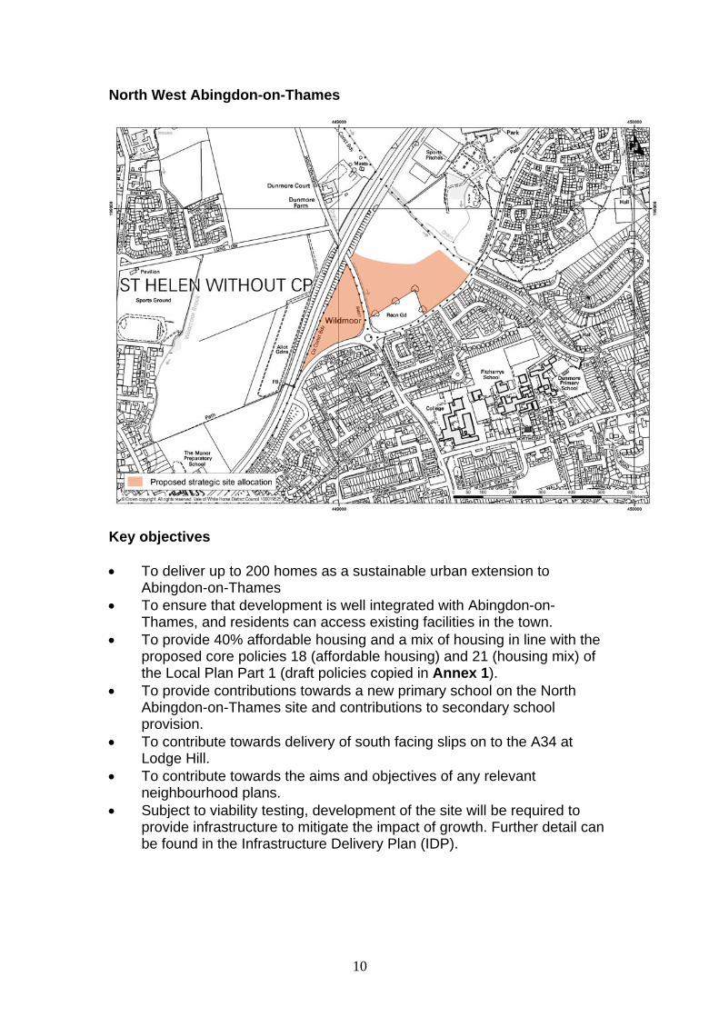
North West Abingdon-on-Thames
Key objectives To deliver up to 200 homes as a sustainable urban extension to
Abingdon-on-Thames To ensure that development is well integrated with Abingdon-on-
Thames, and residents can access existing facilities in the town. To provide 40% affordable housing and a mix of housing in line with the
proposed core policies 18 (affordable housing) and 21 (housing mix) of the Local Plan Part 1 (draft policies copied in Annex 1).
To provide contributions towards a new primary school on the North Abingdon-on-Thames site and contributions to secondary school provision.
To contribute towards delivery of south facing slips on to the A34 at Lodge Hill.
To contribute towards the aims and objectives of any relevant neighbourhood plans.
Subject to viability testing, development of the site will be required to provide infrastructure to mitigate the impact of growth. Further detail can be found in the Infrastructure Delivery Plan (IDP).
11
Physical requirements Developer to liaise with gas provider to ensure that off-site works to
facilitate a new gas supply are carried out if needed. Developer to liaise with electricity provider to ensure any necessary
upstream reinforcement work is carried out if needed. A Drainage Strategy will be required. Developer to liaise with Thames
Water to ensure that adequate waste water facilities are available. Developer to coordinate with Thames Water to ensure that adequate
water resources are available. Access and highways Provide contributions towards an upgrade to the A34 junction at Lodge
Hill to provide full south access. Access to be provided from Copenhagen Drive and Dunmore Road. A network of footpaths and cycle ways will be provided giving access to
the town centre, the countryside and the adjoining external network. This should include appropriate provision for pedestrians to cross Dunmore Road.
Contributions will be required towards bus services. To make appropriate contributions towards any necessary mitigation
measures identified through the ongoing Local Plan transport modelling work.
Social and community Contributions will be required towards increasing the capacity of primary
school education. This will be provided through a new primary school on the North Abingdon-on-Thames site.
Contributions will be required towards expansion of secondary education provision.
Provision of public open space and recreational facilities on site in accordance with the requirements of the IDP.
Appropriate contributions to be provided towards health care and leisure provision.
Urban Design Principles Development will be expected to be of high quality design, in line with the
proposed core policies 37 (design and local distinctiveness) and 37a (design briefs for strategic and major sites).
The Design and Access Statement should demonstrate how the landscape and visual impact assessment and landscape mitigation measures have informed the design and layout of the development.
Ensure development is well integrated with the existing built environment.
Include appropriate landscape mitigation measures to minimise the visual impact of the development on the Green Belt.

12
Provide appropriate setbacks from all physical barriers along the boundaries of this site.
Provide access to the adjacent recreational ground. Environmental Health Mitigation measures will be required to minimise the impact of noise from
the A34, Copenhagen Drive, Dunmore Road, and the B4017. Potential impact on Abingdon-on-Thames Air Quality Management Area
(AQMA) will need to be considered and mitigated if necessary. Ecology The site will be subject to habitat and species surveys carried out in
accordance with the Guidelines for Ecological Impact Assessment produced by the Chartered Institute of Ecology and Environmental Management and relevant best practice guidance.
Important ecological assets will be retained where possible. If loss is unavoidable then appropriate mitigation or compensation measures should be provided.
A net gain in biodiversity will be provided as a result of the development, for example, by incorporating new natural habitats into development and designing buildings with integral bat boxes and bird nesting opportunities, in appropriate circumstances.
Landscape considerations A detailed landscape and visual impact assessment will be required. Provide a recreational landscape corridor along the southern boundary to
Dunmore Road to link the playing fields with the Sports Centre. Reinforce stream side vegetation along the eastern boundary. Plant a woodland belt and copse along Wootton Road. Improve tree cover along the A34 boundary to screen the road and
mitigate noise. Protect and enhance the existing boundary features. Flood risk and drainage A detailed Flood Risk Assessment (FRA) for the site will be submitted,
based on information available in the council’s Strategic Flood Risk Assessment (SFRA). As part of the FRA a surface water drainage strategy will be required.
Any development will be located outside of Flood Zones 2 & 3. The south west corner is susceptible to surface water flooding. This will
need to be investigated and mitigated (if necessary). The site is considered a high risk to groundwater. As such, mitigation
measures may be required to prevent any detrimental impact on groundwater quality.

13
Archaeological interest Predetermination investigation will be required on potential
archaeological features present on site.
14
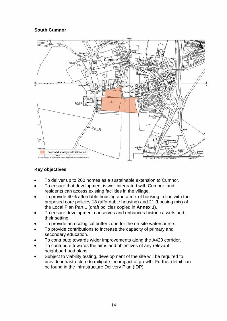
South Cumnor
Key objectives To deliver up to 200 homes as a sustainable extension to Cumnor. To ensure that development is well integrated with Cumnor, and
residents can access existing facilities in the village. To provide 40% affordable housing and a mix of housing in line with the
proposed core policies 18 (affordable housing) and 21 (housing mix) of the Local Plan Part 1 (draft policies copied in Annex 1).
To ensure development conserves and enhances historic assets and their setting.
To provide an ecological buffer zone for the on-site watercourse. To provide contributions to increase the capacity of primary and
secondary education. To contribute towards wider improvements along the A420 corridor. To contribute towards the aims and objectives of any relevant
neighbourhood plans. Subject to viability testing, development of the site will be required to
provide infrastructure to mitigate the impact of growth. Further detail can be found in the Infrastructure Delivery Plan (IDP).
15
Physical requirements Developer to liaise with gas provider to ensure that off-site works to
facilitate a new gas supply are carried out if needed. Developer to liaise with electricity provider to ensure any necessary
upstream reinforcement work is carried out if needed. Developer to coordinate with Thames Water to ensure adequate water
resources are available. A drainage strategy will be required. Access and highways Access to be provided from Appleton Road. Retain the existing footpath through the site or divert as appropriate. Provide a network of footpaths and cycle ways giving access to the
village centre, the countryside and the existing network. A contribution will be required for the enhancement of a premium bus
service to Oxford. Contributions will be required towards wider improvements along the
A420 corridor. To make appropriate contributions towards any necessary mitigation
measures identified through the ongoing Local Plan transport modelling work.
Social and community Contributions will be required towards increasing the capacity of
secondary and primary schools. Public open space and recreational facilities will be provided on site in
accordance with the requirements of the Infrastructure Delivery Plan. Appropriate contributions to be provided towards health care and leisure
provision. Urban Design Principles Development will be expected to be of high quality design, in line with the
proposed core policies 37 (design and local distinctiveness) and 37a (design briefs for strategic and major sites).
The Design and Access Statement should demonstrate how the landscape and visual impact assessment and landscape mitigation measures have informed the design and layout of the development.
Create links to the adjacent developments where possible. Provide linkages through to the village via Robsart Place.
Development must respect and reflect the gradient of the land at this location.
Ensure development is sensitively designed to conserve and enhance the setting and character of the conservation area and listed buildings.
Ensure the density of the scheme respects the loose grain character of the existing village.

16
Landscape considerations A detailed landscape and visual impact assessment will be required, and
a Landscape Strategy for the site should be submitted as part of the planning application.
Ensure that development does not result in harm to the open character and openness of the Greenbelt.
Retain the landscape pasture setting of Cumnor Conservation Area and listed building (The Farmhouse).
Ensure that the new access and junction with Appleton Road is sensitively designed to avoid harm to the Conservation Area and existing mature trees.
Retain the historic field pattern, tree belts and hedgerows within the site as a framework for the subdivision of the site into development land parcels.
New native woodland belt to be provided across the gap to the southern boundary to link existing woodland belts.
The Landscape Strategy shall provide a landscaped corridor along the line of the footpath leading to the south.
The mass and scale of the built form shall be designed to avoid being visually intrusive in the open land to the south.
Ecology An adequate ecological buffer zone will be required for the on-site
watercourse, to ensure there is no detrimental impact on water quality and biodiversity.
A tree survey will be required. The site will be subject to habitat and species surveys carried out in
accordance with the Guidelines for Ecological Impact Assessment produced by the Chartered Institute of Ecology and Environmental Management and relevant best practice guidance.
Important ecological assets will be retained where possible. If loss is unavoidable then appropriate mitigation or compensation measures will be provided.
A net gain in biodiversity as a result of the development will be provided, for example, by incorporating new natural habitats into development and designing buildings with integral bat boxes and bird nesting opportunities, in appropriate circumstances.
Provide contributions towards redressing the identified Green Infrastructure deficit in the area surrounding Cumnor.
Flood risk and drainage A detailed Flood Risk Assessment for the site will be submitted, based
on information available in the council’s Strategic Flood Risk Assessment.
Sustainable Urban Drainage Systems (SUDs) methods will be used to drain the surface water from the development.
17
Mitigation measures may be required to prevent any detrimental impact on groundwater quality (centre of the site).
Archaeological interest An archaeological evaluation of the site will need to be undertaken and
its recommendations implemented.
18
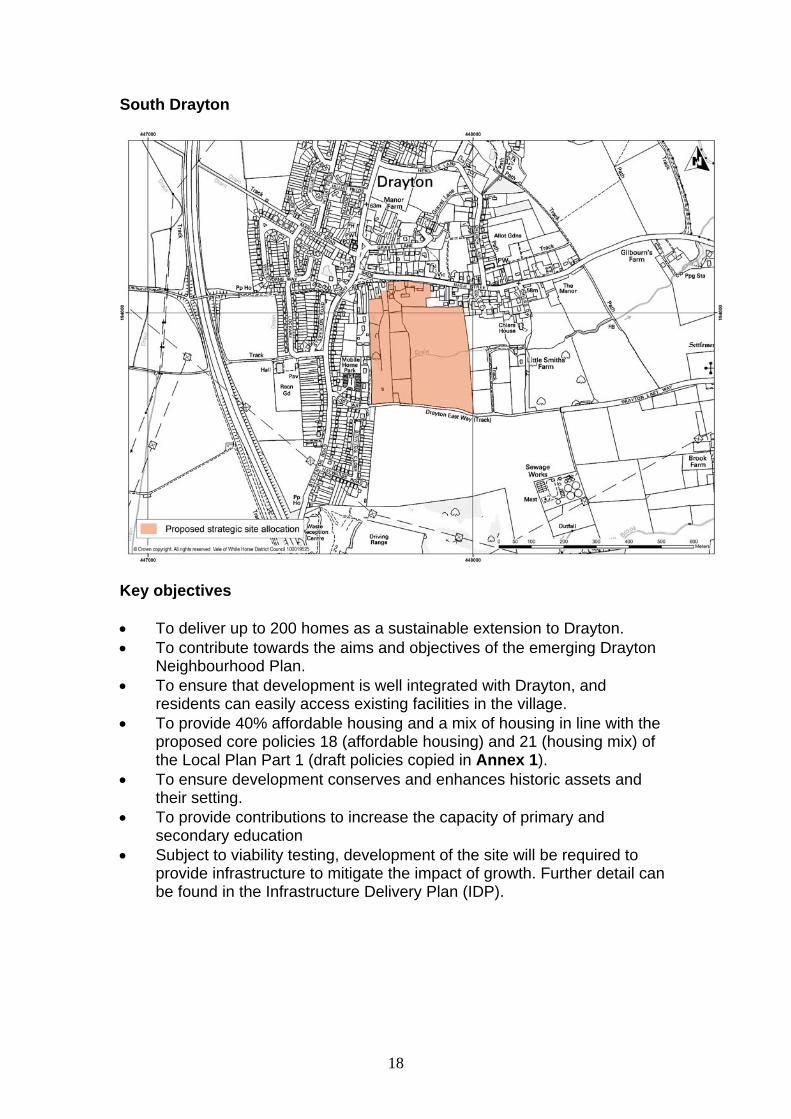
South Drayton
Key objectives To deliver up to 200 homes as a sustainable extension to Drayton. To contribute towards the aims and objectives of the emerging Drayton
Neighbourhood Plan. To ensure that development is well integrated with Drayton, and
residents can easily access existing facilities in the village. To provide 40% affordable housing and a mix of housing in line with the
proposed core policies 18 (affordable housing) and 21 (housing mix) of the Local Plan Part 1 (draft policies copied in Annex 1).
To ensure development conserves and enhances historic assets and their setting.
To provide contributions to increase the capacity of primary and secondary education
Subject to viability testing, development of the site will be required to provide infrastructure to mitigate the impact of growth. Further detail can be found in the Infrastructure Delivery Plan (IDP).
19
Physical requirements Developer to liaise with gas provider to ensure that off-site works to
facilitate a new gas supply are carried out if needed. Developer to liaise with electricity provider to ensure any necessary
upstream reinforcement work is carried out if needed. A Drainage Strategy is required. Developers to liaise with Thames Water
to ensure that adequate waste water facilities are available. Developer to liaise with Thames Water to ensure that adequate water
resources are available. Access and highways Access to be provided from B4016 High Street/Drayton Road. A network of footpaths and cycle ways will be provided to the village
centre, the countryside and to the adjoining external network, and to access bus stops on the Drayton to Abingdon-on-Thames route.
Contributions for the enhancement of a premium bus service (Didcot-Abingdon-on-Thames) will be required.
To make appropriate contributions towards any necessary mitigation measures identified through the ongoing Local Plan transport modelling work.
Social and community To provide contributions towards an increase in the capacity of both
primary and secondary school education. Public open space and recreational facilities to be provided on site in
accordance with the requirements of the IDP. Appropriate contributions to be provided towards health care and leisure
provision. Urban Design Principles Development will be expected to be of high quality design, in line with the
proposed core policies 37 (design and local distinctiveness) and 37a (design briefs for strategic and major sites).
The Design and Access Statement should demonstrate how the landscape and visual impact assessment and landscape mitigation measures have informed the design and layout of the development.
Ensure the footpath that runs alongside the site (in an east/west direction to the south) is retained and enhanced, or replaced (if it is upgraded for vehicular access).
The northern part of the site falls within the conservation area. There are also listed buildings on and adjacent to this part of the site. Any development of the site will need to ensure that it conserves and enhances the setting and character of heritage assets including listed buildings and the conservation area.

20
Sensitive design/engineering measures will have to be undertaken to ensure that access from the north of the site will not harm the significance of the heritage assets.
Environmental health The potential impact of development on the air quality of Abingdon-on-
Thames will need to be considered and mitigated against (if necessary) The Drayton Golf Course landfill lies to the south and outside of the site.
The developer may have to undertake adequate contaminated land investigations to ensure that the land is safe and suitable for the intended use.
Landscape considerations Have regard to the views of the listed buildings, including the church, via
the gap in vegetation from the bridleway at the east end of the site. Maintain the landscape pattern and rural character to the south and east
of Drayton. This should include building on existing landscape features to meet the Oxfordshire Wildlife and Landscape Study (OWLS) landscape strategy and the objectives of policy NE11 of the Local Plan 2011, and any updates to this policy set out in the Local Plan 2031 Part 2.
Create a new landscape structure building on existing features. A detailed landscape and visual impact assessment will be required. Ecology The site includes a number of potential ecological constraints and phase
1 surveys will need to be completed to fully identify these constraints. A detailed tree survey will be required to assess how the existing trees
and hedges can be successfully incorporated into the design of the scheme.
The site will be subject to habitat and species surveys carried out in accordance with the Guidelines for Ecological Impact Assessment produced by the Chartered Institute of Ecology and Environmental Management and relevant best practice guidance.
Important ecological assets will be retained where possible. If loss is unavoidable then appropriate mitigation or compensation measures should be provided.
A net gain in biodiversity will be provided as a result of the development, for example, by incorporating new natural habitats into development and designing buildings with integral bat boxes and bird nesting opportunities, in appropriate circumstances.
Provide contributions towards redressing the identified Green Infrastructure deficit in the area surrounding Drayton.
21
Flood risk and drainage A detailed Flood Risk Assessment (FRA) for the site will need to be
submitted, based on information available in the council’s Strategic Flood Risk Assessment. Any areas of the site which are susceptible to surface water flooding will need to be investigated as part of the FRA, and mitigation measures implemented (if appropriate).
Sustainable Urban Drainage (SUDs) methods will need to be used to drain the surface water from the development.
The southern part of the site is susceptible to surface water flooding, which needs to be investigated and mitigation measures will need to be implemented (if appropriate).
Archaeological interest An archaeological evaluation of the site will need to be undertaken and
its recommendations implemented. Minerals The site contains sand and gravel deposits which may form part of a
workable resource. Further assessment may be required by Oxfordshire County Council.

22
South Kennington
Key Objectives To deliver up to 270 homes as a sustainable extension to Kennington. To ensure that the development is well integrated with Kennington, and
residents can access existing facilities in the village. To provide 40% affordable housing and a mix of housing in line with the
proposed core policies 18 (affordable housing) and 21 (housing mix) of the Local Plan Part 1 (draft policies copied in Annex 1).
To provide contributions towards increasing the capacity of primary and secondary school education.
To contribute towards delivery of south facing slips on to the A34 at Lodge Hill.
To contribute towards the aims and objectives of any relevant neighbourhood plans.
Subject to viability testing, development of the site will be required to provide infrastructure to mitigate the impact of growth. Further detail can be found in the Infrastructure Delivery Plan (IDP).
Physical Requirements Developer to liaise with gas provider to ensure that off-site works to
facilitate a new gas supply are carried out if needed.
23
Developer to liaise with electricity provider to ensure that any necessary upstream reinforcement work is carried out if needed.
Developer to coordinate with Thames Water to ensure adequate water resources are available.
Retention of an overhead power line that traverses the southern part of the site.
Upgrade to sewer network to enable connection to sewage treatment works. A Drainage Strategy is required with submission of a planning application.
Access and Highways Provide contributions towards an upgrade to the A34 junction at Lodge
Hill to provide full south access. Sandford Lane is likely to need improvements to enable access to be
provided. Contributions will be required to enhance the premium bus service,
including the route between Abingdon-on-Thames, Kennington, Oxford. Provide a network of footpaths and cycle ways giving access to the
village centre, the primary school, the countryside and the existing network.
Retain and enhance existing footpaths within the site. To make appropriate contributions towards any necessary mitigation
measures identified through the ongoing Local Plan transport modelling work.
Social and Community Contributions will be required towards primary school provision. Contributions will be required towards the expansion of secondary school
capacity. Public open space and recreational facilities will be provided on site in
accordance with the Infrastructure Delivery Plan (IDP). Appropriate contributions to be provided towards health care and leisure
provision. Urban Design Principles Development will be expected to be of high quality design, in line with the
proposed core policies 37 (design and local distinctiveness) and 37a (design briefs for strategic and major sites).
The Design and Access Statement should demonstrate how the landscape and visual impact assessment and landscape mitigation measures have informed the design and layout of the development.
Create links to Radley Large Wood, adjacent housing and nearby facilities and services where possible and appropriate.
Careful design will be required to successfully integrate the development into Kennington.
24
Environmental Health Given that the site is located adjacent to the historic land fill site at
Sandford Lane, developers will be required to undertake intrusive ground investigation works and to prepare a remediation strategy in relation to any possible impact on water quality in the area.
Mitigation measures will need to be put in place to address noise pollution from the rail-line.
Contaminated land investigations will need to be undertaken. Landscape Considerations The layout of the development must be sensitively designed to take
account of the gradient of the site, particularly to the south and views in and out of the site.
Planting will be required to create a new village edge on the southern side of the development.
A buffer will be required to reduce the impact of the railway. Retain existing mature tree belts surrounding the north, western and
southern boundaries of the site. Retain the existing small copse and infill gaps in tree cover. Provide a wooded link between the copse and Radley Large Wood. Ecology Development should contribute towards management of the adjacent
Local Wildlife Site. The site will be subject to habitat and species surveys carried out in
accordance with the Guidelines for Ecological Impact Assessment produced by the Chartered Institute of Ecology and Environmental Management and relevant best practice guidance.
Important ecological assets will be retained where possible. If loss is unavoidable then appropriate mitigation or compensation measures will be provided. Proposals for the provision of a campus-wide mitigation strategy will be required and a suitable receptor site/nature reserve identified.
A net gain in biodiversity as a result of the development will be provided, for example by incorporating new natural habitats into development and designing buildings with integral bat boxes and bird nesting opportunities, in appropriate circumstances.
Flood Risk and Drainage A detailed Flood Risk Assessment for the site will be submitted, based
on information available in the council’s Strategic Flood Risk Assessment.
Sustainable Urban Drainage Systems (SUDs) methods will be used to drain the surface water from the development.
A drainage strategy is required.
25
Archaeological Interest Predetermination investigation will be required on potential
archaeological features present on site.
26
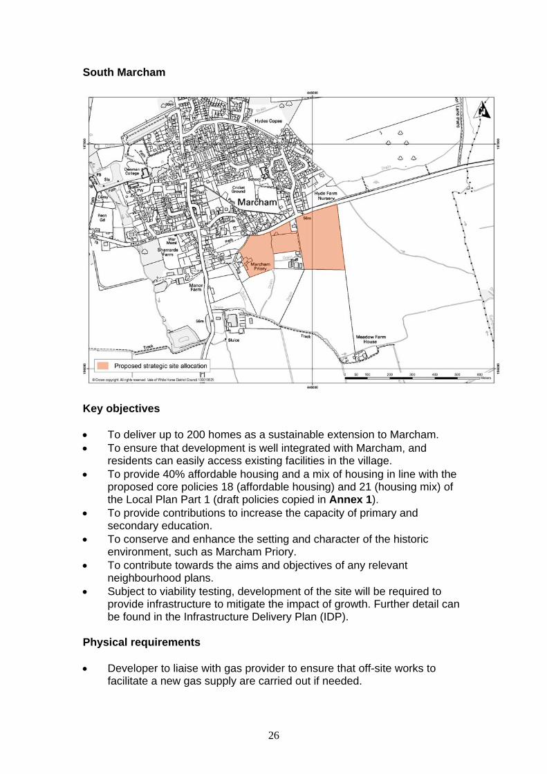
South Marcham
Key objectives To deliver up to 200 homes as a sustainable extension to Marcham. To ensure that development is well integrated with Marcham, and
residents can easily access existing facilities in the village. To provide 40% affordable housing and a mix of housing in line with the
proposed core policies 18 (affordable housing) and 21 (housing mix) of the Local Plan Part 1 (draft policies copied in Annex 1).
To provide contributions to increase the capacity of primary and secondary education.
To conserve and enhance the setting and character of the historic environment, such as Marcham Priory.
To contribute towards the aims and objectives of any relevant neighbourhood plans.
Subject to viability testing, development of the site will be required to provide infrastructure to mitigate the impact of growth. Further detail can be found in the Infrastructure Delivery Plan (IDP).
Physical requirements Developer to liaise with gas provider to ensure that off-site works to
facilitate a new gas supply are carried out if needed.
27
Developer to liaise with electricity provider to ensure any necessary upstream reinforcement work is carried out if needed.
A Drainage Strategy is required. Developers to liaise with Thames Water to ensure adequate waste water facilities are available.
Developer to coordinate with Thames Water to ensure adequate water resource is available.
Access and highways Access to be provided from A415 (Marcham Road). Contributions would be required towards the enhancement of the
premium 31 bus service (Wantage to Abingdon-on-Thames and Oxford). A network of footpaths and cycle ways should be provided giving access
from the new homes to the village centre and the countryside and from the site to the adjoining external network.
To make appropriate contributions towards any necessary mitigation measures identified through the ongoing Local Plan transport modelling work.
Social and community Contributions will be required towards expansion of primary and
secondary education provision. Public open space and recreational facilities to be provided on site in
accordance with requirements of the IDP. Appropriate contributions to be provided towards health care and leisure
provision. Urban design principles Development will be expected to be of high quality design, in line with the
proposed core policies 37 (design and local distinctiveness) and 37a (design briefs for strategic and major sites).
The Design and Access Statement should demonstrate how the landscape and visual impact assessment and landscape mitigation measures have informed the design and layout of the development.
Ensure the development is well connected to the existing settlement. Ensure the development conserves and enhances the setting and
character of heritage assets such as Marcham Priory (Grade II) listed building and the conservation area.
Environmental health The potential impact of development on the air quality of Marcham and
Abingdon-on-Thames needs to be considered and mitigated against (if necessary).
28
Landscape considerations A detailed landscape and visual impact assessment will be required, and
should be used to inform the layout and design of the development to minimise any impact on:
o the site’s landscape setting, including the adjacent Priory avenue approach;
o the aims of policy NE9 of the Local Plan 2011 (i.e. protecting distant views from the high ground of the Corallian Ridge and the North Wessex AONB) and any updates to this policy set out in the Local Plan 2031 Part 2.
A Landscape Strategy for the site should be submitted as part of the planning application.
The mass and scale of the built form shall be designed to avoid being visually intrusive in sensitive views from the surrounding countryside.
Retain and enhance existing vegetation and watercourse, integrating them sensitively into the development.
The retention of the open, rural approach to Marcham is sought through the inclusion of new planting to the eastern boundary to create a strong, new edge to the settlement.
Ensure that the new access and junction from the A415 is sensitively designed to avoid harm to the rural character of the road and minimise loss of the existing mature hedgerow.
Retain the historic field pattern within the site, utilising tree belts and hedgerows as a framework for the subdivision of the site into development land parcels.
The layout and design should allow for some long distance views to be retained.
Create new landscape structure (including new tree / hedgerow planting) to contain new housing.
Ecology The site includes a number of potential ecological constraints and phase
1 surveys will need to be completed to fully identify these constraints. The site will be subject to habitat and species surveys carried out in
accordance with the Guidelines for Ecological Impact Assessment produced by the Chartered Institute of Ecology and Environmental Management and relevant best practice guidance.
Important ecological assets will be retained where possible. If loss is unavoidable then appropriate mitigation or compensation measures will be provided.
A net gain in biodiversity will be provided as a result of the development, for example, by incorporating new natural habitats into development and designing buildings with integral bat boxes and bird nesting opportunities, in appropriate circumstances.
Provide contributions towards redressing the identified Green Infrastructure deficit in the area surrounding Marcham.

29
Flood risk and drainage A detailed Flood Risk Assessment for the site should be submitted,
based on information available in the council’s Strategic Flood Risk Assessment.
Sustainable Urban Drainage (SUDs) methods should be used to drain the surface water from the development.
The centre of the site is susceptible to surface water flooding, which needs to be investigated and mitigation measures would need to be implemented..
Archaeological interest An archaeological evaluation of the site will need to be undertaken and
its recommendations implemented.
Minerals The site contains sand and gravel deposits which may form part of a
workable resource. Further assessment may be required by Oxfordshire County Council.
30
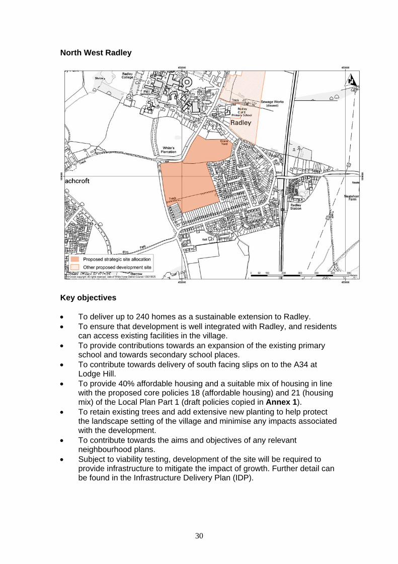
North West Radley
Key objectives To deliver up to 240 homes as a sustainable extension to Radley. To ensure that development is well integrated with Radley, and residents
can access existing facilities in the village. To provide contributions towards an expansion of the existing primary
school and towards secondary school places. To contribute towards delivery of south facing slips on to the A34 at
Lodge Hill. To provide 40% affordable housing and a suitable mix of housing in line
with the proposed core policies 18 (affordable housing) and 21 (housing mix) of the Local Plan Part 1 (draft policies copied in Annex 1).
To retain existing trees and add extensive new planting to help protect the landscape setting of the village and minimise any impacts associated with the development.
To contribute towards the aims and objectives of any relevant neighbourhood plans.
Subject to viability testing, development of the site will be required to provide infrastructure to mitigate the impact of growth. Further detail can be found in the Infrastructure Delivery Plan (IDP).

31
Physical requirements Developer to liaise with gas provider to ensure that off-site works to
facilitate a new gas supply are carried out if needed. Developer to liaise with electricity provider to ensure that any necessary
upstream reinforcement work is carried out if needed. Retention of an overhead power line that traverses the southern part of
the site. Upgrade to sewer network to enable connection to sewage treatment
works. A Drainage Strategy is required with submission of a planning application.
Developer to liaise with Thames Water to ensure adequate water resource is available.
Access and highways Provide contributions towards an upgrade to the A34 junction at Lodge
Hill to provide south access. Provide a network of footpaths and cycle ways to the village centre, the
countryside and the existing network. Contributions to bus service will be required. To make appropriate contributions towards any necessary mitigation
measures identified through the ongoing Local Plan transport modelling work.
To provide improvements to Whites Lane junction with Foxborough Road.
Social and community Contributions will be required towards expansion of primary and
secondary school provision. Provision of public open space and recreational space on site in
accordance with the requirements of the IDP. Appropriate contributions to be provided towards health care and leisure
provision. Urban Design Principles Development will be expected to be of high quality design, in line with the
proposed core policies 37 (design and local distinctiveness) and 37a (design briefs for strategic and major sites).
The Design and Access Statement should demonstrate how the landscape and visual impact assessment and landscape mitigation measures have informed the design and layout of the development.
Housing to be designed to a density that is appropriate for the location on the edge of the village.
Create linkages between the site and the adjacent housing developments and nearby facilities and services where possible and appropriate.

32
Preserve the setting of Radley College, including views to and from the College as well as the parkland setting of the College.
Environmental health Potential impact on Abingdon-on-Thames air quality must be considered
and mitigation measures put in place as appropriate. The site lies partly over the footprint of Whites Lane landfill - the
developer would have to undertake adequate contaminated land investigations to ensure that the land is safe and suitable for the intended use.
Landscape considerations A detailed landscape and visual impact assessment will be required. Conserve and enhance the semi-rural setting of the historic core of
Radley. The interface between the existing settlement of Radley and the new
development must be carefully designed with improved footpath linkages.
The landscape approach to Radley must be reinforced along White’s Lane including planting to White’s Lane to reflect the double line of mature trees in Radley Park, building on the existing line of individual trees.
Existing trees and hedgerows to be retained where possible. Ecology The site will be subject to habitat and species surveys carried out in
accordance with the Guidelines for Ecological Impact Assessment produced by the Chartered Institute of Ecology and Environmental Management and relevant best practice guidance.
Important ecological assets will be retained where possible. If loss is unavoidable then appropriate mitigation or compensation measures will be provided.
A net gain in biodiversity will be provided as a result of the development, for example, by incorporating new natural habitats into development and designing buildings with integral bat boxes and bird nesting opportunities, in appropriate circumstances.
Flood risk and drainage Sustainable Urban Drainage (SUDs) methods will be used to drain the
surface water from the development. A detailed Flood Risk Assessment for the site will be submitted, based
on information available in the council’s Strategic Flood Risk Assessment.

33
Archaeological interest An archaeological evaluation of the site will need to be undertaken and
its recommendations implemented.
34
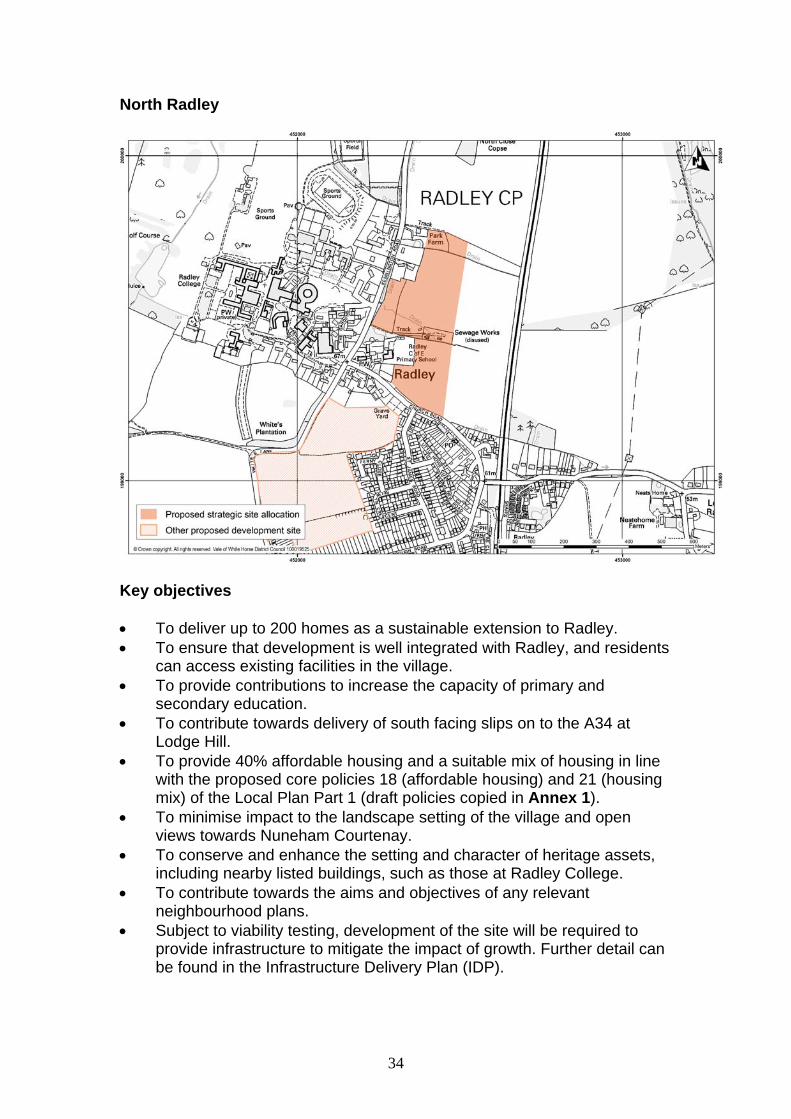
North Radley
Key objectives To deliver up to 200 homes as a sustainable extension to Radley. To ensure that development is well integrated with Radley, and residents
can access existing facilities in the village. To provide contributions to increase the capacity of primary and
secondary education. To contribute towards delivery of south facing slips on to the A34 at
Lodge Hill. To provide 40% affordable housing and a suitable mix of housing in line
with the proposed core policies 18 (affordable housing) and 21 (housing mix) of the Local Plan Part 1 (draft policies copied in Annex 1).
To minimise impact to the landscape setting of the village and open views towards Nuneham Courtenay.
To conserve and enhance the setting and character of heritage assets, including nearby listed buildings, such as those at Radley College.
To contribute towards the aims and objectives of any relevant neighbourhood plans.
Subject to viability testing, development of the site will be required to provide infrastructure to mitigate the impact of growth. Further detail can be found in the Infrastructure Delivery Plan (IDP).

35
Physical requirements Developer to liaise with gas provider to ensure that off-site works to
facilitate a new gas supply are carried out if needed. Developer to liaise with electricity provider to ensure that any necessary
upstream reinforcement work is carried out if needed. An overhead power line traverses the north to south west part of the site.
This will need to be retained. Upgrade to sewer network to enable connection to sewage treatment
works. A Drainage Strategy is required with submission of a planning application.
Access and highways Provide contributions towards an upgrade to the A34 junction at Lodge
Hill to provide full north and south access. Access to be provided from Kennington Road. A network of footpaths and cycle ways should be provided giving access
from the new homes to the village centre and the countryside and from the site to the adjoining external network.
Contributions will be required to enhance the Abingdon-on-Thames-Kennington-Oxford premium bus service.
To make appropriate contributions towards any necessary mitigation measures identified through the ongoing Local Plan transport modelling work.
To provide improvements to Whites Lane junction with Foxborough Road.
Social and community Public open space and recreational facilities to be provided on site in
accordance with the requirements of the IDP. Contributions will be required towards the expansion of primary and
secondary education provision. Appropriate contributions to be provided towards health care and leisure
provision. Urban Design Principles Development will be expected to be of high quality design, in line with the
proposed core policies 37 (design and local distinctiveness) and 37a (design briefs for strategic and major sites).
The Design and Access Statement should demonstrate how the landscape and visual impact assessment and landscape mitigation measures have informed the design and layout of the development.
The development will need to preserve views from the site eastwards to the historic park and garden at Nuneham Courtenay.

36
The development will need to protect the openness and landscape character of the Green Belt and appropriate mitigations measures will need to be implemented to offset any harm, where appropriate.
Development will need to be sensitively designed to conserve and enhance the character and setting of heritage assets including the listed buildings to the west and the historic park/garden at Nuneham Courtenay.
Retention of the existing trees on the edge of the site. Maintain a strategic landscape gap between the village and Radley
College. Linkages to village services and facilities should be provided. Environmental health Potential impact on Abingdon-on-Thames air quality must be considered
and mitigation measures put in place as appropriate. Include noise mitigation measures to offset the harmful impacts of the
site’s proximity to the railway. Landscape considerations A detailed landscape and visual impact assessment will be required, and
a Landscape Strategy for the site should be submitted as part of the planning application.
Ensure that development does not result in harm to the open character and openness of the Greenbelt.
The site should be subdivided into character area land parcels set within a landscape framework to mitigate the impact of the scale of the development on Radley village.
Retain existing trees and existing hedgerows where possible. Identify important views to and from the east of the site including the
Thames Valley floor and the Nuneham Park escarpment including the Historic Park and Garden. The development should be designed to minimise any harm to these views.
Protect and enhance the views of the Church tower and its tree setting as well as views from the Oxford Greenbelt Way.
Conserve and enhance the rural character of Kennington Road in Radley.
Conserve and enhance the character and setting of adjoining heritage assets (i.e. listed buildings).
The Landscape Strategy shall include woodland copse planting, located to link into existing woodland and tree belts and groups and to provide new copse features: on the site of the disused sewage works; east of Park Farm; and north of Church Road (south-east corner of the site).
The Landscape Strategy shall retain an open area of pasture west of the sewage works up to Kennington Road.
Provide native tree screening belts to northern and eastern boundaries of the site.

37
Ensure new access and junction with Kennington Road is sensitively designed to avoid harm to the character of the village and landscape setting of Radley Park.
The mass and scale of the built form should be designed to avoid harm to the open rural character of the surrounding landscape and the rural character of the village and Radley Park.
The mass and scale of the built form shall be designed to avoid being visually intrusive in the open land to the east.
Ecology The site will be subject to habitat and species surveys carried out in
accordance with the Guidelines for Ecological Impact Assessment produced by the Chartered Institute of Ecology and Environmental Management and relevant best practice guidance.
Important ecological assets will need to be retained where possible. If loss is unavoidable then appropriate mitigation or compensation measures will need to be provided.
A net gain in biodiversity will be provided as a result of the development, for example, by incorporating new natural habitats into development and designing buildings with integral bat boxes and bird nesting opportunities, in appropriate circumstances.
Flood risk and drainage Sustainable Urban Drainage (SUDs) methods should be used to drain
the surface water from the development. A detailed Flood Risk Assessment for the site should be submitted,
based on information available in the council’s Strategic Flood Risk Assessment.
Part of the site may be susceptible to surface water flooding. This will need to be investigated and mitigated against (if necessary).
Archaeological interest An archaeological evaluation of the site will need to be undertaken and
its recommendations implemented.

38
East Wootton
Key objectives To deliver up to 200 homes as a sustainable extension to Wootton. To ensure that development is well integrated with Wootton, and
residents can access existing facilities in the village. To provide 40% affordable housing and a mix of housing in line with the
proposed core policies 18 (affordable housing) and 21 (housing mix) of the Local Plan Part 1 (draft policies copied in Annex 1).
To provide contributions to increase the capacity of primary and secondary education.
To contribute towards the aims and objectives of any relevant neighbourhood plans.
Subject to viability testing, development of the site will be required to provide infrastructure to mitigate the impact of growth. Further detail can be found in the Infrastructure Delivery Plan (IDP).
Physical requirements Developer to liaise with gas provider to ensure that off-site works to
facilitate a new gas supply are carried out if needed. Developer to liaise with electricity provider to ensure any necessary
upstream reinforcement work is carried out if needed.
39
A Drainage Strategy will be required. Developer to liaise with Thames Water to ensure adequate waste water facilities are available.
Developer to coordinate with Thames Water to ensure adequate water resources are available.
Access and highways Access to be provided from Lamborough Hill. To provide contributions towards improving public transport connections
between Oxford and Abingdon-on-Thames. A network of footpaths and cycle ways will be provided to the village
centre, the countryside and to the adjoining external network. To make appropriate contributions towards any necessary mitigation
measures identified through the ongoing Local Plan transport modelling work.
Social and community Contributions will be required towards increasing the capacity of primary
and secondary education. Provision of public open space and recreational facilities on site in
accordance with the requirements of the IDP. Appropriate contributions to be provided towards health care and leisure
provision. Urban Design Principles Development will be expected to be of high quality design, in line with the
proposed core policies 37 (design and local distinctiveness) and 37a (design briefs for strategic and major sites).
The Design and Access Statement should demonstrate how the landscape and visual impact assessment and landscape mitigation measures have informed the design and layout of the development.
Ensure that development is well integrated with the existing built environment.
Minimise visual impact on the Green Belt with appropriate landscape mitigation measures.
Ensure that the development appropriately integrates the existing footpath on site into the overall design concept.
Environmental Health Mitigation measures may be required to minimise the impact of noise
from the B4017.

40
Landscape considerations A detailed landscape and visual impact assessment will be required, and
a Landscape Strategy for the site should be submitted as part of the planning application.
Ensure that development does not result in harm to the open character and openness of the Greenbelt.
Maintain the separate identity and individual character of the settlements at Wootton and Whitecross.
The street pattern and open space provision shall be designed to allow views to Boars Hill from Lamborough Hill.
Reinforce and enhance the existing hedgerow along the eastern boundary to include tree belt planting to contain the site.
Tree belt planting shall be undertaken along the northern boundary to contain the site.
Individual tree planting shall be undertaken to soften the roadside edge with Lamborough Hill.
Ecology Any planning application for this site should be accompanied by a Green
Infrastructure Plan, as recommended by the Local Plan Habitats Regulations Assessment. The Green Infrastructure Plan should identify new accessible natural greenspace to be provided by the development in line with the Natural England Accessible Natural Greenspace standards (ANGSt), to ensure that the new development is effectively self-sufficient in terms of local semi-natural accessible space. Such green infrastructure should be easily accessible from the development itself, and would particularly need to cater for dog walkers.
The site will be subject to habitat and species surveys carried out in accordance with the Guidelines for Ecological Impact Assessment produced by the Chartered Institute of Ecology and Environmental Management and relevant best practice guidance.
Important ecological assets will be retained where possible. If loss is unavoidable then appropriate mitigation or compensation measures should be provided.
A net gain in biodiversity will be provided as a result of the development, for example, by incorporating new natural habitats into development and designing buildings with integral bat boxes and bird nesting opportunities, in appropriate circumstances.
Flood risk and drainage A detailed Flood Risk Assessment (FRA) for the site will be submitted,
based on information available in the council’s Strategic Flood Risk Assessment (SFRA). As part of the FRA a surface water drainage strategy will be required.
There are areas susceptible to surface water flooding along the eastern and southern boundaries of the site. This would need to be investigated

41
within the site specific FRA, and the appropriate mitigation measures implemented.
Archaeological interest Predetermination investigation required on potential archaeological
features present on site. Minerals The site contains limestone deposits which are part of a larger, possibly
workable resource, but are constrained by existing housing. Further assessment may be required by Oxfordshire County Council.

42
East Sutton Courtenay
Key objectives To deliver up to 220 homes as a sustainable extension to Sutton
Courtenay. To ensure that development is integrated with Sutton Courtenay, and
residents can access existing facilities in the village. To provide 40% affordable housing and a mix of housing in line with the
proposed core policies 18 (affordable housing) and 21 (housing mix) of the Local Plan Part 1 (draft policies copied in Annex 1).
To provide contributions to increase the capacity of primary and secondary education.
To contribute towards the aims and objectives of any relevant neighbourhood plans.
Subject to viability testing, development of the site will be required to provide infrastructure to mitigate the impact of growth. Further detail can be found in the Infrastructure Delivery Plan (IDP).
Physical requirements Liaise with gas provider to ensure that off-site works to facilitate a new
gas supply are carried out if needed. Liaise with electricity provider to ensure any necessary upstream
reinforcement work is carried out if needed.
43
Retain overhead power line which crosses a small section of the site to the west.
A Drainage Strategy will be required. Developers to liaise with Thames Water to ensure adequate waste water facilities are available.
Developer to liaise with Thames Water to ensure that adequate water resources are available.
Access and highways Access to be provided from Hobbyhorse Lane. Contribution and/or onsite mitigation towards countryside access will be
sought from the development. Provide a network of footpaths and cycle ways to the village centre and
the countryside and adjoining external network, and to existing bus stops.
Retain and enhance existing public rights of way which cross the site. Contributions will be required towards the enhancement of the bus
service which connects Abingdon-on-Thames, Didcot, Harwell and Wantage.
To make appropriate contributions towards any necessary mitigation measures identified through the ongoing Local Plan transport modelling work.
Social and community Contributions will be sought towards increasing the capacity of primary
and secondary schools. Open space and recreational facilities to be provided in accordance with
the requirements of the Infrastructure Delivery Plan. Appropriate contributions to be provided towards health care and leisure
provision. Urban Design Principles Development will be expected to be of high quality design, in line with the
proposed core policies 37 (design and local distinctiveness) and 37a (design briefs for strategic and major sites).
Ensure that development is sensitively designed to minimise any impact on the setting of Sutton Courtenay conservation area, which lies in close proximity to the site to the west.
Environmental health Undertake assessments to consider the impact of noise and odour from
the nearby landfill operations. Mitigation measures will be required (if appropriate).
Undertake adequate contaminated land investigations to assess the potential impact of the site’s proximity to the Hobbyhorse Lane North and
44
South landfill uses. This will help ensure that the land is safe and suitable for the intended use.
Landscape considerations Retain and enhance existing vegetation to boundaries. Create a new landscape structure, building on existing landscape
features to meet the Oxfordshire Wildlife and Landscape Study (OWLS) landscape strategy and policy NE11 (areas for landscape enhancement) of the Local Plan 2011, and any updates to this policy set out in the Local Plan 2031 Part 2..
Create a green infrastructure link to the recreation ground located to the north of the site.
Ecology The site should be subject to habitat and species surveys carried out in
accordance with the Guidelines for Ecological Impact Assessment produced by the Institute of Ecology and Environmental Management and relevant best practice guidance.
Important ecological assets should be retained where possible. If loss is unavoidable then appropriate mitigation or compensation measures should be provided.
Provide a net gain in biodiversity as a result of the development, for example, by incorporating new natural habitats into development and designing buildings with integral bat boxes and bird nesting opportunities.
Existing hedges should be integrated into development. Provide contributions towards redressing the identified partial Green
Infrastructure deficit in Sutton Courtenay. Flood risk and drainage A detailed Flood Risk Assessment for the site should be submitted,
based on information available in the council’s Strategic Flood Risk Assessment.
Sustainable Urban Drainage (SUDs) methods should be used to drain the surface water from the development.
Parts of the site are susceptible to surface water flooding (particularly in the north east and south east of the site). This requires further investigations and appropriate mitigation measures will need to be implemented.
Archaeological interest An archaeological evaluation of the site will need to be undertaken and
its recommendations implemented.
45
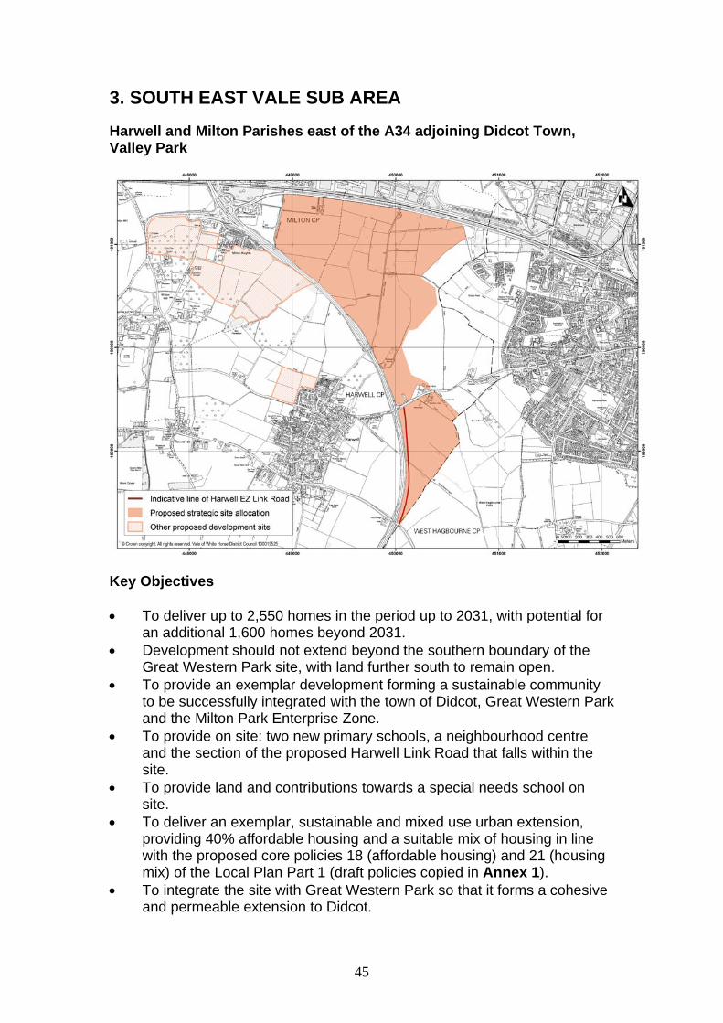
3. SOUTH EAST VALE SUB AREA
Harwell and Milton Parishes east of the A34 adjoining Didcot Town, Valley Park
Key Objectives To deliver up to 2,550 homes in the period up to 2031, with potential for
an additional 1,600 homes beyond 2031. Development should not extend beyond the southern boundary of the
Great Western Park site, with land further south to remain open. To provide an exemplar development forming a sustainable community
to be successfully integrated with the town of Didcot, Great Western Park and the Milton Park Enterprise Zone.
To provide on site: two new primary schools, a neighbourhood centre and the section of the proposed Harwell Link Road that falls within the site.
To provide land and contributions towards a special needs school on site.
To deliver an exemplar, sustainable and mixed use urban extension, providing 40% affordable housing and a suitable mix of housing in line with the proposed core policies 18 (affordable housing) and 21 (housing mix) of the Local Plan Part 1 (draft policies copied in Annex 1).
To integrate the site with Great Western Park so that it forms a cohesive and permeable extension to Didcot.

46
To contribute to balanced employment and housing growth in Science Vale Oxford.
To contribute towards the Science Vale Oxford infrastructure package To contribute towards a significant public transport upgrade, especially to
Didcot and the employment sites at Milton Park and Harwell Oxford Campus.
To contribute towards the aims and objectives of any relevant neighbourhood plans.
Subject to viability testing, development of the site will be required to provide infrastructure to mitigate the impact of growth. Further detail can be found in the Infrastructure Delivery Plan (IDP).
Physical Requirements Local water mains connections will be required. Contributions to new electrical substations will be required. Contributions to a new gas supply will be required. Sewage infrastructure provision will be required to be set out in a
Drainage Strategy submitted with an application. The sewer route through the site will be protected by an easement. The site will be connected to the sewerage treatment works located to the north of Great Western Park.
Cable networks will be installed. Retain the 11,000 volt power lines that cross the site. Access and Highways Provision of proposed Harwell Enterprise Zone Link Road where it falls
within the Valley Park site. Contributions towards the Science Vale Oxford strategic transport
package will be required. Significant contributions will be required towards upgrading public
transport, particularly to Didcot town centre, the railway station and the employment sites at Milton Park and Harwell Oxford Campus.
A network of footpaths and cycle ways giving access from the new homes to the internal green spaces and the countryside and from the site to the adjoining network will be required.
A network of safe and attractive footpaths, cycle tracks, roads and bus routes on the site will be provided that will connect to: o Local services and facilities on the site o The secondary school and district centre at Great Western Park o The railway station o Didcot Town centre o Harwell Oxford Campus o Milton Park (via an improved footpath and cycle access under the
railway at Backhill Lane) Site roads will be designed so as to permit the operation of bus routes
through the site from Didcot centre to Milton Park and Harwell Oxford Campus.
47
Existing public rights of way will be retained or appropriately diverted. A landscaped corridor will be provided along the northern edge of the
site providing a footpath and cycleway from Great Western Park and the existing local centre to Milton Park and a more attractive approach to the town from the A34.
To make appropriate contributions towards any necessary mitigation measures identified through the ongoing Local Plan transport modelling work.
Social and Community Two ‘2 Form Entry’ primary schools will be provided on site and at least
2.22ha provided for each school. A neighbourhood centre of approx. 500sqm, to include local shops and
other community facilities to serve the development will be provided. A community centre of approx. 1400sqm, will be provided. Contributions will be required towards the enlargement of the secondary
school at Great Western Park. Land will be required for a 100 pupil special needs school (2.22 ha).
Contributions will also be required towards special needs school provision.
Contributions will be required towards leisure facilities, including a sports centre.
Public open space and recreational facilities will be provided on site in accordance with the requirements of the Infrastructure Delivery Plan.
A police presence to be provided on site either through a neighbourhood office or as part of a community hub.
Appropriate contributions to be provided towards health care provision. Urban Design Principles Development will be expected to be of high quality design, in line with the
proposed core policies 37 (design and local distinctiveness) and 37a (design briefs for strategic and major sites).
The site will be brought forward with a comprehensive masterplan showing a comprehensive phasing programme for development.
The development will be designed in such a way that enables a high degree of integration and connectivity between new and existing communities, particularly the Great Western Park development.
There will need to be careful consideration of street frontages to ensure that an appropriate building line is established and incorporation of active frontages.
A layout that maximises the potential for sustainable journeys within the neighbourhood, on foot or by bicycle, with a legible hierarchy of routes will be particularly encouraged.
A public transport route through the site will be provided on an appropriate corridor and should avoid passing the front of the primary schools.

48
Public open space will be provided that will form a well connected network of green areas suitable for both formal and informal recreation.
The primary schools and neighbourhood centre will be centrally located to ensure that these are accessible to all of the community.
Environmental Health A Noise Assessment will be required to assess noise from the A34, the
A4130 and the railway. Mitigation measures and buffering will be provided where appropriate.
A contaminated land study will be undertaken and remediation measures proposed and implemented.
Landscape considerations The boundary between the development areas and Harwell village will
need to be carefully treated in order to protect the separate identity of these areas.
Provide open areas and/or introduce increased vegetation each side of the B4493 to maintain, where possible, a sense of openness along this road.
Ensure that development to the south of the site is sensitively planned so as to avoid any adverse impact on the setting of the AONB.
Use landscaping and design features to minimise any noise and light pollution impacts on the AONB.
Plant a new woodland edge to the south eastern site boundary, to create a strong countryside edge and link with the existing and new green infrastructure.
Retain and enhance the footpath to the south of the site (the Driftway) with new tree and hedgerow planting, creating a strong edge and screen to the development area.
Set aside northern parts of the site within the flood zone to provide major areas of Green Infrastructure, including an enhanced footpath / cycle route along the south side of the A4130.
Retain and enhance the existing boundary vegetation. Retain existing hedgerows where possible. Retain parkland trees within the site. Create a new landscape structure to meet the Oxfordshire Wildife and
Landscape Study landscape strategy with a masterplan which coordinates with the adjacent Great Western Park to provide linkages.
Ecology Provide a buffer zone for Moor Ditch and Ladygrove Ditch. Habitat and species surveys will be carried out in accordance with the
Guidelines for Ecological Impact Assessment produced by the Chartered Institute of Ecology and Environmental Management and relevant best practice guidance.

49
Important ecological assets should be retained where possible. If loss is unavoidable then appropriate mitigation or compensation measures should be provided. Proposals for the provision of a site wide mitigation strategy will be required and a suitable receptor site/ nature reserve identified.
A net gain in biodiversity will be provided as a result of the development by incorporating new natural habitats into the development and designing buildings with integral bat boxes and bird nesting opportunities, in appropriate circumstances.
Provide contributions towards redressing the identified Green Infrastructure deficit in the area surrounding Didcot.
Flood risk and drainage A detailed Flood Risk Assessment (FRA) for the site will be required. The
areas in the north western part of the site which are susceptible to surface water flooding will need to be investigated as part of this work. Appropriate mitigation measures will be implemented.
A surface water drainage strategy will be required. No development will be permitted within Flood Zones 2 and 3, other than
flood resilient infrastructure. The site is considered high risk to groundwater, as such mitigation
measures may be required to prevent any detrimental impact on groundwater quality.
Contributions to attenuation features for surface water draining into the sewers.
Sustainable Urban Drainage Systems (SUDs) methods will be used to drain the surface water from the development.
Archaeological Interest An archaeological evaluation of the site will be required to be undertaken
and its recommendations implemented.

50
East Harwell Oxford Campus (Harwell and Chilton Parishes)
Key objectives To deliver up to 1,400 homes to the east of the campus as part of a
mixed use exemplar development, with the potential to provide up to 2,000 further homes beyond 2031.
To provide a sustainable community to be successfully integrated with the internationally significant Harwell Oxford Campus.
To contribute to and be integrated with the Science Vale Oxford infrastructure package
To provide additional high quality community facilities, to complement those already available on the campus.
To ensure that development is sensitively planned to reflect the site’s location within the North Wessex Downs Area of Outstanding Natural Beauty (AONB).
To provide 40% affordable housing and a mix of housing in line with core policies 18 and 21 of the Local Plan Part 1 (draft policies copied in Annex 1).
To provide one new ‘two form entry’ primary school on site. To provide upgrades to public transport, especially to Didcot. To contribute towards the aims and objectives of any relevant
neighbourhood plans.

51
Subject to viability testing, development of the site will be required to provide infrastructure to mitigate the impact of growth. Further detail can be found in the Infrastructure Delivery Plan (IDP).
Physical requirements Developer to liaise with gas provider to ensure that off-site works to
facilitate a new gas supply are carried out if needed. Developer to liaise with electricity provider to ensure any necessary
upstream reinforcement work is carried out if needed. A Drainage Strategy is required. The developer will liaise with Thames
Water to ensure that adequate waste water facilities are available. A detailed water supply strategy will be required. The developer will liaise
with Thames Water to ensure that adequate water supply infrastructure is available.
Access and highways Three accesses will be provided from the A4185 Newbury Road. A contribution will be required towards strategic transport infrastructure in
the Science Vale Oxford area. A network of footpaths and cycle ways will be provided to the campus,
local facilities, and the countryside, and connecting to the Icknield Way and the wider footpath network.
Significant contributions will be required towards upgrading public transport, particularly to Didcot town centre and railway station.
Contributions to bus route enhancement will be required, especially to Didcot
Retain the Icknield Way, which crosses the site, and maintain the open character of this route where possible.
To make appropriate contributions towards any necessary mitigation measures identified through the ongoing Local Plan transport modelling work.
Social and community Provide one new ‘two form entry’ primary school on site. The school will
require 2.22ha of land. Contributions will be required towards secondary education provision. Public open space and recreational facilities will be provided on site in
accordance with the requirements of the Infrastructure Delivery Plan. A police presence to be provided on site either through a neighbourhood
office or as part of a community hub. Appropriate contributions to be provided towards health care and leisure
provision.
52
Urban Design Principles Development will be expected to be of high quality design, in line with the
proposed core policies 37 (design and local distinctiveness) and 37a (design briefs for strategic and major sites).
Consideration will be given to the alignment of the layout of the development with the Harwell - Didcot public transport route.
The site should be designed to reflect the campus character of the adjacent Harwell Oxford Campus, creating a cohesive identity for the development as a whole. In this regard, the proportion of public open space will be higher than the normal requirements.
Green routes will need to be incorporated into the site and linkages created with the adjacent site for pedestrians, cyclists, public transport users and car users.
The Design and Access Statement should demonstrate how the landscape and visual impact assessment and landscape mitigation measures have informed the design and layout of the development.
Environmental health Mitigation or buffering will be required to reduce the impacts of road
noise from the A34. Landscape considerations A detailed landscape and visual impact assessment will be required, and
should be used to inform the layout and design of the development to minimise any impact of development on:
o the landscape character of the site, including the open, rural setting of the Icknield Way;
o the purposes and special qualities of the North Wessex Downs AONB.
A Landscape Strategy for the site should be submitted as part of the planning application.
The mass and scale of the built form shall be designed to avoid being visually intrusive in sensitive views from the surrounding countryside within the AONB.
Use landscaping and design features to minimise any noise and light pollution impacts on the AONB.
Retain the historic field pattern within the site, utilising hedgerows as a framework for the subdivision of the site into development land parcels. The sub-division of the site should be maximised and significant new tree planting should be incorporated.
Plant woodland edge to northern boundary and include enhanced planting to eastern boundary to provide a buffer between the development and the A34.
Retain and enhance existing vegetation, integrating it sensitively into the development.

53
Ensure that the new access and junction from the A4185 are sensitively designed to avoid harm to the semi-rural character of the road and minimise loss of the existing mature hedgerow, utilising existing gaps where possible.
The layout and design should allow for open views to the Ridgeway in key locations and for some long distance views to be retained.
Ecology The site will be subject to habitat and species surveys carried out in
accordance with the Guidelines for Ecological Impact Assessment produced by the Chartered Institute of Ecology and Environmental Management and relevant best practice guidance.
Important ecological assets will be retained where possible. If loss is unavoidable then appropriate mitigation or compensation measures will be provided.
A net gain in biodiversity as a result of the development will be provided, for example, by incorporating new natural habitats into development and designing buildings with integral bat boxes and bird nesting opportunities, in appropriate circumstances.
Provide contributions towards redressing the identified Green Infrastructure deficit in the area surrounding Harwell.
Flood risk and drainage Sustainable Urban Drainage (SUDs) methods will be used to drain the
surface water from the development. A detailed Flood Risk Assessment (FRA) for the site will be prepared,
based on information available in the council’s Strategic Flood Risk Assessment (SFRA). As part of the site specific FRA, a surface water drainage strategy will need to be produced.
There are areas to the centre and east of the site which are susceptible to surface water flooding. This would need to be investigated within the site specific FRA, and appropriate mitigation measures implemented.
Archaeological interest Archaeological predetermination tests will need to be undertaken, and
any recommendations implemented.

54
Land North West of East Challow
Key objectives To deliver up to 200 homes as a sustainable extension to East Challow. To ensure that development is well integrated with East Challow, and
that residents can access existing facilities in the village. To provide 40% affordable housing and a mix of housing in line with the
proposed core policies 18 (affordable housing) and 21 (housing mix) of the Local Plan Part 1 (draft policies copied in Annex 1).
To provide contributions to increase the capacity of primary education in the village, and to contribute towards additional secondary provision at Grove/Wantage.
To contribute towards the Wantage Eastern Link Road. To include an ecological buffer along the route of the Wilts and Berks
Canal. To contribute towards the aims and objectives of any relevant
neighbourhood plans. Subject to viability testing, development of the site will be required to
provide infrastructure to mitigate the impact of growth. Further detail can be found in the Infrastructure Delivery Plan (IDP).
55
Physical requirements Developer to liaise with gas provider to ensure that off-site works to
facilitate a new gas supply are carried out if needed. Developer to liaise with electricity provider to ensure any necessary
upstream reinforcement work is carried out if needed. A Drainage Strategy is required. The developer will liaise with Thames
Water to ensure that adequate waste water facilities are available. Access and highways Access to be provided from the A417 Faringdon Road. A contribution will be required towards the Wantage Eastern Link Road. Contributions will be sought to improve the bus service passing the site,
and to provide additional bus stops on the A417. A network of footpaths and cycle ways should be provided giving access
from the new homes to the village centre, the recreational ground and the countryside and from the site to the existing network as well as bus stops at The Green.
Existing footpaths through the site should be retained and enhanced where possible.
To make appropriate contributions towards any necessary mitigation measures identified through the ongoing Local Plan transport modelling work.
Social and community A contribution will be required towards increasing the capacity of primary
school education in East Challow. Contributions required towards additional secondary school capacity at
Grove/Wantage. Public open space and recreational facilities will be provided on site in
accordance with the requirements of the Infrastructure Delivery Plan. Appropriate contributions to be provided towards health care and leisure
provision. Urban Design Principles Development will be expected to be of high quality design, in line with the
proposed core policies 37 (design and local distinctiveness) and 37a (design briefs for strategic and major sites).
The Design and Access Statement should demonstrate how the landscape and visual impact assessment and landscape mitigation measures have informed the design and layout of the development.
Ensure the development is sensitively designed to protect and enhance the setting and character of listed buildings along the A417 (e.g. Wise’s Farm situated to the east of the site).
Ensure access from the A417 maximises visibility and minimises impact on the rural edge of the settlement.

56
Provide a new bridge over the canal to provide access to the southern section of the site.
Create links to the existing footpath network along the canal. Integrate site into the existing settlement (to the east) through new links
onto the A417. Provide a footpath along the canal.
Environmental Health Mitigation measures may be required to minimise the impact of noise
from the A417 and the scrap yard. Landscape considerations A detailed landscape and visual impact assessment will be required, and
a Landscape Strategy for the site should be submitted as part of the planning application.
Ensure that the development takes into account the landscape character and visual setting of the AONB and that the built form respects the landscape character and visual amenity of the adjacent village and listed buildings.
The site should be subdivided into character area land parcels set within a landscape framework to maintain the small scale pattern on the site.
Retain and enhance all existing tree and hedgerow vegetation around the site and along internal boundaries.
The Landscape Strategy shall conserve and enhance the landscape corridor along the route of the Wilts and Berks Canal.
Ensure that the design and layout of the bridge over the canal minimises the harm to the landscape character of the canal and its landscape setting, including any specific landscape and built features.
New tree planting (in keeping with the historic landscape pattern of the site and its landscape setting) will be required to break up the built form and along the western edge to mitigate the impact of the development on the wider landscape and the public right of way (Cornhill Lane).
The Landscape Strategy shall identify key viewpoints and vistas through the development to maintain visual links between the settlement edge and the wider landscape.
Tree planting and the development shall be designed to avoid visually intrusive development on the higher ground of the site.
The Landscape Strategy shall consider opportunities to retain an area of ridge and furrow as part of the landscape framework for the site
The Landscape Strategy shall consider opportunities to replant an orchard to the edge of the village as part of the landscape framework for the site.
Ensure new access and junction with the A417 is sensitively designed to avoid harm to the rural character of the approach to the village and to landscape features (i.e. tree cover, field patterns and setting of listed buildings).

57
Ecology Ensure development protects habitats and priority species along the
canal corridor. A development buffer of 50 metres either side of the canal is required to
protect the strategic wildlife corridor and to protect habitats and species. A tree survey is required. The site will be subject to habitat and species surveys carried out in
accordance with the Guidelines for Ecological Impact Assessment produced by the Chartered Institute of Ecology and Environmental Management and relevant best practice guidance.
Important ecological assets will be retained where possible. If loss is unavoidable then appropriate mitigation or compensation measures will be provided.
A net gain in biodiversity as a result of the development will be provided, for example, by incorporating new natural habitats into development and designing buildings with integral bat boxes and bird nesting opportunities, in appropriate circumstances.
Provide contributions towards redressing the identified Green Infrastructure deficit in the area surrounding East Challow.
Flood risk and drainage A detailed Flood Risk Assessment (FRA) for the site will be submitted,
based on information available in the council’s Strategic Flood Risk Assessment (SFRA). As part of the FRA a surface water drainage strategy will need to be produced.
Mitigation measures may be required to prevent any detrimental impact on groundwater quality (southern section).
Sustainable Urban Drainage (SUDs) methods will be used to drain the surface water from the development.
Existing watercourses will need to be retained with a buffer zone of eight metres from any development. In the case of the canal, this buffer zone will need to be increased to 50 metres, as set out above.
Archaeological interest Predetermination archaeological investigation will be required.
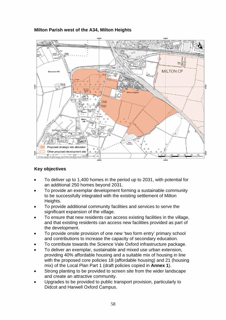
58
Milton Parish west of the A34, Milton Heights
Key objectives To deliver up to 1,400 homes in the period up to 2031, with potential for
an additional 250 homes beyond 2031. To provide an exemplar development forming a sustainable community
to be successfully integrated with the existing settlement of Milton Heights.
To provide additional community facilities and services to serve the significant expansion of the village.
To ensure that new residents can access existing facilities in the village, and that existing residents can access new facilities provided as part of the development.
To provide onsite provision of one new ‘two form entry’ primary school and contributions to increase the capacity of secondary education.
To contribute towards the Science Vale Oxford infrastructure package. To deliver an exemplar, sustainable and mixed use urban extension,
providing 40% affordable housing and a suitable mix of housing in line with the proposed core policies 18 (affordable housing) and 21 (housing mix) of the Local Plan Part 1 (draft policies copied in Annex 1).
Strong planting to be provided to screen site from the wider landscape and create an attractive community.
Upgrades to be provided to public transport provision, particularly to Didcot and Harwell Oxford Campus.
59
To contribute towards the aims and objectives of any relevant neighbourhood plans.
Subject to viability testing, development of the site will be required to provide infrastructure to mitigate the impact of growth. Further detail can be found in the Infrastructure Delivery Plan (IDP).
Physical requirements Developer to liaise with gas provider to ensure that off-site works to
facilitate a new gas supply are carried out if needed. Developer to liaise with electricity provider to ensure that any necessary
upstream reinforcement work is carried out if needed. Upgrade to sewer network to enable connection to sewage treatment
works. A Drainage Strategy is required with submission of a planning application.
Access and highways Access to be provided from the A4130 and Milton Hill. A contribution will be required towards strategic transport infrastructure in
the Science Vale Oxford area. Significant contributions will be required towards public transport
provision, especially to Didcot and Harwell Oxford Campus. To provide new bus stops to enable residents to access the existing
routes that run past the site. A network of footpaths and cycle ways should be provided giving access
from the new homes to the village centre and the countryside and from the site to the adjoining external network.
To make appropriate contributions towards any necessary mitigation measures identified through the ongoing Local Plan transport modelling work.
Social and community A new two form entry primary school will need to be provided on site. Contributions will be required towards increasing the capacity of
secondary school provision. Public open space and recreational facilities to be provided on site in
accordance with the requirements of the IDP. To provide additional community facilities and services to serve the
significant expansion of the village. A police presence to be provided on site either through a neighbourhood
office or as part of a community hub. Appropriate contributions to be provided towards health care and leisure
provision.

60
Urban Design Principles Development will be expected to be of high quality design, in line with the
proposed core policies 37 (design and local distinctiveness) and 37a (design briefs for strategic and major sites).
Ensure that the visual impact of site is mitigated, particularly from the A4130.
Environmental health The potential noise impact from the A34 will need to be assessed and
any harmful impacts mitigated (if necessary). The site is considered a high risk to groundwater; as such mitigation
measures may be required to prevent any detrimental impact on groundwater quality.
Landscape considerations Ensure the development protects distant views from the higher ground to
the north (Corallian Ridge) and the North Wessex Downs to the south. Create linkages with the existing village. Plant a new woodland edge to the south-eastern boundary to create a
strong countryside edge and link with the existing and new green infrastructure.
Ecology Assess the ecological value of the two ponds (one of which falls within
the site boundary) situated on the southern end of the site. Retain and enhance the settings of the ponds and tree belts. The site should be subject to habitat and species surveys carried out in
accordance with the Guidelines for Ecological Impact Assessment produced by the Institute of Ecology and Environmental Management and relevant best practice guidance.
Important ecological assets should be retained where possible. If loss is unavoidable then appropriate mitigation or compensation measures should be provided.
Provide a net gain in biodiversity as a result of the development, for example, by incorporating new natural habitats into development and designing buildings with integral bat boxes and bird nesting opportunities.

61
Flood risk and drainage Sustainable Urban Drainage (SUDs) methods should be used to drain
the surface water from the development. A detailed Flood Risk Assessment for the site should be submitted,
based on information available in the council’s Strategic Flood Risk Assessment.
Areas to the south west and south east of the site are susceptible to surface water flooding. This will need to be investigated and mitigated.
Archaeological interest An archaeological evaluation of the site will need to be undertaken and
its recommendations implemented.

62
Land East of East Hanney
Key objectives To deliver up to 200 homes as a sustainable extension to East Hanney. To ensure that development is integrated with East Hanney and
residents can easily access existing facilities in the village. To provide 40% affordable housing and a mix of housing in line with the
proposed core policies 18 (affordable housing) and 21 (housing mix) of the Local Plan Part 1 (draft policies copied in Annex 1).
To provide contributions to increase the capacity of primary and secondary education.
To contribute towards the aims and objectives of any relevant neighbourhood plans.
Subject to viability testing, development of the site will be required to provide infrastructure to mitigate the impact of growth. Further detail can be found in the Infrastructure Delivery Plan (IDP).
Physical requirements Developer to liaise with gas provider to ensure that off-site works to
facilitate a new gas supply are carried out if needed. Developer to liaise with electricity provider to ensure any necessary
upstream reinforcement work is carried out if needed.
63
A Drainage Strategy is required. Developers to liaise with Thames Water to ensure adequate waste water facilities are available.
Developer to coordinate with Thames Water to ensure adequate water resource is available.
Developer to liaise with Thames Water to ensure that development does not prejudice the implementation of an Upper Thames Reservoir, should this be required.
Access and highways Access to be provided from A338 and Steventon Road. Contribution and/or onsite mitigation towards countryside access (Public
Rights of Way, PROW) will be sought from development A network of footpaths and cycle ways should be provided giving access
from the new homes to the village centre, the countryside and the adjoining external network, and to provide access to existing bus stops.
To make appropriate contributions towards any necessary mitigation measures identified through the ongoing Local Plan transport modelling work.
Social and community Contributions will be required towards increasing the capacity of primary
and secondary education. Public open space and recreational facilities to be provided on site in
accordance with requirements of the IDP. Appropriate contributions to be provided towards health care and leisure
provision. Urban Design Principles Development will be expected to be of high quality design, in line with the
proposed core policies 37 (design and local distinctiveness) and 37a (design briefs for strategic and major sites).
The Design and Access Statement should demonstrate how the landscape and visual impact assessment and landscape mitigation measures have informed the design and layout of the development.
Proposals should include consideration as to how best to integrate and link the site with the existing settlement.
Landscaping measures should be used on the eastern and southern site boundaries, to provide a framework for the development.
Environmental health Undertake a noise assessment to assess the potential impact the A338
could have on the development of the site. An appropriate level of mitigations will be required to offset any adverse impacts (if necessary).

64
Landscape considerations A detailed landscape and visual study will be required, and should be
used to inform the layout and design of the development to minimise any impact on:
o the site’s landscape setting, including the rural setting of and approach to East Hanney and the nearby conservation area; and
o the aims of policy NE9 of the Local Plan 2011 (i.e. protecting distant views from the high ground of the Corallian Ridge and the North Wessex AONB) and any updates to this policy set out in the Local Plan 2031 Part 2.
A Landscape Strategy for the site should be submitted as part of the planning application.
The mass and scale of the built form shall be designed to avoid being visually intrusive in sensitive views from the surrounding countryside.
The rural character of Steventon Road and the A338 should be retained and protected.
Retain and enhance existing vegetation and ditches, integrating them sensitively into the development, as appropriate.
Ensure that the new access and junction from the A338 are sensitively designed to avoid harm to the rural character of the road and minimise loss of the existing mature hedgerow.
Plant woodland edge to the eastern and southern boundaries. Retain the historic field pattern within the site, utilising tree belts and
hedgerows as a framework for the subdivision of the site into development land parcels.
The layout and design should allow for some long distance views to be retained.
Create new landscape structure (including new tree / hedgerow planting) to contain new housing.
Ecology Protect the ditch/watercourse that runs through part of the site. The site will be subject to habitat and species surveys carried out in
accordance with the Guidelines for Ecological Impact Assessment produced by the Chartered Institute of Ecology and Environmental Management and relevant best practice guidance.
Important ecological assets will be retained where possible. If loss is unavoidable then appropriate mitigation or compensation measures will be provided.
A net gain in biodiversity will be provided as a result of the development, for example, by incorporating new natural habitats into development and designing buildings with integral bat boxes and bird nesting opportunities, in appropriate circumstances.

65
Flood risk and drainage A detailed Flood Risk Assessment for the site should be submitted,
based on information available in the council’s Strategic Flood Risk Assessment.
Sustainable Urban Drainage (SUDs) methods should be used to drain the surface water from the development.
Investigate any surface water flooding issues and ensure appropriate mitigation measures are implemented.
Archaeological interest An archaeological evaluation of the site will need to be undertaken and
its recommendations implemented. Minerals The site contains sand and gravel deposits which are part of a larger
resource, but these are believed to be thin and of poor quality. Further assessment may be required by Oxfordshire County Council.
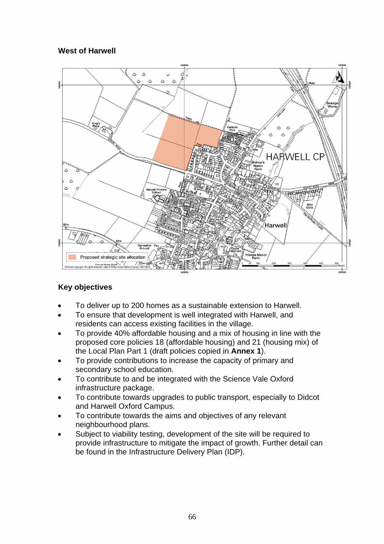
66
West of Harwell
Key objectives To deliver up to 200 homes as a sustainable extension to Harwell. To ensure that development is well integrated with Harwell, and
residents can access existing facilities in the village. To provide 40% affordable housing and a mix of housing in line with the
proposed core policies 18 (affordable housing) and 21 (housing mix) of the Local Plan Part 1 (draft policies copied in Annex 1).
To provide contributions to increase the capacity of primary and secondary school education.
To contribute to and be integrated with the Science Vale Oxford infrastructure package.
To contribute towards upgrades to public transport, especially to Didcot and Harwell Oxford Campus.
To contribute towards the aims and objectives of any relevant neighbourhood plans.
Subject to viability testing, development of the site will be required to provide infrastructure to mitigate the impact of growth. Further detail can be found in the Infrastructure Delivery Plan (IDP).
67
Physical requirements Developer to liaise with gas provider to ensure that off-site works to
facilitate a new gas supply are carried out if needed. Developer to liaise with electricity provider to ensure that any necessary
upstream reinforcement work is carried out if needed. A Drainage Strategy is required. Developer to liaise with Thames Water
to ensure adequate waste water facilities are available. Developer to liaise with Thames Water to ensure adequate water
resources are available
Access and highways Access to be provided from Grove Road and Barrow Road. Improvements required to Grove Road and the Grove Road/A1430
junction. A contribution will be required towards strategic transport infrastructure in
the Science Vale Oxford area. Contributions will be required towards bus route enhancement. A network of footpaths and cycle ways will be provided giving access
from the new homes to the village centre, the countryside, and the adjoining external network, and to existing bus stops.
To make appropriate contributions towards any necessary mitigation measures identified through the ongoing Local Plan transport modelling work.
Social and community Contributions will be required to increase the capacity of primary and
secondary school education. Public open space and recreational facilities to be provided on site in
accordance with the requirements of the Infrastructure Delivery Plan (IDP).
Appropriate contributions to be provided towards health care and leisure provision.
Urban Design Principles Development will be expected to be of high quality design, in line with the
proposed core policies 37 (design and local distinctiveness) and 37a (design briefs for strategic and major sites).
The Design and Access Statement should demonstrate how the landscape and visual impact assessment and landscape mitigation measures have informed the design and layout of the development.
The layout and design of the scheme should be sensitive to the topography of the site.
Proposals should include consideration as to how best to integrate and link the site with the existing settlement.
Opportunity to redefine this key entrance to the village.
68
Landscape considerations A detailed landscape and visual study will be required, and should be
used to inform the layout and design of the development to minimise any impact on:
o the site’s landscape setting, including the approach to Harwell village;
o the aims of the Lowland Vale policy NE9 (i.e. protecting distant views from the high ground of the Corallian Ridge and the nearby North Wessex Downs AONB).
o the North Wessex Downs AONB. A Landscape Strategy for the site should be submitted as part of the
planning application. The mass and scale of the built form shall be designed to avoid being
visually intrusive in sensitive views from the surrounding countryside and particularly the AONB.
Plant woodland edge to western boundary. Retain the historic field pattern within the site, utilising tree belts and
hedgerows as a framework for the subdivision of the site into development land parcels.
The rural character of Grove Road should be retained and protected. If access is needed from Grove Road, ensure that it is sensitively
designed to minimise harm to the rural character of the road and the approach to Harwell village and to minimise loss of the existing mature hedgerow.
Retain and enhance existing vegetation, integrating it sensitively into the development.
The layout and design should allow for some long distance views to be retained.
Create a new landscape structure (including new tree / hedgerow planting) to contain new housing.
Ecology The site should be subject to habitat and species surveys carried out in
accordance with the Guidelines for Ecological Impact Assessment produced by the Institute of Ecology and Environmental Management and relevant best practice guidance.
Important ecological assets should be retained where possible. If loss is unavoidable then appropriate mitigation or compensation measures should be provided.
Provide a net gain in biodiversity as a result of the development, for example, by incorporating new natural habitats into development and designing buildings with integral bat boxes and bird nesting opportunities.
Provide contributions towards redressing the identified Green Infrastructure deficit in Harwell.
69
Flood risk and drainage A detailed Flood Risk Assessment (FRA) for the site should be
submitted, based on information available in the council’s Strategic Flood Risk Assessment (SFRA). As part of the FRA a surface water drainage strategy will need to be produced to ensure flood risk is not increased by the introduction of impermeable surfaces.
Parts of the site may be susceptible to surface water flooding. This requires further investigations and appropriate mitigations need to be implemented (if necessary).
The site is considered high risk to groundwater; as such mitigation measures may be required to prevent any detrimental impact on groundwater quality.
An intrusive ground investigation and remediation strategy may be required to understand levels of contamination on site to ensure there will be no detrimental impact on groundwater quality.
Archaeological interest Predetermination investigation required on potential archaeological
features present on site.

70
4. WESTERN VALE SUB AREA
Great Coxwell Parish, South Faringdon
Key Objectives To deliver up to 200 homes as a sustainable extension to Faringdon. To contribute towards the aims and objectives of the emerging Great
Coxwell and Faringdon Neighbourhood Plans. To ensure that the development is well integrated with Faringdon and
residents can access existing facilities in the town. To provide 40% affordable housing and a mix of housing in line with the
proposed core policies 18 (affordable housing) and 21 (housing mix) of the Local Plan Part 1 (draft policies copied in Annex 1).
To protect the landscape setting of Great Coxwell and retain an open gap between the village and the proposed development.
To provide contributions towards increasing primary and secondary school capacity within the town.
To contribute towards upgrading the A420 junction at Coxwell Road and wider improvements along the A420 corridor.
To contribute towards upgrading wastewater treatment capacity. Subject to viability testing, development of the site will be required to
provide infrastructure to mitigate the impact of growth. Further detail can be found in the Infrastructure Delivery Plan (IDP).

71
Physical Requirements Liaise with the gas provider to ensure that off-site works to facilitate a
new gas supply are carried out if needed. Liaise with the electricity provider to ensure that any necessary upstream
reinforcement work is carried out. Drainage infrastructure and a drainage strategy will be required. Liaise with Thames Water to ensure adequate water resources are
available. Wastewater treatment capacity will need to be addressed. Thames Water is likely to request a planning condition to ensure that the
infrastructure is in place ahead of the occupation of the development. Access and Highways Provide a network of footpaths and cycle ways giving access from the
new homes to the countryside and from the site to the adjoining external network.
Provide a network of safe and attractive footpaths and cycle tracks on the site that will connect to Faringdon centre and other areas where infrastructure and services are located, including to the secondary school.
Access to be provided from Coxwell Road. Improve Coxwell Road/ A420 priority junction. Contributions to wider improvements along the A420 corridor. Contributions to bus services will be required. To make appropriate contributions towards any necessary mitigation
measures identified through the ongoing Local Plan transport modelling work.
Social and Community To provide contributions towards increasing primary and secondary
school capacity within the town. Provision of public open space and recreational facilities on site in
accordance with the requirements of the IDP. Appropriate contributions to be provided towards health care and leisure
provision. Urban Design Principles Development will be expected to be of high quality design, in line with the
proposed core policies 37 (design and local distinctiveness) and 37a (design briefs for strategic and major sites).
Facilitate links to the existing and planned facilities and services on site and, where possible, into the adjacent development.
Provide adequate pedestrian and cycle links to Fernham Road and Coxwell Road.
72
Incorporate the existing trees on site into any development. Include extensive landscaping along the southern part of the site, in
order to prevent coalescence with Great Coxwell. Housing will need to front the public realm including roads and areas of
public open space. Linkages should be provided to the site South West of Faringdon. Environmental Health Incorporate noise mitigation measures from the A420. Undertake adequate contaminated land investigations. Ecology Considerations The site will be subject to habitat and species surveys carried out in
accordance with the Guidelines for Ecological Impact Assessment produced by the Chartered Institute of Ecology and Environmental Management and relevant best practice guidance.
Important ecological assets will be retained where possible. If loss is unavoidable then appropriate mitigation or compensation measures will be provided.
A net gain in biodiversity as a result of the development will be provided, for example, by incorporating new natural habitats into development and designing buildings with integral bat boxes and bird nesting opportunities, in appropriate circumstances.
Include new tree and hedgerow planting along the southern edge of the site.
Provide contributions towards redressing the identified Green Infrastructure deficit in the area surrounding Faringdon.
Landscape Create a new landscape structure building on existing landscape
features to meet Oxfordshire Wildlife and Landscape Study (OWLS) landscape strategy and contribute to the aims of the Great Western Community Forest.
Integrate existing hedges into the development. Create new public rights of way linking to the wider footpath network. Use the existing farm access off of Coxwell Road. Create a landscape buffer on the southern part of the site and to the
west to soften the interface with the higher ground to the west, and to prevent coalescence with Great Coxwell.
73
Flood Risk and Drainage A detailed Flood Risk Assessment for the site will be required, based on
information available in the council’s Strategic Flood Risk Assessment. This should include consideration of any areas of the site which are susceptible to surface water flooding. Appropriate mitigation measures will need to be implemented.
A surface water drainage strategy will be required. Sustainable Urban Drainage Systems (SUDs) will be required for the
disposal of surface water.

74
South West of Faringdon
Key objectives To deliver up to 200 homes as a sustainable extension to Faringdon. To contribute towards the aims and objectives of the emerging Faringdon
and Great Coxwell Neighbourhood Plans. To ensure that the development is well integrated with Faringdon and
residents can access existing facilities in the town. To provide 40% affordable housing and a mix of housing in line with the
proposed core policies 18 (affordable housing) and 21 (housing mix) of the Local Plan Part 1 (draft policies copied in Annex 1).
To protect the landscape setting of Faringdon and the wider area. To provide contributions towards increasing primary and secondary
school capacity within the town. To contribute towards upgrading the A420 junction at Coxwell Road and
wider improvements along the A420 corridor. To contribute towards upgrading wastewater treatment capacity. Subject to viability testing, development of the site will be required to
provide infrastructure to mitigate the impact of growth. Further detail can be found in the Infrastructure Delivery Plan (IDP).

75
Physical requirements Developer to liaise with gas provider to ensure that off-site works to
facilitate a new gas supply are carried out if needed. Developer to liaise with electricity provider to ensure that any necessary
upstream reinforcement work is carried out if needed. Drainage infrastructure and a drainage strategy will be required. Liaise with Thames Water to ensure that adequate water resources are
available. Wastewater capacity will need to be satisfactorily addressed. Thames Water is likely to request a planning condition to ensure that the
infrastructure is in place ahead of the occupation of the development. Retain overhead power line that crosses a small section of the site (in
the south western corner). Access and highways Access to be provided from Highworth Road. To contribute towards upgrading the A420 junction at Coxwell Road. Provide a network of footpaths and cycle ways giving access from the
new homes to the countryside and from the site to the adjoining external network.
Provide a network of safe and attractive footpaths and cycle tracks on the site that will connect to Faringdon centre and other areas where infrastructure and services are located, including to the secondary school.
Provide contributions towards improving public transport. Contributions towards wider improvements along the A420 corridor. To make appropriate contributions towards any necessary mitigation
measures identified through the ongoing Local Plan transport modelling work.
Social and community To provide contributions towards increasing primary and secondary
school capacity within the town. Provision of public open space and recreational facilities on site in
accordance with the requirements of the IDP. Appropriate contributions to be provided towards health care and leisure
provision. Urban Design Principles Development will be expected to be of high quality design, in line with the
proposed core policies 37 (design and local distinctiveness) and 37a (design briefs for strategic and major sites).
The Design and Access Statement should demonstrate how the landscape and visual impact assessment and landscape mitigation measures have informed the design and layout of the development.

76
Proposals should include consideration as to how best to integrate and link the site with the existing settlement.
Linkages should be provided to the adjacent public open space, and to the site at South Faringdon.
The layout and design of the scheme should be sensitive to the topography of the site.
Landscape considerations A detailed landscape and visual impact assessment will be required, and
a Landscape Strategy for the site should be submitted as part of the planning application.
Conserve the distinctive hill and clump. The impact of introducing buildings on the rising ground which is part of the landform should be assessed to avoid adverse impacts on the distinctive clump feature.
Retain and enhance existing hedgerows. Protect views towards the site from Farringdon, Bedbury Hill and from
the Thames Valley. Ensure that the new access and junction from the B4019 is sensitively
designed to avoid harm to the rural character of the road and minimise loss of the existing mature hedgerow.
Retain and manage the historic field pattern within the site, utilising tree belts and hedgerows as a framework for the subdivision of the site into development land parcels.
The Landscape Strategy shall contribute to the aims of the Great Western Community Forest, including provisions for the creation of a diverse woodland environment.
Create new landscape structure (including new tree / hedgerow planting) to contain new housing.
New native woodland belt to be provided along the western and southern boundaries to link existing woodland belts and create a strong, vegetated edge to the settlement and backdrop to views of the clump from the Bedbury Hill.
The mass and scale of the built form shall be designed to avoid being visually intrusive in sensitive views from the surrounding countryside.
Ecology The site will be subject to habitat and species surveys carried out in
accordance with the Guidelines for Ecological Impact Assessment produced by the Chartered Institute of Ecology and Environmental Management and relevant best practice guidance.
Important ecological assets will be retained where possible. If loss is unavoidable then appropriate mitigation or compensation measures should be provided.
A net gain in biodiversity will be provided as a result of the development, for example, by incorporating new natural habitats into development and designing buildings with integral bat boxes and bird nesting opportunities, in appropriate circumstances.

77
Provide contributions towards redressing the identified Green Infrastructure deficit in the area surrounding Faringdon.
Flood risk and drainage A detailed Flood Risk Assessment (FRA) for the site will be submitted,
based on information available in the council’s Strategic Flood Risk Assessment (SFRA). As part of the FRA a surface water drainage strategy will be required.
Sustainable Urban Drainage Systems (SUDs) will be required for the disposal of surface water.
Archaeological interest Predetermination investigation will be required on potential
archaeological features present on site.
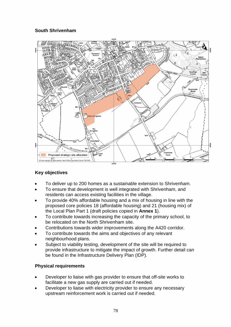
78
South Shrivenham
Key objectives To deliver up to 200 homes as a sustainable extension to Shrivenham. To ensure that development is well integrated with Shrivenham, and
residents can access existing facilities in the village. To provide 40% affordable housing and a mix of housing in line with the
proposed core policies 18 (affordable housing) and 21 (housing mix) of the Local Plan Part 1 (draft policies copied in Annex 1).
To contribute towards increasing the capacity of the primary school, to be relocated on the North Shrivenham site.
Contributions towards wider improvements along the A420 corridor. To contribute towards the aims and objectives of any relevant
neighbourhood plans. Subject to viability testing, development of the site will be required to
provide infrastructure to mitigate the impact of growth. Further detail can be found in the Infrastructure Delivery Plan (IDP).
Physical requirements Developer to liaise with gas provider to ensure that off-site works to
facilitate a new gas supply are carried out if needed. Developer to liaise with electricity provider to ensure any necessary
upstream reinforcement work is carried out if needed.

79
Retention of an 11,000 volt overhead line that runs past the eastern corner of the site.
A Drainage Strategy is required. Developer to liaise with Thames Water to ensure that adequate waste water facilities are available.
A detailed water supply strategy will be required. Developer to liaise with Thames Water to ensure that adequate water supply infrastructure is available.
Access and highways Access to be provided from Station Road and Longcott Road and not
Stainswick Lane. Contributions will be required towards wider improvements along the
A420 corridor. Footpaths and cycle ways to be provided within the site giving access to
the village, the countryside and to the adjoining external network, and to provide as short a walk as possible to bus stops for the route 66 service.
Contributions will be required towards bus route development. To make appropriate contributions towards any necessary mitigation
measures identified through the ongoing Local Plan transport modelling work.
Social and community Contributions will be required towards the expansion of Shrivenham
primary school which is to be relocated on the North Shrivenham site. Contributions will be required towards the expansion of secondary school
provision. Provision of public open space and recreational facilities on site in
accordance with requirements of the IDP. Appropriate contributions to be provided towards health care and leisure
provision. Urban design principles Development will be expected to be of high quality design, in line with the
proposed core policies 37 (design and local distinctiveness) and 37a (design briefs for strategic and major sites).
Create links from the east through to the west of this site including taking advantage of the public footpath along the southern boundary of the site.
Create links to the housing developments to the north and facilities and services where possible and appropriate.
Ensure appropriate design of development to avoid negative effects on Shrivenham Conservation Area.
Landscape considerations A detailed landscape and visual impact assessment will be required, and
should include an assessment of any impact on views from the AONB.
80
Include landscaping measures to meet the Oxfordshire Wildlife and Landscape Study (OWLS) landscape strategy and the aims of policy NE12 (Great Western Community Forest) of the Local Plan 2011, and any updates to this policy set out in the Local Plan 2031 Part 2..
Provide a new planted edge to the southern side of the site. Adequate space must be provided to mitigate the visual impact of the
site having regard to views from the AONB and to allow access to the open countryside to the south.
Retain existing structural vegetation and specimen trees where possible. Retain and enhance existing footpaths with new vegetation and create
additional footpaths within the site. Ecology Great crested newts have been recorded on the site. Appropriate
surveys and mitigation will be required prior to the commencement of any on site development works.
A tree survey will be required to identify which trees should be retained. The site will be subject to habitat and species surveys carried out in
accordance with the Guidelines for Ecological Impact Assessment produced by the Chartered Institute of Ecology and Environmental Management and relevant best practice guidance.
Important ecological assets will be retained where possible. If loss is unavoidable then appropriate mitigation or compensation measures will be provided.
A net gain in biodiversity will be provided as a result of the development, for example, by incorporating new natural habitats into development and designing buildings with integral bat boxes and bird nesting opportunities, in appropriate circumstances.
Provide contributions towards redressing the identified Green Infrastructure deficit in the area surrounding Shrivenham.
Flood risk and drainage A detailed Flood Risk Assessment (FRA) for the site will be submitted,
based on information available in the council’s Strategic Flood Risk Assessment (SFRA). As part of the FRA a surface water drainage strategy will be required.
Sustainable urban drainage (SUDs) methods will be used to drain the surface water from the development.
Archaeological interest Archaeological predetermination tests will need to be undertaken, and
any recommendations implemented.
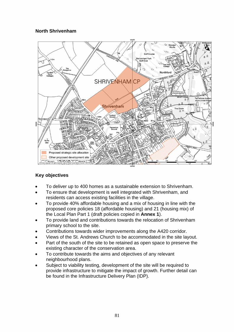
81
North Shrivenham
Key objectives To deliver up to 400 homes as a sustainable extension to Shrivenham. To ensure that development is well integrated with Shrivenham, and
residents can access existing facilities in the village. To provide 40% affordable housing and a mix of housing in line with the
proposed core policies 18 (affordable housing) and 21 (housing mix) of the Local Plan Part 1 (draft policies copied in Annex 1).
To provide land and contributions towards the relocation of Shrivenham primary school to the site.
Contributions towards wider improvements along the A420 corridor. Views of the St. Andrews Church to be accommodated in the site layout. Part of the south of the site to be retained as open space to preserve the
existing character of the conservation area. To contribute towards the aims and objectives of any relevant
neighbourhood plans. Subject to viability testing, development of the site will be required to
provide infrastructure to mitigate the impact of growth. Further detail can be found in the Infrastructure Delivery Plan (IDP).

82
Physical requirements Developer to liaise with gas provider to ensure that off-site works to
facilitate a new gas supply are carried out if needed. Developer to liaise with electricity provider to ensure any necessary
upstream reinforcement work is carried out if needed. Retention of an 11,000 volt overhead line that runs through the eastern
corner of the site. A Drainage Strategy is required. Developer to liaise with Thames Water
to ensure that adequate waste water facilities are available. A detailed water supply strategy will be required. Developer to coordinate
with Thames Water to ensure that adequate water supply infrastructure is available.
Access and highways Access to be provided from Highworth Road. A network of footpaths and cycle ways will be provided giving access to
the village centre, the countryside and the adjoining external network, and to ensure as short a walk as possible to bus stops for the route 66 service.
Footpath access into Claypits Lane shall be provided if possible. Contributions to bus services will be required. Contributions will be required towards wider improvements along the
A420 corridor. To make appropriate contributions towards any necessary mitigation
measures identified through the ongoing Local Plan transport modelling work.
Social and community Land (2.22 ha) and contributions will be required towards the relocation
and expansion of Shrivenham primary school to the site. Contributions will be required towards the expansion of secondary school
provision. Provision of public open space and recreational facilities on site in
accordance with the requirements of the IDP. Appropriate contributions to be provided towards health care and leisure
provision. Urban design principles Development will be expected to be of high quality design, in line with the
proposed core policies 37 (design and local distinctiveness) and 37a (design briefs for strategic and major sites).
Create links and connections into the existing movement network. Provide areas of public open space in appropriate locations so that these
areas enhance the overall appearance of the site. Clear and well
83
designed links should be created between housing and areas of open space.
The layout of any development scheme must take account of important views in this area.
Development will be sensitively designed to conserve and enhance the setting of Shrivenham conservation area, which adjoins the site to the south east.
Landscape considerations A detailed landscape and visual impact assessment will be required. A detailed assessment of the impact on the setting of the Conservation
Area will be required. Include landscaping measures to meet the Oxfordshire Wildlife and
Landscape Study landscape strategy and the aims of policy NE12 (Great Western Community Forest) of the Local Plan 2011, and any updates to this policy set out in the Local Plan 2031 Part 2.
The area closest to Shrivenham Conservation Area will be retained as open space.
Views across the site to the listed church (St. Andrews) should be accommodated in the site layout.
Existing footpath routes should be enhanced and new links created, especially east/west across the site.
Create a new vegetated northern edge to the settlement. Retain existing trees and hedgerows where possible. Ecology A tree survey is required to establish which trees should be retained. Proposals will need to demonstrate that development will not affect the
hydrological systems which feed into the Tuckmill Meadows Site of Special Scientific Interest (SSSI), which is located in close proximity to the site to the north east.
The site will be subject to habitat and species surveys carried out in accordance with the Guidelines for Ecological Impact Assessment produced by the Chartered Institute of Ecology and Environmental Management and relevant best practice guidance.
Important ecological assets will be retained where possible. If loss is unavoidable then appropriate mitigation or compensation measures will be provided.
A net gain in biodiversity will be provided as a result of the development, for example, by incorporating new natural habitats into development and designing buildings with integral bat boxes and bird nesting opportunities, in appropriate circumstances.
Provide contributions towards redressing the identified Green Infrastructure deficit in the area surrounding Shrivenham. In this regard land adjacent to the site to the north could contribute towards the Green Infrastructure provision.
84
Flood risk and drainage A detailed Flood Risk Assessment (FRA) for the site will be submitted,
based on information available in the council’s Strategic Flood Risk Assessment (SFRA). As part of the FRA a surface water drainage strategy will be required.
Sustainable Urban Drainage (SUDs) methods will be used to drain the surface water from the development.
Archaeological interest Archaeological predetermination tests will need to be undertaken, and
any recommendations implemented.
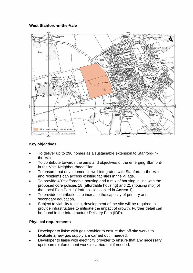
85
West Stanford-in-the-Vale
Key objectives To deliver up to 290 homes as a sustainable extension to Stanford-in-
the-Vale. To contribute towards the aims and objectives of the emerging Stanford-
in-the-Vale Neighbourhood Plan. To ensure that development is well integrated with Stanford-in-the-Vale,
and residents can access existing facilities in the village. To provide 40% affordable housing and a mix of housing in line with the
proposed core policies 18 (affordable housing) and 21 (housing mix) of the Local Plan Part 1 (draft policies copied in Annex 1).
To provide contributions to increase the capacity of primary and secondary education.
Subject to viability testing, development of the site will be required to provide infrastructure to mitigate the impact of growth. Further detail can be found in the Infrastructure Delivery Plan (IDP).
Physical requirements Developer to liaise with gas provider to ensure that off-site works to
facilitate a new gas supply are carried out if needed. Developer to liaise with electricity provider to ensure that any necessary
upstream reinforcement work is carried out if needed.

86
A Drainage Strategy will be required. Developers to liaise with Thames Water to ensure that adequate waste water facilities are available.
Developer to liaise with Thames Water to ensure that adequate water resources are available.
Access and highways Access to be provided from the A417 Faringdon Road. Contributions will be required to improve the bus service passing the site. Contributions towards wider improvements along the A420 corridor. Contribution and/or on-site mitigation will be required towards Public
Rights Of Way (PROW) access to countryside A network of footpaths and cycle ways will be provided, giving access to
the village centre, the countryside and to the adjoining external network, and to existing bus stops for the route 67 service.
To make appropriate contributions towards any necessary mitigation measures identified through the ongoing Local Plan transport modelling work.
Social and community Contribution will be sought towards increasing the capacity of primary
and secondary school education. Provide public open space and recreational facilities on site in
accordance with the requirements of the Infrastructure Delivery Plan. Appropriate contributions to be provided towards health care and leisure
provision. Urban Design Principles Development will be expected to be of high quality design, in line with the
proposed core policies 37 (design and local distinctiveness) and 37a (design briefs for strategic and major sites).
Ensure mitigation measures are included to minimise the visual impact on the countryside.
Ensure that any noise and/or air pollution from the adjacent employment use is mitigated.
Environmental Health Mitigation measures may be required to minimise the impact of noise
from the A417, the industrial estate and the quarry. Landscape considerations Build on the landscape structure to meet the Oxfordshire Wildlife and
Landscape Study (OWLS) landscape strategy to contain the proposed site and limit the impact on the wider landscape.

87
Additional planting along the A417 will need to be undertaken as well as tree planting along the hedgerow, along the northern edge of the settlement.
Create a link with the recreation ground east of the A417. Ecology A hedgerows analysis should be undertaken to determine any
hedgerows that are worthy of retention. The site will be subject to habitat and species surveys carried out in
accordance with the Guidelines for Ecological Impact Assessment produced by the Chartered Institute of Ecology and Environmental Management and relevant best practice guidance.
Important ecological assets will be retained where possible. If loss is unavoidable then appropriate mitigation or compensation measures should be provided.
A net gain in biodiversity will be provided as a result of the development, for example, by incorporating new natural habitats into development and designing buildings with integral bat boxes and bird nesting opportunities, in appropriate circumstances.
Provide contributions towards redressing the identified Green Infrastructure deficit in the area surrounding West Stanford-in-the-Vale.
Flood risk and drainage A detailed Flood Risk Assessment (FRA) for the site will be submitted,
based on information available in the council’s Strategic Flood Risk Assessment (SFRA). As part of the FRA a surface water drainage strategy will be required.
A small part of the site (in the south east) is susceptible to surface water flooding. This requires further investigations and appropriate mitigations (if necessary).
Archaeological interest Predetermination investigation will be required on potential
archaeological features present on site.
88
5. ANNEX 1: PROPOSED CORE POLICIES 18 (AFFORDABLE HOUSING) AND 21 (HOUSING MIX) AS SET OUT IN THE FEBRUARY 2013 LOCAL PLAN PART 1 CONSULTATION DOCUMENT
Core Policy 18: Affordable Housing Forty per cent affordable housing with a tenure mix of 75 per cent social/affordable rented and 25 per cent intermediate housing will be sought on all sites capable of a net gain of three or more dwellings subject to the viability of development. Any affordable housing provided should: i. be of a size and type which meets the requirements of those in housing need, and ii. be indistinguishable in appearance from the market housing and distributed evenly across the site In cases where the 40 per cent calculation provides a part unit, a financial contribution will be sought, equivalent to that part unit. In circumstances where it can be demonstrated that the level of affordable housing being sought would be unviable, a revised mix and type of housing will be considered before a lower level of affordable housing provision is accepted. The council will seek to deliver affordable housing following the preferred hierarchy shown below: 1. On site provision (with the exception of part units) 2. Mix of on site and off site provision 3. Off site provision 4. On site provision and financial contribution 5. Off site provision and financial contribution 6. Financial contribution Off-site contribution and/or financial contributions for the provision of affordable housing in lieu of on-site provision may be appropriate if it can be robustly justified that: iii. it is not physically possible or feasible to provide affordable housing on the application site, or iv. there is evidence that a separate site would more satisfactorily meet local housing need and contribute to the creation of mixed communities.
89
Core Policy 21: Housing Mix An appropriate mix of dwelling types and sizes to meet the needs of current and future households will be sought on all new residential developments. This should be in accordance with the council’s current Housing Needs Assessment unless robust evidence identifies the need for a degree of flexibility by establishing a: i. different mix based on the need of a specific settlement, or ii. variation of mix is necessary due to viability constraints.

Other language versions and alternative formats of this publication are available on request.
These include large print, Braille, audio cassette, computer disk and email.
www.whitehorsedc.gov.uk
Planning Policy TeamAbbey House, Abbey Close,
Abingdon, OX14 3JE Tel: 01235 540499 Fax: 01235 540397
Email: [email protected]
Arabic
Bengali
Urdu
Chinese
Punjabi
District Council