local government coordination memo
TRANSCRIPT

Bachman Area Planning – Local Government Coordination Technical Memorandum
1
Date: November 2021
Bachman Area Planning Technical Memorandum
Subject: Past Plans, Funding, and Ongoing Local Government Coordination
Background Dallas City Councilmember Omar Narvaez, in June of 2020, sent a letter requesting the North Central Texas Council of Governments’ (NCTCOG) assistance in addressing transportation issues in the Bachman/Love Field area of Northwest Dallas. The Regional Transportation Council allocated funds for NCTCOG staff in August of 2020 to facilitate a planning process advancing land use-sensitive multi-modal transportation efforts and address needs of the community. Public input, reinforced with data and technical coordination among agencies, has been used to develop a series of informative documentation memos that will culminate in a set of recommended transportation improvements. This is one of several technical memorandums in the Bachman Area Planning Study documenting information used in creating recommendations. The primary purpose of this memo is to review and provide a summary of past planning efforts and ongoing implementation in the Bachman/Love Field area.

Bachman Area Planning – Local Government Coordination Technical Memorandum
2
Summary of Relevant Planning Efforts to the Bachman Lake, Northwest Dallas, and Love Field Area Several Dallas city-wide plans and neighborhood-specific plans were reviewed to understand the background of public initiatives and existing recommendations. This also provided context of the progress made on implementing the recommendations of existing plans. Some major themes presented in the various studies include health/safety improvements, transportation improvements, and social/cultural enhancements. Figure 1 shows a summary of these major themes in the documents.
Figure 1: Overview of major themes by plan Health and Safety
Improvements Transportation Improvements
Social/Cultural Enhancements
Area Specific Plans and Studies Northwest Highway Urban Design Study (1999) Bachman Lake Needs Assessment (2005)
Dallas Love Field CIP (2015) -
ULI Panel Study (2020)
City-wide Plans
forwardDallas! (2006)
Dallas Bike Plan (2011)
Dallas UHI Study (2017) -
Age-Friendly Dallas (2018)
Dallas Cultural Plan (2018) - Resilient Dallas Strategy (2018) CECAP (2020)
Connect Dallas (2021)
Dallas Sidewalk Master Plan (2021) Dallas Economic Development Strategy (2021) -
Relevant Adjacent Plans Trinity River Corridor Plan (2005) - - Stemmons Corridor – SWMDA (2010) - -
DART Zoom (2021) - -

Bachman Area Planning – Local Government Coordination Technical Memorandum
3
Area Specific Plans Northwest Highway Urban Design Study (1999) Document not online
The City of Dallas completed the Northwest Highway Urban Design Study in summer of 1999. The objective of this study was to catalyze aesthetic environment improvements and economic revitalization by capitalizing on the infrastructure improvements related to Northwest Highway, Interstate 35E, the Dallas Area Rapid Transit (DART) rail line, and Bachman Lake Park.
Many recommendations are made in this plan, most of which are related to improving the urban design aesthetics of the area through streetscaping. Key project recommendations are a pedestrian bridge over Northwest Highway at the Timberline Drive intersection into Bachman Lake Park; sidewalk gap filling at key gateways into the area; and tree planting/general landscaping improvements in the major corridors and gateways. All recommended projects are also given conceptual cost estimates and funding strategies. This study recommended over $3 million in physical improvements to be funded through federal, State, and local government programs as well as various private programs.
Bachman Lake/West Northwest Highway Needs Assessment Study (2005) https://dallascityhall.com/departments/pnv/Strategic%20Planning%20Division%20Documents/plans/2000/Bachman%20Lake%20Needs%20Assessment%20Study%202005.pdf
The City of Dallas completed a study in 2005 of an area directly north and northwest of Bachman Lake along West Northwest Highway between Interstate 35E and Mixon Drive. The goal of this study was to develop recommendations using a community-driven process. It was also the goal of this study that the recommendations be applicable to the rest of Dallas to prevent the issues that are prevalent in the Bachman area from growing in other neighborhoods. Primarily, this needs assessment addresses crime and code issues but also briefly addresses the desires of the community for better built-environment aesthetics.
Public/stakeholder input and analysis of existing conditions resulted in recommendations related to crime, code and certificate of occupancy violations, existing zoning ordinance classifications, and urban design/area identity were created. Most relevant, urban design recommendations include better implementation of the 1999 Northwest Highway Urban Design Study, evaluation of Tax Increment Investment Zone district feasibility, and construction of a pedestrian bridge that would span Northwest Highway at Timberline Drive and connect neighborhood residents safely to Bachman Lake Park. The document specifically notes the pedestrian bridge estimated to cost $1,055,000 was submitted through a federal call for projects in 2001 under the “Transportation Equity Act for the 21st Century” but was not selected for funding.
Dallas Love Field Capital Improvement Plan/Master Plan (2015) https://www.dallas-lovefield.com/business-info/airport-development/documents-and-resources
Dallas Love Field completed a Master Plan update in 2015 primarily for aviation planning purposes, such as improving airport operations or evaluating future infrastructure needs, and partially to inventory, identify noise/air quality impacts, and improve the area surrounding the airport. Intersection and roadway improvements on Mockingbird Lane, Airdrome Drive, Cedar Springs/Herb Kelleher Way, and Lemmon Avenue are briefly mentioned in the future land use

Bachman Area Planning – Local Government Coordination Technical Memorandum
4
section of the document. Section 6.2 indicates public engagement, as part of the master plan, identified pedestrian safety improvements around all sides of the airport as a community priority. Initial concepts for Lemmon Avenue pedestrian improvements and the “Loop Trail” are discussed. Roadway improvements are recommended to accommodate forecasted airport growth and improve vehicular access to the airport from the south. All intersection/roadway projects were projected to be completed before Fiscal Year 2021. The estimated funding source was expected to be airport funds for most of the bike/pedestrian projects except for the Mockingbird/Cedar Springs/Herb Kelleher intersection improvement project, which was expected to be primarily funded through other City funds. The plan also notes neighborhoods north and south of the airport, which will experience the most noise impact from aircrafts.
Urban Land Institute (Resilient Land Use Cohort) Advisory Services Panel (2020) https://knowledge.uli.org/reports/aspr/2020/dallas-tx-vasp?utm_source=realmagnet&utm_medium=email&utm_campaign=HQ%20Urban%20Land%202%2F8%2F21
The Urban Land Institute (ULI) completed an Advisory Services Panel (ASP) study in 2020 of a 400-acre area roughly three miles northwest of Bachman Lake that was heavily impacted by an EF3 tornado in October of 2019. The goal of this study was to use public input and technical expertise to make recommendations for land use, infrastructure, and social investments related to climate resilience.
Analysis of several factors (demographics, tax revenue, previously completed plans, etc.) and public input resulted in a vision and recommendations. New preliminary ideas for extending the Northaven Trail and/or connecting it to the south and west were presented. The vision included themes of inclusivity, neighborhood character, and policy/code improvements. Key recommendations included:
• Coordinate and support a champion group [local government, business, and non-profit community organizations];
• Engage social services and providers; • Activate DART Walnut Hill/Denton station parking lot; • Install bilingual wayfinding; • Identify and publicize a safe and accessible resilience hub; and • Explore development financing tools to leverage current opportunities.

Bachman Area Planning – Local Government Coordination Technical Memorandum
5
Summary of Area-Specific Plan Recommendations The recommendations from the four area-specific plans fell into three main categories: A) Infrastructure and Physical Improvement, B) Policy and Coordination Improvement, and C) Social and Economic Programs. Recommendations from the three older plans mostly fall under the first category while the Urban Land Institute’s 2020 study provided recommendations more heavily focused on the other two categories.
Figure 2 lists paraphrased recommendations related to infrastructure and physical improvements from each of the plans. Many plans featured specific details regarding each recommendation however none are complete with only a few in progress. One early project in particular, a pedestrian bridge, was recommended in the 1999 study along with a location sketch (crossing Northwest Highway at Timberline Drive) and was given special consideration in the 2005 needs assessment.
Figure 2: A) Infrastructure and Physical Improvement Recommendations and Implementation Comments
Northwest Highway Urban Design Study
(1999)
Bachman Lake Needs Assessment
(2005)
Dallas Love Field CIP (2015)
ULI Panel Study (2020)
Infrastructure and Physical Improvement
Pedestrian Bridge (not complete)
Pedestrian Bridge (not complete)
Airport Improvements
Walnut Hill Lane and Harry Hines
Streetscaping (not complete)
Street Topper Signs (not complete)
1999 Design Study Recommendations
Cedar Springs Rd/Herb Kelleher Way
Lighting/Streetscaping (in progress)
Webb Chapel and Starlight
Streetscaping (not complete)
Mockingbird Lane-Cedar Springs Road Intersection
Streetscaping (in progress)
Webb Chapel Ext. Welcome Area Improvements (not complete)
Denton Dr and Lemmon Ave
Gateway Improvements
(in progress)

Bachman Area Planning – Local Government Coordination Technical Memorandum
6
Figure 3 lists paraphrased recommendations related to policy and coordination improvements. The specific zoning improvement from 2005, to require a Special Use Permit for billiard halls in Community Retail (CR) and Commercial Service (CS) zones, was not adopted. The August 2020 ULI Study recommendations have not yet had time to be implemented.
Figure 3: B) Policy and Coordination Improvement Recommendations and Implementation Comments Northwest Highway Urban Design Study
(1999)
Bachman Lake Needs Assessment
(2005)
Dallas Love Field CIP
(2015)
ULI Panel Study (2020)
Policy and Coordination Improvement
Zoning/Code
Improvements (not complete)
Activate Walnut Hill/Denton parking lot
Bilingual Wayfinding Champion Group creation Consumer and Business Survey Establish an area identity/brand Zoning/Code Improvements
Establish a catalytic pilot TOD
development at the DART station
Build on existing trail connections to
expand recreational opportunities and expand network of bike lanes
Vision Plan creation, continue
public/stakeholder engagement, and conduct further planning studies
Clearly designate loading zones and sidewalks within the study area to
improve pedestrian access and walkability

Bachman Area Planning – Local Government Coordination Technical Memorandum
7
Figure 4 lists paraphrased recommendations related to social and economic programs. The Tax Increment Financing (TIF) district feasibility evaluation from the 2005 needs assessment may have been considered, however, no TIF district was established in the Bachman Area. The August 2020 ULI Study recommendations have not yet had time to be implemented.
Figure 4: C) Social and Economic Program Recommendations and Implementation Comments
Northwest Highway Urban Design Study
(1999)
Bachman Lake Needs Assessment
(2005)
Dallas Love Field CIP
(2015)
ULI Panel Study (2020)
Social and Economic Programs
Social Services Improvements
(unknown) Social Services Improvements
TIF District Feasibility Evaluation
(not complete)
Prepare for and incentivize new business
to relocate to the area
Identify green infrastructure
opportunities and implement strategies to reduce the UHI
Explore new strategies to allow
easier/better financing for small and local businesses
Explore development finance tools, and other tools, to leverage current
opportunities on underused lots to catalyze development
Explore typologies of mixed live/work/learn/play and embrace new
development mixes that build on existing businesses to support a walkable
community

Bachman Area Planning – Local Government Coordination Technical Memorandum
8
City-wide Plans forwardDallas! (2006) https://dallascityhall.com/departments/pnv/Pages/comprehensive-plan.aspx
The City of Dallas’ comprehensive plan, forwardDallas!, is the overarching guiding document for the future of Dallas in terms of economics, housing, land use, transportation, and more. The plan focuses on six core values, the most relevant of which for the purposes of this study are public safety, healthy environment, and convenient transportation. A new comprehensive planning process was authorized by Dallas City Council in May 2021 and is ongoing.
Dallas Bike Plan (2011) https://dallascityhall.com/departments/transportation/bikeway/Pages/bikeplan2011.aspx
The Dallas Bike Plan was written in 2011 to establish a long-term vision for the city’s bicycle infrastructure. The vision includes wide-spread use of bicycles for all purposes, a safe and efficient bikeway system, residents who have a high understanding of the bikeway system, and a bicycling culture that contributes to city development and neighborhood revitalization.
There are several on-street and off-street bikeways planned and funded in the study area. The off-street bikeways connect directly to the Trinity River Corridor and the on-street bikeways connect to the off-street bikeways as well as other nearby amenities such as Dallas Love Field and transit stations. The study area is also located within the “Medium Term” priority area.
Dallas Urban Heat Island Mitigation Study (2017) https://www.texastrees.org/projects/dallas-urban-heat-island-mitigation-study/#:~:text=Texas%20Trees%20Foundation%20today%20announced,the%20country%20except%20for%20Phoenix
The Dallas Urban Heat Island (UHI) Mitigation Study was commissioned by the Texas Trees Foundation in 2017 to assess the extent of the UHI effect in the city and develop mitigation strategies. This study modeled heat management scenarios to understand the impact of different types of heat management strategies, the authors then give recommendations based on their findings. Generally, the study recommends increased usage of cool materials (reflective roofs/alternative pavements) in concert with greening strategies (street trees/vegetation planting) to reduce excess heat due to non-reflective surfaces such as concrete. The Bachman/Northwest Dallas/Love Field area is recognizable through the data in this study as an area that is especially affected by the UHI and is especially vulnerable from a socioeconomic perspective.
Age-Friendly Dallas (2018) https://www.aarp.org/content/dam/aarp/livable-communities/age-friendly-network/2020/Dallas-Action%20Plan-TX-2020.pdf
Age-Friendly Dallas is an action plan created through a process developed by the American Association of Retired Persons (AARP) and the World Health Organization (WHO) that has a four-step cycle including an assessment, action plan, implementation phase, and evaluation phase. Seven “age-friendly domains” are recognized through the process. The most prevalent of which for this study are outdoor spaces and buildings, transportation, and social participation/inclusion.

Bachman Area Planning – Local Government Coordination Technical Memorandum
9
Dallas Cultural Plan (2018) http://dallasculturalplan.com/the-plan/
The Dallas Cultural Plan was completed in 2018 following a year-long comprehensive cultural planning process, which engaged local artist, residents, and cultural organizations. The following six priorities were identified: equity, diversity, space, support for artists, sustainable arts ecosystem, and communication. While these priorities are angled toward culture and art in Dallas, there is a factor of transportation involved with some of the plan including connecting residents to cultural hubs with public transit and making art accessible through a more equitable and accessible transportation network.
The Bachman neighborhood is also specifically categorized in this plan as a place that has “opportunity for arts in non-traditional spaces” due to the land uses that are found in the area. Non-traditional spaces include right-of-way zones, which are often largely underutilized.
Resilient Dallas Strategy (2018) https://dallascityhall.com/departments/pnv/resilient_dallas/Pages/default.aspx
The Resilient Dallas Strategy is a document developed by 100 Resilient Cities, an initiative created by the Rockefeller Foundation, in conjunction with the City of Dallas to evaluate all areas of resilience in the city and establish a roadmap to a more resilient community. Seven goals and 49 actions are detailed in the document. The most applicable of which for this study are ensuring equitable access to transit/transportation and investing in historically underserved neighborhoods.
This plan becomes most relevant to the study area in its discussion of inequity – racial, economic, etc.– and the impacts of those inequities on neighborhood development. The sixth goal, “invest in neighborhood infrastructure to revitalize historically underserved neighborhoods,” includes actions such as institutionalizing place-based revitalization approaches, interdepartmental collaboration, and leveraging data to support the local nonprofit/philanthropic sector. An organization that is specifically mentioned as a future partner in these efforts is Dallas Truth, Racial Healing & Transformation (TRHT), which was formed in 2016 and has direct ties to the Bachman area through its current Executive Director.
Comprehensive Environmental & Climate Action Plan (2020) https://www.dallasclimateaction.com/
The Comprehensive Environmental & Climate Action Plan (CECAP) describes the actions that the city will take to adapt and mitigate the effects of changing climate on the city and residents. Goals that are most relevant to this study include improving access to sustainable and affordable transportation options, higher air quality, protecting and enhancing natural ecosystems, and improving access to healthy food.
This plan also indicates that the study area, especially the Bachman neighborhood, is significantly impacted by the urban heat island effect. Related to this issue, the neighborhood has very few trees and minimal green infrastructure. The lack of green infrastructure also contributes to the relatively high flash flood potential in the area. However, the study area was not identified as an area that has many opportunities for new green infrastructure based on the methodology.

Bachman Area Planning – Local Government Coordination Technical Memorandum
10
Connect Dallas (2021) https://dallascityhall.com/departments/transportation/Pages/Strategic-Mobility-Plan.aspx
Connect Dallas, the City of Dallas’ strategic mobility plan, describes the vision, created through stakeholder and public input, for the city’s future transportation investments. The plan is rooted in six driving principles – safety, environmental sustainability, equity, economic vitality, housing, and innovation. Three scenarios were developed in this plan; each intended to be an extreme version of the most likely outcome with the intention of pushing the envelope. Scenario A, Compact and Connected, scored the highest (of the three scenarios) in five of six driving principles (second in innovation). This scenario includes fewer new roadways, and more transit, bikeways, and trails. Scenario A also scored significantly higher with the public and stakeholders. A detailed action plan with 14 recommendations and 30 individual actions concludes this document.
This plan also identifies a Northwest Planning Area where Bachman Lake and the surrounding neighborhoods are located. It is noted by the plan authors that the transit connectivity and walkability in the Northwest Planning Area are low. Several projects are also identified in the Bachman Lake area including a livable streets project, bike facilities, and street capacity improvements in the Bachman Lake area. Each of the identified projects have been scored through this planning process using the six driving principles in a similar way as the three scenarios.
Dallas Sidewalk Master Plan (2021) http://engagekh.com/dallassidewalks
The Dallas Sidewalk Master Plan was a process to identify the most impactful sidewalk projects and provide guidance for decision makers on budgeting for both new construction and repair projects. The plan maps out existing and missing sidewalk locations throughout the city, prioritizes new construction and repair locations, and estimates over a billion dollars in needed funding to address all sidewalk needs.
The Bachman neighborhood and Love Field area was not one of the twelve focus area locations with extensive field work and detailed analysis completed. However, it does include high priority sidewalk segments identified in the city-wide priority data analysis. These locations include:
• Brockbank Drive from Lombardy Ln to Walnut Hill Lane • Harry Hines Boulevard from Union Pacific Railroad to Anson Road • Starlight Rd from Storey Lane to Webb Chapel Extension • Timberline Drive from Northwest Highway to Community Drive
Dallas Economic Development Strategy (2021) https://www.dallasecodev.org/544/Strategic-Economic-Development-Plan
The City of Dallas’ economic development strategy produced four focus areas following a market analysis and public input process. These four focus areas are 1) generating economic vitality, 2) promoting community sustainability, 3) creating conditions for smart growth and sustainable development, and 4) delivering responsive governance. Highlights of the implementation strategy include establishing a new development entity, strategically investing in South Dallas, and creating walkable communities.
Bachman Area Planning – Local Government Coordination Technical Memorandum
11
Relevant Adjacent Plans Trinity River Corridor Comprehensive Land Use Plan (2005) https://dallascityhall.com/departments/pnv/Pages/Trinity-River-Corridor-Landing-page.aspx
The Trinity River Corridor Comprehensive Land Use Plan was adopted in 2005 by the Dallas City Council. The plan breaks up the Trinity corridor into seven planning districts, the closest of which to the study area are the Elm Fork District (west/northwest of Bachman Lake) and the Stemmons District (southwest of Bachman Lake). These planning districts were then given specific study areas. The Stemmons Crossroads study area sits directly west of the lake and encompasses most of the Northwest Highway/Interstate IH 35E/Storey Lane interchange. Recommended improvements in this area are primarily road improvements (with accompanying bike/ped facilities), trails, and transit station support projects.
Stemmons Corridor - Southwestern Medical District Area Plan (2010) https://dallascityhall.com/departments/pnv/Pages/Stemmons-Corridor---SWMD-landing-page.aspx
The Stemmons Corridor – Southwestern Medical District Area Plan (SWMDA) is a result of the City’s comprehensive plan, which called for action planning in key areas. This area of Dallas is located directly south of Love Field Airport and the Bachman Lake area and is an important economic node in Northwest Dallas. This plan resulted in a land development vision (land use/development), a circulation vision (transportation), and identifies four “strategic opportunity areas” that have significant catalytic potential for the surrounding area. Those four areas are the Inwood Station area, the Market Center/Parkland Station areas, the Victory/Design District connection area, and the Wycliff Avenue Trinity access area. Improvements in these areas primarily focused on bicycle/pedestrian-friendly infrastructure and TOD.
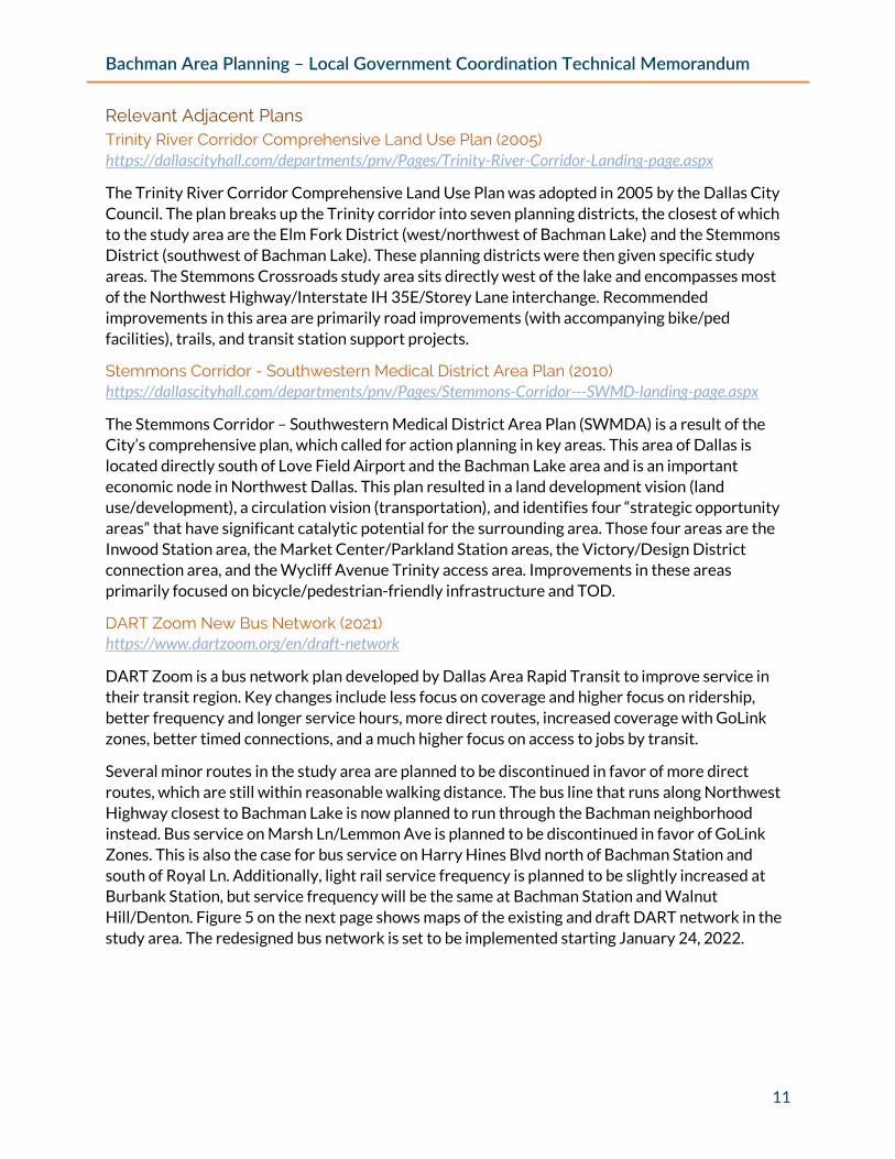
DART Zoom New Bus Network (2021) https://www.dartzoom.org/en/draft-network
DART Zoom is a bus network plan developed by Dallas Area Rapid Transit to improve service in their transit region. Key changes include less focus on coverage and higher focus on ridership, better frequency and longer service hours, more direct routes, increased coverage with GoLink zones, better timed connections, and a much higher focus on access to jobs by transit.
Several minor routes in the study area are planned to be discontinued in favor of more direct routes, which are still within reasonable walking distance. The bus line that runs along Northwest Highway closest to Bachman Lake is now planned to run through the Bachman neighborhood instead. Bus service on Marsh Ln/Lemmon Ave is planned to be discontinued in favor of GoLink Zones. This is also the case for bus service on Harry Hines Blvd north of Bachman Station and south of Royal Ln. Additionally, light rail service frequency is planned to be slightly increased at Burbank Station, but service frequency will be the same at Bachman Station and Walnut Hill/Denton. Figure 5 on the next page shows maps of the existing and draft DART network in the study area. The redesigned bus network is set to be implemented starting January 24, 2022.
Bachman Area Planning – Local Government Coordination Technical Memorandum
12
Figure 5: Existing and Future DART Network
Existing DART Network Future DART Network
Bachman Station
Walnut Hill/ Denton Station
Burbank Station
Bachman Station
Walnut Hill/ Denton Station
Burbank Station

Bachman Area Planning – Local Government Coordination Technical Memorandum
13
2012 and 2017 City of Dallas Bond Dallas residents approved a bond program in 2012 that included 11 projects in the study area. Ten of the eleven projects have been completed including the Bachman Lake Trail. The 2017 bond program approved by voters included 40 projects that fall within the study area boundaries. Twenty-six of the 40 projects have been completed while the remaining projects are either under construction or under design. Most of projects from this bond program were street resurfacing, local street reconstruction, or alley reconstruction. Figure 6 displays these projects on a map.
Figure 6: 2012 and 2017 Study Area Bond Projects (Map)

Bachman Area Planning – Local Government Coordination Technical Memorandum
14
Figure 7 displays all 2012 and 2017 bond program projects in the Bachman Lake area. The 2012 bond program totaled $12,441,700 in the Bachman Lake area while the 2017 bond program totaled $27,060,351. A total of six projects in these two bond programs included bicycle or pedestrian facilities. Street resurfacing projects are the most common project type in these bond programs followed by street reconstructions and alley reconstructions.
Figure 7: 2012 and 2017 Study Area Bond Program Projects (Table)
Name Category Status Bond
Amount District
Bicycle or Pedestrian Facility Included?
2012
Capps Dr & Rexford Dr from. Lemmon Ave parallel to Glencrest Ln
Alley Petitions Complete $146,900 13 No
Mockingbird Ln from Maple Ave to Forest Park Blvd
Flood Management Complete $2,300,000 2 No
Denton Dr from Storey Rd to Community Dr (west side only)
Sidewalk Improvements Complete $20,000 6 Yes
Langdon Ave from Thurston Dr to Denton Dr
Street Reconstruction Complete $474,000 2 Yes
Empire Central St from Harry Hines Blvd to Heartsill Dr
Street Resurfacing Complete $374,300 2 No
Lemmon Ave from W. University Blvd to Bluffview Blvd
Street Resurfacing Complete $407,700 2 No
Mockingbird Ln (W) from Maple to Harry Hines
Street Resurfacing Complete $1,010,100 2 No
Roanoke Ave from Huron Dr to Mohawk Dr
Street Resurfacing Complete $53,800 2 No
Southwell Rd from Harry Hines Blvd to Denton Dr
Street Resurfacing Complete $62,600 6 No
Bachman Lake-PB12S614 Trails Complete $1,600,000 2, 6, 13 Yes
Denton Drive Phase 1 (Walnut Hill to Royal)
Intergovernmental Partnership Projects
Under Award - Construction
$5,992,300 6 Yes
2017 2503-2623 W Lovers Ln & 2502-2614 W Amherst Ave
Alley Reconstruction Complete $195,878 2 No
3703-3771 Cortez Dr & 3702-3770 Durango Dr
Alley Reconstruction Complete $301,620 2 No

Bachman Area Planning – Local Government Coordination Technical Memorandum
15
Name Category Status Bond
Amount District
Bicycle or Pedestrian Facility Included?
3805-3945 Hawick Ln & 3804-3858 Eaton Dr
Alley Reconstruction Complete $330,922 2 No
3903-3991 Cortez Dr & 3904-3990 Durango Dr
Alley Reconstruction Complete $384,430 6 No
4902-5032 Thursh St & 4903-5033 Wenonah Dr
Alley Reconstruction Complete $262,126 2 No
Bluffview Park - playground expansion, shade structure and site development
Parks & Recreation Complete $350,000 13 No
K. B. Polk Park - Sprayground-sm., walking trail, playground, shade pavilion
Parks & Recreation Complete $2,000,000 2 No
Bristol Ave from March Ave to Hopkins Ave
Sidewalk Improvements Complete $79,872 2 Yes
W University Blvd from Roper St to Kenwell St
Sidewalk Improvements Complete $94,833 2 Yes
Bombay Ave from Huron Dr to Thurston Dr
Street Reconstruction Local Streets
Complete $1,286,618 2 No
Fillmore Dr from Empire Central to Register Ave
Street Reconstruction Local Streets
Complete $1,342,845 2 No
Cochran Chapel Cir from Midway Rd to Cochran Chapel Cir
Street Resurfacing Complete $140,000 13 No
Cortez Dr from Larga Dr to El Centro Dr
Street Resurfacing Complete $158,891 2 No
Cortez Dr from Mixon Dr to Lenel Pl
Street Resurfacing Complete $187,887 2 No
Hargrove Dr from Oradell Ln to Webb Chapel Ext
Street Resurfacing Complete $57,075 2 No
Newmore Ave from Kaywood Dr to Robin Rd
Street Resurfacing Complete $180,938 2 No
Norwalk Ave from Timberline Dr to Hargrove Dr
Street Resurfacing Complete $187,484 2 No
Oradell Ln from Timberline Dr to Hargrove Dr
Street Resurfacing Complete $269,509 2 No
Shady Trl from Manana Dr to Andjon Dr
Street Resurfacing Complete $113,670 6 No

Bachman Area Planning – Local Government Coordination Technical Memorandum
16
Name Category Status Bond
Amount District
Bicycle or Pedestrian Facility Included?
Sheila Ln from Timberline Dr to Hargrove Dr
Street Resurfacing Complete $243,433 2 No
Timberline Dr from Community Dr to Kendale Dr
Street Resurfacing Complete $107,085 6 No
W Amherst Ave from Huron Dr to Thurston Dr
Street Resurfacing Complete $204,040 2 No
W Lovers Ln from Menier St to Preston Park Dr
Street Resurfacing Complete $317,995 13 No
W Mockingbird Ln from N Stemmons Serv E to Brookriver Dr
Street Resurfacing Complete $314,098 2 No
Webb Chapel Ext from Hargrove Dr to Larga Dr
Street Resurfacing Complete $176,183 2 No
Webb Chapel Ext from Larga Dr to Webb Chapel Rd
Street Resurfacing Complete $484,899 6 No
Bachman Lake Park - Regional Family Aquatic Center - Phase 1 (with $2.5M from CD 2)
Parks & Recreation Under
Construction $3,500,000 6 No
Bachman Regional Family Aquatic Center - Phase 1 (with CD 6)
Parks & Recreation Under
Construction $2,500,000 2 No
Lenel PL (Partnership W/ Dist 2) from Clover Ln to Wemdon Dr
Street Reconstruction Local Streets
Under Construction
$786,854 6 No
Lenel Pl (Partnership W/ Dist 6)from Clover Ln to Wemdon Dr
Street Reconstruction Local Streets
Under Construction
$786,854 2 No
Lenel Pl from Wemdon Dr to Mixon Dr
Street Reconstruction Local Streets
Under Construction
$1,515,109 6 No
Viceroy Dr from King George Dr to Regal Row
Street Resurfacing Under
Construction $273,786 2 No
W University Blvd from Robin Rd to Inwood Rd
Street Resurfacing Under
Construction $103,472 2 No
Amhurst Ave. and Stanford Ave. from Linwood Ave. to Briarwood Ln. (alley)
Alley Petitions Under Design $212,000 13 No
3004-3150 Kinkaid Dr & 3045-3155 Park Ln
Alley Reconstruction Under Design $796,250 6 No
Bachman Lake Skatepark Parks & Recreation Under Design $4,000,000 6 No
Bachman Area Planning – Local Government Coordination Technical Memorandum
17
Name Category Status Bond
Amount District
Bicycle or Pedestrian Facility Included?
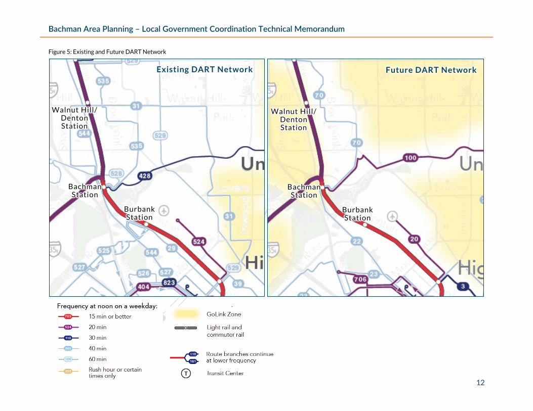
Joe's Creek West Fork Bridge @ Walnut Hill
Storm Drainage Under Design $470,000 6 No
Geraldine DR from Kendale Dr to Lombardy Ln
Street Reconstruction Local Streets
Under Design $851,847 6 No
Nagle St from Denton Dr to Overlake Dr
Street Reconstruction Local Streets
Under Design $1,125,377 6 No
Waneta Dr from Robin Rd to Inwood Rd
Street Reconstruction Local Streets
Under Design $366,471 2 No

Bachman Area Planning – Local Government Coordination Technical Memorandum
18
Dallas County Major Capital Improvement Program 7th Call for Projects The Dallas County Commissioner’s Court approved funding in December 2020 for City of Dallas projects through the County’s 7th Major Capital Improvement Program (MCIP). All seven projects in this study area are expected to improve bicycle and pedestrian access. Four projects include reconstruction of existing roadways to add bicycle and pedestrian facilities. Additionally, a feasibility study to connect the Bachman Lake Trail to Irving’s Campion Trail, HAWK signal installation on Northwest Highway, and a pedestrian needs assessment for Lovers Lane are also included. Figure 8 shows the general limits of where MCIP funding may be applied. Ongoing coordination on the scope of these initiatives and impact on other projects is needed as the City and County finalize project designs.
Figure 8: Dallas County MCIP 7th Call Projects (Map)

Bachman Area Planning – Local Government Coordination Technical Memorandum
19
Figure 9 displays all MCIP 7th Call projects in the Bachman Lake area. A total of $14,200,000 has been approved by Dallas County for these seven projects. Project scopes and information below is tentative based on information from City of Dallas.
Figure 9: Dallas County MCIP 7th Call Projects (Table)
Name Scope Limits Status Total Cost County Funding
Estimated Timing
Bachman to Campion Trail
Feasibility Study
Study feasible alignments for multi-use trail
Bachman Lake to Campion
Trail in the City of Irving
Fully Funded $450,000 $150,000 Consultant selection
anticipated in FY 22/23
Community Drive Complete Street
Reconstruct from 2 lanes to 3 with 6 ft bike lanes, 5 ft sidewalk,
includes drainage and water utilities
Denton Dr to Northwest
Highway Designed $4,140,000 $2,070,000
Construction anticipated in FY 22/23
Denton Dr Complete Street
Reconstruct from asphalt to concrete, add bike facilities and sidewalk (variable cross section)
and replace bridge over Northwest Highway
Walnut Hill Ln to Webb Chapel
Ext
Partially Funded, City to Match in
Future Bond
$4,000,000 $2,000,000 TBD pending City
match
Empire Central Drive
Complete Street
Reconstruct as complete street with bike lanes
Forest Park Rd to Maple Ave
Partially Funded, City to Match in
Future Bond
$4,160,000 $2,080,000 TBD pending City
match
NW Highway Pedestrian
Crossing Improvements
Add HAWK signal, crosswalk, and associated sidewalks with
bicycle accommodation
Denton Dr to Webb Chapel
Rd Fully Funded $1,000,000 $500,000
Construction anticipated FY 23/24
Shorecrest Dr Complete Street
Reconstruct to 4 lane complete street, may include shared-use
path or bike lane (variable cross section)
Harry Hines Blvd to Lemmon
Ave
Partially Funded, City to Match in
Future Bond
$5,000,000 $2,500,000 TBD pending City
match
Lovers Ln Study and
Signal Improvements
Reconstruct signal and crosswalk at Dallas North
Tollway intersection. Study of pedestrian
improvement needs along corridor.
Lemmon Ave to City Limit (with
University Park)
Partially Funded, City to Match in
Future Bond
$9,800,000 $4,900,000
TBD pending City match and
coordination with City of University Park and
Dallas County

Bachman Area Planning – Local Government Coordination Technical Memorandum
20
Summary Previous plans Four area-specific plans, eight city-wide plans, and three relevant adjacent plans were reviewed for this study. Major themes of these plans include health and safety improvements, transportation improvements, and social/cultural enhancements. The 2011 bike plan provides a good starting point and has been implemented in small areas but can be greatly informed by other transportation proposals, specifically crossing Northwest Highway. The recently completed sidewalk master plan is also significant to prioritizing improvements in the neighborhood. Many of the past plan infrastructure and economic recommendations have yet to be implemented. The proposed pedestrian bridge at Timberline Dr across Northwest Hwy and a proposed Tax Increment Reinvestment Zone are notable unimplemented past recommendations still of interest today.
Bond Program Most of (70 percent) the 2012 and 2017 bond projects in the study area, totaling $39,502,051 in funding, a have been completed. The remaining 15 projects are under design or under construction according to the City of Dallas Office of Bond and Construction Management. Notable bond projects that remain incomplete including the skate park and aquatic center which are now in progress. While implementing this past bond investment is mostly complete, it’s possible the scope of past bonds investment may not have been enough to deal with the high amount of community infrastructure needs.
MCIP 7th Call for Projects The recently awarded Dallas County MCIP 7th Call projects are primarily still in a conceptual or project design stage. The City of Dallas and Dallas County total funding for these projects is estimated at $28,400,000 (plus $150,000 from the City of Irving). However, four of the projects still need a source of local dollars from the City of Dallas to match County funds at 50 percent. Matching funds will likely come from a future bond that may not occur until after 2023.
In creating recommendations for the Bachman Area, duplication of funding on streets addressed by MCIP 7th call projects will be avoided but also the opportunity to coordinate design on intersecting projects should be leveraged. The funding for a bike/pedestrian HAWK signal should be included in coordination with NCTCOG and TxDOT in the larger vision for a redesigned Northwest Highway. The Bachman Lake Park trail to the Campion Trail in Irving feasibility study needs to be coordinated with the Harry Hines Blvd Study. The scenarios around a second entrance to Love Field Airport need to inform the partially funded improvements to Shorecrest Drive.

Bachman Area Planning – Local Government Coordination Technical Memorandum
21
Next Steps and Recommendations This memorandum outlines past and ongoing planning and implementation efforts by the City and County. Stakeholders have indicated there remain many challenges and needed improvements. Detailed improvement projects will be provided by NCTCOG staff later in the project. Generally, the existing plans and funding will inform those through this focus:
• More resources and coordination are needed to implement concepts for safe crossings of Northwest Highway which has been a priority for 20+ years.
• Past bond funds have been mostly implemented but the scale of need in the neighborhood likely requires further investment. Future bond programs should include more bicycle and pedestrian improvements recommended in previous plans.
• Dallas County has recently committed additional funding but how and when it will be implemented is unclear. Recurring meetings between County staff and City staff are needed to ensure efficient project completion.
• Economic development investments coordinated with transportation projects are still needed in the area.
NCTCOG will continue to coordinate with City and County staff throughout and beyond this project on the issues above to address critical gaps and upcoming opportunities that leverage adjacent major transportation investments.