local climate zones - wordpress.com climate zones iain stewart and tim oke department geography...
TRANSCRIPT

Local Climate Zones
Iain Stewart and Tim Oke
Department Geography
University of British Columbia
Vancouver CANADA
Origins, development, and application to urban heat islands
Annual Meeting of the American Association of Geographers, April 11-16, 2011, Seattle, WA
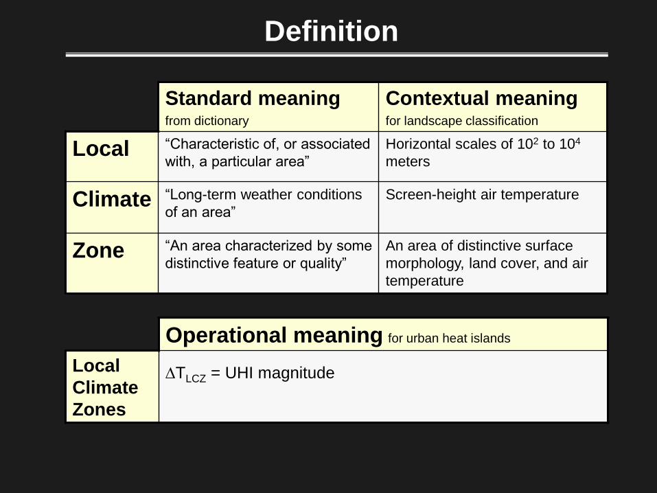
Definition
Standard meaning
from dictionary
Contextual meaning
for landscape classification
Local “Characteristic of, or associated
with, a particular area”
Horizontal scales of 102 to 104
meters
Climate “Long-term weather conditions
of an area”
Screen-height air temperature
Zone “An area characterized by some
distinctive feature or quality”
An area of distinctive surface
morphology, land cover, and air
temperature
Operational meaning for urban heat islands
Local
Climate
Zones
DTLCZ = UHI magnitude

Communicating local climate zones
Datasheets

Challenges:
• Landscape interpretation varies with culture, region, and
language…
• Sites are diverse in exposure, land cover, building materials,
human activities…
• “Urban” and “rural” are deeply rooted in UHI methodology;
lack meaningful definition...
• No comprehensive site classification system; UTZ (Ellefsen
1990-91) and UCZ (Oke 2004) are good but no rural zones…
Find common physical traits in all sites, then group traits into
distinctive classes…
How do we form a comparative, climate-based view of urban and
rural field sites?
Constructing the LCZ Framework

1. Height of roughness features
highrise > 25 m
midrise 10-20 m
lowrise < 8 m
no rise 0 m
trees > 3 m
bush 1-2 m
grasses < 1 m
soil 0 m
Buildings
Vegetation
Constructing the LCZ Framework

compact H/W > 1
open H/W < 1
sparse H/W < 0.25
compact H/W > 1
open H/W < 1
sparse H/W < 0.25
2. Packing of roughness features
Buildings
Vegetation
Constructing the LCZ Framework

impervious concrete/rock
pervious low plants
pervious soils
heavy concrete, stone
lightweight sheet metal, wood
3. Surface cover around roughness features
Constructing the LCZ Framework
4. Thermal admittance of materials

Standard Set
Local Climate Zones

Summary
• UHI datasets from Uppsala
(1948, 1976), Nagano
(2000-06), and Vancouver
(1992-2010).
• Observations support the
hierarchical structure of the
LCZ system.
• Each LCZ class has a
unique thermal climate.
• Temperature patterns are
sensitive to surface relief,
surface wetness, tree
geometry, and weather.
Observational support for LCZs
-3.5 -3.0 -2.5 -2.0 -1.5 -1.0 -0.5 0.0 0.5 1.0 1.5 2.0 2.5 3.0
Departure from group mean (K)
March 3
March 5
March 8
Average
Stewart ID, Oke TR. 2010. Preprints, 9th Symposium on Urban Environment.
Evening temperatures in Vancouver 2010

Summary S. Krayenhoff
University of British Columbia
• Highly simplified approach
(treed zones excluded).
• Urban-surface (TEB) and
plant-soil (CAPS) schemes
coupled with atmospheric
boundary layer model.
• Simulated DTR varies with
building height, packing, land
cover, and surface wetness.
• Dry/natural zones more
thermally responsive than
wet/built-up zones.
Numerical modeling support for LCZs
5 7 9 11 13 15 17 19 21
Diurnal Temperature Range (K)
DTR wet
DTR dry
See Krayenhoff et al., 2009. Preprints, 8th Symposium on the Urban Environment.
Computer simulated temperatures

Application of local climate zones
Assessing social
inequalities in
Santiago, CHILE
Mapping urban
terrain in
Novi Sad, SERBIA
Classifying
weather stations in
HONG KONG
Quantifying UHI
magnitude in
Vancouver, CANADA
Sites of LCZ testing / application

Purpose
• To define and quantify UHI
magnitude through inter-zone
temperature differences (DTLCZ).
3 March 2010 19:30 hr
Stewart ID, Oke TR. 2010. Preprints, 9th Symposium on Urban Environment.
Results
• UHI magnitude (DTLCZ) varies with
differences in morphology and land
cover between LCZ pairs.
• DTLCZ > 7 K for zones with large
morphological differences; < 2 K
for zones with small differences.
LCZ1
LCZ2
LCZ11
LCZ15
Investigators
• I. Stewart and T. Oke
University of British Columbia
DTLCZ = 2 K DTLCZ = 6 K
Quantifying UHI magnitude: VANCOUVER

Purpose
• To classify HKO weather stations into
LCZs, and identify representative
sites for UHI measurement.
Investigators
• C. Siu and M. Hart
University of Hong Kong
Results
• Three of seventeen stations are
representative of local scale.
• New standardized documentation
system for station metadata.
• Challenges with LCZ system in
Hong Kong.
Siu C. 2010. Unpublished MS Thesis, University of Hong Kong.
Classifying weather stations: HONG KONG

Mapping urban terrain: SERBIA
Purpose
• To map urban terrain and air
temperature in Novi Sad using
LCZs, and recommend strategic
configuration for an urban climate
network.
Investigators
• J. Unger et al.
University of Szeged / Novi Sad
Results
• Seven LCZs identified in Novi Sad
urban area.
• Spatial correlation between LCZs
and modeled air temperatures.
• Ten-station network recommended
for UHI monitoring in Novi Sad.
Unger J. et al. Article submitted to Advances in Meteorology.

Assessing social inequalities: CHILE
Purpose
• To map LCZs in Santiago and assess
the socio-economic status of district
populations.
Investigators
• H. Romero et al.
Universidad de Chile
Results
• LCZ morphology reflects thermal and
social inequalities in Santiago.
• High-density districts: high temperatures,
low-income populations.
• Low-density districts: low temperatures,
affluent populations. Romero H. et al. 2010. Climate change and urban climate:
Relations between thermal zones and the socioeconomic
conditions of the population of Santiago, Chile. Revista INVI
70: 151-179.

What does the local climate zone system offer ?
• The first comprehensive, climate-based classification of
landscapes for heat island investigators.
• A user-friendly classification that transfers easily to any city,
region, or culture.
• A standardized definition of UHI magnitude through
climatologically defined urban and rural zones (DTLCZ ).
• An educational and analytical tool for students, researchers,
and practitioners of urban climatology.
Final Remarks