lloyds shoals study plan meeting (ferc no. 2336)
TRANSCRIPT

Lloyds Shoals Study Plan Meeting(FERC No. 2336)January 16, 2019
2
Introduction
Courtenay O’Mara, P.E.Southern Company

3
Study Plan Meeting Agenda
Morning Session: 10:00 a.m. ‒ 12:00 p.m.
• Welcome, Introductions & Operations Presentation 10:00 – 10:30 a.m.
• Recreation and Land Use Study 10:30 – 11:00 a.m.
• Terrestrial, Wetland, and Riparian Resources Study 11:00 – 11:30 a.m.
• Rare, Threatened, and Endangered Species Study 11:30 a.m. – 12:00 p.m.
Lunch: 12:00 p.m. ‒ 1:00 p.m.
Afternoon Session: 1:00 p.m. ‒ 5:00 p.m.
• Water Resources Study 1:00 – 1:30 p.m.
• Fish and Aquatic Resources Study 1:30 – 2:00 p.m.
• American Eel Abundance & Upstream Movements Study 2:00 – 2:30 p.m.
• Geology and Soils Study 2:30 – 3:00 p.m.
• Cultural Resources Study 3:00 – 3:30 p.m.
• Q&A Discussion (if none, Early Dismissal at 3:30 p.m.) 3:30 – 5:00 p.m.

4
Study Plan Development Schedule
Comments on PAD and SD1,
and Study Requests
Study Plan Meeting
GPC FilesProposed Study
PlanFERC Issues SD2
if Necessary
Comments on
Proposed Study Plan DUE DATE
GPC FilesRevised
Study PlanFile Reply
Comments within 15 days
45
30
90
Nov 5, 2018 Dec 20, 2018 Jan 16, 2019Mar 20, 2019
FERC Issues Study Plan
Determination
No DisputesFirst
Season Studies
30
30
20Apr 19, 2019 May 20, 2019 May 2019-Apr 2020
Notice of Study Dispute
If Necessary
20Jun 10, 2019
Study Dispute Resolution
Process
70
Resolution of Study Issues
If Necessary

5
Content of Study Request (18 CFR § 5.9(b))
1. Goals and objectives of study proposal2. Relevant resource management goals
3. Relevant public interest
4. Existing information, and need for additional information5. Nexus between project operations and effects
6. Study methodology and generally accepted practice
7. Level of effort and cost
6
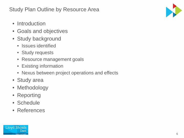
Study Plan Outline by Resource Area
• Introduction• Goals and objectives• Study background
• Issues identified• Study requests• Resource management goals• Existing information• Nexus between project operations and effects
• Study area• Methodology• Reporting• Schedule• References

7
Master Schedule for Study Implementation
Activity Start DateCompletion Date
or Deadline
Conduct Field Studies• Geology and Soils• Water Resources• Fish and Aquatic Resources• American Eel Abundance & Upstream Movements• Terrestrial, Wetland, and Riparian Resources• Rare, Threatened, and Endangered Species• Recreation and Land Use• Cultural Resources
May 2019 Apr 2020
Study Progress Report (All Studies) -- Jan 31, 2020
Study Report (First Season of Studies) -- May 19, 2020
Study Results Meeting -- Jun 3, 2020

8
Project Boundary
Project Boundary
Georgia Power Project Recreation Facilities
Public/Private Recreation Access

1
Project Operations
Melissa Crabbe, P.E.Southern Company

2
Lloyd Shoals Project (FERC No. 2336)
Generating Capacity 18 MW
Number of units: 6 (horizontal, Francis-type)
Max. hydraulic capacity: 620 cfs/unit or 3,720 cfs total plant capacity
Full reservoir storage: 107,000 acre-feet
Normal operating range: 527 to 530 feet
Average annual inflow: 1,732 cfs
Operation mode: Modified run-of-river
Minimum flow: 400 cfs or inflow, whichever is less
Spillway Capacity: 16,770 cfs

3
Lloyd Shoals Project Works Flow Release Sequence
Lake Jackson
Spillway
Auxiliary Spillway
Substation
Powerhouse

4
Lloyd Shoals Generating Unit Cross-section and Terminology
Lake Jackson / Reservoir
Ocumlgee River
Operating Unit:Turbine, Generator and Shaft
Headworks/Intake
Discharge/Tailrace

5
• No storage
• Run-of-RiverInflow = outflow all the time
• Example: old mill sites where steady power was more important than peaking power
• Project purpose: steady power or no power
Reservoir Storage and Effect on OperationsSmall Reservoirs – Run-of-River Operation

6
• Some storage
• Water is stored for hours or days
• Inflow ≠ outflow hourly or daily
Reservoir Storage and Effect on OperationsMedium Reservoirs – Modified Run-of-River Operation
• Water is released for the weekInflow = outflow on a weekly basis
• Example:Lake Jackson (useable storage = 74,750 acre-feet)
• Project purpose: power generation

7
• Significant storage
• Water is stored for months or yearsInflow ≠ outflow
• Capture flows during high flow periods for use in low flow periods
Reservoir Storage and Effect on OperationsLarge Reservoirs – Storage Operation
https://media.defense.gov/2017/Nov/29/2001849723/-1/-1/0/171129-A-CE999-006.JPG
• Example:Lake Lanier (Useable Storage = 1,087,600 acre-feet)
• Project purposes: power generation, flood control, navigation, and recreation

8
Hydroelectric Project Purpose Comparison
Lanier Basin1,040 square miles
Jackson Basin1,400 square miles
Lanier Storage2,554,000 acre-ft
Jackson Storage107,000 acre-ft

9
Large Drainage Basin – Small Amount of Storage
Atlanta
Covington
Lawrenceville
McDonough
10
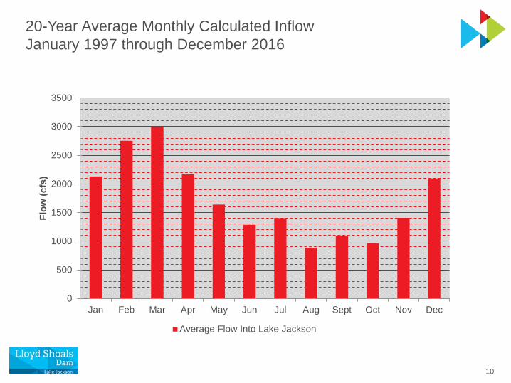
20-Year Average Monthly Calculated InflowJanuary 1997 through December 2016
0
500
1000
1500
2000
2500
3000
3500
Jan Feb Mar Apr May Jun Jul Aug Sept Oct Nov Dec
Flow
(cfs
)
Average Flow Into Lake Jackson
11
518.00519.00520.00521.00522.00523.00524.00525.00526.00527.00528.00529.00530.00531.00532.00
0
500
1000
1500
2000
2500
3000
3500
4000
5/12/2013 5/13/2013 5/14/2013 5/15/2013 5/16/2013 5/17/2013 5/18/2013 5/19/2013
Res
ervo
ir El
evat
ion
Flow
(cfs
)
NORMAL INFLOW
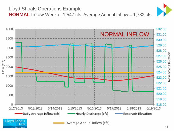
Lloyd Shoals Operations ExampleNORMAL Inflow Week of 1,547 cfs, Average Annual Inflow = 1,732 cfs
Average Annual Inflow (cfs)

12
Lloyd Shoals Operations ExampleDROUGHT Period of 313 cfs, Average Annual Inflow = 1,732 cfs
Average Annual Inflow (cfs)
518.00519.00520.00521.00522.00523.00524.00525.00526.00527.00528.00529.00530.00531.00532.00
0
400
800
1200
1600
2000
2400
2800
3200
3600
4000
7/24/2011 8/13/2011 9/2/2011 9/22/2011 10/12/2011 11/1/2011 11/21/2011 12/11/2011
Flow
(cfs
)
Daily Average Inflow (cfs) Hourly Discharge (cfs) Reservoir Elevation (ft)
DROUGHT

13
518.00519.00520.00521.00522.00523.00524.00525.00526.00527.00528.00529.00530.00531.00532.00
0
5000
10000
15000
20000
25000
30000
35000
40000
45000
12/19/2015 12/21/2015 12/23/2015 12/25/2015 12/27/2015 12/29/2015 12/31/2015 1/2/2016
Flow
(cfs
)
Daily Average Inflow (cfs) Hourly Discharge (cfs) Reservoir Elevation
Lloyd Shoals Operations ExampleHIGH Inflow Period of 17,544 cfs, Average Annual Inflow = 1,732 cfs
Average Annual Inflow (cfs)
HIGH INFLOW

14
Lake Jackson Elevation 2007-2016Typical Range Between 527 to 530 Feet
522
524
526
528
530
532
J F M A M J J A S O N D
Elev
atio
n (ft
)
Daily Maximum Elevation (ft) Daily Minimum Elevation (ft)
Typical Operating Range

15
Spillway Gate Enhancement / Operational Improvements

16
Obermeyer Gates Significantly Reduce Frequency of Reservoir Fluctuations
• Installed in 2011/2012 to replace spillway flashboards
• Decrease frequency of Lake Jackson fluctuations outside of normal pool elevation range caused by high flow events
• Eliminate safety hazards for plant personnel
• Water saved provides more water for reliable, clean, and renewable generation

17
• Weather related events• High inflows • Drought
• Task/goal oriented• Emergency• Homeowner or dam maintenance
Operations Outside of Normal Pool Elevation Range

18
Questions

1
Recreation and Land UseProposed Study Plan
Dawson IngramLake Resources Manager
Georgia Power
2
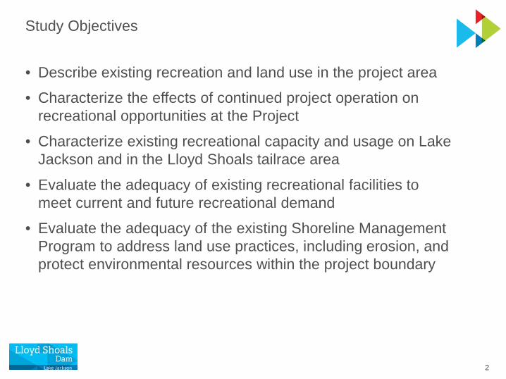
Study Objectives
• Describe existing recreation and land use in the project area• Characterize the effects of continued project operation on
recreational opportunities at the Project
• Characterize existing recreational capacity and usage on Lake Jackson and in the Lloyd Shoals tailrace area
• Evaluate the adequacy of existing recreational facilities to meet current and future recreational demand
• Evaluate the adequacy of the existing Shoreline Management Program to address land use practices, including erosion, and protect environmental resources within the project boundary

3
Issues Identified during Scoping
• Effects of the water level changes of up to 3 ft on recreational opportunities in Lake Jackson
• Effects of continued project operation on downstream recreation in the Ocmulgee River
• Adequacy of existing public access and recreational facilities in the project boundary to meet current and future recreation demand, including special events (e.g. fishing tournaments) at the Project
• Adequacy of the existing Shoreline Management Program to address land use practices, including erosion, and to protect environmental resources within the project boundary

4
Study Modification Requests and Comments
• Georgia Department of Natural Resources (GDNR) Wildlife Resources Division (WRD):
• Clarification needed on how recreational use and capacity data were calculated in the FERC Form 80 from 2015
• Evaluate existing Georgia Power boating access sites, including the tailrace boat ramp facility, to ensure they adequately support user needs
• Provide a map of Georgia Power land holdings distinguishing between leased and non-leased lands
5
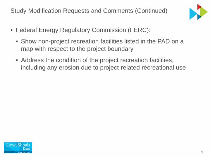
Study Modification Requests and Comments (Continued)
• Federal Energy Regulatory Commission (FERC):
• Show non-project recreation facilities listed in the PAD on a map with respect to the project boundary
• Address the condition of the project recreation facilities, including any erosion due to project-related recreational use

6
Existing Information
• Form 80 from 2015 and supporting data collected in 2014
• Article 405 Recreation Report completed in 2015
• Available Georgia Bass Chapter Federation and other fishing tournament information
• Statewide Comprehensive Outdoor Recreation Plan (SCORP) for Georgia
• Regional recreation plans
• Georgia Power Shoreline Management Guidelines
• Population and employment projections for the region developed for the state-wide water planning process

7
Study Area
• Project boundary around Lake Jackson and the Lloyd Shoals tailrace area
• Butts, Jasper, Newton, and Henry Counties
Project Recreation Facilities
Project Boundary
Public/Private Recreation Access

8
Project Recreation Facilities
Butts County Jasper County
Ocmulgee River Park
Lloyd Shoals Park
Tailrace Fishing Pier
Jane Lofton Public Access
Area
Lake Jackson

9
Project Recreation Facility Amenities
Park/Facility CountyArea
within PB Amenities
Lloyd Shoals Park Butts 5 acres Boat ramp, dock, picnic tables, pavilion, playground, swimming beach, restrooms, fishing pier, bank fishing
Jane Lofton Public Access Area
Butts 0.7 acre Bank fishing
Tailrace Fishing Pier Butts 0.6 acre Barrier-free ramp, fishing pier
Ocmulgee River Park Jasper 4 acres Boat ramp, picnic tables, bank fishing

10
Methodology Overview
• Recreational usage trends and demand
• Existing recreation facilities and opportunities
• Recreation field surveys
• Future recreation demands
• Land use assessment

11
Methodology – Recreational Usage Trends and Demand
• Analyze 2015 Form 80 and supporting data, including Article 405 Recreation Report completed in 2015
• Annual recreation use estimated for project waters
• Estimates derived from cameras, traffic counters, attendance records, staff observations, and visitor counts/surveys
• Describe methods and analyze data
• Summarize fishing tournament information for Lake Jackson from Georgia Bass Chapter Federation reports

12
Methodology – Existing Recreation Facilities and Opportunities
• Project recreation facilities• Describe and inventory recreation amenities
• Delineate area within project boundary and show on map
• Describe current condition and any project-related erosion• Public and private non-project recreation facilities providing
recreation access to project waters
• Describe recreation amenities, delineate area within project boundary, and show on map
• Regional recreation opportunities• Describe reservoirs, parks, and other water-based recreation
opportunities within a 60-mile radius of the Project

13
Methodology – Recreation Field Surveys
• Objectives: • Assess recreation user satisfaction and user trends
• Evaluate adequacy of existing facilities
• Conduct surveys at the four project recreation facilities on 5 days in spring and summer 2019• 2 weekdays, 2 weekend days, 1 holiday weekend day
• Interview recreation users with prepared questionnaire
• Periodically count vehicles and users throughout the day• Interview bank anglers at other informal access points

14
Recreation Survey Form
Site info
County of origin, group size, ages
Duration and frequency of visits
Reasons for visit
Species fished for
Quality of facilities
Improvements desired
Other parks used

15
Methodology – Future Recreation Demands
• Estimate future recreational demand based on population forecasts and review of the SCORP and other relevant plans and information
• Compare future demand to the estimated carrying capacity of the existing project recreation facilities

16
Methodology – Land Use Assessment
• Evaluate the existing Shoreline Management Program
• Review available land use and zoning information
• Apply findings of shoreline survey for Geology and Soils Study
• Prepare a land use map of lands within project boundary and zone extending 2,000 ft beyond
• Delineate developed and undeveloped lands, and leased and non-leased Georgia Power lands within project boundary
• Evaluate consistency of the Project with federal, state, regional, and local resource management plans

17
Schedule for Recreation and Land Use Study
Activity Deadline
Begin literature-based review and field surveys
May 2019
Complete literature-based review and field surveys
October 2019
File progress report January 31, 2020
File study report May 19, 2020

18
Georgia Power Shoreline Management
Mission – Georgia Power is committed to preserving the scenic, environmental, and recreational values of our lakes
http://georgiapowerlakes.com/lakejackson/

19
Georgia Power Shoreline Management Program
• Landowner agreement types
• Residential lease lots
• Access lease agreement
• License agreement
• Permitting Program for all construction, renovation, tree removal, grading, and dredging
• Shoreline Management Guidelines for structure size, setbacks, docks, seawalls, boat houses, gazebos, etc.
• Monitoring and compliance

20
Permitting Program
• A valid lease agreement or license is required to receive permits for construction on Georgia Power lakes and property
• A permit must be applied for, issued, and posted properly before beginning any construction, renovation, clearing, tree removal, grading, etc.
• To protect the vegetative buffer, no mechanical clearing is permitted within 25 feet of the shoreline

21
Shoreline Management Guidelines
• Allow reasonable use and enjoyment of lake while limiting aesthetic impact to shoreline
• Limit number, sizes, material, and configuration of shoreline structures (e.g., decks, docks, boat slips, boathouses, seawalls)
• Shoreline erosion control
• Tree removal permitting• Dredging permitting GP requires the placement
of rip-rap along the base of all seawalls…helps reduce undermining and restores shoreline habitat

22
Compliance Program
• Shoreline inspections at renewal and transfer to new owner• Random inspections
• Proactive communications with HOA, builders, realtors, and contractors
• Enforcement – work with GEPD and Local County Authorities• Unpermitted structures are subject to removal, no future
permits, termination of access lease, legal action

23
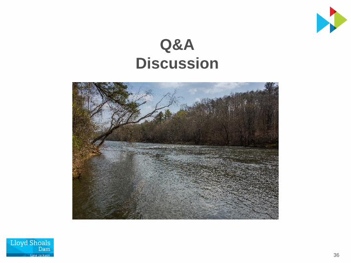
Q&ADiscussion

24
Terrestrial, Wetland, and Riparian Resources
Proposed Study PlanJim Ozier
Georgia Power

25
Study Objectives
• Describe upland terrestrial wildlife and botanical resources occurring in the Lloyd Shoals project area
• Lists of representative plant and animal species
• Identify invasive species
• Describe floodplain, wetlands, and riparian habitats occurring in the project area
• Lists of representative plant and animal species
• Identify invasive species
• Prepare a map of principal vegetative community types, including wetlands
Shutterstock.com

26
Issues Identified during Scoping
• Effects of continued project operation and maintenance, project-related recreation, and shoreline development on upland habitat, reservoir wetland, and littoral habitats, and associated wildlife
• Effects of continued project operation and maintenance, as well as project-related recreation, on state species of concern in the vicinity of the project
• Effects of continued project operation and maintenance activities, including shoreline management, and project-related recreation on non-native invasive botanical and wildlife species

27
Study Modification Requests and Comments
• WRD:• Survey and map submersed aquatic vegetation to assist
aquatic habitat planning and addressing future issues
• Develop an aquatic vegetation plan and include notifying WRD of aquatic nuisance vegetation treatment
• FERC:• Developing sufficient detail for describing existing resources
and assessing potential project-related effects
• Time field surveys for botanical RTE species to coincide with each species’ flowering or fruiting period
• File documentation of occurrences of federally listed species or their habitats as “Not for Public Disclosure, Privileged”

28
Sources of Existing Information
• GDNR State Wildlife Action Plan• GDNR Wildlife Conservation Section
• Edwards et al. (2013), The Natural Communities of Georgia
• Georgia Museum of Natural History• National Audubon Society Christmas Bird Count
• USGS North American Breeding Bird Survey
• FWS National Wetlands Inventory (NWI)• Georgia Exotic Pest Plant Council
• Georgia Power information on monitoring and treatment of terrestrial and aquatic invasive nuisance vegetation

29
Study Area
• FERC project boundary around Lake Jackson and tailrace area downstream
• For mapping vegetation and wetlands, a zone extending 2,000 ft beyond the project boundary
Project Recreation Facilities
Project Boundary

30
Methodology – Review of Existing Information
• Review existing information summarized in PAD
• Inspect existing aerial photography and NWI maps
• Compile wildlife and plant species lists for common species
• Describe vegetative community types, including wetlands
• Map vegetative cover, including approximate wetland boundaries
• Describe occurrences of non-invasive aquatic plants
• Describe Georgia Power’s invasive vegetation and management activities for Lake Jackson and project lands

31
Methodology – Field Reconnaissance Survey
• Inspect aerial photography to identify representative communities for field reconnaissance
• Visually assess terrestrial, wetland, and riparian communities from a boat and/or walking on Georgia Power or public lands
• Ground truth aerial photography signatures of representative plant communities
• Identify and approximately delineate extent of wetlands and submersed aquatic vegetation within project boundary
• Identify occurrence and extent of invasive nuisance plants within project boundary, including project recreation facilities
• Identify Bald Eagle nests and wading bird nesting areas
Wikipedia CC BY-SA 3.0
32
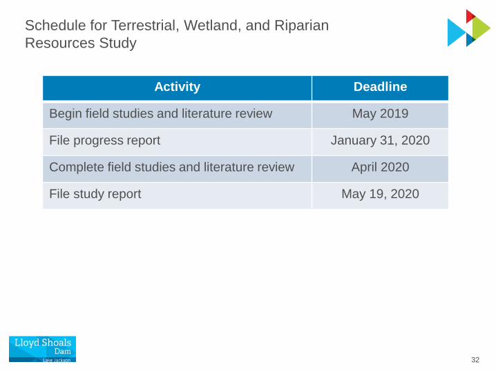
Schedule for Terrestrial, Wetland, and Riparian Resources Study
Activity Deadline
Begin field studies and literature review May 2019
File progress report January 31, 2020
Complete field studies and literature review April 2020
File study report May 19, 2020

33
Q&ADiscussion

34
Rare, Threatened, and Endangered (RTE) Species
Proposed Study PlanTony Dodd
Georgia Power

35
Study Objectives
• List federal and state RTE plant and animal species, and species currently under federal status review, with known records of occurrence near the Project
• Identify the habitat requirements of these species
• Describe distributions and habitat use of RTE species presently occurring near the Project

36
Issues Identified during Scoping
• Effects of continued project operation and maintenance, and project-related recreation, on federally listed endangered, threatened, and candidate species, and their habitat, in the vicinity of the project
U.S. Fish and Wildlife Service
Michaux’s Sumac – Federally Endangered

37
Study Modification Requests and Comments
• FWS supports the proposed DO monitoring in the Lloyd Shoals tailrace as part of the Water Resources Study because Robust Redhorse is under federal status review for listing
• FERC requests that the timing of field surveys for the botanical RTE species coincides with each species’ flowering or fruiting period, as appropriate, for accurate identification
• FERC requests that documentation of occurrences of federally listed species or their habitats be filed as “Not for Public Disclosure, Privileged”

38
Sources of Information and Data
• GDNR Wildlife Conservation Section rare element data portal
• FWS Environmental Conservation Online System
• Fishes of Georgia website
• NatureServe Explorer
• Scientific literature, manuals, texts, and technical reports
• Freshwater mollusk survey planned as part of the Fish and Aquatic Resources Study
Shutterstock.com
Nate Tessler, NANFA.org
Altamaha Shiner – GA Threatened
Bald Eagle – GA Threatened

39
Aquatic RTE Species
• No federally listed aquatic species presently known to occur at Project• Robust Redhorse and Reverse Pebblesnail under federal status review
Scientific Name Common NameGeorgia Status
Federal Status Location
Alasmidonta arcula Altamaha arcmussel T -- Lake Jackson and Ocmulgee River
Pyganodon gibbosa Inflated floater -- --a Lake Jackson
Somatogyrus alcoviensis Reverse pebblesnail -- Under review
Alcovy River upstream of Lake Jackson
Cyprinella xaenura Altamaha shiner T -- Ocmulgee River
Moxostoma robustum Robust redhorse E Under review
Ocmulgee River
a Not listed or under review but considered to be at-risk in Altamaha River basin.

40
Terrestrial RTE Species
• No federally listed terrestrial species presently known to occur at Project• Granitic outcrops preferred by many of the plant species are absent
Scientific Name Common NameGeorgia Status
Federal Status
Occurs at Project
Amphianthus pusillus Pool spritea T LT --
Eriocaulon koernickianum Dwarf hatpinsa E -- --
Isoetes melanospora Black-spored quillworta E LE --
Rhus michauxii Michaux’s sumac E LE --
Sedum pusillum Granite stonecropa T -- --
Trillium reliquum Relict trillium E LE --
Heterodon simus Southern hognose snake T -- --
Haliaeetus leucocephalus Bald eagle T -- X
Picoides borealis Red-cockaded woodpecker E LE --a Plant species limited in occurrence to granite outcrop habitats.

41
Study Area
• FERC project boundary around Lake Jackson and tailrace area downstream, including the project recreation facilities
Project Recreation Facilities
Project Boundary

42
Methodology – Review of Existing Information
• Known records of RTE occurrence in or near the Project
• Update and refine the list of RTE species from the PAD
• Describe occurrences of RTE species in the project boundary as well as those potentially occurring in the project area

43
Methodology – Field Surveys
• Identify areas of potentially suitable habitat for RTE species using existing maps, aerial photography, and literature review
• Survey representative habitats species, primarily in spring and early summer, during flowering/fruiting periods of RTE plants
• Conduct field surveys in coordination with field surveys for Terrestrial, Wetland, and Riparian Resources Study

44
Schedule for RTE Species Study
Activity Deadline
Begin field studies and literature review May 2019
File progress report January 31, 2020
Complete field studies and literature review April 2020
File study report May 19, 2020

45
Q&ADiscussion
Relict Trillium – Federally Endangered
Pete Pattavina, U.S. Fish and Wildlife Service

1
Water ResourcesProposed Study Plan
Tony DoddGeorgia Power

2
Study Objectives
• Characterize water use, availability, and water quality
• Characterize effects of continued project operation on water quality, including dissolved oxygen (DO) concentrations and water temperature, in Lake Jackson and the tailrace area within the project boundary
• Characterize effects of project operations during drought on water uses downstream in the Ocmulgee River
3
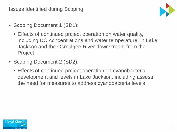
Issues Identified during Scoping
• Scoping Document 1 (SD1): • Effects of continued project operation on water quality,
including DO concentrations and water temperature, in Lake Jackson and the Ocmulgee River downstream from the Project
• Scoping Document 2 (SD2):
• Effects of continued project operation on cyanobacteria development and levels in Lake Jackson, including assess the need for measures to address cyanobacteria levels

4
Study Modification Requests and Comments
• Georgia Environmental Protection Division (GEPD):• Expand proposed tailrace water quality monitoring to a full year
• Analyze monthly grab samples from tailrace for several water chemistry parameters to support GEPD’s hydrodynamic and water quality model for the Ocmulgee River
• EPA:• Coordinate with resource agencies to define a downstream
boundary for the proposed water quality studies
• Consider year-round monitoring to demonstrate water-quality standards compliance
• Acquire downstream baseline data from readily available sources including state and federal agencies

5
Sources of Existing Information and Data
• Georgia Power seasonal water quality data collected in Lake Jackson at multiple locations from 2000 to 2017
• Water quality data collected in Lake Jackson by Adopt-a-Lake member Jackson Lake Association
• Scientific and technical literature on nutrient loading sources and land use practices upstream of Lake Jackson and their potential influences on water quality, eutrophication, cyanobacteria, and harmful algal blooms in the reservoir
• Middle Ocmulgee Regional Water Plan (2017)• Water Resource Management Plan of the Metropolitan North
Georgia Water Planning District (2017)
• Georgia 305(b)/303(d) listing documents

6
Study Area
• Lake Jackson and the Lloyd Shoals tailrace area downstream to end of project boundary
• Tributary watersheds upstream of Lake Jackson
• Ocmulgee River downstream of project boundary based on available water quality data

7
Methodology Overview
• Review existing water quality monitoring data for Lake Jackson
• Georgia Power vertical profiles and water chemistry (2000-2017)
• Adopt-a-Lake, GEPD, and other readily available sources
• Water quality monitoring in Lloyd Shoals tailrace area
• Continuous monitoring of DO and temperature for 1 year
• Monthly water chemistry grab samples for 1 year
• Literature review and analysis of occurrences of harmful algal blooms in Lake Jackson

8
Georgia Power Lake Jackson Water Quality Sampling2000-2017
Winter Spring Summer Fall
Year Jan Feb Mar Apr May Jun Jul Aug Sep Oct Nov Dec
2000
2001
2002
2003
2004
2005
2006
2007
2008
2009
2010
2011
2012
2013
2014
2015
2016
2017
Profile & chemistry data at 6 stations
Profile & chemistry data at <6 stations
Profile data only at6 stations

9
Lake Jackson Water Quality Monitoring Stations
• Georgia Power monitored six stations for several decades
• Vertical profiles measured seasonally 2000-2017
• Water chemistry sampled seasonally 2014-2017
Lloyd Shoals Dam
StationVertical Profiles
Water Chemistry
JA1
JA2
JA3
JA4
JA5
JA6
GEPD stationGeorgia Power water quality station

10
Vertical Profiles of Lake Jackson – Forebay
Thermocline
DO Chemocline
Bottom of Intake
Summer

11
Lake Jackson Seasonal Water Chemistry Parameters
Parameter
Alkalinity (mg/L)
Ammonia (mg/L)
Calcium (mg/L)
Chlorophyll a (µg/L)
Fecal coliform bacteria (MPN colonies/100 ml)
Hardness (mg/L)
Iron (mg/L)
Magnesium (mg/L)
Manganese (mg/L)
Nitrate (mg/L)
Nitrite (mg/L)
Total Phosphorus (mg/L)
Turbidity (NTU)
12
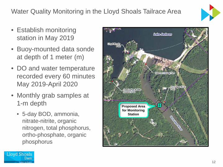
Water Quality Monitoring in the Lloyd Shoals Tailrace Area
• Establish monitoring station in May 2019
• Buoy-mounted data sonde at depth of 1 meter (m)
• DO and water temperature recorded every 60 minutes May 2019-April 2020
• Monthly grab samples at 1-m depth• 5-day BOD, ammonia,
nitrate-nitrite, organic nitrogen, total phosphorus, ortho-phosphate, organic phosphorus
Proposed Area for Monitoring
Station

13
Analysis of Information and Data
• Lake Jackson• Compile seasonal water quality data in tables and graphs
• Summarize and present other water quality data sources
• Perform cyanobacteria literature review and analysis• Lloyd Shoals Tailrace
• Align continuous water quality and operational data to evaluate effects of operations during summer and performance of existing passive draft tube aeration system
• Ocmulgee River Downstream of Project Boundary• Summarize and present available water quality data sources

14
Literature Review of Cyanobacteria Occurrence and Blooms
• GEPD information and data
• Georgia Power algal reports and sampling information
• Research program of phycologist (algal biologist)Dr. Kalina Manoylov, GCSU
• Research program of aquatic community ecologist Dr. Alan Wilson, Auburn Univ.
• UGA CyanoTracker Project
• Scientific literature

15
Schedule for Water Resources Study
Activity Deadline
Begin field studies and literature review May 21, 2019
File progress report January 31, 2020
Complete field studies and literature review April 2020
File study report May 19, 2020

16
Q&ADiscussion

17
Fish & Aquatic ResourcesProposed Study Plan
Patrick O’RoukeGeorgia Power
18
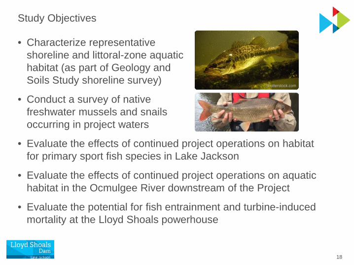
Study Objectives
• Characterize representative shoreline and littoral-zone aquatic habitat (as part of Geology and Soils Study shoreline survey)
• Conduct a survey of native freshwater mussels and snails occurring in project waters
• Evaluate the effects of continued project operations on habitat for primary sport fish species in Lake Jackson
• Evaluate the effects of continued project operations on aquatic habitat in the Ocmulgee River downstream of the Project
• Evaluate the potential for fish entrainment and turbine-induced mortality at the Lloyd Shoals powerhouse
Shutterstock.com

19
Issues Identified during Scoping (SD2 additions in italics)
• Effects of continued project operation and shoreline permitting (e.g., docks, seawalls, etc.) on fish habitat and aquatic resources in Lake Jackson, including addressing the need for habitat improvements in Lake Jackson
• Effects of continued project operation on habitat for primary sport fish species in Lake Jackson, including Largemouth Bass and stocked Striped Bass
• Effects of continued project operation on riverine fish and mussel habitat downstream in the Ocmulgee River
• Effects of continued project operation on fish movement in the Ocmulgee River, including addressing the need for fish passage (American Eel and American Shad) at the Project

20
Issues Identified during Scoping (Continued)
• Effects of continued project operation on fish entrainment and turbine-induced mortality at the Project
• Aquatic non-native invasive species and their effects on native flora and fauna within the project boundary, and the effects of continued project operation and maintenance activities and project-related recreation on non-native invasive aquatic species
• Effects of continued project operation on state species of concern in the vicinity of the Project

21
Study Modification Requests and Comments
• U.S. Fish and Wildlife Service (FWS) and National Marine Fisheries Service (NMFS) requested a study of American Eel abundance and upstream movements • Separate study plan
• WRD requested additional objectives for shoreline aquatic habitat survey• Part of Geology and Soils Study Plan
• FERC requested that desktop entrainment analysis include an estimate of total number of fish entrained annually by species, size class, and season
• WRD requested estimates of monetary loss of fish due to entrainment and impingement

22
Key Sources of Existing Information
• WRD annual standardized fishery surveys of Lake Jackson
• Previous relicensing studies for the Project, including an instream flow (IFIM) study in the Ocmulgee River downstream
• Georgia Bass Chapter Federation long-term fishing tournament database of bass catch statistics in Georgia reservoirs
• Scientific literature on the distribution, habitat use, and movements of riverine fish in the Ocmulgee River downstream
• Ongoing monitoring of Robust Redhorse downstream through existing Candidate Conservation Agreement with Assurances
• WRD records of freshwater mussels and snails in the upper Ocmulgee River basin
23
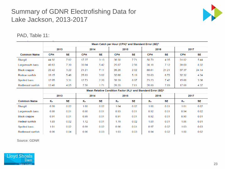
Summary of GDNR Electrofishing Data for Lake Jackson, 2013-2017
PAD, Table 11:
Source: GDNR

24
Habitat-Discharge Relationships for Target Fish Species and Life Stages in Ocmulgee River Instream Flow (IFIM) Study
• Conducted in consultation with GDNR and FWS
• 17-mile study reach
• 12 fish species/life stages
• Habitat suitability criteria derived from site-specific field studies
• Physical Habitat Simulation Model (PHABSIM) produced discharge versus weighted usable area relationships for each species life stage
Aver
age
PMW
UA
Aver
age
PMW
UA
Discharge (cfs)
SPAWNING/REARING SEASON(May-Oct)
NON-SPAWNING SEASON(Nov-Apr)
PMWUA = Percent of Maximum Weighted Usable Area

25
Freshwater Mollusk Occurrences near Lloyd Shoals Project,2008-2014
PAD, Table 15:
● Georgia state-listed as threatened.
● Petitioned for federal listing; under review.
●
●
Source: GDNR

26
Study Area
• FERC project boundary around Lake Jackson and the Lloyd Shoals tailrace area
• Ocmulgee River downstream to Juliette Dam (19 miles)
Upstream extent of anadromous fish migration
Project Boundary

27
Methodology Overview
• Shoreline habitat survey
• Presented under Geology and Soils Study Plan
• Freshwater mollusk survey
• Habitat for primary sport fish species
• Downstream riverine habitat
• Fish entrainment evaluation

28
Methodology – Freshwater Mollusk Survey
• Objectives:• Characterize occurrence, distribution, relative
abundance, and species richness of native mollusk community
• Satisfy survey objectives of Candidate Conservation Agreement for Mollusks of Altamaha River Basin
• Survey elements:1. Lake Jackson mussel survey
2. Reverse Pebblesnail survey upstream but near project boundary
3. Lloyd Shoals tailrace area mussel survey
Altamaha Arcmussel
GDNR Wildlife Resources Division

29
Methodology – Freshwater Mollusk Survey
• Led by experienced WRD mussel biologists• Conducted in summer or fall 2019
• Occupancy-based sampling model developed by WRD
• Search methods to include visual observations while wading, hand grubbing, snorkeling, SCUBA, or surface-supplied air
• Survey sites:
• Up to 12 in Lake Jackson
• Up to 12 in tailrace area to first shoals below GA Hwy 16• To be determined on-site for Reverse Pebblesnail

30
Methodology – Habitat for Primary Sport Fish Species
• Objectives:• Evaluate the suitability of summer water quality for sport fish
species in Lake Jackson, including Largemouth Bass and Striped Bass
• Data sources:• Georgia Power water quality monitoring data
• GDNR standardized fisheries survey data for sport fishes
• Temperature and DO suitability criteria reported in scientific literature for primary sport fish species

31
Methodology – Habitat for Primary Sport Fish Species
• Compile and analyze vertical profile data from up to six locations in the reservoir collected annually
• Analyze GDNR fisheries survey data for abundance and growth characteristics of primary sport fish species
• Length-frequency distribution, relative condition factors, relative abundance, catch per unit effort, and other descriptive statistics
• Evaluate water quality suitability for Largemouth Bass and Striped Bass based on water temperature, DO, and other habitat suitability information from the scientific literature
• Summarize GDNR reports on fish kill events occurring in the project waters during the current license term
• Describe littoral habitat (as part of Geology and Soils study)

32
Methodology – Downstream Riverine Habitat
• Water quality – compare tailrace continuous monitoring data to water temperature, DO, and other relevant habitat suitability information for riverine species from the scientific literature
• Physical habitat – present habitat-discharge relationships developed in previous IFIM study for comparison of habitat availability across discharges ranging from 50 to 3,500 cfs
• Riverine species – review existing literature and study information for Robust Redhorse, other riverine fish and invertebrate species, and diadromous fishes to further characterize current conditions and the potential for impacts of continued project operations to the riverine aquatic community
33
Methodology – Fish Entrainment Evaluation
• Objectives:• Characterize potential entrainment at the Project, including the
number of fish entrained annually, their size distribution and species composition, and seasonal variation in entrainment rates
• Evaluate mortality rates of fish passing through turbines based on survival tests conducted at other projects with similar head and turbine design characteristics to those at Lloyd Shoals
• Primary data sources:• Scientific literature on hydropower turbines and fish mortality
• EPRI fish entrainment and turbine passage survival databases
• Comprehensive entrainment reviews by EPRI and FERC
• Entrainment field studies from other southeastern hydro projects

34
Methodology – Fish Entrainment Evaluation
• Apply common trends and data from field studies at other hydroelectric sites with consideration of the physical, operational, and fisheries characteristics of Lloyd Shoals
• Assess potential impacts of entrainment losses based on:• Fishery survey data for the reservoir
• Intake location and other characteristics of the reservoir forebay
• Natural mortality rates of young fish
• Other relevant factors
• Evaluate potential implications to Striped Bass and hybrid bass management and experimental stocking of American Shad

35
Schedule for Fish and Aquatic Resources Study
Activity Deadline
Begin field studies and literature review May 2019
File progress report January 31, 2020
Complete field studies and literature review April 2020
File study report May 19, 2020
36
Q&ADiscussion
37
American Eel Abundance and Upstream MovementsProposed Study Plan
Patrick O’RoukeGeorgia Power

38
Study Objectives
• Identify the life stage and size range of American Eels migrating to Lloyd Shoals Dam
• Identify the timing of upstream movements in terms of seasonality and any correlation with discharge, water temperature, and percent of moon illumination
• Calculate indices of abundance of American Eel migrating to Lloyd Shoals Dam
Atlantic States Marine Fisheries Commission

39
Scoping Issue and Study Requests
• Issue identified during Scoping (SD2 additions in italics)
• Effects of continued project operation on fish movement in the Ocmulgee River, including addressing the need for fish passage (American Eel and American Shad) at the Project
• Study Requests
• FWS and NMFS requested a study of American Eel abundance and upstream movements
• This study plan adopts the agencies’ study requests, with proposed modifications to reflect existing information

40
American Eel (Anguilla rostrata) Life Cycle
• Catadromous – spending most of life in fresh or brackish water then migrating to sea to spawn
• Life stages:• Eggs – deposited in Sargasso Sea• Leptocephali – larvae drift in ocean
currents toward coast• Glass eels – migrate into estuaries
and rivers• Elvers – migrate upstream,
surmounting vertical obstacles• Yellow eels – may continue
migrating upstream; occupy wide range of habitats for several years• Silver eels – reproductively mature; migrate downstream to ocean
and to Sargasso Sea to spawn

41
American Eel Abundance in the Ocmulgee River
Station 1 Station 2 Station 3 Station 4
Miles below Lloyd Shoals Dam 0.6 – 1.1 4.2 – 4.8 14.0 – 15.0 27.6 – 28.2
Quarterly Catch (no. of fish)
April 11 26 1 10
June 30 29 23 15
September 4 19 5 10
December 2 11 6 2
Total 47 85 35 37
Quarterly CPUE (fish/0.5 hr)
April 7.3 14.3 0.2 6.0
June 19.3 17.0 3.8 7.6
September 2.7 11.3 0.8 6.3
December 1.0 6.7 1.0 1.3
Lengths (mm) Mean = 343; range: 168 – 825
American Eel Electrofishing Catch Statistics below Lloyd Shoals Dam, 1988:
Source: EA Engineering, Science, and Technology, Inc. (1990)
42
Study Area
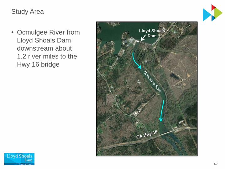
• Ocmulgee River from Lloyd Shoals Dam downstream about 1.2 river miles to the Hwy 16 bridge
Lloyd Shoals Dam

43
Methodology
• Conduct sampling during 6 months of a 1-year period
• March, April, May, and June to encompass onset and probable peak of upstream migration (after water temperature rises above 15°C)
• September and October before water temperature falls below 15°C
Water temperatures between 15 and 25 °C, suitable for migration
2017
2018
Ocmulgee River Water Temperature

44
Methodology - Electrofishing
• Sample once per month in Mar-Jun and Sep-Oct
• Boat and backpack electrofishing in daylight during off-peak releases
• Timed runs or transects in representative habitats and both sides of river• Up to four 30-minute boat
electrofishing runs
• Up to four 15-minute backpack electrofishing runs in wadeablehabitats
Study Area
45
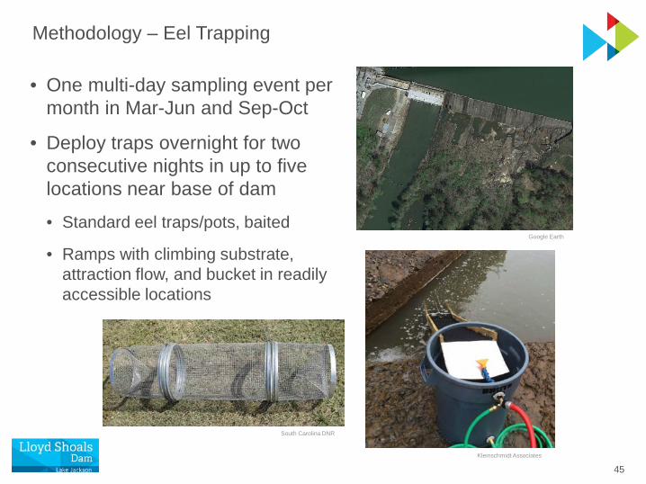
Methodology – Eel Trapping
• One multi-day sampling event per month in Mar-Jun and Sep-Oct
• Deploy traps overnight for two consecutive nights in up to five locations near base of dam
• Standard eel traps/pots, baited
• Ramps with climbing substrate, attraction flow, and bucket in readily accessible locations
South Carolina DNR
Kleinschmidt Associates
Google Earth

46
Methodology – Data Analysis
• Yellow eels will be anesthetized, measured (total length), weighed, caudal fin-clipped, a Passive Integrated Transponder (PIT) tag inserted, and released to study area
• Large numbers of elvers, if captured, will be counted volumetrically and a subsample measured for total length
• Length-frequency distributions and CPUE by gear type, and mark-recapture population estimates will be presented
• Data for environmental variables will be collected, including:• River discharge from USGS gage near Jackson• Water temperature from tailrace continuous water quality monitoring• Moon illumination from U.S. Naval Observatory
• Eel catch data will be evaluated for correlation to water temperature, discharge, and percent moon surface illumination

47
Schedule for American Eel Abundance and Upstream Movements Study
Activity Deadline
Begin field studies and literature review May 2019
File progress report January 31, 2020
Complete field studies and literature review April 2020
File study report May 19, 2020

48
Q&ADiscussion
Julie Devers, U.S. Fish and Wildlife Service

49
Geology & SoilsProposed Study Plan
Joey CharlesGeorgia Power

50
PiedmontAtlanta
Coastal Plain
SC
GA
AL
FL
Ecoregions of Georgia
Lloyd Shoals Project

51
Study Objectives
• Characterize existing shoreline conditions with respect to erosion and sedimentation in Lake Jackson and the Lloyd Shoals tailrace
• Evaluate the effects of continued project operation and project-related recreation on reservoir and tailrace shoreline erosion and sedimentation
• Conduct a survey of shoreline aquatic habitat and literature review on the relationship between shoreline structural stabilization practices and littoral-zone fish habitat

52
Representative Shorelines

53
Issues Identified during Scoping
• Scoping Document 1 (SD1): • Effects of continued project operation and project-related
recreation on reservoir and tailrace shoreline erosion and sedimentation
• Scoping Document 2 (SD2):
• Effects of continued project operation on sediment transport and accumulation within Lake Jackson, including contaminated sediment and evaluation of the need for measures to address sedimentation

54
Study Modification Requests and Comments
• WRD, regarding the shoreline habitat survey:• Provide maps representing developed and undisturbed
project shoreline areas
• Survey and map submersed vegetation in the reservoir
• Complete literature review on how rates and magnitude of shoreline development affect sport fish species such as Largemouth Bass, Black Crappie, and sunfish
• Incorporate schedules for drawdowns, including magnitude and duration, for planning aquatic plantings and fish stockings inside the project boundary

55
Study Modification Requests and Comments (Continued)
• FERC:• Denote whether erosion is project related, non-project related,
or a combination thereof
• Analyze spatial and temporal changes in geomorphology through a comparison of new and historical data, such as bathymetry, topography, and/or aerial photography
• Provide a map delineating ownership of lands along the reservoir and tailrace shorelines indicating whether land is privately or project-owned
• Summarize all dredging permits issued at the Project and available information pertaining to each dredging event

56
Other Scoping Comments
• Ms. Julia Haar expressed concern about siltation and its consequences for water quality of Lake Jackson
• Mr. Josh Williford expressed concern about accumulated sediment in Lake Jackson with respect to mercury and PCBs
• Altamaha Riverkeeper expressed concern about sedimentation with respect to water and accumulated pollutants
57
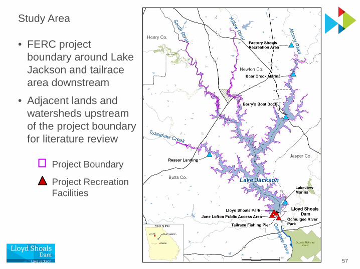
Study Area
• FERC project boundary around Lake Jackson and tailrace area downstream
• Adjacent lands and watersheds upstream of the project boundary for literature review
Project Recreation Facilities
Project Boundary

58
Study Area Sections for Shoreline Survey
• Stratified random selection of 500-ft shoreline sites
• 106 total sites
• Each project recreation facility represented
MR
TR
25 25
25
25
SR AR
TC
6
Number of survey sites

59
Shoreline Survey Form
Site info
Riparian zone
Bank stability and protection
Stabilization practices
Erosion causes(project & non-project related)
Shoreline fish habitat
Land uses

60
Methodology – Analysis of Existing Information and Data
• Shoreline temporal change analysis using aerial photography since 1993; identify changes & trends in representative areas
• Evaluate effects of project operation on shoreline erosion and sedimentation using data on reservoir fluctuation frequency
• Literature review on shoreline structural stabilization practices and their effects on littoral-zone aquatic habitat in reservoirs
• Summarize dredging permits issued and available information on dredging events (purpose, location, methods, volume)
• Prepare map delineating lands within project boundary as privately or project-owned
• Literature review on sediment transport and accumulation in Lake Jackson, including mercury and PCBs in sediment

61
Schedule for Geology and Soils Study
Activity Deadline
Begin temporal change analysis and literature review
May 21, 2019
Conduct shoreline survey Summer 2019
File progress report January 31, 2020
Complete data analysis and literature review February 28, 2020
File final study report May 19, 2020

62
Q&ADiscussion

63
Cultural ResourcesProposed Study Plan
Joey CharlesGeorgia Power

64
Source: Hudson (1997). Knights of Spain, Warriors of the Sun

65

66
Study Objectives
• Identify and delineate the area of potential effect (APE)
• Identify known historic resources through literature and site file review
• Determine if any historic properties are eligible for listing on the National Register of Historic Places (NRHP)
• Evaluate the potential for effects upon historic resources by the operation and maintenance of the Project or by activities conducted along the shoreline of the project reservoir

67
Issues Identified during Scoping
• Effects of continued project operation and maintenance on properties that are included in, or eligible for inclusion in, the NRHP
• Effects of continued project operation and maintenance on archaeological and historic resources at the Project

68
Study Modification Requests and Comments
• FERC:
• Provide maps that clearly identify the APE in relation to project boundary
• Provide documentation of concurrence on the proposed APE from the GDNR Historic Preservation Division (HPD) and potentially affected tribes

69
Study Background – Resource Management Goals
• GDNR Historic Preservation Division (HPD) administers state historic preservation under Georgia’s State Historic Preservation Plan 2017-2021: Integrating Innovation with Preservation
• Resource management goals consistent with the plan include:• Preventing the unintentional disturbance of
historic properties
• Preserving the integrity of any historical structures of the project dam and powerhouse and historical information regarding the development of the Project

70
Study Background – Existing Information and Data
• Historic properties investigated during previous relicensing
• Six sites recommended eligible for NRHP now monitored annually as part of existing Cultural Resources Management Plan (CRMP):
• Lloyd Shoals Construction and Operator’s Village
• Dempsey Ferry – historic artifact scatter, inundated
• Hendrick’s Mill – structural remains, inundated
• Powerhouse and dam also recommended as eligible resources; managed according to CRMP maintenance guidelines

71
Archaeological Investigations
Brockington and Associates (1989)

72
NRHP-Eligible Lloyd Shoals Powerhouse
Prior to 1983 transformer explosion and fire (EDAW, 1990)
Powerhouse today, with upper floor half the size of the original
The interior of the first floor today remains remarkably similar to historic photographs
73
Study Area
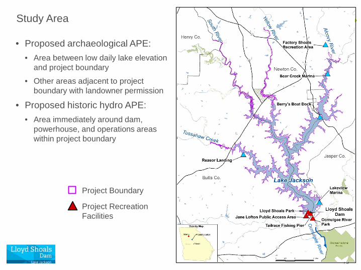
• Proposed archaeological APE:• Area between low daily lake elevation
and project boundary• Other areas adjacent to project
boundary with landowner permission
• Proposed historic hydro APE:• Area immediately around dam,
powerhouse, and operations areas within project boundary
Project Recreation Facilities
Project Boundary

74
Methodology
• Performed by professional cultural resources consultant
• Prepare maps showing APE in relation to project boundary
• Review existing information and data
• Conduct further evaluation of sites recommended eligible for NRHP
• Definitive determination of eligibility and need for monitoring
• Conducted in consultation with HPD and in accordance with Georgia Standards and Guidelines for Archaeological Surveys
• Photo-document current condition of dam, powerhouse, and project works

75
Tribal Consultation
• FERC initiated government-to-government consultation with tribes identified by FERC as having cultural, religious, or historical ties to the project area
• Georgia Power will participate in consultation as a “non-federal designee”
• Georgia Power will incorporate input from consulting tribes into studies, report findings, and the Historic Properties Management Plan (HPMP) as appropriate

76
Schedule for Cultural Resources Study
Activity Deadline
Begin field studies and literature-based review
May 2019
File progress report January 31, 2020
Complete field studies and literature-based review
March 2020
File final study report May 19, 2020

77
Q&ADiscussion