llandovery evelopment environmental … llandovery.pdfthis development is now subject to a...
TRANSCRIPT

LLANDOVERY DEVELOPMENT ENVIRONMENTAL IMPACT ASSESSMENT

Sagicor Ja. Ltd. (LOJ) Llandovery Development Environmental Impact Assessment
________________________________________________________________________
SAGICOR JAMAICA LIMITED (FORMERLY LIFE OF JAMAICA) JAMAICA
LLANDOVERY DEVELOPMENT
ENVIRONMENTAL IMPACT ASSESSMENT
JUNE 2008 TECHNOLOGICAL AND ENVIRONMENTAL MANAGEMENT NETWORK LIMITED 20 WEST KINGS HOUSE ROAD KINGSTON 10 JAMAICA TEL: (876) 920-6012 [email protected] WWW.TEMNETWORK.COM

Sagicor Ja. Ltd. (LOJ) Llandovery Development Environmental Impact Assessment
________________________________________________________________________
TOC - i
LIST OF CONTENTS Page
4.3. Socio-Economics Assessment 57 4.3.1. Demography 57 4.3.2. Employment and Income 59 4.3.3. Transportation 60 4.3.4. Social Services 60 4.3.5. Education 60 4.3.6. Housing 61 4.3.7. Solid Waste Disposal 62 4.3.8. Community Fabric Cohesion 62 4.3.9. Cultural Heritage 63 4.3.10. Public Perception 63
4.4. Hydrogeology 64 4.4.1. Geology, Topography and Soils 64 4.4.2. Groundwater and Surface Water Resources 65
Executive Summary Summary i-xvi
1.0 Introduction 1 1.1 Terms of Reference 1 1.2 Impact Assessment 1
2.0 Description of Project 2 2.1 Background 2
2.1.1. Historical Information 2 2.1.2. Geography 2 2.2. Proposed Development 3
3.0 Methodology 5 3.1 Environmental Chemistry 5
3.1.1. Water Quality 6 3.1.2. Noise 8 3.1.3. Air Quality 10
3.2 Ecology 11 3.2.1. Terrestrial Ecology 12 3.2.2. Marine Ecology 14
3.3 Socio-Economics Assessment 15 3.3.1. Land Use 16
3.4 Hydrogeology 18 3.4.1. Background and Approach 18 3.4.2. Explorative Drainage Assessment 20 3.4.3. Site Description 20
3.5 Coastal Dynamics 20 3.5.1. Location and Bathymetry 21
4.0 The Environmental Setting 23 4.1 Environmental Chemistry 23
4.1.1. Water Quality 23 4.1.2. Noise 28 4.1.3. Air Quality 30
4.2 Ecology 30 4.2.1. Terrestrial Flora 30 4.2.2. Terrestrial Fauna 41 4.2.3. Marine Flora and Fauna 44

Sagicor Ja. Ltd. (LOJ) Llandovery Development Environmental Impact Assessment
________________________________________________________________________
TOC - ii
4.4.3. Sewerage Facilities 66 4.4.4. Flooding or other disaster incidents 66 4.4.5. Seismic Hazard 66 4.4.6. Landslip Hazard 66 4.4.7. Pollution Incidents 66 4.4.8. Hydrological Assessment 67 4.4.9. Flooding Potential 70 4.4.10. Site Storm Runoff 72
4.5 Coastal Dynamics 74 4.5.1. Hurricane Waves and Storm Surge 74
5.0 Stakeholders and Public Consultation 84
6.0 Environmental Impact Assessment 85 6.1. Environmental Chemistry Impacts 85
6.1.1. Present Impacts 85 6.1.2. Projected Impacts 85
6.2. Ecological Impacts 86 6.2.1. Loss of land use 86 6.2.2. Loss of Habitat and Biodiversity 87
6.3. Socio-Economics Impacts 92 6.3.1. Construction Impacts 92 6.3.2. Post-Construction 93
6.4. Hydrogeological Impacts 94
7.0 Recommended Mitigation and Monitoring 95 7.1. Environmental Chemistry 95
7.1.1 During Construction 95 7.1.2 Post Construction 95
7.2. Ecology 95 7.2.1. Clearing Phase 96 7.2.2. Site preparation and Construction Phases 100
7.3. Socio-Economics 102 7.3.1 Community Development /Recreation 102
7.4. Hydrogeology 103 7.4.1 Drainage control during construction 103 7.4.2 Drainage control during operation 105
7.5 Monitoring and Management Plan 107
8.0 Assessment of Alternatives to project 108 8.1. Alternative 1: Without Project Scenario 108
8.1.1. Ecology 108 8.1.2. Socio-Economics 108
8.2. Alternative 2: With Project Scenario 109 8.2.1. Ecology 109 8.2.2. Socio-Economics 110
9.0 Legislative and Regulatory Framework 111 9.1. Responsible Authorities 111 9.2. Planning and Environmental Legislation 112 9.3. Other Significant Legislation and Policies 114
10.0 References 115

Sagicor Ja. Ltd. (LOJ) Llandovery Development Environmental Impact Assessment
________________________________________________________________________
TOC - iii
11.0 Appendices
Appendix I – Terms Of Reference
Appendix II – Monitoring Plan
Environmental Chemistry
Ecology
Hydrogeology
Appendix III – Environmental Management Plan
Appendix IV – Impact Matrices
Weighting for Impact Matrix
Environmental Chemistry
Ecology
Socio-Economics
Appendix V – Maps
Proposed site concept
Location Map of Montego Bay, St. James
Appendix VI – Hydrogeology
Appendix VII – Environmental Chemistry
Appendix VIII – Project Personnel
117
Sagicor Ja. Ltd. (LOJ) Llandovery Development Environmental Impact Assessment
________________________________________________________________________
Summary - i
EXECUTIVE SUMMARY Sagicor Jamaica Limited (formerly Life of Jamaica) proposes to develop a beachfront property in Llandovery in the Parish of St. Ann. This development is now subject to a feasibility study which includes an Environmental Impact Assessment (EIA) which is a requirement of the National Environment and Planning Agency (NEPA) in exercising their powers under the NRCA Act 1991. Technological and Environmental Management Network (TEMN) Limited has been engaged by Life of Jamaica, through Reliance Consulting Group Limited to carry out the EIA, and this report presents the findings thereof. The Environmental Impact Assessment was carried out by a multidisciplinary team, and utilised skills in biological assessments, hydrogeology, environmental chemistry, socioeconomics, oceanography, and project management. A comprehensive evaluation of the study area was carried out and the environmental character of the area determined. This was related to the development plans and the potential impacts identified. Recommendations are made which are aimed at ensuring compliance with relevant environmental statutes, and ensuring the preservation or restoration of the ecological balance through the mitigation of anticipated impacts The site is located within the district of Llandovery (Latitude N 18o29’57.3”, and Longitude W077o38’27.9”), St. Ann which is situated on Jamaica’s north-west coast. St. Ann otherwise called the “Garden Parish” is located at latitude 18°12'N, longitude 77°28'W. It is bordered by Clarendon, St. Catherine, St. Mary and Trelawny. Its coast washed by the Caribbean Sea, St. Ann covers an area of 1,212.6km, making it the largest parish. The population was an estimated 168,726 in 2001. There are two distinct tourist areas in the parish - Ocho Rios and Runaway Bay. Ocho Rios ranks with Montego Bay and Negril as the three most popular tourist destinations in the island. However, it leads in cruise ship arrivals. The industry is a major employer and supports other businesses in the resort areas and parish. The development proposes to have 300 habitable units on 4.087 hectares of beachfront property inclusive of studios, apartments and townhouses. Along with an administration building and a club house with spa, commissary, kitchen, dining, sports bar, kiddies pool and adult swimming pool with swim up bar, on the beach front side.
There are also plans for development of a boardwalk and viewing deck alongside a natural stand of mangroves. Road ways will be made of asphalted concrete while parking spaces (278) will be made of turf block (to minimise surface drainage). National Work Agency (NWA) requested a 9.14m building set back from front boundary adjacent to the Highway while NEPA requested 31.25m building set back from the high water mark on sea frontage except for the beach swim up bar. Buildings will be 2 and 3 storey high built of 6” concrete blocks and reinforced concrete floors. Most rooms will have two-wall exposure with large windows for maximum cross ventilation. Mini Split air conditioning units will be used only when necessary as ceiling fans will be installed in most rooms. Sewage treatment will be via Chromoglass® package plant and Constructive Wetlands with adjoining Retention Tanks for recycling irrigation to landscape areas.

Sagicor Ja. Ltd. (LOJ) Llandovery Development Environmental Impact Assessment
________________________________________________________________________
Summary - ii
Pre-construction activities would include bushing to allow for surveyor to establish levels and the establishment of site office inclusive of temporary on site pit latrine. Construction method and works would be conventional i.e. Strip or raft foundation.
Duration of construction phase should not exceed 6 months for road and sewage. The construction of the Beach Cottages should not exceed 12 months. Both activities could go on simultaneously.
Water and electricity will be supplied in the usual manner. Solid waste disposal will be carried out by the National Solid Waste Management Agency (NSWMA). Storm water flows will be captured and dispersed to the main drain using storm water pipes of the required size.
IMPACT ASSESSMENT The Environmental Impact Assessment was carried out by a multidisciplinary team, and utilised skills in biological assessments, hydrogeology, environmental chemistry, socioeconomics, oceanography and project management. A comprehensive evaluation of the study area was carried out and the environmental character of the area determined. This was related to the development plans and the potential impacts identified. Recommendations are made which are aimed at ensuring compliance with relevant environmental statutes, and ensuring the preservation or restoration of the ecological balance through the mitigation of anticipated impacts. Environmental Chemistry Impacts
Present Impacts TSS and turbidity results were consistent with the fact that no obvious sources of pollution were observed in the immediate vicinity. However physical evidence photographed, point to moments of high flow, which may contain considerable amount of silt and rubble. Phosphate levels were close to, but just within the draft marine standard. Nitrate levels however exceeded the standard suggesting impact from land-based sources external to the development site. The absence of faecal coliform indicates no direct impact from sewage or livestock waste on coastal water quality at the time of sampling.
Projected Impacts
During Construction potential impacts will be associated with the movement of traffic engaged in the transportation of construction material as well as earth movement. Specific impacts could include:
1. Silt laden run off from the site to the marine environment, 2. Spillage of earth and debris from trucks onto roadways

Sagicor Ja. Ltd. (LOJ) Llandovery Development Environmental Impact Assessment
________________________________________________________________________
Summary - iii
3. Aeolian dispersion of dust 4. Deposition of earth on roadways from truck wheels 5. Disposal of sewage generated by site workers 6. Disposal of solid waste generated by construction activity
Post Construction Impacts to the environment will be associated with the populating of the area and the conversion of soft surface to hard surface. Specific impacts anticipated include:
1. Increased run off to the marine environment 2. Sewage discharge to the environment 3. Introduction of household solid waste to the area.
Post Construction Impacts to the development will be associated with the location of the development adjacent to a major highway to the south, the marine environment to the north, and a major drain to the east. Specific impacts likely include:
1. Corrosion of metallic fixtures and materials 2. Susceptibility to intrusive noise from traffic 3. Susceptibility to tidal influence and storm water runoff from the nearby hilly
region.
ECOLOGICAL IMPACTS Development of residential development projects with multiple units designed as integrated scheme on single expanse of land such as the Llandovery property brings with it a series of environmental impacts. The following section identifies anticipated environmental impacts resulting from the proposed project based on the information provided and on the surveys conducted in the area. The environmental impacts are summarised, rated and classified as immediate, short-term, long-term or deferred in the Impact Matrix .Environmental impacts of significance during and post construction phases include: Loss of Land Use: The portion of the Llandovery property that has been proposed for the condominium development has been partially cleared and has been previously exploited (possibly as agricultural or pasture lands). Construction of condominium units represents a permanent and irreversible commitment of land resources, eliminating all other land use options including agricultural uses or rehabilitation of the area as a nature reserve. Loss of Habitat and Biodiversity Loss of Vegetative Cover The clearing of the site in preparation for the construction phase represents an immediate and negative environmental impact to the area. The removal of trees and shrubs would reduce the existing forest cover, resulting in irreversible loss of natural habitat for flora and associated fauna in the area. The construction activities and the presence of the development will impact negatively on the composition of the bird community and lead
Sagicor Ja. Ltd. (LOJ) Llandovery Development Environmental Impact Assessment
________________________________________________________________________
Summary - iv
to loss of species from the area, especially of the forest-based endemic species. The development site is situated in the middle of a stretch of undeveloped coastal area and will result in permanent fragmentation of the existing habitat. This carries with it the possibility of permanently altering the movement patters of terrestrial fauna and/or nesting and feeding patters of the avifauna thereby altering the overall function of the ecosystems in the area (Clevenger & Waltho 2003). Loss of Avifauna The proposed development will have negative (disruptive) effects on the bird composition of the area. There will obviously be loss of species from the area, however based on the low numbers of species observed, any loss would be negligible. It is expected that most species would relocate to more suitable habitat. Impact on the Beach and Wetland areas Wetland areas, common to Jamaica’s coastal areas, are among the most biologically productive ecosystems and are defined as “a site where plants and animals have become adapted to temporary or permanent flooding by saline brackish or fresh water” including “permanently or temporary flooded lands with sedge or grass morass, swamp forest or mangroves”. Regardless of the size, coastal wetland areas are essential to coastal stability and to reducing coastal erosion by acting as a physical buffer and against wave action and flood waters. Acting as “sinks”, wetland areas are capable of absorbing and slowing down flood waters thereby reducing riverbed and coastal erosion. Wetland areas or costal marshes also act as a natural “sediment trap” playing a vital role in protecting coral reefs and seagrass beds from being smothered by silt brought downstream by flood waters. Wetland areas support a rich indigenous flora, and fauna, with several of the species being endemic. Species of birds, crabs, fish, brackish water shrimp and also commercially important species use wetland areas as breeding and nursery grounds. The Jamaican government (NEPA – Coastal Zone Management &Wetland Policy) has adopted the mangrove and coastal wetlands protection policy and regulation in order to promote the management of coastal wetlands to ensure that the many benefits they provide are sustained. Wetlands are an important part of Jamaica's coastal resources and their preservation is a key component of coastal area management. In addition to the national significance, government has a wider responsibility to conserve wetlands (especially those which are waterfowl habitats) as a signatory to the Ramsar Convention on Wetlands of International Importance. Wetland destruction resulting from draining and filling activities associated with land reclamation has been shown to result in loss of fishery resources as well as reduced flood control. The draining of wetlands by widening and deepening of wetland compromises the role and the capability of these areas in slowing the run-off of flood waters. The consequences of manipulating coastal wetland areas contributes to increasing freshwater flows to coastal areas contributing to the die-off of nearby coral reefs. Housing developments located on or near drained/filled wetland areas are more vulnerable to the effects of natural disasters including wave action, flash flooding and the occurrence of nuisance species e.g. mosquitoes. The potential increase in runoff from the construction site would compound the nutrient

Sagicor Ja. Ltd. (LOJ) Llandovery Development Environmental Impact Assessment
________________________________________________________________________
Summary - v
loading into the reef lagoon which is already heavily impacted by sedimentation and could result in further deterioration of inshore water quality, with negative impacts to the marine life due to loss or degradation of the benthic habitat. Increased use of the beach area by the residents of the condominium could result in trampling of the Turtlegrass beds in the shallow waters which not only serve as a nursery habitat to numerous juvenile fish species but also serve to trap sediments in the lagoon. Loss or Alteration of Turtle Nesting Grounds Sea turtles: The sandy Llandovery beach is a known turtle nesting area. The area has not been developed and as such there is no light pollution onshore to confuse the navigation instincts of returning turtles coming to lay eggs. Two species of turtles have been reported nesting in the area including the greenback and the Hawksbill turtles. Turtles favour nesting on remote, clean sandy beaches, preferably under some type of vegetative cover. Their nesting behaviour can be very easily disturbed by beach development or activity, noise and light pollution, litter, disease and many other variables. Construction of buildings and other structures near or on beaches used by hawksbills can alter the beach and destroy the vegetation and other conditions needed for successful reproduction. As such measures must be taken to ensure that the natural state of the beach is not directly or indirectly compromised in a manner that could deter turtles from nesting on the beach. Soil Erosion and Changes in Drainage Patters Clearing vegetation, site grading, construction, excavation and concentrated discharge of collected runoff could impact the existing drainage patterns in the area resulting in erosion and increased sedimentation, if not properly controlled. Removal of trees and other vegetative cover on the site and the subsequent construction and excavation activities required for infrastructure installation (paving of roads, laying of water/sewage pipes, electrical cables, etc.) will impact the existing drainage patterns in the area. More specifically, the clearing of the riparian vegetation along the east and west borders of the property, along the seasonal waterways which receive waters from the watershed via culverts located along the highway will lead to soil erosion and excess run-off especially during the rainy season. Seasonal streams provide natural waterways that can facilitate the management of runoff from the property serving as principal pathways for storm water run-off from the site near the eastern and western boundaries of the property. Loss of topsoil due to soil erosion as well as excessive runoff into the reef lagoon is a cause for concern which must be addressed prior to the clearing phase. Due to the location and the elevation of the project site soil erosion will remain a problem during the clearing, the construction and the operational phases if proper measures are not implemented. In addition to soil erosion and run-off, lack of proper drainage ways could result in localized pooling and flooding on the project site, providing ideal conditions for the proliferation of nuisance pests such as mosquitoes. Excessive runoff, especially during heavy rains, could also lead to elevated nutrient loading into the reef lagoon. The compounded effect of turbidity and sedimentation would negatively impact the inshore water quality and the seagrass beds in the reef lagoon. Transportation and Storage of Construction Materials Transportation of heavy machinery and building supplies/materials implies heavy traffic on the roads leading to the site with possible negative impacts such as gas emissions, dust, petroleum spillage and noise to the surrounding

Sagicor Ja. Ltd. (LOJ) Llandovery Development Environmental Impact Assessment
________________________________________________________________________
Summary - vi
area. Use of uncovered trucks for transporting building materials as well as improper storage of building materials, especially gravel, sand and cement on the construction site could lead to inadvertent dispersal of materials during heavy rains or high winds during dry periods. This could have a negative impact on the coastal waters. Improper storage or handling of hazardous or flammable materials, including fuel, paints and solvents) could result in soil contamination. Airborne and Noise Pollution The increased traffic to the area, use of heavy equipment during the clearing of the site and transportation of building materials will create noise and raise dust which could further disturb the habitat of the existing fauna, in particular the birds nesting in the area, as well as the plants and insects they feed on. Dust and emissions from the construction vehicles and heavy machinery are inevitable both during the site clearing as well as during construction phases. Airborne pollution, in particular dust resulting from clearing of the land and from exposed piles of building materials (e.g. sand, cement, etc.) may further stress the local flora and fauna, and may also pose a health risk to construction workers and residents in the vicinity who suffer from asthma or other respiratory ailments. Disposal of Construction Debris Construction debris generated throughout the construction cycle of the development must be managed efficiently through a waste management plan in order to avoid negative impacts to the site and the surrounding area. Cut vegetation resulting from the clearing of the area could pose a fire hazard and affect air quality if burned on location. Other construction materials including concrete waste, wood, steel, packaging plastics could be dispersed and could end up blocking drainage channels if not disposed of at approved disposal sites. Sewage and Garbage Disposal Inadequate provision of portable restrooms and garbage dumpsters at the construction site could lead to unsanitary conditions. Resulting impacts could vary from unsightly littering of the site, fly and vermin infestations to increased nutrient levels in the stream leading into the bay. Reliable sewage treatment systems are a long term concern for the area. It is essential for the villas, cottages and the nearby beach recreation area to have proper sewage treatment systems capable of handling increases in capacity while ensuring that there is no direct discharge of untreated effluent into the porous substrate which drains directly into inshore marine waters. Other concerns include:
• Density of building area to land area • Given the typically poor standard of environmental management practice on
construction sites in Jamaica, particular attention should be paid to the monitoring of the construction works (Monitoring plan).
SOCIO-ECONOMIC IMPACTS Socioeconomic impacts include construction and post-construction impacts. These are summarized in the Impact Matrix in Appendix IV.

Sagicor Ja. Ltd. (LOJ) Llandovery Development Environmental Impact Assessment
________________________________________________________________________
Summary - vii
Construction Impacts Land Use Land use impacts of the proposed development are limited to the change of use from vacant land to residential development. The proposed land use is located within an area identified as “Coastal Development Area Boundary” on the St. Ann Development Order. Employment and Income Employment and income would be impacted positively by the proposed development. The positive impact is represented by the creation of jobs during construction of the development. Transportation Transportation impacts may be temporary. There may be an increase in vehicular traffic with the movement of construction materials and equipment on and off site. Community Development Lands within 0.5km of the site are undeveloped vacant lands. As such, there will be no construction impact on the community. Post-Construction The post-construction impacts of the proposed development include national/regional impacts, land use, employment and community development/recreation. National/Regional Development The proposed development includes the construction of a residential community with recreational facilities. This will contribute to overall housing development and will increase the housing stock of the nation. There may be employment generation for security personnel, domestic workers and staff for the recreational facilities on site. This will contribute to the reduction of the unemployment rate of the parish of St. Ann (regional) and the country. Land Use The proposed development’s post-construction impact on land use is limited to change in use from undeveloped vacant land to a residential community. Employment As mentioned above in the national/regional impacts, the post-construction phase of the proposed development will provide employment on the local, regional and national scale. Transportation Post-construction impacts on transportation include increased vehicular traffic from increased movement with additional residents moving into the area. However, the proposed development is located along the North Coast Highway which is adequate to accommodate the expected increased activity.

Sagicor Ja. Ltd. (LOJ) Llandovery Development Environmental Impact Assessment
________________________________________________________________________
Summary - viii
Community Development/Recreation The post-construction impacts on the community/community development and recreation are both positive and negative. The positive impact is long-term and direct. There is the potential for increased employment opportunities which may result in increased economic activities in the area. Increased employment will lead to increase incomes, which will affect other economic activities such as shopping facilities for the population with increased residual incomes to spend on consumer goods. The proposed development will also increase the availability of recreation facilities within the community as the proposal includes recreational facilities including a restaurant and club house with fitness centre and spa, swimming pool and a beach. The proposed development has the potential for increasing employment, housing stock and therefore has the potential for increasing the population of the area. There will be increased vehicular traffic and the need for services (for example, banks and ATMs) will increase. The existing social services (schools, waste disposal systems) may not be able to facilitate the increased activities anticipated in the SIA study area.
HYDROGEOLOGICAL IMPACTS
The major, temporal impacts occur during construction as the land is developed and most vulnerable to the impacts of atmospheric events. The impacts are mitigable if sediment and erosion control planning objectives aligned to those outlined in Section 4.4 are implemented and maintained over the duration of the project.
During operation the major sources of impacts to water and soil resources are considered to the open channel flow and channel maintenance. The implementation of the concrete open channel will benefit river bed integrity in the lower reach. Consequently surface water quality will see a small, positive impact as fine soil material that normally would be mobilized within the lower reach. Maintenance of the channel may also contribute negatively to downstream water quality, if done during the annual wet seasons.
RECOMMENDED MITIGATION ENVIRONMENTAL CHEMISTRY The development of a mitigation strategy should include a consideration of the following:
During Construction 1. Ensure adequate covering of haulage vehicles. 2. Use of wheel washing or gravel beds to reduce deposition of earth on roadways
from truck wheels 3. Sprinkling of site to prevent aeolian dust dispersion 4. Provide approved portable sanitary facilities for site staff 5. Use of adequate measures to contain site run off.

Sagicor Ja. Ltd. (LOJ) Llandovery Development Environmental Impact Assessment
________________________________________________________________________
Summary - ix
6. Disposal of construction debris and solid waste at an approved location.
Post Construction 1. Employment of tertiary sewage treatment to prevent any contribution to nitrogen
load. 2. Reservation of adequate land area to modulate surface run off from the developed
site 3. Adequate set back from the highway and the marine environment. 4. Use of vegetation to buffer the corrosive effect of the marine atmosphere. 5. Use of vegetation to modulate noise from the highway.
ECOLOGY Construction of a subdivision such as the Llandovery Project represents a permanent and irreversible commitment of land resources. Although the area proposed for the project has been previously exploited, it will no longer be available for other uses especially not for rehabilitation to its natural state. The loss of natural habitat as well as a loss of the option for alternative uses of the land is a significant negative impact. The following recommendations are based on fundamental principles outlined in The National Land Policy (1996) which acknowledges the direct relationship between the use of land for domestic, commercial, industrial or agricultural purposes, the generation of waste by these uses and the impact on the quality of both surface and groundwater resources. The land policy addresses specific land use and water resource management issues and speaks to the following: • the need to preserve and reforest watersheds to ensure the recharge of aquifers and
reduce the problem of flooding and turbidity in rivers • the institution of programs to eliminate the pollution of rivers and streams by
pesticides, herbicides and other pollutants • preserving vegetation along water courses.
Clearing Phase
Mitigating Loss of Habitat and Biodiversity
Impact mitigation calls for protecting and restoring as much of the original condition on the development site as possible. Additional measures must be considered to further minimize negative impacts on the terrestrial ecology in the area, more specifically:
Mitigating Loss of Vegetation Prior to the commencement of site clearing and construction, a qualified landscape manager (hired for the duration of the project) should be tasked with creating a landscape plan, which includes a vegetation map clearly identifying all mature and ecologically valuable trees (trunk diameter >30cm) earmarked for protection. The identified trees must be clearly marked and protected. This map can be used to adjust final construction plans as well as individual lots with the goal of minimizing tree removal. A landscaping plan includes action items corresponding to each phase of the project ensuring
Sagicor Ja. Ltd. (LOJ) Llandovery Development Environmental Impact Assessment
________________________________________________________________________
Summary - x
gradual, albeit partial, restoration of the site’s ecological characteristics. A landscape plan would ensure that designated trees are protected and/or if absolutely necessary, relocated and that areas suitable for replanting are identified and landscaped using only local tree and shrub species used for feeding by local bird species. Selecting appropriate plant species for replanting is essential in determining the types of birds, butterflies and other fauna that will re-inhabit the site upon completion of the project. Landscaping is deemed to be a powerful mitigation activity with a positive impact by: • Maintaining and replanting green areas on the development site with trees and shrubs that
would continue to attract avifauna to the area • An integral part of the landscape plan should also address means of protecting and
monitoring the wetland areas during site clearing and construction phases to ensure that the ecological integrity of the area is maintained.
• Incorporate as far as possible into the landscaping plan the natural vegetation typical of the area. Plant large trees on perimeter of compound to create a natural windbreak, which will also serve the purpose of being a sight screen
• In an effort to preserve the existing biodiversity, naturally occurring plants such as those used primarily by the birds for food and shelter should be harvested during the site clearing phase and relocated to a nursery, to serve as a source of plants for replanting at a later date. This would ensure that primarily native plants are used in the landscape plan thus minimizing the use of imported species and eliminating the introduction of potentially invasive species.
Mitigating Impact on Avifauna Suggested mitigations especially with respect to the land birds, is the use of native species able to tolerate the soil composition (which is mostly sand), as a part of the replanting (“greening”) of the development. These native trees would encourage the return of some bird species and new species to the area. Using bird feeders may encourage the displaced avifauna to remain in or return to the general vicinity, thus maintaining the existing biodiversity.
Minimizing Impact to the Beach and from the loss of Wetland Areas
All of the potential impacts listed in the previous section under impacts, especially loss of biodiversity, soil erosion, runoff and garbage dispersal, can have a detrimental effect on the beach and the wetland areas. Mitigating actions call for minimising the impact of construction near or on the beach. If construction is necessary then suspended and elevated structures supported by columns or piles with minimal footprint should be used. The true value of the beach lies in its natural setting and as such preserving the natural state of the beach is a priority. The most effective mitigation measure for the beach and wetland areas would be to avoid the construction of permanent structures on or immediately near the beach. Maintaining or enhancing the wetland areas on either side of the property is essential to mitigating the loss of habitat and maintaining biological diversity in the area. The wetland immediately east of property is slated to receive drainage water from the drainage plan being proposed. The development plan calls for the filling in of the western wetland to accommodate the construction of two buildings. Mitigation for the loss of this unproductive wetland area is

Sagicor Ja. Ltd. (LOJ) Llandovery Development Environmental Impact Assessment
________________________________________________________________________
Summary - xi
centered around the drainage plan for the development. This plan calls for the creation of several water detention ponds within the boundaries of the development totaling an area equal to approximately three times the size of the wetland area to be lost. These detention ponds will be stocked with appropriate flora and fauna which will enhance the productivity of the system ensure its long term viability and also be an aesthetically pleasing aspect of the development. Detained water from ponds will flow through a filter system before being released out to sea. Further the sewerage plan for development will also include a constructed wetland in the south eastern area of property.
Protecting Turtle Nesting Grounds
Providing long-term protection to turtle nesting beaches is paramount to protecting the species. Eliminating threats such as beachfront development, beach erosion resulting from sand mining, eliminating vehicles on the beach, working with local authorities, scientists and volunteer groups to report turtle sightings, nesting activities and poaching activities are critical to the long-term management of this species. Landscaping plans, while favorable, must ensure that native vegetation is protected on the beach area. Existing vegetation can provide additional benefits such as screening out artificial beachfront lighting which can interfere with nesting behavior and disorient hawksbill hatchlings. Landscaping plans must ensure that any introduced plants are not harmful to the development and hatching of sea turtle eggs (e.g. Casaurina and Sea oats (Uniola) have been found to be lethal to hawksbill eggs). Highly visible signs should be posted on the beach at appropriate locations warning of the legal penalties for interfering with turtles and their nests. Lighting on the beach must meet the standards for Model Lighting Ordinance for Marine Turtle Protection (Coastal Roadway Lighting Manual - Appendix H, 2008).
Soil Erosion and Change in Drainage Patterns
This is a potentially significant impact that can be reduced to a less-than-significant level by implementing the following mitigation measures:
• Site clearing activities should be conducted in stages to minimize the area of exposed soil at any given time. Exposed soil should be seeded with grass or other appropriate cover as soon as possible to minimise soil erosion. Monitoring and maintaining proper storm water drainage systems, use of catchment/settlement areas and redirecting flows during periods of heavy rain are steps that can minimize erosion and surface runoff into the bay.
• Restrict grading and earthwork during the rainy season (September - October and May - June) and stabilize all exposed soils and graded areas prior to onset of the rainy season through mulching and reseeding. Temporary mulching and reseeding (using a biologist/botanist approved native seed mix) will reduce erosion by establishing quick growing plants to stabilize disturbed areas which will not have permanent landscaping installed for a period of time or which may be redistributed at a later date. Permit grading during the rainy seasons only with installation of adequate sediment and erosion control measures.
Sagicor Ja. Ltd. (LOJ) Llandovery Development Environmental Impact Assessment
________________________________________________________________________
Summary - xii
• Install and maintain silt basins and fences or sand bags along drainage paths during construction to contain on-site soils until bare slopes are vegetated. Carefully stockpile graded soils away from drainages.
• Replanting cleared/graded areas with appropriate native plant species (as determined by a qualified botanist) immediately upon completion of grading.
• Mitigation of potential drainage impacts include:
o Maintaining natural drainage ways by :
o Stabilizing the slopes on the banks of the seasonal streams and/or gullies by planting and/or maintaining erosion resistant shrubs.
o Maintaining or planting erosion resistant riparian vegetation along the seasonal stream pathways or gullies to maintain natural drainage and minimize soil erosion and
o Retaining the vegetation around the seasonal stream pathways, including the large trees to provide shade and to absorb water
o Preventing blockage of waterways (through rubbish dumping) must be strictly prohibited both during the construction and post-construction phases
Site preparation and Construction Phases
Transportation and Storage of Construction Materials
Arrangements should be made with contractors and subcontractors to ensure that the vehicles used for transporting building materials to the site are appropriately sealed and covered to minimize dust. Dust producing building materials such as sand or cement should be stockpiled in low enclosures and covered, away from drainage areas where they could easily be washed away during rainfall. Ensure that all material (sand and aggregate) stockpiled on the site to be used in construction activities are regularly sprayed to reduce the effects of wind whipping. Ensure that all trucks carrying aggregate and sand are covered during delivery to the site. Care must be taken in the unloading of aggregate, sand and cement to prevent spillage. Extra care must be taken to reduce dust in periods when wind speed are greatest which is between June and July, e.g. extra wetting of the compound to suppress dust. All staff employed at the construction site must be provided with dust masks and be asked to use them. All raw materials must be sourced as close as possible to the construction site. Where possible waste must be transported off-site for processing, not burnt or stored for any longer than is necessary.

Sagicor Ja. Ltd. (LOJ) Llandovery Development Environmental Impact Assessment
________________________________________________________________________
Summary - xiii
Ensure that all vehicles involved in the transport of construction material and staff, and machinery involved in the construction are properly maintained and serviced. Machines must not be left idling for unnecessary periods; this will save fuel and reduce emissions and noise pollution.
Airborne and Noise Pollution
The site clearing plan should provide for 10-15m wide green buffer zones along roadsides and drainage ways to dampen the noise and dust related to construction. Access roads and exposed terrain should be sprayed by water trucks to minimize the dust. Use of heavy machinery should be restricted to daylight hours in order to minimize the noise pollution arising from the construction site. The clearing of vegetation must be carried out on a phased basis; that is, only areas designated for construction during the necessary phase of development must be cleared to minimize the dust and runoff.
Disposal of Construction Debris
A site waste management plan should be made the responsibility of the building contractor to provide for the designation of appropriate waste storage areas on the site and a schedule for the timely collection and removal of construction debris to an approved dump site. Organic waste produced during site clearing should be mechanically mulched and composted at the site and used for landscaping at a later date.
Sewage and Garbage Disposal
Providing adequate number of portable restrooms (chemical toilets or dry composting toilets) for the workmen and waste baskets and dumpsters is essential to keeping the construction site clean and pest free. Arrangements should be made for regular garbage collection and removal of sewage from the construction site. All measures must be taken to ensure that untreated sewage is not directed into the bay waters. SOCIO-ECONOMICS
Mitigation measures for the socio-economic impacts are summarized in the Impact Matrix Table in Appendix IV. Mitigative measures are recommended to offset the negative impacts of the proposed development. Community Development/Recreation Mitigative measures for the negative impacts on community development include the upgrading of infrastructure and the increased provision of social services for current and future residents of the SIA study area. Consideration should be given to a proper on-site waste disposal programme that includes recycling and waste to resource initiates.

Sagicor Ja. Ltd. (LOJ) Llandovery Development Environmental Impact Assessment
________________________________________________________________________
Summary - xiv
HYDROGEOLOGY
Drainage Control during Construction During construction, features such as, site access, storage of materials, site drainage during construction and protection of surfaces from erosion and increased sediment influx to the Flat Point River require particular attention. To ensure that the flow dynamics of the lower reach of the Flat Point River are not disrupted during construction, it is recommended that the drainage works for the Flat Point River be implemented first during the normal dry season, before major site clearance. Sediment control features could then be incorporated into the site development plan to mitigate against sediment influx from site activities to the Flat Point River.
Unfortunately, in Jamaica construction practices and general workmanship have made implementation of proper site housekeeping difficult as it is not the norm for contractors to consider such activities. This makes their implementation and maintenance that much more difficult on any construction site due to unfamiliarity and the inherent difficulty in modifying human behaviour without appropriate punitive sanctions levied by the regulatory agencies.
Notwithstanding the foregoing, the site’s proximity to the coast and existing Flat Point River drainage channels it is clear that erosion and sediment control will be of paramount importance during construction in order to reduce discharges to nearby water bodies. In order to mitigate any deleterious impact the following guidelines are recommended in developing the erosion and sediment control plans:
Implement the major drainage works for the Flat Point River prior to other site activity.
Determine the extents of clearing and grading on the other parts of the site
Determine permanent drainage features and define the limits of construction activities.
Determine the extent of any temporary channel containment for the existing drainage pathways that lead to the Flat Point River from the larger site.
Determine suitable sediment controls by investigating the requirements of each drainage sub-catchment. This would assist considerably in the reduction of final discharge volumes and flow velocity.
Determine the staging of construction with a view to minimising the period of exposure of exposed open ground.
Identify locations for topsoil or aggregate stockpiles and temporary construction roads.
The principal objectives of the erosion controls during construction should:
Implement the Flat Point River training to the final agreed channel location prior to other site works.
Limit or reduce soil erosion, sediment movement and deposition to water bodies of all land

Sagicor Ja. Ltd. (LOJ) Llandovery Development Environmental Impact Assessment
________________________________________________________________________
Summary - xv
disturbing activities.
Seek to establish temporary or permanent cover as soon as possible after final grading has been completed. Surface stabilisation should be considered for areas not at final grade which may remain undisturbed for more than 30 days. Given that Jamaica is prone to short intense rainfall events, especially in the afternoon, consideration should be given to controlling sediment movement through temporary covers, silt fences, and diversion ditches for areas within 30m of a water body.
Design all temporary and permanent facilities for the conveyance of water from disturbed areas at non-erosive velocities.
Erosion and Sediment Control techniques that should be considered are:
Routing runoff through existing vegetation to control sediments and reduce downstream velocities. Manage vegetation clearance in a manner that preserves pockets of existing vegetation for use as vegetative control devices.
Install gravel diversion trenches upstream of exposed land, bearing in mind that depth to groundwater may limit vertical depth.
Temporary sediment traps/basins to reduce velocities.
Silt fences placed at the toe of earth slopes or stockpiles.
Construction road stabilisation with stones immediately after grading to prevent erosion during wet weather due to vehicular traffic and to reduce the need for regrading for permanent roadbeds between initial and final stabilisation.
Drainage Control during Operation
Surface Water Drainage including existing Flat Point River Drainage design for the Flat Point River will be designed to the 4% in any one year (1 in 25yr) event with site drainage being designed for the more frequent 20% in any year (1 in 5yr) rainfall event. The WRA had recommended an evaluation of the 50yr and 100yr flood inundation levels that would be produced by hydrologic events of the same frequency.
A preliminary look at the 50yr and 100yr hydrologic event was evaluated above and the peak discharges for the 50yr and 100yr event are presented in Table 4-14. The results indicate that the predicted runoff, based on the Forestry Department land use maps and Ministry of Agriculture soil maps, were both less than the very conservative 80m3/s predicted in the drainage report. On balance this would indicate that the 80m3/s design criteria should be sufficient for both the HEC-HMS predicted 50 yr and 100yr events.

Sagicor Ja. Ltd. (LOJ) Llandovery Development Environmental Impact Assessment
________________________________________________________________________
Summary - xvi
Pollution Control Measures during Operation Pollution control measures are likely to include a mix of the following:
Earth swales
Detention Ponds with Gravel filters
Sand berms for storm surges
It is further recommended that:
All storm drain outlets during construction have suitable designed structures to reduce velocity and mobilization of sediment. Swales and or temporary storage devices should be incorporated into the overall construction phase drainage control plan to provide areas of temporary storage and settlement.
During operation source control techniques such as harvesting roof runoff, permeable pavements and infiltration devices should be considered for the hard surfaces. Dealing with the water locally not only reduces the quantity that has to be managed at any one point, but also reduces the need for conveying the water off the site. Additionally, the reuse of roof water for on-site irrigation would reduce the requirement for mains water.
Drainage interceptors, gravel filters, and manholes must be checked as part of the regular maintenance to remove accumulated debris. The annual maintenance of the open channel prior to the approach of the annual wet seasons should be considered a requirement for development and be incorporated within the permit document.

Sagicor Ja. Ltd. (LOJ) Llandovery Development Environmental Impact Assessment
________________________________________________________________________
1
1.0 INTRODUCTION Sagicor Jamaica Limited (formerly Life of Jamaica - LOJ) proposes to develop a beachfront
property in Llandovery in the Parish of St. Ann. This development is now subject to a
feasibility study which includes an Environmental Impact Assessment (EIA) which is a
requirement of the National Environment and Planning Agency (NEPA) in exercising their
powers under the NRCA Act 1991. Technological and Environmental Management Network
(TEMN) Limited has been engaged by Life of Jamaica, through Reliance Consulting Group
Limited to carry out the EIA, and this report presents the findings thereof.
1.1 TERMS OF REFERENCE The Terms of Reference as approved by NEPA is located in Appendix I. This forms the basis
for this study.
1.2 IMPACT ASSESSMENT The Environmental Impact Assessment was carried out by a multidisciplinary team, and
utilised skills in biological assessments, hydrogeology, environmental chemistry,
socioeconomics, oceanography and project management. A comprehensive evaluation of the
study area was carried out and the environmental character of the area determined. This was
related to the development plans and the potential impacts identified. Recommendations are
made which are aimed at ensuring compliance with relevant environmental statutes, and
ensuring the preservation or restoration of the ecological balance through the mitigation of
anticipated impacts.
Sagicor Ja. Ltd. (LOJ) Llandovery Development Environmental Impact Assessment
________________________________________________________________________
2
2.0 PROJECT DESCRIPTION 2.1 BACKGROUND 2.1.1 Historical information
The site is located within the district of Llandovery (Latitude N 18o29’57.3”, and Longitude
W077o38’27.9”), St. Ann which is situated on Jamaica’s north-west coast. “St. Ann is one of
the oldest populated areas in the island of Jamaica tracing back to 600 - 650 A.D. It is believed
to be the earliest Taino/Arawak settlement in Jamaica. When Christopher Columbus first came
to Jamaica in 1494, he landed on the shores of St. Ann. The parish of St. Ann was named after
Lady Anne Hyde the first wife of King James II of England. Ocho Ríos later began to develop
as a modern town and a favourite tourist destination in Jamaica.”
(http://www.jamlib.org.jm/stann_history.htm).
2.1.2 Geography
St. Ann, otherwise called the “Garden Parish” is located at latitude 18°12'N, longitude
77°28'W. It is bordered by Clarendon, St. Catherine, St. Mary and Trelawny. Its coast washed
by the Caribbean Sea, St. Ann covers an area of 1,212.6km, making it the largest parish. The
population was an estimated 168,726 in 2001. The highest elevation in the parish is in the Dry
Harbour Mountains at 762 metres above sea level. Because of its limestone formation, the
parish is noted for its 59 caves and numerous sinkholes. There are two distinct tourist areas in
the parish - Ocho Rios and Runaway Bay. Ocho Rios ranks with Montego Bay and Negril as
the three most popular tourist destinations in the island. However, it leads in cruise ship
arrivals. The industry is a major employer and supports other businesses in the resort areas and
parish” (http://www.jamlib.org.jm/stann_history.htm). Within the Rio Bueno White River
Watershed Management Unit, St. Ann is noted for its many rivers such as the Negro, St Ann,
Great, Roaring, Cave, Pedro, Dunn, Cistern and Flat Point River to name a few. The latter
traverses a small section of the property proposed for development.
Sagicor Ja. Ltd. (LOJ) Llandovery Development Environmental Impact Assessment
________________________________________________________________________
3
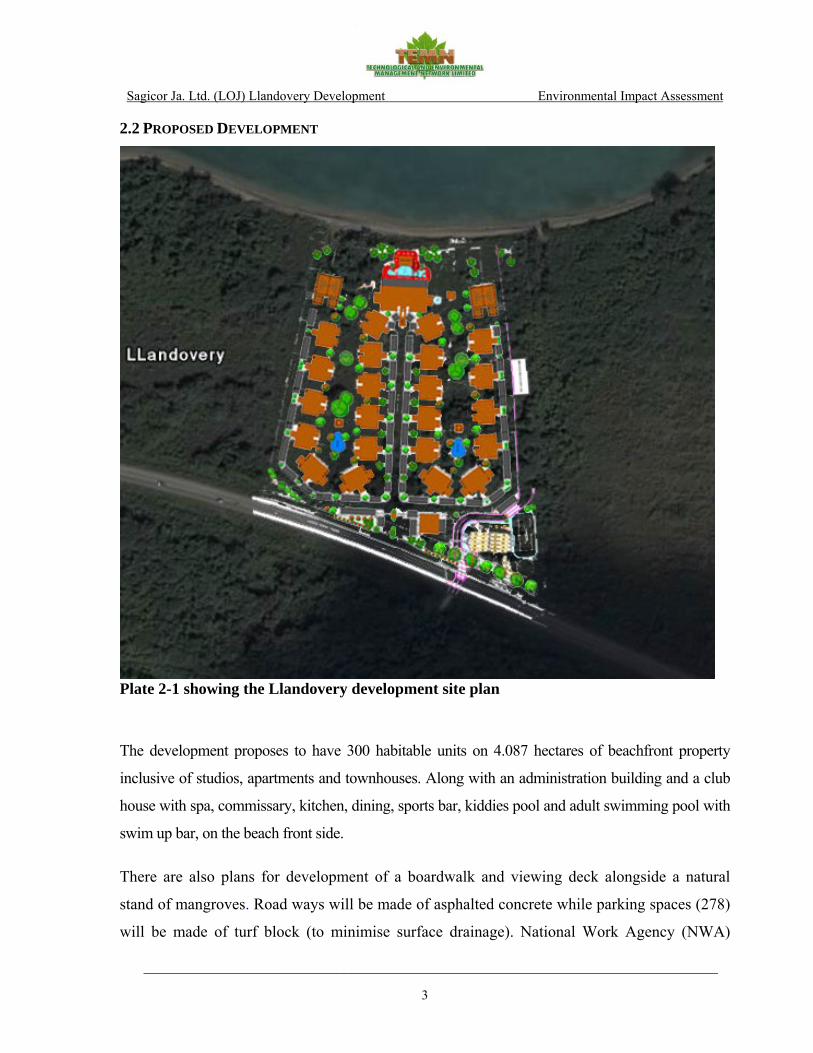
2.2 PROPOSED DEVELOPMENT
Plate 2-1 showing the Llandovery development site plan
The development proposes to have 300 habitable units on 4.087 hectares of beachfront property
inclusive of studios, apartments and townhouses. Along with an administration building and a club
house with spa, commissary, kitchen, dining, sports bar, kiddies pool and adult swimming pool with
swim up bar, on the beach front side.
There are also plans for development of a boardwalk and viewing deck alongside a natural
stand of mangroves. Road ways will be made of asphalted concrete while parking spaces (278)
will be made of turf block (to minimise surface drainage). National Work Agency (NWA)

Sagicor Ja. Ltd. (LOJ) Llandovery Development Environmental Impact Assessment
________________________________________________________________________
4
requested a 9.14m building set back from front boundary adjacent to the Highway while NEPA
requested 31.25m building set back from the high water mark on sea frontage except for the
beach swim up bar. Buildings will be 2 and 3 storey high built of 6” concrete blocks and
reinforced concrete floors. Most rooms will have two-wall exposure with large windows for
maximum cross ventilation. Mini Split air conditioning units will be used only when necessary
as ceiling fans will be installed in most rooms. Sewage treatment will be via Chromoglass®
package plant and Constructive Wetlands with adjoining Retention Tanks for recycling
irrigation to landscape areas
Pre-construction activities would include bushing to allow for surveyor to establish levels and
the establishment of site office inclusive of temporary on site pit latrine. Construction method
and works would be conventional i.e. Strip or raft foundation.
Duration of construction phase should not exceed 6 months for road and sewage. The
construction of the Beach Cottages should not exceed 12 months. Both activities could go on
simultaneously.
Water and electricity will be supplied in the usual manner. Solid waste disposal will be carried
out by the National Solid Waste Management Agency (NSWMA). Storm water flows will be
captured and dispersed to the main drain using storm water pipes of the required size.

Sagicor Ja. Ltd. (LOJ) Llandovery Development Environmental Impact Assessment
________________________________________________________________________
5
3.0 METHODOLOGY 3.1 ENVIRONMENTAL CHEMISTRY The environmental chemistry component of the EIA is required to review background levels of
critical physical/chemical indicators as well as identify and quantify actual and/or potential
impacts associated with the implementation of the proposed housing development at
Llandovery. Based on the nature of the proposed development and in keeping with the Terms
of Reference, the environmental chemistry assessment is based on the following indicators:
- Nitrate (NO3) - o-Phosphate (o-PO4) - Coliform bacteria (total and faecal) - Biological Oxygen Demand (BOD) - Suspended solids - Dissolved Oxygen - Salinity - Conductivity - Temperature - Noise
This assessment included a review of pertinent standards and fieldwork to collect physical
chemical data on the near-shore marine environment. Fieldwork was conducted on Thursday
June 14, 2007 to collect field data for dissolved oxygen, salinity, conductivity, temperature and
noise. GPS locations for sampling sites are given in Table 3-1. Rainfall, temperature and
humidity data for the sampling period was obtained from the Meteorological Division - U.W.I.
Discovery Bay Marine Laboratory site, while data on wind speed and direction (where
available) was also obtained from the Meteorological Division – Norman Manley International
Airport (NMIA). Wind data from the Meteorological Division is only available from the
NMIA and or the Donald Sangster International Airport. Hence data from the NMIA was used
as it was determined to be more representative of the proposed development site. The locations
of the sampling sites are shown in Plate 3.1.
Noise level was monitored using the Type 2 CEL – 328 Integrating Octave Band Sound Level
Meter. Readings were recorded minutely between 12:35 PM and 12:50 PM at the proposed
development site along the eastern boundary approximately 40m from the main road (Plate 3-1

Sagicor Ja. Ltd. (LOJ) Llandovery Development Environmental Impact Assessment
________________________________________________________________________
6
below). Spot determinations of maximum sound level (Lmax) were performed using the A
weighting to enable comparison with the international standards. Noise measurements are
supported by descriptive information on activities associated with noise levels.
Table 3-1 Showing Monitoring Sites for LOJ’s - Llandovery Development 2007
Station
ID Description Parameters Monitored
Coordinates N 18o
Coordinates W 77o
1 East Boundary, Wetland Lagoon Near Shoreline Water Quality 28.012 17.114
2 Marine Environment, Water Quality 28.026 17.119
3 West Boundary Near Shoreline Water Quality 28.022 17.209
4 Near East Boundary Approx 40m From Main Rd Noise 27.910 17.148
Air quality was assessed by literature review and field observations.
3.1.1 Water Quality
Some international and local standards/draft standards are presented in Table 3-2. Standards
are Draft NEPA standards unless otherwise indicated.
Table 3-2 showing Ambient Standards for Marine Waters
Parameters NRCA Draft Ambient Marine Standards
Dissolved Oxygen (mg/L) ≥4.8*
BOD (mg/L) 0.57-1.16
Nitrate (mg/L) 0.001-0.081
TSS (mg/l) 10**
Phosphate (mg/L) 0.001-0.055
Total Coliform (MPN/100ml) 48-256
Faecal Coliform (MPN/100ml) <100 * (USEPA Standard) ** (Draft National Policy for the Protection of Coral reefs - NRCA)
Sagicor Ja. Ltd. (LOJ) Llandovery Development Environmental Impact Assessment
________________________________________________________________________
7
In addition to the dissolved oxygen (DO) standard another important value is the saturation
value of oxygen (DOsat), the maximum level of oxygen that can be dissolved in water at a
particular temperature, salinity and altitude/barometric pressure. For a healthy water body,
where oxygen is replenished at about the same rate that it is consumed, dissolved oxygen will
be slightly lower than or equal to DOsat. In cases where the water body is overloaded with
biodegradable organic waste, DO will be substantially lower than DOsat and can approach
total depletion. High nutrient levels on the other hand (especially N and/or P) can lead to the
proliferation of algae which by photosynthesis produce levels of DO during the day time that
far exceed the saturation value of oxygen (TEMN 2007). This condition referred to as
eutrophication is also characterised by very low DO levels during the night time with the
cessation of photosynthesis and the additional burden placed on available DO by the
respiratory requirements of the massive amount of algae. The difference between the actual
DO and DOsat is called the DO deficit, which ideally should be 0. We can also speak of deficit
in terms of the level of saturation (DOsl), which is the percentage of the saturation value
(DOsat) achieved. The level of saturation should ideally be at or near 100% and will tend to
zero where there is significant organic pollution. Where there is an algal bloom such as is
associated with high nutrient levels the saturation level during daytime will be significantly
higher than 100%.
Samples were analysed by a local laboratory, in accordance with APHA, AWWA, Standard
Methods for the Analysis of Water and Wastewater:
Nitrate was determined using the cadmium reduction method.
Phosphate was determined by the molybdenum colorimetric method.
Suspended Solids was determined by filtration through 0.45u filter paper and gravimetry.
Turbidity was measured by photometry,
Dissolved Oxygen, temperature and salinity were measured using the YSI Model 33 S-C-T-O meter
calibrated in ambient air.
BOD was determined using the bottle method.
Coliform bacteria were determined by the membrane filter method.

Sagicor Ja. Ltd. (LOJ) Llandovery Development Environmental Impact Assessment
________________________________________________________________________
8
3.1.2 Noise (Background) Noise is defined as any loud, discordant or disagreeable sound or sounds. More commonly, in
an environmental context, noise is defined simply as unwanted sound. The impact of Noise is a
function of sound level and the effect of that noise on people. Depending on the level and
duration, noise can be a minor intrusion, a definite disturbance, or a threat to ones hearing to
actually causing pain (Table 3-3 below).
A reasonable goal for any permitted operation should be to minimise increases in sound
pressure level above ambient levels at the chosen point of sound reception based on known
reactions of humans to these increases (Table 3-4 below). Increases ranging from 0-3 dB
should have no appreciable effect on receptors. Increases from 3-6 dB may have potential for
adverse noise impact only in cases where the most sensitive of receptors are present. Sound
pressure increases of more than 6 dB may require a closer analysis of impact potential
depending on existing Sound Pressure Levels (SPLs) and the character of surrounding land use
and receptors. SPL increases approaching 10 dB deserve consideration of avoidance and
mitigation measures in most cases (NYDEC).
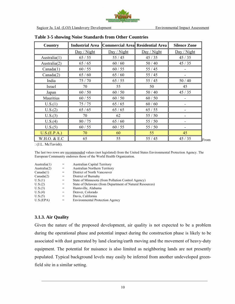
In the absence of local ambient standards for noise, standards from other countries are
presented in Table 3-5. This assessment compares noise levels measured at the undeveloped
site to the USEPA standard of 55dB for residential areas.

Sagicor Ja. Ltd. (LOJ) Llandovery Development Environmental Impact Assessment
________________________________________________________________________
9
Table 3-3 showing Sound and Human Response Criteria
Source: Original Chart: The Aggregate Handbook, 1991 Table 3-4 showing Human Reaction to Increases in Sound Pressure Level
Increase in Sound Pressure (dB) Human Reaction Under 5 Unnoticed to tolerable 5 - 10 Intrusive 10 - 15 Very noticeable 15 - 20 Objectionable Over 20 Very objectionable to intolerable
Source: (Down and Stocks - 1978)
Sagicor Ja. Ltd. (LOJ) Llandovery Development Environmental Impact Assessment
________________________________________________________________________
10
Table 3-5 showing Noise Standards from Other Countries From
: (J.L. McTavish). The last two rows are recommended values (not legislated) from the United States Environmental Protection Agency. The European Community endorses those of the World Health Organization. Australia(1) = Australian Capital Territory Australia(2) = Australian Northern Territory Canada(1) = District of North Vancouver Canada(2) = District of Burnaby U.S.(1) = State of Minnesota (from Pollution Control Agency) U.S.(2) = State of Delaware (from Department of Natural Resources) U.S.(3) = Huntsville, Alabama U.S.(4) = Denver, Colorado U.S.(5) = Davis, California U.S.(EPA) = Environmental Protection Agency
3.1.3. Air Quality
Given the nature of the proposed development, air quality is not expected to be a problem
during the operational phase and potential impact during the construction phase is likely to be
associated with dust generated by land clearing/earth moving and the movement of heavy-duty
equipment. The potential for nuisance is also limited as neighboring lands are not presently
populated. Typical background levels may easily be inferred from another undeveloped green-
field site in a similar setting.
Country Industrial Area Commercial Area Residential Area Silence Zone Day / Night Day / Night Day / Night Day / Night
Australia(1) 65 / 55 55 / 45 45 / 35 45 / 35 Australia(2) 65 / 65 60 / 60 50 / 40 45 / 35 Canada(1) 60 / 55 60 / 55 55 / 45 - Canada(2) 65 / 60 65 / 60 55 / 45 -
India 75 / 70 65 / 55 55 / 45 50 / 40 Israel 70 55 50 45 Japan 60 / 50 60 / 50 50 / 40 45 / 35
Mauritius 60 / 55 60 / 50 60 / 50 - U.S.(1) 75 / 75 65 / 65 60 / 60 - U.S.(2) 65 / 65 65 / 65 65 / 55 - U.S.(3) 70 62 55 / 50 - U.S.(4) 80 / 75 65 / 60 55 / 50 - U.S.(5) 60 / 55 60 / 55 55 / 50 -
U.S.(E.P.A.) 70 60 55 45 W.H.O. & E.C 65 55 55 / 45 45 / 35

Sagicor Ja. Ltd. (LOJ) Llandovery Development Environmental Impact Assessment
________________________________________________________________________
11
Plate 3-1: Showing noise level sampling stations for the LOJ – Llandovery Development 3.2 ECOLOGY
Terrestrial and marine ecological assessments of the area surrounding the proposed location of
the Llandovery condominium complex were conducted in June and August 2007. The
objectives of the assessment were to:
• Provide a baseline evaluation of the biological status of the project area,
• Identify direct and indirect as well as short and long term impacts to the ecology of the area
resulting from the proposed development activities,
• Assess alternative development options and suggest appropriate mitigation for the proposed
development.
Caribbean Sea
To Montego Bay
N
LOJ 1
LOJ 2 LOJ 3
LOJ 4
Sagicor Ja. Ltd. (LOJ) Llandovery Development Environmental Impact Assessment
________________________________________________________________________
12
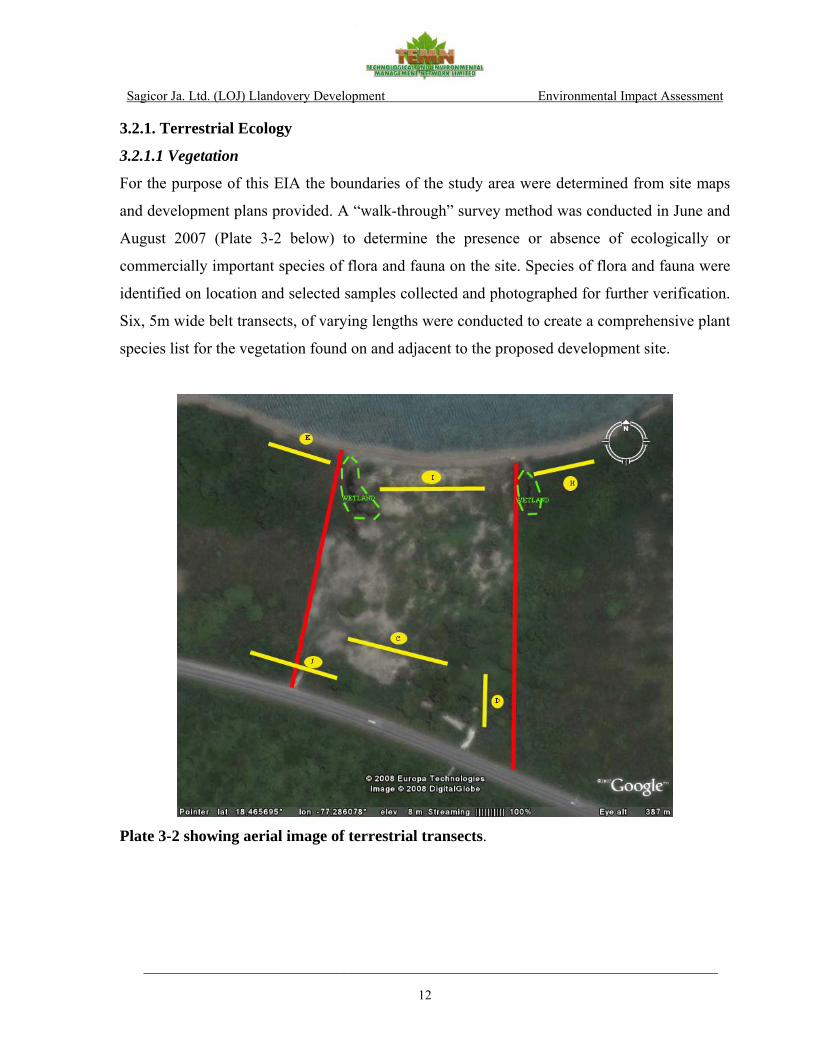
3.2.1. Terrestrial Ecology
3.2.1.1 Vegetation
For the purpose of this EIA the boundaries of the study area were determined from site maps
and development plans provided. A “walk-through” survey method was conducted in June and
August 2007 (Plate 3-2 below) to determine the presence or absence of ecologically or
commercially important species of flora and fauna on the site. Species of flora and fauna were
identified on location and selected samples collected and photographed for further verification.
Six, 5m wide belt transects, of varying lengths were conducted to create a comprehensive plant
species list for the vegetation found on and adjacent to the proposed development site.
Plate 3-2 showing aerial image of terrestrial transects.

Sagicor Ja. Ltd. (LOJ) Llandovery Development Environmental Impact Assessment
________________________________________________________________________
13
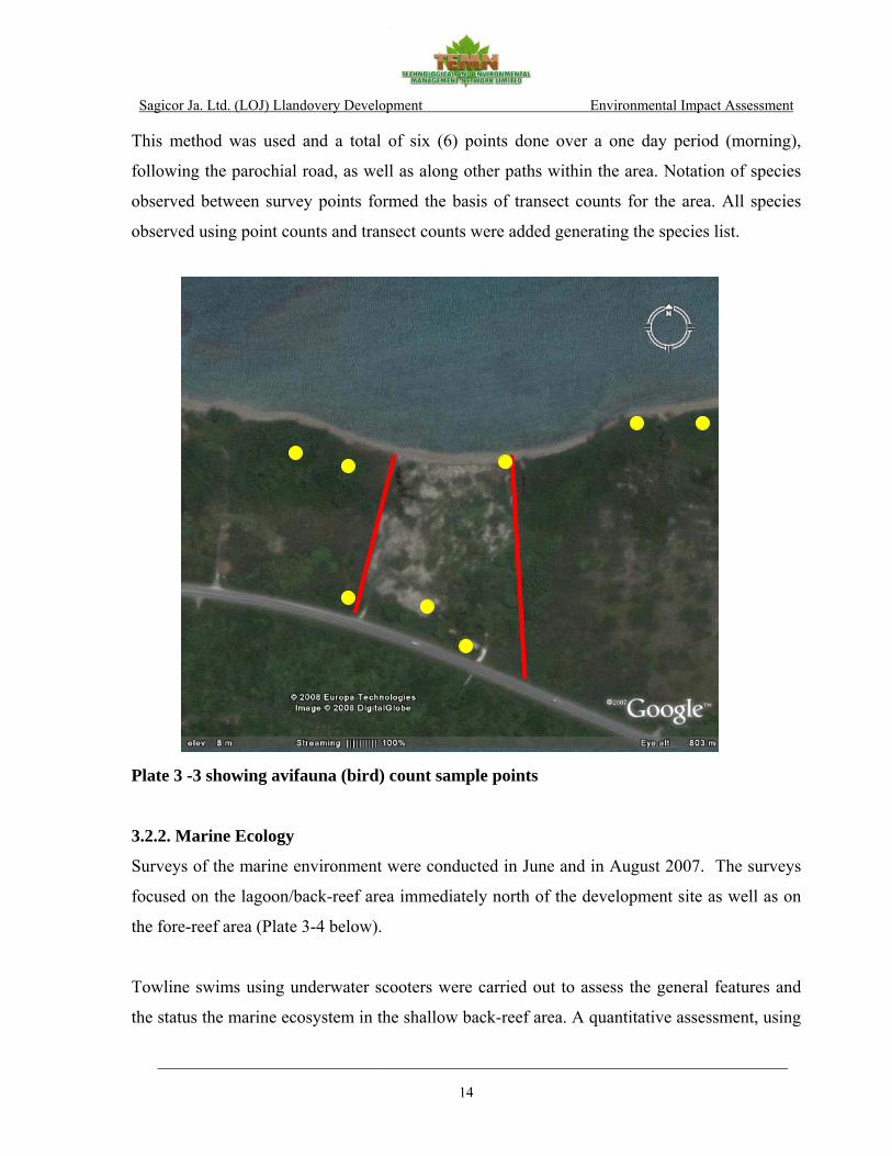
3.2.1.2 Avifauna
An avifaunal survey conducted in November 2007 was used to (Plate 3-3 below):
a) Determine the bird species composition found on and in the vicinity of the proposed
development site
b) Identify the potential impacts of the proposed development on the avifauna.
Birds were identified and enumerated according to the Fixed Radius Point Count Census
Method which is based on the principle of counting individuals from a defined location and
estimating the distance to the individual contact. A point was selected from where all bird
contacts (seen and heard) were recorded, and the distance estimated (< 25m or >25m) for each
contact. The procedure was repeated every 10 min (Bibby et al., 1998), before moving to
another location within a 100m radius. Avifaunal species observed between point counts were
also recorded.
Avifauna identified was ranked according to the following criteria:
R = resident, E = endemic, I = introduced, W = winter migrant, S = summer migrant
DAFOR Scale: D= 9-10; A= 7-8; F= 4-6; O=2-3; R=1
Economic Scale Value – this value was based on four components: Status, DAFOR, IUCN
rating (Scale: 1:10,000)
Ecological Scale Value – this value was based on Status and Feeding Guild of the species; 1 –
lowest, 5 - highest
Advantages of this method include:
• Ease of observation of the birds and their habitats from a stationary position
• More time available to identify contacts
• Greater opportunity to identify cryptic and skulking species
• Easier to relate bird occurrence to habitat features
Sagicor Ja. Ltd. (LOJ) Llandovery Development Environmental Impact Assessment
________________________________________________________________________
14
This method was used and a total of six (6) points done over a one day period (morning),
following the parochial road, as well as along other paths within the area. Notation of species
observed between survey points formed the basis of transect counts for the area. All species
observed using point counts and transect counts were added generating the species list.
Plate 3 -3 showing avifauna (bird) count sample points
3.2.2. Marine Ecology
Surveys of the marine environment were conducted in June and in August 2007. The surveys
focused on the lagoon/back-reef area immediately north of the development site as well as on
the fore-reef area (Plate 3-4 below).
Towline swims using underwater scooters were carried out to assess the general features and
the status the marine ecosystem in the shallow back-reef area. A quantitative assessment, using

Sagicor Ja. Ltd. (LOJ) Llandovery Development Environmental Impact Assessment
________________________________________________________________________
15
photo-quadrates (0.5-1.0 m2) was conducted in the back-reef area to describe the substrate
composition and to generate an abundance rating (DAFOR) for species encountered.
Photo transects were used to quantify the benthic components at randomly chosen,
representative sites on the fore-reef area. Two x 20m long transects (0.5m x 20m) were
photographed at each location. Random dot analysis of transect photos, was used to determine
the substrate composition. Corals and algae were identified to the species level where possible
while all other reef components were grouped into categories (e.g. sponges, anemones or
gorgonians). Fish counts were conducted along the same transect lines.
Plate 3-4 showing aerial image of marine (back reef & fore reef) transects.
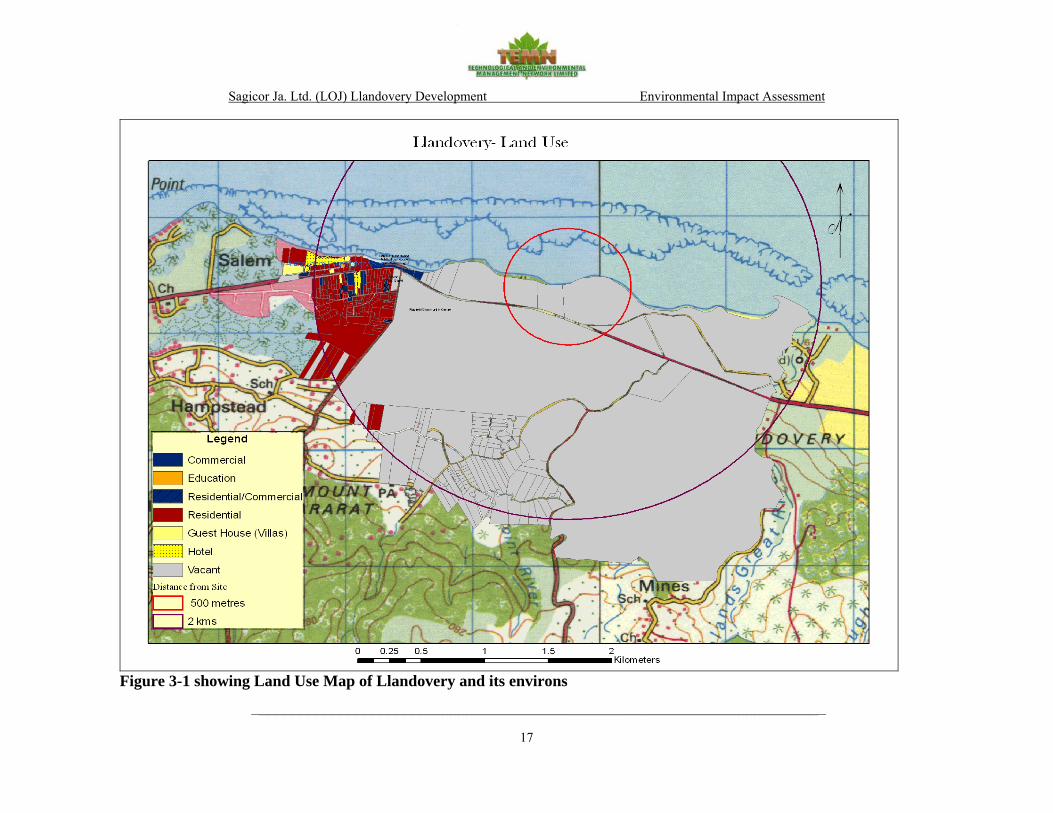
3.3 SOCIO-ECONOMIC ASSESSMENT
The socioeconomic impact assessment (SIA) examines the socio-economic and cultural setting
of the study area and identifies potential impacts of the proposed development. The study area

Sagicor Ja. Ltd. (LOJ) Llandovery Development Environmental Impact Assessment
________________________________________________________________________
16
for the SIA includes the proposed site and areas within two kilometers (2km) of the site. Any
new development in a community will have both local (micro), regional and national and
(macro) impacts. For the purpose of this SIA the local impacts included the proposed site and
the area within 2km of the site. Regional impacts were those at the Parish level while national
impacts were island wide. The SIA included desktop research as well as a socioeconomic and
public perception survey. A site reconnaissance and socioeconomic and perception survey
were conducted on the 23rd and 24th June 2007. The land use survey for this SIA included a
review of satellite imagery of Jamaica, topographic maps and a land use survey which was
conducted for this study on June 23rd and 24th, 2007.
3.3.1 Land Use
3.3.1.1 On-site
The subject site is located along the North Coast Highway and consists of a 4.087 hectares
undeveloped parcel that contains low lying vegetation and scattered trees. An area appearing
to be a small wetland was observed close to the centre of the site.
3.3.1.2 With-in 0.5km of the Site
The lands within 0.5km of the site consist mainly of undeveloped vacant lands. The Caribbean
Sea is located immediately north. The lands to the east and west of the site consist of vacant
land with low lying vegetation in some areas. The North Coast highway is immediately south
of the site, beyond which is undeveloped vacant land.
3.3.1.3 With-in 0.5km-2km of the Site
Lands within 0.5km-2km of the site stretches from the easternmost portion of the community
of Salem in the west, Beverly to the south, just west of Laughlands to the east and the
Caribbean Sea to the north. The lands to the west consist of residential, commercial and resort
(hotel and guest houses) uses. The area to the far south and southwest consist of mainly
residential land uses. The remaining areas consist of undeveloped vacant lands and unused
agricultural lands.
Sagicor Ja. Ltd. (LOJ) Llandovery Development Environmental Impact Assessment
________________________________________________________________________
17
Figure 3-1 showing Land Use Map of Llandovery and its environs

Sagicor Ja. Ltd. (LOJ) Llandovery Development Environmental Impact Assessment
________________________________________________________________________
18
3.4 HYDROGEOLOGY 3.4.1 Background and Approach
This report satisfies Task #2A (i) and Task #5 TORs of the proposed Llandovery
Condominium Development at Llandovery, St. Ann. These aspects include:
A definition of the study area, based on the drainage area of which this development is
a part. These boundaries will be demarcated based on a desktop review of available
topography maps and limited field reconnaissance along open and traversable access
ways.
Baseline data collection on the study area (hydrology, geology, hydrogeology,
geomorphology, etc.) and review of existing reports and other information relevant to the
study area.
Review the collected data with a view to determine:
1) Water demand of the development which will be reconciled against the available water supply.
2) Pre and post project runoff rates for 25 year (yr) return period and 50yr and 100 yr
3) Possibility for contamination of the coastal waters as a result of the proposed project.
Identification of Potential Environmental Impacts relating to:
1) Flooding of the site or to adjacent areas as a consequence of the development.
2) Soil erosion to and from the site.
3) Utilization of existing water supply sources and/or the development of new source(s) e.g. well source.
Explorative Drainage Assessment to determine:
1) Drainage for the site during construction, including sediment control mitigation.
Sagicor Ja. Ltd. (LOJ) Llandovery Development Environmental Impact Assessment
________________________________________________________________________
19
2) Drainage for the site during operation, including sediment control and pollution control.
3) Drainage control for the Flat Point River that discharges onto the property, to
include impacts that this will have on the aesthetics, water quality and
sedimentation of the beach area, etc.
The available data that was referenced for this study is listed below:
Satellite Photographs of site taken from Google Earth
1: 50,000 Series Geological Sheet 14 (Provisional) undated
Water Resources Authority (WRA) Data Request – Llandovery, 2007 and 1990 Water
Resources Development Master Plan
Office of the Disaster Preparedness and Emergency Management (ODPEM)
The National Water Commission (NWC) website and local library searches
The archives of TEMN where pertinent to the study area
The hydrological assessment was made using the ArcHydro extension of ArcGIS to perform
the initial terrain and watershed processing and the data was then input into HEC-HMS and
cross referenced with WinTR-55 both of which are used around the world for peak flow
estimation of small rural drainage basins and is the most widely used method for urban
drainage design. Terrain analysis (i.e. watershed delineation) was carried out using the
Llandovery Digital Elevation Models (DEM) and the inputs fed into GeoHMS.
Discharges for return periods of 25, 50 and 100 years were evaluated for the Flat Point
catchment and 5yr design storm for site-created runoff pre- and post- development changes
were assessed.
Written environmental searches were undertaken through the WRA, NWC and ODPEM. In
addition, website searches of the National Environment and Planning Agency (NEPA), and
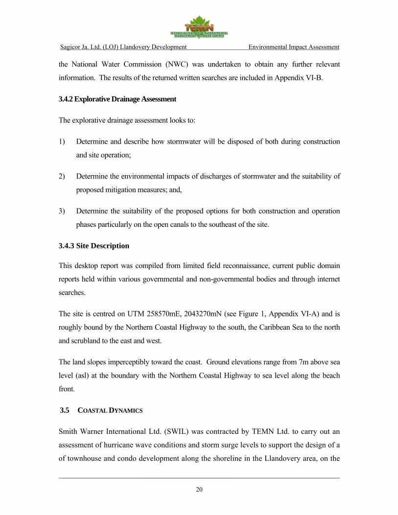
Sagicor Ja. Ltd. (LOJ) Llandovery Development Environmental Impact Assessment
________________________________________________________________________
20
the National Water Commission (NWC) was undertaken to obtain any further relevant
information. The results of the returned written searches are included in Appendix VI-B.
3.4.2 Explorative Drainage Assessment
The explorative drainage assessment looks to:
1) Determine and describe how stormwater will be disposed of both during construction
and site operation;
2) Determine the environmental impacts of discharges of stormwater and the suitability of
proposed mitigation measures; and,
3) Determine the suitability of the proposed options for both construction and operation
phases particularly on the open canals to the southeast of the site.
3.4.3 Site Description This desktop report was compiled from limited field reconnaissance, current public domain
reports held within various governmental and non-governmental bodies and through internet
searches.
The site is centred on UTM 258570mE, 2043270mN (see Figure 1, Appendix VI-A) and is
roughly bound by the Northern Coastal Highway to the south, the Caribbean Sea to the north
and scrubland to the east and west.
The land slopes imperceptibly toward the coast. Ground elevations range from 7m above sea
level (asl) at the boundary with the Northern Coastal Highway to sea level along the beach
front.
3.5 COASTAL DYNAMICS
Smith Warner International Ltd. (SWIL) was contracted by TEMN Ltd. to carry out an
assessment of hurricane wave conditions and storm surge levels to support the design of a
of townhouse and condo development along the shoreline in the Llandovery area, on the

Sagicor Ja. Ltd. (LOJ) Llandovery Development Environmental Impact Assessment
________________________________________________________________________
21
north coast of Jamaica. Of primary concern is how various return period storm surges
will affect the proposed development. In addition, there is the need to determine a safe
floor level for this development. The required tasks are outlined below.
Task 1 – Collection of Bathymetric Data
Bathymetric data will be collected in front of and close to the project area out to a depth
of approximately 30 meters, to ensure that nearshore seabed data is accurately recorded.
Task 2 – Wave Climate and Storm Surge Modeling
The deep water wave climates obtained (extreme) will be input to a 2-dimensional near-
shore transformation model, SWAN, to give the wave climate within the Llandovery
nearshore area. The SWAN model takes into account the processes of wave shoaling,
refraction and reflection, and also includes the computation of wave set-up, which can be
an important aspect of storm surge. The results of the model will be used to indicate the
extent the storm surge inundation of the proposed development. Design water levels will
be evaluated, taking into account tides, storm surge, global sea level rise and wave set-up.
3.5.1 Location and Bathymetry The project is located in St. Ann, north coast of Jamaica. It consists of a property
extending from the main road down to the coastline, and has a beach frontage of
approximately 185 meters. The beach is protected from storms and hurricane waves by a
barrier reef located about 450 meters offshore.
A detailed bathymetric survey in the near-shore region was carried out (depths up to
50m) in order to properly compute the wave transformation in this area. The survey was
carried out from a boat using a depth sounder and GPS system that was able to record
depths at 1 second intervals along pre-determined tracks. Data measurements were
focused in the vicinity of the project site. Additional deep water depths taken from
nautical charts were appended to produce a final bathymetric map (Figure 3-2). The map
shows two distinct morphological regions separated by the reef barrier: Seaward of the
reef, the seabed has a steep and constant slope; from the reef barrier to the coastline the

Sagicor Ja. Ltd. (LOJ) Llandovery Development Environmental Impact Assessment
________________________________________________________________________
22
seabed is composed of very shallow reef patches, which are generally separated by areas
5 meters deep.
Figure 3-2 Bathymetric map of the coastal area adjacent to the project site
257600 257800 258000 258200 258400 258600 258800 259000 259200
2043200
2043400
2043600
2043800
2044000
2044200
2044400
2044600
0 5 15 30 45 60 75 90
Water Depth (m)
Project Site
Product:Bathymetry of Llandovery Area
Client:SeaControl Ltd.
Notes:Depth contours in metersUTM coordinates
Prepared by: Gustavo Oliveira
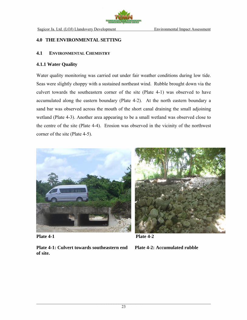
Sagicor Ja. Ltd. (LOJ) Llandovery Development Environmental Impact Assessment
________________________________________________________________________23
4.0 THE ENVIRONMENTAL SETTING
4.1 ENVIRONMENTAL CHEMISTRY 4.1.1 Water Quality Water quality monitoring was carried out under fair weather conditions during low tide.
Seas were slightly choppy with a sustained northeast wind. Rubble brought down via the
culvert towards the southeastern corner of the site (Plate 4-1) was observed to have
accumulated along the eastern boundary (Plate 4-2). At the north eastern boundary a
sand bar was observed across the mouth of the short canal draining the small adjoining
wetland (Plate 4-3). Another area appearing to be a small wetland was observed close to
the centre of the site (Plate 4-4). Erosion was observed in the vicinity of the northwest
corner of the site (Plate 4-5).
Plate 4-1 Plate 4-2 Plate 4-1: Culvert towards southeastern end Plate 4-2: Accumulated rubble of site.
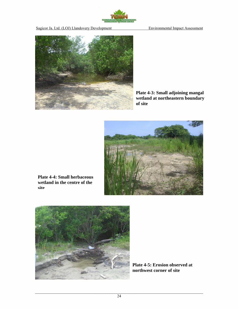
Sagicor Ja. Ltd. (LOJ) Llandovery Development Environmental Impact Assessment
________________________________________________________________________24
Plate 4-3: Small adjoining mangal wetland at northeastern boundary of site
Plate 4-4: Small herbaceous wetland in the centre of the site
Plate 4-5: Erosion observed at northwest corner of site

Sagicor Ja. Ltd. (LOJ) Llandovery Development Environmental Impact Assessment
________________________________________________________________________25
Results from the analysis of water samples are summarised in Table 4-1. Table 4-1 showing LOJ – Llandovery Development, Coastal Water Quality Data (June 14, 2007)
ppt – parts per thousand; mg/l – milligrams per liter; NTU – Nephelometric Turbid Units; ms - millisiemens ; MPN - most probable number per 100ml. TSS was in the range 4.5 - 13mg/l for all sites monitored (Figure 4-1). The highest value
was determined for the samples taken in the sea while in the lagoon TSS was lowest.
Turbidity at all sites was in the range 2 - 6NTU. Turbidity showed a similar pattern to
TSS being higher for the samples taken from the sea (Figure 4-1).
Biological Oxygen Demand (BOD) was in the range 1.0 - 1.6mg/l for all sites (Figure 4-
2). The highest BOD was determined for the sample taken in the wetland lagoon (Station
1). The sample taken in the sea at the eastern boundary (Station 2), had a BOD of
1.4mg/l, while at the western site (Station 3), BOD was 1.0mg/l.
Dissolved Oxygen was in the range 2.0 - 8.3mg/l (Figure 4-2). DO was lowest in the
wetland lagoon while in sea water, DO exceeded the saturation value (DOsat) to have a
saturation level well in excess of 100%.
ID TIME (24 hour)
SAL. (ppt)
COND. (ms)
TEMP.(oC)
BOD5 (mg/l)
DO (mg/l)
TURB. (NTU)
TSS (mg/L)
PO4
(mg/l) NO3
(mg/l) FC
(MPN)TC
(MPN)
LOJ 1 11:07 12.2 22.6 29.8 1.6 2.0 2 4.5 0.046 0.490 2 490
LOJ 2 11:30 33.4 55.8 30.5 1.4 7.9 4 13.0 0.035 0.529 0 0
LOJ 3 12:00 34.2 57.8 31.4 1.0 8.3 6 13.0 0.018 0.299 0 0
STD 1.2 4.8 10.00 0.055 0.080 100 256

Sagicor Ja. Ltd. (LOJ) Llandovery Development Environmental Impact Assessment
________________________________________________________________________26
LOJ 1 LOJ 2 LOJ 3 STD
TURB (NTU)
TSS (mg/L)0
2
4
6
8
10
12
14
mg/
l & N
TU
ID
Figure 4-1: LOJ - Llandovery, TSS & Turbidity, June 14, 2007
TURB (NTU) TSS (mg/L)
LOJ 1 LOJ 2LOJ 3
STD
BOD5 (mg/l)
DO (mg/l)0.0
1.0
2.0
3.0
4.0
5.0
6.0
7.0
8.0
9.0
mg/
l
ID
Figure 4-2: LOJ - Llandovery, BOD & Dissolved Oxygen, June 14, 2007.
BOD5 (mg/l) DO (mg/l)

Sagicor Ja. Ltd. (LOJ) Llandovery Development Environmental Impact Assessment
________________________________________________________________________27
Nitrate was determined to be in the range 0.299 to 0.529mg/l (Figure 4-3). The highest
level was determined o the east of the site (Station 1) while to the west (Station 3) nitrate
was lowest (0.299mg/l). In the wetland lagoon (Station 1) nitrate was 0.490mg/l.
Phosphate was in the range 0.018 to 0.127mg/l for the sites monitored (Figure 4-3).
Phosphate was slightly higher in the wetland lagoon (Station 1) than at the marine sites.
In the lagoon the level was 0.046mg/l while at Stations 2 and 3 the levels were
0.0635mg/l and 0.018mg/l.
Total Coliform was detected only in the sample taken from the wetland lagoon, for
which a level of 490MPN/100ml was determined (Figure 4-4).
Faecal Coliform was absent in all samples with the exception of that taken from the
wetland lagoon, which gave a value of 2MPN/100 (Figure 4-4).
LOJ 1 LOJ 2 LOJ 3 STD
PO4 (mg/l)
NO3 (mg/l)0
0.1
0.2
0.3
0.4
0.5
0.6
mg/
l
ID
Figure 4-3: LOJ - Llandovery, NO3 & PO4, June 14, 2007
PO4 (mg/l) NO3 (mg/l)
Sagicor Ja. Ltd. (LOJ) Llandovery Development Environmental Impact Assessment
________________________________________________________________________28
LOJ 1LOJ 2
LOJ 3STD
FC (MPN)
TC (MPN)0
50
100
150
200
250
300
350
400
450
500M
PN/1
00m
l
ID
Figure 4-4: LOJ - Llandovery, Total & faecal Coliform, June 14, 2007
FC (MPN) TC (MPN)
4.1.2 Noise (Observations and Results) Background sounds of mainly birds chirping, rustling of foliage and traffic were the only
sources of noise perceived. Average SPL was 55.2dB with a maximum of 62dB and a
minimum of 50dB (Figure 4-5). The maximum was associated with a truck passing on
the highway. Other traffic sounds (cars passing), were also significant contributors to
noise levels. This assessment compares noise levels measured at the undeveloped site to
the USEPA standard of 55dB for residential areas. Details of the monitoring are shown in
Table 4-2 below.

Sagicor Ja. Ltd. (LOJ) Llandovery Development Environmental Impact Assessment
________________________________________________________________________29
Table 4-2 showing the LOJ’s - Llandovery Development sound pressure level at the Eastern Boundary (approximately 40m from the road) of site. DATE: March 7, 2007
Time SPL (A) STD COMMENTS/SOURCE 12:35 59.0 55 Truck Passes 12:36 57.0 55 Truck Passes 12:37 57.0 55 Truck Passes 12:38 50.0 55 Background (Birds chirping) 12:39 50.0 55 Background (Birds chirping) 12:40 55.0 55 Traffic (cars passing) 12:41 56.0 55 Traffic (cars passing) 12:42 56.0 55 Traffic (cars passing) 12:43 62.0 55 Truck Passes 12:44 50.0 55 Background (Birds chirping) 12:45 53.0 55 Traffic (cars passing) 12:46 56.0 55 Traffic (cars passing) 12:47 50.0 55 Background (Birds chirping) 12:48 55.0 55 Traffic (cars passing) 12:49 58.0 55 Traffic (cars passing) 12:50 59.0 55 Traffic (cars passing) AVG 55.2 MAX 62.0 MIN 50.0
Figure 4-5: LOJ - Llandovery, Noise, June 14, 2007
0.0
10.0
20.0
30.0
40.0
50.0
60.0
70.0
12:35 12:36 12:07 12:38 12:39 12:40 12:41 12:42 12:43 12:44 12:45 12:46 12:47 12:48 12:49 12:50
Time of Day (p.m.)
db
SPL (A) STD

Sagicor Ja. Ltd. (LOJ) Llandovery Development Environmental Impact Assessment
________________________________________________________________________30
4.1.3 Air Quality (and Weather data) No sources of air pollutants were observed at or close to the site other than traffic on the
main road. Typical data for a similarly undeveloped site at Silver Sands (Amaterra
Resort) in Trelawny (Table 4-3) indicate that background levels of the criteria pollutants
(PM10, SOx and NOx) are within the ambient standard (TEMN Ltd., 2004).
Table 4-3 showing the Amaterra Resort Development baseline Air Quality data
ID DESCRIPTION N 18o W 77o PM10
(ug/m3) SO2 NO2
OP 1AQ Near Silver Sands 29.232 32.199
111 ND ND
OP 2AQ Carey Park 28.618 33.125
28 ND ND
OP 4AQ Duncan’s Hill 28.228 32.772
56 Not done Not done
STD NEPA 24-HR Standard
150 ND – Not detected.
For the month of May (2007) winds were generally lighter in the early morning (zero
wind speed recorded at 1:00AM on two occasions towards the end of the month) picking
up towards the afternoon. Average early morning wind speed in for the month before
sampling was 9km/hr while the average in the early afternoon was 27km/hr from the
NNE. Wind data was not yet available for the data collection month of June (2007) (See
Appendix VII for detailed climate/weather data).
4.2 ECOLOGY
4.2.1. Terrestrial Flora
The area can best be described as a disturbed woodland area (Grossman et al. 1991), of
fairly low elevation with vast open areas interspersed with isolated tree stands. The site
reaches a maximum height of 7m (based on survey areas) above sea level. The access to
the area is through a parochial road leading to the beach area.
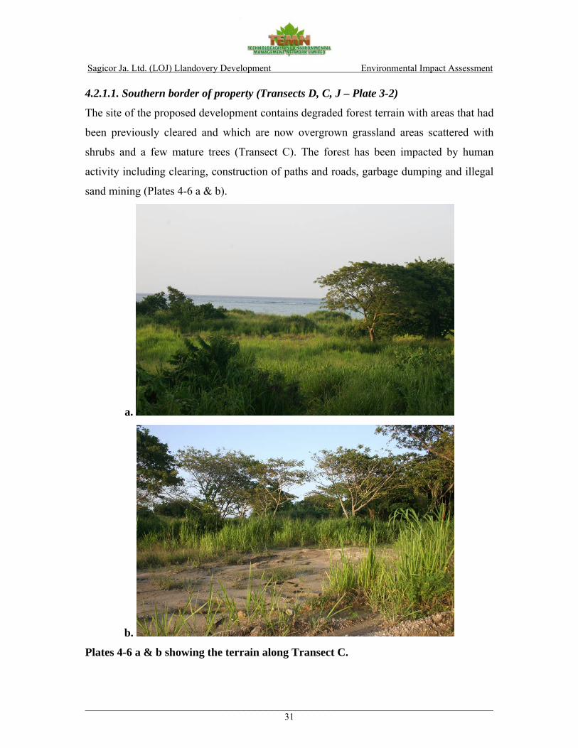
Sagicor Ja. Ltd. (LOJ) Llandovery Development Environmental Impact Assessment
________________________________________________________________________31
4.2.1.1. Southern border of property (Transects D, C, J – Plate 3-2)
The site of the proposed development contains degraded forest terrain with areas that had
been previously cleared and which are now overgrown grassland areas scattered with
shrubs and a few mature trees (Transect C). The forest has been impacted by human
activity including clearing, construction of paths and roads, garbage dumping and illegal
sand mining (Plates 4-6 a & b).
a.
b.
Plates 4-6 a & b showing the terrain along Transect C.
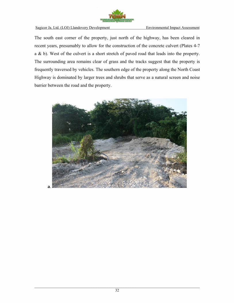
Sagicor Ja. Ltd. (LOJ) Llandovery Development Environmental Impact Assessment
________________________________________________________________________32
The south east corner of the property, just north of the highway, has been cleared in
recent years, presumably to allow for the construction of the concrete culvert (Plates 4-7
a & b). West of the culvert is a short stretch of paved road that leads into the property.
The surrounding area remains clear of grass and the tracks suggest that the property is
frequently traversed by vehicles. The southern edge of the property along the North Coast
Highway is dominated by larger trees and shrubs that serve as a natural screen and noise
barrier between the road and the property.
a.
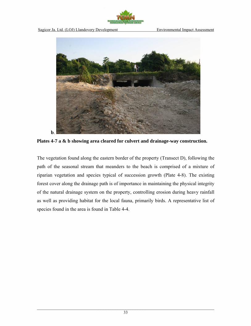
Sagicor Ja. Ltd. (LOJ) Llandovery Development Environmental Impact Assessment
________________________________________________________________________33
b.
Plates 4-7 a & b showing area cleared for culvert and drainage-way construction.
The vegetation found along the eastern border of the property (Transect D), following the
path of the seasonal stream that meanders to the beach is comprised of a mixture of
riparian vegetation and species typical of succession growth (Plate 4-8). The existing
forest cover along the drainage path is of importance in maintaining the physical integrity
of the natural drainage system on the property, controlling erosion during heavy rainfall
as well as providing habitat for the local fauna, primarily birds. A representative list of
species found in the area is found in Table 4-4.

Sagicor Ja. Ltd. (LOJ) Llandovery Development Environmental Impact Assessment
________________________________________________________________________34
Plate 4-8 showing vegetation cover along the seasonal stream path (Transect D)

Sagicor Ja. Ltd. (LOJ) Llandovery Development Environmental Impact Assessment
________________________________________________________________________35
Table 4-4 showing representative species of flora identified on the proposed development site (Transects D, C, J), Llandovery.
Scientific Name Common Name Economic/ Form DAFOR DAFOR DAFOR Ecological Value D C J
Andropogon scoparius Giant reed Craft Grass A Cyperus ligoris Razor grass - Grass A D D Aborescens mill. Bamboo Craft Tall grass A Cynerium sagittatum Wild cane Craft Tall grass A A Achyranthes indica Devil’s horse whip Medicine Shrub O Bidens cynapiifolia Spanish needle Animal feed Shrub A A Blechum pyramidatum Marsh miller - Shrub O Borrichia arborescens Seaside marigold - Shrub A Coccoldoa Wild grape Shrub O Croton linearis Wild rosemary Shrub O Eupatorium odoratum Jack in the bush Medicine Shrub R O Euphorbiacere phyllanthus - Shrub O Jatropha gossypiifolia Cassada marble - Shrub O Lantana camara Red sage Poison Shrub O Lipianodiflora - Shrub O Mallotaniagnaphalodes Sea lavender - Shrub O Moghania strobilifera Wild hops - Shrub O Pluchea cardinensis Wild tobacco - Shrub O Pothomorphe umbellate Cowfoot Animal feed Shrub R Sida acuta Broom weed Medicine Shrub O Wild cocoa Ornament Shrub O O Cow tongue Medicine Shrub O Ambrosia penuviana Wild Tansy Shrub A Sapindus saponaria Soap bush Shrub D Smilax auricalata Smilax Shrub D Mimosa pudica Sensitive plant Medicine Creeping shrub A Bursera simaruba Red berch Gum Tree R Cassia siamea Cassia (Senna) Animal feed Tree F Cecropia peltata Trumpet Medicine Tree O O O Crescantia cutete Calabash Craft/medicine Tree O Ficus aurea Strangular fig Bird feed Tree O
Guazama ulnifolia Bastard (Baseda) cedar Animal feed Tree A A
Prosopis julifloria Cashaw Firewood Tree A Psidium guajava Guava Food/medicine Tree O
Ricanus communis Castor oil Medicine/cosmetics Tree O
Samanea saman Guango Timber/shade Tree F O F Spathodea campanulata Flame of the forest Tree O R Therminalia catappa Almond Food Tree A A
Thespecia populnea Sea cotton (Mahoe) Timber/Shade Tree O
Albizia lebbeck Mimosa (woman tongue) - Small Tree A A
Guilandina crista Nicol (Nicker bean) Craft Small Tree O O
Imopoea tiliacea Wild potato slip Animal feed Vine A A Pseudelephantopus spicatus Kuaku bush Medicine Vine A A Yucca aloifolia Spanish bayonet R
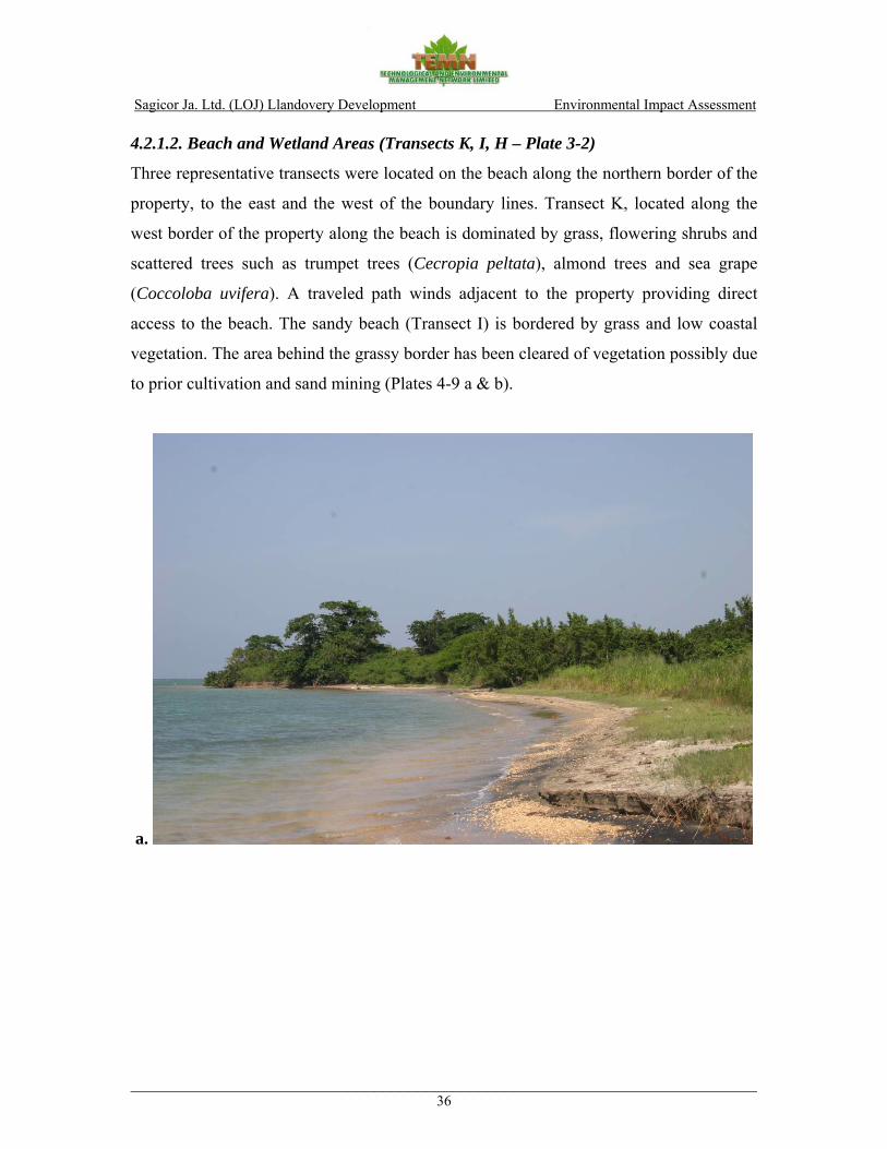
Sagicor Ja. Ltd. (LOJ) Llandovery Development Environmental Impact Assessment
________________________________________________________________________36
4.2.1.2. Beach and Wetland Areas (Transects K, I, H – Plate 3-2)
Three representative transects were located on the beach along the northern border of the
property, to the east and the west of the boundary lines. Transect K, located along the
west border of the property along the beach is dominated by grass, flowering shrubs and
scattered trees such as trumpet trees (Cecropia peltata), almond trees and sea grape
(Coccoloba uvifera). A traveled path winds adjacent to the property providing direct
access to the beach. The sandy beach (Transect I) is bordered by grass and low coastal
vegetation. The area behind the grassy border has been cleared of vegetation possibly due
to prior cultivation and sand mining (Plates 4-9 a & b).
a.

Sagicor Ja. Ltd. (LOJ) Llandovery Development Environmental Impact Assessment
________________________________________________________________________37
b.
Plates 4-9 a & b showing the North boundary of the property. View from beach (Transect I). The western (Transect K) and eastern (Transect H) boundaries of the property contains,
or border on, wetland areas. The western wetland area (approximately 1600m2 in area)
occupies the north-western corner of the property (Plate 4-10) is a degraded area and has
little in the way of canopy. It supports wetland associate, terrestrial vegetation and
limited seashore flora. No mangrove species observed. It was created by illegal sand
mining activities in the early 1980’s which resulted in ponding (pers. comm. caretaker of
property). The water in the wetland has limited communication with the sea (salinity of 7
ppt from a one time sample) suggesting that it is sustained by storm water drainage from
the road and property to the south of it. Few faunal species (1 fish < 2cmFL) were seen
in the standing water pools perhaps because of the wide variations in salinity and
temperature expected in a pond of this size with restricted circulation. The muddy/sandy
sides of the pond displayed numerous crab burrows (likely Pachygrapsus or Sesarma
spp.). Only fallen, rotting vegetation was visible in the pond with no sign of any
colonization of the floral structures by other submerged flora or fauna.

Sagicor Ja. Ltd. (LOJ) Llandovery Development Environmental Impact Assessment
________________________________________________________________________38
The eastern wetland, approximately 1, 000 m2 in size and bordering the north eastern
limits of the property supported a mixed stand of black mangrove (Avicennia germinans),
red mangrove (Rhizophora mangle) and white mangrove (Laguncularia racemosa) as
well as other seashore species such Seaside Mahoe (Thespecia populnea) and sea grape
(Coccoloba uvifera) (Plate 4-11). Both wetland areas are degraded or immature and in
process of evolving from terrestrial systems into wetland areas. Sand mining near the
coast has allowed seawater to intrude inland carrying with it opportunistic mangrove
seedlings which have colonized the calm banks of the embayment. Because of the highly
intermittent and limited access of fresh or marine water to the western pond it appears
stalled in its development and is not productive in terms of its ability to produce
significant floral or faunal biomass. The eastern wetland, though smaller appears to
receive a better water supply and therefore more species of mangroves occur with a fairly
well developed canopy. Despite their state of limited development they appear to serve as
seasonal waterways for storm water run-off from the upland areas to the south of the
highway. Table 4-5 below shows species of flora identified along the beach and wetland
areas on the proposed development site.

Sagicor Ja. Ltd. (LOJ) Llandovery Development Environmental Impact Assessment
________________________________________________________________________39
Plate 4-10 showing wetland at the west border of the property as seen from the beach (Transect K)
Plate 4-11 showing wetland at the east border of the property as seen from the beach (Transect H)

Sagicor Ja. Ltd. (LOJ) Llandovery Development Environmental Impact Assessment
________________________________________________________________________40
Table 4-5 showing representative species of flora identified along the beach and wetland areas (Transects K, I and H) on the proposed development site, Llandovery.
Scientific name Common name Economic/ Form DAFOR DAFOR DAFOR Ecological value K I H
Adriantum fragile Wreath fern Craft Fern O Polypodiaceae Polypodium Ornament Fern O Cyperus ligoris Razor grass - Grass A Panicum maximum Guinea grass Animal feed Grass D Rhynchospora nervosa Star grass - Grass A Typha domingensis Reed mace - Grass A Uniola peniculata Sea oats - Grass A A Cynerium sagittatum Wild cane Craft Tall grass D Phlebodium Cabbage palm fern Ornament Palm R Sapindus saponaria Soap bush - Shrub D D Batis maritime Jamaica samphire - Shrub O Lantana camara Red sage Poison Shrub O Pothomorphe umbellate Cowfoot Animal feed Shrub O Tragia Volubilis Twining cow-itch Medicine Shrub F Turnera ulnifolia Ram goat dash along Medicine Shrub O R Vinca rosa Perriwinkle (white) Med/ornament Shrub R Stachytarpheta jamaicensis Vervine Medicine Shrub O O O Avicennia germinans Black mangrove Fishing gear Tree A A Cassia siamea Cassia (Senna) Animal feed Tree A A Cecropia peltata Trumpet Medicine Tree O Cocoloba uvifera Sea grape Food Tree A Comocladia pinnatifdia Maiden plum Lumber Tree O Gliricidea sepium Quick stick Medicine Tree A Guazama ulnifolia Bastard (Baseda) cedar Animal feed Tree A Haematoxylum campechianum Logwood Honey bees Tree O Laguncularia racemosa White mangrove Firewood Tree A Psidium guajava Guava Food/medicine Tree R Rhizophora mangle Red mangrove Timber Tree A A Spathodea campanulata Flame of the forest Medicine Tree R Therminalia catappa Almond Food Tree O A Thespecia populnea Seaside Mahoe Timber/medicine Tree O A Albizia lebbeck Mimosa (woman tongue) - Small Tree A A Coccoldoa Wild Grape - Small Tree A Guilandina crista Nicol (Nicker bean) Craft Small Tree O Centrosema sp. Twiner climber - Vine O Dalbergia ecastophyllum Coin vine - Vine A Ipomoea pes-capre Morning glory - Vine A Imopoea tiliacea Wild potato slip Animal feed Vine A Merremia dissecta ‘Know you’ climber - Vine A Sissus sicyoides Pudding (snake) with - Vine O Thumbergia grandiflora Sky vine - Vine A Virgin rose - Vine A Rhipsalis baccifera Currant cactus (Mistletoe) - Hanging vine O

Sagicor Ja. Ltd. (LOJ) Llandovery Development Environmental Impact Assessment
________________________________________________________________________41
4.2.2. Terrestrial Fauna
4.2.2.1. Bird Composition, Distribution and Habitat Usage
A total of twenty-two bird species were observed for the censure period. A breakdown
based on species status shows the following:
• 5 Resident Species • 6 Endemic Species • 4 Endemic Sub-species • 4 Winter Migrant Species • 2 Species which can either be resident or migrants
The bird species observed (Table 4-6 below) present a clustered distribution. The
anthropogenic disturbance in the area can be considered negligible in terms of its effect
on the avifaunal population. The area supports small “wetland” areas which are deemed
essential in supporting the observed diversity of bird species. Species such as Great
Egret, Yellow-Crowned Night Heron and Yellow Warbler were found in the wetland
areas.
The habitat usage for avifaunal species is primarily as a feeding area. All birds observed
are using specific niche areas to acquire necessary food. There were observed nests
(possibly Bananaquits), but these species are noted to construct nests for sleeping and not
necessarily for nesting purposes.
Table 4-7 below shows the DAFOR Ratings, Ecological and Economic Values of
avifaunal species observed. Species considered to be of high Ecological Value were, the
Jamaican Euphonia, the Loggerhead Kingbird, and Bananaquit. Ecological Value was
based on the status and feeding guild of the species.
The species considered of significant economic value was the Yellow-Shouldered
Grassquit. Other species of fairly high economic value, included: the Jamaican Vireo
(Endemic), the Jamaican Oriole (Endemic subspecies), the black-Crowned Night Heron
(Resident) and the American Redstart (Winter Migrant). The value was based on DAFOR
and IUCN ratings.
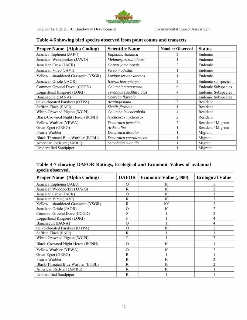
Sagicor Ja. Ltd. (LOJ) Llandovery Development Environmental Impact Assessment
________________________________________________________________________42
Table 4-6 showing bird species observed from point counts and transects
Proper Name (Alpha Coding) Scientific Name Number Observed Status Jamaica Euphonia (JAEU) Euphonia Jamaica 2 Endemic Jamaican Woodpecker (JAWO) Melanerpes radiolatus 1 Endemic Jamaican Crow (JACR) Corvus jamaicensis 2 Endemic Jamaican Vireo (JAVI) Vireo modestus 1 Endemic Yellow – shouldered Grassquit (YSGR) Loxipasser anoxanthos 1 Endemic Jamaican Oriole (JAOR) Icterus leucopteryx 2 Endemic subspecies Common Ground Dove (COGD) Columbina passerina 6 Endemic Subspecies Loggerhead Kingbird (LOKI) Tyrannus caudifasciatus 4 Endemic Subspecies Bananaquit (BANA) Coereba flaveola 3 Endemic Subspecies Olive-throated Parakeet (OTPA) Aratinga nana 3 Resident Saffron Finch (SAFI) Sicalis flaveola 1 Resident White-Crowned Pigeon (WCPI) Columba leucocephala 4 Resident Black-Crowned Night Heron (BCNH) Nycticorax nycticorax 2 Resident Yellow Warbler (YEWA) Dendroica petechia 2 Resident / Migrant Great Egret (GREG) Ardea alba 1 Resident / Migrant Prairie Warbler Dendroica discolor 1 Migrant Black-Throated Blue Warbler (BTBL) Dendroica caerulescens 1 Migrant American Redstart (AMRE) Setophaga ruticilla 1 Migrant Unidentified Sandpiper 1 Migrant Table 4-7 showing DAFOR Ratings, Ecological and Economic Values of avifaunal specie observed. Proper Name (Alpha Coding) DAFOR Economic Value (, 000) Ecological Value Jamaica Euphonia (JAEU) O 10 5 Jamaican Woodpecker (JAWO) R 10 2 Jamaican Crow (JACR) O 10 1 Jamaican Vireo (JAVI) R 10 3 Yellow – shouldered Grassquit (YSGR) R 100 3 Jamaican Oriole (JAOR) O 10 2 Common Ground Dove (COGD) F 1 2 Loggerhead Kingbird (LOKI) F 1 4 Bananaquit (BANA) O 1 4 Olive-throated Parakeet (OTPA) O 10 2 Saffron Finch (SAFI) R 1 1 White-Crowned Pigeon (WCPI) F 1 2 Black-Crowned Night Heron (BCNH) O 10 1 Yellow Warbler (YEWA) O 10 2 Great Egret (GREG) R 1 1 Prairie Warbler R 10 2 Black-Throated Blue Warbler (BTBL) R 10 2 American Redstart (AMRE) R 10 1 Unidentified Sandpiper R 1 1

Sagicor Ja. Ltd. (LOJ) Llandovery Development Environmental Impact Assessment
________________________________________________________________________43
4.2.2.2 Other Fauna
In terms of other species of fauna observed during the day and evening terrestrial
surveys, the Llandovery property can be characterized as species poor. Most of the fauna
observed were associated with the wetland areas, which in addition to birds, included
butterfly and wasp species common to the rest of the north coast habitat as well as land
crabs (Cardisoma guanhumi). Blue land crab burrows are found within the mangrove
areas along the beach as well as within the wooded areas throughout the property. Land
crabs are harvested locally as a food source. At the local scale, it is believed that
population numbers have been negatively impacted by the construction of the highway.
As such, the proposed development will further contribute to fragmenting the land crab
habitat range in the area.
Mongoose were observed along roadside transects. They were introduced to Jamaica in
the 1800s and their status as an invasive/pest species is attributed to their indiscriminate
predation on animals ranging from rats to ground-nesting birds and their eggs, snakes,
lizards, toads as well as crabs.
Although the survey results did not yield direct observations of indigenous and endemic
species that require special conservation considerations, it is important to note that the
proposed site is part of habitat corridor along the island’s north coast which historically
supported a wide range of floral and faunal species e.g. various bats; the Jamaican
yellow boa as well as sea turtles that in particular used the vast stretches of rapidly
disappearing undisturbed sandy beaches as nesting grounds.
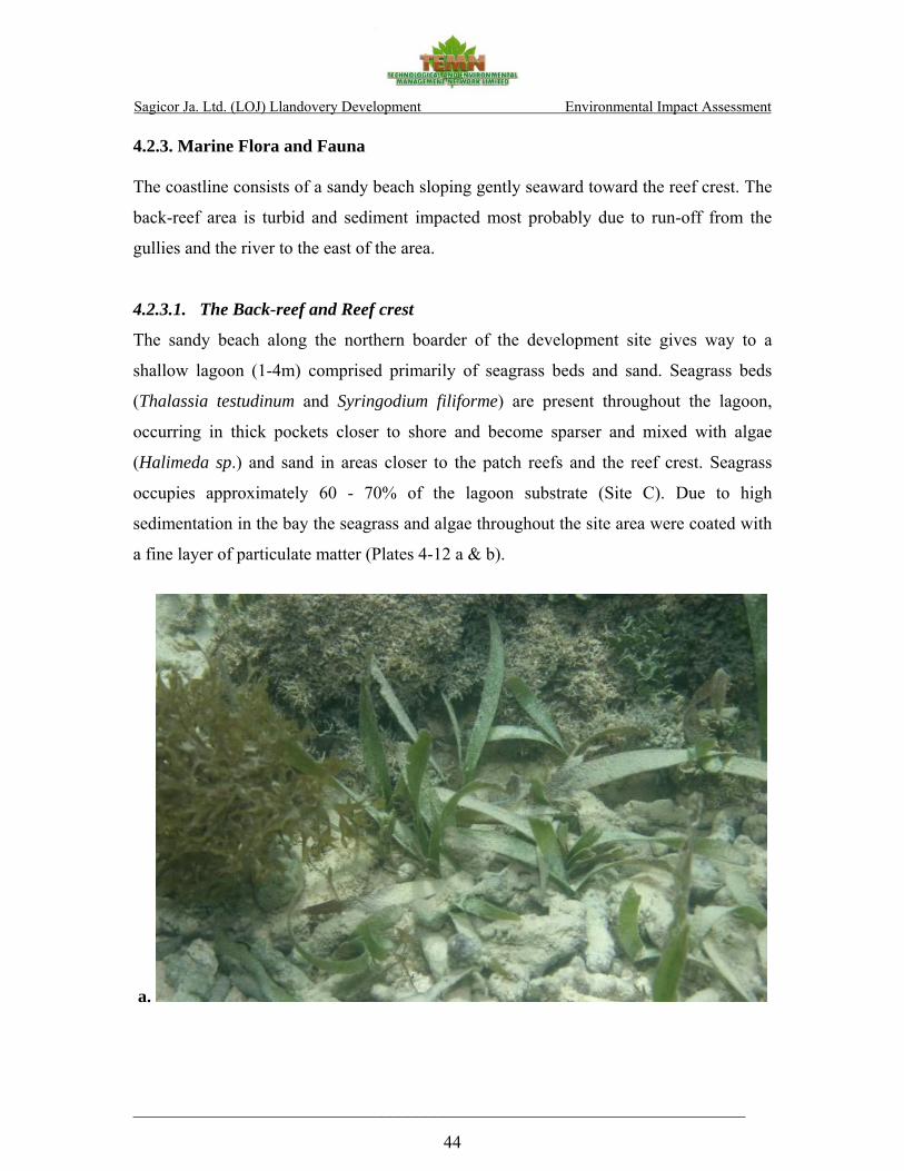
Sagicor Ja. Ltd. (LOJ) Llandovery Development Environmental Impact Assessment
_____________________________________________________________________
44
4.2.3. Marine Flora and Fauna
The coastline consists of a sandy beach sloping gently seaward toward the reef crest. The
back-reef area is turbid and sediment impacted most probably due to run-off from the
gullies and the river to the east of the area.
4.2.3.1. The Back-reef and Reef crest
The sandy beach along the northern boarder of the development site gives way to a
shallow lagoon (1-4m) comprised primarily of seagrass beds and sand. Seagrass beds
(Thalassia testudinum and Syringodium filiforme) are present throughout the lagoon,
occurring in thick pockets closer to shore and become sparser and mixed with algae
(Halimeda sp.) and sand in areas closer to the patch reefs and the reef crest. Seagrass
occupies approximately 60 - 70% of the lagoon substrate (Site C). Due to high
sedimentation in the bay the seagrass and algae throughout the site area were coated with
a fine layer of particulate matter (Plates 4-12 a & b).
a.

Sagicor Ja. Ltd. (LOJ) Llandovery Development Environmental Impact Assessment
_____________________________________________________________________
45
b. Plates 4-12 a & b showing sediment covered seagrass bed. Coral cover in the lagoon is generally sparse, comprised primarily of a few scattered
coral boulders (Siderastrea siderea). To the west, the lagoon is interspersed with dead
patch reef formations which are in certain cases entirely overgrown with algae (Site E),
particularly red algae Bryothamnion triquetrum and Bostrychia tenella as well as brown
algae Dictyota sp., Lobophora and Padina sp (Plates 4-13 a, b, & c). Small colonies of
Diploria sp. Montastrea cavernosa, Montastrea faveolata, Porites porites as well as M.
complanata and the gorgonian, Briareum asbestinum were observed on the leeward side
of the reef crest (Sites G and D).

Sagicor Ja. Ltd. (LOJ) Llandovery Development Environmental Impact Assessment
_____________________________________________________________________
46
a.
b.
c.
Plates 4-13 a, b & c showing dead reef patches observed in the lagoon overgrown with macroalgae.

Sagicor Ja. Ltd. (LOJ) Llandovery Development Environmental Impact Assessment
_____________________________________________________________________
47
The fish community in the bay is comprised primarily of juvenile fish including wrasses,
grunts, Harlequin basses, juvenile parrotfish, and damselfish. Due to very poor visibility
it was not possible to carry out a proper assessment of the fish population in the lagoon.
Sea urchins, namely Diadema antillarum and Tripneustes esculentus were notably absent
in the back-reef area. Other echinoderm species such as Lytechinus veriegatus and
Holothuria Mexicana were occasionally found in the seagrass beds.
The windward side of the reef crest (sites D, B and A), which is also subject to high
sedimentation, supports a diverse coral community. The relatively high coral cover
ranges from 15 to 30% and can be attributed to the presence of large encrusting coral
colonies primarily Montastrea faveolata (~0.5m 2), Siderastrea siderea, Diploria
labyrinthiformis and Colpophyllia natans (Plates 4-14 a & b). Other frequently occurring
coral species include Porites porites, Porites asteroides sp, Montastrea cavernosa, and
Agaricia sp., including Agaricia tenufolia (Table 4-8).
a.
b.
Plates 4-14 a & b showing coral cover on the windward side of the reef crest.
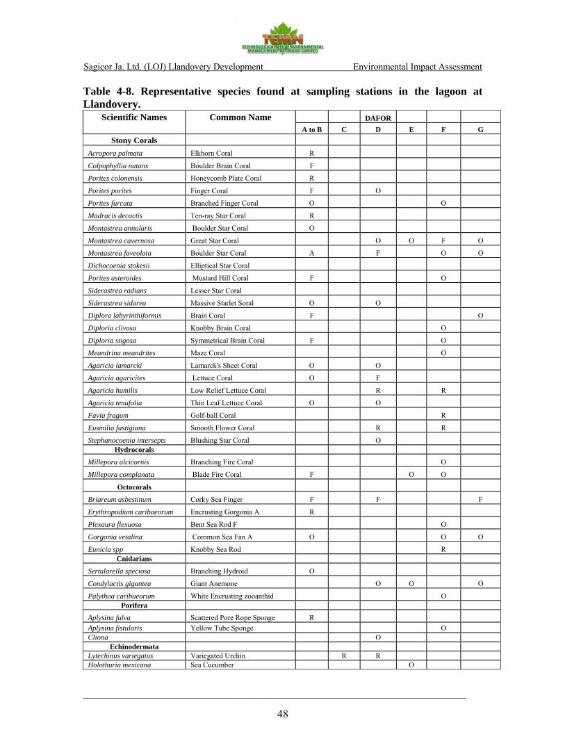
Sagicor Ja. Ltd. (LOJ) Llandovery Development Environmental Impact Assessment
_____________________________________________________________________
48
Table 4-8. Representative species found at sampling stations in the lagoon at Llandovery.
Scientific Names Common Name DAFOR A to B C D E F G
Stony Corals
Acropora palmata Elkhorn Coral R
Colpophyllia natans Boulder Brain Coral F
Porites colonensis Honeycomb Plate Coral R
Porites porites Finger Coral F O
Porites furcata Branched Finger Coral O O
Madracis decactis Ten-ray Star Coral R
Montastrea annularis Boulder Star Coral O
Montastrea cavernosa Great Star Coral O O F O
Montastrea faveolata Boulder Star Coral A F O O
Dichocoenia stokesii Elliptical Star Coral
Porites asteroides Mustard Hill Coral F O
Siderastrea radians Lesser Star Coral
Siderastrea sidarea Massive Starlet Soral O O
Diplora labyrinthiformis Brain Coral F O
Diploria clivosa Knobby Brain Coral O
Diploria stigosa Symmetrical Brain Coral F O
Meandrina meandrites Maze Coral O
Agaricia lamarcki Lamarck's Sheet Coral O O
Agaricia agaricites Lettuce Coral O F
Agaricia humilis Low Relief Lettuce Coral R R
Agaricia tenufolia Thin Leaf Lettuce Coral O O
Favia fragum Golf-ball Coral R
Eusmilia fastigiana Smooth Flower Coral R R
Stephanocoenia intersepts Blushing Star Coral O Hydrocorals
Millepora alcicornis Branching Fire Coral O
Millepora complanata Blade Fire Coral F O O
Octocorals
Briareum asbestinum Corky Sea Finger F F F
Erythropodium caribaeorum Encrusting Gorgonia A R
Plexaura flexuosa Bent Sea Rod F O
Gorgonia vetalina Common Sea Fan A O O O
Eunicia spp Knobby Sea Rod R Cnidarians
Sertularella speciosa Branching Hydroid O
Condylactis gigantea Giant Anemone O O O
Palythoa caribaeorum White Encrusting zooanthid O Porifera
Aplysina fulva Scattered Pore Rope Sponge R Aplysina fistularis Yellow Tube Sponge O Cliona O
Echinodermata Lytechinus variegatus Variegated Urchin R R Holothuria mexicana Sea Cucumber O
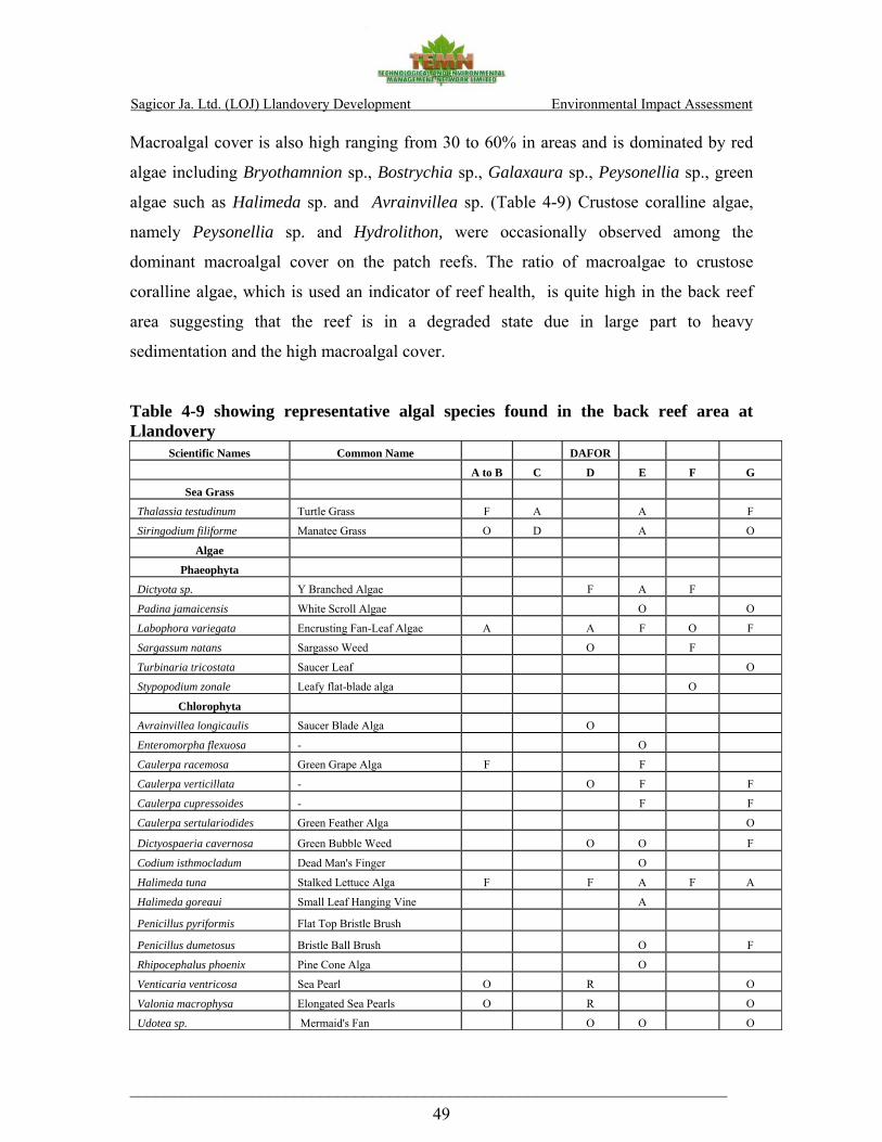
Sagicor Ja. Ltd. (LOJ) Llandovery Development Environmental Impact Assessment
_____________________________________________________________________ 49
Macroalgal cover is also high ranging from 30 to 60% in areas and is dominated by red
algae including Bryothamnion sp., Bostrychia sp., Galaxaura sp., Peysonellia sp., green
algae such as Halimeda sp. and Avrainvillea sp. (Table 4-9) Crustose coralline algae,
namely Peysonellia sp. and Hydrolithon, were occasionally observed among the
dominant macroalgal cover on the patch reefs. The ratio of macroalgae to crustose
coralline algae, which is used an indicator of reef health, is quite high in the back reef
area suggesting that the reef is in a degraded state due in large part to heavy
sedimentation and the high macroalgal cover.
Table 4-9 showing representative algal species found in the back reef area at Llandovery
Scientific Names Common Name DAFOR
A to B C D E F G
Sea Grass
Thalassia testudinum Turtle Grass F A A F
Siringodium filiforme Manatee Grass O D A O
Algae
Phaeophyta
Dictyota sp. Y Branched Algae F A F
Padina jamaicensis White Scroll Algae O O
Labophora variegata Encrusting Fan-Leaf Algae A A F O F
Sargassum natans Sargasso Weed O F
Turbinaria tricostata Saucer Leaf O
Stypopodium zonale Leafy flat-blade alga O
Chlorophyta
Avrainvillea longicaulis Saucer Blade Alga O
Enteromorpha flexuosa - O
Caulerpa racemosa Green Grape Alga F F
Caulerpa verticillata - O F F
Caulerpa cupressoides - F F
Caulerpa sertulariodides Green Feather Alga O
Dictyospaeria cavernosa Green Bubble Weed O O F
Codium isthmocladum Dead Man's Finger O
Halimeda tuna Stalked Lettuce Alga F F A F A
Halimeda goreaui Small Leaf Hanging Vine A
Penicillus pyriformis Flat Top Bristle Brush
Penicillus dumetosus Bristle Ball Brush O F
Rhipocephalus phoenix Pine Cone Alga O
Venticaria ventricosa Sea Pearl O R O
Valonia macrophysa Elongated Sea Pearls O R O
Udotea sp. Mermaid's Fan O O O

Sagicor Ja. Ltd. (LOJ) Llandovery Development Environmental Impact Assessment
_____________________________________________________________________ 50
Scientific Names Common Name DAFOR
A to B C D E F G
Rhodophyta
Galaxaura sp. Tubular Thicket Algae O F F F
Amphiroa rigida Y Twig Alga O F
Bostrychia tenella - A F A
Bryothamnion triquetrum - A A A
Ceramium - A A
Gelidiella acerosa - F F
Jania sp. Pink Segmented Algae F F F F
Gracilaria sp - F F
Hydrolithon Reef Cement O O
Peyssonnelia Burgandy Crust Algae F F F
4.2.3.2. Fore-Reef Area (Sites F and H)
The fringing reef is located approximately 500 m from the shore displays the typical spur
and groove reef formation. The shallow fore-reef area (Site F) is in relatively poor
condition comprised primarily of bare substrate with little vertical relief. The area is
subject to continuous wave action and strong surge (Plates 4-15 a & b).
a.
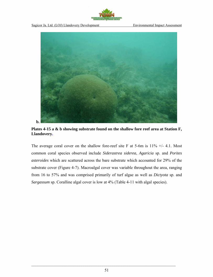
Sagicor Ja. Ltd. (LOJ) Llandovery Development Environmental Impact Assessment
_____________________________________________________________________ 51
b.
Plates 4-15 a & b showing substrate found on the shallow fore reef area at Station F, Llandovery.
The average coral cover on the shallow fore-reef site F at 5-6m is 11% +/- 4.1. Most
common coral species observed include Siderastrea siderea, Agaricia sp. and Porites
asteroides which are scattered across the bare substrate which accounted for 29% of the
substrate cover (Figure 4-7). Macroalgal cover was variable throughout the area, ranging
from 16 to 57% and was comprised primarily of turf algae as well as Dictyota sp. and
Sargassum sp. Coralline algal cover is low at 4% (Table 4-11 with algal species).

Sagicor Ja. Ltd. (LOJ) Llandovery Development Environmental Impact Assessment
_____________________________________________________________________ 52
F
-100
10203040506070
CORAL
GORGONIANS
SPONGES
MACROALGAE
CORALLINE ALGAE
SEAGRASS
OTHER LIVE
DISEASED CORALS
DEAD CORAL WITH ALGA
SAND, PAVEMENT, R
UBB
TAPE , WAND, S
HADOW
% c
over
+/-
SD
Figure 4-7 showing percent cover (+/- SD) of benthic organisms on the shallow fore-reef station F at a depth of 6m
The gently sloping fore-reef substrate gives way to well developed buttresses separated
by unusually deep sand channels sloping gradually towards the drop-off. In contrast to
many other areas of north coast reefs, healthy colonies of Acropora palmata (which is a
CITESiii protected species) were frequently observed atop the buttresses (Plates 4-16 a, b,
c, d &e).

Sagicor Ja. Ltd. (LOJ) Llandovery Development Environmental Impact Assessment
_____________________________________________________________________ 53
a. b.
c.
d. e.
Plates 4-16 a, b, c, d & e showing sand channel between two buttresses with healthy Acropora palmata colonies.

Sagicor Ja. Ltd. (LOJ) Llandovery Development Environmental Impact Assessment
_____________________________________________________________________ 54
The average scleractinian coral cover on the buttress was 21.1% +/-4, with Porites
asteroides, Agaricia sp. and Montastrea faveolata being the most common species
encountered at the 8-10m depth range (Table 4-10). Sponges, primarily encrusting and
boring sponges such at Cliona sp., accounted for 16% +/- 0.8 of the substrate.
The relatively high coral cover and the presence of Acropora spp. in shallow water was a
rare sight and has potential in terms of the possibility of this reef acting as a reproductive
reservoir for various species of coral. It also stressed the need for the protection of this
area from further anthropogenic impact.
Gorgonians, which contributed to approximately 2% of the substrate cover, include
species such as the Common Sea Fan (Gorgonia ventalina) and the Encrusting Gorgonian
(Erythropodium caribaeorum).
H
05
10152025303540
CORAL
GORGONIANS
SPONGES
MACROALGAE
CORALLINE ALGAE
SEAGRASS
OTHER LIVE
DISEASED CORALS
DEAD CORAL WITH ALGA
SAND, PAVEMENT, RUBBL
TAPE, WAND, SHADOW
% c
over
+/-
SD
Figure 4-8 showing Percent cover (+/- SD) of benthic organisms on the shallow fore-reef station F at a depth of 6m

Sagicor Ja. Ltd. (LOJ) Llandovery Development Environmental Impact Assessment
_____________________________________________________________________ 55
Table 4-10 showing coral species identified on the shallow fore-reef and on the buttress at 10m at Llandovery
Common Name Scientific Name F (6m) H (10m) Coral Coral Mean SD Mean SD Elkhorn coral Acropora palmata - - 0.45 0.3 Lettuce coral Agaricia agaricites 1.09 0.6 2.12 0.6 Dimpled sheet coral Agaricia grahamae - - 0.18 0.3 Low relief lettuce coral Agaricia humilis - - 0.65 0.6 White star sheet coral Agaricia lamarki - - 0.96 0.3 Sheet coral Agaricia sp 0.19 0.3 - - Scroll coral Agaricia undata - - 0.07 0.1 Boulder brain coral Colpophyllia natans - - 0.33 0.5 Grooved brain coral Diploria labyrinthiformis - - 0.66 0.9 Symmetrical brain coral Diploria strigosa 0.25 0.1 0.06 0.1 Smooth flower coral Eusmilia fastigiata 0.10 0.1 - - Ten-ray star coral Madracis decactis - - 0.12 0.2 Yellow pencil coral Madracis mirabilis - - 0.26 0.4 Maze coral Meandrina meandrites 0.27 0.2 0.12 0.2 Fire coral Millepora sp 1.04 0.1 1.20 0.6 Boulder star coral Montastraea annularis - - 1.07 0.4 Great star coral Montastraea cavernosa 0.48 0.7 0.63 0.1 Boulder star coral Montastrea faveolata 0.19 0.3 1.62 1.1 Mustard hill coral Porites astreoides 0.84 0.4 9.39 6.5 Thin finger coral Porites furcata 0.08 0.1 0.26 0.4 Finger coral Porites porites 0.10 0.1 0.18 0.3 Lesser starlet coral Siderastrea radians 0.25 0.1 0.19 0.1 Massive starlet coral Siderastrea sidereal 5.56 2.5 0.39 0.2
Blushing star coral Stephanocoenia intersepta 0.33 0.2 0.12 0.2
Coral juvenile 0.19 0.3 - - Percent coral cover (%) 10.97 21.07
The algal community at the 8-10m depth range was dominated by fleshy species
including, Dictyota sp., Lobophora sp. and Sargassum sp. which contribute to
approximately 28.3% +/- 5.2. Calcareous macroalgae (including Crustose Coralline
algae) account for up to 22.7% +/- 0.9 of the substrate within this depth range and are
represented by Halimeda sp. (Table 4-10).

Sagicor Ja. Ltd. (LOJ) Llandovery Development Environmental Impact Assessment
_____________________________________________________________________ 56
Table 4-11 showing algal species identified on the shallow fore-reef and on the buttress at 10m.
Common Name Scientific Name 6m 10m Macroalgae Macroalgae Mean SD Mean SD Green-grape alga Caulerpa sp. - - 0.33 0.29 Dead man's fingers Codium sp. 0.24 0.34 - - Y branched alga Dictyota sp. 5.44 3.05 5.01 0.91 Encrusting fan-leaf alga Lobophora sp. 0.45 0.18 3.24 0.46 Meristiella sp. 0.10 0.14 - - Sargassum Sargassum sp. 2.41 1.51 1.89 0.80 Turf Turf algae 27.64 24.91 17.82 3.29 Percent Cover 36.27 28.29 Common Name Scientific Name 6m 10 m Coralline Algae Coralline Algae Mean SD Mean SD Twig Alga Amphiroa sp. 0.08 0.11 0.78 0.40 Tubular thicket alga Galaxaura sp. - - 0.07 0.09 Watercress alga Halimeda sp. 0.29 0.41 15.09 2.98 Pink segmented alga Jania sp. - - 0.44 0.25 White scroll alga Padina sp. 0.08 0.11 - - Burgundy crust alga Peysonellia sp. 0.10 0.14 - - Mermaid’s fans Udotea sp. 0.08 0.11 - - Crustose coralline algae 3.21 3.64 6.34 3.58 Percent Cover 3.83 22.71
Diadema antillarum a keystone species (Lessios, 1988) were frequently observed on the
fore reef area and exhibited a patchy distribution throughout the habitat (Plate 4-17). At 6
m Diadema densities ranged between 2 and 14 urchins per m2 and were slightly lower at
18m with densities ranging between 2 and 8 urchins per m2.
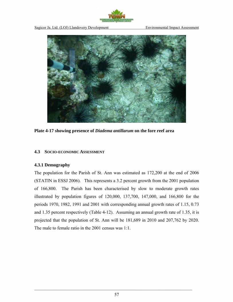
Sagicor Ja. Ltd. (LOJ) Llandovery Development Environmental Impact Assessment
_____________________________________________________________________ 57
Plate 4-17 showing presence of Diadema antillarum on the fore reef area 4.3 SOCIO-ECONOMIC ASSESSMENT
4.3.1 Demography
The population for the Parish of St. Ann was estimated as 172,200 at the end of 2006
(STATIN in ESSJ 2006). This represents a 3.2 percent growth from the 2001 population
of 166,800. The Parish has been characterised by slow to moderate growth rates
illustrated by population figures of 120,000, 137,700, 147,000, and 166,800 for the
periods 1970, 1982, 1991 and 2001 with corresponding annual growth rates of 1.15, 0.73
and 1.35 percent respectively (Table 4-12). Assuming an annual growth rate of 1.35, it is
projected that the population of St. Ann will be 181,689 in 2010 and 207,762 by 2020.
The male to female ratio in the 2001 census was 1:1.

Sagicor Ja. Ltd. (LOJ) Llandovery Development Environmental Impact Assessment
_____________________________________________________________________ 58
Table 4 - 12 showing population for the Parish of St. Ann
Year Total Males Females Intercensal Change %
Annual Rate of Growth
1970 120,000 59,500 60,500 - -
1982 137,700 69,300 69,300 14.75 1.15
1991 147,000 73,800 73,200 6.75 0.73
2001 166,800 83,915 82,773 13.40 1.35
2006 172,200 0.65 Source: STATIN, Jamaica
The population of the Socio-Economic Impact Assessment (SIA) study area falls within
several enumeration districts (Table 4 - 13). The 2001 population census indicated that
the population of the enumeration district within which the SIA site is located was
approximately 389. However, visits to the area revealed that there were no residences or
other evidence of population within 0.5km of the site. The population was 3004 within
2km of the site. Assuming annual growth rates of 0.65 percent, the population of the SIA
area would be 6,139 in 2006 and 3083 in 2010 and 3289 in 2020.
The socio-economic and perception survey results indicated that the average household
size of the SIA study area is 4 individuals with ranges from 1 to 14 persons per
household. This average exceeds the national average of 3.3 (Survey of Living
Conditions [SLC] 2005). It also represents an increase from the Parish average in 2002,
which was 3.5 (SLC 2002). Sixty four percent (64%) of respondents were the head of
their households. Of this, 76 percent were males and 24 percent were females. This
represents a significant increase from the 57.8 percent male-headed households reported
for the parish of St. Ann in the 2002 SLC. Twenty eight percent (28%) of the heads of
households were between ages 30-39 and 24 percent were between 40 and 49. Fifteen
percent (15%) were in 18-29 age group, 14 percent were in the 50-59 age group and 8
percent were in the over 60 age group. Four percent (4%) of the household heads did not
identify the age group to which they belonged. The proposed development includes the
construction of 108 residential units. Assuming average household size of 4.1, the

Sagicor Ja. Ltd. (LOJ) Llandovery Development Environmental Impact Assessment
_____________________________________________________________________ 59
proposed development may introduce an additional 443 persons to the SIA study area.
This would change the population projections to 3492 in 2010 and 3726 in 2020.
Table 4 – 13 showing population within SIA Study Area
Enumeration Districts (EDs) Male Female Total Within 0.5 km
06NW027 0 0 0
Within 2km
06NW020 289 344 633
06NW021 277 310 587
06NW022 126 265 391
06NW026 281 311 592
06NW027 164 225 389
06NW028 117 295 412
Total 1254 1750 3004 Source: STATIN-2001, Jamaica
4.3.2 Employment and Income
Of the respondents interviewed, 67 percent were employed outside of the home. Of this,
32 percent had full-time jobs, 20 percent were self-employed and 16 percent had part-
time jobs. The main occupation types included hospitality workers (e.g. housekeepers,
care takers, receptionists and waiters), law enforcement officers, business owners,
construction workers, vendors, store clerks and cashiers. Twenty seven percent (27%) of
respondents earned over $10,000 per week. Nineteen percent (19%) earned $3,000-
$5,999 per week, 12 percent (12%) earned $6,000-$9,000. Thirty eight percent had no
response and five percent earned less than $3,000 per week.
Ten percent of respondents interviewed indicated that they worked one mile or less (0.62
km) from their homes. Twenty three percent (23%) worked between 1-5 miles, 10

Sagicor Ja. Ltd. (LOJ) Llandovery Development Environmental Impact Assessment
_____________________________________________________________________ 60
percent worked 6-10 miles, two percent (2%) worked between 11-20 miles and 3 percent
worked over 20 miles from home.
4.3.3 Transportation
The survey indicated that the most frequent mode of transportation utilised within the
SIA study area was public transportation in the form of buses and taxis. A large number
of respondents used their private vehicles while a smaller percentage walked short
distances within the SIA area. Mini and mid size buses were also used to travel to other
areas such as Ocho Rios, St. Ann’s Bay, Discovery Bay, Falmouth, Montego Bay and
Kingston.
4.3.4 Social Services
The survey indicated that over 90 percent of applicable respondents shopped outside the
SIA study area. Thirty two percent (32%) shopped in St. Ann’s Bay, 4 percent in Ocho
Rios, three percent (3%) in Runaway Bay, 2 percent in Browns Town and 1 percent in
Discovery Bay and Montego Bay. There was a supermarket and several retail stores,
wholesales and restaurants within the SIA area.
The respondents also obtained health care outside of the SIA study area. The majority of
the respondents obtained health care from the Saint Ann’s Bay Hospital, which is located
approximately 8km from the SIA study area. Health care was also obtained in Runaway
Bay, Ocho Rios, Falmouth and Montego Bay.
There were no Fire or Police Stations within the SIA study area. The closest police and
fire stations are located in Runaway Bay and St. Ann’s Bay, respectively.
4.3.5 Education
There are no public schools within the SIA study area. However, a private preparatory
school is in Salem. Two public schools, Hampton and Glen Preparatory, are located in
Runaway Bay. Public schools are also located in St. Ann’s Bay.
Sagicor Ja. Ltd. (LOJ) Llandovery Development Environmental Impact Assessment
_____________________________________________________________________ 61
The average household size within the SIA study area was 4 comprising of an average of
3 children under 18 years old. Approximately 65 percent of applicable respondents had
children attending schools that are located five miles or from home. The main schools
attended were Runaway Bay All Age, York Castle High, Hampton Preparatory, St. Ann’s
Bay Primary, Ocho Rios High, Browns Town High and Buckingham Prep.
Assuming per household average of 3 children under 18 years (survey), the proposed
development may introduce an additional 702 children in the SIA study area. This will
have implications for education as the educational facilities in the area may not be
sufficient to serve the relevant population being introduced.
Five percent (5%) of heads of households interviewed indicated that they had no
schooling. Thirty percent (30%) attained up to primary level, 49 percent attained up to
secondary/high school level and 14 percent attained up to college/university levels.
4.3.6 Housing
The survey revealed that 46 percent of respondents owned the house in which they live.
This figure is less than the figure recorded for the parish in the 1991 census (63.1 %) and
the 2002 SLC (59.6 %). Forty one percent (41%) of respondents owned or leased the
lands on which their homes are situated. Seventy seven percent (77%) of respondents’
dwellings were constructed of reinforced concrete while seventeen percent (17%) were
constructed of wood and other materials. The majority of the roofs of dwellings were
constructed of zinc (44 %) and concrete (19 %). This is consistent with the construction
material of dwellings in the parish percent (52.5 %) in the 2002 SLC).
The majority of respondents lived in houses containing 1-4 bedrooms (94 %) and 1-2
bathrooms (91 %). Eighty percent (80%) of houses were equipped with indoor toilet
facilities (water closets) and five percent (5%) had pit latrines. The majority of
households had access to public piped water into their houses (64 %) or their yards (22
Sagicor Ja. Ltd. (LOJ) Llandovery Development Environmental Impact Assessment
_____________________________________________________________________ 62
%). There was some access to residential phones (27 % of respondents); however, the
majority used mobile phones.
4.3.7 Solid Waste Disposal
The survey indicated that there was a regular solid waste disposal system serving the
area. Approximately 75 % of respondents had their garbage collected by public garbage
trucks operated by the municipality (North-Eastern Parks and Waste Management Ltd.).
Four percent (4%) had private arrangements for garbage collection, while 15 % burned
their garbage. Three percent (3%) of respondents reported that they disposed of their
garbage in the gully. Fifty nine percent (59%) of respondents had their garbage collected
once to twice per week.
The National Solid Waste Management Authority (NSWMA) is the government agency
with the mandate to regulate the solid waste industry in Jamaica. The NSWMA currently
collects, treats and disposes of domestic solid waste. However, the NSWMA is not
responsible for the collection, treatment or disposal of commercial, agricultural, industrial
or hazardous waste. Therefore, the NSWMA would be responsible for the collection of
solid waste for only the residential portions of the proposed development. The parishes
of St. Ann, Portland and St. Mary are located in the North-Eastern Parks and Waste
Management Ltd. (NEPM) waste shed. The NSWMA indicated that NEPM Ltd.
consisted of a fleet of 16 trucks in 2006, which is inadequate to meet the needs of the
waste shed. The proposed development will result in an increase of domestic waste,
which will further stress the activities of the NEPM.
4.3.8 Community Fabric/Cohesion
Community fabric and cohesiveness may be considered relatively strong in the study
area. Sixty four percent (64%) of respondents reported that they participate in activities
within their communities and the study area including street dances, sporting activities,
church group activities and youth clubs. There is a community centre (Salem
Community Centre) and a fishing/bathing beach within 2km of the SIA site.
Sagicor Ja. Ltd. (LOJ) Llandovery Development Environmental Impact Assessment
_____________________________________________________________________ 63
4.3.9 Cultural Heritage
The Jamaica National Heritage Trust indicated that there are no Historical Sites within
the SIA study area. Jamaica Heritage sites identified beyond the study area include The
St Ann Parish Church, the St. Ann’s Bay Fort and Cardiff Hall Great House in Runaway
Bay.
4.3.10 Public Perception
Seventy one percent (71 %) of respondents indicated that they were not aware of the
proposed residential development. Eighty percent (80%) of respondents thought that the
proposed development would have a positive impact on the community, while five
percent (5%) thought that the impacts would be negative.
Respondents were asked what effects they think the proposed development will have on
employment, housing, the environment, tourism and them personally. Over 50 percent
(50%) of respondents indicated that the development would result in increased job
opportunities. Respondents also thought that the development would increase the
availability of housing in the area. Some respondents however noted that based on the
site’s location and the type of housing being proposed the prices of the units would be
unaffordable to many. Respondents also noted that there would be less vacant land and
the community would be more aesthetic. Two percent (2%) of respondents thought the
proposed development could result in increased squatting from migrant workers.
Only seven percent (7%) of respondents indicated that the proposed development would
negatively impact the environment, and that it may result in increasing flooding of the
area.
Most respondents thought that the proposed development would have no impact on them
personally. However, others indicated that there would be increased availability of
housing solutions which they may be able to afford. Others thought they would not be
able to afford the units.
The respondents commented that the proposed development will provide more housing
solutions which may alleviate squatting. Others commented that the jobs would be

Sagicor Ja. Ltd. (LOJ) Llandovery Development Environmental Impact Assessment
_____________________________________________________________________ 64
provided which would cut unemployment and “give the young people something to do.”
The main area of concern expressed was whether the residents of the community would
benefit from the community.
4.4 HYDROGEOLOGY 4.4.1. Geology, Topography and Soils
Published geological information (Geological Sheet 14, 1:50,000 Imperial Series, extract
shown in Figure 2, Appendix VI-A) indicates the solid geology of the site comprises elevated
reefs and Gravel Fans of the Falmouth Formation of the Pleistocene Coastal Group. These
reefs can be up to 40m thick and contain well preserved fauna of corals and molluscs. The
gravel fans form a continuous belt along the coast and comprise well rounded, poorly sorted
reworked White Limestone. The elevated reefs form a fringing terrace along the coast at Flat
Point. The elevated reef levels are comparable to reef terrace levels found in other parts of the
worldi.
The overlying superficial deposits, in the vicinity of the site, comprise a combination of
reworked limestone gravels resulting from alluvial processes associated with possibly the
meandering of the Flat Point River. The soils are generally insignificant or shallow. The
Geological Classification of Jamaican Rocks (1983) presumes the bearing capacity of such
soils as reasonable (600 – 2000 KN/m2), however the presence of wetlands would suggest the
presence of low permeability soils such as clays which typically have a low to very low
bearing capacity especially if peat or organic soils are present. No intrusive borelogs were
available for the site at the time of this report.
The Hampton Well cave is identified by the WRA in the Beverley area 700m southwest of the
site. The cave is characterised by a plunge pool and is also referred to as “Sailor Hole”.
The foregoing Quaternary Deposits are further underlain by Miocene Montpelier Limestone
Formation of the White Limestone Group. Both the Quaternary and the older Miocene
formations are lumped classified as aquicludes by the WRA (Figure 3, Appendix VI-A). No
significant structural systems (faults, etc.) are indicated on the geological sheet within 500m of

Sagicor Ja. Ltd. (LOJ) Llandovery Development Environmental Impact Assessment
_____________________________________________________________________ 65
the site footprint. The beach sand is likely to consist of fine to coarse, moderately sorted
calcareous sand derived from the existing coastal reef systems.
4.4.2 Groundwater and Surface Water Resources
The nearest, named surface watercourse to the site is the Flat Point River, which lies along the
eastern boundary of the site. Its drainage basin is approximately 3.7 km2. The second closest
watercourse is the Cistern River located approximately 1km east of the site. The closest stream
flow gauging stations are located 1.5km east of the site, on the Laughlands Great River.
No water quality records were held by the WRA for the Flat Point River. The WRA is not
aware of any material groundwater or surface water contamination issues, but does suggest
that groundwater quality at the coast may be impacted by the marine environment (i.e. tidal
influenced) and as such may be brackish.
Figure 3, Appendix VI-A shows no wells or boreholes within the 1km of the site. No licensed
surface or groundwater abstractions are noted within 1km of the site. The nearest licensed
abstraction is that at the Cardiff Hall well 4km southwest of the site.
The 30-yr mean annual (1951-1980) rainfall for St. Ann was obtained from the
Meteorological Office for June and July is recorded at 150mm and 50mm respectively. In
June 2006 and June 2007 the rainfall figures stood at 123mm and 147mm respectively. By
the Met Service’s calculations this rainfall is 7% greater than the 30-yr average.
Mains water, according to the National Water Commission (NWC) comes from the recently
implemented a J$2.4 billion Martha Brae/Harmony Hall water supply project that supplies
developments along the north coast from Falmouth to Port Maria, St. Mary in the east. The
project involved the refurbishing of the Martha Brae treatment plant to increase output from 4
million gallons per day (mgd) to 6mgd. There will also be the construction of over 19
kilometres of pipelines, two service reservoirs and a booster station. The project was
successfully completed in 2006. Given the projected capacity of the system the proposed
project will have more than adequate water supply should it be undertaken. Currently

Sagicor Ja. Ltd. (LOJ) Llandovery Development Environmental Impact Assessment
_____________________________________________________________________ 66
negotiations are underway to decide whether the 20” supply line should be extended to the
development or the current north coast 8” pipeline would be used.
4.4.3. Sewerage Facilities
There are no recorded sewerage facilities within 1km of the site.
4.4.4. Flooding or other disaster incidents
The WRA has no floodplain maps of the site. The ODPEM records indicate one flood event
at Scarlett, St. Ann 2 km west of the site. No details were given as to the date, cause, or
extent, of the flooding.
Given the proximity of the site to the coast, shallow depth to groundwater and the low-lying
nature of the land, flooding from both storm surges and the Flat Point River are realisable
hazards. A brief review of the flooding hazard is discussed in Section 4.4.9 .The storm surge
analysis is in section 4.5.
4.4.5. Seismic Hazard
The seismic hazard map of Jamaica shows that the project site lies in an area that can expect a
Modified Mercalli Intensity of 7 with a 10% chance of exceedance in any 50 year period.
Expected horizontal ground velocity is predicted to be between 18 -16 cm/sec and horizontal
ground acceleration between 270 – 245 galsii.
4.4.6. Landslip Hazard
The topography and geology would suggest that land slippage would be a negligible risk.
And any created slopes would need to be done according to the geotechnical design
specifications to mitigate the risk of failure.
4.4.7. Pollution Incidents
No major groundwater or surface water pollution incidents are recorded within 1000m of the
site by the WRA.
Sagicor Ja. Ltd. (LOJ) Llandovery Development Environmental Impact Assessment
_____________________________________________________________________ 67
4.4.8. Hydrological Assessment
4.4.8.1 Existing and Projected Water Demand
Based on the habitable density taken from the site layout plan (see Figure 3, Appendix VI-A)
water demand should be a minimum of 84 m3/day (22,000 US gallons/day) based on a 294
habitable units. Given the throughput of the current mains water supply system the site
demand will be able to be met by existing supplies.
4.4.8.2. Stormwater Runoff
The ArcHydro extension of ArcGIS was used to determine the watershed characteristics
(slope, drainage area, longest drainage lines etc). The files were further pre-processed in
GeoHMS to make them ready for import and use within the main watershed model HEC-
HMS. HEC-HMS was used to obtain the predicted runoffs for the catchment for the 25, 50
and 100 year return periods. WinTR-55 was then used to cross-validated the output of HEC-
HMS. The evaluation was done using the SCS curve number method with the average CN
(Curve Number) being determined from available soils (obtained from the Ministry of
Agriculture soils maps) and land use maps(obtained from the Forestry Department).
For determining the storm runoff in Jamaica the 24-hour, 25-year return period storm is
normally accepted as the design flow period for major drainage systems. However, this can
be modified by the regulatory agencies based on their specific appreciations of the site. Instead
of return period, it is more accurate to think in terms of the exceedance probability (p), where
p=1/T. Thus, a "25 year storm" actually designates a rainfall event which has a 4% chance of
occurring in any given year. While a 50 and 100 year storm has a 2% and 1% chance
respectively of occurring in any given year.
The computed and published 24hr rainfall intensity for the Llandovery site as tabled below.
Table 4-14 show close agreement between the computed and recorded rainfall intensities,
based on this is was deemed reasonable to use the published St. Ann’s Bay figures.

Sagicor Ja. Ltd. (LOJ) Llandovery Development Environmental Impact Assessment
_____________________________________________________________________ 68
Table 4-14 Site computed 24hr rainfall intensity and rainfall intensity obtained from the Meteorological Service of Jamaica
Exceedance Probability
100%
(1yr return)
50%
(2yr return)
20%
(5yr return)
10%
(10yr return)
4%
(25y return)
2%
(50yr return)
1%
(100yr return)
Computed rainfall intensities1
- - - 181 237 - 301
24-hr rainfall (mm) – St. Ann Bay
- 119 166 199 239 269 300
Total Catchment Storm Runoff – Flat Point Hydrologic Basin
The catchment of the Flat Point hydrologic basin is approximately 3km2, whilst the area
considered for development is approximately 1% of the total catchment but is located at the
outlet of the Flat Point River. Figure 4-9 shows the delineation of the Flat Point River
catchment with the derived main drainage pathway based on terrain processing of the DEM.
1 The estimates for the peak rainfall for different return periods were computed with the regression equations given by the regional flood frequency study (Thomas, 1987).

Sagicor Ja. Ltd. (LOJ) Llandovery Development Environmental Impact Assessment
_____________________________________________________________________ 69
Figure 4-9 Hill shaded catchment of the Flat Point River. The lighter colours indicate higher elevations and the dark the lower elevations. The site is located adjacent to the outlet at the top of the page. The blue line shows the derived river from the DEM which corresponds well with the actual river course.
The preliminary engineering drainage assessment2 reports the peak 25 year design event flow
at 80m3/s from the catchment. Predictions using the above terrain model and HEC-HMS and
TR-55 are tabulated below. The HEC-HMS predicted results were in good agreement when
cross-validated with TR-55 using generally the same predicted catchment characteristics
obtained from the terrain pre-processing. No baseflow was assumed and this corresponds well
with the actual catchment as the Flat Point River has no discharge outside of sustained rainfall
2 Preliminary Drainage Report by Foreman, Chung & Sykes, August 2007 prepared for Life of Jamaica

Sagicor Ja. Ltd. (LOJ) Llandovery Development Environmental Impact Assessment
_____________________________________________________________________ 70
events. The differences in the models are due mostly to the assumptions that are incorporated
into either modeling programmes (Table 4 - 15).
Table 4 - 15 - Predicted peak flows for the Flat Point River catchment
Design Event HEC-HMS Predicted Peak Flows
WinTR-55 Predicted Peak Flows
Engineering Report Peak Flows
25 yr 23.6 m3/s 36.4 m3/s 80 m3/s
50 yr 29.4 m3/s 45.3 m3/s -
100 yr 35.6 m3/s 54.7 m3/s -
Appreciating the assumptions in both simulation models (HEC-HMS and WinTR-55), and
specific conservative assumptions chosen by individual modelers, it is more likely that the
results show a range of discrete points along a discharge continuum for the Flat Point
catchment. And additionally, do show discharges within the same order of magnitude and as
such, given the assumptions used, would on balance suggest reasonably likely discharge
quantities with 80m3/s likely representing the most conservative, upper boundary of the
catchment. In the end the final design must be based on the engineer’s drainage report. Once
this is done it is likely that the design parameters for the open channel within the site should be
sufficient to handle event the 100 yr design even storm.
The models also validate what residents verbally confirm – that the Flat Point River is a
“flashy” river. This would be a river which responds very quickly to rainfall events, the flow
of water rising rapidly to a high peak before receding similarly quickly. Flat Point River’s
modeled hydrograph suggest peak flows being reached rather rapidly, within 1-2 hours then
declining to post-event levels within 4 hrs (see hydrograph Appendix VI-C).
4.4.9. Flooding Potential
It is understood that the design event on the North Coast Highway (NCH) box culvert that the
Flat Point River crosses before entering the site is designed for a 10yr storm event. If correct,
Sagicor Ja. Ltd. (LOJ) Llandovery Development Environmental Impact Assessment
_____________________________________________________________________ 71
this design criteria places severe constraints on the type developments that can occur within
the upper catchment of the Flat Point River as the NCH culvert will act as fixed, outlet control
structure. Consequently, future developments (legal and illegal/informal) within the upper
catchment will have to be heavily ordinanced to ensure zero-runoff changes in order to not
change the flow regime on the Flat Point River which could lead to an exceedance of the safe
design capacity of the NCH Flat Point box culvert.
Scour evidence on the site shows that the Flat Point River has two outlet points, the main
channel to the east defined by the 6.4m (21ft) concrete box culvert and a smaller subsidiary
outlet serviced by a 0.9m (3ft) diameter concrete pipe culvert) to the west. The two outlets
suggest that the Flat Point River may have formerly meandered within the space defined by
the two channels; with the eastern channel being the current dominant outlet and the western
channel accommodating localized topography-controlled drainage. Changes to the lower
catchment during the NCH construction (filling and grade changes etc.) would have
hydraulically confined the river to its current eastern corridor and made it unlikely for such
meandering to continue without destroying the road infrastructure works.
With the proposed open culvert being designed by the consulting engineers to accommodate a
80m3/s peak flow, and given that the final floor invert levels of the open channel will be
graded toward its discharge point and be at least 3m lower than the final site grade, it is
unlikely that the Flat Point River would reclaim is old course over the projected life span of
the development.
Preliminary scoping calculations within Hec-RAS (v4), hydraulic simulation software
developed and used by the US Army Corps of Engineers, gave scoping levels ranging
between 1.5 – 3m outside of the main eastern channel for the 4% exceedance event. These
results were obtained using the DEM to create the river cross-sections. Although the channel
slope resolution is substantially reduced on the DEM (allowing for more out-of-bank
exceedance, or instances of flooding), it is unlikely that the predicted out-of-bank levels will
be as high in actuality. If this were the case then the lands adjacent the Flat Point River, and

Sagicor Ja. Ltd. (LOJ) Llandovery Development Environmental Impact Assessment
_____________________________________________________________________ 72
the NCH, would be repeatedly inundated during recent rainfall events (in Nov/Dec 2007) and
this was patently not the case.
To be able to provide a more refined look at the inundation levels a more detailed mapping of
the lower reach of the Flat Point would be necessary to increase the model’s resolution and
this was outside the scope and budget of this report. The WRA had required that the
consulting engineers do an evaluation of the 50yr and 100yr flood inundation levels post
development.
In addressing the issue of flooding the engineers report does state that “building floor levels
will be set above the 1 in 50yr flood level.” This presumes that some modeling will be done to
obtain the flood levels across the site. It further indicates that the coastal engineer has
recommended a minimum of 3m lift above mean sea level for storm surge protection. Based
on the data in hand, these design criteria coupled with the open channel invert below site grade
and mandatory annual debris-clearing maintenance should be sufficient to mitigate the flood
risk from storm surges, and probably riverine flooding on the site to acceptable levels. The
flood assessment will further clarify this position.
It should be pointed out that there is no recent anecdotal, or recorded, evidence to suggest that
the NCH box culvert, or the site for that matter, has been overtopped or significant flood levels
have been noted, respectively, due to the Flat Point River.
4.4.10. Site Storm Runoff
Given the site’s location and its proposed macro drainage works for the Flat Point River it is
most likely the case that site-derived runoff will be the major precursor to site runoff.
Currently, site drainage direction is principally toward the coast with localized area draining
toward the western and eastern drainage lines for the Flat Point River (Table 4-16).
4.4.10.1. Pre-development
The current site is approximately 1% of the total catchment area at approximately 42,000m2.
Currently the site is covered with trees and shrubs and has no hard surfacing. Expectedly
runoff will be much lower than compared to the post development scenario. Using the
Sagicor Ja. Ltd. (LOJ) Llandovery Development Environmental Impact Assessment
_____________________________________________________________________ 73
Rational Method, the predicted total-site storm runoff with a 20% (1 in 5 yr) chance of
occurrence in any one year is 0.4m3/s.
4.4.10.2. Post-development
For post development storm runoff land use determinations were based on the proposed site
layout. Post-development, the predicted runoff with a 20% (1 in 5yr) chance of occurring in
any given year is estimated to be 1.2m3/s.
Table 4-16 showing the predicted run-off figures with pre- and post- development comparisons
Site Area Site Runoff with a 20% exceedance probability
Pre-development (i.e. predicted existing) 0.4 m3/s
Post-development (i.e. predicted expected) 1.2 m3/s
Increase above existing 0.8 m3/s
Percentage increase above existing 167%
From Table 4-16 the expected increase in runoff above existing is largely due to the addition
of hard surfaces which are required for project development. Although this increase is largely
unavoidable, the clients, through their consulting engineers, have proposed a site drainage plan
(Figure 7-1 and discussion below) that reduces the site into ten (10) sub-drainage areas. Each
sub-catchment will have a peak discharge of below 0.3m3/s. The design will also see the use
of “low impact” drainage measures that see building runoff being directed to driveways and
then to earth swales. These swales will then discharge to suitable detention ponds with gravel
filters prior to final seaward discharge.
Additionally, it should be borne in mind that the site will not impact on any downstream
infrastructure as the development is at the coast.
Appendix VI - C presents the Excel analysis for the report referred to in this section.
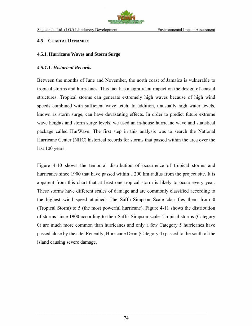
Sagicor Ja. Ltd. (LOJ) Llandovery Development Environmental Impact Assessment
_____________________________________________________________________ 74
4.5 COASTAL DYNAMICS
4.5.1. Hurricane Waves and Storm Surge
4.5.1.1. Historical Records Between the months of June and November, the north coast of Jamaica is vulnerable to
tropical storms and hurricanes. This fact has a significant impact on the design of coastal
structures. Tropical storms can generate extremely high waves because of high wind
speeds combined with sufficient wave fetch. In addition, unusually high water levels,
known as storm surge, can have devastating effects. In order to predict future extreme
wave heights and storm surge levels, we used an in-house hurricane wave and statistical
package called HurWave. The first step in this analysis was to search the National
Hurricane Center (NHC) historical records for storms that passed within the area over the
last 100 years.
Figure 4-10 shows the temporal distribution of occurrence of tropical storms and
hurricanes since 1900 that have passed within a 200 km radius from the project site. It is
apparent from this chart that at least one tropical storm is likely to occur every year.
These storms have different scales of damage and are commonly classified according to
the highest wind speed attained. The Saffir-Simpson Scale classifies them from 0
(Tropical Storm) to 5 (the most powerful hurricane). Figure 4-11 shows the distribution
of storms since 1900 according to their Saffir-Simpson scale. Tropical storms (Category
0) are much more common than hurricanes and only a few Category 5 hurricanes have
passed close by the site. Recently, Hurricane Dean (Category 4) passed to the south of the
island causing severe damage.
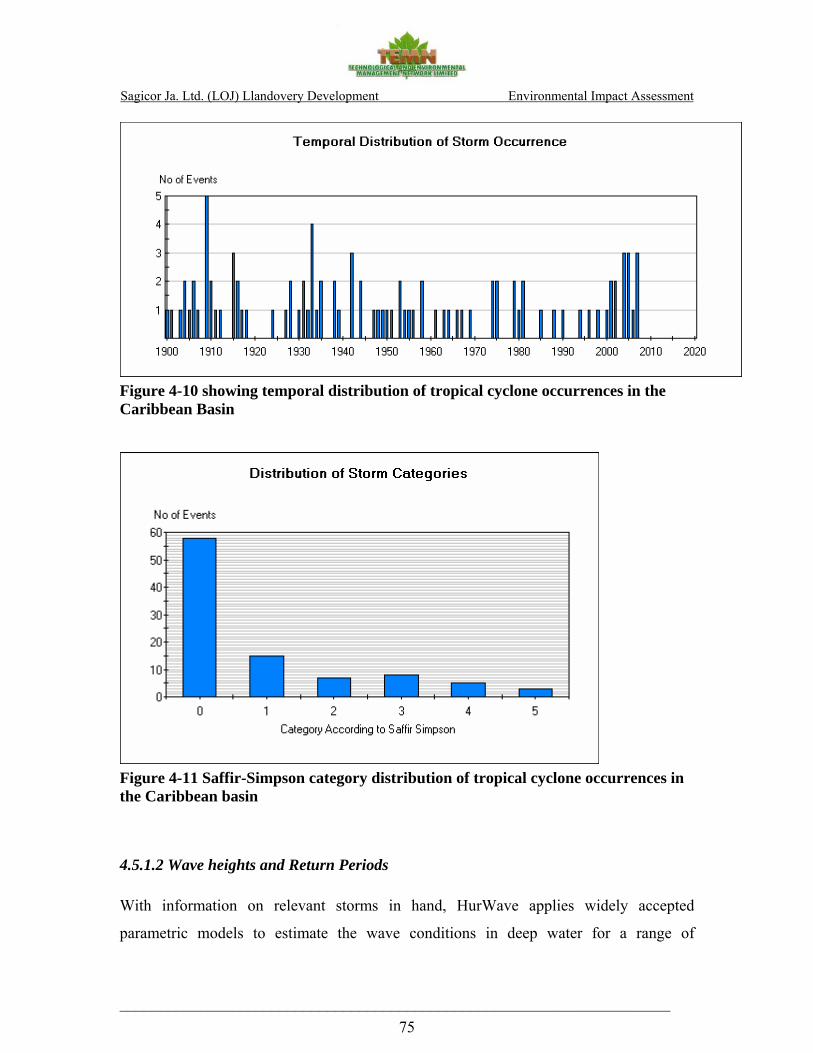
Sagicor Ja. Ltd. (LOJ) Llandovery Development Environmental Impact Assessment
_____________________________________________________________________ 75
Figure 4-10 showing temporal distribution of tropical cyclone occurrences in the Caribbean Basin
Figure 4-11 Saffir-Simpson category distribution of tropical cyclone occurrences in the Caribbean basin
4.5.1.2 Wave heights and Return Periods With information on relevant storms in hand, HurWave applies widely accepted
parametric models to estimate the wave conditions in deep water for a range of

Sagicor Ja. Ltd. (LOJ) Llandovery Development Environmental Impact Assessment
_____________________________________________________________________ 76
directional sectors. Within this context, wave conditions are often described in terms of a
return period, which is the average time period between successive occurrences of an
event being equaled or exceeded. Depending on the type of development and its relative
importance, the return period will determine to what degree engineering designs should
be carried out for it to withstand the forces propelled by nature. The greater the return
period, the larger the design significant wave height will be. Higher return periods will
yield a safer design standard, but the associated cost of the development will also be
higher. A level of risk must therefore be taken into consideration for the design to balance
safety with economy. The higher the return period for a storm, the less likely its chance
of occurring within the lifetime of the facility, but if it does occur, the more damage it
will cause. Table 4-17 shows the probability of occurrence of storm events for various
design life assumptions. For example, if the proposed structure is expected to have a 50
year design life, and it is designed to withstand the 1 in 50-year storm event, there will be
a 64% chance of this occurring over the life of the facility.
Table 4-17 showing the probability of occurrence for various Return Periods and Design Life
Design Life (years) Return Period (years) 25 50 100
25 64% 87% 98%
50 40% 64% 87%
100 22% 39% 63%
By best-fitting the values of wave heights that were estimated using the parametric model
to a Weibull distribution, we arrive at the deep water wave heights. Table 4 -18 shows the
estimated deep water wave conditions for various return periods from each of the relevant
directional sectors for the project site (West, North-west, North, North-east, and East).

Sagicor Ja. Ltd. (LOJ) Llandovery Development Environmental Impact Assessment
_____________________________________________________________________ 77
Table 4-18 showing deep water wave conditions off the project site for various return periods
Direction Return Period (years) Sig. Wave Height (m) Wave Period (s)
25 7.23 11.47
50 7.57 11.82 Nor
th
100 7.99 12.22
25 8.05 12.27
50 10.04 14.11
Nor
thea
st
100 11.86 15.67
25 10.85 14.82
50 13.1 16.69 East
100 15.24 18.36
25 5.85 10.04
50 6.19 10.4 Wes
t
100 6.55 10.79
25 6.83 11.07
50 7.2 11.44
Nor
thw
est
100 7.64 11.88
4.5.1.3. Storm Surge Analysis
The elevated water level that accompanies hurricanes creating flooding and damage to
coastal infrastructure is known as storm surge. A storm surge is the rise in the water
surface elevation of the sea above its mean level. The storm surge is made up of mainly
five components:
1. The Inverse Barometric Rise (IBR)

Sagicor Ja. Ltd. (LOJ) Llandovery Development Environmental Impact Assessment
_____________________________________________________________________ 78
2. Highest Astronomical Tide (HAT)
3. Global Sea Level Rise (GSLR)
4. Wind Setup
5. Wave Setup.
The IBR is the rise in the water surface elevation caused by the low pressure in the centre
of the hurricane. It has its peak at the eye of the storm and decreases with increased
distance from the center or “eye”.
The HAT is the highest level that daily tidal variations may reach. This level can be
accurately predicted and is available from tide charts. It is important to include this water
level in the computation of storm surge, as it is possible for the storm to occur while the
sea level is already at this elevation.
Global Sea Level Rise (GSLR) has been predicted by scientists according to current rates
of sea level rise and forecasting of the effects of global warming on the thermal
expansion of the seas and the melting of glaciers and polar ice caps. The increase in sea
level over the next century (until 2100) is estimated in the Intergovernmental Panel on
Climate Change – Third Assessment Report to range between 90 and 880 mm, with a
central value of approximately 480mm. This corresponds to approximately 0.25 m over
the next 50 years, which is the assumed design life of the project.
Wind setup is a result of intense winds blowing over the water surface. This tends to push
water towards the land. This water will rise more steeply in areas where there is a shallow
offshore shelf, and therefore further add to the water level rise in near-shore areas.
Wave setup includes the increase in water elevation due to the dissipation of wave energy
as waves approach the shoreline and start to break. At the point of wave breaking, there is
a shift in energy from a kinetic to a potential state, thereby resulting in an increase in
water levels. Figure gives a diagrammatic representation of the components of storm
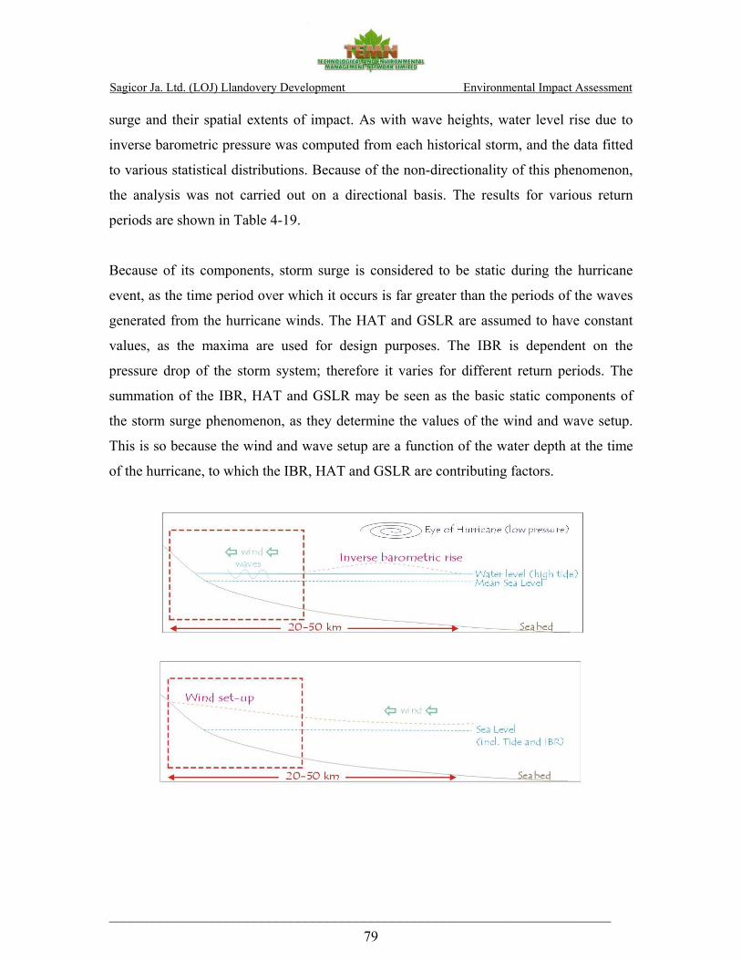
Sagicor Ja. Ltd. (LOJ) Llandovery Development Environmental Impact Assessment
_____________________________________________________________________ 79
surge and their spatial extents of impact. As with wave heights, water level rise due to
inverse barometric pressure was computed from each historical storm, and the data fitted
to various statistical distributions. Because of the non-directionality of this phenomenon,
the analysis was not carried out on a directional basis. The results for various return
periods are shown in Table 4-19.
Because of its components, storm surge is considered to be static during the hurricane
event, as the time period over which it occurs is far greater than the periods of the waves
generated from the hurricane winds. The HAT and GSLR are assumed to have constant
values, as the maxima are used for design purposes. The IBR is dependent on the
pressure drop of the storm system; therefore it varies for different return periods. The
summation of the IBR, HAT and GSLR may be seen as the basic static components of
the storm surge phenomenon, as they determine the values of the wind and wave setup.
This is so because the wind and wave setup are a function of the water depth at the time
of the hurricane, to which the IBR, HAT and GSLR are contributing factors.
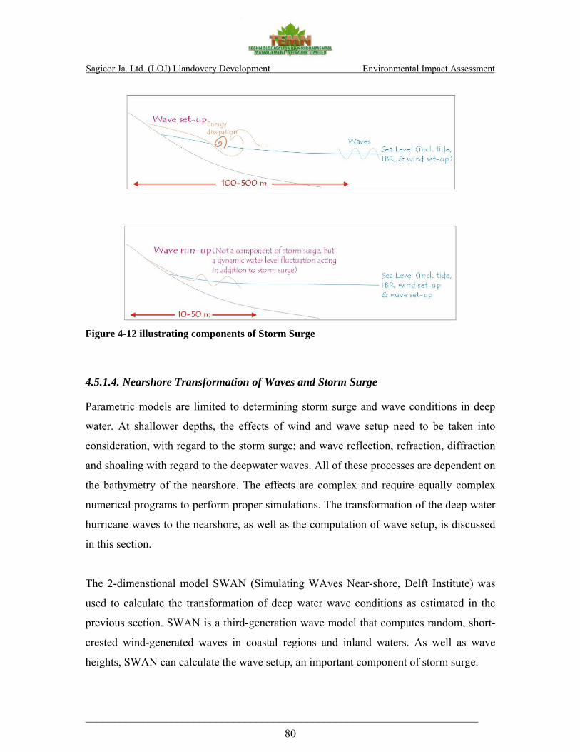
Sagicor Ja. Ltd. (LOJ) Llandovery Development Environmental Impact Assessment
_____________________________________________________________________ 80
Figure 4-12 illustrating components of Storm Surge
4.5.1.4. Nearshore Transformation of Waves and Storm Surge
Parametric models are limited to determining storm surge and wave conditions in deep
water. At shallower depths, the effects of wind and wave setup need to be taken into
consideration, with regard to the storm surge; and wave reflection, refraction, diffraction
and shoaling with regard to the deepwater waves. All of these processes are dependent on
the bathymetry of the nearshore. The effects are complex and require equally complex
numerical programs to perform proper simulations. The transformation of the deep water
hurricane waves to the nearshore, as well as the computation of wave setup, is discussed
in this section.
The 2-dimenstional model SWAN (Simulating WAves Near-shore, Delft Institute) was
used to calculate the transformation of deep water wave conditions as estimated in the
previous section. SWAN is a third-generation wave model that computes random, short-
crested wind-generated waves in coastal regions and inland waters. As well as wave
heights, SWAN can calculate the wave setup, an important component of storm surge.
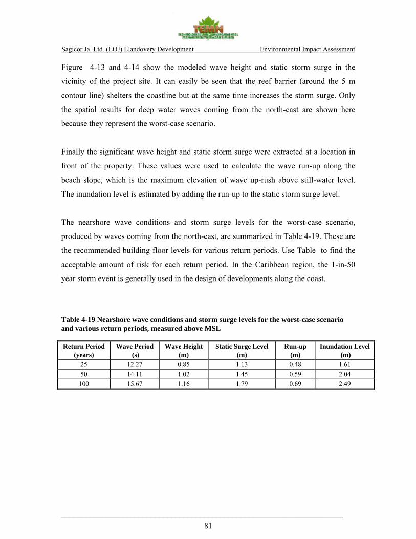
Sagicor Ja. Ltd. (LOJ) Llandovery Development Environmental Impact Assessment
_____________________________________________________________________ 81
Figure 4-13 and 4-14 show the modeled wave height and static storm surge in the
vicinity of the project site. It can easily be seen that the reef barrier (around the 5 m
contour line) shelters the coastline but at the same time increases the storm surge. Only
the spatial results for deep water waves coming from the north-east are shown here
because they represent the worst-case scenario.
Finally the significant wave height and static storm surge were extracted at a location in
front of the property. These values were used to calculate the wave run-up along the
beach slope, which is the maximum elevation of wave up-rush above still-water level.
The inundation level is estimated by adding the run-up to the static storm surge level.
The nearshore wave conditions and storm surge levels for the worst-case scenario,
produced by waves coming from the north-east, are summarized in Table 4-19. These are
the recommended building floor levels for various return periods. Use Table to find the
acceptable amount of risk for each return period. In the Caribbean region, the 1-in-50
year storm event is generally used in the design of developments along the coast.
Table 4-19 Nearshore wave conditions and storm surge levels for the worst-case scenario and various return periods, measured above MSL
Return Period (years)
Wave Period (s)
Wave Height (m)
Static Surge Level (m)
Run-up (m)
Inundation Level (m)
25 12.27 0.85 1.13 0.48 1.61 50 14.11 1.02 1.45 0.59 2.04
100 15.67 1.16 1.79 0.69 2.49

Sagicor Ja. Ltd. (LOJ) Llandovery Development Environmental Impact Assessment
_____________________________________________________________________ 82
Prepared by:Gustavo Oliveira
Depth countours in metersDirection where waves are going to
Investigation Details:
Hs = 10.04 m Wind speed = 29.95 m/sTp = 14.11 s Wind direction = NEDir = NE Water Level (IBR+HAT+GSLR) = 0.80
Wave Height (m)
257600 257800 258000 258200 258400 258600 258800 259000 259200
2043200
2043400
2043600
2043800
2044000
2044200
2044400
0
1
2
3
4
5
6
7
8
9
10
PropertyBoundary
Figure 4-13 showing nearshore wave heights in the vicinity of the project site for waves coming from the north-east and with return period of 50 years

Sagicor Ja. Ltd. (LOJ) Llandovery Development Environmental Impact Assessment
_____________________________________________________________________ 83
Prepared by:Gustavo Oliveira
Depth countours in metersDirection where waves are going to
Investigation Details:
Hs = 10.04 m Wind speed = 29.95 m/sTp = 14.11 s Wind direction = NEDir = NE Water Level (IBR+HAT+GSLR) = 0.80
Surge Level (m)
257600 257800 258000 258200 258400 258600 258800 259000 259200
2043200
2043400
2043600
2043800
2044000
2044200
2044400
0.8
1
1.2
1.4
1.6
PropertyBoundary
Figure 4-14 showing nearshore storm surge levels in the vicinity of the project site for waves coming from the north-east and with return period of 50 years

Sagicor Ja. Ltd. (LOJ) Llandovery Development Environmental Impact Assessment
_____________________________________________________________________ 84
5.0 STAKEHOLDERS AND PUBLIC CONSULTATION
The St. Ann Parish Council and the St. Ann Chamber of Commerce were contacted for
the organisations’ views of the proposed development. However, despite repeated
reminders, responses were not received at the date of completion of this report.

Sagicor Ja. Ltd. (LOJ) Llandovery Development Environmental Impact Assessment
_____________________________________________________________________ 85
6.0 ENVIRONMENTAL IMPACT ASSESSMENT These are summarized in the Impact Matrices in Appendix IV 6.1 ENVIRONMENTAL CHEMISTRY IMPACTS
6.1.1 Present Impacts TSS and turbidity results were consistent with the fact that no obvious sources of
pollution were observed in the immediate vicinity. However physical evidence
photographed, point to moments of high flow, which may contain considerable amount of
silt and rubble.
Phosphate levels were close to, but just within the draft marine standard. Nitrate levels
however exceeded the standard suggesting impact from land-based sources external to
the development site.
The absence of faecal coliform indicates no direct impact from sewage or livestock waste
on coastal water quality at the time of sampling.
6.1.2 Projected Impacts
During Construction potential impacts will be associated with the movement of traffic
engaged in the transportation of construction material as well as earth movement.
Specific impacts could include:
1. Silt laden run off from the site to the marine environment,
2. Spillage of earth and debris from trucks onto roadways
3. Aeolian dispersion of dust
4. Deposition of earth on roadways from truck wheels
5. Disposal of sewage generated by site workers
6. Disposal of solid waste generated by construction activity
Sagicor Ja. Ltd. (LOJ) Llandovery Development Environmental Impact Assessment
_____________________________________________________________________ 86
Post Construction Impacts to the environment will be associated with the populating of
the area and the conversion of soft surface to hard surface. Specific impacts anticipated
include:
1. Increased run off to the marine environment
2. Sewage discharge to the environment
3. Introduction of household solid waste to the area.
Post Construction Impacts to the development will be associated with the location of the
development adjacent to a major highway to the south, the marine environment to the
north, and a major drain to the east. Specific impacts likely include:
1. Corrosion of metallic fixtures and materials
2. Susceptibility to intrusive noise from traffic
3. Susceptibility to tidal influence and storm water runoff from the nearby hilly
region.
6.2 ECOLOGICAL IMPACTS Development of residential development projects with multiple units designed as
integrated scheme on single expanse of land such as the Llandovery property brings with
it a series of environmental impacts. The following section identifies anticipated
environmental impacts resulting from the proposed project based on the information
provided and on the surveys conducted in the area. The environmental impacts are
summarised, rated and classified as immediate, short-term, long-term or deferred in the
Impact Matrix (Appendix IV).Environmental impacts of significance during and post
construction phases include:
6.2.1 Loss of Land Use
The portion of the Llandovery property that has been proposed for the condominium
development has been partially cleared and has been previously exploited (possibly as
agricultural or pasture lands). Construction of condominium units represents a permanent
Sagicor Ja. Ltd. (LOJ) Llandovery Development Environmental Impact Assessment
_____________________________________________________________________ 87
and irreversible commitment of land resources, eliminating all other land use options
including agricultural uses or rehabilitation of the area as a nature reserve.
6.2.2 Loss of Habitat and Biodiversity
6.2.2.1 Loss of Vegetative Cover
The clearing of the site in preparation for the construction phase represents an immediate
and negative environmental impact to the area. The removal of trees and shrubs would
reduce the existing forest cover, resulting in irreversible loss of natural habitat for flora
and associated fauna in the area. The construction activities and the presence of the
development will impact negatively on the composition of the bird community and lead
to loss of species from the area, especially of the forest-based endemic species. The
development site is situated in the middle of a stretch of undeveloped coastal area and
will result in permanent fragmentation of the existing habitat. This carries with it the
possibility of permanently altering the movement patterns of terrestrial fauna and/or
nesting and feeding patters of the avifauna thereby altering the overall function of the
ecosystems in the area (Clevenger & Waltho 2003).
6.2.2.2 Loss of Avifauna
The proposed development will have negative (disruptive) effects on the bird
composition of the area. There will obviously be loss of species from the area, however
based on the low numbers of species observed, any loss would be negligible. It is
expected that most species would relocate to more suitable habitat.
6.2.2.3 Impact on the Beach and Wetland areas
Wetland areas, common to Jamaica’s coastal areas, are among the most biologically
productive ecosystems and are defined as “a site where plants and animals have become
adapted to temporary or permanent flooding by saline brackish or fresh water” including
“permanently or temporary flooded lands with sedge or grass morass, swamp forest or
mangroves”. Regardless of the size, coastal wetland areas are essential to coastal stability
and to reducing coastal erosion by acting as a physical buffer and against wave action and

Sagicor Ja. Ltd. (LOJ) Llandovery Development Environmental Impact Assessment
_____________________________________________________________________ 88
flood waters. Acting as “sinks”, wetland areas are capable of absorbing and slowing
down flood waters thereby reducing riverbed and coastal erosion. Wetland areas or costal
marshes also act as a natural “sediment trap” playing a vital role in protecting coral reefs
and seagrass beds from being smothered by silt brought downstream by flood waters.
Wetland areas support a rich indigenous flora, and fauna, with several of the species
being endemic. Species of birds, crabs, fish, brackish water shrimp and also
commercially important species use wetland areas as breeding and nursery grounds. The
Government of Jamaica (GOJ) - NEPA (Ecosystems Management Branch) has adopted
the mangrove and coastal wetlands protection policy and regulation in order to promote
the management of coastal wetlands to ensure that the many benefits they provide are
sustained. Wetlands are an important part of Jamaica's coastal resources and their
preservation is a key component of coastal area management. In addition to the national
significance, the GOJ has a wider responsibility to conserve wetlands (especially those
which are waterfowl habitats) as a signatory, since February 7, 1998, to the Ramsar
Convention on Wetlands of International Importance.
Wetland destruction resulting from draining and filling activities associated with land
reclamation has been shown to result in loss of fishery resources as well as reduced flood
control. The draining of wetlands by widening and deepening of wetland compromises
the role and the capability of these areas in slowing the run-off of flood waters. The
consequences of manipulating coastal wetland areas contributes to increasing freshwater
flows to coastal areas contributing to the die-off of nearby coral reefs. Housing
developments located on or near drained/filled wetland areas are more vulnerable to the
effects of natural disasters including wave action, flash flooding and the occurrence of
nuisance species e.g. mosquitoes.
The potential increase in runoff from the construction site would compound the nutrient
loading into the reef lagoon which is already heavily impacted by sedimentation and
could result in further deterioration of inshore water quality, with negative impacts to the

Sagicor Ja. Ltd. (LOJ) Llandovery Development Environmental Impact Assessment
_____________________________________________________________________ 89
marine life due to loss or degradation of the benthic habitat. Increased use of the beach
area by the residents of the condominium could result in trampling of the Turtlegrass
beds in the shallow waters which not only serve as a nursery habitat to numerous juvenile
fish species but also serve to trap sediments in the lagoon.
6.2.2.4 Loss or Alteration of Turtle Nesting Grounds Sea turtles
The sandy Llandovery beach is a known turtle nesting area. The area has not been
developed and as such there is no light pollution onshore to confuse the navigation
instincts of returning turtles coming to lay eggs. Two species of turtles have been
reported nesting in the area including the greenback and the Hawksbill turtles. Turtles
favour nesting on remote, clean sandy beaches, preferably under some type of vegetative
cover. Their nesting behaviour can be very easily disturbed by beach development or
activity, noise and light pollution, litter, disease and many other variables. Construction
of buildings and other structures near or on beaches used by hawksbills can alter the
beach and destroy the vegetation and other conditions needed for successful reproduction.
As such measures must be taken to ensure that the natural state of the beach is not
directly or indirectly compromised in a manner that could deter turtles from nesting on
the beach.
6.2.2.5 Soil Erosion and Changes in Drainage Patterns
Clearing vegetation, site grading, construction, excavation and concentrated discharge of
collected runoff could impact the existing drainage patterns in the area resulting in
erosion and increased sedimentation, if not properly controlled.
Removal of trees and other vegetative cover on the site and the subsequent construction
and excavation activities required for infrastructure installation (paving of roads, laying
of water/sewage pipes, electrical cables, etc.) will impact the existing drainage patterns in
the area. More specifically, the clearing of the riparian vegetation along the east and west
borders of the property, along the seasonal waterways which receive waters from the
watershed via culverts located along the highway will lead to soil erosion and excess run-

Sagicor Ja. Ltd. (LOJ) Llandovery Development Environmental Impact Assessment
_____________________________________________________________________ 90
off especially during the rainy season. Seasonal streams provide natural waterways that
can facilitate the management of runoff from the property serving as principal pathways
for storm water run-off from the site near the eastern and western boundaries of the
property. Loss of topsoil due to soil erosion as well as excessive runoff into the reef
lagoon is a cause for concern which must be addressed prior to the clearing phase. Due to
the location and the elevation of the project site soil erosion will remain a problem during
the clearing, the construction and the operational phases if proper measures are not
implemented. In addition to soil erosion and run-off, lack of proper drainage ways could
result in localized pooling and flooding on the project site, providing ideal conditions for
the proliferation of nuisance pests such as mosquitoes. Excessive runoff, especially
during heavy rains, could also lead to elevated nutrient loading into the reef lagoon. The
compounded effect of turbidity and sedimentation would negatively impact the inshore
water quality and the seagrass beds in the reef lagoon.
6.2.2.6 Transportation and Storage of Construction Materials
Transportation of heavy machinery and building supplies/materials implies heavy traffic
on the roads leading to the site with possible negative impacts such as gas emissions,
dust, petroleum spillage and noise to the surrounding area. Use of uncovered trucks for
transporting building materials as well as improper storage of building materials,
especially gravel, sand and cement on the construction site could lead to inadvertent
dispersal of materials during heavy rains or high winds during dry periods. This could
have a negative impact on the coastal waters. Improper storage or handling of hazardous
or flammable materials, including fuel, paints and solvents) could result in soil
contamination.
6.2.2.7 Airborne and Noise Pollution
The increased traffic to the area, use of heavy equipment during the clearing of the site
and transportation of building materials will create noise and raise dust which could
further disturb the habitat of the existing fauna, in particular the birds nesting in the area,
as well as the plants and insects they feed on. Dust and emissions from the construction

Sagicor Ja. Ltd. (LOJ) Llandovery Development Environmental Impact Assessment
_____________________________________________________________________ 91
vehicles and heavy machinery are inevitable both during the site clearing as well as
during construction phases. Airborne pollution, in particular dust resulting from clearing
of the land and from exposed piles of building materials (e.g. sand, cement, etc.) may
further stress the local flora and fauna, and may also pose a health risk to construction
workers and residents in the vicinity who suffer from asthma or other respiratory
ailments.
6.2.2.8 Disposal of Construction Debris
Construction debris generated throughout the construction cycle of the development must
be managed efficiently through a waste management plan in order to avoid negative
impacts to the site and the surrounding area. Cut vegetation resulting from the clearing of
the area could pose a fire hazard and affect air quality if burned on location. Other
construction materials including concrete waste, wood, steel, packaging plastics could be
dispersed and could end up blocking drainage channels if not disposed of at approved
disposal sites.
6.2.2.9 Sewage and Garbage Disposal
Inadequate provision of portable restrooms and garbage dumpsters at the construction site
could lead to unsanitary conditions. Resulting impacts could vary from unsightly littering
of the site, fly and vermin infestations to increased nutrient levels in the stream leading
into the bay. Reliable sewage treatment systems are a long term concern for the area. It is
essential for the villas, cottages and the nearby beach recreation area to have proper
sewage treatment systems capable of handling increases in capacity while ensuring that
there is no direct discharge of untreated effluent into the porous substrate which drains
directly into inshore marine waters.
Other concerns include:
• Density of building area to land area
Sagicor Ja. Ltd. (LOJ) Llandovery Development Environmental Impact Assessment
_____________________________________________________________________ 92
• Given the typically poor standard of environmental management practice on
construction sites in Jamaica, particular attention should be paid to the monitoring
of the construction works (Monitoring plan).
6.3 SOCIO-ECONOMIC IMPACTS
Socioeconomic impacts include construction and post-construction impacts. These are
summarized in the Impact Matrix in Appendix IV.
6.3.1 Construction Impacts
6.3.1.1 Land Use
Land use impacts of the proposed development are limited to the change of use from
vacant land to residential development. The proposed land use is located within an area
identified as “Coastal Development Area Boundary” on the St. Ann Development Order.
6.3.1.2 Employment and Income
Employment and income would be impacted positively by the proposed development.
The positive impact is represented by the creation of jobs during construction of the
development.
6.3.1.3 Transportation
Transportation impacts may be temporary. There may be an increase in vehicular traffic
with the movement of construction materials and equipment on and off site.
6.3.1.4 Community Development
Lands within 0.5km of the site are undeveloped vacant lands. As such, there will be no
construction impact on the community.

Sagicor Ja. Ltd. (LOJ) Llandovery Development Environmental Impact Assessment
_____________________________________________________________________ 93
6.3.2 Post-Construction
The post-construction impacts of the proposed development include national/regional
impacts, land use, employment and community development/recreation.
6.3.2.1 National/Regional Development
The proposed development includes the construction of a residential community with
recreational facilities. This will contribute to overall housing development and will
increase the housing stock of the nation.
There may be employment generation for security personnel, domestic workers and staff
for the recreational facilities on site. This will contribute to the reduction of the
unemployment rate of the parish of St. Ann (regional) and the country.
6.3.2.2 Land Use
The proposed development’s post-construction impact on land use is limited to change in
use from undeveloped vacant land to a residential community.
6.3.2.3 Employment
As mentioned above in the national/regional impacts, the post-construction phase of the
proposed development will provide employment on the local, regional and national scale.
6.3.2.4 Transportation
Post-construction impacts on transportation include increased vehicular traffic from
increased movement with additional residents moving into the area. However, the
proposed development is located along the North Coast Highway which is adequate to
accommodate the expected increased activity.
6.3.2.5 Community Development/Recreation
The post-construction impacts on the community/community development and recreation
are both positive and negative. The positive impact is long-term and direct. There is the

Sagicor Ja. Ltd. (LOJ) Llandovery Development Environmental Impact Assessment
_____________________________________________________________________ 94
potential for increased employment opportunities which may result in increased
economic activities in the area. Increased employment will lead to increase incomes,
which will affect other economic activities such as shopping facilities for the population
with increased residual incomes to spend on consumer goods. The proposed development
will also increase the availability of recreation facilities within the community as the
proposal includes recreational facilities including a restaurant and club house with fitness
centre and spa, swimming pool and a beach.
The proposed development has the potential for increasing employment, housing stock
and therefore has the potential for increasing the population of the area. There will be
increased vehicular traffic and the need for services (for example, banks and ATMs) will
increase. The existing social services (schools, waste disposal systems) may not be able
to facilitate the increased activities anticipated in the SIA study area.
6.4 HYDROGEOLOGICAL IMPACTS
The major, temporal impacts occur during construction as the land is developed and most
vulnerable to the impacts of atmospheric events. The impacts are mitigable if sediment
and erosion control planning objectives aligned to those outlined in Section 4.4 are
implemented and maintained over the duration of the project.
During operation the major sources of impacts to water and soil resources are considered
to the open channel flow and channel maintenance. The implementation of the concrete
open channel will benefit river bed integrity in the lower reach. Consequently surface
water quality will see a small, positive impact as fine soil material that normally would be
mobilized within the lower reach. Maintenance of the channel may also contribute
negatively to downstream water quality, if done during the annual wet seasons.
Sagicor Ja. Ltd. (LOJ) Llandovery Development Environmental Impact Assessment
_____________________________________________________________________ 95
7.0 RECOMMENDED MITIGATION AND MONITORING 7.1 ENVIRONMENTAL CHEMISTRY The development of a mitigation strategy should include a consideration of the following:
7.1.1 During Construction
1. Ensure adequate covering of haulage vehicles
2. Use of wheel washing or gravel beds to reduce deposition of earth on
roadways from truck wheels
3. Sprinkling of site to prevent aeolian dust dispersion
4. Provide approved portable sanitary facilities for site staff
5. Use of adequate measures to contain site run off.
6. Disposal of construction debris and solid waste at an approved location.
7.1.2 Post Construction
1. Employment of tertiary sewage treatment to prevent any contribution to
nitrogen load.
2. Reservation of adequate land area to modulate surface run off from the
developed site
3. Adequate set back from the highway and the marine environment.
4. Use of vegetation to buffer the corrosive effect of the marine atmosphere.
5. Use of vegetation to modulate noise from the highway.
7.2 ECOLOGY
Construction of a subdivision such as the Llandovery Project represents a permanent and
irreversible commitment of land resources. Although the area proposed for the project
has been previously exploited, it will no longer be available for other uses especially not
for rehabilitation to its natural state. The loss of natural habitat as well as a loss of the
option for alternative uses of the land is a significant negative impact. The following
recommendations are based on fundamental principles outlined in The National Land
Policy (1996) which acknowledges the direct relationship between the use of land for

Sagicor Ja. Ltd. (LOJ) Llandovery Development Environmental Impact Assessment
_____________________________________________________________________ 96
domestic, commercial, industrial or agricultural purposes, the generation of waste by
these uses and the impact on the quality of both surface and groundwater resources. The
land policy addresses specific land use and water resource management issues and speaks
to the following:
• the need to preserve and reforest watersheds to ensure the recharge of aquifers
and reduce the problem of flooding and turbidity in rivers
• the institution of programs to eliminate the pollution of rivers and streams by
pesticides, herbicides and other pollutants
• preserving vegetation along water courses.
7.2.1. Clearing Phase
7.2.1.1. Mitigating Loss of Habitat and Biodiversity
Impact mitigation calls for protecting and restoring as much of the original condition on
the development site as possible. Additional measures must be considered to further
minimize negative impacts on the terrestrial ecology in the area, more specifically:
7.2.1.2. Mitigating Loss of Vegetation
Prior to the commencement of site clearing and construction, a qualified landscape
manager (hired for the duration of the project) should be tasked with creating a landscape
plan, which includes a vegetation map clearly identifying all mature and ecologically
valuable trees (trunk diameter >30cm) earmarked for protection. The identified trees must
be clearly marked and protected. This map can be used to adjust final construction plans
as well as individual lots with the goal of minimizing tree removal.
A landscaping plan includes action items corresponding to each phase of the project
ensuring gradual, albeit partial, restoration of the site’s ecological characteristics. A
landscape plan would ensure that designated trees are protected and/or if absolutely
necessary, relocated and that areas suitable for replanting are identified and landscaped
using only local tree and shrub species used for feeding by local bird species. Selecting
appropriate plant species for replanting is essential in determining the types of birds,

Sagicor Ja. Ltd. (LOJ) Llandovery Development Environmental Impact Assessment
_____________________________________________________________________ 97
butterflies and other fauna that will re-inhabit the site upon completion of the project.
Landscaping is deemed to be a powerful mitigation activity with a positive impact by:
• Maintaining and replanting green areas on the development site with trees and shrubs
that would continue to attract avifauna to the area.
• An integral part of the landscape plan should also address means of protecting and
monitoring the wetland areas during site clearing and construction phases to ensure
that the ecological integrity of the area is maintained.
• Incorporate as far as possible into the landscaping plan the natural vegetation typical
of the area. Plant large trees on perimeter of compound to create a natural windbreak,
which will also serve the purpose of being a sight screen.
• In an effort to preserve the existing biodiversity, naturally occurring plants such as
those used primarily by the birds for food and shelter should be harvested during the
site clearing phase and relocated to a nursery, to serve as a source of plants for
replanting at a later date. This would ensure that primarily native plants are used in
the landscape plan thus minimizing the use of imported species and eliminating the
introduction of potentially invasive species.
7.2.1.3. Mitigating Impact on Avifauna
Suggested mitigations especially with respect to the land birds, is the use of native
species able to tolerate the soil composition (which is mostly sand), as a part of the
replanting (“greening”) of the development. These native trees would encourage the
return of some bird species and new species to the area. Using bird feeders may
encourage the displaced avifauna to remain in or return to the general vicinity, thus
maintaining the existing biodiversity.
7.2.1.4. Minimizing Impact to the Beach and from the loss of Wetland Areas
All of the potential impacts listed in the previous section under impacts, especially loss of
biodiversity, soil erosion, runoff and garbage dispersal, can have a detrimental effect on
the beach and the wetland areas. Mitigating actions call for minimising the impact of

Sagicor Ja. Ltd. (LOJ) Llandovery Development Environmental Impact Assessment
_____________________________________________________________________ 98
construction near or on the beach. If construction is necessary then suspended and
elevated structures supported by columns or piles with minimal footprint should be used.
The true value of the beach lies in its natural setting and as such preserving the natural
state of the beach is a priority. The most effective mitigation measure for the beach and
wetland areas would be to avoid the construction of permanent structures on or
immediately near the beach. Maintaining or enhancing the wetland areas on either side of
the property is essential to mitigating the loss of habitat and maintaining biological
diversity in the area. The wetland immediately east of property is slated to receive
drainage water from the drainage plan being proposed. The development plan calls for
the filling in of the western wetland to accommodate the construction of two buildings.
Mitigation for the loss of this unproductive wetland area is centered around the drainage
plan for the development. This plan calls for the creation of several water detention ponds
within the boundaries of the development totaling an area equal to approximately three
times the size of the wetland area to be lost. These detention ponds will be stocked with
appropriate flora and fauna which will enhance the productivity of the system ensure its
long term viability and also be an aesthetically pleasing aspect of the development.
Detained water from ponds will flow through a filter system before being released out to
sea. Further the sewerage plan for development will also include a constructed wetland in
the south eastern area of property.
7.2.1.5. Protecting Turtle Nesting Grounds
Providing long-term protection to turtle nesting beaches is paramount to protecting the
species. Eliminating threats such as beachfront development, beach erosion resulting
from sand mining, eliminating vehicles on the beach, working with local authorities,
scientists and volunteer groups to report turtle sightings, nesting activities and poaching
activities are critical to the long-term management of this species. Landscaping plans,
while favorable, must ensure that native vegetation is protected on the beach area.
Existing vegetation can provide additional benefits such as screening out artificial
beachfront lighting which can interfere with nesting behavior and disorient hawksbill
hatchlings. Landscaping plans must ensure that any introduced plants are not harmful to
Sagicor Ja. Ltd. (LOJ) Llandovery Development Environmental Impact Assessment
_____________________________________________________________________ 99
the development and hatching of sea turtle eggs (e.g. Casaurina and Sea oats (Uniola)
have been found to be lethal to hawksbill eggs). Highly visible signs should be posted on
the beach at appropriate locations warning of the legal penalties for interfering with
turtles and their nests. Lighting on the beach must meet the standards for Model Lighting
Ordinance for Marine Turtle Protection (Coastal Roadway Lighting Manual - Appendix
H, 2008).
7.2.1.6. Soil Erosion and Change in Drainage Patterns
This is a potentially significant impact that can be reduced to a less-than-significant level
by implementing the following mitigation measures:
• Site clearing activities should be conducted in stages to minimize the area of
exposed soil at any given time. Exposed soil should be seeded with grass or other
appropriate cover as soon as possible to minimise soil erosion. Monitoring and
maintaining proper storm water drainage systems, use of catchment/settlement
areas and redirecting flows during periods of heavy rain are steps that can
minimize erosion and surface runoff into the bay.
• Restrict grading and earthwork during the rainy season (September - October and
May - June) and stabilize all exposed soils and graded areas prior to onset of the
rainy season through mulching and reseeding. Temporary mulching and reseeding
(using a biologist/botanist approved native seed mix) will reduce erosion by
establishing quick growing plants to stabilize disturbed areas which will not have
permanent landscaping installed for a period of time or which may be
redistributed at a later date. Permit grading during the rainy seasons only with
installation of adequate sediment and erosion control measures.
• Install and maintain silt basins and fences or sand bags along drainage paths
during construction to contain on-site soils until bare slopes are vegetated.
Carefully stockpile graded soils away from drainages.

Sagicor Ja. Ltd. (LOJ) Llandovery Development Environmental Impact Assessment
_____________________________________________________________________ 100
• Replanting cleared/graded areas with appropriate native plant species (as
determined by a qualified botanist) immediately upon completion of grading.
• Mitigation of potential drainage impacts include:
o maintaining natural drainage ways by :
o Stabilizing the slopes on the banks of the seasonal streams and/or gullies
by planting and/or maintaining erosion resistant shrubs.
o Maintaining or planting erosion resistant riparian vegetation along the
seasonal stream pathways or gullies to maintain natural drainage and
minimize soil erosion and
o Retaining the vegetation around the seasonal stream pathways, including
the large trees to provide shade and to absorb water
o Preventing blockage of waterways (through rubbish dumping) must be
strictly prohibited both during the construction and post-construction
phases
7.2.2. Site preparation and Construction Phases
7.2.2.1. Transportation and Storage of Construction Materials
Arrangements should be made with contractors and subcontractors to ensure that the
vehicles used for transporting building materials to the site are appropriately sealed and
covered to minimize dust. Dust producing building materials such as sand or cement
should be stockpiled in low enclosures and covered, away from drainage areas where
they could easily be washed away during rainfall.
Ensure that all material (sand and aggregate) stockpiled on the site to be used in
construction activities are regularly sprayed to reduce the effects of wind whipping.

Sagicor Ja. Ltd. (LOJ) Llandovery Development Environmental Impact Assessment
_____________________________________________________________________ 101
Ensure that all trucks carrying aggregate and sand are covered during delivery to the site.
Care must be taken in the unloading of aggregate, sand and cement to prevent spillage.
Extra care must be taken to reduce dust in periods when wind speed are greatest which is
between June and July, e.g. extra wetting of the compound to suppress dust.
All staff employed at the construction site must be provided with dust masks and be
asked to use them. All raw materials must be sourced as close as possible to the
construction site. Where possible waste must be transported off-site for processing, not
burnt or stored for any longer than is necessary.
Ensure that all vehicles involved in the transport of construction material and staff, and
machinery involved in the construction are properly maintained and serviced.
Machines must not be left idling for unnecessary periods; this will save fuel and reduce
emissions and noise pollution.
7.2.2.2. Airborne and Noise Pollution
The site clearing plan should provide for 10-15m wide green buffer zones along
roadsides and drainage ways to dampen the noise and dust related to construction. Access
roads and exposed terrain should be sprayed by water trucks to minimize the dust. Use of
heavy machinery should be restricted to daylight hours in order to minimize the noise
pollution arising from the construction site. The clearing of vegetation must be carried
out on a phased basis; that is, only areas designated for construction during the necessary
phase of development must be cleared to minimize the dust and runoff.

Sagicor Ja. Ltd. (LOJ) Llandovery Development Environmental Impact Assessment
_____________________________________________________________________ 102
7.2.2.3. Disposal of Construction Debris
A site waste management plan should be made the responsibility of the building
contractor to provide for the designation of appropriate waste storage areas on the site
and a schedule for the timely collection and removal of construction debris to an
approved dump site. Organic waste produced during site clearing should be mechanically
mulched and composted at the site and used for landscaping at a later date.
7.2.2.4. Sewage and Garbage Disposal
Providing adequate number of portable restrooms (chemical toilets or dry composting
toilets) for the workmen and waste baskets and dumpsters is essential to keeping the
construction site clean and pest free. Arrangements should be made for regular garbage
collection and removal of sewage from the construction site. All measures must be taken
to ensure that untreated sewage is not directed into the bay waters.
7.3 SOCIO-ECONOMICS
Mitigation measures for the socio-economic impacts are summarized in the Impact
Matrix Table in Appendix IV. Mitigative measures are recommended to offset the
negative impacts of the proposed development.
7.3.1 Community Development/Recreation
Mitigative measures for the negative impacts on community development include the
upgrading of infrastructure and the increased provision of social services for current and
future residents of the SIA study area. Consideration should be given to a proper on-site
waste disposal programme that includes recycling and waste to resource initiates.

Sagicor Ja. Ltd. (LOJ) Llandovery Development Environmental Impact Assessment
_____________________________________________________________________ 103
7.4 HYDROGEOLOGY
7.4.1 Drainage Control during Construction
During construction, features such as, site access, storage of materials, site drainage during
construction and protection of surfaces from erosion and increased sediment influx to the Flat
Point River require particular attention. To ensure that the flow dynamics of the lower reach
of the Flat Point River are not disrupted during construction, it is recommended that the
drainage works for the Flat Point River be implemented first during the normal dry season,
before major site clearance. Sediment control features could then be incorporated into the site
development plan to mitigate against sediment influx from site activities to the Flat Point
River.
Unfortunately, in Jamaica construction practices and general workmanship have made
implementation of proper site housekeeping difficult as it is not the norm for contractors to
consider such activities. This makes their implementation and maintenance that much more
difficult on any construction site due to unfamiliarity and the inherent difficulty in modifying
human behaviour without appropriate punitive sanctions levied by the regulatory agencies.
Notwithstanding the foregoing, the site’s proximity to the coast and existing Flat Point River
drainage channels it is clear that erosion and sediment control will be of paramount
importance during construction in order to reduce discharges to nearby water bodies. In order
to mitigate any deleterious impact the following guidelines are recommended in developing
the erosion and sediment control plans:
Implement the major drainage works for the Flat Point River prior to other site activity.
Determine the extents of clearing and grading on the other parts of the site
Determine permanent drainage features and define the limits of construction activities.
Determine the extent of any temporary channel containment for the existing drainage
pathways that lead to the Flat Point River from the larger site.

Sagicor Ja. Ltd. (LOJ) Llandovery Development Environmental Impact Assessment
_____________________________________________________________________ 104
Determine suitable sediment controls by investigating the requirements of each drainage
sub-catchment. This would assist considerably in the reduction of final discharge
volumes and flow velocity.
Determine the staging of construction with a view to minimising the period of exposure
of exposed open ground.
Identify locations for topsoil or aggregate stockpiles and temporary construction roads.
The principal objectives of the erosion controls during construction should:
Implement the Flat Point River training to the final agreed channel location prior to
other site works.
Limit or reduce soil erosion, sediment movement and deposition to water bodies of all
land disturbing activities.
Seek to establish temporary or permanent cover as soon as possible after final grading
has been completed. Surface stabilisation should be considered for areas not at final
grade which may remain undisturbed for more than 30 days. Given that Jamaica is
prone to short intense rainfall events, especially in the afternoon, consideration should be
given to controlling sediment movement through temporary covers, silt fences, and
diversion ditches for areas within 30m of a water body.
Design all temporary and permanent facilities for the conveyance of water from
disturbed areas at non-erosive velocities.
Erosion and Sediment Control techniques that should be considered are:
Routing runoff through existing vegetation to control sediments and reduce downstream
velocities. Manage vegetation clearance in a manner that preserves pockets of existing
vegetation for use as vegetative control devices.
Sagicor Ja. Ltd. (LOJ) Llandovery Development Environmental Impact Assessment
_____________________________________________________________________ 105
Install gravel diversion trenches upstream of exposed land, bearing in mind that depth to
groundwater may limit vertical depth.
Temporary sediment traps/basins to reduce velocities.
Silt fences placed at the toe of earth slopes or stockpiles.
Construction road stabilisation with stones immediately after grading to prevent erosion
during wet weather due to vehicular traffic and to reduce the need for regrading for
permanent roadbeds between initial and final stabilisation.
7.4.2 Drainage Control during Operation
Surface Water Drainage including existing Flat Point River
Drainage design for the Flat Point River will be designed to the 4% in any one year (1 in 25yr)
event with site drainage being designed for the more frequent 20% in any year (1 in 5yr)
rainfall event. The WRA had recommended an evaluation of the 50yr and 100yr flood
inundation levels that would be produced by hydrologic events of the same frequency.
A preliminary look at the 50yr and 100yr hydrologic event was evaluated above and the peak
discharges for the 50yr and 100yr event are presented in Table 4-14. The results indicate that
the predicted runoff, based on the Forestry Department land use maps and Ministry of
Agriculture soil maps, were both less than the very conservative 80m3/s predicted in the
drainage report. On balance this would indicate that the 80m3/s design criteria should be
sufficient for both the HEC-HMS predicted 50 yr and 100yr events.
Pollution Control Measures during Operation
Pollution control measures are likely to include a mix of the following:
Earth swales
Detention Ponds with Gravel filters
Sand berms for storm surges
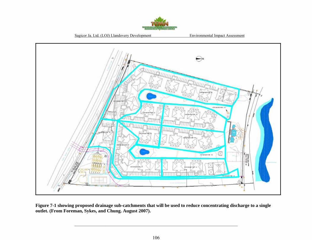
Sagicor Ja. Ltd. (LOJ) Llandovery Development Environmental Impact Assessment
_____________________________________________________________________
106
Figure 7-1 showing proposed drainage sub-catchments that will be used to reduce concentrating discharge to a single outlet. (From Foreman, Sykes, and Chung. August 2007).

Sagicor Ja. Ltd. (LOJ) Llandovery Development Environmental Impact Assessment
___________________________________________________________________________ 107
It is further recommended that:
All storm drain outlets during construction have suitable designed structures to reduce velocity
and mobilization of sediment. Swales and or temporary storage devices should be incorporated
into the overall construction phase drainage control plan to provide areas of temporary storage and
settlement.
During operation source control techniques such as harvesting roof runoff, permeable pavements
and infiltration devices should be considered for the hard surfaces. Dealing with the water locally
not only reduces the quantity that has to be managed at any one point, but also reduces the need
for conveying the water off the site. Additionally, the reuse of roof water for on-site irrigation
would reduce the requirement for mains water.
Drainage interceptors, gravel filters, and manholes must be checked as part of the regular
maintenance to remove accumulated debris. The annual maintenance of the open channel prior to
the approach of the annual wet seasons should be considered a requirement for development and
be incorporated within the permit document.
7.5 MONITORING PLAN AND MANAGEMENT PLAN
A draft Monitoring and Environmental Management plan is located in Appendix II and III.

Sagicor Ja. Ltd. (LOJ) Llandovery Development Environmental Impact Assessment
___________________________________________________________________________ 108
8.0 ASSESSMENT OF ALTERNATIVES TO PROJECT 8.1 ALTERNATIVE 1: WITHOUT PROJECT SCENARIO
8.1.1 Ecology
From an ecological perspective, the without-project scenario holds its value in that the area
retains the potential for remediation toward its former state through actions such as tree
replanting and various wetland conservation and rehabilitation measures. The development site is
part of a larger watershed area and its function remains critical to the health of the surrounding
ecosystem. The wetland areas on the east and west boundaries of the property, although small in
size, serve important and growing roles in terms of providing coastal protection from erosion
and buffering coastal waters from excess sedimentation and nutrient loading. The present state of
sedimentation levels in nearshore waters adjacent this site indicates the severity of this problem
and the need for immediate amelioration. The most ecologically sensitive alternative to the
current development proposal would call for remediating the area including measures to enhance
the existing wetland areas, thereby maximizing the coastal functionality of the ecosystem. In the
absence of remediation, the without project scenario does not provide ecological benefits to the
area since it leaves the area vulnerable to uncontrolled clearing, sand mining and other similarly
destructive activities which could further compromise the integrity of the ecosystem.
8.1.2 Socio-economics
Without the proposed development project, the site would continue to be undeveloped vacant
land. New housing solutions would not be provided. Additionally, potential for employment
during and after construction of the proposed development would also be lost. The without
project scenario is therefore less favourable.

Sagicor Ja. Ltd. (LOJ) Llandovery Development Environmental Impact Assessment
___________________________________________________________________________ 109
8.2 ALTERNATIVE 2: WITH PROJECT SCENARIO
8.2.1 Ecology
The Llandovery project represents an irreversible commitment of coastal resources. For the with-
project scenario to be viewed in a positive light, it is essential that the most negative impacts are
mitigated and that the project, as a whole is developed in a manner congruent with its
environment.
Excessive clearing of vegetation along with inappropriate development of low lying areas which
are part of a greater watershed, including small wetland areas, have the potential to compromise
the capacity of the watershed ecosystem to buffer the terrestrial and marine environs from
impacts of seasonal flash flooding and storm surges. The proposed high density development for
the Llandovery will bring with it a number of negative impacts to the existing ecosystem. The
long term negative impacts to the area could be mitigated by reducing the number of units and
the associated impermeable surfaces in favour of keeping vegetated areas, especially the existing
riparian vegetation along the seasonal stream paths and the wetland areas located near the beach.
Increasing the current setback distance of 31.25 to >45 m would serve to maintain the integrity
of the wetland areas along the eastern and western boundaries of the property, while providing a
vegetated buffer zone protecting the property during high wave events and at the same time
reducing beach erosion and protecting coastal waters from excess sedimentation and runoff.
According to UNESCO (1997) guidelines for construction setbacks, it is “recommended that the
line of "permanent" vegetation be used as the baseline for measurement. This is the tree line or
scrub line and can be easily defined and agreed by different observers. It also shows only slight
change apart from the relatively rare tropical storms and hurricanes. Features such as high water
mark vary according to the tidal cycle and are very subjective.”
Habitat conservation is essential for mitigating habitat fragmentation and the decline in
biodiversity due to development. Habitat conservation plans developed in Florida and California
call for habitat conservation at ratios ranging from 1:1 to 3:1 (conserved/developed) depending
on the ecological sensitivity, including the presence of endangered species, in the area under
Sagicor Ja. Ltd. (LOJ) Llandovery Development Environmental Impact Assessment
___________________________________________________________________________ 110
consideration. Reducing the footprint of the development would maximize conservation ratio
which is a consideration in making the with-project scenario a more viable one. Incorporation of
the water detention ponds in the development proposal is a key mitigative element to the
acceptability of this proposal especially the loss of the degraded western wetland area is to be
considered.
8.2.2 Socio-economics
The “with project” scenario of the proposed residential development would result in significant
and long term positive impacts on the availability of housing and employment. This would then
result in other economic gains (housing, increased incomes etc.). This alternative is most
favourable.
Sagicor Ja. Ltd. (LOJ) Llandovery Development Environmental Impact Assessment
___________________________________________________________________________ 111
9.0 LEGISLATIVE AND REGULATORY FRAMEWORK
9.1 Responsible Authorities The responsibility for regulating and facilitating environmentally sound development lies with
several authorities. The principal agency responsible for environmental matters is the National
Environment and Planning Agency (NEPA) of the Ministry of Environment and Housing. This
agency administers the Natural Resources Conservation Authority Act (1991), which allows the
Authority, the Board to which NEPA reports, to request an environmental impact assessment in
addition to the requirements of the Permit and Licensing System for development or construction
considered likely to have an adverse effect on the environment. Failure or refusal to submit the
documents is an offence under the law. This agency also administers the Beach Control Act
under which a License is required for encroachment on the foreshore, such as the development of
a pier.
The Environmental Health Division (ECD) of the Ministry of Health administers the Public
Health Regulations (1976) developed under the Public Health Act of 1985, under which air; soil
and water pollution control standards are established and monitored. A full application for
approval of sewage treatment plans may be made to the EHD, which will input into the detailed
application to be approved by the NRCA before authorizing any development. The EHD and
local planning authorities monitor construction work to ensure that all development restrictions
and requirements are properly adhered to.
In addition, there are Parish Acts and guidelines of local significance, including the Local
Improvements Act (1944). However, whereas general approval under the Parish Councils Act is
needed for building permits, the UDC Act supersedes all other legislation in the UDC designated
areas. The construction of all buildings must comply with the Building Code. The Ministry of
Environment and Housing (developed by ASCEND, 1996) and the Town Planning Department
have manuals which provide guidelines and planning standards for housing developments. The

Sagicor Ja. Ltd. (LOJ) Llandovery Development Environmental Impact Assessment
___________________________________________________________________________ 112
national planning enforcement authority is the Town and Country Planning Authority (TCPA)
which is now part of the NEPA.
9.2 Planning and Environmental Legislation Natural Resources Conservation Authority (NRCA) Act
The Natural Resource Conservation Authority (NRCA) Act allows the Authority to request an
environmental impact assessment for development or construction considered likely to have an
adverse effect on the environment. A permit is required from the NRCA for the undertaking of
any activity within certain prescribed categories. A permit to operate is required by any new
development, construction or modification of any works enabling the discharge of trade or
sewage effluent into the environment under Sections 9, 10 and 12 of the NRCA act. This
Legislation referred to includes:
- The NRCA (Prescribed Areas) (Prohibition of Categories of Enterprise, Construction and
Development) Order.
- The NRCA (Permit and Licence) (Forms, Processing and Fees) Regulations
Failure or refusal to submit the required documentation shall constitute an offence. In general,
planning permission must first be sought from the NRCA.
Public Health Act (Air, Soil, and Water Regulations)
The Public Health Act (1974) specifies that persons responsible for any construction, repair or
alteration and grit removal facilities, treatment ponds, sludge handling and disposal, and outfalls
have to seek the approval of the Ministry of Health. It also deals with issues such as emergency
power facilities, fencing and appropriate signage around treatment ponds.
The Watershed Protection Act
The Watershed Protection Act (1963) was enacted to provide protection for watersheds and
adjoining areas and by that means promote the conservation of water resources. The Ocean

Sagicor Ja. Ltd. (LOJ) Llandovery Development Environmental Impact Assessment
___________________________________________________________________________ 113
Pointe development is located within the Martha Brae Watershed Management Unit, one such
designated watershed area. The Watershed Protection Commission, established by the Act, can
make relevant regulations restricting the planting of crops, the felling and destruction of trees,
and the clearing of vegetation within watershed areas.
The Town and Country Planning Act
The TCPA formulates and coordinates strategic plans for area development in the form of
Development Orders consistent with the Town and Country Planning Act (1975). This act is
now administered by NEPA, and the NRCA board functions as the Town and Country Planning
Authority
The Housing Act
The Housing Act (1973) requires that any proposal for the subdivision of land and the
construction of houses thereon be accompanied by a plan of the area inclusive of, but not
restrictive to, the following: the manner in which it is intended that the area shall be laid out, in
particular, the land intended to be used for the provision respectively of houses, roads and open
spaces for public and commercial purposes;
� the approximate area of the land;
� the approximate number and nature of the houses and other buildings to be provides;
� the average number of houses to be constructed per acre;
� Particulars relating to water supply, drainage and sewage disposal.
The Beach Control Act
The Beach Control Act (1956) states that no person shall be deemed to have any rights in or over
the foreshore of the island or the floor of the sea and all rights over the foreshore of the island
and the floor of the sea are declared to be vested in the Crown. Additionally, no person shall
encroach on or use, or permit any encroachment on or use of, the foreshore or the floor of the sea
for any public purpose or for or in connection with any trade or business, or commercial
enterprise without a licence granted under this Act. This act is administered by NEPA.

Sagicor Ja. Ltd. (LOJ) Llandovery Development Environmental Impact Assessment
___________________________________________________________________________ 114
The Tourist Board Act
This Act states that no person shall operate or maintain any tourism enterprise unless such person
is the holder of a licence.
9.3 Other Significant Legislation and Policies
Other significant legislation includes the Tree Preservation Order which provides for the
protection of all trees from destruction or mutilation of any kind, except with the express
permission of the local planning authority. The Wildlife Protection Act (1981) and the Forestry
Act (1983) are also relevant to the proposed undertaking.
National Land Policy (1996)
This policy establishes the framework to enhance the efficient planning, management,
development and use of land. It is comprehensive in order to achieve complementary and
compatible development which is in harmony with economic and socio-cultural factors.
Chapter 3 of the National Land Policy includes rural development and the protection of
watershed and fragile areas, exploitation of mineral resources, and crop and livestock production.
Section 3.5.2 (Tourism) states that Government has adopted policies to:
#1 Improve physical planning and infrastructure development in resort areas;
#6 Ensure the preservation and or development as well as access by all to public open spaces
and recreational areas.
Section 4.2.2 (Land Access) states that Government will seek to:
#1 Reduce the incidence of squatting by eviction, relocation, regularization and upgrading of
infrastructure where necessary;
Sagicor Ja. Ltd. (LOJ) Llandovery Development Environmental Impact Assessment
___________________________________________________________________________ 115
10.0 REFERENCES
Anthony P. Clevenger, A. P., Waltho, N. 2003. Long-Term, Year-Round Monitoring of Wildlife Crossing Structures and the Importance of Temporal and Spatial Variability in Performance Studies Making Connections: ICOET 2003 Proceedings pp. 293-302.
Barksdale, R.D., editor, 1991. The Aggregate Handbook: National Stone Association
(Washington, DC), 1.V Bibby C.J.; Jones, M.J. and S.J. Marsden. 1998. Expedition Field Techniques: Bird Surveys.
Expedition Advisory Centre, Royal Geographical Society, London. Coastal Roadway Lighting Manual - Appendix H, 2008. Turtle Time Inc.
http://www.turtletime.org/lighting/appendix_h.htm (Accessed June 20, 2008) Down, C.G. and Stocks, J.; Environmental Impact of Mining. Applied Science Publishers
Ltd., ISBN 0853347166, 1978.
Economic and Social Survey of Jamaica. Planning Institute of Jamaica. 2005 and 2006.
Jamaica Forestry Department (2003). Manual of Dendrology, Forestry Department, Jamaica
Jamaica National Heritage Trust. Accessed January 2008. Available at http://www.jnht.com/
Jamaica Survey of Living Conditions. Parish Report. PIOJ and STATIN. 2002, 2004 and 2005
J. L. McTavish A Review of Jamaican And International Noise Standards. For Natural Resources Conservation Authority (2001).
Lessios, H. A., 1988. Mass Mortality of Diadema Antillarum in the Caribbean: What Have We Learned? Annual Review of Ecology and Systematics. Vol. 19: 371-393 (Volume publication date November 1988)
Mangrove and Coastal Wetlands Protection Draft Policy and Regulation (Negril Case
Study) NRCA: Coastal Zone Management Division
National Solid Waste Authority. Solid Waste Information. Accessed January 2008. Available
at http://www.nswma.gov.jm Natural Resources Conservation Authority, Air and Water Pollution Interim Guidelines, Standards,
and Regulations under the Natural Resources Conservation Act (1992). Natural Resources Conservation Authority Coastal Zone Management Divisions, Draft Coral Reef
Conservation Policy and Regulations April 1996

Sagicor Ja. Ltd. (LOJ) Llandovery Development Environmental Impact Assessment
___________________________________________________________________________ 116
New York State Department of Environmental Conservation, Assessing and Mitigating Noise Impacts, Program Policy, February 2, 2001
Statistical Institute of Jamaica. Population Census 1991. V 1, Part 6. Parish of St. Ann. Statistical Institute of Jamaica. Population Census 2001. V 4, Part A. Housing. TEMN Ltd., Environmental Monitoring Of Kingston Wharves Expansion Works At Berths 8
And 9 Monitoring Report No 35 (September 27 To October 3, 2007). TEMN Ltd., Environmental Impact Assessment, Amaterra Ocean Pointe, Resort Development,
2004. USEPA, Washington D.C. (1971) Quality Criteria for Water. Wunderle Jr, J.M. 1994. Census methods for Caribbean land birds. Gen. Tech. Rep. SO-98. New
Orleans, LA: U.S. Department of Agriculture, Forest Service, Southern Forest Experiment Station

Sagicor Ja. Ltd. (LOJ) Llandovery Development Environmental Impact Assessment
___________________________________________________________________________ 117
11.0 APPENDICES
Appendix I – Terms Of Reference
Appendix II – Monitoring Plan
Environmental Chemistry
Ecology
Hydrogeology
Appendix III – Environmental Management Plan
Appendix IV – Impact Matrices
Weighting for Impact Matrix
Environmental Chemistry
Ecology
Socio-Economics
Appendix V – Maps
Proposed site concept
Location Map of Montego Bay, St. James
Appendix VI – Hydrogeology
Appendix VII – Environmental Chemistry
Appendix VIII – Project Personnel

Sagicor Ja. Ltd. (LOJ) Llandovery Development Environmental Impact Assessment
___________________________________________________________________________ 118
APPENDIX I
TERMS OF REFERENCE

Sagicor Ja. Ltd. (LOJ) Llandovery Development Environmental Impact Assessment
___________________________________________________________________________ 119
Terms of Reference
The Environmental Impact Assessment should include but not be limited to the following:
1) Objectives
2) Complete description of the existing site proposed for development.
3) Significant environmental issues of concern through the presentation of baseline data
which should include social, cultural and heritage considerations. Assess public
perception of the proposed development.
4) Policies, Legislation and Regulations relevant to the project.
5) Likely impacts of the development on the described environment, including direct,
indirect and cumulative impacts, and their relative importance to the design of the
development’s facilities.
6) Mitigation action to be taken to minimise predicted adverse impacts and quantify
associated costs.
7) Monitoring Plan which should ensure that the mitigation plan is adhered to.
8) Alternatives to the project that could be considered at that site or at any other location.
9) Conclusions
The following tasks to be undertaken:
Task #1: Description of the Project
Provide a comprehensive description of the project and its the surrounding environment
specifying any information necessary to identify and assess the environmental effects of the
project. This should include project objectives and information on the nature, location/ existing
setting, timing, duration, frequency, general layout and size of facility including ancillary
buildings, pre-construction activities, construction methods, works and duration, and post
construction plans. A description of raw material inputs, technology and processes to be used as
well as products and by-products generated, should be provided. Note areas to be reserved for
construction and areas to be preserved in their existing state as well as activities and features
which will introduce risks or generate impact (negative and positive) on the environment.

Sagicor Ja. Ltd. (LOJ) Llandovery Development Environmental Impact Assessment
___________________________________________________________________________ 120
Sewage treatment system including treated effluent disposal must be clearly outlined as well as
solid waste disposal option. In addition, plans for storm water collection and disposal as well as
plans for providing utilities and other services should be clearly stated. This should involve the
use of maps at appropriate scales, site plans, aerial photographs and other graphic aids and
images, as appropriate.
In terms of beach modification, the proposed works on the foreshore and the floor of the sea
must be clearly described including but not limited to any seagrass or coral removal and
replanting.
A storm surge analysis must be conducted to inform coastal setbacks of buildings and impact
mitigation structures/measures.
For projects to be done on a phased basis it is expected that all phases clearly define the relevant
time schedules provided and phased maps, diagrams and appropriate visual aids be included.
Task #2: Description of the Environment/Baseline Studies Data Collection and
Interpretation
Describe study area/geographical boundaries, and methodology to be utilized for baseline and
other data and the length of the study. This task involves the generation of baseline data which is
used to describe the study area as follows:
i) Physical environment
ii) Biological environment
iii) Socio-economic and cultural constraints.
(A) Physical
i) A detailed description of the existing soil and geology and geomorphology, landscape,
aesthetic values and hydrology. Special emphasis should be placed on storm water run-

Sagicor Ja. Ltd. (LOJ) Llandovery Development Environmental Impact Assessment
___________________________________________________________________________ 121
off, drainage patterns, aquifer characteristics, effect on groundwater and availability of
potable water. Any slope stability issues that could arise should be thoroughly explored.
ii) Water quality of any existing wells, rivers, ponds, streams or coastal waters in the
vicinity of the development. Quality Indicators should include but not necessarily be
limited to nitrates, phosphates, faecal coliform, and suspended solids.
iii) Coastal and Marine ecosystem, including but not limited to any wetlands including
mangroves, seagrass and coral community with indication of its function and value in the
project area.
iv) Climatic conditions and air quality in the area of influence including particulate
emissions from stationary or mobile sources, NOx, SOx, wind speed and direction,
precipitation, relative humidity and ambient temperatures,
v) Noise levels of undeveloped site and the ambient noise in the area of influence.
vii) Obvious sources of existing pollution and extent of contamination.
viii) Availability of solid waste management facilities.
(B) Biological
Present a detailed description of the flora and fauna (terrestrial and aquatic) of the area, with
special emphasis on rare, threatened, endemic, protected, endangered species. Migratory species
wild food crop plants and presence of invasive alien species should also be considered. There
may be the need to incorporate micro-organisms to obtain an accurate baseline assessment.
Generally, species dependence, habitats/niche specificity, community structure and diversity
ought to be considered.
(C) Socio-economic & cultural
Present and projected population; present and proposed land use; planned development activities;
issues relating to squatting and relocation; (housing demand and supply) community structure;
economic base /employment; distribution of income; goods and services; utilities; recreation;
public health and safety; cultural peculiarities, aspirations and attitudes should be explored. The
historical importance (heritage, archaeological sites and feature) and other material assets of the
Sagicor Ja. Ltd. (LOJ) Llandovery Development Environmental Impact Assessment
___________________________________________________________________________ 122
area should also be examined. While this analysis is being conducted, it is expected that an
assessment of public perception of the proposed development be conducted. This assessment
may vary with community structure and may take multiple forms such as public meetings or
questionnaires/surveys.
Task #3: Policy, Legislative and Regulatory Considerations
Outline the pertinent regulations and standards governing environmental quality, safety and
health, protection of sensitive areas, protection of endangered species, siting and land use control
at the national and local levels. The examination of the legislation should include at minimum,
legislation such as the NRCA Act, the Housing Act, the Town and Country Planning Act,
Building Codes and Standards, Development Orders and Plans and the appropriate international
convention/protocol/treaty where applicable.
Task #4: Identification and Assessment/Analysis of Potential Impacts
Identify the significant environmental and public health/safety issues of concern and indicate
their relative importance.
Identify the nature, severity, size and extent of potential direct, indirect and cumulative impacts
(for terrestrial and aquatic environments) during the pre-construction, construction and
operational phases of the development as they relate to, (but are not restricted by) the following:
- change in drainage patterns
- flooding potential
- landscape impacts of excavation and construction
- loss of and damage to geological and palaeontological features
- loss of species and natural features
- habitat loss and fragmentation species
- biodiversity/ecosystem functions
- pollution of potable, coastal, marine, surface and ground water
- air pollution
- capacity and design parameters of proposed sewage treatment facility

Sagicor Ja. Ltd. (LOJ) Llandovery Development Environmental Impact Assessment
___________________________________________________________________________ 123
- socio-economic and cultural impacts.
- Impact of flooding, loss of natural features, excavation and construction on the
historic landscape, architecture and archaeology of the site.
- risk assessment
- noise
- solid waste
- soil
- access to resources such as beaches
- carrying capacity of the proposed site
Identify the interaction between different impacts and impacts of other projects should also be
considered. In addition, the impacts that have occurred and those impacts which could still occur
as a consequence of the clearing works that were conducted on the site prior to the preparation of
the TORs should also be identified and analysed
Distinguish between significant positive and negative impacts, reversible or irreversible direct
and indirect, long term and immediate impacts as well as avoidable and irreversible impacts.
Characterize the extent and quality of the available data, explaining significant information
deficiencies, assumptions and any uncertainties associated with the predictions of impacts. A
major environmental issue is determined after examining the impact (positive and negative) on
the environment and having the negative impact significantly outweigh the positive. It is also
determined by the number and magnitude of mitigation strategies which need to be employed to
reduce the risk(s) introduced to the environment. Project activities and impacts should be
represented in matrix form with separate matrices for pre and post mitigation scenarios.
Task #5: Drainage Assessment
An assessment of Storm Water Drainage should be conducted. The
EIA Report should cover, but not limited to:

Sagicor Ja. Ltd. (LOJ) Llandovery Development Environmental Impact Assessment
___________________________________________________________________________ 124
i. Drainage for the site during construction, to include mitigation for sedimentation
to the aquatic environment
ii. Drainage for the site during operation, to include mitigation for sedimentation to
the aquatic environment
iii. Drainage control for the gully traversing the property, to include impacts that this
drain will have on the aesthetics, water quality and sedimentation of the beach
area, etc.
Task #6: Mitigation
Prepare guidelines for avoiding or reducing (e.g. restoration and rehabilitation), as far as
possible, any adverse impacts due to proposed usage of the site and utilising of existing
environmental attributes for optimum development. Quantify and assign financial and economic
values to mitigating methods.
Task #7: Environmental Management and Monitoring Plan
Design a plan for the management of the natural, historical and archaeological environments of
the project to monitor implementation of mitigatory or compensatory measures and project
impacts during construction and occupation/operation of the units/facility. An Environmental
Management Plan and Historic Preservation Plan (if necessary) for the long term operations of
the site should also be prepared.
An outline monitoring programme should be included in the EIA, and a detailed version
submitted to NEPA for approval after the granting of the permit and prior to the commencement
of the development. At the minimum the monitoring programme and report should include:
• Introduction outlining the need for a monitoring programme and the relevant specific
provisions of the permit and/or licence(s) granted.
• The activity being monitored and the parameters chosen to effectively carry out the
exercise.
• The methodology to be employed and the frequency of monitoring.

Sagicor Ja. Ltd. (LOJ) Llandovery Development Environmental Impact Assessment
___________________________________________________________________________ 125
• The sites being monitored. These may in instances, be pre-determined by the local
authority and should incorporate a control site where no impact from the development is
expected.
• Frequency of reporting to NEPA
The Monitoring report should also include, at minimum:
• Raw data collected. Tables and graphs are to be used where appropriate
• Discussion of results with respect to the development in progress, highlighting any
parameter(s) which exceeds the expected standard(s).
• Recommendations
• Appendices of data and photographs if necessary.
Task #8: Project Alternatives
Examine alternatives to the project including the no-action alternative. This examination of
project alternatives should incorporate the use history of the overall area in which the site is
located and previous uses of the site itself. Refer to NEPA guidelines for EIA preparation.
Task #9: Public Participation/Consultation Programme
Conduct a public presentation on the findings of the EIA to inform, solicit and discuss comments
from the public on the proposed development.
• Document the public participation programme for the project.
• Describe the public participation methods, timing, type of information to be provided to
the public, and stakeholder target groups.
• Summarise the issues identified during the public participation process
• Discuss public input that has been incorporated into the proposed project design; and
environmental management systems

Sagicor Ja. Ltd. (LOJ) Llandovery Development Environmental Impact Assessment
___________________________________________________________________________ 126
All Findings must be presented in the EIA report and must reflect the headings in the body of
the ToRs, as well as references. Ten hard copies and an electronic copy of the report should be
submitted to the National Environment and Planning Agency.
The report should include an appendix with items such as maps, site plans, the study team,
photographs, ToR and other relevant information.

Sagicor Ja. Ltd. (LOJ) Llandovery Development Environmental Impact Assessment
___________________________________________________________________________ 127
APPENDIX II
MONITORING PLAN

Sagicor Ja. Ltd. (LOJ) Llandovery Development Environmental Impact Assessment
___________________________________________________________________________ 128
SCOPE OF STUDY AND METHODOLOGY
The monitoring programme is designed to ensure that the requirements of the Permit granted by
the NEPA are met. Monitoring and mitigation of impacts during the implementation of the
project will also require coordinated scheduling of activities between Sagicor (Life of Jamaica)
and the consultants, as well as regular reports required by the NEPA. Water quality and
ecological parameters that may be affected by construction and operation of the development
will be monitored with the necessary fieldwork component to provide the data as needed.
Field observations and measurements will be correlated simultaneously with weather prevailing
conditions, so that any change in weather can be compensated for, and unwanted impacts can be
avoided. In order to abide by the terms of the Permit set by the authorities, and certify
satisfactory completion of the project, it will be necessary to perform the following:
a. The monitoring of water quality parameters, specifically, Turbidity, Total Suspended
Solids (TSS), and Dissolved Oxygen (DO) during the implementation and post
construction phases of the project. Samples will be collected at various locations
(approved by the NEPA) twice during the first week of operation, weekly and then at
fortnightly, depending on the nature of the activities being carried out at the time.
Monitoring will be carried out more frequently as required if the results of initial
monitoring suggest that there is a potential threat to the environment.
b. Random photographs (and aerial surveys) will be taken at regular intervals to determine
whether the project is being carried out according to the stipulations of the Permit.
c. A suite of ecological observations would be required to observe any changes in the
composition of marine, benthic and terrestrial flora and fauna If required, as above,
monitoring will be carried out more frequently if the results of initial monitoring suggest
that there is a potential threat to the environment.
d. Final monitoring will be carried out at least three weeks after the works are complete.
.

Sagicor Ja. Ltd. (LOJ) Llandovery Development Environmental Impact Assessment
______________________________________________________________________________
129
OUTPUT
The information from the monitoring exercise will be used by the consultant to guide LOJ
regarding the efficacy of the mitigation measures being implemented. Any changes required to
enhance the effectiveness of existing mitigation actions would then be recommended.
Monitoring reports will contain the results of water quality and ecological examinations, as well
as photographic monitoring carried out, in the period preceding the report, as well as
recommendations for action, if required, for improving the construction process from an
Environmental perspective. Data will be presented in both tabular and spatial form on maps
prepared for this purpose. The maps will carry background, average and current data on each site
of monitoring as well as coordinates. Monitoring reports would be produced according to the
following schedule, in hard copy and electronic format:
1. Monitoring Report No. 1 - within one week following commencement of construction.
2. Monitoring Reports No. 2 onwards - within one week following the monitoring period
(fortnightly or monthly) as determined, unless there is an unforeseen situation which
could negatively affect the environment.
3. Post Project Monitoring will take place three weeks after the works are complete and the
Final Monitoring Report will be submitted within week four after completion of the post
project monitoring.
Depending on the length of the construction process, the NEPA may require monitoring reports
on a schedule different from the intervals proposed.
Sagicor Ja. Ltd. (LOJ) Llandovery Development Environmental Impact Assessment
______________________________________________________________________________
130
ENVIRONMENTAL CHEMISTRY
1.0 BACKGROUND
This plan is developed to satisfy the water quality monitoring component of the Sagicor
(LOJ) construction project at the Llandovery. The water quality component is required to
evaluate impacts on critical parameters as a result of the proposed construction. In order to
evaluate immediate and short term effects of the project, the monitoring plan will be
carried out in two parts as follows:
• Water quality monitoring during construction
• Post development monitoring
Rationale for Selection of Water Quality Indicators
Our experience in this area has allowed us to determine that parameters of significance to
the monitoring programme are Total Suspended Solids (TSS), Turbidity, Biological
Oxygen Demand (BOD), and Dissolved Oxygen (DO).
2.0 METHODOLOGY
Initial sampling will be carried out prior to the commencement of construction, to compare
current conditions with data previously collected in order to confirm the baseline water quality
for comparison with data collected during the project. Sampling will be carried out twice during
the first week of construction. If the results are satisfactory, then sampling will be done weekly
thereafter. As the project progresses there may be the request to change the frequency to
fortnightly. Sampling will be increased to three times per week if a potential threat to the
environment is identified.
At least four sampling stations will be established to enable comparison with data collected for
the targeting areas slated for development ·and the closest sensitive area(s) potentially affected
by the development.

Sagicor Ja. Ltd. (LOJ) Llandovery Development Environmental Impact Assessment
______________________________________________________________________________
131
2.1 Sample Collection
Surface and sub-surface water samples will be collected at all sites established using a Van Dorn
sampler or similar device. Sampling will be carried out on several occasions during the
development project as follows: Twice in the first week after commencement of infrastructure
construction and then weekly thereafter. Final monitoring will be three weeks after completion
of the project.
2.2 Sample Analysis
Laboratory analyses will be carried out by local facilities in accordance with Standard Methods
for the Analysis of Water and Wastewater to determine levels of TSS and BOD. Dissolved
Oxygen (DO) will be determined in situ using portable instrumentation.
Total Suspended Solids will be determined by filtration and gravimetry.
Biological oxygen demand (BOD) will be determined by the bottle dilution method.
Dissolved oxygen (DO), will be determined using the YSI Model 51B Oxygen meter, and Model
5739 Field Probe. The probe uses a Clark-type gas permeable membrane that covers
polarographic electrode sensors. The system has a built in thermistor for temperature
compensation, and temperature measurement. Measurement range of the instrument is 0-15mg/l,
and accuracy is better than .2mg/l when calibrated within +/- 5oC of actual sample temperature.
Readability is better than 0.1mg/l.
3.0 OUTPUT
Monitoring reports will be produced according to the following schedule:
1. Monitoring Report No. 1 - within one week after commencement of construction
2. Monitoring Reports No. 2 onwards - within one week after the monitoring period
(fortnightly or monthly) as determined, unless there is an unforeseen situation which
could negatively affect the environment.

Sagicor Ja. Ltd. (LOJ) Llandovery Development Environmental Impact Assessment
________________________________________________________________________
132
3. Post Project Monitoring will take place three weeks after the works are complete
and the Final Monitoring Report will be submitted within week four after completion of
the post project monitoring.
ECOLOGY
1.0 BACKGROUND
The ecology component of the monitoring of the LOJ Llandovery development calls for
the evaluation of the impacts of the proposed construction on the overall flora and fauna
of the area of influence of the project. The general objective will be to inspect, assess
and characterise specific areas of the marine and terrestrial environment examined prior
to, during; and immediately after the construction activities to be carried out.
The location of indicator species would be such as to render them directly or indirectly
impacted by the development. Acute impacts resulting from the project will be evaluated
by habitat monitoring during the construction and by post project monitoring.
Rationale for selection of ecological parameters
Particular emphasis will be placed on possible impacts to near shore mangrove stands,
coral reefs, seagrass beds as well as other flora and fauna that may be affected (fall within
the predetermined area of influence). The indicator parameters considered relevant to the
assessment of significant impacts to the ecosystems include physical environmental data
and the species composition and density of individuals comprising particular stands or
habitats as well as mobile species that may inhabit them. The parameters of significance
are considered to be ambient light levels, suspended sediments and the density of
occurrence of reef building corals, seagrass shoots and the extent of these habitats located
in close juxtaposition to site modification activities.

Sagicor Ja. Ltd. (LOJ) Llandovery Development Environmental Impact Assessment
________________________________________________________________________
133
2.0 METHODOLOGY
An examination of the ecology of the area of influence of the project will be carried out
at sites previously established to define baseline conditions before construction
commences. Sampling will then be carried out initially, at two week intervals.
Maintenance of or deviations from the status quo regarding the parameters being
investigated would determine whether or not the sampling period would be increased or
decreased. At least six sampling stations will be established in concert with the water
quality monitoring stations if possible or appropriate so as to allow comparison with data
collected from the ecological assessments made in previous studies
2.1 Sample collection and analysis
Sampling of the habitat component species will be carried out by direct visual count
(using chain or quadrat transects of appropriate length; by use of grab samplers for
benthic infauna or by videotaping of the substrate for later analysis (random dot matrix
analysis) in the laboratory - as appropriate.
Sediment rates & levels will be measured with appropriately sized and positioned
sediment samplers while light levels will be evaluated with the aid of a secchi disc Initial
sampling exercises are expected to occur at the commencement of the project; two weeks
after commencement then at two week intervals. Final monitoring will be three weeks
after completion.
Random aerial photography re. influence of project on the overall environment will take
place at monthly intervals if appropriate.
3.0 OUTPUTS
Monitoring reports will be produced according to the following schedule:

Sagicor Ja. Ltd. (LOJ) Llandovery Development Environmental Impact Assessment
________________________________________________________________________
134
Monitoring Report No. 1 - One week after commencement of the project. Subsequent
reports every two weeks. Post Project Monitoring will take place three weeks after
construction is complete and the Final Monitoring Report will be submitted three weeks
after completion of the post project monitoring.
HYDROGEOLOGY
The aqueous environment should be monitored both during and post construction to ensure
that national water quality objectives for beaches and freshwater are achieved and
demonstrated to be achieved. Sites for monitoring shall include the main open channel and
the sea.
During the Construction Phase: precautionary engineering measures (outlined above)
should be implemented to reduce run-off and prevent it from reaching existing drains and
the coast. Nothing which could cause pollution, including sediment-laden water, should
be allowed to enter any such watercourse.
All temporary fuel, oil and chemical storage must be sited on an impervious base within a
bund and secured. The base and bund walls must be impermeable to the material stored
and of an adequate capacity. Storage at or above roof level should be avoided.
Leaking or empty oil drums must be removed from the site immediately and disposed of
via a licensed waste disposal contractor or in conjunction with the local authority.
Washings from concrete mixers, paint or paint utensils should not be allowed to flow into
any drain or watercourse.
Post construction: General monitoring of the open channel and debris removal.
Sagicor Ja. Ltd. (LOJ) Llandovery Development Environmental Impact Assessment
________________________________________________________________________ 135
APPENDIX III
ENVIRONMENTAL MANAGEMENT PLAN
Sagicor Ja. Ltd. (LOJ) Llandovery Development Environmental Impact Assessment
________________________________________________________________________ 136
ENVIRONMENTAL MANAGEMENT PLAN
This plan has been prepared in accordance with the requirements of the National
Environment and Planning Agency as it pertains to the LOJ Llandovery development...
This plan is being prepared to ensure effective management of the environment during
the operational phase of this project.
This plan aims to provide:
• An integrated plan for the comprehensive monitoring and control of impacts.
• Auditable commitments displaying practical, achievable strategies for
management to ensure that environmental requirements are specified and
complied with
The Environmental Management Plan (EMP) defines a process wherein the managers of
the LOJ Llandovery development will:
1) Establish its commitment to improving the environment
To this end an Environmental Management policy must be laid out by the management
Suggested Policy:
The management of Sagicor (Life of Jamaica) will work towards protecting the environment by ensuring that its activities do not contribute to its degradation. We will seek to lead by example in the national imperative of maintaining a healthy environment. To this end, The Sagicor will strive to operate in a safe, responsible manner within the country’s environmental standards to secure a healthy environment for employees, visitors, and the wider society. All employees are expected to understand, promote and assist in the implementation of
this policy. This can be done by scheduling lectures, preparation of printed material etc
to assist the decision makers of the management team as well as ordinary employees to
be sensitive to the environmental character and vulnerabilities if the Llandovery Site, and
the potential of their routine activities to impact on the environment.
Sagicor Ja. Ltd. (LOJ) Llandovery Development Environmental Impact Assessment
________________________________________________________________________ 137
2) Review its activities and identify those that have a significant impact on the
environment.
This would involve a familiarity with the provisions of the NEPA Environmental Permit
and Licences, particularly with the mitigation required and NRCA/NEPA Standards.
Activities for the monitoring of the coral reef health and turtle nesting areas would be
paramount.
3) Put programmes in place to eliminate or reduce these impacts.
A monitoring programme should be in place for the sewage effluent management as well
as the quality of the coastal waters to identify changes from the background, baseline
conditions.
The environmental monitoring plan must clearly identify the mitigating actions to be
taken, including ecological surveys of the reef, development of drainage systems, dust
control and waste disposal. Retaining the services of a third party monitor to carry out
regularly scheduled sampling (e.g. on a monthly basis) of the area during the various
phases of the development would ensure that negative impacts are identified and
addressed in the earliest stages, thus preventing further deterioration of the environment.
A monitoring programme designed for the construction phase of the project should focus
on:
• Collecting data and providing ongoing feedback on the state of the environment in
the affected area
• Monitoring the state of the reefs, the nearshore area, the state of trees marked for
protection and other landscape activities
• Looking for signs of soil erosion and runoff especially after significant rainfall
• Monitoring the marine community, as well as sedimentation rates and water
quality in the nearshore
• Assessing transportation, storage and disposal of construction materials
• Assessing waste management practices

Sagicor Ja. Ltd. (LOJ) Llandovery Development Environmental Impact Assessment
________________________________________________________________________ 138
The Products of the EMP will be:
• Specific targets and actions to reduce the impact of the development’s activities
on the environment;
• The establishment of a system of monitoring the activities of the development
identified above.
• A data base, preferably digital, of the development’s activities and data collected
to track the effect of the management programme
• An increase the awareness and knowledge of the staff at all levels of the
environmental impacts of the decisions and activities that they undertake, and of
the standards requited by NEPA.
• A communications programme to encourage environmental stewardship among
the residents.
The outcome of the EMP will be an improvement of the environment in and around the
development.

Sagicor Ja. Ltd. (LOJ) Llandovery Development Environmental Impact Assessment
________________________________________________________________________ 139
APPENDIX IV
IMPACT MATRICES
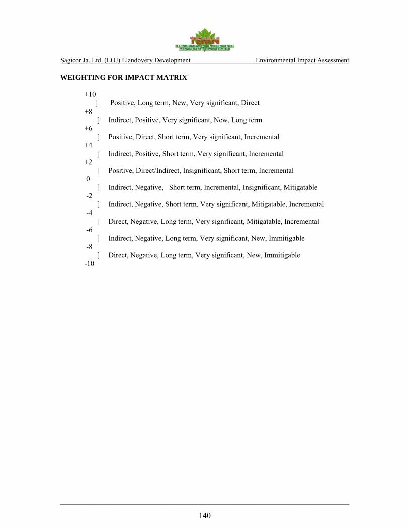
Sagicor Ja. Ltd. (LOJ) Llandovery Development Environmental Impact Assessment
________________________________________________________________________ 140
WEIGHTING FOR IMPACT MATRIX +10 ] Positive, Long term, New, Very significant, Direct
+8 ] Indirect, Positive, Very significant, New, Long term
+6 ] Positive, Direct, Short term, Very significant, Incremental +4 ] Indirect, Positive, Short term, Very significant, Incremental
+2 ] Positive, Direct/Indirect, Insignificant, Short term, Incremental 0 ] Indirect, Negative, Short term, Incremental, Insignificant, Mitigatable
-2 ] Indirect, Negative, Short term, Very significant, Mitigatable, Incremental -4 ] Direct, Negative, Long term, Very significant, Mitigatable, Incremental -6 ] Indirect, Negative, Long term, Very significant, New, Immitigable -8 ] Direct, Negative, Long term, Very significant, New, Immitigable
-10

Sagicor Ja. Ltd. (LOJ) Llandovery Development Environmental Impact Assessment
________________________________________________________________________ 141
ENVIRONMENTAL CHEMISTRY
PRE-MITIGATION Coastal Water Quality
Organic Pollution indicators
INDICATOR TYPE EXTENT MAGNITUDE MITIGATIVE MEASURES COMMENTS WEIGHT
BOD Negative Long Term Significant Due to sewage discharge -6
Nitrogen Negative Long Term Significant Due to sewage discharge -6
Pesticides Negative Long Term Significant Use in Maintenance of Landscape -6
TSS Negative Short Term Significant Due to sewage discharge -6
Oil and Grease Negative Long Term Significant Deposition of oil contaminated soil
-6
Coliform Negative Long Term Significant Mainly from sewage -4
D.O. Negative Long Term Significant Due to high level of BOD in sewage -4
Inorganic Pollution Indicators:
Phosphate Negative Long Term Significant From fertilisers used in maintenance of landscape -4
Nitrate Negative Long Term Significant Due to break down of sewage and use of fertilisers -4
Salinity Negative Long Term Significant Reduced salinity of coastal water due to increased fresh water run off
-6
TSS Negative Long Term Significant Due to sewage discharge, erosion -6
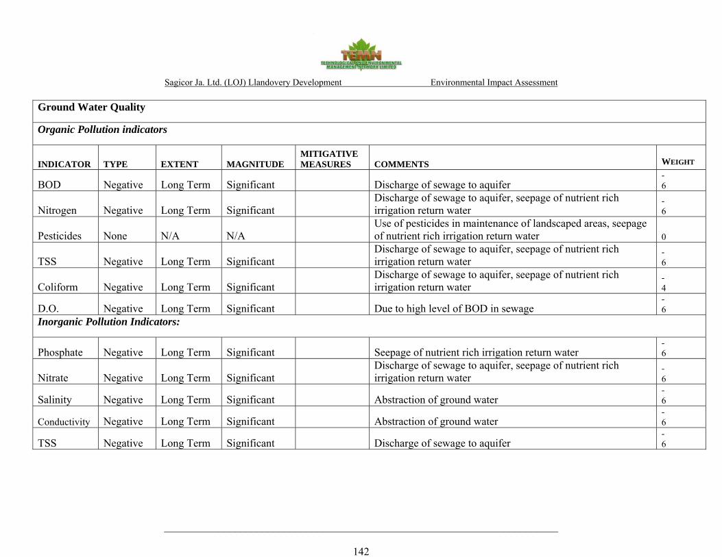
Sagicor Ja. Ltd. (LOJ) Llandovery Development Environmental Impact Assessment
________________________________________________________________________ 142
Ground Water Quality
Organic Pollution indicators
INDICATOR TYPE EXTENT MAGNITUDE MITIGATIVE MEASURES COMMENTS WEIGHT
BOD Negative Long Term Significant Discharge of sewage to aquifer -6
Nitrogen Negative Long Term Significant Discharge of sewage to aquifer, seepage of nutrient rich irrigation return water
-6
Pesticides None N/A N/A Use of pesticides in maintenance of landscaped areas, seepage of nutrient rich irrigation return water 0
TSS Negative Long Term Significant Discharge of sewage to aquifer, seepage of nutrient rich irrigation return water
-6
Coliform Negative Long Term Significant Discharge of sewage to aquifer, seepage of nutrient rich irrigation return water
-4
D.O. Negative Long Term Significant Due to high level of BOD in sewage -6
Inorganic Pollution Indicators:
Phosphate Negative Long Term Significant Seepage of nutrient rich irrigation return water -6
Nitrate Negative Long Term Significant Discharge of sewage to aquifer, seepage of nutrient rich irrigation return water
-6
Salinity Negative Long Term Significant Abstraction of ground water -6
Conductivity Negative Long Term Significant Abstraction of ground water -6
TSS Negative Long Term Significant Discharge of sewage to aquifer -6

Sagicor Ja. Ltd. (LOJ) Llandovery Development Environmental Impact Assessment
________________________________________________________________________ 143
Air Quality
INDICATOR TYPE EXTENT MAGNITUDE MITIGATIVE MEASURES COMMENTS WEIGHT
SOx None NOx None CO None CO2 None
PM10 Negative Short Term Significant Land clearing vehicle movement on haul roads -4
Noise Negative Short Term Significant Vehicle movement through community, horns, defective vehicles, engine compression noise
-4

Sagicor Ja. Ltd. (LOJ) Llandovery Development Environmental Impact Assessment
________________________________________________________________________ 144
POST-MITIGATION Coastal Water Quality
Organic Pollution indicators
INDICATOR TYPE EXTENT MAGNITUDE MITIGATIVE MEASURES COMMENTS WEIGHT BOD Negative Short Term Insignificant Treatment of sewage to ensure compliance with trade
effluent standards -
1 Nitrogen Negative Short Term Insignificant Treatment of sewage to ensure compliance with trade
effluent standards. Containment of surface run off Overflow may occur in extreme events
-2
Pesticides None N/A N/A Containment of surface run off and irrigation return water Overflow may occur in extreme events
-2
TSS Negative Short Term Insignificant Containment of surface run off and Treatment of sewage to ensure compliance with trade effluent standards
Overflow may occur in extreme events
-2
Coliform None Treatment of sewage to ensure compliance with trade effluent standards
0
D.O. None Treatment of sewage to ensure compliance with trade effluent standards
0
Inorganic Pollution Indicators:
Phosphate Negative Short Term Insignificant Containment of surface run off Overflow may occur in extreme events
-2
Nitrate Negative Short Term Insignificant Treatment of sewage to ensure compliance with trade effluent standards and Containment of surface run off
Overflow may occur in extreme events
-2
Salinity Negative Short Term Insignificant Containment of surface run off Overflow may occur in extreme events
-2
conductivity Negative Short Term Insignificant Containment of surface run off Overflow may occur in extreme events
-2
TSS Negative Short Term Insignificant Containment of surface run off Overflow may occur in extreme events
-2

Sagicor Ja. Ltd. (LOJ) Llandovery Development Environmental Impact Assessment
________________________________________________________________________
145
Ground Water Quality
Organic Pollution indicators
INDICATOR TYPE EXTENT MAGNITUDE MITIGATIVE MEASURES COMMENTS WEIGHT BOD None Use of appropriate liner in containment area 0 Nitrogen None 0 Pesticides None Use of appropriate liner in containment area 0 TSS None Use of appropriate liner in containment area 0 Coliform None Use of appropriate liner in containment area 0 Inorganic Pollution Indicators
Phosphate None Use of appropriate liner in containment area 0 Nitrate None Use of appropriate liner in containment area 0 conductivity None Avoid use of ground water for irrigation 0
TSS None Use of appropriate liner in containment area 0
Air Quality
SOx None
NOx None
CO None
CO2 None
PM10 Negative Short Term Insignificant Sprinkling of haul roads and other areas as appropriate to
minimise dust hazards, appropriate covering of haul vehicles -
2 Noise Negative Short
Term Insignificant Regulation of traffic, Planning of routes, use of only vehicles
satisfying traffic regulations -
2

Sagicor Ja. Ltd. (LOJ) Llandovery Development Environmental Impact Assessment
________________________________________________________________________ 146
ECOLOGY
LLANDOVERY ECOLOGICAL IMPACT INDICATOR
Impa
ct T
ype
Sign
ifica
nt
Not
si
gnifi
cant
Dir
ect
Indi
rect
Shor
t-te
rm
Lon
g-te
rm
Una
void
able
Irre
vers
ible
Cum
ulat
ive
M
itiga
tion
Req
uire
d
Comments
Wei
ght
Loss and fragmentation of natural habitat: NEG x x x x x x x
The clearing of the site in preparation for the construction phase represents an immediate and most negative environmental impact to the area. The removal of trees and shrubs would reduce and fragment the existing forest cover, resulting in irreversible loss of natural habitat for flora and associated fauna in the area. -9
Decreased biodiversity NEG x x x x x x x
Development activities will have a negative impact on bird populations (indicator species for biodiversity) using the habitat. Keeping/replanting food trees for birds & using feeders would encourage avifauna to remain in the area. -9
Loss or Alteration of Turtle Nesting Grounds NEG x x x x x x
Coastal development near beaches used by hawksbills can alter the beach, introduce light pollution and destroy the vegetation and other conditions needed for successful reproduction. Measures must be taken to ensure that the natural state of the beach is not directly or indirectly compromised in a manner that could deter turtles from nesting on the beach. -8
Impact on the beach and wetland areas. NEG x x x x x x
Altering the wetland areas, in part or in full, will compromise the ability of wetlands to act as a physical buffer against storm surges, reducing coastal erosion, reducing runoff and flood waters, filtering out sediment, protecting coral reefs and serving as a habitat for flora and fauna. -8
D
urin
g C
onst
ruct
ion
Change in drainage patterns and soil erosion NEG x x x x x x
Removal of vegetation, excavation and construction activities will impact the existing drainage patterns in the area. Removal of riparian vegetation along the east and west borders of the property, along the seasonal waterways which receive waters from the watershed via culverts located along the highway will lead to soil erosion and excess run-off. Soil erosion and excessive runoff into the lagoon present a significant impact with long term implications. -6

Sagicor Ja. Ltd. (LOJ) Llandovery Development Environmental Impact Assessment
________________________________________________________________________ 147
LLANDOVERY ECOLOGICAL IMPACT INDICATOR
Impa
ct T
ype
Sign
ifica
nt
Not
si
gnifi
cant
Dir
ect
Indi
rect
Shor
t-te
rm
Lon
g-te
rm
Una
void
able
Irre
vers
ible
Cum
ulat
ive
Miti
gatio
n R
equi
red Comments
Wei
ght
Degradation of marine environment NEG x x x x x
Excessive runoff, especially during heavy rains, could also lead to elevated nutrient loading into the lagoon. The compounded effect of turbidity and sedimentation would negatively impact the inshore water quality and the seagrass beds in the lagoon. -8
Transportation and Storage of Construction Materials NEG x x x x
Transportation of building supplies as well as improper storage of building materials could have a negative impact on the coastal waters. Improper storage or handling of hazardous or flammable materials, including fuel, paints and solvents) could result in soil contamination. -4
Noise and dust pollution NEG x x x x x Noise barriers. Restricting construction to daylight hours. Proper transportation and storage of building materials on site. -4
Disposal of construction debris NEG x x x x x Need for comprehensive construction site disposal plan. -2
Sewage and Garbage Disposal NEG x x x x x Provision of appropriate sanitation for workers. -2
Setback line POS x x x
Increasing the setback distance of 31.25 to >45 m would serve to maintain the integrity of the wetland areas along the eastern and western boundaries of the property, while providing a vegetated buffer zone protecting the property during high wave events and at the same time reducing beach erosion and protecting coastal waters from excess sedimentation and runoff. 8
Wetland conservation POS x x x x
The most effective mitigation measure for the beach and wetland areas would be to avoid the construction of permanent structures on or immediately near the beach. Maintaining or enhancing the wetland areas on either side of the property is essential to mitigating the loss of habitat and maintaining biological diversity in the area. The alternative to use the western wetland for development purposes and mitigate its loss by the creation of water retention ponds within the development designed to function as self sustaining wetland areas has great merit 10
Landscaping and replanting POS x x x x
Landscaping plan to use local species in green areas to maintain species diversity of flora. Keeping food trees for birds & using feeders would encourage them to remain in the area. 7
Protection of turtle nesting ground POS x x x x
Providing long-term protection to turtle nesting beaches is paramount to protecting the species. Eliminating threats such as beachfront development, beach erosion resulting from sand mining. Monitoring is essential during and upon completion of development. 7
Pos
t- C
onst
ruct
ion
Construction site management plan POS x x x
Construction site plan to deal with proper transportation. storage and disposal of materials. The plan would entail proper rubbish and sewage disposal for the construction site. 2
Cumulative impact weight -27

Sagicor Ja. Ltd. (LOJ) Llandovery Development Environmental Impact Assessment
________________________________________________________________________ 148
SOCIO-ECONOMICS ASSESSMENT IMPACT MATRIX
Factor Indicator Type Extent Magnitude Mitigative Measures Comments Weight
Socio-economic Construction (Micro)
Land Use
Employment and Income
Transportation
Community Development
a) Positive, direct
a) Positive, direct
a) Negative, indirect
N/A
Long-term
Short-term
Short-term
N/A
Very Significant
Significant
Insignificant
N/A
N/A
N/A
Proper planning and scheduling of transportation activities on and off site.
N/A
The site will be developed with residential units
Employment creation during construction activities
Increased vehicular traffic
Lands within 0.5 km of the site are undeveloped vacant land. As such community activities will not be significantly impacted by the proposed development
+10
+6
-1
0
Socio-economic Post-Construction (Macro)
National/Regional
a) Positive, direct
b) Positive, direct/indirect
Long-term
Short and Long-term
Very Significant
Very Significant
N/A
N/A
Increased housing stock for the nation
Contribute to employment/ reducing unemployment
+10
+10

Sagicor Ja. Ltd. (LOJ) Llandovery Development Environmental Impact Assessment
________________________________________________________________________ 149
Factor Indicator Type Extent Magnitude Mitigative Measures Comments Weight
(Micro)
Land Use
Employment
Transportation
Community Development/ Recreation
a) Positive, indirect
a) Positive, indirect
a) Negative direct
a) Positive, direct
b) Negative, indirect
Long-term
Long-term
Long-term
Long-term
Long-term
Very Significant
Significant
Insignificant
Very Significant
Significant
N/A
N/A
The proposed development is located along the North Coast Highway which is adequate to accommodate the expected increased activity.
N/A
Expand access to social services for current and future residents of the community and visitors
Post-construction land use will be residential
Employment opportunities
Increased vehicular traffic with movement of visitors and cargo via land transportation
Increased employment opportunities may result in increased economic activities in the area. Increased employment will lead to increase incomes, which will affect other economic activities such as shopping facilities for the population with increased residual incomes to spend on consumer goods. The proposed development will also increase the availability of recreation facilities within the community.
Existing social services such as schools and waste disposal systems) may not be able to facilitate the increased population within the SIA study area
+8
+8
-1
+6
-4

Sagicor Ja. Ltd. (LOJ) Llandovery Development Environmental Impact Assessment
____________________________________________________________________________________________
150
APPENDIX V
MAPS
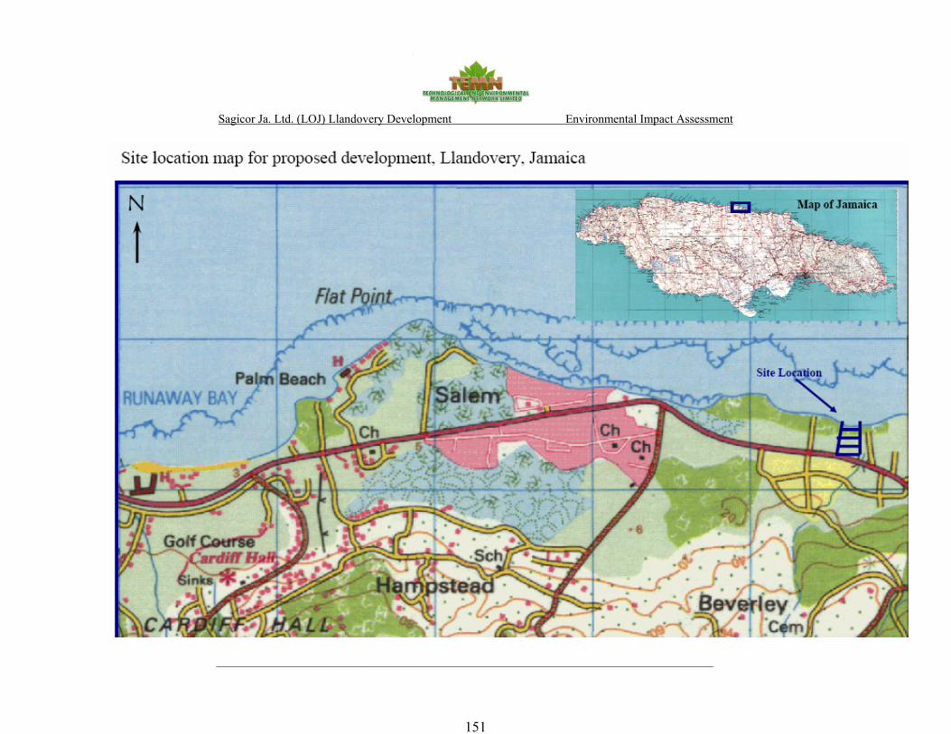
Sagicor Ja. Ltd. (LOJ) Llandovery Development Environmental Impact Assessment
____________________________________________________________________________________________
151

Sagicor Ja. Ltd. (LOJ) Llandovery Development Environmental Impact Assessment
____________________________________________________________________________________________
152
Aerial view of proposed development site with site plan overlay.

Sagicor Ja. Ltd. (LOJ) Llandovery Development Environmental Impact Assessment
____________________________________________________________________________________________
153
APPENDIX VI
HYDROGEOLOGY

Sagicor Ja. Ltd. (LOJ) Llandovery Development Environmental Impact Assessment
____________________________________________________________________________________________ 154
APPENDIX A
Figure 1 – Site location plan. Blue lines are the rivers. Image adapted from Google Earth
Flat Point River Cistern River
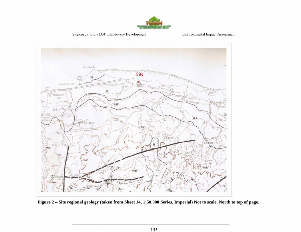
Sagicor Ja. Ltd. (LOJ) Llandovery Development Environmental Impact Assessment
____________________________________________________________________________________________ 155
Figure 2 – Site regional geology (taken from Sheet 14, 1:50,000 Series, Imperial) Not to scale. North to top of page.
Site

Sagicor Ja. Ltd. (LOJ) Llandovery Development Environmental Impact Assessment
____________________________________________________________________________________________ 156
Figure 3 – Environmental setting within 5km showing the hydrostratigraphy, springs, licensed abstractions, geological features and flood events. (Compiled from WRA data)

Sagicor Ja. Ltd. (LOJ) Llandovery Development Environmental Impact Assessment
____________________________________________________________________________________________ 157
APPENDIX B
WRA – Llandovery data summary

Sagicor Ja. Ltd. (LOJ) Llandovery Development Environmental Impact Assessment
____________________________________________________________________________________________ 158
APPENDIX C
Flat Point Peak Discharge 1 in 25yr hydrologic event – HEC-HMS

Sagicor Ja. Ltd. (LOJ) Llandovery Development Environmental Impact Assessment
____________________________________________________________________________________________ 159
Flat Point Peak Discharge 1 in 50yr hydrologic event – HEC-HMS
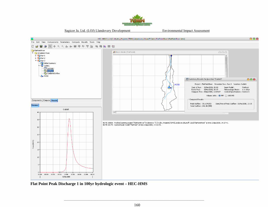
Sagicor Ja. Ltd. (LOJ) Llandovery Development Environmental Impact Assessment
____________________________________________________________________________________________ 160
Flat Point Peak Discharge 1 in 100yr hydrologic event – HEC-HMS

Sagicor Ja. Ltd. (LOJ) Llandovery Development Environmental Impact Assessment
____________________________________________________________________________________________ 161
Project: Llandovery DevelopmentLocation: Llandovery, St. AnnClient: TEMN
Date: April 2008
Rational EquationQ=0.00278 CIA Metric units
Q=1.008 CIA SI unitsWhere,Q = peak runoff rate (cfs, m3/s)C = runoff Coefficient from Table in Sheet 2 0.3 unitlessI = average rainfall intensity ( in/hr, mm/hr) 123 mm/hrA = the drainage area (acres, hectares) 4.2 hectares
Pre-development ShrublandC 0.3 unitlessI* 123.3 mm/hrA** 4.2 hectaresConversion factor 0.00278Calculated Peak Discharge, Q 0.43 m3/s
TOTAL 0.4 m3/s
Hardsurfaced Areas Green AreasPost-development est. 90% of total area est. 10% of total areaC 0.85 0.35 unitlessI* 123.3 123.3 mm/hrA** 3.8 0.4 hectaresConversion factor 0.00278 0.00278Calculated Peak Discharge, Q 1.10 0.05 m3/s
TOTAL 1.15 m3/s
* Taken from the Preliminary Drainage Aug 2007**est. from Llandovery Site Plan; undated
Percentage change 167% Global site pre- and post- site runoff using Rational Method for a 1 in 5yr event
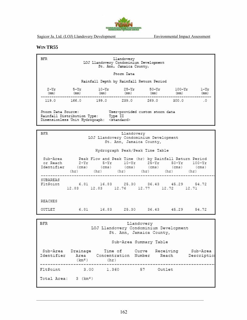
Sagicor Ja. Ltd. (LOJ) Llandovery Development Environmental Impact Assessment
____________________________________________________________________________________________
162
WIN TR55

Sagicor Ja. Ltd. (LOJ) Llandovery Development Environmental Impact Assessment
____________________________________________________________________________________________
163

Sagicor Ja. Ltd. (LOJ) Llandovery Development Environmental Impact Assessment
____________________________________________________________________________________________
164
APPENDIX VII
ENVIRONMENTAL CHEMISTRY
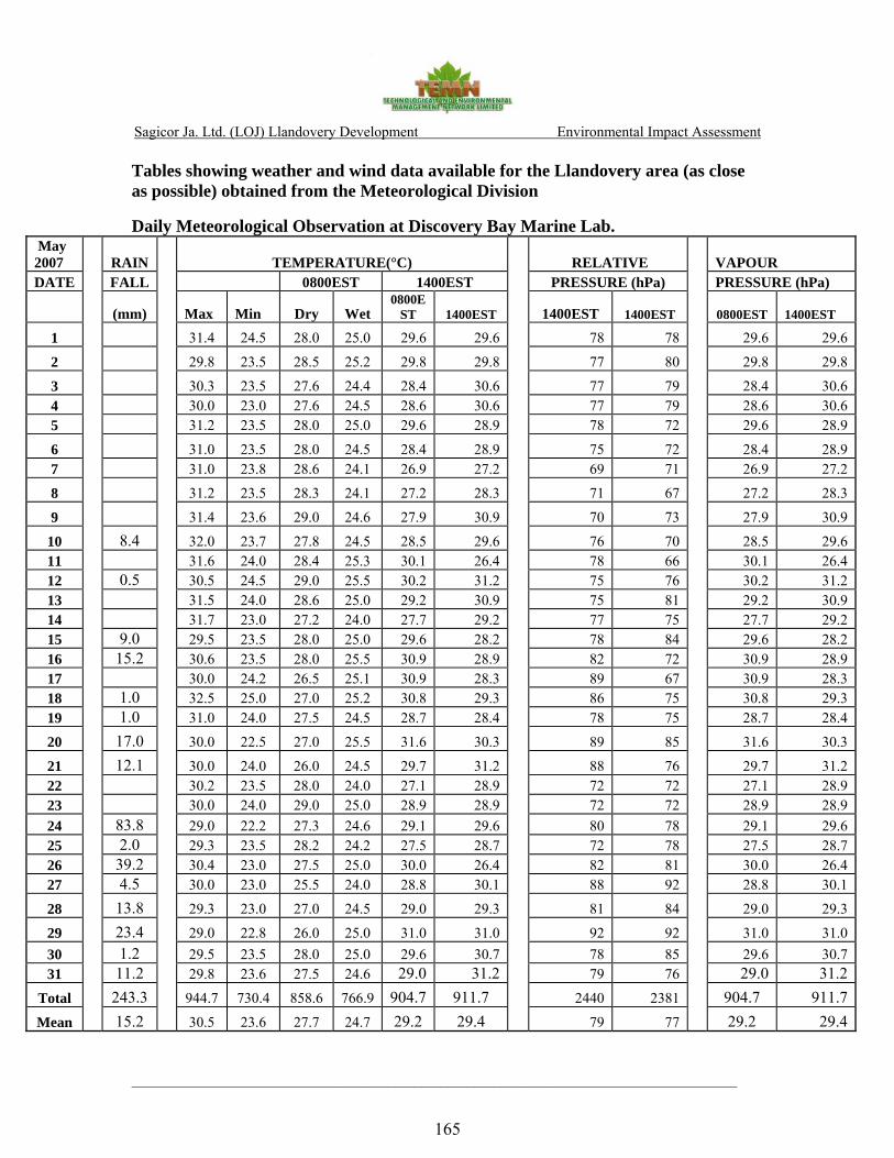
Sagicor Ja. Ltd. (LOJ) Llandovery Development Environmental Impact Assessment
____________________________________________________________________________________________
165
Tables showing weather and wind data available for the Llandovery area (as close as possible) obtained from the Meteorological Division
Daily Meteorological Observation at Discovery Bay Marine Lab. May 2007 RAIN TEMPERATURE(°C) RELATIVE VAPOUR DATE FALL 0800EST 1400EST PRESSURE (hPa) PRESSURE (hPa)
(mm) Max Min Dry Wet 0800E
ST 1400EST 1400EST 1400EST 0800EST 1400EST
1 31.4 24.5 28.0 25.0 29.6 29.6 78 78 29.6 29.6
2 29.8 23.5 28.5 25.2 29.8 29.8 77 80 29.8 29.8
3 30.3 23.5 27.6 24.4 28.4 30.6 77 79 28.4 30.64 30.0 23.0 27.6 24.5 28.6 30.6 77 79 28.6 30.65 31.2 23.5 28.0 25.0 29.6 28.9 78 72 29.6 28.9
6 31.0 23.5 28.0 24.5 28.4 28.9 75 72 28.4 28.97 31.0 23.8 28.6 24.1 26.9 27.2 69 71 26.9 27.2
8 31.2 23.5 28.3 24.1 27.2 28.3 71 67 27.2 28.3
9 31.4 23.6 29.0 24.6 27.9 30.9 70 73 27.9 30.9
10 8.4 32.0 23.7 27.8 24.5 28.5 29.6 76 70 28.5 29.611 31.6 24.0 28.4 25.3 30.1 26.4 78 66 30.1 26.412 0.5 30.5 24.5 29.0 25.5 30.2 31.2 75 76 30.2 31.213 31.5 24.0 28.6 25.0 29.2 30.9 75 81 29.2 30.914 31.7 23.0 27.2 24.0 27.7 29.2 77 75 27.7 29.215 9.0 29.5 23.5 28.0 25.0 29.6 28.2 78 84 29.6 28.216 15.2 30.6 23.5 28.0 25.5 30.9 28.9 82 72 30.9 28.917 30.0 24.2 26.5 25.1 30.9 28.3 89 67 30.9 28.318 1.0 32.5 25.0 27.0 25.2 30.8 29.3 86 75 30.8 29.319 1.0 31.0 24.0 27.5 24.5 28.7 28.4 78 75 28.7 28.4
20 17.0 30.0 22.5 27.0 25.5 31.6 30.3 89 85 31.6 30.3
21 12.1 30.0 24.0 26.0 24.5 29.7 31.2 88 76 29.7 31.222 30.2 23.5 28.0 24.0 27.1 28.9 72 72 27.1 28.923 30.0 24.0 29.0 25.0 28.9 28.9 72 72 28.9 28.924 83.8 29.0 22.2 27.3 24.6 29.1 29.6 80 78 29.1 29.625 2.0 29.3 23.5 28.2 24.2 27.5 28.7 72 78 27.5 28.726 39.2 30.4 23.0 27.5 25.0 30.0 26.4 82 81 30.0 26.427 4.5 30.0 23.0 25.5 24.0 28.8 30.1 88 92 28.8 30.1
28 13.8 29.3 23.0 27.0 24.5 29.0 29.3 81 84 29.0 29.3
29 23.4 29.0 22.8 26.0 25.0 31.0 31.0 92 92 31.0 31.030 1.2 29.5 23.5 28.0 25.0 29.6 30.7 78 85 29.6 30.731 11.2 29.8 23.6 27.5 24.6 29.0 31.2 79 76 29.0 31.2
Total 243.3 944.7 730.4 858.6 766.9 904.7 911.7 2440 2381 904.7 911.7Mean 15.2 30.5 23.6 27.7 24.7 29.2 29.4 79 77
29.2 29.4

Sagicor Ja. Ltd. (LOJ) Llandovery Development Environmental Impact Assessment
____________________________________________________________________________________________
166
June 2007 RAIN TEMPERATURE(°C) RELATIVE VAPOUR DATE FALL 0800EST 1400EST PRESSURE (hPa) PRESSURE (hPa)
(mm) Max Min Dry Wet 0800E
ST 1400EST 1400EST 1400EST 0800EST 1400EST
1 1.3 31.4 23.5 25.5 25.0 26.8 25.0 96 86 31.4 30.5
2 9.5 30.0 24.5 27.0 25.0 27.0 25.0 85 85 30.3 30.3
3 0.1 31.0 23.5 27.5 25.5 29.0 26.5 85 82 31.3 32.94 32.0 24.5 29.0 26.0 30.0 27.0 79 79 31.6 33.65 33.0 24.5 29.5 26.0 30.4 27.2 76 78 31.2 33.9
6 33.4 24.4 28.5 24.8 31.0 25.5 74 64 28.8 28.97 32.9 24.0 28.6 25.7 30.0 26.0 79 73 31.0 30.9
8 2.0 31.5 24.5 28.0 26.0 30.5 25.0 85 64 32.3 27.9
9 32.0 24.0 29.0 25.5 29.7 25.5 75 71 30.2 29.8
10 29.5 23.2 26.2 24.3 27.8 25.0 85 80 29.1 29.811 1.2 31.6 23.0 28.0 24.5 27.1 24.5 75 81 28.4 29.012 16.6 31.3 22.8 27.0 25.5 29.5 27.0 89 82 31.6 34.013 5.1 30.7 22.6 27.0 24.7 29.5 26.0 83 76 29.6 31.214 31.5 23.5 28.1 24.6 30.8 27.0 75 74 28.5 33.115 32.5 24.5 29.5 26.0 31.0 27.5 76 76 31.2 34.316 33.9 25.5 30.0 25.5 31.0 27.3 70 75 29.6 33.817 33.0 24.5 29.0 25.5 30.5 25.5 75 67 30.2 29.218 32.5 25.0 29.5 26.0 30.5 26.5 76 73 31.2 31.919 32.8 24.2 29.3 25.5 30.7 27.5 74 78 30.0 34.5
20 33.5 23.7 28.0 25.3 31.0 26.0 80 67 30.4 30.2
21 33.0 25.5 29.0 26.0 29.9 27.0 79 80 31.6 33.722 33.5 24.8 30.0 25.1 31.0 27.0 67 73 28.5 32.923 33.9 24.6 30.0 25.0 31.7 26.5 67 66 28.3 31.124 33.5 25.0 30.4 26.0 31.3 27.0 70 72 30.6 32.725 6.0 32.1 26.0 29.1 26.0 29.0 26.0 78 79 31.5 31.626 32.7 25.0 28.8 25.0 31.3 26.8 73 70 29.1 32.227 1.2 32.0 24.5 29.5 25.0 29.6 26.5 69 78 28.6 32.5
28 8.2 31.6 24.0 29.2 25.5 29.5 26.2 74 77 30.1 31.8
29 33.1 24.5 29.5 24.5 30.6 26.5 66 72 27.3 31.830 2.5 33.4 23.5 28.9 25.0 30.5 26.5 73 73 29.0 31.931 6.1 6.1
Total 53.7 968.8 727.3 858.6 760.0 898.2 788.5 2309 2253 908.6 957.7Mean 4.9 32.3 24.2 28.6 25.3 29.9 26.3 77 75
29.3 30.9
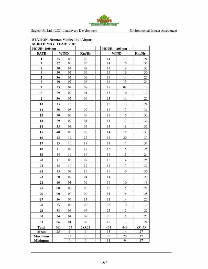
Sagicor Ja. Ltd. (LOJ) Llandovery Development Environmental Impact Assessment
____________________________________________________________________________________________
167
STATION: Norman Manley Int'l Airport MONTH:MAY YEAR: 2007 HOUR: 1:00 am HOUR: 1:00 pm
DATE WIND Km/Hr WIND Km/Hr
1 35 03 06 14 13 24 2 32 03 06 14 16 30 3 30 04 07 13 18 33 4 50 05 09 14 16 30 5 36 05 09 14 14 26 6 40 02 04 14 13 24
7 33 04 07 17 09 17
8 29 02 04 15 10 19
9 36 05 09 13 14 26
10 13 16 30 15 13 24
11 30 05 09 14 17 31
12 30 05 09 12 16 30
13 29 02 04 14 17 31
14 35 03 06 13 18 33
15 40 03 06 14 18 33
16 12 12 22 14 20 37
17 13 10 19 14 17 31
18 11 09 17 15 15 28
19 14 10 19 14 13 24
20 11 05 09 15 14 26
21 15 10 19 14 17 31
22 13 08 15 15 16 30
23 20 02 04 14 11 20
24 10 03 06 14 10 19
25 00 00 00 16 15 28
26 00 00 00 11 15 28
27 36 07 13 11 14 26
28 35 03 06 25 10 19
29 33 03 06 25 12 22
30 34 04 07 25 15 28
31 06 01 02 12 13 24 Total 761 154 285.21 464 449 831.55 Mean 25 5 9 15 14 27
Maximum 16 30 25 20 37 Minimum 0 0 11 9 17
Sagicor Ja. Ltd. (LOJ) Llandovery Development Environmental Impact Assessment
____________________________________________________________________________________________
168
Illustration of a Compass Rose used in the interpretation of wind data.
Sagicor Ja. Ltd. (LOJ) Llandovery Development Environmental Impact Assessment
____________________________________________________________________________________________
169
APPENDIX VIII
PROJECT PERSONNEL

Sagicor Ja. Ltd. (LOJ) Llandovery Development Environmental Impact Assessment
____________________________________________________________________________________________
170
The following persons were involved in the study:
Donovan Rose M.Sc. - Project Coordinator, Impact Assessment Peter Gayle B.Sc. - Ecology Paul Carroll M.Sc. - Environmental Chemistry Allison Richards M.Sc. - Socio- Economics Brian Richardson M.Sc. - Hydrogeology Pierre Diaz B.Sc. - Oceanography/Coastal Dynamics Michelle McNaught B.Sc. - Project Research Assistant
Sub Contractor - Smith Warner International Ltd.
i Synopsis of the Geology of Jamaica, Bulletin No. 4, Geol. Sur. Dept., JA, 1962 ii http://www.oas.org/CDMP/document/seismap/jamaica.htm, accessed April 27, 2007 iii CITES (the Convention on International Trade in Endangered Species of Wild Fauna and Flora) is an international agreement between governments. Its aim is to ensure that international trade in specimens of wild animals and plants does not threaten their survival. Jamaica is a signatory to CITES as of July 22, 1997 (http://www.cites.org/index.html).