lithgow bush fire risk management plan 2015a · road, tarana lithgow south unlikely moderate...
TRANSCRIPT

Lithgow Bush Fire Risk Management Plan 2015 Page 1 of 47
Lithgow Bush Fire Management Committee
Bush Fire Risk Management Plan

Lithgow Bush Fire Risk Management Plan 2015 Page 2 of 47
Table of Contents
Glossary 6
Chapter 1. Introduction 7
1.1 Background 7
1.2 Aim and Objectives 7
1.3 Description of the Lithgow BFMC Area 8 1.3.1 Location and land tenure 8 1.3.2 Climate and bush fire season 8 1.3.3 Population and demographic information 8 1.3.4 History of bush fire frequency and ignition cause 10
Chapter 2. Identifying and Assessing the Bush Fire Risk 11
2.1 Process 11
2.2 Communication and Consultation 11
2.3 Identifying the Bush Fire Risk 12 2.3.1 Assets 12 2.3.2 Assessing the Bush Fire Risk - Consequence 13 2.3.3 Assessing the Bush Fire Risk - Likelihood 14 2.3.4 Identifying the level of risk 14 2.3.5 Evaluating the Bush Fire Risk 14 2.3.6 Prioritising Treatments 15 2.3.7 Risk Acceptability 15
Chapter 3. Treating the Risk 16
3.1 Bush Fire Management Zones 16
3.2 BFMC Wide Treatments 18
3.3 Asset Specific Treatments 20
3.4 Fire Thresholds 21
3.5 Annual Works Programs 21
3.6 Implementation 22
Chapter 4. Performance Monitoring and Reviewing 23
4.1 Review 23
4.2 Monitoring 23
4.3 Reporting 23
4.4 Performance Measurements 23
Appendix 1: Community Participation Strategy 24
Appendix 2: Asset Register 28
Appendix 3: Treatment Register 33
Appendix 4: Maps 47
Lithgow Bush Fire Risk Management Plan 2015 Page 3 of 47
List of Tables Table 1.1 Land Tenure 8 Table 1.2 Demographic Profile 10 Table 3.1 Bush Fire Management Zones: Purpose, objectives and characteristics 17 Table 3.2 Asset specific treatments used in the Lithgow BFMC area 20 Table 3.3 Fire Thresholds for Vegetation Categories 21 Appendix Table 1.1 Community Participation Plan 27 List of Figures Figure 2.1 Overview of the risk assessment process ........................................................................................................ 11


Lithgow Bush Fire Risk Management Plan 2015 Page 5 of 47
Amendment List
Amendment Entered
Number Date Signature Date

Lithgow Bush Fire Risk Management Plan 2015 Page 6 of 47
Glossary Assets: anything valued by the community which includes houses, crops, heritage buildings and places, infrastructure, the environment, businesses, and forests, that may be at risk from bush fire. Bush Fire: a general term used to describe fire in vegetation, includes grass fire. Bush Fire Hazard: the potential severity of a bush fire, which is determined by fuel load, fuel arrangement and topography under a given climatic condition. Bush Fire Risk: the chance of a bush fire igniting, spreading and causing damage to the community or the assets they value. Bush Fire Risk Management: a systematic process that provides a range of treatments which contribute to the well being of communities and the environment, which suffer the adverse effects of wildfire/bush fire. Bush Fire Threat: potential bush fire exposure of an asset due to the proximity and type of a hazard and the slope on which the hazard is situated. Consequence: outcome or impact of a bush fire event. Fire Fighting Authorities: the NSW Rural Fire Service, Fire & Rescue NSW, the National Parks and Wildlife Service and Forestry Corporation of NSW. Likelihood: the chance of a bush fire igniting and spreading. Major Bush Fire: A bush fire which requires the attendance of multiple brigades, or causes damage to property or injury to one or more persons.
Display area: geographic area determined by the Bush Fire Management Committee which is used to provide a suitable area and scale for community participation and mapping display purposes. Recovery costs: the capacity of an asset to recover from the impacts of a bush fire.
Risk Acceptance: an informed decision to accept the consequences and the likelihood of a particular risk. Risk Analysis: a systematic process to understand the nature of and to deduce the level of risk. Risk Assessment: the overall process of risk identification, risk analysis and risk evaluation. Risk Identification: the process of determining what, where, when, why, and how something could happen. Risk Treatment: the process of selection and implementation of measures to modify risk. Vulnerability: the susceptibility of an asset to the impacts of bush fire.

Lithgow Bush Fire Risk Management Plan 2015 Page 7 of 47
Chapter 1. Introduction
1.1 Background
Under the Rural Fires Act 1997 the Bush Fire Coordinating Committee (BFCC) must constitute a Bush Fire Management Committee (BFMC) for each area in the State, which is subject to the risk of bush fires. Each BFMC is required to prepare and submit to the BFCC a draft Bush Fire Risk Management Plan (BFRMP).
A BFRMP is a strategic document that identifies community assets at risk and sets out a five-year program of coordinated multi-agency treatments to reduce the risk of bush fire to the assets. Treatments may include such things as hazard reduction burning, grazing, community education, fire trail maintenance and establishing community fireguard groups.
Annual programs to implement the treatments identified in this Plan will be undertaken by the relevant land managers and fire fighting authorities.
In exercising its functions under the Rural Fires Act 1997, including the preparation of a draft BFRMP, the Lithgow BFMC is required to have regard to the principles of ecologically sustainable development (ESD).
This document and the accompanying maps together form the BFRMP for the Lithgow BFMC area.
This BFRMP has been prepared by the Lithgow BFMC and covers both public and private lands. This BFRMP must be reviewed and updated within each successive five-year period from the constitution of the BFMC.
The BFCC recognises that climate change has the potential to increase bush fire risk. The risk assessment process applied in this BFRMP is based on current climatic conditions. The BFCC will monitor information on climate change and will modify the process when necessary.
1.2 Aim and Objectives
The aim of this BFRMP is to minimise the risk of adverse impact of bush fires on life, property and the environment.
The objectives of this BFRMP are to:
• reduce the number of human-induced bush fire ignitions that cause damage to life, property and the environment;
• manage fuel to reduce the rate of spread and intensity of bush fires, while minimising environmental/ecological impacts;
• reduce the community’s vulnerability to bush fires by improving its preparedness; and
• effectively contain fires with a potential to cause damage to life, property and the environment.
Lithgow Bush Fire Risk Management Plan 2015 Page 8 of 47
1.3 Description of the Lithgow BFMC Area
1.3.1 Location and land tenure
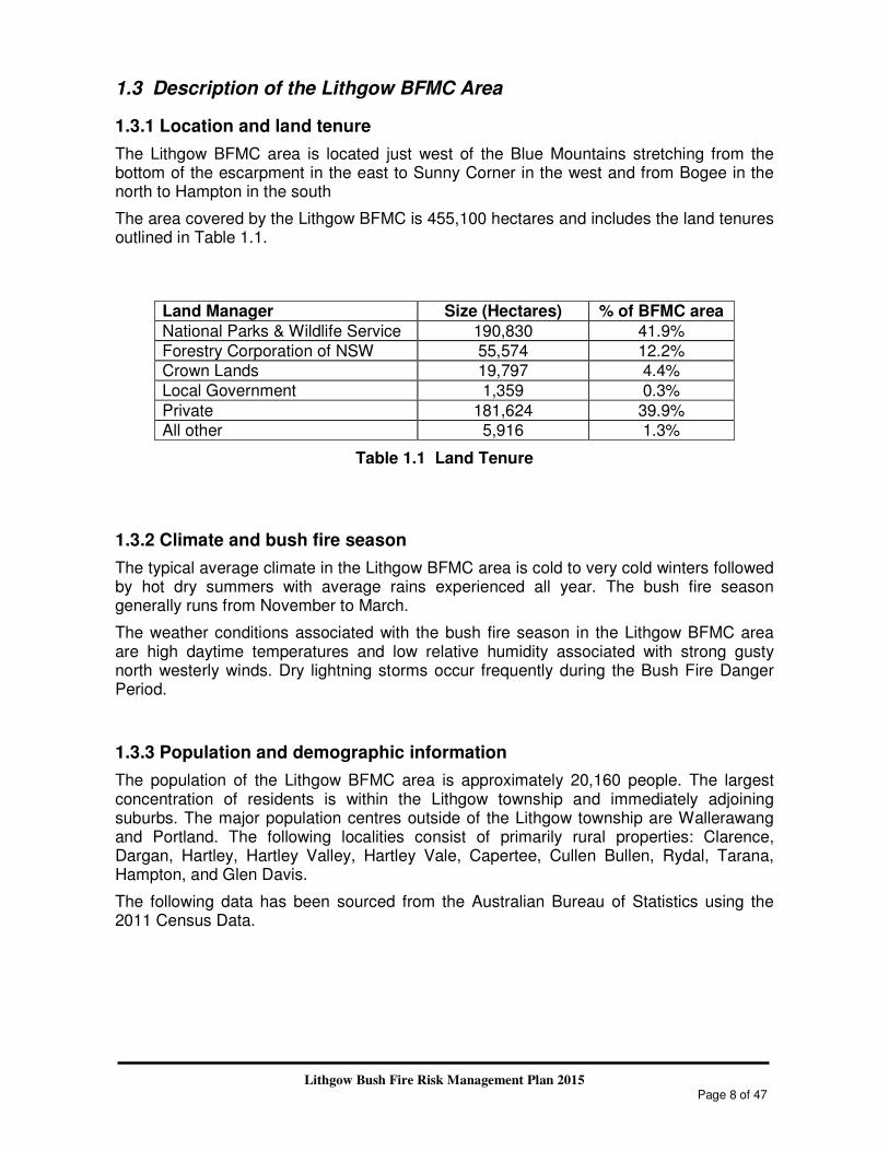
The Lithgow BFMC area is located just west of the Blue Mountains stretching from the bottom of the escarpment in the east to Sunny Corner in the west and from Bogee in the north to Hampton in the south
The area covered by the Lithgow BFMC is 455,100 hectares and includes the land tenures outlined in Table 1.1.
Land Manager Size (Hectares) % of BFMC area
National Parks & Wildlife Service 190,830 41.9%
Forestry Corporation of NSW 55,574 12.2%
Crown Lands 19,797 4.4%
Local Government 1,359 0.3%
Private 181,624 39.9%
All other 5,916 1.3%
Table 1.1 Land Tenure
1.3.2 Climate and bush fire season
The typical average climate in the Lithgow BFMC area is cold to very cold winters followed by hot dry summers with average rains experienced all year. The bush fire season generally runs from November to March.
The weather conditions associated with the bush fire season in the Lithgow BFMC area are high daytime temperatures and low relative humidity associated with strong gusty north westerly winds. Dry lightning storms occur frequently during the Bush Fire Danger Period.
1.3.3 Population and demographic information
The population of the Lithgow BFMC area is approximately 20,160 people. The largest concentration of residents is within the Lithgow township and immediately adjoining suburbs. The major population centres outside of the Lithgow township are Wallerawang and Portland. The following localities consist of primarily rural properties: Clarence, Dargan, Hartley, Hartley Valley, Hartley Vale, Capertee, Cullen Bullen, Rydal, Tarana, Hampton, and Glen Davis.
The following data has been sourced from the Australian Bureau of Statistics using the 2011 Census Data.

Lithgow Bush Fire Risk Management Plan 2015 Page 9 of 47
Total Persons 20,160 % of Total
Indigenous Persons
(comprising Aboriginal & Torres Strait Islanders) 901 4.5%
Male 10,290 51.0%
Female 9,870 49.0%
Age Groups
Median Age 42
0 - 14 3,771 18.7%
15 - 24 2,376 11.8%
25 - 34 1,981 9.8%
35 - 44 2,501 12.4%
45 - 54 3,024 15.0%
55 - 64 2,857 14.2%
65 & over 3,650 18.1%
Families 5,305
Average Children per Family 1.9
Family Composition
Couple family without children 2,207 41.6%
Couple family with children 2,042 38.5%
One parent family 964 18.2%
Other family 94 1.8%
Country of Birth
Top 5 responses
Australia 17,104 84.8%
England 536 2.7%
New Zealand 161 0.8%
Scotland 132 0.7%
Germany 89 0.4%
Language Spoken at Home
Top 5 responses
English Only 18,290 90.7%
Italian 54 0.3%
German 52 0.3%
Cantonese 42 0.2%
Arabic 28 0.1%

Lithgow Bush Fire Risk Management Plan 2015 Page 10 of 47
Total Persons
% of Total
Employment
Reported being in labour force, aged 15 years and over
Working Full-Time 4,952 57.0%
Working Part-Time 2,551 29.4%
Away from work 558 6.4%
Unemployed 622 7.2%
Total Available Labour Force 8,683
Travel to Work
By car as driver or passenger 5,882 90.8%
Walked only 349 5.4%
Truck 127 2.0%
Public Transport 122 1.9%
Dwellings 7,786
Owned outright 3,132 40.2%
Owned with mortgage 2,429 31.2%
Rented 1,892 24.3%
Other tenure type / not stated 333 4.3%
Table 1.2 Demographic Profile
1.3.4 History of bush fire frequency and ignition cause
The Lithgow BFMC area has, on average, 80 bush fires per year, of which up to 6 may be considered to be major fires.
October 2013 fire activity included a significant fire event for the BFMC area. The State Mine Fire commenced at Marrangaroo and impacted 56,590 hectares as it spread north, east and south of Lithgow township. The impact of this fire has been considered in the development of this BFRMP.
The main sources of ignition in the Lithgow BFMC area are:
• Arson/incendiaries
o Most commonly in grasslands and forested areas adjacent to townships
• Illegal burning activities
• Escaped fires from legal burning activities
• Lightning activity (mainly associated with late spring and early summer)
Lithgow Bush Fire Risk Management Plan 2015 Page 11 of 47
Chapter 2. Identifying and Assessing the Bush Fire Risk
2.1 Process
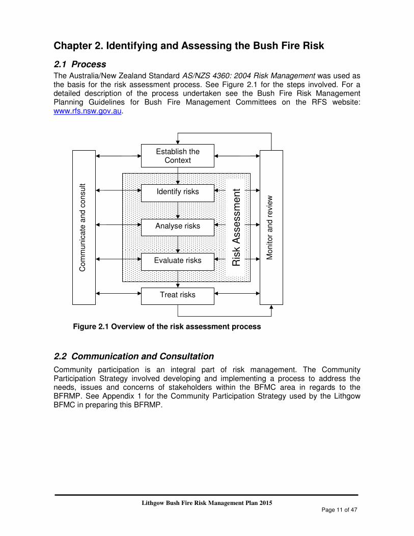
The Australia/New Zealand Standard AS/NZS 4360: 2004 Risk Management was used as the basis for the risk assessment process. See Figure 2.1 for the steps involved. For a detailed description of the process undertaken see the Bush Fire Risk Management Planning Guidelines for Bush Fire Management Committees on the RFS website: www.rfs.nsw.gov.au.
Figure 2.1 Overview of the risk assessment process
2.2 Communication and Consultation
Community participation is an integral part of risk management. The Community Participation Strategy involved developing and implementing a process to address the needs, issues and concerns of stakeholders within the BFMC area in regards to the BFRMP. See Appendix 1 for the Community Participation Strategy used by the Lithgow BFMC in preparing this BFRMP.
Establish the Context
Identify risks
Analyse risks
Evaluate risks
Treat risks
Mo
nitor
an
d r
evie
w
Com
mu
nic
ate
and c
on
sult
Ris
k A
sse
ssm
ent

Lithgow Bush Fire Risk Management Plan 2015 Page 12 of 47
2.3 Identifying the Bush Fire Risk
Identifying the level of bush fire risk firstly involved identifying important community assets within the Lithgow BFMC area that are considered to be at risk from bush fire, and then assessing the likelihood and consequence ratings.
2.3.1 Assets
BFMC members and the community, including RFS volunteers, identified assets within the Lithgow BFMC that they believed were at risk of bush fire.
The assets were divided into four asset types:
Human settlement
• Residential areas including urban bushland interface areas and rural properties;
• Special Fire Protection areas including schools, hospitals, nursing homes, and tourist facilities; and
• Other human settlement areas including commercial and industrial areas where distinct from major towns.
• Neighbourhood Safer Place (NSP) is defined by the Rural Fires Act 1997 as land or a building designated as a neighbourhood safer place under section 62C. NSPs provide a place of last resort for people during a bush fire. All designated NSP locations for Lithgow City Council are available at http://www.rfs.nsw.gov.au/plan-and-prepare/neighbourhood-safer-places/lithgow-lga.
Economic
• Agricultural; e.g. major silos, regional saleyards, cropping/grazing land;
• Commercial/industrial e.g. major industries, waste treatment plants, sawmills;
• Infrastructure e.g. large power lines, gas and oil pipelines, railway lines, electricity substations, communication facilities;
• Tourist and recreational e.g. tourist sites and facilities, resorts, retreats;
• Mines;
• Commercial forests e.g. pine plantations, eucalypt plantations and commercial native forests; and
• Drinking water catchments.
Environmental
• Threatened species, populations and ecological communities and Ramsar wetlands;
• Locally important species and ecological communities, such as species and ecological communities especially sensitive to fire.

Lithgow Bush Fire Risk Management Plan 2015 Page 13 of 47
Cultural
• Aboriginal significance – Aboriginal places and items of significance;
• Non-indigenous heritage – places and items arising from the early occupation of NSW by European or other non-indigenous settlers; and
• Other cultural assets – community halls, clubs and recreational facilities.
See Appendix 3 for the full list of assets identified in the Lithgow BFMC area. See maps 1-5 for the location of assets to be treated under this BFRMP
2.3.2 Assessing the Bush Fire Risk - Consequence
Once the assets were identified, the consequence of a bush fire impacting on these assets was assessed.
See Appendix 3 for the consequence ratings assigned to each asset identified in the Lithgow BFMC area.
The different asset types had different assessment processes used to determine the consequence. These processes are identified below.
Human settlement
A potential fire behaviour model using vegetation type, slope and separation distance was used to produce a threat rating for human settlement assets. The vulnerability of the asset to a bush fire was also assessed and a rating assigned. These ratings were then used to assess the consequence of a bush fire impacting upon a human settlement asset.
Special Fire Protection (SFP) assets were considered inherently more vulnerable to bush fire due to mobility capacity, knowledge or other issues relating to their inhabitants, (e.g. the elderly, infirm, children or tourists) and therefore stricter requirements for vulnerability assessment and rating were applied. Due to circumstances surrounding NSPs and their use during a bush fire, stricter requirements for vulnerability assessment and rating will also apply to these assets.
Economic
The level of economic impact e.g. local, regional or state, as well as the economic recovery costs (how long and complicated a financial recovery will be) of the asset were identified. These ratings were used to assess the consequence of a bush fire impacting upon an economic asset.

Lithgow Bush Fire Risk Management Plan 2015 Page 14 of 47
Environmental
Environmental assets with known minimum fire threshold were assessed to determine if they were at risk of a bush fire within the 5 year life of the BFRMP using fire history data. Those environmental assets which were within or above the fire threshold were not assessed in the BFRMP, as the negative impact of a fire within the 5 year period was determined as being low and may even be of benefit to the asset and surrounding habitat.
The vulnerability of an environmental asset was determined by its conservation status and its geographic extent (distribution across the landscape). Vulnerability and potential impact of bush fire were used to assess the consequence of a bush fire impacting upon an environmental asset.
Cultural
For non-indigenous historical, Aboriginal and other cultural assets a potential fire behaviour model using fuel load, slope and proximity was used to produce a threat rating. The physical vulnerability of the asset to a bush fire was also assessed. These ratings were then used to assess the consequence of a bush fire impacting upon a cultural asset.
2.3.3 Assessing the Bush Fire Risk - Likelihood
For all asset types the likelihood of a bush fire occurring was assessed. This involves considering fire history, including ignition cause and patterns, known fire paths, access, containment potential and potential fire run (size of the vegetated area). See Appendix 3 for the likelihood ratings assigned to each asset identified in the Lithgow BFMC area.
2.3.4 Identifying the level of risk
The consequence and likelihood ratings were then used to identify the level of risk. See Appendix 3 for the risk ratings assigned to each asset identified in the Lithgow BFMC area.
2.3.5 Evaluating the Bush Fire Risk
Once the risk ratings for each asset were identified, they were evaluated to:
a) confirm that risk levels identified in the risk analysis process are appropriate and reflect the relative seriousness of the bush fire risk;
b) identify which assets require treatments; and c) identify treatment priorities.

Lithgow Bush Fire Risk Management Plan 2015 Page 15 of 47
2.3.6 Prioritising Treatments
No organisation has limitless resources to deal with adverse risk. It is therefore necessary to define priorities. The bush fire risk ratings determined were used to prioritise the risk treatments, i.e. areas of extreme risk were considered first for treatment, then very high, then high then medium then low. It was also necessary to prioritise within the risk levels i.e. determining which of the high risks was the most serious. This was done on the basis of the consequence and likelihood ratings.
2.3.7 Risk Acceptability
Risks below a certain level were assessed as not requiring treatment within the life of this Plan. This is due to a combination of priority and capacity to undertake the works. Within the Lithgow BFMC area the level of acceptability is medium. Areas of medium or low risk are likely to be managed by routine procedures and so do not require a specific application of resources.
All NSPs for a BFMC area will require ongoing treatment by the applicable land owner to ensure that the asset remains viable as a place of last resort for people during a bush fire. Therefore, all NSP assets are allocated specific treatments in this Plan, regardless of the level of bush fire risk identified and the risk acceptability nominated by the Lithgow BFMC.

Lithgow Bush Fire Risk Management Plan 2015 Page 16 of 47
Chapter 3. Treating the Risk
3.1 Bush Fire Management Zones
Bush Fire Management Zones were identified within the Lithgow BFMC area and mapped (see maps 1-5). These zones identify the fire management intent for a specific area. See Table 3.1 for descriptions of the zones and their purposes. The four categories of Bush Fire Management Zones are:
• Asset Protection Zone (APZ);
• Strategic Fire Advantage Zone (SFAZ);
• Land Management Zone (LMZ); and
• Fire Exclusion Zone (FEZ).
Some of these zones (usually Land Management Zones) may be further classified within this category by the land manager, e.g. LMZ - Heritage Management Zone (NPWS).

Lithgow Bush Fire Risk Management Plan 2015 Page 17 of 47
Zone Purpose Suppression Objective(s) Zone characteristics
Asset Protection Zone
To protect human life, property and highly valued public assets and values.
To enable the safe use of Direct Attack suppression strategies within the zone.
To minimise bush fire impacts on undefended assets.
As per RFS document Standards for Asset Protection Zones.
Strategic Fire Advantage Zone
To provide strategic areas of fire protection advantage which will reduce the speed and intensity of bush fires, and reduce the potential for spot fire development;
To aid containment of wildfires to existing management boundaries.
To improve the likelihood and safe use of: Parallel Attack suppression strategies within the zone. and/or Indirect Attack (back burning) in high to very high fire weather conditions within the zone. To reduce the likelihood of: Crown fire development within the zone. and/or Spot fire ignition potential from the zone
.
Zone width related to suppression objectives and dependant upon:
• Topography
• Aspect
• Spotting propensity
• Location of adjacent firebreaks
• Mosaic pattern of treatment
Assess Overall Fuel Hazard (OFH) once vegetation communities reach minimum fire thresholds within this Plan.
Management practices should aim to achieve mosaic fuel reduction patterns so that the majority of the SFAZ has an OFH of less than high.
Land Management Zone
To meet relevant land management objectives in areas where APZs or SFAZs are not appropriate.
As per the land management and fire protection objectives of the responsible land management agency.
To reduce the likelihood of spread of fires.
To undertake mosaic burning
As appropriate to achieve land management e.g. heritage and/or fire protection e.g. broad scale mosaic burning objectives.
Fire Exclusion Zone
To exclude bush fires.
N/A Variable dependant on size of fire sensitive area requiring protection.
Table 3.1 Bush Fire Management Zones: Purpose, objectives and characteristics
NB: OFH refers the Overall Fuel Hazard Guide as described in the document published by (Dept. of Sustainability and Environment 3rd ed. 1999 & NPWS version); State-wide procedures for assessment of fuel hazard will be developed in conjunction with the BFCC. Note: All areas that are not mapped or described as APZs or SFAZs are considered as LMZs.

Lithgow Bush Fire Risk Management Plan 2015 Page 18 of 47
*For the purpose of the Bush Fire Environmental Assessment Code:
1. Plantations that are approved under the Plantations & Reafforestation Act 1999
after closure of the public exhibition period for this BFRMP are considered to be identified in this BFRMP; and
2. Retained vegetation within the aforementioned plantations is considered to be a Strategic Fire Advantage Zone identified in the text of this BFRMP as long as it meets the suppression objectives for SFAZs included in the BFRMP, and is not mapped or otherwise described as a Fire Exclusion Zone in the BFRMP.
3.2 BFMC Wide Treatments
BFMC wide treatments are activities which reduce the overall bush fire risk within the BFMC area and are undertaken on an ongoing basis as part of normal business. These treatments are not linked to specific assets in the BFRMP, rather they are applied across all or part of the BFMC area as designated by legislation or agency policy. BFMC wide treatments include the following:
• Reviewing the bush fire prone land map
These maps identify bush fire prone land and are used to trigger whether a development application is assessed using Planning for Bush Fire Protection1.
• Ensuring developments in bush fire prone land comply with Planning for Bush Fire Protection
This assessment process requires new applications for development to include bush fire protection measures.
• Using the Local Environment Plan/s (LEPs) to control developments in areas with a bush fire risk
LEPs can be used to exclude development in extreme bush fire risk areas or where bush fire protection measures cannot be incorporated.
• Varying the standard bush fire danger period as required
In years where the weather is particularly adverse the bush fire danger period may be brought in early or extended. This is assessed every year by the BFMC.
• Requiring permits during the bush fire danger period
In the bush fire danger period a fire safety permit is required to light a fire in the open. Permits specify conditions such as fire fighting equipment that must be on site, or restrict burns based on weather conditions.
• Prosecution of arsonists/offenders
Under the Rural Fires Act 1997 persons may be prosecuted for breaching the conditions on a fire permit, lighting a fire during a Total Fire Ban, allowing fire to escape their property, or other breaches of the Act.
1 NSW Rural Fire Service 2006 Planning for Bush Fire Protection: A guide for councils, planners, fire
authorities and developers.

Lithgow Bush Fire Risk Management Plan 2015 Page 19 of 47
• Investigation of bush fire cause
All bush fires which do not have a known cause are investigated to identify how they started.
• Normal fire suppression activities
Responding to bush fire is a normal business activity for the fire fighting authorities.
• Assessing and managing compliance with strategic fire fighting resource allocation provisions
Strategic fire fighting resource allocation provisions is the process used to identify the number of stations, brigades and appliances required in an area, and considers members, training, assets and hazards.
• Preparation of a S52 Operations Coordination Plan
The Operations Coordination Plan is prepared biannually and sets out how coordinated fire fighting will occur. It includes specific operational restrictions on fire fighting techniques in certain areas, where fires will be managed from, and how agencies involved can communicate during operations.
• Fire Management Plans or Plans of Management
Some land management agencies have developed fire management plans or plans of management with specific fire or fuel management strategies, for example a Forestry Corporation of NSW Regional Fuel Management Plan, a NPWS Reserve Fire Management Strategy. These publicly exhibited plans form the basis for operational fire planning on public parks, reserves and forests.
The following National Parks are located within the Lithgow Local Government Area and all are covered by individual fire management plans:
• Hartley Historic Site
• Wollemi National Park
• Marrangaroo National Park
• Blue Mountains National Park
• Turon National Park
• Gardens of Stone National Park
• Kanangra-Boyd National Park
• Mugii-Murum-ban State Conservation Area
• Capertee National Park
• Winburndale Nature Reserve
• Evans Crown Nature Reserve
• Wambool Nature Reserve
A Bush Fire Management Plan (BMP) has been developed for Marrangaroo Training Area (MARRTA). MARRTA is located in Marrangaroo, approximately 5 km north of Lithgow. The property is accessed by Reserve Road, off the Great Western Highway, and consists of approximately 1,520 hectares of Defence owned

Lithgow Bush Fire Risk Management Plan 2015 Page 20 of 47
land and 177 hectares of Newnes State Forest, leased under occupation permit from Forestry Corporation of NSW.
The BMP details fire management and mitigation requirements for the site. The BMP is prepared in accordance with Chapter Six (Bush Fire Management and Mitigation on the Defence Estate) of the Manual of Fire Protection and Engineering (MFPE) (Department of Defence 2011) and Bush Fire Management and Mitigation on the Defence Estate – National Guidelines (Guidelines) (Department of Defence 2013).
• Bush Fire Hazard Complaints
If someone is concerned about possible bush fire hazards on a neighbouring property or any other land, then this can be reported to the RFS Commissioner or their local RFS Fire Control Centre. The complaint will be investigated and may result in a notice being issued to the landowner or manager to reduce the hazard.
3.3 Asset Specific Treatments
There are five broad strategy groups available to treat the bush fire risk to assets identified in the BFRMP.
The types of asset specific treatments in each strategy group used in the Lithgow BFMC area are listed below. A full list of the treatment strategies in the Lithgow BFMC area are in Appendix 4.
Strategy Targeted treatments used in the Lithgow BFMC area
Ignition Management
• Activate ‘no burn’ plans in specific locations
• Man fire towers and patrol area as required
Hazard Reduction
• Create and maintain Asset Protection Zones
• Undertake burning in Strategic Fire Advantage Zones
• Undertake burning in Land Management Zones
• Undertake burning in line with Fire Management Plans or Plans of Management
• Maintain fuels in accordance with NSP guidelines Community Education
• Undertake community engagement activity
• Provision of bush fire information to tourist information centres
• Installation of bush fire safety signage at camping areas Property Planning
• Develop / implement / maintain site specific preparedness plans
Preparedness • Inspect and maintain fire trails
• Inspect and maintain water points and fire breaks
• Inspect and maintain strategic fire trails
Table 3.2 Asset specific treatments used in the Lithgow BFMC area

Lithgow Bush Fire Risk Management Plan 2015 Page 21 of 47
3.4 Fire Thresholds
The vegetation in the Lithgow BFMC area was classified into fire threshold categories (Table 3.3).
Vegetation formation Minimum
SFAZ Threshold
Minimum LMZ
Threshold
Maximum Threshold
Notes
Rainforest NA NA NA Fire should be avoided.
Alpine complex NA NA NA Fire should be avoided.
Wet Sclerophyll forest (shrubby subformation)
25 30 60 Crown fires should be avoided in the lower end of the interval range.
Wet Sclerophyll forest (grassy subformation)
10 15 50 Crown fires should be avoided in the lower end of the interval range.
Grassy woodland 5 8 40
Minimum interval of 10 years should apply in the southern Tablelands area. Occasional intervals greater than 15 years may be desirable.
Grassland 2 3 10
Occasional intervals greater than 7 years should be included in coastal areas. There was insufficient data to give a maximum interval; available evidence indicates maximum intervals should be approximately 10 years.
Dry sclerophyll forest (shrub/grass subformation)
5 8 50 Occasional intervals greater than 25 years may be desirable.
Dry sclerophyll forest (shrub subformation)
7 10 30 Occasional intervals greater than 25 years may be desirable.
Heathlands 7 10 30 Occasional intervals greater than 20 years may be desirable.
Freshwater wetlands 6 10 35 Occasional intervals greater than 30 years may be desirable.
Forested wetlands 7 10 35 Some intervals greater than 20 years may be desirable.
Saline wetlands NA NA NA Fire should be avoided.
Semi-arid woodlands (grassy subformation)
6 9 No max Not enough data for a maximum fire interval.
Semi-arid woodlands (shrubby subformation)
10 15 No Max Not enough data for a maximum fire interval.
Arid shrublands (chenopod subformation
NA NA NA Fire should be avoided.
Arid shrublands (acacia subformation)
10 15 No Max Not enough data for a maximum fire interval.
Table 3.3 Fire Thresholds for Vegetation Categories
3.5 Annual Works Programs
The land management agencies and fire fighting authorities responsible for implementing the treatments identified in this Plan will include those treatments in their annual works programs detailing how, when, and where the required activities will be undertaken.

Lithgow Bush Fire Risk Management Plan 2015 Page 22 of 47
3.6 Implementation
When the treatments identified in this BFRMP are implemented there are a number of issues that need to be considered by the responsible agency including environmental assessments and approvals, smoke management and prescribed burn plans.

Lithgow Bush Fire Risk Management Plan 2015 Page 23 of 47
Chapter 4. Performance Monitoring and Reviewing
4.1 Review
This BFRMP must be reviewed and updated within each successive five-year period from the constitution of the BFMC. The Lithgow BFMC will also review this Plan as necessary to account for any changes in context or risk. This may be triggered by a range of circumstances, including but not limited to:
• changes to the BFMC area, organisational responsibilities or legislation;
• changes to the bush fire risk in the area; or
• following a major fire event.
4.2 Monitoring
The BFMC is required to monitor progress towards the completion of treatment works listed in the BFRMP, and the timeliness of the works.
4.3 Reporting
The BFMC is required to report annually to the BFCC on its progress in implementing the bush fire risk management activities identified in this Plan.
4.4 Performance Measurements
State wide performance measurements which are linked to the BFRMP have been identified by the BFCC. All BFMCs must use these to monitor and report on their success in reducing the bush fire risk in their BFMC area.

Lithgow Bush Fire Risk Management Plan 2015 Page 24 of 47
Appendix 1: Community Participation Strategy
Lithgow BFMC Area Bush Fire Risk Management Plan
Community Participation Strategy Background The Bush Fire Management Committee (BFMC) has the responsibility to prepare a Bush Fire Risk Management Plan (BFRMP) for their area and for this Plan to be reviewed every 5 years in accordance with the Rural Fires Act 1997. Aims of Community Participation Strategy The community participation strategy is an essential part of the BFRMP process and should be prepared early on in the process. Communication and consultation with the community is an essential tool in ensuring the success of the BFRMP. The process of the Community Participation Strategy is to address the needs, issues and concerns of stakeholders within the BFMC area in regards to bush fire. The purpose of a community participation strategy is to:
• Ensure that specific and targeted communication occurs between the BFMC and the community and other stakeholders throughout the development of a BFRMP;
• Ensure prominent stakeholders do not make judgements on the acceptability of a risk based on their own perception;
• Provide greater opportunity for local brigades, land holders and other stakeholders to have input into the bush fire risk management process;
• Ensure that the community’s concerns and perceptions of bush fire risk are identified, understood, documented and addressed;
• Improve community confidence in bush fire risk management across the landscape and provide the community with a sense of ownership of the BFRMP; and
• Educate the community regarding bush fire risk management in the area and their responsibilities, so that they can contribute towards risk reduction.
Steps of Developing a Community Participation Strategy The BFMC acknowledges that any strategy for community participation on the BFRMP will require communications to be dependent upon the targeted audience and have consideration of the community’s availability and resources. Following are the steps that have been used as the basis of the community participation strategy.

Lithgow Bush Fire Risk Management Plan 2015
Targeted Audiences BFMC Agencies: It will be the responsibility for the agency representatives on the BFMC to take the information back to their agency and communicate the Plan to their agency. Residential communities: Includes those that live or have assets within the area, particularly those that may be affected by bush fires. Community Groups: A range of community groups will be invited to review the BFRMP and to provide feedback. RFS Brigades: As brigades play an integral role within the community and bush fire management, brigades have an opportunity to provide feedback and to inform others within their communities. Lithgow District Community Engagement Committee: This is group of volunteers representing local brigades and those that are actively involved in community engagement. Information to be communicated The key information items to be communicated are:
• What is a Bush Fire Risk Management Plan
• Process of developing a Bush Fire Risk Management Plan
• How it may affect the community
• Identification of risk in the area;
• Understanding treatment strategies
• Public exhibition

Lithgow Bush Fire Risk Management Plan 2015 Page 26 of 47
Methods of communications It is identified that there needs to be various forms of consultation in order to address the different target audiences as well as the type of information that may be appropriate for a particular audience. The methods and targeted audiences that will be deployed to engage the public on the Bush Fire Risk Management Plan, are as follows:
• Local Newspaper: o Advertisements and special articles placed in local newspapers distributed to
areas affected by the Bush Fire Risk Management Plan; o Include specific reference to locations where the BFRMP is on display
• Brigade and Group Officer Information: o A copy of the Bush Fire Risk Management Plan to be provided to all Rural
Fire Brigades and Group Officers within the BFMC area o NSW RFS members are encouraged to review and provide feedback in line
with the timing of the public display period
• Lithgow Community Engagement Committee o BFRMP to be presented at a convened meeting to the members of the
Committee for review
• Public Displays: Information to be provided on display at the following strategic locations;
o Lithgow City Council Office o Lithgow Public Library o Wallerawang Public Library o Lithgow Fire Control Centre
Documentation Refer to Community Participation Communications Plan.

Lithgow Bush Fire Risk Management Plan 2015 Page 27 of 47
Community Participation Communications Plan
Date
Targeted
Audience
Method of
Communication
Method of
Notification
Key Message /
Purpose Resources Responsibility
01-Apr-14
BFMC Sub-
Committee Meeting Email
Stakeholder
Contribution
Draft
BFRMP NSWRFS
01-Jul-14 BFMC Sub-
Committee Meeting Email
Treatment Listing
Review
Draft
BFRMP NSWRFS
09-Sep-14 BFMC Meeting Email
Review for
Approval of Draft
to go on display &
submitted to
Region for review
Maps &
Presentation NSWRFS
22-Sep-14
Lithgow District
Rural Fire
Brigades
Printed copy Email Stakeholder
Contribution
BFRMP,
Maps &
Presentation
NSWRFS
22-Sep-14
Lithgow
Community
Engagement
Committee
Printed copy &
meeting
28th
Oct
Email Stakeholder
Contribution
BFRMP,
Maps &
Presentation
NSWRFS
22-Sep-14 General Public Display Print
advertising
Feedback to BFMC
to prepare final
BFRMP
Printing &
Distribution NSWRFS
10-Nov-14 BFMC Submissions
received Various
Complete review of
submissions
received and action
accordingly
Annex I,
Appendix 6 BFMC
Appendix Table 1.1 Community Participation Plan
Community Participation Feedback Submissions / feedback in writing will be invited from the community to provide information for the Bush Fire Management Committee on any particular issues in relation to the Draft Bush Fire Risk Management for further consideration by that committee. Feedback on the Draft Plan will be encouraged; however will be considered on relevance and in the broader terms of the Plan.

Lithgow Bush Fire Risk Management Plan 2015 Page 28 of 47
Appendix 2: Asset Register
Priority Map
Ref No. Asset type Asset sub type Asset name Asset Location LGA Display area Likelihood Consequence Risk
1A 1 Human Settlement Residential Hartley Vale & Lawsons Long Alley Hartley Vale Lithgow East Almost certain Catastrophic Extreme
1B 0 Cultural Aboriginal Significance Aboriginal Sites of High Vulnerability Lithgow undefined Likely Catastrophic Extreme
2 Economic Commercial Forest Hampton State Forest Hampton Lithgow South Likely Catastrophic Extreme
3 Economic Commercial Forest Jenolan State Forest Jenolan Lithgow South Likely Catastrophic Extreme
4 Economic Commercial Forest Lidsdale State Forest Wallerawang Lithgow South Likely Catastrophic Extreme
5 Economic Commercial Forest Newnes State Forest Newnes Lithgow Central Likely Catastrophic Extreme
6 Economic Commercial Forest Sunny Corner State Forest Dark Corner Lithgow West Likely Catastrophic Extreme
7 Economic Infrastructure Mount Piper Power Station Portland Lithgow Central Likely Catastrophic Extreme
8 Economic Infrastructure Wallerawang Power Station Wallerawang Lithgow Central Likely Catastrophic Extreme
9 Human Settlement Residential Capertee - Village Capertee Lithgow North Likely Catastrophic Extreme
10 Human Settlement Residential Lowther & Hampton - Rural Properties Lowther & Hampton Lithgow South Likely Catastrophic Extreme
11 Human Settlement Special Fire Protection Hampton Public School Hampton Lithgow South Likely Catastrophic Extreme
1C 0 Environment Endangered Endangered Ecological Community 3 Lithgow undefined Almost certain Major Extreme
0 Environment Endangered Gentianaceae Lithgow undefined Almost certain Major Extreme
0 Environment Endangered Gyrostemonaceae Lithgow undefined Almost certain Major Extreme
0 Environment Endangered Orchidaceae 1 Lithgow undefined Almost certain Major Extreme
0 Environment Endangered Rhamnaceae 2 Lithgow undefined Almost certain Major Extreme
2A
0 Cultural Aboriginal Significance Aboriginal Sites of Moderate Vulnerability
Lithgow undefined Likely Major Very High
0 Economic Drinking Water Catchment Water Pipeline - Oberon to Glen Davis Oberon to Glen Davis Lithgow undefined Likely Major Very High
0 Economic Infrastructure Electricity Infrastructure (Transmission Lines & Towers) Various Lithgow undefined Likely Major Very High
0 Environment Endangered Apiaceae
Lithgow undefined Likely Major Very High
0 Environment Endangered Apocynaceae Lithgow undefined Likely Major Very High
0 Environment Endangered Ardeidae
Lithgow undefined Likely Major Very High
0 Environment Endangered Burhinidae Lithgow undefined Likely Major Very High
0 Environment Endangered Calomniaceae
Lithgow undefined Likely Major Very High
0 Environment Endangered Cyperaceae Lithgow undefined Likely Major Very High
0 Environment Endangered Dryopteridaceae Lithgow undefined Likely Major Very High
0 Environment Endangered Endangered Ecological Community 1 Lithgow undefined Likely Major Very High

Lithgow Bush Fire Risk Management Plan 2015 Page 29 of 47
Priority Map
Ref No. Asset type Asset sub type Asset name Asset Location LGA Display area Likelihood Consequence Risk
2A
0 Environment Endangered Endangered Ecological Community 2 Lithgow undefined Likely Major Very High
0 Environment Endangered Endangered Ecological Community 4 Lithgow undefined Likely Major Very High
0 Environment Endangered Fabaceae (Faboideae) 1
Lithgow undefined Likely Major Very High
0 Environment Endangered Fabaceae (Faboideae) 2 Lithgow undefined Likely Major Very High
0 Environment Endangered Fabaceae (Faboideae) 3
Lithgow undefined Likely Major Very High
0 Environment Endangered Fabaceae (Faboideae) 4 Lithgow undefined Likely Major Very High
0 Environment Endangered Grammitidaceae Lithgow undefined Likely Major Very High
0 Environment Endangered Hylidae 1 Lithgow undefined Likely Major Very High
0 Environment Endangered Hylidae 2 Lithgow undefined Likely Major Very High
0 Environment Endangered Hylidae 3 Lithgow undefined Likely Major Very High
0 Environment Endangered Lycaenidae Lithgow undefined Likely Major Very High
0 Environment Endangered Megapodiidae Lithgow undefined Likely Major Very High
0 Environment Endangered Myobatrachidae 1 Lithgow undefined Likely Major Very High
0 Environment Endangered Myobatrachidae 2
Lithgow undefined Likely Major Very High
0 Environment Endangered Myrtaceae 1 Lithgow undefined Likely Major Very High
0 Environment Endangered Myrtaceae 2
Lithgow undefined Likely Major Very High
0 Environment Endangered Myrtaceae 3 Lithgow undefined Likely Major Very High
0 Environment Endangered Orchidaceae 2 Lithgow undefined Likely Major Very High
0 Environment Endangered Orchidaceae 3 Lithgow undefined Likely Major Very High
0 Environment Endangered Petaluridae Lithgow undefined Likely Major Very High
0 Environment Endangered Podocarpaceae Lithgow undefined Likely Major Very High
0 Environment Endangered Proteaceae Lithgow undefined Likely Major Very High
0 Environment Endangered Rhamnaceae 1
Lithgow undefined Likely Major Very High
0 Environment Endangered Rutaceae 2 Lithgow undefined Likely Major Very High
0 Environment Endangered Scincidae
Lithgow undefined Likely Major Very High
0 Environment Endangered Scrophulariaceae 1 Lithgow undefined Likely Major Very High
0 Environment Endangered Scrophulariaceae 2
Lithgow undefined Likely Major Very High
12 Economic Commercial Forest Ben Bullen State Forest Ben Bullen Lithgow Central Likely Major Very High
13 Economic Commercial Forest Wolgan State Forest Wolgan Lithgow Central Likely Major Very High
14 Economic Infrastructure Hassans Walls Communication Towers Lithgow Lithgow Central Likely Major Very High

Lithgow Bush Fire Risk Management Plan 2015 Page 30 of 47
Priority Map
Ref No. Asset type Asset sub type Asset name Asset Location LGA Display area Likelihood Consequence Risk
2A 15 Economic Infrastructure Mount Airly Communication Tower Capertee Lithgow North Likely Major Very High
16 Economic Infrastructure Mount Lambie Communication Tower Mount Lambie Lithgow South Likely Major Very High
17 Human Settlement Residential Bowenfels Bowenfels Lithgow Central Likely Major Very High
18 Human Settlement Residential Clarence Clarence Lithgow East Likely Major Very High
19 Human Settlement Residential Dargan Dargan Lithgow East Likely Major Very High
20 Human Settlement Residential Hartley - Rural Properties Hartley Lithgow South Likely Major Very High
21 Human Settlement Residential Little Hartley - Rural Properties Little Hartley Lithgow East Likely Major Very High
22 Human Settlement Residential Mount Lambie - Rural Properties Mount Lambie Lithgow South Likely Major Very High
23 Human Settlement Residential Wolgan Valley - Rural Properties Wolgan Valley Lithgow Central Likely Major Very High
24 Human Settlement Residential Marrangaroo Marrangaroo Lithgow Central Likely Major Very High
25 Human Settlement Residential Capertee - Rural Properties Capertee Lithgow North Likely Major Very High
26 Human Settlement Residential Cullen Bullen - Village Cullen Bullen Lithgow North Likely Major Very High
27 Human Settlement Residential Rydal - Village Rydal Lithgow South Likely Major Very High
28 Human Settlement Residential Hampton - Village Hampton Lithgow South Likely Major Very High
29 Economic Mines Baal Bone Colliery Cullen Bullen Lithgow North Likely Major Very High
30 Economic Mines Cullen Valley Colliery Cullen Bullen Lithgow North Likely Major Very High
31 Economic Mines Angus Place Colliery Lidsdale Lithgow Central Likely Major Very High
32 Economic Mines Clarence Colliery Clarence Lithgow Central;East Likely Major Very High
33 Economic Mines Ivanhoe Colliery Blackmans Flat Lithgow North Likely Major Very High
34 Economic Infrastructure Mount Bindo Fire Lookout and Communication Tower Mount Bindo Lithgow South Likely Major Very High
35 Human Settlement Residential Kanimbla - Rural Properties Kanimbla Lithgow East Likely Major Very High
36 Economic Mines Springvale Colliery Lidsdale Lithgow Central Likely Major Very High
37 Economic Mines Invincible Colliery Cullen Bullen Lithgow North Likely Major Very High
38 Economic Mines Sibelco Quarry Round Swamp Lithgow North Likely Major Very High
39 Economic Mines Austen Quarry Hartley Lithgow South Likely Major Very High
40 Economic Mines Hanson Quarries Clarence Lithgow Central;East Likely Major Very High
41 Economic Infrastructure Thompsons Creek Dam Wallerawang Lithgow undefined Likely Major Very High
42 Economic Mines Metro Mix Quarry Marrangarro Lithgow Central Likely Major Very High
2C 43 Cultural Non Indigenous Collits Inn Hartley Vale Lithgow East Almost certain Moderate Very High
3A 0 Cultural Aboriginal Significance Aboriginal Sites of Low Vulnerability
Lithgow undefined Likely Moderate High

Lithgow Bush Fire Risk Management Plan 2015 Page 31 of 47
Priority Map
Ref No. Asset type Asset sub type Asset name Asset Location LGA Display area Likelihood Consequence Risk
3A 44 Cultural Non Indigenous Hartley Historic Village Hartley Lithgow East Likely Moderate High
45 Cultural Non Indigenous Old Airly Village Capertee Lithgow North Likely Moderate High
46 Cultural Non Indigenous Newnes Historic Village Newnes Lithgow Central Likely Moderate High
47 Economic Commercial Howards Pyrotechnics Wallerawang Lithgow Central Likely Moderate High
48 Economic Infrastructure Lithgow Water Treatment Works Oaky Park Lithgow Central Likely Moderate High
49 Economic Infrastructure Marrangaroo Training Area Marrangaroo Lithgow Central Likely Moderate High
50 Human Settlement Residential City of Lithgow Lithgow Lithgow Central Likely Moderate High
51 Human Settlement Residential Palmers Oakey - Rural Properties Palmers Oakey Lithgow West Likely Moderate High
52 Human Settlement Residential Portland - Village Portland Lithgow North Likely Moderate High
53 Human Settlement Residential Tarana - Village & Rural Properties Tarana Lithgow South Likely Moderate High
54 Economic Tourist and Recreational Newnes Ruins Newnes Lithgow Central Likely Moderate High
55 Economic Tourist and Recreational Emirates Resort Wolgan Valley Lithgow Central Likely Moderate High
56 Economic Tourist and Recreational Zig Zag Railway Station Clarence Lithgow East Likely Moderate High
57 Economic Infrastructure Lithgow Sewerage Treatment Plant Bowenfels Lithgow Central Likely Moderate High
58 Human Settlement Residential Glen Alice - Rural Properties Glen Alice Lithgow North Likely Moderate High
59 Economic Infrastructure Portland Sewerage Treatment Plant Portland Lithgow North Likely Moderate High
60 Economic Drinking Water Catchment Farmers Creek Dam State Mine Gully Lithgow Central Likely Moderate High
61 Human Settlement Residential Bogee/Mount Marsden/Dunville Loop - Rural Properties Bogee Lithgow North Likely Moderate High
62 Economic Infrastructure Wallerawang Sewerage Treatment Plant Wallerawang Lithgow Central Likely Moderate High
3B 0 Environment Endangered Rutaceae 1
Lithgow undefined Possible Major High
3C 0 Human Settlement Other Recreational Camping Areas Various Lithgow undefined Unlikely Catastrophic High
63 Human Settlement Residential Glen Davis - Village Glen Davis Lithgow North Unlikely Catastrophic High
4
64 Cultural Non Indigenous Glen Davis Shale Oil Works & Refinery Glen Davis Lithgow North Likely Minor Medium
65 Human Settlement Other NSP - Capertee Castlereagh Highway, Capertee Lithgow North Unlikely Major Medium
66 Human Settlement Other NSP - Glen Alice Jamison Street, Glen Alice Lithgow North Unlikely Major Medium
67 Human Settlement Residential Ganbenang - Rural Properties Ganbenang Lithgow South Unlikely Major Medium
68 Human Settlement Residential Rydal - Rural Properties Rydal Lithgow Central Unlikely Major Medium
69 Human Settlement Special Fire Protection Glen Alice Public School Glen Alice Lithgow North Unlikely Major Medium
70 Human Settlement Special Fire Protection Lithgow Correctional Facility Marrangaroo Lithgow Central Unlikely Major Medium

Lithgow Bush Fire Risk Management Plan 2015 Page 32 of 47
Priority Map
Ref No. Asset type Asset sub type Asset name Asset Location LGA Display area Likelihood Consequence Risk
4 71 Economic
Tourist and Recreational Venice Caravan Park Hartley Lithgow East Likely Minor Medium
72 Economic Tourist and Recreational Glow Worm Tunnel Day Use Area Newnes Plateau Lithgow Central Likely Minor Medium
73 Economic Tourist and Recreational
Glen Davis Camping Area & Community Centre Glen Davis Lithgow North Likely Minor Medium
74 Human Settlement Residential Meadow Flat Village Meadow Flat Lithgow West Unlikely Major Medium
NA 75 Human Settlement Other NSP - Marrangaroo
501 Great Western Highway Marrangaroo Lithgow Central Unlikely Moderate Low
76 Human Settlement Other NSP - Tarana
Cnr of Sodwalls Road and Diamond Swamp Road, Tarana Lithgow South Unlikely Moderate Low
77 Human Settlement Other NSP - Portland Cnr of Lime Street and Villiers Street, Portland Lithgow North Unlikely Moderate Low
78 Human Settlement Other NSP - Rydal Bathurst Street, Rydal Lithgow South Unlikely Moderate Low
79 Human Settlement Other NSP - Wallerawang Barton Avenue, Wallerawang Lithgow Central Unlikely Moderate Low
80 Human Settlement Other NSP - Lithgow Barton Street, Lithgow Lithgow Central Unlikely Moderate Low
81 Human Settlement Residential Wallerawang - Village Wallerawang Lithgow Central Unlikely Moderate Low

Lithgow Bush Fire Risk Management Plan 2015 Page 33 of 47
Appendix 3: Treatment Register
Priority (Risk
Rating)
Asset ID
Asset Name Strategy Treatment
ID Action Description Comment
Responsible Agencies
Other RA Support
Agencies 1516 1617 1718 1819 1920
1A (Extreme)
1 Hartley Vale &
Lawsons Long Alley
Community Education
2 Undertake Community Engagement Activity
RFS [1516] [1617] [1718] [1819] [1920]
Hazard Reduction 1
Create and Maintain APZ
Private RFS [1516] [1617] [1718] [1819] [1920]
3 Undertake Burn in SFAZ RFS [1920]
Preparedness 4 Inspect and Maintain Fire Trails
RFS [1516] [1617] [1718] [1819] [1920]
1B (Extreme)
0 Aboriginal Sites of High Vulnerability
Hazard Reduction 20 Undertake burning in SFAZs and LMZs
OEH;RFS;DPI;FCNSW
[1516] [1617] [1718] [1819] [1920]
Ignition Management
19 Implement Prevention Plan
Implement arson and illegal/careless fires prevention plan
RFS [1516] [1617] [1718] [1819] [1920]
2 Hampton State
Forest
Community Education
6 Make Fact Sheets and Pamphlets Available
Recreation use of Forests pamphlets available through Tourist Information Centre
FCNSW [1516] [1617] [1718] [1819] [1920]
Hazard Reduction 5 Undertake Burning in line with FCNSW Plan
FCNSW [1516] [1617] [1718] [1819] [1920]
Ignition Management
8
Activate No Burn Plan
Activate solid fuel fire ban in state forests during Bush Fire Danger Period
FCNSW [1516] [1617] [1718] [1819] [1920]
14 Man Fire Towers and Patrol Area as Required
Undertake patrols of area during TOBAN. Man Fire Towers as stated in Lithgow BFMC Operations Coordination Plan.
FCNSW [1516] [1617] [1718] [1819] [1920]
Preparedness
9 Inspect and Maintain Strategic Fire Trails
Maintain a road network within plantations in line with FCNSW Strategic Plan of Management
FCNSW [1516] [1617] [1718] [1819] [1920]
10 Inspect and Maintain Water Points and Fire Breaks
In line with FCNSW Strategic Plan of Management
FCNSW [1516] [1617] [1718] [1819] [1920]
Property Planning 7 Implement FCNSW State of Preparation Guidelines
FCNSW [1516] [1617] [1718] [1819] [1920]
3
Jenolan State Forest
Community Education
6 Make Fact Sheets and Pamphlets Available
Recreation use of Forests pamphlets available through Tourist Information Centre
FCNSW [1516] [1617] [1718] [1819] [1920]
Hazard Reduction 5 Undertake Burning in line with FCNSW Plan
FCNSW [1516] [1617] [1718] [1819] [1920]
Ignition Management
8
Activate No Burn Plan
Activate solid fuel fire ban in state forests during Bush Fire Danger Period
FCNSW [1516] [1617] [1718] [1819] [1920]

Lithgow Bush Fire Risk Management Plan 2015 Page 34 of 47
Priority (Risk
Rating)
Asset ID
Asset Name Strategy Treatment
ID Action Description Comment
Responsible Agencies
Other RA Support
Agencies 1516 1617 1718 1819 1920
1B
(Extreme)
3
Jenolan State Forest Preparedness
9 Inspect and Maintain Strategic Fire Trails
Maintain a road network within plantations in line with FCNSW Strategic Plan of Management
FCNSW [1516] [1617] [1718] [1819] [1920]
10 Inspect and Maintain Water Points and Fire Breaks
In line with FCNSW Strategic Plan of Management
FCNSW [1516] [1617] [1718] [1819] [1920]
Property Planning 7 Implement FCNSW State of Preparation Guidelines
FCNSW [1516] [1617] [1718] [1819] [1920]
4 Lidsdale State Forest
Community Education
6 Make Fact Sheets and Pamphlets Available
Recreation use of Forests pamphlets available through Tourist Information Centre
FCNSW [1516] [1617] [1718] [1819] [1920]
Hazard Reduction 5 Undertake Burning in line with FCNSW Plan
FCNSW [1516] [1617] [1718] [1819] [1920]
Ignition Management
8
Activate No Burn Plan
Activate solid fuel fire ban in state forests during Bush Fire Danger Period
FCNSW [1516] [1617] [1718] [1819] [1920]
Preparedness
9 Inspect and Maintain Strategic Fire Trails
Maintain a road network within plantations in line with FCNSW Strategic Plan of Management
FCNSW [1516] [1617] [1718] [1819] [1920]
10 Inspect and Maintain Water Points and Fire Breaks
In line with FCNSW Strategic Plan of Management
FCNSW [1516] [1617] [1718] [1819] [1920]
Property Planning 7 Implement FCNSW State of Preparation Guidelines
FCNSW [1516] [1617] [1718] [1819] [1920]
5 Newnes State Forest
Community Education
6 Make Fact Sheets and Pamphlets Available
Recreation use of Forests pamphlets available through Tourist Information Centre
FCNSW [1516] [1617] [1718] [1819] [1920]
Hazard Reduction 5 Undertake Burning in line with FCNSW Plan
FCNSW [1516] [1617] [1718] [1819] [1920]
Ignition Management
8
Activate No Burn Plan
Activate solid fuel fire ban in state forests during Bush Fire Danger Period
FCNSW [1516] [1617] [1718] [1819] [1920]
Preparedness
9 Inspect and Maintain Strategic Fire Trails
Maintain a road network within plantations in line with FCNSW Strategic Plan of Management
FCNSW [1516] [1617] [1718] [1819] [1920]
10 Inspect and Maintain Water Points and Fire Breaks
In line with FCNSW Strategic Plan of Management
FCNSW [1516] [1617] [1718] [1819] [1920]
Property Planning 7 Implement FCNSW State of Preparation Guidelines
FCNSW [1516] [1617] [1718] [1819] [1920]
6
Sunny Corner State Forest
Community Education
6 Make Fact Sheets and Pamphlets Available
Recreation use of Forests pamphlets available through Tourist Information Centre
FCNSW [1516] [1617] [1718] [1819] [1920]
Hazard Reduction 5 Undertake Burning in line with FCNSW Plan
FCNSW [1516] [1617] [1718] [1819] [1920]

Lithgow Bush Fire Risk Management Plan 2015 Page 35 of 47
Priority (Risk
Rating)
Asset ID
Asset Name Strategy Treatment
ID Action Description Comment
Responsible Agencies
Other RA Support
Agencies 1516 1617 1718 1819 1920
1B
(Extreme)
6
Sunny Corner State
Forest
Ignition Management
8
Activate No Burn Plan
Activate solid fuel fire ban in state forests during Bush Fire Danger Period
FCNSW [1516] [1617] [1718] [1819] [1920]
Preparedness
9 Inspect and Maintain Strategic Fire Trails
Maintain a road network within plantations in line with FCNSW Strategic Plan of Management
FCNSW [1516] [1617] [1718] [1819] [1920]
10 Inspect and Maintain Water Points and Fire Breaks
In line with FCNSW Strategic Plan of Management
FCNSW [1516] [1617] [1718] [1819] [1920]
Property Planning 7 Implement FCNSW State of Preparation Guidelines
FCNSW [1516] [1617] [1718] [1819] [1920]
7 Mount Piper Power
Station
Preparedness 12 Inspect and Maintain Fire Breaks
Private RFS [1516] [1617] [1718] [1819] [1920]
Property Planning 11 Develop/Maintain/Implement Preparedness Plan
Private RFS [1516] [1617] [1718] [1819] [1920]
8 Wallerawang Power
Station
Preparedness 12 Inspect and Maintain Fire Breaks
Private RFS [1516] [1617] [1718] [1819] [1920]
Property Planning 11 Develop/Maintain/Implement Preparedness Plan
Private RFS [1516] [1617] [1718] [1819] [1920]
9 Capertee - Village
Community Education
16 Undertake Community Engagement Activity
RFS [1516] [1617] [1718] [1819] [1920]
Hazard Reduction 15
Create and Maintain APZ
Private RFS [1516] [1617] [1718] [1819] [1920]
17 Undertake Burn in SFAZ RFS [1920]
10 Lowther & Hampton -
Rural Properties
Community Education
16 Undertake Community Engagement Activity
RFS [1516] [1617] [1718] [1819] [1920]
Hazard Reduction 15
Create and Maintain APZ
Private RFS [1516] [1617] [1718] [1819] [1920]
17 Undertake Burn in SFAZ RFS [1920]
Preparedness 18 Inspect and Maintain Fire Trails
RFS [1516] [1617] [1718] [1819] [1920]
11 Hampton Public
School Hazard Reduction
13 Create and Maintain APZ
Other Dept of
Education [1516] [1617] [1718] [1819] [1920]
17 Undertake Burn in SFAZ RFS [1920]
1C (Extreme)
0
Endangered Ecological
Community 3
Hazard Reduction 22 Undertake burning in SFAZs and LMZs
OEH;RFS;DPI;FCNSW
[1516] [1617] [1718] [1819] [1920]
Ignition Management
21 Implement Prevention Plan
Implement arson and illegal/careless fires prevention plan
RFS [1516] [1617] [1718] [1819] [1920]
Gentianaceae
Hazard Reduction 22 Undertake burning in SFAZs and LMZs
OEH;RFS;DPI;FCNSW
[1516] [1617] [1718] [1819] [1920]
Ignition Management
21 Implement Prevention Plan
Implement arson and illegal/careless fires prevention plan
RFS [1516] [1617] [1718] [1819] [1920]
Gyrostemonaceae
Hazard Reduction 22 Undertake burning in SFAZs and LMZs
OEH;RFS;DPI;FCNSW
[1516] [1617] [1718] [1819] [1920]
Ignition Management
21 Implement Prevention Plan
Implement arson and illegal/careless fires prevention plan
RFS [1516] [1617] [1718] [1819] [1920]

Lithgow Bush Fire Risk Management Plan 2015 Page 36 of 47
Priority (Risk
Rating)
Asset ID
Asset Name Strategy Treatment
ID Action Description Comment
Responsible Agencies
Other RA Support
Agencies 1516 1617 1718 1819 1920
0 Orchidaceae 1
Hazard Reduction 22 Undertake burning in SFAZs and LMZs
OEH;RFS;DPI;FCNSW
[1516] [1617] [1718] [1819] [1920]
Ignition Management
21 Implement Prevention Plan
Implement arson and illegal/careless fires prevention plan
RFS [1516] [1617] [1718] [1819] [1920]
Rhamnaceae 2
Hazard Reduction 22 Undertake burning in SFAZs and LMZs
OEH;RFS;DPI;FCNSW
[1516] [1617] [1718] [1819] [1920]
Ignition Management
21 Implement Prevention Plan
Implement arson and illegal/careless fires prevention plan
RFS [1516] [1617] [1718] [1819] [1920]
2A (Very High)
0
Aboriginal Sites of Moderate
Vulnerability
Hazard Reduction 44 Undertake burning in SFAZs and LMZs
OEH;RFS;DPI;FCNSW
[1516] [1617] [1718] [1819] [1920]
Ignition Management
43 Implement Prevention Plan
Implement arson and illegal/careless fires prevention plan
RFS [1516] [1617] [1718] [1819] [1920]
Apiaceae
Hazard Reduction 46 Undertake burning in SFAZs and LMZs
OEH;RFS;DPI;FCNSW
[1516] [1617] [1718] [1819] [1920]
Ignition Management
45 Implement Prevention Plan
Implement arson and illegal/careless fires prevention plan
RFS [1516] [1617] [1718] [1819] [1920]
Apocynaceae
Hazard Reduction 46 Undertake burning in SFAZs and LMZs
OEH;RFS;DPI;FCNSW
[1516] [1617] [1718] [1819] [1920]
Ignition Management
45 Implement Prevention Plan
Implement arson and illegal/careless fires prevention plan
RFS [1516] [1617] [1718] [1819] [1920]
Ardeidae
Hazard Reduction 46 Undertake burning in SFAZs and LMZs
OEH;RFS;DPI;FCNSW
[1516] [1617] [1718] [1819] [1920]
Ignition Management
45 Implement Prevention Plan
Implement arson and illegal/careless fires prevention plan
RFS [1516] [1617] [1718] [1819] [1920]
Burhinidae
Hazard Reduction 46 Undertake burning in SFAZs and LMZs
OEH;RFS;DPI;FCNSW
[1516] [1617] [1718] [1819] [1920]
Ignition Management
45 Implement Prevention Plan
Implement arson and illegal/careless fires prevention plan
RFS [1516] [1617] [1718] [1819] [1920]
Calomniaceae
Hazard Reduction 46 Undertake burning in SFAZs and LMZs
OEH;RFS;DPI;FCNSW
[1516] [1617] [1718] [1819] [1920]
Ignition Management
45 Implement Prevention Plan
Implement arson and illegal/careless fires prevention plan
RFS [1516] [1617] [1718] [1819] [1920]
Cyperaceae
Hazard Reduction 46 Undertake burning in SFAZs and LMZs
OEH;RFS;DPI;FCNSW
[1516] [1617] [1718] [1819] [1920]
Ignition Management
45 Implement Prevention Plan
Implement arson and illegal/careless fires prevention plan
RFS [1516] [1617] [1718] [1819] [1920]
Dryopteridaceae
Hazard Reduction 46 Undertake burning in SFAZs and LMZs
OEH;RFS;DPI;FCNSW
[1516] [1617] [1718] [1819] [1920]
Ignition Management
45 Implement Prevention Plan
Implement arson and illegal/careless fires prevention plan
RFS [1516] [1617] [1718] [1819] [1920]
Electricity Infrastructure
(Transmission Lines & Towers)
Preparedness 35 Inspect and Maintain Fire Breaks
In Line with Industry Guidelines and Practice Notes
Other Transgrid [1516] [1617] [1718] [1819] [1920]

Lithgow Bush Fire Risk Management Plan 2015 Page 37 of 47
Priority (Risk
Rating)
Asset ID
Asset Name Strategy Treatment
ID Action Description Comment
Responsible Agencies
Other RA Support
Agencies 1516 1617 1718 1819 1920
2A (Very High)
0
Endangered Ecological
Community 1
Hazard Reduction 46 Undertake burning in SFAZs and LMZs
OEH;RFS;DPI;FCNSW
[1516] [1617] [1718] [1819] [1920]
Ignition Management
45 Implement Prevention Plan
Implement arson and illegal/careless fires prevention plan
RFS [1516] [1617] [1718] [1819] [1920]
Endangered Ecological
Community 2
Hazard Reduction 46 Undertake burning in SFAZs and LMZs
OEH;RFS;DPI;FCNSW
[1516] [1617] [1718] [1819] [1920]
Ignition Management
45 Implement Prevention Plan
Implement arson and illegal/careless fires prevention plan
RFS [1516] [1617] [1718] [1819] [1920]
Endangered Ecological
Community 4
Hazard Reduction 46 Undertake burning in SFAZs and LMZs
OEH;RFS;DPI;FCNSW
[1516] [1617] [1718] [1819] [1920]
Ignition Management
45 Implement Prevention Plan
Implement arson and illegal/careless fires prevention plan
RFS [1516] [1617] [1718] [1819] [1920]
Fabaceae (Faboideae) 1
Hazard Reduction 46 Undertake burning in SFAZs and LMZs
OEH;RFS;DPI;FCNSW
[1516] [1617] [1718] [1819] [1920]
Ignition Management
45 Implement Prevention Plan
Implement arson and illegal/careless fires prevention plan
RFS [1516] [1617] [1718] [1819] [1920]
Fabaceae (Faboideae) 2
Hazard Reduction 46 Undertake burning in SFAZs and LMZs
OEH;RFS;DPI;FCNSW
[1516] [1617] [1718] [1819] [1920]
Ignition Management
45 Implement Prevention Plan
Implement arson and illegal/careless fires prevention plan
RFS [1516] [1617] [1718] [1819] [1920]
Fabaceae (Faboideae) 3
Hazard Reduction 46 Undertake burning in SFAZs and LMZs
OEH;RFS;DPI;FCNSW
[1516] [1617] [1718] [1819] [1920]
Ignition Management
45 Implement Prevention Plan
Implement arson and illegal/careless fires prevention plan
RFS [1516] [1617] [1718] [1819] [1920]
Fabaceae (Faboideae) 4
Hazard Reduction 46 Undertake burning in SFAZs and LMZs
OEH;RFS;DPI;FCNSW
[1516] [1617] [1718] [1819] [1920]
Ignition Management
45 Implement Prevention Plan
Implement arson and illegal/careless fires prevention plan
RFS [1516] [1617] [1718] [1819] [1920]
Grammitidaceae
Hazard Reduction 46 Undertake burning in SFAZs and LMZs
OEH;RFS;DPI;FCNSW
[1516] [1617] [1718] [1819] [1920]
Ignition Management
45 Implement Prevention Plan
Implement arson and illegal/careless fires prevention plan
RFS [1516] [1617] [1718] [1819] [1920]
Hylidae 1
Hazard Reduction 46 Undertake burning in SFAZs and LMZs
OEH;RFS;DPI;FCNSW
[1516] [1617] [1718] [1819] [1920]
Ignition Management
45 Implement Prevention Plan
Implement arson and illegal/careless fires prevention plan
RFS [1516] [1617] [1718] [1819] [1920]
Hylidae 2
Hazard Reduction 46 Undertake burning in SFAZs and LMZs
OEH;RFS;DPI;FCNSW
[1516] [1617] [1718] [1819] [1920]
Ignition Management
45 Implement Prevention Plan
Implement arson and illegal/careless fires prevention plan
RFS [1516] [1617] [1718] [1819] [1920]
Hylidae 3
Hazard Reduction 46 Undertake burning in SFAZs and LMZs
OEH;RFS;DPI;FCNSW
[1516] [1617] [1718] [1819] [1920]

Lithgow Bush Fire Risk Management Plan 2015 Page 38 of 47
Priority (Risk
Rating)
Asset ID
Asset Name Strategy Treatment
ID Action Description Comment
Responsible Agencies
Other RA Support
Agencies 1516 1617 1718 1819 1920
2A (Very High)
0
Hylidae 3
Ignition Management
45 Implement Prevention Plan
Implement arson and illegal/careless fires prevention plan
RFS [1516] [1617] [1718] [1819] [1920]
Lycaenidae
Hazard Reduction 46 Undertake burning in SFAZs and LMZs
OEH;RFS;DPI;FCNSW
[1516] [1617] [1718] [1819] [1920]
Ignition Management
45 Implement Prevention Plan
Implement arson and illegal/careless fires prevention plan
RFS [1516] [1617] [1718] [1819] [1920]
Megapodiidae
Hazard Reduction 46 Undertake burning in SFAZs and LMZs
OEH;RFS;DPI;FCNSW
[1516] [1617] [1718] [1819] [1920]
Ignition Management
45 Implement Prevention Plan
Implement arson and illegal/careless fires prevention plan
RFS [1516] [1617] [1718] [1819] [1920]
Myobatrachidae 1
Hazard Reduction 46 Undertake burning in SFAZs and LMZs
OEH;RFS;DPI;FCNSW
[1516] [1617] [1718] [1819] [1920]
Ignition Management
45 Implement Prevention Plan
Implement arson and illegal/careless fires prevention plan
RFS [1516] [1617] [1718] [1819] [1920]
Myobatrachidae 2
Hazard Reduction 46 Undertake burning in SFAZs and LMZs
OEH;RFS;DPI;FCNSW
[1516] [1617] [1718] [1819] [1920]
Ignition Management
45 Implement Prevention Plan
Implement arson and illegal/careless fires prevention plan
RFS [1516] [1617] [1718] [1819] [1920]
Myrtaceae 1
Hazard Reduction 46 Undertake burning in SFAZs and LMZs
OEH;RFS;DPI;FCNSW
[1516] [1617] [1718] [1819] [1920]
Ignition Management
45 Implement Prevention Plan
Implement arson and illegal/careless fires prevention plan
RFS [1516] [1617] [1718] [1819] [1920]
Myrtaceae 2
Hazard Reduction 46 Undertake burning in SFAZs and LMZs
OEH;RFS;DPI;FCNSW
[1516] [1617] [1718] [1819] [1920]
Ignition Management
45 Implement Prevention Plan
Implement arson and illegal/careless fires prevention plan
RFS [1516] [1617] [1718] [1819] [1920]
Myrtaceae 3
Hazard Reduction 46 Undertake burning in SFAZs and LMZs
OEH;RFS;DPI;FCNSW
[1516] [1617] [1718] [1819] [1920]
Ignition Management
45 Implement Prevention Plan
Implement arson and illegal/careless fires prevention plan
RFS [1516] [1617] [1718] [1819] [1920]
Orchidaceae 2
Hazard Reduction 46 Undertake burning in SFAZs and LMZs
OEH;RFS;DPI;FCNSW
[1516] [1617] [1718] [1819] [1920]
Ignition Management
45 Implement Prevention Plan
Implement arson and illegal/careless fires prevention plan
RFS [1516] [1617] [1718] [1819] [1920]
Orchidaceae 3
Hazard Reduction 46 Undertake burning in SFAZs and LMZs
OEH;RFS;DPI;FCNSW
[1516] [1617] [1718] [1819] [1920]
Ignition Management
45 Implement Prevention Plan
Implement arson and illegal/careless fires prevention plan
RFS [1516] [1617] [1718] [1819] [1920]
Petaluridae
Hazard Reduction 46 Undertake burning in SFAZs and LMZs
OEH;RFS;DPI;FCNSW
[1516] [1617] [1718] [1819] [1920]
Ignition Management
45 Implement Prevention Plan
Implement arson and illegal/careless fires prevention plan
RFS [1516] [1617] [1718] [1819] [1920]

Lithgow Bush Fire Risk Management Plan 2015 Page 39 of 47
Priority (Risk
Rating)
Asset ID
Asset Name Strategy Treatment
ID Action Description Comment
Responsible Agencies
Other RA Support
Agencies 1516 1617 1718 1819 1920
2A (Very
High)
0 Podocarpaceae
Hazard Reduction 46 Undertake burning in SFAZs and LMZs
OEH;RFS;DPI;FCNSW
[1516] [1617] [1718] [1819] [1920]
Ignition Management
45 Implement Prevention Plan
Implement arson and illegal/careless fires prevention plan
RFS [1516] [1617] [1718] [1819] [1920]
Proteaceae
Hazard Reduction 46 Undertake burning in SFAZs and LMZs
OEH;RFS;DPI;FCNSW
[1516] [1617] [1718] [1819] [1920]
Ignition Management
45 Implement Prevention Plan
Implement arson and illegal/careless fires prevention plan
RFS [1516] [1617] [1718] [1819] [1920]
Rhamnaceae 1
Hazard Reduction 46 Undertake burning in SFAZs and LMZs
OEH;RFS;DPI;FCNSW
[1516] [1617] [1718] [1819] [1920]
Ignition Management
45 Implement Prevention Plan
Implement arson and illegal/careless fires prevention plan
RFS [1516] [1617] [1718] [1819] [1920]
Rutaceae 2
Hazard Reduction 46 Undertake burning in SFAZs and LMZs
OEH;RFS;DPI;FCNSW
[1516] [1617] [1718] [1819] [1920]
Ignition Management
45 Implement Prevention Plan
Implement arson and illegal/careless fires prevention plan
RFS [1516] [1617] [1718] [1819] [1920]
Scincidae
Hazard Reduction 46 Undertake burning in SFAZs and LMZs
OEH;RFS;DPI;FCNSW
[1516] [1617] [1718] [1819] [1920]
Ignition Management
45 Implement Prevention Plan
Implement arson and illegal/careless fires prevention plan
RFS [1516] [1617] [1718] [1819] [1920]
Scrophulariaceae 1
Hazard Reduction 46 Undertake burning in SFAZs and LMZs
OEH;RFS;DPI;FCNSW
[1516] [1617] [1718] [1819] [1920]
Ignition Management
45 Implement Prevention Plan
Implement arson and illegal/careless fires prevention plan
RFS [1516] [1617] [1718] [1819] [1920]
Scrophulariaceae 2
Hazard Reduction 46 Undertake burning in SFAZs and LMZs
OEH;RFS;DPI;FCNSW
[1516] [1617] [1718] [1819] [1920]
Ignition Management
45 Implement Prevention Plan
Implement arson and illegal/careless fires prevention plan
RFS [1516] [1617] [1718] [1819] [1920]
Water Pipeline - Oberon to Glen
Davis Hazard Reduction 31 Create and Maintain
APZ Other
State Water Corp.
[1516] [1617] [1718] [1819] [1920]
12
Ben Bullen State Forest
Community Education
37
Make Fact Sheets and Pamphlets Available
Recreational use of Forests Information and Solid Fuel Fire Ban Information available through Visitor Information Centres
FCNSW [1516] [1617] [1718] [1819] [1920]
Hazard Reduction 36 Undertake Burning in line with FCNSW Plan
FCNSW [1516] [1617] [1718] [1819]
Ignition Management
38
Activate No Burn Plan
Activate solid fuel fire ban in state forests during Bush Fire Danger Period
FCNSW [1516] [1617] [1718] [1819] [1920]
Preparedness 39 Inspect and Maintain Strategic Fire Trails
Maintain a road network within plantations in line with FCNSW Strategic Plan of Management
FCNSW [1516] [1617] [1718] [1819] [1920]

Lithgow Bush Fire Risk Management Plan 2015 Page 40 of 47
Priority (Risk
Rating)
Asset ID
Asset Name Strategy Treatment
ID Action Description Comment
Responsible Agencies
Other RA Support
Agencies 1516 1617 1718 1819 1920
2A (Very High)
12
Ben Bullen State
Forest Property Planning 40
Implement FCNSW State of Preparation Guidelines
FCNSW [1516] [1617] [1718] [1819] [1920]
13 Wolgan State Forest
Community Education
37
Make Fact Sheets and Pamphlets Available
Recreational use of Forests Information and Solid Fuel Fire Ban Information available through Visitor Information Centres
FCNSW [1516] [1617] [1718] [1819] [1920]
Hazard Reduction 36 Undertake Burning in line with FCNSW Plan
FCNSW [1516] [1617] [1718] [1819]
Ignition Management
38
Activate No Burn Plan
Activate solid fuel fire ban in state forests during Bush Fire Danger Period
FCNSW [1516] [1617] [1718] [1819] [1920]
Preparedness 39 Inspect and Maintain Strategic Fire Trails
Maintain a road network within plantations in line with FCNSW Strategic Plan of Management
FCNSW [1516] [1617] [1718] [1819] [1920]
Property Planning 40 Implement FCNSW State of Preparation Guidelines
FCNSW [1516] [1617] [1718] [1819] [1920]
14 Hassans Walls Communication
Towers Hazard Reduction
23 Create and Maintain APZ
LGA [1516] [1617] [1718] [1819] [1920]
27 Undertake Burn in SFAZ OEH;RFS [1718]
15 Mount Airly
Communication Tower
Hazard Reduction 23 Create and Maintain APZ
LGA [1516] [1617] [1718] [1819] [1920]
16 Mount Lambie
Communication Tower
Hazard Reduction 24 Create and Maintain APZ
Other Transgrid [1516] [1617] [1718] [1819] [1920]
17 Bowenfels
Community Education
26 Undertake Community Engagement Activity
RFS [1516] [1617] [1718] [1819] [1920]
Hazard Reduction 27 Undertake Burn in SFAZ OEH;RFS [1718]
42 Create and Maintain APZ
Private RFS [1516] [1617] [1718] [1819] [1920]
18 Clarence
Community Education
26 Undertake Community Engagement Activity
RFS [1516] [1617] [1718] [1819] [1920]
Hazard Reduction 28 Undertake Burn in SFAZ RFS [1718] [1920]
42 Create and Maintain APZ
Private RFS [1516] [1617] [1718] [1819] [1920]
Preparedness 29 Inspect and Maintain Fire Trails
RFS [1516] [1617] [1718] [1819] [1920]
19 Dargan
Community Education
26 Undertake Community Engagement Activity
RFS [1516] [1617] [1718] [1819] [1920]
Hazard Reduction 27 Undertake Burn in SFAZ OEH;RFS [1718]
42 Create and Maintain APZ
Private RFS [1516] [1617] [1718] [1819] [1920]
Preparedness 29 Inspect and Maintain Fire Trails
RFS [1516] [1617] [1718] [1819] [1920]
20
Hartley - Rural Properties
Community Education
26 Undertake Community Engagement Activity
RFS [1516] [1617] [1718] [1819] [1920]

Lithgow Bush Fire Risk Management Plan 2015 Page 41 of 47
Priority (Risk
Rating)
Asset ID
Asset Name Strategy Treatment
ID Action Description Comment
Responsible Agencies
Other RA Support
Agencies 1516 1617 1718 1819 1920
2A (Very High)
20
Hartley - Rural
Properties Hazard Reduction
28 Undertake Burn in SFAZ RFS [1718] [1920]
42 Create and Maintain APZ
Private RFS [1516] [1617] [1718] [1819] [1920]
Preparedness 29 Inspect and Maintain Fire Trails
RFS [1516] [1617] [1718] [1819] [1920]
21 Little Hartley - Rural
Properties
Community Education
26 Undertake Community Engagement Activity
RFS [1516] [1617] [1718] [1819] [1920]
Hazard Reduction 28 Undertake Burn in SFAZ RFS [1718] [1920]
42 Create and Maintain APZ
Private RFS [1516] [1617] [1718] [1819] [1920]
Preparedness 29 Inspect and Maintain Fire Trails
RFS [1516] [1617] [1718] [1819] [1920]
22 Mount Lambie - Rural Properties
Community Education
26 Undertake Community Engagement Activity
RFS [1516] [1617] [1718] [1819] [1920]
Hazard Reduction 34 Undertake Burn in LMZ RFS [1516]
42 Create and Maintain APZ
Private RFS [1516] [1617] [1718] [1819] [1920]
23 Wolgan Valley - Rural Properties
Community Education
26 Undertake Community Engagement Activity
RFS [1516] [1617] [1718] [1819] [1920]
Hazard Reduction 42 Create and Maintain APZ
Private RFS [1516] [1617] [1718] [1819] [1920]
24 Marrangaroo
Community Education
26 Undertake Community Engagement Activity
RFS [1516] [1617] [1718] [1819] [1920]
Hazard Reduction 27 Undertake Burn in SFAZ OEH;RFS [1718]
42 Create and Maintain APZ
Private RFS [1516] [1617] [1718] [1819] [1920]
25 Capertee - Rural
Properties
Community Education
26 Undertake Community Engagement Activity
RFS [1516] [1617] [1718] [1819] [1920]
Hazard Reduction 42 Create and Maintain APZ
Private RFS [1516] [1617] [1718] [1819] [1920]
Preparedness 30 Inspect and Maintain Fire Trails
OEH;RFS [1516] [1617] [1718] [1819] [1920]
26 Cullen Bullen -
Village
Community Education
26 Undertake Community Engagement Activity
RFS [1516] [1617] [1718] [1819] [1920]
Hazard Reduction 28 Undertake Burn in SFAZ RFS [1718] [1920]
42 Create and Maintain APZ
Private RFS [1516] [1617] [1718] [1819] [1920]
27 Rydal - Village
Community Education
26 Undertake Community Engagement Activity
RFS [1516] [1617] [1718] [1819] [1920]
Hazard Reduction 41
Inspect and Maintain SFAZ as Required
RFS [1516] [1617] [1718] [1819] [1920]
42 Create and Maintain APZ
Private RFS [1516] [1617] [1718] [1819] [1920]
28
Hampton – Village
Community Education
26 Undertake Community Engagement Activity
RFS [1516] [1617] [1718] [1819] [1920]
Hazard Reduction 28 Undertake Burn in SFAZ RFS [1718] [1920]
42 Create and Maintain APZ
Private RFS [1516] [1617] [1718] [1819] [1920]

Lithgow Bush Fire Risk Management Plan 2015 Page 42 of 47
Priority (Risk
Rating)
Asset ID
Asset Name Strategy Treatment
ID Action Description Comment
Responsible Agencies
Other RA Support
Agencies 1516 1617 1718 1819 1920
2A (Very High)
28
Hampton - Village
Preparedness 29 Inspect and Maintain Fire Trails
RFS [1516] [1617] [1718] [1819] [1920]
29 Baal Bone Colliery Hazard Reduction 28 Undertake Burn in SFAZ RFS [1718] [1920]
Property Planning 25 Develop/Maintain/Implement Preparedness Plan
Private RFS [1516] [1617] [1718] [1819] [1920]
30 Cullen Valley Colliery Hazard Reduction 28 Undertake Burn in SFAZ RFS [1718] [1920]
Property Planning 25 Develop/Maintain/Implement Preparedness Plan
Private RFS [1516] [1617] [1718] [1819] [1920]
31 Angus Place Colliery Property Planning 25 Develop/Maintain/Implement Preparedness Plan
Private RFS [1516] [1617] [1718] [1819] [1920]
32 Clarence Colliery Property Planning 25 Develop/Maintain/Implement Preparedness Plan
Private RFS [1516] [1617] [1718] [1819] [1920]
33 Ivanhoe Colliery Property Planning 25 Develop/Maintain/Implement Preparedness Plan
Private RFS [1516] [1617] [1718] [1819] [1920]
34
Mount Bindo Fire Lookout and
Communication Tower
Hazard Reduction 33 Create and Maintain APZ
FCNSW [1516] [1617] [1718] [1819] [1920]
35 Kanimbla - Rural
Properties
Community Education
26 Undertake Community Engagement Activity
RFS [1516] [1617] [1718] [1819] [1920]
Hazard Reduction 28 Undertake Burn in SFAZ RFS [1718] [1920]
42 Create and Maintain APZ
Private RFS [1516] [1617] [1718] [1819] [1920]
Preparedness 29 Inspect and Maintain Fire Trails
RFS [1516] [1617] [1718] [1819] [1920]
36 Springvale Colliery Property Planning 25 Develop/Maintain/Implement Preparedness Plan
Private RFS [1516] [1617] [1718] [1819] [1920]
37 Invincible Colliery Property Planning 25 Develop/Maintain/Implement Preparedness Plan
Private RFS [1516] [1617] [1718] [1819] [1920]
38 Sibelco Quarry Property Planning 25 Develop/Maintain/Implement Preparedness Plan
Private RFS [1516] [1617] [1718] [1819] [1920]
39 Austen Quarry
Hazard Reduction 28 Undertake Burn in SFAZ RFS [1718] [1920]
Property Planning 25 Develop/Maintain/Implement Preparedness Plan
Private RFS [1516] [1617] [1718] [1819] [1920]
40 Hanson Quarries Property Planning 25 Develop/Maintain/Implement Preparedness Plan
Private RFS [1516] [1617] [1718] [1819] [1920]
41 Thompsons Creek
Dam Hazard Reduction 32
Create and Maintain APZ around Infrastructure
Private RFS [1516] [1617] [1718] [1819] [1920]
42 Metro Mix Quarry Property Planning 25 Develop/Maintain/Implement Preparedness Plan
Private RFS [1516] [1617] [1718] [1819] [1920]
2C (Very High)
43 Collits Inn Hazard Reduction 47 Create and Maintain APZ
Private RFS [1516] [1617] [1718] [1819] [1920]
3A (High)
0 Aboriginal Sites of Low Vulnerability
Hazard Reduction 64 Undertake burning in SFAZs and LMZs
OEH;RFS;DPI;FCNSW
[1516] [1617] [1718] [1819] [1920]
Ignition Management
63 Implement Prevention Plan
Implement arson and illegal/careless fires prevention plan
RFS [1516] [1617] [1718] [1819] [1920]
44
Hartley Historic Village
Hazard Reduction
48 Create and Maintain APZ
OEH [1516] [1617] [1718] [1819] [1920]

Lithgow Bush Fire Risk Management Plan 2015 Page 43 of 47
Priority (Risk
Rating)
Asset ID
Asset Name Strategy Treatment
ID Action Description Comment
Responsible Agencies
Other RA Support
Agencies 1516 1617 1718 1819 1920
3A (High)
44 Hartley Historic Village
Hazard Reduction 58
Undertake Burn in LMZ RFS [1617]
45 Old Airly Village Hazard Reduction 48 Create and Maintain APZ
OEH [1516] [1617] [1718] [1819] [1920]
46 Newnes Historic
Village Hazard Reduction
48 Create and Maintain APZ
OEH [1516] [1617] [1718] [1819] [1920]
54 Undertake Burn in SFAZ OEH;RFS [1718]
47 Howards
Pyrotechnics Property Planning 49
Develop/Maintain/Implement Preparedness Plan
Private RFS [1516] [1617] [1718] [1819] [1920]
48 Lithgow Water
Treatment Works Hazard Reduction
50 Create and Maintain APZ
LGA [1516] [1617] [1718] [1819] [1920]
60 Inspect and Maintain SFAZ as Required
RFS [1516] [1617] [1718] [1819] [1920]
49 Marrangaroo Training Area
Community Education
59 Undertake Defence Community Education
Defence [1516] [1617] [1718] [1819] [1920]
Hazard Reduction 51
Undertake hazard reduction (burning & mechanical)
All activity in accordance with MARRTA BMP 2014 - 2018
Defence [1516] [1617] [1718] [1819] [1920]
60 Inspect and Maintain SFAZ as Required
RFS [1516] [1617] [1718] [1819] [1920]
Ignition Management
52 Restrict Military Exercises During TOBAN
Defence [1516] [1617] [1718] [1819] [1920]
Preparedness 53 Inspect and Maintain Fire Trails. Liaise with RFS
Defence [1516] [1617] [1718] [1819] [1920]
50 City of Lithgow
Community Education
56 Undertake Community Engagement Activity
RFS [1516] [1617] [1718] [1819] [1920]
Hazard Reduction
54 Undertake Burn in SFAZ OEH;RFS [1718]
60 Inspect and Maintain SFAZ as Required
RFS [1516] [1617] [1718] [1819] [1920]
61 Create and Maintain APZ
Private RFS [1516] [1617] [1718] [1819] [1920]
51 Palmers Oakey - Rural Properties
Community Education
56 Undertake Community Engagement Activity
RFS [1516] [1617] [1718] [1819] [1920]
Hazard Reduction 61 Create and Maintain APZ
Private RFS [1516] [1617] [1718] [1819] [1920]
Preparedness 57 Inspect and Maintain Fire Trails
RFS [1516] [1617] [1718] [1819] [1920]
52 Portland - Village
Community Education
56 Undertake Community Engagement Activity
RFS [1516] [1617] [1718] [1819] [1920]
Hazard Reduction
60 Inspect and Maintain SFAZ as Required
RFS [1516] [1617] [1718] [1819] [1920]
61 Create and Maintain APZ
Private RFS [1516] [1617] [1718] [1819] [1920]
62 Undertake hazard reduction (burning & mechanical)
DPI [1516] [1617] [1718] [1819] [1920]
53 Tarana - Village & Rural Properties
Community Education
56 Undertake Community Engagement Activity
RFS [1516] [1617] [1718] [1819] [1920]
Hazard Reduction 61 Create and Maintain APZ
Private RFS [1516] [1617] [1718] [1819] [1920]

Lithgow Bush Fire Risk Management Plan 2015 Page 44 of 47
Priority (Risk
Rating)
Asset ID
Asset Name Strategy Treatment
ID Action Description Comment
Responsible Agencies
Other RA Support
Agencies 1516 1617 1718 1819 1920
3A (High)
54 Newnes Ruins Hazard Reduction 48
Create and Maintain APZ
OEH [1516] [1617] [1718] [1819] [1920]
54 Undertake Burn in SFAZ OEH;RFS [1718]
55 Emirates Resort Hazard Reduction
42 Create and Maintain APZ
Private RFS [1516] [1617] [1718] [1819] [1920]
54 Undertake Burn in SFAZ OEH;RFS [1718]
Property Planning 49 Develop/Maintain/Implement Preparedness Plan
Private RFS [1516] [1617] [1718] [1819] [1920]
56 Zig Zag Railway
Station
Hazard Reduction 55
Create and Maintain APZ
Private RFS [1516] [1617] [1718] [1819] [1920]
60 Inspect and Maintain SFAZ as Required
RFS [1516] [1617] [1718] [1819] [1920]
Property Planning 49 Develop/Maintain/Implement Preparedness Plan
Private RFS [1516] [1617] [1718] [1819] [1920]
57 Lithgow Sewerage
Treatment Plant Hazard Reduction
50 Create and Maintain APZ
LGA [1516] [1617] [1718] [1819] [1920]
60 Inspect and Maintain SFAZ as Required
RFS [1516] [1617] [1718] [1819] [1920]
58 Glen Alice - Rural
Properties
Community Education
56 Undertake Community Engagement Activity
RFS [1516] [1617] [1718] [1819] [1920]
Hazard Reduction 61 Create and Maintain APZ
Private RFS [1516] [1617] [1718] [1819] [1920]
Preparedness 57 Inspect and Maintain Fire Trails
RFS [1516] [1617] [1718] [1819] [1920]
59 Portland Sewerage
Treatment Plant Hazard Reduction 50
Create and Maintain APZ
LGA [1516] [1617] [1718] [1819] [1920]
60 Farmers Creek Dam Hazard Reduction 50 Create and Maintain APZ
LGA [1516] [1617] [1718] [1819] [1920]
61
Bogee/Mount Marsden/Dunville
Loop - Rural Properties
Community Education
56 Undertake Community Engagement Activity
RFS [1516] [1617] [1718] [1819] [1920]
Hazard Reduction 61 Create and Maintain APZ
Private RFS [1516] [1617] [1718] [1819] [1920]
62 Wallerawang
Sewerage Treatment Plant
Hazard Reduction 50
Create and Maintain APZ
LGA [1516] [1617] [1718] [1819] [1920]
60 Inspect and Maintain SFAZ as Required
RFS [1516] [1617] [1718] [1819] [1920]
3B (High)
0 Rutaceae 1
Hazard Reduction 66 Undertake burning in SFAZs and LMZs
OEH;RFS;DPI;FCNSW
[1516] [1617] [1718] [1819] [1920]
Ignition Management
65 Implement Prevention Plan
Implement arson and illegal/careless fires prevention plan
RFS [1516] [1617] [1718] [1819] [1920]
3C (High)
0 Recreational
Camping Areas
Community Education
68 Make Fact Sheets and Pamphlets Available
RFS Fact Sheets available through Tourist Information Centre/Other Outlets
RFS [1516] [1617] [1718] [1819] [1920]
69 Installation of Camp Fire Safety Signage
RFS [1516] [1617] [1718] [1819] [1920]
Preparedness 67 Inspect and Maintain Fire Trails
OEH;DPI;FCNSW
RFS [1516] [1617] [1718] [1819] [1920]
63
Glen Davis – Village
Community Education
71 Undertake Community Engagement Activity
RFS [1516] [1617] [1718] [1819] [1920]

Lithgow Bush Fire Risk Management Plan 2015 Page 45 of 47
Priority (Risk
Rating)
Asset ID
Asset Name Strategy Treatment
ID Action Description Comment
Responsible Agencies
Other RA Support
Agencies 1516 1617 1718 1819 1920
3C (High) 63 Glen Davis - Village Hazard Reduction 70
Create and Maintain APZ
Private RFS [1516] [1617] [1718] [1819] [1920]
4 (Medium) 64
Glen Davis Shale Oil Works & Refinery
65 NSP - Capertee Hazard Reduction 72 Maintain Fuels in Accordance with Guidelines
Maintain bush fire fuels at or below the level that meets the Essential Selection Criteria specified in the Neighbourhood Safer Places Guidelines prepared by NSW RFS.
Other Dept of
Education [1516] [1617] [1718] [1819] [1920]
66 NSP - Glen Alice Hazard Reduction 72 Maintain Fuels in Accordance with Guidelines
Maintain bush fire fuels at or below the level that meets the Essential Selection Criteria specified in the Neighbourhood Safer Places Guidelines prepared by NSW RFS.
Other Dept of
Education [1516] [1617] [1718] [1819] [1920]
67 Ganbenang - Rural
Properties
68 Rydal - Rural
Properties Hazard Reduction 73
Inspect and Maintain SFAZ as Required
RFS [1516] [1617] [1718] [1819] [1920]
69 Glen Alice Public
School
70 Lithgow Correctional
Facility
71 Venice Caravan Park
72 Glow Worm Tunnel
Day Use Area
73 Glen Davis Camping Area & Community
Centre
74 Meadow Flat Village
NA (Low)
75 NSP - Marrangaroo Hazard Reduction 74 Maintain Fuels in Accordance with Guidelines
Maintain bush fire fuels at or below the level that meets the Essential Selection Criteria specified in the Neighbourhood Safer Places Guidelines prepared by NSW RFS.
LGA [1516] [1617] [1718] [1819] [1920]
76 NSP - Tarana Hazard Reduction 74 Maintain Fuels in Accordance with Guidelines
Maintain bush fire fuels at or below the level that meets the Essential Selection Criteria specified in the Neighbourhood Safer Places Guidelines prepared by NSW RFS.
LGA [1516] [1617] [1718] [1819] [1920]

Lithgow Bush Fire Risk Management Plan 2015 Page 46 of 47
Priority (Risk
Rating)
Asset ID
Asset Name Strategy Treatment
ID Action Description Comment
Responsible Agencies
Other RA Support
Agencies 1516 1617 1718 1819 1920
NA (Low)
77 NSP - Portland Hazard Reduction 74 Maintain Fuels in Accordance with Guidelines
Maintain bush fire fuels at or below the level that meets the Essential Selection Criteria specified in the Neighbourhood Safer Places Guidelines prepared by NSW RFS.
LGA [1516] [1617] [1718] [1819] [1920]
78 NSP - Rydal Hazard Reduction 74 Maintain Fuels in Accordance with Guidelines
Maintain bush fire fuels at or below the level that meets the Essential Selection Criteria specified in the Neighbourhood Safer Places Guidelines prepared by NSW RFS.
LGA [1516] [1617] [1718] [1819] [1920]
79 NSP - Wallerawang Hazard Reduction 75 Maintain Fuels in Accordance with Guidelines
Maintain bush fire fuels at or below the level that meets the Essential Selection Criteria specified in the Neighbourhood Safer Places Guidelines prepared by NSW RFS.
Other Dept of
Education [1516] [1617] [1718] [1819] [1920]
80 NSP - Lithgow Hazard Reduction 74 Maintain Fuels in Accordance with Guidelines
Maintain bush fire fuels at or below the level that meets the Essential Selection Criteria specified in the Neighbourhood Safer Places Guidelines prepared by NSW RFS.
LGA [1516] [1617] [1718] [1819] [1920]
81 Wallerawang -
Village Hazard Reduction 76
Inspect and Maintain SFAZ as Required
RFS [1516] [1617] [1718] [1819] [1920]

Lithgow Bush Fire Risk Management Plan 2015 Page 47 of 47
Appendix 4: Maps
Map 1 – North Map 2 – East Map 3 – Central Map 4 – South Map 5 – West

Kandos
Portland
Dabee
Bogee
Newnes
Charbon
Carwell
Wollemi
Wirraba
Kelgoola
Capertee
Lidsdale
Clandulla
Bowenfels
Oaky Park
Upper Nile
Glen Alice
Glen Davis
Ben Bullen
Cobar Park
Springvale
Round Swamp
Wollangambe
Marrangaroo
Wallerawang
Meadow Flat
Mount Irvine
Mount Lambie
Dunville Loop
Brogans Creek
Mount Vincent
Mount Marsden
Wolgan Valley
Cullen Bullen
Running Stream
Blackmans Flat
Mountain Lagoon
State Mine Gully
GLEN DAVIS ROAD
GREAT WESTERN HIGHWAY
RANGE
ROAD
BYLO
NG
VA
LLEY
WAY
CASTLEREAGH HIGHWAY
PIPERS FLAT ROAD
PORTLAND CULLEN BULLEN ROAD
BARTO
N AVEN
UE
CASTLEREAGH H
IGHW
AY
CASTLEREAGH HIGHWAY
9
8
7
6
5
4
442
41
62
61
60
59
40
38
37
74
36
58
73
55
33
32
31
30
29
54
72
70
69
81
26
25
52
24
23
22
63
79
66
65
77
75
15
49
13
12
12
47
46
45
64
North
Central
West
SouthEast
150°35'0"E
150°35'0"E
150°30'0"E
150°30'0"E
150°25'0"E
150°25'0"E
150°20'0"E
150°20'0"E
150°15'0"E
150°15'0"E
150°10'0"E
150°10'0"E
150°5'0"E
150°5'0"E
150°0'0"E
150°0'0"E
149°55'0"E
149°55'0"E
32°55'0"S 32°55'0"S
33°0'0"S 33°0'0"S
33°5'0"S 33°5'0"S
33°10'0"S 33°10'0"S
33°15'0"S 33°15'0"S
33°20'0"S 33°20'0"S
33°25'0"S 33°25'0"S
1
3
4
5
2
Lithgow BFMC Bush Fire RiskManagement Plan 2015
North - Map Display AreaMap 1 of 5
This Bush Fire Risk Management Plan (BFRMP) has been prepared by the Lithgow Bush Fire ManagementCommittee (BFMC) pursuant to section 52 of the Rural Fires Act 1997.
The aim of this BFRMP is to reduce the adverse impact of bush fires on life, property and the environment.
The objectives of this BFRMP are to:- reduce the number of human-induced bush fire ignitions that cause damage to life, property or the environment;- manage fuel to reduce the spread and intensity of bush fires while minimising environmental/ecological impacts;- reduce the community's vulnerability to bush fires by improving its preparedness; and- effectively contain fires with a potential to cause damage to life, property and the environment.
This map forms part of the BFRMP for the Lithgow BFMC, covering the local government area(s) of Lithgow. It shouldbe viewed in conjunction with the accompanying BFRMP document which provides further details on the BFMC area,the assets assessed and the risk assessment process used.
ReviewUnder the Rural Fires Act 1997 this plan must be reviewed and updated within each successive five year periodfollowing the constitution of the BFMC. The Lithgow BFMC will also review this plan as necessary. This may betriggered by a range of circumstances, including but not limited to:- changes to the BFMC area, organisational reponsibilities or legislation;- changes to the bush fire risk in the area; or- following a major fire event.AssetsThis BFRMP identifies the assets that are considered by the Lithgow BFMC and community to be at risk from bushfires, assesses the bush fire risk to each asset and assigns treatments designed to mitigate the risk. Assets in theBFMC area identified as requiring treatments are listed in the assets table. Other assets within the BFMC area thatwere assessed as not requiring treatments within the life of this plan are listed in the appendix to the BFRMPdocument. The Map Ref number "NA" denotes non-spatial assets.
TreatmentsSpecific treatments assigned to assets in the Lithgow area are listed in the treatments table and linked to the assetswhich they are designed to protect. Standard BFMC wide treatments (i.e. not linked to a specific asset) which occur onan ongoing basis within the BFMC area are:- reviewing the bush fire prone land map;- ensuring developments in the bush fire prone land comply with Planning for Bush Fire Protection;- using the Local Environment Plan/s (LEPs) to control development in areas with a bush fire risk;- varying the standard bush fire danger period as required;- requiring permits during bush fire danger periods- prosecution of arsonists/offenders- investigation of bush fire cause;- normal fire suppression activities;- assessing and managing compliance with strategic fire-fighting resource allocation management systems;- preparation of a S52 Operations Coordination Plan;- fire management plans or plans of management; and- bush fire hazard complaints.
Note on LMZ: All areas not specifically mapped as an APZ, SFAZ or FEZ are considered as LMZ for this riskmanagement plan. For areas identified by an LMZ polygon on the map, please refer to the BFRMP document for thespecific land management objectives.
DisclaimerThe Lithgow BFMC makes every effort to ensure the quality of the information available on this map. Before relyingon the information on this map, users should carefully evaluate its accuracy, completeness and relevance for theirpurposes, and should obtain any appropriate professional advice relevant to their particular circumstances.
The Lithgow BFMC can not guarantee and assumes no legal liability or responsibility for the accuracy, currency orcompleteness of the information. Copyright: Lithgow BFMC 2015.
Authorized by .......................................................... of Lithgow BFMC.Date created: Thursday, 3 December 2015
BFRR version 2.1.25.0 +S
Zone Purpose Suppression Objective(s) Zone characteristics
Asset Protection Zone
To protect human life, property and highly valued public assets and values.
To enable the safe use of Direct Attack suppression strategies within the zone. To minimise bush fire impacts on undefended assets.
As per RFS document Standards for Asset Protection Zones.
Strategic Fire Advantage Zone
To provide strategic areas of fire protection advantage which will reduce the speed and intensity of bush fires, and reduce the potential for spot fire development; To aid containment of wildfires to existing management boundaries.
To improve the likelihood and safe use of: Parallel Attack suppression strategies within the zone. and/or Indirect Attack (back burning) in high to very high fire weather conditions within the zone. To reduce the likelihood of: Crown fire development within the zone. and/or Spot fire ignition potential from the zone.
Zone width related to suppression objectives and dependant upon: - Topography - Aspect - Spotting propensity - Location of adjacent firebreaks - Mosaic pattern of treatment Assess Overall Fuel Hazard (OFH) once vegetation communities reach minimum fire thresholds within this plan. Management practices should aim to achieve mosaic fuel reduction patterns so that the majority of the SFAZ has an OFH of less than high.
Land Management Zone
To meet relevant land management objectives in areas where APZs or SFAZs are not appropriate.
As per the land management and fire protection objectives of the responsible land management agency. To reduce the likelihood of spread of fires. To undertake mosaic burning
As appropriate to achieve land management e.g. heritage and/or fire protection e.g. broad scale mosaic burning objectives.
Fire Exclusion Zone
To exclude bush fires.
N/A Variable dependant on size of fire sensitive area requiring protection.
0 1.5 3 4.5 6
km @ A0

Lithgow
Blackheath
Mount Victoria
Mckellars Park
Bell
Dargan
Hartley
Kanimbla
Clarence
Bowenfels
Oaky Park
Littleton
Cobar Park
Corney Town
Doctors Gap
Hartley Vale
Morts Estate
Old Bowenfels
Hassans Walls
Sheedys Gully
Little Hartley
Vale Of ClwyddPottery Estate
Hermitage Flat
South Bowenfels
South Littleton
State Mine Gully
Mckellars Paddock
GREAT WESTERN HIGHWAY
DAR
LIN
G C
AUSE
WAY
JEN
OLA
N C
AVE
S R
OA
D
MAIN STREET
MORT STREET
CHIFLEY ROAD
GR
EAT
WE
STE
RN
HIG
HW
AY
1
60
40
39
35
57
56
32
71
21
20
19
1850
17
80
49
48
14
44
43
East
Central
South
150°20'0"E
150°20'0"E
150°15'0"E
150°15'0"E
150°10'0"E
150°10'0"E
33°30'0"S 33°30'0"S
33°35'0"S 33°35'0"S
33°40'0"S 33°40'0"S
1
3
4
5
2
Lithgow BFMC Bush Fire RiskManagement Plan 2015
East - Map Display AreaMap 2 of 5
This Bush Fire Risk Management Plan (BFRMP) has been prepared by the Lithgow Bush Fire ManagementCommittee (BFMC) pursuant to section 52 of the Rural Fires Act 1997.
The aim of this BFRMP is to reduce the adverse impact of bush fires on life, property and the environment.
The objectives of this BFRMP are to:- reduce the number of human-induced bush fire ignitions that cause damage to life, property or the environment;- manage fuel to reduce the spread and intensity of bush fires while minimising environmental/ecological impacts;- reduce the community's vulnerability to bush fires by improving its preparedness; and- effectively contain fires with a potential to cause damage to life, property and the environment.
This map forms part of the BFRMP for the Lithgow BFMC, covering the local government area(s) of Lithgow. It shouldbe viewed in conjunction with the accompanying BFRMP document which provides further details on the BFMC area,the assets assessed and the risk assessment process used.
ReviewUnder the Rural Fires Act 1997 this plan must be reviewed and updated within each successive five year periodfollowing the constitution of the BFMC. The Lithgow BFMC will also review this plan as necessary. This may betriggered by a range of circumstances, including but not limited to:- changes to the BFMC area, organisational reponsibilities or legislation;- changes to the bush fire risk in the area; or- following a major fire event.AssetsThis BFRMP identifies the assets that are considered by the Lithgow BFMC and community to be at risk from bushfires, assesses the bush fire risk to each asset and assigns treatments designed to mitigate the risk. Assets in theBFMC area identified as requiring treatments are listed in the assets table. Other assets within the BFMC area thatwere assessed as not requiring treatments within the life of this plan are listed in the appendix to the BFRMPdocument. The Map Ref number "NA" denotes non-spatial assets.
TreatmentsSpecific treatments assigned to assets in the Lithgow area are listed in the treatments table and linked to the assetswhich they are designed to protect. Standard BFMC wide treatments (i.e. not linked to a specific asset) which occur onan ongoing basis within the BFMC area are:- reviewing the bush fire prone land map;- ensuring developments in the bush fire prone land comply with Planning for Bush Fire Protection;- using the Local Environment Plan/s (LEPs) to control development in areas with a bush fire risk;- varying the standard bush fire danger period as required;- requiring permits during bush fire danger periods- prosecution of arsonists/offenders- investigation of bush fire cause;- normal fire suppression activities;- assessing and managing compliance with strategic fire-fighting resource allocation management systems;- preparation of a S52 Operations Coordination Plan;- fire management plans or plans of management; and- bush fire hazard complaints.
Note on LMZ: All areas not specifically mapped as an APZ, SFAZ or FEZ are considered as LMZ for this riskmanagement plan. For areas identified by an LMZ polygon on the map, please refer to the BFRMP document for thespecific land management objectives.
DisclaimerThe Lithgow BFMC makes every effort to ensure the quality of the information available on this map. Before relyingon the information on this map, users should carefully evaluate its accuracy, completeness and relevance for theirpurposes, and should obtain any appropriate professional advice relevant to their particular circumstances.
The Lithgow BFMC can not guarantee and assumes no legal liability or responsibility for the accuracy, currency orcompleteness of the information. Copyright: Lithgow BFMC 2015.
Authorized by .......................................................... of Lithgow BFMC.Date created: Thursday, 3 December 2015
BFRR version 2.1.25.0 +S
Zone Purpose Suppression Objective(s) Zone characteristics
Asset Protection Zone
To protect human life, property and highly valued public assets and values.
To enable the safe use of Direct Attack suppression strategies within the zone. To minimise bush fire impacts on undefended assets.
As per RFS document Standards for Asset Protection Zones.
Strategic Fire Advantage Zone
To provide strategic areas of fire protection advantage which will reduce the speed and intensity of bush fires, and reduce the potential for spot fire development; To aid containment of wildfires to existing management boundaries.
To improve the likelihood and safe use of: Parallel Attack suppression strategies within the zone. and/or Indirect Attack (back burning) in high to very high fire weather conditions within the zone. To reduce the likelihood of: Crown fire development within the zone. and/or Spot fire ignition potential from the zone.
Zone width related to suppression objectives and dependant upon: - Topography - Aspect - Spotting propensity - Location of adjacent firebreaks - Mosaic pattern of treatment Assess Overall Fuel Hazard (OFH) once vegetation communities reach minimum fire thresholds within this plan. Management practices should aim to achieve mosaic fuel reduction patterns so that the majority of the SFAZ has an OFH of less than high.
Land Management Zone
To meet relevant land management objectives in areas where APZs or SFAZs are not appropriate.
As per the land management and fire protection objectives of the responsible land management agency. To reduce the likelihood of spread of fires. To undertake mosaic burning
As appropriate to achieve land management e.g. heritage and/or fire protection e.g. broad scale mosaic burning objectives.
Fire Exclusion Zone
To exclude bush fires.
N/A Variable dependant on size of fire sensitive area requiring protection.
0 0.8 1.6 2.4 3.2
km @ A0

Lithgow
Portland
Mount Victoria
Mckellars Park
Bell
Rydal
Bilpin
Newnes
Dargan
Lowther
Hartley
Wirraba
Sodwalls
Capertee
Clarence
Lidsdale
Berambing
Bowenfels
Oaky Park
Littleton
Glen Davis
Ben Bullen
Cobar Park
Springvale
Mount Tomah
Wollangambe
Corney Town
Doctors Gap
Marrangaroo
Wallerawang
Hartley Vale
Mount Wilson
Mount Irvine
Mount Lambie
Old BowenfelsHassans Walls
Wolgan Valley
Cullen Bullen
Sheedys Gully
Little Hartley
Blackmans Flat
Vale Of ClwyddPottery Estate
Hermitage Flat
South Bowenfels
State Mine Gully
Mckellars Paddock
The Devils Wilderness
Blue Mountains National Park
GLEN DAVIS ROAD
RANGE ROAD
JENO
LAN
CAVE
S R
OAD
CASTLEREAGH HIGHWAY
DAR
LIN
G C
AUSE
WAY
PIPERS FLAT ROAD
GREAT WESTERN HIGHWAY
PORTLAND CULLEN BULLEN ROAD
BARTON AVENUE
MAIN STREET
MORT STREET
CASTLEREAGH H
IGHW
AY
1
9
8
7 5
4
4
2
42
41
62
60
59
40
39
37
36
35
57 56
73
55
33
32
31
30
29
54
72
71
70
81
27
26
25
52
24
23
68
22
21
20
63
19
18
50
1780
79
65
78
77
75
16
15
49
48
14
13
12
12
47
46
45
44
64
43
Central
North
South
East
West
West
150°35'0"E
150°35'0"E
150°30'0"E
150°30'0"E
150°25'0"E
150°25'0"E
150°20'0"E
150°20'0"E
150°15'0"E
150°15'0"E
150°10'0"E
150°10'0"E
150°5'0"E
150°5'0"E
150°0'0"E
150°0'0"E
33°5'0"S 33°5'0"S
33°10'0"S 33°10'0"S
33°15'0"S 33°15'0"S
33°20'0"S 33°20'0"S
33°25'0"S 33°25'0"S
33°30'0"S 33°30'0"S
33°35'0"S 33°35'0"S
1
3
4
5
2
Lithgow BFMC Bush Fire RiskManagement Plan 2015
Central - Map Display AreaMap 3 of 5
This Bush Fire Risk Management Plan (BFRMP) has been prepared by the Lithgow Bush Fire ManagementCommittee (BFMC) pursuant to section 52 of the Rural Fires Act 1997.
The aim of this BFRMP is to reduce the adverse impact of bush fires on life, property and the environment.
The objectives of this BFRMP are to:- reduce the number of human-induced bush fire ignitions that cause damage to life, property or the environment;- manage fuel to reduce the spread and intensity of bush fires while minimising environmental/ecological impacts;- reduce the community's vulnerability to bush fires by improving its preparedness; and- effectively contain fires with a potential to cause damage to life, property and the environment.
This map forms part of the BFRMP for the Lithgow BFMC, covering the local government area(s) of Lithgow. It shouldbe viewed in conjunction with the accompanying BFRMP document which provides further details on the BFMC area,the assets assessed and the risk assessment process used.
ReviewUnder the Rural Fires Act 1997 this plan must be reviewed and updated within each successive five year periodfollowing the constitution of the BFMC. The Lithgow BFMC will also review this plan as necessary. This may betriggered by a range of circumstances, including but not limited to:- changes to the BFMC area, organisational reponsibilities or legislation;- changes to the bush fire risk in the area; or- following a major fire event.AssetsThis BFRMP identifies the assets that are considered by the Lithgow BFMC and community to be at risk from bushfires, assesses the bush fire risk to each asset and assigns treatments designed to mitigate the risk. Assets in theBFMC area identified as requiring treatments are listed in the assets table. Other assets within the BFMC area thatwere assessed as not requiring treatments within the life of this plan are listed in the appendix to the BFRMPdocument. The Map Ref number "NA" denotes non-spatial assets.
TreatmentsSpecific treatments assigned to assets in the Lithgow area are listed in the treatments table and linked to the assetswhich they are designed to protect. Standard BFMC wide treatments (i.e. not linked to a specific asset) which occur onan ongoing basis within the BFMC area are:- reviewing the bush fire prone land map;- ensuring developments in the bush fire prone land comply with Planning for Bush Fire Protection;- using the Local Environment Plan/s (LEPs) to control development in areas with a bush fire risk;- varying the standard bush fire danger period as required;- requiring permits during bush fire danger periods- prosecution of arsonists/offenders- investigation of bush fire cause;- normal fire suppression activities;- assessing and managing compliance with strategic fire-fighting resource allocation management systems;- preparation of a S52 Operations Coordination Plan;- fire management plans or plans of management; and- bush fire hazard complaints.
Note on LMZ: All areas not specifically mapped as an APZ, SFAZ or FEZ are considered as LMZ for this riskmanagement plan. For areas identified by an LMZ polygon on the map, please refer to the BFRMP document for thespecific land management objectives.
DisclaimerThe Lithgow BFMC makes every effort to ensure the quality of the information available on this map. Before relyingon the information on this map, users should carefully evaluate its accuracy, completeness and relevance for theirpurposes, and should obtain any appropriate professional advice relevant to their particular circumstances.
The Lithgow BFMC can not guarantee and assumes no legal liability or responsibility for the accuracy, currency orcompleteness of the information. Copyright: Lithgow BFMC 2015.
Authorized by .......................................................... of Lithgow BFMC.Date created: Thursday, 3 December 2015
BFRR version 2.1.25.0 +S
Zone Purpose Suppression Objective(s) Zone characteristics
Asset Protection Zone
To protect human life, property and highly valued public assets and values.
To enable the safe use of Direct Attack suppression strategies within the zone. To minimise bush fire impacts on undefended assets.
As per RFS document Standards for Asset Protection Zones.
Strategic Fire Advantage Zone
To provide strategic areas of fire protection advantage which will reduce the speed and intensity of bush fires, and reduce the potential for spot fire development; To aid containment of wildfires to existing management boundaries.
To improve the likelihood and safe use of: Parallel Attack suppression strategies within the zone. and/or Indirect Attack (back burning) in high to very high fire weather conditions within the zone. To reduce the likelihood of: Crown fire development within the zone. and/or Spot fire ignition potential from the zone.
Zone width related to suppression objectives and dependant upon: - Topography - Aspect - Spotting propensity - Location of adjacent firebreaks - Mosaic pattern of treatment Assess Overall Fuel Hazard (OFH) once vegetation communities reach minimum fire thresholds within this plan. Management practices should aim to achieve mosaic fuel reduction patterns so that the majority of the SFAZ has an OFH of less than high.
Land Management Zone
To meet relevant land management objectives in areas where APZs or SFAZs are not appropriate.
As per the land management and fire protection objectives of the responsible land management agency. To reduce the likelihood of spread of fires. To undertake mosaic burning
As appropriate to achieve land management e.g. heritage and/or fire protection e.g. broad scale mosaic burning objectives.
Fire Exclusion Zone
To exclude bush fires.
N/A Variable dependant on size of fire sensitive area requiring protection.
0 1.5 3 4.5 6
km @ A0

Oberon
Lithgow
Mckellars Park
Rydal
Tarana
Dargan
Lowther
Hartley
Hampton
Megalong
Kanimbla
Sodwalls
Clarence
Ganbenang
Duckmaloi
Bowenfels
Oaky Park
Littleton
Hazelgrove
Cobar Park
The Meadows
Mount Olive
Corney Town
Doctors Gap
MarrangarooMeadow Flat
Kirkconnell
Hartley Vale
Morts Estate
Mount Lambie
Old Bowenfels
Hassans Walls
Sheedys Gully
Little Hartley
Vale Of ClwyddPottery Estate
Hermitage Flat
South Bowenfels
South Littleton
State Mine Gully
Mckellars Paddock
JENOLAN CAVES ROAD
GREAT WESTERN HIGHWAY
DUCKMALOI ROAD
HAZELG
RO
VE R
OAD
EDITH ROAD
DIAMOND SWAMP ROAD
RANGE
ROAD
MAIN STREET
MORT STREET
OBERON STREET
BARTON AVENUE
CHIFLEY ROAD
HAMPTON ROAD
TAR
ANA
RO
AD
PRINCE STREET
1
4
4
3
2
2
42
41
60
40
39
74
35
5756
32
71
28
11
70
27
53
24
68
22
21
20
67
10
1850
17
80
79
78
34
76
75
16
49
48
14
44
43
South
East
Central
West
North
150°15'0"E
150°15'0"E
150°10'0"E
150°10'0"E
150°5'0"E
150°5'0"E
150°0'0"E
150°0'0"E
149°55'0"E
149°55'0"E
33°25'0"S 33°25'0"S
33°30'0"S 33°30'0"S
33°35'0"S 33°35'0"S
33°40'0"S 33°40'0"S
33°45'0"S 33°45'0"S
1
3
4
5
2
Lithgow BFMC Bush Fire RiskManagement Plan 2015
South - Map Display AreaMap 4 of 5
This Bush Fire Risk Management Plan (BFRMP) has been prepared by the Lithgow Bush Fire ManagementCommittee (BFMC) pursuant to section 52 of the Rural Fires Act 1997.
The aim of this BFRMP is to reduce the adverse impact of bush fires on life, property and the environment.
The objectives of this BFRMP are to:- reduce the number of human-induced bush fire ignitions that cause damage to life, property or the environment;- manage fuel to reduce the spread and intensity of bush fires while minimising environmental/ecological impacts;- reduce the community's vulnerability to bush fires by improving its preparedness; and- effectively contain fires with a potential to cause damage to life, property and the environment.
This map forms part of the BFRMP for the Lithgow BFMC, covering the local government area(s) of Lithgow. It shouldbe viewed in conjunction with the accompanying BFRMP document which provides further details on the BFMC area,the assets assessed and the risk assessment process used.
ReviewUnder the Rural Fires Act 1997 this plan must be reviewed and updated within each successive five year periodfollowing the constitution of the BFMC. The Lithgow BFMC will also review this plan as necessary. This may betriggered by a range of circumstances, including but not limited to:- changes to the BFMC area, organisational reponsibilities or legislation;- changes to the bush fire risk in the area; or- following a major fire event.AssetsThis BFRMP identifies the assets that are considered by the Lithgow BFMC and community to be at risk from bushfires, assesses the bush fire risk to each asset and assigns treatments designed to mitigate the risk. Assets in theBFMC area identified as requiring treatments are listed in the assets table. Other assets within the BFMC area thatwere assessed as not requiring treatments within the life of this plan are listed in the appendix to the BFRMPdocument. The Map Ref number "NA" denotes non-spatial assets.
TreatmentsSpecific treatments assigned to assets in the Lithgow area are listed in the treatments table and linked to the assetswhich they are designed to protect. Standard BFMC wide treatments (i.e. not linked to a specific asset) which occur onan ongoing basis within the BFMC area are:- reviewing the bush fire prone land map;- ensuring developments in the bush fire prone land comply with Planning for Bush Fire Protection;- using the Local Environment Plan/s (LEPs) to control development in areas with a bush fire risk;- varying the standard bush fire danger period as required;- requiring permits during bush fire danger periods- prosecution of arsonists/offenders- investigation of bush fire cause;- normal fire suppression activities;- assessing and managing compliance with strategic fire-fighting resource allocation management systems;- preparation of a S52 Operations Coordination Plan;- fire management plans or plans of management; and- bush fire hazard complaints.
Note on LMZ: All areas not specifically mapped as an APZ, SFAZ or FEZ are considered as LMZ for this riskmanagement plan. For areas identified by an LMZ polygon on the map, please refer to the BFRMP document for thespecific land management objectives.
DisclaimerThe Lithgow BFMC makes every effort to ensure the quality of the information available on this map. Before relyingon the information on this map, users should carefully evaluate its accuracy, completeness and relevance for theirpurposes, and should obtain any appropriate professional advice relevant to their particular circumstances.
The Lithgow BFMC can not guarantee and assumes no legal liability or responsibility for the accuracy, currency orcompleteness of the information. Copyright: Lithgow BFMC 2015.
Authorized by .......................................................... of Lithgow BFMC.Date created: Thursday, 3 December 2015
BFRR version 2.1.25.0 +S
Zone Purpose Suppression Objective(s) Zone characteristics
Asset Protection Zone
To protect human life, property and highly valued public assets and values.
To enable the safe use of Direct Attack suppression strategies within the zone. To minimise bush fire impacts on undefended assets.
As per RFS document Standards for Asset Protection Zones.
Strategic Fire Advantage Zone
To provide strategic areas of fire protection advantage which will reduce the speed and intensity of bush fires, and reduce the potential for spot fire development; To aid containment of wildfires to existing management boundaries.
To improve the likelihood and safe use of: Parallel Attack suppression strategies within the zone. and/or Indirect Attack (back burning) in high to very high fire weather conditions within the zone. To reduce the likelihood of: Crown fire development within the zone. and/or Spot fire ignition potential from the zone.
Zone width related to suppression objectives and dependant upon: - Topography - Aspect - Spotting propensity - Location of adjacent firebreaks - Mosaic pattern of treatment Assess Overall Fuel Hazard (OFH) once vegetation communities reach minimum fire thresholds within this plan. Management practices should aim to achieve mosaic fuel reduction patterns so that the majority of the SFAZ has an OFH of less than high.
Land Management Zone
To meet relevant land management objectives in areas where APZs or SFAZs are not appropriate.
As per the land management and fire protection objectives of the responsible land management agency. To reduce the likelihood of spread of fires. To undertake mosaic burning
As appropriate to achieve land management e.g. heritage and/or fire protection e.g. broad scale mosaic burning objectives.
Fire Exclusion Zone
To exclude bush fires.
N/A Variable dependant on size of fire sensitive area requiring protection.
0 1 2 3 4
km @ A0

Portland
Rydal
Walang
Wambool
Gemalla
Capertee
Lidsdale
Yetholme
Limekilns
Ben Bullen
Winburndale
Upper Turon
Dark Corner
Marrangaroo
Wallerawang
Meadow Flat
Kirkconnell
Clear Creek
Palmers Oaky
Paling Yards
Mount Lambie
Sunny Corner
Cullen Bullen
Napoleon Reef
Blackmans Flat
GREAT WESTERN HIGHWAY
GLEN DAVIS ROAD
RANGE ROAD
CASTLEREAGH HIGHWAY
PIPERS FLAT ROAD
DIA
MO
ND
SW
AMP
RO
AD
PORTLAND CULLEN BULLEN ROAD
BARTON AVENUE
WALLER
ARAN
G PO
RTLAN
D R
OAD
O'CONNELL ROAD
CAS
TLER
EA
GH
HIG
HW
AY
CAS
TLER
EA
GH
HIG
HW
AY
9
8
7
6
4
4
42
41
62
59
37
74
36
33
31
30
29
81
27
26
25
52
68
51
22
79
65
78
77
16
15
13
12
12
47
45
North
West
Central
South
150°5'0"E
150°5'0"E
150°0'0"E
150°0'0"E
149°55'0"E
149°55'0"E
149°50'0"E
149°50'0"E
149°45'0"E
149°45'0"E
149°40'0"E
149°40'0"E
33°5'0"S 33°5'0"S
33°10'0"S 33°10'0"S
33°15'0"S 33°15'0"S
33°20'0"S 33°20'0"S
33°25'0"S 33°25'0"S
33°30'0"S 33°30'0"S
1
3
4
5
2
Lithgow BFMC Bush Fire RiskManagement Plan 2015
West - Map Display AreaMap 5 of 5
This Bush Fire Risk Management Plan (BFRMP) has been prepared by the Lithgow Bush Fire ManagementCommittee (BFMC) pursuant to section 52 of the Rural Fires Act 1997.
The aim of this BFRMP is to reduce the adverse impact of bush fires on life, property and the environment.
The objectives of this BFRMP are to:- reduce the number of human-induced bush fire ignitions that cause damage to life, property or the environment;- manage fuel to reduce the spread and intensity of bush fires while minimising environmental/ecological impacts;- reduce the community's vulnerability to bush fires by improving its preparedness; and- effectively contain fires with a potential to cause damage to life, property and the environment.
This map forms part of the BFRMP for the Lithgow BFMC, covering the local government area(s) of Lithgow. It shouldbe viewed in conjunction with the accompanying BFRMP document which provides further details on the BFMC area,the assets assessed and the risk assessment process used.
ReviewUnder the Rural Fires Act 1997 this plan must be reviewed and updated within each successive five year periodfollowing the constitution of the BFMC. The Lithgow BFMC will also review this plan as necessary. This may betriggered by a range of circumstances, including but not limited to:- changes to the BFMC area, organisational reponsibilities or legislation;- changes to the bush fire risk in the area; or- following a major fire event.AssetsThis BFRMP identifies the assets that are considered by the Lithgow BFMC and community to be at risk from bushfires, assesses the bush fire risk to each asset and assigns treatments designed to mitigate the risk. Assets in theBFMC area identified as requiring treatments are listed in the assets table. Other assets within the BFMC area thatwere assessed as not requiring treatments within the life of this plan are listed in the appendix to the BFRMPdocument. The Map Ref number "NA" denotes non-spatial assets.
TreatmentsSpecific treatments assigned to assets in the Lithgow area are listed in the treatments table and linked to the assetswhich they are designed to protect. Standard BFMC wide treatments (i.e. not linked to a specific asset) which occur onan ongoing basis within the BFMC area are:- reviewing the bush fire prone land map;- ensuring developments in the bush fire prone land comply with Planning for Bush Fire Protection;- using the Local Environment Plan/s (LEPs) to control development in areas with a bush fire risk;- varying the standard bush fire danger period as required;- requiring permits during bush fire danger periods- prosecution of arsonists/offenders- investigation of bush fire cause;- normal fire suppression activities;- assessing and managing compliance with strategic fire-fighting resource allocation management systems;- preparation of a S52 Operations Coordination Plan;- fire management plans or plans of management; and- bush fire hazard complaints.
Note on LMZ: All areas not specifically mapped as an APZ, SFAZ or FEZ are considered as LMZ for this riskmanagement plan. For areas identified by an LMZ polygon on the map, please refer to the BFRMP document for thespecific land management objectives.
DisclaimerThe Lithgow BFMC makes every effort to ensure the quality of the information available on this map. Before relyingon the information on this map, users should carefully evaluate its accuracy, completeness and relevance for theirpurposes, and should obtain any appropriate professional advice relevant to their particular circumstances.
The Lithgow BFMC can not guarantee and assumes no legal liability or responsibility for the accuracy, currency orcompleteness of the information. Copyright: Lithgow BFMC 2015.
Authorized by .......................................................... of Lithgow BFMC.Date created: Thursday, 3 December 2015
BFRR version 2.1.25.0 +S
Zone Purpose Suppression Objective(s) Zone characteristics
Asset Protection Zone
To protect human life, property and highly valued public assets and values.
To enable the safe use of Direct Attack suppression strategies within the zone. To minimise bush fire impacts on undefended assets.
As per RFS document Standards for Asset Protection Zones.
Strategic Fire Advantage Zone
To provide strategic areas of fire protection advantage which will reduce the speed and intensity of bush fires, and reduce the potential for spot fire development; To aid containment of wildfires to existing management boundaries.
To improve the likelihood and safe use of: Parallel Attack suppression strategies within the zone. and/or Indirect Attack (back burning) in high to very high fire weather conditions within the zone. To reduce the likelihood of: Crown fire development within the zone. and/or Spot fire ignition potential from the zone.
Zone width related to suppression objectives and dependant upon: - Topography - Aspect - Spotting propensity - Location of adjacent firebreaks - Mosaic pattern of treatment Assess Overall Fuel Hazard (OFH) once vegetation communities reach minimum fire thresholds within this plan. Management practices should aim to achieve mosaic fuel reduction patterns so that the majority of the SFAZ has an OFH of less than high.
Land Management Zone
To meet relevant land management objectives in areas where APZs or SFAZs are not appropriate.
As per the land management and fire protection objectives of the responsible land management agency. To reduce the likelihood of spread of fires. To undertake mosaic burning
As appropriate to achieve land management e.g. heritage and/or fire protection e.g. broad scale mosaic burning objectives.
Fire Exclusion Zone
To exclude bush fires.
N/A Variable dependant on size of fire sensitive area requiring protection.
0 1 2 3 4
km @ A0