liquefied gravity flow-induced tsunami: first evidence and ... · a gravity flow of liquefied...
TRANSCRIPT

Landslides (2019) 16:195–200DOI 10.1007/s10346-018-1114-xReceived: 2 November 2018Accepted: 12 November 2018Published online: 28 November 2018© The Author(s) 2018
Shinji Sassa I Tomohiro Takagawa
Liquefied gravity flow-induced tsunami: first evidenceand comparison from the 2018 IndonesiaSulawesi earthquake and tsunami disasters
Abstract On 28 September 2018, a strong earthquake with a mo-ment magnitude of 7.5 occurred on the island of Sulawesi, Indo-nesia. This earthquake caused extensive liquefaction andliquefaction-induced flow slides inland. Despite a strike-slip fault,which typically displaces land horizontally, being unlikely to pro-duce significant tsunamis, the earthquake in fact caused devastat-ing tsunamis. Our field investigations showed that there was anoccurrence of extensive liquefaction in coastal areas. Significantcoastal liquefaction can result in a gravity flow of liquefied soilmass that can cause a tsunami. A comparison with a past disasterof the strike-slip fault Haiti earthquake tsunami indicated thatessentially the same occurred at the Palu coast of Central Sulawesi.Namely, liquefaction-induced total collapse of coastal land causedliquefied sediment flows, resulting in a tsunami. An importantdifference between this time and Haiti was that such total collapsesand flows of coastal land due to liquefaction occurred at several (atleast nine) places, resulting in multiple tsunamis. Analysis of the tidaldata implied that less than 20% of the tsunami height was related totectonic processes, and the majority was caused by the coastal andsubmarine landslides as characterized by liquefied gravity flows.
Keywords Coastal and submarine landslide . Liquefaction . Gravityflow . Tsunami . Sulawesi earthquake
IntroductionThe 2018 Indonesia Sulawesi earthquake and tsunami disasters thattook place on 28 September caused more than 2000 fatalities. Thefocal mechanism of the earthquake was strike-slip faulting. From thedistribution of aftershocks, it is estimated that the fault length wasover 150 km. Comparing satellite images before and after the earth-quake, it is revealed that the fault traversed 20 km across the Pal Bayin the North-South direction, and the east and west sides of the faultmoved about 4 m past each other to the north and the south,respectively (Valkaniotis 2018). Due to the strong ground shaking,extensive liquefaction and liquefaction-induced flow slides with sev-eral hundred meters to kilometer scale flow-out distances wereobserved inland (Fig. 1). Field investigations were conducted inlandand along coastal land on 17 to 19 October 2018. The basic mecha-nism at work in the liquefaction and liquefied flows in Palu city,Central Sulawesi may be described as follows. First, alluvial thickloose deposits of sand with high groundwater level were subjected toa strong ground shaking of the Mw= 7.5 earthquake with its shallowfocal depth of < 10 km. Second, the ground contained a certainamount of silt and clay, with essential fractions being sand, and thesemay have enhanced the flowability of the liquefied soil. Third, thepresence of confined groundwater imposed osmotic pressure, name-ly, seepage, on the occurrence of liquefaction and further promoted
the flowability of the liquefied soil. All these factors may have helpedthe substantial liquefied flows occur on a very gentle inland slope ofaround only 1° (Fig. 1).
Coastal inundation surveys showed that the tsunami inunda-tion height was 3–4 m on average around the Palu bay and, was ashigh as 6.8 m in localized areas above the mean sea level and 6.2 mabove the astronomical tide level when the earthquake occurred(the splash was excluded). These inundation heights are consistentwith the prior observations made by the International Research Insti-tute of Disaster Science (IRIDeS) at Tohoku University (2018). Theaverage inundation distance was around 200 m, which is very short.This implies that the spatial extent of the tsunami source was muchsmaller than the scale of tectonic deformation of theMw 7.5 earthquake.
Below, we present and discuss the liquefaction and liquefaction-induced phenomena that occurred along the Palu coast of CentralSulawesi, Indonesia.
Coastal liquefactionThe field investigations along the Palu coast revealed a new evi-dence of the extensive liquefaction in these areas, not only inlandbut also at coastal land. The liquefied area confirmed and thecorresponding representative remains/situations indicating theoccurrence of liquefaction are shown in Fig. 2. The two photo-graphs put side by side on the upper right show pipes that came upto the ground surface and lay randomly half-buried in the ground,showing that the ground was once liquefied. The photographs atthe center right show the situations where liquefaction-inducedsand boils accompanied fine silt and clay content that depositedon the soil surface and subsequently became dehydrated andremained as films containing voids and cracks. The correspondingside photograph shows remains of boils with fine content asconfirmed just after the 2018 Hokkaido Eastern Iburi Earthquake inJapan, which occurred on September 2018. Both share the samecharacteristics mentioned above, showing the occurrence of liquefac-tion. The photograph on the lower right shows large remains of sandboils just behind a structure that prevented the ejecta from beingwashed away by the tsunami, thus showing a clear evidence of lique-faction. The photograph to the right also shows sand ejecta spreadingover the original ground. All these features are clear evidence of theliquefaction occurrence. These small pieces of evidence are identifiedfrom neither aerial photographs nor satellite images. They can beobtained only through direct and close observations on site.
Features of liquefied gravity flowsA gravity flow of liquefied sediment is a phenomenon triggered by asignificant coastal liquefaction, which is then followed by the collapse
Landslides 16 & (2019) 195
News/Kyoto Commitment

of the liquefied soil under gravity. It is categorized as a coastal/submarine landslide that transforms itself into a high-density gravityflow and subsequently flows out over a long distance, leading to re-deposition. The concurrent processes and the dynamics of liquefiedgravity flow that may have a significant impact on tsunami generationare governed by two-phase physics (Sassa and Sekiguchi 2010, 2012).
Liquefied gravity flow-induced tsunami: comparison with the pastdisaster and analysisThe 2010 Haiti earthquake, with a moment magnitude of 7.0,represented a strike-slip fault earthquake that was unlikely toproduce significant tsunami, but nevertheless generated substan-tial tsunamis at coastal areas. In the Haiti case, an extensiveliquefaction took place in the river delta area, and accordingly anarea of coastal land extending for 400 m in the along-shoredirection and 100 m in the cross-shore direction totally collapsedand flowed away, generating a substantial tsunami with the
maximum flow depth of 3 m and a greater inundation height atthe coast (Hornbach et al. 2010). The Haiti case shares threeimportant characteristics with the present Sulawesi case: (1) bothwere strike-slip fault earthquakes, (2) substantial tsunamis, and (3)liquefactions occurred. Further, the Haiti coastal geography alsoshares the same basic features with the Palu bay, such as theaverage sea bottom slope of 1:5, namely, a 200-m water depth isreached at 1 km offshore distance (Badan Informasi Geospasial2018a). For the purpose of comparison, the Haiti coast and thePalu coast before and just after the earthquake are shown side byside in Fig. 3 on the same spatial scale. The comparison, togetherwith the results and evidence obtained from the field investiga-tions conducted at the Palu coast, described above, indicate thatessentially the same phenomena occurred at both coasts. Namely,the strong strike-slip fault earthquake caused liquefaction, trigger-ing the total collapse of the coastal land and its flow that resultedin a substantial tsunami.
Fig. 1 a Spatial distribution of the epicenters of the Sulawesi earthquake and aftershocks within 3 days (USGS 2018). b The fault crosses the Palu Bay and Palu city in theNorth-South direction (Valkaniotis 2018). c The areas of tsunami inundation and landslides are marked (satellite image: Digital Globe Open data Program 2018).Destructive tsunamis struck the coastal area (d) and kilometer-scale landslides (e) occurred in several places (photos: Reuters (2018), both locations are shown in b and c,respectively)
News/Kyoto Commitment
Landslides 16 & (2019)196

A notable difference between the 2010 Haiti earthquake andthe 2018 Sulawesi earthquake is that such liquefaction-inducedtotal collapse and the subsequent flow of coastal land occurred
not only at one place, as in the Haiti earthquake, but at several(at least nine) places, simultaneously causing multiple substan-tial tsunamis throughout the bay and coastal areas, as shown in
Sand boils at a sheltered area
Liquefaction-induced remains of sand boils with fines content: Left: This earthquake, Right: 2018 Hokkaido Eastern Iburi Earthquake
Liquefied area
Liquefaction-induced floatation and burial of pipes
Surficial remains of sand boils
Palu
Epicenter: 77km north of Palu
2km
Fig. 2 Evidence of extensive coastal liquefaction along Palu coast
Palu Coast 2018Haiti Coast 2010
100m
After earthquake: October 1
Coastal land disappeared
Before earthquake: August 22
100m
Fig. 3 Comparison of the Haiti coast (Hornbach et al. 2010) and the Palu coast (Reuters Graphics 2018) before and just after the Haiti and Sulawesi earthquakes. For thepurpose of clarity, a white dotted line has been added at the land-sea interface on the image taken on 25 January 2010 of Hornbach et al. (2010)
Landslides 16 & (2019) 197
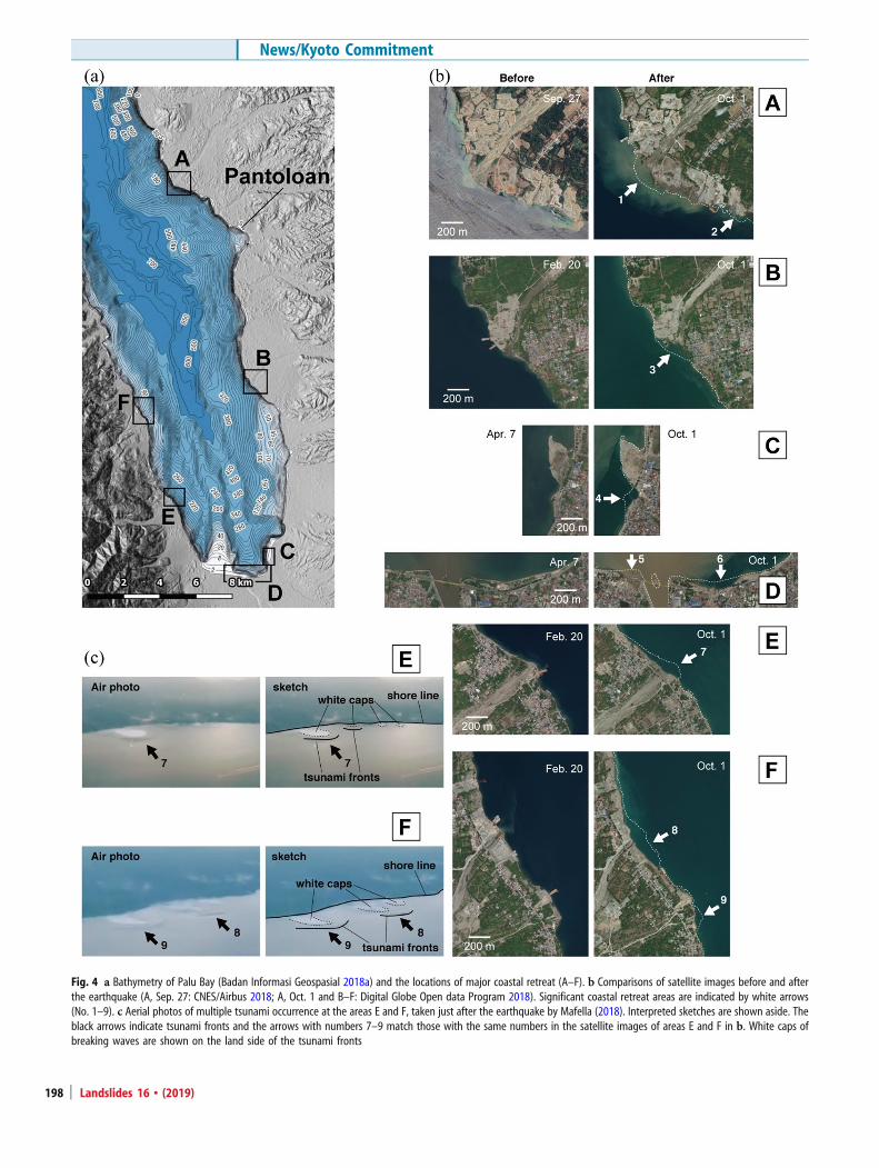
Fig. 4 a Bathymetry of Palu Bay (Badan Informasi Geospasial 2018a) and the locations of major coastal retreat (A–F). b Comparisons of satellite images before and afterthe earthquake (A, Sep. 27: CNES/Airbus 2018; A, Oct. 1 and B–F: Digital Globe Open data Program 2018). Significant coastal retreat areas are indicated by white arrows(No. 1–9). c Aerial photos of multiple tsunami occurrence at the areas E and F, taken just after the earthquake by Mafella (2018). Interpreted sketches are shown aside. Theblack arrows indicate tsunami fronts and the arrows with numbers 7–9 match those with the same numbers in the satellite images of areas E and F in b. White caps ofbreaking waves are shown on the land side of the tsunami fronts
News/Kyoto Commitment
Landslides 16 & (2019)198
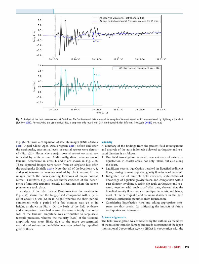
Fig. 4(a-c). From a comparison of satellite images (CNES/Airbus2018; Digital Globe Open Data Program 2018) before and afterthe earthquake, substantial levels of coastal retreat were detect-ed (Fig. 4(b)). Places where major coastal retreat occurred areindicated by white arrows. Additionally, direct observation oftsunami occurrence in areas E and F are shown in Fig. 4(c).These captured images were taken from an airplane just afterthe earthquake (Mafella 2018). Note that all of the locations 7, 8,and 9 of tsunami occurrence marked by black arrows in theimages match the corresponding locations of major coastalretreat. Therefore, Fig. 4(b), (c) shows evidence of the occur-rence of multiple tsunamis exactly at locations where the abovephenomena took place.
Analysis of the tidal data at Pantoloan (see the location inFig. 4(a)) shows that the long-period component with a peri-od of about 1 h was 0.7 m in height, whereas the short-periodcomponent with a period of a few minutes was 3.6 m inheight, as shown in Fig. 5. On the basis of the field evidenceand comparison described above, the results imply that only16% of the tsunami amplitude was attributable to large-scaletectonic processes, whereas the majority (84%) of the tsunamiamplitude was most likely due to the more concentratedcoastal and submarine landslides as characterized by liquefiedgravity flows.
SummaryA summary of the findings from the present field investigationsand analysis of the 2018 Indonesia Sulawesi earthquake and tsu-nami disasters is as follows.
& Our field investigation revealed new evidence of extensiveliquefaction in coastal areas, not only inland but also alongthe coast.
& Significant coastal liquefaction resulted in liquefied sedimentflows, causing tsunami: liquefied gravity flow-induced tsunami.
& Integrated use of multiple field evidence, state-of-the-artknowledge of liquefied gravity flows, and comparison with apast disaster involving a strike-slip fault earthquake and tsu-nami, together with analysis of tidal data, showed that theliquefied gravity flows induced multiple tsunamis, and hence,most of the earthquake and tsunami disasters in the 2018Sulawesi earthquake stemmed from liquefaction.
& Considering liquefaction risks and taking appropriate mea-sures are thus crucial for mitigating the impacts of futureearthquakes and tsunamis.
AcknowledgementsThe field investigation was conducted by the authors as membersof the mission team for damage and needs assessment of the JapanInternational Cooperation Agency (JICA) in cooperation with the
Fig. 5 Analysis of the tidal measurements at Pantoloan. The 1-min-interval data was used for analysis of tsunami signals which were obtained by digitizing a tide chart(Sudibyo 2018). For extracting the astronomical tide, a long-term tide record with 2–3 min interval (Badan Informasi Geospasial 2018b) was used
Landslides 16 & (2019) 199
Ministry of Land, Infrastructure, Transport and Tourism (MLIT),Japan. Both authors would like to thank JICA and MLIT for theirassistance and cooperation during the field work.
Funding information This work was supported in part by JSPSKAKENHI Grant Numbers JP15H02265 and JP15H04052.
Open Access This article is distributed under the terms of theCreative Commons Attribution 4.0 International License (http://creativecommons.org/licenses/by/4.0/), which permits unrestrict-ed use, distribution, and reproduction in any medium, providedyou give appropriate credit to the original author(s) and thesource, provide a link to the Creative Commons license, andindicate if changes were made.
References
Badan Informasi Geospasial (2018a) Contour map of Palu Bay, Retrieved from https://cloud.big.go.id. Accessed 30 Oct 2018
Badan Informasi Geospasial (2018b) Real time tidal observation, Retrieved from http://tides.big.go.id:8888/dash/. Accessed 30 Oct 2018
CNES/Airbus (2018) Satellite image of Labua, Sulawesi, Indonesia. Retrieved from http://www.earth.google.com. Accessed 30 Oct 2018
Digital Globe Open data Program (2018) Satellite images of Palu and Donggala,Sulawesi, Indonesia, Retrieved from https://www.digitalglobe.com/opendata/indone-sia-earthquake-tsunami/. Accessed 30 Oct 2018
Hornbach MJ, Braudy N, Briggs RW, Cormier MH, Davis MB, Diebold JB, Dieudonne N,Douilly R, Frohlich C, Gulick SPS, Johnson III HE, Mann P, McHugh C, Ryan-Mishkin K,Prentice CS, Seeber L, Sorlien CC, Steckler MS, Symithe SJ, Taylor FW, Templeton J(2010) High tsunami frequency as a result of combined strike-slip faulting and coastallandslides. Nat Geosci 3:783–788
International Research Institute of Disaster Science (2018) 2018 Sulawesi earthquake andtsunami, Retrieved from http://irides.tohoku.ac.jp/topics_disaster/2018sulawesi-eq.html. Accessed 30 Oct 2018
Mafella R (2018) Batik Air ID 6231 scheduled to depart at 17.55, door closed at 17.52then pushed back. 18.02 after cleared for take off, tower building collapsed.[Instagram Post], Retrieved from https://www.instagram.com/p/BoRttnsn5po/?tak-en-by=icoze_ricochet. Accessed 30 Oct 2018
Reuters (2018) Indonesia's quake-hit Sulawesi island from above, Retrieved from https://www.reuters.com/news/picture/indonesias-quake-hit-sulawesi-island-fro-idUSRTS23SN1. Accessed 30 Oct 2018
Reuters Graphics (2018) Destruct ion in Palu, Regrieved from https: //fingfx.thomsonreuters.com/gfx/rngs/INDONESIA-QUAKE/010080MZ19R/index.html.Accessed 30 Oct 2018
Sassa S, Sekiguchi H (2010) LIQSEDFLOW: role of two-phase physics in subaqueoussediment gravity flows. Soils Found 50(4):495–504
Sassa S, Sekiguchi H (2012) Dynamics of submarine liquefied sediment flows: theory,experiments and analysis of field behavior. Adv Nat Tech Hazards Res 31:405–416
Sudibyo M (2018) Wave record from the tidal station of the Pantoloan port, Palu city atthe time of tsunami event [twitter post], Retrieved from https://twitter.com/marufins/status/1047467798996242433. Accessed 30 Oct 2018
USGS (2018) Earthquake hazards program, Retrieved from https://earthquake.usgs.gov/earthquakes/search/. Accessed 30 Oct 2018
Valkaniotis S (2018) Displacement from #Sentinel2 @CopernicusEU image framesfor the whole length of the #Palu #earthquake sequence. [twitter post]Retrieved from https://twitter.com/SotisValkan/status/1047515941570007042.Accessed 30 Oct 2018
S. Sassa ()) : T. TakagawaPort and Airport Research Institute,National Institute of Maritime, Port and Aviation Technology,3-1-1 Nagase, Yokosuka, 239-0826, JapanEmail: [email protected]
News/Kyoto Commitment
Landslides 16 & (2019)200