linking european classifications of wildlife habitats and ... · 1 inspire-geospatial world forum,...
TRANSCRIPT

1 INSPIRE-Geospatial World Forum, 25-29 May 2015, Lisbon, Portugal
Linking European classifications of wildlife habitats and protected species to site
observations for ranking high conservation value areas: Towards a universal geospatial
model for ecological assessment:
Pierre Jorcin, Benjamin Allegrini, Olivier Peyre
Naturalia Environnement, site Agroparc, Le Moitessier, rue Lawrence Durrell, F-840911 Avignon, France.
[email protected], [email protected],
Abstract:
In ecological impact assessments, wildlife habitats sensibility is determined by experts, and is often difficult to
be demonstrated from an objective point of view. However, standardized methods are lacking for producing
spatial analyses compiling various ecological sensibilities on site. By linking the European protection
classifications to local parameters, the method described fills the gap in assessing sites conservation value at a
regional level. Thus, high conservation perimeters can be traced more precisely from an accurate delineation of
classified habitats. With field data, a geospatial model is applied to generate a unique index for each habitat unit.
The method merges qualitative and quantitative observations made over small landscape units and helps
evaluating ecological sensitivity. Using European sensitive species and habitats classifications, the geospatial
model can be applied to add value to any ecological assessment by putting in place standardized calculations
where the output can be easily verified and demonstrated.
Several European protected species categories and ranking is utilized to calculate indices for every listed taxon.
This index is then weighted based on parameters observed locally, such as species population density and habitat
quality, or level of environmental degradation. Species occurrences and associated taxa values are aggregated
together within a habitat. A synthesis is produced by calculating indices for distinct habitat patches for each
biological group. This quantitative evaluation method provides an efficient tool to draw information from field
data and European environmental indicators, to generate a scaled and comprehensive analysis. Flora, fauna, and
habitat conservation values can be assessed and compared on a similar basis for various places, highlighting
locations where a combination of species of interest is present in a suitable habitat.
Introduction
This paper presents an effective and replicable method for accurate mapping and ranking of
nature conservation concern areas. Usually methods focus on wild species occurrence
distribution maps, or produce an aggregation of observations at the level of an administrative
boundary. For high precision level studies, especially Environmental Impact Assessments
(EIA), the team developed a method giving more consideration to the wildlife habitats as
integrated landscape units. At such a scale, a precise evaluation of the conservation value is
critical for designing project plans and selecting site implementation, according to
biodiversity protection acts and legal constraints. The accuracy of the scoring system is
essential, and should be able to integrate every significant parameter to generate the
ecological concern classification.
A high conservation value area is usually defined by the presence of protected species, using
ranks according to the species inner and global conservation value. Wildlife observations are
spatially linked to comprehensive landscape units of similar patterns, according to the
European Nature Information System (EUNIS) and the Corine Biotope coding systems.

2 INSPIRE-Geospatial World Forum, 25-29 May 2015, Lisbon, Portugal
However, standardized methods are lacking for producing spatial analyses compiling various
ecological sensibilities on site.
Several European protected species categories and ranking is utilized to calculate indices for
every listed taxon. This index is then weighted based on parameters observed locally, such as
species population density and habitat quality, or level of environmental degradation. Species
occurrences and associated taxa values are aggregated together within a habitat. A synthesis is
produced by calculating indices for distinct habitat patches for each biological group. This
quantitative evaluation method provides an efficient tool to draw information from field data
and European environmental indicators, to generate a scaled and comprehensive analysis.
Flora, fauna, and habitat conservation values can be assessed and compared on a similar basis
for various places, highlighting locations where a combination of species of interest is present
in a suitable habitat.
Objectives of the method and description of the ranking system
The method is focusing on building a link between the observed species and their territory, as
well as on finding solutions to compile data significantly within their habitats. The objective
is to produce a comprehensive synthesis of individual habitat units, taking in account all the
conservation concern parameters. This is done with a ranking methodology calibrated to the
source data, and applied through a complex aggregation process.
The methodology makes use of qualitative rank attribution through a multi-criteria notation
process. The system converts these qualitative ranks to quantitative indices to be computed as
numeric values using a calibrated formula. There are several levels of iterative notation
process. Each level corresponds to a level of data aggregation, from punctual field
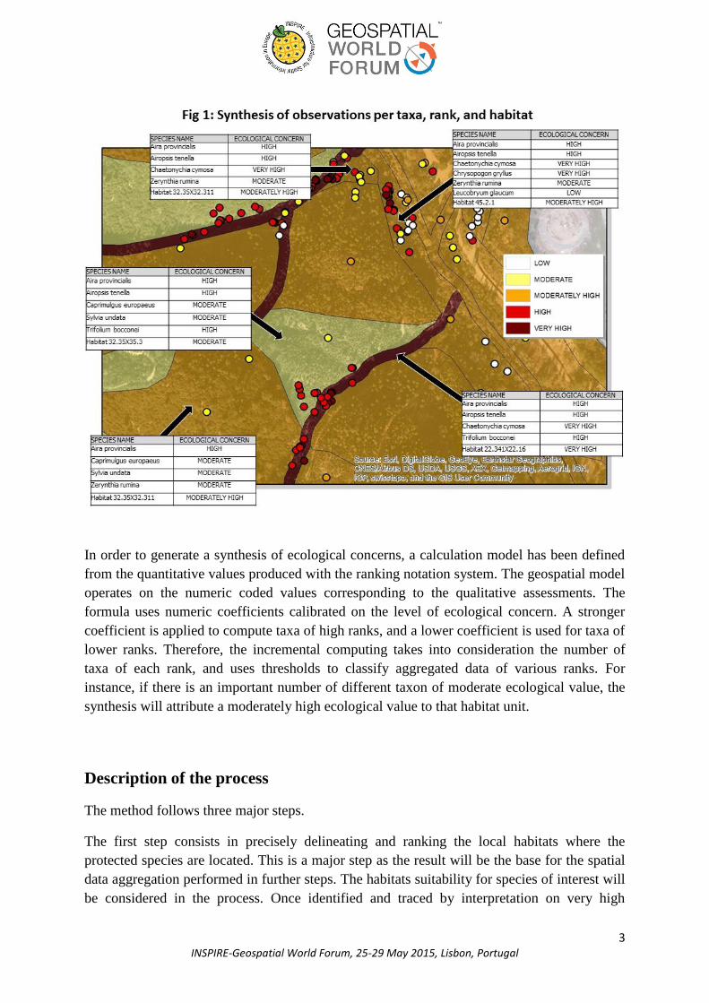
observations to a list of fauna and flora taxa in a classified habitat. Within a habitat, several
taxa of same or different rank are compiled together (Fig 1).
3 INSPIRE-Geospatial World Forum, 25-29 May 2015, Lisbon, Portugal
In order to generate a synthesis of ecological concerns, a calculation model has been defined
from the quantitative values produced with the ranking notation system. The geospatial model
operates on the numeric coded values corresponding to the qualitative assessments. The
formula uses numeric coefficients calibrated on the level of ecological concern. A stronger
coefficient is applied to compute taxa of high ranks, and a lower coefficient is used for taxa of
lower ranks. Therefore, the incremental computing takes into consideration the number of
taxa of each rank, and uses thresholds to classify aggregated data of various ranks. For
instance, if there is an important number of different taxon of moderate ecological value, the
synthesis will attribute a moderately high ecological value to that habitat unit.
Description of the process
The method follows three major steps.
The first step consists in precisely delineating and ranking the local habitats where the
protected species are located. This is a major step as the result will be the base for the spatial
data aggregation performed in further steps. The habitats suitability for species of interest will
be considered in the process. Once identified and traced by interpretation on very high

4 INSPIRE-Geospatial World Forum, 25-29 May 2015, Lisbon, Portugal
resolution satellite imagery, the habitats are named and defined according to the European
Nature Information System (EUNIS) referential. The effort made on habitat typology
standardization is a key feature in the process. This will allow a better traceability on the
results. According to the EUNIS typology, habitats are noted on their intrinsic ecological
value. This intrinsic value note combines notes on frequency in the region, regional
responsibility, and extinction threat level. The result is further calibrated by weighting this
value according to local parameters observed on site, such as the habitat authenticity, and its
current conservation status.
The second step looks at the species observations to evaluate their level of ecological concern.
As for habitat ranking, the species ranking is based on standard references, using official red
lists available from the International Union for Conservation of Nature (UICN) and the
French Natural Heritage National Inventory (INPN). The notation parameters included are the
species rarity, the regional responsibility and its vulnerability. The level defined from this
notation is then weighted according to population and functional factors observed on site. For
instance, a prolific population will give a higher note than a reduced population. At the
contrary, an unusual presence in a particular habitat will result in a lower note than a presence
in a typical habitat with standard functional ecology. Fauna and Flora taxa are evaluated
separately with specific weighting criteria.
The third step corresponds to the core process. At this stage, we run the geospatial model to
generate a compiled synthesis of ecological concern par habitat unit. The model has been
designed in the form of a geospatial script written in Python coding language. The script
applies iterative transformations on input variables from the features attributes and their
spatial parameters, e.g. the occurrence of species of interest within habitat units (Fig 2).
Indices are calculated according to the weighting criteria, the ranking coefficients,and the
aggregation formula. The result generates thematic layers in the Geographical Information
System (GIS) for habitat, flora, and for all biological groups of fauna. Finally, the highest
rank of each group determines the rank applied to the global ecological value of the parcel
(Fig 3).

5 INSPIRE-Geospatial World Forum, 25-29 May 2015, Lisbon, Portugal

6 INSPIRE-Geospatial World Forum, 25-29 May 2015, Lisbon, Portugal
The wildlife habitats are classified in five classes, and a map is produced showing an
ecological concern ranking from low to moderate, moderately high, high, and very high.
Additionally, the model includes an option to generate a sensibility index according to a
project potential impact on the landscape. This index describes the level of ecological
sensibility to a specific impact, such as a road, highway, new housing settlement, or any
development project. The approach is similar to the calculation of the ecological concern
value, where a sensibility value is attributed to the wildlife habitats and species according to
taxa resilience capacity and related characteristics. A risk factor is then applied according to
the type of project (Fig 4).

7 INSPIRE-Geospatial World Forum, 25-29 May 2015, Lisbon, Portugal
Conclusion
Overall, the process follows a standardization approach in order to be applied consistently
when used by different people, as well as facilitate a balanced comparison of ecological
concern among different territories. Traceability of the results was one of the key requirements to
design the model. The standardization is strengthened by the notation system based on official
referential such as the EUNIS codes, and the IUCN and INPN red lists. The method described
in this paper is aimed to build an automated geospatial application that operates with field
observations inputs, and generates a thematic map layer representing the ecological concern at
the scale of small landscape units.

8 INSPIRE-Geospatial World Forum, 25-29 May 2015, Lisbon, Portugal
The method elaborates a mathematical model for spatial and thematic data aggregation,
following computation rules corresponding to the underlying scientific concepts in ecological
concern evaluation. The complexity of the model relies mostly on selecting the computing
factors and calibrating the coefficients. An iterative process of data enrichment is
implemented, and is supported by setting up a dynamic relation between qualitative and
quantitative values. The model provides an effective solution to integrate ecological ranking
system into a GIS and mapping application.
Acknowledgement:
This article is extracted from an on-going research and development program undertaken by
Naturalia-Environnement. Special thanks to Eric Durand and Caroline Ta-Truong for their
scientific guidance on biodiversity studies and environmental assessment.
References:
AUGEL J.C., PREY T., DUHAMEL F., CORNIER, T., 2009. Hiérarchisation des enjeux de conservation des
habitats et des espèces végétales de la directive habitat/flore/faune dans la région Picardie. Centre régional de
phytosociologie/ conservatoire botanique de Bailleul, Direction régionale de l’environnement, de l’aménagement
et du logement.
AVERY M.,WINGFIELD GIBBONS D., PORTER R., TEW T., TUCKER G., WILLIAMS G., 2008, Revising
the British Red Data List for birds: the biological basis of U.K. conservation priorities, Ibis 137:232-239.
DE GRAMMONT P.C., CUARON A.D. 2006, An Evaluation of Threatened Species Categorization Systems
Used on the American Continent. Conservation Biology 20:14-27.
GOMEZ L., HAESEVOETS S., KUIJPERS B., Alejandro A. VAISMAN A.A., 2008. Spatial Aggregation: Data
Model and Implementation, Journal information systems vol 34 : issue 6 september 2006. P551-576
IUCN 2001 IUCN Red List Categories and Criteria version 3.1, Gland, Switzerland –Cambridge, United
Kingdom
KELLER,V., and BOLLMANN K. 2004. From red list to species of conservation concern. Conservation biology
18:1636-1644
ROLLAND-MAY C., 1996. Régionalisation d'espaces géographiques imprécis et incertains définis par des
variables qualitatives. Revue Géographique de l’Est tome 36, n°3-4 pp 213-241

9 INSPIRE-Geospatial World Forum, 25-29 May 2015, Lisbon, Portugal
Biography:
Paper Reference No.: PN 282
Title of the paper : Linking European classifications of wildlife habitats and protected
species to site observations for ranking high conservation value areas: Towards a
universal geospatial model for ecological assessment:
Name of the Presenter : Pierre Jorcin
Author (s) Affiliation : Naturalia Environnement
Mailing Address : Naturalia Environnement, site Agroparc, Le Moitessier, rue
Lawrence Durrell, F-840911 Avignon, France.
Email Address : [email protected]
Telephone number (s) : 04.90.84.17.95
Fax number (s) :
Brief Brief Biography (100 words): Geographer specialised in GIS and remote
sensing, Pierre Jorcin is expert in mapping methodologies, geostatistics, and multi
criteria analyses. He has been involved in setting up geospatial components for natural
resource management, environmental studies, and development programs policies. He
has worked on urban and rural development, watershed management, hydrogeological
research and Location Based Services in South Asia and South East Asia for 12 years.
He was involved in producing modeling applications and Atlas for UNESCO, Wildlife
Conservation Society, and Bing Maps. He is currently working on building GIS
services for ecological impact assessments in South of France.