linking conservation and land use planning: using the state
TRANSCRIPT

LINKING CONSERVATION AND LAND USE PLANNING: Using the State Wildlife Action Plans to Protect Wildlife
From Urbanization
This report was supported by The Doris Duke Charitable Foundation
and Surdna Foundation

ABOUT DEFENDERS OF WILDLIFE Defenders of Wildlife is a national, nonprofit membership organization dedicated to the protection of all native wild animals and plants in their natural communities.
This report was made possible with the generous support of The Doris Duke Charitable Foundation and Surdna Foundation.
AUTHORS Julia Michalak, Defenders of Wildlife Jeff Lerner, Defenders of Wildlife
PRODUCTION Kassandra Kelly, Defenders of Wildlife Allison Barra Srinivas, Defenders of Wildlife
© 2007 Defenders of Wildlife 1130 17th Street NW
Washington D.C. 20036 202.682.9400
http://www.defenders.org
COVER PHOTOGRAPHS • Courtesy of Natural Resources
Conservation Service (NRCS) • Courtesy of U.S. Fish and Wildlife
Service • Julia Michalak

Linking Conservation and Land Use Planning:
Using the State Wildlife Action Plans to Protect Wildlife From Urbanization
DEFENDERS OF WILDLIFE Washington D.C. ● April 2007


TABLE OF CONTENTS Executive Summary........................................................................................................1 Habitat and Sprawl........................................................................................................ 4
Why link conservation and land use planning?............................................................................5 How can the State Wildlife Action Plans help? .......................................................................... 5
How do the State Wildlife Action Plans address land use planning?........................... 7
Threat Summary.............................................................................................................................. 7 Underlying mechanisms linking development and species decline.......................................10 Development patterns that negatively impact wildlife…………………………..............11 Actions Summary.............................................................................................................................13 Mapping and Spatial Data............................................................................................................15
Linking Land Use and Conservation.............................................................................17
Land Use Planning Tools................................................................................................................17 The Comprehensive Plan...............................................................................................................18 Developing Model Ordinances....................................................................................................22
Zoning.......................................................................................................................................23 Subdivision and Land Development Regulations...............................................................24 Transferable Development Rights (TDR)...........................................................................26
The Permit Review Process........................................................................................................27 Capital Improvements Programs (CIP)....................................................................................29 Transportation Planning.............................................................................................................29
Partners in the Land Use Planning Community..........................................................................30 The Planning Commission/Board............................................................................................31 The Planners.................................................................................................................................32 Elected Officials...........................................................................................................................32
Coordinating across jurisdictions...................................................................................................32 State Planning Office...................................................................................................................33 Regional Councils.........................................................................................................................33 Transportation planners and Metropolitan Planning Organizations (MPOs)....................33
Recommendations for Starting a Sustainable Planning Program.................................34 Approach Land use Planning Strategically....................................................................................34 Provide Meaningful Technical Assistance.....................................................................................36 Target Education Strategically.........................................................................................................40 Increase Capacity...............................................................................................................................41 Conclusions………………………………………….………………...………………….43 Literature Cited Appendix A— Current Research Addressing Conservation and Land Use Planning Appendix B— Annotated Bibliography of Relevant Land Use Planning Resources

1
R esearchers widely recognize habitat loss as one of the most significant causes of
species imperilment in the United States (Wilcove et al. 1998). In recent years, researchers, government agencies and land use planners have become increasingly concerned about the impacts of urbanization and residential and commercial development on biodiversity (Brown and Laband 2006, USDA, Forest Service 2006, Ewing et al. 2005, Radeloff et al. 2005, Doyle et al. 2001, Abbitt et al. 2000, Babbitt 1999). As humans convert more land from rural and undeveloped uses to residential and commercial developments, so called urban-adaptive species thrive while urban sensitive species, which tend to be of greater conservation concern, decline (Donnelly and Marzluff 2004, Germaine et al. 1998, Germaine and Wakeling 2001, Delis et al. 1996). In response to these trends, numerous authors have called for increased coordination between land use planners and ecologists (Theobald et al. 2005, Broberg 2003, Beatley 2000, Dale et al. 2000, Babbitt 1999). Careful land use planning can reduce the impacts of development on wildlife. Conservation plans can play a critical role by gathering and synthesizing relevant biological information that can help inform land use policy decisions. As of October 2005, every state wildlife agency, in conjunction with numerous partners, completed a State Wildlife Action Plan (Action Plans or Plans). Congress required the State Wildlife Agencies to create these plans using extensive public input and the best available current science. As a result, the Plans are the best current compilation of conservation information for each state and, viewed together, can provide valuable insight into conservation trends and needs nationwide.
These Plans can be particularly useful in the context of land use planning as they can provide information about declining species, key habitats, conservation threats and actions to prevent further species decline. Perhaps more importantly, the Plans can provide a platform for creating long lasting partnerships between state biologists and land use planners and for devising a long-term strategy for addressing development impacts. We reviewed the State Plans to determine 1) to what extent they identify development as an issue for wildlife and 2) to understand how the Plans can improve the land use planning process for wildlife. We searched the Plans from all 50 states and the District of Columbia for references to development, urban/suburban growth, sprawl, and land use planning/planners. We then coded each reference into a series of threat and action categories and identified the resulting themes across all Plans. We found that the Plans clearly support concerns voiced in the conservation literature that identify development as a significant, and in many states a top priority, threat. All 51 plans presented development (whether urban, suburban, exurban, residential or commercial) as a concern for wildlife conservation. Eight states indicated that development was the greatest threat to wildlife statewide; seventeen states indicated that development was a top priority threat to specific regions or habitats; and twelve states emphasized development as a significant issue. These findings indicate that 37 states (73%) consider development an important issue affecting wildlife either regionally or statewide.
EXECUTIVE SUMMARY

2
Collectively, the Plans further defined underlying mechanisms that link development and species imperilment. These mechanisms coincide with those identified by Doyle and colleagues (2000) in California and by Hansen and colleagues (2005) including: habitat loss/degradation, habitat fragmentation, altered hydrologic regimes, increased pollution, increased invasive species, increased mesopredators (including native and non-native), increased road density and impacts, direct mortality, noise/light pollution, increased wildlife-human conflict and increased human use of the area (primarily through recreation). Many states voiced concerns over particular development trends. More than half the Action Plans (28) indicated that a lack of land use planning and increasingly prevalent low density development patterns (frequently referred to as sprawl) exacerbate the habitat loss and fragmentation resulting from development. Almost half the states (22) expressed concern about rural and/or second home/vacation development. Rural development patterns have the potential to impact biodiversity patterns and degrade existing protected areas severely (USDA, Forest Service 2006, Hansen et al. 2005). We searched for actions tied directly to development issues and found that all the plans recognized that land use planning is a valuable conservation tool. This finding is significant because state wildlife agencies are not traditionally involved in land use decision-making. Although some agency biologists may
review permits or advise on a particular development projects, few state wildlife agencies currently have an established system for working with land use planners. Collectively, the states presented a wide range of actions covering the spectrum from education and incentive based programs to making changes in land use law and policy (see Table 2 on page 13 for more detail). We identified the following eleven general categories based on the actions references: coordination with land use planners, regulations, landscape level planning, education, site development design, incentives programs, restoration, mitigation, monitoring, research and capacity building. Within each of these categories, the states included a diverse array of actions which we coded into action “themes.” Some of the most common themes across the plans were: Support integration of conservation and land use planning; Increase coordination/communication with land use planners and local decision makers; Provide information, data, support or technical assistance to local planners; Participate in the planning process (through project planning or review); Apply land use planning tools such as zoning, transferable development rights, conservation overlays, and “conservation” subdivision regulations to protect habitat and species. By viewing the collected actions from all plans, we were able to identify a number of points of intervention where State Wildlife Agencies and other conservationists can help make the land use planning process more ecologically sustainable. These include: 1) integrating conservation priorities into comprehensive or master land use plans; 2) developing model land use ordinance language for zoning regulations, site level development designs and transferable development rights programs; 3) participating in

3
the permit review process; 4) coordinating residential and commercial development with existing infrastructure capacity; and 5) coordinating with land use decision-makers within and across jurisdictional boundaries. Overall, the Plans clearly demonstrate that development threatens wildlife and that land use planning is a necessary tool to abate that threat. However, we found that very few states presented a clear and coherent strategy for addressing development threats, even if development was a high priority. We found that viewing the plans collectively yielded a far more comprehensive treatment of this issue. By producing this report, we hope to provide states with additional ideas, which were themselves generated by other states, about how to address development impacts and work productively with land use planners. Based on the findings from this report, we have developed a set of implementation recommendations for wildlife agencies interested in initiating a comprehensive program to address development threats and work with land use planners. These include: Address Land Use Planning Strategically: Given the patchwork nature of land use planning in the U.S., wildlife agencies will not be able to work closely with all local jurisdictions in the state. To narrow down the options and gain insight into the scope of development threats, agencies can overlay maps of priority conservation areas with projected future development patterns for the next 50 and 100 years. This exercise will identify both the
most biologically important and threatened areas of the state or region. Use this information to develop strategic relationships with land use planners and begin creating more detailed regional conservation plans that can intersect directly with county and city level comprehensive or master plans. Provide Meaningful Technical Assistance: Provide meaningful technical assistance to land use planners by providing them with maps and data, interpreting those data and working cooperatively and consistently with planners at multiple levels in the land use planning process. Target Education Strategically: Target education strategically to elected officials, planning commissions and land use planners. Focus efforts in areas with high conservation potential and development risks. Build Capacity: In order to address this challenging issue, wildlife agencies will need to devote resources and staff time to land use policy. The state wildlife grants funding can provide some money for working on land use planning issues, but it will not be enough. States will need to seek out additional creative funding sources to fully meet their needs. Some wildlife agencies may have to review their current organizational structure and shift staff from research and inventory to more proactive work on land use planning.
The State Wildlife Action Plans are officially known as Comprehensive Wildlife Conservation Strategies (CWCS). Several states have chosen unique names such as Florida’s Wildlife Legacy Initiative and Nebraska’s Wildlife Legacy Project. This report refers to all the plans as State Wildlife Action Plans (SWAPs) or simply as “Action Plans” or “State Plans.”

4
T he rapid growth and expansion of residential and commercial development in
the United States has attracted significant attention in the last few decades. People are increasingly concentrated in urban areas, but at the same time more dispersed within those areas (Anderson et al. 1996). These low-density development patterns have been linked to numerous environmental and social problems including: obesity (Ewing et al. 2003); increased traffic congestion, pollution and car accidents (Ewing et al. 2002); reduced water quality (Otto et al. 2002); and loss of resource lands (1000 Friends of Oregon 2005). Sprawling development also has alarming implications for wildlife and endangered species (Ewing et al. 2005). Habitat degradation and fragmentation is among the most significant causes of species imperilment in the United States (Wilcove et al. 1998), and habitat loss due to development has emerged as a prominent issue among conservation practitioners (Brown and Laband 2006, Ewing et al. 2005, Radeloff et al. 2005, Doyle et al. 2001, Abbitt et al. 2000, Babbitt 1999). Development has both direct impacts on wildlife through habitat loss and fragmentation and indirect impacts including spreading invasive species, increasing road density, increasing recreation activity, altering hydrologic regimes, increasing pollution, wildfire suppression, noise pollution and increasing urban and edge predators such as raccoons and cats (Doyle et al. 2001). Sprawl and development have traditionally been associated with large metropolitan areas.
However, recently, “rural sprawl” has become a concern as people migrate out of the cities seeking second homes, peaceful retirement, or closer proximity to natural amenities (USDA, Forest Service 2006). From 1950 to 2000, exurbanized areas increased sevenfold in transitional metropolitan counties and nearly tenfold in counties adjacent to metropolitan areas (Brown et al. 2005). The nation lost 10.4 million acres of forestland to urban and developed areas between 1982 and 1997, with losses of 1 million acres a year during the last
five years in that period (Alig et al. 2003). In the Southeastern U.S., urban development is a now more significant cause of forestland loss than agricultural conversion (Alig et al. 2004). Recent research estimates that 44.2 million acres of private forestland could be converted to housing development by 2030 (Stein et al. 2005). In many regions of the U.S., land is being developed faster than the population is growing. Between 2000 and
2025, the U.S. population is expected to grow by 24 percent, while predicted land development is expected to grow a disproportionate 79 percent (USDA, Forest Service 2006). While these projections are alarming, they also reveal that uncontrolled growth is not a foregone result of increasing population. Instead, the ways we choose to develop contribute significantly to this loss of resource land and open space. As a result, numerous authors have called for increased coordination between land use planners and ecologists (Theobald et al. 2005, Broberg 2003, Beatley 2000, Dale et al. 2000, Babbitt 1999).
HABITAT AND SPRAWL
Shifting from rural to urban From rural or exurban to urban – A total of 21.7 million acres across the
country are projected to shift from rural or exurban to urban by 2030.
Forty watersheds may have a shift from non-urban to urban use levels on 10-30% of their area
From rural to exurban – A total of 22.5 million acres across the
country are projected to shift from rural to exurban by 2030.
Twenty-seven watersheds contain forests projected to experience this shift on more than 10-20% of their area.
(Stein et al. 2005)

5
Integrating regional ecological information with state and local land use planning efforts can help the development process support conservation efforts, reduce loss of open space and increase the quality of life for both rural and urban residents. Using conservation plans to inform land use plans, and vice versa, is the critical nexus for achieving this integration.
Why link conservation and land use planning? In many ways, conservation planning and land use planning are complementary processes. Both use spatial data to identify priority places for various actions and project into the future to make decisions that affect the character of the landscape. Where development and conservation occur will have profound implications for residents, wildlife and a community’s overall quality of life. Communities across the U.S. have expressed their concerns over the loss of open space by approving open space ballot measures (Trust for Pubic Land, 2006). Coordinating conservation and development can minimize environmental impacts and help relieve conflicts and delays for developers. Just as comprehensive planning leads to better and “smarter” development patterns, it also helps coordinate conservation efforts. Given that not every patch of open space is priority habitat and land is expensive (Battisti and Gippoliti 2004), this coordination and planning is especially important near urban areas. By assessing the landscape as a whole to identify valuable wildlife habitat and sensitive landscape features, conservationists and planners can ensure that the efforts of multiple groups contribute to a unified, functional, conservation network.
Integrating land use and conservation planning strengthens both processes by considering the entire urban-rural-wildlands continuum at the same time. Conservation and development are two sides of the same process and both endeavors necessarily each lead to trade-offs with the other. Communities and stakeholders have the right to view available data and hold honest, transparent debates about land use decisions that will not only affect the welfare of present generations, but also of generations yet to come. Planning for growth and conservation in concert gives planners and landowners the time to find equitable and flexible solutions utilizing a wide range of tools. Communities will benefit by making these tough decisions voluntarily and proactively rather than under the restrictive requirements of the Endangered Species Act. “The United States generally lacks and desperately needs such organizing ecological frameworks to guide planning and policy, and to ensure that the conservation investments we make (at a number of levels) will in the end protect biodiversity… Developing (and officially adopting) statewide ecological networks or integrated, connected systems of habitat would do much to provide such an important ecological planning framework.” (Beatley 2000)
How can the State Wildlife Action Plans help? In 2005, all 50 states, the District of Columbia, and all the U.S. territories completed Comprehensive Wildlife Conservation Strategies. These plans, also known as State Wildlife Action Plans, are intended to direct conservation to proactively protect species before they require federal listing under the Endangered Species Act. They therefore contain information about priority species, habitats and places in each state that can help land use decision-makers reduce the harmful effects of developments on ecosystem function.
“It starts with smart planning, which is at the heart of this Plan’s strategies. When people are able to clearly see the connections between good wildlife management, clean air and water, sustainable economic growth, and our quality of life, wildlife habitat conservation actions will naturally be brought to the forefront of planning decisions.” (New Hampshire SWAP, Exec Summ, pp. xvi).

6
The Action Plans are important tools for linking conservation and land use planning. These plans are the best representation of statewide conservation issues and priorities currently available because they were created with extensive input from the public, stakeholders and local and regional experts. The statewide perspective of the plans will help multiple jurisdictions and conservation entities work towards common conservation goals. In addition, the newness of the Action Plans provides a unique opportunity to reach out to local planners and county commissioners while the findings revealed in the Action Plans can help local officials justify taking pro-active conservation action.
How the States describe the role of their Action Plan: Alaska: “A valuable result of Alaska’s CWCS could be not only to build basic knowledge about Alaksa’s wildlife resources, but also to increase technological capacity so that interested communities can access up-to-date wildlife and habitat databases for planning purposes. These would include important habitat areas needed by wildlife, including migratory species that rely on the sources of food, resting areas, and other resources that local habitats provide during their migratory movements” (pp. 113-114). Arkansas: “Looking into the future, the CWCS can be also used as practical context for Environmental Impact Statements, project reviews, and infrastructure and municipal development planning. This is especially important in Arkansas, a rural state with minimal planning or zoning laws” (Sec 1, pp. 2). New Mexico: “All signals indicate that county involvement in local wildlife conservation planning will increase over the CWCS planning period… CWCS is uniquely positioned to provide comprehensive wildlife planning and implementation services to county planning processes… It is also the intent and purview of CWCS to develop products and services that will assist local planning groups with the assessment, monitoring, and conservation of Species of Conservation Priority. The CWCS Implementation Team can develop the support services and products and conduit them into local planning processes through the field personnel of the CWCS partnership (NDOW, NNHP, The Nature Conservancy, Lahontan Audubon Society). Because there are other county planning processes that would also benefit from CWCS products and services (Quality of Life Plans, other open space and recreation plans, etc.), it is important that the CWCS Implementation Team build direct lines of communication to the various county planning departments” (pp. 288). Washington: “WDFW and its conservation partners will use the CWCS, ecoregional assessments and other plans and assessments on which they are based to raise public awareness and gain support for conservation measures necessary to sustain fish and wildlife populations, habitat and biodiversity. Ecoregional assessments and other data sources will be used to develop county-level habitat assessments and other tools to better inform public and private landowners, and to help local decision makers and planners administer the Growth Management Act and other local conservation programs” (Sec 1, pp. 4).
One of the Association of Fish and Wildlife Agencies guiding principles for the Action Plans: “Make the Plan-Strategy a driving force in guiding activities under diverse wildlife and habitat conservation initiatives, and usable for helping to inform land-use decision-making.”

7
The Action Plans are part of the Federal State & Tribal Wildlife Grants program. As such, Congress required the states to include information in the plans about wildlife and habitats, much of which will be useful for land use planners. The plans identify species of greatest conservation need, priority habitats, conservation threats, and actions to address those threats. Many of the plans presented this information spatially and 25 states included maps of priority conservation areas. These conservation plans do not supplant existing land use plans, but rather can help land use planners by: 1) Emphasizing the significance of
development as a threat to wildlife; 2) Identifying planning and policy tools that
can help protect habitat; 3) Helping local governments prioritize species
and habitats for protection; and 4) Mapping priority conservation areas. We searched the Plans from all 50 states and the District of Columbia for references to development, land use planning and sprawl. We then coded each passage for threat and action themes and consolidated the codes into
broad categories. We only used threats and actions that were clearly linked in the text with development. For example, although virtually all the plans included acquisition as a general conservation action, it was only included in this analysis if it was clearly proposed in response to development as a threat.
Threat Summary The State Plans confirm and, for many states, underscore assertions from the conservation community that development patterns have negative impacts on wildlife and are a prominent cause of habitat loss in the United States. We found that all 51 plans presented development (whether urban, suburban, exurban, residential or commercial) as a concern for wildlife conservation. Eight states indicated that development was the greatest threat to wildlife statewide; seventeen states indicated that development was a top priority threat to specific regions or habitats; and twelve states emphasized development as a significant issue. These findings indicate that 37 states (73%) consider development an important issue affecting wildlife either regionally or statewide (see Map 1).
HOW DO THE STATE WILDLIFE ACTION PLANS ADDRESS LAND USE PLANNING?

8
Eight states identified development as the greatest threat to wildlife:
Alabama: “There was clear consensus that the primary threat to species of GCN statewide is the historic and ongoing loss and degradation of wildlife habitat, largely due to development pressures related to Alabama's increasing human population” (Chapter 3, pp. 43) Delaware: “Residential and commercial development pressure is probably the most significant issue facing wildlife habitats in Delaware” (Determining conservation issues and actions, pp 5-3). Florida: "The Strategy identifies habitat loss and fragmentation as one of the most pervasive threats to Florida’s wildlife, reaching across habitats statewide. This threat primarily comes from residential, commercial and industrial development and is directly related to a subsequent array of threats from infrastructure or actions of Florida’s residents (e.g., roads, surface water diversion and withdrawal, residential activities, and nutrient loads)” (Strategic Vision pp. 43). Maryland: “There is clear consensus that the loss and degradation of habitats across the state from Maryland’s development and growing economy (including unplanned growth in population and consumption) remains the primary overarching threat to species of greatest conservation need (GCN) as is true nationwide (Trauger et al. 2003)" (Ch 1, pp. 2). Massachusetts: "This direct loss of habitat due to development, combined with the effects of habitat fragmentation due to increased transportation infrastructure, has created a threat to wildlife not seen since the early days of the 19th century when the state was largely deforested…By far the greatest contributor to the loss of species and habitat diversity in Massachusetts has been the destruction and fragmentation of habitat by residential, commercial, and industrial development” (pp.11).
Indiana: “Habitat degradation and urban sprawl were the top two reported threats to habitat” (pp. 4). "The top ranking threats of habitat degradation, commercial or residential development (sprawl), agricultural or forestry practices, habitat fragmentation, and counterproductive financial incentives or regulations are all inter-related and affected by land use policies (Table 5)" (pp. 54). New Hampshire: “Rapid urban development in many parts of the state was identified as the most potent risk to our wildlife, devastating the health of many terrestrial, wetland, and aquatic populations and irreversibly fragmenting their habitats” (Exec Summ, pp. x). Pennsylvania: "Habitat is the key to animal abundance. Habitat loss, caused by development and sprawl, as well as direct and indirect habitat degradation are the primary causes of species declines in Pennsylvania and worldwide (Ehrlich and Ehrlich 1981, Ehrlich and Wilson 1991, Noss et al.1995)" (Part 2A, 11.3 Habitat Loss: the statewide threat to fish and wildlife).
Encouragingly, many states discussed development threats candidly, despite some concerns about alienating stakeholders. It was not surprising that all coastal states at least emphasized the significance of development threats. Initially, it is not surprising that Interior Western and Upper Midwestern states did not prioritize development as a threat, as these states have historically low population densities. However, four states (KS, KY, MN, and MO)
each contain one of 35 of the fastest growing metropolitan areas in the country (Ewing et al. 2005), yet did not prioritize development as a threat to wildlife even within those regions. Ironically, the majority of research documenting development impacts on wildlife has occurred in Colorado (see Appendix A), which did not prioritize or emphasize development as a threat in their State Wildlife Action Plan.

9
Average population density appears to be loosely correlated with concern about development in each state (see Figure 1). The states that did not emphasis development as a threat all have very low population densities (less than 110 persons per mile squared) except Connecticut. In contrast, population growth rates (at least between 2000 and 2005) did not correlate well with development threat prioritization. Many states did not use a formal threats analysis or explicitly prioritize threats at all, making a more detailed assessment of the extent of this threat difficult. For several states, public meetings and surveys revealed that their constituents feel very strongly that development has significant negative impacts on wildlife and that better land use policies are needed to protect wildlife and their habitat.
Public concern about sprawl and rapid development: Virginia: “The decline and fragmentation of habitat emerged as an area of concern in all input sessions. This issue was consistently ranked as one of the highest priority concerns across the sessions (Table 3.25). Loss of habitat due to commercial, residential and roadway development was repeatedly mentioned. Lack of land use controls and development sprawl are viewed as major contributing factors to the increased fragmentation of existing habitats and wildlife corridors” (Sec 3.4.3, pp. 3-42). West Virginia: “West Virginians contacted for a 2005 public opinion survey saw habitat loss from development as the most important issue confronting rare, threatened and endangered species. Perhaps they are attuned to the fact that there are major regional exceptions to the statewide pattern” (pp. 41). South Dakota: Highlights of the September Town Meetings: Citizen Input into the South Dakota Comprehensive Wildlife Conservation Plan “Animal and habitat issues were centered on development, urban sprawl, overgrazing, and drought…Attendee’s advice was to: focus on specific or critical habitat and wildlife species relationships, build and enforce long term housing development plans to protect habitat and environment, to make agriculture a priority, and to control wildlife at a manageable level” (pp. 348).
Figure 1: This figure shows the average population density (Calculated using 2005 U.S. Census Bureau popula-tion data and land area from U.S. Census Bureau, 2004) grouped by emphasis on development as a threat to wildlife.
Average Population Density (2005) of States Grouped by Development Threat Em phasis
0200400600
800100012001400
0 1 2 3 4 5
Development Threat Emphasis
Ave
rage
Pop
ulat
ion
Den
sity
(per
sons
per
mi
sq.)
Top ThreatStatewideTop Threat toRegion/HabitatStrongEmphasisIncluded asThreat

10
Category (Number of Plans)
Category Description
Habitat loss or degradation (51)
Development either directly replaces natural habitat or indirectly degrades habitat quality.
Habitat Fragmentation (44)
These Plans noted that development can fragment large blocks of habitat, thereby increasing the edge to interior ratio and creating effects beyond the development’s immediate footprint. In addition, some noted that development leads to increased roads, utility lines, etc that further fragment habitats.
Altered Hydrologic Regime (42)
The Plans noted that increased impervious surfaces cause flash flooding leading to stream bank erosion. Impervious surfaces block ground water recharge and preclude filtration of pollutants and sediment from run-off.
Increased Pollution (40)
Plans in this category included pollution either from point or non-point sources. Specific concerns included run-off from roads and pavement, increased nutrient levels, sedimentation, and temperature pollution.
Increased Invasive Species (25)
These Plans connected development with the spread invasive species through road construction, planting non-native species, increased fragmentation, releasing/allowing pets outdoors or clearing native vegetation for building construction thereby providing a clean slate for colonization.
Increased Mesopredators (21)
Mesopredators include both native species such as raccoons, foxes and coyotes and non-native species like cats and dogs. The Plans connected development to the introduction of the non-native predators or driving larger top predators, like wolves and mountain lions, away resulting in an upsurge of mid-level predators. Many plans argued that these species pose a significant risk as nest and egg predators while also depressing populations of small prey items.
Increased Road Impacts (21)
These Plans noted that housing and commercial development can lead to more road construction and higher traffic levels. All of the plans noted that roads have negative impacts on wildlife and many also stated that roads can in turn lead to greater development. Trombulak and Frissell (2000) have identified the following impacts of roads on wildlife: mortality from road construction or direct collisions, modification of animal behavior, alteration of the physical environment, alteration of the chemical environment, spread of exotic species and increased human use of an area.
Table continued on next page
Table 1: Development Threat Categories
Underlying mechanisms linking development and species decline Doyle and colleagues (2000) developed a set of direct and indirect impacts of development on species based on research in California. Hansen and colleagues (2005) identified similar mechanistic links between development and biodiversity in their review of relevant primary literature on exurban development. We determined the frequency that these impacts were cited in the Action Plans (see Table 1).

11
Direct Mortality (10)
The Plans noted increased mortality either from an increase in roads and traffic leading to more vehicle collisions, poisoning from pesticides or ornamental plants, bird collisions with buildings, and development construction.
Noise/Light Pollution (7)
Several Plans determined that development leads to increased noise and/or light pollution, particularly detrimental to certain species including sea turtle hatchlings, moth species, and sensitive nesting songbirds.
Increased Wildlife-Human Conflict (6)
Six Plans noted that as development increases and spreads into previously undeveloped wildlife habitat, conflicts between humans and wildlife increase. Specific examples include increased crop damage, higher numbers of “nuisance” species such as white-tailed deer, and property destruction in gardens, ponds and golf courses. Ohio also noted that increased development leads to a greater number of injured and orphaned wildlife.
Increased Human Use of Area (6)
Six Plans expressed concern that development can lead to increased human use of a particular area, generally through increased recreation. Specific examples from these plans include increased use by off-road vehicles, mountain bikes, hikers, rock climbers, and spelunkers. These recreation activities can lead to trampling of native vegetation, soil compaction, and nest disturbance.
Altered Fire Regime (13)
The Plans indicated that development can increase the number of human-caused fires and/or limit habitat manager’s ability to use prescribed burning to maintain fire-dependent habitats. Homeowners are concerned about damage to private property and increase air pollution from smoke. Fire suppression in many areas can lead to increased forest density resulting in more damaging and uncontrollable wildfires.
Category (Number of Plans)
Category Description
Development patterns that negatively impact wildlife Many states emphasized that changing development and demographic patterns were resulting in disproportionate impacts to wildlife relative to the level of population growth in the state. Twenty-eight states specified that a lack of adequate land use planning, otherwise termed “sprawl,” amplifies the impacts from residential and commercial development. Many states quoted statistics demonstrating that land consumption is increasing at a significantly higher rate than population growth.
Illinois: “Development with a larger “footprint” reduces, degrades and fragments more wildlife habitat. Infrastructure further fragments habitat and poses collision hazards for wildlife. “Exurban” development, scattered single-family homes on large lots removed from municipalities, fragment larger tracts of forest and other habitat, and futher parcelize ownership that complicates conservation actions and the ability of others to acquire permission to access private lands and waters for recreation. Managing nuisance wildlife in low-density development areas is complex” (Sec 3, pp. 89-91).
Photo Courtesy of NRCS
Table 1: Development Threat Categories (cont.)

12
References to Sprawl: Alaska: “Over 75% of recent growth in the state’s population has been in the Municipality of Anchorage and the Matanuska-Susitna Borough. Growth in these areas is expected to outpace population growth anywhere else in the state, with these two population centers eventually merging into a “Greater Anchorage” area (Goldsmith 2004). Implementing measures to reduce the effects of sprawl (e.g., zoning that promotes “node,” or “core area,” development) is critical to maintaining diverse populations of fish and wildlife over the long term” (pp. 102). California: “Land-use planning and zoning laws have allowed sprawling development, including residential projects that are located far from existing urban centers, requiring new roads and infrastructure, and communities designed with large lot sizes and little or no preserved open space. Presently, the region’s remaining rural areas and natural lands are highly threatened by zoning for 4- to 8-acre lots for rural ranchette-style development” (pp. 171-172). Kentucky: “Increasing human populations, uncontrolled urban sprawl, invasive exotics, pollution, and disease continue to take their toll on the wildlife resources of the Commonwealth and throughout the nation. Today in Kentucky, we lose more than 47,000 acres per year to development alone. A lack of planning by professionals on how to conserve the special places and the special creatures under our protection will continue to result in a loss of species diversity” (Foreword). Maine: “In a 2001 report, The Brookings Institute found that sprawl – the conversion of rural lands for urban or suburban purposes – in the greater Portland area is occurring at one of the fastest rates in the country (Fulton et al. 2001). From 1982-1997, the population of the greater Portland metropolitan region grew 17.4% with a 108.4% increase in urbanized land” (Ch 2, pp. 4-5).
Twenty-two states specified concern over “rural” and/or vacation home development (“ranchette” development was included in this group). Some of these states noted that rural development was particularly troublesome because rural communities may not feel pressure to plan for increased growth or feel dependent on growth to increase their tax base. In addition, small communities may not have land use policies to address rapid development and frequently do not have the staff or capacity to develop such policies. These observations are especially troubling since rural jurisdictions have the most flexibility in choosing both development and conservation sites and therefore are in the best position to plan for sustainable development. Many communities realize the need for comprehensive planning
only after development has reached a crisis point, at which point conservation options are limited. Second or vacation home developments were also a concern. These generally occur near desirable natural amenities, such as lakes, rivers, beach front or public lands, which tend to be particularly sensitive to development impacts as well as to provide important habitat for many species. The concern with rural development voiced in the Action Plans closely mirrors recent publications in the conservation literature. Brown and colleagues (2005) assessed changes in land use for the coterminous U.S. from 1950-2000. They found that in 1950, 5% (270, 680 km2) of the U.S. was characterized as “exurban” (1 unit per between 1 and 40 acres).
Montana: “Increasingly, the high and flat benches [of Shrub Grassland] that traditionally provided grazing lands for wildlife and livestock are prized for residential development because of their easy ac-cess with 100-mile views” (pp. 134).

13
By 2000, 25% (1.39 million km2) of the coterminous U.S. qualified as exurban. This growth in exurban development occurred primarily in transitional (from non-metropolitan to metropolitan) counties or in counties adjacent to metropolitan counties. Rural development currently encroaches upon public lands and challenges effective public lands management (USDA, Forest Service 2006). A recent review of the literature revealed significant changes in species composition and ecosystem processes as a result of exurban development including decreased native species richness, increased invasive species richness, increased habitat fragmentation, structural microhabitat changes, loss or alteration of natural disturbance regimes, altered nutrient cycling, changes in predator-prey relationships and interspecific competition and increased human disturbance (Hansen et al 2005). These publications, and the concerns voiced in the
State Wildlife Plans, indicate that residential and commercial development threats must be addressed across the entire landscape, not simply at the urban fringe.
Actions Summary All 51 plans indicated that working within the land use planning process was important for protecting wildlife and habitat either by stating an interest in working with land use decision-makers, using land use regulations to protect habitat from development or informing the planning process. The most frequently mentioned actions were related to increased coordination between land use decision-makers and/or local, state, and federal agencies. Capacity building was the least frequently included action category (see Table 2).
Category (Number of Plans including at least one related action)
Specific Action Themes
Coordination with land use planners (46)
• Working with landowners or developers (27 states), Land trusts or NGOs (26), and/or transportation planners (23)
• Providing technical assistance to planners (20 states) • Coordinating regionally (18 states) • Sharing data on species locations and priority areas with planners (15 states) • Getting involved in the land use planning process (9 states) • Entering into a Memorandum of Agreement with planners (5 states) • Organizing a land use planning committee or working group (4 states) • Organizing or working with a regional planning structure (4 states)
Incentives (44) • Conservation easements/purchase of development rights (41 states) or land acquisition (37 states)
• Tax deductions (15 states) • Cost sharing programs (8 states) • Technical assistance to landowners (13 states) • Protecting working lands from development (18 states) • Farm bill programs (12 states)
Table continued on next page
Table 2: Action Categories and Themes

14
Regulations (43) • Enforcing existing land use planning laws and ordinances to address development impacts (22 states)
• Creating new or changing existing laws to better protect wildlife habitat during the development process (20 states)
• Applying the development permit review process (24 states) • Zoning regulations (25 states) or zoning overlays (DE, PA). • Using or creating a transferable development rights program (6 states)
Planning: Overall Planning(40) Landscape Level Design (38) Coordination with other planning processes (28)
Overall Planning: • Supported land use planning as a conservation tool (31 states) • Transportation planning (15 states) • Support smart growth or growth management policies (15 states total) • Recognizing that comprehensive or master land use plans can play a role in
conservation planning (19 states) Recommendations to Planners:
• Work to maintain or enhance connectivity (27 states) • Locate development projects to avoid sensitive locations (26 states) • Encouraging development in or near existing developed areas (8 states) • Encouraging or promoting policies that minimize or limit impervious surface (6
states) • Crafting policies that will slow or limit growth in or near sensitive areas (9 states)
Coordination with other planning processes; • Using existing conservation plans (16 states) • Specific examples: Habitat Conservation Plans (3 states), watershed plans (15
plans), or local conservation plans (6 states) • Integrating existing conservation and/or land use plans (13 states)
Education (30) • Target education by active outreach to land use planners, local government officials and other land use decision-makers (28 states)
• Educate land use planners in landscape ecology and conservation theory through training programs or by integrating graduate degree programs to foster better understanding between disciplines (9 states)
Site Level Development Design (38)
• Conservation subdivisions or clustering (14 states) • Encouraging or requiring development best management practices including
creating development guidelines or BMP manuals, using environmentally friendly building materials, native plant landscaping, sediment control practices during construction, implementing stormwater management techniques or maintaining riparian and wetland buffers (36 states)
Restoration/ Mitigation (28/23)
• Restoration (28 states) • Mitigation (22 states) • Mitigation Banking (3 states)
Monitoring/ Research (26/34)
• Monitor land use or land cover change (26 states) • Monitor implementation of development related actions (14 states) • Research development threats (27 states) • Research effective strategies (21 states) • Map or model development pressure (11 states)
Capacity Building (14)
• Increasing capacity: hiring more staff (8 states), increasing funding (11 states)
Action Category (Number of Plans including at least one related action)
Specific Actions Table 2: Action Categories and Themes

15
Mapping and Spatial Data Both conservation and land use planning are inherently spatial exercises (Margules and Pressey 2000, Daniels and Daniels 2003). As such, one of the best mechanisms for influencing the land use planning process is to identify where important habitat, priority conservation areas and key linkages are on the landscape. By providing spatial information to planners and the public, conservationists form the basis for a transparent conservation planning process. Thirty-three states included maps of either priority conservation areas (25 states) or priority habitat types (8 additional states) (See Map 2 below). These maps vary greatly in style and detail. Some can be used to prioritize areas for protection through fee simple purchase, less than fee simple, landowner incentives or a variety of land use policy tools. Others will need additional refinement before they are useful to planners. Thirty-nine states (including DC) indicated that they wanted to share spatial data with land use planners. Specific actions included creating
maps of priority areas, identify priority areas to protect from development, sharing general spatial data (such as habitat and species locations) and initiating other spatially explicit planning exercises such as watershed planning or Habitat Conservation Planning. To varying degrees, each State Wildlife Agency and/or State Heritage Program develops and maintains spatial data for species and habitat locations throughout each state. As these data sets and maps develop it will be important to coordinate with land use planners to create data that can directly inform land use planning efforts.
“The foundation of information supporting rural land use planning is a high-quality spatial database” (Theobald et al 2005)

16
Spatial actions: New Jersey: “DEP to encourage the use of Landscape Project critical habitat mapping to guide land use planning and zoning decisions by planning agencies at the federal, state, and local level” (pp. 78). New York: “Improve mapping accuracy and availability for sensitive habitats like wetlands and riparian zones. Use this information to identify buffer parcels and inform landowners and local planning and zoning boards of their value” (pp. 80). Washington: “Upon completion of the CWCS and the ecoregional assessments described in Chapter VI, Washington’s Ecoregional Conservation Strategy, WDFW will expand its efforts to help local governments use “best available science” in protecting important habitat. This will be done by providing good habitat mapping products to local planners and by working with them to ensure that their local GMA plans, as well as other local conservation programs such as “conservation futures” and open space property tax incentives, address the Species of Greatest Conservation Need, associated habitats, and conservation actions identified in the CWCS” (Sec 3, pp. 253). Kansas: Use geographic information systems to assist local governments with planning, and with Department wildlife diversity planning” (pp. 20).
Conclusion The Action Plans overwhelmingly indicated that their agencies want and need to get involved in the land use planning process. The vast majority of states indicated that they want to increase coordination with land use planners, share data, participate in the planning process and/or use land use planning tools like zoning, transfer of development rights and conservation development design standards to further habitat protection. However, the Action Plans cover an immense amount of
material and information about a wide range of conservation issues and needs and the agencies will only be able to focus on some of these issues. Many states used strong language to describe development threats indicating that this issue should be a priority at least in certain states and regions. However, it was difficult to discern from the Plans which states intend to take immediate action on this issue and which states even have the capacity to allow them to take action.
17
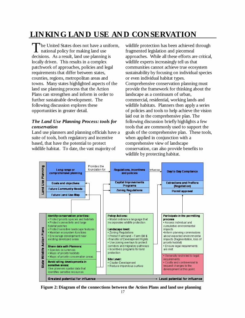
LINKING LAND USE AND CONSERVATION
T he United States does not have a uniform, national policy for making land use
decisions. As a result, land use planning is locally driven. This results in a complex patchwork of approaches, policies and legal requirements that differ between states, counties, regions, metropolitan areas and towns. Many states highlighted aspects of the land use planning process that the Action Plans can strengthen and inform in order to further sustainable development. The following discussion explores these opportunities in greater detail. The Land Use Planning Process: tools for conservation Land use planners and planning officials have a suite of tools, both regulatory and incentive based, that have the potential to protect wildlife habitat. To date, the vast majority of
wildlife protection has been achieved through fragmented legislation and piecemeal approaches. While all these efforts are critical, wildlife experts increasingly tell us that communities cannot achieve true ecosystem sustainability by focusing on individual species or even individual habitat types. Comprehensive conservation planning must provide the framework for thinking about the landscape as a continuum of urban, commercial, residential, working lands and wildlife habitats. Planners then apply a series of policies and tools to help achieve the vision laid out in the comprehensive plan. The following discussion briefly highlights a few tools that are commonly used to support the goals of the comprehensive plan. These tools, when applied in conjunction with a comprehensive view of landscape conservation, can also provide benefits to wildlife by protecting habitat.
Figure 2: Diagram of the connections between the Action Plans and land use planning

18
The Comprehensive Plan Nineteen Action Plans mentioned using comprehensive or master plans as a vehicle for local conservation planning. These references noted the importance of incorporating spatially explicit conservation information directly into comprehensive and master plans. The comprehensive plan is the key to most local and regional land use planning processes and can provide an important nexus for conservation and land use planning. Thirteen states have growth management legislation that all require local comprehensive planning, nine states require at least certain jurisdictions to do comprehensive planning and 28 states conditionally require comprehensive planning (Environmental Law Institute 2003).1 Five states (IL, MN, MS, NY, and NC) leave the choice of whether to do comprehensive planning entirely up to each jurisdiction’s discretion, but within those states, most jurisdictions do plan. Pendall et al. (2006) recently surveyed all jurisdictions (municipalities and counties) within the 50 largest metropolitan areas in the U.S. and found that 85% had comprehensive plans. This number is even higher in the western U.S., of which 99% of jurisdictions had plans. Comprehensive plans can cover counties, townships, towns or metropolitan areas and therefore can encompass the entire urban-rural spectrum. The comprehensive plan lays out a vision for the community that includes goals supported
by specific objectives and policies. The plans also inventory existing infrastructure including housing, economic activity, public facilities and services, transportation, land use, parks, recreation and environmental protection, and compares existing capacity to future needs based on population projections for the area. Finally, comprehensive plans include Future Land Use maps (sometimes referred to as FLUs or FLUMs) that places each parcel into a particular “zone” thereby designating development regulations spatially. Comprehensive plans are updated usually every 10-20 years through a formal process involving extensive public input (Daniels and Daniels 2003). However, population growth rates can change quickly. The environmental impacts of growth will be significantly higher for a locality absorbing sudden rapid growth with an out-dated comprehensive plan than jurisdictions with clear planning policies that can guide and control growth. Duerksen and Snyder (2005) have commented that old or out-dated comprehensive plans commonly fail to adequately address environmental issues. Although environmental protections can be added in through amendments, a plan that will address ecosystem protection as a whole using a suite of policies is more likely to benefit wildlife than one that applies one or two policies in isolation. Therefore, wildlife agencies hoping to influence the local planning process will benefit by knowing how often and on what schedule local governments update their comprehensive plans.
1 States with conditionally mandatory planning authorize, but do not require the jurisdiction in question to plan. However, if the jurisdiction forms a planning commission, it is then required to create a comprehensive plan (Environmental Law Institute and Defenders of Wildlife 2003).
The Comprehensive Plan “A comprehensive plan is largely a policy statement of the future land use and development goals of a particular jurisdiction. Also known as a master plan or general land use plan, it serves primarily to mitigate conflicts between different land uses. But it also functions to coordinate such related issues as transportation, economic development, housing, parks, and recreation” (Pendall et al. 2006). “In short, comprehensive land use planning is environmental planning.” (Daniels and Daniels 2003)

19
Conservation principles can integrate into all aspects of the comprehensive plan. Plan goals can include maintaining specific ecosystem services (like adequate groundwater recharge), preserving specific sensitive areas (like riparian buffers) and protecting and restoring priority habitat types. These goals are supported by objectives and policies that can recognize the harmful effects of certain development practices and recommend solutions (see Box 1).
The future land use map is particularly relevant for conservation. This map identifies areas zoned for high, medium and low density residential development, industrial development, agriculture and forestry. Some jurisdictions also include a “conservation” zone. The zoning designation translates into density restrictions and other regulations. Incorporating habitat protection and land conservation directly into the future land use map is one way of integrating conservation and land use planning. Future land use maps can
also raise red flags for conservationists, showing whether a particularly important area is zoned for development. Conservation planners need to incorporate planned growth into their own conservation plans. Whether that means targeting areas slated for development or avoiding spending money to protect land that will soon be surrounded by subdivisions. Understanding how cities and rural areas expect to grow is essential for creating an effective conservation plan. See Figure 3 on following page. Frequently, the comprehensive plan includes additional resource maps such as prime agricultural soils, existing parks and trails, population growth and demographics, wetlands and aquatic resources and buffered sensitive species locations. Some counties have created green infrastructure maps identifying priority wildlife habitat, open space and habitat corridors, and included these in the comprehensive plan. Many jurisdictions engage in a separate environmental planning process. The resulting environmental action plan can either be separate from or integrated with the comprehensive plan. Daniels and Daniels (2003) recommend the latter. This integration is a powerful symbolic gesture, but also confers practical benefits such as wider circulation, greater legal weight and better coordination between development and environmental protection. Simply getting accurate habitat and species information into comprehensive plans sends an important message that wildlife protection is important to the community, while also giving developers and planners the opportunity to avoid these areas voluntarily.
Box 1: Sample goals, objectives and policies for comprehensive plans: Goal: Protect and maintain the natural functions of springsheds. Objective: Minimize impacts from development by designing high recharge areas as part of the primary and secondary protection zones. Policy: Avoid inappropriate development within high recharge areas as identified in the future land use element. From (FDEP and FDCA 2002) “Protecting Florida’s Springs: Land use planning strategies and Best Management Practices.”

20
Figure 3: This figure shows Citrus County Florida’s Proposed Future Land Use Map. The three maps on the bottom show the location of different ecologically significant areas. A darker color indicates a higher priority resource. Comparing maps of future land use with maps of ecological resources can help identify areas of conservation opportunity. The region circled above is zoned for rural residential. The natural resource maps show that there are some valuable resources located within that zone. This information can help inform discussions with diverse stakeholders about land use policies and regulations within that area.
The extent to which jurisdictions have included conservation and environmental protection in their plans in the past varies greatly. Comprehensive planning traditionally focused on stimulating economic development, which, until recently, did not acknowledge the economic benefits of conservation (Daniels and Daniels 2003). In the 1970s, Sanibel Island, FL was the first locality to structure their comprehensive plan around six ecological zones (Duerksen and Snyder 2005). Since then numerous jurisdictions have included environmental protection and conservation in the goals for their community. However, the
land use planning process is flexible, even in states with the strictest planning requirements. Jurisdictions conform to their plans to varying degrees and simply including environmentally friendly policies does not ensure resource protection (Brody and Highfield 2005). Like many conservation plans, local comprehensive and master plans can languish on the shelf if they lack the adequate support and assistance for effective implementation. Getting support and technical assistance from state wildlife agencies will help make the difference between creating a green comprehensive plan and achieving a sustainable and green community.

21
Box 2: The Sonoran Desert Conservation Plan for Pima County, AZ http://www.pima.gov/cmo/sdcp/index.html In 1998, the Pima County Board of Supervisors took progressive action to address an increasingly heated debate about the region’s recent growth. Rather than simply focus on restricting growth, the Board decided to plan for future development and conservation together. The result was the Sonoran Desert Conservation Plan (SDCP). The SDCP provided maps of resources that stakeholders identified as important for conservation. These resources include critical habitat and biological corridors, riparian buffers, mountain parks, historical and cultural sites and ranch lands. Importantly, Pima County integrated the SDCP with the update of their comprehensive plan. Furthermore, the county adopted local ordinances, land acquisition programs, and other tools to implement the plan. Creating the SDCP gave Pima County a scientifically based conservation plan, fulfilled requirements for updating their comprehensive plan, and helped them comply with federal endangered species act regulations. By creating this plan, the Board redirected the conversation about growth from the question of how much should the county grow to how should the county grow and where to put new developments. In 2002, the SDCP won the American Planning Association’s Outstanding Planning Award. In 2004, Pima County citizens approved a $174.3 million bond program to provide funding for protecting conservation lands identified in the SDCP. To date, funding from this ballot measure has purchased 25,556 acres of land identified by the SDCP and protected 86,000 additional acres from development through conservation easements.
Comprehensive Planning Actions California: “Priorities specific to [the South Coast Region] include: As a complement to [Natural Community Conservation] planning, wildlife agencies should work with local governments to develop General Plans and zoning regulations that are compatible with conservation goals. In particular, local land-use plans should direct growth within established communities and along existing infrastructure and transportation corridors, restrict rural residential subdivision, and support those ranching and agricultural land uses that maintain habitat values and benefit environmental quality” (pp. 163-164). District of Columbia: “Participate in the planning process— It is strategic to use smart growth by aligning conservation principles with development goals during the District planning process. The DC Office of Planning produces a Comprehensive Plan that provides guidance for future land use, planning, and development. The Division of Fisheries and Wildlife staff will keep abreast of proposed plans that would impact species of greatest conservation need and their habitats and become involved in the planning process wherever possible” (Chapter 7, pp. 3). Nevada: “Identify the capacity of the Walker River watershed, and groundwater resources contained therein, to sustain additional commercial and residential development; work with county planners to integrate these limits in relevant master plans” (pp. 233).
continued on next page

22
Comprehensive Planning Actions Rhode Island: Every municipality in Rhode Island must develop a Comprehensive Community Plan, which maps out local land use, open space, natural resource and other community priorities (RI DA 2002g, 2003). Local Comprehensive Community Plans must be consistent with the State Guide Plan, which includes all of the state conservation and management plans previously discussed. The plans are required to be updated every five years… This is a key opportunity for incorporation of GCN species and habitat conservation needs at the local level and has been recognized as a high priority action for this CWCS” (Ch 7, pp. 290-291). South Carolina: “Assist local governments in drafting meaningful comprehensive plans, as they relate to the Natural Resources section of local comprehensive plans. [Highest priority] Indicators of Success: # of partnerships developed; # of information exchanges; # of comprehensive plans prepared; % of recommendations implemented; # of comprehensive plans commented on” (From TABLE 4-3: Prioritized Conservation Actions and Measures of Success, pp. 4-33).
Texas: “High Priority Conservation Actions for the Trans-Pecos: An Arroyo Protection and a Natural Open Space Ordinance in El Paso. Work has begun on arroyo protection and open space plans that include recreational areas, like City Parks and golf courses. Open Space Preservation methods need to focus on natural undisturbed native habitats. The City of El Paso’s development Master Plan’s need to include a protocol of looking at the entire habitat before making development plans. This will include surveying the entire area to protect arroyos, canyons and other areas of high ecological importance prior to drafting a master plan” (Trans-Pecos Ecoregion, Section II, pp. 238). Oregon: “Action 1.5. Support local land use plans and ordinances that protect farm and forestlands and other fish and wildlife habitats in urban and rural areas. Decisions about land use occur at the local level through local comprehensive land use plans, Goal 5 (natural resources) planning, ordinances and other means. These local plans take into account local values, priorities, and needs. To implement this Conservation Strategy, agencies will need to work with local community leaders and groups to find opportunities to incorporate Strategy Species and Habitats and Conservation Opportunity Area approaches into local plans that conserve farmlands, forestlands, open space, and natural areas” (Sec b, pp. 41-43). Washington: “Ecoregional assessments: These maps and the data used to recreate them can guide cost efficient conservation efforts at various scales on both public and private land. The primary uses of these maps are 1) prioritizing potential land acquisitions and conservation easements, 2) rating grant proposals for habitat protection or restoration, and 3) informing local planners for the purposes of county comprehensive plans and other local planning projects” (Section 3, pp. 258-9).
Developing Model Ordinances Twenty Plans emphasized that new or altered regulations are necessary to improve wildlife and habitat protection. For the most part, language associated with these actions expressed an interest in encouraging or supporting local governments to adopt certain
ordinances or regulations. Of these, some agencies recognized that while they cannot actively change local land use ordinances, they can provide model ordinance language for counties. Many localities are likely to be interested in protecting their natural resources, but find the prospect of creating new policies

23
daunting because they lack either expertise or capacity. While each jurisdiction should tailor land use ordinances to their local needs, developing general model ordinance language makes creating a new regulation easier and helps jurisdictions avoid common pitfalls. Providing model language can provide the catalytic boost needed for many local governments to tackle complex ecological issues.
Zoning Where and at what intensity development occurs on the landscape has profound implications for wildlife. Planners have the authority to zone districts for a variety of land uses and development densities. The future land use map forms the basis for these regulations. Planners can apply “large lot” zoning to particular areas to keep the human population density lower and protect more open space. However, the details of the zoning regulation are critical. Many jurisdictions have found that zoning laws must restrict development to one dwelling per 20 or even 50 acres to fight sprawl effectively. Mid-level densities of one dwelling per 5 or 10 acres can accelerate habitat fragmentation and even low densities of one dwelling per 20 acres results in altered species compositions (Lenth et al. 2006). New Jersey, the most densely populated state in the nation, identifies large-lot zoning as the cause rather than the solution to sprawl: “Suburban ‘sprawl’ and large-acre zoning cause extensive habitat loss and fragmentation. Many communities limit development by creating large-acre zoning. While large-acre zoning (usually five-plus acres) limits the human population within a locality, it dramatically fragments existing habitat, rendering remaining habitat remnants unsuitable for area-sensitive forest and grassland species.” (NJ SWAP, Overview, p. 16). Twenty-five plans included zoning laws as one tool for reducing development impacts on wildlife. Besides large-lot zoning, these regulations can also specify clustering or other site level design requirements. Planners can create a “zoning overlay” to protect a particular tract of land that may span multiple zoning districts. Overlays can be particularly useful for protecting particular habitat features like wetlands or corridors (McElfish 2004).
Creating model ordinances: California: “The state should coordinate the development of a model ordinance and building codes for new or expanding communities in fire-adapted landscapes to make those communities more fire compatible and reduce the state’s liability for fire suppression” (pp. 8). Texas: “We need to, and currently are, working with cities to write ordinances that allow for taller grass and forbs species to grow. It is difficult to do restoration when a large number of the plants are going to be restricted” (Sec II, pp. 71). North Carolina: “Light on beaches can deter nesting sea turtles or disorient hatchlings. The Commission’s Faunal Diversity Program works with beach communities to get ordinances passed so lighting will not disturb nesting or hatchling sea turtles. A continued effort needs to be made to work with additional townships to further this endeavor” (pp. 46). Washington: “Assist counties in developing and updating county ordinances and incentives that help to mitigate or control development in areas with resource and conservation values and that encourage environmentally sensitive development in growth areas” (Sec 3, pp. 299-300).

24
Subdivision and Land Development Regulations An alternative to simple down zoning is to require, or at least permit, clustering. Clustering ordinances specify an average low density for development, but require that the dwellings be clustered on, for example, 25% of the lot, leaving the other 75% as open space. While there are benefits to conservation subdivisions, recently published research by Lenth and colleagues (2006) demonstrates that the ecological characteristics of clustered housing developments are more similar to traditional dispersed developments than they are to undeveloped sites. The researchers found that human-adapted species, such as starlings, robins and grackles, were prevalent in clustered developments while development-sensitive species like horned larks, western meadowlarks and vesper sparrows were only common in undeveloped sites. Similarly, non-native vegetation was prevalent in both dispersed and clustered developments compared with undeveloped sites. Lenth and colleagues caution that the size of the protected open space in the clustered developments could be too small to confer real benefits (in this study open space in clustered developments averaged <80 ha compared with the average of 480 ha for “undeveloped” sites). The authors suggest planning several clustered developments at once and “pooling” their
open space into one larger protected area. In addition, the authors add that restoring the vegetation composition and structure in clustered developments may have beneficial impacts. Fourteen states included actions relating to clustering or conservation developments (this theme included references to “low impact development,” “clustered development” or “conservation subdivision”). Most of the Action Plans only mentioned clustering as a requirement for conservation subdivisions, which, according to the latest research, does not appear to provide significant conservation benefits. The Plans could improve in this area by defining “conservation subdivision” more specifically. Identifying priority areas on the landscape for protection could help planners design multiple conservation developments so that they all contribute to protecting one large habitat patch, thus yielding greater benefits. Additional considerations for “conservation development” designation include the location of the development on the landscape, the coverage and quality of native vegetation in the protected area, the ratio of interior to edge habitat for the protected area, and management of protected areas. The U.S. Green Building Council recently developed standards for neighborhood design that could inform “conservation subdivision” guidelines.
Zoning Actions: Alabama: “CA2. Discourage residential development of bluff lines. Work with local governments to promote restrictive zoning, or to purchase scenic easements, as has been done in other parts of the country. Performance measures: Acres restored, enhanced, and/or protected by easements or restrictive zoning; number of regulatory protections implemented to restrict residential development” (Ch 4, pp. 122). Louisiana: “Work with local parish planning commissions and LDNR to change zoning and redirect development sites in areas with target species” (Chapter 5, pp. 296). North Carolina: ““Land use planning and zoning laws are needed to limit development, land clearing, and hydrology alterations within floodplains (e.g., route highways and other corridors that cross floodplains as closely as possible to existing corridors to avoid fragmenting an extensive corridor of forest; try to avoid routing sewerlines through high quality floodplain)” (Ch 5, pp. 182).

25
Box 3: Leadership in Energy and Environmental Design for Neighborhood Development (LEED-ND) Modeled on the success of LEED certification programs for green buildings, LEED-ND is a newly completed certification program that measures an entire development’s congruence with sustainability principles such as energy efficiency, compact development, and good location. Under the rating system, developments must meet certain baseline requirements to qualify for consideration, including locating in or near existing communities, avoiding imperiled species habitat, and other prerequisites. Once they meet those prerequisites, developments can receive silver, gold, or platinum ratings by earning points if they, for example, provide access to public transportation, design pedestrian-friendly mixed-use communities, build on brownfields, or protect wetlands, wildlife habitat, steep slopes and other sensitive areas. Developers who seek to earn wildlife conservation points are encouraged to consult with state fish and wildlife officials to identify and protect significant habitat. The LEED-ND certification process was created by a panel of 15 experts in the architecture, planning, green building, land development, and environmental fields. The certification itself provides developers with recognition for their choice of good location and for their environmental efforts. Communities can make green development even more attractive by tying financial incentives and streamlined permitting to LEED-ND certification. Thirty-six Wildlife Action Plans wanted to create or use best management practices for developers. State wildlife agencies can use LEED-ND as a tool to meet those objectives by supporting incentives for LEED-ND certification, and by working with developers seeking LEED-ND certification. For more information on LEED-ND see: http://www.usgbc.org/LEED/ND
Conservation Subdivision Actions: Delaware: “Work with conservation partners, state and county planning officials, and developers to create certification for environmentally friendly developments, including an associated media campaign with awards” (pp. 6-2) Florida: “Develop a curriculum for those designing developments that provides design features that maximize natural habitat values. Incorporate this curriculum into relevant continuing education programs” (pp. 383). Michigan: “Encourage green-space planning and clustered development” (LEB, pp. 121). Nebraska: “Develop partnerships with community planning leaders, business leaders, and private organizations to develop best management practices (e.g. cluster housing) that can help ensure residential and commercial developments minimize the impacts to natural communities and biological diversity” (Ch 4, pp. 32). Texas: “The Urban Program is currently working with cooperative developers by providing site-specific technical guidance so that development is directed into the most suitable locations while conserving the best habitats (conservation subdivision design). The undeveloped acres are then placed under conservation easement and permanently maintained as open space” (Sec II, pp. 549).

26
Transferable Development Rights (TDR) Several jurisdictions have realized that both large lot zoning and cluster developments are limited in terms of their conservation benefits. Instead, they have developed a more complicated, but perhaps more effective, system for protecting large blocks of habitat while also providing some equity for landowners who find their development options restricted. TDR programs zone particular areas for high density development
(receiving areas) and other areas for conservation (sending areas). A developer building in the receiving area can gain density bonuses (i.e. develop more dwellings on the same number of acres) by purchasing development rights from landowners in the sending areas. This system can allow planners to restrict development severely over a large area while also providing landowners with some compensation. The market determines the price of the development credits.
Box 4: New Jersey Pinelands: Regional planning and transferable development rights The Pinelands is a state-designated National Reserve in Southeast New Jersey that covers 927,123 acres, or about 19% of the state, and intersects seven counties and 53 municipalities. This region was created by the New Jersey Pinelands Protection Act in 1979 and currently protects the largest block of open space along the highly developed eastern seaboard between Richmond, VA and Boston, MA. The Pinelands region has its own Comprehensive Management Plan (CMP) that delineates areas for preservation, forest, agriculture, rural development, regional growth, towns, villages, and military installations (see map of management zones at right). The strength of the plan lies in the fact that growth and development are coordinated with conservation. This regional approach strengthens smart growth by directing and concentrating development and allows for protection of large contiguous blocks of conservation and agricultural lands. The CMP is enforced by the Pinelands Commission (composed of 15 representatives from all seven counties, seven gubernatorial appointees and one representative from the U.S. Secretary of the Interior), which has the power to review all master plans for the affected counties and municipalities to ensure that they conform to the Pinelands CMP. The Pinelands Preservation Act was extremely controversial in 1979 and remains so, to some degree, to this day. An innovative transferable development rights program is integral to the persistence of Pinelands regional planning. This program allows developers in designated receiving areas (the Regional Growth Areas) to purchase development rights from landowners in sending areas (the Preservation or Agricultural Areas). These rights allow developers to build at higher densities than the existing zoning regulations in the receiving areas allow. The program uses market-based incentives to protect land and allow landowners in conservation areas to receive compensation for zoning restrictions. The market determines the price of the development rights. The median price per right in 1985 was $5,000 (in 2004 dollars) and in the last few years has risen to $30,000. To date, the program has protected 51,819 acres of preservation and agricultural land (Grogen, personal communication). For more information, go to http://www.state.nj.us/pinelands/.

27
TDR programs have been successful in several locations around the country in protecting both farmland and wildlife habitat. Challenges with these programs include creating regional partnerships to implement the program, identifying receiving areas where demand for development is high enough to warrant purchasing development rights and properly locating the sending and receiving areas. Although these programs can protect significant tracts of land, it is critical that these lands actually confer benefits to wildlife.
Likewise, poorly locating a receiving area can negate any benefits from associated land protection. Six states included TDR as a tool for habitat protection in their Action Plans. Of these, Florida and New Jersey already have active programs. Similarly to conservation subdivisions, the Action Plans simply include TDR as an action, rather than describing how such a program could function.
The Permit Review Process The permit review process ensures that developments are consistent with the goals and objectives laid out in the comprehensive plan and that they comply with existing federal, state and local regulations. At the local level, planning commissions, zoning boards, zoning officers and elected officials review the development proposals to ensure compliance. Frequently, state wildlife agencies are involved in reviewing development permit applications for compliance with state level environmental laws. At this late stage of the development process, the agency is generally not able to alter the development plans substantially. Even if the agency is able to do so, making significant changes at this stage in the process is extremely costly to developers and exacerbates conflict. Therefore, although this is an important role, wildlife agencies will have a much more positive and productive impact on development patterns if they are involved in the initial planning stages. Developers will benefit also by knowing the legal and political landscape during their scoping process. Twenty-four states indicated that they already, or plan to in the future, use the permit review process to influence land use planning and reduce development impacts. Of these, only a few specifically addressed the limitations of permit review as a conservation tool.
Transferable Development Rights Actions: Georgia: “Georgia Land Conservation Partnership Plan: This report also addressed the need for tax relief to protect rural properties from the impacts of residential and commercial sprawl and mentioned other relatively new approaches such as transferable development rights and carbon sequestration credits” (Sec 5, pp. 187). New Jersey: “Encourage farmers to preserve farmland through conservation easements and Transfer of Development Rights (TDRs)” (pp. 176). Oregon: “Work cooperatively within existing land use planning processes to conserve Strategy Habitats, and optimize use of transferred development rights, conservation banking and other market-based tools to meet land use goals: the Conservation Strategy encourages innovative solutions within the existing regulatory framework” (Sec. b, pp. 41-43).

28
Permit Review Comments: Connecticut: “As data collection and management improve, landscape-level maps and plans can be developed that identify wildlife habitat to assist local land-use boards and commissions in reviewing development projects that will adversely impact GCN species or their habitats” (pp. 4-6). Massachusetts: The MDFW is engaged in a number of environmental review activities that directly protect biodiversity in the Commonwealth, including permit reviews such as groundwater withdrawals, interbasin transfers of water, 401 permits, and NPDES permits. In addition, we review construction and development projects, lake management projects, and we are the lead agency for fish kill investigations in the Commonwealth” (Ch 4, pp. 78). North Carolina: “Work with local municipalities (commissions, planning boards, and other government entities) to promote ordinances that protect natural resources and improve water quality. Stormwater management. Increasing the effectiveness of ordinances on the ‘front-end’ (i.e., during initial planning of development projects) is a critical step to streamlining the ‘back-end’ (i.e., the environmental review process). If site improvements that are now made as a result of the environmental review process could instead be incorporated into the initial site design (through adherence to set ordinances), the environmental review process would be more efficient for both developers and reviewers” (pp. 46). New Hampshire: “401 Objective: Release Wildlife Maps to the Public. The state should make wildlife-related information accessible to developers and public, while also protecting sensitive information and landowner rights. If developers and consultants have access to information prior to planning their projects, they will know which agencies to contact for a full review or for help in developing project designs before investing large amounts of time and money in a project. This will also help to streamline the review process and reduce redundancy in review requests” (pp. 5-12). South Carolina: “Even if SCDNR or partners do not own lands, there are ways of protecting habitats. Coordination of wildlife goals and strategies during land planning processes and ability of SCDNR to review development and environmental impact plans for relevance to priority species can also assist in protecting habitats” (pp. 4-9). Vermont: “Collaborative efforts to address habitat concerns related to development, including assessment of direct and indirect impacts, avoidance and minimization of impacts and appropriate mitigation early in a project's planning processes can not only protect habitat from alteration, degradation, conversion and fragmentation, but can speed the project more successfully through the permit review process” (pp. 1-9).

29
Capital Improvements Programs (CIP) Capital Improvements Programs coordinate residential and commercial development with the necessary supportive infrastructure such as roads, sewer and water lines, schools and infrastructure repairs. As such, the CIPs are powerful tools for causing or reducing sprawl. Jurisdictions can require “concurrency” which means that the supportive infrastructure must be in place before a development is permitted. Extending this infrastructure prematurely into undeveloped areas can encourage development to sprout in agricultural fields and wildlife habitat far from existing development centers (Daniels and Daniels 2003). Wildlife agencies can help planners by identifying priority conservation areas and discouraging the construction of sewer and water lines and roads in those areas. Also, the presence of sewer and water lines is a good indicator of development pressure and can be used to identify threatened habitat parcels. North Carolina was the only state to allude to controlling sewer and water lines as a means of protecting land from development. The North Carolina Plan states for floodplain forests, “Land use planning and zoning laws are needed to limit development, land clearing, and hydrology alterations within floodplains (e.g., route highways and other corridors that cross floodplains as closely as possible to existing corridors to avoid fragmenting an extensive corridor of forest; try to avoid routing sewerlines through high quality floodplain)” (Ch 5, pp. 182). Six states included a related action, recommending that developers be required to coordinate their building with water availability .
Coordinating Development and Water Supply Arizona: “Promote urban growth planning initiatives that protect instream flow or acquire water rights (through purchase, conservation agreement, etc.)” (pp. 212-214). California: “State and local agencies should allocate sufficient water for ecosystem uses and wildlife needs when planning for and meeting regional water supply needs” (pp. 5). Florida: “Explore ways to protect natural lands and commercial forests from conversion that are outside an Urban Service Boundary. Develop incentives to take into consideration wildlife, habitat, and available water resources” (pp. 382-385). Nevada: “Identify the capacity of the Walker River watershed, and groundwater resources contained therein, to sustain additional commercial and residential development; work with county planners to integrate these limits in relevant master plans” (pp. 233).
Transportation Planning Transportation planning has a significant influence on land use planning and development patterns. Increased development can lead to the need for more roads and greater transportation capacity in a region, and conversely, the mere existence of a road makes development of a region more likely. Twenty-three states included working with transportation planners as a strategy for addressing development threats, all 51 Plans included roads and highways as a threat to wildlife, 49 states included at least one transportation related action and 38 states emphasized the need to work with transportation agencies. The transportation planning process offers wildlife agencies another important avenue to influence development patterns.

30
The recently passed Safe, Accountable, Flexible, Efficient Transportation Equity Act: A Legacy for Users (SAFETEA-LU) gives wildlife agencies and transportation planners a strong incentive to work together. Section 6001 of SAFETEA-LU states “consultation under clause (i) shall involve comparison of transportation plans to State and tribal conservation plans or maps, if available, and comparison of transportation plans to inventories of natural or historic resources, if available.” With the completion of the Action Plans, all states and U.S. territories have conservation plans available. SAFETEA-LU not only mandates that transportation planners consider wildlife and conservation at the beginning of the long-range planning process, it also makes transportation dollars available to restore habitat connectivity, relieve traffic pressure on our public lands and prevent the spread of roadside invasive species. The Action Plans included significant information about transportation planning. Vermont included a particularly detailed assessment of road-related threats and potential conservation actions in their Action Plan. Vermont’s transportation agency, VTrans, has created a Wildlife Crossing steering committee with the state Fish and Wildlife Department. Collectively, they have worked to inventory and remove fish passage barriers, create a predictive model for habitat connectivity, created an interagency agreement to protect eastern racer habitat, and created a program to train transportation planners in ecology (Austin et al. 2004). Defenders of Wildlife has produced an additional analysis of the Action Plans focused on this important and complex issue (see White et al. in prep).
Partners in the Land Use Planning Community Although many areas have state or regional planning bodies, local governments still retain the greatest control over the land use planning process. Partnering with people at the local level can therefore lead to strong environmental protection. People involved with land use care deeply about their community and its character. As such, they can be powerful advocates for conservation if they are given the right information. Forty-six Action Plans included references or actions to initiate or strengthen existing partnerships with land use decision-makers, making this category the most frequently mentioned among the Plans. Some plans simply included local agencies or planning organizations as partners. Others expressed the need to improve coordination with these groups on particular issues. Some states presented ideas for coordinating structures like work groups or committees or recommended that the agency get involved in the land use planning process more actively. Other coordination and partnership actions included providing technical assistance to planners (20 states), sharing data (15 states) and developing a Memorandum of Understanding with local governments (5 states).

31
Coordination Actions: North Carolina: “The Ecosystem Enhancement Program, developed through a 2003 Memorandum of Agreement between the NC Department of Environment and Natural Resources, the NC Department of Transportation, and the US Army Corps of Engineers, also has huge potential to dictate future land acquisitions in North Carolina through a watershed approach to compensatory mitigation from unavoidable impacts to stream and wetlands associated with highway development projects” (Ch 4, pp. 61). North Dakota: “Work with county zoning and planning officials to designate areas in need of protective covenants” (Sec 5.7, pp. 75). Rhode Island: “Collaboration with Local Partners – “The Comprehensive Community Plans that each municipality is required to develop and maintain (on a five-year update schedule) guide local land use planning and provide an opportunity to implement CWCS conservation actions on a local level. RI DEM has existing partnerships with several municipal organizations and governments, some of which are highlighted below. This will provide an effective mechanism for coordination throughout the CWCS revision and implementation efforts over the next decade” (Ch 7, pp. 289). South Carolina: “Conservation Action Committees would provide an excellent opportunity to work with partners to develop comprehensive statewide strategies for South Carolina that were not tied specifically to a single species or habitat. Two Conservation Action Committees, those for Education and Outreach and Urban and Developing Lands, were convened prior to completion of the CWCS; additional committee meetings will be held for the remaining CAAs as the CWCS is being implemented; resulting conservation strategies will be included in future revisions of the South Carolina CWCS” (pp. 6-2 – 6-3). Virginia: “Coordinate work efforts between state and federal agencies and nonprofits groups: • Enact interagency agreements among land managers to coordinate efforts • Hire more multidisciplinary personnel • Host forums to bring agencies, organizations and interested citizens together to discuss and Address issues • Increase industry partnerships • Integrate data resources • Partner with local governments and provide technical assistance” (pp.3-41).
The Planning Commission/Board Planning commissions can operate at the county, metropolitan or regional scale. Members are generally appointed and serve to provide policy advice to relevant local officials and help guide the growth and development of their jurisdiction. The specific duties of each planning commission varies but can include approving the comprehensive plan, setting zoning and other local land use ordinances, setting subdivision regulations and reviewing rezoning and subdivision applications.
Amazingly, these dedicated individuals are often volunteers or minimally compensated for their efforts. Providing planning commissions with information about the impacts of land use decisions on wildlife and ecosystems is essential to help them make informed zoning and permitting decisions. If the planning commission can be convinced that protecting natural resources is beneficial to the community, both ecologically and economically, they have the power to make a real difference.

32
The Planners The planners work under the planning commission and are, generally, the ones who create the comprehensive and master plans, compile data about land use and population growth, and create maps to support the goals of the plans. Some planning departments may employ only one or two planners, who primarily review development permit applications. In the latter case, the planners hire a contractor to write the comprehensive plan making it difficult to include meaningful environmental protection provisions. Development planners (also sometimes grouped as “current” planners) focus on zoning, subdivision requirements, and site plan reviews. Comprehensive planners (sometimes referred to as “advance” or “long-range” planners) look at big picture, future land use needs across the jurisdiction as well as provide information about population growth trends. The comprehensive planners are particularly useful for taking a landscape-level approach to conservation because they plan county-wide and think in broad terms about urban growth, agriculture, timber and conservation lands. In addition to current and long-range planners, some departments have environmental planners and most have GIS analysts. The former can create separate environmental action plans, review developments to check for NEPA compliance, and address specific environmental issues like coastal zone management. The GIS analysts are essential for creating the zoning and future land use maps that are central components of the comprehensive plan. In addition, the comprehensive plans can contain maps of recreation, prime agriculture soils, wetlands, and other important landscape features. The planners are in a good position to offer recommendations to the commission, push for different policies, or help wildlife advocates navigate local politics. As a result, working with these staff members could help influence the
planning commission. It is essential that the planners understand conservation planning efforts at the state level and that they have access to the most up-to-date data about priority species and areas. Many planners have a background in environmental science or ecology and got involved in planning to support those causes.
Elected Officials Elected officials, including mayors, governors, boards of supervisors and town councils, are critical to the land use planning process. Strong leadership is essential if local planners are going to have the support they need to make difficult land use decisions. Many planners have environmental backgrounds and interests and are familiar with different land use planning tools that will help protect sensitive resources. For these individuals, a lack of support from local leaders is a barrier to making sounds land use decisions. Wildlife agencies can help by targeting elected officials at both the local and state level with education programs about the importance of protecting a network of conservation lands.
Coordinating across jurisdictions Patchy environmental planning yields poor long-term results for ecosystems. Protecting ecosystem elements like wildlife migrations, meta-population dynamics, watershed integrity, large contiguous habitat blocks and corridors relies on cooperation between jurisdictions. Like all land use planning, different regions will have varying levels of institutionalized regional planning. Many states have a state planning office, or even an office of Smart Growth, several metropolitan areas have regional planning commissions with real oversight authority, and many regions have formed voluntary regional commissions. These entities usually focus on development, sprawl, transportation and economic health and may or may not address environmental impacts directly. A few regional commissions were

33
created specifically to protect a regionally significant natural area. Improving the ability of state and regional planners to incorporate wildlife concerns into their agenda can produce impressive results and is a important opportunity for implementing the State Wildlife Action plans.
State Planning Office State Planning Offices are part of the Executive Department and their directors are generally appointed by the Governor. The Office conducts policy analysis for the Governor and the state legislature, provides technical assistance to local governments and coordinates land use planning, to a varying degree, across the state. Many state planning offices have departments devoted to natural resource protection, Smart Growth planning, coastal development or land conservation. State planning offices oversee critical conservation programs such as the Rural Legacy Program in Maryland, the Beginning with Habitat program in Maine and the Conservation and Land Stewardship Program in New Hampshire.
Regional Councils Species and habitats range across the landscape regardless of local political boundaries.
Regional Councils oversee certain planning activities and provide technical support for multiple municipalities and counties. The councils can have regulatory authority, but are more often voluntary coalitions. The former are politically difficult to create and maintain because they are frequently seen as infringements on local autonomy. Despite this challenge, regional planning is critical to sustainable development.
Transportation planners and Metropolitan Planning Organizations (MPOs) Transportation planning is an inherently regional exercise that requires coordination with land use planners across multiple jurisdictions. As a result, most regions have MPOs that do long range planning to identify future transportation needs for the community. Working with these organizations is critical given the impacts of new or expanded roads and highways. Transportation planners work over a particularly long time horizon making it critical for wildlife agencies and conservationists to get involved as early as possible. By the time a project has an Environmental Impact Statement, it is usually too late to make substantive changes.
Regional Planning Actions: New Jersey: “DEP will encourage New Jersey counties and/or municipalities to develop Regional Habitat Conservation Plans within the next 10 years in order to benefit wildlife, habitat and the quality of life for New Jersey citizens. County and municipal planners should collaborate in developing master planning documents and ordinances that consider the larger region as a precursor to Habitat Conservation Plans” (Overview, pp. 25-26). North Carolina: “One NC Naturally also provides support for development of regional open space plans, providing assistance through regional meetings and resource materials. One NC Naturally’s regional planning process provides an effective forum for decision-making about conservation in our communities… Currently, 92 counties across North Carolina are involved in 14 local and regional open space planning efforts” (Ch 3, pp. 36). Ohio: “Participate in and support (e.g., technical assistance and funding) regional land use planning efforts in Ohio” (pp. 36). Oklahoma: “Create and fund Regional Planning Organizations to address agricultural land, fragmentation, urban sprawl, open space, and watershed protection. ” (Crosstimbers, pp. 176).

34
RECOMMENDATIONS FOR STARTING A SUSTAINABLE PLANNING PROGRAM
T he Action Plans contain a wealth of information that can help land use
planners make sound development decisions and, conversely, planning officials can be instrumental allies for implementing the plans effectively. In the coming years, protecting and sustaining wildlife will mean taking an active approach to land use to ensure that species and habitats are protected and included in our land use decisions. Clearly, wildlife agencies have a very specific role to play in this process. Wildlife agency personnel are not land use planners and are not in a position to instruct local governments, change laws and regulations or create their own land use plans. Instead, wildlife agencies can inform planning efforts, provide technical assistance, and give expert advice.
Approach Land use Planning Strategically From an ecological perspective, fragmenting land use policy between literally hundreds, if not thousands, of individual counties and municipalities is less than ideal. This heterogeneity is a significant challenge to landscape level conservation planning because even if one town or county takes a stand to protect natural resources, these efforts can be undone by neighboring jurisdictions. In addition, the sheer number of entities involved presents a challenge to wildlife agencies, which lack the staff to build relationships with every local government. Luckily, conservationists have recently made headway into working with another set of decentralized decision-makers: individual landowners. Addressing development issues and working with local governments is challenging, but no more so than working with farmers, fishermen or small
scale timber harvesters. Wildlife agencies looking to provide education and technical assistance need to locate and target the individuals who are in the best position to effect change. Getting familiar with different planning organizations, commissions, boards and planners is complex and daunting. One way to approach this task is to contact the state chapter of the American Planning Association (APA). These experts should be able to explain generally how land use planning works in that state and identify any regional bodies or other major planning entities. Given the number of jurisdictions involved, wildlife agencies will need to take a strategic approach to their involvement in land use planning. A strategic approach will need to take into account ecological priorities and development pressure, which both vary across the landscape. As such, these measures can provide meaningful criteria for prioritizing localities to work with or target with education campaigns. The following series of steps provides a basic framework for developing an approach to addressing land use and development issues. Step 1: Identify priority habitats and species, and design a connected network of conservation lands. Defenders strongly recommends developing an ecological priority map with, initially, as little political influence as possible. It is important to identify priority lands based on ecology alone in order to understand the array of conservation options and development trade-offs occurring in each landscape. Several states and regions are taking a “green infrastructure”
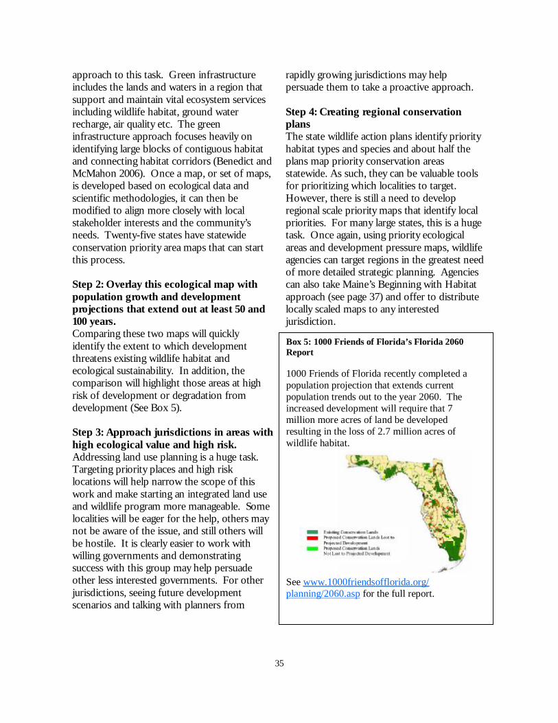
35
approach to this task. Green infrastructure includes the lands and waters in a region that support and maintain vital ecosystem services including wildlife habitat, ground water recharge, air quality etc. The green infrastructure approach focuses heavily on identifying large blocks of contiguous habitat and connecting habitat corridors (Benedict and McMahon 2006). Once a map, or set of maps, is developed based on ecological data and scientific methodologies, it can then be modified to align more closely with local stakeholder interests and the community’s needs. Twenty-five states have statewide conservation priority area maps that can start this process. Step 2: Overlay this ecological map with population growth and development projections that extend out at least 50 and 100 years. Comparing these two maps will quickly identify the extent to which development threatens existing wildlife habitat and ecological sustainability. In addition, the comparison will highlight those areas at high risk of development or degradation from development (See Box 5). Step 3: Approach jurisdictions in areas with high ecological value and high risk. Addressing land use planning is a huge task. Targeting priority places and high risk locations will help narrow the scope of this work and make starting an integrated land use and wildlife program more manageable. Some localities will be eager for the help, others may not be aware of the issue, and still others will be hostile. It is clearly easier to work with willing governments and demonstrating success with this group may help persuade other less interested governments. For other jurisdictions, seeing future development scenarios and talking with planners from
rapidly growing jurisdictions may help persuade them to take a proactive approach. Step 4: Creating regional conservation plans The state wildlife action plans identify priority habitat types and species and about half the plans map priority conservation areas statewide. As such, they can be valuable tools for prioritizing which localities to target. However, there is still a need to develop regional scale priority maps that identify local priorities. For many large states, this is a huge task. Once again, using priority ecological areas and development pressure maps, wildlife agencies can target regions in the greatest need of more detailed strategic planning. Agencies can also take Maine’s Beginning with Habitat approach (see page 37) and offer to distribute locally scaled maps to any interested jurisdiction.
Box 5: 1000 Friends of Florida’s Florida 2060 Report 1000 Friends of Florida recently completed a population projection that extends current population trends out to the year 2060. The increased development will require that 7 million more acres of land be developed resulting in the loss of 2.7 million acres of wildlife habitat.
See www.1000friendsofflorida.org/planning/2060.asp for the full report.

36
Provide Meaningful Technical Assistance Twenty-five states indicated that they wanted to provide technical assistance or data to land use planners. Wildlife biologists have an expertise in ecology, biology, and natural resources that most planners lack. As a result, they can apply the best available science to evaluate the impacts of different policy scenarios on wildlife populations. Technical assistance can come in several forms including sharing data, helping to create local conservation plans, and evaluating policy scenarios. In particular, biologists must be able to explain the subtleties of landscape ecology, connectivity, habitat fragmentation and the “zone of influence” of development. They also must be able to provide maps of habitat, species locations and priority conservation areas so that planners have the best
information for making development decisions and crafting their comprehensive plans. Planning for large reserves and connectivity requires having a spatially-explicit landscape level conservation plan. Landscape conservation plans enable conservationists and land use planners to evaluate the cumulative impacts of development in a region. While the habitat lost by an individual development can be viewed as insignificant, the habitat loss and fragmentation resulting from many developments is very significant. Protecting and maintaining a network of large connected habitat blocks is widely accepted as an essential conservation strategy (Groves et al. 2002).
Technical Assistance Actions: Alabama: “Statewide Conservation Actions, All Habitats: S1. SWG funding and the CWCS process provide an unprecedented opportunity for DWFF to expand its leadership role in the dissemination of information about good land and water stewardship. Following completion of the CWCS, product development should be tailored to the wildlife conservation needs of water and land use decision-makers at local, regional and statewide scales. This will allow GCN species, habitats, and their conservation actions from this CWCS to be incorporated and integrated into their conservation plans to promote a coordinated Alabama conservation effort” (Ch 4, pp. 50). Alaska: “Work with other partners to support a single, statewide database that includes a spatial component and makes species information available to managers, planners and developers” (pp. 100). California: “The state should provide scientific and planning assistance and financial incentives to local governments to develop and implement regional multispecies conservation plans for all of the rapidly developing areas of the Sierra Nevada and Cascades” (pp. 11). New Hampshire: “The critical gap that NHFG can address is the scientific basis for implementing land use policies and regulations that protect the ecological function and health of wildlife populations and their habitats. This technical assistance needs to be combined with an integrated approach to land use decisions among local decision-makers. NHFG should work with UNH Cooperative Extension and New Hampshire Office of Energy and Planning, key outreach partners to facilitate training for NHFG biologists on the integration of wildlife habitat information into local land use planning and regulation. Likewise, Cooperative Extension can facilitate training for town planners, planning boards, regional planners, and others involved in writing master plans and local ordinances, on how to integrate wildlife considerations into local planning. NHA and The Jordan Institute are other important partnering entities, through their Three Infrastructures Analysis with local communities” (pp. 5-29 – 5-30).

37
Box 6: Maine’s Beginning with Habitat Program (http://www.beginningwithhabitat.org/index.html) In Maine, both the Department of Inland Fisheries (MDIFW) and the State Planning Office (SPO) were concerned about the impacts of increasing development on the state’s biodiversity. In response, they created the Beginning with Habitat program. This program is a shining example of active technical assistance. MDIFW will supply local planning offices with a series of GIS data layers depicting: 1) riparian areas; 2) high value wildlife habitat; and 3) remaining large blocks of intact forest. The program has also created a handbook that explains why local governments need to think about wildlife during land use planning, the benefits of conservation, consequences for inaction, and outlines a set of recommendations. Importantly, this handbook also explains how MDFIW identifies the three habitat features and why they are important. To date, MDIFW has distributed these maps to 270 towns across Maine. Interested local governments can request Beginning with Habitat presentations to learn more about the program.
Map of important wildlife habitat for Saco, ME. Map of large undeveloped habitat blocks for Saco, ME
Without a landscape scale ecological strategy, it will be difficult to provide land use planners with useful and specific information. Too often, wildlife biologists advise planners with general suggestions like reduce fragmentation, maintain connectivity, and avoid sensitive areas. While those suggestions work when talking about planning in general, they are challenging to apply to a specific location. Wildlife agency personnel need to be prepared to look at a county or regional map and identify specific areas where development will cause fragmentation, loss of connectivity or
impact sensitive areas. Identifying a range of conservation options gives the community some flexibility in their planning process.

38
Providing Science-Based Guidance: a summary of urban ecology research Wildlife agencies can contribute to sustainable land use planning by interpreting current biological research in the context of land use planning. Although research on this topic remains limited, numerous studies have quantified changes in species composition in response to urbanization, and a growing number of studies are testing land use policies and providing specific recommendations to planners (See Appendix A for more information). Issue: Protecting the existing array of species in urbanizing landscapes It is well documented that species composition changes along the urban-wildland gradient. Some species adapt well to urban conditions while others are very sensitive to even low density development. While the former are generally increasing nationwide (Hansen et al. 2005, McKinney 2002), the latter are declining and therefore of greater conservation concern (Birds: Donnelly and Marzluff 2004, Germaine et al. 1998, Lizards: Germaine and Wakeling 2001, Amphibians: Delis et al. 1996). Several researchers have categorized species by their sensitivity to urbanization (See Appendix A). This gradient in species richness can peak for certain taxa at intermediate levels of urbanization due to the mixing of non-native and native urban-adapted species with native urban-avoiding species (Birds: Blair 1996, Lizards: Germaine and Wakeling 2001, Review: McKinney 2002). Recommendation: A regional conservation plan must provide adequate habitat protection for the entire spectrum of wildlife. Within urbanizing landscapes, focusing solely on species richness measure and/or “hotspots” of biodiversity may be misleading. Protecting moderately sized habitat patches in a rapidly urbanizing landscape may provide adequate protection for the majority of local species. However, planners must also protect a few large contiguous areas that will protect the most urban sensitive species. Issue: Habitat Patch Size vs. Quality Habitat patch size and quality are both important considerations when judging the conservation value of a reserve in urbanized landscapes (Donnelly and Marzluff 2004, Germaine et al. 1998, Germaine and Wakeling 2001). Researchers have clearly shown that larger reserves are better and connectivity is important (MacArthur and Wilson 1967, Beier and Noss 1998). However, significant debate continues regarding habitat patch size thresholds. Research demonstrates that surrounding land uses can impact habitat quality. Odell and colleagues (2003) identified a 100 meter “zone of influence” surrounding each individual human dwelling in an exurban landscape. The species composition within this zone favored non-native and urban-adaptive species such as American Robins, Brown-Headed Cowbirds, House Wrens, and domestic dogs and cats. However, habitat management that replaces invasive vegetation with native species and increases habitat complexity and heterogeneity can increase species richness despite surrounding land uses (Butterflies: Collinge et al. 2003, Birds: Germaine et al. 1998). Recommendation: Work with local land trusts, open space protection programs, local governments and stakeholders to create a workable regional conservation plan (See Groves 2003). Appendix A summarizes the findings from several recently published articles relating to conservation thresholds in urbanizing landscapes. Another useful publication is the Environmental Law Institute’s “Conservation Thresholds for Land Use Planners.” Planners should designate a minimum buffer of 100 meters around any human structure.

39
(cont. from previous page) Although additional studies are needed to tease apart the relative benefits of vegetation management in small habitat patches, wildlife agencies can still encourage developers to leave native vegetation in place as much as possible during the construction process. Wildlife agencies can also provide money and technical assistance to communities to help them maintain native vegetation in their communities. Any development dubbed a “conservation subdivision” should be required to maintain native vegetation and habitat complexity in their protected open space. Issue: Site Development Patterns Clustering and minimizing impervious surface are two proposed options for minimizing the impact of development on wildlife. Unfortunately, current research concluded that low density or even clustered exurban developments both significantly alter species composition compared to undeveloped sites, calling into question the conservation value of these development patterns (Lenth et al. 2006). Minimizing impervious surface across the landscape is critical for protecting aquatic species, but also improves the conservation value of protected areas for terrestrial fauna (Donnelly and Marzluff 2004, Lussier et al. 2004). Recommendation: Clustered developments remain a viable planning tool, but they do not, as presently designed, meet the needs of the most urban-sensitive species. As a result they should not be the central component of an urban biodiversity conservation strategy. The spatial arrangement of development at the site level cannot fully mitigate the impacts of poorly placed development at the landscape level. Site development designs that minimize impervious surface will have positive benefits for aquatic and some terrestrial species. Monitoring impervious surface coverage in conjunction with habitat patch size, shape and connectivity provide a more complete picture of the cumulative impacts of development in a region. Issue: Development and Protected Areas Many protected areas, especially in the west, encompass high elevation habitat, while development continues to reduce habitat at lower elevations. Low elevation habitats are critical for many species and should not be ignored for protection (Hansen and Rotella 2002). The recent USFS publication “Cooperating Across Boundaries” documents the damaging impacts of development encroachment on public lands including loss of buffering natural habitat and connectivity between habitat patches, increased invasive species on public lands, challenges to applying fire management, decreased water quality and quantity throughout the watershed, increased recreational use of public lands, and increased human-wildlife conflicts (USDA, Forest Service 2006). Recommendation: Conservation planners need to address second home, rural, and exurban development that encroaches upon existing protected areas. This concern is especially relevant for protected areas that cover high elevation habitats with poor soils. Planners should leave at least a 100 meter buffer between public land boundaries and buildings. In general, keeping dwellings sited as far from park boundaries as possible and targeting adjacent landowners for “backyard habitat” programs may help reduce the impacts of encroachment. Developments adjacent to public lands may be good candidates for a cluster design. Planners could site the open space protected by clustering to provide a buffer between the development and the park.

40
Target Education Strategically Thirty-two plans suggested educating landowners and the public about conservation and development impacts. Although general public education is important, it is necessary to target education towards the people who make land use decisions, namely planning commissioners, elected officials and land use planners. Twenty-eight states indicated that they wanted to target these groups. The Wildlife Action Plans present a unique opportunity to reach out to land use decision-makers. Often, land use planners are concerned with the character of their community, but might not see the connections between quality of life and wildlife conservation. Agencies can highlight the economic benefits of protecting habitat and the economic costs of poorly planned development. Linking
wildlife habitat conservation with other community concerns like clean air and water, rural character, open space and recreation is often an effective way of raising awareness about wildlife that resonates with the public. At the same time, biologists need to caution that protecting environmental amenities like water quality, does not automatically provide meaningful habitat for sensitive species. As scientists, wildlife biologists can explain the impacts of different development scenarios on ecological function, using the best available science. Decision-makers will ultimately decide to what extent they are willing to alter development patterns to protect wildlife. However, they cannot make this decision responsibly without being fully informed of the trade-offs they are making.
Targeted Education Actions: California: “For local governments currently working on [Natural Community Conservation Plans], or in areas where new NCCPs are being developed, the state could facilitate local governments’ participation in the planning process by providing educational materials, leadership training, and collaborative group forums to educate local leaders about conservation planning” (pp. 179-180). Florida: “Develop an education program for county staff on the utility and application of the Habitat Conservation Plan process for reducing conflicts between development and conservation of wildlife and habitat” (pp. 383). Iowa: “Develop training programs for professionals in fields that affect land use (agriculture, engineering, community planning, developers, etc.) and community leaders to inform them of the impacts of development on wildlife habitats and the quality of life for citizens on a local level” (pp. 13, also repeated in Ch 6, pp. 113) Louisiana:
“Provide local and parish planning boards with information regarding sensitive habitats and species in their areas, and work to redirect the development of these areas.
Work with universities that provide training to urban planners to educate future planning board members on the conservation of habitats and species of concern.
Encourage university curricula to incorporate sensitive natural areas into student studies (especially landscape architecture and courses for planners).
Provide information to developers on ecosystem values and functions which benefit species of concern, and encourage the integration of ecosystem functions into developments” (Ch 5, pp. 296-267).
Table continued on next page

41
Michigan: “Educate local planning and zoning boards about the value of prairie and methods to conserve prairie systems” (SLP, pp. 8). New Mexico: “Planning or implementation of specific actions in riparian areas can only be influenced if the entity planning or undertaking the action understands the value of riparian systems and has sufficient information to carry out actions in appropriate ways that minimize or avoid adverse effects” (Ch 5, pp. 244-245). North Carolina: “Target developers, local government staff, and elected officials. Developers are impacting the land now. Educating them on ways to minimize impacts (e.g., impervious surface effects on stormwater drainage) and working to adjust regulations to provide more benefit to water quality and wildlife needs to occur immediately. Home Owner Association backing may be able to assist in strengthening the cause. The newly created Urban Wildlife Program within the Commission’s Faunal Diversity Program is striving to bring wildlife expertise to planning and zoning boards since they designate lands for development and protection. This pilot project seeks to create a new niche that links local governments to wildlife professionals for increased communication and cooperation, ultimately decreasing the potential for costly disagreements on land usage patterns before they arise. Another education tool is the draft (as of 2005) “Swimming with the Current” document, a partnership between the Commission, the NC Department of Environment and Natural Resources, the US Fish and Wildlife Service, and the NC Department of Transportation to educate municipalities about secondary and cumulative impacts and the environmental review process” (pp. 47-48).
Targeted Education Actions:
Increase Capacity One of the guiding principles issued by the Association of Fish and Wildlife Agencies encouraged states to, “ensure that the Plan-Strategy can be implemented, i.e. that it is administratively and politically feasible, and that there are sufficient resources (funding and staff) among the partners to accomplish significant gains at a large scale, and within an appropriate time frame, to preserve our Nation’s wildlife heritage” (AFWA 2002). However, only eight plans indicated that they want to hire additional staff to address development issues while eleven states recognized the need to find additional funding for dealing with this problem. There is little doubt that addressing development impacts will require increased capacity including time, money, and technical expertise. Most wildlife agencies are strapped
for the first two and may not have staff with experience or even interest in land use planning policy. Even if states take a strategic approach to this issue, the wildlife agencies will still need to devote significant staff time and money to address this issue fully. States will need either to identify new funding sources or to shift their existing resources to match these new priorities. State Wildlife Grant funding and transportation funding (section 6001 of SAFETEA-LU) provide new options for linking land use and conservation planning. In addition, many local communities are passing open space ballot measures. State wildlife agencies can work with land trusts and local governments to guide open space protection to areas with high wildlife habitat value. A recent report by the Environmental Law Institute reviewed a sample of state level open space protection programs and found
42
that the majority are able to tailor land protection programs to enhance biodiversity conservation (Environmental Law Institute 2006). State wildlife agencies will need to take a hard look at their existing priorities and decide where their money can be spent most effectively. The Action Plans clearly state that development is among the most significant
issues for wildlife in many states in the U.S. The strong statements regarding development threats in many of the plans clearly justify shifting personnel and money towards tackling this issue.
Capacity Building Actions: Florida: “Explore the establishment of a biologist/ecologist staff position within each local government whose job duties include reviewing land conversion applications and making recommendations for minimizing effects to wildlife habitat” (pp. 382). New Hampshire: “NHFG should more fully develop a land protection staff and budget. Much of the GIS infrastructure and knowledge to generate conservation planning maps exists in NHFG… Wildlife biologists, both at NHFG headquarters and in regional offices should have the responsibility and time to work with local landowners, land trusts, conservation commissions, regional land trusts, and other members of the conservation community to identify and contribute in a substantial way to land protection projects” (pp. 5-21). New Mexico: “Work with federal, state, and private agencies and institutions to identify sources of funding for long-term conservation of SGCN and to maintain tracts of native vegetation as an alternative to converting land to agriculture or urban development. Funding should create incentives for habitat maintenance and improvement on private lands and conservation easements. Employ existing incentive programs to facilitate partnerships with private landowners. These programs include the Conservation Reserve Program (CRP), Landowner Incentive Program, Wetland Reserve Program, Wildlife Habitat Incentives Program, State Wildlife Grants, Private Stewardship Grants Program, Safe Harbor Agreements, and Environmental Quality Incentive Program” (Ch 5, pp. 147). Virginia: “Hire a natural resources planner within each Planning District Commission” (pp. 3-40).
A new role for wildlife agency staff: Numerous authors in the conservation field are urging wildlife biologists to get involved with land use planning (Brogerg 2003, Theobald et al 2000, and Theobald et al 2005). Wildlife agencies, as fellow government agencies, can advise local planners with a weight that non-governmental organizations, or even university professors, lack. For most wildlife agencies, engaging in land use planning will require shifting personnel from traditional field research into a new interdisciplinary role that applies biological training to providing useful data and recommendations to policy-makers. The following are a set of tasks and projects that these new “hybrid” staff members can take on: • Develop relationships with planners in priority locations • Familiarize the wildlife agency with relevant state and local policies • Research the impacts of projected development on important wildlife areas • Work with land use planners to identify important habitat patches and corridors for protection at the regional level • Assist planners with incorporating ecological data into comprehensive plans • Work with open space protection programs to make them more effective at protecting wildlife habitat • Monitor development project proposals and review permits

43
T he State Wildlife Action Plans unequivocally state that residential and
commercial development patterns are a significant threat to wildlife conservation across the U.S. For many states, development is the most significant threat statewide, for others it is a priority issue in particular regions. As the Massachusetts Action Plan states, “this direct loss of habitat due to development, combined with the effects of habitat fragmentation due to increased transportation infrastructure, has created a threat to wildlife not seen since the early days of the 19th century when the state was largely deforested. This time, however, the opportunity to reforest old farm fields abandoned by a westward exodus to the prairies is not likely to be repeated” (MA SWAP, pp. 7). The states have taken an historic step forward in creating these Wildlife Action Plans. The Plans are potentially the best tools available for organizing and prioritizing conservation action at the state level. Collectively, the Plans identified a wide variety of key actions to address this threat. However, most of the Plans do not clearly indicate the wildlife agency’s commitment to addressing this issue. Many state agencies will need to shift their resources and personnel to focus more directly on development and land use planning issues. The Wildlife Action Plans can provide the basis for a more targeted strategy for integrating wildlife conservation and land use planning in the coming years. The State Wildlife Grants program marks the beginning of a new direction for state wildlife agencies. The scope of their efforts is expanding to include proactive wildlife conservation of declining species before they
are endangered. Protecting these species means protecting their habitat and that means dealing with land use planning. Although it is unfamiliar and politically difficult terrain, addressing development patterns is central to protecting and maintaining wildlife populations in the United States today. For many states, land use decisions made over the next decade will permanently determine the fate of the state’s wildlife and ecological sustainability. As stewards of the nation’s wildlife, the wildlife agencies can provide real leadership in addressing this difficult challenge. A failure to address these issues now will compromise our ability to live sustainably with wildlife in the future.
CONCLUSIONS

44
Literature Cited
Abbitt, R. J. F., J. M. Scott, and D. S. Wilcove. 2000. The geography of vulnerability: incorporating species geography and human development patterns into conservation planning. Biological Conservation 96:169-175.
Association of Fish and Wildlife Agencies. 2002. State Wildlife Conservation Strategies: Guiding Principles. Association of Fish and Wildlife Agencies, Washington, DC. http://www.teaming.com/pdf/state%20strategies%20guiding%20principles.pdf (Accessed on April 25, 2007).
Anderson, W. P., P. S. Kanaroglou, and E. J. Miller. 1996. Urban form, energy and the environment: a review of issues, evidence and policy. Urban Studies 33:7-35.
Alig, R. J., J. D. Kline, and M. Lichtenstein. 2004. Urbanization on the U.S. landscape: looking ahead in the 21st century. Landscape and Urban Planning 69: 219-234.
Alig, R. J., A. J. Plantinga, S. Ahn, and J. D. Kline. 2003. Land use changes involving forestry in the United States: 1952 to 1997, with projections to 2050 – a technical document supporting the 2000 USDA Forest Service RPA assessment. General Technical Report PNW-GTR-587. Portland, OR: U.S. Department of Agriculture, Forest Service, Pacific Northwest Research Station. 92 p.
Austin, J. M., C. Alexander, E. Marshall, F. Hammond, J. Shippee, E. Thompson, and Vermont League of Cities and Towns. 2004. Conserving Vermont’s Natural Heritage: A guide to community-based planning for the conservation of Vermont’s Fish, Wildlife, and Biological Diversity. Vermont Fish and Wildlife Department and Agency of Natural Resources, Waterbury, Vermont.
Babbitt, B. 1999. Noah’s mandate and the birth of urban bioplanning. Conservation Biology 13:677-678. Battisti, C. and S. Gippoliti. 2004. Conservation in the Urban-Countryside Interface: a cautionary note from Italy.
Conservation Biology 18:581-583. Benedict, M.A. and E. T. McMahon. 2006. Green Infrastructure: Linking landscapes and communities. Island Press,
Washington DC. Beatley T. 2000. Challenges for Planners. Journal of American Planning Association 66: 5-21. Beier, P. and R. Noss. 1998. Do habitat corridors provide connectivity? Conservation Biology 12:1241-1252. Blair, R. B. 1996. Land use and avian species diversity along an urban gradient. Ecological Applications 6: 506-519. Bock, C. E., Z. F. Jones, and J. H. Bock. 2006. Rodent communities in an exurbanizing Southwestern landscape
(USA). Conservation Biology 20: 1242-1250. Broberg, L. 2003. Conserving ecosystems locally: A role for ecologists in land-use planning. Bioscience 53:670-673. Brody, S. D. and W. E. Highfield. 2005. Does planning work? Testing the implementation of local environmental
planning in Florida. Journal of the American Planning Association 71: 159-175. Brown R. M. and D. N. Laband. 2006. Species imperilment and spatial patterns of development in the United
States. Conservation Biology 20:239-244. Brown, D. G., K. M. Johnson, T. R. Loveland, and D. M. Theobald. 2005. Rural land-use trends in the coterminous
United States, 1950-2000. Ecological Applications 15: 1851-1863. Collinge, S. K., K. L. Prudic, and J. C. Oliver. 2003. Effects of local habitat characteristics and landscape context on
grassland butterfly diversity. Conservation Biology 17: 178-187. Dale, V. H., S. Brown, R. A. Haeuber, N. T. Hobbs, N. Huntly, R. J. Naiman, , W. E. Riebsame, M. G. Turner, and
T. J. Valone. 2000. Ecological principles and guidelines for managing the use of land. Ecological Applications 10:639-670.
Daniels, T. and K. Daniels. 2003. The Environmental Planning Handbook. American Planning Association, Chicago, IL.
Delis, P. R., H. R. Mushinsky, and E. D. McCoy. 1996. Decline of some west-central Florida anuran populations in response to habitat degradation. Biodiversity and Conservation 5: 1579-1595.
Donnelly, R. and J. M. Marzluff. 2004. Importance of research size and landscape context to urban bird conservation. Conservation Biology 18: 733-745.
Doyle, K., J. Kostyack, B. McNitt, G. Sugameli, C. Whitaker, K. Whitcomb-Blaylock, J. Byrd and G, Skull. 2001. Paving paradise: Sprawl’s impact on wildlife and wild places in California. National Wildlife Federation, Washington D.C.
Duerksen, C. and C. Snyder. 2005. Nature-Friendly Communities: Habitat protection and land use planning. Island Press, Washington D.C.
Environmental Law Institute. 2006. The Nature of Open Space Programs: Linking land protection and biodiversity conservation. Environmental Law Institute, Washington D.C.
Environmental Law Institute. 2003. Planning for biodiversity: authorities in state land use laws. Defenders of Wildlife, Washington D.C.

45
Ewing, R., J. Kostyack, D. Chen, B. Stein, and M. Ernst. 2005. Endangered by Sprawl: How runaway Development Threatens America’s Wildlife. National Wildlife Federation, Smart Growth America, and NatureServe. Washington, D.C.
Ewing, R., T. Schmid, R. Killingsworth, A. Zlot, S. Raudenbush. 2003. Relationship between urban sprawl and physical activity, obesity, and morbidity. The Science of Health Promotion 18: 47-57.
Ewing, R., R. Pendall, D. Chen. 2002. Measuring sprawl and its impact. Smart Growth America, Washington D.C. FDEP and FDCA. 2002. Protecting Florida’s Springs: Land use planning strategies and best management practices.
Florida Department of Environmental Protection and Florida Department of Community Affairs, Tallahassee, FL.
1000 Friends of Oregon. 2005. Too many homes on the range: The impact of rural sprawl on ranching and habitat. 1000 Friends of Oregon, Portland, OR.
Germaine, S. S. and B. F. Wakeling. 2001. Lizard species distributions and habitat occupation along an urban gradient in Tuscon, Arizona, USA. Biological Conservation 97: 229-237.
Germaine, S. S., S. S. Rosenstock, R. E. Schweinsburg, and W. S. Richardson. 1998. Relationships among breeding birds, habitat and residential development in greater Tuscon, Arizona. Ecological Applications 8: 680-691.
Groves, C. R., D. B. Jensen, L. L. Valutis, K. H. Redford, M. L. Shaffer, J. M. Scott, J. V. Baumgartner, J. V. Higgins, M. W. Beck, and M. G. Anderson. 2002. Planning for biodiversity conservation: putting conservation science into practice. Bioscience 52:499-512.
Hansen A. J., R. L. Knight, J. M. Marzluff, S. Powell, K. Brown, P. H. Gude, and K. Jones. 2005. Effects of exurban development on biodiversity: Patterns, mechanisms, and research needs. Ecological Applications 15: 1893-1905.
Hansen, A. J. and J. J. Rotella. 2002. Biophysical factors, land use, and species viability in and around nature reserves. Conservation Biology 16: 1112-1122.
Land Trust Alliance. 2003. National Land Trust Census. http://www.lta.org/aboutlt/census.shtml (Accessed March 26, 2006).
Lenth, B. A., R. L. Knight, and W. C. Gilbert. 2006. Conservation value of clustered housing developments. Conservation Biology 20: 1445-1456.
Lussier, S. M., R. W. Enser, S. N. Dasilva, and M. Charpentier. 2006. Effects of habitat disturbance from residential development on breeding bird communities in riparian corridors. Environmental Management 38: 504-521.
MacArthur, R. H. and E. O. Wilson. 1967. The Theory of Island Biogeography. Princeton University Press: Princeton, New Jersey.
Maestas, J. D., R. L. Knight, and W. C. Gilgert. 2003. Biodiversity across a rural land-use gradient. Conservation Biology 17: 1425-1434.
Margules C. R. and R. L. Pressey. 2000. Systematic conservation planning. Nature 405:243-253. McElfish, J. M. 2004. Nature-Friendly Communities. Environmental Law Institute: Washington DC. McKinney, M. L. 2002. Urbanization, Biodiversity, and Conservation. Bioscience 52: 883-890. Miyashita, T., A. Shinkai, and T. Chida. 1998. The effects of forest fragmentation on web spider communities in
urban areas. Biological Conservation 86: 357-364. Odell, E. A., D. M. Theobald, and R. L. Knight. 2003. Incorporating ecology into land use planning: the sognbirds’
case for clustered development. Journal of the American Planning Association 69: 72-82. Odell, E. A., and R. L. Knight. 2001. Songbird and medium-sized mammal communities associated with exurban
development in Pitkin County, Colorado. Conservation Biology 15: 1143-1150. Otto, B., K. Ransel, J. Todd, D. Lovaas, H. Stutzman, and J. Bailey. 2002. Paving our way to water shortages: How
sprawl aggravates the effects of drought. American Rivers, the Natural Resources Defense Council, and Smart Growth America, Washington D.C.
Pendall R., R. Puentes, and J. Martin. 2006. From traditional to reformed: A review of the land use regulations in the Nation’s 50 largest metropolitan areas. The Brookings Institution, Washington DC.
Pima County. 2000. Springs in Pima County. Sonoran Desert Conservation Plan. Pima County Administrator's Office, Tucson, Arizona.
Radeloff, V. C., R. B. Hammer, S. I. Stewart, J. S. Fried, S. S. Holcomb and J. F. McKeefry. 2005. The wildland-urban interface in the United States. Ecological Applications 15:799-805.
Stein, M. S., R. E. McRoberts, R. J. Alig, M. D. Nelson, D. M. Theobald, M. Eley, M. Dechter, and M. Carr. 2005. Forests on the edge: housing development on america’s private forests. General Technical Report PNW-GTR-363. Portland, ORL U.S. Department of Agriculture, Forest Service, Pacific Northwest Research Station. 16 p.

46
Theobald, D. M., T. Spies, J. Kline, B. Maxwell, N. T. Hobbs, and V.H. Dale. 2005. Ecological support for rural land-use planning. Ecological Applications 15:1906-1914.
Trust for Public Land. 2006. Land Vote Database. http://www.tpl.org/tier3_cdl.cfm?content_item_id=12010&folder_id=2386. Accessed March 21, 2006.
U.S. Census Bureau. 2004. Statistical Abstract of the United States: Geography and Environment. http://www.census.gov/prod/2004pubs/04statab/geo.pdf (Accessed on March 30, 2007).
U.S. Census Bureau. 2007. State and County Quick Facts. http://quickfacts.census.gov/qfd/index.html (Accessed on March 30, 2007).
USDA, Forest Service. 2006. Cooperating across boundaries: partnerships to conserve rural America. FS-861. USDA, Forest Service, Washington DC.
White, T., J. Michalak, J. Feinberg, and J. Lerner. In prep. State Wildlife Action Plans and Transportation Planning. Defenders of Wildlife, Washington DC.
Wilcove, D. S., D. Rothstein, J. Dubow, A. Phillips, and E. Losos. 1998. Assessing the relative importance of habi-tat destruction, alien species, pollution, overexploitation, and disease. Bioscience 48:607-615.
Wilson, J. D. and M. E. Dorcas. 2003. Effects of habitat disturbance on stream salamanders: implications for buffer zones and watershed management. Conservation Biology 17: 763-771.

47
APPENDIX A: CURRENT RESEARCH ADDRESSING CONSERVATION AND LAND USE PLANNING
Citation Study Location
Types of land use compared
Species/ taxa addressed
Habitat type
Findings
Blair (1996)
Santa Clara County, CA
Urban Gradient 1. Jasper Ridge
Biological Reserve
2. Open Space Recreation Area
3. Golf Course 4. Residential
Area 5. Office Park 6. Business
District
Birds (Categorizes species by their tolerance of urbanization)
All sites were historically oak woodland
• Species shifted from native to non-native as urbanization increased.
• Highest species diversity (both native and non-native) peaked at intermediate levels of development.
• Sensitive species were lost as urbanization increased. • Bird diversity patterns correlated with variables including
impervious surface, buildings, lawns, grasslands, trees and shrubs.
• Moderate urbanization can increase species diversity overall, but decrease native species diversity.
• Golf courses have high species richness, but the species composition is different from pre-disturbance habitat.
Bock et al (2006)
Colorado Exurban and livestock grazing
Rodents Grasslands, mesquite savannas, and oak savanna
• Livestock grazing had more detrimental effects than development.
• “Exurban development had no obvious effects on rodent variety or abundance. Results suggest southwestern exurban developments can sustain a rich assemblage of grassland and savanna rodents if housing densities are low and houses are embedded in a matrix of natural vegetation with little grazing.”
Collinge et al (2003)
Boulder, Colorado
Grasslands surrounded by urbanized landscapes of various intensities.
Butterflies Tallgrass remnants and hayfields in lowland floodplains. Mixed-grass and shortgrass prairies on upland slopes and mesas bordered by Ponderosa pine woodlands.
• Grassland type and habitat quality significantly predicted butterfly species richness.
• There was no relationship between butterfly species richness and surrounding urban intensity.
• Grassland type influenced species evenness with butterflies more evenly distributed among species in mixed-grass plots. Urbanization did not influence evenness.
• Butterfly abundance depended significantly on grassland type and quality. Urbanization did not affect abundance.
• Maintaining high quality grassland habitat contributes significantly to butterfly biodiversity protection.
• Urbanization had no impact on butterfly species composition. However, study sites were embedded in a relatively contiguous band of grassland surrounding Boulder. The resulting connectivity may have negated negative impacts from development.
• For invertebrate species, patch characteristics may have greater influence than landscape context.

48
Citation Study Location
Types of land use compared
Species/taxa addressed
Habitat type
Findings
Donnelly and Marzluff (2004)
Seattle Metropolitan Area, WA
Urban (mean % = 9% forest, 19% urban forest, 72% urban), Suburban (mean % = 36% forest, 44% urban forest, 20% urban), Exurban (mean % landcover = 77% forest, 17% urban forest, 5% urban).
Birds (Also categorizes species by their tolerance to development)
Compared small (mean 2.1 ha), medium (34.7 ha) and large (1471 ha) reserves in the Western Hemlock Forest region.
• Found higher species richness as reserve size increased. • Total bird abundance was greater in urban and suburban
reserves than in exurban reserves indicating that birds were “packing” into forest patches.
• Species richness increased unexpectedly in medium and large reserves with increased urbanization. The authors suggest that had they added sites in the core business district, species would peak at intermediate levels of development as documented by Blair (1996).
• Native forest species were lost as reserve size decreased (see manuscript for specific thresholds for species).
• Most species were present in sites > 42 ha. • Urban tolerant species were gained as surrounding landscape
development intensified with most species present in reserves surrounded by >40% impervious surface.
• Small reserves in any landscape had no value as breeding habitat for at least two native forest species.
• Large reserves in urban landscapes had “exceptional conservation value for most native forest species.”
Germaine et al (1998)
Tuscon, AZ
Randomized transects across the urban to wildlands gradient surrounding Tuscon, AZ.
Birds Sonoran Desert habitat including lowland and upland Sonoran vegetation, mesquite bosque, and riparian desert scrub.
• Non-native species increased with increasing levels of development
• Native species including Cactus Wrens, Gila Woodpeckers, Curve-billed Thrashers, Mourning Doves, House Finches, Brown-headed Cowbirds, Anna’s Hummingbird, and Northern Cardinals appeared unaffected by development pressure.
• Verdins, Pyrrhuloxias, Black-tailed Gnatcatchers, Black-throated sparrows, and Northern Flickers were negatively correlated with development descriptors.
• Native breeding bird species richness correlated positively with native vegetation coverage and negatively with increased distance from riparian vegetation and native vegetation patches > 1 ha.
• Intact riparian corridors positively influence native bird species richness.
• Retaining habitat patches of native vegetation greater than 1 ha in size can provide habitat for sensitive species even in urban areas. Areas should be located within 0.5 km of each other to allow dispersal between patches.
Germaine and Wakeling (2001)
Tuscon, AZ
Randomized transects across the urban to wildlands gradient surrounding Tuscon, AZ.
Lizards Sonoran Desert habitat including lowland and upland Sonoran vegetation, mesquite bosque, and riparian desert scrub.
• Lizard species richness peaked at low-moderate levels of development and plunged sharply as urbanization increased from moderate levels.
• Tree lizards were the most urban-adapted species, whip-tailed lizards were most abundant in homogenous Lower Sonoran vegetation with little to no development, other species reached optima in areas with greater than average Upland Sonoran vegetation and plot hereogeneity.

49
Citation Study Location
Types of land use compared
Species/taxa ad-dressed
Habitat Types
Findings
Lussier et al (2004)
Rhode Island
Riparian forest with variable vegetation composition and sub-watershed land-cover (i.e. % impervious surface cover-age and % residential land use).
Birds Riparian For-est
• Urban tolerant species predominated in landscapes with > 12% residential land use coverage and > 3% impervious surface cov-erage.
• Urban intolerant species predominated in landscapes with < 12% residential land use coverage and < 3% impervious surface.
Lenth et al (2006)
Boulder County, Colorado
Dispersed housing devel-opments (ranging from 1 dwelling per 2 to16 ha, aver-age 9.75 ha per house), clus-tered housing developments (housing re-stricted to 25% of the total project area and remaining 75% is placed under conservation easement, aver-age 9.75 ha per house) and undeveloped areas in ex-urban land-scapes (defined as development outside of in-corporated city limits).
Birds and Mammals
All study plots were on Ned-erland-Valmont asso-ciation soil type. Unde-veloped sites were mixed-grass prairie that allowed recreation and some seasonal grazing. De-veloped sites had never been con-verted to agri-culture, but did allow horse and cattle grazing.
• Found significantly higher densities of Common grackles, Euro-pean starlings, American Robins, Red-Winged Blackbirds, Mourning Doves, Rock Doves, and Killdeer in both dispersed and clustered developments than in undeveloped areas.
• Found significantly higher densities of Western meadowlarks, Vesper sparrows, Grasshopper sparrows, and Horned larks in undeveloped areas compared with both dispersed and clustered developments.
• Nest density was significantly higher in undeveloped areas com-pared to both dispersed and clustered development
• Detected domestic dogs significantly more frequently in dis-persed and clustered developments compared to undeveloped areas.
• Detections of Red fox, Skunk, Cow, and Prairie dogs were higher in both development types, but not significantly so.
• Detections of coyote were higher in clustered and undeveloped sites, but this was not significant.
• Detections of field mice were higher in undeveloped sites com-pared to both development types (p=0.093).
• Native vegetation cover in undeveloped sites was twice as high as in either development type.
• Non-native vegetation cover was significantly higher in both development types compared to undeveloped sites.
• The ecological characteristics of clustered and dispersed devel-opment patterns are more similar to each other than either is to undeveloped sites.
• Protected open space in clustered development may be too small (<80 ha) to provide real conservation benefits. Planning on a regional scale could result in pooling protected areas from multiple projects, leading to larger reserves.
• Placement of clustered developments on the project site could influence benefits and vegetation management that encourages native species may also increase conservation value.

50
Citation Study Location
Types of land use compared
Species/taxa addressed
Habitat Type
Findings
Odell et al. (2003)
Pitkin County, CO
Distance from individual houses in rural areas (30, 180 and 330 m from individual houses)
Birds, mesopre-dators
Mountain Shrubland Habitat domi-nated by Gambel’s Oak and Snowberry
• Human-tolerant species (American Robin, Black-billed magpie, brown headed cowbird, broad-tailed hummingbird, house wren) had highest relative abundance 30 meters from the houses and dropped significantly at 180 and 330 meters.
• Human-sensitive birds (Black-capped chickadee, blue-gray gnat-catcher, dusky flycatcher, orange-crowned warbler, plumbeous vireo, and spotted towhee) had lowest abundance at 30 meters and increased significantly at 180 and 330 meters. Virginia’s war-bler was not detected at 180 meters but was significantly more abundant at 330 meters than at 180 meters.
• Domestic cats and dogs were detected more often near homes, while coyotes and foxes were detected more frequently farther from homes.
• The authors propose adding a 100 meter “zone of influence” to each individual dwelling. Clustered development patterns could help reduce overall influence by overlapping portions of the zone of influence for each individual dwelling.
Odell and Knight (2001)
Pitkin County, CO
Same as above. Also compared high (1.04 houses per ha) and low (0.095 houses per ha) density develop-ments with un-developed (at least 700 m from any developed area) areas. One hectare is ap-proximately 2.47 acres.
Birds, mesopre-dators
Mountain Shrubland Habitat domi-nated by Gambel’s Oak, service-berry, choke-cherry, and mountain sagebrush
• Same data presented as in Odell et al (2003) • Human-tolerant species (see Odell et al 2003 above) were simi-
larly abundant in both high and low density developments. • Human-sensitive species reached higher densities in undeveloped
areas compared with high density developments • Green-tailed towhee, dusky flycatcher, and plumbeous vireo had
slightly higher abundance in low density development compared with high density.
• Developing at lower densities did not significantly improve biodi-versity in the landscape.
Maestas et al. (2003)
Cache la Poudre River Wa-tershed, Larimer, County, CO
Exurban, Ranchland, Protected natu-ral areas
Birds, mesopre-dato-rs, plant communities
Shrub and Grassland
• Densities of songbirds and carnivores were more similar on ranches and in protected areas than to areas with “ranchettes.”
• Human adapted species including domestic dogs, cats, black-billed magpies, and European starlings were most abundant in ranchette sites.
• Spotted towhee, Green-tailed towhee, Brewer’s sparrow, Lazuli bunting, Vesper Sparrow, and Rock Wren were significantly less dense in exurban sites compared with ranch and reserve sites.
• Greatest number of non-native plant species were found on ranchette sites.
• Percent cover of non-native species was highest on ranchette and reserve sites compared with ranches.

51
Miya-shita et al. (1998)
Tokyo and Yoko-hama, Japan
Various for-ested patches ranging from 0.5 – 40 ha in a highly frag-mented and isolated land-scape (Tokyo) and less frag-mented land-scape (Yokohama).
Spiders Deciduous and evergreen oak and dog-wood in Yo-kohama, and Zelkova (Ulmaceae) and Aucuba (Cornaceae) in Tokyo.
• Species richness and density increased linearly with increasing patch size.
• Species richness and density was higher over all in Yokohama com-pared with Tokyo
• Number of species increased with increasing % forest cover in the landscape surrounding each fragment.
• Nephila clavata females were larger in larger fragments.
Wilson and Dorcas (2003)
Davidson, NC
Compared sites with low, me-dium, and high disturbance (from agricul-ture or residen-tial develop-ment) through-out the water-shed
Salamanders Small streams in second growth mixed hardwood pine forest with agricul-ture and pas-tures and recent residen-tial develop-ment.
• Salamander abundance was significantly negatively correlated to disturbance through out the subwatershed.
• Salamander abundance was not correlated to the presence of a pro-tective riparian buffer ranging in size from 10.7 meters (as required by law in the county) to 61 meters.
• Landscape context throughout the watershed impacts salamander abundance significantly more than the presence of a riparian buffer.
• This pattern is especially true for salamander species that depend on terrestrial habitats.
Citation Study Location
Types of land use compared
Species/taxa addressed
Habitat Types
Findings

52
Austin, J. M., C. Alexander, E. Marshall, F. Hammond, J. Shippee, E. Thompson, and Vermont League of Cities and Towns. 2004. Conserving Vermont’s Natural Heritage: A guide to community-based planning for the conservation of Vermont’s Fish, Wildlife, and Biological Diversity. Vermont Fish and Wildlife Department and Agency of Natural Resources, Waterbury, Vermont.
This handbook provides information to planners in Vermont who are interested in protecting natural resources through their land use planning process. The guide covers basic information about the importance of protecting biodiversity and ecosystem function and about conservation planning. Part II identifies a set of sensitive ecosystem elements at different scales, discusses their significance, and outlines how planners can obtain data about these elements. Part III outlines a local conservation planning process including setting goals, gathering information, developing strategies, and plan implementation. Beatley T. 2000. Preserving biodiversity: challenges for planners. Journal of American Planning
Association 66: 5-21. Beatley argues that historical biodiversity protection measures, including the Endangered Species Act, are not sufficient alone to adequately protect biodiversity in the United States. He argues that maintaining ecosystem functions requires an approach that utilizes regional and local scales while also connecting with larger statewide and even continental efforts. Ultimately, land use planners need to alter their comprehensive plans to include protection for a connected network of ecologically significant lands. Broberg, L. 2003. Conserving ecosystems locally: A role for ecologists in land-use planning. Bioscience
53:670-673. Brogerg advocates for better integration of ecological principles into land use planning. He offers the follow four areas where biologists can get involved and make a difference: “(1) educating members of the staff, planning board, and governing body involved in land-use decisions; (2) serving on a planning commission or governing body; (3) commenting at public hearings; and (4) participating in citizen review panels for land-use laws and policies.” Cohn, J. and J. Lerner. 2003. Integrating land use planning and biodiversity. Defenders of Wildlife,
Washington D.C. This document summarizes a workshop Defenders of Wildlife organized that brought together planners and conservationists to talk about coordinated planning efforts. Participants discussed the benefits of conservation planning, barriers to integrating conservation plans with local land use planning, recommendations for creating state and regional conservation plans, recommendations for integrating regional conservation plans into local land use planning, and the role for conservation organizations. Cohn and Lerner also included discussions of existing conservation plans. Dale, V. H., S. Brown, R. A. Haeuber, N. T. Hobbs, N. Huntly, R. J. Naiman, , W. E. Riebsame, M. G.
Turner, and T. J. Valone. 2000. Ecological principles and guidelines for managing the use of land. Ecological Applications 10:639-670.
Dale et al. summarized the findings of a committee convened by the Ecological Society of America to explore how the land use planning process works and where ecologists can influence the process. The paper reviews land use trends over the last hundred years, reviews the land use decision-making process in the U.S. and derives a set of guidelines for land managers. The guidelines are as follows: (1) Examine impacts of local decisions in a regional context (2) Plan for long-term change and unexpected events (3) Preserve rare landscape elements and associated species (4) Avoid land uses that deplete natural resources (5) Retain large contiguous or connected areas that contain critical habitats (6) Minimize the introduction and spread of nonnative species (7) Avoid or compensate for the effects of development on ecological processes (8) Implement land-use and management practices that are compatible with the natural potential of the area.
APPENDIX B – ANNOTATED BIBLIOGRAPHY OF RELEVANT LAND USE PLANNING RESOURCES
53
Duerksen, C. and C. Snyder. 2005. Nature-Friendly Communities: Habitat protection and land use planning. Island Press, Washington D.C.
This book is a must-read for conservation and land use planners alike. The first two chapters are especially essential for busy conservation professionals. Chapter one synthesizes the benefits of protecting ecosystems for local communities including a pithy discussion of economic benefits. This information is especially useful for convincing local governments to invest in resource protection. Chapter two provides a quick yet thorough course in nature-friendly planning. It covers the basics of local land use planning, acquisition programs, program structures, and innovative approaches in regulation, education and incentives. These two chapters are an excellent introduction to how land use planning and ecosystem protection can fit together. The remaining chapters detail case studies of various localities and their approaches to resource conservation. These illustrate how communities have implemented theoretical ordinances and planning techniques with a frank discussion of successes and pitfalls. Overall, the book is written in a fresh and engaging style and is packed with information. Duerksen, C. J., D. L. Elliott, E. Johnson, and J. R. Miller. 1997. Habitat protection planning: where the
wild things are. American Planning Association, Washington D.C. This 82 page primer provides a good introduction to habitat protection planning. Chapter 2 covers basic landscape ecology concepts, fitting them into the urban-suburban-rural context. This chapter is particularly useful for planners with limited biological backgrounds, but also will help ecologists see how science and planning can mesh. Chapter 4 covers the wide variety of tools available for habitat protection within the local planning framework, including a discussion of regulations, incentives, acquisition, development agreements, education and more. Chapter 5 addresses the legal pitfalls of land use planning and gives helpful advice about how to navigate this potential minefield (particularly regulatory takings challenges). Finally, the last chapter outlines applicable federal legislation like the Endangered Species Act, Section 404 wetlands protection and farm bill programs. Environmental Law Institute. 2003a. Conservation thresholds for land use planners. The Environmental
Law Institute, Washington D.C. “Conservation thresholds” synthesizes biological research on topics such as riparian buffer widths, habitat patch size, and corridor design. This information is critical for designing functional conservation networks and especially their supporting regulations. Given that we will never have perfect information about ecological processes, this report gives planners and natural resource managers numbers, backed by science, to work with. It also provides a complete bibliography (up until 2003) of relevant peer-reviewed journal articles that can provide more detailed information. Environmental Law Institute. 2003b. Planning for Biodiversity: authorities in state land use laws. The
Environmental Law Institute and Defenders of Wildlife, Washington DC. Does your state require counties to do a comprehensive plan? Does each metropolitan area in your state have a planning commission? Every state has different laws and planning requirements. This report navigates these convoluted laws for each state. The authors also identified language in the laws that support biodiversity or natural resource protection. This is a good resource for learning about the structure of your state’s land use planning authority and how it can be used to support biodiversity protection. Ewing, R., J. Kostyack, D. Chen, B. Stein, and M. Ernst. 2005. Endangered by Sprawl: How runaway
Development Threatens America’s Wildlife. National Wildlife Federation, Smart Growth America, and NatureServe. Washington, D.C.
This report presents the findings of a NatureServe analysis that compared rare, threatened and endangered species occurrences with metropolitan area boundaries. The research finds significant overlap between the two and concludes that addressing urban development patterns and sprawl is necessary to conserve biodiversity effectively. The report also outlines steps that states and local governments have taken or can take in the future to create green infrastructure plans (local and state land conservation plans) that will help abate development threats.

54
Groves, C. R., D. B. Jensen, L. L. Valutis, K. H. Redford, M. L. Shaffer, J. M. Scott, J. V. Baumgartner, J. V. Higgins, M. W. Beck, and M. G. Anderson. 2002. Planning for biodiversity conservation: putting conservation science into practice. Bioscience 52:499-512.
This paper gives a very quick overview of The Nature Conservancy’s basic process for creating regional conservation plans. The process involves seven major steps: 1) identifying conservation targets, 2) collecting information and identifying gaps, 3) establishing goals, 4) assess existing conservation areas, 5) evaluate ability of conservation targets to persist, 6) assemble a portfolio of conservation areas, and 7) identify priority conservation areas. For a more detailed treatment of this subject see “Drafting a Conservation Blueprint: A Practitioner’s Guide to Planning for Biodiversity,” by Craig Groves, published by Island Press. Hansen A. J., R. L. Knight, J. M. Marzluff, S. Powell, K. Brown, P. H. Gude, and K. Jones. 2005. Effects of
exurban development on biodiversity: Patterns, mechanisms, and research needs. Ecological Applications 15: 1893-1905.
Hansen and colleagues review current literature on the impacts of low density, exurban development on biodiversity. The review concludes that 1) there is evidence for reduced species survival and reproduction near homes even in low density developments, 2) species responses to development intensity may be non-linear and instead change abruptly when a particular threshold is reached, 3) species composition continues to change in response to a new development for years and perhaps decades after construction, 4) exurban dwellings are often sited in landscapes with important biodiversity value, 5) the effects of exurban development are likely to differ depending on the predominant habitat type in the region, 6) research has identified a set of ecological mechanisms linking development and biodiversity patterns, and 7) exurban development may have a greater impact on biodiversity than development at the urban fringe because it will have impacts on adjacent lands, which are frequently public lands. Maine’s Department of Inland Fisheries and Wildlife. 2003. Beginning with Habitat. Accessed from
http://www.beginningwithhabitat.org/ (Accessed on March 22, 2006). Maine’s Beginning with Habitat program provides a model for collaborative partnerships and effective technical assistance between a state wildlife agency and local land use decision-makers. The program allows local planners to request maps of significant ecological features within their planning jurisdiction; namely water resources and riparian areas, high value plant and animal habitats, and large contiguous habitat blocks. The maps are produced at a local scale and so can directly inform land use planning. Margules C. R. and R. L. Pressey. 2000. Systematic conservation planning. Nature 405:243-253. Margules and Pressey advocate and present a process for systematic conservation planning. The process includes six stages: 1) compile data, 2) identify conservation goals, 3) review existing conservation areas, 4) select additional conservation areas, 5) implement conservation actions, and 6) maintain required values of the conservation areas. McElfish, J. M. 2004. Nature-Friendly Ordinances. Environmental Law Institute: Washington DC. This book is an essential primer for understanding the variety of land use planning tools available to support biodiversity protection. The book covers planning and zoning, development approvals, growth management and infrastructure ordinances, conservation practice ordinances, and public open space acquisition and management. McElfish describes each tool’s general function, its application to biodiversity protection, and key considerations for creating an effective ordinance. The book provides illustrative examples from real communities for each ordinance.

55
Theobald, D. M., N. T. Hobbs, T. Bearly, J. A. Zack, T. Shenk and W. E. Riebsame. 2000. Incorporating biological information in local land-use decision making: designing a system for conservation planning. Landscape Ecology 15:35-45.
Theobald and colleagues offer a description of their collaborative process for creating a conservation decision support system that would help inform the land use planning process. The collaborative discussions revealed three significant needs. First, stakeholders with diverse views, i.e. developers and environmental advocates, were interested in obtaining information about the potential environmental concerns of developing on a proposed site. Developers would benefit by getting a preview of what kind of permits and community resistance they might face for choosing a particular site, while environmental advocates and concerned citizens would be able to assess a proposed development’s potential impacts. Second, land use planners wanted to include ecological information in their comprehensive plans. To do so, the team created a series of maps identifying priority conservation features such as large habitat patches and connecting habitat corridors. Third, users needed a method for evaluating cumulative impacts from numerous small developments over time. This need was met with an application that estimated a range of future population growth and development scenarios to assess the potential cumulative impacts of each. The paper closes with a set of lessons learned from the process. Weber, T. 2003. Maryland’s Green Infrastructure Assessment: A Comprehensive Strategy for and
Conservation and Restoration. Maryland Department of Natural Resources, Annapolis, MD. Maryland’s Green Infrastructure Assessment (GIA) was one component of Governor Glendening’s Smart Growth Initiatives. The GIA identified the large regions of mostly intact natural resources remaining throughout the state, termed “hubs,” and potential connecting pathways between the hubs, termed “corridors.” These areas, if maintained more or less in their current natural state, will provide Maryland’s residents with a wide range of environmental benefits including biodiversity protection, air and water purification, ground water recharge, pollination, climate regulation, nutrient cycling, and carbon sequestration. To identify these areas, Weber used a variety of data sets including, but not limited to: satellite imagery, habitat data, rare, threatened and endangered species occurrences, steep slopes, habitat intactness, and proximity to other natural areas. This technical document describes Weber’s methods for identifying “hubs” and “corridors” in great detail.