lincoln laboratory dual pol algorithm development program · lincoln laboratory dual pol algorithm...
TRANSCRIPT

LL DP for TAC-1
DJS 7/14/2011
Lincoln Laboratory
Dual Pol Algorithm
Development Program
David J. Smalley
NEXRAD TAC
March 9, 2011

LL DP for TAC-2
DJS 7/14/2011
FAA Weather Systems Benefit from
Improved NEXRAD Algorithms
Integrated
Terminal Weather
System
Weather And
Radar
Processor
Corridor Integrated
Weather System
Route
Availability
Planning Tool
Consolidated
Storm Prediction
for Aviation
Functionality Gap Algorithm First Deployed
Legacy Algorithm
Performance/Resolution
Precipitation Coverage - HRVIL 2002
Echo Tops - HREET 2003
Data Quality Data Quality Improvements - DQA 2003
Wind Shear Product Gust Front Detection - MIGFA 2007
Microburst Detection - AMDA In development
Hydrometeor
Identification
Icing Hazards - IHL In development
Hail Hazards - HHL In development

LL DP for TAC-3
DJS 7/14/2011
Outline
• Automated Microburst Detection Algorithm (AMDA)
• Dual Pol Algorithm Development Plan
• Icing Hazard
• Hail Hazard
• Data Quality Improvement
• High Res VIL Recovery

LL DP for TAC-4
DJS 7/14/2011
Airport Wind Shear Exposure
Airport Size Large
Medium
Small
Wind shear Exposure (min/yr)

LL DP for TAC-5
DJS 7/14/2011
Current Airport Wind Shear Coverage
Airport Size Large
Medium
Small
Wide-area wind shear coverage
Current TDWR/WSP Airport Coverage Circles Represent 30 KM Airport Coverage Area
Wind shear Exposure (min/yr)

LL DP for TAC-6
DJS 7/14/2011
Airport Size Large
Medium
Small
Wind shear Exposure (min/yr)
Wide-area wind shear coverage
TDWR/WSP NEXRAD w/TDWR/WSP Circles Represent 30 KM Airport Coverage Area
Complementary NEXRAD
Enhanced Wind Shear Coverage

LL DP for TAC-7
DJS 7/14/2011
Airport Size Large
Medium
Small
Wide-area wind shear coverage
TDWR/WSP NEXRAD NEXRAD w/TDWR/WSP Circles Represent 30 KM Airport Coverage Area
Potential NEXRAD Enhanced Wind Shear Coverage Wind shear Exposure (min/yr)

LL DP for TAC-8
DJS 7/14/2011
Automated Microburst Detection Algorithm
• TDWR benefits study identified NEXRAD as a cost effective alternative for wind shear detection
• NEXRAD does not currently have a microburst detection product
• There is a need for more wind shear products in NextGen
• NEXRAD AMDA based on AMDA concept for the ASR-9 WSP and lidar
• Does not require months of code development to determine if such a capability will be useful in the NEXRAD system

LL DP for TAC-9
DJS 7/14/2011
AMDA Overview
Read a Scan of
Base Data
Segment
Association
Segment
Density
Thresholding
Assimilate
Evidence
Segment
Detection
MB Detections To Shape
Algorithm & Display

LL DP for TAC-10
DJS 7/14/2011
AMDA Segment Detection
Read a Scan of
Base Data
Segment
Association
Segment
Density
Thresholding
Assimilate
Evidence
Segment
Detection
MB Detections To Shape
Algorithm & Display

LL DP for TAC-11
DJS 7/14/2011
AMDA Segment Association
Read a Scan of
Base Data
Segment
Association
Segment
Density
Thresholding
Assimilate
Evidence
Segment
Detection
MB Detections To Shape
Algorithm & Display

LL DP for TAC-12
DJS 7/14/2011
AMDA Segment Density Thresholding
Read a Scan of
Base Data
Segment
Association
Segment
Density
Thresholding
Assimilate
Evidence
Segment
Detection
MB Detections To Shape
Algorithm & Display

LL DP for TAC-13
DJS 7/14/2011
NEXRAD AMDA Implementation Progress
• Generate NEXRAD AMDA results to compare to TDWR/ITWS microburst algorithm results at a few live sites
– Dallas area with two TDWRs – Indianapolis area with a TDWR and NEXRAD running AVSET
• Comparison warrants integration of AMDA into ORPG CODE – Approx. 85% detection when verified in NEXRAD data – Approx. 25 – 30% of TDWR detections not visible to NEXRAD
• NEXRAD surface (0.5o) scanning likely too infrequent – Best max. return to surface scan every ~4.3 minutes (AVSET help?) – Other AMDA and TDWR/ITWS microburst algorithm based on 1
minute or less return to surface scan
• No predictive component for NEXRAD AMDA – TDWR/ITWS microburst algorithm has predictive component – NEXRAD AMDA may need such to augment infrequent surface
scanning

LL DP for TAC-14
DJS 7/14/2011
Microburst Comparison Study TDWR and NEXRAD
NEXRAD
17 km northeast of
Microburst center
TDWR
6.5 km northwest of
Microburst center
Microburst Location
Aug. 21, 2010
23:48 UTC
First Phase is to compare TDWR and NEXRAD microburst detections
Norman, Oklahoma

LL DP for TAC-15
DJS 7/14/2011
NEXRAD Detection of Norman, OK Microburst
Reflectivity (dBZ) Radial Velocity (m/s)

LL DP for TAC-16
DJS 7/14/2011
Damage Survey From Microburst Event
in Norman Oklahoma
TOKC
TDWR
KOUN NEXRAD
Dual Pol
Damage Survey Mapping Courtesy of Paul Schlatter, NOAA
NEXRAD
17 km northeast of
Microburst center
TDWR
6.5 km northwest of
Microburst center
Fencing
Trees/Limbs
Windows/Siding/Shingles
Street Signs
MB center
Power Poles
August 21, 2010 23:48 UTC
TDWR
Detections

LL DP for TAC-17
DJS 7/14/2011
Outline
• Automated Microburst Detection Algorithm (AMDA)
• Dual Pol Algorithm Development Plan
• Icing Hazard
• Hail Hazard
• Data Quality Improvement
• High Res VIL Recovery

LL DP for TAC-18
DJS 7/14/2011
Partnerships Contribute to LL Development
of Dual Pol Algorithm Products
• FAA supports LL partnership plan with subject matter experts (SMEs) on dual pol radar from national laboratories and universities
• Contributions from SMEs to be incorporated into real-time dual pol algorithms in development at LL for FAA weather systems
• Proxy data sources being used prior to NEXRAD upgrade – Valparaiso University‟s C-band Dual Pol radar – KOUN (Norman, OK) prototype and beta site dual pol data
• Identify strategies to bolster determination of the melting layer altitude and hydrometeor classification
• Incrementally more robust products from increasingly sophisticated algorithms
– Current Source: NEXRAD Open Radar Product Generator – Future Added Source: NextGen Weather Processor
LL DP for TAC-19
DJS 7/14/2011
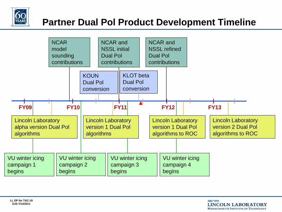
Partner Dual Pol Product Development Timeline
NCAR and
NSSL initial
Dual Pol
contributions
FY09 FY10 FY11 FY12 FY13
VU winter icing
campaign 2
begins
Lincoln Laboratory
alpha version Dual Pol
algorithms
NCAR
model
sounding
contributions
Lincoln Laboratory
version 2 Dual Pol
algorithms to ROC
NCAR and
NSSL refined
Dual Pol
contributions
Lincoln Laboratory
version 1 Dual Pol
algorithms
VU winter icing
campaign 3
begins
KOUN
Dual Pol
conversion
KLOT beta
Dual Pol
conversion
VU winter icing
campaign 1
begins
Lincoln Laboratory
version 1 Dual Pol
algorithms to ROC
VU winter icing
campaign 4
begins

LL DP for TAC-20
DJS 7/14/2011
Icing Hazard and Hail Hazard Products
-20 C
0 C
Gridded Flat Polar Output
Class
Altitude Top/Bottom
• Identify 3D hazard regions in radar
volume
• Version 1 with NEXRAD hydrometeor
classification, T/RH model soundings, and
dual pol fields (target summer 2011)
• Version 2 with added techniques from
Lincoln Laboratory and partner labs
(target delivery in out years)
• Will need surface data and/or additional
sounding fields
• 1o x 1 km grid to 300 km range
• Top/bottom altitude of hazard per grid point
• Severity and confidence indices in final version
• LL/FAA readiness decision in 2011
• Hand off to ROC in early 2012

LL DP for TAC-21
DJS 7/14/2011
Outline
• Automated Microburst Detection Algorithm (AMDA)
• Dual Pol Algorithm Development Plan
• Icing Hazard
• Hail Hazard
• Data Quality Improvement
• High Res VIL Recovery

LL DP for TAC-22
DJS 7/14/2011
Complete Icing Hazard Coverage
B. ICING HAZARDS BENEATH LOWEST SCAN AND ABOVE SURFACE
Snow, sleet, rain, freezing rain, supercooled water
A. ICING HAZARDS WITHIN RADAR VOLUME FOR EN ROUTE APPLICATIONS
Supercooled water, ice crystals
C. ICING HAZARDS AT SURFACE FOR TERMINAL APPLICATIONS
Snow, sleet, rain, freezing rain
TEMPERATURE oC
0
HE
IGH
T A
GL
FREEZING LEVEL
ALTITUDE
PLUS
Radar Volume Thermodynamic Sounding
A
B B
C
A

LL DP for TAC-23
DJS 7/14/2011
Discover Supercooled Water in Dual Pol Data (from: Bailey and Hallett (2009)
assemblages
of thin plates
compact assemblages
of plates, thick & thin plates
thin
skeletal
plates
thin plates
thick plates
Range of
+ZDR
„Bright Bands‟
Supercooled
cloud
droplets
shrink
ice
crystals
expand
water vapor
The dendrite and plate
regimes respond differently
to supercooled water
(icing) and yield different
dual pol signature
combinations

LL DP for TAC-24
DJS 7/14/2011
Valparaiso University‟s
Winter Weather Verification Campaigns

LL DP for TAC-25
DJS 7/14/2011
Sounding Augments +ZDR Bright Band Interpretation
• +ZDR Bright Band often noted within the -9o to -15o C temperature range
• Moderate rime icing PIREPs often associated with the -9o to -15o C altitude
• LL, NSSL, and NCAR discussing relevance of this feature to the icing hazard
• Plan to integrate +ZDR Bright Band concept into Icing Hazard product
Sounding VLP Dual Pol C-band ZDR RHI
+ZDR Bright Band
Melting Layer Bright Band

LL DP for TAC-26
DJS 7/14/2011
NSSL – Surface Typing Technique
• Determine background winter weather classifications using RUC or HRRR model thermodynamic vertical profiles
• Add dual polarization identification of elevated warm layer (bright band) to get final surface classification
• Extends range from radar that surface classifications will be possible

LL DP for TAC-27
DJS 7/14/2011
NCAR – Non-constrained Icing Hazard Levels (IHL)
Algorithm Development
• Two IHL approaches – Using current HCA augmented with CIP-like
use of model thermodynamic profiles etc. – Using additional NCAR components (above)
for later version(s) Will NEXRAD ORPG environment support? Will NextGen Weather Processor be more
appropriate?
• Data sources
– MAP via NCAR SPOL with in situ aircraft
– CHILL radar
– NEXRAD DP
PID = NCAR Particle Identification algorithm
CIP = NCAR Current Icing Potential product
LL DP for TAC-28
DJS 7/14/2011
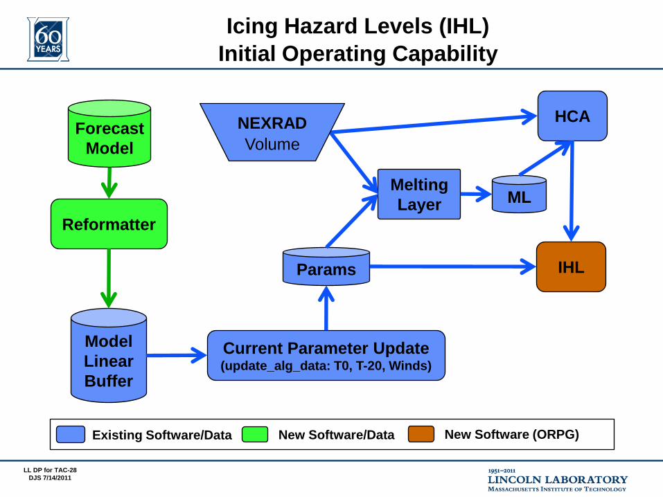
Icing Hazard Levels (IHL)
Initial Operating Capability
Current Parameter Update (update_alg_data: T0, T-20, Winds)
Reformatter
Model
Linear
Buffer
HCA
IHL
Forecast
Model
Melting
Layer ML
Params
Existing Software/Data New Software/Data New Software (ORPG)
NEXRAD Volume

LL DP for TAC-29
DJS 7/14/2011
Icing Hazard Levels (IHL)
CIP-Enhanced Environmental Support
Current Parameter Update (update_alg_data: T0, T-20, Winds)
Model Grid Ingest
Reformatter
Model
Linear
Buffer
HCA
IHL
Forecast
Model
Melting
Layer ML
Params
CIP-like
Gridded
Inputs
Existing Software/Data New Interim Software New Software (ORPG)
T0, T-20,
CIPt,
CIPrh
Volume
NEXRAD Volume
CIP = NCAR Current Icing Potential product

LL DP for TAC-30
DJS 7/14/2011
• Melting Layer Detection Algorithm – Some minor errors in the MLDA layer calculation – Default freezing level important
Updated to ingest RUC model data for defaults
– Spatial changes are important in icing situations Freezing level or levels evolve during the storm Current algorithm uses only the radar location for freezing level Updating to create dynamic freezing level from merging model
and MLDA over entire grid
• Hydrometeor Classification Algorithm categories – Thresholding based on melting level limits flexibility – Icing algorithm may benefit from understanding „confusion
matrix‟ rather than single category
• Verification – Hail and differentiation of liquid/frozen categories are easily
verified based on ground observations – Refining verification of graupel, wet snow, dry snow, etc.
more challenging Working on utilizing manual/automated techniques to verify
frozen categories with greater differentiation
Icing Hazard Levels (IHL) Development Challenges

LL DP for TAC-31
DJS 7/14/2011
HCA Relationship to Icing Hazard
HCA Classification Key
Current HCA Category
Not in HCA
Not enough information
to classify
Icing Hazard Key
Icing:
Conditional:
Unknown:
None:
Definitive icing region
Potential hazard based on
fluctuations in freezing level
More research is needed
No icing

LL DP for TAC-32
DJS 7/14/2011
Zdr = 0.5 RA HR RH BD BI GC DS WS IC GR Sum
HCA Weight 0 0 0.8 0 0.06 0.4 0.8 0 0.6 1.0 3.66
% 0 0 22% 0 2% 11% 22% 0 16% 27% 100%
Sensitivity of HCA Parameter Weighting Functions
Small variations in Zdr result in large impacts to HCA
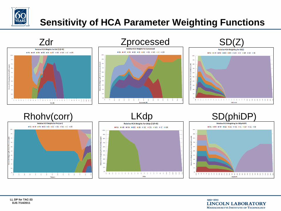
LL DP for TAC-33
DJS 7/14/2011
Zdr Zprocessed SD(Z)
Rhohv(corr) LKdp SD(phiDP)
Sensitivity of HCA Parameter Weighting Functions

LL DP for TAC-34
DJS 7/14/2011
NCAR Method for Detection of Melting Level Altitude
The data difference between the center
(green) region and the non-center (blue
and red) regions are computed and a
derived value 'Ring(r,a)' is computed for
that point
NCAR method is applied to Z, ZDR, ρhv
for all elevation angle scans and then
combined for consensus
Differential Reflectivity
Ring Analysis
Clumping Analysis
9.1 degree elevation
Single Field Example

LL DP for TAC-35
DJS 7/14/2011
LL Implementation of
NCAR Detection of Melting Layer Altitude
• Valparaiso University dual pol data used
• Challenging double melting layer case
• Extend logic to other challenging cases and possibly +ZDR bright band
Reflectivity Sample Max. Ring Analysis
Clumping Analysis
4.3 degree elevation Multi-Field Example

LL DP for TAC-36
DJS 7/14/2011
Transform Model Data to NCAR CIP Interest Products
Centered at Valparaiso
RUC-13 km
Full Grid
Subsample
~800 km2
Membership
Functions
Interest
Grids
Temperature
Relative Humidity
LL has added operational model capability to
NEXRAD ORPG Common Operations and Development Environment
CIP = NCAR Current Icing Potential product

LL DP for TAC-37
DJS 7/14/2011
Apply NCAR CIP Interest Products to Valparaiso Data
warm layers
CIP = NCAR Current Icing Potential product

LL DP for TAC-38
DJS 7/14/2011
Icing Hazard Levels (IHL) Flow Revisited
CIP - Interest
HCA
Graupel
Ice crystals
Big Drops
Rain/Hail
Light/Mod Rain
Heavy Rain
CIP - Temp
CIP - RH
Merge HCA and
CIP interest fields
Determine icing
hazard regions
(horizontal &
vertical extent)
Adjust for
thermodynamic
profile and
multiple freezing
levels
Multi-level
Icing Hazard
Assessment
HCA = NEXRAD Hydrometeor Classification Algorithm
CIP = NCAR Current Icing Potential product

LL DP for TAC-39
DJS 7/14/2011
Icing Hazard Levels Example
KOUN
02/24/2011
1653 UTC
IHL – Graupel Tops IHL – Dual Hazard Synthesis

LL DP for TAC-40
DJS 7/14/2011
Outline
• Automated Microburst Detection Algorithm (AMDA)
• Dual Pol Algorithm Development Plan
• Icing Hazard
• Hail Hazard
• Data Quality Improvement
• High Res VIL Recovery

LL DP for TAC-41
DJS 7/14/2011
Hail can be displaced from the
updraft core for LP (low
precipitation ) supercells
Hail Hazard Layers (HHL) Product
• HHL Addresses – Unexpected hail aloft – Identify early hail potential
(indicator of future cell intensity)
• Supplement use of current NEXRAD hail algorithm by FAA weather systems
– Provide vertical extent of hazard
– ITWS operational use – WARP receives product
HAIL LAYER TOP
HAIL LAYER BOTTOM
INCLUDE
HCA
ANALYSIS
Heinselman and Ryzhkov (2006)
show hail class algorithm with
CSI of 89% vs. 56% for traditional
algorithm

LL DP for TAC-42
DJS 7/14/2011
Hail Hazard Layers (HHL) Product Comparison
Hydrometeor Classification for mid-level
scan of radar volume (red indicates
rain/hail class)
Triangles are storm cells with hail identified by the legacy Hail algorithm. Large triangles
represent greater hail likelihood. Filled triangles represent greater severe hail likelihood.
HHL volume product depicting top
altitude of hail found in radar volume by
azimuth and range
02/10/2009
22:02 UTC
KOUN

LL DP for TAC-43
DJS 7/14/2011
NSSL Large Hail Sizing Technique
Hail Hazard
Giant Hail
1-2” Wet Hail?
Dry Hail ?
• NEXRAD HCA rain/hail class is the basis for sizing of large hail
• NSSL method for large hail (> 2.5 cm dia.) uses Z, ZDR, ρhv, and height from melting layer
• Sizing logic will be a sidebar to NEXRAD HCA
• Small and giant hail sizing targeted for future
LL DP for TAC-44
DJS 7/14/2011
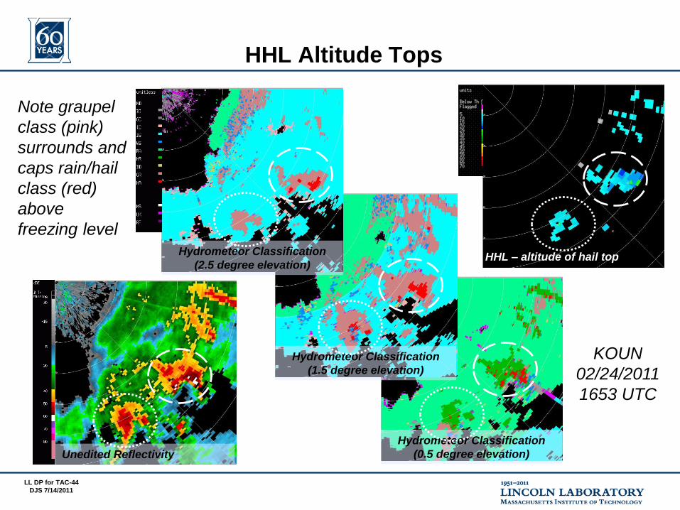
HHL Altitude Tops
HHL – altitude of hail top
Unedited Reflectivity
Hydrometeor Classification
(2.5 degree elevation)
Hydrometeor Classification
(1.5 degree elevation)
Hydrometeor Classification
(0.5 degree elevation)
Note graupel
class (pink)
surrounds and
caps rain/hail
class (red)
above
freezing level
KOUN
02/24/2011
1653 UTC

LL DP for TAC-45
DJS 7/14/2011
Outline
• Automated Microburst Detection Algorithm (AMDA)
• Dual Pol Algorithm Development Plan
• Icing Hazard
• Hail Hazard
• Data Quality Improvement
• High Res VIL Recovery

LL DP for TAC-46
DJS 7/14/2011
FAA Data Quality Assurance (DQA)
Radial Constant Power Removal Modules
Constant Power Constant Power Solar Strobe
Before editing
After editing
All images are precipitation products
All radials with the
same power
Each radial with
different power
Predictable Position
75 dBZ
0
75 dBZ
0
75 dBZ
0
75 dBZ
0

LL DP for TAC-47
DJS 7/14/2011
FAA Data Quality Assurance (DQA)
Elevation tilt-based Removal Modules
Speckle Spike AP
Before editing
After editing
All images are precipitation products
Isolated in azimuth Spatially isolated High reflectivity
zero Doppler

LL DP for TAC-48
DJS 7/14/2011
Hybrid DQA Evolution
• Up-convert logic modules to account for improved resolution data (¼ km, 1 deg. and ¼ km, ½ deg.)
• Integrate Dual Pol Hydrometeor Classification for removal of Ground Clutter and Biologicals
• Integrate up-convert and dual pol based modules into Hybrid DQA
• Work with NSSL, ROC, and Air Force to add class to Hydrometeor Classification Algorithm to IDENTIFY CHAFF HRVIL HREET
HCA
NEXRAD
Elevation
DQA
HYBRID DQA
Z_DQA

LL DP for TAC-49
DJS 7/14/2011
Hybrid DQA Example – KOUN Feb. 24, 2011 1653 UTC
FAA Data Quality Edited Reflectivity
(new elev. product)
Hydrometeor Classification
(debut elev. dual pol product)
FAA Data Quality Edited Reflectivity
(future HYBRID product)
Data Quality Edited Reflectivity
(using HCA BI and GC classes only)
Unedited Reflectivity (current
legacy and super res products)

LL DP for TAC-50
DJS 7/14/2011
Path to the Future in NEXRAD Dual Pol Era
Super Res for
Low Elevation
Scans to 1.5o
¼ km, ½o
with ORDA CMDA
Regular Res for
Elevation Scans
above 1.5o
¼ km, 1o
NO ORDA CMDA
Severe AP
possible up to
mid-volume scans Super Res Reflectivity
(current elev. product)
Regular Res Reflectivity
(current elev. product)
Hydrometeor Classification
(debut elev. dual pol product)
FAA Data Quality Edited Reflectivity
(new elev. product)
For All Scans
Best available res.
Possible for
NextGen Segment 0
No ORDA CMDA
with dual pol; to
be restored circa
2014
For All Scans
¼ km, 1o
Future new classes
such as chaff
Will incorporate
non-weather
hydrometeor
classes to further
improve quality
FAA likely needs
aviation-specific
classifier as HCA
evolves for precip
estimation use
SNOW
CRYSTALS
CLUTTER

LL DP for TAC-51
DJS 7/14/2011
Outline
• Automated Microburst Detection Algorithm (AMDA)
• Dual Pol Algorithm Development Plan
• Icing Hazard
• Hail Hazard
• Data Quality Improvement
• High Res VIL Recovery
LL DP for TAC-52
DJS 7/14/2011
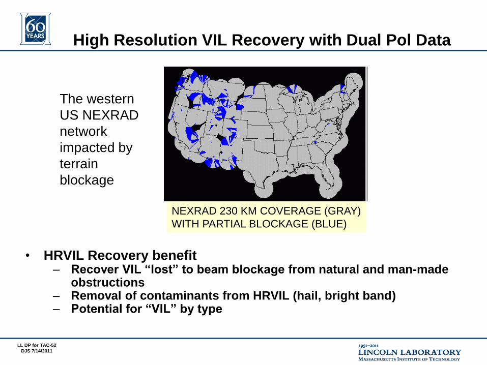
High Resolution VIL Recovery with Dual Pol Data
• HRVIL Recovery benefit – Recover VIL “lost” to beam blockage from natural and man-made
obstructions
– Removal of contaminants from HRVIL (hail, bright band) – Potential for “VIL” by type
The western
US NEXRAD
network
impacted by
terrain
blockage
NEXRAD 230 KM COVERAGE (GRAY)
WITH PARTIAL BLOCKAGE (BLUE)

LL DP for TAC-53
DJS 7/14/2011
Partial Beam Blockage Mitigation Using
Dual Polarization
• Bias in Z due to partial beam blockage (PBB) negatively affects downstream algorithms (VIL, QPE)
• Dual polarization provides capabilities to mitigate PBB through specific differential phase (KDP) derived from differential phase (ΦDP), which is immune to blockage
• LL and NSSL found NEXRAD KDP product not satisfactory to mitigate partial beam blockage
Does blockage
exist?
Yes
Compute liquid water
content M using Z
M = 3.44 * 10-3 Z4/7
Compute liquid water
content M using KDP
M = 0.34 * (KDP λ)0.702
No
Example logic to mitigate PBB for VIL
QPE = Quantitative Precipitation Estimate λ = wavelength
VIL = Vertically Integrated Liquid Z = reflectivity

LL DP for TAC-54
DJS 7/14/2011
• Robust method is based on the general idea of consistency between reflectivity Z, specific differential phase KDP, and differential reflectivity ZDR in rain
– NSSL method based in the power-law KDP – Z relation (Ryzhkov et al. 1997)
KDP = a * Zb
• Variable intercept a is determined on the scan-to-scan basis using the data in unblocked azimuthal directions
– Primary variability of factor a is due to changes in drop size distributions that will vary from storm-to-storm
– A climatological beam blockage fraction map is created to cover all azimuths for elevation scans with blockage
• Radial integrals of KDP (i.e., ΦDP) and Z are computed for each radial – Ratio of integrals compared in regions with and without blockage and
correction applied to Z
• Method has potential to work in areas of significant (> 50%) blockage and accounts for dynamic atmosphere and earth surface changes
NSSL Z-ΦDP Method to Adjust Z
for Partial Beam Blockage

LL DP for TAC-55
DJS 7/14/2011
Climatological Beam Blockage
DEM = Digital Elevation Map
Buildings
Mountain
Observed VIL
Corrected VIL

LL DP for TAC-56
DJS 7/14/2011
Summary
• LL is operating and evaluating new dual pol algorithm products 24/7 live via KOUN data
– Icing Hazard and Hail Hazard – Also hybrid dual pol data quality products
• Important contributions from partner scientists being evaluated and implemented to address multiple challenges
– Additional contributions in development
• Collaborative discussion continues to relate the microphysics of mixed-phase conditions to robust dual pol signatures usable in real-time algorithms
• Spring/summer season will provide further opportunity to quantify performance of NEXRAD AMDA
• Version 1 dual pol algorithms could be transferred to the ROC by early 2012