library feasibility study
TRANSCRIPT

Library Feasibility Study
PREPARED FOR
District of Columbia Public Library Foundation
June 2006

THIS PAGE LEFT INTENTIONALLY BLANK
PREPARED BY
EDAW, IncIN ASSOCIATION WITH
Gorove/Slade Associates, Inc. JUNE 2006

1.0 Introduction1.1 Introduction 11.2 Scope of Study 11.3 Design Concept 3
2.0 Technical Analysis 2.1 Existing Land Uses and Characteristics 52.2 Historic Resources 132.3 Natural Environment 192.4 Underground Infrastructure 212.5 Accessibility 232.6 Anticipated Costs 31
3.0 Recommendations3.1 Potential Challenges/Approaches 333.2 Mitigation Strategies 353.3 Agency Approach 373.4 Conclusions 39
Contents
DC PUBLIC LIBRARY FOUNDATION/ INTRODUCTIONiv
MOUNT VERNONSQUARE
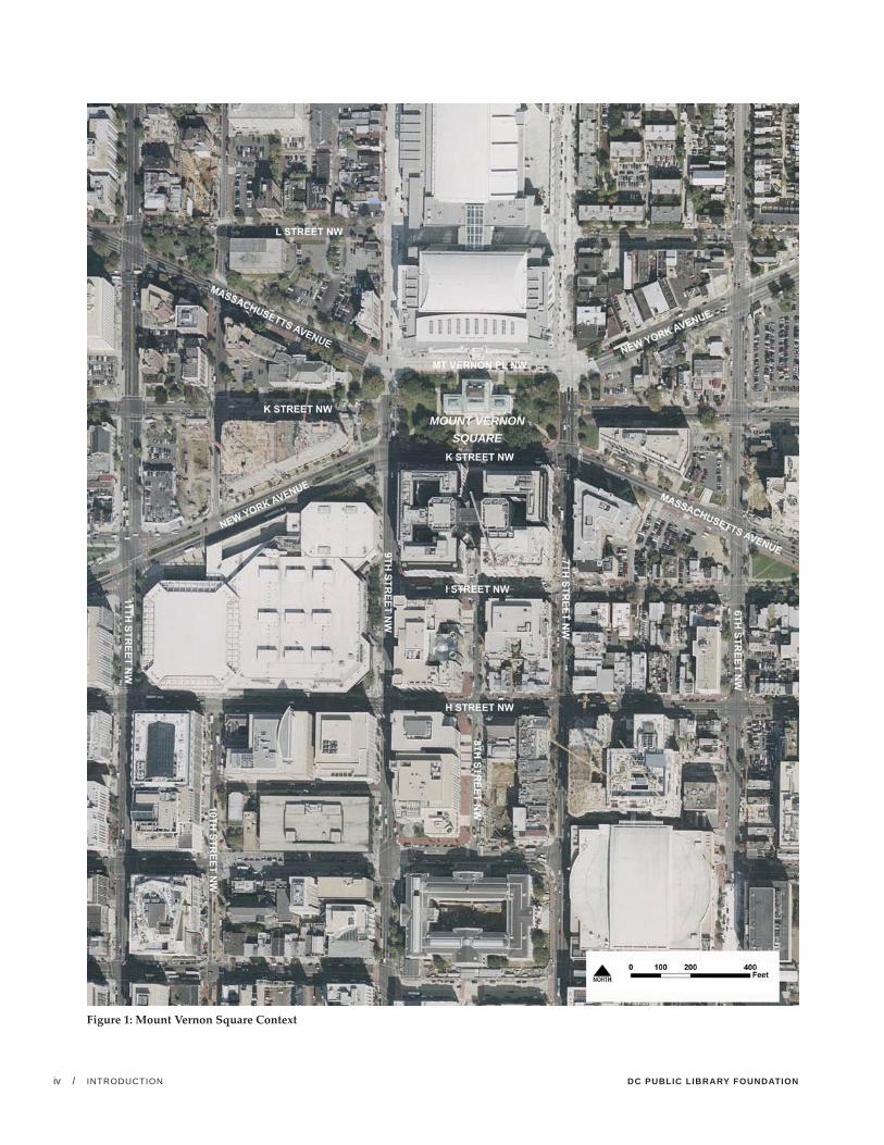
Figure 1: Mount Vernon Square Context

LIBRARY FEASIBILITY STUDY /INTRODUCTION 1
Introduction
1.0
1.1 Introduction
The modern library is evolving in bold new ways to meet the current and future needs of the 21st Century. In the District of Columbia, the vision for a new public library system is one that will, “serve the people of Washington, be a safe and inviting place for learning and a welcome site for community gathering.” To shape this vision, the Mayor’s Task Force on the Future of the District of Columbia Public Library System, in its draft recommendations A Blueprint for Change, proposes to develop state-of-the-art facilities that would provide world class service to DC residents. Leading the upgrade of the library system would be a new Central Library envisioned to, “serve as a visible state-ment about the value of reading, education, and lifelong learning,” and provide, “a key civic space that residents use throughout their lifetime.”
DC is not unique in seeking to update its library system. In recent years, several library systems across the country (including cities such as Los Angeles, Phoenix, New York and Seattle) have undertaken major renovation efforts, seeking to redefine the role of a library system in the new era of the digital age.
1.2 Scope of the Study
This study was undertaken on behalf of the District of Columbia Public Library Foundation. The purpose of the study is to determine the feasibility of constructing a 21st Century Central Library at Mount Vernon Square, which is the current site of the historic Carnegie Library building. Mount Vernon Square was the location of the District’s original Central Library from 1903 until 1972, when it was relocated to the Martin Luther King, Jr. Memorial Library.
For purposes of this study, “feasibility” will be determined by examining the following:
• An appropriate degree of multi-modal accessibility and traffi c safety adjacent to the site for library users;
• A reasonable and justifi able cost for constructing a new Central Library, including access to parking; and
• The ability to design and construct the Central Library within a reasonable timeframe, including the likelihood of receiving approvals from the relevant boards and commissions with jurisdiction over the proposed site.

DC PUBLIC LIBRARY FOUNDATION/ INTRODUCTION2
Figure 2: Conceptual Massing Plans; the above-ground massing of the potential new building would frame the existing Carnegie Library building. (Source - Polshek Partnership Architects)
N

LIBRARY FEASIBILITY STUDY /INTRODUCTION 3
1.3 Design Concept
This building feasibility study considers a conceptual massing design concept for a new Central Library at the Mount Vernon Square site prepared by Polshek Partnership Architects. To accommodate the building program for a state-of-the-art library, the design concept envisions reusing the Carnegie Library building and adding new structures on the north, east and west side of the Carnegie Library. The southern side of the Carnegie Library would remain open.
The new structures would extend five- to six-stories above ground. In addition, a basement would be added across the entire square, and would extend two- to three-stories below ground. A third story below grade could accom-modate parking, if the need to provide spaces on-site is established. The main entrances to the building would occur from the north side through the new structure, or
from the south side through the current front door of the Carnegie Library.
According to the project architects, the building massing illustrated reflects a total of approximately 515,000 square feet. This is more space than the approximately 315,000 square feet that is required by the library program. The concept diagram was developed to understand the maximum volume that could fit on the site. To accommo-date the required program for the central library, approxi-mately 63,000 square feet within the Carnegie Library would be supplemented with approximately 252,000 square feet of new construction. Approximately 161,000 square feet of the new construction would be above grade and approximately 92,000 square feet below grade.
Figure 3: Conceptual Massing Cross-Section; a potential massing of a new structure is indicated in line drawings and the Carnegie Building is shown with shading. (Source - Polshek Partnership Architects)

DC PUBLIC LIBRARY FOUNDATION/ TECHNICAL ANALYSIS4
Figure 3: Study Area

LIBRARY FEASIBILITY STUDY /TECHNICAL ANALYSIS 5
Technical AnalysisFor the purpose of this analysis, the study area was defined by a quarter-mile radius surrounding the square. This represents a typical five-minute walking distance.
2.1 Existing Uses and Characteristics
Adjacent Land Uses
Mount Vernon Square is located at the northern edge of downtown Washington, DC, between 7th and 9th Streets, NW, and Mount Vernon Place and K Street, NW. The square is located at the edge of the Shaw neighborhood which extends north from K Street to Florida Avenue; and adjacent to Mount Vernon Triangle, which is located to the east between New York Avenue and Massachusetts Avenue.
Mount Vernon Square has historically been used for civic buildings. Once the original site of the DC Public Library, it was recently renovated to accommodate the District’s City Museum. The area within a quarter mile of the site is characterized by commercial, institutional, residential, open space, and religious uses, and vacant land.
Located immediately to the north, the Washington Convention Center, a 2.3 million-square-foot meeting and convention facility, provides a public use overlooking the square. Medium- and high-density residential uses are also located nearby. Other land uses to the north include a mix of religious, educational, commercial and heavy commer-cial uses.
The area south of Mount Vernon Square includes Washington’s original downtown area, which has become increasingly popular as an entertainment district in recent years. There is a mix of commercial office, retail, residen-tial, and surface parking uses in the area.
The International Trade Center, known as Techworld, is located immediately to the south of the square, and houses technology and information industries. Chinatown, located two blocks south of the site, contains mostly commercial uses that are dominated by restaurants, retail franchises and local shops. East of 7th Street, there are both neigh-borhood-scale and regional-scale commercial uses, and high-density residences.
The areas to the east and west have seen an increased amount of new apartments and condominiums, spurred by the emerging entertainment uses and a strong housing market. (See Appendix A for recent and planned develop-ment in the area).
The area to the northeast of the square includes a mix of small garden style apartments, high-density apartment buildings, commercial uses, and vacant sites. This area also includes the Mount Vernon Square Historic District, which extends roughly from 7th Street to First Street, and from New York Avenue north to N Street.
The area east of Mount Vernon Square includes a mix of uses including commercial, institutional, high- and medium-density residential, open space, parking, and vacant uses. Commercial development includes small scale, independent retail uses (many with two stories of residences above the ground floor), that are interspersed with vacant lots, vacant buildings, and parking lots. An increased amount of residential uses are located to the northwest of the site that include renovated townhouses, walk up apartments, and high-density residential build-ings.
Zoning
Mount Vernon Square is located on Square 403N, zoned for government use (GOV). Development of the square is not subject to zoning regulations because of its federal ownership. However, redevelopment of the site may be influenced by nearby zoned properties that are located within the Downtown Development District Overlay District (DD). The DD overlay takes precedence over any underlying zoning in the area and permits incentive requirements for developments with a maximum FAR of 6.0 to 10.0, a maximum height of 130 feet (in accordance with the Buildings Height Act of 1910), and maximum lot occupancy of 100 percent.
Generally, land uses permitted in the area include medium- to high-density office, retail, housing, and mixed-use development. The area further to the north and southeast also allows moderate development of general residential uses, including single-family dwellings, flats, and apart-ment buildings.
2.0

DC PUBLIC LIBRARY FOUNDATION/ TECHNICAL ANALYSIS6
Figure 5: Generalized land uses in the surrounding area (Source - DCOP)

LIBRARY FEASIBILITY STUDY /TECHNICAL ANALYSIS 7
POT EN T I AL OP PORT U N I T I ES A N D ISSU ES
Relocating the library to the Mount Vernon Square site would provide for the expansion of the facility as an important public education resource, and allow the historic use of the site for civic purposes to continue. The library would become a prominent stand-alone destination with high visibility and prominence . Also, the Mount Vernon Square location would place the library close to existing residential areas to the north, providing easy access to this resource by residents of the adjacent neighborhoods.
As a land use, there is some potential for conflict between the Convention Center, which serves as a destination for generally out-of-town visitors, and the library, which would primarily serve the city and area residents.
Zoning regulations of nearby areas to the north allow for increased residential development. This potential growth could add more residents proximate to the Mount Vernon Square site who could benefit from the library at this location.
Urban Design Characteristics
Mount Vernon Square is a prominent open space located at the convergence of Massachusetts and New York Avenues, two of the city’s most significant and high-volume diagonal streets. It is also situated on the 8th Street axis.
The square includes two combined city blocks within Washington, DC’s rectilinear street grid and it is located at the seam between two general character areas. The areas towards the south, east and west reflect a denser pattern of development, with taller and more dominant buildings; whereas, the area to the north (with the exception of the Convention Center) consists of lower-density develop-ment, where building are lower (three- to five-stories) and smaller in scale.
The square itself is primarily a park, with mature deciduous trees, walks and benches, in a highly developed area. The focal point of the square is Carnegie Library, a symmetrical, white marble Neoclassical building situated in the center of the square. The surrounding walks and plantings respond to the building’s symmetrical design and alignment on the axis of 8th Street, N.W. The streetscape surrounding the square is paved in brick with a raised concrete edge on the park side of the sidewalk, creating lawn areas slightly higher than the sidewalk.
Beyond the adjacent streets, built edges define the northern and southern extents of the square. To the north, the new Convention Center, with its glass and stone-clad façade, establishes a strong presence, where the building extends the entire distance between 7th and 9th Streets. To the south, the 9- to 12-story Techworld Building (which includes the Renaissance Hotel) provides another vertical edge to the square that extends from 7th to 8th Streets, and from 8th to 9th Streets. The Techworld Building frames a view between the Carnegie Building and the Old Patent Office Building to the south along 8th Street, although the view is constrained by an elevated, dark glass walkway that connects two towers of the building.
Beyond 7th and 9th Streets, the eastern and western edges of the square are not as well defined. Three free-standing buildings provide narrow and tall elements facing the square.
POT EN T I AL OP PORT U N I T I ES A N D ISSU ES
The relocation of the main library to the Mount Vernon Square site would provide an opportunity to reinforce the importance of the prominent square. It could also allow for effective transitions between the lower density neighbor-hood to the north and the higher density neighborhoods east, west and south of the site. However, the proposed development would block views along Massachusetts and New York Avenues from the north, and would diminish park area and open space in a densely developed area of the District.

DC PUBLIC LIBRARY FOUNDATION/ TECHNICAL ANALYSIS8
Figure 6: Adjacent land uses include the New Convention Center (upper image), the Chinatown area (lower left image) and the still-developing New York Avenue corridor (lower right image).

LIBRARY FEASIBILITY STUDY /TECHNICAL ANALYSIS 9
Planning Policies
Redevelopment of the Carnegie Library and Mount Vernon Square would be influenced by several District and Federal planning policies as discussed below:
COM P R E H ENSI V E P L A N
Redevelopment of the Carnegie Library and Mount Vernon Square would be influenced by the District Elements of the Comprehensive Plan. The existing plan was last revised in 1998. A new plan is under development and was released in draft form in May 2006 for public review. The following discussion briefly summarizes the 1998 plan and then focuses on the relevant policies from the 2006 draft plan.
COM P R E H ENSI V E P L A N FOR T H E NAT IONAL C A PI TAL ,
DIST R IC T ELEM EN TS, 19 9 8
The goals and objectives of the 1998 issuance of the Comprehensive Plan include policies related to urban design, the stabilization of neighborhoods, preserva-tion and historic features, and the development of the downtown. Overall, the objectives seek to preserve the city’s historic fabric and enhance its physical image. Regarding Mount Vernon Square, the plan states that the area will experience growth and redevelopment early in the 21st century, forming a transition between the core of Downtown to the south and the Shaw community north of M Street. A complete listing of applicable policies from the 1998 plan is provided in the Appendix.
COM P R E H ENSI V E P L A N FOR T H E NAT IONAL C A PI TAL ,
DIST R IC T ELEM EN TS, DR A F T, M AY 2 0 0 6
Community Services and Facilities Element
The goal for community services and facilities is to “provide high-quality, accessible, efficiently managed, and properly funded community services and facilities to support the efficient delivery of municipal services, protect public health and safety, and enhance the well-being of current and future District residents.” Policies in support of this goal include:
• Construct, rehabilitate, and maintain the facilities necessary for the effi cient delivery of public services to current and future District residents;
• Locate new public facilities to support economic devel-opment and neighborhood revitalization eff orts;
• Ensure that the District has a state-of-the-art Central Library and branch libraries that meet the information and life-long learning needs of District residents; and
• Explore public-private partnerships to fund the construction of new libraries, including the develop-ment of new and remodeled libraries within mixed use projects on existing library sites. In such cases, any redevelopment should conform to the other provisions of the Comprehensive Plan, including the protection of useable neighborhood open space.
Urban Design Element
The broad goal for urban design in the District is to “enhance the livability of the city by protecting its historic design legacy, reinforcing the identify of its neighborhoods, harmoniously integrating new construction with existing buildings and the natural environment, and improving the vitality, appearance, and security of streets and public places.” Specific policies in support of this goal include:
• Respect and reinforce the L’Enfant and McMillan Plans to maintain the District’s unique, historic, and grand character. This policy should be achieved through a variety of urban design measures, including appropriate building placement, view protection, enhancement of L’Enfant Plan reservations (green spaces), limits on alley closings, and the siting of new monuments and memo-rials in locations of visual prominence;
• Protect the civic and historical character of the city, particularly the “horizontal” urban quality of Central Washington, by limiting building heights in accordance with the Height Act of 1910;
• Recognize and protect major views in the city, particu-larly characteristic views of city landmarks. Recognize the importance of views to the quality of life in the city and the identity of Washington and its neighborhoods;
• Protect views and view corridors along boulevards, particularly along streets that terminate at important civic monuments or that frame distant landmarks. Vistas along such streets should be accentuated by creating more well-defi ned street walls, improving land-scaping, and requiring the highest architectural quality as development takes place;
• Establish and maintain scale and density transitions between Downtown and adjacent lower density neigh-borhoods. Use variations in height, massing, and archi-tectural quality to ensure that the fi ne-grained patt ern of adjacent neighborhoods is protected;
• Preserve the architectural continuity and design integ-rity of historic districts and other areas of strong archi-tectural character. New development within such areas

DC PUBLIC LIBRARY FOUNDATION/ TECHNICAL ANALYSIS10
Figure 7: Some of the defi ning features of the L’Enfant Plan include its diagonal and grid vistas, including New York Avenue (upper image), Massachusett s Avenue (lower left image) and K Street NW (lower right image).

LIBRARY FEASIBILITY STUDY /TECHNICAL ANALYSIS 11
does not need to replicate prevailing architectural styles exactly but should be complementary in form, height, and bulk;
• Ensure that infi ll development respects and improves the integrity of neighborhood open spaces and public areas. Buildings should be designed to avoid the loss of sunlight and reduced usability of neighborhood parks and plazas; and
• Require design excellence for all public buildings, with government leading by example to create a more att rac-tive environment in the city and its neighborhoods. Important civic places, such as schools and libraries, should be individually designed to foster community identity and neighborhood character.
Historic Preservation Element
The overall goal for historic preservation is to “preserve and enhance the unique cultural heritage, beauty, and iden-tity of the District of Columbia by respecting the enduring value of its historic structures and places, recognizing their importance to the citizens of the District and the nation, and sharing the mutual responsibilities for their protection and stewardship.” Specific policies in support of this goal include:
• Sustain exemplary standards of stewardship for historic properties under District ownership or control. Use historic properties to the maximum extent feasible when adding new space for government activities, promote innovative new design, and ensure that rehabilitation adheres to the highest preservation standards. Properly maintain both designated and eligible historic proper-ties and protect them from deterioration and inappro-priate alteration;
• Preserve the defi ning features of the L’Enfant and McMillan plans for Washington. Work jointly with federal agencies to maintain the public squares, circles, and major reservations as landscaped open spaces that provide a means to experience the legacy of the city plan. Preserve the historic patt ern of streets and associated minor reservations, and protect these historic rights-of-way from incompatible incursions and intru-sions;
• Protect and enhance the views and vistas, both natural and designed, which are an integral part of Washington’s historic image. Preserve the historic skyline and the low-rise character of the District of
Columbia through enforcement of the 1910 Height of Buildings Act;
• Protect the generous open space and reciprocal views of the L’Enfant Plan streets and avenues. Reinforce the spatial defi nition of the street network by encouraging property owners to align primary building facades along the historic building lines. Support public and private eff orts to provide and maintain street trees to help frame axial views and reinforce the city’s historic landscape character;
• Maintain historic properties in their original use to the greatest extent possible. If this is no longer feasible, encourage appropriate adaptive uses consistent with the character of the property;
• Preserve the important historic features of the District while permitt ing compatible new infi ll development. Ensure that new construction is in scale with and respects the character of its historic context through sensitive siting and design and the appropriate use of materials and architectural details; and
• Preserve the continuous and open green quality of landscaped front and side yards in public space. Take special care at historic landmarks and in historic districts to protect this public environment from intru-sions, whether form excessive paving, vehicular access and parking, high walls and fencing, or undue disrup-tion of the natural contours or bermed terraces.
DOW N TOW N AC T ION AGEN DA
Urban Design and Public Space Management
Strategy Three: Preserve Historic Resources
• Alterations and additions to historic landmarks should be compatible with the design, height, proportion, massing, confi guration, materials, texture, and colors within historic areas: The District of Columbia Historic Preservation Guidelines, available from the DC Historic Preservation Division should be followed. Residents in newly created historic districts (particularly those neigh-borhoods north of Mt. Vernon Square) should especially be encouraged to reference the Guidelines.
• Retain the neighborhood character near the new down-town Convention Center:
• Development around the new Convention Center should be designed to maintain the sense of neighbor-

DC PUBLIC LIBRARY FOUNDATION/ TECHNICAL ANALYSIS12
Figure 8: Sensitive historic resources consist of the Carnegie Library building (upper image), and the L’Enfant vistas that include the 8th Street vista (lower left image) and the Massachusett s Avenue vista looking towards the southeast (lower right image).

LIBRARY FEASIBILITY STUDY /TECHNICAL ANALYSIS 13
hood in the adjacent communities. Historic buildings should be preserved and the scale of new construction should be limited on historic sites.
Culture
Strategy Three: Attract Major Cultural Venues to Downtown
• It is paramount that major facilities for cultural arts be located Downtown. One-of a- kind venues, such as performing arts spaces, the MCI Center, and major museums, draw people to the Downtown area from the National Mall and the Convention Center. Marketing, financial, and regulatory incentives can help Downtown become the region’s focus for cultural arts perfor-mances and exhibitions. Downtown needs a multi-use facility that can serve as a cultural information hub for the District. A redeveloped and expanded Martin Luther King, Jr. Library could be adapted to serve as a dual-purpose cultural center and headquarters library. This site is ideal as it is near Gallery Place and is large enough to accommodate exhibits, performances, and other events. Another key opportunity is the existing Convention Center site, which can be redeveloped with a mix of cultural attractions and other uses.
POT EN T I AL OP PORT U N I T I ES A N D ISSU ES
Consistent with the District Elements, the relocation of the main library to the Carnegie Library building would provide a wonderful opportunity to return a historic building to its intended use. It would also provide opportunities to reinforce the view along the historic 8th Street axis, respect the Building Heights Act, and design the new structures such that they are compatible with the historic Carnegie Library building in terms of materials and architectural details. The greatest constraint is that the proposed plan would not maintain the historic L’Enfant Reservation as landscaped open space, but would create a developed urban block. It would also compromise views of the Carnegie Library building along the L’Enfant avenues north of the site.
2.2 Historic Resources
Mount Vernon Square is an original reservation on the L’Enfant Plan, located in a historic portion of the City. This section documents the historic resources that are present on the proposed site and within the immediate surrounding area. It also discusses the potential for archaeological features to exist on the site.
T H E C EN T R AL P U BLIC (C A R N EGI E) LI BR A RY
The Central Public Library (Carnegie Library) was listed in the DC Inventory of Historic Sites in 1964, and identified as a Category II Landmark which contributes significantly to the cultural heritage and visual beauty of the District of Columbia. It was also listed in the National Register of Historic Places in 1969. The nomination lists Education as the area of significance.
Currently housing the collections of the Historical Society of the District of Columbia, the Carnegie Library was constructed on the Mount Vernon Square site between 1899 and 1902. It is one of a series of libraries funded by Andrew Carnegie at the turn of the century. Following a design competition, the New York firm of Ackerman and Ross was selected to design the building. Their design exemplifies the national popularity of Beaux Arts Classicism and the influence of the McMillan Commission on the construction of public buildings during the early twentieth century.
The Carnegie Library building is an important example of Neoclassical style architecture in Washington, DC. Three stories in height, the building has basement walls and approaches of pink Milford granite and upper exterior walls of white Vermont marble. The main K Street façade is comprised of a central section with three arches, flanked on either side by pedimented single-bay end pavilions. A series of engaged Ionic columns separate the arches and are crowned by a frieze that reads “Science Poetry History.” The building is approached by a series of steps and a wide terrace, followed by another series of steps that become narrower approaching the front door. Curved granite seats flanked by pedestals and inscribed with the words “A University for the People” frame the steps leading to the single entrance door. A strongly dentiled cornice and attic story cap the main central section.

DC PUBLIC LIBRARY FOUNDATION/ TECHNICAL ANALYSIS14
Figure 9: Historic Resources

LIBRARY FEASIBILITY STUDY /TECHNICAL ANALYSIS 15
Three-story, bay end wings are located on either side of the central block of the building. The side wings consist of a low granite basement story and a high marble main floor separated from the low attic story by an overhanging cornice. The walls of the wings are divided into three recessed rectangular niches which contain large arched windows. On the north façade, the central section of the building is notable for its narrow vertical windows which originally provided light to the book stacks.
T H E L’ EN FA N T P L A N
Recognized as one of the country’s most notable achieve-ment in urban planning, Pierre Charles L’Enfant’s 1791 Plan for the City of Washington includes a coordinated system of radiating avenues, vistas, squares and parks overlaid upon an orthogonal grid of streets. Circles and rectangles formed by the intersection of avenues and streets were to be sites for monuments, memorials, and key civic build-ings. L’Enfant’s Plan identified the Mount Vernon Square site, at the intersections of New York and Massachusetts Avenues, as Reservation Number 2.
The Senate Park Commission of 1901, also known as the McMillan Commission, expanded on the L’Enfant Plan in a manner consistent with the City Beautiful movement. The McMillan Plan is significant because it represented the first effort to conduct systematic, comprehensive urban plan-ning for a major city. The McMillan Commission extended L’Enfant’s designs with the construction of waterfront parks on reclaimed land at the west end of the Mall, and the creation of new monuments and vistas.
The L’Enfant Plan is listed in the National Register of Historic Places. This nomination also recognizes compo-nents of the McMillan Plan that contribute to the plan of Washington, DC. Mount Vernon Square is a contributing feature within the L’Enfant Plan. It is one of fifteen original L’Enfant Reservations (originally Reservation Number 2, it is now referred to as Reservation 8). The L’Enfant Plan is also listed in the DC Inventory of Historic Sites.
The Mount Vernon Square site is located at the intersection of New York and Massachusetts Avenues, both contrib-uting avenues in the L’Enfant Plan. The vistas along these avenues are also contributing elements. Those from the south provide oblique views of the formal south façade of the library building.
Eighth Street, although closed to the north due to the Convention Center, is considered a major street within the Plan. The axial vista to the south, an important vista in
the L’Enfant Plan, connects the Carnegie Library with the Old Patent Office Building. The vista, however, has been compromised by an elevated portion of the Techworld building.
Mount Vernon Square is also bordered by L’Enfant streets and their associated vistas. Seventh and 9th Streets, both contributing streets, define the east and west boundaries of the site. K Street, designated a major street within the Plan, borders the site to the south. It also terminates at the eastern and western sides of the site, providing views of the sides of the library building. The vistas along K Street are further considered to be contributing features to the L’Enfant Plan.
OT H E R H ISTOR IC R ESOU RC ES LOC AT ED I N T H E
V IC I N I T Y
Several other historic resources lie in the area immedi-ately surrounding Mount Vernon Square. The American Federation of Labor Building, located at 901 Massachusetts Avenue, was designed by the firm of Milburn, Heister and Company in 1915 and 1916. Known as the “national labor temple,” the building was designated a National Historic Landmark in 1974, listed in the National Register in 1974, and listed in the DC Inventory in 1979. Across the street from the American Federation of Labor Building, the Mount Vernon Place United Methodist Church is notable for its high pedimented portico with Doric columns. It was listed in the DC Inventory in 1964.
East of Mount Vernon Square, the buildings in the 1000 block of 7th Street and 649-651 New York Avenue are Italianate commercial buildings typical of the 1870s in Washington. They are significant for their association with the local German merchants who served a growing immi-grant community. This group of buildings was listed in the DC Inventory in 1978 and the in the National Register in 1984. Finally, the Mount Vernon Square Historic District is located east of the Square, encompassing 429 contributing buildings in a variety of architectural styles dating from 1845 to 1945. A portion of a larger neighborhood that used to exist near Mount Vernon Square, the district is signifi-cant for its association with working-class residential and commercial history. It was listed in the DC Inventory and the National Register in 1999.

DC PUBLIC LIBRARY FOUNDATION/ TECHNICAL ANALYSIS16
Figure 10: The Carnegie Library building currently sits in a park sett ing (upper image). It was the original Central Library (lower left image) and shares a reciprocal vista with the Old Patent Offi ce Building along 8th Street NW (lower right image).

LIBRARY FEASIBILITY STUDY /TECHNICAL ANALYSIS 17
A RC H AEOLOGIC AL RESOU RC ES
Mount Vernon Square was originally part of a parcel known as Port Royal owned by Lynch and Sands, two of the original proprietors of the District of Columbia. According to the National Register nomination for the Carnegie Library, the square was undeveloped until 1840, when a fire house was erected on the southern portion of the site. In 1845, the Northern Liberty Market House was opened on the east side of the square. The market was torn down in 1872, part of a city-wide improvement plan spearheaded by the head of the Board of Public Works, Alexander Shepherd. Mount Vernon Square was then enclosed as a public park until construction began on the library in 1899.
Although prehistoric archaeological resources may have existed on the site, 19th century development would likely have disturbed any resources on the central, eastern and southern portions of the site. The western portion of the site has the highest likelihood for prehistoric archaeological resources, since it has remained undeveloped. Historic archaeological remains are possible on the east side of the site, due to its prior use as a market house.
Due to the potential for prehistoric and historic archaeo-logical resources to exist on the Mount Vernon Square site, archaeological research and testing should be conducted prior to undertaking ground disturbing activities.
POT EN T I AL OP PORT U N I T I ES A N D ISSU ES
The potential re-location of the main DC Public Library to Mount Vernon Square would provide a tremendous opportunity to reuse the Carnegie Library for its intended use. This is consistent with the Secretary of the Interior’s Standards for Rehabilitation. It would also maintain a civic use on the site, in keeping with the intent of the L’Enfant Plan.
There would, however, be adverse effects to historic resources resulting from the renovation and expansion of
the Carnegie Library building. As it currently exists, the Carnegie Library is set within a park. With the proposed additions to the building, the site would become a developed urban block. In the early 1950s, similar plans were made to build out the reservation to allow for the expansion of the library. The Commission of Fine Arts objected to the proposal based on the fact that it would have eliminated open space on the L’Enfant Reservation. To mitigate this, to the extent possible, the current plan should maintain a green buffer around the building, particularly in front of the main southern elevation.
There would also be adverse effects to important historic vistas. Views of the building from the north, along Massachusetts and New York Avenues, would be blocked by portions of the new building. To the extent possible, views of Carnegie Library from the south on Massachusetts and New York Avenues should be maintained, and the view north on the 8th Street axis (that connects the Old Patent Office Building to the Carnegie Library Building) should be enhanced.
The proposed renovation and additions to Carnegie Library would also have potential adverse effects on the library building itself. Under the proposed plan, the north elevation would be rebuilt and replaced with new construction. The east and west sides of the building would be obscured from vantage points along 7th and 9th Streets, but would be visible from the courtyard areas created on the east and west ends of the building. The effect of three structural portions of the new building surrounding and rising above the Library building could dwarf it, constituting a significant adverse effect. However, in the hands of a skilled architect, the new addition could frame Carnegie Library with a complementary backdrop. Such a design could be viewed as placing a jewel (the historic library building) within a jewelbox (the new addi-tions) and thus not detrimental to the historic building.

DC PUBLIC LIBRARY FOUNDATION/ TECHNICAL ANALYSIS18
Figure 11: The proposed new addition (the structural portions of the new building are indicated by yellow shaded areas in the upper image) would replace existing park area (a portion of which is shown in the lower left image) and disturb Special Trees (lower right image).

LIBRARY FEASIBILITY STUDY /TECHNICAL ANALYSIS 19
2.3 Natural Environment
Site Vegetation
The landscape of Mount Vernon Square consists of trees planted in a symmetrical but somewhat informal manner, typical of many of the squares, circles and triangular parks found along intersections of key avenues and streets on the L’Enfant Plan. There are approximately 60 trees, most of them mature, which provide an overall effect of a shaded park enclosing the Carnegie Library.
The species of trees found at Mount Vernon Square are varied, and include oaks, elms, buckeye, Japanese Pagoda, Japanese Zelkova and linden trees. Most of the street trees along 7th and 9th Streets are Japanese Zelkovas of mature size and appear to be in good condition. With their dense canopy and expansive size, these trees do much to create the green enclosure around the Carnegie Library. In addi-tion to these street trees, there are two very large White Oak trees, located symmetrically about the main building entrance to the south along the 8th Street axis. The western most White Oak has lost what appears to have been a major limb at approximately 20 feet above grade and is leaning to the north. The eastern most oak appears to be in good health with a full crown but some damage to the trunk at the base.
A large Red Oak, located on the northwest corner of the Square, appears to be in very good condition as is an American Basswood occupying a similar location on the northeast corner. A large and apparently health American Elm tree terminates the view looking west toward the Square from K Street.
The District of Columbia provides protection to “Special Trees” from unauthorized removal under the District’s Urban Forest Preservation Act of 2002. Special Trees are defined as any non-exempt tree having a circumference of 55” or greater at breast height (i.e., a diameter of 17.5” or greater measured at a height of 4.5 feet above grade). Three tree species are exempt from this Act: Ailanthus altissima (Tree of Heaven), Morus species (Mulberry), and Acer platanoides (Norway Maple). The Forest Preservation Act requires that Special Trees cannot be removed without a Special Tree Removal Permit. Further, in return for permitted removal of trees, an applicant is required to either plan new trees of equal circumference to the removed tree, or pay into a Tree Fund collected by the District.
As part of this study, a senior landscape architect from EDAW conducted a visual assessment of the existing trees at Mount Vernon Square. The visual assessment found that of the approximately 60 trees in the square, 54
appeared to be in good health; only six trees appeared to be in decline or nearly dead. In addition, many of the trees can be categorizes as Special Trees due to their sizes, and none of the existing species are exempt. Due to the age and condition of the trees on-site, any future work at this site should include a detailed assessment of the existing trees, conducted by a certified arborist.
POT EN T I AL OP PORT U N I T I ES A N D ISSU ES
Given the number of Special Trees on Mount Vernon Square, any proposal to add structures on this site would require a replacement plan for the trees that would be lost. The footprints of the new structures, based on the preliminary conceptual massing study for a library at Mount Vernon Square, suggest a below-grade expansion that would occupy the entire site, extending nearly to the sidewalk on all sides. Such expansion would require all existing trees on the site to be removed, and the potential for adding new trees would be limited to the roof of the underground structures.
If the library program allows, the building massing concepts should be modified to minimize the area of disturbance, particularly to the southern portion and perimeter of the site. An expanded front yard and/or increased perimeter setback could help preserve existing trees. One concept could be to increase the setback along 7th and 9th Streets to accommodate street trees by aligning the façade of a proposed expansion with setback of the Convention Center façade to the north, as opposed to the Techworld Building to the south.
Ground Water
Bedrock in the vicinity of the site slopes toward the southeast at a five percent slope according to the U.S. Geological Survey (USGS 1951). Existing information (NCPC, New Washington Convention Center EIS, 1997) indicates that bedrock at a USGS well placed at 8th and M Streets, N.W. was encountered at 98 feet. Additional soil borings conducted at the Convention Center site encoun-tered groundwater at approximately 25 to 30 feet below the surface. This condition may have changed due to the construction of the Convention Center and will have to be verified through boring wells at the site.
Groundwater flow directions generally tend to mimic bedrock and/or surface topographic gradients in a subdued manner, therefore, the groundwater flow is expected to flow south by southeast toward the Anacostia River. If groundwater does flow in this direction, the Metrorail line running north/south along 7th Street may locally intercept some of the groundwater flow toward the Anacostia River.

DC PUBLIC LIBRARY FOUNDATION/ TECHNICAL ANALYSIS20
Figure 12: Major Underground Infrastructure

LIBRARY FEASIBILITY STUDY /TECHNICAL ANALYSIS 21
POT EN T I AL OP PORT U N I T I ES A N D ISSU ES
The massing diagrams prepared to accommodate a library at this location indicate that underground structures would extend two to three stories below grade. Therefore, it is likely that groundwater would be encountered during construction, requiring the preparation and implementa-tion of a dewatering plan. This would potentially add to the cost of construction.
Soil Conditions
Soil testing prior to the construction of the Convention Center identified that the subsurface conditions below that site were relatively uniform. Silty sands and gravels were found for more than 30 feet below the surface. The soils below consisted of silty clay with sand. Groundwater was observed in the top layer, and the underlying silty clay was found to be saturated. The soil conditions below the surface at Mount Vernon Square are likely to be similar, although a geotechnical study would be necessary to confirm these conditions.
The Convention Center study area was also investigated for hazardous materials and found several underground storage tanks located near Mount Vernon Square (four along 9th Street between Mt. Vernon Place and L Street, three on Massachusetts Avenue to the west of 9th Street, and one at the intersection of 7th Street and Mt. Vernon Place). While some or all of these tanks may have since been removed, a Phase I Environmental Study would be necessary to determine whether any hazardous materials would need to be removed as part of constructing below grade.
POT EN T I AL OP PORT U N I T I ES A N D ISSU ES
The massing diagrams prepared to accommodate a library at this location indicate that underground structures would occupy the entire site, and extend two to three stories below grade. Depending upon results from a Phase I Environmental Study of the site, it may be necessary to undertake remediation measures such as removal of oil tanks (if present) from the site. Given that the site has mostly been a park with little previous development other than the market, fire station and the Carnegie Library, the potential for underground hazardous material is low.
Noise
The primary source of day-to-day noise at Mount Vernon Square is vehicular traffic. There are no stationary sources of constant noise located near the site. However, during
certain major events, the Convention Center could contribute to elevated noise levels in the area.
POT EN T I AL OP PORT U N I T I ES A N D ISSU ES
While noise is not a significant concern, the library building may need to be designed with measures to attenuate noise increases that may occur due to events at the Convention Center.
2.4 Underground Infrastructure
Mount Vernon Square and the adjacent area contains underground infrastructure associated with utility systems and the Metrorail. These include smaller utility lines that serve the area including six- and eight-inch water lines, and eight-, 12- and 15-inch combined sanitary and sewer (CSS) lines. In addition, there are several major systems located in the vicinity of the site. These include the following:
• A 30-inch water line that runs from K Street to the west, diagonally through the southern portion of the site, to Massachusett s Avenue to the east.
• A 48-inch CSS line that runs along 9th Street; a 54-inch CSS line that connects to a 36-inch CSS line along K Street, to the south of the site; a 36-inch CSS line that runs along 7th Street; and a 24-inch line that connects to a 36-inch line that runs in the north-south direction across the site.
• A tunnel for Metrorail’s Green line runs below 7th Street to the east of the site.
POT EN T I AL OP PORT U N I T I ES A N D ISSU ES
The massing diagrams prepared to accommodate a library at this location indicate that underground structures would occupy the entire site, and extend two to three stories below grade. These would potentially require the 30-inch water line and the 36-inch CSS line running through the site to be relocated. The Metrorail tunnel, which runs along 7th Street to the east, eliminates the potential for connecting the site with adjacent areas through a below-grade connection in that direction (either for a tunnel or to connect with other utility systems). Also, if below-grade tunnels to connect the site to areas to the west or south are explored, the 48-inch CSS line that runs along 9th Street, and the 54-inch/36-inch CSS line that runs along K Street could interfere with such tunnels.

DC PUBLIC LIBRARY FOUNDATION/ TECHNICAL ANALYSIS22
Figure 13: Nearby Parking Availability

LIBRARY FEASIBILITY STUDY /TECHNICAL ANALYSIS 23
2.5 Accessibility
Existing Road Network
Access to Mount Vernon Square is provided via Massachusetts Avenue NW, New York Avenue NW, Mount Vernon Place NW, K Street NW, 7th Street NW and 9th Street NW. The site currently accommodates the District’s City Museum which generates mostly pedestrian traffic. It has a curb cut on Mt. Vernon Place near the northeast corner of the square. The following is a description of the roadways in the vicinity of the site:
Massachusetts Avenue, NWMassachusetts Avenue is a 5-lane diagonal principal arterial roadway that connects with 9th Street toward the southeast and 7th Street towards the northwest serving significant commuter and local traffic in the vicinity of the square.
New York Avenue, NWNew York Avenue is a 6-lane diagonal principal arterial roadway that connects with 9th Street toward the northeast and 7th Street towards the southwest serving significant commuter and local traffic in the vicinity of the square.
Mt. Vernon Place, NWMt. Vernon Place is a 4-lane minor arterial roadway on the north side of the square that connects with 9th Street toward the west and 7th Street towards the east serving significant commuter and local traffic in the vicinity of the square.
K Street, NWK Street to the south of the square is a 4-lane minor arterial with metered parking on both sides of the street. The portion of the roadway east of 7th Street is a two-lane, two-way minor arterial. The portion of the roadway west of 9th Street is also a two-lane roadway, however it is a one-way westbound principal arterial.
7th Street, NW7th Street is a 5-lane arterial roadway running north-south.
9th Street, NW9th Street is a one-way southbound 5-lane minor arterial roadway running north-south with one lane designated for buses only.
Mount Vernon Square is located at the confluence of four major arterials (New York Avenue, Massachusetts Avenue, K Street and 7th Street) and one minor arterial (9th Street). Though 9th Street, NW, has a functional classification of a minor arterial roadway, it carries a high percentage of
the trips entering and exiting the city via the Southwest Freeway and I-395. Therefore, streets surrounding Mount Vernon Square are highly congested during the commuter peak periods with heavy traffic flow at slow speeds with significant backup and delays. Traffic demand during other times of the day is also heavy but not as congested, and speeds are therefore increased.
Pedestrian traffic through the area of Mount Vernon Square is heavy periodically and can be attributed to the adjacent Convention Center. Pedestrian volumes are expected to increase based on the amount of development planned in the area.
Both 9th and 12th Streets, NW serve as high capacity links to the Southwest Freeway and Interstate 395 in the south-bound direction. East-west traffic, however, is funneled through the Mount Vernon Square area and capacity is reduced due to several factors. Massachusetts Avenue, New York Avenue and K Street are all interrupted due to the square. As a result, there are two important pairs of streets through downtown that extend from Massachusetts Avenue west and from New York Avenue west: L and M Streets, NW, and H and I Streets, NW. These streets may be used as alternatives to decrease the traffic flow through Mount Vernon Square. The one-way pairs become two way streets at New York and Massachusetts Avenue.
Local Circulation
Because 9th Street is one-way in the southbound direction and all other streets surrounding the site are two-way, ideal clockwise circulation is not available. Some vehicle turning movements are accommodated with dual turn lanes. These include high speed turns across crosswalks that could pose a safety hazard to pedestrians. Signals have been modified to provide for safe pedestrian crossings. Pedestrian traffic volumes are periodically heavy and increasing due to the neighboring development. There are no quality freight or passenger loading areas to accommodate visitor and service delivery pick-up/drop-off directly on the site. Truck access to the site is currently located at an informal curb-cut near the northeast corner of the square.
Parking
According to data provided by the Washington Parking Association (WPA), there is a significant amount of parking available in area to the west and south of Mount Vernon Square, as shown in Figure 13. Therefore, leasing dedicated parking for library staff and users at one or more of these nearby existing facilities may be an option. However, other parking plan alternatives include the lease or purchase of parking to be developed on the former Convention Center

DC PUBLIC LIBRARY FOUNDATION/ TECHNICAL ANALYSIS24
Figure 14: Accident Data Summary (2005)
Figure 15: Mount Vernon Square - Possible Pedestrian and Bicycle Improvements
1 Number of Accidents
1 Number of Injuries
Figure 16: Existing crosswalk (above) and an example of ladder crosswalk with underlaying red paint for added visibility (below).
Figure 17: Existing setback of crosswalk (above) and an example of increase setback creating further separation between vehicles and pedestrians (below).

LIBRARY FEASIBILITY STUDY /TECHNICAL ANALYSIS 25
site and, possibly, the construction of an on-site parking facility. The construction of an on-site parking facility would raise cost issues, in addition to the physical impacts of a vehicular access driveway and the safety impact of driveway traffic on pedestrian flows around the square.
Accident Patt erns
Traffic flows around Mount Vernon Square is metered by traffic signals on all four corners. Traffic signals are phased and timed to provide minimal, yet adequate time for safe pedestrian crossing, and thereby provide maximum time for vehicular traffic. The distance between 7th and 9th Streets, allows vehicles to travel at higher speeds along K Street, which creates an unpleasant pedestrian environment. Pedestrians are unable to make safe mid-block crossings of these streets on the 8th Street axis even though this pedestrian axis is part of the design for the Convention Center, the Carnegie Library building and Techworld. Pedestrian traffic will continue to increase with the redevelopment of the old Convention Center site and the continued residential development along the Massachusetts Avenue corridor. A summary of accident and injury locations for the year 2005 at the six intersec-tions encompassing Mount Vernon Square area is shown in Figure 14.
Pedestrian/Vehicular Traffi c – Range of Solutions
The following design treatments taken from the Federal Highway Administration’s (FHWA) Pedestrian Facilities Users Guide can provide additional pedestrian street crossing capacity and enhance pedestrian safety and comfort, both within the crosswalks and on adjacent sidewalks. In order to enhance the pedestrian environ-ment around the site, a range of pedestrian solutions are depicted in Figure 15 and are described below:
Reducing the Number of LanesReducing the number of lanes on a multi-lane roadway can reduce crossing distances for pedestrians and may slow vehicle speeds. A traffic analysis should be done to determine whether the number of lanes for each roadway is appropriate. Level-of-service analysis for intersections should not dictate the design for the entire length of roadway. For example, a four-lane undivided road can be converted to one through lane in each direction, with a center left turn lane or with a raised median, and turn pockets and bicycle lanes on both sides of the roadway. Turning pockets may be needed only at specific locations. Depending on conditions, it may also be possible to add
on-street parking while allowing for bicycle lanes on both sides of the street — instead of a center turn lane.
Adjusting Traffic Signal TimingsA review of existing pedestrian crossings at each intersec-tion indicates that traffic signal timing could be adjusted to better accommodate pedestrian flows. The Convention Center generates large platoons of pedestrians, and the minimum walk times provided at the signalized intersec-tions are not adequate. Re-allocating “green time” from vehicles to pedestrians would create an impediment to vehicles currently passing through Mount Vernon Square, potentially diverting them to other routes. However, for this to work, potential other routes would have to be made more attractive for vehicular traffic. Additionally, providing an advance walk signal before the motorists get a green light, gives pedestrians several seconds to start in the crosswalk. This makes pedestrians more visible to motorists and motorists more likely to yield to them. This advance crossing phase approach has been used success-fully in several places, such as New York City, for two decades and studies have demonstrated reduced conflicts for pedestrians. The advance pedestrian phase is particu-larly effective where there is a two-lane turning movement.
Right-Turn-On-Red RestrictionsProhibiting right-turn-on-red should be considered where and/or when there are high pedestrian volumes. This can be done with a simple sign posting, although there are some options that are more effective than a standard sign. For example, one option is a larger 30-inch by 36-inch NO TURN ON RED sign, which is more conspicuous. For areas where a right turn is acceptable during certain times, time-of-day restrictions may be appropriate. A variable message NO TURN ON RED sign is also an option.
Tighten Turn RadiiReconstruct, where possible, wider intersection turning radii to a tighter turn to reduce turning speeds, shorten the crossing distance for pedestrians, and also improve sight distance between pedestrians and motorists.
Redesign Crosswalks and Crosswalk NetworkModify crosswalk widths, markings, position, and place-ment to provide more pedestrian capacity and to make crosswalks more visible as well as safer. Key design recom-mendations include (see Figures 16 and 17 for examples):
• Crosswalks experiencing or expected to experience heavy pedestrian volumes should be at least 20 feet in width.
• To ensure motorist and pedestrian visibility, “ladder” markings made out of highly reflective white inlay tape

DC PUBLIC LIBRARY FOUNDATION/ TECHNICAL ANALYSIS26
Figure 18: Existing intersection crossings (upper left ) and wide roadway (upper right) could be improved with pedestrian bump-outs (lower left ) and pedestrian islands (lower right) that shorten the pedestrian crossing distance.
Figure 19: Currently, there is no separation between moving vehicular traffi c and pedestrians (see left image). This condition can be improved by adding bollards or low fencing to protect pedestrians (see right image).

LIBRARY FEASIBILITY STUDY /TECHNICAL ANALYSIS 27
should be used. Use of red paint beneath the white inlay tape should further enhance crosswalk visibility and reinforce the perception that motorists are passing through a pedestrian priority zone.
• Curb-ramps should be adequately wide to accommo-date pedestrians in wheelchairs and preferably as wide as the crosswalk and should face the same direction as the crosswalk.
• Moving crosswalks in from the curb provides additional space between turning vehicles and crossing pedes-trians.
• At signalized intersections and mid-block crossings, the vehicle stop line can be moved farther back from the pedestrian crosswalk for an improved factor of safety and for improved visibility of pedestrians. The advanced stop lines allow pedestrians and drivers to have a clearer view of each other and more time in which to assess each other’s intentions (see Figure 17).
• Study the feasibility of controlled mid-block pedestrian crossings of Mount Vernon Place and K Street on the Eighth Street axis. These would provide additional pedestrian crossing capacity and convenience, and with special paving materials, would further “calm” vehic-ular traffic. These mid-block crossings should be aligned with 8th Street to strengthen the pedestrian connection along this axial street.
Physically Narrow Pedestrian CrossingsProvide curbside bump-outs and mid-street pedestrian refuge islands (possibly as part of landscaped medians) at crosswalk locations (see Figure 18) to physically narrow the vehicle zone space that pedestrians must cross.
• Curb bump-outs extend the sidewalk or curb line out into the parking or loading lane, reducing the eff ective street width.
• Refuge islands allow pedestrians to deal with only one direction of traffi c at a time, and they enable them to stop partway across the street if the signal changes.
• Medians are raised barriers in the center portion of the street or roadway that can serve as a place of refuge for pedestrians who cross a street mid-block or at an intersection location. They may provide space for trees and other landscaping that, in turn, can help change the character of a street and reduce speeds.
Physical Barriers to Protect Pedestrians from Moving TrafficUse bollards or low iron fencing to separate pedestrians on the sidewalk from moving vehicular traffic when there is no curbside parking or planter/tree buffer (see Figure 19 for examples). Concrete planters should be placed adjacent to intersection crosswalks and on pedestrian refuge islands.
Bicycle LanesBicycle lanes provide a buffer between motor vehicle traffic and pedestrians when sidewalks are immediately adjacent to the curb. Bicycle lanes are typically designated by striping and/or signing, although colored pavement has also been used in certain situations (e.g., blue or red bike lanes, though they are not an accepted MUTCD standard). Additionally, bicycle lanes can be grade-separated from motor vehicle traffic or can be part of a shared bus-bicycle lane. As striping bike lanes reduces the space dedicated to motor vehicles, safety may be enhanced for pedestrians who wish to cross the street.
Existing Transit
The Mount Vernon Square area is currently well served by transit through Metrorail, Metrobus and the DC Circulator. The following section describes the extent and locations of those services.
MetrorailAll five Metrorail lines (Orange, Blue, Green, Yellow, and Red) serve the Mount Vernon Square area, as shown in Figure 20. Morning and evening peak period Metrorail service is generally every two to three minutes while off-peak weekday, evening, and weekend service ranges from six to fifteen minutes.
The Orange and Blue lines connect Mount Vernon Square to Vienna, Virginia and New Carrollton, Maryland through the Metro Center station, with the closest station entrance located at the southeast corner of G and 12th Streets.
The Green and Yellow lines under Seventh Street, NW, connect the Mount Vernon Square area to the northeast and southeast sectors of the District, Prince Georges County, and Arlington and Alexandria, Virginia. Stations serving the area include Mount Vernon Square (with a station entrance at Seventh and M Street) and Gallery Place (near F and Seventh Streets, NW). The closest Gallery Place station entrance to Mount Vernon Square is located at the south-east corner of Seventh and H Streets.

DC PUBLIC LIBRARY FOUNDATION/ TECHNICAL ANALYSIS28
Figure 20: Existing Transit Systems

LIBRARY FEASIBILITY STUDY /TECHNICAL ANALYSIS 29
Finally, the Red Line connects the Mount Vernon Square area to the northeast and northwest parts of the District, as well as Montgomery County. The station providing easiest Red Line access to Mount Vernon Square is Gallery Place.
MetrobusNumerous Metrobus routes run through the Mount Vernon Square area, mostly in either a north-south or east-west direction, connecting the area to the rest of the District (see Figure 20). Key major bus routes serving the study area are the Georgia Avenue/Seventh Street Line (passing north-south through the area along Seventh Street) and the Benning Road-H Street Line (serving H Street and connecting to the eastern part of the District). Morning and evening weekday peak period service is generally every five to ten minutes while off-peak weekday, evening, and weekend service is generally every ten to fifteen minutes.
DC CirculatorIn July 2005, Phase I of the Downtown Circulator Bus service commenced operations with two routes serving the Mount Vernon Square area (see Figure 20):
• Union Station to Georgetown via Massachusett s Avenue and K Street; and
• The O Street Market to the Southwest Waterfront via the National Mall, Seventh and Ninth Streets.
The Union Station-Georgetown route passes on the south side of Mount Vernon Square with eastbound stops located across Ninth Street on New York Avenue as well as across Seventh Street on Massachusetts Avenue and a westbound stop located across Seventh Street on Massachusetts Avenue (see Figure 20). The O Street Market-Southwest Waterfront Route passes immediately on east and west sides of Mount Vernon Square, with southbound service along Ninth Street, NW and northbound service along Seventh. Northbound stops are located on Seventh Street just south of Massachusetts Avenue and just north of New York Avenue and a southbound stop is located on Ninth Street south of Mount Vernon Square.
Library Operations
Passenger LoadingTo accommodate school bus access for student programs one option would be to provide lay-bys for up to 4 buses along K Street NW on the north side of the curb. Another option could be to provide lay-bys along Mount Vernon Place. These bus lay-bys should be located away from the 8th Street axis.
Truck LoadingTo better serve the loading needs of the truck service opera-tions, several alternatives have been considered. The first alternative is to provide loading bays within the new structure. This alternative presents the issues of impacts to the aesthetics of the building, as well as, the pedestrian environment.
Under this option, trucks would be required to back in to the access driveway from the adjacent street. The second alternative is to provide loading in the basement of the subject building with truck access from one of three adjacent sites including: the Convention Center; the former Convention Center site redevelopment; and, the proposed Convention Center Hotel. In addition to this alternative, a third alterna-tive would be to provide loading bays in adjacent buildings and hand-truck items via a below street grade tunnel from the adjacent sites. These three options may be augmented to provide for curbside loading or on-plaza loading for certain occasional requirements.

DC PUBLIC LIBRARY FOUNDATION/ TECHNICAL ANALYSIS30

LIBRARY FEASIBILITY STUDY /TECHNICAL ANALYSIS 31
(This is based on purchasing 100 spaces at a one time cost of $50,000 per space.)
• If constructed on-site = $5,000,000 (This is based on constructing 100 underground spaces
at a cost of $50,000 per space.)
Loading Options
• Construct on-site as part of building cost
• Construct off -site with tunnel connection to site for hand-carts = $1,800,000 to $2,600,000
(This is based on purchasing four truck bays at $150,000 per bay, and constructing a tunnel for $1,200,000 to $2,000,000, depending on the length of the tunnel.)
• Off -site access with tunnel into building = $2,400,000 to $4,000,000
(This would be dependent on the length of tunneling required.)
Pedestrian
• Paint striping and signal timing modifi cations = No cost (These improvements should be provided by the
District Department of Transportation.)
• Construction of bump-outs, barriers and/or medians = $300,000 to 700,000
• Pedestrian tunnel from parking access located on adja-cent sites = $1,200,000 to 2,000,000
(This would be dependent on the length of the tunnel required.)
• School bus loading zones = No cost to the library (These improvements should be provided by the
District Department of Transportation.)
Cost Summary
The overall order-of-magnitude costs for a new Central Library for the Mount Vernon Square site is estimated to be approximately $130,000,000 to $132,000,000. Without a direct comparison to the current budget for other construc-tion options, it appears that the construction for the Mount Vernon Square site would not represent a significant premium.
2.6 Potential Construction Costs
The following order-of-magnitude costs are conceptual in nature and have been prepared for discussion purposes only. The costs are being provided for: (1) the architectural component, including renovation of the Carnegie Library and new building construction; (2) the landscaping component, including construction of a new plaza and replacing special trees; and (3) those related to parking and accessibility.
Architectural Component (Source: Polshek Partnership Architects)
• Renovating Carnegie Library = $15,700,000 (This is based on renovating 80 percent of the library at
a cost of $250 per square feet.)
• Constructing new space = $104,500,000 (This is based on constructing 160,952 square feet above
grade at $450 per square feet, and 91,620 square feet below grade at $350 per square feet. No parking is included in this cost estimate.)
The order-of-magnitude costs for renovation and new construction would be approximately $120,200,000.
Landscaping Component (Source: EDAW, Inc.)
• Construction of a new grand plaza area at the south side of the building adjacent to K Street = $1,000,000
(This includes demolition of existing pavement, and adding special pavements, lighting and furniture including a special sculpture/fountain.)
• Replacement of Special Trees = $500,000
The order-of-magnitude costs for landscaping would be approximately $1,500,000.
Parking and Accessibility Component (Source: Gorove/Slade Associates)
Parking Options
• If leased in the area = $264,000 per year (or $5,280,000 for 20 years. This is based on leasing 100 spaces at $220 per space per month.)
• If purchased at the Old Convention Center site = $5,000,000

DC PUBLIC LIBRARY FOUNDATION/ TECHNICAL ANALYSIS32
Figure 21: Agency/Public Participation

LIBRARY FEASIBILITY STUDY /TECHNICAL ANALYSIS 33
3.1 Potential Challenges/Approaches
Returning the Central Library to Mount Vernon Square, an iconic setting and its original site, is a bold idea with a strong symbolic appeal. With respect to historic preserva-tion, the reuse of the Carnegie Library for its original intended use would be consistent with several local and federal guidelines. In addition, the site is well-served by transit (with two Metrorail stations nearby) and there is available parking in the surrounding area. Although the area experiences heavy volumes of traffic, pedestrian access to the site is adequate and can be enhanced.
However, locating the Central Library at this site will face significant challenges. The strongest criticisms towards redevelopment of the site, assuming a design concept that is similar to the massing diagram prepared by Polshek Partnership Architects, would likely come from the historic preservation and environment communities. Opposing arguments could focus on: (1) the adverse effect on Mount Vernon Square (changing its character from a historic building in a park, to a mostly developed block); (2) the architectural design of the new building (depending upon the design and the degree to which it complements or contrasts with the Carnegie Library); (3) changes to important vistas (particularly from Massachusetts Avenue looking in the southeast direction, and New York Avenue looking in the southwest direction); and (4) the loss of open park space and mature tree canopy in a densely developed (and developing) area of downtown.
A strong and sustained commitment, including the expen-diture of political capital at the Mayoral level and the coor-dinated advancement of policy decisions by the senior staff of various District government agencies, will be necessary to move the relocation project past these arguments and successfully navigate the review/approvals process. The controversies likely to accompany this project will require DCPL to work closely with the relevant reviewing agencies to build support, and engage in intensive consultations with the various opposing groups to minimize obstacles.
Pursuit of the Mount Vernon Square site will also require a willingness to modify the development program, physical design, or other aspects of the project. Ultimately, a Central Library at this site is likely to be reached through negoti-ated agreements with interested parties and the resulting project may differ greatly from the original proposal.
The recommended approaches outlined in this section assume that Mount Vernon Square is successfully trans-ferred to the District of Columbia. Should the proposal site remain under federal jurisdiction, the review process will be even more challenging as approvals from federal agencies would also be required.
Recommendations3.0

DC PUBLIC LIBRARY FOUNDATION/ TECHNICAL ANALYSIS34

LIBRARY FEASIBILITY STUDY /TECHNICAL ANALYSIS 35
3.2 Mitigation Strategies
Several approaches could be pursued to minimize the potential adverse effects of relocating the Central Library to Mount Vernon Square. These mitigation strategies include the following:
Design as Mitigation
In the skilled hands of a highly qualified architect, the physical design of the library would be a key mitigation strategy. The following suggestions include some of the strategies for avoiding or reducing potential impacts:
Minimize the apparent size of the new structure(s). Accommodating the majority of the library program below grade, and minimizing the building footprint and height, would reduce the amount of open space that could be lost and could potentially reduce the visible impact of the new structure(s).
Enhance the front yard setting of the library.An expanded lawn area and a ‘grand’ plaza along K Street would improve the setting of the building and enhance important vistas from the south (along 8th Street, Massachusetts Avenue and New York Avenue). A public gathering space would partially offset some of the open space that would be lost.
Increase the perimeter setback of the building.Expanding the sidewalk zone and preserving the street trees, particularly along 7th and 9th Streets, would preserve the setting of the library to some extent and could also help preserve the vistas from the north (along New York and Massachusetts Avenues).
Off -Site Mitigation
Additional strategies that could be pursued to mitigate the relocation of the library to Mount Vernon Square may require actions beyond the actual project site. Examples of such strategies could include:
Strengthen the 8th Street axis to the south of Mount Vernon Square. The reciprocal vista between the Carnegie Library and the Old Patent Office Building could be enhanced by providing a new pedestrian connection across K Street and improving the quality of the existing streetscape.
Replace the trees lost to development on Mount Vernon Square. Development of Mount Vernon Square would displace most, if not all, existing trees on the site. Planting an equal amount of caliper inches on other locations in the down-town area where new trees are needed could help offset the tree loss.

DC PUBLIC LIBRARY FOUNDATION/ TECHNICAL ANALYSIS36
Figure 22: Potential Involvement of Agencies

LIBRARY FEASIBILITY STUDY /TECHNICAL ANALYSIS 37
3.3 Agency Approvals
Agency Involvement
Obtaining agency approvals for a new Central Library at Mount Vernon Square will likely require widespread cooperation from nearly the entire District government. As discussed previously, such cooperation would involve substantial political capital and high level policy decisions. Therefore, a detailed road map for securing approvals with a high degree of certainty is not possible at this point in time given the upcoming Mayoral and Council elections.
Nevertheless, this section attempts to outline the roles and responsibilities of the multiple agencies that would be involved in reviewing or approving the relocation of a Central Library to the Mount Vernon Square site (assuming that jurisdiction of the site is transferred from the federal government to the District of Columbia). Given that the proposed project would include various levels of agency involvement, the likely review, approval, or advisory roles for specific agencies are identified below. In addition, a strategic approach for DCPL is provided for each category of agencies.
PartnershipsDCPL should establish partnerships, and conduct regular team meetings, with the District leaders and elected officials that would advance the project and/or provide funding resources. The partnership group would include the following entities:
• The DC Public Library Foundation would lead the eff ort to establish a new central library;
• The Mayor’s Offi ce would provide key political support and project coordination;
• The DC Council would off er input and oversight.
Regular CoordinationDCPL should closely coordinate their actions with the District agencies that would help implement aspects of the project, such as infrastructure or roadway improve-ments. The relevant approval agencies would include the following agencies:
• The DC Offi ce of Planning would have a key project review role and would provide assistance with applica-tions to the Board of Zoning Appeals (BZA). The BZA would have approval authority over the use, height, and bulk of a new Central Library.
• The DC Department of Transportation would provide technical review of the project and associated transpor-tation studies, and would need to approve roadway and circulation improvements, service and delivery func-tions, traffi c control measures, and pedestrian access and signalization improvements.
• The Department of Consumer and Regulatory Aff airs (DCRA) would conduct technical reviews of the project as part of the permitt ing process. DCRA would be the agency with the approval authority to issue various building permits and occupancy certifi cates.
• The Public Space Committ ee approves construction work that occurs within the right-of-way of District streets. This process requires the submitt al of an application followed by presentation to the Public Space Committ ee.
• The Fire Marshall would review the project with approval authority for emergency egress and other safety code issues.
• The Civil Rights Division would review the building design with approval authority to ensure universal accessibility.
Intensive ConsultationDCPL should conduct intensive consultation with the resource agencies (and community organizations) that may oppose the concept. These agencies and organizations would include:
• The Historic Preservation Offi ce (HPO) would review the project to issue a determination of eff ect. The HPO serves as the historic resources staff for the agencies with approval authority over historic preservation issues.
• The Historic Preservation Review Board (HPRB) has approval authority over changes to historic landmarks and historic districts including demolition, additions, alterations, or new construction.
• The Mayor’s Agent (formerly the State Historic Preservation Offi cer) has fi nal approval over historic preservation issues in consideration of recommenda-tions made by the HPRB. [Additional information regarding the historic preservation review process is provided in the Appendix.]

DC PUBLIC LIBRARY FOUNDATION/ TECHNICAL ANALYSIS38

LIBRARY FEASIBILITY STUDY /TECHNICAL ANALYSIS 39
• The Washington Convention Center Authority has a particular interest in Mount Vernon Square given its proximity to their ceremonial front door, and may have their own plans for the reuse of the Carnegie Library building.
• Community groups that can exert political pressure on a public project include the DC Preservation League, the Committ ee of 100 on the Federal City, the Casey Tree Foundation, and the Sierra Club, to name a few. The ability of these groups to collectively infl uence the outcome of a project should not be underestimated.
CooperationDCPL should work cooperatively with the other agencies without formal approval roles that may be interested in the project. Assuming transfer of the site from the federal government to the District under the DC Lands Bill, federal agencies with an advisory role would include:
• The National Park Service (NPS) is the agency that currently has administrative jurisdiction over the site;
• The National Capital Planning Commission (NCPC) reviews projects in the District and its environs to protect the federal interest;
• The Commission of Fine Arts (CFA) provides design review and advice on District projects.
Approval Timeline
A series of meetings with each of the individual agencies that have approval authority are requirements of the pre-construction process. In addition, meetings with agencies that perform advisory reviews are important and expected. While a limited number of multiple agencies can occasion-ally be accommodated in a joint meeting, generally project meetings occur over multiple months at each stage of the project. Negotiations on certain aspects of a proposal can further lengthen the review and approvals process.
There are three typical stages in the pre-construction process for a project of this magnitude. Each stage would require a series of coordination and consultation meetings. The particular effort for each stage is described generally below:
Stage 1 – Concept Definition and Analysis During the early part of the first stage, the purpose and intent of the proposed project would be defined and then publicly announced. The concept plan would be devel-oped internally and then unveiled to the public. In addi-
tion, the technical analyses that support the project would be conducted and initial findings would be shared with relevant review agencies. Public opinion and the political arena would be critical elements throughout this stage.
Stage 2 – Preliminary Design During this stage, project work would include design development, completion of the technical analyses, and consultation to secure preliminary approvals from key agencies. The focus of this stage would be identifying the preferences and obstacles of the key approval agencies and beginning to negotiate key issues.
Stage 3 – Final Design The final pre-construction stage would consist primarily of design refinement efforts as the project planning and design work would be nearing completion. During this stage, the emphasis would include resolving outstanding approval issues, completing the project design, and final-izing the construction budget.
Given the issues involved with a new library at the Mount Vernon Square site, the pre-construction process would likely require approximately 3 years to accommodate design, review, and approval efforts. Given the current project timeline, the anticipated approvals process would not necessarily extend the project schedule, but it would likely increase the level of effort required by DCPL and their project team.
3.4 Conclusion
Mount Vernon Square is a viable location for a new 21st Century public library, but it is not without challenges and potential opposition. Therefore, a compelling argument must be made to justify pursuit of the Mount Vernon Square site (similar to the argument that explains the urgent need for a new facility).
Given the civic nature of the project, and the sensitive issues relating to the Mount Vernon Square site and the Carnegie Library building, we recommend that an open and comprehensive process should be conducted to thor-oughly review potential alternative sites, and explore and consider design options. Such a process should include a detailed comparative analysis of the Old Convention Center site, the Mount Vernon Square site, and the renova-tion of the Martin Luther King building.

DC PUBLIC LIBRARY FOUNDATION

LIBRARY FEASIBILITY STUDY
APPENDIX A
DEVELOPMENT PROJECTS IN THE SURROUNDING AREA
Source: http://www.dcmarketingcenter.com/
Project Name LocationTotal Square
Footage Major Use Status Expected DeliveryFormer Convention Center (City Center) 900 9th Street, NW 1,480,000 mixed-use proposed 2011Convention Center Hotel 901 Massachusetts Avenue, NW 900,000 hospitality proposed 2010Mount Vernon Place K Street Promenade 400 block of K Street, NW 765,000 office under construction 0CityVista 5th and K Streets, NW 566,402 mixed-use under construction 20086th & K Street Office 6th & K Streets, NW 400,000 office proposed 0The Whitman 910 M Street residential under construction 2006Ten Ten Mass 1010 Massachusetts Avenue, NW 220,000 residential under construction 20071099 New York Avenue 1099 New York Avenue, NW 179,000 office planned 0917 M Street 917 M Street, NW 50,000 residential planned 20071212 9th Street 1212 9th Street, NW 15,500 residential planned 2007

DC PUBLIC LIBRARY FOUNDATION
Appendix B
Comprehensive Plan for the National Capital, District Elements, 1998
Urban Design Element
General: The policy established in support of the urban design objectives is to strengthen and enhance the physical image and symbolic qualities of the District that establish its character as an urban center and the Nation’s Capital.
Built Environment: The buildings objective is to encourage developments which respond to the horizontal skyline of the District so as to maintain its low-scale image and contribute to the enhancement of the District’s character.
Areas of Stable Character: The areas of stable character objectives are to maintain those areas of the District that have a positive physical image and to provide that new development and renovation within or adjacent to these areas is complementary in scale and character. The policies established in support of the areas of stable character objec-tives applicable to this project are as follows:
• Encourage in-fi ll development to be complementary to the established character of the area. In-fi ll develop-ment in stable areas should not create sharp changes in physical patt ern which might lead to deterioration;
• Encourage rehabilitation, rather than demolition and redevelopment, of architecturally significant and struc-turally sound structures in deteriorating areas, so that these renovated structures can be initial elements that help to bring about a positive image to an area;
• Use landscaping in areas without strong building char-acter to present a more positive physical image;
Preservation and Historic Features Element
The new preservation and historic features goal for the District is to preserve the important historic features of the District while permitting new development that is compatible with those features. The objective for historic properties is to increase awareness of, and access to, facili-ties, places, and activities essential to residents and visitors. The specific policies for Protection and Enhancement of Historic Properties applicable to this project are as follows:
• Every eff ort should be made to provide for the continued, appropriate use of all historic properties. If the original use or a reasonable intensifi cation of the
original use is no longer feasible, appropriate adaptive uses consistent with applicable land use regulations should be encouraged.
• The distinguishing qualities or character of historic landscapes should be protected and enhanced.
• The landscaped green space on publicly owned, privately maintained front and side yards in historic districts and on historic landmarks should be preserved. Special care should be taken to protect these historic green areas from being paved over for vehicular access and parking.
• Publicly owned historic landscaped and historic open spaces, such as monument grounds, public building grounds, gardens, batt lefi elds, forts, cemeteries, reserva-tions, parks, and park systems, should be protected from unrelated and unnecessary construction that would adversely aff ect their integrity.
• In historic districts the established form of development, as evidenced by lot- coverage limitations, yard require-ments and other standards that contribute to the open space character and att ractiveness of those districts, should be protected.
• New construction on historic landmarks or in historic districts should be compatible with the historical archi-tectural character and cultural heritage of the landmark or district. In design, height, proportion, mass, confi gu-ration, building materials, texture, color, and location, new construction should complement these valuable features of the landmark or district, particularly features in the immediate vicinity to which the new construction will be visually related.
The policies for Special Streets and Places in the Preservation and Historic Features Element, specific to this project, are as follows:
• Special streets and places should be maintained and enhanced in a manner that promotes their role as major features that help establish the images and the symbols of the National Capital in the minds of its residents and visitors. They should be embellished, when possible, with monuments, fountains, sculpture, gardens, distinc-tive buildings, and other features of civic art. These embellishments should be placed strategically to serve as frequent points of orientation and visual delight. To the extent practicable, public activities and buildings should be located and focused on the special streets and places.

LIBRARY FEASIBILITY STUDY
• The existing street space and the buildings fronting on special streets and places should be maintained, protected, and enhanced. Any repair, maintenance, improvement, or new building should respect the historic elements, enhance the aesthetic quality, and promote the amenity of this space.
• The streetscape and treatment of buildings fronting on special streets should serve to connect visually special places with one another when possible, by creating lines of sight and continuity with street trees and plant-ings, by use of special paving materials, and by careful consideration of building height and massing.
• Architecturally prominent buildings should be located in special streets and places to accentuate vistas, provide focal points, and mark entrances. The general height, roof lines, and massing of buildings should serve as a unifi ed background for the public space in these special streets and places.
Downtown Plan Element
The key land use concept for Downtown is a balanced mixture of uses to attract a variety of persons, such as District residents, suburban residents, and out-of-town visitors. The most important uses are retail, hotel, residen-tial, and arts and culture. Although private office space will also be important, the concept of the “Living Downtown” recognizes that special efforts will be needed to attract the other desired uses. The specific policies applicable to this project are as follows:
• The Mount Vernon Square area will be a major area of development in the early 21st century, as areas east, west and north of Mount Vernon Square fully develop, forming a transition between the core of Downtown to the south and the Shaw community north of M Street.
The Downtown arts, cultural, and entertainment land use objectives are to retain, expand, and support arts, cultural, and entertainment activities in Downtown. The policies established in support of the Downtown arts, cultural, and entertainment land use objective applicable to this project are as follows:
• Capitalize on the potential aff orded by the signifi cant increase in visitor population around the Convention Center, Chinatown, and other areas to encourage enter-tainment activities that will serve both residents and visitors;
The policies established in support of the objective for other Downtown land uses are as follows:
• Support recycling of landmark federal buildings for new uses, particularly residential, arts, cultural, and retail activities;
• Allow for appropriate institutions that require Downtown locations and encourage institutions to make full use of existing facilities and assist their adap-tation to changing roles in Downtown;
The urban design objectives in Downtown are as follows:
• Reinforce the specifi c physical qualities that establish the unique urban character of Downtown, including the network of diagonal avenues superimposed upon the rectangular grid of local streets, a variety of building forms and open spaces created by this street plan, a relatively low building height, and the mix of old and new buildings as well as monumental and vernacular architecture
• Strengthen the framework of the L’Enfant Plan as the sett ing for Downtown through landscape improvements and building frontage requirements that emphasize diagonal avenues, north-south axial streets and special places such as Mount Vernon Square, Pennsylvania Quarter, Gallery Place, and Judiciary Square;
• Preserve and reuse historically and architecturally signifi cant buildings and districts, where appropriate, as integral elements of Downtown development;
The historic preservation objectives for Downtown are as follows:
• Preserve individual historic buildings and districts;
• Require that renovation of historic buildings and new construction aff ecting historic districts be sensitive to the character of those buildings and districts, in accor-dance with design criteria to be established;
• Recognize the importance of historic preservation as a viable economic development strategy.
• The policies established in support of the Downtown historic preservation objectives are as follows:
• Protect landmark buildings that have been designated;
• Protect the character of historic districts in Downtown.

DC PUBLIC LIBRARY FOUNDATION
Ward 2 Plan
Mount Vernon Square is located in Washington, DC’s Ward 2, which includes the northwest and southwest quadrants of the city. Portions of it are generally bounded by North and South Capitol Streets on the east, the Potomac River on the south and Whitehaven Parkway on the west and a line extending generally along Whitehaven Parkway, Florida Avenue, N.W., and S Street, N.W., on the north.
The objectives for economic development are as follows:
• Enhance the image of Ward 2 as a place to do business and to reside;
• Maintain sound areas of the ward and rebuild and develop other areas of the ward where economic devel-opment actions are needed;
• Spur growth of the “visitor industry” by att racting addi-tional visitors of all types and increasing their average length of stay in Washington and by constructing a new convention center on the six squares north of Mount Vernon Square;
The public facilities objectives are as follows:
• Ensure the construction, rehabilitation, and maintenance of facilities essential for public service delivery to the ward’s current and future population; and
• Provide for coordinated planning of public facilities construction or rehabilitation.
The actions in support of public facilities objectives are as follows:
• Work with private service organizations to ensure that their locations and operations do not create negative impacts in the ward;
The objective for urban design is to develop a quality urban design environment, combining old and new developments, taking maximum advantage of special design Opportunity Areas.
Enhance the overall design character of Ward 2, and the special character of the different areas and neighborhoods of Ward 2, including those undergoing major redevelop-ment as follows:
• The Offi ce of Planning (OP) shall prepare urban design guidelines for areas within Ward 2 as part of its small area plans;
• The city should include urban design guidelines as part of the planning program for Development Opportunity Areas and for other areas that will undergo major development in the future (Mount Vernon Square North, West End, and South Capitol Street/Buzzard Point);
• The city, in conjunction with community groups, shall place special emphasis on maintaining and enhancing distinguishable physical qualities including open spaces and landscape features throughout Ward 2;
The objectives in support of preservation and historic features include:
• Preserve and reuse historic landmarks and buildings in historic areas in Ward 2;
• Preserve and protect existing buildings and small scale and open spaces in historic areas in Ward 2.
Actions in support of preservation and historic features objectives:
• Require DCRA to increase awareness of and access to facilities, places and activities in order that residents and visitors gain a fuller understanding of their culture and history. DCRA should focus special att ention on the numerous historical and cultural facilities within Ward 2 to inform the general public of their existence and availability;
Objective in support of the arts, cultural, and educational land objectives:
• Develop an overall combination of existing and new arts, cultural and educational institutions in Ward 2 in order to make the ward a special cultural and educa-tional center.
The actions in support of the arts, cultural and educational land use objective are as follows:
• Strengthen Ward 2 libraries, schools and community learning centers.

LIBRARY FEASIBILITY STUDY
Appendix C
Background on Historic Preservation
The D.C. Preservation Law protects all landmarks or structures that contribute to a historic district listed in the District of Columbia Inventory of Historic Sites. Under the law, permit applications involving a listed property, a building contributing to a historic district or its site must be reviewed for historic compatibility prior to issuance.
Under the city’s preservation law, the Historic Preservation Review Board must determine the appropriateness of changes to historic landmarks and historic districts. To facilitate reviews, each of the city’s historic districts is assigned to a professional staff member. For a specific project, consultation would occur with the staff member assigned to that neighborhood. HPO staff prepares a report to the HPRB prior to a hearing on the project.
Once the HPRB has recommended in favor of an applica-tion, it is sent to the Mayor’s Agent for signature. After the permit is signed and returned to the Permit Processing Division, the applicant returns to complete the remaining code reviews, including mechanical, structural, and electrical approval. When the application has received all necessary clearances, and the fee is paid, the permit is issued and construction can begin. If HPRB recommends against granting a permit for demolition, additions, altera-tions, or new construction, the staff notifies the applicant in writing of the recommendation and of his right to request a public hearing before the Mayor’s Agent. The property owner has ten days after receipt of this notice to request a hearing.
The Mayor’s Agent acts on behalf of the Mayor of the District of Columbia in reviewing the applications. The recommendations of the D.C. Historic Preservation Review Board are considered, and the decision is made as to whether or not the application meets the requirements of the law. After the hearing, the Mayor’s Agent issues a written decision that is effective 15 days later. There is no provision for administrative appeal of a decision by the Mayor’s Agent. Appeals may be pursued through the judicial process.
(Source: DC Office of Planning, Historic Preservation Office; Georgetown University Law Center)