lesleigh anderson, - university of pittsburghmabbott1/climate/mark/abstracts/pubs/...lesleigh...
TRANSCRIPT
Palaeohydrology of the Southwest YukonTerritory, Canada, based on multiproxyanalyses of lake sediment cores from adepth transectLesleigh Anderson,1* Mark B. Abbott,2 Bruce P. Finney3 andMary E. Edwards4
(1Department of Geosciences, University of Massachusetts Amherst, Amherst
MA 01003, USA; 2Department of Geology and Planetary Science, University ofPittsburgh, Pittsburgh PA 15260-3332, USA; 3Institute of Marine Science,University of Alaska Fairbanks, Fairbanks AK 99775, USA; 4Institute of ArcticBiology, University of Alaska Fairbanks and School of Geography, University ofSouthampton, Highfield, Southampton SO17 1BJ, UK)
Received 5 August 2003; revised manuscript accepted 22 April 2005
Abstract: Lake-level variations at Marcella Lake, a small, hydrologically closed lake in the southwestern
Yukon Territory, document changes in effective moisture since the early Holocene. Former water levels,
driven by regional palaeohydrology, were reconstructed by multiproxy analyses of sediment cores from
four sites spanning shallow to deep water. Marcella Lake today is thermally stratified, being protected from
wind by its position in a depression. It is alkaline and undergoes bio-induced calcification. Relative
accumulations of calcium carbonate and organic matter at the sediment�/water interface depend on the
location of the depositional site relative to the thermocline. We relate lake-level fluctuations to down-core
stratigraphic variations in composition, geochemistry, sedimentary structures and to the occurrence of
unconformities in four cores based on observations of modern limnology and sedimentation processes.
Twenty-four AMS radiocarbon dates on macrofossils and pollen provide the lake-level chronology. Prior
to 10 000 cal. BP water levels were low, but then they rose to 3 to 4 m below modern levels. Between 7500
and 5000 cal. BP water levels were 5 to 6 m below modern but rose by 4000 cal. BP. Between 4000 and
2000 cal. BP they were higher than modern. During the last 2000 years, water levels were either near or 1 to
2 m below modern levels. Marcella Lake water-level fluctuations correspond with previously documented
palaeoenvironmental and palaeoclimatic changes and provide new, independent effective moisture
information. The improved geochronology and quantitative water-level estimates are a framework for
more detailed studies in the southwest Yukon.
Key words: Lake-level, effective moisture, palaeoclimate, palaeolimnology, carbon isotopes, nitrogen
isotopes, Yukon Territory, Canada, Holocene.
Introduction
Previous palaeoecological studies in the semi-arid regions of
central Alaska and southwest Yukon have identified long-term
millennial-scale climatic fluctuations since the late Pleistocene
(Cwynar, 1988; Stuart et al., 1989; Cwynar and Spear, 1991;
Wang and Geurts, 1991; Anderson and Brubaker, 1994;
Edwards and Barker, 1994; Lacourse and Gajewski, 2000).
Little is known, however, about the relative importance of
temperature and effective moisture during the Holocene, or
about quantitative changes in effective moisture (Ritchie and
Harrison, 1993; Barber and Finney, 2000; Abbott et al., 2000).
Lake-level records provide a direct means to determine
regional effective moisture because they reflect the water-table,
which is controlled by effective moisture. In central Alaska,
lake-level records from Birch Lake (Figure 1) provide evidence
*Author for correspondence (Present address: U.S. Geological Survey,Box 25046 MS-980, Federal Center, Denver CO 80225-0046, USA.E-mail: [email protected])
The Holocene 15,8 (2005) pp. 1172�/1183
# 2005 Edward Arnold (Publishers) Ltd 10.1191/0959683605hl889rp
for effective moisture during the late Pleistocene and early
Holocene (Barber and Finney, 2000; Abbott et al., 2000;
Finney et al., 2000). Birch Lake was either seasonally dry or
desiccated prior to 14 000 cal. BP. It subsequently filled, but
levels fluctuated between 13 000 and 9000 cal. BP. Soon after
5500 cal. BP it overflowed, which is broadly coincident with
oxygen isotope evidence for a transition to cooler and wetter
climatic conditions in the central Brooks Range of northern
Alaska (Anderson et al., 2001). However, once overflowing, the
lake was no longer sensitive to further increases in effective
moisture and the late Holocene record is largely unknown.
Less information is known about postglacial effective moisture
variability in the southwest Yukon (Ritchie and Harrison,
1993). Previous studies have documented early Holocene
warmth in the northern Yukon (Ritchie et al., 1983; Burn
1997), and a middle-Holocene wet phase in the central Yukon
(Pienitz et al., 2000). Late-Holocene glacial advances occurred
in the southwest Yukon, interpreted as evidence for cooler
temperatures (Denton and Karlen, 1977; Calkin et al., 2001)
This paper presents new evidence for lake-level variations in
the southwest Yukon. Modern limnology and surface sediment
data from Marcella Lake were used to develop a sedimentary
model for shallow, intermediate and deep-water sites. During
summer the lake is thermally stratified and surface-sediment
composition variations are controlled by thermocline depth.
Assuming that lake-level changes adjust thermocline depths,
variations in surface sediment composition at different water
depths record lake-level variations through time (e.g., Diger-
feldt, 1986). Following this approach, we reconstructed a
quantitative lake-level record from variations in sediment cores
along a gently sloping bathymetric profile. The sampling
resolution and sediment core chronologies are of sufficient
quality to document the timing of effective moisture shifts at
the millennial scale, or better.
Field area
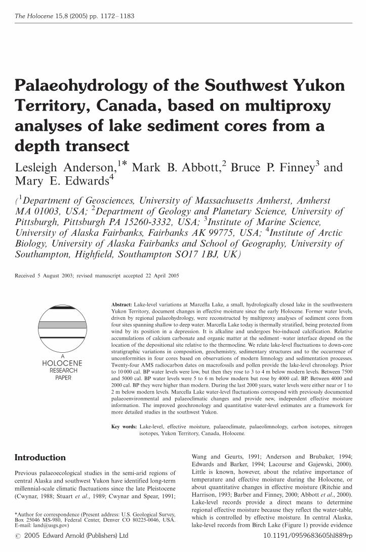
Marcella Lake (60.0748N, 133.8088W, 697 m a.s.l.) is located in
a northwest to southeast trending depression on a terrace of
unconsolidated till and outwash east of the Lubbock River in
the southern Yukon Plateau physiographic region (Figure 1).
The larger depression is interpreted as a former melt-water
channel that presumably formed �/11 000 cal. BP during
recession of the northern edge of the Cordilleran Ice Sheet
(Dyke et al., 2002). The lake is small (0.4 km2), shallow (9.7 m)
and sits �/20 m below the terrace surface in a well-defined
0.8-km2 watershed. Surface inflow is limited to the local basin
and outflow appears to be restricted to evaporation. Bathy-
metry is simple with a gently dipping slope from the shallow
southeast bay to the deepest area of the basin (Figure 1). The
watershed is dominated by open stands of lodgepole pine
(Pinus contorta), trembling aspen (Populus tremuloides) and
white spruce (Picea glauca). Sage (mainly Artemisia frigida)
and grasses (Poaceae) grow on treeless well-drained south-
facing slopes. Submerged charophyte vegetation dominates the
southeast bay. Otherwise, littoral plant communities are
diverse, but limited to shallow near-shore areas. Water levels
today reflect water-table depth.
Figure 1 Location of the Yukon Territory, Marcella Lake and Birch Lake (modified from the Atlas of Canada, Natural Resources Canada)indicating core locations for this study and that of Cwynar (1988). (Photograph A22408, copyright 1949 by Her Majesty the Queen in Rightof Canada, reproduced from the collection of the National Air Photo Library, with permission of Natural Resources Canada)
Lesleigh Anderson et al.: Palaeohydrological analysis of lake sediments in a depth transect 1173
Marcella Lake is located �/200 km northeast of the Gulf of
Alaska in a pronounced rain shadow of the St Elias Moun-
tains, restricting mean annual precipitation in the interior to
�/260 mm/yr (Wahl et al., 1987). The intensity and position of
the Aleutian Low, centred over the Gulf of Alaska, influences
the trajectory and intensity of storms entering the region. A
precipitation maximum occurs between May and September
(Wahl et al., 1987; Mock et al., 1998). Mean annual tempera-
tures measured at nearby Teslin and Whitehorse are between
�/2 and 08C. January mean temperatures range between �/15
and �/208C and July mean temperatures are between 10 and
158C (Wahl et al., 1987; Environment Canada, 2003). Regional
lake-ice break-up occurs between April and May and freeze-up
occurs between October and November. Cwynar (1988)
produced a detailed late-Quaternary pollen record for this
site; in his study the lake was called Kettlehole Pond.
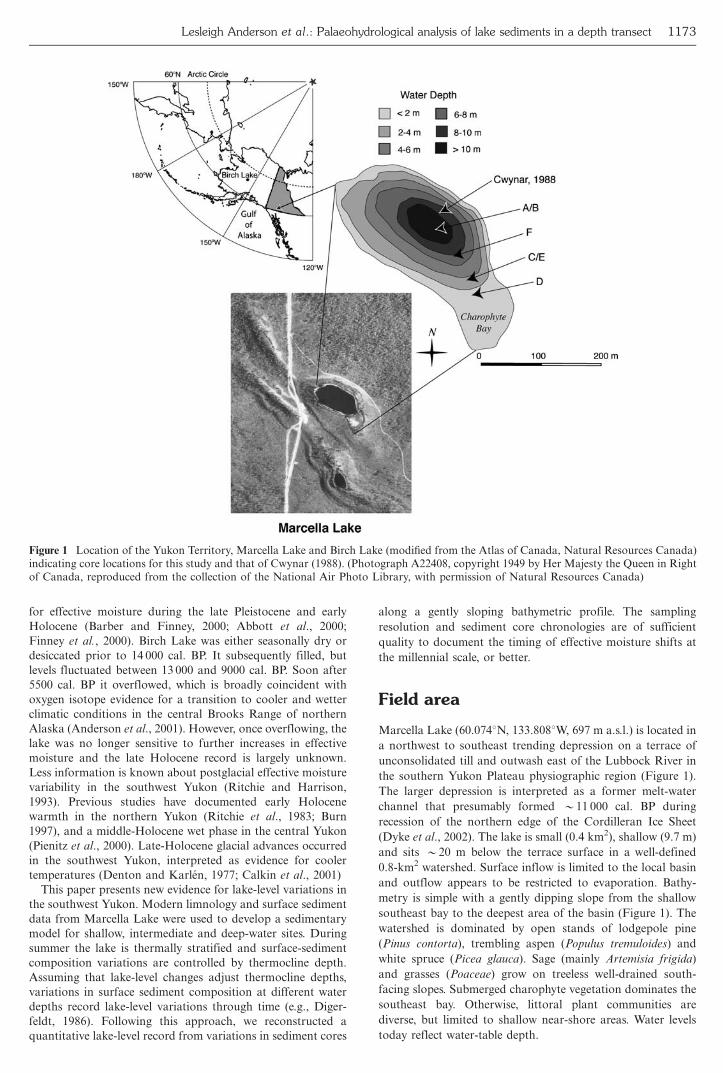
Limnology and sedimentation
Limnological measurements made in July 2000 provide a basis
for understanding the controls on modern sedimentary facies
and a means to interpret down-core sedimentary facies changes
in terms of lake level. Autocthonous sedimentation of bio-
induced calcium carbonate and organic matter are predomi-
nant throughout the lake. The wind-protected basin experiences
a strong thermal stratification, which is shown by temperature
and dissolved oxygen profiles of the water column (Figure 2).
Surface-water was 16.3oC, a thermocline occurred between 5
and 8 m depth and bottom water temperatures were 5.58C.
Dissolved oxygen concentrations at the surface, 9.2 mg/L,
decreased to B/0.3 mg/L in the hypolimnion. However, intact
surface sediments from gravity cores taken in 9.6 m depth
clearly showed the sediments to be bioturbated. The lake
probably overturns at least once, but more likely twice per
year during the spring and/or autumn.
Thermocline depth is controlled by lake volume and heat
capacity, and is strongly influenced by lake level (e.g., Fee et al.,
1996). In general, for lakes with simple bathymetry, an increase
in lake volume will result in a decrease in thermocline depth
and vice versa. Marcella Lake basin morphometry is simple
and has been modified very little by Holocene sedimentary
infilling. If past thermoclines formed at depths similar to today
(�/5�/8 m), then contrasting sedimentation above and below
the thermocline provides a means to reconstruct former lake
levels from sediment cores from shallow-to-deep depths.
Marcella Lake water alkalinity, calcium and magnesium
concentrations (339 mg CaCO3/L, 25.4 mg/L Ca2� and
70.8 mg/L Mg2�) sustain bio-induced carbonate precipitation
within surface waters by Charophytes (Chara sp.) in the
shallow southeast bay (McConnaughy, 1991; McConnaughy
et al., 1994). Randomly collected surface sediments (collected
by L.C. Cwynar) demonstrate how relative proportions of
calcium carbonate and organic matter are related to thermo-
cline depth (Figure 2). In general, sediments accumulating
above the thermocline (5/5 m) contain significantly more
calcium carbonate (30�/80%) than organic matter (20�/50%).
Sediments accumulating within the upper-thermocline (5�/6 m)
contain approximately equal proportions, and calcium carbon-
ate is predominantly intact charophyte encrustations rather
than fine-grained calcite. Sediments accumulating below the
thermocline (]/7 m) contain significantly more organic matter
(�/60%) than calcium carbonate (B/20%). This relationship
appears to be related to acidity, temperature and dissolved
oxygen in the water column (e.g., Stabel, 1986; Dean and
Megard, 1993; Dean 1999; Ramisch et al., 1999). At deposi-
tional locations below the thermocline, raining carbonate
particles apparently dissolve, either during deposition or before
burial. Raining carbonate particles accumulate at depositional
sites located above the thermocline.
In our interpretation we assume the following sedimentation
scenarios. If water depths were ]/5 m (within or below the
thermocline) at a given depositional location, then organic
matter accumulation would exceed that of calcium carbonate.
This occurs because carbonate is dissolved either within the
thermocline, in the hypolimnion or at the sediment�/water
interface. In contrast, if water depths were 5/5 m (above the
thermocline) then calcium carbonate accumulation would
increase relative to organic matter. Furthermore, in littoral
zones, lower water levels could create sedimentary uncon-
formities by wave action, thereby decreasing shallow-water
sedimentation rates. In contrast, deep-basin sedimentation
rates would be uninterrupted and rapid as a result of sediment
focusing. The possibility also exists that sediment re-working
Figure 2 Surface sediment %LOI (unpublished data, 2004, courtesy of L.C. Cwynar) and water column measurements of Marcella Lake inJuly 2000
1174 The Holocene 15 (2005)
because of lower water levels could disrupt sedimentation,
resulting in displaced material at depth.
Methods
Bathymetry was determined by fish-finder soundings. A
Hydrolab Surveyor 4 and Datasonde 4 were used to collect
water column temperature, pH, specific conductivity and
dissolved oxygen. Sediment cores were retrieved from a plat-
form with a modified square rod piston corer at 1.95, 4.30, 6.97
and 9.60 m below modern level (BML) (Figure 1). Sediments
were visually logged for Munsell colour, sedimentary struc-
tures, biogenic features and smear-slide features. Magnetic
susceptibility was measured on half cores at 5-mm intervals
with a Bartington Susceptibility Meter. Smear-slide analyses
showed that mineral-rich sediments (lower organic and car-
bonate content) were higher in dry bulk density and higher in
magnetic susceptibility. Organic matter (% organic matter) and
calcium carbonate content were determined by the loss-on-
ignition (%LOI) method (Bengtsson and Enell, 1986; Heiri et
al., 2001). Weight% CaCO3 was based on the following
calculation of the mass lost after a 4-h burn at 10008C:
[%LOI10008C�(100/44)]. Elemental carbon (% organic carbon)
and nitrogen content and d13C and d15N were analy-
sed on selected samples after acid pretreatment using an
elemental analyser coupled with a Finnigan Delta-plus mass
spectrometer. Isotope sample reproducibility is 9/0.2�.
Carbon and nitrogen isotope ratios are reported in d-notation,
d�/([Rsample/Rstandard]�/1)�/1000 where R�/13C/12C or
15N/14N, and are expressed as per mil (�) relative to the
international standards: Vienna Peedee Belmnite (VPDB) for
carbon and air (VAIR) for nitrogen.
The core chronologies are based on AMS radiocarbon dates
from terrestrial macrofossils (Table 1) and the median cali-
brated (2-sigma) age of the White River tephra, 1150 cal. BP
(Clague et al., 1995). At stratigraphic levels where terrestrial
macrofossils were not present in sufficient quantities, intact
aquatic macrofossils and purified spruce pollen samples were
used (Brown et al., 1989). Radiocarbon ages were calibrated
using CALIB 4.0 following the methods of Stuiver et al. (1998).
Both the measured radiocarbon and median calibrated ages
are reported but only calibrated ages are used for discussion.
Rates of sedimentation were determined by linear interpolation
between dated stratigraphic depths.
Results
The cores were taken on a transect from deep to shallow
water (Figure 1). Core A and B were taken within 2 m of each
other at 960 cm BML and have overlapping stratigraphic
intervals. The cores were matched visually and with bulk
sediment data to make composite core A/B (Figures 3 and 4).
Core F was taken on the slope between A/B and C/E. It
contained 340 cm of reworked lacustrine mud interspersed with
shell lag deposits. With the exception of an AMS radiocarbon
age of the basal sediments, no other sedimentary analyses were
performed on core F. Core C and E were taken within 1 m of
each other at 430 cm BML. They contain overlapping
stratigraphic intervals and were matched in a similar manner
as A and B (Figure 5). Core D (195 cm BML) contained 360
cm of stratigraphically intact sediment (Figure 6). Sedimentary
facies descriptions and water depth interpretations are sum-
marized in Table 2.
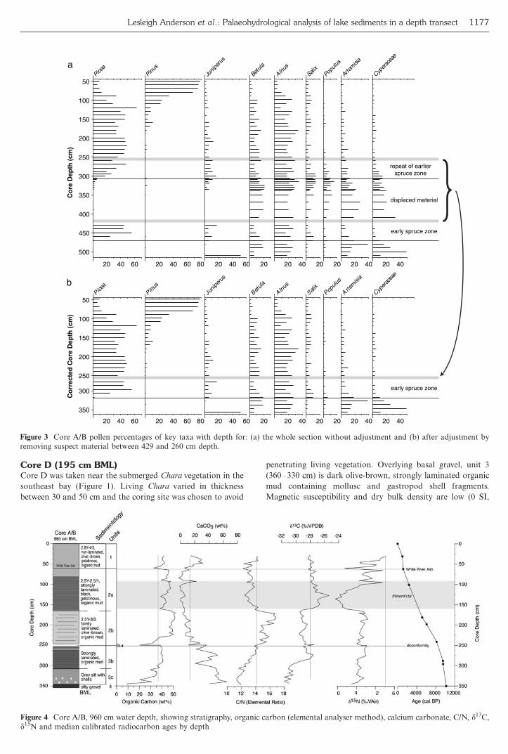
Core A/B (960 cm BML)Bulk sedimentary data and the pollen record from core A/B
contain features that indicate a sedimentary discontinuity, both
when examined for internal consistency and compared with
Cwynar’s (1988) record. At 428.5 cm depth, bulk sedimentary
values are abruptly interrupted and a visible centimetre-scale
unconformable surface occurs. The overlying dark brown
organic-rich sediments upwards to �/260 cm depth contain
disturbed textures, and otherwise rare aquatic mosses, and
produced suspiciously old radiocarbon ages (Table 1).
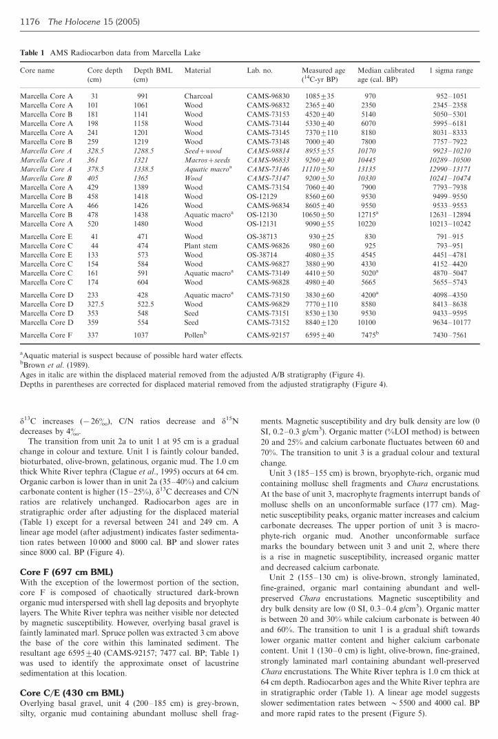
Figure 3a shows percentages of key pollen taxa with depth
for the whole section, prior to any adjustments. Upwards from
near the base, the early spruce zone (�/470�/425 cm) shows
increasing Picea, stable Juniperus and Alnus, and decreasing
Betula, Salix, Populus, Artemisia and Cyperaceae. Between the
samples at 428.5 cm and 408.5 cm these patterns are abruptly
interrupted and succeeded by a zone (labelled ‘displaced
material’) in which taxa prominent prior to the spruce rise
dominate, and Picea and Juniperus are largely absent. Towards
the top of this zone (�/340�/300 cm), small quantities of Picea
and Juniperus reappear, suggesting that there may have been
some mixing of the sediments as the displaced material moved.
From �/300�/260 cm, the pollen curves are almost identical to
those of the early spruce zone and this repeat is taken to mark
the uppermost portion of the displaced material. Figure 3b
shows that removal of the suspect material (thickness, accord-
ing to the pollen stratigraphy, 5/170 cm) yields a pollen curve
consistent with Cwynar’s (1988). Statistically identical radio-
carbon ages from depths immediately above (259 cm) and
below (429 cm) provided further constraints on the thick-
ness of the displaced material and the timing of the event
(�/7850 cal. BP). Figure 4 shows core A/B stratigraphy and
bulk sedimentary data after removing the suspect sediment
(unit 3a) and adjusting the depths for samples below 260 cm.
Overlying basal gravel (unit 4), unit 3c (348�/328 cm,
corrected depth) is composed of grey, silty marl characterized
by a relatively high magnetic susceptibility (�/3 SI), high dry
bulk density (�/0.6 g/cm3), low organic carbon (B/30%;
elemental analyser method) and high calcium carbonate
(�/40%) primarily in the form of bivalve shell fragments.
d13C values are low (�/31�) and C/N ratios are relatively low
(12). A radiocarbon age reversal indicated on an aquatic
macrophyte at 505 cm, 10 6509/50 (OS-12130), indicates either
a significant reservoir effect or sediment re-working.
The lower boundary of unit 3b (328�/260 cm, corrected
depth) is marked by a transition to strongly laminated organic
marl. The shift is distinguished by decreased magnetic suscept-
ibility (0 SI), decreasing dry bulk density (B/0.2 g/cm),
increased organic carbon (30�/40%) and highly variable
but lower carbonate content (20�/40%). C/N ratios rise to
�/14 and d13C values increase (�/28�). Radiocarbon ages of
86059/40 (CAMS-96834) and 85609/60 (OS-12129), at 296
and 288 cm corrected depths, respectively, and 70609/40
(CAMS-73154) at 259 cm corrected depth, support the
stratigraphic integrity of unit 3b.
Lowermost unit 2b (260�/165 cm) is dark-brown organic
mud, which becomes olive-brown faintly laminated or-
ganic mud up-core. Organic carbon, calcium carbonate and
C/N ratios increase while d13C remains relatively unchanged.
Unit 2a (165�/90 cm) is marked by a transition to black,
gelatinous organic mud containing micro-scale laminae.
Smear-slide analyses indicated the laminae alternate between
diatoms and fine-grained organic mud. Both organic carbon
and calcium carbonate decrease, presumably because of an
increased proportion of biogenic silica in the diatom laminae.
Lesleigh Anderson et al.: Palaeohydrological analysis of lake sediments in a depth transect 1175
d13C increases (�/26�), C/N ratios decrease and d15N
decreases by 4�.
The transition from unit 2a to unit 1 at 95 cm is a gradual
change in colour and texture. Unit 1 is faintly colour banded,
bioturbated, olive-brown, gelatinous, organic mud. The 1.0 cm
thick White River tephra (Clague et al., 1995) occurs at 64 cm.
Organic carbon is lower than in unit 2a (35�/40%) and calcium
carbonate content is higher (15�/25%), d13C decreases and C/N
ratios are relatively unchanged. Radiocarbon ages are in
stratigraphic order after adjusting for the displaced material
(Table 1) except for a reversal between 241 and 249 cm. A
linear age model (after adjustment) indicates faster sedimenta-
tion rates between 10 000 and 8000 cal. BP and slower rates
since 8000 cal. BP (Figure 4).
Core F (697 cm BML)With the exception of the lowermost portion of the section,
core F is composed of chaotically structured dark-brown
organic mud interspersed with shell lag deposits and bryophyte
layers. The White River tephra was neither visible nor detected
by magnetic susceptibility. However, overlying basal gravel is
faintly laminated marl. Spruce pollen was extracted 3 cm above
the base of the core within this laminated sediment. The
resultant age 65959/40 (CAMS-92157; 7477 cal. BP; Table 1)
was used to identify the approximate onset of lacustrine
sedimentation at this location.
Core C/E (430 cm BML)Overlying basal gravel, unit 4 (200�/185 cm) is grey-brown,
silty, organic mud containing abundant mollusc shell frag-
ments. Magnetic susceptibility and dry bulk density are low (0
SI, 0.2�/0.3 g/cm3). Organic matter (%LOI method) is between
20 and 25% and calcium carbonate fluctuates between 60 and
70%. The transition to unit 3 is a gradual colour and textural
change.
Unit 3 (185�/155 cm) is brown, bryophyte-rich, organic mud
containing mollusc shell fragments and Chara encrustations.
At the base of unit 3, macrophyte fragments interrupt bands of
mollusc shells on an unconformable surface (177 cm). Mag-
netic susceptibility peaks, organic matter increases and calcium
carbonate decreases. The upper portion of unit 3 is macro-
phyte-rich organic mud. Another unconformable surface
marks the boundary between unit 3 and unit 2, where there
is a rise in magnetic susceptibility, increased organic matter
and decreased calcium carbonate.
Unit 2 (155�/130 cm) is olive-brown, strongly laminated,
fine-grained, organic marl containing abundant and well-
preserved Chara encrustations. Magnetic susceptibility and
dry bulk density are low (0 SI, 0.3�/0.4 g/cm3). Organic matter
is between 20 and 30% while calcium carbonate is between 40
and 60%. The transition to unit 1 is a gradual shift towards
lower organic matter content and higher calcium carbonate
content. Unit 1 (130�/0 cm) is light, olive-brown, fine-grained,
strongly laminated marl containing abundant well-preserved
Chara encrustations. The White River tephra is 1.0 cm thick at
64 cm depth. Radiocarbon ages and the White River tephra are
in stratigraphic order (Table 1). A linear age model suggests
slower sedimentation rates between �/5500 and 4000 cal. BP
and more rapid rates to the present (Figure 5).
Table 1 AMS Radiocarbon data from Marcella Lake
Core name Core depth
(cm)
Depth BML
(cm)
Material Lab. no. Measured age
(14C-yr BP)
Median calibrated
age (cal. BP)
1 sigma range
Marcella Core A 31 991 Charcoal CAMS-96830 10859/35 970 952�/1051
Marcella Core A 101 1061 Wood CAMS-96832 23659/40 2350 2345�/2358
Marcella Core B 181 1141 Wood CAMS-73153 45209/40 5140 5050�/5301
Marcella Core A 198 1158 Wood CAMS-73144 53309/40 6070 5995�/6181
Marcella Core A 241 1201 Wood CAMS-73145 73709/110 8180 8031�/8333
Marcella Core B 259 1219 Wood CAMS-73148 70009/40 7800 7757�/7922
Marcella Core A 328.5 1288.5 Seed�/wood CAMS-98814 89559/55 10170 9923�/10210
Marcella Core A 361 1321 Macros�/seeds CAMS-96833 92609/40 10445 10289�/10500
Marcella Core A 378.5 1338.5 Aquatic macroa CAMS-73146 111109/50 13135 12990�/13171
Marcella Core B 405 1365 Wood CAMS-73147 92009/50 10330 10241�/10474
Marcella Core A 429 1389 Wood CAMS-73154 70609/40 7900 7793�/7938
Marcella Core B 458 1418 Wood OS-12129 85609/60 9530 9499�/9550
Marcella Core A 466 1426 Wood CAMS-96834 86059/40 9550 9533�/9553
Marcella Core B 478 1438 Aquatic macroa OS-12130 106509/50 12715a 12631�/12894
Marcella Core A 520 1480 Wood OS-12131 90909/55 10220 10213�/10242
Marcella Core E 41 471 Wood OS-38713 9309/25 830 791�/915
Marcella Core C 44 474 Plant stem CAMS-96826 9809/60 925 793�/951
Marcella Core E 133 573 Wood OS-38714 40809/35 4545 4451�/4781
Marcella Core C 154 584 Wood CAMS-96827 38809/90 4330 4152�/4420
Marcella Core C 161 591 Aquatic macroa CAMS-73149 44109/50 5020a 4870�/5047
Marcella Core C 174 604 Wood CAMS-96828 49809/40 5665 5655�/5743
Marcella Core D 233 428 Aquatic macroa CAMS-73150 38309/60 4200a 4098�/4350
Marcella Core D 327.5 522.5 Wood CAMS-96829 77709/110 8580 8413�/8638
Marcella Core D 353 548 Seed CAMS-73151 85309/130 9530 9433�/9595
Marcella Core D 359 554 Seed CAMS-73152 88409/120 10100 9634�/10177
Marcella Core F 337 1037 Pollenb CAMS-92157 65959/40 7475b 7430�/7561
aAquatic material is suspect because of possible hard water effects.bBrown et al. (1989).
Ages in italic are within the displaced material removed from the adjusted A/B stratigraphy (Figure 4).
Depths in parentheses are corrected for displaced material removed from the adjusted stratigraphy (Figure 4).
1176 The Holocene 15 (2005)
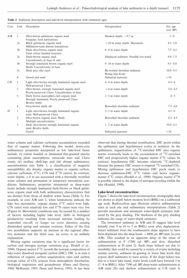
Core D (195 cm BML)Core D was taken near the submerged Chara vegetation in the
southeast bay (Figure 1). Living Chara varied in thickness
between 30 and 50 cm and the coring site was chosen to avoid
penetrating living vegetation. Overlying basal gravel, unit 3
(360�/330 cm) is dark olive-brown, strongly laminated organic
mud containing mollusc and gastropod shell fragments.
Magnetic susceptibility and dry bulk density are low (0 SI,
20
500
400
300
200
100
450
350
250
150
50
40 60 20 2040 20 20 2040 20 40 20 406020 40 60 80
a aeciPsuniP
surepinuJ
aluteB
sunlAxilaS
sulupoP
aisimetrA
eaecarepyC
repeat of earlierspruce zone
displaced material
early spruce zone
20
350
200
100
300
250
150
50
40 60 20 2040 20 20 2040 20 40 20 406020 40 60 80
b aeciPsuniP
surepinuJ
aluteB
sunlAxilaS
sulupoP
aisimetrA
eaecarepyC
early spruce zone
Co
rrec
ted
Co
re D
epth
(cm
)C
ore
Dep
th (
cm)
Figure 3 Core A/B pollen percentages of key taxa with depth for: (a) the whole section without adjustment and (b) after adjustment byremoving suspect material between 429 and 260 cm depth.
Figure 4 Core A/B, 960 cm water depth, showing stratigraphy, organic carbon (elemental analyser method), calcium carbonate, C/N, d13C,d15N and median calibrated radiocarbon ages by depth
Lesleigh Anderson et al.: Palaeohydrological analysis of lake sediments in a depth transect 1177
0.2�/0.4 g/cm3), organic matter (%LOI method) varies between
20 and 30% and calcium carbonate (%LOI method) varies
between 60 and 80%.
Strongly laminated structures are disrupted at the boundary
between unit 3 and unit 2 (330�/245 cm). At the base of unit 2
there are bands of mollusc shell fragments overlain by
disturbed, fine-grained, organic mud. Variability of organic
matter and calcium carbonate content increases in unit 2. Four
or possibly six unconformable surfaces were visually identified.
The transition from unit 2 to unit 1 (245�/0 cm) is identified
by a change to strongly laminated, light olive-brown, fine-
grained, organic marl containing abundant Chara encrusta-
tions. Dry bulk density increases, organic matter decreases and
calcium carbonate increases. Based on cores A/B and C/E, the
depth of the White River tephra would be 58 to 66 cm depth,
but the tephra was not visible or magnetically detected.
Instead, a band of green, unusually well-preserved Chara
vegetation occurs at 68 cm. Between 40 and 70 cm, increased
dry density, decreased organic matter and increased calcium
carbonate may indicate an unconformity or re-working.
Radiocarbon ages in core D are in stratigraphic order
(Table 1). Similar to core C/E, sedimentation rates prior to
4200 cal. BP were slower. The radiocarbon age at 233 cm of
38309/60 (CAMS-73150) could be too old because of hard
water effects but if the age is accurate, then after 4200 cal. BP
core D rates are higher than core C/E. At the core D site,
sediments appear to have accumulated on a flat shelf, while
core C/E sediments dip 158 towards the deep basin, possibly
leading to some down-slope sediment sloughing.
Discussion
If our lake-level thermocline model is correct we can use
sedimentary properties to infer past water depth. When water
depths were 5/5 m in the deep basin, there was an unstratified
Figure 5 Core C/E, 430 cm water depth, showing stratigraphy, magnetic susceptibility, dry bulk density, organic matter (%LOI method),calcium carbonate and median calibrated radiocarbon ages by depth
Figure 6 Core D, 195 cm water depth, showing stratigraphy, magnetic susceptibility, dry bulk density, organic matter (%LOI method),calcium carbonate and median radiocarbon calibrated ages by depth
1178 The Holocene 15 (2005)
water column and calcium carbonate accumulation exceeded
that of organic matter. Following this model, down-core
sedimentary properties interpreted as low lake-level facies
include: (i) colour banded or laminated fine-grained micrite
containing plant macrophytes, ostracode tests and Chara
crusts, (ii) mollusc shell-lags and (iii) abrupt sedimentary
unconformities (see Table 3, a classification of magnetic
susceptibility, dry density, organic matter or organic carbon,
calcium carbonate, d13C, C/N and d15N ratios). In contrast,
water depths ]/8 m are associated with a thermally stratified
water column and permanent or temporary meromictic con-
ditions. Sedimentary properties interpreted as deep-water
facies include strongly laminated dark-brown or black gelati-
nous organic mud with bulk sedimentary characteristics that
are distinct from those of shallow water facies (Table 3). For
example, in core A/B unit 2, when laminations indicate the
lake was meromictic, organic matter d13C ratios were high,
C/N ratios were relatively low and d15N ratios were very low
(Figure 4). Meromictic conditions may be caused by a number
of factors including higher lake level, shifts in biological
productivity resulting from increased nutrient loading by
watershed run-off, or longer ice cover duration causing
diminished spring and autumn overturn. Either of the first
two possibilities supports an increase in the regional effec-
tive moisture and the third case, ice cover, is an unlikely
explanation.
Mixing regime variations may be a significant factor for
carbon and nitrogen isotope variations (e.g., Hodell et al.,
1998). Organic matter d13C records the isotopic composition of
lake-water dissolved inorganic carbon (DIC). DIC is in turn a
reflection of organic carbon sequestration rates and carbon
isotope ratios of CO2 sources from atmospheric dissolution,
biological respiration and groundwater (Oana and Deevey,
1960; McKenzie, 1985; Dean and Stuiver, 1993). It has been
observed that during thermal stratification, DIC pools within
the epilimnion and hypolimnion evolve in isolation. In the
epilimnion, sequestration of 12C-enriched DIC into organic
matter eventually leads to the accumulation of 13C-enriched
DIC and progressively higher organic matter d13C values. In
contrast, hypolimnion DIC becomes relatively 13C-depleted
because the primary DIC source is respired 12C-enriched CO2.
Mixing epilimnion and hypolimnion DIC pools tends to
decrease epilimnion-DIC d13C values and hence organic-
matter d13C values (Hodell et al., 1998). Organic matter d15N
is possibly related to the degree of nitrogen recycling within the
lake (Kendal, 1998).
Lake-level reconstructionFigure 7 shows the lake-level reconstruction; stratigraphic data
are shown as depth below modern level (BML) on a calibrated
age scale. Radiocarbon ages illustrate relative sedimentation
rates at each site and sedimentary interpretations (Table 2)
provide maximum and minimum water-depth estimates indi-
cated by the grey shading. The thickness of the grey shading
indicates the range of water-depth estimates.
The lowermost sediment in A/B and D suggest lake level
initially rose 9 m (4 to 5 m BML) soon after deglaciation.
Intact sediment from the southeastern slope appears to have
been displaced into the deep basin �/8000 cal. BP (unit 3a core
A/B). This resulted in an apparent delay in the onset of
sedimentation at F (7500 cal. BP) and slow, disturbed
sedimentation at D (unit 2). Such slope failures are due to
instability that could be caused by a variety of events including
seismic activity, sediment de-gassing or lower lake levels that
expose shelf sediments to wave action. If the slope failure was
due to a lower lake stand, water levels could have lowered 3 m
(7�/8 m BML). After 7500 cal. BP, deep-water sedimentation at
A/B (unit 2b) and shallow sedimentation at C/E (unit 3)
Table 2 Sediment description and lake-level interpretation with estimated ages
Core Unit Description Interpretation Est. age
(cal. BP)
A/B 1 Olive-brown gelatinous organic mud
Irregular, faint laminations
Modern depth, �/9.7 m 2�/0
2a Black gelatinous organic mud
Millimetre-scale diatom laminations
�/10 m water depth. Meromixis 4.5�/2.0
2b Dark olive-brown organic mud
Faint colour banded structure
6�/8 m water depth 7.5�/4.5
3a Dark-brown organic mud
Unconformity at base of unit
Displaced sediment. Possible low-stand 8.0�/7.5
3b Strongly laminated brown organic marl
Shells. Unconformity at base
9�/10 m water depth 9.5�/8.0
3c Dark grey silty marl Re-worked shoreline sediment
Rising lake-levels
10.0�/9.5
4 Gravel and sand Subaerial exposure �/10
C/E 1 Light olive-brown strongly laminated organic marl
Well-preserved Chara
4�/6 m water depth 4.5�/0
2 Olive-brown, strongly laminated organic marl
Poorly-preserved Chara. Unconformity at base
�/6 m water depth 5.0�/4.5
3 Dark brown macrophyte-rich organic mud
Strongly laminated. Poorly preserved Chara
Bivalve shells
1�/3 m water depth 6�/5
4 Grey-brown shelly silt Reworked shoreline sediment 7.5�/6.0
D 1 Light olive-brown strongly laminated organic
marl. Well-preserved Chara
3�/5 m water depth 4.5�/0
2 Olive-brown organic marl. Shells
Multiple unconformities
Reworked shoreline sediment 8.5�/4.5
3 Dark olive-brown strongly laminated organic
mud. Bivalve shells
1�/2 m water depth 10.0�/8.5
Gravel Subaerial exposure �/10
Lesleigh Anderson et al.: Palaeohydrological analysis of lake sediments in a depth transect 1179
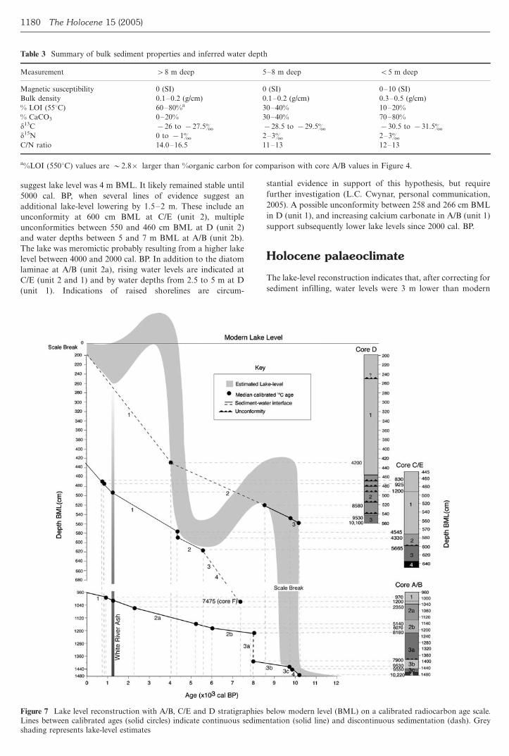
suggest lake level was 4 m BML. It likely remained stable until
5000 cal. BP, when several lines of evidence suggest an
additional lake-level lowering by 1.5�/2 m. These include an
unconformity at 600 cm BML at C/E (unit 2), multiple
unconformities between 550 and 460 cm BML at D (unit 2)
and water depths between 5 and 7 m BML at A/B (unit 2b).
The lake was meromictic probably resulting from a higher lake
level between 4000 and 2000 cal. BP. In addition to the diatom
laminae at A/B (unit 2a), rising water levels are indicated at
C/E (unit 2 and 1) and by water depths from 2.5 to 5 m at D
(unit 1). Indications of raised shorelines are circum-
stantial evidence in support of this hypothesis, but require
further investigation (L.C. Cwynar, personal communication,
2005). A possible unconformity between 258 and 266 cm BML
in D (unit 1), and increasing calcium carbonate in A/B (unit 1)
support subsequently lower lake levels since 2000 cal. BP.
Holocene palaeoclimate
The lake-level reconstruction indicates that, after correcting for
sediment infilling, water levels were 3 m lower than modern
Table 3 Summary of bulk sediment properties and inferred water depth
Measurement �/8 m deep 5�/8 m deep B/5 m deep
Magnetic susceptibility 0 (SI) 0 (SI) 0�/10 (SI)
Bulk density 0.1�/0.2 (g/cm) 0.1�/0.2 (g/cm) 0.3�/0.5 (g/cm)
% LOI (558C) 60�/80%a 30�/40% 10�/20%
% CaCO3 0�/20% 30�/40% 70�/80%
d13C �/26 to �/27.5� �/28.5 to �/29.5� �/30.5 to �/31.5�d15N 0 to �/1� 2�/3� 2�/3�C/N ratio 14.0�/16.5 11�/13 12�/13
a%LOI (5508C) values are �/2.8�/ larger than %organic carbon for comparison with core A/B values in Figure 4.
Figure 7 Lake level reconstruction with A/B, C/E and D stratigraphies below modern level (BML) on a calibrated radiocarbon age scale.Lines between calibrated ages (solid circles) indicate continuous sedimentation (solid line) and discontinuous sedimentation (dash). Greyshading represents lake-level estimates
1180 The Holocene 15 (2005)
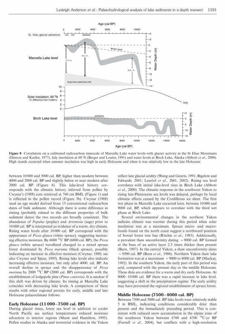
between 10 000 and 5000 cal. BP, higher than modern between
4000 and 2000 cal. BP and slightly below or near modern after
2000 cal. BP (Figure 8). This lake-level history cor-
responds with the climatic history inferred from pollen by
Cwynar’s (1988) core retrieved at 760 cm BML (Figure 1) and
is reflected in the pollen record (Figure 3b). Cwynar (1988)
used an age model derived from 15 conventional radiocarbon
dates of bulk sediment. Although there is some difference in
timing (probably related to the different properties of bulk
sediment dates) the two records are broadly consistent. The
abundance of Populus (poplar) and Artemisia (sage) prior to
10 000 cal. BP is interpreted as evidence of a warm, dry climate.
Rising water levels after 10 000 cal. BP correspond with the
appearance of Picea glauca (white spruce), suggesting increas-
ing effective moisture. By 6000 14C BP (6800 cal. BP), the Picea
glauca (white spruce) woodland changed to a mixed spruce
forest dominated by Picea mariana (black spruce), possibly
indicating an increase in effective moisture (Cwynar, 1988; see
also Cwynar and Spear, 1995). Rising lake levels also indicate
increasing effective moisture, but only after 4000. cal. BP. An
overall decline in spruce and the disappearance of Picea
mariana by 2000 14C BP (2000 cal. BP) corresponds with the
establishment of lodgepole pine (Pinus contorta). It is unclear if
this shift was driven by climate. Its timing at Marcella Lake
coincides with decreasing lake levels. A comparison of these
results with other regional proxies for early, middle and late
Holocene palaeoclimate follows.
Early Holocene (11000�/7500 cal. BP)During glacial times, lower sea level in addition to cooler
North Pacific sea surface temperatures reduced moisture
advection to interior regions (Mann and Hamilton, 1995).
Pollen studies in Alaska and terrestrial evidence in the Yukon
reflect late glacial aridity (Wang and Geurts, 1991; Bigelow and
Edwards, 2001; Lauriol et al., 2001, 2002). Rising sea level
correlates with initial lake-level rises in Birch Lake (Abbott
et al., 2000). The climatic response in the southwest Yukon to
rising late-Pleistocene sea levels was delayed, perhaps by local
climatic effects caused by the Cordilleran ice sheet. The first
wet phase in Marcella Lake occurred later, between 10 000 and
9000 cal. BP, which appears to correlate with the third wet
phase at Birch Lake.
Several environmental changes in the northern Yukon
indicate climate was warmer during this period when solar
insolation was at a maximum. Spruce micro- and macro-
fossils found on the north coast suggest a northward position
of boreal forest tree line (Ritchie et al., 1983). Additionally,
a prevalent thaw unconformity dating �/9000 cal. BP formed
at the base of an active layer 2.5 times thicker than present
(Burn, 1997). In the central Yukon, a thaw unconformity dates
�/9500 cal. BP (Burn et al., 1986). Northern Yukon thaw lake
formation was at a maximum �/9000 to 8000 cal. BP (Mackay,
1992). In the southern Yukon, the early part of this period was
arid, compared with the present day or the middle Holocene.
These data are evidence for a warm and dry early Holocene. At
9000�/10 000 cal. BP there was a rapid increase in lake level,
suggesting a shift in the precipitation regime. The early aridity
may have prevented the regional establishment of spruce forest.
Middle Holocene (7500�/4000 cal. BP)Between 7500 and 5000 cal. BP lake levels were relatively stable
5 m BML, indicating conditions considerably drier than
present and the immediately preceding period. This is con-
sistent with reduced snow accumulation in the alpine zone of
the southwest Yukon between 6700 and 4700 14C-yr BP
(Farnell et al., 2004), but conflicts with a high-resolution
2000 4000 6000 8000 10000
-14
-12
-10
-8
-6
-4
-2
0
+2
+4
Modern depth
Marcella Lake level
Birch Lake level
Age (cal BP)
Wat
er D
epth
(m
)
0 2000 4000 6000 8000 10000 12000 14000
15
10
5
0
+5
Age (cal BP)
Wat
er D
epth
(m
)
16000
0
2
4
6
8
10
Solar Insolation, 60 oN (% difference from modern)
July
9.2+ m
10+ m
overflowing
Deep basin sedimentary infill
9.7 m
0
St. Elias glacial advances
Figure 8 Correlation on a calibrated radiocarbon timescale of Marcella Lake water levels with glacier activity in the St Elias Mountains(Denton and Karlen, 1977), July insolation at 608N (Berger and Loutre, 1991) and water levels at Birch Lake, Alaska (Abbott et al., 2000).High stands occurred when summer insolation was high in early Holocene and when it was relatively low in the late Holocene
Lesleigh Anderson et al.: Palaeohydrological analysis of lake sediments in a depth transect 1181
diatom-inferred salinity profile in the central Yukon that
indicates a wet middle Holocene (Pienitz et al., 2000). In terms
of temperature, fossil spruce deposits on the eastern slopes of
the St Elias Mountains were found up to 70 m higher than
modern tree line, suggesting warmer conditions at 6500 cal. BP
(Denton and Karlen, 1977). Later, temperatures in the north-
ern Yukon decreased. Peat-land permafrost development by
4700 cal. BP suggests decreasing temperatures (Vardy et al.,
1997) and ice-wedge growth, which was uncommon in the early
Holocene, was underway by 4500 cal. BP (Mackay, 1992).
Late Holocene (4000 cal. BP to present)Regional cooling occurred during a period of higher than
modern water levels between 4000 and 2000 cal. BP and is
contemporaneous with valley glacier advances in the St Elias
Mountains (Denton and Karlen, 1977). Three intervals of
glacier expansion were documented (3400�/2400, �/1200 and
400�/90 cal. BP) (Figure 8). Thus, as in central and northern
Alaska, late Holocene glacial advances in the southwest Yukon
appear to coincide with increasingly wet climatic conditions in
addition to a millennial-scale decrease in summer insolation
(Anderson et al., 2001; Lamoreux and Cockburn, 2005). Fossil
spruce found above modern tree line dated between 4000�/3000
and 2000�/1000 cal. BP, suggest favourable growing condi-
tions occurred at times during a generally cooler and moister
late Holocene. Marcella Lake levels dropped to near or slightly
below modern by 2000 cal. BP. This shift corresponds
with increases in the palaeosalinity documented by Pienitz
et al. (2000) that also suggest increasing aridity. The resolution
of the lake-level estimates is limited, but continuous sedimen-
tation at shallow depths indicates water levels have remained
near modern, with no major lowering since 1200 cal. BP.
Recent glacial advances since 400 cal. BP represent, in most
cases, maximum advances since deglaciation (Calkin et al.,
2001) and probably reflect significant cooling during the ‘Little
Ice Age’. Thus, the late Holocene has trended away from a
moisture maximum and conditions during the last millennium
have likely been drier than any since the middle Holocene.
Conclusions
Holocene sedimentation at Marcella Lake can be interpreted in
terms of lake-level variation, providing a quantitative record of
effective moisture variability. An early Holocene lake-level rise
may have been significant for the regional establishment of
spruce forest, but the region remained drier than present until
4000 cal. BP. Early Holocene high stands in Marcella Lake
coincide with higher than modern summer insolation. Wetter
than modern conditions probably occurred between 4000 and
2000 cal. BP, and coincide with the onset of late Holocene
glacial activity and decreasing summer insolation. Neverthe-
less, after 2000 cal. BP lake levels dropped and Little Ice Age
glacial advances occurred under drier conditions than preced-
ing millennia.
This long-term moisture record, together with modern
climatological observations, allows us to propose a hypothesis
for circulation adjustments that have controlled Holocene
moisture changes. Moisture delivery in the region is strongly
influenced by the strength and position of the Aleutian Low
centred over the Gulf of Alaska. A weakened Aleutian Low
favours more zonal atmospheric flow that could allow more
moisture to reach interior areas. Such a scenario could be
invoked for the period between 4000 and 2000 cal. BP when
lake levels were higher than today. In contrast, when effective
moisture trends reversed 2000 cal. BP, the Aleutian Low may
have intensified, enhancing meridional on-shore airflow that
intensifies the rain shadow effect and restricts moisture flow to
the interior. Indeed, an increasing body of evidence suggests
just such a mechanism (Spooner et al., 2003; Anderson et al.,
2005) and forthcoming research will evaluate this hypothesis in
further detail (e.g., Fisher et al., 2004). This lake-level
reconstruction serves to constrain the timing and direction of
large-scale changes in effective moisture and thereby provide a
framework for further, more detailed studies.
Acknowledgements
The authors wish to thank Les Cwynar for contributing
surface sediment data and his insights to this study. Joseph
Rodgers and Britt Haugen assisted in the field and Andrea
Krumhardt, Trent Hayden, and Bronwen Whitney in the lab.
Two anonymous reviewers provided helpful comments that
improved the mansucript. This research was supported by
grants from the National Science Foundation (ATM-0296157
and ATM-0097127) and the Department of Geosciences at the
University of Massachusetts Amherst.
References
Abbott, M.B., Finney, B.P., Edwards, M.E. and Kelts, K.R. 2000:Lake-level reconstructions and paleohydrology of Birch Lake,Central Alaska, based on seismic reflection profiles and coretransects. Quaternary Research 53, 154�/66.Anderson, L., Abbott, M.B. and Finney, B.P. 2001: Holoceneclimate inferred from oxygen isotope ratios in lake sediments,Central Brooks Range, Alaska. Quaternary Research 55, 313�/21.Anderson, L., Abbott, M.B., Finney, B.P. and Burns, S.J. 2005:Regional atmospheric circulation change in the North Pacificduring the Holocene inferred from lacustrine carbonate oxygenisotopes, Yukon Territory, Canada. Quaternary Research 64, 21�/
35.Anderson, P.M. and Brubaker, L.B. 1994: Vegetation history ofnorth-central Alaska: a mapped summary of late-Quaternarypollen data. Quaternary Science Reviews 13, 71�/92.Barber, V. and Finney, B.P. 2000: Late Quaternary paleoclimaticreconstructions for interior Alaska based on paleo lake-level dataand hydrologic models. Journal of Paleolimnology 24, 29�/41.Bengtsson, L. and Enell, M. 1986: Chemical analyses. In Berglund,B.E., editor, Handbook of Holocene paleoecology and paleo-
hydrology. Chichester: J. Wiley, 423�/51.Berger, A. and Loutre, M.F. 1991: Insolation values for the climateof the last 10 million years. Quaternary Science Reviews 10, 297�/
317.Bigelow, N. and Edwards, M.E. 2001: A 14,000 yr paleoenviron-mental record from Windmill Lake, Central Alaska: late glacialand Holocene vegetation in the Alaska Range. Quaternary Science
Reviews 20, 203�/15.Brown, T.A., Nelson, D.E., Mathewes, R.W., Vogel, J.S. andSouthen, J.R. 1989: Radiocarbon dating of pollen by acceleratormass spectrometry. Quaternary Research 32, 205�/12.Burn, C.R. 1997: Cryostratigraphy, paleogeography, and climatechange during the early Holocene warm interval, western Arcticcoast, Canada. Canadian Journal of Earth Sciences 34, 912�/25.Burn, C.R., Michel, F.A. and Smith, M.W. 1986: Stratigraphic,isotopic, and mineralogical evidence for an early Holocene thawunconformity at Mayo, Yukon Territory. Canadian Journal of
Earth Sciences 23, 794�/803.Calkin, P.E., Wiles, G.C. and Barclay, D.J. 2001: Holocene coastalglaciation of Alaska. Quaternary Science Reviews 20, 449�/61.Clague, J.J., Evans, S.G., Rampton, V.N. and Woodsworth, G.J.1995: Improved age estimates for the White River and BridgeRiver tephras, western Canada. Canadian Journal of Earth
Sciences 32, 1172�/79.
1182 The Holocene 15 (2005)
Cwynar, L.C. 1988: Late Quaternary vegetation history ofKettlehole Pond, southwestern Yukon. Canadian Journal ofForest Research 18, 1270�/79.Cwynar, L.C. and Spear, R.W. 1991: Reversion of forest to tundrain the central Yukon. Ecology 72, 202�/12.____ 1995: Paleovegetation and paleoclimatic changes in theYukon at 6 ka BP. Geographie Physique et Quaternaire 49, 29�/35.Dean, W.E. 1999: The carbon cycle and biogeochemical dynamicsin lake sediments. Journal of Paleolimnology 21, 375�/93.Dean, W.E. and Megard, R.O. 1993: Environment of deposition ofCaCO3 in Elk Lake, Minnesota. In Bradbury, J.P. and Dean, W.E.,editors, Elk Lake, Minnesota: evidence for rapid climate change inthe north-central United States. Boulder CO: Geological Society ofAmerica Special Paper 276, 97�/113.Dean, W.E. and Stuiver, M. 1993: Stable carbon and oxygenisotope studies of the sediments of Elk Lake, Minnesota. InBradbury, J.P. and Dean, W.E., editors, Elk Lake, Minnesota:evidence for rapid climate change in the north-central United States.Boulder CO: Geological Society of America Special Paper 276,163�/80.Denton, G.H. and Karlen, W. 1977: Holocene glacial and tree-linevariations in the White River Valley and Skolai Pass, Alaska andYukon Territory. Quaternary Research 7, 63�/111.Digerfeldt, G. 1986: Studies on past lake level fluctuations. InBerglund, B.E., editor, Handbook of Holocene paleoecology andpaleohydrology. Chichester: J. Wiley, 127�/43.Dyke, A.S., Andrews, J.T., Clark, P.U., England, J.H., Miller, G.H.,Shaw, J. and Veillette, J.J. 2002: The Laurentide and Innuitian icesheets during the Last Glacial Maximum. Quaternary ScienceReviews 21, 9�/31.Edwards, M.E. and Barker, E.D. 1994: Climate and vegetation innortheastern Alaska 18,000 yr B.P. �/ present. Palaeogeography,Palaeoclimatology, Palaeoecology 109, 127�/35.Environment Canada 2003: Canadian climate normals. http://climate.weatheroffice.ec.gc.ca/climate_normals/index_e.htmlFarnell, R., Hare, G.P., Blake, E., Bowyer, V., Schweger, C., Greer,S. and Gotthardt, R. 2004: Multidisciplinary investigations ofalpine ice patches in southwest Yukon, Canada: paleoenviron-mental and paleobiological investigations. Arctic 57, 247�/59.Fee, E.J., Hecky, R.E., Kasian, S.E.M. and Cruikshank, D.R. 1996:Effects of lake size, water clarity, and climatic variability on mixingdepths in Canadian Shield lakes. Limnology and Oceanography 41,912�/20.Finney, B.P., Edwards, M.E., Abbott, M.B., Barber, V., Anderson,L. and Rohr, M. 2000: Holocene precipitation variability ininterior Alaska. 30th International Arctic Workshop Program andAbstracts. Boulder CO: Institute for Arctic and Alpine Research,xvi, 60.Fisher, D.A., Bourgeois, J., Demuth, M., Koerner, R.M., Parnandi,M., Sekerka, J., Zdanowicz, C., Zheng, J., Wake, C., Yalcin, K.,Mayewski, P., Kreutz, C., Osterberg, E., Dahl-Jensen, D., Goto-Azuma, K., Holdsworth, G., Steig, E., Ruper, S. and Wasckiewicz,M. 2004: Mount Logan ice cores: the water cycle in the NorthPacific in the Holocene. EOS 85, American Geophysical UnionFall Meeting Supplement, Abstract PP23C-07.Heiri, O., Lotter, A.F. and Lemcke, G. 2001: Loss on ignition as amethod for estimating organic and carbonate content insediments: reproducibility and comparability of results. Journalof Paleolimnology 25, 101�/10.Hodell, D.A., Schelske, C.L., Fahnensteil, G.L. and Robbins, L.L.1998: Biologically induced calcite and its isotopic composition inLake Ontario. Limnology and Oceanography 43, 187�/99.Kendal, C. 1998: Tracing nitrogen sources and cycling incatchments. In Kendal, C. and McDonnell, J.J., editors, Isotopetracers in catchment hydrology. Amsterdam: Elsevier, 519�/76.Lacourse, T. and Gajewksi, K. 2000: Late Quaternary history ofblack spruce and grasslands in southwest Yukon Territory.Canadian Journal of Botany 70, 1336�/45.Lamoreux, S. and Cockburn, J.M.H. 2005: Timing and climaticcontrols over Neoglacial expansion in the northern CoastMountains, British Columbia. The Holocene 15, 619�/24.
Lauriol, B., Grimm, W., Cabana, Y., Cinq-Mars, J. and Geurtz,
M.A. 2001: Cliff-top eolian deposits as indicators of Late
Pleistocene and Holocene Beringia. Quaternary International 87,
59�/79.Lauriol, B., Duduay, C.R. and Riel, A. 2002: Response of the
Porcupine and Old Crow rivers in northern Yukon, Canada, to
Holocene climatic change. The Holocene 12, 27�/34.Mackay, J.R. 1992: Lake stability in an ice-rich permafrost
environment: examples from the western arctic coast. In Robarts,
R.D. and Bothwell, M.L., editors, Aquatic ecosystems in semi-arid
regions: implications for resource management. Symposium Series
7, Saskatoon: Environment Canada, 1�/25.Mann, D.H. and Hamilton, T.D. 1995: Late Pleistocene and
Holocene paleoenvironments of the North Pacific coast.
Quaternary Science Reviews 14, 449�/71.McConnaughy, T. 1991: Calcification in Chara corallina: CO2
hydroxylation generates protons for bicarbonate assimilation.
Limnology and Oceanography 36, 619�/28.McConnaughy, T.A., LaBaugh, J.W., Rosenberry, D.O. and
Streigel, R.G. 1994: Carbon budget for a groundwater-fed lake:
calcification supports summer photosynthesis. Limnology and
Oceanography 39, 1319�/32.McKenzie, J.A. 1985: Carbon isotopes and productivity in the
lacustrine and marine environment. In Stumm, W., editor,
Chemical processes in lakes. Toronto: J. Wiley, 99�/118.Mock, C.J., Bartlein, P.J. and Anderson, P.A. 1998: Atmospheric
circulation patterns and spatial climatic variations in Beringia.
International Journal of Climatology 18, 1085�/104.Oana, S. and Deevey, E.S. 1960: Carbon-13 in lake waters and its
possible bearing on paleolimnology. American Journal of Science
258-A, 253�/72.Pietnitz, R., Smol, J.P., Last, W.M., Leavitt, P.R. and Cumming,
B.F. 2000: Multi-proxy Holocene paleoclimatic record from a
saline lake in the Canadian subarctic. The Holocene 10, 673�/86.Ramisch, F., Ditrich, M., Mattenberger, C., Wehrli, B. and Wuest,
A. 1999: Calcite dissolution in two deep eutrophic lakes.
Geochimica et Cosmochimica Acta 63, 3349�/56.Ritchie, J.C. and Harrison, S.P. 1993: Vegetation, lake levels, and
climate in western Canada during the Holocene. In Wright, H.E.,
Kutzbach, J.E., Webb, T., III, Ruddiman, W.F., Street-Perrott, F.A.
and Bartlein, P.J., editors, Global climate since the Last Glacial
Maximum. Minneapolis MN: University of Minnesota Press, 401�/
14.Ritchie, J.C., Cwynar, L.C. and Spear, R.W. 1983: Evidence from
north-west Canada for an early Holocene Milankovitch thermal
maximum. Nature 305, 126�/28.Spooner, I.S., Barnes, S., Baltzer, K.B., Raeside, R., Osborn, G.D.
and Mazzuchi, D. 2003: The impact of air mass circulation
dynamics on late Holocene paleoclimate in northwestern North
America. Quaternary International 108, 77�/83.Stabel, H-H. 1986: Calcite precipitation in Lake Constance:
chemical equilibrium, sedimentation, and nucleation by algae.
Limnology and Oceanography 31, 1081�/93.Stuart, S.L., Helmer, J.W. and Hills, L.V. 1989: The Holocene
paleoecology of Jenny Lake area, southwest Yukon, and its
implications for prehistory. Arctic 42, 347�/53.Stuiver, M., Reimer, P.J., Bard, E., Beck, J.W., Burr, G.S., Hughen,
K.A., Kromer, B., McCormac, F.G., v.d.Plicht, J. and Spurk, M.
1998: Radiocarbon age calibration 24,000�/0 cal BP. Radiocarbon
40, 1041�/83.Vardy, S.R., Warner, B.G. and Aravena, R. 1997: Holocene climate
effects on the development of a peatland on the Tuktoyaktuk
Peninsula, Northwest Territories. Quaternary Research 47, 90�/104.Wahl, H.E., Fraser, D.B., Harvey, R.C. and Maxwell, J.B. 1987:
Climate of the Yukon. Ottawa: Climatic Studies by Environment
Canada, Atmospheric Environment Service, 1�/323.Wang, X.-C. and Geurts, M.-A. 1991: Late Quaternary pollen
records and vegetation history of the southwest Yukon Territory: a
review. Geographie Physique et Quaternaire 45, 175�/193.
Lesleigh Anderson et al.: Palaeohydrological analysis of lake sediments in a depth transect 1183