legend utc aerospace systems former upco facility...
TRANSCRIPT
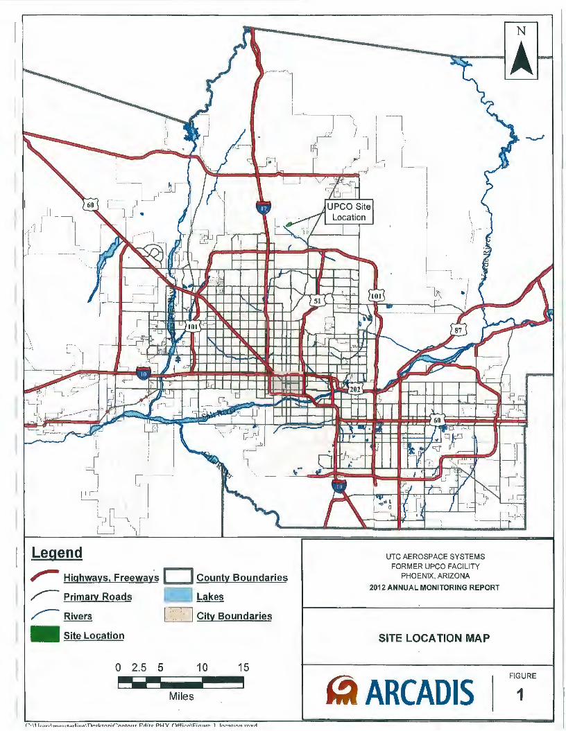
Legend
,..... Highways, Freeway's D County Boundaries
~ Primary Roads Lakes
~Rivers D City Boundaries
- Site Location
0 2.5 5 10 15
Miles
UTC AEROSPACE SYSTEMS FORMER UPCO FACILITY
PHOENIX, ARIZONA
2012 ANNUAL MONITORING REPORT
SITE LOCATION MAP
~ ARCADIS FIGURE
1
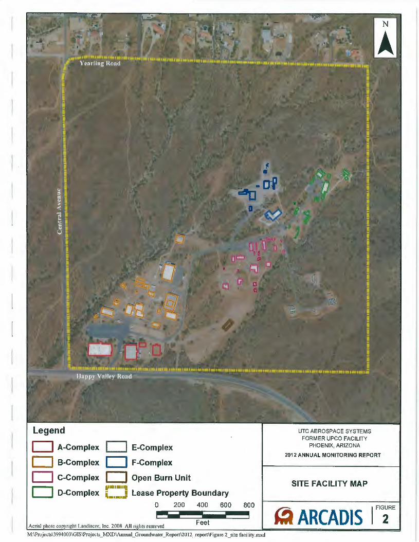
Legend
D A-Complex D E-Complex
D B-Complex D F-Complex
D C-Complex D Open Burn Unit
D D-Complex ...... Ill
Lease Property Boundary • I ~ .......
0 200 400 600 800 - ----Feet
M:\Projects\3994003\GIS\Projects _ MXD\Annual_ Groundwater_ Report\20 12 _report\Figure 2 _site facility. mxd
UTC AEROSPACE SYSTEMS FORMER UPCO FACILITY
PHOENIX, ARIZONA
2012 ANNUAL MONITORING REPORT
SITE FACILITY MAP
~ ARCADIS
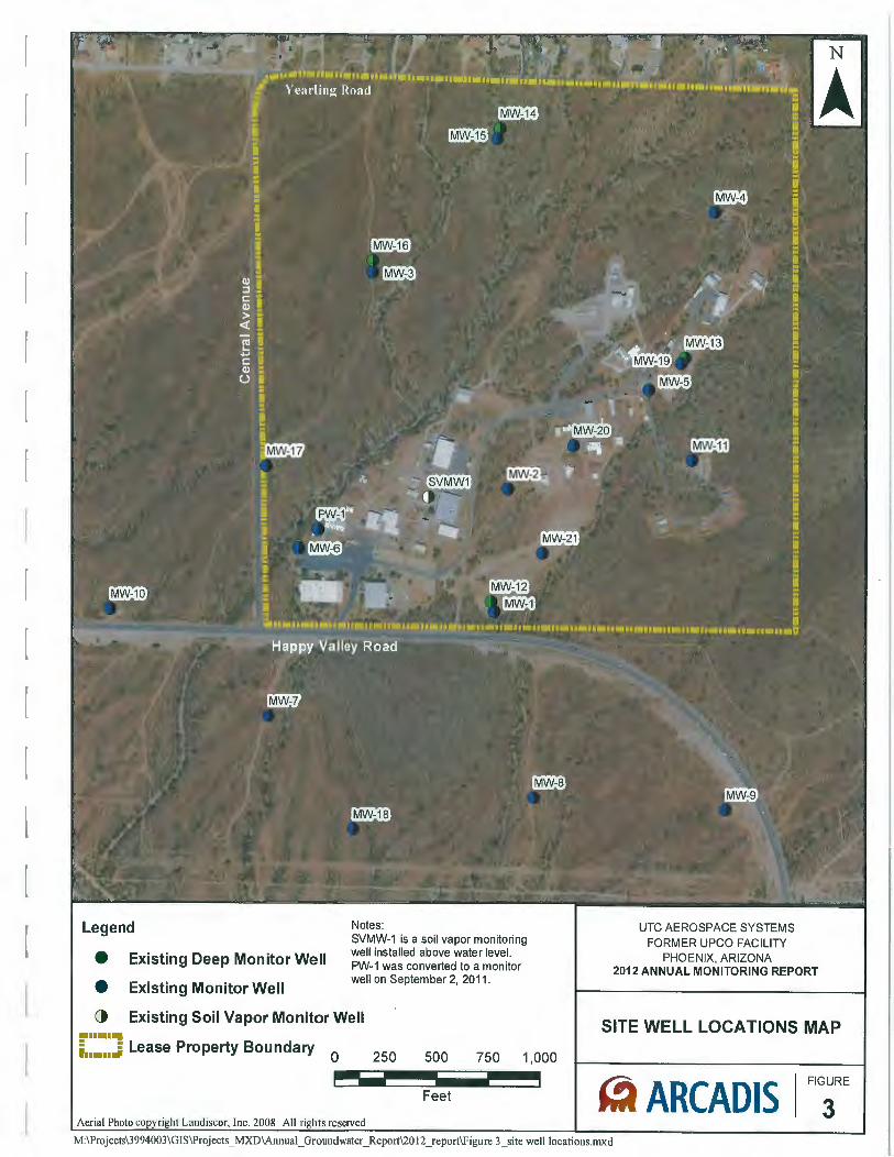
Legend
Existing Deep Monitor Well
Existing Monitor Well
Notes: SVMW-1 is a soil vapor monitoring well installed above water level. PW-1 was converted to a monitor well on September 2, 2011 .
• • () Existing Soil Vapor Monitor Well .......
=1 . r11= Lease Property Boundary ..... 250 0 500 750 1,000 ---Feet
UTC AEROSPACE SYSTEMS FORMER UPCO FACILITY
PHOENIX, ARIZONA 2012 ANNUAL MONITORING REPORT
SITE WELL LOCATIONS MAP
~ ARCADIS I FIGURE
3 M:\Projects\3994003\GIS\Projects _ MXD\Annual_ Groundwater_ Report\20 12 _report\Figure 3 _site well locations.mxd
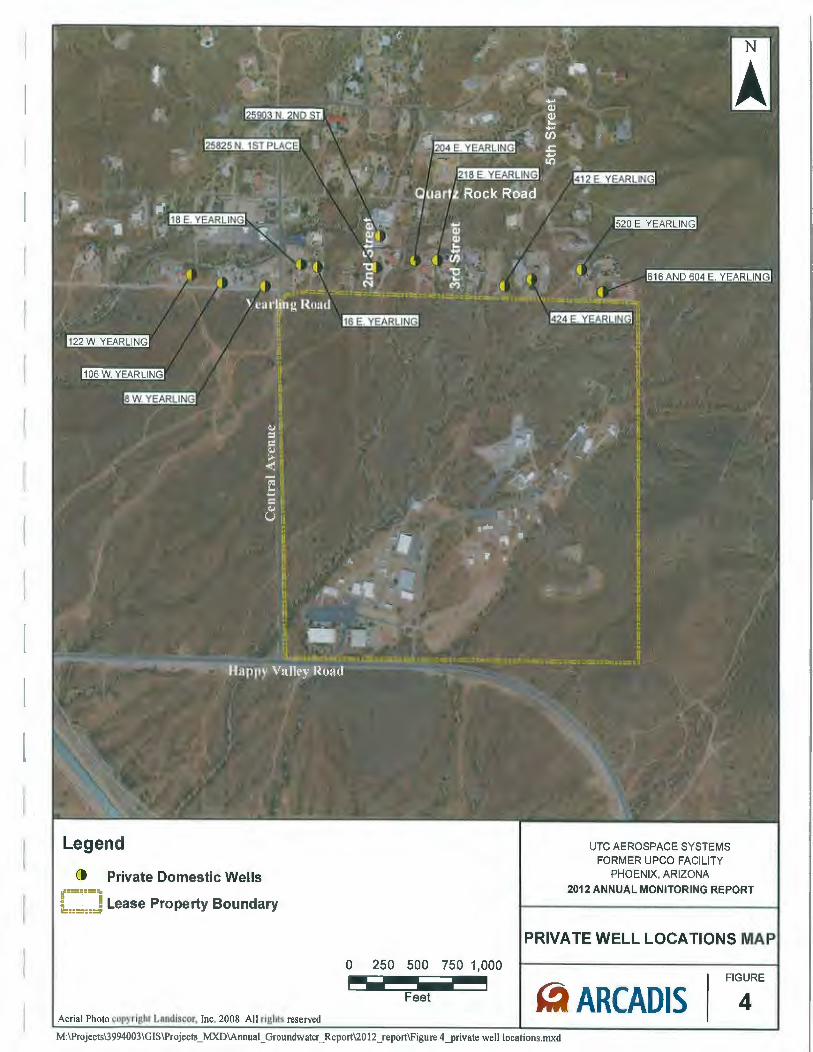
Legend
() Private Domestic Wells tf•=:•=:;. ib.====J Lease Property Boundary
0 250 500 750 1,000 - --- -Feet
UTC AEROSPACE SYSTEMS FORMER UPCO FACILITY
PHOENIX, ARIZONA
201 2 ANNUAL MONITORING REPORT
PRIVATE WELL LOCATIONS MA
FIGURE
~ ARCADIS 4 M:\Projects\3994003\GJS\Projects _ MXD\Annual_ Groundwater_ Report\20 12 _report\Figure 4 _private well locations. mxd
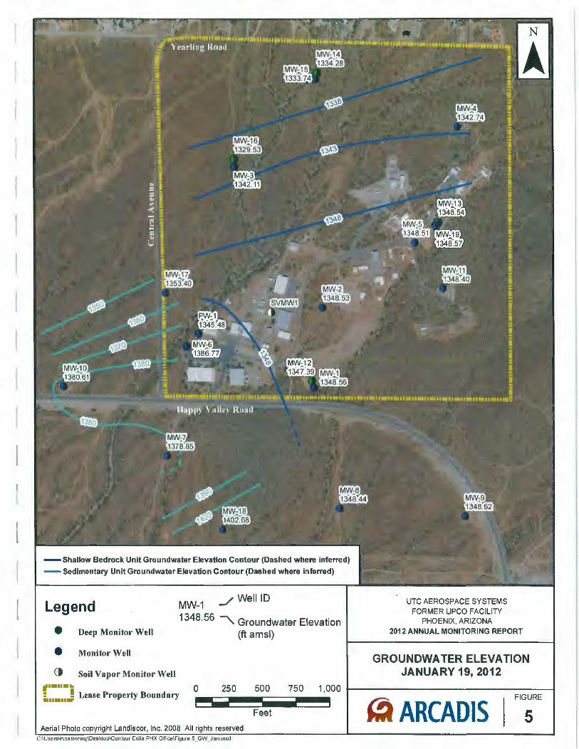
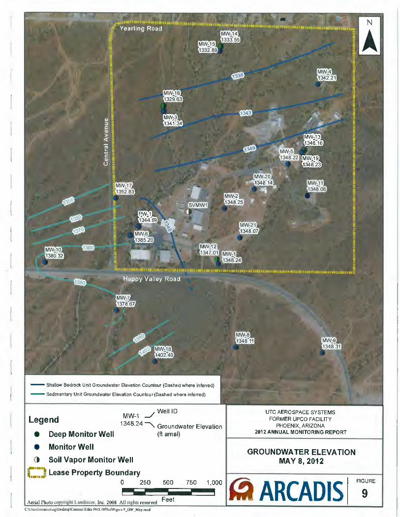
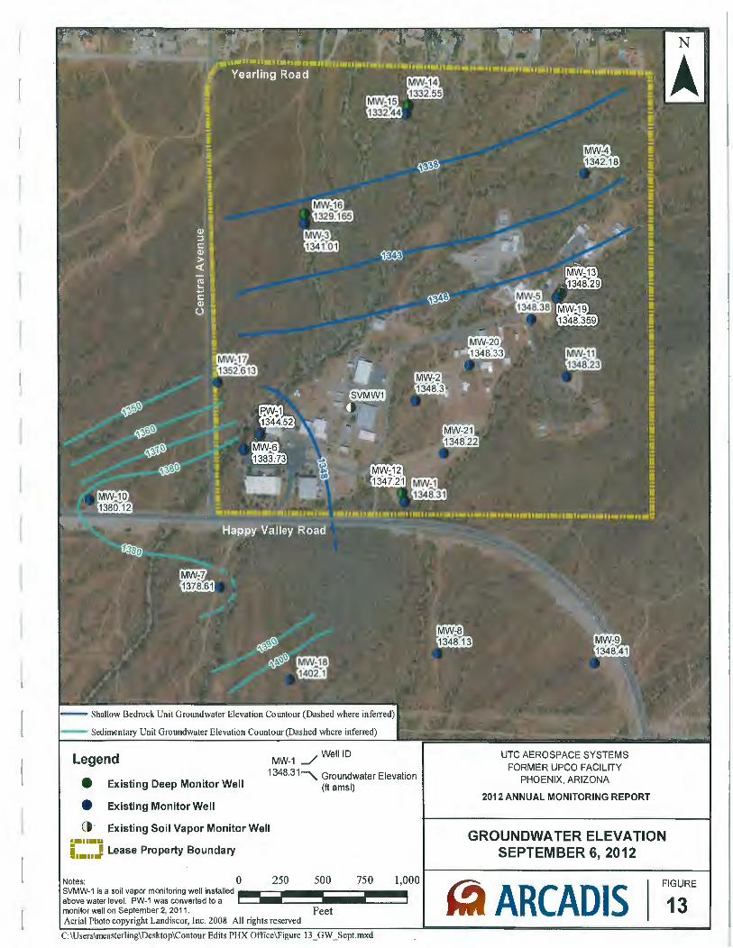
- Shallow Bedrock Unit Groundwater Elevation Contour (Dashed where inferred)
- Sedimentary Unit Groundwater Elevation Contour (Dashed where inferred)
Legend
e Deep Monitor Well
e Monitor Well
() Soil Vapor Monitor Well
MW-1 _/ WeiiiD
1348·56 "'- Groundwater Elevation (ft amsl)
UTC AEROSPACE SYSTEMS FORMER UPCO FACILITY
PHOENIX, ARIZONA 2012 ANNUAL MONITORING REPORT
GROUNDWATER ELEVATION JANUARY 19, 2012
.,....... 0 ;. ..... J Lease Property Boundary 250 500 750 1,000 f--------------------1 - -- 5 Feet ~ ARCADIS
FIGURE
Aerial Photo copyright Landiscor, Inc. 2008 All rights reserved C:\Userslmeastening\Desktop\Contour Edits PHX Office\Figure 5_GW_Jan.mxd
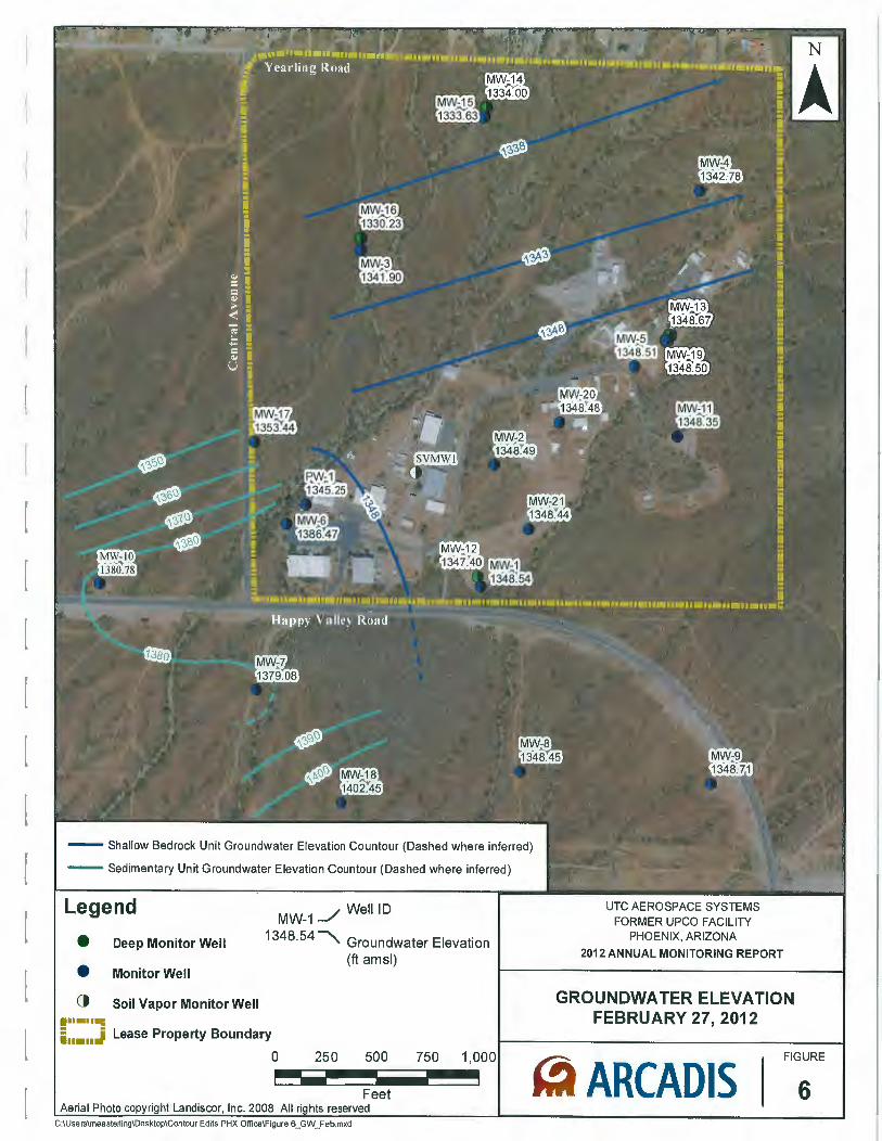
- Shallow Bedrock Unit Groundwater Elevation Countour (Dashed where inferred)
- Sedimentary Unit Groundwater Elevation Countour (Dashed where inferred)
Legend
e Deep Monitor Well
e Monitor Well
ct Soil Vapor Monitor Well .......
MW-1 __/ WeiiiD
1348·54 ~ Groundwater Elevation (ft amsl)
i ..... J Lease Property Boundary
0 250 500 750 1,000 - ----Feet Aerial Photo ht Landiscor Inc. 2008 All hts reserved
C:\Userslmeasterling\Desktop\Contour Edits PHX Oflice\Figure 6_GW_Feb.mxd
UTC AEROSPACE SYSTEMS FORMER UPCO FACILITY
PHOENIX, ARIZONA
2012 ANNUAL MONITORING REPORT
GROUNDWATER ELEVATION FEBRUARY 27, 2012
~ ARCADIS FIGURE
6
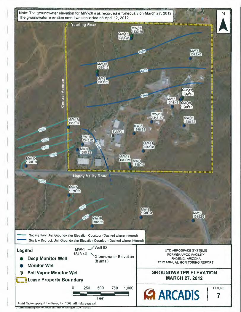
Note: The groundwater elevation for MW-20 was recorded erroneously on March 27, 2012. The groundwater elevation noted was collected on April12, 2012.
Sedimentary Unit Groundwater Elevation Countour (Dashed where inferred)
Shallow Bedrock Unit Groundwater Elevation Countour (Dashed where inferred)
Legend
e Deep Monitor Well
MW-1 _/ WeiiiD
1348.40""""\ G d El . roun water · evat1on (ft amsl)
e Monitor Well
() Soil Vapor Monitor Well
;~~·~ Lease Property Boundary ...... "
UTC AEROSPACE SYSTEMS FORMER UPCO FACILITY
PHOENIX, ARIZONA 2012 ANNUAL MONITORING REPORT
GROUNDWATER ELEVATION MARCH 27, 2012
0 250 500 750 1,000
~ ARCADIS FIGURE ----Feet 7
Aerial Photo copyright Landiscor, Inc. 2008 All rights reserved
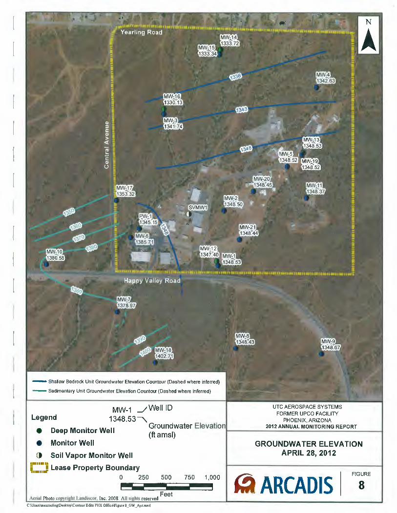
- Shallow Bedrock Unit Groundwater Elevation Countour (Dashed where inferred)
- Sedimentary Unit Groundwater Elevation Countour (Dashed where inferred)
MW-1 .JWeii iD 1348.53 """"\. Legend
• Deep Monitor Well Groundwater Elevatio (ft amsl)
e Monitor Well
() Soil Vapor Monitor Well ..... u
i .... J Lease Property Boundary
Aeria l Photo
0 250 500
Landiscor Inc. 2008 All · Feet
IS reserved C:\Users\measterling\Desktop\Contour Edits PHX Office\Figure 8 _GW _Apr.mxd
750 1,000
UTC AEROSPACE SYSTEMS FORMER UPCO FACILITY
PHOENIX, ARIZONA 2012 ANNUAL MONITORING REPORT
GROUNDWATER ELEVATION APRIL 28, 2012
~ ARCADIS 8 FIGURE
1 - Shallow Bedrock Unit Groundwater Elevation Countour (Dashed where inferred)
- Sedimentary Unit Groundwater Elevation Countour (Dashed where inferred)
_/ WeiiiD MW-1 Legend
• Deep Monitor Well
1348·24 """"' Groundwater Elevation (ft amsl)
• Monitor Well
() Soil Vapor Monitor Well ........ ; ·- Lease Property Boundary ........
0 250 500 750 1,000 - ----Aerial Photo Landiscor Inc. 2008 All · reserved Feet
C:\Users\measterling\Desktop\ContourEdits PHX Office\Figure 9 _GW _May.mxd
UTC AEROSPACE SYSTEMS FORMER UPCO FACILITY
PHOENIX, ARIZONA 2012 ANNUAL MONITORING REPORT
GROUNDWATER ELEVATION MAY 8, 2012
ARCADIS FIGURE
9
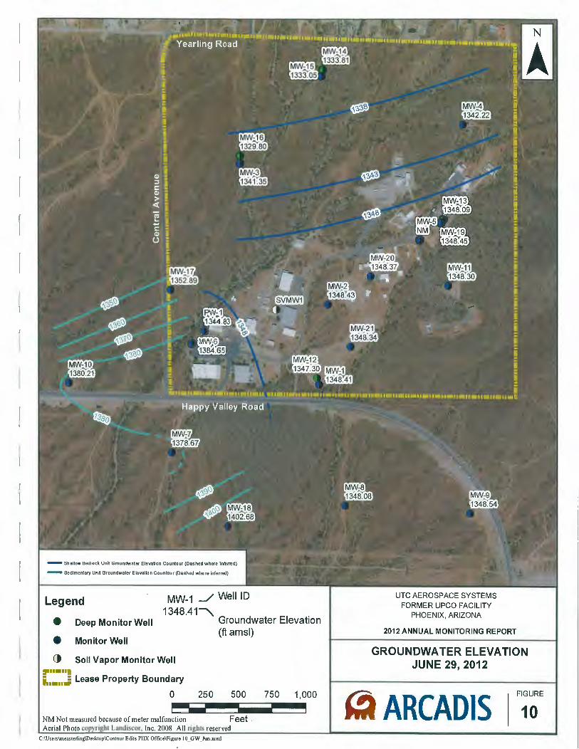
- Shallow Bedrock Unit Groundwater Elevation Countour (Dashed where inferred)
- Sedimentary Unit Groundwater Elevation Countour (Dashed where inferred)
Legend
e Deep Monitor Well
e Monitor Well
MW-1 _/ WeiiiD 1348.41~
Groundwater Elevation (ft amsl)
() Soil Vapor Monitor Well ,. .....• i. .... J Lease Property Boundary
0 250 500 750 1,000 - ---NM Not measured because of meter malfunction Feet . Aerial Photo Landiscor, Inc. 2008 All reserved
C:\Users\measterling\Desktop\Contour Edits PHX Office\Figure 1 O_GW _Jun.mxd
UTC AEROSPACE SYSTEMS FORMER UPCO FACILITY
PHOENIX, ARIZONA
2012 ANNUAL MONITORING REPORT
GROUNDWATER ELEVATION JUNE 29, 2012
10 ~ ARCADIS FIGURE
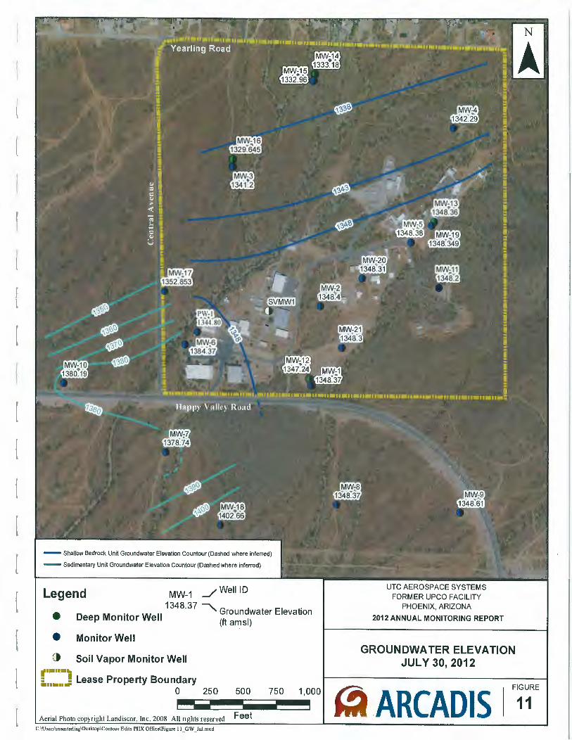
- Shallow Bedrock UnH Groundwater Elevation Countour (Dashed where inferred)
- Sedimentary Unit Groundwater Elevation Countour (Dashed where inferred)
Legend MW-1 J WeiiiD
1348.37 ~ G d t El t' • D M "t W II roun wa er eva 1on
eep om or e (ft a":Jsl)
• Monitor Well
() Soil Vapor Monitor Well t••••• .. : ! Lease Property Boundary ........ 0
250 500 750 1,000 - ----Aerial Photo Landiscor, Inc. 2008 All ri reserved Feet C:\Users\measterling\Desktop\Contour Edits PHX Office\Figure II_ GW _Jul.mxd
UTC AEROSPACE SYSTEMS FORMER UPCO FACILITY
PHOENIX, ARIZONA
2012 ANNUAL MONITORING REPORT
GROUNDWATER ELEVATION JULY 30, 2012
~ ARCADIS FIGURE
11
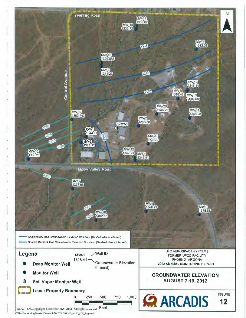
- Sedimentary Unit Groundwater Elevation Countour (Dashed where inferred)
- Shallow Bedrock Unit Groundwater Elevation Countour (Dashed where inferred)
Legend MW-1 _/WeiiiD
• 1348.41 ~ Deep Monitor Well Groundwater Elevation
(ft amsl)
• Monitor Well
() Soil Vapor Monitor Well ......... = ! Lease Property Boundary ........
0 250 500 750 1,000 ----Aerial Photo I Landiscor Inc. 2008 All ri reserved Feet C:\Users\measterling\Desktop\Contour Edits PHX Office\Figure 12_GW _Aug.mxd
UTC AEROSPACE SYSTEMS FORMER UPCO FACILITY
PHOENIX, ARIZONA 2012 ANNUAL MONITORING REPORT
GROUNDWATER ELEVATION AUGUST 7-19, 2012
~ ARCADIS FIGURE
12
Sedimentary Unit Groundwater Elevation Countour (Dashed where inferred)
Legend MW-1 _/ WeiiiD
e Existing Deep Monitor Well
e Existing Monitor Well
1348.31~ Groundwater Elevation (ftamsl)
() · Existing Soil Vapor Monitor Well ,. ... .. 1 .... J Lease Property Boundary
Notes: 0 250 500 750 1,000 SVMW-1 is a soil vapor monitoring well installed ~~-~~~~ iiiiiiiiiiiiil~~~ above water level. PW-1 was converted to a 1: monitor well on September 2, 2011 . Feet Aerial Photo copyright Landiscor, Inc. 2008 All rights reserved
C:\Users\measterling\Desktop\Contour Edits PHX Office\Figure 13_GW _Sept.mxd
UTC AEROSPACE SYSTEMS FORMER UPCO FACILITY
PHOENIX, ARIZONA
2012 ANNUAL MONITORING REPORT
GROUNDWATER ELEVATION SEPTEMBER 6, 2012
~ ARCADIS FIGURE
13
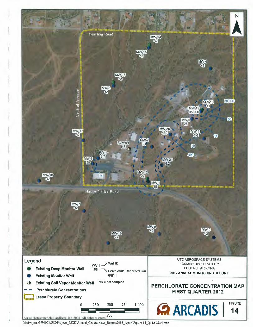
Legend
e Existing Deep Monitor Well
Existing Monitor Well
1 _/ WeiiiD MW-
68 --.....,. Perch lorate Concentration (IJQ/L) •
() Existing Soil Vapor Monitor Well NS =not sampled
Perchlorate Concentrations ..... IIIII: 1 ....: Lease Property Boundary ........
0 250 500 750 1,000 - ----Feet
UTC AEROSPACE SYSTEMS FORMER UPCO FACILITY
PHOENIX, ARIZONA
2012 ANNUAL MONITORING REPORT
PERCHLORATE CONCENTRATION MAP FIRST QUARTER 2012
14 ~ ARCADIS FIGURE
M:\Pro jects\3994003\GIS\Projects _ MXD\Annual_ Groundwater_ Report\20 12 _report\Figure 14 _ Q 112 Cl04.mxd
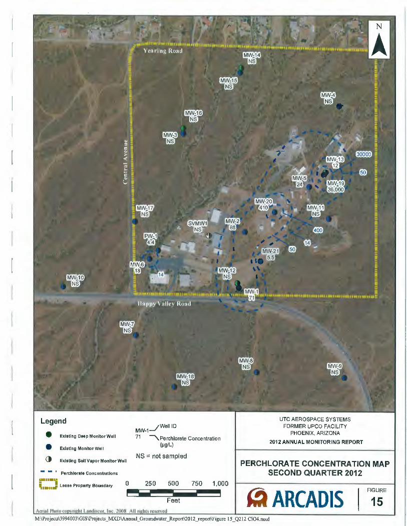
Legend
Existing Deep Monitor Well
Existing Monitor Well
• • () Existing Soli Vapor Monitor Well
Perchlorate Concentrations ..... -; ~••••Jill! Lease Property Boundary 0
MW-1_/WeiiiD
71 'Perchlorate Concentration (IJg/L)
NS = not sampled
250 500 750 1,000 ----Feet
UTC AEROSPACE SYSTEMS FORMER UPCO FACILITY
PHOENIX, ARIZONA
2012 ANNUAL MONITORING REPORT
PERCHLORATE CONCENTRATION MAP SECOND QUARTER 2012
~ ARCADIS 15 FIGURE
M:\Projects\3994003\GIS\Projects _ MXD\Annual_ Groundwater_ Report\20 12 _report\Figure 15 _ Q212 CI04.mxd
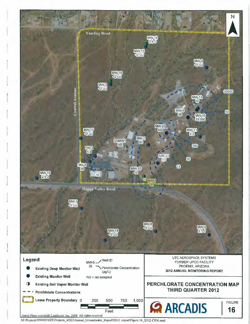
{
r
Legend
e Existing Deep Monitor Well
e Existing Monitor Well
MW-S _/WeiiiD
26 ~Perchlorate Concentration (IJg/L)
NS = not sampled
() Existing Soil Vapor Monitor Well
- - • Perchlorate Concentrations ~ .... ,. ~ .... .; Lease Property Boundary 0 250 500 750 1,000 - ----Feet Aerial
UTC AEROSPACE SYSTEMS FORMER UPCO FACILITY
PHOENIX, ARIZONA
2012 ANNUAL MONITORING REPORT
PERCHLORATE CONCENTRATION MAP THIRD QUARTER 2012
FIGURE
~ ARCADIS 16 M:\Projects\3994003\GJS\Projects _ MXD\Annual_ Groundwater_ Report\20 12 _report\Figure 16 _ Q312 CI04.mxd