legend - california department of conservation lake horse lake humboldt bay r klamath river lake ......

1
# * # * # * # * # * # * # * # * # * # * # * # * # * # * # * # * # * # * # * # * # * # * # * # * # * # * # * # * # * # * # * # * # * # * # * # * # * # * # * # * # * # * # * # * # * # * # * # * # * # * # * # * # * # * # * # * # * # * # * # * # * # * # * # * # * # * # * # * # * # * # * # * # * # * # * # * # * # * # * # * # * # * # * # * # * # * # * # * # * # * # * # * # * # * # * # * # * # * # * # * # * # * # * # * # * # * # * # * # * # * # * # * # * # * # * # * # * # * # * # * # * # * # * # * # * # * # * # * # * # * # * # * # * # * # * # * # * # * # * # * # * # * # * # * # * # * # * # * # * # * # * # * # * # * # * # * # * # * # * # * # * # * # * # * # * # * # * # * # * # * # * # * # * # * # * # * # * # * # * # * # * # * # * # * # * # * # * # * # * # * # * # * # * # * # * # * # * # * # * # * # * # * # * # * # * # * # * # * # * # * # * # * # * # * # * # * # * # * # * # * # * # * # * # * # * # * # * # * # * # * # * # * # * # * # * # * # * # * # * # * # * # * # * # * # * # * # * # * # * # * # * # * # * # * # * # * # * # * # * # * # * # * # * # * # * # * # * # * # * # * # * # * # * # * # * # * # * # * # * # * # * # * # * # * # * # * # * # * # * # * # * # * # * # * # * # * # * # * # * # * # * # * # * # * # * # * # * # * # * # * # * # * # * # * # * # * # * # * # * # * # * # * # * # * # * # * # * # * # * # * # * # * # * # * # * # * # * # * # * # * # * # * # * # * # * # * # * # * # * # * # * # * # * # * # * # * # * # * # * # * # * # * # * # * # * # * # * # * # * # * # * # * # * # * # * # * # * # * # * # * # * # * # * # * # * # * # * # * # * # * # * # * # * # * # * # * # * # * # * # * # * # * # * # * # * # * # * # * # * # * # * # * # * # * # * # * # * # * # * # * # * # * # * # * # * # * # * # * E E E E E E E E E E E E E E E E E E E E E E E E E E E E E E E Big Sage Reservoir Clair Eagle Lake Clear Lake Clear Lake Reservoir Eagle Lake Eel River Gene Wash Reservoir Goose Lake Hetchy Hetch Reservoir Honey Lake Horse Lake Humboldt Bay Kern River Klamath River Lake Almanor Lake Berryessa Lake Davis Lake Havasu Lake Henshaw Lake Tahoe Lower Klamath Lake Lower Lake Middle Alkali Lake Mono Lake Nacimiento Reservoir New Don Pedro Reservoir Owens Lake (Dry) Owens River Pit River Russian River Salinas River Salton Sea San Antonio Reservoir San Francisco Bay San Luis Reservoir San Pablo Bay Santa Maria River Shasta Lake Thermalito Forebay Trinity River Upper Lake Badwater Basin (Dry) Cotton Bail Marsh (Dry) Merced River Bakersfield 143/438 Million Tons 21 to 30 Years Barstow Victorville 124/159 Million Tons 31 to 40 Years Eastern Merced County 50/100 Million Tons 21 to 30 Years El Dorado County 18/76 Million Tons 11 to 20 Years Fresno 46/435 Million Tons 10 or Fewer Years Glenn County 33/59 Million Tons 21 to 30 Years Nevada County 26/100 Million Tons 11 to 20 Years Northern Tulare County 27/124 Million Tons 11 to 20 Years North San Francisco 110/521 Million Tons 11 to 20 Years Palmdale 152/577 Million Tons 11 to 20 Years Palm Springs 152/295 Million Tons 21 to 30 Years Placer County 152/151Million Tons More Than 50 Years Sacramento County 42/670 Million Tons 10 or Fewer Years San Bernardino 241/993 Million Tons 11 to 20 Years San Fernando Valley-Saugus Newhall 77/476 Million Tons 10 or Fewer Years San Gabriel Valley 322/809 Million Tons 11 to 20 Years San Luis Obispo-Santa Barbara 75/240 Million Tons 11 to 20 Years Shasta County 52/93 Million Tons 21 to 30 Years Southern Tulare County Proprietary / 73 Million Tons 21 to 30 Years Stanislaus County 45/214 Million Tons 11 to 20 Years Stockton Lodi 232/436 Million Tons 31 to 40 Years Tehama County 32/62 Million Tons 21 to 30 Years Western Merced County Proprietary / 28 Million Tons 31 to 40 Years Western San Diego County 167/1014 Million Tons 10 or Fewer Years Claremont-Upland 109/203 Million Tons 21 to 30 Years Monterey Bay 323/346 Million Tons 41 to 50 Years Sacramento-Fairfield 128/196 Million Tons 11 to 20 Years South San Francisco 404/1381 Million Tons 11 to 20 Years Temescal Valley-Orange County 297/1,077 Million Tons 11 to 20 Years Ventura County 96/298 Million Tons 11 to 20 Years Yuba City-Marysville 392/403 Million Tons 41 to 50 Years § ¨ ¦ 15 ¬ « 99 £ ¤ 95 £ ¤ 95 £ ¤ 199 ¬ « 299 ¬ « 60 £ ¤ 97 £ ¤ 101 £ ¤ 101 £ ¤ 395 £ ¤ 101 £ ¤ 395 ¬ « 99 £ ¤ 101 £ ¤ 101 £ ¤ 101 £ ¤ 101 £ ¤ 395 £ ¤ 395 £ ¤ 101 £ ¤ 6 ¬ « 66 £ ¤ 101 ¬ « 70 ¬ « 99 ¬ « 70 ¬ « 60 ¬ « 299 ¬ « 299 £ ¤ 395 § ¨ ¦ 110 § ¨ ¦ 405 § ¨ ¦ 80 § ¨ ¦ 280 § ¨ ¦ 113 § ¨ ¦ 580 § ¨ ¦ 680 § ¨ ¦ 215 § ¨ ¦ 5 § ¨ ¦ 210 § ¨ ¦ 5 § ¨ ¦ 5 § ¨ ¦ 805 § ¨ ¦ 505 § ¨ ¦ 80 § ¨ ¦ 10 § ¨ ¦ 15 § ¨ ¦ 580 § ¨ ¦ 205 § ¨ ¦ 5 § ¨ ¦ 5 § ¨ ¦ 80 § ¨ ¦ 15 § ¨ ¦ 15 § ¨ ¦ 880 § ¨ ¦ 5 § ¨ ¦ 5 § ¨ ¦ 105 § ¨ ¦ 5 § ¨ ¦ 8 § ¨ ¦ 8 § ¨ ¦ 40 § ¨ ¦ 180 § ¨ ¦ 115 § ¨ ¦ 113 § ¨ ¦ 10 ¬ « 41 ¬ « 139 ¬ « 243 ¬ « 33 ¬ « 155 ¬ « 139 ¬ « 116 ¬ « 1 £ ¤ 50 ¬ « 12 ¬ « 4 ¬ « 65 ¬ « 59 ¬ « 58 ¬ « 247 ¬ « 78 ¬ « 16 ¬ « 94 ¬ « 269 ¬ « 1 ¬ « 98 ¬ « 120 ¬ « 74 ¬ « 43 ¬ « 140 ¬ « 1 ¬ « 1 ¬ « 138 ¬ « 168 ¬ « 127 ¬ « 271 ¬ « 96 ¬ « 29 ¬ « 14 ¬ « 111 ¬ « 12 ¬ « 20 ¬ « 1 ¬ « 12 ¬ « 36 ¬ « 18 ¬ « 45 ¬ « 128 ¬ « 62 ¬ « 17 ¬ « 1 ¬ « 3 ¬ « 58 ¬ « 79 ¬ « 245 ¬ « 195 ¬ « 254 ¬ « 198 ¬ « 41 ¬ « 89 ¬ « 49 ¬ « 138 ¬ « 223 ¬ « 33 ¬ « 172 ¬ « 33 ¬ « 32 ¬ « 74 ¬ « 111 ¬ « 162 ¬ « 16 ¬ « 198 ¬ « 46 ¬ « 43 ¬ « 1 ¬ « 227 ¬ « 88 ¬ « 79 ¬ « 190 ¬ « 178 ¬ « 18 ¬ « 58 ¬ « 78 ¬ « 79 ¬ « 76 ¬ « 1 ¬ « 136 ¬ « 162 ¬ « 168 ¬ « 4 ¬ « 140 ¬ « 1 ¬ « 120 ¬ « 169 ¬ « 89 ¬ « 145 ¬ « 46 ¬ « 79 ¬ « 86 ¬ « 49 ¬ « 12 ¬ « 49 ¬ « 49 ¬ « 177 ¬ « 4 ¬ « 168 ¬ « 20 ¬ « 247 ¬ « 162 ¬ « 89 ¬ « 3 ¬ « 120 ¬ « 108 ¬ « 44 Alturas Anaheim Angels Camp Antioch Anza Atascadero Auburn Avalon Avenal Azusa Baker Bakersfield Barstow Berkeley Big Pine Bishop Blythe Brawley Brentwood Cajon Pass Carmel Carmel Valley Carpenteria Castaic Chester Chico China Lake Cloverdale Coalinga Coloma Crescent City Desert Center Edwards A.F.B. El Cajon El Centro El Segundo Escondido Eureka Fairfield Fillmore Fort Bragg Fort Ross Fremont Fresno Fullerton Furnace Creek Furnance Creek Ranch Gaviota Gilroy Gorman Grass Valley Healdsburg Hollister Hollywood Idyllwild Indio Inyokern Irvine Isabella Julian King City La Jolla Laguna Beach Lake Hughes Lake Isabella Lakeport Lassen Peak Lee Vining Livermore Lodi Lompoc Lone Pine Long Beach Los Altos Los Angeles Los Banos Lucerne Valley Madera Malibu Mammoth Lakes Maricopa Markleeville Marysville Mecca Merced Mexicali Modesto Mojave Monterey Morongo Valley Morro Bay Mount Shasta City Napa Needles Newhall Newport Beach Oakdale Oakland Oceanside Ocotillo Wells Oildale Olancha Oroville Oxnard Pacifica Palm Springs Palmdale Paradise Parker Parkfield Paso Robles Placerville Pleasanton Point Arena Point Conception Point Dume Point Reyes Point Sur Porterville Portola Quincy Red Bluff Redding Redondo Beach Ridgecrest Riverside Rohnert Park Sacramento Salinas Salton City San Andreas San Benito San Bernardino San Clemente San Diego San Francisco San Jose San Juan Bautista San Luis Obispo San Pedro San Rafael San Simeon Santa Barbara Santa Clara Santa Cruz Santa Maria Santa Monica Santa Paula Santa Rosa Scotts Valley Scotty's Castle Seal Beach Shoshone Simi Valley Sonora Stockton Susanville Taft Tahoe Valley Tehachapi Tejon Pass Thousand Oaks Tijuana Tracy Tres Pinos Trona Truckee Tulare Twentynine Palms Ukiah Upland Vacaville Vallejo Ventura Victorville Visalia Watsonville Weed Westmorland Williams Willits Willows Woodland Yosemite Valley Yreka Yuba City Yucaipa CALIFORNIA GEOLOGICAL SURVEY JOHN G. PARRISH PH.D., STATE GEOLOGIST STATE OF CALIFORNIA, EDMUND G. BROWN, JR., GOVERNOR NATURAL RESOURCES AGENCY, JOHN LAIRD, SECRETARY DEPARTMENT OF CONSERVATION, MARK NECHODOM, DIRECTOR MAP SHEET 52 (UPDATED 2012) AGGREGATE SUSTAINABILITY IN CALIFORNIA AGGREGATE SUSTAINABILITY IN CALIFORNIA AGGREGATE SUSTAINABILITY IN CALIFORNIA Fifty-Year Aggregate Demand Compared to Permitted Aggregate Reserves Contributions By: Joshua Smith and John Church GIS Design and Map Layout By: Milton Fonseca Fifty-Year Aggregate Demand Compared to Permitted Aggregate Reserves* The pie charts show the projected 50-year demand for aggregate as of January 2011 compared to currently permitted aggregate reserves (in short tons). The 50-year demand for a particular study area is graphically represented by one of four pie diagram sizes. Study area boundaries are shown on the index map of aggregate studies (lower left). * Permitted aggregate reserves are those portions of the resources for which local lead agencies (counties and cities) have issued mining permits. Non-permitted aggregate resource information is given in each aggregate study report. See accompanying text for references to these reports. 0 20 40 60 10 Miles 0 40 80 20 Kilometers Scale: 1:1,100,000 Projection: Teale Albers Datum: NAD 83 LEGEND 50-year demand that will not be met by existing permitted reserves. Permitted aggregate reserves. 50-year demand is 25 to 200 million tons. 50-year demand is > 200 to 500 million tons. 50-year demand is > 500 to 800 million tons. 50-year demand is more than 800 million tons. 50-year demand for aggregate is 100 million tons; permitted resources total 25 million tons of the 50-year demand. 25/100 Million Tons (permited reserves/ 50-year demand) 17 to 20 Years (years of permitted reserves remaining) 50-year demand for aggregate is 510 million tons; permitted reserves are greater than or equal to the 50-year demand. 550/510 Million Tons (permited reserves/ 50-year demand) More Than 50 Years (Years of permitted reserves remaining) Examples < 0.5 Million Tons per Year > 0.5 - 1.5 Million Tons per Year > 1.5 - 3 Million Tons per Year > 3 - 5 Million Tons per Year > 5 Million Tons per Year Aggregate Production Areas (Symbols represent one or more aggregate mines, tonnage represents 2010 annual production) Areas With Short Term Aggregate Supply Population < 10 years of permitted reserves remaining in the study area. 1 Dot = 100 Persons (based on 2010 Census Data) City Interstate Route U.S. Route State Route Primary Highway Secondary Highway County Boundary Map Usage and Limitations This map is intended to provide general information about the current availability of California's permitted construction aggregate reserves to state, regional, and local land-use planners and decision-makers. It is designed to assist planning agencies in considering construction aggregate needs in the regional planning process. However, the map is not intended to be used as the sole source of information about construction aggregate availability, or as the basis for site- specific land-use decisions. Although the statewide and regional information on this map may be useful to local decision-makers, the more detailed information contained in the referenced aggregate studies should be used for local land-use decision-making purposes. § ¨ ¦ £ ¤ ( ! ! ! ! ! ! ! ! ! ! ! ! ! ! ! ! ! ! ! ! ! ! ! ! ! ! ! ! ! ! ! ! ! ! ! ! ! ! ! ! ! ! ! ! ! ! ! ! ! ! ! ! ! ! ! ! ! ! ! ! ! ! ! ! ! ! ! ! ! ! ! ! ! ! ! ! ! ! ! ! ! ! ! ! ! ! ! ! ! ! ! ! ! ! ! ! ! ! ! ! ! ! ! ! ! ! ! ! ! ! ! ! ! ! ! ! ! ! ! ! ! ! ! ! ! ! ! ! ! ! ! ! ! ! ! ! ! ! ! ! ! ! ! ! ! ! ! ! ! ! ! ! ! ! ! ! ! ! ! ! ! ! ! ! ! ! ! ! ! ! ! ! ! ! ! ! ! ! ! ! ! ! ! ! ! ! ! ! ! ! ! ! C C A A L L I I F F O O R R N N I I A A G G E E O O L L O O G G I I C C A A L L S S U U R R V V E E Y Y River Lake/ Ocean # * # * # * # * # * By John P. Clinkenbeard (PG #4731) 2012 Copyright © 2012 by the California Department of Conservation. All rights reserved. No part of this publication may be reproduced without written consent of the California Department of Conservation. The California Department of Conservation makes no warranties as to the suitability of this product for any particular purpose. Shasta OFR - 97-03 (1997) Tehama OFR 2000-18 (2001) Monterey Bay OFR 99-01 (1999) Merced OFR 99-08 (1999) Tulare OFR 97-01 (1997) Placer OFR 95-10 (1995) El Dorado OFR 2000-03 (2001) Fresno OFR 99-02 (1999) Nevada SR 164 (1990) Glenn OFR 97-02 (1997) North San Francisco Bay SR 205 (In Progress) Bakersfield SR 210 (2009) Palmdale OFR 94-14 (1994) San Diego OFR 96-04 (1996) South San Francisco Bay OFR 96-03 (1996) Barstow-Victorville OFR 92-06 (1993) Sacramento OFR 99-09 (1999) Stanislaus SR 173 (1993) Orange OFR 94-15 (1995) San Luis Obispo- Santa Barbara SR 215 (2011) Temescal Valley SR 165 (1991) Palm Springs SR 198 (2007) Saugus-Newhall OFR 94-14 (1994) Orange-Temescal OFR 94-15 (1995) San Gabriel Valley SR 209 (2010) Stockton- Lodi SR 199 (2012) Western Ventura OFR 93-10 Part I (1993) Yuba City-Marysville SR 132 (1986) Sacramento-Fairfield SR 156 (1988) San Bernardino SR 206 (2008) San Fernando Valley OFR 94-14 (1994) Claremont-Upland SR 202 (2007) Simi Valley OFR 93-10 Part I (1993) OFR = Open File Report SR = Special Report 2 2 Aggregate Studies by California Geological Survey 1 Footnotes: 1 Study areas are displayed in several colors for clarity purposes. 2 These reports can be obtained at: Geologic Information and Publications California Geological Survey 801 K Street, MS 14-34 Sacramento, CA 95814-3532 Tel: (916) 445-5716 Or visit our website: http://www.conservation.ca.gov/Index/Pages/Index.aspx

Upload: vankiet

Post on 30-Apr-2018

218 views

Category:

Documents


4 download

TRANSCRIPT

#*#*

#*

#*

#*

#*#*

#*

#*

#*#*

#*

#*

#*#*

#*

#*

#*

#*

#*

#*#*

#*

#*

#*#*

#*#*#*

#*#*

#*

#*

#*

#*#*

#*#*#*

#*#*

#*

#*

#*

#*

#*

#*

#*#*

#*

#*#*

#*

#*

#*

#*

#*

#*#*

#*

#*

#*

#*

#*#*

#*

#*

#*#*

#*

#*

#*#*

#*

#*

#*

#* #*

#*

#*

#*

#*

#*

#*#*#*

#*

#*

#*

#*

#*

#*#*#*#*

#*

#*#*

#*

#*

#*#*

#*

#*

#*#*

#*

#*

#*

#*#*

#*

#*#*

#*#*

#*

#*

#*

#*

#*

#*#*#*

#*

#*

#*

#*#*

#*#*

#*

#*

#*

#*

#*

#*

#*

#*

#*

#*

#*#*

#*

#*

#*

#*

#*

#*

#*

#*

#*

#*

#*

#*

#*

#*

#*

#*

#*

#*

#*#*

#*

#*#*#*#* #*#*

#*

#*

#*

#*

#*#*

#*

#*

#*#*

#*

#*

#*

#*

#*#*

#*

#*

#*

#*

#*

#*

#*

#*

#*

#*

#*

#*

#*#*#*

#*

#*#*

#*#*

#*

#*

#*

#*

#*

#*#*

#*

#*

#*

#*

#*

#*

#*

#*

#*

#*#*

#*#*

#*#*

#*

#*

#*

#*

#*

#*

#*#*#*

#*

#*

#*#*

#*

#*#*

#*

#*#*

#*

#*

#*

#*#*

#*

#*

#*

#*

#*#*

#*

#*

#*

#*

#*

#*

#* #*

#*

#*

#*

#*

#*

#*#*

#*

#*

#*#*

#*

#*

#*

#*#*#*

#*

#*

#*

#*

#*

#*

#*

#*

#*

#*

#*

#*

#*#*

#*

#*

#*

#*#*#*

#*

#*#*

#*

#*#*

#*

#*

#*#*

#*

#*

#*

#*#*

#* #*

#*

#*

#*

#*

#*

#*#*#*#*

#*

#*

#*

#*#*#*

#*

#*

#*

#*

#*

#*

#*#*

#*

#*

#*

#*#*

#*

#*

#*

#*

#*

#*

#*

#*#*

#*

#*

#*

#*

#*

#*

#*

#*#*

#*#*

#*

#*#*

#*

#*

#*

#* #*#*

#*

#*

#*#*

#*

#*

#*#*

#*

#*

#*

#*

#*

#*

#*

#*

#*

#*#*

#*#*

#*

#*

#*

#*#*

#*

#*

#*

#*

#*

#*

#*

#*

#*

#*

#*

#*

#* #* #* #*

#*#*#*

#*

#*#*

#*

#*

#*

E

E

E

E

E

E

E

E

E

E

E

E

E

E

E

E

E

E

E

E

E

E

E

E

E

E

E

E

E

E

E

Big SageReservoir

ClairEagleLake

ClearLake

Clear LakeReservoir

EagleLake

Eel River

Gene WashReservoir

GooseLake

HetchyHetchReservoir

Honey Lake

HorseLake

Humboldt Bay

Kern River

KlamathRiver

LakeAlmanor

LakeBerryessa

LakeDavis

LakeHavasu

LakeHenshaw

LakeTahoe

LowerKlamath

Lake

LowerLake

MiddleAlkaliLake

MonoLake

NacimientoReservoir

New DonPedroReservoir

OwensLake(Dry)

Owens River

PitRiver

Russian River

Salinas River

SaltonSea

San AntonioReservoir

SanFrancisco

Bay

San LuisReservoir

SanPabloBay

Santa Maria River

ShastaLake

ThermalitoForebay

TrinityRiver

UpperLake

BadwaterBasin (Dry)

CottonBail

Marsh(Dry)

Merced River

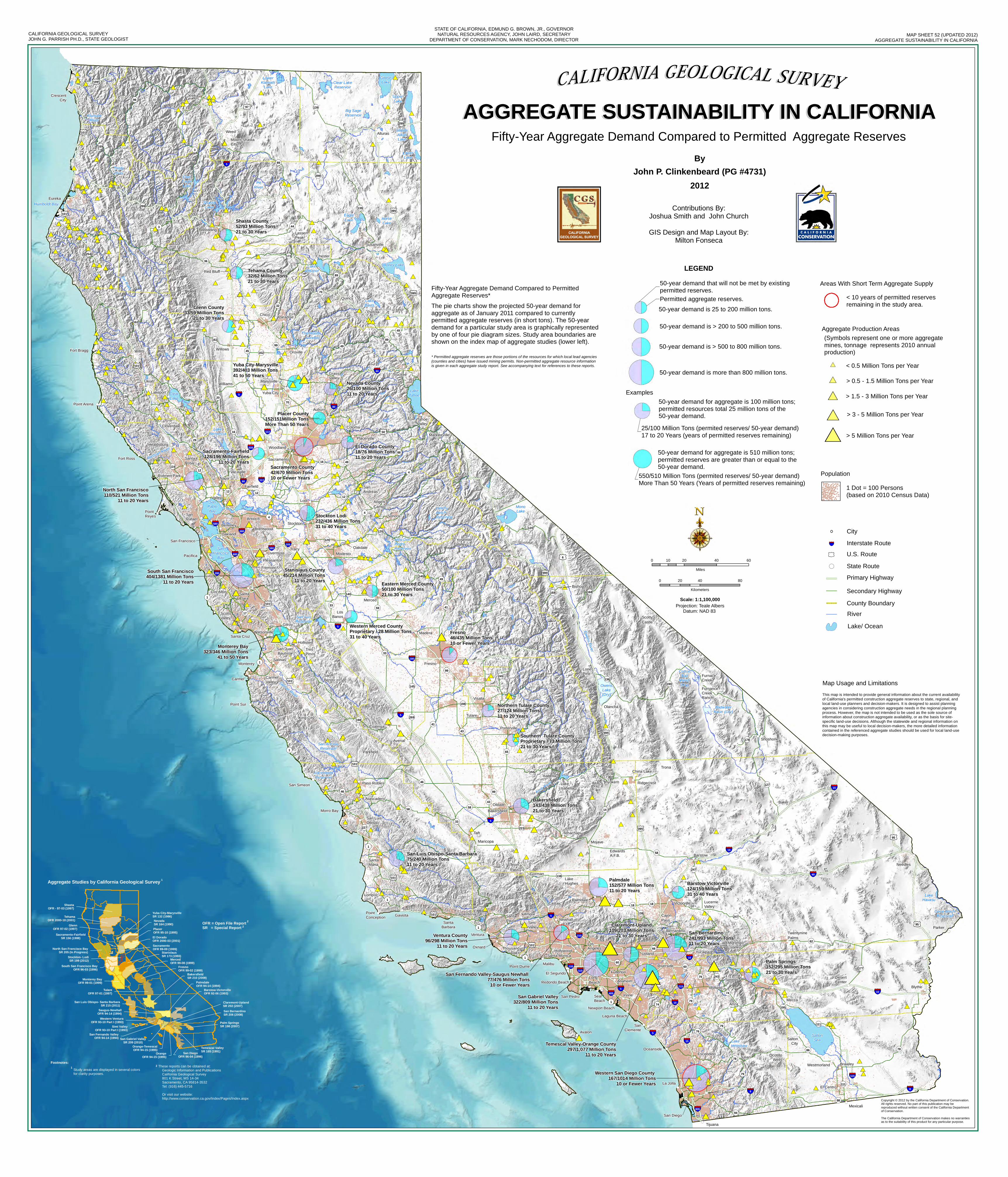
Bakersfield143/438 Million Tons21 to 30 Years

Barstow Victorville124/159 Million Tons31 to 40 Years

Eastern Merced County50/100 Million Tons21 to 30 Years

El Dorado County18/76 Million Tons11 to 20 Years

Fresno46/435 Million Tons10 or Fewer Years

Glenn County33/59 Million Tons

21 to 30 Years

Nevada County26/100 Million Tons11 to 20 Years

Northern Tulare County27/124 Million Tons11 to 20 Years

North San Francisco110/521 Million Tons

11 to 20 Years

Palmdale152/577 Million Tons11 to 20 Years

Palm Springs152/295 Million Tons21 to 30 Years

Placer County152/151Million TonsMore Than 50 Years

Sacramento County42/670 Million Tons10 or Fewer Years

San Bernardino241/993 Million Tons11 to 20 Years

San Fernando Valley-Saugus Newhall 77/476 Million Tons

10 or Fewer Years

San Gabriel Valley322/809 Million Tons

11 to 20 Years

San Luis Obispo-Santa Barbara75/240 Million Tons11 to 20 Years

Shasta County52/93 Million Tons21 to 30 Years

Southern Tulare CountyProprietary / 73 Million Tons21 to 30 Years

Stanislaus County45/214 Million Tons

11 to 20 Years

Stockton Lodi232/436 Million Tons31 to 40 Years

Tehama County32/62 Million Tons21 to 30 Years

Western Merced CountyProprietary / 28 Million Tons31 to 40 Years

Western San Diego County 167/1014 Million Tons

10 or Fewer Years

Claremont-Upland109/203 Million Tons

21 to 30 Years

Monterey Bay323/346 Million Tons

41 to 50 Years

Sacramento-Fairfield128/196 Million Tons

11 to 20 Years

South San Francisco404/1381 Million Tons

11 to 20 Years

Temescal Valley-Orange County297/1,077 Million Tons

11 to 20 Years

Ventura County96/298 Million Tons

11 to 20 Years

Yuba City-Marysville392/403 Million Tons41 to 50 Years

§̈¦15

¬«99

£¤95

£¤95

£¤199

¬«299

¬«60

£¤97

£¤101

£¤101

£¤395

£¤101

£¤395

¬«99

£¤101

£¤101

£¤101

£¤101

£¤395

£¤395

£¤101

£¤6

¬«66

£¤101

¬«70

¬«99

¬«70

¬«60

¬«299

¬«299

£¤395

§̈¦110

§̈¦405

§̈¦80

§̈¦280

§̈¦113

§̈¦580

§̈¦680

§̈¦215

§̈¦5

§̈¦210

§̈¦5

§̈¦5

§̈¦805

§̈¦505

§̈¦80

§̈¦10

§̈¦15

§̈¦580 §̈¦205

§̈¦5

§̈¦5

§̈¦80

§̈¦15

§̈¦15

§̈¦880

§̈¦5

§̈¦5

§̈¦105

§̈¦5

§̈¦8 §̈¦8

§̈¦40

§̈¦180

§̈¦115

§̈¦113

§̈¦10

¬«41

¬«139

¬«243

¬«33

¬«155

¬«139

¬«116

¬«1

£¤50

¬«12

¬«4

¬«65

¬«59

¬«58

¬«247

¬«78

¬«16

¬«94

¬«269

¬«1

¬«98

¬«120

¬«74

¬«43

¬«140

¬«1

¬«1

¬«138

¬«168

¬«127

¬«271

¬«96

¬«29

¬«14

¬«111

¬«12

¬«20

¬«1

¬«12

¬«36

¬«18

¬«45

¬«128

¬«62

¬«17

¬«1

¬«3

¬«58

¬«79

¬«245

¬«195

¬«254

¬«198

¬«41

¬«89

¬«49

¬«138

¬«223¬«33

¬«172

¬«33

¬«89

¬«32

¬«74

¬«111

¬«162

¬«16

¬«198

¬«46

¬«43

¬«1

¬«227

¬«88

¬«79

¬«190

¬«108

¬«178

¬«18

¬«58

¬«78

¬«79

¬«76

¬«1

¬«136

¬«162

¬«168

¬«4

¬«140

¬«1

¬«120

¬«169

¬«89

¬«145

¬«46

¬«79

¬«86

¬«49

¬«12

¬«49

¬«49

¬«177

¬«4

¬«168

¬«20

¬«247

¬«162

¬«89

¬«3

¬«120

¬«108

¬«44

Alturas

Anaheim

AngelsCamp

Antioch

Anza

Atascadero

Auburn

Avalon

Avenal

Azusa

BakerBakersfield

Barstow

Berkeley

Big Pine

Bishop

Blythe

Brawley

Brentwood

CajonPass

Carmel CarmelValley

Carpenteria

Castaic

Chester

Chico

China Lake

Cloverdale

Coalinga

Coloma

CrescentCity

DesertCenter

EdwardsA.F.B.

El CajonEl Centro

El Segundo

Escondido

Eureka

Fairfield

Fillmore

Fort Bragg

Fort Ross

Fremont

Fresno

Fullerton

FurnaceCreekFurnanceCreekRanch

Gaviota

Gilroy

Gorman

GrassValley

Healdsburg

Hollister

Hollywood

IdyllwildIndio

Inyokern

Irvine

Isabella

Julian

King City

La Jolla

Laguna Beach

LakeHughes

LakeIsabella

Lakeport

LassenPeak

Lee Vining

Livermore

Lodi

Lompoc

LonePine

LongBeach

Los Altos

LosAngeles

LosBanos

LucerneValley

Madera

Malibu

MammothLakes

Maricopa

Markleeville

Marysville

Mecca

Merced

Mexicali

Modesto

Mojave

Monterey

MorongoValley

Morro Bay

Mount ShastaCity

Napa

Needles

Newhall

Newport Beach

Oakdale

Oakland

OceansideOcotillo

Wells

Oildale

Olancha

Oroville

Oxnard

Pacifica

PalmSprings

Palmdale

Paradise

Parker

Parkfield

Paso Robles

Placerville

Pleasanton

Point Arena

PointConception

Point Dume

PointReyes

Point Sur

Porterville

Portola

Quincy

Red Bluff

Redding

Redondo Beach

Ridgecrest

Riverside

Rohnert Park

Sacramento

Salinas

SaltonCity

SanAndreas

SanBenito

SanBernardino

SanClemente

San Diego

San Francisco

San Jose

San JuanBautista

San LuisObispo

San Pedro

SanRafael

San Simeon

SantaBarbara

SantaClara

Santa Cruz

SantaMaria

Santa Monica

SantaPaula

SantaRosa

ScottsValley Scotty's

Castle

SealBeach

Shoshone

SimiValley

SonoraStockton

Susanville

Taft

TahoeValley

Tehachapi

TejonPass

ThousandOaks

Tijuana

Tracy

TresPinos

Trona

Truckee

Tulare

TwentyninePalms

Ukiah

Upland

Vacaville

Vallejo

Ventura

Victorville

Visalia

Watsonville

Weed

Westmorland

Williams

Willits Willows

Woodland

YosemiteValley

Yreka

Yuba City

Yucaipa

CALIFORNIA GEOLOGICAL SURVEYJOHN G. PARRISH PH.D., STATE GEOLOGIST

STATE OF CALIFORNIA, EDMUND G. BROWN, JR., GOVERNORNATURAL RESOURCES AGENCY, JOHN LAIRD, SECRETARY

DEPARTMENT OF CONSERVATION, MARK NECHODOM, DIRECTORMAP SHEET 52 (UPDATED 2012)

AGGREGATE SUSTAINABILITY IN CALIFORNIA

AGGREGATE SUSTAINABILITY IN CALIFORNIAAGGREGATE SUSTAINABILITY IN CALIFORNIAFifty-Year Aggregate Demand Compared to Permitted Aggregate Reserves

Contributions By:Joshua Smith and John ChurchGIS Design and Map Layout By:

Milton Fonseca

Fifty-Year Aggregate Demand Compared to PermittedAggregate Reserves*The pie charts show the projected 50-year demand foraggregate as of January 2011 compared to currentlypermitted aggregate reserves (in short tons). The 50-yeardemand for a particular study area is graphically representedby one of four pie diagram sizes. Study area boundaries areshown on the index map of aggregate studies (lower left).* Permitted aggregate reserves are those portions of the resources for which local lead agencies(counties and cities) have issued mining permits. Non-permitted aggregate resource informationis given in each aggregate study report. See accompanying text for references to these reports.

0 20 40 6010

Miles

0 40 8020Kilometers

Scale: 1:1,100,000Projection: Teale Albers

Datum: NAD 83

LEGEND50-year demand that will not be met by existingpermitted reserves.Permitted aggregate reserves.50-year demand is 25 to 200 million tons.

50-year demand is > 200 to 500 million tons.

50-year demand is > 500 to 800 million tons.

50-year demand is more than 800 million tons.

50-year demand for aggregate is 100 million tons;permitted resources total 25 million tons of the50-year demand.

25/100 Million Tons (permited reserves/ 50-year demand)17 to 20 Years (years of permitted reserves remaining)

50-year demand for aggregate is 510 million tons;permitted reserves are greater than or equal to the50-year demand.

550/510 Million Tons (permited reserves/ 50-year demand)More Than 50 Years (Years of permitted reserves remaining)

Examples

< 0.5 Million Tons per Year

> 0.5 - 1.5 Million Tons per Year

> 1.5 - 3 Million Tons per Year

> 3 - 5 Million Tons per Year

> 5 Million Tons per Year

Aggregate Production Areas(Symbols represent one or more aggregatemines, tonnage represents 2010 annualproduction)

Areas With Short Term Aggregate Supply

Population

< 10 years of permitted reservesremaining in the study area.

1 Dot = 100 Persons(based on 2010 Census Data)

CityInterstate RouteU.S. RouteState RoutePrimary HighwaySecondary HighwayCounty Boundary

Map Usage and LimitationsThis map is intended to provide general information about the current availabilityof California's permitted construction aggregate reserves to state, regional, andlocal land-use planners and decision-makers. It is designed to assist planningagencies in considering construction aggregate needs in the regional planningprocess. However, the map is not intended to be used as the sole source ofinformation about construction aggregate availability, or as the basis for site-specific land-use decisions. Although the statewide and regional information onthis map may be useful to local decision-makers, the more detailed informationcontained in the referenced aggregate studies should be used for local land-usedecision-making purposes.

§̈¦

£¤

(

!

!

!!!

!

!

!

!!

! !

!

!

!!

!

!

!

!

!

!

!

!

!

!

!!

!

!

!

!

!!

!

! !

!

!!

!

!

!

!!

!

!

!

!!

!! !

!

!

!

!!

!!

!

!

!!

!

!

!

!

!

!

!

!

!!

!! !

!

!

!

!!

!!

!!

!!

!!

!

!

!!

!

!

!

!

!! !

!

!

!

!!

!!

!

!

!!

!

!

!

!

!

!

!

!

!

!

!!

!

!!

!

!!

!

! !

!

!!

!

!

!

!!

!

!

!

!!

!! !

!

!

!

!!

!!

!

!

!!

!

!

!

!

!

!

!

!

!!

!! !

!

!

!

!!

!!

!!

!!

!

!

!

!

!

!

!

!

CCAALLIIFFOORRNNIIAA GGEEOOLLOOGGIICCAALL SSUURRVVEEYY

RiverLake/ Ocean

#*

#*

#*

#*

#*

ByJohn P. Clinkenbeard (PG #4731)

2012

Copyright © 2012 by the California Department of Conservation.All rights reserved. No part of this publication may bereproduced without written consent of the California Departmentof Conservation. The California Department of Conservation makes no warranties as to the suitability of this product for any particular purpose.

ShastaOFR - 97-03 (1997)

TehamaOFR 2000-18 (2001)

Monterey BayOFR 99-01 (1999)

MercedOFR 99-08 (1999)

TulareOFR 97-01 (1997)

PlacerOFR 95-10 (1995)El DoradoOFR 2000-03 (2001)

FresnoOFR 99-02 (1999)

NevadaSR 164 (1990)Glenn

OFR 97-02 (1997)

North San Francisco BaySR 205 (In Progress)

BakersfieldSR 210 (2009)

PalmdaleOFR 94-14 (1994)

San DiegoOFR 96-04 (1996)

South San Francisco BayOFR 96-03 (1996)

Barstow-VictorvilleOFR 92-06 (1993)

SacramentoOFR 99-09 (1999)

StanislausSR 173 (1993)

OrangeOFR 94-15 (1995)

San Luis Obispo- Santa BarbaraSR 215 (2011)

Temescal ValleySR 165 (1991)

Palm SpringsSR 198 (2007)

Saugus-NewhallOFR 94-14 (1994)

Orange-TemescalOFR 94-15 (1995)

San Gabriel ValleySR 209 (2010)

Stockton- LodiSR 199 (2012)

Western VenturaOFR 93-10 Part I (1993)

Yuba City-MarysvilleSR 132 (1986)

Sacramento-FairfieldSR 156 (1988)

San BernardinoSR 206 (2008)

San Fernando ValleyOFR 94-14 (1994)

Claremont-UplandSR 202 (2007)

Simi ValleyOFR 93-10 Part I (1993)

OFR = Open File ReportSR = Special Report

22

Aggregate Studies by California Geological Survey 1

Footnotes:1 Study areas are displayed in several colors

for clarity purposes.2 These reports can be obtained at:

Geologic Information and Publications California Geological Survey 801 K Street, MS 14-34 Sacramento, CA 95814-3532 Tel: (916) 445-5716 Or visit our website: http://www.conservation.ca.gov/Index/Pages/Index.aspx