leaving certificate geography higher level examination …geography+hl+solutions… · 2015...
TRANSCRIPT

Leaving Certificate Geography Higher Level Examination Paper
CONTENTS
2015 ............................................................................. 2
2014 ............................................................................. 34
2013 ............................................................................. 65
2012 ............................................................................. 96
2011 ............................................................................. 126
2010 ............................................................................. 157
SOLUTIONSEX
AM PAPER
EXAM PAPER

2015 GEOGRAPHY Higher Level
2 Leaving Certificate Geography – Higher Level Solutions
PART 1SHORT ANSWER QUESTIONS
Any 10 questions: 8 marks each
Question 1 – Structure of a Volcano (8 x 1 mark)
Feature (i) Letter (ii) Plutonic (ii) VolcanicSill C üPyroclastic sediment A üDyke D üLava flow B ü
Question 2 – Aerial Photograph (8 x 1 mark)
Landform (i) Letter (ii) Processes of coastal erosion
(ii) Processes of coastal deposition
Blow hole C üSea stack A üBay-head beach D üGeo B ü
Question 3 – European Union (4 x 2 marks) (i) False (ii) True (iii) False (iv) False
Question 4 – Weather Chart (4 x 2 marks) (i) False (ii) True (iii) False (iv) False
Question 5 – Plate Tectonics (4 x 2 marks) (i) Divergent/constructive (ii) Ocean ridge, mid-ocean ridge (iii) Any valid extrusive igneous rock, e.g. basalt (iv) Asthenosphere
Question 6 – Mass Movement (i) (4 marks)
Process LetterRotational slump DSoil creep ALandslide BMudflow C
TIP:
There are twelve short questions. Students should attempt all twelve and the best ten answers will be counted. Do not leave any blank spaces and have a go at each question.

2015 GEOGRAPHY Higher Level
3© Educate.ie
(ii) Gravity, slope, vegetation, precipitation, water content, etc. (2 marks) (iii) Very rapid mass movement process: mudflow, landslide, lahar, etc. (1 mark) Very slow mass movement process: soil creep (1 marks)
Question 7 – Ordnance Survey Map (4 x 2 marks)
(i) 6.1–6.4 km (ii) 6–8 km2
(iii) Mention of sink/slugga or disappearing stream (iv) Any valid species of deciduous tree, e.g. oak, ash, sycamore
Question 8 – Aerial Photograph and Ordnance Survey Map (4 x 2 marks)
(i) V 910 712 (ii) South/south-south west (iii) N71 (iv) Any mention of a diamond or planned shape, wide streets, etc.
Question 9 – Map Skills (4 x 2 marks)
(i) N71 (ii) The Kerry Way (Sli Uibh Rathach) (iii) Cummeenboy (iv) 395–405 m
Question 10 – Landform and Pattern Recognition
(i) (6 marks)
Landform/Pattern LetterTrellis drainage FEven slope BDendritic drainage CConcave slope ADrumlins DCut-off meander E
(ii) Any simple explanation stating that the trend indicates the direction that the ice moved. (2 marks)
Question 11 – Statistical Interpretation (4 x 2 marks)
(i) 5,371 hectares
(ii) 4,352 hectares
(iii) Increase/rise, etc.
(iv) Any brief mention of EU/government grants encouraging forestry or any other valid explanation.
Question 12 – Satellite Interpretation (4 x 2 marks)
Description Letter
Delta DOpen-cast mining BDust storm AForest fire C
TIP:
If the answer is a figure, you must give the unit, whether it is metres (m), kilometres (km), kilometres squared (km2), dollars ($), euros (€), degrees Celsius (°C), etc.

2015 GEOGRAPHY Higher Level
4 Leaving Certificate Geography – Higher Level Solutions
PART 2NOTE ON SRPs
AN SRP (SIGNIFICANT RELEVANT POINT) IS WORTH 2 MARKS.
• It must be a ‘chunky’ piece of information.
• It might also be a correct statistic or factual piece of information.
• Examiners show where they are awarding an SRP in an answer by using two forward slashes (– –).
• In OS map and aerial photograph questions, SRPs are given for accurate grid references or correct photograph locations.
• In most answers, SRPs are awarded for giving relevant examples and specific locations.
SECTION 1 – COREPATTERNS AND PROCESSES IN THE PHYSICAL ENVIRONMENT
QUESTIONS 1 TO 3
Attempt ONE Question
Question 1
A. Karst Landscapes (20 marks)
(i) A Grike (2 marks) B Clint (2 marks) C Swallow hole/slugga/sink hole (2 marks) D Stalactite (2 marks) E Stalagmite (2 marks) F Pillar (2 marks)
(ii) Any two chemical processes from: solution, hydration, hydrolysis, carbonation and oxidation. (2 + 2 marks) (iii) Permeable rocks are rocks that allow water to pass through them (2 marks), e.g. limestone (2 marks).
B. Surface Processes (30 marks)
Answer (i) or (ii).
(i)Cliffs are vertical or very steeply sloping areas found on the coastline between the high water mark and the low water mark. They are formed by the processes of marine erosion. The main processes of marine erosion involved are hydraulic action, abrasion and compression.
TIP:
When answering questions in physical geography, always give at least one example and, if relevant, draw a labelled diagram to aid your answer. Marks are usually automatically awarded when examples are given and for relatively simple labelled diagrams.
TIP:
Two processes of erosion named: 2 + 2 marks
Landform of erosion named: 2 marks
Examination: 12 x SRPs
• A simple, labelled diagram would receive 1 SRP, and any other information in the diagram that is not in the written account could also receive an SRP.
• When attempting to describe the formation of a feature in physical geography, use the D.E.E.P.D method: D = Description; E = Example; E = Explanation; P = Processes (focus on linking the processes to the formation of the feature); D = Diagram (draw a labelled diagram of the feature).
• This question has come up in some shape or form every year since 2006, a sample answer for waterfall formation is given in the 2013 solutions. Here is a sample answer
on the formation of sea cliffs.

2015 GEOGRAPHY Higher Level
5© Educate.ie
The Cliffs of Moher in County Clare are a good example of cliffs in Ireland.
Hydraulic action is the sheer force of moving water. Destructive waves pound the coastline at a rate of more than 12 per minute. They are even more powerful when driven onshore by stormy winds in winter.
The waves pick up stones and rocks and, through the process of abrasion, hurl them against the coastline between the high and low water marks. Any weakness in the coastline will be soon exposed and the constant wave attacks will cut a notch into the coastline.
As the swash pushes into the notch, air is compressed into cracks and crevices in the rock face. When the backwash retreats, the pressure on the compressed air in the small cracks and crevices is released in an explosive manner. Over time, the notch is enlarged and, by the process of undercut and collapse, the land above the notch (the overhang) collapses and a cliff is formed.
The process begins again and the cliff begins to slowly retreat inland, creating a wave-cut platform where the land used to be. The wave-cut platform eventually protects the cliff from further erosion as it absorbs the energy from the incoming waves. The cliff face above the high water mark may be weakened by weathering processes like freeze thaw action and mass movement. In time, the cliff will become inactive when the wave-cut platform protects the cliff from the destructive wave action.
C. Tectonic Activity – Irish Landscape Development (30 marks)
While today Ireland lies safely away from violent plate boundaries, there is ample evidence all around us to prove that this was not always the case. In fact, at one stage, over 850 million years ago, Ireland was divided into two halves. The northern half of Ireland was just south of the equator; the southern half being south of the Tropic of Capricorn. Ireland’s incredible journey from these two locations to our present location involved plates colliding and separating, creating many different tectonic landforms still evident on the landscape today.
About 400 million years ago, the two halves of Ireland crashed into each other through the collision of the American and Eurasian plates. Ireland was created and the Caledonian fold mountains in the northwest of the country were formed. At this time, the Leinster Batholith was also formed, when part of one plate was subducted down towards the mantle. The crust was melted as it sank, forming an enormous chamber of slowly cooling magma. The cooled magma eventually solidified into granite. The granite of the Wicklow Mountains was eventually exposed at the surface by millions of years of weathering and erosion.
About 250 million years ago, the Eurasian and African plates collided, folding the southern half of the country upwards above sea level to form the ridge and valley province of Munster.
Another piece of evidence of our tectonic past is the spectacular Giant’s Causeway in County Antrim. This is part of the Antrim-Derry plateau that was formed about 65 million years ago when the American and Eurasian plates began to separate. When two plates separate, large fissures (cracks) appear as the crust is stretched and lava begins to flow out from the mantle and onto the crust. The lava flowed over a large area, cooling quickly to form a relatively flat area of high ground of basalt rock. At the Giant’s Causeway the lava cooled and contracted a little slower into the world-famous hexagonal columns of basalt. Slemish Mountain in County Antrim is, in fact, an extinct volcano.
TIP:
Two tectonic activities identified: 2 + 2 marks
Two valid Irish locations: 2 + 2 marks
Examination: 11 x SRPs
• Note that the question is related to Ireland.
• One SRP will be awarded for a relevant labelled diagram.

2015 GEOGRAPHY Higher Level
6 Leaving Certificate Geography – Higher Level Solutions
Question 2
A. Ordnance Survey Map (20 marks)
B. Sedimentary Rocks (30 marks)
Sedimentary rocks are formed by the compaction and cementation of the deposited sediments of other rocks and/or the remains of once-living organisms on the seafloor. As the deposited material accumulates on the seafloor, the sediments are compacted by their own weight and the weight of the water above them. The air and water is compressed out of the sediments and naturally occurring cementing agents in the murky seafloor binds the particles together. This process is called lithification.
There are two main types of sedimentary rocks: organically formed and inorganically formed.
Sandstone is an inorganic sedimentary rock made from the compression and cementation of deposited sand particles on the seafloor. About 400 million years ago Ireland was located in a desert environment, about 20 degrees south of the equator. The Caledonian folding
TIP:
Sketch outline: 4 marks
Four features: 4 marks each
Each item shown: 3 marks (graded 3/1/0)
Each item named: 1 mark
• The sketch map must be portrait and 9 cm x 12 cm.
• Draw the four sides of the frame of the sketch and do not use the side of the page or the margin as one of the sides.
• Show the entire course of the Kenmare River and the entire route of the Beara Way as they are shown on the OS map.
• Only show the area of coniferous plantation in the grid square V 85 72 and draw a boundary around it.
• Only show the area of land above 300 metres at Letter South and clearly draw a boundary around it.
• Label each item or use a key. Use a different colour to show each item. The three marks for showing each item are for showing each item accurately and in proportion.
Sketch map of the Kenmare area
Land over 300 mat Letter South
Coniferousplantationat V 85 72
Kenmare River
TIP:
Two Irish examples of sedimentary rocks named: 2 + 2 marks
Two Irish locations of the named sedimentary rocks: 2 + 2 marks
Explanation of formation: 11 x SRPs
• As in any physical geography question there are SRPs for a good labelled diagram.
• The focus of this question is on the formation of sedimentary rocks and not on how limestone may be weathered by carbonation.
The formation of some sedimentary rocks
Silt shale
Gravelconglomerate
Sandsandstone
Shellslimestone
The formation of some sedimentary rocks

2015 GEOGRAPHY Higher Level
7© Educate.ie
period created fold mountains on this landscape in the northern half of Ireland. The southern half of Ireland was under sea at this time. As the plate carrying Ireland moved north, heavy rain eroded the mountains and washed the sand particles south into the southern half, onto the sea bed. There, the particles were lithified into sandstone. Later, the Armorican folding period folded the layers of sandstone above sea level to create the mountains of Munster. These mountains, such as the Caha Mountains in County Cork, are made of what is now called old red sandstone.
Limestone is an organically formed sedimentary rock. It is Ireland’s most common rock and is found exposed at the surface in the Burren, County Clare. Most of the limestone found in Ireland was formed over 350 million years ago, when Ireland was located in a shallow tropical sea south of the equator. This sea was teeming with sea creatures, such as coral, shellfish and fish. When the sea creatures died, their remains began to accumulate on the seafloor where, over time, they were compressed and cemented together to form limestone. This is why limestone rock often contains the fossil remains of sea creatures. Limestone is a layered rock as the lithification process occurred over a very long period of time and in many different stages. Eventually, the Armorican folding lifted the layers of limestone above sea level to form the Munster ridge and valley landscape. The folding squeezed the layers of rock together, forming vertical joints in the layers of limestone.
C. Isostasy (30 marks)
Isostasy has caused many impacts along the courses of some Irish rivers. At the end of the last ice age, about ten thousand years ago, rivers began to flow on the landscape, as the ice slowly melted and eventually disappeared.
When the massive weight of the ice was removed from the continental land mass, the continental plate slowly rebounded upwards and the base level of some rivers fell at the point where they used to reach the sea. Base level is the lowest level at which a river can erode.
This point is now marked on the landscape by a steep drop in the river’s graded profile called a knick point. Where the fall is very steep, rapids or a waterfall may sometimes be found. Due to the sudden drop the river now flows quicker, has more erosive power and is more like a young river. The river is therefore said to be rejuvenated.
The river Barrow in County Kilkenny has multiple knick points, proving that sea levels have fallen more than once along the course of the Barrow.
The river has much more erosive power and can erode vertically down into the river channel again. The river cuts down deeply into the pre-existing meanders to form incised meanders – these are also found on the River Barrow.
The river is now flowing at a lower level than originally, and as it is still in the old-age stage it carves out a new flood plain for itself at the lower level. In this way, paired terraces are formed at either side of the river. A river may have two or more rejuvenations and may then have two or more terraces on either side of the river valley. Paired river terraces are found on the River Nore.
TIP:
Two impacts identified: 2 + 2 marks
Two different Irish locations of the impacts: 2 + 2 marks
Examination of impact: 11 x SRPs
• This question relates to Ireland.
• A labelled diagram merits 1 SRP.
Zone ofincision
Source
Knick pointKnick point
Past base levelsKnick points andincised valley sectionsretreat upstream

2015 GEOGRAPHY Higher Level
8 Leaving Certificate Geography – Higher Level Solutions
Question 3
A. Glaciation (20 marks)
(i) A Drumlin (2 marks) B Terminal moraine (2 marks) C Outwash plain (2 marks) D Esker (2 marks) E Kettle hole lake (2 marks) F Kame (2 marks) (ii) Fluvioglacial processes are processes impacting on the landscape caused by meltwater from glaciers at
the end of the last ice age. The meltwater from the ice eroded, transported and deposited material from the terminal moraine. (4 marks)
(iii) Any two valid landforms, e.g. eskers, outwash plains and glacial spillways. (2 + 2 marks)
B. Landform Development (30 marks)
The collision of massive tectonic plates throughout the world has created fold mountains. The collision of the Indian plate and the Eurasian plate created the Himalayas, the world’s biggest mountains and a barrier to communication and agriculture in Asia today. In South America, the Andes were created when the Nazca plate collided with the South American plate.
There are four main types of folding evident on the landscape:
1. Simple or symmetrical folds: these are formed when the pressure is equal on both sides of the rock. This is very rare. Both limbs are equal on the sides of the mountains.
2. Asymmetrical folds: this occurs when one plate is more powerful than the other and one limb seems to lean over the other.
3. Overfold or overturn: if the pressure continues, soon both limbs lean in the same direction.4. Overthrust fold: if the pressure continues, the rock will snap and one limb (the stronger) will collapse on top
of the other limb.
In Ireland, there have been two major periods of folding or plate collision. The Caledonian period occurred over 400 million years ago with the collision of the Eurasian and North American plates. Mountains from this period are found in the northern half of Ireland and include the Twelve Bens and the Blue Stack Mountains. These mountains are quite small now as they have been eroded and weathered for a long time.
The Armorican folding period occurred about 250 million years ago with the collision of the African plate and the Eurasian plate. This created the ridge and valley province of Munster. The mountains of Munster run in a west to east trend. Before folding, the geology of the province comprised of a layer of thin, weak shale and limestone on top of a harder, older sandstone.
TIP:
Two landforms identified: 2 + 2 marks
Two locations for landforms: 2 + 2 marks
Explanation of folding: 11 x SRPs
AnticlineSyncline
LimbNormal Limb
Overturned Limb
Symmetrical fold
Asymmetrical fold
Overturned fold
Limb
Diagram of types of folding

2015 GEOGRAPHY Higher Level
9© Educate.ie
When the landscape was folded upwards, the upfolds (anticlines), being exposed and made of soft rock, were quickly eroded away, leaving ridges of harder sandstone. The downfolds (synclines), being sheltered, retained their cover of limestone and shale. This landscape is called a ridge and valley landscape and has influenced drainage, settlement, transport and agriculture immensely in the province of Munster.
C. Human Interaction with the Rock Cycle (30 marks)
Geothermal energy uses heat from igneous rocks to heat water and generate steam to produce electricity. Developed countries are leaders in the development of geothermal energy schemes, including New Zealand and Japan. Here, I will consider the development of geothermal energy in Iceland.
Iceland is on the Mid-Atlantic Ridge, a constructive plate boundary where two plates are separating. Molten magma rises close to the surface and very high temperatures occur at or near the surface. This results in the heating of groundwater.
Alternatively, cold water can be pumped near the heated rocks and back up to the surface, where it is pumped to Iceland’s capital city, Reykjavik. Here, the hot water is used to heat offices, apartments and even the footpaths. It may also be used to heat greenhouses and produce fruit and vegetables in this cold boreal climate, thus reducing Iceland’s imports of food.
In geothermal power plants, the water is at such high temperatures it is turned to steam and is used to generate electricity. Nearly 30 per cent of Iceland’s electricity comes from this cheap, clean renewable source of energy. Expensive imports of much dirtier fossil fuels have been dramatically reduced and Reykjavik is now the cleanest capital city in the Western world.
Tourism to Iceland has also increased, as many visitors come to see the Blue Lagoon, an outdoor, man-made geothermal spa. The spa is fed by the water output from a nearby geothermal power station. The water is rich in minerals like sulphur and silica, which are excellent in the treatment of arthritis and psoriasis. Over 400,000 tourists visit the spa annually, bringing much needed revenue to this country of just over 320,000 people. Many hotels, providing much needed employment, have been built near the spa to cater for the rapidly growing tourist industry.
Iceland’s balance of payments has been improved dramatically by the development of geothermal energy. It is envisaged that in the future surplus electricity may be exported to the UK, bringing in even more revenue.
TIP:
Labelled diagram: 2 marks
Examination: 15 x SRPs
• Two SRPs will be awarded for specific examples from examination.
• One SRP will be awarded for a relevant labelled diagram.
• A diagram without labelling is worth 0 marks.
• This sample answer considers geothermal energy production.
Cold waterpumped down
Steam andhot water
Generating station
Hot rocks in the Earth's crust

2015 GEOGRAPHY Higher Level
10 Leaving Certificate Geography – Higher Level Solutions
REGIONAL GEOGRAPHY QUESTIONS 4 TO 6
Attempt ONE Question
Question 4
A. Map Skills (20 marks)
B. Industrial Decline (30 marks)
The Sambre-Meuse region of Belgium is a region of industrial decline that I have studied.
During the industrial revolution, Sambre-Meuse was a very prosperous region of Europe. Its wealth was based on high-quality coal, which provided cheap energy to heavy iron and steel industries and textile industries. Heavy industries were attracted to the region and provided plentiful employment for its people. Many migrants from Flanders, a more rural and agricultural region of Belgium, migrated to Sambre-Meuse.
However, by the early 1950s the best coal seams were exhausted and the region began to go into serious economic decline. Cheaper coal was available from Poland. Cleaner, cheaper and more efficient sources of energy, like oil and gas, were discovered in the North Sea. Foreign competition from the newly industrialising, lower-wage Asian Tiger economies meant that many of the Sambre-Meuse’s industries were no longer competitive. The Belgian government and the EU could no longer support the uneconomic coalmines. As the coalmines shut down, the heavy industries that were located next to them also closed.
TIP:
Map outline: 4 marks (graded 4/2/0)
Four features: 4 marks each
Features shown: 2 marks (graded 2/1/0)
Features named: 2 marks
• This question clearly asks for a European region, so if drawing a country, e.g. Italy to show the Mezzogiorno, clearly show the boundary of the region in Italy.
• Label each feature to get the naming marks. Reasonable accuracy is required. Have a go at showing and naming everything: a line leaving the named urban centre labelled ‘motorway’ would suffice for the named road or rail link.
TIP:
Cause identified: 2 marks
Impact identified: 2 marks
Examination: 13 x SRPs
• One SRP will be awarded from the examination marks for an example of a region’s industrial decline.
• An examination without reference to a named region will receive 0 marks.
• A maximum 7 x SRPs can only be awarded if causes only or impacts only are examined.
• The causes and impacts may be positive or negative, social or economic.
• A valid labelled sketch map can receive 1 SRP.
Northern limit
of the Mezzogiorno
Naples
Mt. Etna
The Apennines
River Agri
Sardinia
Sicily
Reggio
Key
The Autostradade Sole
Apennine Mountains – a relief featureNaples – an urban centreAutostrada de Sole – a road linkAgri – a named river
River Volturno

2015 GEOGRAPHY Higher Level
11© Educate.ie
Once the most prosperous part of Belgium, Sambre-Meuse had become a region of very high unemployment, poverty and out migration. The region had been left scarred and pitted from centuries of coalmining and heavy smokestack industries.
Modern, light, footloose industries were not attracted to the region as many of the workers in the area were older and unskilled. Instead, these industries tended to locate in the once poorer Flanders region, leading to a reversal of fortunes for both regions. There is a lot of tension between these two regions as they have different cultures and speak different languages. This is not helped by the many economic migrants going from Sambre-Meuse to Flanders in search of work. Many observers believe that the country may well split in two in the future due to the cultural and economic divide.
C. Tertiary Activity in Ireland (30 marks)
I have studied the development of tourism in the Greater Dublin Area (GDA). This has been affected by two main factors: 1. the area’s transport infrastructure and 2. The many attractions the area offers.
1. One factor that has influenced this development is the excellent transport infrastructure of the region. Dublin is the focal point of the Irish transport system and this has greatly helped the development of tourism in the GDA. All of Ireland’s major motorways and railway connections radiate out from Dublin.
Dublin has the country’s biggest seaport with ferry terminals connecting the city from Dun Laoghaire to Holyhead and from Dublin to Liverpool. Dublin’s location on the east coast of Ireland means it is accessible to our nearest neighbour, the UK, and to Europe.
Dublin also has Ireland’s biggest airport, which offers daily connections to the UK, Europe and the USA. The construction of a second terminal at Dublin Airport has made the GDA even more accessible to tourists.
When tourists get to Dublin they can benefit from the many recent improvements to the public transport system. Dublin has a very efficient public bus system, the Luas tram system and the DART commuter rail system. Tourists may also use the dublinbikes rental scheme to move about the city. They can also hire cars from many companies, or use the new short-term rental cars located around the city.
The ever-improving transport infrastructure has influenced the development of tourism in the GDA.
2. A second factor that has aided the development of tourism in the GDA is the vast range of historical, cultural and sporting attractions in and around the city.
The Book of Kells is kept open to the public in Trinity College in the heart of Dublin. The Guinness Storehouse at St James’s Gate on the Banks of the River Liffey is the number one tourist attraction in Ireland.
Six Nations rugby international games bring affluent tourists to the city every spring. Major concerts are held in the 3Arena, the RDS Arena and Croke Park, bringing music lovers to the city from all over Ireland.
Powerscourt, the Curragh and the Irish National Stud are all less than 30 minutes from the city and attract tourists from all over the world. The region has many world famous golf courses, such as Mount Juliet and The K Club, which recently hosted the Ryder Cup.
All of these attractions have influenced the development of tourism in the GDA.
Question 5
A. Irish Seafood Exports (20 marks)
(i) France and United Kingdom (2 + 2 marks) (ii) Russia and Other Non-EU (2 + 2 marks) (iii) 30 % (4 marks)
TIP:
Examination: 15 x SRPs
• Two SRPs will be awarded for specific Irish examples of transport or tourism.
• A maximum of two SRPs will be given if only a description of transport or tourism is provided with no accounting for its development.
• A positive or negative interpretation of development is acceptable.

2015 GEOGRAPHY Higher Level
12 Leaving Certificate Geography – Higher Level Solutions
(iv) One major challenge facing the Irish fishing industry is that Irish fishing grounds must now be shared with our EU partners. The Spanish fishing fleet is very modern and the Spanish have a very high demand for fish, which has led to overfishing. (2 + 2 marks) A second challenge facing the Irish fishing industry is the quota system imposed by the EU on Irish fishermen. Ireland’s quota has always been very small in relation to the size of our fishing grounds. The quota puts a very low limit on what can be caught and therefore limits the income of people who fish. (2 + 2 marks)
B. Manufacturing in a European Region (30 marks)
I have studied the development of manufacturing in the Paris Basin. Two factors influencing the development of manufacturing in the region are 1. the rich agricultural base and 2. the transport infrastructure and location.
1. Regions with a rich agricultural base nearly always have a well-developed manufacturing sector as the agricultural sector provides the raw materials necessary for industrialisation. The Paris Basin is no exception – it is one of the most productive agricultural regions in the world. The temperate climate, rich limon soils, low-lying undulating landscape and large farms produce a diverse supply of high-quality raw materials to the manufacturing sector. Normandy’s damp climate favours dairying and most of the milk is processed into Camembert cheese. Danone processes the milk into yoghurts and cheeses and is a major industry in the region. Cider making is also an important industry in Normandy.
In the Île-de-France, two regions have excellent agriculture. The Brie region is an excellent dairying region and provides the raw material for the manufacturing of the world-famous Brie cheese. The Beauce region specialises in the production of cereals, especially wheat. Wheat is the raw material for the production of flour, which can be used to make bread. Brewing is also very popular in the Paris basin and the industry is supplied with barley and hops from the Beauce tillage region.
Vine cultivation in the famous Champagne region provides grapes, the raw material for France’s world-famous sparkling wine industry. Only sparkling wine from the Champagne region can be labelled champagne.
The productive agricultural sector has created a huge demand for farm machinery; most of which is designed and manufactured in the region.
2. The Paris Basin is centrally located in the North European Plain, close to the major affluent markets of Germany, the Netherlands, Italy, Belgium and Switzerland. The region has developed an excellent transport infrastructure that is vital in attracting footloose, modern industry.
Paris is on the River Seine, which is navigable by large barges from Paris to the river’s mouth at Le Havre. This attracts heavy industry.
Paris is the focus point of the French road and rail networks. Motorways connect Paris to markets all over France and beyond. The TGV rapid rail system connects all the main French cities to Paris. The Eurostar rail line connects Paris, London and Brussels through the Channel Tunnel, enabling the rapid transport of executives to and from the Paris region.
Paris also has two international airports, Orly and Charles de Gaulle, which can be used to transport light manufacturing products.
The excellent transport infrastructure and core location has attracted many industries. For example, car manufacturers, such as Renault and Citroën, need the infrastructure offered by the Paris Basin to transport components from many different locations.
TIP:
Examination: 15 x SRPs
• Answers must not deal with Irish or continental/sub-continental regions.
• The discussion must be linked to a named European region and not to a country.
• Two SRPs will be awarded for examples of manufacturing. Examples of manufacturing could be the name of a company or a type of manufacturing activity, such as food processing.

2015 GEOGRAPHY Higher Level
13© Educate.ie
C. The Dynamics of Regions – Human Processes (30 marks)
Population dynamics
The colonisation of Brazil by Portugal in the late fifteenth century has resulted in Brazil having a multiracial population. White settlers from Portugal began to colonise the country in search of wealth and adventure. The Native American population was nearly wiped out because they had no immunity to the common illnesses that the European settlers brought with them, such as measles and influenza. The Portuguese settlers soon ran out of native labourers to work their plantations and brought black African slaves captured from West Africa to work the land. In the twentieth century, migration from other European countries, such as Italy and Germany, continued as the Brazilian government encouraged skilled Europeans to settle in Brazil. Brazil also has a growing Asian community.
Marriage between the different racial groups and the multiracial society that has resulted are features of Brazilian society.
Along the Amazon, the extreme equatorial climate repels settlement. The majority of the population live along the southeast coast, where the climate is milder. Migrants prefer to move to coastal cities like Rio de Janeiro and São Paulo, where jobs are more plentiful.
Urban development
Portuguese colonisers developed port towns to ship the raw materials from Brazil back to Portugal. As a result, most of Brazil’s cities are on the coast. Because the climate on the southeast coast is milder than the extreme equatorial climate of the north, most urban development has occurred on the southeast coast.
The major cities of Brazil are São Paulo, Rio de Janeiro and Curitiba. These cities continue to grow because of the very high migration of people from poorer parts of Brazil and their high birth rates. At present, over 80 per cent of Brazil’s population live in urban areas.
Incomes are three times the national average in the cities of the southeast and the rapid urban population growth has caused many problems. Many of the migrants from poorer parts of the country live in favelas (shanty towns). Cities like São Paulo cannot cope with the rapid population growth and the newly arrived migrants live in huts often made of plywood and corrugated iron. The favelas rarely have running water, sewage, refuse collection or electricity. Drug-related crime is common in the favelas and the police have little control.
São Paulo’s population is now approaching 20 million people and there are also major problems with traffic congestion, air and water pollution and lack of space. Such was the overcrowding in the cities of the southeast in the late 1950s that the government decided to relocate the capital from Rio de Janeiro to the interior and built a brand new capital called Brasilia. The government gave incentives, such as higher salaries, to people living in the cities of the southeast to move to Brasilia but the new capital is not popular because of its hot and humid climate.
Question 6
A. Ireland – Population Dynamics (20 marks)
(i) 1,200 and 4,700 (2 + 2 marks) (ii) 22,400. Any African country will do here, such as Nigeria or Egypt. (2 + 2 marks) (iii) 50.3 %. Most left because in 2008 Ireland went into a serious economic recession and unemployment went over 15 %. (2 + 2 marks) (iv) One positive impact of immigration on Ireland is that many migrants are highly skilled and take up jobs in sectors of the economy where there are skills shortages, such as in the medical sector. (2 + 2 marks) Another positive impact of immigration on Ireland is that when migrants take up employment in our country they contribute to the economy by paying income tax on their earnings. This revenue can be used by the government to improve Ireland’s infrastructure. (2 + 2 marks)
TIP:
Process 1
Influence identified: 2 marks
Examination: 7 x SRPs
Process 2
Influence identified: 2 marks
Examination: 6 x SRPs
• Answers must not deal with Irish or European regions.
• A discussion without a link to a named or clearly inferred region is worth 0 marks.
• A maximum of seven SRPs can be awarded if only one process is discussed.
• Positive and negative influences can be discussed.

2015 GEOGRAPHY Higher Level
14 Leaving Certificate Geography – Higher Level Solutions
B. Primary Economic Activity – Continental/Sub-Continental Region (30 marks)
A primary economic activity I have studied is agriculture in India. Factors influencing the development of agriculture in India are 1. climate and 2. soils.
1. India has a tropical monsoon climate, with temperatures ranging from 20 °C to 32 °C. Agriculture in India is very much influenced by a combination of the monsoon winds, relief and soil type.
The word ‘monsoon’ means seasonal wind. The wet monsoon winds from June to September combined with the high temperatures favour the cultivation of rice and coffee in many parts. During the dry monsoon season from October to June, wheat, maize and millet may be grown. In effect, a system of double cropping exists in India due to the tropical monsoon climate.
In the northwest of India, millet, a hardy cereal that can grow on poor, dry soils dominates, as the region only receives about 900 mm of rain per year due to being in the rain shadow of the Western Ghats. Millet is used to make flour in India. The year-round high temperatures favours the cultivation of tea, sugar cane and cotton. These are grown as cash crops for export.
2. The wet, fertile, alluvial soils along the Ganges River Valley favour the growth of rice. Rice is the staple diet of most of India’s 1.2 billion people, as most agriculture in India is subsistent and carried out on very small plots of land.
The black volcanic soils of the Deccan Plateau are excellent for the cultivation of cotton. In the Western Ghats, the heavy relief rainfall of over 3,000 mm per year causes severe leaching and the formation of laterite soils that are unsuited to productive farming.
Agriculture in the north in the Himalayas is limited to subsistent herding of goats and sheep due to the thin soils and high relief. The desert soils of the Thar Desert are of little use for any type of farming without irrigation.
C. Dynamics of Regions – Climate (30 marks)
The West of Ireland, comprising the counties of Galway, Mayo and Roscommon, is a peripheral region of Ireland that faces many challenges due to its cool, temperate oceanic climate.
Agriculture in the region is severely limited by the year-round, heavy relief rain. Some parts of the West receive more than 2,000 mm of rain per year. Average July temperatures rarely exceed 13 °C, while average January temperatures are about 5 °C.
The heavy rain and low temperatures are major factors determining the type and quality of agriculture carried out in the region. Productive cultivation of commercial cereal crops like wheat or barley is nearly impossible as the heavy rain causes leaching and the relatively low temperatures and lack of sunshine means cereal production is not viable.
Agriculture is limited to pastoral farming in most parts of the West. On the upland mountain areas sheep farming dominates, while cattle rearing is possible, on the better soils and milder climate of the lowland areas. The poor agricultural base means there are very few raw materials available for industrial growth in the region.
The West of Ireland possesses a beautiful, unspoilt, coastal landscape with long stretches of sandy beaches and magnificent scenery. However, the area is not a major tourist destination due to the cool, damp climate. It rains all year round and the cloudy skies mean there is very little sunshine. In some parts of Connemara, it rains up to 250 days per year. Summer temperatures rarely exceed 20 °C. Foreign tourists that do visit the West do so for its culture and scenery, rather than for its climate. Most Irish people prefer to get away from the rain and take their annual holidays in countries where they can be guaranteed hot sunny weather, like Spain and Portugal.
TIP:
Two challenges identified: 2 + 2marks
Two activities challenged by climate: 2 + 2 marks
Examination: 11 x SRPs
TIP:
Factors identified: 2 + 2 marks
Naming two specific examples of the primary activity chosen: 2 + 2marks
Examination: 11 x SRPs
• An alternative answer to this question can be found in the 2010 solutions for agriculture in Brazil.

2015 GEOGRAPHY Higher Level
15© Educate.ie
SECTION 2 – ELECTIVESQUESTIONS 7 TO 12
Attempt ONE Question
PATTERNS AND PROCESSES IN ECONOMIC ACTIVITIESQUESTIONS 7 TO 9
Question 7
A. Future Development of Economic Activities (20 marks)
(i) Facebook/Twitter/YouTube (2 + 2 marks) (ii) 25 % (4 marks) (iii) Second and Malta (2 + 2 marks) (iv) The buying and selling of goods and services on the World Wide Web (2 + 2 marks) (v) Businesses that sell goods on the internet do not need to have expensive shops on the high street. (2 marks) Businesses that trade on the internet have access to an international market without huge costs. (2 marks)
B. Environmental Impact (30 marks)
Local impacts
After Ireland joined the EU in 1973, the overgrazing of sheep in Connemara caused severe soil erosion. Sheep numbers tripled in Connemara when the EU offered Irish farmers headage payments for every animal they stocked on their land. Soon nearly two million sheep were grazing on the Connemara uplands. The vegetation cover was stripped away, exposing the very wet peat soil. A combination of heavy relief rain and gravity caused numerous bog bursts as the waterlogged peat soil moved quickly down slope, removing the natural vegetation cover and destroying the habitat of this delicate ecosystem.
In 2008, the construction of a wind farm on the Stack’s Mountains near Tralee in County Kerry caused a bog burst that saw tonnes of peat flowing into a local stream. The stream was a tributary of the River Feale and the deposition of the peat on the riverbed destroyed the spawning grounds of thousands of salmon and trout along the course of this renowned angling river. The foundations being dug out by heavy machinery for the wind turbines altered the local drainage and lead to the bog burst.
A similar ecological disaster happened in Derrybrien, County Galway, in 2003, when over 50,000 fish were killed in local streams and rivers.
Global impacts
The deforestation of the rainforest for economic gain in the Amazon region of Brazil is leading to the international problem of global warming. The rainforests are the lungs of planet earth, taking in carbon dioxide and releasing oxygen. As the rainforests are destroyed, there is more and more carbon dioxide in the atmosphere. The carbon dioxide lets solar energy in but then traps this energy close to planet earth. As a result, the earth is slowly getting warmer.
Global warming has many negative impacts on the environment. One major impact is the melting of the polar ice caps. This has led to the natural habitats of many animals in the polar regions being irreversibly destroyed. The polar bear and arctic fox will soon only be seen in zoos. The melting of the ice caps is also leading to a rise in sea levels. This is already an environmental problem for low-lying tropical islands, such as the Maldives in the Indian Ocean, which are at risk of disappearing altogether.
TIP:
Two local impacts identified: 2 + 2 marks
Two global impacts identified: 2 + 2 marks
Examination: 11 x SRPs
• It is important to note that the answer must focus on the environmental impacts of economic activities.

2015 GEOGRAPHY Higher Level
16 Leaving Certificate Geography – Higher Level Solutions
Acid rain, caused by the release of harmful gasses into the atmosphere by developed world industries, is also an international problem. The gasses in the atmosphere come down in the rain and the rain is often very acidic and harmful to the environment. Acid rain knows no boundaries and pollution caused many hundreds of miles away in Germany and the UK is causing fish kills in Sweden. Millions of trees in Sweden have been killed by acid rain, destroying the habitats of much of the country’s wildlife.
C. Colonialism (30 marks)
Brazil was colonised by Portugal in the late fifteenth century and remained a colony until 1822. While the negative impacts of this colonialism far outweigh the positive impacts, there were some positive impacts. The Portuguese developed agriculture and trade in Brazil. Prior to colonialism, Brazil was a tribal region. Agriculture was subsistent and poorly developed. The Portuguese brought crops like sugar cane, coffee and cotton and set up more productive plantations. The Portuguese also developed the seaports on the east coast of Brazil, such as São Paulo and Rio de Janeiro. Trade links were developed with Europe and the USA.
However, there were many more negative impacts of the colonialism. While trade links were established between Brazil and Portugal, it was mainly to the benefit of the Portuguese. A dominant–dependant relationship developed, whereby Brazil supplied Portugal with raw materials that were then processed in Portugal. Portugal never encouraged Brazil to develop its secondary industries as they would be in competition with them. After independence, Brazil was overdependent on primary trade activities, such as coffee, sugar cane and oranges. The prices of these goods fluctuated on the world markets and so did Brazil’s economy. Even after independence in 1822, Brazil was still dependent on trade with Portugal, up to the twentieth century. Brazil had very few trading partners apart from Portugal and this hindered economic development. This is called neo-colonialism.
Portugal also took much of Brazil’s natural resources, such as Brazilian hardwood, to be processed in Portugal. Brazil then had to buy finished products back from Portugal at very high prices. Paying high prices for products created from its own raw materials prevented the economic development of Brazil.
In the second half of the twentieth century, Brazil finally escaped from its colonial past and joined Mercosur, a free trade organisation for South American countries. Today, Brazil is a modern, quickly developing economy that is no longer tied down by colonialism.
TIP:
Developing economy named: 2 marks
Two impacts identified: 2 + 2 marks
Examination: 12 x SRPs

2015 GEOGRAPHY Higher Level
17© Educate.ie
Question 8
A. Aerial Photograph (20 marks)
TIP:
Correctly measured frame (14.2 cm x 9.25 cm): 4 marks or 0 marksEach required item: 4 marksEach item accurately shown: 3 marks (graded 3/1/0) Each item labelled: 1 mark
• The sketch must have four sides and be landscape in orientation.
• To get the full 3 marks for showing an item it must be accurately located and be in proportion.
• Labelling can be on the sketch itself or a key may be used.
KeyCar parkTriangular street network in middlegroundCommercial/industrial building in foregroundWaste ground suitable for development
Car park Large commercial/industrial buildingin foreground
Triangular street network in middleground
Sketch map of Kenmare
Area of waste groundsuitable for development

2015 GEOGRAPHY Higher Level
18 Leaving Certificate Geography – Higher Level Solutions
B. Mobility of Economic Activities (30 marks)
Dell is a multinational company that I have studied. Today, Dell is the world’s third-largest manufacturer of computers, after HP and Lenovo. Dell was founded in Texas in 1984 by Michael Dell and now employs over 100,000 workers worldwide.
Initially, one of the unique features of Dell’s operation was its direct sales model: it built individual PCs to order to customers’ specifications. Customers could order their PC online or over the phone. Dell now also supplies computers to retailers, as customers wanted to be able to see the products in shops before purchase.
Dell is a very mobile MNC and has a strategy of manufacturing its computers as near as possible to its markets to reduce the time from order to delivery. This strategy also cuts down on transport costs. Dell has plants supplying the markets of three main regions. For North and South America, Dell has four manufacturing plants in the US and Brazil. Dell employs 16,000 people at its headquarters at Round Rock, Texas. Dell’s second major market is the EMEA region: Europe, the Middle East and Africa. Dell also has operations producing computer products for the Asia/Japan market.
Dell is a footloose MNC and will open and close manufacturing plants in response to labour costs and the taxation policies of the countries in which it operates. All developed economies try to attract MNCs by offering grants and tax incentives. A feature of Dell’s operation is its strategy of closing plants in one country and relocating plants to a country that offers the company better financial terms and conditions. A very good example of this was the closure of the Dell manufacturing plant in Limerick in 2009, with the loss of 1,900 jobs. The plant was relocated to Łódź in Poland, where labour costs were one third of Irish labour costs. Dell was initially attracted to Ireland by government grants and Ireland’s low corporation tax of just 12.5 per cent, but the Polish government were able to offer Dell a better deal. The Polish government offered Dell over €50 million in grants to relocate to Łódź. This opening and closing of branch plants due to changing economic factors shows the mobility of a large MNC like Dell. Dell retained its sales and support staff for the EMEA region at its Cherrywood Science & Technology Park location in Dublin.
Another feature of Dell’s operation is the division of labour that exists through the global distribution of its workers. Jobs in management, research and development (R&D) and sales are located in the US and other developed economies. Jobs in manufacturing tend to be located in low-wage economies like China, Mexico and Brazil. Dell employs 1,200 sales and R&D workers in Cherrywood Park, Dublin.
Like all MNCs, Dell is diversifying its product base and now manufactures LCD TVs and tablet devices. New plants will be opened wherever Dell secures a beneficial deal from countries hoping to attract industrial development from mobile MNCs.
C. Sustainable Development (30 marks)
Sustainable development is development that meets the needs of the present without compromising the ability of future generations to meet their own needs. In Ireland, two major economic activities are now using sustainable development to reduce damage to the environment: agriculture and energy production.
Agriculture
When Ireland joined the EU in 1973, agriculture in Ireland was transformed as Irish farmers now had access to the Common Agricultural Policy (CAP). Farmers got grants to modernise their farms and received headage payments for every animal they stocked. The CAP guaranteed farmers a market and a fair price for any goods they produced.
Overproduction quickly became a major problem in the dairy, beef and sheep sectors. As a consequence, the rural environment was under threat. Soil erosion was destroying upland areas of Connemara due to overgrazing. Fish kills were common in Irish rivers from the run-off from fertilisers such as slurry, and hedgerows were being destroyed as farmers made their farms more productive.
TIP:
MNC (multinational company) named: 2 marks
Examination: 14 x SRPs
• Two SRPs will be awarded for two named locations of the MNC.
TIP:
Examination: 15 x SRPs
• Two examples of sustainable development will be each awarded 1 SRP.

2015 GEOGRAPHY Higher Level
19© Educate.ie
Eventually, in 1994, the EU and the Irish Government introduced the Rural Environment Protection Scheme (REPS). This scheme encourages environmentally friendly and sustainable farming by giving farmers grants when they join the REPS scheme. Farmers would receive grants if they complied with 11 basic measures over a five-year period. For example, farmers would agree to: adopt a grassland management plan to avoid overgrazing and soil erosion; stop using pesticides, herbicides and fertilisers around streams and rivers to protect watercourses and wells; and retain wildlife habitats like woodlands and wetlands. As a result, farmers would be controlling the environmental impact of their activities in a sustainable manner.
Energy production
All developed economies are reducing their dependence on fossil fuels and switching to renewable energy sources. In the production of energy, Ireland is moving away from the burning of fossils fuels to produce electricity. There are now nearly 200 wind farms in Ireland. Fossil fuels produce greenhouse gasses that lead to global warming, whereas wind turbines are a clean and renewable method of producing energy. By adopting more renewable forms of energy production, fossil fuels will last longer and less pollution will be created. The generation of energy through wind farms is an example of sustainable development reducing the environmental impact of economic activities.
Question 9
A. The Environment (20 marks)
(i)
(ii) To cover the costs of transporting the waste to the waste disposal facility and to cover the cost of the workers’ wages.
TIP:
Title: 2 marks
Vertical axis named: 1 mark
Horizontal axis named: 1 mark
Six items illustrated: 2 marks each
• Use graph paper as that is required and marks will be lost if graph paper is not used.
• Use a bar graph to show the information.
• Give the graph a suitable title and label both axes.
• Use a suitable scaled vertical axis, keeping in mind some of the figures are not whole numbers.
• The total marks for the graph is 16 marks. Do not forget to do part (ii) of this question.
TIP:
Any valid explanation: 2 + 2 marks
Country and year
Mill
ion
tonn
es o
f was
te
2004 2012 2004 2012 2004 2012Ireland Denmark Czech Republic
123456789
101112131415161718192021222324252627282930
Total waste generated by households and businesses in selected EU countries in 2004 and 2012 (million tonnes)

2015 GEOGRAPHY Higher Level
20 Leaving Certificate Geography – Higher Level Solutions
B. Location of Economic Activity (30 marks)
One reason it may be difficult to attract large foreign companies to this area is the very poor transport infrastructure of the region. The region does not have any motorways or national primary roads. It only possesses two national secondary roads, the N70 and the N71, and regional roads. There was a railway line into Kenmare at one time, seen at V92 72, but it is now disused. Large MNCs require a good transport infrastructure to move raw materials in and finished products out to the market.
A second reason large MNCs would not be attracted to this area is the upland nature of the physical landscape. Except for the town of Kenmare, most of the landscape is hill or mountain. The north of the map is dominated by upland relief such as Peakeen Mountain at V904 765, which is at a height of 555 metres. Large companies prefer lowland areas to build large plants on, and where there is ample room to expand. The upland nature of the relief means that the further development of a good road transport network would be hindered and air transport would be impossible to develop.
A third reason a large MNC would not be attracted to this region is the rural nature of the area. There is only one town in the area: Kenmare at V90 71. This is a very small town with a limited supply of labour for a large MNC. The town itself would also only provide a very small market for any goods manufactured by the company. It would also seem that the town is dominated by tourism and locals might be against the location of a large factory in the town. This is seen by the location of two golf courses at V921 710 and at V917 718. The Kerry Way, Ring of Kerry Cycle Route and the Beara Way also focus on the town. Therefore, there might be many objections to the location of a large MNC in the town.
C. European Union Policy (30 marks)
The Common Agricultural Policy (CAP) has raised farm incomes and reduced rural poverty in Ireland. The CAP was introduced in 1962 by the EU to ensure that Europe had a steady supply of good quality food, that it was self-sufficient in food production and to reduce foreign imports of food. This was done by giving farmers subsidy payments so that they would have a decent income and would continue farming. Import tariffs and quotas were placed on non-EU food imports. Farmers were guaranteed a fair price and market for their produce.
Farming in many parts of Ireland has always been challenging because of the difficult physical landscape, wet climate and peripheral location. Farm sizes were traditionally small and the local market for goods was limited. When Ireland joined the EU in 1973, agriculture in the country was transformed. Irish farmers now had access to the EU market with no trade barriers. More importantly, farmers now had access to funding from the EU’s biggest fund, the CAP. The CAP gave funding to farmers to modernise their farms. Grants were available for installing modern milking machinery, bulk storage tanks and slatted units, amongst many other grants. Headage payments were initially available to sheep farmers on the bad, hilly land of the West of Ireland. The numbers of sheep being kept soared to such an extent that environmental damage was done to the upland areas of Connemara as overgrazing caused soil erosion.
Farm productivity tripled in the country and the CAP was so successful that overproduction soon became a problem. Quotas had to be introduced to limit production and, as a result, farm incomes were limited unless farmers could increase their quota by buying or renting more land. Bigger farmers benefited more from the CAP.
TIP:
Three reasons: 10 marks each
Reason stated: 2 marks
Map reference/evidence: 2 marks
Explanation: 3 SRPs = 6 marks
• In any question involving an ordnance survey map (or an aerial photograph) it is essential that each point being made is backed up with map evidence in the form of a grid reference (if it is not possible to give a grid reference, give a named feature like a road or a river).
• Vary the reasons, as the answer should not be all about one reason, e.g. transport.
TIP:
Naming a relevant EU policy: 2 marks
Two impacts identified on primary activity: 2 x 2 marks
Examination: 12 x SRPs
• The focus of the question is on the impact of EU policy on primary economic activity. Do not examine secondary or tertiary activity.

2015 GEOGRAPHY Higher Level
21© Educate.ie
As agricultural production increased, jobs in the Irish food processing industry also increased. Irish farm produce was now being processed in Ireland instead of being exported raw to the UK. Food companies like Kerry and Glanbia set up factories in small towns around the country, creating much needed jobs in rural Ireland. Irish exports to other EU countries also increased, as Ireland became less dependent on the UK as its main market. The CAP encouraged farmers to diversify their production away from the overproduction in dairy, beef and lamb.
Forestry was actively encouraged on the poorer land in the Border, Midland and Western (BMW) region and this also created some employment in the timber processing industry. Early retirement schemes were introduced to enable farmers on low incomes to retire on a decent pension and to reduce overproduction and the high cost of storing surplus farm products. The CAP has increased farm incomes, created employment and reduced poverty and emigration in rural Ireland.
Another policy of the EU that has had an impact on the Irish economy is the Common Fisheries Policy (CFP). All along the western seaboard, many small towns, such as Killybegs, Dingle and Castletownbere, depend on fishing. The CFP made funds available for the modernisation of fleets, catches were increased and much needed jobs were created in fish processing plants. Ireland also gained access to new markets in the EU for wild Atlantic salmon and shellfish from the unpolluted waters around Ireland. Unfortunately, overfishing became a problem with the improvements in technology and the fact that other EU countries could fish off the Irish coast. Quotas had to be introduced and the industry is heavily regulated. Many Irish fishers are now seeing their incomes reduced by the strict regulations.

2015 GEOGRAPHY Higher Level
22 Leaving Certificate Geography – Higher Level Solutions
PATTERNS AND PROCESSES IN THE HUMAN ENVIRONMENT QUESTIONS 10 TO 12
Question 10
A. Aerial Photograph (20 marks)
TIP:
Correctly measured frame (14.2 cm x 9.25 cm): 4 marks
Each required item: 4 marks
Each item accurately shown: 3 marks (graded 3/1/0)
Each item labelled: 1 mark
• The sketch must have four sides and be landscape in orientation.
• Labelling can be on the sketch itself or a key may be used.
• Common methods of managing traffic in a town are roundabouts, off-street parking, double yellow lines and other road markings, traffic lights, one-way streets, clearways zones, etc.
Key
Triangular street network in middleground
Three methods for managing tra�c:
O�-street car parkRoad markings at a junction
Roundabout
Sketch map of Kenmare

2015 GEOGRAPHY Higher Level
23© Educate.ie
B. Urban Problems (30 marks)
Urban sprawl is a major problem in the Greater Dublin Area (GDA). The city has grown from being a small, compact city in the 1950s to an extended urban area of over 1.5 million inhabitants in a very short time. The city urban area now extends into the neighbouring counties of Kildare, Meath and Wicklow. The commuter belt extends even further.
This has many impacts on the surrounding rural area. Urban sprawl has caused the loss of prime agricultural land around Dublin. The demand for land to construct housing estates for Dublin’s rapidly growing population enticed many farmers near the city to sell land to property developers. The city is becoming a concrete jungle full of monotonous estates. What were once quiet, rural villages outside Dublin have seen their character destroyed.
There is consequent overcrowding in schools and other services as small villages and nearby towns struggle to cope with the ever-rising population. Sewage schemes are not able to deal with the waste from the new housing developments. Towns like Newbridge, Navan and Naas have tripled in population due to urban sprawl from Dublin.
As agricultural land and amenity land is changed to residential land, the natural habitats of many native plants and animals have been destroyed. New roads have to be built and existing roads widened to cope with the volume of commuters travelling to and from Dublin.
The construction of new motorways has led to the destruction of many artefacts and historic buildings. The N3 motorway is very close to The Hill of Tara and is causing visual pollution in this beautiful area. Public transport systems cannot cope with the number of commuters, so workers have to travel to work in their cars. The air pollution caused by the increased number of cars on the roads is now a problem in the Dublin area.
Traffic congestion is a problem in the small villages and cities near the city as the roads were not built to deal with such a high volume of traffic. The air quality in the GDA has declined dramatically with the increased congestion on the area’s roads. Such was the increase in pollution that smoky coal had to be banned in the GDA.
The quality of people’s lives is also reduced as they spend more time in their cars commuting to and from work and less times with their families and friends. Commuters have to get up early in the morning to make it to work on time and then spend a lot of time frustrated and stressed in rush-hour traffic jams on their journey home. Commuters are tired when they arrive home and have no time to get involved in their communities, in sport clubs coaching young children or in other community projects. Residents in the commuter towns outside Dublin sometimes don’t even know their own neighbours.
Bypasses have to be built to take the cars out of the small towns and villages. Local farmers are forced to give their land over to the National Roads Authority to build the new roads. Farms are often divided by the construction of the new roads, causing health and safety problems for the farmers and their livestock. Improvements in the public transport system in the area, like more bus lanes and urban rail networks, would take some of the cars off the roads and reduce congestion in the GDA.
TIP:
Each example of different urban centres: 1 SRP
Examination of problem one: 7 x SRPs
Examination of problem two: 6 x SRPs
• Always give two examples.
• The urban example can be an urban area or part of an urban area.
• Remember that the examination should focus on problems and not solutions to the problems, even though a maximum of 2 SRPs can be awarded for discussion on solutions.
• This sample answer discusses urban sprawl and traffic congestion.

2015 GEOGRAPHY Higher Level
24 Leaving Certificate Geography – Higher Level Solutions
C. Overpopulation (30 marks)
Overpopulation occurs when the number of people living in an area is too great to be supported by the available natural resources.
Sahel, North AfricaOvergrazing and overcropping in the Sahel region of North Africa has led to the depletion of the soil and overpopulation in the region. The Sahel is a transitional climate zone found between the hot desert climate of the Sahara and the Savanna grassland climate. The area was covered by sparse grass and bushy vegetation. The vegetation cover was protecting the soil underneath.
Many nomadic tribes live in the area and use the grasslands as fodder for their cattle and goats. The nomadic tribesmen measure wealth according to their herd size, and with an increasing demand for food due to rising population they began to keep more and more animals. The animals overgrazed the land. The soil’s protective cover was removed and the soil was dried out by the sun and eroded by the wind. The immediate impact of this was famine and death in the Sahel. Countries like Mali and the Sudan were very badly affected. The herdsmen’s way of life was destroyed and many were forced to move into urban areas, where they were forced to live in shanty towns.
Aral Sea, former USSRThe unwise use of a natural resource, water, has caused overpopulation in the Aral Sea in the former USSR. The Aral Sea was once the third largest inland sea in the world. Over 30 million people lived around the sea in thriving communities. There were fishing ports, tourist towns and a rich agricultural hinterland. All of these activities were supported by accompanying industries, such as shipbuilding and food processing.
Two major rivers flowed into the Aral Sea: the Syr and Amu. The delta regions of both rivers were rich in many species of fish and had excellent soil for agriculture. The government of the USSR, thousands of miles away in Moscow, decided to divert water from the rivers to grow cotton on plantations along the rivers. Cotton is a water-thirsty crop and soon less and less water reached the Aral Sea. The sea began to shrink. The new coastline is now 80 kilometres further in from some of the once thriving ports.
The region has become an environmental disaster area. Fishing, tourism and agriculture have been destroyed and many people live in extreme poverty. The climate of the region has become hotter and drier as there is less moisture in the air. The freshwater lake has become very saline due to climate change and many species of fish have been wiped out. The environment is now very dry and dusty and people’s health has been adversely affected by respiratory diseases like TB.
TIP:
One cause of overpopulation identified: 1 SRP
One effect of overpopulation identified: 1 SRP
Two examples/locations of overpopulation: 1 SRP each
Examination: 11 x SRPs

2015 GEOGRAPHY Higher Level
25© Educate.ie
Question 11
A. Population Dynamics (20 marks)
(i)
(ii) The introduction of free secondary school education in the late 1960s meant that most girls finished their secondary school education. This, in turn, led to many women choosing to work full- time outside the home, which resulted in a fall in Irish birth rates.
B. Urban Settlement (30 marks)
Kenmare is the only major urban centre on the map and the town is a nodal point where many routes converge. The town is a focus point of road networks where the N71 and N70 secondary routes and the R569 and R 571 regional roads meet. This makes Kenmare a busy crossroads, where road traffic is constantly passing through. Trade and commerce would flourish in the town as it is the only large central place in the region and easy to access through the road network.
Most essential services would be located in the town to serve the people of the town and its hinterland. For example, there is a hospital at V914 718 and schools at V912 715. Most people like to live close to the essential services and this would help the town to grow and develop.
Historically, the town may also have used rail and sea transport to grow and develop. There is evidence of a rail connection at V92 72, and this railway line is seen to have once connected with the town. In the nineteenth century, rail transport was the dominant form of transport as the car had yet to be invented. Railway lines were built all across the country and towns that had a railway line grew and developed as they were connected to all the large urban centres in Ireland. Agricultural produce could be quickly transported to the market before it went off and also tourists could visit Kenmare.
It is also very likely that sea transport played a part in the development of the town as there is a pier at V906 701. This may have been used for the local fishing industry, providing many jobs on the boats and in processing and transporting the fish.
TIP:
Any valid explanation: 2 + 2 marks
• A simple statement and development will do here, it doesn’t have to be very long.
TIP:
Examination: 12 x SRPs
Three pieces of map evidence: 1 SRP each
• Three well-explained points in three paragraphs would be the best approach here.
• For each point, provide suitable evidence from the map. (Do not give any evidence from the aerial photograph.)
TIP:
Title: 2 marks
Vertical axis named: 1 mark
Horizontal axis named: 1 mark
Six items illustrated: 2 marks each
• Use graph paper as that is required and marks will be lost if graph paper is not used.
• Use a bar graph to show the information.
• Give the graph a suitable title and label both axes.
• Use a suitable scaled vertical axis, keeping in mind some of the figures are not whole numbers.
• The total marks for the graph is 16 marks. Do not forget to do part (ii) of this question.
Year
Birt
h an
d de
ath
rate
s pe
r 1,0
00
1950 1990 2013
123456789
101112131415161718192021222324
Irish birth and death rates per 1,000 of population Bi
rth
rate
Dea
th ra
te
Birt
h ra
te
Dea
th ra
te
Birt
h ra
te
Dea
th ra
te

2015 GEOGRAPHY Higher Level
26 Leaving Certificate Geography – Higher Level Solutions
Today, tourism is definitely helping the town to grow and develop. The town is the focus point for three major touristic routeways: the Kerry Way, the Ring of Kerry Cycle Route and the Beara Way. These routeways would attract much needed revenue to this rural, peripheral location. Tourists would need food, drink and lodging on arrival in the town and many jobs would be created locally. There are two youth hostels in the town, one of those is at V911 706. The many roads converging on the town would also bring tourists to the town to play in the town’s golf courses, one of which is located at V 921 710. Most of the workers in the tourist trade would live locally, building houses, starting families and spending their wages in the town. All of this would help the town to grow and develop even further.
C. Migration (30 marks)
São Paulo in Brazil is a developing world city that has experienced rural to urban migration on a very large scale. São Paulo is the economic core of Brazil and attracts migrants from the poorer parts of the country in search of employment and a better standard of living.
One of the most noticeable impacts on São Paulo of this migration is the growth of favelas (shanty towns) on the urban fringe of the city. The population growth in São Paulo has been so rapid due to the sheer volume of migrants arriving in the city and very high birth rates. As a result, there is not enough housing. Newly arrived migrants build illegal dwellings wherever they can. It is now estimated that nearly 20 per cent of the population of the city live in favelas. The people live in extreme poverty as São Paulo cannot provide employment for the rapidly growing population.
Favela dwellings are essentially huts made of bits of plywood and sometimes have corrugated iron roofs. The huts have no running water, electricity, sewage or refuse collection. Some of the favelas have been built near dumps so the people in the favelas can scavenge for waste. Some of the favelas have been built on steep hill slopes and landslides are a problem after heavy rain. Disease, illness, drug abuse and crime are widespread in the favelas.
The city authorities are trying to improve the living conditions in the favelas by giving the residents building materials to rebuild their dwellings, but progress is very slow. The national government has tried to reduce the population pressure in São Paulo by building a brand new capital city in the interior. Residents in São Paulo are given financial incentives to move to Brasilia and free farmland is offered to anyone if they relocate to the interior of Brazil.
Another impact of the rapidly increasing population in São Paulo due to rural to urban migration is traffic congestion and pollution. The urban area has a population of over 20 million people and this figure continues to rise. There are over 6 million cars in the city and the roads cannot cope with this volume. Public transport is inadequate and traffic congestion is widespread. The air pollution caused by the burning of fossil fuels in cars and factories is causing a rise in respiratory illnesses in young children and the elderly.
The city is the focus point for many motorways in the region and the recent construction of an orbital ring road has helped eased traffic congestion in the city. The authorities have also introduced a rota system for car owners, where they must leave their car at home one day a week. This has reduced the volume of cars on the city streets by 20 per cent.
Question 12
A. Population (20 marks)
(i) Pyramid A: 2 %. Pyramid B: 3 %. (2 + 2 marks) (ii) Pyramid B. Pyramid A tapers as it goes up, while B stays broad at the top. (2 + 2 marks) (iii) Pyramid A. Any African country would do here, like Mali, Chad, Ethiopia, etc. (2 + 2 marks) (iv) The provision of good healthcare for the elderly will be a challenge as the population ages and the elderly require more medical care. The cost of paying pensions to the elderly will also be a challenge as most people live longer. Both of these costs may have to be funded through increased taxation. (2 + 2 marks)
TIP:
City of the developing world named: 2 marks
Two impacts identified: 2 + 2 marks
Examination: 12 x SRPs
TIP:
Two impacts identified: 1 SRP each
Two examples of urban strategies: 1 SRP each
OR
Two areas that have undergone urban planning: 1 SRP each
Examination: 11 x SRPs

2015 GEOGRAPHY Higher Level
27© Educate.ie
B. Urban Planning (30 marks)
In the late 1960s, the Ballymun Flats complex was built to solve the problem of overcrowding in Dublin’s inner city. Initially, this consisted of seven 15-storey apartment tower blocks. Unfortunately, the Ballymun Flats were a planning disaster as they were very poorly constructed. They became an area of high unemployment, as many of the residents were low-skilled early school leavers. Social stratification was a feature of the Ballymun area as it became populated by mainly low-income residents.
In 1997, the Ballymun Regeneration Project began. The project was to transform the area into a modern, low-rise urban area. The tower blocks were demolished and replaced with modern, well-built, low-rise housing. Green belts, playgrounds, sports centres, a health centre, crèches and a modern town centre were also newly built to provide essential services for the residents of Ballymun. Jobs were created for the locals in the new town centre and in the Ikea superstore nearby. The impact of the project has been immense and residents can take pride in the modern, planned urban landscape.
A second successful urban planning strategy called the schéma directeur was started in Paris in the late 1960s. There was huge pressure to cope with the rapid growth of Paris in the twentieth century in a planned and organised fashion. Urban sprawl, traffic congestion and urban decay were already major problems in the city. The schéma directeur plan was initiated to cope with the problems the city was now facing.
Urban renewal and urban redevelopment projects began in the inner city to revitalise the run-down and derelict areas. La Défense, an old industrial area, was transformed into a modern international financial centre, employing over 80,000 workers and breathing new life into this part of the city.
To cope with urban sprawl, five new towns were built in the suburbs of the city. The most famous of these is Marne-la-Vallée, which has a population of over 280,000 residents and also contains the Euro Disney complex. Technology parks providing much needed jobs were built in the new towns and the rapid, unplanned growth of Paris was stopped.
The impact of the plan was a reduction in the overcrowding, pollution and traffic congestion in Paris. The inner city is now a vibrant part of Paris but still retains its old-style charm and buildings. Paris remains the most popular tourist city in the world, for which the schéma directeur is largely responsible.
C. Phases of Historical Settlement (30 marks)
(i) Three historical phases evident on the map are the Celtic era, the Early Christian era and the Norman era. (ii) Evidence of a Celtic era settlement is the ring fort at V905 741. Evidence of an early Christian settlement is the church at V922 702. Evidence of settlement from the Norman era is the castle at V884 705(iii) The Celts came to Ireland around 500 BC. Ring forts
are the signature settlement of the Celts. They were often built on slightly elevated sites for defence reasons as these sites had good observation over the surrounding landscape. They were easy to defend as attackers had to move uphill to attack the site. On upland sites there would be less thick forest to clear and the soil would be easier to work. The ring fort shown on this map is built on a hilltop site of over 150 metres in height. Place names beginning with Lios or Dύn mean fort, such as Lissyclearig near this ring fort.
The early Christian era began in the fifth century. Early Christians built small churches to worship in all over Ireland. They often chose isolated, rural sites for the churches as they wanted peace and quiet for their prayer. This site is near the Kenmare River for a source of fresh water, food and transport. If the sites
TIP:
(i) Naming each of the three historical phases is worth 2 marks each.
(ii) Naming an example of a settlement from each of the phases is worth 2 marks, and giving a correct location (i.e. a six figure grid reference) for each of the settlements is also worth 2 marks each.
(iii) Explaining each of the three phases is worth 4 marks each (3 x 2 + 2 marks).
Today, tourism is definitely helping the town to grow and develop. The town is the focus point for three major touristic routeways: the Kerry Way, the Ring of Kerry Cycle Route and the Beara Way. These routeways would attract much needed revenue to this rural, peripheral location. Tourists would need food, drink and lodging on arrival in the town and many jobs would be created locally. There are two youth hostels in the town, one of those is at V911 706. The many roads converging on the town would also bring tourists to the town to play in the town’s golf courses, one of which is located at V 921 710. Most of the workers in the tourist trade would live locally, building houses, starting families and spending their wages in the town. All of this would help the town to grow and develop even further.
C. Migration (30 marks)
São Paulo in Brazil is a developing world city that has experienced rural to urban migration on a very large scale. São Paulo is the economic core of Brazil and attracts migrants from the poorer parts of the country in search of employment and a better standard of living.
One of the most noticeable impacts on São Paulo of this migration is the growth of favelas (shanty towns) on the urban fringe of the city. The population growth in São Paulo has been so rapid due to the sheer volume of migrants arriving in the city and very high birth rates. As a result, there is not enough housing. Newly arrived migrants build illegal dwellings wherever they can. It is now estimated that nearly 20 per cent of the population of the city live in favelas. The people live in extreme poverty as São Paulo cannot provide employment for the rapidly growing population.
Favela dwellings are essentially huts made of bits of plywood and sometimes have corrugated iron roofs. The huts have no running water, electricity, sewage or refuse collection. Some of the favelas have been built near dumps so the people in the favelas can scavenge for waste. Some of the favelas have been built on steep hill slopes and landslides are a problem after heavy rain. Disease, illness, drug abuse and crime are widespread in the favelas.
The city authorities are trying to improve the living conditions in the favelas by giving the residents building materials to rebuild their dwellings, but progress is very slow. The national government has tried to reduce the population pressure in São Paulo by building a brand new capital city in the interior. Residents in São Paulo are given financial incentives to move to Brasilia and free farmland is offered to anyone if they relocate to the interior of Brazil.
Another impact of the rapidly increasing population in São Paulo due to rural to urban migration is traffic congestion and pollution. The urban area has a population of over 20 million people and this figure continues to rise. There are over 6 million cars in the city and the roads cannot cope with this volume. Public transport is inadequate and traffic congestion is widespread. The air pollution caused by the burning of fossil fuels in cars and factories is causing a rise in respiratory illnesses in young children and the elderly.
The city is the focus point for many motorways in the region and the recent construction of an orbital ring road has helped eased traffic congestion in the city. The authorities have also introduced a rota system for car owners, where they must leave their car at home one day a week. This has reduced the volume of cars on the city streets by 20 per cent.
Question 12
A. Population (20 marks)
(i) Pyramid A: 2 %. Pyramid B: 3 %. (2 + 2 marks) (ii) Pyramid B. Pyramid A tapers as it goes up, while B stays broad at the top. (2 + 2 marks) (iii) Pyramid A. Any African country would do here, like Mali, Chad, Ethiopia, etc. (2 + 2 marks) (iv) The provision of good healthcare for the elderly will be a challenge as the population ages and the elderly require more medical care. The cost of paying pensions to the elderly will also be a challenge as most people live longer. Both of these costs may have to be funded through increased taxation. (2 + 2 marks)
TIP:
City of the developing world named: 2 marks
Two impacts identified: 2 + 2 marks
Examination: 12 x SRPs
TIP:
Two impacts identified: 1 SRP each
Two examples of urban strategies: 1 SRP each
OR
Two areas that have undergone urban planning: 1 SRP each
Examination: 11 x SRPs

2015 GEOGRAPHY Higher Level
28 Leaving Certificate Geography – Higher Level Solutions
chosen by the early Christians had good situations, towns often grew around the site of the church. This is not the case at this site but in the town of Kenmare there are two pieces of evidence that it has early Christian origins, the Cillίn at V904 705 and the Holy Well at V907 710.
The Normans were the great castle builders. They began to slowly colonise the country from 1169 AD onwards. The Normans usually chose strategic locations to build their castles, as they were invaders and they wanted to control the movement of people and goods. This castle is outside of the town of Kenmare overlooking the Kenmare River estuary, maybe to control movement up and down the river. The castles were built of stone for defence purposes and they are the dominant feature of the Norman era. Many towns grew around the castles for protection, as is evident in Irish place names like Castlebar, Castleisland and Castlegregory.
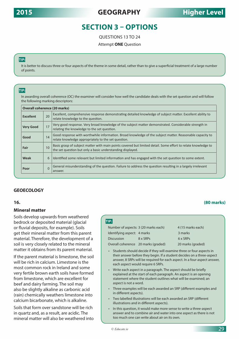
2015 GEOGRAPHY Higher Level
29© Educate.ie
SECTION 3 – OPTIONSQUESTIONS 13 TO 24
Attempt ONE Question
GEOECOLOGY
16. (80 marks)
Mineral matter Soils develop upwards from weathered bedrock or deposited material (glacial or fluvial deposits, for example). Soils get their mineral matter from this parent material. Therefore, the development of a soil is very closely related to the mineral matter it obtains from its parent material.
If the parent material is limestone, the soil will be rich in calcium. Limestone is the most common rock in Ireland and some very fertile brown earth soils have formed from limestone, which are excellent for beef and dairy farming. The soil may also be slightly alkaline as carbonic acid (rain) chemically weathers limestone into calcium bicarbonate, which is alkaline.
Soils that form over sandstone will be rich in quartz and, as a result, are acidic. The mineral matter will also be weathered into
TIP:
It is better to discuss three or four aspects of the theme in some detail, rather than to give a superficial treatment of a large number of points.
TIP:
Number of aspects: 3 (20 marks each) 4 (15 marks each)
Identifying aspect: 4 marks 3 marks
Discussion 8 x SRPs 6 x SRPs
Overall coherence 20 marks (graded) 20 marks (graded)
• Students should decide if they will examine three or four aspects in their answer before they begin. If a student decides on a three-aspect answer, 8 SRPs will be required for each aspect. In a four-aspect answer, each aspect would require 6 SRPs.
• Write each aspect in a paragraph. The aspect should be briefly explained at the start of each paragraph. An aspect is an opening statement where the student outlines what will be examined; an aspect is not a word.
• Three examples will be each awarded an SRP (different examples and in different aspects).
• Two labelled illustrations will be each awarded an SRP (different illustrations and in different aspects).
• In this question, it would make more sense to write a three-aspect answer and to combine air and water into one aspect as there is not too much one can write about air on its own.
TIP:
In awarding overall coherence (OC) the examiner will consider how well the candidate deals with the set question and will follow the following marking descriptors:
Overall coherence (20 marks)
Excellent 20Excellent, comprehensive response demonstrating detailed knowledge of subject matter. Excellent ability to relate knowledge to the question.
Very Good 17Very good response. Very broad knowledge of the subject matter demonstrated. Considerable strength in relating the knowledge to the set question.
Good 14Good response with worthwhile information. Broad knowledge of the subject matter. Reasonable capacity to relate knowledge appropriately to the set question.
Fair 10Basic grasp of subject matter with main points covered but limited detail. Some effort to relate knowledge to the set question but only a basic understanding displayed.
Weak 6 Identified some relevant but limited information and has engaged with the set question to some extent.
Poor 0General misunderstanding of the question. Failure to address the question resulting in a largely irrelevant answer.

2015 GEOGRAPHY Higher Level
30 Leaving Certificate Geography – Higher Level Solutions
quite large particles that can be seen with the naked eye. This means that soils that develop over sandstone will have excellent drainage qualities, as the texture will allow water to freely drain through the soil.
When granite is exposed at the surface, it is chemically weathered by hydrolysis. Hydrolysis means to split using water. Granite breaks down into particles of mica and quartz as feldspar (the glue that used to bind the particles together) is weathered by rain into clay particles. As a result, soils that develop over granite are acidic from the quartz. They also have very poor drainage, as clay particles are tiny and very slow to let water through the soil.
Desert soils, known as aridisols, are very rich in minerals, due to the constant exfoliation of bare rock. However, good soils rarely develop in arid regions as the climate is far too hot and dry, plant growth is minimal and the soil lacks humus and moisture.
Organic matter This is a vital component in the development of good soils, as decomposing plant litter provides soils with humus. Humus is a black gel-like substance that binds soil particles together. It holds on to minerals and water and enriches the soil. Brown earth soils have developed in the south and east of Ireland on areas that are or were covered in deciduous woodland. The annual autumnal fall of leaves results in these soils being rich in organic matter that is decayed by bacteria and fungi into humus. Soils that have developed in areas once covered by deciduous woodland are deep, fertile soils that are excellent for tillage and dairying.
Conversely, soils that develop in areas under coniferous plantations are shallow, acidic, infertile and lacking in organic matter. Coniferous trees are evergreens and do not shed their leaves in autumn. Their leaves are small needles covered in a waxy resin. The needles are very slow to decompose and when they do they are acidic and prevent the growth of any other plants. Natural decomposers cannot survive in the acid conditions.
Aridisols of desert areas are also lacking in organic matter as the hot, dry climate prevents the growth of vegetation. Plants that do grow in the desert have adapted to survive in the harsh conditions. There is an absence of humus and moisture that would bind the soil particles together. The sun dries out the smaller soil particles and the strong winds remove them. The soils that develop in desert regions are therefore gravelly and stony and unsuited to agriculture.
The latosol soils that develop in the Amazon rainforest have very low humus content due to the rapid decomposition of the organic matter by bacteria in this hot, humid climate. Any humus that is formed is immediately taken up by the shallow-rooted trees of the rainforest.
Water and airToo much water or too little water can have a major effect on soil development. In upland regions along the west coast of Ireland, heavy rain has caused podzolization in moorland areas and areas under coniferous forestry. Organic matter and soluble minerals are removed in solution by the percolating rain. The soil has an ash-grey colour as it is drained of the dark coloured minerals such as iron and aluminium. The soil becomes infertile as the minerals are washed down through the soil. The iron minerals begin to accumulate at the boundary between the A and B horizons to form a crusty hard pan, which is impermeable.
The soil that develops in these regions are waterlogged and of little use for agriculture.
In equatorial regions such as the Amazon rainforest, the heavy, daily, convectional rainfall causes an extreme form of leaching called laterisation. When the protective tree cover is removed, a combination of leaching, high temperatures and carbonation dissolves most minerals out of the soil, except for the iron oxides. As a result, the soil has a very distinctive red colour. The rain mixes with the rapidly decomposing plant litter from the deciduous trees to form humic acid and, as a result, the soils are mildly acidic.
In desert regions such as the Sahara, it is the lack of rain that influences soil development. The lack of precipitation causes moisture in the soil to be drawn upwards to the surface by the extreme heat and capillary action. On reaching the surface, the water is quickly evaporated and any dissolved salts in the water recrystallise. This process is known as salinisation and the topsoil soon becomes toxic as the salts accumulate.
Air provides the soil with nitrogen and oxygen, so vital for growth and for living organisms to thrive. Air is found in the pore spaces between the particles of soil. A good soil typically has 25 per cent air, but when the pores are tiny (such as in clay soils) or when the pores are full of water (as in waterlogged soils), a good soil will not develop as good soil needs nitrogen and oxygen.

2015 GEOGRAPHY Higher Level
31© Educate.ie
17. (80 marks)
One way human activities impact on soil is through overgrazing. A very good example of this occurred in Connemara in the 1970s and 80s.
Ireland joined the EU in 1973 and Irish farmers received the benefits of the Common Agricultural Policy (CAP). One aim of the policy was to ensure that farmers earned a decent income. The CAP did this by offering farmers in peripheral regions headage payments per animal stocked. The more animals a farmer kept, the more money he received from the CAP. As a result, the number of sheep kept on the poor, hilly, mountainous land of Connemara exploded, quickly reaching 2 million. Overgrazing soon caused the soil’s protective vegetation layer to be removed. The animals’ hooves trampling the exposed soil changed the structure of the soil peds from crumby to platy. This meant that water could no longer percolate down through the soil and was forced to run off the surface. The soil was exposed to the heavy relief rain common in the West of Ireland and was easily washed away by the rain.
Mass movement also played an important part in removing the soil from the steep slopes. Once the soil was removed, the area became worthless for agriculture and the many areas of this beautiful part of Connemara had their ecosystems destroyed.
A second way that human activities impact on soil is through overcropping. The massive population explosion in Sub-Saharan countries like Nigeria, Mali and Chad has resulted in an increased demand for food. These countries also have massive foreign debts that they are attempting to repay through the export of cash crops such as cotton and peanuts. The best land is used to grow the cash crops for export.
To grow food crops for the ever-increasing population, the people are forced to cultivate marginal land in the Sahel. The Sahel is a transitional climate zone between the hot desert climate and the savannah grassland climate. The region is semi-arid, with rainfall between 250 and 500 mm per year. The soil is protected by the vegetation cover. However, to grow food crops the soil must be ploughed and the vegetation cover removed. In many parts of the Sahel, the sun dried out the exposed soil and the wind then eroded the soil. Once the soil was removed, the underlying rocky, stony subsoil was uncovered and the land is now forever useless for agriculture. This process is called desertification.
In the USA, a similar problem was caused in the 1930s when farmers in the country’s wheat belt attempted to extend the cultivation of wheat westwards into the prairie belt. The land in the prairie belt, a natural grassland area, was ploughed and exposed to the elements. When a severe drought occurred, the soil was quickly eroded by the wind. Over 400,000 km² of land in the states of Oklahoma and Texas was destroyed. This is known as the American Dust Bowl.
A third human activity that can impact on soil is deforestation. Deforestation is now a very serious problem in the Amazon rainforest in Brazil. The rainforest acts as a natural canopy, protecting the soil underneath from the daily convectional rain. If the trees are cut down, the soil is exposed to the heavy rain. Initially, the soil is quite fertile as it is rich in humus from decaying vegetation. However, leaching by the daily rain soon washes the nutrients and minerals down through the soil and renders it useless. On hills and areas with slopes, the soil is quickly washed away and gullying occurs.
There are many reasons for the deforestation of large tracts of the Brazilian rainforest. American fast food companies, such as McDonald’s and Burger King, clear the rainforest for cattle ranching. The decision made by the Brazilian government in the late 1950s to build a new capital city, Brasilia, in the interior and overpopulation in the coastal cities led to the destruction of huge amounts of rainforest. Slash-and-burn farming techniques used by some Brazilian farmers to clear forest to grow cash crops is another problem. The
TIP:
Number of aspects: 3 (20 marks each) 4 (15 marks each)
Identifying aspect: 4 marks 3 marks
Discussion 8 x SRPs 6 x SRPs
Overall coherence 20 marks (graded) 20 marks (graded)
• Students should decide if they will examine three or four aspects in their answer before they begin. If a student decides on a three-aspect answer, 8 SRPs will be required for each aspect. In a four-aspect answer, each aspect would require 6 SRPs.
• Write each aspect in a paragraph. The aspect should be briefly explained at the start of each paragraph. An aspect is an opening statement where the student outlines what will be examined; an aspect is not a word.
• Three examples will be each awarded an SRP (different examples and in different aspects).
• Two labelled illustrations will be each awarded an SRP (different illustrations and in different aspects).

2015 GEOGRAPHY Higher Level
32 Leaving Certificate Geography – Higher Level Solutions
farmers cut down the trees, burn the trees and undergrowth, and then plant crops like soya beans and coffee. In a few years, leaching makes the soil infertile and the farmer moves on and fells the trees in another part of the rainforest. This type of farming is called shifting cultivation. The Brazilian government offers large farms of land free to people who move from the overpopulated coastal cities to the rainforest. Hardwoods like teak, rosewood and ebony are in demand for furniture in Europe and the US and are a cause of much deforestation. The construction of the Trans-Amazonian highway through the rainforest has led to huge deforestation in the region. Finally, opencast mining in the rainforest is responsible for terrible soil erosion, as the miners have no environmental controls and use toxic chemicals that are harmful to the soil in the mining process.
18. (80 marks)
In this answer, I will examine how plants and animals have adapted to the arid soil conditions and extremely high temperatures of the hot desert climate.
Plant adaptations to the desert climateThe vegetation within this biome is sparse and only vegetation that has adapted to the climate can survive in this harsh climate. Temperatures by day are +30 °C; by night temperatures can fall to near 0 °C. Rainfall in desert areas is between 0 to 250 mm per year and some years there is no rainfall.
Mechanisms that plants adopt to survive are varied. Some plants are ephemerals, like the desert paintbrush, and their seeds lie dormant for long periods until it rains. The seeds have a waxy coating that enables them to survive for years, if necessary. When it rains, the seeds germinate, grow, mature and produce more seeds before the plant dies, all within a very short two-to-three-week cycle. The seeds fall to the ground where they again lay dormant until the next rain arrives, sometimes years later. Other plants are succulents. They have adapted to store huge quantities of water in their fleshy interiors. The most famous succulent plant is the cactus. The cactus can swell out like an accordion to store water after rain.
Plant adaptations to the arid desert soilMany desert plants have adapted their root systems to cope with the arid soil conditions. The mesquite plant has deep tap roots that search for water deep under the surface. The roots can be taller than the plant above ground. Some mesquite roots are over 25 metres in depth. Other plants, like the cactus, have shallow radial roots that spread extensively just under the surface, so that the roots can quickly capture any rain that falls before it is evaporated by the scorching sun. The creosote bush has a combination of tap roots and radial roots that allow the plant to search deep underground for water when it is scarce and to quickly take advantage of any rainfall near the surface before it evaporates. Desert plants are widely spaced from each other to avoid competition for the very scarce water.
TIP:
Number of aspects: 3 (20 marks each) 4 (15 marks each)
Identifying aspect: 4 marks 3 marks
Discussion 8 x SRPs 6 x SRPs
Overall coherence 20 marks (graded) 20 marks (graded)
• Students should decide if they will examine three or four aspects in their answer before they begin. If a student decides on a three-aspect answer, 8 SRPs will be required for each aspect. In a four-aspect answer, each aspect would require 6 SRPs.
• Write each aspect in a paragraph. The aspect should be briefly explained at the start of each paragraph. An aspect is an opening statement where the student outlines what will be examined; an aspect is not a word.
• Three examples will be each awarded an SRP (different examples and in different aspects).
• Two labelled illustrations will be each awarded an SRP (different illustrations and in different aspects).
• This is not a question on the characteristics of a biome, so do not spend too much time (if any) describing/explaining the climate or soil of the biome.
No leaves – to reduce
water lossSmall surface
area – to reduce
water loss
Very thick stem
and able to swell
– to store water
Spines – to stop
animals eating it
Shallow radial
roots just under
the surface – to quickly
capture rain

2015 GEOGRAPHY Higher Level
33© Educate.ie
Animal adaptations to the climate and soil of the hot desertAnimals are very scarce in the hot desert and, like the desert flora, only animals that have made adaptations can survive in the climate. Desert animals use many different methods to survive.
Some species are nocturnal. They burrow into the soil by day to avoid the extreme heat. They emerge at night to hunt for food. The rattlesnake and the kangaroo rat are two nocturnal animals.
Some animals hibernate for long periods of time in burrows underground. They only emerge when it rains to eat, mate and reproduce. The desert toad is a hibernator; in a 24-hour span, after rain, toads mate and the females’ eggs will be fertilised and hatched. The eggs develop into tadpoles in the quickly drying pools and in ten to twelve days the tadpoles develop into toads. As the pool disappears, the toads burrow underground to await the next rain, which could be years away. The desert toad has also made an interesting adaptation to the desert soil conditions – it has evolved its hind feet into digging tools so that it can dig burrows in the sandy soil to escape the desert sun.
Some animals of the hot desert are non-drinkers; thus they do not need a regular supply of water. The fennec fox gets moisture from its prey’s blood. The desert gazelle obtains liquid from the vegetation it eats. Instead of urinating, it passes tiny, dry pellets, which are made of uric acid.
The camel is the animal most famous for its adaptations to the desert conditions. The camel can drink more than 100 litres of water at one time. It doesn’t perspire and can last several months without water. It can store fat in its humps as a food reserve. It has wide, padded hooves so it can walk on the hot, loose sand without sinking. It has a leathery mouth so that it can eat spiky plants. Its pale colour reflects the sun’s heat.
Leathery mouth – to eat spiky plants
Humps – to store fat
Wide, padded hooves – to walk without sinking
Pale colour – to re�ect heat

2014 GEOGRAPHY Higher Level
34 Leaving Certificate Geography – Higher Level Solutions
PART 1SHORT ANSWER QUESTIONS
There are twelve short questions. Students should attempt all twelve and the best ten answers will be counted.
Any 10 questions: 8 marks each
Each question:• 4 parts: 2 marks each• 8 parts: 1 mark each
No grading/scaling of marks
Question 1 – Coastal Features (8 x 1 mark)
Feature (i) Letter (ii) Natural (ii) Human
Groyne B 4
Offshore bar A 4
Rock armour D 4
Cliff C 4
Question 2 – Glacial and Fluvial Landforms (8 x 1 mark)
Landform (i) Letter (ii) Glacial Processes (ii) Fluvial Processes
U-shaped valley D 4
Meander A 4
Arête B 4
V-shaped valley C 4
Question 3 – Patterns and Processes in the Physical Environment (8 x 1 mark)
Feature/Process Letter
Joint D
Syncline G
Volcano A
Coastal deposits C
Bedding plane E
Magma chamber H
Weathering B
Anticline F
TIP:
If the answer is a figure always give the unit (metres, millions, etc.). If the answer is a sum of money use the € symbol and if the answer is a percentage use the % symbol. Marks will be lost if the unit/symbol is missing.
Grid references must have the sub-zone letter.

2014 GEOGRAPHY Higher Level
35© Educate.ie
Question 4 – Weather (4 x 2 marks) (i) 6°C (the answer must have °C) (ii) 1.5°C (the answer must have °C) (iii) Isotherms (iv) The Gulf Stream, a warm ocean current, passes the west coast,
raising temperatures in coastal areas all year round. OR The sea takes a long time to heat, but retains its heat over the
winter, making coastal areas warmer than areas inland in January.
Question 5 – Plate Tectonics (8 x 1 mark) (i) A: North American Plate B: Eurasian Plate C: African Plate D: South American Plate
(ii) E: Constructive/diverging boundary F: Conservative/transverse/transform/passive/neutral boundary
(iii) True True
Question 6 – Regions (8 x 1 mark)
Type of Region Specific Example General Location
Geomorphological Paris Basin North European Plain
Urban Berlin Germany
Climate Mediterranean Southern Europe
Administrative County Meath Ireland
Cultural Basques Northern Spain
Question 7 – Ordnance Survey Map (4 x 2 marks) (i) S273 (or 274) 008 (or 009).
(ii) 90 km²
(iii) North/North-east/North-north-east
(iv) Any answer from 6.7 km to 7.1 km.
Question 8 – Aerial Photograph and Ordnance Survey Map (4 x 2 marks) (i) X255 930
(ii) N25
(iii) Silting, the harbour is too shallow, coastal deposition, etc.
(iv) Priory or church
TIP:
The range is found by subtracting the lowest temperature in Kerry (5.5°C) from the highest temperature in Kerry (7°C).
TIP:
Any combination of those figures in the correct order with the sub-zone letter S.

2014 GEOGRAPHY Higher Level
36 Leaving Certificate Geography – Higher Level Solutions
Question 9 – Map Skills (4 x 2 marks) (i) Gran Canaria
(ii) -2,000 metres
(iii) 6,000 metres
(iv) Many tourists might visit the island (1 mark) creating employment in the services industry. (1 mark)
OR Volcanic regions have very fertile soils (1 mark) which would
result in a very productive agricultural sector. (1 mark)
Question 10 – Pattern Recognition (4 x 2 marks)
Drainage Pattern Letter
Dendritic C
Deranged D
Trellis B
Radial A
Question 11 – Statistical Interpretation (4 x 2 marks) (i) 7,700
(ii) 10,500
(iii) 40,800
(iv) Net migration is the difference between the number of immigrants and the number of emigrants into a country or region.
Question 12 – Graphical Interpretation (4 x 2 marks) (i) 15.8%
(ii) 3.5%
(iii) 47.8%
(iv) Geothermal energy is energy created by pumping cold water down to rocks which are heated by magma under the surface. When the water is heated, it turns to steam and this can be used to create electricity. It is very common in volcanic regions like Iceland.
TIP: The answer needs a statement with a little development.
TIP:
This answer must have the unit (metres).

2014 GEOGRAPHY Higher Level
37© Educate.ie
PART 2NOTE ON SRPs
AN SRP (SIGNIFICANT RELEVANT POINT) IS WORTH 2 MARKS.
• It must be a ‘chunky’ piece of information.
• It might also be a correct statistic or factual piece of information.
• In OS map and aerial photograph questions, SRPs are given for accurate grid references or correct photograph locations. In most answers, SRPs are awarded for giving relevant examples and specific locations.
SECTION 1 – COREPATTERNS AND PROCESSES IN THE PHYSICAL ENVIRONMENT
QUESTIONS 1 TO 3Attempt ONE Question
Question 1 (20 marks)A. Ordnance Survey Map
TIP:
Sketch outline: 4 marks
4 features: 4 marks each
Each item shown: 3 marks (graded 3/1/0)
Naming each item: 1 mark
• The sketch must be to half scale, be portrait shape and have the four sides ruled. Do not use tracing paper or show only a portion of the map. Remember to keep everything in proportion as you are reducing by half.
• For naming the items you can simply label the items on the sketch map or use a key.
• Even if you locate an item poorly (like the gorge) you can still get the naming marks as you have attempted to show the item. There are no marks for blank spaces!
• When a map has a large area of coastline you must draw the coastline on your sketch map.
• For showing each of the 4 items examiners will be looking for accuracy, neatness and proportion.
TIP:
When answering questions in physical geography always give at least one example and if relevant draw a diagram to aid your answer. Marks are usually automatically awarded when examples are given and for relatively simple labelled diagrams.

2014 GEOGRAPHY Higher Level
38 Leaving Certificate Geography – Higher Level Solutions
B. Rocks (30 marks)Igneous rocks are fiery in origin and form from cooled lava or magma. Igneous rocks can be intrusive or extrusive, depending on where the magma/lava cools. Two igneous rocks I have studied are granite and basalt.
Granite is an intrusive igneous rock formed when magma cools slowly under the earth’s surface. As the magma cools slowly, large crystals form in granite. Granite is composed of three minerals: mica, feldspar and quartz. The proportions of these minerals vary creating granites of many different colours and textures. However, grey is the dominant colour found in Ireland. Granite is a strong, resistant rock used in buildings and as worktops. When granite is exposed to rain, it breaks up to form clay.
Granite is found in the Leinster Batholith, formed 400 M.Y.A. during the Caledonian folding movement. Magma chambers formed under the surface where the magma slowly cooled to form granite. Nearby rocks were baked and cooked by the intense heat into metamorphic rocks, e.g. sandstone was metamorphosed into quartz. As the overlying layers of softer sedimentary rocks were eroded, the harder igneous batholith of granite was exposed. The Great Sugar Loaf in Wicklow is granite coated with a sprinkle of quartzite, thus the name ‘Sugar Loaf’.
Basalt is an extrusive igneous rock formed when lava cools quickly on the surface. Lava escapes through fissures and volcanoes and is cooled quickly by air and water. Thus, basalt is smoother with smaller crystals than granite. Basalt is a black, dark-greyrock. It is a very hard rock but is not very attractive, so is usually used in road construction. When basalt weathers, it forms a deep fertile soil as found in the fertile river valleys of Ulster.
The Antrim–Derry plateau is a lava plateau in the north-east of Ireland formed when basic, runny lava escaped from a fissure and flowed for many miles. It cooled quickly to form an elevated plateau. The Giant’s Causeway’s hexagonal columns of basalt are a world-renowned tourist attraction. At the Giant’s Causeway, lava cooled quickly in a stream where the water caused the basalt to shrink and contract into the famous hexagonal columns.
C. The impact of dams on river processes (30 marks)One way human processes can impact on river processes is through dam construction. The biggest dam project in the world was built on the Yangtze River, in China, and is known as the Three Gorges Dam. In Ireland in 1929, the River Shannon was dammed at Ard-na-Crusha near Limerick.
The construction of a dam involves building a wall across a river. The flow of water can then be regulated as the river is forced to flow through tunnels in the dam wall.
Hydro-electric power (HEP) may be created by the moving water through the dam. A vast reservoir or man-made lake, is formed upstream of the dam.
Extrusive igneousrock formation
Intrusive igneousrock formation
Lava
Magma chamber
TIP:
Rocks named: 2 + 2 marks
Correct Irish locations for each rock: 2 + 2 marks
Explanation of formation of igneous rocks: 11 x SRPs
A relevant labelled diagram will receive 1 SRP. If there is extra information in the diagram, which is not mentioned in the text, that information could receive up to an additional 2 SRPs.
TIP:
Examination: 11 x SRPs
• Two impacts on river processes will each be awarded 1 SRP.
• Two named locations of dams will each receive 1 SRP.
• A third impact would require discussion before receiving 1 SRP.
• The answer requires an examination on the impact of dam building on river processes, not the impact of dam building on human activity.

2014 GEOGRAPHY Higher Level
39© Educate.ie
The Three Gorges Dam project in China had four main aims:
1. Flood control
2. The production of HEP
3. Improving navigation along the river
4. Providing irrigation waters to areas of drought.
The project cost US$25 billion and was finished in 2009.
The natural river processes of erosion, transportation and deposition are now being altered by the human activity of dam building. However, one major natural process that the dam controls is flooding. This was the main reason for the project, as flooding along the Yangtze River has claimed 1 million lives in the past 100 years.
Controlling the river’s flooding has had many positive effects for the people in this region. Flood control has improved the living conditions of millions of people along the Yangtze. Farmers are no longer exposed to annual flooding in winter. Water from the winter rains can be stored in the reservoir behind the dam and used for summer irrigation, thus transforming the agriculture of the region.
The project has also had many negative effects. The natural process of river deposition has been affected. When the river reaches the dam, it is slowed down and deposits build up behind the dam. Fertile alluvium is trapped behind the dam and is no longer deposited downstream on the river’s floodplain. Farmers may now have to buy expensive chemical fertiliser to maintain their soil’s fertility.
When water is released through the dam, it has less sediment and can flow much more quickly, the river has a renewed capacity to erode and some flooding may be caused downstream of the dam in times of heavy rain.
As stated, the dam traps sediment behind it and, as a result, less sediment now reaches the Yangtze’s delta. Consequently, the delta is deprived of the coarse deposits that prevent coastal erosion at the delta. The delta region is now being rapidly eroded and the fresh-water ecosystem has been altered. The local fishing industry in the delta has been destroyed with consequent food shortages, unemployment and poverty. The natural delta habitat is also under threat; it has become more saline as less fresh water reaches the delta and many species of fish have been wiped out.
Behind the dam a reservoir 630 km in length was created as the flow of the river was interrupted and over 1.3 million people had to be relocated.
From using this case study, it is clear that human processes, such as dam building, have had a major impact on natural river processes.
Question 2 A. Internal Structure of the Earth (20 marks)
(i) A Crust (2 marks) B Mantle (2 marks) C Asthenosphere (2 marks) D Lithosphere (2 marks) E Outer core (2 marks) F Inner core (2 marks)
(ii) The asthenosphere is made up of molten (tar-like) material (2 marks) while the lithosphere is rigid or solid. (2 marks)
(iii) The plates are moved by convection currents of hot magma rising upwards from the core towards the crust through the mantle. (2 marks) Just under the crust, the plates move laterally as they cool and finally sink downwards again, causing the plates above them to move slowly. (2 marks)
TIP:
Always read the title of the question. This specifies the subject matter of the question.

2014 GEOGRAPHY Higher Level
40 Leaving Certificate Geography – Higher Level Solutions
B. Landform Development (30 marks)
A waterfall is a vertical fall of water usually found in the youthful stage of a river where a band of hard rock lies over a band of softer, less resistant rock. Some good Irish examples of waterfalls are Torc near Killarney and Powerscourt in County Wicklow. The softer rock is eroded away much more quickly than the hard rock by the process of differential erosion. At the point where the soft rock begins, hydraulic action, the force of moving water, begins to cut vertically down into the soft rock. Hydraulic action erodes rocks and stones in the river’s banks and bed. The river now uses this load to erode the soft rock further until the river begins to fall sharply where the two rock types meet, this process is called abrasion.
The falling water with its load quickly erodes a plunge pool in the soft rock. The misty spray rising from the plunge pool may slowly dissolve the back wall and, by solution, weaken the back wall. The hard rock is undercut and, without any support, collapses into the plunge pool and by the process of undercut and collapse, the waterfall migrates upstream towards the source of the river. This process is called headward erosion. As the waterfallslowly moves backward, a deep, narrow valley called a gorge or canyon is created. Niagara Falls in the USA is migrating backwards at a speed of one metre per year.
A delta is a feature of fluvial deposition that I have studied. A delta is a flat area of land made of deposited alluvium formed when a river enters a sea or lake. Deltas are found in the old stage of rivers. An Irish example of a delta may be found at the estuary of the River Shannon, while an international example may be found at the mouth of the River Nile in Egypt. In order for a delta to form, the amount of sediment deposited by the river must be greater than the amount of sediment removed by the tides and currents. Therefore deltas usually form at sheltered river mouths where sea currents and tidal action is weak, like in the Mediterranean Sea.
When a river enters the sea or a lake, its velocity decreases as a small body of water, a river, meets the sea. The river loses its energy and, as a result, the river begins to deposit its load.
Waterfall retreats
Overhang
Hard rock
Fallen rocks
Soft rock
Hard rock
Plunge pool
Steep-sided gorgedevelops as waterfallretreats
Ridges of hard rockcreate an uneven slope.This creates rapids
Block diagram showing gorge formation:
Gorge left by retreatOriginal positionof waterfall
Position of waterfallafter retreat
TIP:
Landform of erosion named: 2 marks
Landform of deposition named: 2 marks
Formation landform of erosion: 6/7 x SRPs
Formation landform of deposition: 6/7 x SRPs
• For each landform credit is given for a relevant, labelled diagram for 1 x SRP.
• A diagram without labelling 0 marks.
• For each landform credit is given for extra relevant information on a labelled diagram for 1 x SRP.
• Credit 1 x SRP for an example of both landform of erosion and deposition.
• Credit a maximum of 1 x SRP per landform for only a description of each landform with no reference to formation.
• Credit 1 x SRP per landform for an explanation of a named process. All further discussion of processes must be tied to formation of the landform.

2014 GEOGRAPHY Higher Level
41© Educate.ie
The deposition is sorted and laid down in three distinctive layers:
1. Bottomset beds: This is the lightest of the material and is carried out the farthest. It is laid down in horizontal layers of fine sediment.
2. Foreset beds: This material is slightly heavier and coarser than the bottomset material and is deposited close to the river mouth.
3. Topset beds: This is the heaviest of the rivers load and is deposited nearest to land. It is so heavy and dense that when it rises above water level, it forces the river to divide up into channels, called distributaries, to reach the sea.
Marine deltas form at the mouths of rivers entering the sea. There are three types of marine delta:
1. Arcuate delta: This is a triangular delta formed from coarse material. It develops where sea currents are quite strong and the edges of the delta can’t be kept straight, e.g. the Nile Delta.
2. Bird’s foot delta: This consists of fine material and a small number of distributaries that extend out like the claw of a bird’s foot, e.g. the Mississippi Delta.
3. Estuarine delta: This is a delta that is yet to extend beyond the coastline. The sediments have been deposited in the shallow water along the sides of the estuary, e.g. the Shannon Estuary.
Deposition occurs as theriver loses velocitywhen it enters the sea
Distributariesform as themain riverchannel splitsinto smallerchannels
Heaviest material isdeposited first and the lightest last
Delta is built upin layers
River mouth Topset beds
Forest beds
Bottomset bedsBedrock
C. Rocks and Landscapes (30 marks)When limestone is exposed at the surface, it is slowly chemically weathered by carbonation to form a karst landscape as can be found in The Burren, County Clare. It is thought that the protective soil cover in this area was removed by glacial erosion during the last ice age, exposing the limestone bedrock to carbonation. Carbonation is a chemical weathering process that occurs when rain absorbs carbon dioxide as it falls through the atmosphere to become a weak acid, called carbonic acid. Carbonic acid slowly dissolves limestone rock, especially in areas where the rock is exposed, but also underground. Limestone is a jointed and layered sedimentary rock. Joints are vertical lines of weakness in limestone and they are slowly enlarged by carbonation. Over time, the joints are widened and deepened to form grikes, the slabs of rocks separating the grikes are called clints and the resulting landscape is called a limestone pavement.
The Giant’s Causeway in County Antrim is a very distinctive landscape that was formed when lava, from a divergent plate boundary, cooled quickly on the surface. In Ireland, basalt was formed about 65 million years ago when the North American Plate began to pull away from the Eurasian Plate, and lava spilled from the mantle onto the surface. The lava cooled rapidly to form the igneous rock, basalt. At the Giant’s Causeway, it is believed that the lava flowed into a river where it was cooled quickly and contracted to form the distinctive hexagonal pillars of basalt. Today the Giant’s Causeway is a world heritage site and a major tourist attraction.
Clints Grykes
JointsBedding
Limestone landscape, before and after carbonation.
TIP:
Rock 1: named and associated landscape named and correctly located: 2 + 2 + 2 marks
Rock 2: named and associated landscape named and correctly located: 2 + 2 + 2 marks
Examination: 9 x SRPs

2014 GEOGRAPHY Higher Level
42 Leaving Certificate Geography – Higher Level Solutions
Question 3A. Landscape Development
(i) A Youthful/Young/Upper (2 marks) B Mature/Middle (2 marks) C Senile/Old age/Lower (2 marks)
(ii) A Waterfall/ V-shaped valley/Interlocking spurs (2 marks) B Meanders/Oxbow lakes (2 marks) C Levees/Delta/Flood plain (2 marks)
(iii) In the theory of the cycle of erosion, a peneplain is an almost flat area of land, once highland, that has been worn down over time by the processes of weathering and erosion. (2 + 2 marks)
(iv) Base level is the lowest point into which a river flows, usually sea level. (2 + 2 marks)
B. Plate Tectonics (30 marks)The theory of Plate Tectonics proposes that the earth’s crust is made of 15 or more rigid sections, called plates. These plates are moved slowly by convection currents of rising magma from the core towards the crust. Just under the crust, the currents cool, move laterally and sink again towards the core. It is this cell-like movement of magma through the mantle that causes the plates to move. There are two types of plates, oceanic and continental. Crust is destroyed at destructive plate boundaries where two plates collide or converge. At these boundaries, the heavier plate is subducted, or forced, under the lighter plate.
There are three types of destructive boundaries:
1. Oceanic–oceanic boundary: This occurs when two oceanic plates collide. At an oceanic–oceanic boundary, the heavier plate is subducted downwards to make an oceanic trench at the point of collision. The sinking plate is melted in the atmosphere (upper mantle) and huge chunks of the melted crust may rise upwards to make a chain of volcanic islands like Japan where the Pacific and Eurasian plates collide in the ocean.
2. Oceanic–continental convergence: This occurs when an oceanic plate and a continental plate collide. A good example of this is the fold mountains the Andes, formed where the Nazca and South American plates collide. The heavier oceanic plate (Nazca) is subducted and the lighter continental plate (South America) is buckled and folded up to make the Andes. A trench is formed where the oceanic plate is forced under the continental plate.
3. Continental–continental convergence occurs where two continental plates collide, massive fold mountains are formed. The Himalayas in Asia were formed about 35 M.Y.A. by the collision of the Indian plate and the Eurasian plate.
TIP:
Examination: 15 x SRPs
· A relevant labelled diagram will get 1 x SRP.
· Extra relevant information on labelled diagram can get 2 x SRPs.
· There are 3 SRPs for correct relevant examples. These may be types of plate boundaries, names of plates or specific locations.
Asthenosphere
Lithosphere
Continental crust
Oceanic crust
TrenchIsland arc
Lithosphere
Asthenosphere
Lithosphere
Continental crust
Oceanic crust
Trench
Volcanic arc
Lithosphere
Asthenosphere
LithosphereLithosphere
Continental-continental convergence
Mountain rangeHigh plateau
Continental crust
Ancient oceanic crust
TIP:
Students may not use a feature in more than one river stage. Meanders and oxbow lakes may be found in either the mature or old stages.

2014 GEOGRAPHY Higher Level
43© Educate.ie
C. Sedimentary Structures (30 marks)Limestone is a sedimentary rock that has joints and bedding planes. Joints are vertical lines of weakness throughout limestone that were formed when the rock was compressed by plate movements. Bedding planes are the horizontal cracks between layers of sedimentary rock. Water can move easily through limestone, down through the joints and along the bedding planes and down through the joints again.Limestone is slowly and chemically weathered by rainwater in a process called carbonation. As rain falls through the atmosphere and soaks through soil, it absorbs carbon dioxide to become aweak acid called carbonic acid. This weak acid slowly dissolves limestone. This process is very evident in karst areas where limestone rock has been exposed. The joints are widened and deepened to become grikes. The large slabs of rock separating the many grikes are called clints. The surface now resembles a lunar landscape and is known as a limestone pavement. When rivers flow into karst landscapes they often disappear down through enlarged joints called swallow holes. The Burren in County Clare is a good example of a karst landscape.
As the rain percolates through the permeable limestone, down the joints and along the bedding planes, it is also dissolving, by carbonation, and eroding, by hydraulic action, the soft limestone rock. The bedding planes may be enlarged into passages and in time vast caves and caverns are created. Limestone caves contain many dripstone features formed by water containing dissolved limestone evaporating in the warm caves. Stalactites hang from the ceilings of the caves while stalagmites grow upwards from water splashing to the floors of the caves. Pillars form when stalactites and stalagmites merge. Crag Caves in Castleisland, County Kerry, are limestone caves and are a major tourist attraction. Dangerous sinkholes can form when the roofs of underground caves collapse suddenly.
In coastal areas, especially near cliffs, where sedimentary rocks are exposed to sea erosion, bedding planes are very quickly enlarged by abrasion and hydraulic action to make sea caves. Waves constantly pounding against the exposed bedding planes and joints quickly form caves. Inside the caves, the joints may be eroded by compressed air, right through the top of the cave to form blow holes. Sea caves and blow holes may be found in Ballybunion, County Kerry.
Sink holeSwallow hole Gryke Exposed
limestone pavement
Clint
River emerges
Pillar
Stalagmite
Stalactite
Blowhole
Cave
TIP:
Examination: 15 x SRPsA relevant, labelled diagram: 1 x SRP
• Extra relevant information on labelled diagrams can achieve up to 2 x SRPs.
• Three different, correct examples are each worth 1 SRP.

2014 GEOGRAPHY Higher Level
44 Leaving Certificate Geography – Higher Level Solutions
Question 4A. Map Skills (20 marks)
B. European Union (30 marks)In 2004, the EU expanded from 15 countries to 25 countries. In 2007, two more countries, Romania and Bulgaria, were added. The new members were mainly from Central and Eastern Europe. The new member states are mostly former satellite states of the USSR, and include Poland, Latvia, Lithuania, Estonia, Slovakia and the Czech Republic. This expansion enabled the free movement of people, capital and goods between all member states. Ireland was one of the few countries that did not place any restrictions on the movement of people in the form of quotas or visa entry requirements.
This eastwards expansion of the EU has posed many economic challenges to the Irish economy. The majority of these countries are quite poorly developed. The new member states can produce agricultural raw materials very cheaply. They can then easily transport these goods to the major EU markets in Germany, France, Italy and the UK. The prices now paid to Irish farmers for their goods has fallen significantly and, as a result, farm incomes in Ireland have decreased. Funds once paid to Irish farmers from the CAP to modernise farms are now being diverted to Eastern Europe, as Ireland is no longer seen as a major problem region. Structural funds from the EU that were used to modernise Ireland’s transport infrastructure are now been awarded to the new poorer Eastern European member states and employment in the construction industry has fallen sharply.
The new member states are low-wage economies when compared with Ireland. Footloose industries wishing to locate in the EU will now be more attracted to these states. This is best illustrated by the closure of Dell in Limerick in 2009 and its relocation to Łódź in Poland. Workers in Limerick trained the Polish workforce and then saw their own jobs lost when Dell moved the plant to Poland.
A more positive aspect of the EU expansion is that Irish industry has gained a huge new market of over 100 million people. Irish companies have access to this market with no trade barriers or restrictions.
Another positive aspect of the 2004 enlargement of the EU on Ireland was the large influx of economic migrants from Eastern Europe to Ireland. These migrants played a significant role in Ireland’s Celtic Tiger economy as
REGIONAL GEOGRAPHY QUESTIONS 4 TO 6
Attempt ONE Question
TIP:
Map outline: 4 marks (graded 4/2/0)
Four features: 4 marks each shown: 2 marks (graded 2/1/0) named: 2 marks
TIP:
Impact identified: 2 marksExamination: 14 x SRPs
• A second impact will be awarded 1 SRP. All further impacts identified require examination before marks can be awarded.
• The impacts may be positive or negative, social, cultural or economic.
• This question is not tied to Ireland.

2014 GEOGRAPHY Higher Level
45© Educate.ie
during the boom there was a major shortage of labour in many areas of the Irish economy. In the Celtic Tiger years there were labour shortages in the construction and hospitality sectors. The migrants filled these gaps and also took jobs in the IT sector that Irish workers were unable to take. The new migrants were also a stimulus to the economy as they bought property, cars and other consumer goods. The VAT receipts from their spending and the income taxes they paid on their earnings helped the Irish economy to prosper. Even though we are in recession now, many of the migrants are highly skilled workers and perform important tasks in the recovering Irish economy.
C. Population Dynamics (30 marks)Brazil is a sub-continental region that I have studied. Population growth in Brazil was quite high, but has decreased in recent decades, as the country moved from stage two to stage three of the population cycle. Birth rates are still much higher than death rates, but are falling as improvements are made in healthcare and education. Women are now better educated and know that because of improvements in healthcare, the children they have will probably survive into adulthood. Subsequently women are having fewer children and birth rates are falling in Brazil. Life expectancy has also increased as the country has become wealthier and, as a result, death rates have also decreased significantly. After the Second World War, many Europeans, especially from Italy and Germany, migrated to Brazil to escape from the war-torn economies of Europe and started new lives in Brazil’s rapidly growing economy. Like most countries, the population of Brazil is not evenly distributed. The population distribution of Brazil is affected mainly by historical, climatic and economic factors. Over 80 per cent of Brazil’s population lives on or near the coast. When the Portuguese colonised Brazil in the sixteenth and seventeenth centuries, they settled mainly along the coast. There, they developed ports in the natural harbours where they could export raw materials from Brazil back to Portugal. Coastal cities, such as São Paulo, Rio de Janeiro, Salvador and Recife, soon became major centres of trade and commerce.There are three main climates in Brazil and climate is a major factor in determining population distribution in the country. The climate in the south-east coastal areas is tropical but much milder and more attractive to settlement than the climate of the interior and the Amazon rainforest region. In the interior of Brazil, the equatorial climate is very hot, humid and wet. Temperatures are over 30°C all year round and precipitation can be over 3,000 mm per year. Agriculture is nearly impossible because of the dense rainforest and the area has a very low population density. The Amazon rainforest region was traditionally occupied by native Amerindians who lived a nomadic lifestyle in harmony with their environment. However, the Brazilian government is encouraging settlers from the overcrowded south-east coast to move to the region to exploit the natural wealth abundant in the Amazon. Mining, ranching and logging companies are attracted to the sparsely populated region and are quickly destroying the natural vegetation.
In the north-east of Brazil, the climate is semi-arid, rainfall is between 250–500 mm per year and, as a result, this area does not attract much settlement except at the coastal ports.
The south-east is the economic core of Brazil. São Paulo, Belo Horizonte and Rio de Janeiro form a major industrial triangle and this area attracts economic migrants from all other parts of Brazil. São Paulo now has a population of over 20 million people and many favelas have grown around the city as it cannot cope with the influx of migrants arriving daily in to the city. In the 1950s, the government of Brazil attempted to reduce the overpopulation in the south-east by relocating the capital city from Rio to a new site in the interior. Brasilia, a new city, 1,000 km from the coast, was built in three years from 1957–1960. The growth of Brasilia has been staggering and it now has a population approaching 3 million people. It is the fourth largest city in Brazil.
São Paulo
TIP: • Two locations from within the examination
will be awarded 1 SRP each.
• A good sketch map could receive up to 2 SRPs.
• A specific region must be named in the examination.
• The answer should make reference to both population growth and population distribution to achieve a high mark.
2014 GEOGRAPHY Higher Level
46 Leaving Certificate Geography – Higher Level Solutions
Question 5A. Irish Trade (20 marks)
(i) 2000 and 2008 (2 + 2 marks)
(ii) €42,537 million (4 marks)
(iii) 19 or 19.03 (4 marks)
(iv) Any valid explanation. For example: A trade surplus means that foreign currency is flowing into an economy because the value of exports is greater than the value of imports. The standard of living in a country increases as there is more money coming in to the economy. (2 + 2 marks)
B. European Regions
Two contrasting European regions with very different relief are the Paris Basin in France and the Mezzogiorno Region in the south of Italy.
The Paris Basin is a low-lying syncline or downfold, and is part of the North European Plain. The fertile limon soils, deposited after the last ice age, and the low-lying relief have combined to make the Paris Basin a highly productive agricultural region. Farms are large, many over 400 hectares and, because of the relief, are very mechanised. The landscape resembles a series of saucers of different sizes stacked on top of each other. The different bedrocks of the Basin created different soil types that have enabled a rich diversity in produce from the land. The Beauce region specialises in commercial cereal production, while the clay soils of the Brie region are more suited to dairying. The world-famous Brie cheese originates in this region of France. On the south-facing slopes in the east of the Paris Basin, viticulture dominates. In the Champagne region of the Paris Basin, the world-famous sparkling wine is produced.
The excellent productive agricultural sector provides much of the raw materials for industrial development in this region. Food processing industries, like Danone, provide employment in the towns and cities of the region.
Because of the low-lying relief, the transport infrastructure in the region is excellent, and enables the easy transport of goods and people. Paris has two major international airports, Orly and Charles de Gaulle. Paris is the focus point of the French road and rail networks and this allows for nearly 25 million tourists to visit the city annually.
The Mezzogiorno region is dominated by the Apennine Mountains. Over 85 per cent of the region may be classified as hill or mountain. The Apennines are a major factor limiting the economic development of the Mezzogiorno. The land of this region is clearly unsuited to commercial, productive agriculture. Soils are thin and infertile due to mass movement and soil erosion caused by occasional, torrential rain falling on the steep slopes. Agriculture in the region is dominated by the extensive rearing of sheep, olives, vines and citrus fruits.
The very poor agricultural base means there are few surplus raw materials that can be sourced locally for the development of the secondary sector. Most produce is consumed by the farmers themselves. The mountainous relief is a barrier to the construction of a modern infrastructure, roads are poor and footloose industries are not attracted to the region as it is remote and relatively inaccessible. In recent years, the Italian government has built a motorway, the Autostrada Del Sol, linking the north of Italy to the region and tried to improve the transport infrastructure so that tourists and industry would be attracted to the region. However, the relief of the region cannot be changed and it remains an underdeveloped, peripheral, problem region of Europe.
(v) Any two exports. For example: Beef, lamb, pork, milk, dairy products, like Kerrygold or Dubliner cheese, etc. (2 + 2 marks)
TIP:
Five parts: 4 marks each
TIP:
Question (ii): This answer must have the euro sign and ‘million’.
TIP: Examination of Region 1: 7/8 x SRPs
Examination of Region 2: 7/8 x SRPs

2014 GEOGRAPHY Higher Level
47© Educate.ie
C. Economic Activity (30 marks)Brazil has developed its secondary industry rapidly since the Second World War. Before this time, Brazil was still very much dependent on Portugal and was mainly involved in the production of raw materials for export to its former colonial power. Government policy changed after the Second World War when Brazil began a policy called the Import Substitution Industrialization Scheme. The aim of this scheme was for Brazil to become self-sufficient as there were major shortages of goods in the post-war period. Tariffs and bans were placed on foreign goods and multinational companies began to locate in Brazil to sell goods to the massive market of nearly 200 million people. Shell, Ford and Volkswagen were among some of the companies to locate in Brazil at this time.
In 1991, Brazil joined Mercosur, an organisation similar to the EU that promotes free trade between South American countries. This gave Brazil access to a huge market for its industrial goods.
Most of Brazil’s secondary industry is located in the south-east of the country in the cities of São Paulo, Belo Horizonte and Rio de Janeiro. This region of Brazil has a good transport infrastructure with deep sea ports, enabling the easy export of finished products to Europe and North America.
Brazil is very rich in many raw materials that are necessary for the development of industry. Brazil has rich deposits of iron ore from which steel is manufactured. This has attracted many MNCs involved in car manufacturing to Brazil. Brazil also has many native energy sources such as oil, gas and HEP. The Amazon River supplies Brazil with cheap, clean, renewable energy that would attract industry to the country.
The hugely productive agricultural sector supplies the secondary sector with the raw materials to develop the labour-intensive, food-processing industry. Brazil has a skilled and low-cost labour force that attracts footloose, multinational companies to the country. Brazil is the world’s leader in the production of coffee, beef, sugar and oranges and many jobs have been created in the processing of these popular food products.
Question 6A. European Union Unemployment (20 marks)
(i) Spain and Netherlands (2 + 2 marks)
(ii) Greece (4 marks)
(iii) Any two of Greece/Netherlands/Spain (2 + 2 marks)
(iv) 1.5% (2 marks)
Because a global recession began in 2008 (2 marks)
(v) One economic effect of increased unemployment would be cutbacks in government spending on health and education as more money is spent on social welfare. (2 + 2 marks)
B. Socio-Economic RegionsA core region of Ireland is the Greater Dublin Area (the GDA) and a peripheral region in Ireland is the Border, Midland, West region (the BMW). Secondary economic activity in these two contrasting regions differs widely.
25 per cent of all Irish manufacturing is located in the GDA. The productive agricultural sector provides the region with the essential raw materials for a thriving food-processing industry. With an affluent market of over 1 million people, there is a major market for processed food, drink and dairy products. Multinational companies like Kerry, Glanbia and Diageo (Guinness) all have manufacturing units in the GDA.
(v) Any two exports. For example: Beef, lamb, pork, milk, dairy products, like Kerrygold or Dubliner cheese, etc. (2 + 2 marks)
TIP:
3 factors identified: 2 + 2 + 2 marks
Discussion: 12 x SRPs
• 2 SRPs will be awarded for examples of different secondary activities. This could be the name of a company or a type of industrial activity, e.g. steel production.
TIP:
Five parts: 4 marks each
TIP:
Core and peripheral regions named: 2 + 2 marksExamination: 13 x SRPs
• Two different, named economic activities will be awarded 1 SRP each from the examination, e.g. specific named companies, like Intel, or types of industrial activity, like computer manufacturing.

2014 GEOGRAPHY Higher Level
48 Leaving Certificate Geography – Higher Level Solutions
The region has attracted many footloose, multinational IT companies like Intel, Hewlett-Packard and Dell. The skilled and highly educated workforce is a major attraction for IT companies. The GDA is the hub of Ireland’s education system and universities like Trinity College Dublin, UCD and DCU provide highly qualified graduates for the computer/software/pharmaceutical sector.
The excellent transport infrastructure enables the easy transport of finished products to markets in Ireland, Europe and North America. Dublin Airport is an international airport with connections worldwide, while Dublin seaport is the country’s busiest port. The Irish road system radiates out from Dublin and now motorways connect the GDA to Cork, Belfast, Galway, Waterford and Limerick.
In contrast, the BMW region has a very poorly developed secondary sector. The region is over-reliant on traditional industries like food processing, textiles and timber processing. Unfortunately, competition from cheaper products from abroad has lead to the closure of many of the traditional companies in the BMW. The sugar company in Tuam and Fruit of the Loom in Donegal were both closed because of their peripheral location and high wage costs.
The agricultural sector is limited because of the rugged relief, poor soils and wet climate. As a result, there are not a lot of raw materials produced for the secondary sector. Farms are small and farmers are ageing as their children migrate to the GDA and abroad in search of better paid employment opportunities.
The transport infrastructure is poorly developed and modern industry is slow to locate in the region without tax incentives from the government. The local market is small and with the exception of Galway city most towns are in decline.
C. Agriculture in Ireland (30 marks)Agriculture in the BMW region of Ireland is severely limited by the wet climate and rugged relief. The climate of the BMW, while being cool temperate oceanic, is much wetter and a little bit cooler than the rest of the country. The prevailing south-westerly winds drive rain bearing clouds onto the BMW. Average rainfall is about 1,700 mm per year but it varies a good deal with relief. The heavy rain causes leaching and reduces the fertility of the soils in this region. Average summer temperatures are 14°C and average winter temperatures are 4.5°C, a little bit cooler than the rest of Ireland. The climate lacks the warmth and sunshine necessary for cereal production and agriculture is dominated by the extensive rearing of sheep and cattle.
Most of the region is dominated by upland relief. Heavy relief rain causes soil erosion and mass movement throughout the region. The mild, wet climate and upland relief is a barrier to commercial agriculture in the region. Mechanisation is extremely difficult on the steep slopes and the few lowland areas concentrate on dairying as the soils are wet and only suited to grazing of cattle. The soils of the upland parts of the region are, for the most part, peats, gleys and podzols. They are leached of their minerals and nutrients by the heavy rain and are poor and infertile.
The River Shannon dominates the drainage of the BMW and some good fertile alluvial soils can be found along its course. Unfortunately, much of the river’s floodplain is flooded in winter and the callows along the Shannon are unsuited to productive agriculture.
The interaction of the negative climate, relief and drainage combine to make commercial agriculture very difficult in the region. Sheep farming dominates the upland areas to such an extent that overgrazing became a severe problem in Mayo and Galway. The setting of coniferous plantations as an alternative land use has become popular on some upland areas as agriculture is so poor.
TIP:
Account of factor 1: 7/8 x SRPs
Account of factor 2: 7/8 x SRPs
• 2 SRPs will be awarded from the examination for two named types of agriculture.
• A discussion without a named Irish region would gain no marks.

2014 GEOGRAPHY Higher Level
49© Educate.ie
SECTION 2 – ELECTIVESQUESTIONS 7 TO 12
Attempt ONE Question
PATTERNS AND PROCESSES IN ECONOMIC ACTIVITIESQUESTIONS 7 TO 9
Question 7A. Economic Development (20 marks)
(i) $35,535 (4 marks)
(ii) Afghanistan and Norway (2 + 2 marks)
(iii) Life expectancy is higher in developed countries as they have much better healthcare services. (2 + 2 marks)
(iv) Educational attainment, average years at school, literacy levels etc. (4 marks)
(v) The Human Development Index gives a broad view of development as it uses both economic and social measures. Countries may be ranked and problem areas identified. (2 + 2 marks)
B. Renewable Energy (30 marks)Renewable energy sources, such as wind, solar, HEP and geothermal energy, are infinite sources of energy. They have many economic and environmental benefits over the use of finite sources of energy, such as oil, gas and coal.
Economic benefits: The use of renewable energy sources in Ireland reduces our imports of very expensive fossil fuels like oil and coal. The cost of oil and gas rise and fall on the international markets and the Irish state has no control over the fluctuating prices of foreign-sourced energy. As we develop our capacity to generate more energy from renewable energy, we become less dependent on expensive fossil fuels. Our balance of payments is being reduced as less money leaves the country when we use native renewable energy. In the future, it is estimated that Ireland will be able to export surplus wind energy to the UK as we have excellent conditions for the generation of wind energy. The cost of energy to the people of Ireland has fallen as now there is competition in the supply of energy to Irish households. Airtricity, an Irish renewable energy company that is developing wind farms in Ireland and Scotland, supplies electricity to 780,000 Irish homes. The company is the cheapest supplier of energy to the Irish domestic market. Airtricity employs over 20,000 workers in Ireland and Scotland, often in quite rural, peripheral parts of Ireland. This is a major economic benefit to Ireland. All over Ireland, there are also many jobs being created in the installation of solar panels, wood burning stoves and wind turbines.
Environmental benefits: Renewable energy sources do not damage the environment. The burning of wood in stoves is carbon neutral but the burning of fossil fuels, especially coal, causes acid rain and does serious damage to the environment. Acid rain pollutes lakes, kills fish and trees and reduces the soil’s natural fertility. As we reduce the amount of fossil fuel we burn and switch to renewable energy sources, our environment is cleaner and healthier. Many people who suffer from respiratory problem, such as asthma, now have a better quality of life. Coal is a very dirty source of energy, and switching to cleaner, renewable energy sources could save up to a million lives worldwide every year.
Global warming is a very serious problem created by the burning of fossil fuels. When greenhouse gases are trapped in the atmosphere, the heat from solar radiation cannot escape and planet earth is getting warmer. Sea levels are rising, leading to serious flooding in low-lying areas, such as Bangladesh and the Maldives. The natural habitats of many animals, such as the polar bear, are being destroyed. The problem of global warming may be halted as countries use more renewable and cleaner sources of energy.
TIP:
Five parts: 4 marks each
TIP:
Economic advantage identified: 2 marks
Environmental advantage identified: 2 marks
Examination: 13 x SRPs

2014 GEOGRAPHY Higher Level
50 Leaving Certificate Geography – Higher Level Solutions
C. Developed Economy (30 marks)The financial services sector in Ireland has grown rapidly since 1986. Government grants and a very low corporation tax of just 10 per cent (usually 12.5 per cent in Ireland) were used to attract international banks and insurance companies to the Dublin docklands. The docklands had become derelict because of improvements in methods of shipping, such as roll-on-roll-off ferries, the use of container ships and air transport. There were cheap, vacant sites available in theDublin Docklands that were much cheaper than most sites in Paris or London. North American companies that wanted a location in the EU were attracted by the tax incentives and the English-speaking, highly educated workforce. The derelict Dublin Docklands was transformed as over 450 financial companies were enticed to locate offices in the International Financial Services Centre (IFSC) in the Dublin Docklands. The jobs in construction were very important as they could be taken up by the local people of the area. Over 17,000 jobs were created in the IFSC in the banking and insurance sectors. The presence of the IFSC has led to the building of modern apartments, hotels and many other leisure facilities in the area, creating even more employment and wealth in this once poverty-stricken part of the inner city. Many foreign companies have made their headquarters in Dublin and, as a result, it is in Ireland that they pay their company tax. The Irish exchequer benefits from the taxes paid by the companies and their employees.
Financial services are not confined to the IFSC. MBNA, an international credit card company owned by the Bank of America, located an office employing 900 people in Carrick-on-Shannon in County Leitrim. This was a massive boost to Leitrim and MBNA was the biggest employer in the county until the recession when MBNA sold some of the business to Avantcard. The company still employs 300 people in the town. These jobs are very important for the economy as they help the growth of rural parts of Ireland that do not have that much native industry.
Financial services employ over 35,000 people in Ireland and this figure continues to grow as the young, well-educated workforce attracts multinational companies like PayPal and its parent company, Ebay. It is expected that these two financial services companies will employ nearly 2,000 people in Dundalk by 2018.
Question 8A. Aerial Photograph (20 marks)
TIP:
Developed economy named: 2 marks
Examination: 14 x SRPs
• A named financial service, e.g. a named bank or financial service, will be awarded 1 SRP from the examination.
TIP:
Sketch outline: 4 marks
4 features: 4 marks each
shown: 3 marks (graded 3/1/0)
named: 1 mark

2014 GEOGRAPHY Higher Level
51© Educate.ie
B. Multinational Company (30 marks)The multinational company that I have studied is Dell. Dell has processing units located worldwide. Dell was founded in 1984 by Michael Dell in Austin, Texas, and quickly grew to be at one time the world’s biggest manufacturer of computers. Currently Dell is the third biggest manufacturer of computers as it has been overtaken by Lenovo and HP. Dell has processing units worldwide and has a policyof manufacturing its products close to its customers. This enables a just-in-time (JIT) manufacturing approach, which minimises the need for Dell to keep a large inventory. Dell manufactures its servers in Austin, Texas. However, Dell has recently closed plants in Tennessee and North Carolina because of the high cost of wages in the US. The work in these plants has been subcontracted to factories in Mexico and Asia.
The main factors influencing the location of the companies processing units are government incentives and taxation policies, labour supply and transport costs. To supply the European, Middle East, Asian market (EMEA), Dell began manufacturing desktops in Limerick in 1991. However, Dell closed this plant in 2009 with the loss of 1,900 jobs. The Polish government offered Dell a grant of €50 million to relocate the plant to Łódź. The Polish site had a more central location and was close to the main European markets of Germany, France and Italy. Dell opened plants in Malaysia in 1995 and in China in 1999. These plants supply the Asian markets, and also assemble over 90 per cent of Dell’s notebooks. Labour costs are very low in Asia and many of the components are sourced in China. Dell also has processing plants in India and Brazil to supply the massive populations in these quickly developing economies.
Another feature of Dell’s operation is the division of labour that exists through the global distribution of its operations. Jobs in management, research and development and sales are located in the US and other developed economies. Jobs in manufacturing tend to be located in low-wage economies, such as China, Mexico and Brazil.
As stated, Dell is a global leader in computer manufacturing and its markets are also global in nature. This is why Dell has located its processing units in Europe, South America and Asia, as well as in the US. Dell originally sold all their computers online or by phone. Customers went to the Dell website, chose the specifications and model they wanted, paid for the model online and the unit was delivered by courier some time later. But by the late 2000s, this ‘configure to order’ approach of supplying the market was no longer efficient and Dell began to sell its products on the high street. Dell is a footloose MNC and will open and close processing units in response to changes in labour costs and changes in the global market.
C. Ireland and the European Union (30 marks)The Common Agricultural Policy (CAP) has raised farm incomes and reduced rural poverty in Ireland. The CAP was introduced by the EU to ensure that Europe had a steady supply of good-quality food after the Second World War; to ensure that it was self-sufficient in food production; and to reduce foreign imports of food. This was done by giving farmers subsidy payments so that they would have a decent income and would remain farming. Import tariffs and quotas were placed on non-EU food imports. Farmers were guaranteed a fair price and market for their produce.
Farming in many parts of Ireland has always been difficult because of the difficult physical landscape, wet climate and peripheral location. Farm sizes were traditionally small and the local market for goods limited. The CAP was to revolutionise Irish agriculture.
When Ireland joined the EU in 1973, agriculture in the country was transformed. Irish farmers now had access to the EU market with no trade barriers. More importantly, farmers now had access to funding from the EU’s biggest fund, the CAP. The CAP gave funding to farmers to modernise their farms. Grants were available for installing modern milking machinery, bulk storage tanks and slatted units, amongst many other grants. Headage payments were available initially to sheep farmers on the bad, hilly land of the West of Ireland. The numbers of sheep being kept soared to such an extent that environmental damage was being done to the upland areas of Connemara as overgrazing caused soil erosion.
TIP:
MNC named: 2 marks
Examination 1: 7 x SRPs
Examination 2: 7 x SRPs
TIP:
Impact identified: 2 marks
Policy identified: 2 marks
Examination: 13 x SRPs
• A second impact identified will be awarded 1 SRP from examination. A second policy identified will be awarded 1 SRP from examination.

2014 GEOGRAPHY Higher Level
52 Leaving Certificate Geography – Higher Level Solutions
Farm productivity tripled in the country and the CAP was so successful that overproduction soon became a problem. Quotas had to be introduced to limit production and, as a result, farm incomes were limited, unless farmers could increase their quota by buying or renting more land. Bigger farmers benefitted a lot more from the CAP.
Jobs in the Irish food-processing industry also increased as agricultural production tripled. Irish farm produce was now being processed in Ireland instead of being exported raw to the UK. Food companies like Kerry and Glanbia set up many factories in small towns around the country, creating much needed jobs in rural Ireland. Irish exports to other EU countries also increased as we became less dependent on the UK as our main market. The CAP encouraged farmers to diversify their production away from the overproduction in dairy, beef and lamb.
Forestry was actively encouraged on the poorer land in the BMW and this also created some employment in the timber-processing industry. Early retirement schemes were introduced to enable farmers on low-incomes to retire on a decent pension and to reduce the overproduction and the high cost of storing surplus farm products. The CAP has increased farm incomes, created employment and reduced poverty and emigration in rural Ireland.
Another policy of the EU that has had an impact on the Irish economy is the Common Fisheries Policy (CFP). All along the western seaboard, many small towns, such as Killybegs, Dingle and Castletownbere, depend on fishing. The CFP made funds available to people who work in the Irish fishing industry to modernise their fleets. Catches were increased and much needed jobs were created in fish-processing plants. Ireland also gained access to new markets in the EU for wild Atlantic salmon and shellfish from the unpolluted waters around Ireland. Unfortunately, overfishing became a problem with the improvements in technology and the fact that other EU countries could fish off the Irish coast. Quotas had to be introduced and the industry is heavily regulated. Many people who work in the Irish fishing industry are now seeing their incomes reduced by the strict regulations.
Question 9A. European Inflation (20 marks) (i)
TIP:
• The information in this table would be best shown in a bar graph.
• It is important to use graph paper, label both axes and to give the graph a suitable title, otherwise marks will be lost.
• Make sure that the vertical axis is evenly graduated and that all the bars are the same width.
Bar Chart Pie ChartTitle 2 marks 2 marks
Veritical axis named: 1 mark1+1 marks (circle and centred)
Horizontal axis named: 1 mark
Six items illustrated2 marks (each graded)
2 marks (each graded)

2014 GEOGRAPHY Higher Level
53© Educate.ie
(ii) Any valid explanation. For example: High inflation means that prices for goods and services are continually increasing, this would lead to workers seeking wage increases. This may result in less foreign direct investment from MNCs as they do not want to pay very high wages. (2 + 2 marks)
B. Location of Economic Activity (30 marks)Dungarvan has a highly developed transport infrastructure. It is a nodal point where transport routes converge. A national primary route, the N25, connects with the main Irish road network, there is also a national secondary route, the N72, and two regional roads enter the town, the R675 and the R672. MNCs would see a good road network as essential when deciding where to locate processing units. The roads would be needed to transport raw materials in and the finished products out from a factory. There is also a good possibility that Dungarvan possesses a sea port as there is a pier located at X265 932. The port could be used for international exports.
Dungarvan is also a large urban area. There are many housing estates as seen by the grid-like layouts at X25 92. An MNC would need a large, educated workforce living nearby. There are three schools located in the town to supply the educated workers. Other essential services for an MNC, like a fire station and hospital at X251 929, are also to be found in Dungarvan. The town may also serve as a market for the goods produced in any local factory.
Just outside the town, at X24 92, there are some excellent sites for the construction of a factory. The land is flat and level so that construction of a plant would be easy. The land is agricultural and may be cheap to purchase.
The surrounding agricultural hinterland could supply a food-processing plant with raw materials or the large areas of forestry to the north-east with timber for processing. Fresh water supply, so vital in the computer software or pharmaceutical industry, would be available from the nearby Colligan river.
C. Conflict of Interest (30 marks)Two major conflicts between economic and environmental interests I have studied are the Corrib gas conflict and the Poolbeg incinerator conflict.
The Corrib gas conflict is between Shell (an MNC involved in oil and gas production) and the local people in north-west Mayo over the processing of natural gas on land at a plant at Bellanaboy. The residents want Shell to process the gas at sea for environmental reasons and Shell want to process the gas on land for economic reasons. It would be far cheaper for Shell to construct the plant on land at Bellanaboy, however the residents have health and safety concerns for the construction of the gas pipeline near to houses on the pipeline route. Supporters of the project point to the economic benefits of nearly 700 jobs involved in the construction of the pipeline and plant. After construction, there will be 100 permanent jobs at the plant. The native source of natural gas is valued at €2 billion and would reduce Ireland’s imports and dependence on foreign fossil fuels. The local spin-off industries in providing services to the plant would be of immense benefit to this rural community with little alternative employment. The cost of fossil fuels is rising rapidly as they are non-renewable and a native source of energy would provide electricity and energy to the region’s population for many years to come.
Objectors to the plant see the destruction of the natural beauty of the area as a serious problem. They are worried about the potential for air and water pollution. They are also worried about the presence of a high-pressure gas pipeline so close to their houses and farms. At present, the project is going ahead but the locals, with supporters from many other parts of Ireland, continue to object and very strict controls have been imposed by the Environmental Protection Agency on the project.
In 2007, Dublin City Council granted permission to an American MNC, Covanta, to build an incinerator at Poolbeg in Dublin harbour at the mouth of the River Liffey. The economic reasons for this were the cost of the
TIP: Three reasons: 10 marks eachFor each reason: reason stated: 2 marks map reference/evidence: 2 marksExamination: 3 x SRPs• As this is a map question, it is essential that each point
has map evidence. This may be a grid reference or the name of a road, river, etc.
• Do not use evidence from the aerial photograph in the answer.
• A good approach would be to deal with three points in three paragraphs. For each point, state the reason and back it up with map evidence and detailed explanation.
TIP: Two examples: 2 + 2 marks
Examination: 13 x SRPs
• Answers need to examine both the economic and environmental sides of the conflict.
TIP: Don’t forget there is a part (ii) in this question.

2014 GEOGRAPHY Higher Level
54 Leaving Certificate Geography – Higher Level Solutions
huge amounts of waste the Dublin region was sending to landfill sites. The EU decided that the amount of waste being sent to landfill had to be reduced, with fines being imposed on member states that failed to do so. Dublin had little or no landfill sites remaining and had to buy landfill sites in Wicklow and Meath. The transport costs involved in moving the waste to the new landfills was enormous. The incinerator would also provide energy and heating from the heat generated in the incineration of waste to over 50,000 households. Local residents are strongly objecting to the plant as they believe there will be air, noise and visual pollution. They also fear the huge volume of trucks bringing waste from all over Dublin and beyond will cause traffic congestion and accidents in the area. A massive volume of waste will be needed to keep the incinerator burning and objectors feel that if people reduced, reused and recycled their waste that the incinerator would not be needed. At present, the European Commission has given permission for the plant to be constructed but construction has yet to begin.
PATTERNS AND PROCESSES IN THE HUMAN ENVIRONMENT QUESTIONS 10 TO 12
Question 10A. Settlement Patterns (20 marks)
B. Changing Urban Functions (30 marks)Urban centres are very dynamic and are constantly changing. This is very evident in Dublin city where many parts of the city have seen their function change over time. In the early twentieth century, the Dublin Docklands was a thriving port area with many heavy industries located along the banks of the River Liffey. What is now the Point Depot (the 3Arena) was originally a train depot serving the port. However improvements in technology in sea transport, such as roll-on-roll-off ferries and the use of container ships, combined with the development of air transport since the Second World War saw the docklands go into decay and dereliction. In the 1980s, the government offered multinational banks and insurance companies very attractive tax incentives to locate financial services in the area.
TIP: Sketch outline: 4 marks
4 features: 4 marks each shown: 3 marks (graded 3/1/0) named: 1 mark
• Use graph paper, the correct dimensions are 12 cm x 9 cm.
• The sketch must have four sides drawn. Do not use the edge of the paper or the margin as one of the sides.
• Show the coastline, it is a major feature. Students would lose 2 marks from the outline marks if they omit the coastline.
• The sketch must be portrait in orientation.
• Name each item by labelling on the sketch or use a key.
• Remember to keep everything in proportion as you are reducing to half scale. The built-up area of Dungarvan should not be too large.
TIP: Functions identified: 2 + 2 marks
Example Irish urban centre: 2 marks
Examination: 12 x SRPs
• A second example of an urban centre will be awarded 1 SRP from the examination.
• An urban centre can be a city, a specific part of a named city or a town.
• Students could use their knowledge of changing land use in Dublin in this answer.
• Students could also use knowledge from the changing functions of their own town/city to gain further SRPs as the question is in the plural.

2014 GEOGRAPHY Higher Level
55© Educate.ie
The derelict docklands site was transformed into the modern International Financial Services Centre (IFSC). There are currently over 500 financial institutions located in the IFSC creating 17,000 jobs in the area. Modern apartments and a hotel have also been built in the centre, along with bars and restaurants.
The inner city of Dublin has also changed function over time. In the nineteenth century, most heavy industry was located close to workers and the port. Cities were smaller and more compact. In time, as the city grew, the inner-city industrial areas became too congested and as the CBD of Dublin expanded, it became practical and economical for many industries to move to the urban fringe. In the urban fringe, land was much cheaper, there was more space and less congestion. The construction of the M50 orbital ring road meant traffic congestion was reduced. The airport was very accessible through the M50 and the construction of the Dublin Port Tunnel took all trucks out of the city centre. Former industrial sites, known as brownstone buildings, have also seen their function change. The Dublin Gasworks has been transformed into a modern apartment complex.
Many smaller towns in Ireland have seen their function change over time. Killarney in County Kerry began as an ecclesiastical settlement with the establishment of a monastery on Inisfallen Island on the beautiful lakes of Killarney in 640 AD. The function then changed to defence after the Anglo-Norman invasion in 1169 when the Normans built a castle near Killarney. The construction of a railway linking the town to Dublin and Cork in the mid-nineteenth century saw Killarney acquire its world-famous tourist function. Queen Victoria even visited the town in 1861. Today, Killarney is the second most popular tourist destination in Ireland after Dublin.
C. Migration (30 marks)Rural to urban migration has long been a feature of population movements in Ireland in the twentieth century. The GDA acts as a magnet to economic migrants from the less developed BMW region. There are many negative impacts for the donor region. In the donor BMW region, it is usually the younger, more energetic and ambitious people who leave. They bring with them their skills, capital and ability. They leave behind their ageing parents and those not willing to move as they take over their parents’ farms or find employment in the BMW. This is known as ‘the brain drain’ as many skilled and educated young people leave the BMW. There is often a gender imbalance in the donor BMW region as more females leave than males. This is becausemen often stay to take over family farms and there are more jobs in health and education in the GDA that young women traditionally take up. The result of this is a falling marriage rate and a falling birth rate in the BMW. The population is in decline as the youth leave and the elderly pass away. Small shops and businesses are no longer viable and many have closed down. The government can no longer afford to keep small rural schools, hospitals and post offices open as the dwindling population can no longer support local services. As these services are closed, the valuable income in the form of workers’ wages are lost to the rural areas of the BMW. The only positive aspect of this rural migration is the safety valve aspect, as if all of the migrants remained in the BMW unemployment and rural poverty would be widespread in the region.
In the GDA, there are positive as well as negative impacts. The migrants are highly skilled and give the GDA a ready-made workforce. The migrants are a stimulus to the economy of the GDA as they are young and willing to spend their disposable income in the area. The migrants settle in the GDA, buy houses, furniture, cars and other consumer items. This all benefits the economy of the GDA. There are some negative impacts. The GDA has seen a property boom and a consequent crash following the recent recession. Property prices rose dramatically during the Celtic Tiger years and as many young people could not afford houses in Dublin city, they bought properties in the nearby towns and villages. This caused urban sprawl in the GDA. Some of the results of this urban sprawl were increased pollution, traffic congestion and pressure on services like schools and hospitals.
TIP: Named developed region: 2 marks
Impact on donor region identified: 2 marks
Impact on receiver region identified: 2 marks
Examination: 12 x SRPs
• The region named must be a developed region.
• Brazil is not a developed region.
• The best approach here would be to examine rural to urban migration in from the BMW region to the GDA.

2014 GEOGRAPHY Higher Level
56 Leaving Certificate Geography – Higher Level Solutions
Question 11A. Population Dynamics (20 marks) (i) Stage 1/High stationary (4 marks)
(ii) Early expanding (2 marks) Any very poor African or Asian country. For example, Nigeria, Pakistan or Ethiopia. (2 marks)
(iii) Senile (2 marks) Any rich European country. For example, Germany, Italy or Switzerland. (2 marks)
(iv) In the senile stage, there is a very high proportion of elderly in the population. This would mean governments would have very high healthcare and pension costs. (Statement 2 marks and development 2 marks)
(v) Natural increase occurs in a country when the birth rate is higher than the death rate. (2 + 2 marks)
B. Population Distribution (30 marks)There are three main reasons why the area north of Northing 97 is unsuited to human settlement: 1. The negative relief and drainage2. The absence of good communications3. The land use is not suitable for productive agriculture.
1. The negative relief and drainage: Most of this area is over 200 m in height and some of the mountains are over 400 m, e.g. Crohaun at S275 005 is 484 m high. The slopes of Croghaun are very steep, for the most part, as seen by the contour lines being packed closely together. Human settlement is just
not attracted to areas where the physical environment is so challenging. The upland relief will result in large amounts of relief rain. The upland landscape is unsheltered and will be windswept and cold. People prefer to live in sheltered lowland valleys where the conditions are milder and more suited to settlement.
2. The area has a very poor transport infrastructure and a complete absence of national primary or secondary routes. The regional road, R672, serves a small part of the north-west of this area. Settlements need communication links so that people can commute to work or go to towns to buy food and services. Children need buses to get to school and farmers need roads to get their produce to market. Yet there are only third- class roads in this area. It is just too expensive and difficult to construct national routes on this upland area. The steep slopes would make the roads dangerous in winter with frost and snow so common on upland areas. People would not be able to build houses in most of this area as it would not be physically possible to transport building materials to sites.
3. The land use is totally unsuited to productive, commercial agriculture. The heavy relief rain would cause the soils to be leached of minerals and nutrients. The upland areas could have mudslides and landslides due to the rain and steep slopes. This is a major reason for the low population density in the area. Coniferous plantations are the only viable land use as coniferous trees will grow in upland areas with poor shallow soils. Much of this area is covered with coniferous forestry, especially on the south-facing slopes of Crohaun at X25 99 and X27 99. Forestry is not a labour-intensive activity and there would be no need for settlement nearby.
TIP: Five parts: 4 marks each
TIP: Remember neither Africa or Asia is a country.
TIP: Three reasons: 10 marks eachFor each reason: reason stated: 2 marksmap evidence: 2 marksExplanation: 3 x SRPs
• Map evidence must be specific, i.e. grid references or named rivers etc.
• Do not use information from the aerial photograph.

2014 GEOGRAPHY Higher Level
57© Educate.ie
C. Central Place Theory (30 marks)Central Place Theory (CPT) is a theory that was proposed by Walter Christaller in the 1930s to explain the number, size and spatial distribution of settlements. The theory was based on the distribution of villages, towns and cities in Bavaria, Germany. Christaller describes a central place as a settlement providing services to the people of the settlement and the surrounding area. The surrounding area that the central place provided services for is called a hinterland. Christaller noted that there was a hierarchy of settlements in any large region or country. At the bottom would be hamlets that you might findat a crossroads in Ireland with a small shop, filling station and some few houses. Above the hamlet was the small village. This might also have a primary school and a church and there would be more shops and houses than in a hamlet. Next was the small town, like Clonakilty, County Cork or Listowel, County Kerry.
Each central place would have all the services of the central place below it in the hierarchy, along with more services. For example, the small towns would have primary schools but would now provide second-level education services to the town and hinterland. Above the small town is the big town, like Tralee, Mallow or Athlone. These towns might offer third-level education services for the people of their hinterland. Both Tralee and Athlone have third-level Institutes of Education. It is now obvious that the larger the central place, the larger the hinterland or area it serves. Students would be prepared to travel a large distance to study in a third-level college.
Above the big town is the small city. Irish examples here are Kilkenny and Limerick. Above the small city is the big city like Cork and Galway. The big city offers all the services of the smaller central places, plus some more, along with newer, more specialised services, as well as advanced health care treatment. Both these big cities offer university education and have a very big hinterland. At the top of the hierarchy in Ireland is Dublin, the capital city, and also a primate city in that it is at least twice the size of the second city, Cork.
Dublin would have very specialised and expensive services that people are prepared to travel the length of the country for. Christaller proposed that there are low-order services, like milk and bread that people need on a daily basis but are only prepared to travel a short distance for. Businesses that sell low-order goods and services do not need a big threshold population as people buy these items regularly. High-order goods and services, such as high-value jewellery or specialised health care, would only be found in the bigger central places of the urban hierarchy as people would not need these services too often. These high-order goods and services need a high threshold population to make their provision viable.
Consequently, there would be a large number of small central places in a region, they would be quite close to each other and would have small hinterlands. There would be very few big cities. They would be very far apart to avoid duplication of services and competition. These cities would have far-reaching hinterlands.
TIP: Explanation: 15 x SRPs
• Two examples of cities and towns will be awarded for 2 SRPs from explanation.
• As this is quite a difficult question, a good approach here would be to describe, explain and evaluate the theory.
• Use Ireland as a model for the theory.

2014 GEOGRAPHY Higher Level
58 Leaving Certificate Geography – Higher Level Solutions
Question 12A. Population Dynamics(i) (20 marks)
(ii) Any valid explanation Dependency ratios are usually higher in rural areas because many of the productive, young adults will have migrated leaving behind a very elderly, dependent population. (2 + 2 marks)
B. Urban Functions (30 marks)One function of Dungarvan is tourist/recreational. In the centre of the photograph, there are many small yachts moored. The owners of these yachts may visit the town and go out for a meal and buy other items in the local shops. In the right background, there is a long stretch of sandy beach that would attract tourists in the summer months. When tourists visit Dungarvan, the local businesses all benefit from the increased trade, jobs will be created and tourism becomes an important function of the town.
A second function evident in Dungarvan is the provision of services. The town provides services for the people of the town and the surrounding hinterland. In the left foreground, there is a large shopping centre which provides retail services to the town. This area is the CBD of the town as it appears to be the main street of the town with many buildings that are probably shops. There is a church in the right centre that provides religious service to the town. Just beside this church, there is a school and a large playing pitch providing educational and sports services.
One of the main functions of Dungarvan is residential. In the middle background, there are modern housing estates laid out in a grid. These estates seem to be planned as they are regular in shape and have green areas nearby. These houses are in the suburbs and are probably middle-income family houses. In the centre and left middleground of the photograph, there are modern apartment blocks. These apartments are in the centre of town and may suit young professional workers without children. Some older, terraced, residential houses may be found in the middle foreground of the photograph. These are close to the CBD and are older residential units possibly owned by low- or middle-income families.
TIP: Bar Chart Pie chartTitle 2 marks 2 marksVertical axis named 1 mark 1 + 1 marks (circle and centred)Horizontal axis named 1 mark
Six items illustrated 2 marks each 2 marks each (graded) (graded)
• Use a bar chart to show the information from the table.
• Use graph paper, give the graph a suitable title and clearly label both axes.
• Choose a suitable scaled axis for the vertical axis and make sure that the bars are of equal width.
TIP: Three functions: 10 marks eachFor each function: function named: 2 marks aerial photo evidence: 2 marksExamination: 3 x SRPs

2014 GEOGRAPHY Higher Level
59© Educate.ie
C. Population (30 marks)Two main areas of technological improvement have impacted on population growth: improvements in medicine and improvements in agriculture.
In medicine, the use of vaccinations worldwide has nearly wiped out killer diseases, a very good example being smallpox. All over the world, immunisation programmes have been used to control the spread of diseases such as measles, mumps andrubella. In developing-world countries, the impact of this is that infant mortality rates have dropped, people are healthier and living longer. What used to be killer diseases, such as HIV/AIDS, can now be controlled and people with this disease can expect to live as long as those without the disease, if they have access to and can afford antiretroviral drugs (ARVs). Unfortunately, HIV/AIDS is responsible for around one third of all deaths in Africa because ARVs are not available or affordable to people living there. In the developed world, AIDS/HIV is no longer a factor in mortality rates because of the use of ARV drugs.
New improvements in the field of immunisation come on stream all the time. In Ireland in recent years, all young girls have received a vaccine for cervical cancer, which will reduce the mortality rate from this quite common cancer in years to come. Kerala state in India has the lowest population growth rate in India. The authorities have managed this through many methods but one of them has been through the use of modern birth-control. The use of the contraceptive pill amongst other family planning methods has reduced the birth rate in Kerala. The use of medical technology in hospitals during childbirth means that fewer children and mothers die during birth. Mothers know that because of improvements in medical technology, the children they have will survive. Mothers therefore have fewer children, thus reducing the birth rate and population growth in the state. As a result, there is less pressure from population growth and now Kerala is the wealthiest and healthiest state in India.
In the second half of the twentieth century, there were great improvements in agricultural technology. The invention of pesticides, herbicides and insecticides, the use of chemical fertilizers and the introduction of irrigation schemes in dry arid regions all increased productivity in agriculture. The impact of these improvements meant that developing-world countries can provide food for their rapidly growing populations. The people are healthier and live longer and this has enabled the populations of countries like India and Brazil to more than double in the twentieth century.
In Ireland, the use of modern farming techniques, like milking parlours and silage machinery, has actually seen a fall in farm family sizes as less labour is now required on Irish farms. In the 1950s, farm families were quite large, often having over seven children per family. However, improvements in farm technology has resulted in a dramatic fall in family sizes to less than two children per family.
Scientists have developed hybrid plant strains that can resist disease, drought and provide more food. Cattle are being bred to be bigger and therefore provide more milk or beef. Semi-desert land, in India, Brazil and China, which was in the past arid and unproductive, has been transformed into productive land by irrigation schemes, producing food and enabling these countries to cope with their rapidly growing populations.
TIP: Impact/influence identified: 2 marks
Examination: 14 x SRPs
• A second named impact/influence will be awarded 1 SRP.
• Two geographical locations will each merit 1 SRP.

2014 GEOGRAPHY Higher Level
60 Leaving Certificate Geography – Higher Level Solutions
SECTION 3 – OPTIONSQUESTIONS 13 TO 24Attempt ONE Question
GEOECOLOGY16. (80 marks)Three characteristics of soils that impact on soil development are mineral matter, water content and organic matter.
Mineral matterSoils develop upwards from weathered bedrock or deposited material (glacial or fluvial deposits, for example). Soils get their mineral matter from this parent material. Therefore the development of a soil is very closely related to the mineral matter it obtains from its parent material. If the parent material is limestone, the soil will be rich in calcium. Limestone is the most common rock in Ireland and some very fertile, brown-earth soils have formed from limestone that are excellent for beef and dairy farming. The soil will also be alkaline as carbonic acid (rain) chemically weathers limestone into calcium bicarbonate, which is alkaline. Soils that form over sandstone will be rich in quartz and, as a result, are acidic. The mineral matter will also be weathered into quite large particles that can be seen with the naked eye. This means that soils that develop over sandstone will have excellent drainage qualities as the texture will enable water to drain freely through the soil. When granite is exposed at the surface, it is chemically weathered by hydrolysis. Hydrolysis means to split using water. Granite breaks down into particles of mica and quartz as feldspar (the glue that used to bind the particles together) is weathered by rain into clay particles. As a result, soils that develop over granite are acidic from the quartz. They also have very poor drainage as clay particles are tiny and very slow to let water through the soil. Desert soils, known as aridsols, are very rich in minerals due to the constant exfoliation of bare rock. However, good soils rarely develop in arid regions as the climate is far too hot and dry, plant growth is minimal and the soil lacks humus and moisture.
WaterToo much water or too little water can have a major effect on soil development. In upland regions along the west coast of Ireland, heavy rain has caused podzolisation in moorland areas and areas under coniferous forestry.
Organic matter and soluble minerals are removed in solution by the percolating rain. The soil has an ash-grey colour as it is drained of dark-coloured minerals, such as iron and aluminium. The soil becomes infertile as the minerals are washed down through the soil. The iron minerals begin to accumulate at the boundary between the A and B horizons to form a crusty hard pan which is impermeable. The soil that develops in these regions is waterlogged and of little use for agriculture. In equatorial regions, such as the Amazon Rainforest, the heavy, daily, convectional rainfall causes an extreme form of leaching called laterisation. When the protective tree cover is removed, a combination of leaching, high temperatures and carbonation dissolves most minerals out of the soil except for the iron oxides. As a result, the soil has a very distinctive red colour. The rain mixes with the rapidly decomposing plant litter from the deciduous trees to form humic acid and, as a result, the soils are mildly acidic. In desert regions, such as the Sahara, it is the lack of rain that influences soil development.
TIP:
It is better to discuss three or four aspects of the theme in some detail, rather than to give a superficial treatment of a large number of points.
TIP: Number of aspects: 3 (20 marks each) 4 (15 marks each)
Identifying aspect: 4 marks 3 marks
Discussion: 8 x SRPs 6 x SRPs
Overall coherence: 20 marks (graded) 20 marks (graded)
• Students should decide if they will examine three or four aspects in their answer before they begin. If a student decides on a three-aspect answer, 8 SRPs will be required for each aspect; in a four-aspect answer, each aspect would require 6 SRPs. Write each aspect in a paragraph. The aspect should be briefly explained at the start of each paragraph. An aspect is an opening statement where the student outlines what will be examined. An aspect is not a word.
• Three examples will be each awarded 1 SRP (different examples and in different aspects).
• Two labelled illustrations will be each awarded 1 SRP (different illustrations and in different aspects).

2014 GEOGRAPHY Higher Level
61© Educate.ie
The lack of precipitation causes moisture in the soil to be drawn upwards to the surface by the extreme heat and capillary action. On reaching the surface, the water is quickly evaporated and any dissolved salts in the water re-crystallise. This process is known as salinisation, and the topsoil soon becomes toxic as the salts accumulate.
Organic matterThis is a vital component in the development of good soils as decomposing plant litter provides soils with humus. Brown-earth soils have developed in the south and east of Ireland on areas that are or were covered in deciduous woodland. The annual autumn fall of leaves has resulted in these soils being rich in organic matter that is decayed by bacteria and fungi into humus. Humus is a black gel-like substance that binds soil particles together. It holds on to minerals and water and enriches the soil. Soils that have developed in areas once covered by deciduous woodland are deep, fertile soils that are excellent for tillage and dairying. Conversely, soils that develop on areas under coniferous plantations are shallow, acidic, infertile and lacking in organic matter. Coniferous trees are evergreens and do not shed their leaves in autumn. Their leaves are small needles covered in a waxy resin. The needles are very slow to decompose and, when they do, they are acidic and prevent the growth of any other plants. Natural decomposers cannot survive in the acid conditions. Aridsols of desert areas are also lacking in organic matter as the hot, dry climate prevents the growth of vegetation. Plants that do grow in the desert have adapted to survive in the harsh conditions. There is an absence of humus and moisture that would bind the soil particles together. The sun dries out the smaller soil particles and the strong winds remove them. The soils that develop in desert regions are therefore gravelly and stony and unsuited to agriculture. The latosol soils that develop in the Amazon Rainforest have a very low humus content because of the rapid decomposition of the organic matter by bacteria in this hot, humid climate. Any humus that is formed is immediately taken up by the trees of the rainforest.
18. (80 marks)Commercial logging in the Amazon RainforestCommercial logging in the Brazilian rainforest has irreversibly altered the biome of this unique and globally important region. The rainforest absorbs and stores carbon in its trees and soil. When the trees are cut down the carbon is released as carbon dioxide, a greenhouse gas that is causing global warming. The deforestation of the Amazon is slowly altering the climate at the fringes of the biome. The removal of the trees means there are fewer plants to transpire the moisture from the daily convectional rain. A vital part of the water cycle has been removed and there is less moisture released back into the atmosphere. If deforestation continues at its present pace, the climate of this biome will be irreversibly altered; already areas on the fringe of the biome are experiencing drought.
The Brazilian government has sold licenses to commercial logging companies to cut down the valuable hardwoods in the Amazon and export the timber to Europe and the USA. The technology available to loggers is vastly superior to that of the indigenous people and a few men with chainsaws can destroy a large area of rainforest in days. It is estimated that an area of about three football pitches is cut down per minute in the Amazon. Illegal logging now accounts for about 80 per cent of the deforestation as the demand for hardwoods such as teak, mahogany and ebony soars. The removal of the trees has destroyed the natural habitat of many still unidentified plants and animals. Medical experts believe that the cures for many serious illnesses could be found in those plants now being destroyed by logging companies.
The Amazon Rainforest biome is also the home to indigenous people such as the Yanomami. The Yanomami people had no immunity to the diseases such as malaria, TB and measles, brought by the loggers into their habitat. Epidemics have reduced the population of the tribe to just 26,000 people. Their way of life has been destroyed by deforestation as they were mostly hunter–gatherers that lived in harmony with the biome.
TIP: Number of aspects: 3 (20 marks each) 4 (15 marks each)
Identifying aspect: 4 marks 3 marks
Discussion: 8 x SRPs 6 x SRPs
Overall coherence: 20 marks (graded) 20 marks (graded)
• Students should decide if they will examine three or four aspects in their answer before they begin. If a student decides on a three-aspect answer, 8 SRPs will be required per aspect. Each aspect in a four-aspect answer would require 6 SRPs. Write each aspect in a paragraph. The aspect should be briefly explained at the start of each paragraph. An aspect is an opening statement where the student outlines what will be examined; an aspect is not a word.
• Three examples will be each awarded 1 SRP (different examples and in different aspects).
• Two labelled illustrations will be each awarded 1 SRP (different illustrations and in different aspects).
2014 GEOGRAPHY Higher Level
62 Leaving Certificate Geography – Higher Level Solutions
Intensive agriculture in the Amazon RainforestThe soils of the rainforest are being altered by intensive agricultural practices. The Amazon is seen by many as a vast region to be exploited by agri-companies as the native people are nomadic and much of the region is unoccupied. The Brazilian government is actively encouraging settlers to move to the region from the overcrowded south-east coast to start farms. Agriculture in Brazil is of vital importance to the economy as the country exports vast quantities of agricultural goods to Europe and the US. These exports have helped Brazil to become a world leader in food production.
However, the cost is the destruction of the rainforest biome. Cattle ranchers are moving into the rainforest and removing the trees at an alarming rate. The trees were acting as a protective cover to the soil from the daily convectional rainfall in the Amazon. When the trees have been removed, the latosol soil is exposed to the heavy rain and it is severely leached. The exposed soil is then baked by the high temperatures, common near the equator, into a hard, clay-like topsoil called laterite that grass roots cannot penetrate. The soil becomes infertile in a matter of years and the ranchers move on to destroy another area of rainforest. The deforested area will never recover as the laterite soil is useless. The water cycle has also been interrupted and it is thought that the cleared land will turn to desert within ten years. The ranchers don’t care as they have moved on and the biome is very quickly being altered by this uncontrolled economic activity.
Industrialisation and urbanisation in the Amazon RainforestThis resource-rich region of Brazil has long been seen by the Brazilian government as a region with great potential for industrial development. Initially, in the nineteenth century, the rubber trees of the Amazon attracted settlers to exploit this region. As the region was inaccessible by road, the transport of goods out of the rainforest was through the River Amazon. An inland port was developed at Manaus, nearly 1,500 km from the mouth of the Amazon. Manaus is now the state capital of the Amazon region with a population of 2 million people and the city is rapidly expanding into the rainforest. Brazil still has high birth rates and many economic migrants are attracted to the employment opportunities in Manaus. The city is still really only accessible by boat and plane, but as the city expands, new roads, the construction of oil and gas pipelines and urban sprawl are opening up the rainforest to further destruction. In the 1960s, Manaus was designated a Free Economic Zone (no corporation tax on companies profits) by the Brazilian government and this caused the city to grow rapidly. The increased air and water pollution resulting from the industrialisation of this sensitive region has caused much destruction to the rainforest.
To open up this region to settlers from the overcrowded south-east, the government began the construction of the Trans-Amazonian Highway in the 1970s. This resulted in large tracts of untouched forest being felled for the construction of the road and by miners and logging companies who now had easy access to the heart of the Amazon. The deforestation of this globally important region has had a disastrous effect on the flora, fauna and native people of this beautiful rainforest.

2014 GEOGRAPHY Higher Level
63© Educate.ie
20. (80 marks)A very good example of the conflict that can arise between cultural groups within state borders is the Northern Ireland conflict. Northern Ireland was created in 1921 after the Irish War of Independence led to the partition of Ireland into the six counties of the North and the 26 counties that would, in time, become the Republic of Ireland. Two distinct cultural groups exist in the North, the majority, Protestant ruling class and the minority Catholic community. The Protestants were mainly Loyalists that wanted to maintain the union with the UK. Many of the Catholic community were Nationalists that wanted a united Ireland. Since the partition in 1921, the Catholic community were discriminated against in employment and in many other aspects of life. In the late 1960s, a Catholic, civil rights movement demanded equal rights by staging massrallies and marches through the streets of Belfast and Derry. Violence erupted when the ruling Protestant majority, through the mainly Protestant police force, the RUC, used violence to break up the peaceful marches. The British Army were sent to keep the peace and initially were welcomed by the Catholic community. However, the violence escalated when, in 1972, 13 men were shot dead in Derry by the British Army while marching in a civil rights protest. The Provisional IRA then launched an armed campaign to force the British out of Northern Ireland and establish a thirty-two-county republic. The violence continued, with over 3,500 people killed, until peace was established by the Good Friday agreement in 1998. Today, a power-sharing type of parliament governs the six counties, but tensions still remain between the two communities. Violence still erupts every July during the Loyalist marching season when Loyalists, commemorating a battle fought over 300 years earlier, attempt to march through Nationalist, Catholic areas.
A second example of conflict between different cultural groups within state borders is the Basque conflict of Spain. The Basques live in the border region between France and Spain along the western Pyrenees. They have their own distinct culture and language and see themselves as a separate people from other Spaniards. The Basque people have been living in the Pyrenees since before Roman times, 180 BC. The Romans failed to conquer the Basques and the people are proudly independent. The Basque people were given autonomy in running their own region until the Spanish Civil War broke out in 1936. When the Nationalist dictator General Franco won the Spanish Civil War, he attempted to regain national control of the region. Franco banned the teaching of the Basque language in schools, the Basque flag, and Basque national holidays. Franco had many Basque leaders executed for treason. The result of this oppression was the emergence in 1959 of ETA, an organisation that attempted to gain independence from Spain by armed struggle. In 1975 after the death of Franco, Spain gave the Basques autonomy but not independence, similar to the autonomy granted to Catalonia. The region has control over local affairs but remains a part of Spain. The violence continued as ETA fought on for full independence, but support for the cause has diminished because of the atrocities carried out by ETA. In 2011, after many broken ceasefires, ETA announced a permanent ceasefire and it is hoped that peace will at last come to this beautiful area of Spain.
A third example of the conflict that can arise between cultural groups within state borders can be found in Belgium. Fortunately, the conflict in this country is, for the most part, non-violent. This is a country divided by language. In Wallonia in the south of the country, along the border with France and Luxemburg, the people are French speaking. In Flanders in the north of Belgium, the people speak Flemish, a Dutch dialect. Not alone are the two regions divided by language but there are also deep economic, cultural and social divisions between Wallonia and Flanders.
Wallonia was once rich in coal and during the Industrial Revolution, Wallonia attracted many traditional iron and steel industries. In the nineteenth and first half of the twentieth centuries, Wallonia was a prosperous industrial region. Flanders, at this time was a more rural agricultural economy and viewed by the Walloons as a poor,
TIP: Number of aspects: 3 (20 marks each) 4 (15 marks each)
Identifying aspect: 4 marks 3 marks
Discussion: 8 x SRPs 6 x SRPs
Overall coherence: 20 marks (graded) 20 marks (graded)
• Students should decide if they will examine three or four aspects in their answer before they begin. If a student decides on a three-aspect answer, 8 SRPs will be required. Each aspect in a four-aspect answer would require 6 SRPs. Write each aspect in a paragraph. The aspect should be briefly explained at the start of each paragraph. An aspect is an opening statement where the student outlines what will be examined; an aspect is not a word.
• Three examples will be each awarded 1 SRP (different examples and in different aspects). Two labelled illustrations will be each awarded 1 SRP (different illustrations and in different aspects).

2014 GEOGRAPHY Higher Level
64 Leaving Certificate Geography – Higher Level Solutions
backward region. The Walloons viewed themselves as culturally superior to the Flemish people. The Walloons resented the Flemish when they came south to look for jobs. However, this economic divide was to be reversed in the 1960s when the once-rich coal reserves of Wallonia became depleted. Most of the traditional smoke-stack industries closed and the region went into serious economic decline. At the same time, Flanders began to attract modern growth industries and became the more prosperous part of Belgium. Flanders now accounts for over 80 per cent of the goods and services produced in Belgium.
The people of both regions rarely mix and, since 1917, both regions have their own semi-autonomous administrations. In recent years, it has been very difficult to form a federal government as many Flemish people now want to break away from the much poorer Wallonia. Both regions have their own education systems, TV stations and newspapers, and it is becoming obvious that the Belgian nation may not last much longer in its present form.

2013 GEOGRAPHY Higher Level
65© Educate.ie
PART 1SHORT ANSWER QUESTIONS
Any 10 questions: 8 marks each
Each question:
• 4 parts: 2 marks each• 8 parts: 1 mark each
No grading/scaling of marks
NOTE: Students must mention the words underlined in their answers.
Question 1 – Plate Tectonics (4 x 2 marks)
(i) A = North American plate (1 mark)
B = Eurasian plate (1 mark)
(ii) C = Basalt (2 marks)
(iii) C = 0–60 million years (1 mark)
D = 120–180 million years (1 mark)
(iv) At the Mid-Atlantic ridge, the two plates are separating, driven apart by convection currents in the mantle. (1 mark) New rock is created at C by cooling lava, while the rock at D is older as it is further from the ridge. (1 mark)
Question 2 – Earthquakes
(i) (4 x 1 mark)
Feature LetterFocus CEpicentre DSeismic waves AFault line B
(ii) (4 marks) A seismologist is a person (1 mark) who studies earthquakes (1 mark). A seismometer is an instrument (1 mark) used to measure the strength of earthquakes (1 mark).
Question 3 – Glaciation (4 x 1 mark)
(i)
Feature LetterHanging valley DArête CTarn ATruncated spur B
(ii) (4 marks) Plucking occurs when a moving glacier thaws and re-freezes around rocks at its base (1 mark) and carries those rocks embedded in the glacier as it moves down the valley. (1 mark) Abrasion occurs when the glacier uses the rocks embedded in its base (1 mark) to erode the valley floor as it moves over it. (1 mark)
TIP:
Attempt twelve questions. The best ten answers will be used.

2013 GEOGRAPHY Higher Level
66 Leaving Certificate Geography – Higher Level Solutions
Question 4 – Physical Features and Processes (8 marks)
Description of Photograph (i) Letter (ii) Process at Work
Scree D Freeze-thaw action
Pebble beach A Attrition
Blow hole C Air pressure
Terracettes B Soil creep
Question 5 – Ordnance Survey Map (4 x 2 marks)
(i) Name any castle, moated site or motte. (1 mark) Grid reference: A six-figure grid reference with a letter and in the correct order. (1 mark)
For example: Castle (S978 355), Moated site (S929 351), Moated site (S942 330)
(ii) Name: Bree Hill or .179 (1 mark) Grid reference: S934/5 329/330 (1 mark).
(iii) 96 km sq (2 marks)
(iv) Any two from the following: contours, spot heights, colour and triangulation pillar. (1 mark + 1 mark)
Question 6 – Aerial Photograph and Ordnance Survey Map (4 x 2 marks)
(i) North or North-North-East (2 marks)
(ii) N11 (2 marks)
(iii) Right centre/middle/ground (2 marks)
(iv) This land is close to the river (1 mark) and is likely to flood in winter. (1 mark)
Question 7 – Map Skills – Cross-Section (4 x 2 marks)
Description Letter
U-shaped Valley B
V-shaped valley D
Third-class road C
Concave slope A
Question 8 – Graphical Interpretation – Weather (4 x 2 marks)
(i) 12% (ii) 12% (iii) South West (iv) South East
Question 9 – European Economy (4 x 2 marks)
(i) True (ii) False (iii) True (iv) True
2013 GEOGRAPHY Higher Level
67© Educate.ie
Question 10 – Satellite Image Interpretation (4 x 2 marks)
Description Letter
Deforestation D
Hydro-electric power station B
Nuclear power station C
River flooding A
Question 11 – Statistical Interpretation (4 x 2 marks)
(i) 2.9%
(ii) 22
(iii) 5
(iv) Include a valid reason. For example: Emigration of Irish speakers because of the recession. The influence of English media is reducing the popularity of Irish.
Question 12 – Rocks (8 x 1 mark)
Name of Rock Category of Rock Location in Ireland Metamorphic Rock
Limestone Sedimentary Central Plain of Ireland Marble
Sandstone Sedimentary Mountains of Munster Quartzite
Granite Igneous Wicklow Mountains Gneiss
PART 2NOTE ON SRPs
AN SRP (SIGNIFICANT RELEVANT POINT) IS WORTH 2 MARKS. • It must be a ‘chunky’ piece of information.
• It might also be a correct statistic or factual piece of information.
• Examiners show where they are awarding an SRP in an answer by using two forward slashes (– –).
• In OS map and aerial photograph questions, SRPs are given for accurate grid references or correct photograph locations.
• In most answers, SRPs are awarded for giving relevant examples and specific locations.

2013 GEOGRAPHY Higher Level
68 Leaving Certificate Geography – Higher Level Solutions
SECTION 1 – COREPATTERNS AND PROCESSES IN THE PHYSICAL ENVIRONMENT
QUESTIONS 1 TO 3Attempt ONE Question
Question 1
A. Ordnance Survey Map (20 marks)
Sketch map of Enniscorthy area
River Slaney
Confluence
Land over170 metres
Naturalwoodland
TIP:
Sketch outline: 4 marks
4 features: 4 marks each
Each item shown: 3 marks (graded 3/1/0)
Naming each item: 1 mark
The sketch must be to half scale, be portrait shape and have the four sides ruled. Do not use tracing paper or show only a section of the map. Remember to keep everything in proportion as you are reducing by half.
For naming, you can simply label your items on your sketch map, or you can use a key.
Even if you locate an item poorly, you can still get the naming marks as you have attempted to show the item. There are no marks for blank spaces!
TIP:
When answering physical geography questions always give at least one example and if possible draw a diagram to aid your answer. Marks are usually automatically awarded when examples are given and for relatively simple diagrams.

2013 GEOGRAPHY Higher Level
69© Educate.ie
B. Rocks (30 marks)
Metamorphic rocks are formed when pre-existing igneous or sedimentary rocks are changed by intense heat or pressure or both. This usually occurs at plate margins or when magma or lava comes into contact with other rocks. The rocks are changed chemically by the intense heat/pressure. For example, limestone is changed to marble and green marble may be found in Connemara. Sandstone is changed to quartzite and may be found on the Sugar Loaf in County Wicklow. Shale is changed to slate and slate is found on Valentia Island in County Kerry.
There are three types of metamorphism:1. Thermal or contact metamorphism: This occurs when rocks come into contact with magma or lava. The heat
is often greater than 200 degrees Celsius and the rocks are slowly cooked or baked into metamorphic rocks. This happened in County Wicklow when an intrusion of magma from the mantle into the crust changed the pre-existing sandstone into quartzite.
2. Dynamic metamorphism: This occurs at plate boundaries where there is intense heat generated by the friction at the boundaries as plates move against each other. Rocks at the boundary are under intense pressure and are altered and chemically changed.
3. Regional metamorphism: This occurs when a combination of great heat and pressure changes rocks. This may happen at a zone of subduction when one plate is forced under another plate when two plates collide. Granite being changed into gneiss is a good example here. The intense pressure often compacts and flattens the rock like when shale is changed to slate.
Metamorphic rocks are usually much harder than the original rock as they have survived the extreme heat/pressure, but they may be brittle as in the example of shale changing to slate. Metamorphic rocks often change colour during the change as the minerals react to the intense heat . For example, marble found in Cork often has a reddish colour due to the presence of iron in the original limestone.
TIP:
Naming 2 metamorphic rocks: 2 + 2 marks
Examination: 13 SRPs (2 marks each)
From the examination, the examiner will also award marks for:
Naming two correct locations for metamorphic rocks: 2 + 2 marks
Showing extra relevant information on a labelled diagram: 2 marks
Naming a third named metamorphic rock: 2 marks
Regional metamorphism
Platescolliding
Magma intrusion
Thermal metamorphism Magma

2013 GEOGRAPHY Higher Level
70 Leaving Certificate Geography – Higher Level Solutions
C. Fluvial Adjustment (30 marks)
At the end of the last ice age, about ten thousand years ago in Ireland, rivers began to flow on the landscape as the ice slowly melted backwards and eventually disappeared. As the massive weight of the ice was removed from the continental land mass, the continental plate rebounded upwards and the base level of the river fell at the point where it used to reach the sea. This point is now marked on the landscape by a steep drop in the river’s profile called a knick point. Where the fall is very steep a waterfall may sometimes be found. Because of the sudden drop, the river flows more quickly, has more erosive power and is more like a young river. The river is therefore said to be rejuvenated. The River Barrow in County Kilkenny has knick points.
The river has much more erosive power and can again erode vertically down into the river channel. The river cuts down deeply into the pre-existing meanders to form incised meanders. These can be found on the Colorado River at the Grand Canyon.
The river is now flowing at a lower level than it was originally and, as it is still in the old age stage, it carves out a new flood plain for itself at the lower level. In this way, paired terraces are formed. A river may have two or more rejuvenations and may then have two or more terraces on either side of the river valley. Paired river terraces may be found on the River Nore.
Question 2
A. Faulting and Landforms (20 marks)
(i) A = Normal fault (4 marks) B = Reverse fault (4 marks)
(ii) A normal fault is caused by tension at a fracture between two rock masses. (2 marks) The land on one side will slide down relative to the other side at the fault. (2 marks)
(iii) C = Rift Valley or Graben (4 marks) D = Block Mountain or Horst (4 marks)
TIP:
Adjustment identified: 2 marks
Example (a river): 2 marks
Examination: 13 SRPs
From the examination, the examiner will award marks for:
A relevant labelled diagram: 2 marks
A second named example (a different river): 2 marks
A second named adjustment (knick points, incised meanders, paired terraces): 2 marks
An adjustment could be a landform or a process like rejuvenation or isostatic movement. All further adjustments require explanation before any marks are awarded.
Zone ofincision
Source
Knick pointKnick point
Past base levelsKnick points andincised valley sectionsretreat upstream
TIP:
Always read the title of the question. This specifies the subject matter of the question.

2013 GEOGRAPHY Higher Level
71© Educate.ie
B. Landform Development
Answer (i) OR (ii). (30 marks) (i)A waterfall is a vertical fall of water usually found in the youthful stage of a river where a band of hard rock lies over a band of softer less resistant rock. Some Irish examples of waterfalls are Torc near Killarney and Powerscourt in County Wicklow. The softer rock is eroded away much quicker than the hard rock by the process of differential erosion. At the point where the soft rock begins, hydraulic action, the force of moving water, begins to cut vertically down into the soft rock. Hydraulic action erodes rocks and stones in the river’s banks and bed. The river now uses this load to further erode the soft rock until the river begins to fall sharply where the two rock types meet. This process is called abrasion. The falling water, with its load, quickly erodes a plunge pool in the soft rock. The misty spray rising from the plunge pool may slowly dissolve the back wall and by solution weaken the back wall. The hard rock is undercut and without any support collapses into the plunge pool. By this process of undercut and collapse, the waterfall migrates upstream towards the source of the river. This process is called headward erosion. As the waterfall slowly moves backward, a deep, narrow valley called a gorge or canyon is created. Niagara Falls in the USA is migrating backwards at a speed of one metre per year. Waterfalls are only temporary features on the landscape as they migrate back to the source and the river attempts to achieve a graded profile. Waterfalls may also be formed by glacial erosion at a hanging valley when a glacier erodes the main valley deeper than a tributary valley.
TIP:
Named landform: 2 marks
Labelled diagram: 4 marks (graded 4/2/0)
Explanation: 12 SRPs (2 marks each)
Within the explanation, the examiner will award marks for naming a relevant process (e.g. hydraulic action or abrasion) and for explaining any further processes as they relate to the formation of the landform. The examiner will award marks for two examples of the landform (at 2 marks each). The examiner may also award marks for extra relevant information on diagrams not in the written account.
W aterfall retreats
Overhang
Hard rock
Fallen rocks
Soft rock
Hard rock
Plunge pool
Steep-sided gorgedevelops as waterfallretreats
Ridges of hard rockcreate an uneven slope.This creates rapids
Block diagram showing gorge formation
Gorge left by retreatOriginal positionof waterfall
Position of waterfallafter retreat

2013 GEOGRAPHY Higher Level
72 Leaving Certificate Geography – Higher Level Solutions
C. Human Interaction (30 marks)
A major interaction with the rock cycle I have studied is the development of geothermal energy in Iceland. Geothermal energy uses heat from igneous rocks to heat water and generate steam to produce electricity. Many developed countries, such as New Zealand and Japan, are leaders in the development of geothermal energy schemes.
Iceland is on the Mid-Atlantic ridge, a constructive plate boundary where two plates are separating. Molten magma rises close to the surface and very high temperatures occur at or near the surface. This results in the heating of groundwater. Alternatively, cold water can be pumped near the heated rocks and back up to the surface where it is now pumped to the capital, Reykjavik. The hot water is used to heat offices, apartments and even the footpaths. It may also be used to heat greenhouses and produce fruit and vegetables in this cold Boreal climate, thus reducing Iceland’s imports of food.
At geothermal power plants the water is at such high temperatures it has turned to steam and is used to generate electricity. Nearly 30 per cent of Iceland’s electricity comes from this cheap, clean renewable source of energy. Expensive imports of much dirtier fossil fuels have been dramatically reduced and Reykjavik is now the cleanest capital city in the Western world.
Tourism to Iceland has also increased as many visitors come to see the Blue Lagoon, an outdoor geothermal spa. The spa is a man-made lagoon fed by the water output from a nearby geothermal power station. The water is rich in minerals like sulfur and silica which are excellent in the treatment of arthritis and psoriasis. Over 400,000 tourists visit the spa annually bringing revenue to this country of just 320,000 people. Many hotels, providing much needed employment, have been built near the spa to cater for the rapidly growing tourist industry.
Iceland’s balance of payments has been improved dramatically by the development of geothermal energy. It is envisaged that in the future surplus electricity may be exported to the UK, bringing in even more revenue.
TIP:
Example: 2 marks
Discussion: 14 SRPs
Within the discussion marks, the examiner will award 1 SRP for another example. A relevant labelled diagram will be awarded 1 SRP. The examiner will award 1 SRP for a specific interaction named, for example electricity production in geothermal energy production.
The discussion here may be positive or negative, human or physical, economic or social.
Cold waterpumped down
Steam andhot water
Generating station
Hot rocks in the Earth's crust

2013 GEOGRAPHY Higher Level
73© Educate.ie
Question 3
A. Volcanoes (20 marks)
(i) Lateral blast deposits (4 marks)
(ii) Any compass point from North West to North East (4 marks)
(iii) 5 to 5.2 miles (4 marks)
(iv) Any two from the following: ash, dust, cinders, pebbles, stones and rocks (2 + 2 marks)
(v) Answer should include two brief points of information: reference to the build-up of gases, acidic lava, high silica content, build-up of pressure. (2 + 2 marks)
B. Weathering (30 marks)
Weathering is the breaking down of rock in position. I have studied the physical processes of weathering. Freeze-thaw action occurs in temperate climates on upland areas especially in the winter months. Rainwater collects in cracks and crevices in upland areas, by night, as temperatures fall below freezing point, the water freezes and expands in volume by about 9 per cent. The ice exerts a powerful force on the rock as it slowly expands. By day, the ice melts and the whole process starts again that night if temperatures fall below zero. This continuous cycle of freezing and thawing eventually causes the rocks to shatter and fall down the slope. These pieces of weathered rock are jagged, sharp and angular and are called scree. The slopes of Croagh Patrick in County Mayo are littered with scree.
Exfoliation or onion weathering is a form of physical weathering common in areas that have a very high diurnal range in temperature. This is quite common in desert areas such as the Sahara Desert. Desert areas have extremely high daytime temperatures because of their low latitude near the equator. Desert areas are situated in high pressure belts meaning they have blue cloudless skies and sunshine by day. Temperatures often reach the high 30s.
At night, because there are no clouds to keep the heat in, temperatures drop rapidly, often to below freezing point. Because of the extreme climate, there is little or no vegetation cover and rocks are exposed to this sudden temperature change daily. As a result, by day the rocks expand slightly and by night they contract slightly. This continuous process weakens the outer layer of some rocks, especially sedimentary rocks, and they begin to peel like an onion. It is thought that the heat of the sun also draws moisture to the surface by capillary action and as it evaporates it speeds up the process of exfoliation by salt crystal growth.
Pressure release is another form of physical weathering. In the Wicklow Mountains, an intrusion of granite was covered by sandstone. Over time, the sandstone was eroded away, exposing the granite in many areas. With the weight of the sandstone removed, the granite ‘bounced up’ and fractured at the surface into massive blocks called granite tors.
TIP:
Process named: 2 marks
Discussion: 14 SRPs
From the discussion, the examiner will award marks for a relevant labelled diagram for 1 SRP, two examples/locations for 1 SRP each, a second named process for 1 SRP and all further processes require explanation before SRPs can be awarded.
Water seeps into cracks and fractures in rock
When the water freezesit expands about 9% involume, which wedgesapart the rock
With repeated freeze/thawcycles, rock breaks into pieces

2013 GEOGRAPHY Higher Level
74 Leaving Certificate Geography – Higher Level Solutions
C. Earthquakes and Volcanoes (30 marks)
Predicting earthquakes: The study of plate tectonics has meant that seismologists can now very accurately predict where earthquakes will occur – it’s when they will occur that’s difficult to pinpoint. It is well known that major earthquakes occur at plate boundaries, especially destructive boundaries where two plates collide, or transform boundaries where two plates slide past each other. Japan is a major earthquake zone because it is on the boundary of three major plates. The San Andreas Fault in California is a transform boundary where earthquakes regularly occur. Seismologists have mapped the recent earthquakes along the fault and can accurately predict where the next earthquake will occur, they just don’t know when. The bigger the time gap since the last earthquake, the more destructive the next one will be.
Monitoring earthquakes: Seismologists use modern technology to monitor earthquake activity along fault lines. Lasers and tiltmeters are used to monitor changes along the fault. Scientists use seismometers to study the tremors along the fault lines. Water and oil levels in wells are closely monitored for sudden changes that might mean the ground is under pressure. Radon gas levels are measured because any sudden increase in radon gas levels means rocks are fracturing underground. In China, changes in animal behaviour are observed and have been used as early warnings for earthquakes.
Predicting volcanoes: Like earthquakes, volcanoes also usually occur at plate boundaries. The more destructive volcanoes tend to occur at destructive plate boundaries. It is easy to predict where volcanoes will occur as they are very active in the days before an eruption. Even dormant volcanoes are kept under strict observation and any changes are monitored using modern technology.
Monitoring volcanoes: Before volcanoes erupt there are many obvious signs. A gradual or sudden swelling in the volcano is a sign of magma moving upwards through the vent into the cone. This was clear to see in Mount St Helens before it erupted in 1980. Lasers can very accurately monitor changes in the shape of volcanoes. There was also a significant increase in the emissions of sulfur dioxide before the eruption. This is a sure sign of major volcanic activity as more magma rises near to the surface. Finally, the use of seismometers is key to monitoring volcanoes as tremors before an eruption are giveaway signs of magma moving up through the crust.
A seismometer
TIP:
Examination: 15 SRPs
From the examination, the examiner will award 1 SRP for a relevant labelled diagram. Extra relevant information on the diagram may be credited for up to 2 SRPs. Two named geographical locations will be credited for 1 SRP each.
Answers should not refer to causes or effects of volcanoes or earthquakes. If answers refer only to earthquakes or only to volcanoes, a maximum of 8 SRPs can be awarded.
Spring
Weight
Pen
Rotating drum

2013 GEOGRAPHY Higher Level
75© Educate.ie
REGIONAL GEOGRAPHY QUESTIONS 4 TO 6
Attempt ONE Question
Question 4
A. European Region (20 marks)
B. Secondary Economic Activity in Ireland (30 marks)
I have studied the development of secondary activity in the Greater Dublin Area (the GDA). 25 per cent of all Irish manufacturing is located in the GDA. There are many physical and socio-economic factors that attract industry to the GDA.
The cool temperate climate combined with the excellent brown earth soils and low-lying relief allows for a wide variety of agricultural activities that provide the raw materials for a thriving food-processing industry. With an affluent market of over one million people, there is a major market for processed beef and dairy products. Keepak in County Meath process beef for the Dublin market and for export through Dublin Port. Horticulture in North County Dublin provides raw materials for the Green Isle frozen-food company. Barley and hop growers provide the raw materials for the Guinness brewery in St James’s Gate in Dublin.
The GDA is the hub of Ireland’s transport infrastructure which connects Dublin to the rest of Ireland, the UK, Europe and beyond. Dublin Port is Ireland’s biggest port and roll-on/roll-off ferries enable easy access to the EU. Container ships import and export goods from the modern sea port. The recent construction of the Dublin Port Tunnel has made the port even more accessible. Dublin Airport is a major international airport and is an important factor in attracting modern footloose industries in the computer/IT sector to the GDA. Intel, based in Leixlip, County Kildare, uses the airport to export silicon chips worldwide. A second terminal has recently been opened at Dublin Airport, easing congestion at the airport. Dublin is the focal point of Ireland’s road and rail network. Motorways now link the capital to Cork, Belfast, Limerick and Galway. Irish news media use this excellent motorway system to transport newspapers from City West to the rest of Ireland.
TIP:
Named examples of secondary activity: 2 marks
Factors named: 2 + 2 marks
Discussion/Examination: 12 SRPs
From within the discussion marks, the examiner will credit a second named secondary industry for 1 SRP. All further factors influencing the development of secondary activity require discussion before marks are awarded.
Northern Limit
of the Mezzogiorno
Sketch map of theMezzogiorno Region of Italy
Cagliari
Naples
Mount Etna
Bari
The ApennineMountains
River Agri
TIP:
The map outline: 4 marks (graded 4/2/0)
Accurately showing the relief feature: 2 marks (graded 2/1/0)
Naming the relief feature: 2 marks
Accurately showing the river: 2 marks (graded 2/1/0)
Naming the river: 2 marks
Accurately showing each of the urban centres is worth 2 marks each (graded 2/1/0) and naming each urban centre is worth 2 marks each.
You are asked to draw a European region not a country. If a country is drawn, the region within must be clearly shown. The relief feature, river and two urban centres shown on the sketch must be in the region that the student is attempting to draw.
Italy is an easy country to draw. Practise drawing it and learn some of the main features of the Mezzogiorno. Clearly show the Mezzogiorno region. There are not too many major rivers in the region so learn the location of one. The River Agri is a short river that flows between the toe and the heel of Italy.

2013 GEOGRAPHY Higher Level
76 Leaving Certificate Geography – Higher Level Solutions
Modern industry is knowledge based and requires a very well-educated workforce. The GDA is the focus of Ireland’s education system. Trinity College Dublin, UCD and DCU along with many other Institutes of Technology provide young, highly qualified graduates for the computer/software sector. Intel, Hewlitt-Packard and Dell are among some of the many IT companies attracted to the GDA for its educated, English-speaking workforce. The low corporation tax of just 12.5 per cent and the presence of the International Financial Services Centre in the Dublin Docklands are also factors attracting MNCs to the GDA.
C. Concept of a Region (30 marks)
Socio-economic regions are regions that may be defined by their unique economic development. This may be measured by the region’s per capita income. There are three main types of socio-economic regions: core regions, peripheral/less developed regions and regions of industrial decline. Different physical, social and economic factors combine to make a region unique.
Core regions like the Paris Basin have very high per capita incomes. The favourable physical environment and excellent location have resulted in this area becoming one of the richest regions in Europe. The temperate climate, fertile limon soils and low-lying relief has allowed for the development of a highly productive agricultural sector. This productive primary sector provides the raw materials for a thriving secondary sector. The Paris Basin is the hub of the French economy. Paris is the political, cultural and economic capital of France. Paris is the administrative and commercial centre of France. The Paris Basin attracts industrial development because of its highly educated workforce, affluent market of 22 million people and modern transport infrastructure. Core regions are magnets for in-migration of young dynamic people making core regions vibrant and exciting places that attract further economic development. Average incomes in core regions are greater than 120 per cent of the norm as a result.
By contrast, peripheral regions, like the Mezzogiorno region in Italy, are regions of harsh physical environment, out-migration and low average incomes. The Mediterranean climate in this region means summer drought is a serious problem that limits agriculture. 80 per cent of the land may be classified as hill or mountain. Soils are very poor and are often eroded away by torrential rain in winter. Agriculture is extensive and not very productive. As a result, secondary activity lacks the basic raw materials for development. The region has few if any native supplies of the raw materials or energy sources so vital for industrialisation to occur. The Apeninne Mountains account for the poorly developed infrastructure that repels industrial development. The peripheral location far from the core of Europe means transport costs would be too high for modern footloose industries to locate here. The continuous brain drain of the brightest people out of the region means the region is slowly dying leaving behind an elderly conservative population. The influence of the Mafia is still very strong and does little to attract development to the region.
TIP:
Socio-economic factors named: 2 + 2 marks
Examples of regions named: 2 + 2 marks
Discussion/Examination: 11 SRPs
2013 GEOGRAPHY Higher Level
77© Educate.ie
Question 5
A. Disposable Income of Irish Regions (20 marks)
(i) Six
(ii) The Border region
(iii) The Mid East region
(iv) The Dublin region
(v) Any two brief explanations. For example, Dublin is Ireland’s capital city and has a lot of well-paid jobs in politics and finance. Dublin is the core region of Ireland and has many well-paid jobs in industry, education healthcare and business.
B. Agriculture in a Continental / Sub-Continental Region (30 marks)
Soils play an important factor in the development of agriculture in Brazil. In a country the size of Brazil, soils vary a good deal. In the state of São Paulo, the very fertile Terra Rossa soil is ideal for the cultivation of coffee. Terra Rossa soils are fertile and rich in humus. Brazil is the world’s biggest producer of coffee. In the Amazon Rainforest, latosol soils are very difficult to cultivate over long periods of time. Due to the heavy rain and decaying humus, latosols are acidic. Initially, after the removal of the trees, the soil is rich in humus and fertile, however the heavy daily rainfall soon leaches most of the nutrients, except for the heavier iron oxides, from the soil. The intense heat and rainfall bakes the latosol soil into laterite, a reddish coloured brick like soil that is impossible to cultivate. In the space of three or four years, the soil soon becomes infertile and farmers have to move and clear another section of forest to begin farming again. This is known as shifting cultivation or slash and burn agriculture. Along river valleys, like the Amazon, fertile alluvium soil can be found and good agriculture may be practised in the flood plains of the river valleys.
Brazil has a population of 200 million people. This provides a massive internal market for agricultural goods. Cities like Rio de Janeiro and São Paulo (population 18 million) have a huge demand for food products. Brazilians consume huge quantities of beef and are the world’s third biggest consumers of beef after Australia and Argentina. Brazil is the world’s biggest producer of beef, sugar, oranges and coffee. MNCs like Nestle and Kraft produce over 30 per cent of the world’s coffee in Brazil for the US and European markets. The USA is a major market for Brazilian beef for its fast food outlets like McDonald’s and Burger King. Even here in Ireland, we import cheap Brazilian chicken and the Irish sugar industry collapsed because of the much cheaper Brazilian sugar imports. Europe is a major market for non-genetically modified soya. Sugar cane is also used to produce ethanol which is widely used as a fuel throughout Brazil in cars and trucks. Brazil is also a member of Mercosur, an EU-style organisation that promotes free trade amongst five of South America’s biggest economies. Membership of Mercosur has increased trade and improved markets for Brazil’s agricultural produce. With improvements in Brazil’s transport infrastructure and the globalisation of Brazil’s economy, agriculture in Brazil has found new markets for its produce and has become a world leader in agricultural production.
TIP:
Discussion of factor 1: 8 SRPs
Discussion of factor 2: 7 SRPs
TIP: 5 parts: 4 marks each

2013 GEOGRAPHY Higher Level
78 Leaving Certificate Geography – Higher Level Solutions
C. Population in a European Region (30 marks)
I have studied the population distribution of the Mezzogiorno region of Italy. The region’s harsh physical environment and low level of economic development have been major factors in the region’s changing population distribution. Before 1950, the Mezzogiorno was a region that depended mainly on agriculture. Even with the difficult relief, summer drought and poor thin soils, agriculture was the main economic activity, because there was little alternative employment available. Farmers avoided the low-lying coastal areas as they were swampy and infested with mosquitoes that spread malaria. For the most part, farmers lived in upland areas, mainly in small hilltop villages and towns. Population density was quite high in the uplands as the land was owned in huge estates called latifundia by absentee landlords. The estates were divided into tiny plots rented out to sharecroppers called minifundia. Most plots were less than 10 acres and with so many small farms, population densities were surprisingly high in the upland areas of the Apennines prior to the 1950s.
The exceptions at this time were the coastal cities, especially around Naples and the surrounding province of Campania. Here, fertile soil from the nearby volcanic Vesuvius meant there was a thriving agricultural base leading to the development of the food processing industry and the growth of trade and commerce through the port of Naples.
Around this time, the region was more like part of Africa than part of Europe. The government of Italy had to step in to stop the constant out-migration of young people from the south of the country. In 1950, the Cassa per il Mezzogiorno (the Fund for the South) was set up to address the regional imbalance in Italy’s economy. At first, the fund tackled the problem of land ownership. Land was taken from the absentee landlords and redistributed to the peasant farmers in bigger, more viable plots. As a result, fewer farmers were needed in the upland areas and people began to move to the coast. The coastal malarial swamps were drained so people could live and farm on the coastal plains.
The Cassa then began to develop secondary activities in industrial growth poles in selected coastal towns and cities. As jobs became available in the growth poles, like Naples and the industrial triangle of Bari-Brindisi-Taranto, the population distribution of the region began to change. In the 1980s, the Cassa turned its attention to developing tourism in the beautiful, unspoilt coast. Many more jobs were created along the Mezzogiorno’s coastline. As income levels rose, the region soon became a destination area for migrants from the war-torn Balkan region and from Africa. These migrants also settled in the coastal regions and cities.
TIP:
Examination: 15 SRPs
From within the examination, the examiner will award 2 SRPs for two named locations within the region. A valid sketch map could receive 1 SRP and if it has extra relevant information, an extra 1 SRP will be given.
The region cannot be a country and the answer needs to deal with the population distribution throughout the region. If only one part of a region is discussed, a maximum of 7 SRPs only can be achieved.

2013 GEOGRAPHY Higher Level
79© Educate.ie
Question 6
A. Tourism and Travel (20 marks)
(i) 6,928,000
(ii) 2007 and 2011
(iii) 212,000
(iv) One advantage of tourism to the Irish economy is that jobs are created in hotels and restaurants throughout the country. This reduces the numbers unemployed and reduces the states social welfare bill.
(v) One reason for the rise in tourism in 2010 and 2011 was the great publicity the country received from the historic visits of Queen Elizabeth II and the President of the USA.
OR
The worst of the recession was over in many wealthy European countries like Germany. Tourists could now afford to visit Ireland as our prices had dropped a good deal since 2008.
B. Urban Area in a Continental / Sub-Continental Region (30 marks)
I have studied the development of São Paulo in Brazil. São Paulo was developed by Portuguese settlers in the late 15th century. Brazil was a colony of Portugal from that time until 1822 and Portugal developed São Paulo as its most important seaport for the export of raw materials from Brazil. The city now has a population of nearly 18 million people and is the economic and commercial capital of Brazil. Many Europeans and Asians emigrated to São Paulo after the Second World War to take advantage of the booming coffee trade in the region. These migrants came on state-sponsored schemes as Brazil tried to kick-start its economy after the war. There were many employment opportunities in São Paulo as MNCs came to the city to take advantage of the low labour costs and huge South American market. Ford, General Motors, Volkswagen and Intel all have plants in the city.
One of the main reasons for the continuing growth of the city is rural to urban migration. São Paulo is a magnet for rural people living in poverty with poor health and education services. Mechanisation on rural farms has created very high unemployment in the interior of Brazil. The city offers the prospect of work in the secondary/tertiary sectors and of much improved living standards. However the reality for many migrants from the interior is that they will end up living in a favela or shanty town.
Another reason for the rapid growth of the city is the very high birth rates. Migrants are mainly young adults who may be starting families, while most Brazilians are Catholic. The Catholic religion frowns on the use of many modern birth control methods. Many Brazilians have large families by necessity rather than by choice, as children are sent out to work at a young age to supplement the family income.
São Paulo is also a tourist destination. Visitors to São Paulo get all the benefits of a sophisticated, cosmopolitan city. They can eat at the finest restaurants in Brazil and shop in the expensive boutiques. The city is the hub of Brazil’s economy. The parliament sits in Brailisa but São Paulo is where most important decisions are made. The stock exchange is located in the city and it is the headquarters of the country’s banks and financial institutions. All of these factors are important in the growth and development of the city.
TIP:
Five parts: 4 marks each
When asked to interpret information from a table, always find out the unit the table is dealing with. For example, this table is giving information on the number of tourists coming to Ireland and the number of Irish people going on holidays abroad in thousands. Try to give logical answers. It is not very likely that only 6,928 tourists came to Ireland in 2009, yet this wrong answer was given most of the time.
TIP:
Urban area named: 2 marks
Reasons stated: 2 + 2 marks
Examination: 12 SRPs

2013 GEOGRAPHY Higher Level
80 Leaving Certificate Geography – Higher Level Solutions
C. Economic, Political and Cultural Activities (30 marks)
I will examine the interaction between economic, political and cultural activities in the Greater Dublin Area (the GDA). Dublin is the capital of Ireland and, as a result, it is the administrative and economic centre of Ireland. There are thousands of well-paid jobs in the public service in the GDA and all of these enhance the economy of the region. Dublin is Ireland’s largest city and over a quarter of the Dáil’s TDs represent Dublin constituencies. As a result, Dublin benefits most from economic decisions made in the Dáil. The government decision to maintain Irish corporation tax at 12.5 per cent has attracted many MNCs to Dublin, like Google, Microsoft, PayPal and Intel. These jobs are well-paid and this is a very good example of how political decisions interact to the benefit of a region’s economy. The government decision to revitalise the Dublin docklands in the 1980s was a major boost to the economy of the region. This run-down area was transformed from a derelict docklands site to a modern International Financial Services Centre with accompanying newly-built hotels and modern apartments. Over 35,000 jobs were created by this political initiative. As Dublin is the core economic region of the country, over 25 per cent of all Irish industry is located in the region. The economy is well developed and allows for a thriving cultural community to grow.
Dublin is the third most popular city break destination in Europe, after Paris and London. This is of great benefit to the economy of the region. Many jobs have been created in the service industry in hotels, restaurants, pubs, art galleries, theatres and other touristic sites. Temple Bar is another good example of how political activities interact with the economy. Government grants and tax incentives were given to property owners in Temple Bar to renew and redevelop their premises. The area was eventually transformed into a vibrant tourist attraction with many small art galleries, pubs and restaurants thus benefitting the economy of the region.
Dublin is also the sporting and cultural capital of Ireland. The big rugby international weekends in the 6 Nations tournament and the recent hosting of the Heineken Cup final in Dublin bring thousands of affluent tourists to the region. Croke Park hosts the GAA All-Ireland hurling and football semi-finals and finals every year and these are also a major boost to Dublin’s economy. The St Patrick’s Day parade every 17 March brings tourists from all over the world to witness this cultural event. This is another good example of how cultural activities and the economy interact.
SECTION 2 – ELECTIVESQUESTIONS 7 TO 12
Attempt ONE Question
PATTERNS AND PROCESSES IN ECONOMIC ACTIVITIESQUESTIONS 7 TO 9
Question 7
A. International Trade (20 marks)
(i) Germany
(ii) Italy
(iii) €17,781.8 million
(iv) 15.8/15.82 up to 16%
(v) The balance of trade is the difference between the visible exports and the visible imports of a country.
TIP:
Examination: 15 SRPs
Examination without a link to a named region will gain no marks. There must be a discussion on two or three activities. If there is no reference to interaction between the activities a maximum of 7 SRPs can only be awarded.
TIP:
5 parts: 4 marks each
For question (iii), the answer must include both the euro symbol and ‘million’, otherwise it will not gain any marks.

2013 GEOGRAPHY Higher Level
81© Educate.ie
B. Tertiary Economic Activity (30 marks)
Accessibility: This region is very accessible and would have great potential for tourism because of its varied transport network. The N11 primary road runs north to south through the region while the N30 primary road runs west from Enniscorthy. These major roads would enable tourists to gain easy access to the region by car and bus. The area is also served by a railway line and Enniscorthy has a railway station at S975 402. This provides an alternative method of transport for tourists who do not wish to travel by car. The River Slaney runs north to south through the region and may be used by tourists on cruise boat holidays. Cruise boats are very popular with tourists who wish to take a more leisurely journey through a region.
Attractions: This area has many historical and natural attractions that would be very popular with tourists. The River Slaney might be used for angling holidays as many European rivers are badly polluted. Many German anglers would come to Ireland to fish in the beautiful unpolluted rivers like the Slaney. The town of Enniscorthy has a medieval castle near the town centre and just outside the town at S984 398 is the site of the battle of Vinegar Hill. Both of these historical attractions would draw tourists to the area. The unspoilt rural landscape would be ideal for walking holidays especially around Bree Hill at S935 330.
Services (excluding transport): The town of Enniscorthy has many services that have tourist potential. There is a youth hostel at S971 396. This hostel would be of use to tourists on a small budget. The town also has a tourist information office at S975 397. This is of great service to tourists visiting an area for the first time. The town has two hospitals for any medical treatment tourists may need. Tourists may also avail of the many religious services as there are three churches in the town. The post office may be used to post letters or for financial services such as changing currencies or wiring money.
C. European Union (30 marks)
Ireland joined the EU in 1973 and since that time has benefited a good deal from membership of the EU. Before joining the EU, agriculture in Ireland was poorly developed. The Common Agricultural Policy of the EU transformed and modernised Irish agriculture to such an extent that in a short time surpluses were being produced on Irish farms. Farmers got grants from the EU to modernise their farms, and subsidies to supplement their incomes. Farmers now had the means to further develop their farms by purchasing new machinery and equipment. The rest of the economy benefited from this transformation in Irish agriculture. Irish food companies like Kerry and Glanbia are now major employers providing much needed employment in rural areas of Ireland. Rural poverty in Ireland has been greatly reduced by membership of the EU through the single farm payment and generous early retirement schemes funded by the EU.
Membership of the EU gave Ireland access to a market of nearly 500 million people. The single European market allows for free trade amongst the 27 members of the EU. Irish beef and dairy products are now sold all over Europe. Kerrygold butter is the most popular butter sold in Germany. US companies like Intel and Dell were attracted to Ireland to gain access to this affluent market of 500 million people. These companies provide Irish people with well-paid jobs and their exports are a massive boost to our balance of trade.
Structural funds from the EU have been used all over Ireland to develop our infrastructure. Motorways now link the capital, Dublin, to Cork, Galway, Belfast and Limerick. These roads enable the easy transport of goods and people around Ireland. Structural funds are also used to improve rail, water, electrical capacity and telecommunications all over Ireland. The jobs created in improving our infrastructure have been very important
TIP:
The three headings will be marked at 10 marks each.
For each heading:
Map evidence/location: 2 marks
Explanation: 4 SRPs
If a heading has no map evidence/location, it can only be awarded 1 SRP from the explanation.
When answering questions on maps and aerial photographs, always give at least one correct location to develop your answer.
Remember to use evidence from the O.S. map only in answering this question. Evidence from the aerial photograph is worthless here, yet many students make this error.
In your answer develop three points fully in three paragraphs.
TIP:
Impact identified: 2 marks
Examination: 14 SRPs
A second impact will be credited 1 SRP from the examination. All further impacts require examination. Any named EU policy will be awarded 1 SRP. All further EU policies require examination before marks can be awarded. The impacts can be positive or negative.

2013 GEOGRAPHY Higher Level
82 Leaving Certificate Geography – Higher Level Solutions
in developing our economy, while the improvements to our infrastructure are vital in attracting foreign direct investment to Ireland. Companies like Google, PayPal, Amazon and Microsoft have all located in Ireland in recent years. These MNCs are huge companies on a global scale and the spin off industries created in keeping these companies supplied with goods and services are very important to the economy. These companies would not be locating in Ireland if we were not members of the EU.
Question 8
A. Aerial Photograph (20 marks)
B. Environmental Impact (30 marks)
One of the major environmental impacts caused by the burning of fossil fuels is acid rain. Acid rain does not recognise national boundaries. Gases, such as sulfur dioxide and nitrogen oxide, are released into the atmosphere when fossil fuels like coal and oil are burned. These gases combine with water vapour in the atmosphere to make the rain acidic. Acid rain has destroyed all aquatic life in most of the lakes of southern Sweden. The acid rain is created in industrial countries like the UK and Germany. The lakes have to be limed at enormous costs to reduce their acid levels. Coniferous forests in Sweden have also been destroyed by acid rain. The needles wither and the barks are stripped of their protective cover and eventually the trees die. Good farmland is rendered useless by acid rain as the soil’s fertility decreases as the nutrients are leached away. In Greece, more damage has been done to the beautiful buildings by acid rain in the last 50 years than in the previous 2,000 years. This has a major impact on the tourist industry in Greece.
Global warming is another environmental impact caused by burning fossil fuels. The gases released into the atmosphere are trapping incoming solar radiation and as a consequence world temperatures are rising. This is not a good thing. The ice caps are melting and sea levels are rising. The natural habitat of animals such as the polar bear is disappearing and, as a result, so is the polar bear. Low-lying islands in the Indian Ocean, such as the Maldives, are now under serious pressure from the rising sea levels and the coral reefs are being wiped out by rising temperatures. The islands’ tourist industry is under serious threat by global warming. Low-lying countries like Bangladesh are experiencing floods on a disastrous scale, leading to death and the destruction of invaluable farmland.
Grainstoragearea
Two connectingstreets
River
Railwaybridge
Sketch map of Enniscorthy
TIP:
Sketch outline: 4 marks
4 features: 4 marks each
Each item shown: 3 marks (graded 3/1/0)
Naming each item: 1 mark
The sketch needs to be to half scale, have four sides drawn and be landscape in orientation.
To show the railway bridge and connecting streets, you should use a double line. Items must be shown in proportion. Remember that the map is to half scale, so items sizes should be reduced accordingly. For naming the items, label the sketch or a key may be used. Showing the items for 3 marks requires accurate location and good proportion.
TIP:
Environmental impact identified: 2 marks
Examination: 14 SRPs
A second impact will be awarded 1 SRP. All further impacts require examination. The question demands that answers focus on the environmental impact of burning fossil fuels, so economic impacts can only be credited to a maximum of 2 SRPs. Two solutions can be accepted if they are clearly linked to the environmental impacts.

2013 GEOGRAPHY Higher Level
83© Educate.ie
Smog is another by-product created by the burning of fossil fuels. Smog is a mixture of smoke and fog. In London in the winter of 1952 over 4,000 people were killed by smog. The elderly and people with respiratory problems were especially at risk. In Ireland, the burning of smoky coal in Irish cities and towns has been banned because of the smog released into the atmosphere. The ban has improved air qualities in our cities and towns and the ban will soon be extended to all of Ireland.
C. Economic Development (30 marks)
The developed economy I have studied is Ireland. A number of physical, socio-economic and political factors have influenced Ireland’s level of economic development.
Physical factors: Ireland’s peripheral island location on the western fringe of Europe has for many years been a drawback to economic development as it increased transport costs to and from the country. Before the country’s entry to the EU in 1973, MNCs were reluctant to locate here because of our location and the small native market of less than 4 million people. After entry to the EU, this was reversed and many Canadian and American MNCs were attracted to Ireland to gain entry to the EU markets and our location close to the east coast of North America. Our cool temperate climate has meant dairy and beef farming are very productive activities on Irish farms and the food processing industry is one of our major employers as a result. The export of food products to the EU and beyond is of great importance to the economy and has helped our balance of trade.
Socio-economic factors: Ireland has a young, very well-educated, English-speaking workforce. This is vital in attracting footloose IT companies to Ireland. MNCs like Dell, Intel, Microsoft and Hewlett-Packard will only locate in countries with a skilled workforce. Ireland’s transport infrastructure has been greatly improved in recent years and this is another factor in attracting foreign direct investment to Ireland. A second terminal has been built at Dublin Airport and the Dublin Port Tunnel has made sea transport much more efficient. The low corporation tax of just 12.5 per cent is a big incentive for foreign companies to locate their headquarters in Ireland and companies like Google and Yahoo have located in Dublin. The International Financial Services Centre (IFSC) located in the Dublin Docklands provides financial services for companies willing to locate in Ireland.
Political factors: The Industrial Development Authority (IDA) seeks out foreign direct investment from MNCs throughout the developed world. The IDA has been very successful in attracting industry to Ireland and improving our level of economic development. Ireland’s entry into the EU in 1973 has brought in over €50 billion in EU funding to develop the infrastructure of the country. As Ireland was classified as a problem region in need of development, the EU gave funding to agriculture, fishing and to modernise the economy through the construction of new educational and health facilities.
TIP:
Developed economy named: 2 marks
Factors named: 2 + 2 marks
Examination: 12 SRPs
All further factors require examination. Discussion of a developing economy will score 0 marks.

2013 GEOGRAPHY Higher Level
84 Leaving Certificate Geography – Higher Level Solutions
Question 9
A. Oil Production (20 marks)
(i)
(ii) Fossil fuels are formed from the dead remains of plants and animals stored under the sea or underground. Good examples are coal and oil.
TIP:
(i)
Title of graph: 2 marks
Vertical axis labelled: 1 mark (‘Barrels of oil per day (in millions)’ is ideal)
Horizontal axis labelled: 1 mark (label each region)
Six items accurately plotted: 2 marks each (graded 2/1/0)
A trend/line graph is not acceptable to show this data. Trend graphs show change through time and this is not suitable here. Use a bar graph.
Be careful choosing the vertical axis unit interval as four of the figures are not whole numbers and the data must be plotted accurately.
(ii)
Do not forget that there is two parts to this (A) question. A simple explanation (2 marks) and an example of a fossil fuel (2 marks) will suffice here.
NorthAmerica
5
10
15
20
25
30
Oil production by region in 2011
Regions
Barr
els
of o
il pe
r day
(in
mill
ions
)
AsiaPaci�c
Eurasia/Europe
Central/S. America
Africa MiddleEast

2013 GEOGRAPHY Higher Level
85© Educate.ie
B. Developing Economy (30 marks)
I have studied the impacts of globalisation on Brazil. Brazil was a colony of Portugal until independence was achieved in 1822. Up until independence, Brazil mainly traded with its colonial master and this trend continued afterwards. Brazil was a struggling economy that depended on the export of raw materials like coffee, sugar cane and oranges. Successive Brazilian governments prevented Brazil from trading on the global market by operating protectionist policies. From the 1950s to the 1980s, Brazil protected agriculture and industry by placing tariffs and quotas on foreign imports. This policy, while protecting native industries, did nothing to help Brazil’s struggling economy. A change of policy was needed to attract foreign direct investment from MNCs into Brazil and to kick-start the economy.
From 1990, democratic governments ruled in Brazil and the conservative military regimes were replaced by a more liberal and less corrupt system. Brazil ended the protectionist policies of the past and embraced globalism. Brazil joined Mercosur, a free-trade organisation for South American countries. This gave Brazil access to markets and raw materials in most of South America.
Globalisation has had a very positive effect on Brazil’s economy. MNCs like Ford, Intel, Volkswagen, Fiat and General Motors have located in Brazil. These companies are providing much needed jobs in Brazil. These companies are exporting their goods from Brazil to the other countries in South America and also to North America. This has helped with Brazil’s balance of payments and reduced its reliance on Portugal. Brazil is now the world’s third largest manufacturer of aeroplanes. This shows how far Brazil has come since it opened up to world trade. Foreign direct investment is now of major importance to the economy and Brazil is continuing to industrialise very rapidly and become a world leader. A disadvantage of being reliant on global trade for Brazil is that the country may be adversely affected by recessions in other parts of the world, especially in the US and Europe. The wages paid by some MNCs are quite low and recent rioting in Brazil because of poor education and healthcare facilities shows that the country may be affected by the global recession.
C. Multinational Company (MNC) (30 marks)
I have studied the global distribution of Dell. Dell is an MNC with many locations worldwide. It was founded in Austin, Texas, by Michael Dell, and has branch plants in Ireland, Poland, Brazil and Singapore, to name just a few. The main factors influencing its distribution are government incentives and policies, labour supply and transport costs.
Government incentives and policies: Most European governments make huge efforts to entice footloose MNCs to their countries, and Ireland is no different. The Irish government gave Dell massive grants to locate its European manufacturing base in Limerick and 1,900 jobs were created at the plant. The plant was closed in 2009 when the Polish government offered Dell a grant of over €50 million to relocate to Łódź, where 3,000 jobs were then created. This shows the footloose nature of MNCs and their willingness to move to where they will get a better deal. The Irish government also attracted Dell to Ireland through its very low corporation tax of just 12.5 per cent. Dell still retains its research and development sector in Cherrywood, Dublin. Ireland is also a member of the EU which provided Dell access to an affluent market of nearly 500 million people.
Labour supply: Dell was attracted to Ireland initially by its relatively low-wages and highly educated, English-speaking workforce. The University of Limerick could provide the skilled graduates in engineering needed for a high-tech industry. When wage demands became too high for Dell in Limerick, it closed the plant and moved to a lower-wage economy in Poland. Dell has also located manufacturing plants in low-wage economies such as India and Brazil. The higher paid jobs in R&D, needing graduates and skills, are located in more developed countries, like the US, while manual jobs are located in low-wage economies.
TIP:
Developing economy named: 2 marks
2 impacts identified: 2 + 2 marks
Examination: 13 SRPs
All further impacts require examination before marks can be given. Impacts can be positive or negative. A named developing country must be dealt with. Discussion on a developed country will be worth 0 marks.
TIP:
MNC named: 2 marks
Factors named: 2 + 2 marks
Reference to two global locations: 2 marks
Examination: 11 SRPs
The answer needs to focus on the global distribution of the MNC not why the company came to Ireland.

2013 GEOGRAPHY Higher Level
86 Leaving Certificate Geography – Higher Level Solutions
Transport costs: Dell needs to locate near its major markets to reduce transport costs and to make sure its products sell at a competitive price. This was another reason for closing its Limerick plant. The Polish plant would be much nearer to Dell’s European markets in Germany and France. By locating plants in India and Brazil, Dell reduced transport costs to these emerging markets. Dell’s chosen locations in Ireland were both located near international airports in Dublin and Shannon, allowing for easy access to European and Middle Eastern markets.
PATTERNS AND PROCESSES IN THE HUMAN ENVIRONMENTQUESTIONS 10 to 12
Question 10
A. Urban Growth (20 marks)
(i) 1,153
(ii) 101
(iii) Choose any two from the following: Urban sprawl, rural to urban migration, Dublin is a core region and has many jobs.
(iv) Choose one of the following: Traffic congestion is a problem caused by rapid urban growth leading to people spending more money on fuel. Urban sprawl is destroying the natural habitats of many native birds and animals.
(v) Choose two briefs points of information. For example: The Census of Population is important for urban planning as from the census data governments can plan where essential services need to be built. For example if an urban area has a very large number of young children under the age of 5, new primary schools may have to be built and, in time, new secondary schools.
B. Rural Settlement Patterns (30 marks)
Linear pattern: This pattern may be found at S959 373. Linear pattern often occurs on quiet third-class roads outside towns. Some people do not want to live in towns where house prices can be more expensive and sizes much smaller. Farmers are willing to sell half-acre sites with road frontage at a good price and many parents with young children prefer the rural locations. There is much less noise and traffic on the third-class roads, yet families are still close enough to town to avail of all its services. The provision of utilities, like electricity, water and sewage, is easy as all the houses are in a row along the road.
Nucleated pattern: This pattern can be found at Davidstown at S928 371. Nucleated rural pattern is often found at a crossroads. Here houses cluster together to take advantage of a rural setting where some basic services may also be provided. Davidstown has a church and probably also has some small shops and pubs. At other times, houses may cluster together at dry points to get away from a river flooding, this may be the case at S975 355. Some nucleated patterns are the remnants of the rundale farming system where families would live together in a small hamlet and farm an area of land together.
Dispersed pattern: Dispersed pattern usually occurs along third-class roads on good low-lying farm land such as at S95 35. In this pattern the farms are usually big, there may be two or three farm buildings close together, but the buildings are separated from each other by the farm’s land. Some of these farms are located at the end of boreens and would not be attractive sites to non-farming residents. At any rate, county planners are now very slow to give planning permission for new houses in the countryside to people who don’t farm in the area. Planners prefer the non-farming dwellers to live in small villages and towns where there are services available, like sewage, water and national schools. Thus the dispersed pattern remains in rural agricultural areas.
TIP: 5 parts: 4 marks each
TIP:
Three patterns explained at 10 marks each.
For each pattern:
Pattern named: 2 marks
Pattern located: 2 marks
Pattern examined and explained: 3 SRPs
The patterns must be rural patterns so avoid any areas in the grey shaded area of Enniscorthy. Acceptable patterns would be linear/ribbon, dispersed, nucleated and absence.

2013 GEOGRAPHY Higher Level
87© Educate.ie
C. Patterns of Migration (30 marks)
The 1950s was a time of deep economic recession in Ireland. Successive governments had adopted failed protectionist policies and the economic war with the United Kingdom had ruined the economy. The only solution for most of Ireland’s youth was the boat to England or further abroad to the US or Canada. The country was famously described as a potato economy sinking into the Atlantic Ocean. Eamon de Valera’s vision of a self-sufficient Ireland was ruining the country. The population of Ireland fell to 2.9 million as over 50,000 people were emigrating every year in the 1950s.
Things had to change and they did when Seán Lemass became Taoiseach in 1959. Lemass is widely regarded as the father of modern Ireland because he stimulated industrial growth by attracting foreign direct investment into the country. Tax incentives and grants were offered to foreign companies to locate in Ireland and many took up the offer. For the first time since the Great Famine of the 1840s, there were jobs available to the youth of Ireland on leaving school. In fact, many Irish emigrants began to return to Ireland to take up work and the population began to rise again.
In 1973, Ireland joined the EU and this gave the economy a further boost, especially in agriculture. Emigration seemed a thing of the past as the country began to modernise and prosper. However, the good times were not to last as the oil crisis of the mid-1970s threw Ireland into recession and emigration began in huge quantities once again. Factory closures were commonplace and those factories that survived were on three-day working weeks. There was no alternative for school leavers but the boat or plane. This recession, unfortunately, lasted well into the 1980s and thousands of young Irish people were forced to emigrate.
The ‘Celtic Tiger’ is the term given to the dramatic recovery in the Irish economy from 1995 to 2008. State-driven economic development, social partnership between employers and workers’ trade unions and the low corporation tax of 12.5 per cent transformed the economy once again. Many MNCs, such as Dell, Intel and Google, chose Ireland as a location for industrial and services development. Ireland became a destination for economic migrants from poorer Eastern European countries, like Poland and Lithuania, to take lower paid jobs that Irish people did not want. The boom and bust cycle continued with the global recession of 2008 once again causing Irish emigration to countries like Australia and Canada.
TIP:
Changing patterns identified into Ireland: 2 marks
Changing patterns identified out of Ireland: 2 marks
Examination: 13 SRPs
All further changes in patterns require discussion. The answer demands discussion on both patterns. The answer may begin in the 1950s, but it cannot begin any time before that. One final point, the Great Famine occurred in Ireland in the 1840s not the 1950s.

2013 GEOGRAPHY Higher Level
88 Leaving Certificate Geography – Higher Level Solutions
Question 11
A. Map Skills (20 marks)
B. Population (30 marks)
The poor development of soil in the Sahel region of North Africa has lead to overpopulation in the region. Overpopulation occurs when the number of people living in an area is too great to be supported by the available natural resources. The Sahel is a transitional climate zone found between the hot desert climate of the Sahara and the Savanna grassland climate. The area was covered by sparse grass and bushy vegetation. The vegetation cover was protecting the soil underneath. Many nomadic tribes live in the area using the grasslands as fodder for their cattle and goats. The nomadic tribesmen measure wealth according to their herd size and with increasing demand for food because of a rising population, they began to keep more and more animals. Soon the animals overgrazed the land. The soil’s protective cover was removed and the soil was dried out by the sun and eroded by the wind. The immediate impact of this was famine and death in the Sahel. Countries like Mali and the Sudan were very badly affected, the herdsmen’s way of life was destroyed and many were forced to move into urban areas where they were forced to live in shanty towns.
The unwise use of the natural resource water has caused overpopulation in the Aral Sea in the former USSR. The Aral Sea was once the third largest inland sea in the world. Over 30 million people lived around the sea in thriving communities. There were fishing ports, tourist towns and a rich agricultural hinterland. All of these activities were supported by accompanying industries, like shipbuilding and food processing. Two major rivers flowed into the Aral Sea, the Syr and Amu. The delta regions of both rivers were rich in many species of fish and had excellent soil for agriculture. The government of the USSR, thousands of miles away in Moscow, decided to divert water from the rivers to grow cotton on plantations along the rivers. Cotton is a water-thirsty crop and soon less and less water reached the Aral Sea. The sea began to shrink. The new coastline is now 80 kilometres further in from some of the once-thriving ports. The region is now an environmental disaster area. Fishing, tourism and agriculture have been destroyed and people now live in extreme poverty. The climate of the region has become hotter and drier as there is less moisture in the air. The freshwater lake has become very saline due to climate change and many species of fish have been wiped out. The environment is now very dry and dusty and people’s health has been adversely affected by respiratory diseases like TB.
TIP:
Impact named: 2 marks
Examples: 2 + 2 marks
Examination: 12 SRPs
A second named impact will be awarded 1 SRP in the examination. All further impacts need discussion.
Your answer can deal with positive or negative development of resources. In fact, the question would be best answered by examining how the unwise development of natural resources affects population. Treat it as a question on overpopulation.
Sketch map of central Enniscorthy
Cathedral
Car park
MarketsquareWeafer street
Rafter St.
TIP:
Sketch outline: 4 marks
4 features: 4 marks each
Each item shown: 3 marks (graded 3/1/0)
Naming each item: 1 mark
To gain 4 marks, the sketch outline needs to have four sides drawn (do not use the edge of a page as a side of the map!) and a landscape orientation.
To get a full 3 marks for showing, features need to be well located, neat and well proportioned.
To get the naming marks, features can be labelled or a key may be used. To show streets a double line must be used. Boundary lines should be drawn around the market square, cathedral and car park. Features should be much the same shape as those on the original map.

2013 GEOGRAPHY Higher Level
89© Educate.ie
C. Migration (30 marks)
An example of migration causing serious religious issues is the plantation of Ulster. After the defeat of the last strong Irish leaders, Hugh O’Neill and Hugh O’Donnell in 1601, the Crown confiscated their lands and gave the land to loyal Scottish and English settlers. The new settlers were Protestant, for the most part, while the native Irish were Catholic. Since that time, there has been violence and conflict along religious lines in Ulster. The Protestant landowners had wealth and power, while the native Catholics were treated as second-class citizens. Violence has sometimes erupted between both religious communities. Catholic and Protestant churches have been burned and badly damaged. Both religious groups attend different schools, for the most part, and live in different communities of the towns and cities. There are also ethnic differences between both communities. The descendants of the Scottish and English settlers are Loyalists and want to maintain the union with the UK. The Catholic community are usually Nationalist. Both have very different cultures and the expression of their culture sometimes causes ethnic issues. The Ulster Orangemen (Unionists) have a marching season every July to mark the anniversary of the Battle of the Boyne. Their marches often bring them through Nationalist areas where they are not welcome. Rioting and violence often break out during the marching season when the police force tries to prevent the Orangemen from marching on ‘the Queen’s highway’.
France is another country that has experienced ethnic and religious issues due to migration. In the 1950s and 1960s, many migrants from former French colonies in northern Africa migrated to France. The majority settled in or near Paris. The migrants were mostly Muslim. French people are mostly Catholic. The French government wanted the migrants to assimilate, but the migrants wanted to practise their own religion and culture. The Muslims built mosques in France and the women often wore traditional Muslim dress in public. The French government brought in laws preventing all religions from wearing religious icons and jewellery in French schools. Female Muslims were also prevented from wearing veils in schools. These laws have outraged the Muslim community. The migrants feel they have been discriminated against in the French economy. In 2005, serious rioting and violence broke out between the Muslim community and the French authorities when two Muslim youths were accidentally killed as they fled from French police.
TIP:
Example named: 2 marks
Religious issue named: 2 marks
Ethnic issue named: 2 marks
Examination: 12 SRPs
A second named example will be credited for 1 SRP. All further examples and issues require discussion.
Your answer must deal with both a religious issue and an ethnic issue. The issues do not have to be dealt with in the same example but they could be. Your answer must also have reference to migration. For this answer, you must draw on your knowledge from different sections of the course especially regional geography.

2013 GEOGRAPHY Higher Level
90 Leaving Certificate Geography – Higher Level Solutions
Question 12
A. Population (20 marks)
(i)
(ii) The dependency ratio is the ratio between the productive sector of an economy and the non-productive sector (those under 15 and aged over 65).
5
10
15
20
25
Country
2001 2011Ireland Germany
Percentage of the population aged 65 and over in 2001 and 2011 in three selected countries
Perc
enta
ge
ove
r 65
yea
rs
Switzerland2001 2011 2001 2011
TIP:
(i)
The graph title: 2 marks
Vertical axis labelled: 1 mark
Horizontal axis labelled: 1 mark
Six figures accurately plotted: 2 marks each (graded 2/1/0)
A bar graph would be best here. Using a line graph to show the information would be very messy. The title must clearly explain what the graph is showing. The vertical axis should be numbered and the width of the bars should be uniform.
(ii)
Do not forget to answer the second part of this question for 4 marks. (2 + 2 marks)

2013 GEOGRAPHY Higher Level
91© Educate.ie
B. Urban Development (30 marks)
The town may have grown at this location because it is a bridge point over the river. There are two bridges over the river in the right foreground. In medieval times, bridges were very important structures as they controlled the movement of people, goods and armies. The bridges were important as they were the only method of crossing the river. Trade and commercial activity usually grew up around bridges and eventually towns developed near the bridge. The river would have provided the people of the town with fresh water, fish and fertile soil for farming. The river might also have been used as a means of transport before the development of rail and road transport.
The town may have grown here because of the presence of the Norman castle located in the right foreground. The Normans built the castle to control the bridge point. Castles were built in strategic locations by the Normans to control the movement of their enemies. The castle would require a garrison that would live near the castle. The garrison would require many services that would also locate near the castle. People would move to live near the castle for protection and, as a result of these factors, towns often grew up around Norman castles.
The town continues to grow as it is a service centre for the people of the town and the surrounding hinterland. There are many different services provided in the town. There is a very large church or cathedral in the centre foreground of the photo. This would provide the people with a religious service. Along the main streets of the town in the right foreground there seem to be many retail units providing the residents with shopping facilities. Along the river, also in the right foreground, there are what appear to be some industrial buildings. These would provide the people of the town with jobs and as the workers would live nearby this would help the town to grow.
C. Future Urbanisation (30 marks)
Urban sprawl is a major problem evident in cities of the developed world. Dublin is a city that has undergone very rapid urban sprawl since the 1960s. Up to that time, Dublin remained a small city but the economic transformation that occurred in Ireland around that time caused Dublin to expand rapidly. Older housing near the city was knocked down and residents were re-housed in the suburbs. The rural to urban migration of young people taking up employment in the city caused an immediate need for housing near the city. What had once been quiet towns and villages near the city saw a massive growth in their population. Places like Tallaght, Lucan and Clondalkin grew rapidly. Coastal towns, like Swords and Malahide, also saw a huge increase in numbers. The town’s infrastructures could not cope with the sudden increase in population. There was overcrowding in schools and hospitals. Water and sewage schemes could not provide services for the growing population. Farmland was overrun by urban development and the natural habitats of many birds and animals were destroyed. Property prices began to rise and soon people had to move even farther from the city. They moved out to counties like Kildare and Meath to buy houses as they were just too expensive near the city. The quality of people’s lives deteriorated as they had to spend hours commuting on congested roads to and from Dublin.
Pollution is also a problem in developed world cities. The rapid growth in Dublin’s population saw a huge rise in environmental problems in the city. The city’s roads could not cope with the doubling of cars on the roads since 1990 and traffic congestion became widespread. Cars are stuck in traffic for long periods of time, causing severe air pollution. The city has improved its public transport system in recent years through the Luas tram service. Many cycle lanes have been built and a bike rental scheme has been introduced to try and reduce the congestion and pollution problem.
TIP:
Three reasons at 10 marks each.
For each reason:
Reason stated: 2 marks
Aerial photograph evidence: 2 marks
Examination/Discussion: 3 SRPs
If no photograph evidence is given to explain a reason, you will only gain 2 marks for naming the reason. If you do this for the three reasons the maximum mark you can attain is 6 marks (out of 30).
When answering questions on Ordnance Survey maps and aerial photographs, always give a location in your answer.
In aerial photograph questions, the correct method for giving locations must be used – i.e. the left background and right foreground, etc.
TIP:
The first issue examined: 8 SRPs
The second issue examined: 7 SRPs
For naming the issue: 1 SRP each
The question clearly states ‘issues facing cities in the developed world’, therefore do not write about shanty towns or any city in the developing world.

2013 GEOGRAPHY Higher Level
92 Leaving Certificate Geography – Higher Level Solutions
In winter, homeowners light fires that are also causing air pollution. The problem with smog was so serious that eventually a ban on smoky coal had to be introduced. The disposal of massive quantities of rubbish is also a problem in Dublin. It is now planned to build an incinerator in Poolbeg near the port area. Local residents are not happy about this development as they fear the air quality will be further reduced by the incineration of rubbish from the city and beyond. But something will have to be done as landfill sites for rubbish are full and new landfill sites near Dublin are proving difficult to find as locals object.
SECTION 3 – OPTIONSQUESTIONS 13 TO 24Attempt ONE Question
Note: It is better to discuss three or four aspects of the theme in some detail, rather than to give a superficial treatment of a large number of points.
Geoecology
17. (80 marks)
I have studied the North American desert biome. Examples include the Mojave and the Sonora deserts.
The climate of this biome is influenced by its latitude, prevailing winds, the effects of ocean currents and the rain shadow effect. Hot deserts are found between 15 to 30 degrees north and south of the equator. The sun is high in the sky and shines directly overhead, concentrating its heat on a small area. Hot deserts are found in high pressure belts, with descending air being warmed and absorbing rather than emitting any moisture in the atmosphere. The sun heats air laden with moisture at the equator. The warm, moist, rising air causes intense rainfall at the equator. As it rises, it moves laterally through the atmosphere where it cools and begins to descend at about 30 degrees north and south. As the cooled air falls, it is warmed and absorbs moisture. The descending air mass causes high pressure at the hot deserts. As a result, the hot deserts have constant high pressure with clear, sunny blue skies by day. At night, it is very cold as there is no cloud insulation to keep in the extreme heat of the day.
Most hot deserts are found on the western side of continental land masses where cold ocean currents pass by. The Californian cold current passes the west coast of California where it sucks the moisture out of the air. Onshore sea breezes are as a result very dry. The prevailing winds to the North American deserts are the northeast trade winds that come over the interior of the North American continent. Therefore, they have already lost any moisture they contained when they reach the biome and are also very dry. The deserts of North America also suffer from the rain shadow effect as the coastal mountain ranges cause relief rain to occur to any clouds before they can reach the biome. The combination of all these influences makes this biome an extremely hot and arid region. Daytime temperatures often reach the mid-thirties Celsius and rainfall can be less than 250 mm per year.
The vegetation within this biome is sparse and only vegetation that has adapted to the climate can survive in this harsh climate. Mechanisms that plants adopt to survive are varied. Some plants are ephemerals, like the desert paintbrush. Their seeds lie dormant for long periods until it rains. The seeds have a waxy coating that enables them to survive for years if necessary. When it rains, the seeds germinate, grow, mature and produce more seeds before the plant dies, all within a very short two- to three-week cycle. The seeds fall to the ground where they again lie dormant until the next rain arrives, sometimes years later. Other plants are succulents.
TIP:
You may attempt a 3-aspect or a 4-aspect answer.
Number of aspects: 3 (27 + 27 + 26) 4 (20 marks each)
Identifying aspect: 4 marks 4 marks
Discussion: 8 x SRPs OR 6 x SRPs
Overall coherence: 6 or 7 marks (graded) 4 marks (graded)
An aspect is an opening statement where the student outlines the theme they will discuss for that aspect. Two examples may be awarded SRPs, different examples in different aspects. Overall coherence marks are awarded at the end of each aspect for the quality of the aspect.

2013 GEOGRAPHY Higher Level
93© Educate.ie
They have adapted whereby they can store huge quantities of water in their fleshy interiors. The most famous succulent plant is the cactus. The cactus can swell out like an accordion to store water after rain. Many plants of the desert have adapted to their root systems to cope with the arid conditions. The mesquite plant has deep tap roots that search for water deep under the surface, the roots can be taller than the plant above ground. Other plants, like the cactus, have shallow radial roots that spread extensively just under the surface so that the roots can quickly capture any rain that falls before it is evaporated.
Desert soils are called aridsols. They are usually coarse textured but rich in minerals. The extreme heat in the desert means vegetation is sparse. As a result there is little or no humus to bind the soil. There is no moisture to dampen the soil so the sun dries the soil and the wind erodes the fine material. As a result, desert soils are gravelly and coarse. The extreme heat also causes exfoliation of the exposed rock. They peel like onions making the surface of the desert often rocky and stony. Two processes are dominant in the formation of desert soils, salinisation and calcification. Salinisation occurs when the heat draws moisture to the surface by capillary action. When the water reaches the surface it is quickly evaporated and any salts that were dissolved re-crystallise on the surface. Salt Lake City in Utah has extensive salt pans. Calcification is a very similar process, except it is dissolved calcium that is pulled to the surface. There it forms a thick crusty hardpan, called a caliche, which plant roots are unable to penetrate. The combination of these two processes and the lack of humus gives desert soils their characteristic whitey-grey colour. Desert soils are rich in minerals but lack moisture and humus to make them viable for agriculture. Irrigation schemes can transform desert soils into very productive soils. This has happened in parts of California.
18. (80 marks)
Mineral matter
Soils develop upwards from weathered bedrock or deposited material (glacial or fluvial deposits for example). Soils get their mineral matter from this parent material. Therefore the development of a soil is very closely related to the mineral matter it obtains from its parent material. If the parent material is limestone, the soil will be rich in calcium. Limestone is the most common rock in Ireland and some very fertile brown earth soils have formed from limestone that are excellent for beef and dairy farming. The soil will also be alkaline as carbonic acid (rain) chemically weathers limestone into calcium bicarbonate, which is alkaline.
Soils that form over sandstone will be rich in quartz and, as a result, are acidic. The mineral matter will also be weathered into quite large particles that can be seen with the naked eye. This means that soils that develop over sandstone will have excellent drainage qualities as the texture will allow water to freely drain through the soil.
When granite is exposed at the surface, it is chemically weathered by hydrolysis. Hydrolysis means to split using water. Granite breaks down into particles of mica and quartz as feldspar (the glue that used to bind the particles together) is weathered by rain into clay particles. As a result, soils that develop over granite are acidic from the quartz. They also have very poor drainage as clay particles are tiny and very slow to let water through the soil.
Desert soils, known as aridsols, are very rich in minerals due to the constant exfoliation of bare rock. However good soils rarely develop in arid regions as the climate is far too hot and dry, plant growth is minimal and the soil lacks humus and moisture.
TIP:
Number of aspects: 3 (27 + 27 + 26)
Identifying aspect: 4 marks
Discussion: 8 x SRPs
Overall coherence: 6 or 7 marks (graded) This answer will be marked as a three-aspect answer, so 8 SRPs per aspect will be required. The examiner will allow for up to two examples to a max of 2 SRPs (different examples and in different aspects) and for up to two labelled illustrations to a maximum of 2 SRPs (different illustrations and in different aspects).

2013 GEOGRAPHY Higher Level
94 Leaving Certificate Geography – Higher Level Solutions
Water
Too much water or too little water can have a major effect on soil development. In upland regions along the west coast of Ireland, heavy rain has caused podzolisation in moorland areas and areas under coniferous forestry. Organic matter and soluble minerals are removed in solution by the percolating rain. The soil has an ash-grey colour as it is drained of the dark coloured minerals such as iron and aluminium. The soil becomes infertile as the minerals are washed down through the soil. The iron minerals begin to accumulate at the boundary between the A and B horizons to form a crusty hard pan which is impermeable. The soil that develops in these regions is waterlogged and of little use for agriculture.
In equatorial regions, such as the Amazon Rainforest, the heavy, daily, convectional rainfall causes an extreme form of leaching called laterisation. When the protective tree cover is removed, a combination of leaching, high temperatures and carbonation dissolves most minerals out of the soil except for the iron oxides. As a result, the soil has a very distinctive red colour. The rain mixes with the rapidly decomposing plant litter from the deciduous trees to form humic acid and, as a result, the soils are mildly acidic.
In desert regions such as the Sahara, it is the lack of rain that influences soil development. The lack of precipitation causes moisture in the soil to be drawn upwards to the surface by the extreme heat and capillary action. On reaching the surface, the water is quickly evaporated and any dissolved salts in the water re-crystallise. This process is known as salinisation and the topsoil soon becomes toxic as the salts accumulate.
Organic matter
This is a vital component in the development of good soils as decomposing plant litter provides soils with humus. Brown earth soils have developed in the south and east of Ireland on areas that are or were covered in deciduous woodland. The annual autumnal falls of leaves results in these soils being rich in organic matter that is decayed by bacteria and fungi into humus. Humus is a black gel-like substance that binds soil particles together. It holds on to minerals and water and enriches the soil. Soils that have developed in areas once covered by deciduous woodland are deep, fertile soils that are excellent for tillage and dairying.
Conversely, soils that develop on areas under coniferous plantations are shallow, acidic, infertile and lacking in organic matter. Coniferous trees are evergreens and do not shed their leaves in autumn. Their leaves are small needles covered in a waxy resin. The needles are very slow to decompose and when they do they are acidic and prevent the growth of any other plants. Natural decomposers cannot survive in the acid conditions.
Aridsols of desert areas are also lacking in organic matter as the hot dry climate prevents the growth of vegetation. Plants that do grow in the desert have adapted to survive in the harsh conditions. There is an absence of humus and moisture that would bind the soil particles together. The sun dries out the smaller soil particles and the strong winds remove them. The soils that develop in desert regions are therefore gravelly and stony and unsuited to agriculture.
The latosol soils that develop in the Amazon rainforest have a very low humus content due to the rapid decomposition of the organic matter by bacteria in this hot, humid climate. Any humus that is formed is immediately taken up by the trees of the rainforest.
Culture and Identity
20. (80 marks)
People express their cultural identity through their language, religion, music, dress and sport.
In the Gaeltacht regions of Ireland, language is an important part of the people’s culture. The language is kept alive by the government through its funding of media sources like TG4 and Raidió na Gaeltachta. The Gaeltacht regions are important for the Irish language as the language is in daily use by the local people in these areas. The government does not want to see the language diluted in these regions along the western seaboard, so people must pass an Irish language test before they are allowed to build new houses in the area.
TIP:
Number of aspects: 3 (27 + 27 + 26) 4 (20 marks each)
Identifying aspect: 4 marks 4 marks
Discussion: 8 x SRPs OR 6 x SRPs
Overall coherence: 6 or 7 marks (graded) 4 marks (graded)

2013 GEOGRAPHY Higher Level
95© Educate.ie
Údarás na Gaeltachta tries to attract industries to locate in the Gaeltacht through government grants and tax incentives, thereby creating jobs for locals and reducing emigration. The Irish language is also important to many other Irish people who do not live in the Gaeltacht areas. Gaelscoileanna are being opened all over Ireland in a bid to make our native tongue even stronger. Irish is compulsory in Irish primary and secondary schools and now 40 per cent of the leaving cert exam is awarded to oral Irish. Irish music and Gaelic games are also very important cultural indicators in the Gaeltacht. Many nationwide competitions are held in Gaelic games for teams from the region and the finals are shown on TG4. Irish music is played in the pubs and attracts tourists from the rest of the country and abroad. Irish language schools teach Irish to young students in the summer months, bringing much needed revenue to the region, but also passing on the language to Ireland’s youth. In these ways, the Irish language and culture is kept alive for future generations.
Religion is another important way that people express their cultural identity. In Northern Ireland, the population is divided along religious lines. The Catholic community is mainly Nationalist and expresses its culture through their participation in Gaelic games, learning the Irish language and playing Irish music. Religious ceremonies like Communion and Confirmation are important to the Catholic community. Parents can spend large quantities of money in preparing their children for these ceremonies. The Protestant community express their culture in different ways. They are Unionist in their politics and want to maintain a strong union with the United Kingdom. They are more likely to play rugby than Gaelic games. Many Protestant men join the Orange Order, an organisation that does not allow Catholics to join. The Orangemen express their culture through their marching bands. This has caused much conflict in the North as they often want to march through Catholic areas. Both communities, for the most part, attend different schools and because of this there is very little mixing of the communities. Compulsory integrated education may help to reduce the tension between both religious groups.
French culture is expressed in many varied ways by the French people. French people are very proud of their language, cuisine, history and culture. The French are very worried that their culture is being diluted by Anglo-American influences especially in music, film and TV. French radio stations have to play a certain percentage of French music throughout the day. The use of English language words in everyday terms is frowned upon and is termed ‘franglais’. The French are very proud of their art and fashion design. Paris Fashion Week is a major world event where the top French designers show off their designs. Paintings from Monet and Renoir and many others are displayed in the Louvre. The French are also very proud of their world famous cuisine. Foie gras and other regional specialities bring tourists from all over the world to sample French food. French wine is taken daily by French people with their meals and viticulture is very important to the French. In fact, the French see their culture and way of life as superior to most other cultures. French design in car manufacturers like Citröen and Renault is highly innovative and respected. All French secondary students study French philosophy in school. French history is important to the French and the smallest of villages all have monuments remembering the dead from both world wars.

2012 GEOGRAPHY Higher Level
96 Leaving Certificate Geography – Higher Level Solutions
PART 1SHORT ANSWER QUESTIONS
Any 10 questions: 8 marks each
Each question:
• 4 parts: 2 marks each• 8 parts: 1 mark eachNo grading/scaling of marks
Question 1 – Glacial Landforms (8 marks)
Letter Landform
A Lateral moraine
B Arête
C Pyramidal peak
D Cirque/Corrie/Coom
Question 2 – Physical Features (8 marks)
(i)
Feature Letter
Dry river valley A
Dendritic drainage C
Swallow hole B
(ii) Limestone
Question 3 – Weather Chart (8 marks)
(i) True (ii) True (iii) False (iv) True
Question 4 – Structure of a Volcano (8 marks)
Feature Letter
Vent G
Crater C
Ash cloud B
Secondary cone/Parasitic cone H
Lava flow A
Magma chamber E
Volcanic bombs/Lava bombs D
Subsidiary vent F
TIP:
Attempt twelve questions. The best ten answers will be used.

2012 GEOGRAPHY Higher Level
97© Educate.ie
Question 5 – Plate Tectonics (8 marks)
(i) Destructive/Convergent/Colliding
(ii) Continental
(iii) Subduction
(iv) Asthenosphere/upper mantle
Question 6 – Regions (8 marks)
(i)
Letter Region Type
A Climatic region
B Urban capital
C Geomorphological region
D Language region
Example in Europe Letter
The Central Plain of Ireland C
Wallonia D
Mediterranean A
Berlin B (ii)
A peripheral region is one where average incomes are below average with locations far from the core of a country.
Administrative regions are units of local or national government, e.g. Wicklow County Council.
Question 7 – Physical Processes (8 marks)
Description of photograph (i) Letter (ii) Process at work
Incised meander D Tectonic uplift
Landslide B Mass movement
Caldera A Volcanic activity
Limestone pavement C Chemical weathering
TIP: 1 mark for each answer.
TIP:
Two definitions at 2 marks each. Two brief pieces of information (1 mark + 1 mark) or one brief piece of information and a correct example (1 mark + 1 mark).

2012 GEOGRAPHY Higher Level
98 Leaving Certificate Geography – Higher Level Solutions
Question 8 – Ordnance Survey Map (8 marks) (i) Jamestown canal (ii) G 946 037 Crannóg M 906 950 Clos/Rath/Lios/Ringfort (iii) Drumlin (iv) North East
Question 9 – Aerial Photograph and Ordnance Survey Map (8 marks) (i) False (ii) South/South west/South-south west (iii) Killukin River (iv) M 940/939 987/988
Question 10 – Satellite Interpretation (8 marks)
Description Letter
The Aswan Dam D
A hurricane C
A recent lava flow A
Coastal sediments B
Question 11 – Population Ireland (8 marks)
(i) 8.1%
(ii) Mid-West
(iii) 83,427
(iv) The Midlands had the largest increase in population because it is taking the overspill from the Dublin region where property is very expensive.
Question 12 – Graphical Interpretation
(8 marks)
(i) Finland (ii) Austria (iii) Denmark (iv) All answers were accepted here as Ireland does in fact have some incinerators, but something like ‘there have been a lot of local and national objections to incinerators in Ireland because of their potential to pollute’ would suffice.
PART 2NOTE ON SRPs
AN SRP (SIGNIFICANT RELEVANT POINT) IS WORTH 2 MARKS.
• It must be a ‘chunky’ piece of information.• It might also be a correct statistic or factual piece of information.• Examiners show where they are awarding an SRP in an answer by using two forward slashes (– –).• In OS map and aerial photograph questions, SRPs are given for accurate grid references or correct
photograph locations.• In most answers, SRPs are awarded for giving relevant examples and specific locations.

2012 GEOGRAPHY Higher Level
99© Educate.ie
SECTION 1 – COREPATTERNS AND PROCESSES IN THE PHYSICAL ENVIRONMENT
QUESTIONS 1 TO 3Attempt ONE Question
Question 1
A. Aerial Photograph (20 marks)
B. Sedimentary and Metamorphic Rocks (30 marks)Limestone is an organically formed sedimentary rock formed from the accumulation of once living organisms like coral, shells and remains of fish. Limestone was formed on the beds of tropical seas and lakes that were teeming with living organisms. The organisms lived and died and fell to the beds of the shallow seas. There the remains were compressed by the weight of more dead remains falling on top, water and the weight of the atmosphere overhead. At depth, the water is forced out of the spaces between the sediments as the sediments are compacted together. The material is cemented together by naturally occurring cementing agents in the murky water such as silica and calcite. This process is known as lithification. Limestone is a stratified rock as the different layers were laid down at different times and are easily recognised at cliff faces by their bedding planes (the boundaries between the layers). Limestone is also jointed, this means it has many vertical cracks through the strata. These were formed by tectonic plates compressing the layers and causing it to fracture. Limestone contains the fossil remains of many sea creatures as it is formed from the organic remains of sea creatures. Limestone is the most common rock found in Ireland, proving we once had a tropical location. Limestone is exposed at the surface at the Burren in County Clare.
Marble is the metamorphic rock formed when limestone is chemically changed through contact with great heat and/or pressure. Marble is formed through contact with magma. This is called thermal metamorphism. Intrusions of magma close to the surface are intensely hot and cook or bake other rocks they come into contact. In this way limestone was changed to marble. Marble is harder and often a different colour to limestone due to the chemical changes that occur because of the intense heat from the magma.
TIP:
Name one sedimentary rock: 2 marksName one metamorphic rock: 2 marksFormation of sedimentary rock: 11 x SRPs (max)Formation of metamorphic rock: 2 x SRPsCredit will be given for a relevant labelled diagram (1 SRP). Extra relevant information from labelled diagram will be credited with up to 2 SRPs. One location of a sedimentary rock (1 SRP).The metamorphic rock only needs a brief explanation to cover its formation but it must be the rock formed from the sedimentary rock that you chose to explain. For example, if you chose to explain the formation of limestone, the metamorphic rock then explained must be marble.
TIP:
The proportion and the frame are worth 2 marks each. The measurements required are 12.65 cm by 8.45 cm but 0.5 cm leeway will be allowed on each side. The frame involves drawing four sides neatly. Each of the four features is worth 4 marks (3 marks graded 3/1/0 for accurately showing and 1 mark for naming).The complete course of the largest river is required. The shape, size and location of the river would need to be well shown to get full 3 marks for showing. The tributary river can be found in the left background. The confluence is where the two rivers meet and should be clearly marked with an X and labelled ‘confluence’. There are three drumlins in the photograph. The largest is in the left background. There is another drumlin above the bridge in the centre background. Finally, there is a drumlin in the right background/centre background above the marina. To get full 3 marks (showing), the features need to be accurate size, shape and location. Naming could be in a key or simply labelling each feature on the sketch map. If you draw the Ordnance Survey Map, you will get zero marks. If you trace the aerial photograph, you will only be awarded the 4 marks for naming the four features, i.e. 4 marks out of a possible 20.
Largest River
Sketch map of Carrick-on-Shannon
Drumlin
Tributary river
Confluence
TIP:
When answering physical geography questions always give at least one example and if possible draw a diagram to aid your answer. Marks are usually automatically awarded when examples are given and for relatively simple diagrams.

2012 GEOGRAPHY Higher Level
100 Leaving Certificate Geography – Higher Level Solutions
C. Earthquakes (30 marks)
The theory of plate tectonics proposes that the earth’s lithosphere (crust and upper mantle) is made up of 15 or more rigid plates floating on a semi-plastic asthenosphere (upper mantle). The plates are constantly moving, driven by convection currents of intense heat rising from the earth’s core. Earthquakes occur mainly at the margins of the plate boundaries and are therefore explained by understanding plate tectonics theory.
The theory is made up of two separate strands put forward by two different people over 50 years apart. In 1912, Alfred Wegener proposed his Continental Drift Theory. This theory stated that the earth’s continents were once all joined together in one supercontinent called Pangaea and have drifted apart to their present positions over 200 million years.
Wegener’s theory was rejected as he could not explain the mechanism that moved the continents. In the 1960s, Harry Hess discovered that the rocks in the Mid-Atlantic were much younger than the rocks at the edge of the surrounding continents. He discovered there was a ridge of volcanic rock in the Mid-Atlantic. He proposed that along that ridge the Eurasian plate and the North American plate were separating, driven apart by convection currents moving upwards and then laterally from the core. Hess therefore explained the mechanism that moved the plates. Together with Wegener’s Continental Drift Theory, this formed plate tectonics theory.
Most earthquakes occur at plate boundaries, there are three types of plate boundaries:
1. Converging or destructive boundaries
2. Diverging or constructive boundaries
3. Transform or passive boundaries.
The majority of earthquakes happen at zones of subduction where two plates collide. When a heavier oceanic plate is forced under a lighter continental plate, e.g. at Japan, the heavier plate gets jammed. Pressure builds up until eventually it is released, through massive destructive energy from the focus, the point under the surface where the earthquake begins. The point on the surface above the focus where most destruction occurs is known as the epicentre.
Another very common location for earthquakes is at a transform boundary, such as at the San Andreas fault in California. This is a passive boundary where two plates, the North American plate and the Pacific plate, are sliding past each other. At different locations, the plates get jammed. When they release suddenly, an earthquake occurs. Shallow focus earthquakes occur when the focus is near the surface. Shallow focus earthquakes are much more destructive than deep focus earthquakes, as the energy released is much nearer the surface.
Thus it is evident that an understanding of plate tectonics is needed to explain the distribution of earthquakes.
TIP:
Global examples of earthquakes: 2+2 marks
Discussion: 13 x SRPs
If no link is made between the theory of plate tectonics and earthquakes a maximum of 6 SRPs will be received.
The San Andreas Fault (Conservative Plate Margin)
Paci�c plate movingNW by 6 cm per year.
North American Plate movingNW by 1 cm per year.
As plates move past each other they tend to stick.This results in the build-up of pressure, which is eventuallyreleased in the form of an earthquake.
Thus it is evident that an understanding of plate tectonics isneeded to explain the distribution of earthquakes.

2012 GEOGRAPHY Higher Level
101© Educate.ie
Question 2
A. Plate Tectonics – Earthquakes (20 marks) (i) X = Eurasian
Y = Pacific
(ii) 55mm per year
(iii) The epicentre is the point directly above the focus where the earthquake is most powerful.
(iv) Tsunami A tsunami will be formed, a huge volume of water will be forced upwards and then outwards, creating a massive wave rippling out from the epicentre.
(v) Choose two from the following: Richter scale, Mercali scale or Moment magnitude scale.
B. Landform Development
Answer (i) OR (ii). (30 marks)A delta is a feature of fluvial deposition that I have studied. A delta is a flat area of land made of alluvium, formed when a river enters a sea or lake. Deltas are found in the old stage of rivers. An Irish example of a delta may be found at the estuary of the River Shannon, while an international example may be found at the mouth of the River Nile in Egypt. In order for a delta to form, the amount of sediment deposited by the river must be greater than the amount of sediment removed by the tides and currents. Therefore, deltas usually form at sheltered river mouths where sea currents and tidal action is weak, like in the Mediterranean Sea.
When a river enters the sea or a lake, its velocity decreases as the river is a small body of water meeting a larger body of water (the sea). The river loses its energy and, as a result, the river begins to deposit its load. The deposition is sorted and laid down in three distinctive layers:
1. Bottomset beds: This is the lightest of the material and is carried out the furthest. It is laid down in horizontal layers of fine sediment.
2. Foreset beds: This material is slightly heavier and coarser than the bottomset material and is deposited close to the river mouth.
3. Topset beds: This is the heaviest of the river’s load and is deposited nearest to land. It is so heavy and dense that when it rises above water level it forces the river to divide up into channels called distributaries to reach the sea.
Marine deltas form at the mouths of rivers entering the sea. There are three types of marine delta:
1. Arcuate delta: This is a triangular shaped delta, formed from coarse material. It develops where sea currents are quite strong and the edges of the delta can’t be kept straight, e.g. the Nile Delta.
2. Bird’s foot delta: This consists of fine material and a small number of distributaries that extend out like the claw of a bird’s foot, e.g. the Mississippi Delta.
3. Estuarine delta: This is a delta which is yet to extend beyond the coastline. The sediments have been deposited in the shallow water along the sides of the estuary, e.g. the Shannon Estuary.
TIP:
Questions (i), (iii) and (v): 4 marks each
Question (ii): 2 marks
Question (iv): 6 marks (2 marks for naming the main effect and 4 marks (2 + 2) for explaining it).
TIP:
(i)
Named landform: 2 marksLabelled diagram: 4 marks (graded 4/2/0)Explanation: 12 x SRPs A maximum 3 SRPs will be credited for extra, relevant information on labelled diagrams. However, a diagram without labelling will result in 0 marks. A maximum of 2 marks SRPs will be gained for a description only of the landform. 1 SRP should be allowed for giving an example from the explanation.
River mouth Topset beds
Foreset beds
Bottomset bedsBedrock

2012 GEOGRAPHY Higher Level
102 Leaving Certificate Geography – Higher Level Solutions
C. Surface Processes (30 marks)
One way human processes can have an impact on river processes is through Dam Construction. The biggest dam project in the world was built on the Yangtze River, in China, known as the Three Gorges Dam. In Ireland in 1929, the River Shannon was dammed at Ard-na-Crusha near Limerick.
The construction of a dam involves building a wall across a river. The flow of water can then be regulated as the river is forced to flow through tunnels in the dam wall.
Hydro-electric power (HEP) may be created by the water moving through the dam. A vast reservoir or man-made lake is formed upstream of the dam.
The Three Gorges Dam project in China had four main aims:1. Flood control
2. The production of HEP
3. Improving navigation along the river
4. To provide irrigation waters to areas of drought.
The project cost US$25 billion and was finished in 2009.
The natural river processes of erosion, transportation and deposition are altered by the human activity of dam building. However, one major natural process the dam controls is flooding. This was the main reason for the project, as flooding along the Yangtze River has claimed 1 million lives in the past 100 years.
Controlling the rivers flooding has had many positive effects for the people in this region. Flood control has improved the living conditions of millions of people along the Yangtze. Farmers are no longer exposed to annual flooding in winter.
The environmental air quality has also been improved as HEP is replacing coal-burning power stations. Water from the winter rains can be stored in the reservoir behind the dam and used for summer irrigation, thus transforming the agriculture of the region.
The project has also had many negative effects. The natural process of river deposition has been affected as fertile alluvium is trapped behind the dam and is no longer deposited on the river’s floodplain. Farmers may now have to buy expensive chemical fertiliser to maintain the soil’s fertility.
Below the dam, the river now flows quite rapidly and erosion is increased.
Because of irrigation, less fresh water now reaches the Yangtze’s delta and, as a result, the freshwater ecosystem has been altered. The local fishing industry in the delta has been destroyed, with consequent food shortages, unemployment and poverty. The natural delta habitat is also under threat as it has become more saline as less fresh water reaches the delta and many species of fish have been wiped out. Behind the dam, a reservoir 630km in length was created and over 1.3 million people had to be relocated.
From using this case study, it is clear that human processes, such as dam building, have had a major impact on natural river processes.
TIP:
Human activity identified: 2 marks
Impact identified: 2 marks
Named example: 2 marks
Discussion: 12 x SRPs
Examiners will credit a second example from discussion. All further examples and impacts require discussion. Examples are not tied to Ireland. A maximum of 2 x SRPs will be gained for a description of human activity only.

2012 GEOGRAPHY Higher Level
103© Educate.ie
Question 3
A. Rock Cycle (20 marks)
(i) Sedimentary, an example is limestone, sandstone, shale, etc.
(ii) Metamorphic, an example is marble, slate, quartzite, etc.
(iii) Granite
(iv) Basalt
(v) Weathering is the breaking up of rock in position, erosion is the breaking up of rock and transporting the sediments elsewhere.
B. Limestone Pavement (30 marks)
Limestone is the most common rock found in Ireland and, where it has been exposed, the rock is chemically weathered by the process of carbonation. Limestone has been exposed to weathering at The Burren in County Clare. It is unclear how the limestone was exposed; perhaps it was exposed during the ice age as massive glaciers removed the soil cover, or maybe it was exposed by the overgrazing of the animals of early settlers to the region. Limestone is chemically weathered by rainwater. It is slowly dissolved by the rain as it falls on and moves through the rock. As rain falls through the atmosphere, it absorbs carbon dioxide and changes to a weak acid called carbonic acid that slowly dissolves limestone (H2O + CO2 = H2CO3).
Limestone is a jointed and stratified rock. It was formed by the compaction and cementation of the remains of sea creatures as they accumulated in layers on the beds of shallow tropical seas. The joints were formed as the rock was squeezed together by plate movements. The collision of plates caused the limestone to fold up above sea level, forming new land. Now, the limestone is at the surface and when it is exposed to the process of carbonation, limestone pavements are formed.
Limestone is a permeable rock. The joints are the lines of weakness through which water moves when limestone is exposed. Rainwater slowly enlarges the joints into deep fissures called grikes. The slabs of rock between the grikes are called clints. In time, the landscape resembles a set of pavements, with the clints resembling the pavements and the grikes resembling the gutters. Limestone landscapes are termed ‘karst landscapes’ and because the rock is permeable, there is no surface drainage. Rivers and streams that enter the area soon disappear down through chemically enlarged joints called swallow holes. As the limestone is continually being weathered, it will eventually disappear. Freeze-thaw action also plays a part in enlarging the grikes during the winter months.
TIP: 5 parts: 4 marks each
TIP:
Named process: 2 marks
Labelled diagram(s): 4 marks (graded 4/2/0)
Discussion: 12 x SRPs
From the discussion marks 1 SRP will be awarded for an example of a karst region. Extra relevant information in a diagram may gain up to 2 SRPs, but the diagram itself need not be new information. This is a physical geography question, so diagrams and examples will always be worth some marks.
Clint
Grike
Limestone

2012 GEOGRAPHY Higher Level
104 Leaving Certificate Geography – Higher Level Solutions
C. Folding (30 marks)
The collision of massive tectonic plates throughout the world has created fold mountains. The collision of the Indian plate and the Eurasian plate created the Himalayas, the world’s biggest mountains and a barrier to communication and agriculture in Asia today. In South America, the Andes were created when the Nazca plate collided with the South American plate.
There are 4 main types of folding evident on the landscape.
1. Simple or symmetrical folds: These are formed when the pressure is equal on both sides of the rock. This is very rare. Both limbs are equal on the sides of the mountains.
2. Asymmetrical folds: These occur when one plate is more powerful than the other and one limb seems to lean over the other.
3. Overfold or overturn folds: These occur if the pressure continues, resulting in both limbs soon leaning in the same direction.
4. Overthrust folds: These occur when the pressure continues and the rock snaps. One limb (the stronger) will collapse on top of the other limb.
In Ireland, there have been two major periods of folding or plate collision. The Caledonian period occurred over 400 million years ago with the collision of the Eurasian and North American plates. Mountains from this period are found in the northern half of Ireland and include the Twelve Bens and the Bluestack Mountains. These mountains are quite small today as they have been eroded and weathered away for a long time.
The Armorican folding occurred about 250 million years ago by the collision from the south of the African plate and the Eurasian plate. This created the ridge and valley province of Munster. The mountains of Munster run in a west to east trend. Before the folding, the geology of the province comprised of a layer of thin, weak, shales and limestones, on top of a harder, older sandstone. When the landscape was folded upwards, the upfolds, called anticlines, became exposed and, being made of soft rock, were quickly eroded, leaving ridges of harder sandstone. The downfolds, called synclines, were sheltered and so retained their cover of limestone and shale. This landscape is called a ridge and valley landscape and has influenced drainage, settlement, transport and agriculture immensely in the province of Munster.
TIP:
Examples: 2 + 2 marks
Discussion: 13 x SRPs
In this question, a labelled diagram with extra information could gain up to 3 SRPs.
AnticlineSyncline
LimbNormal Limb
Overturned Limb
Symmetrical fold
Asymmetrical fold
Overturned fold
Limb
Diagram of types of folding

2012 GEOGRAPHY Higher Level
105© Educate.ie
REGIONAL GEOGRAPHY QUESTIONS 4 TO 6
Attempt ONE QuestionQuestion 4
A. Continental/Sub-Continental Region (20 marks)
OR
TIP:
Map outline: 4 marks (graded 4/2/0)
Four features: 4 marks
Shown: 2 marks (graded 2/1/0)
Named: 2 marks
India is the easiest sub-continental region to draw, but students need to practise drawing the sketch map accurately. It’s a good idea to learn two major urban centres in any region you learn for the sketch map question. For the major road or rail link, draw a line between two cities and mark it as a railway line between the cities, e.g. ‘Calcutta–Bombay Railway line’. Rail travel is very popular in India and there is bound to be a rail connection between all the big cities.
Place the required features accurately on the sketch. If you know the name of a feature but do not know where to place it on the sketch, have a guess as you will be awarded the naming marks. There are no marks for blank spaces!
Amazon river
Sketch map of Brazil
The Brazilian Highlands
Brasilia
Rio De Janeiro
São Paulo-Brasiliamotorway
São Paulo
Sketch map of India
River Ganges
New Delhi
Mumbai-New Delhi rail link
Mumbai(Bombay)
Calcutta(Kolkata)
Bangladesh
The Deccan Plateau

2012 GEOGRAPHY Higher Level
106 Leaving Certificate Geography – Higher Level Solutions
B. Agriculture in Europe (30 marks)
I have studied the development of agriculture in the Mezzogiorno region of southern Italy. The Mediterranean climate has had a major limiting effect on agriculture in the region. Summer drought is very common as temperatures average 26 degrees Celsius and above, while rainfall is very rare in summer. In summer, the region is in a high pressure belt, the prevailing winds are the northeasterly trade winds that are warm and dry as they come over the continental interior. In the far south and in Sicily, a hot, dry wind from the Sahara, called the Sirocco, desiccates crops as it blows over them. In winter, the region is in a low pressure belt and winters are mild and moist as the prevailing southwesterlies bring some warm, moist conditions. Annual rainfall varies because of latitude and relief, but averages about 700mm per year. Heavy convectional rain can fall in summer, causing soil erosion and damage to crops. Winter temperatures rarely fall below 12 degrees Celsius. Only crops and animals that can cope with the summer drought can be grown and reared in the region. On south-facing slopes, viticulture is important and Italy has a growing wine industry. Olives and citrus fruits are also important crops in the region as they both thrive in the climate. It is difficult to rear cattle in such a warm, dry climate and the main animals reared for their wool and milk are sheep and goats. Where irrigation has been introduced, such as in the Metapontino, early salad crops can be cultivated for export to Italian markets and beyond.
Relief also limits the development of agriculture in the Mezzogiorno. The region is dominated by the Apennine Mountains and 85 per cent of the land is classified as hill or mountain. In addition, nearly half the land is very steeply sloping and this makes the use of modern machinery impossible. Thus farming in the region is very unproductive and extensive. Soil erosion from heavy rain and mass movement means that the upland soils are thin and infertile. Deforestation on the slopes has only made soil erosion worse and hindered the development of agriculture in the region. Most of the underlying rock is limestone which is permeable and does not retain any of the moisture that crops would need for growth. In the low-lying plains, the rapid run-off from winter rains has made the land very swampy and unsuited to agriculture. The exception is the Plain of Campania, the low-lying plain around Naples. Volcanic ash from Vesuvius has, over many eruptions, created a very fertile soil and this area has the best agriculture in the Mezzogiorno. The lower slopes can be used to plant vines, olives and citrus fruits. On the upper slopes, sheep and goats are farmed extensively. Poor-quality winter wheat may be grown on drained lowland areas.
C. Population in Ireland (30 marks)
I have studied population distribution in the Greater Dublin Area (GDA). The GDA is the core economic region of Ireland, it is the centre of decision-making and industry. Dublin is the capital city and 25 per cent of Irish industry is located here. Dublin is the hub of Ireland’s transport infrastructure and also the centre of Ireland’s health care, education and tourism industries. As a result, the GDA has always been a magnet for rural to urban migration in Ireland. In the 1960s, Dublin remained quite a small city and most people lived quite close to the city centre. Much of the housing for lower income families was quite poor. The 1960s, however, saw a dramatic improvement to the Irish economy and Dublin was to experience a rapid growth in population and also a change in the distribution of that population.
Residents in the poor-quality housing close to the city centre were rehoused in multistorey apartments on the then fringes of the city, such as at Ballymun. Tallaght, which had been a quiet rural village, was transformed into a town similar in size to Limerick. As Dublin continued to grow, because of rural to urban migration and high birth rates, urban sprawl continued.
Today, the Dublin region has over one third of the nation’s population, about 1.3 million people. The city was prevented from growing to the south by the Dublin–Wicklow Mountains, to the north by the airport and to the east by the Irish Sea. Therefore, the city grew west, and new towns like Blanchardstown, Lucan and Clondalkin grew rapidly. Dublin property prices were far too high for many young couples buying their first property so they moved into more affordable housing in the surrounding counties of Kildare, Meath, Wicklow and even further beyond. Small provincial towns, like Navan, Naas and Newbridge, have tripled in population since the 1960s. Urban planners in Dublin struggled to cope with the urban sprawl as the transport infrastructure could
TIP: Examination: 15 x SRPs
TIP:
Discussion of factor 1: 8 x SRPs
Discussion of factor 2: 7 x SRPs

2012 GEOGRAPHY Higher Level
107© Educate.ie
not cope with the volume of commuters travelling in and out of Dublin every day. Adamstown in southwest Dublin was planned as one solution to the problem. It was to be a high-density town housing 25,000 people with excellent public transport links (rail and bus) to the city centre. The multistorey apartment blocks in Ballymun were an abject failure as they became areas of social deprivation and poverty. They were eventually demolished with newer, better quality and lower density housing built to replace them.
The Dublin Docklands in the city centre was transformed from being a derelict port area into an International Financial Services Centre. 11,000 housing units were built on the old docklands site, mainly modern apartments in the European style of high-density city living. It is hoped the population of the Docklands will soon reach over 40,000 people. The area has been gentrified as many young professionals want to live close to the city centre. The Dart line, which travels along the coastline, has given people greater mobility and towns along the Dart, like Bray, Greystones and Malahide have become dormitory towns for Dublin.
Question 5
A. Irish Agricultural Trade (20 marks)
(i) 15.02%/15%
(ii) Sheepmeat
(iii) €113 million
(iv) Agricultural exports boost Ireland’s balance of trade and create many jobs in food processing industries.
(v) A major challenge facing Irish agriculture is competition from cheap imports from the Eastern European countries that have recently joined the EU.
B. Concept of a Region (30 marks)
Some regions may be defined by their unique climate or landscape. A region defined by its climate is the hot desert biome. I have studied the North American desert biome, examples of which include the Mojave and the Sonora deserts. The climate of this biome is influenced by its latitude, prevailing winds, the effects of ocean currents and the rain shadow effect. Hot deserts are found between 15 to 30 degrees north and south of the equator. The sun is high in the sky and shines directly overhead concentrating its heat on a small area. Hot deserts are found in high pressure belts, with descending air being warmed and absorbing rather than emitting any moisture in the atmosphere. The sun heats air laden with moisture at the equator. That warm, moist, rising air causes intense rainfall at the equator. As it rises, it moves laterally through the atmosphere, where it cools and begins to descend at about 30 degrees north and south. As the cooled air falls it is warmed and absorbs moisture. The descending air mass causes high pressure at the hot deserts. As a result, the hot deserts have constant high pressure with clear, sunny blue skies by day. At night, it is very cold as there is no cloud insulation to keep in the extreme heat of the day. Most hot deserts are found on the western side of continental land masses, where cold ocean currents pass by. The Californian cold current passes the west coast of California where it sucks the moisture out of the air. As a result, onshore sea breezes are very dry. The prevailing winds to the North American deserts are the northeast trade winds that come over the interior of the North American continent. Therefore, they have already lost any moisture they contained when they reach the biome and are also very dry. The deserts of North America also suffer from the rain shadow effect, as the coastal mountain ranges cause relief rain to occur to any clouds before they can reach the biome. The combination of all these influences makes this biome an extremely hot and arid physical region. Daytime temperatures often reach the mid-thirties degrees Celsius and rainfall can be less than 250mm per year.
The Burren in County Clare is a unique physical region of bare limestone rock. The vegetation cover may have been eroded during the ice age and the exposed limestone is slowly weathered by carbonation. As rain falls through the atmosphere, it absorbs carbon dioxide to become a weak acid called carbonic acid.
TIP: Five parts: 4 marks each
TIP:
Named examples: 2 + 2 marks
Examination: 13 x SRPs

2012 GEOGRAPHY Higher Level
108 Leaving Certificate Geography – Higher Level Solutions
This weak acid reacts with calcium bicarbonate in limestone and dissolves the rock slowly. Joints at the surface of the limestone are enlarged to form deep grooves between large slabs of limestone rock to make limestone pavements. The grooves are called grikes and the slabs between them are called clints. The surface of limestone regions are very unique and resemble lunar landscapes. The carbonic acid continues to move underground through the permeable limestone, dissolving the rock and carving out caves and caverns. The caverns have many unique dripstone features, such as stalactites and stalagmites. These may be seen at Aillwee Cave in County Clare. A final unique feature of this physical region is the almost total absence of surface drainage because limestone is a permeable rock.
C. Economic Activities (30 marks)
I have studied the development of Paris. Paris is the hub of the French transport system and this has influenced the development of the city. Paris is the focal point of the French road and rail networks. Autoroutes (motorways) radiate out from the capital to all the other major cities in France. This enables the easy movement of people and goods to and from the city. The TGV rail network, a high-speed rail network, connects Paris to all the major European cities. It is possible to get to Madrid in only twelve hours on the TGV. The TGV also connects to London through the Channel tunnel joining two of Europe’s biggest cities. Paris has two international airports: Orly and Charles de Gaulle. These airports combined with the excellent road and rail networks allow for over 30 million tourists to visit Paris annually and have helped the city to develop. Paris is on the River Seine which is navigable from the port at its mouth, Le Havre, to the city of Paris. This enables the transport of heavy, bulky goods to and from the city, and is very important for industry located in the city. The city also has a very efficient Metro underground rail network that can move workers and tourists throughout the city. The RER railway connects Paris to the outer suburbs, preventing urban sprawl and connecting the dormitory towns to the city.
Paris is located in the centre of the Paris basin on the River Seine. It has a central location on a low-lying plain. The Paris basin is a syncline or downfold caused by folding. Its central location on a gently undulating plain has allowed Paris to become a nodal point and the market centre for goods produced in the region. Paris is part of the North European Plain a vast, low-lying fertile area from the Paris basin to Poland. The region is densely populated and has excellent agriculture due to the productive limon soils. As Paris is also an inland port, the city became the natural trade centre for goods produced in the region. Paris prospered and industry was attracted to the city to supply the thriving agricultural region with machinery. Both Renault and Citröen manufacture cars in the city. The food-processing industry is thriving as the city is an excellent location for industry with its highly developed transport infrastructure and population of over 10 million people. The city lies in the heart of Europe and is at the crossroads of European trade and culture due to its central location. It is the capital city of France and the seat of the government and civil service.
TIP:
Urban area named: 2 marks
Factor 1 examination: 7 x SRPs
Factor 2 examination: 7 x SRPs

2012 GEOGRAPHY Higher Level
109© Educate.ie
Question 6
A. The European Union (EU) – ‘Euro Crisis’ (20 marks)
(i) 6
(ii) 9.2
(iii) Any two founding member states (choose from the following): Germany, Italy, France, Belgium, Holland and Luxembourg.
(iv) Any two members not in the eurozone (choose from the following): Sweden, Denmark and the UK.
(v) The euro crisis began in 2008 when a banking collapse in many EU states lead to a deep economic recession, with high unemployment throughout Europe.
B. Economic Activity (30 marks)
I have studied the development of tourism in the Greater Dublin Area (GDA). One factor that has influenced its development is the excellent transport infrastructure of the region. Dublin is the focal point of the Irish transport system and this has greatly helped the development of tourism in the GDA. All of Ireland’s major motorways and railway connections radiate out from Dublin. Dublin has the country’s biggest seaport, with ferry terminals connecting the city from Dún Laoghaire to Holyhead and from Dublin to Liverpool. Dublin’s location on the east coast of Ireland means it is much more accessible to our nearest neighbour, the UK, and to Europe. Dublin also has Ireland’s biggest airport with daily connections to the UK, Europe and the USA. The construction of a second terminal at the airport has made Dublin even more accessible to tourists and made air transport more efficient to and from the region. When tourists arrive in Dublin, they can benefit from the many recent improvements to the public transport system. Dublin has a very efficient public bus system, the Luas (which is a tram system) and the Dart, a commuter rail system. Tourists may also use the new bicycle rental scheme to move about the city and there is also soon to be a similar scheme for the short term rental of cars. The ever-improving transport infrastructure has influenced the development of tourism in the GDA.
A second factor that has aided the development of tourism in the GDA is the vast range of cultural and historical attractions in and around the city. The Book of Kells is kept open to the public in Trinity College Dublin in the heart of Dublin. The Guinness hop store at St James’s Gate is the number one tourist attraction in Ireland and is on the banks of the River Liffey near the city centre. The Six Nations rugby international weekends bring affluent tourists to the city every spring. Major concerts are held in the 3Arena and in the RDS, bringing music lovers to the city from all over Ireland. Beyond the city, Powerscourt Waterfall, horseracing at the Curragh and the national stud are all less than 30 minutes from the city and attract tourists from all parts of the world. The region has many world famous golf course, such as The K Club, which recently hosted the Ryder Cup, and Mount Juliet. All of these attractions have influenced the development of tourism in the GDA.
C. The Dynamics of Regions – Human Processes (30 marks)
Population dynamics: The colonisation of Brazil by Portugal in the late 15th century has resulted in Brazil having a very multiracial population. White settlers from Portugal began to colonise the country in search of wealth and adventure. The Native American population was nearly wiped out because they had no immunity to the common illnesses, such as measles and the flu, that the European settlers brought with them. The Portuguese settlers soon ran out of native labourers to work their plantations and brought black African slaves captured from West Africa to work the land. In the twentieth century, migration from other European countries, such as Italy and Germany, continued as the Brazilian government encouraged skilled settlers from Europe to live in Brazil. Brazil also has a growing Asian community. Inter-marriage between the different racial groups has been a feature of Brazilian society and the multiracial society that has resulted live
TIP: Five parts: 4 marks each
TIP:
Named tertiary economic activity: 2 marks
Factors: 2 + 2 marks
Discussion: 12 x SRPs
TIP:
Two impacts identified: 2 + 2 marks
Examination impact 1: 7 x SRPs
Examination impact 2: 6 x SRPs

2012 GEOGRAPHY Higher Level
110 Leaving Certificate Geography – Higher Level Solutions
without the racial violence found in many other countries worldwide. The majority of the population lives along the southeast coast where the climate is mild. Along the Amazon Rainforest the extreme equatorial climate repels settlement. Migrants prefer to move to the coastal cities, like Rio de Janeiro and São Paulo, where jobs are more plentiful.
Urban development: The Portuguese colonisers developed port towns to ship the raw materials from Brazil back to Portugal. As a result most of Brazil’s cities are on the coast. Because the climate in the southeast is milder than the extreme equatorial climate of the northeast, most urban development has occurred on the southeast coast. The major cities of Brazil are São Paulo, Rio de Janeiro and Curitiba. These cities continue to grow because of the very high in-migration of people from other poorer parts of Brazil and the high birth rates in the cities.
At present over 80 per cent of Brazil’s population lives in urban areas. However, incomes are three times the national average in the cities of the southeast and the rapid urban population growth has caused many problems. Many of the migrants from poorer parts live in favelas or shanty towns. Cities like São Paulo cannot cope with the rapid population growth and the newly arrived migrants live in huts often made of plywood and corrugated iron. The favelas rarely have running water, sewage, refuse collection or electricity. Drug-related crime is common in the favelas and the police have no control in these areas. São Paulo’s population is now approaching 20 million people and there are also major problems with traffic congestion, air and water pollution and lack of space. Such was the overcrowding in the cities of the southeast that in the late 1950s that the government decided to relocate the capital from Rio de Janeiro to the interior and built a brand new capital called Brasilia. The government gave incentives, such as higher salaries, to people living in the cities of the southeast to move to Brasilia but the new capital is not popular because of its hot and humid climate.
SECTION 2 – ELECTIVESQUESTIONS 7 TO 12
Attempt ONE Question
PATTERNS AND PROCESSES IN ECONOMIC ACTIVITIESQUESTIONS 7 TO 9
Question 7
A. Greenhouse Effect (20 marks)
(i) Highest = Asia and Oceania Lowest = Africa
(ii) 10.5%
(iii) Europe burns a huge amount of fossil fuel that cause greenhouse gas because the climate in winter is quite cold and the region is densely populated.
(iv) Any two from the following: Carbon monoxide, methane, nitrous oxide and water vapour.
(v) The greenhouse effect is causing global warming which causes droughts, leading to crop failure and food shortages in many parts of Africa.
B. Economic Development (30 marks)
Primary economic development in this area is influenced by the physical landscape. For agriculture, the land is low-lying and most of the land is under 100 metres. However the landscape is dominated by the presence of drumlins. These are small, steep hills that would really only allow pastoral farming to take place. The place name ‘drum’ is evident all over the map, for example at Drumlion M 906 971. Around Drumsna, the river may flood as it is low-lying, wide and meandering. The main land use here is mixed forestry and this would provide the raw material for the timber industry. This would provide much needed employment opportunities in this mainly rural area.
TIP: Five parts: 4 marks each
TIP:
3 factors: 10 marks each
For each factor:
Named factor: 2 marks
Map evidence: 2 marks
Examination: 3 x SRPs

2012 GEOGRAPHY Higher Level
111© Educate.ie
Economic activity would be influenced by the transport infrastructure available in the area. The main town of the region, Carrick-on-Shannon, is a nodal point. The N4 national primary route passes through the town and three regional roads, the R370, R368 and the R280 converge on the town. The town would be a centre of trade and commerce and a service centre for the people of the town and the surrounding hinterland. The town is also served by a railway line with a station at M931 988, which would enable the easy transport of goods and people to and from the town.
Tourism in the area is influenced by the beauty of the natural landscape and by the many historical attractions in the area. The River Shannon and the many lakes in the area would be major tourist attractions and would create many employment opportunities throughout the region. Lough Eidin is a very large, unpolluted lake that could be used for angling and other water-related leisure activities. There are also many ancient historical sites that would be of interest to tourists from abroad, such as the crannóg at G895 016 and the moated site at G911 014. Tourism along the river and lakes would be major economic activity in this area as it seems to be mainly rural and should be scenic and unpolluted. This would create jobs in B&Bs, restaurants and hotels. Local farmers would also have a ready-made market for beef, lamb and other food products.
C. European Union Policy (30 marks)
The Common Agricultural Policy (CAP) has raised farm incomes and reduced rural poverty in the Border, Midlands, West (BMW) region of Ireland. The CAP was introduced by the EU to ensure that Europe had a steady supply of good-quality food after the Second World War; to ensure that it was self-sufficient in food production; and to reduce foreign imports of food. This was done by giving farmers subsidy payments so that they would have a decent income and would remain farming and by putting import tariffs and quotas on non-EU food imports. Farmers were guaranteed a fair price and market for their produce. Farming in the BMW region of Ireland has always been tough because of the difficult physical landscape, wet climate and peripheral location. Farm sizes were traditionally small and the local market for goods limited.
When Ireland joined the EU in 1973, agriculture in the region was transformed. Irish farmers suddenly had access to the EU market with no trade barriers. More importantly, farmers in the BMW region had access to funding from the EU’s biggest fund, the CAP. The CAP gave funding to farmers to modernise their farms. Grants were available for installing modern milking machinery, bulk storage tanks and slatted units, amongst many other grants. Headage payments were available initially to sheep farmers on the bad, hilly land of the region. The numbers of sheep being kept soared to such an extent that environmental damage was done to the upland areas of Connemara, as overgrazing caused soil erosion. Farm productivity tripled in the region and the CAP was so successful that overproduction soon became a problem. Quotas had to be introduced to limit production and therefore farm incomes were limited.
Jobs in the food processing industry in the BMW also increased as agricultural production tripled. Irish food from the farms was being processed in Ireland instead of being exported raw to the UK. Irish exports to other EU countries also increased as we became less dependent on the UK as our main market. The CAP encouraged farmers to diversify their production away from the overproduction in dairy, beef and lamb. Forestry was actively encouraged on the poorer land in the BMW and this also created some employment in the timber processing industry. Funds also became available to farmers that farm in an environmentally sustainable fashion through the Rural Environment Protection Scheme (REPS). Farmers are encouraged to keep their hedgerows, use less chemicals and be aware of the environment. As a result, farmers are less productive but are rewarded through direct payments from the EU. Early retirement schemes were introduced to enable farmers on low-incomes to retire on a decent pension and to reduce the overproduction and the high cost of storing surplus farm products. The CAP has increased incomes, created employment, reduced poverty and out-migration from the BMW region of Ireland.
TIP:
Policy named: 2 marks
Influence named: 2 marks
Examination: 13 x SRPs
A second named policy will be awarded 1 SRP. A second named influence will also gain 1 SRP. All further policies and influences require examination before marks can be awarded. 2 SRPs may be awarded for a description of the policy.

2012 GEOGRAPHY Higher Level
112 Leaving Certificate Geography – Higher Level Solutions
Question 8
A. Energy Sources
(20 marks)
(i)
(ii) Any two from the following: nuclear, geothermal, biomass and tidal.
TIP:
(i) Bar chart Pie chartTitle 2 marks 2 marks
Each axis scaled: 1 + 1 marks 2 marks (circle and centred)
6 items illustrated: 2 marks each (graded) 2 marks each (graded)
If you do not use graph paper, you will lose 2 marks. A bar graph would do best here, remember to use a scaled vertical axis and to label both axes. Trend or line graphs would not be acceptable here.
(ii)
Two other sources named: 2 marks each.
1
2
3
4
5
6
7Estimated indigenous sources of energy in Ireland in 2020
Energy Source
Perc
enta
ge
Natural gas
Peat Solar Hydro Wind Forest &woodland

2012 GEOGRAPHY Higher Level
113© Educate.ie
B. Developing Economies (30 marks)
Brazil was colonised by Portugal in the late 15th century and remained a colony until 1822. While the negative impacts of this colonialism far outweigh the positive impacts, there were some positive impacts. The Portuguese developed agriculture and trade in Brazil. Prior to colonialism, Brazil was a backward tribal region. Agriculture was subsistent and very poorly developed. The Portuguese brought crops, like sugar cane, coffee and cotton, and set up much more productive plantations. The Portuguese also developed the sea ports on the east coast of Brazil, like São Paulo and Rio de Janeiro. Trade links were developed with Europe and the USA. The Portuguese also brought with them their culture, technology, language, religion and architecture. While some may question if some of these aspects were superior to the Brazilian culture, it must be remembered that before colonisation Brazil was just a huge area controlled by many different tribes. The Portuguese made Brazil into the nation state it would eventually become.
There were far more negative impacts of Portugese colonialism. Firstly, the Amerindian population was nearly wiped out in the first decades of the colonisation process. The native population was defeated in battle, but more often killed by European diseases against which they had no immunity. Their land was then confiscated, resulting in the native population living in poverty. Even today, nearly 200 years after independence, the native population is far poorer then the descendants of the European colonisers. While trade links were established between Brazil and Portugal, it was mainly to the benefit of the Portuguese. A dominant-dependant relationship developed whereby Brazil supplied Portugal with raw materials, which were then processed in Portugal. Portugal never encouraged Brazil to develop its secondary industries as they would be in competition with Portugal’s. After independence, Brazil was over-dependent on coffee, sugar cane and oranges. The prices of these goods fluctuated on the world markets and so did Brazil’s economy. Even after independence in 1822, Brazil was still dependent on trade with Portugal up to the twentieth century. This is called neo-colonialism. In the second half of the twentieth century, Brazil finally escaped from its colonial past and joined Mercosur, a free trade organisation for South American countries. Today Brazil is a modern, quickly-developing economy no longer tied down by colonialism.
C. Economic Activities (30 marks)
Footloose MNCs, like Dell and Intel, have been attracted to Ireland for a variety of reasons.
1. Government incentives and policies: Since the 1950s, the Industrial Development Authority (IDA) has offered grant aid to footloose MNCs to locate in Ireland. Intel, which is located in Leixlip, County Kildare, has been given over €100 million in government grant aid to continue its operation in Ireland. Irish corporation tax is one of the lowest in Europe at only 12.5 per cent and this is a major attraction to MNCs as corporation tax is double this level in Germany and France. Ireland joined the EU in 1973 and has received €17 billion in EU structural and cohesion funds since then. This funding has been used to develop Ireland’s physical infrastructure and make the country much more attractive to footloose companies. As Ireland is a member of the EU, non-EU MNCs that locate in Ireland have access to the full EU affluent market of nearly 500 million people, as the EU permits free trade between its member states.
2. Labour supply: Before the Celtic Tiger era, Ireland was seen as a relatively low-wage economy and this was a factor attracting footloose industry to the country. The Irish workforce was also regarded as highly educated and skilled, mainly because of the improvements made to the education system from EU funding. Over 90 per cent of the workers in Intel have a third-level qualification and the company was able to draw on graduates from the many third-level institutes in the Dublin area such as UCD, DCU and Trinity College Dublin. The workforce is also English-speaking and the ability to communicate with American and Canadian
TIP:
Positive impact identified: 2 marks
Negative impact identified: 2 marks
Naming developing economy: 2 marks
Examination: 12 SRPs
Naming the colonising power will gain 1 SRP.
TIP:
Footloose industry named: 2 marks
Developed economy named: 2 marks
Factors: 2 + 2 marks
Examination: 11 x SRPs
A second footloose industry named will get 1 SRP. All further factors need discussion before they can be awarded marks.
ORTourism
Developed economy named: 2 marks
Factors: 2 + 2 marks
Examination: 12 x SRPs

2012 GEOGRAPHY Higher Level
114 Leaving Certificate Geography – Higher Level Solutions
MNCs was vital to footloose companies wishing to gain access to the EU market.
3. Transport infrastructure: Intel was attracted by the Dublin area’s well-developed transport infrastructure. Dublin has Ireland’s biggest international airport and seaport. The airport has recently built a second terminal and has connecting flights to all of the world’s developed economies. The road network around the plant at Leixlip has been vastly improved in recent years, enabling easy access to the seaport through the Dublin Port Tunnel. Tollbooths have been removed on the M50 road to the airport. All of these improvements enable the easy transport of goods and people to and from the factory in Leixlip.
Question 9
A. Aerial Photograph (20 marks)
B. Multinational Companies (MNC) (30 marks)
Dell is an MNC that is footloose and has a history of opening and closing branch plants. The recent closure of its manufacturing plant in Limerick in 2009 with the loss of 1,900 jobs illustrates this point. Since the 1960s, Ireland has pursued a policy of industrialisation by invitation. The Industrial Development Authority is a state-funded agency responsible for attracting foreign direct investment to Ireland. Dell was attracted to Ireland by the large grants that were offered to them by the Irish state, but companies like Dell play different countries’ offers against each other until they get the best deal. This is one of the corporate strategies used by MNCs in opening branch plants. All developed economies are trying to attract MNCs to locate in their own countries because of the well-paid jobs and the multiplier effect of having huge manufacturing plants locate in their towns and cities. Ireland offers MNCs a very low corporation tax of only 12.5 per cent and this would have been taken into account by Dell when deciding where to locate.
Dell has its headquarters in Austin, Texas. It is there that decisions to open and close branch plants are taken. One of the key factors is labour. When Dell came to Limerick, Ireland was a relatively low-wage economy. The labour force was skilled and educated. The nearby University of Limerick could provide the plant with graduates skilled in engineering and electronics. The area had a very good transport infrastructure with Shannon airport and a motorway to Dublin port. When Dell decided to close the plant, labour costs were the most significant factor. Dell relocated the plant to Łódź in Poland for nearly the exact same reasons that it originally located to Ireland – low wages, an educated workforce and government incentives (the Polish government offered Dell a grant of €50 million). Ireland’s location had become too peripheral, while Łódź had a central European location close to the quickly developing Eastern European economies that Dell saw as an emerging market for their products. Dell also has many plants in Asia to serve the huge populations in India and China. Most of the raw materials for the Irish plant were coming from Asia and transport costs would be considerably reduced by closing the Limerick plant and relocating to Asia.
TIP:
Proportion (to half scale): 2 marks
Frame: 2 marks
4 features: 4 marks each
Each item shown: 3 marks (graded 3/1/0)
Naming each item: 1 mark
The frame should have four sides drawn. The proportions should be 12.65cm by 8.45cm (a difference of up to 0.5cm will be allowed). Title the sketch and clearly mark each of the four required items. To get the full 3 marks for showing, the items need to be accurately located and be in proportion.
Sketch map of Carrick-on-Shannon
RiverBridge
Industrial area
Buildingunder construction
Car park
TIP:
Named MNC: 2 marks
Corporate strategy named: 2 marks
Examination: 13 x SRPs

2012 GEOGRAPHY Higher Level
115© Educate.ie
At the Limerick plant, the factory was designed to make desktop computers mainly; however, laptops were rapidly becoming far more popular. It would be cheaper to close the Limerick plant rather than retool the plant to manufacture new products. The plant was nearly obsolete, the life cycle of its products was in decline, so Dell made the decision to close the plant. This is how corporate decisions made in Austin, Texas, can have devastating effects on the lives of workers in relatively small cities like Limerick.
C. Conflict of Interest (30 marks)
Two major conflicts between economic and environmental interests I have studied are the Corrib gas conflict and the Poolbeg incinerator conflict.
The Corrib gas conflict is between Shell (an MNC involved in oil and gas production) and the local people in northwest Mayo over the processing of natural gas on land at a plant at Bellanaboy. The residents want Shell to process the gas at sea for environmental reasons and Shell want to process the gas on land for economic reasons. It would be far cheaper for Shell to construct the plant on land at Bellanaboy, however the residents have health and safety concerns for the construction of the gas pipeline near to houses on the pipeline route. Supporters of the project point to the economic benefits of nearly 700 jobs involved in the construction of the pipeline and plant. After construction, there will be 100 permanent jobs at the plant. The native source of natural gas is valued at €2 billion and would reduce Ireland’s imports and dependence on foreign fossil fuels. The local spin-off industries providing services to the plant would be of immense benefit to this rural community with little alternative employment. The cost of fossil fuels is rising rapidly as they are non-renewable and a native source of energy would provide electricity and energy to the region’s population for many years to come.
Objectors to the plant see the destruction of the natural beauty of the area as a serious problem. They are worried about the potential for air and water pollution. They are also worried about the presence of a high-pressure gas pipeline so close to their houses and farms. At present, the project is going ahead but the locals, with supporters from many other parts of Ireland, continue to object and very strict controls have been imposed by the Environmental Protection Agency on the project.
In 2007, Dublin City Council granted permission to an American MNC, Covanta, to build an incinerator at Poolbeg in Dublin harbour at the mouth of the River Liffey. The economic reason for this was the cost of the huge amount of waste the Dublin region was sending to landfill. The EU decided that the amount of waste being sent to landfill had to be reduced and fines would be imposed on members that failed to do so. Dublin had few or no landfill sites remaining and had to purchase landfill sites in Wicklow and Meath. The transport costs involved in moving the waste to the new landfills was enormous.
The incinerator would also provide energy and heating from the heat generated in the incineration of waste to over 50,000 households. Local residents are strongly objecting to the plant as they believe there will be air, noise and visual pollution. They also fear the large volume of trucks bringing waste from all over Dublin and beyond will cause traffic congestion and accidents in the area. A massive volume of waste will be needed to keep the incinerator burning and objectors feel that if people reduced, reused and recycled their waste, the incinerator would not be needed.
TIP:
Conflict identified: 2 marks
Reference to example: 2 marks
Examination: 13 x SRPs
Note the use of the plural ‘example(s)’ in the question. Therefore, a second conflict and a second example will each gain 1 SRP.

2012 GEOGRAPHY Higher Level
116 Leaving Certificate Geography – Higher Level Solutions
PATTERNS AND PROCESSES IN THE HUMAN ENVIRONMENT QUESTIONS 10 TO 12
Question 10
A. Historical Map (20 marks)
B. Urbanisation (30 marks)
São Paulo is a developing world city with a very rapid population growth. The population of the city is now over 17 million people and it continues to grow because of very high rural to urban migration and very high birth rates. This rapid urban growth has caused many problems that the Brazilian government are struggling to overcome. The growth of favelas, or shanty towns, on the edge of the city is the biggest problem the authorities face. Migrants to the city find that they have no place to live so they construct illegal dwellings on any space they can find on the edge of the city. Over 20 per cent of the city’s population live in favelas. The favelas consist of huts made of bits of plywood and corrugated iron roofs, if the inhabitants are lucky. Most favelas have no electricity, running water, sewage or refuse collection. The residents live in extreme poverty where crime, drug abuse and disease are widespread. Initially, the authorities tried to remove the favelas by demolishing them and building large apartment blocks on their sites. The displaced favela dwellers relocated further out to the urban fringe, only moving the problem, not solving it. Today the authorities are trying to upgrade the dwellings, providing water, electricity and sewage schemes. The dwellers are given ownership of their plot and the motivation to self-improve their dwelling. Dwellers are given building materials by the local authorities so that they can improve their living conditions and eventually the favelas may be changed into good-quality housing.
Another serious problem in São Paulo is traffic congestion. The city has grown so rapidly that the public transport system cannot cope with the volume of commuters. The public transport system is very poor and residents are forced to use private cars to commute around the city. The air quality in the city is so poor that the city is known as ‘cough city’. It is estimated that around 1,000 new cars were coming onto the roads of São Paulo every day. The local authorities have attempted to reduce the problem by improving the public transport system. A new underground metro has been built to take cars off the congested roads. An orbital ring road has been built so that commuters do not have to go through the city centre on their journeys to and from work. Car owners must leave their car at home now one day a week, which has reduced the volume of cars on the roads by 20%.
Similar problems existed in the capital city Rio de Janeiro, to such an extent that the national government decided to relocate the capital to the interior. A brand new capital city, Brasilia, was built in three years on a greenfield site from 1957 to 1960. It was hoped that this new city would alleviate the problems of rapid urban growth on the southeast coast of Brazil. Higher salaries were offered to workers to relocate to Brasilia, but most were reluctant to move to the new city because of its hot, humid climate, so overcrowding remains a problem in the coastal cities.
TIP:
Example named: 2 marks
Examination: 14 x SRPs
A second named example will be awarded 1 SRP.
TIP:
Proportion: 2 marks
Frame: 2 marks
4 features: 4 marks each
Shown: 3 marks (graded 3/1/0)
Feature named: 1 mark
To get the full 3 marks for showing, the items should be neatly and accurately sketched, they should be accurately located and be in proportion. For naming, clearly label the feature or use a key.
Sketch map of historical map of Carrick-on-Shannon
The school
Main Street
TheFairGreen
The Courthouse(Administration)
two connecting streets

2012 GEOGRAPHY Higher Level
117© Educate.ie
C. Population Change (30 marks)
The first obvious change in population is the steady rise in population from 1956 to 1966. At the start of this period in 1956, the population was declining by about 15,000; at the end in 1966, the population was increasing by 10,000. During this time, birth rates would have been high, so migration was the factor causing the change in population. In the early 1950s, emigration was seen as the only solution for most of Ireland’s young adults. Jobs were impossible to find in Ireland and the boat to England or beyond was all that remained. The population declined until an economic recovery was initiated in 1959 by the new Taoiseach, Seán Lemass. Lemass encouraged foreign direct investment from MNCs by offering grants and tax incentives. Jobs were now available to school leavers and for the first time since the Great Famine, the Irish population began to increase.
From 1971 to 1981, the population continued to grow to such an extent that, in 1979, the population grew by 50,000 people. Ireland joined the EU in 1973 and gained access to the then EU market of nearly 400 million people. Agriculture was thriving due to the funds made available from the Common Agricultural Policy. Food processing companies like Kerry Group and Glanbia were providing jobs in small towns throughout the country. In 1979, net migration was positive, with nearly 15,000 more people entering the country than leaving it. Industrialisation continued as many more MNCs continued to locate in Ireland because of the low labour costs and our membership of the EU. Migrants who had gone to the UK in earlier decades returned home to take up employment.
In the late 1970s, a major worldwide recession began and Ireland was severely affected by the economic downturn. From studying the graph, we can see that, from 1979 to 1991, emigration began again. In the 1986–1991 period, emigration was as high as 25,000 emigrants per year. Industries began to close and relocate to lower-wage economies in Asia. Unemployment was over 20 per cent and young people began to leave in large numbers once again. Peripheral regions of the west of Ireland were most severely hit by the brain drain of well-educated young adults as the economy stagnated. The situation remained like this until the Celtic Tiger began in the mid-1990s. Foreign direct investment, by mainly pharmaceutical and computer companies, combined with social partnership agreements between trade unions, employers and government saw a rapid improvement in the Irish economy.
Question 11
A. Transport and Traffic (20 marks)
(i) 49,142
(ii) 71.5%/71.52%
(iii) The economic recession which began in 2008 led to the collapse of the construction industry and a sharp reduction in the number of goods vehicles on the road.
(iv) Poor public transport systems and the growth in urban population.
(v) Authorities can improve public transport systems, like the building of the Luas light rail in Dublin.
OR
Authorities could increase parking fees in cities so that it would be very expensive for commuters to take their car to work. This has been done in London.
TIP: Five parts: 4 marks each
TIP:
Three changes: 10 marks each
For each change:
Reference to graph: 2 marks
Explanation: 4 x SRPs
It is very important to refer to the graph when answering this question.
2012 GEOGRAPHY Higher Level
118 Leaving Certificate Geography – Higher Level Solutions
B. Urban Functions (30 marks)
The first function this town has is transport. Carrick is a bridge point over the river. The bridge is in the centre of the photograph. To the left of the bridge, the river widens and to the right of the bridge, the river is also quite wide. Many towns grew at bridge points as they were strategic locations and became busy trading routes. Carrick is also a route focus for roads, a point where many roads converge. This is again because it is a bridge point over the river. It is also obvious that transport along the river is popular by the number of boats in the marina in the right background.
A second function of Carrick is the services function. The town provides services for the people of the town and the surrounding hinterland. This helps the town to grow and develop. One such service would be retail. There are many shops in the centre of the photo, below the bridge. This is the CBD of the town and would contain many shops and other services, such as banks, a post office, restaurants, pubs and maybe hotels. The town also offers a religious service as there is a church in the right foreground. There is a large car park in the middle foreground where shoppers can park safely off the main street and visit the CBD, which is only a short distance away.
A third function the town has is a tourist/recreation function. This is seen by the number of cruise boats at the marina in the right background. Tourists cruising the River Shannon can stop in Carrick and go into town for a meal or to shop. It may be possible to rent the cruise boats at the marina, adding to the town’s tourist function. On the far side of the marina, there are holiday apartments built on the river bank. These apartments would be very popular in summer as they are on a beautiful site on the river. Tourists staying in the apartments would be a huge boost to the town as they would spend their money locally, bringing revenue and creating jobs in restaurants, shops and hotels.
C. Demographic Change (30 marks)
Two main areas of technological improvement have impacted on population growth: improvements in medicine and improvements in agriculture.
In medicine, the use of vaccinations worldwide has nearly wiped out killer diseases, a very good example being smallpox. All over the world, immunisation programmes have been used to control the spread of diseases, such as measles, mumps and rubella. In developing world countries, the impact of this is that infant mortality rates have dropped, people are healthier and living longer. What used to be killer diseases, such as HIV/AIDS, can now be controlled and people with this disease can expect to live as long as normal if they have access to and can afford antiretroviral drugs (ARVs). Unfortunately, HIV/AIDS is responsible for around one third of all deaths in Africa because ARVs are not available or affordable to the people. In the developed world, AIDS/HIV is no longer a factor in mortality rates because of the use of ARV drugs.
New improvements in the field of immunisation come on stream all the time. In Ireland in recent years, all young girls have received a vaccine for cervical cancer, which will reduce the mortality rate from this quite common cancer in years to come. Kerala state in India has the lowest population growth rate in India. The authorities have managed this through many methods, one of which has been through the use of modern birth control. The use of the contraceptive pill amongst other family planning methods has reduced the birth rate in Kerala state. The use of medical technology in hospitals during childbirth means that fewer children and mothers die during birth. Mothers know that because of improvements in medical technology, the children they have will survive, so mothers have fewer children, thus reducing the birth rate and population growth in the state. As a result, there is less pressure from population growth and now Kerala is the wealthiest and healthiest state in India.
TIP:
Three functions: 10 marks each
For each of the three functions:
Named function: 2 marks
Location of evidence on the aerial photograph: 2 marks
Explanation: 3 x SRPs
As in all map/photo questions, it is essential that you give a correct location for each point you wish to make. This is an oblique photo, it has no north arrow, so the correct method of giving location is the right background, left foreground, etc.
The question is looking for functions of Carrick-on-Shannon town, so anything outside town, especially anything agricultural, will not gain marks.
TIP:
Specific improvements in technology named: 2 + 2 marks
Impacts named: 2 + 2 marks
Examination: 11 x SRPs

2012 GEOGRAPHY Higher Level
119© Educate.ie
In the second half of the twentieth century, there were great improvements in agricultural technology. The invention of pesticides, herbicides and insecticides, the use of chemical fertilisers, and the introduction of irrigation schemes in dry arid regions have increased productivity in agriculture. The impact of these improvements has meant that developing world countries can provide food for their rapidly growing populations. The people are healthier and live longer and this has allowed the populations of countries like India and Brazil to more than double in the twentieth century. In Ireland, the use of modern farming techniques, like milking parlours and silage machinery, has actually seen a fall in farm family sizes as less labour is now required on Irish farms. In the 1950s, farm families were quite large, often with over seven children per family. However, improvements in farm technology have resulted in a dramatic fall in family sizes to fewer than two children per family.
Scientists have developed hybrid plant strains that can resist disease, drought and provide more food. Cattle are being bred to be bigger and therefore provide more milk or beef. Semi-desert land, as in India and China, which in the past was arid and unproductive, has been transformed into productive land by irrigation schemes, producing food and enabling these countries to cope with their rapidly growing populations.
Question 12
A. Life Expectancy (20 marks)
TIP:
(i) Bar chart Pie chart
Title 2 marks 2 marks
Each axis labelled: 1 + 1 marks 2 marks (circle and centred)
6 items illustrated: 2 marks each (graded) 2 marks each (graded)
A bar chart would be the easiest to draw here, remember to title it and to label both axes. The axes should be scaled, meaning that there should be even spaces between the units on the vertical axis and the bars should all be of equal width. You should use graph paper or you will lose 2 marks. The vertical axis should have ‘years’ labelled somewhere along the axis.
(ii)
Do not forget to do the second part of this question.
Two reasons stated: 2 marks each

2012 GEOGRAPHY Higher Level
120 Leaving Certificate Geography – Higher Level Solutions
(i)
(ii) Choose any two from the following: Medical advances, like treatment and screening for cancer; improvements to diet and nutrition; and better education of the general population in healthy living.
B. Population Distribution (30 marks)
There is absence of settlement in many places along the River Shannon and on the shores of Lough Eidin. At M98 98, there is no settlement along the river. This is because of the danger of the river flooding. The river seems to be in the old-age stage. There is a very wide meander here and settlement would not locate on this flood plain. The main land use here is mixed woodland, as agriculture would be impossible because of seasonal flooding. People avoid building settlements on land that is too wet or prone to flooding and the river is a major factor influencing the distribution of population in this area.
There is a nucleated urban settlement at Carrick-on-Shannon at M93 99. This town has the highest population density in the area. Population has grown here because this is a bridging point over the River Shannon. As this location was probably the earliest bridge point built in the area, all routes converge at this bridge point. Trade and commerce would prosper at the bridge point and towns usually grew at bridge points. Today, the town would provide services for the people of Carrick-on-Shannon and the surrounding hinterland and this is why the town has the highest population density in the area.
TIP:
Two pieces of map evidence: 2 marks each
Two features of distribution: 2 marks each
Explanation: 11 SRPs
Within the explanation, a third map reference will get 1 SRP and a third feature of distribution identified will get 1 SRP.
As with all map/photo questions, it is essential to give map/photo evidence for each point. This is a map question so do not refer to the photo as that would be worth 0 marks.
The best approach to take is to treat this question as a question about settlement patterns and to explain in detail three settlement patterns, now and again referring to population distribution in your answer. Give three points in three paragraphs, each point with a grid reference to get the map evidence marks.
10
20
30
40
50
60
70
Country and year
80
90
Fem
ale
life
exp
ecta
ncy
at
bir
th (
in y
ears
)
1990 2009 1990 2009 1990 2009Bulgaria Ireland Germany
Female life expectancy in years in 1990 and 2009 in three selected countries

2012 GEOGRAPHY Higher Level
121© Educate.ie
There is a linear/ribbon settlement pattern on the third-class road north of Carrick at G94 01. Linear patterns are found outside urban areas on quieter roads. Many people prefer to live in these locations as sites are bigger and house owners have more space to raise their families. The people are still very close to the town and can avail of the town’s many services but they avoid the traffic congestion and noise pollution. The provision of utilities, like water, electricity and sewage, is much easier as all the houses are located close to the road. The population distribution in the area is influenced by the fact that many people want to live near the town but not in the town.
C. Changing Land-Use Patterns (30 marks)
Dublin city was quite a small, compact city until the 1960s when it began to grow very quickly. The Irish economy was growing rapidly due to the industrial initiatives of new Taoiseach, Seán Lemass. The CBD began to expand as the city grew and the tenements close to the city centre were demolished. The people were re-housed in what were then greenfield sites in the suburbs.
The infamous Ballymun tower apartment blocks were built in the 1960s. These tower blocks have since been demolished in another example of changing land use and replaced with low-density, better quality housing. As the population continued to grow, new towns were planned on the urban fringe to house the population. Towns like Tallaght, Blanchardstown and Clondalkin, once rural villages, were built. Tallaght now has a population of 100,000 people. Urban sprawl became a serious problem as agricultural land use was quickly changed to residential land use as the city expanded westwards.
Older industries in Dublin that were located close to the CBD and in the port area have relocated to the suburbs. They have tended to relocate to greenfield sites along the M50 orbital ring road. In the suburbs, land is cheaper, so industries have more space and escape the congestion of the city centre. The old brownfield sites, such as the gasworks, have been changed into modern apartments quite popular with young professionals who want to live near the city centre.
Another obvious changing land use in Dublin has been the transformation of the Dublin Docklands from a derelict, run-down industrial site with low-income housing into a modern International Financial Services Centre. Dublin port began to decline in the 1950s, with changes in transport technology such as the use of roll-on, roll-off ferries and container ships. The area went into serious decline until the 1990s, when the government offered grants and tax incentives to financial institutions to locate in the docklands. Modern apartments and a hotel were also built on the old dockland sites. The land use in the area has now been changed substantially from a derelict site to a middle-income, residential area with a modern financial centre. The Point Depot (the 3Arena) was originally a train station for Dublin port until it was closed in the 1950s. It was changed into a major music venue in the 1990s, and today is one of Europe’s most popular concert venues.
Dublin’s transport infrastructure has also changed over time with the construction of the Dublin Port Tunnel, the Luas light rail system and the Dart suburban rail system. These infrastructure changes are another example of changing land-use patterns in Dublin.
TIP:
Changing land-use patterns identified: 2 + 2 marks
Named urban area: 2 marks
Examination: 12 x SRPs

2012 GEOGRAPHY Higher Level
122 Leaving Certificate Geography – Higher Level Solutions
SECTION 3 – OPTIONSQUESTIONS 13 TO 24Attempt ONE Question
N.B. It is better to discuss three or four aspects of the theme in some detail, rather than to give a superficial treatment of a large number of points.
Geoecology
16.
Weathering
Weathering is the physical and chemical breakdown of rocks in position. The type of weathering that occurs in a region is largely dependent on the climate and the rock type dominating in the region. For example, in temperate climates, freeze-thaw action dominates and if the parent rock is limestone, carbonation will occur. In any case, weathering breaks down the parent rock material into smaller pieces that will eventually form soil grains, but the characteristics of the soil will be mainly affected by the characteristics of the parent rock. When soils form from weathered limestone, the soil will be rich in calcium, the soil’s pH will be alkaline and because of carbonation the soil will have a dark brown colour.
If a soil is developed from weathered sandstone, it will have excellent drainage due to its sandy texture, however it may be a poor soil in a time of drought as it does not retain water. Heavy rain may also wash minerals quickly down through the soil. Soils derived from sandstone are also acidic as quartz, one of the minerals found in sandstone, is acidic. Soils that derive from sandstone will also have a light colour, another characteristic of sandstone.
When granite is chemically weathered by hydrolysis, it breaks down into tiny particles of clay. As a result, soils that form from granite have a clay texture and very poor drainage.
The latosol soils of the Amazon Rainforest are very acidic because of the rapid decay of dead plant matter, a form of chemical weathering. Oxidation in these soils, another type of chemical weathering, causes iron in the soil, not leached down by the daily heavy rain, to break down into iron oxide giving the soil a reddish colour.
Leaching
Leaching is the removal of water-soluble plant nutrients from the soil by the percolation of rainwater. Excessive leaching removes the minerals soils needed to ensure they are fertile from the soil’s A horizon. The minerals then tend to accumulate at the boundary of the A and B horizons to form a hard pan. This is an impermeable crusty layer of minerals that results in the soil becoming very wet, as the hard pan prevents the drainage of water through the soil. Many upland areas of the west of Ireland have poor, wet, infertile soils because heavy rain has caused leaching and the formation of hard pans. The heavy rain also washes the dark brown humus down through the soil, giving the A horizon of leached soils a pale grey colour.
In the Amazon Rainforest, the daily convectional rain causes extreme leaching when the protective forest cover is removed by deforestation. The latosol soil is soon baked by the high temperatures, common near the equator, into laterite, a hard brick-like substance. Leaching does not remove in solution the iron and aluminium particles. They remain near the surface and are oxidised by the hot humid climate to give the soil its characteristic red colour. The rain mixes with the rapidly decaying plant matter as it moves down through the soil forming humic acid and, as a result, the soil becomes mildly acidic.

2012 GEOGRAPHY Higher Level
123© Educate.ie
Podzolisation
Podzolisation is a complex process where organic matter and soluble minerals (mainly iron and aluminium) are leached from the A horizon to the B horizon by acidic water percolating down through soil covered with moorland or coniferous trees. Conifers reduce competition by producing an acidic and toxic plant litter that is very slow to decompose. The O horizon (organic layer of decaying plant litter) that lies on top of the A horizon formed under coniferous forest is acidic.
In upland areas of Ireland, where conifers have been planted, heavy rain causes leaching, the rainwater becoming acidic as it percolates down through the O horizon and into the A horizon. This acidic mixture dissolves the soluble minerals in the A horizon as it soaks through the soil, forming an ash-grey coloured podzol soil. As the minerals are removed, the soil becomes infertile and of little value for agriculture. The minerals, especially the iron oxide, tend to accumulate at the boundary between the A and B horizons to form a crusty hard pan. Therefore the B horizon often has a distinctive reddish colour at the top of the horizon. The hard pan is usually impermeable and does not allow the percolating water to pass through and, as a result, the A horizon becomes waterlogged and of even less value for agriculture.
17. (80 marks)
One way human activities accelerate soil erosion is through overgrazing. A very good example of this occurred in Connemara in the 1970s and 1980s. Ireland joined the EU in 1973 and Irish farmers received the benefits of the Common Agricultural Policy. One aim of the policy was to ensure that farmers earned a decent income. The CAP did this by offering farmers in peripheral regions headage payments per animal. The more animals a farmer kept, the more money he received from the CAP. As a result, the number of sheep kept on the poor, hilly, mountainous land of Connemara exploded. In no time, the number of sheep reached 2 million. Overgrazing soon caused the soil’s protective vegetation layer to be removed. The soil was now exposed to the heavy relief rain so common in the west of Ireland, the soil was easily washed away by the rain. Mass movement also played an important part in removing the soil from the steep slopes. Once the soil was removed, the area soon became worthless for agriculture and many parts of this beautiful part of Connemara had their ecosystems destroyed. The EU then introduced a quota system where the number of sheep farmers could keep was limited.
A second way that human activities accelerate soil erosion is through overcropping. The massive population explosion in sub-Saharan countries, like Nigeria, Mali and Chad, has resulted in an increased demand for food. These countries also have massive foreign debts that they are attempting to repay through the export of cash crops, like cotton and peanuts. The best land is used to grow the cash crops for export. To grow food crops for the ever increasing population, the people are forced to cultivate marginal land in The Sahel. The Sahel is a transitional climate zone between the hot desert climate and the savannah grassland climate. The region is semi-arid with rainfall between 250–500mm per year. The soil is protected by the vegetation cover. However, to grow food crops, the soil must be ploughed and the vegetation cover removed. In many parts of the Sahel, the sun dried out the exposed soil and the wind then eroded the soil. When the soil was removed, the underlying rocky, stony subsoil was uncovered and the land was forever useless for agriculture. This process is called desertification. In the USA, a similar problem was caused in the 1930s when farmers in the US wheat belt attempted to extend the cultivation of wheat westwards into the prairie belt. The land in the prairie belt, a natural grassland area, was ploughed and exposed to the elements. When a severe drought occurred, the soil was quickly eroded by the wind. Over 400,000 km² of land in the states of Oklahoma and Texas was destroyed. This is known as the American Dust Bowl.
A third human activity that can accelerate soil erosion is deforestation. Deforestation is now a very serious problem in the Amazon Rainforest in Brazil. The rainforest acts as a natural canopy, protecting the soil underneath from the daily convectional rain. If the trees are cut down, the soil is now exposed to the heavy
TIP:
Number of aspects: 3 (27 + 27 + 26) 4 (20 marks each)
Identifying aspect: 4 marks 4 marks
Discussion: 8 x SRPs OR 6 x SRPs
Overall coherence: 6 or 7 marks (graded) 4 marks (graded)
For this question, explain three aspects in detail. Name each aspect at the beginning of the explanation. For each aspect give a specific but different example as marks will be awarded twice for examples.

2012 GEOGRAPHY Higher Level
124 Leaving Certificate Geography – Higher Level Solutions
rain. Initially, the soil is quite fertile as it is rich in humus from decaying vegetation. However, leaching by the daily rain soon washes the nutrients and minerals down through the soil and renders the soil useless. On hills and areas with slopes, the soil is soon washed away.
There are many reasons for the deforestation of large tracts of the Brazilian rainforest. American food companies such as McDonald’s and Burger King clear the rainforest for cattle ranching. The decision made by the Brazilian government in the 1950s to build a new capital city, Brasilia, in the interior, as well as overpopulation in the coastal cities, led to destruction of huge amounts of rainforest. Slash and burn farming techniques used by some Brazilian farmers to clear forest to grow cash crops is another problem. The farmers cut down and burn the trees and undergrowth, and then plant crops like soya beans and coffee. In a few years, leaching makes the soil infertile and the farmer moves on and fells the trees in another part of the rainforest. This type of farming is called shifting cultivation. The Brazilian government offers large farms of land free to people that move from the overpopulated coastal cities to the rainforest. Hardwoods, like teak, rosewood and ebony, are in demand for furniture in Europe and the US and are a cause of much deforestation. The construction of the trans-Amazonian highway through the rainforest has lead to huge deforestation in the region. Finally, opencast mining in the rainforest is responsible for terrible soil erosion, as there are no environmental controls on the miners who cut down the trees as they see fit.
Culture and identity
19. (80 marks)
A very good example of the conflict that can arise between national government and cultural groups is the Northern Ireland conflict. Northern Ireland was created in 1921 after the Irish War of Independence led to the partition of Ireland into the six counties of Northern Ireland and the 26 counties that would in time become the Republic of Ireland. Two distinct cultural groups existed in the North: the majority Protestant ruling class and the minority Catholic community. The Protestants were mainly Loyalists who wanted to maintain the union with the UK. Many of the Catholic community were Nationalists who wanted a united Ireland.
From Partition in 1921, the Catholic community were discriminated against in employment and in many other aspects of life. In the late 1960s, a Catholic, civil rights movement demanded equal rights by staging mass rallies and marches through the streets of Belfast and Derry. Violence erupted when the ruling Protestant majority, through the mainly Protestant police force, the RUC, tried to break up the peaceful marches. The British Army was sent to the area to keep the peace and, initially, were welcomed by the Catholic community. However, attitudes towards the British soldiers changed when in 1972, 13 men were shot dead in Derry by the British Army while marching in a civil rights protest. The Provisional IRA then launched an armed campaign to force the British out of Northern Ireland and establish a 32-county republic. The violence continued and 3,500 people were killed before a peace was achieved by the Good Friday Agreement in 1998. Today, a power-sharing type of parliament governs the six counties, but tensions still remain between the two communities. Violence still erupts every July during the Loyalist marching season when Loyalists, commemorating a battle fought over 300 years earlier, attempt to march through Nationalist areas.
A second example is the conflict between the Spanish government and the Basques. The Basques live in the border region between France and Spain, along the western Pyrenees. They have their own distinct culture and language and see themselves as a separate people from other Spaniards. The Basque people have been living in the Pyrenees since before Roman times, 180 BC. The Romans failed to conquer the Basques and the people are proudly independent.
The Basque people were given autonomy in running their own region until the Spanish Civil War broke out in 1936. When the Nationalist dictator General Franco won the Spanish Civil War, he attempted to regain national control of the region. Franco banned the teaching of the Basque language in schools, the Basque flag and
TIP:
Number of aspects: 3 (27 + 27 + 26) 4 (20 marks each)
Identifying aspect: 4 marks 4 marks
Discussion: 8 x SRPs OR 6 x SRPs
Overall coherence: 6 or 7 marks (graded) 4 marks (graded)
Explain three conflicts between national governments and cultural groups.

2012 GEOGRAPHY Higher Level
125© Educate.ie
Basque national holidays. Franco had many Basque leaders executed for treason. The result of this oppression was the emergence in 1959 of ETA, an organisation that attempted to gain independence from Spain by armed struggle. In 1975, after the death of Franco, Spain gave the Basques autonomy but not independence, similar to the autonomy granted to Catalonia. The region has control over local affairs but remains a part of Spain. Violence continued as ETA fought on for full independence, but support for the cause is diminishing due to the atrocities carried out by ETA. In 2011, after many broken ceasefires, ETA announced a permanent ceasefire and it is hoped that peace will at last come to this beautiful area of Spain.
A third example of the conflict that can arise between cultural groups and national government can be found in the Darfur region of Sudan. Sudan has two main cultural groups, the ruling Arab majority and the minority African population who live in the Darfur province of Western Sudan. The Arabic ruling class have always tried to dominate the peasant African farmers of the region. Since the 1980s, serious drought in this semi-arid region has caused the displacement of hundreds of thousands of people in the Sudan. Many Arabs came to Darfur and have tried to take land from the native African community.
The Arabs saw the natives as a second-class people and thought it was their right to dispossess the locals. In 2003, the problem was worsened by the arrival of more Arab migrants from other African states, like Chad and Libya. The demand for land rose and eventually violence broke out in 2003 when the native Africans rebelled against the Sudanese government and sought a democratic Sudan. The Sudanese government have tried to put down the rising in a brutal fashion. The government are arming a local militia, called the Jangaweed, who have murdered and destroyed whole African villages. Over 480,000 people have been killed in the conflict and over 2 million people displaced. The Arab government refuses to let humanitarian aid into the region and refugees are forced to flee to refugee camps in neighbouring countries where they live in extreme poverty. Disease and starvation are widespread in the camps, meanwhile the international community does little to stop the ethnic cleansing in Darfur.

2011 GEOGRAPHY Higher Level
126 Leaving Certificate Geography – Higher Level Solutions
PART 1SHORT ANSWER QUESTIONS
Any 10 questions: 8 marks each
Each question:
• 4 parts: 2 marks each• 8 parts: 1 mark eachNo grading/scaling of marks
Question 1 – Glaciation (8 marks)
Photograph Letter Process (erosion/deposition)
Boulder clay B Deposition
Erratic C Deposition
Striations A Erosion
Drumlin D Deposition
Question 2 – Ordnance Survey Map (8 marks)
(i) Clós/Ráth/Lios/Enclosure/Ringfort
(ii) 50m
(iii) Yes
(iv) Conical Hill
Question 3 – Aerial Photograph and Ordnance Survey Map (8 marks)
(i) Dingle way/R560
(ii) N86
(iii) Q 446 007
(iv) North/North-northeast
Question 4 – Types of Region (8 marks)
Region Type Name of Region
Cultural region Basque
Physical region The Alps
Peripheral region Mezzogiorno
Urban region Paris
TIP:
Attempt twelve questions, the best ten answers will be used.

2011 GEOGRAPHY Higher Level
127© Educate.ie
Question 5 – Coastal Landforms (8 marks)
Landform Letter
Sea stack C
Blowhole A
Bay D
Sea arch B
Question 6 – Weather Chart (8 marks) (i) True
(ii) True
(iii) False/True (either is acceptable)
(iv) False
Question 7 – Landforms (8 marks)
Landform Letter Fluvial Processes Glacial Processes
V-shaped valley D P
Corrie/Cirque B P
Arête C P
Meander A P
Question 8 – The Structure of the Earth (8 marks)
Name Letter
Mantle D
Asthenosphere C
Core A
Crust B
Question 9 – Rock Type (8 marks)
Rock Type Letter
Basalt B
Limestone A
Sandstone D
Granite C

2011 GEOGRAPHY Higher Level
128 Leaving Certificate Geography – Higher Level Solutions
Question 10 – Satellite Interpretation (8 marks)
Description Letter
Oil slick in the Gulf of Mexico A
Flooding in Pakistan, 5 August, 2010 C
Erupting volcano in Alaska B
San Andreas Fault in California D
Question 11 – Energy Capacity in Ireland (8 marks)
(i) 1,264mw
(ii) Wind energy is cheaper and cleaner (1 mark) than burning fossil fuels like coal and oil (1 mark).
(iii) 33mw
(iv) Any two from the following: tidal, solar, geothermal, biofuels and wave.
Question 12 – Graphical Interpretation (8 marks)
(i) Outside Dublin
(ii) €250,000
(iii) April 2007
(iv) The economic recession began in 2008 leading to a fall in demand for property, so prices fell to encourage people to buy.
PART 2NOTE ON SRPs
AN SRP (SIGNIFICANT RELEVANT POINT) IS WORTH 2 MARKS. • It must be a ‘chunky’ piece of information.
• It might also be a correct statistic or factual piece of information.
• Examiners show where they are awarding an SRP in an answer by using two forward slashes (– –).
• In OS map and aerial photograph questions, SRPs are given for accurate grid references or correct photograph locations.
• In most answers, SRPs are awarded for giving relevant examples and specific locations.

2011 GEOGRAPHY Higher Level
129© Educate.ie
SECTION 1 – COREPATTERNS AND PROCESSES IN THE PHYSICAL ENVIRONMENT
QUESTIONS 1 TO 3
Attempt ONE Question
Question 1
A. Ordnance Survey Map (20 marks)
Proportion involves showing correct scale (2 marks) and coastline (2 marks). Show the complete course of the Garfinny River from source to sea. Cliffs may be found at the coastline where contour lines are packed very closely together. For the area of land over 600m, find easting 50, look to the east of it and draw a boundary around any area of land over 600m. Beaches will be in yellow shading along the coastline. Label each of the 4 items clearly on the sketch or use a key.
TIP:
Proportion: 4 marks (graded 4-2-0)
4 features: 4 marks each (shown 2 marks, graded)
Named: 2 marks
Sketch map of the Dingle area
Key
Sea
GarfinnyRiver
Land over600 metres
Cliffs
Beach(Trá Chathail)
TIP:
When answering physical geography questions, always give at least one example and if possible draw a diagram to aid your answer. Marks are usually automatically awarded when examples are given and for relatively simple diagrams.

2011 GEOGRAPHY Higher Level
130 Leaving Certificate Geography – Higher Level Solutions
B. Volcanoes (30 marks)
The first positive impact of volcanic activity is tourism. Mount Vesuvius near Naples in the south of Italy is one of Italy’s most popular tourist attractions. Over 1 million tourists visit the volcano every year. Thousands of jobs are created in hotels, restaurants, shops and travel companies catering to the tourists. The Mezzogiorno region of southern Italy is a very underdeveloped region, so the revenue brought into the region through tourists visiting Vesuvius is of vital economic importance to the region. In Iceland, a large, outdoor spa, the blue lagoon, has been built from the hot water released from one of the countries geothermal plants. The spa attracts 400,000 tourists to the country annually. Yellowstone Park in the state of Wyoming in the US attracts a massive 2.5 million tourists annually. The revenue generated by such a large number of tourists to the state is vital to the economy of this peripherally located state.
A second positive impact of volcanic activity is the production of energy and heat in geothermal energy plants. Geothermal energy uses the heat from volcanic rocks under the surface to heat water and to generate steam to make electricity. This energy is cheap, clean and renewable. Countries like Iceland, Italy and New Zealand have developed geothermal plants as they are on plate boundaries where magma is very near the surface. Geothermal energy provides 30 per cent of Iceland’s electricity and reduces the country’s dependence on expensive imports of fossil fuels. Reykjavik, the capital of Iceland, is now the cleanest capital city in the developed world because geothermal energy is clean energy.
Finally, the fertile ash soils produced after repeated eruptions around volcanoes are excellent for agriculture. Around Vesuvius, the plain of Campania contains the best soils in the Mezzogiorno region of Italy. Grapevines grow very well in volcanic soils and some of the world’s best rated wines come from this area. Coffee from Colombia, Brazil and Costa Rica is grown on fertile volcanic soils. The coffee is exported all over the world providing employment and reducing the balance of payments in these developing countries.
C. Human Interaction (30 marks)
One way human processes can have an impact on river processes is through dam construction. The biggest dam project in the world was built on the Yangtze River in China, known as the Three Gorges Dam. In Ireland in 1929, the River Shannon was dammed at Ard-na-Crusha near Limerick. The building of artificial levees along the banks of a river prevents flooding, but also denies the floodplain the rich alluvial soil carried by a river.
The construction of a dam involves building a wall across a river. The flow of water can then be regulated as the river is forced to flow through tunnels in the dam wall.
Hydro-electric power (HEP) may be created by the water moving through the dam. A vast reservoir (man-made lake) is formed upstream of the dam.
The Three Gorges Dam project in China had four main aims:
1. Flood control
2. The production of HEP
3. Improving navigation along the river
4. Providing irrigation waters to areas of drought
The project cost US$25 billion and was finished in 2009.
TIP:
Positive impacts identified: 2+2 marks
Discussion: 13 x SRPs
Naming an example of a volcano will be awarded 1 SRP from the discussion marks, a relevant diagram will also merit 1 SRP. Third and subsequent positive impacts will only gain marks with some examination but the first 2 positive impacts stated are worth 1 SRP each. Volcanic activity is not confined to extrusive volcanic features like cones. It would be a waste of time to discuss the negative impacts of volcanic activity.
TIP:
Human activity identified: 2 marks
Impact identified: 2 marks
Named example: 2 marks
Discussion: 12 SRPs
A second example will be awarded 1 SRP from the discussion. All further impacts require examination before they can gain marks. Here the question looks for human activities (plural), so a quick reference to another activity, like building levees, will suffice. The body of the answer could then concentrate on dam construction and its impacts.

2011 GEOGRAPHY Higher Level
131© Educate.ie
The natural river processes of erosion, transportation and deposition are altered by the human activity of dam building. However, one major natural process the dam controls is flooding. This was the main reason for the project, as flooding along the Yangtze River has claimed 1 million lives in the past 100 years.
Controlling the river’s flooding has had many positive effects for the people in this region. Flood control has improved the living conditions of millions of people along the Yangtze. Farmers are no longer exposed to annual flooding in winter.
The environmental air quality has also been improved as HEP is replacing coal-burning power stations. Water from the winter rains can be stored in the reservoir behind the dam and used for summer irrigation, thus transforming the agriculture of the region.
The project has also had many negative effects. The natural process of river deposition has been affected as fertile alluvium is trapped behind the dam and is no longer deposited on the river’s floodplain. Farmers may now have to buy expensive chemical fertiliser to maintain the soil’s fertility.
Below the dam, the river now flows quite rapidly and erosion is increased.
Because of irrigation, less fresh water now reaches the Yangtze’s delta and, as a result, the freshwater ecosystem has been altered. The local fishing industry in the delta has been destroyed with consequent food shortages, unemployment and poverty. The natural delta habitat is also under threat as it has become more saline as less fresh water reaches the delta and many species of fish have been wiped out. Behind the dam, a reservoir 630km in length was created and over 1.3 million people had to be relocated.
From using this case study, it is clear that human processes, such as dam building, have had a major impact on natural river processes.
Question 2
A. Plate Tectonics (20 marks)
(i) A North American Plate
B Nazca Plate
C African Plate
D Pacific Plate
(ii) X Mid-Atlantic Ridge or Constructive/divergent
TIP: 5 parts: 4 marks each.

2011 GEOGRAPHY Higher Level
132 Leaving Certificate Geography – Higher Level Solutions
B. Landform Development
Answer (i) or (ii) (30 marks)
There is a waterfall at Q492 060. A waterfall is a vertical fall of water usually found in the youthful stage of a river where a band of hard rock lies over a band of softer less resistant rock. Some Irish examples of waterfalls are Torc near Killarney and Powerscourt in County Wicklow. The softer rock is eroded away much more quickly than the hard rock by the process of differential erosion. At the point where the soft rock begins, hydraulic action (the force of moving water) begins to cut vertically down into the soft rock. Hydraulic action erodes rocks and stones in the river’s banks and bed. The river now uses this load to further erode the soft rock until the river begins to fall sharply where the two rock types meet. This process is called abrasion. The falling water, along with its load, quickly erodes a plunge pool in the soft rock. The misty spray rising from the plunge pool may slowly dissolve the back wall and weaken it. The hard rock is undercut and without any support collapses into the plunge pool. By this process of undercut and collapse, the waterfall migrates upstream towards the source of the river. This process is called headward erosion. As the waterfall slowly moves backward, a deep, narrow valley called a gorge or canyon is created. Niagara Falls in the USA is migrating backwards at a speed of one metre per year. Waterfalls are only temporary features on the landscape as they migrate back to the source and the river attempts to achieve a graded profile. Waterfalls may also be formed by glacial erosion at a hanging valley when a glacier erodes the main valley deeper than a tributary valley.
W aterfall retreats
Overhang
Hard rock
Fallen rocks
Soft rock
Hard rock
Plunge pool
Steep-sided gorgedevelops as waterfallretreats
Ridges of hard rockcreate an uneven slope.This creates rapids
Block diagram showing gorge formation
Gorge left by retreatOriginal positionof waterfall
Position of waterfallafter retreat
TIP:
Named landform: 2 marks
Six-figure grid reference: 2 marks
Process named: 2 marks
Labelled diagram: 4 marks (graded)
Extra information (diagram): 2 marks
Explanation 10 x SRPs

2011 GEOGRAPHY Higher Level
133© Educate.ie
C. Human Interaction (30 marks)
A major interaction with the rock cycle I have studied is the development of geothermal energy in Iceland. Geothermal energy uses heat from igneous rocks to heat water and generate steam to produce electricity. Many developed countries, such as New Zealand and Japan, are leaders in the development of geothermal energy schemes.
Iceland is on the Mid-Atlantic Ridge, a constructive plate boundary where two plates are separating. Molten magma rises close to the surface and very high temperatures occur at or near the surface. This results in the heating of groundwater. Alternatively, cold water can be pumped near the heated rocks and back up to the surface where it is now pumped to the capital, Reykjavik. The hot water is used to heat offices, apartments and even the footpaths. It may also be used to heat greenhouses and produce fruit and vegetables in this cold Boreal climate, thus reducing Iceland’s food imports.
At geothermal power plants, the water is at such high temperatures that it has turned to steam and is used to generate electricity. Nearly 30 per cent of Iceland’s electricity comes from this cheap, clean, renewable source of energy. Expensive imports of much dirtier fossil fuels have been dramatically reduced and Reykjavik is now the cleanest capital city in the Western world.
Tourism to Iceland has also increased as many visitors come to see the Blue Lagoon, an outdoor geothermal spa. The spa is a man-made lagoon fed by the water output from a nearby geothermal power station. The water is rich in minerals like sulfur and silica which are excellent in the treatment of arthritis and psoriasis. Over 400,000 tourists visit the spa annually, bringing revenue to this country of just 320,000 people. Many hotels, providing much-needed employment, have been built near the spa to cater for the rapidly growing tourist industry.
Iceland’s balance of payments has been improved dramatically by the development of geothermal energy. It is envisaged that in the future surplus electricity may be exported to the UK, bringing in even more revenue.
Cold waterpumped down
Steam andhot water
Generating station
Hot rocks in the Earth's crust
TIP:
Interaction identified: 2 marks
Example: 2 marks
Economic benefit identified: 2 marks
Diagram: 2 marks
Discussion: 12 x SRPs
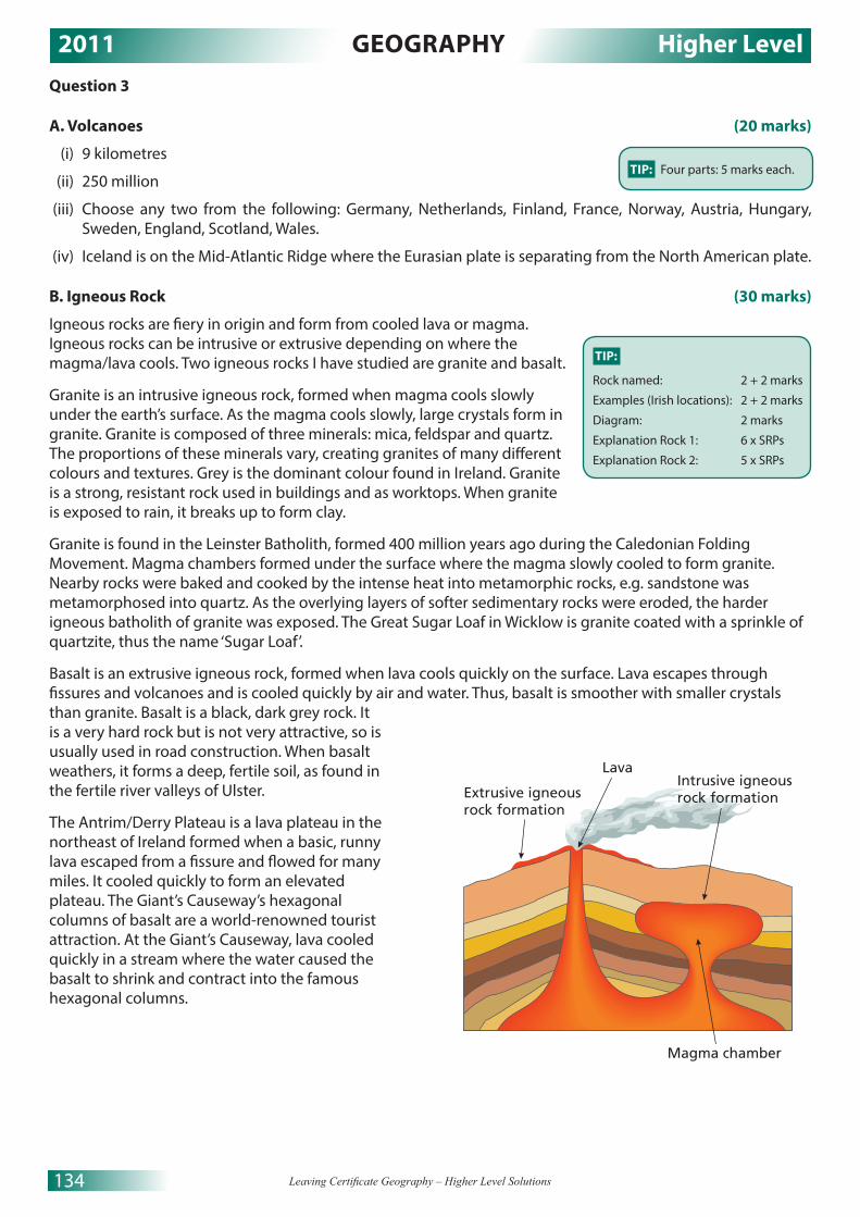
2011 GEOGRAPHY Higher Level
134 Leaving Certificate Geography – Higher Level Solutions
Question 3
A. Volcanoes (20 marks)
(i) 9 kilometres
(ii) 250 million
(iii) Choose any two from the following: Germany, Netherlands, Finland, France, Norway, Austria, Hungary, Sweden, England, Scotland, Wales.
(iv) Iceland is on the Mid-Atlantic Ridge where the Eurasian plate is separating from the North American plate.
B. Igneous Rock (30 marks)
Igneous rocks are fiery in origin and form from cooled lava or magma. Igneous rocks can be intrusive or extrusive depending on where the magma/lava cools. Two igneous rocks I have studied are granite and basalt.
Granite is an intrusive igneous rock, formed when magma cools slowly under the earth’s surface. As the magma cools slowly, large crystals form in granite. Granite is composed of three minerals: mica, feldspar and quartz. The proportions of these minerals vary, creating granites of many different colours and textures. Grey is the dominant colour found in Ireland. Granite is a strong, resistant rock used in buildings and as worktops. When granite is exposed to rain, it breaks up to form clay.
Granite is found in the Leinster Batholith, formed 400 million years ago during the Caledonian Folding Movement. Magma chambers formed under the surface where the magma slowly cooled to form granite. Nearby rocks were baked and cooked by the intense heat into metamorphic rocks, e.g. sandstone was metamorphosed into quartz. As the overlying layers of softer sedimentary rocks were eroded, the harder igneous batholith of granite was exposed. The Great Sugar Loaf in Wicklow is granite coated with a sprinkle of quartzite, thus the name ‘Sugar Loaf’.
Basalt is an extrusive igneous rock, formed when lava cools quickly on the surface. Lava escapes through fissures and volcanoes and is cooled quickly by air and water. Thus, basalt is smoother with smaller crystals than granite. Basalt is a black, dark grey rock. It is a very hard rock but is not very attractive, so is usually used in road construction. When basalt weathers, it forms a deep, fertile soil, as found in the fertile river valleys of Ulster.
The Antrim/Derry Plateau is a lava plateau in the northeast of Ireland formed when a basic, runny lava escaped from a fissure and flowed for many miles. It cooled quickly to form an elevated plateau. The Giant’s Causeway’s hexagonal columns of basalt are a world-renowned tourist attraction. At the Giant’s Causeway, lava cooled quickly in a stream where the water caused the basalt to shrink and contract into the famous hexagonal columns.
TIP:
Rock named: 2 + 2 marks
Examples (Irish locations): 2 + 2 marks
Diagram: 2 marks
Explanation Rock 1: 6 x SRPs
Explanation Rock 2: 5 x SRPs
Extrusive igneousrock formation
Intrusive igneousrock formation
Lava
Magma chamber
TIP: Four parts: 5 marks each.

2011 GEOGRAPHY Higher Level
135© Educate.ie
C. Isostatic Changes (30 marks)
Isostatic changes have caused adjustments along the courses of some Irish rivers. At the end of the last ice age, about ten thousand years ago in Ireland, rivers began to flow on the landscape as the ice slowly melted backwards and eventually disappeared. As the massive weight of the ice was removed from the continental land mass, the continental plate rebounded upwards and the base level of some rivers fell at the point where it used to reach the sea. This point is now marked on the landscape by a steep drop in the river’s profile called a knick point. Where the fall is very steep, a waterfall may sometimes be found. Because of the sudden drop, the river now flows more quickly, has more erosive power and is more like a young river. The river is therefore said to be rejuvenated. The River Barrow in County Kilkenny has knick points.
After rejuvenation, the river has much more erosive power and can again erode vertically down into the river channel. The river cuts down deeply into the pre-existing meanders to form incised meanders. These can be found on the Colorado River at the Grand Canyon.
The river is now flowing at a lower level than originally and as it is still in the old-age stage, it carves out a new flood plain for itself at the lower level. In this way, paired terraces are formed. A river may have two or more rejuvenations and may then have two or more terraces on either side of the river valley. Paired river terraces may be found on the River Nore.
Zone ofincision
Source
Knick pointKnick point
Past base levelsKnick points andincised valley sectionsretreat upstream
TIP:
Impact /Feature identified: 2 + 2 marks
Example: 2 + 2 marks
Diagram: 2 marks
Explanation: 11 x SRPs
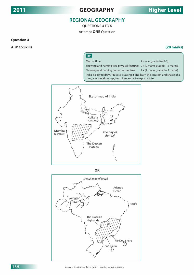
2011 GEOGRAPHY Higher Level
136 Leaving Certificate Geography – Higher Level Solutions
REGIONAL GEOGRAPHY QUESTIONS 4 TO 6
Attempt ONE Question
Question 4
A. Map Skills (20 marks)
OR
TIP:
Map outline: 4 marks graded (4-2-0)
Showing and naming two physical features: 2 x (2 marks graded + 2 marks)
Showing and naming two urban centres: 2 x (2 marks graded + 2 marks)
India is easy to draw. Practise drawing it and learn the location and shape of a river, a mountain range, two cities and a transport route.
Sketch map of India
River
Mumbai(Bombay)
Kolkata(Calcutta)
The Deccan Plateau
Ganges
The Bay of Bengal
Amazon River
Sketch map of Brazil
The Brazilian Highlands
Rio De Janeiro 3
São Paulo 4
Atlantic Ocean
Recife
2
1

2011 GEOGRAPHY Higher Level
137© Educate.ie
B. Agriculture in Ireland (30 marks)
Two regions with very contrasting agriculture are the Border Midlands West region (BMW) and the Greater Dublin Region (GDA). Both regions contrast in the physical and human factors that impact on the development of agriculture. While both regions have a cool, temperate, oceanic climate, the BMW is much wetter. Average rainfall in the BMW is over 1,700mm per year, while average rainfall in the GDA is just over 700mm per year. Average summer temperatures are only 14 degrees Celsius. This has a limiting effect on agriculture in the BMW. It is far too wet for the cultivation of high-yielding, commercial, tillage crops like wheat. The soils are mostly poor-quality peats, gleys and podzols and unsuited to productive agriculture. The relief of the BMW is dominated by hills and mountains. This again severely limits agricultural productivity. Upland areas receive large amounts of relief rainfall, which causes soils to be leached of minerals and nutrients. Upland areas are not suited to tillage, as machinery cannot be used on the steep slopes. Agriculture is dominated by the rearing of sheep on the upland areas and the rearing of cattle on the better land in lowland areas. The cattle are only kept for a short while before they are sold on for fattening in the GDA. Forestry is being encouraged by the EU and the state to supplement farm incomes. Forestry is a viable alternative to the extensive, low-yielding agriculture so common in the BMW region.
By contrast, the climate, relief and soils to be found in most of the GDA region (except for parts of County Wicklow) are much more favourable for the development of agriculture. The climate is drier and milder, there is very little frost that would hinder the growth of tillage crops like wheat and barley. The relief is, for the most part, low-lying and suited to mechanisation. The soils are fertile brown earths with very good drainage that allow for the cultivation of wheat, barley, fruit and vegetables and beef farming. Dairying, beef production and cereal farming are the most profitable types of farming and the positive physical environment of the GDA promotes these types of farming.
Human factors also contrast deeply between the two regions. Farm size is much bigger in the GDA, averaging at over 45 hectares per farm. Farm sizes in the BMW average at just over 25 hectares per farm. This means farms in the GDA are much more productive when you add in the much more positive physical environment. The smaller holdings in the BMW are a result of the old tradition of subdivision in the region. Agriculture in the GDA also benefits from an excellent transport infrastructure and proximity to the affluent Dublin market. By contrast, the peripheral location of the BMW region only adds to the cost of production and the area also suffers from a poorly developed transport infrastructure. Farmers in the BMW are older because of the brain drain of most of the region’s young adults and are generally more conservative. In the GDA, the farmers are younger and more open to trying new techniques and using new technology.
C. Urban Regions (30 marks)
I have studied the factors influencing the development of Paris in the Paris Basin region of France. A major factor influencing its development is the fact that Paris is the capital city of France. Paris has been the economic, political, financial and cultural capital of France for centuries. It is also a primate city, and with a population of over 12 million people living in the urban area has a population five times that of Lyon, France’s second city. Paris has long been a magnet for rural to urban migration because of the many employment opportunities available in the French civil service. Migrants from former French colonies in northern Africa also migrate to Paris in search of employment.
Paris is also a major industrial city. This is another factor in its development. Paris is a very attractive location for industry with its population of 12 million and over 22 million people in the region. This is a major affluent market. Paris is a world leader in fashion and culture and many of the world’s leading clothing and cosmetic companies, like L’Oreal and Chanel, have factories in the region. Heavy industry, like car manufacturers Renault and Citröen, have located in the city because of its inland port location. The River Seine is navigable from its mouth at Le Havre to Paris. This enables the easy transport of raw materials to the plants, and the export of finished products worldwide. The attraction of jobs in industry has helped the city to grow and develop.
TIP:
Regions named: 2 + 2 marks
Clearly stated contrasts: 2 + 2 marks
Discussion: 11 x SRPs
TIP:
Region named: 2 marks
Urban area named: 2 marks
Factors: 2 marks + 2 marks
Examination: 11 x SRPs

2011 GEOGRAPHY Higher Level
138 Leaving Certificate Geography – Higher Level Solutions
Paris is also the world’s number one tourist destination. Over 25 million tourists visit the city annually. The provision of services to the tourist industry employs 250,000 people in the city. Paris is the focus of the French transport system. It has two international airports, Orly and Charles de Gaulle, that can bring tourists to Paris from all over the world. Paris is also the focus point of the French road and rail networks. Autoroutes and the TGV fast rail radiate out from Paris. The channel tunnel now links Paris to London by fast rail, with the journey taking just over two hours. The excellent transport infrastructure has helped the development of industry and tourism in Paris and is a big factor in the development of the city.
Question 5
A. European Fishing (20 marks)
(i) Spain (ii) 400 million euro
(iii) 1100 million euro (iv) Choose any two from: Dingle, Killybegs, Castletownbere and Howth.(v) Overfishing is the biggest challenge facing Irish fishing (2 marks). The entry of Spain to the EU in 1986
opened up Irish waters to the Spanish fishing fleet and since then fish stocks have decreased rapidly (2 marks).
B. European Union (30 marks)
In 2004, the EU expanded from 15 countries to 25 countries. In 2007, two more countries, Romania and Bulgaria, were added. The new members were mainly from central and eastern Europe. The new member states are mostly former satellite states of the USSR and include Poland, Latvia, Lithuania, Estonia, Slovakia and the Czech Republic.
This eastward expansion of the EU has posed many economic challenges to the Irish economy. The majority of these countries are quite poorly developed. They can produce agricultural raw materials very cheaply. They can then easily transport these goods to the major EU markets in Germany, France, Italy and the UK. The prices now paid to Irish farmers for their goods has fallen significantly and, as a result, farm incomes have fallen. Funds once paid to Irish farmers by the CAP, to modernise their farms, are now being diverted to Eastern Europe as Ireland is no longer seen as a major problem region. Structural funds, that were used to modernise Ireland’s transport infrastructure, are now been awarded to the new poorer Eastern European member states.
In industry, the new member states are low wage economies, in comparison with Ireland. Footloose industries wishing to locate in the EU will now be more attracted to these states. This is best illustrated by the closure of Dell in Limerick in 2009 and its relocation to Łódź in Poland. Workers in Limerick trained the Polish workforce and then saw their own jobs lost when Dell moved the plant to Poland.
A more positive aspect of the EU expansion is that Irish industry has gained a huge new market of over 100 million people. Irish companies have access to this market with no trade barriers or restrictions. Also Irish people are now free to live in and buy property, such as holiday homes, in these new member states. Many Irish have bought properties on the Bulgarian Black Sea coast with its Mediterranean climate and low cost of living.
Another positive aspect of the 2004 enlargement of the EU on Ireland was the large influx of economic migrants from Eastern Europe to Ireland. These migrants played a significant role in Ireland’s Celtic Tiger economy as during the boom there was a major shortage of labour in many areas of the Irish economy. In the Celtic Tiger years there were labour shortages in the construction and hospitality sectors. The migrants filled these gaps and also took jobs in the IT sector that Irish workers were unable to take. The new migrants were also a stimulus to the economy as they bought property, cars and other consumer goods. The VAT receipts from their spending and the income taxes they paid on their earnings helped the Irish economy to prosper. Even though we are in recession now, many of the migrants are highly skilled workers and perform important tasks in the recovering Irish economy.
TIP: Five parts: 4 marks each
TIP:
Economic impact identified: 2 marks Examination: 14 SRPs

2011 GEOGRAPHY Higher Level
139© Educate.ie
C. Concept of a Region (30 marks)
Some regions may be defined by their climate. A unique climatic region I have studied is the cool, temperate, oceanic climate of northwestern Europe. This climate is found between latitudes 40–55 degrees (approx.) north and south of the equator. Ireland is a very good example of a country that experiences this climate. Average July temperatures are about 15 degrees Celsius, while average January temperatures are only 5 degrees Celsius. Rainfall occurs year-round with a winter maximum. Rainfall varies with relief and decreases from west to east. Rainfall in Killarney, County Kerry, is around 1,700mm per year. The major influences on this climate are latitude, distance from the sea and prevailing winds.
Latitude: The fact that this climate occurs in the mid-latitudes means that this is a moderate climate with no extremes in temperature. The annual temperature range is only around 10 degrees Celsius.
Distance from the sea and prevailing winds: The prevailing southwesterly winds blow over the Atlantic into northwest Europe bringing rain all year round. The winds are mild as they come from the south. The North Atlantic Drift, a warm ocean current, has a moderating influence on coastal regions, preventing freezing along the coast of Norway. Depressions that form over the Atlantic are driven into Western Europe by the prevailing southwesterly winds, making the climate mild but very moist. Coastal areas remain mild in winter as the sea stores heat from the summer for quite a long time, ensuring the climate remains temperate and mild all year round.
A unique geomorphological (physical) region found in Ireland is the Burren in County Clare. The Burren is a karst landscape where limestone has been exposed at the surface, possibly by glacial erosion. The protective soil cover has been removed and the bare limestone rock can be chemically weathered by rainwater. This process is known as carbonation and has resulted in a unique and very distinctive physical landscape in the Burren. Rainwater absorbs carbon dioxide, as it falls through the atmosphere to become a weak carbonic acid that slowly dissolves limestone. Limestone is a jointed and layered rock and this enables rain to pass through the rock, slowly dissolving the limestone. At the surface, the joints are enlarged by the carbonic acid to eventually form limestone pavements with their unique clints and grikes. As the carbonic acid moves downwards through the limestone, it continues to dissolve it, creating caves and caverns, such as the Aillwee Cave in County Clare. These caves may contain unique dripstone features, stalactites, stalagmites and pillars. These are formed when the water evaporates in the caverns and the once dissolved limestone reforms as calcite.
TIP:
Named criterion: 2 marks
Named example: 2 marks
Diagram: 2 marks
Discussion: 13 x SRPs
A second named example and criterion will be awarded 1 SRP each from the discussion.
The question looks for an example, or example(s). It would be easier to answer the question by explaining two different types of regions, as it might be difficult to gain 13 SRPs by explaining just one example.
It is difficult to gain 30 marks by discussing just one region. The discussion on the second region need not be as detailed.
Sink holeSwallow hole Grike Exposed
limestone pavement
Clint
River emerges
Pillar
Stalagmite
Stalactite
Features of karst landscapes

2011 GEOGRAPHY Higher Level
140 Leaving Certificate Geography – Higher Level Solutions
Question 6
A. Irish Tourism (20 marks)
(i) 687,000
(ii) Britain
(iii) 2,931,000
(iv) Choose any two valid Irish attractions (e.g. the Burren and the Lakes of Killarney).
(v) The economic recession (2 marks) means people have less money to spend on foreign holidays (2 marks).
B. Population Distribution (30 marks)
I have studied the population distribution of Brazil. This sub-continental region has a very uneven population distribution for historical, climatic and political reasons.
Historical: Brazil was colonised by Portugal in the late 15th century. Before that, the population of Brazil was very small. The native people were mainly nomadic hunter-gatherers, as agriculture was primitive. The Portuguese introduced modern agriculture in the form of huge plantations of sugar cane, coffee and cotton. The Portuguese initially settled on the southeast coast. The produce from the plantations was exported back to Portugal for processing through the ports of the southeast coast, such as Rio de Janeiro, São Paulo and Recife, which became important centres of trade and commerce. From that time, the southeast coast became the economic core of Brazil. Rural to urban migration from the poorer areas of Brazil to the southeast coast by migrants in search of employment and better living conditions has caused overpopulation in this part of Brazil. Many of the poor migrants live in favelas or shanty towns on the outskirts of São Paulo and Rio. This region has the highest population density in Brazil.
A second major factor affecting population distribution in Brazil is the climate. The climate of the southeast is warm and temperate. It is much more attractive for human settlement than most other parts of Brazil. The interior of Brazil has an equatorial climate. It is, for the most part, a dense rainforest. It rains every day and average precipitation is over 3,000mm per year. It is hot and humid all year, with average temperatures of over 27 degrees Celsius. Soils are easily leached so agriculture is limited. Population densities are low in the Brazilian interior. The northeast of Brazil has a very arid and hot climate. Rainfall is less than 300mm per year and temperatures average over 30 degrees Celsius. Productive agriculture is very difficult and there is a steady outmigration of people to the economic core of the southeast coast.
Finally, government policy is now influencing population distribution in Brazil. In the 1950s, the Brazilian government grew very concerned about the overpopulation in the cities of the southeast coast. Favelas were growing to such an extent that over 20 per cent of the population of São Paulo was living in the shanty towns. Tourism to Rio and São Paulo was being affected by the rapid growth of the favelas. The government decided to try and reduce the pressure on Rio by relocating the capital city inland to a greenfield site. A new capital city, Brasilia, was built in the interior in a three-year period. The government and civil service is now located in Brasilia. The new city has a population of 2.3 million people and it continues to grow as the government offers more attractive salaries to workers that relocate to Brasilia.
TIP: Five parts: 4 marks each
TIP:
Named region: 2 marks
Discussion: 14 x SRPs

2011 GEOGRAPHY Higher Level
141© Educate.ie
C. Manufacturing Industry (30 marks)
The Irish region that I have studied is the Greater Dublin Area (GDA). The Dublin region contains Dublin city, the capital of Ireland, and the manufacturing industry is very developed here, particularly manufacturing associated with the computer and food-processing industries.
The GDA is the location of a quarter of all the manufacturing industry in the state. Its manufacturing industry is varied, ranging from brewing and distilling, like the Guinness manufacturing plant, to pharmaceutical manufacturers, like Wyeth Biotech Campus in Clondalkin. Dublin specialises in the manufacture of healthcare products and computers products. Intel is a prime example of manufacturing in the computer industry.
The GDA is attractive to manufacturing industry because of its labour force, infrastructure, market and the availability of raw materials for food-processing industries.
It is is able to provide a skilled workforce to the region’s manufacturers. It has a young population as 45 per cent of the population of Dublin is under the age of 25. It has excellent universities, like Trinity College, DCU and UCD, which provide thousands of graduates to the manufacturing industry annually. These graduates are specialised in science, business, marketing, engineering and electronics.
The infrastructure in the GDA is also ideal for the development of secondary economic activities. Dublin is the centre of Ireland’s road and rail network. Dublin Airport is the largest airport in Ireland and Dublin port is also the main port in the country. This excellent infrastructure provides access to the worldwide market. It also facilitates the import of raw materials and the export of finished products. The M50 orbital motorway is an attractive location for modern growth industries as it connects factories along the M50 to the air and sea ports. Dublin is connected by motorway to Belfast, Cork, Limerick and Galway, enabling the easy transport of goods and people.
The GDA provides an affluent market for these manufacturing industries. The area has a population of over 1.5 million people. The city also provides financial management and business development services at the International Financial Service Centre (ISFC) in the docklands. This has greatly assisted the manufacturing industry in the Dublin region.
The final factor that has led to the development of manufacturing industry in the GDA is the high volume of good-quality raw materials produced in the region, which has lead to the development of the food-processing industry. Barley is produced in the south and west of the GDA, in areas like north Kildare. Barley and hops are used in the brewing of Guinness. Horticulture in North County Dublin provides vegetables for the food-processing industry. Irish MNC food ingredient companies, like Greencore and Kerry Group, have plants in the GDA.
TIP:
Region named: 2 marks
Named example: 2 marks
Discussion: 13 x SRPs
A second named example of an industry will be awarded 1 SRP from the discussion marks.

2011 GEOGRAPHY Higher Level
142 Leaving Certificate Geography – Higher Level Solutions
SECTION 2 – ELECTIVESQUESTIONS 7 TO 12
Attempt ONE Question
PATTERNS AND PROCESSES IN ECONOMIC ACTIVITIESQUESTIONS 7 TO 9
Question 7
A. Unemployment Rate (20 marks)
(i)
(ii) The government could reduce unemployment by giving industries tax incentives and grants to take on new employees (2 marks). The government could make work more attractive by reducing income tax for workers and reducing social-welfare payments (2 marks).
TIP: (i) Bar chart Pie chartTitle: 2 marks 2 marksScaled axis: 2 marks 2 marks (circle and centred)6 items illustrated: 2 marks each (graded) 2 marks each (graded)A bar chart would be best here. Do not forget to title the graph, label both axes and use graph paper. A scaled axis means that the units on the vertical axis should be evenly spaced and the bars should all be the same width. The graph is worth 16 marks.(ii)Two appropriate measures... appropriate measures should be named, they gain 2 marks each.
1
Year
Un
emp
loye
d (
%)
2
3
4
5
6
7
8
9
10
United States unemployment rates (%) 2005-2010
2005 2006 2007 2008 2009 2010

2011 GEOGRAPHY Higher Level
143© Educate.ie
B. Ordnance Survey Map (30 marks)
I would build the fish-processing plant at Q447 004. This is a vacant greenfield site. The land is unoccupied so there would be no costs in demolishing buildings. The site is flat, under 10m, and low-lying as indicated by the absence of contour lines. This would make the construction of the factory very easy. This site is away from the tourist town of Dingle so people could not object to any noise or odours coming from the factory. This is a very large site, suitable for the construction of a large plant with parking for trucks and cars. This site has ample space for expansion, being outside town and with very little settlement nearby. Land is also cheaper to buy on the periphery of town so start-up costs can be kept down.
This site also has very good transport links. As a fish-processing plant, my chosen site has the necessary coastal location for fishing boats to unload their catches. The harbour itself is very sheltered and protected from winter storms, so production could continue year-round. The site already has a third-class road and this road is linked to the national secondary road the N86. Good roads are essential for a fish-processing factory, as the product is perishable and must be transported to market quickly. The roads also connect the site to Dingle and would enable easy access for the workforce from the town to the plant. The nearby helipad at Q446 004 could be used to transport management to and from the factory.
C. Developing Economies (30 marks)
Brazil was colonised by Portugal in the late 15th century and remained a colony until 1822. While the negative impacts of this colonialism far outweigh the positive impacts, there were some positive impacts. The Portuguese developed agriculture and trade in Brazil. Prior to colonialism, Brazil was a backward, tribal region. Agriculture was subsistent and very poorly developed. The Portuguese brought crops like sugar cane, coffee and cotton and set up much more productive plantations. The Portuguese also developed the sea ports on the east coast of Brazil, like São Paulo and Rio de Janeiro. Trade links were developed with Europe and the USA. The Portuguese also brought with them their culture, technology, language, religion and architecture. While some may question if some of these aspects were superior to the Brazilian culture, it must be remembered that before colonisation Brazil was just a huge area controlled by many different tribes. The Portuguese made Brazil into the nation state it would eventually become.
There were far more negative impacts of Portugese colonialism. Firstly, the Amerindian population was nearly wiped out in the first decades of the colonisation process. The native population was defeated in battle, but more often killed by European diseases from which the people had no immunity. Their land was then confiscated resulting in the native population living in poverty. Even today, nearly 200 years after independence, the native population is far poorer then the descendants of the European colonisers. While trade links were established between Brazil and Portugal, it was mainly to the benefit of the Portuguese. A dominant-dependant relationship developed, whereby Brazil supplied Portugal with raw materials which were then processed in Portugal. Portugal never encouraged Brazil to develop its secondary industries, as they would be in competition with them. After independence, Brazil was over-dependent on the production of coffee, sugar cane and oranges. The prices of these goods fluctuated on the world markets and so did Brazil’s economy. Brazil was still dependent on trade with Portugal up to the twentieth century. This is called neo-colonialism. In the second half of the twentieth century, Brazil finally escaped from its colonial past and joined Mercosur, a free-trade organisation for South American countries. Today, Brazil is a modern, quickly-developing economy, no longer tied down by colonialism.
TIP:
Impact identified: 2 marks
Named developing economy: 2 marks
Examination: 13 x SRPs
TIP:
(i):
A six-figure grid reference for suitable site will gain 2 marks.
(ii):
2 reasons: 14 marks each
Reason identified: 2 marks
Map evidence: 2 marks
Explanation: 5 x SRPs
A second piece of map evidence (grid reference) will be accepted from the explanation of each reason.

2011 GEOGRAPHY Higher Level
144 Leaving Certificate Geography – Higher Level Solutions
Question 8
A. Aerial Photograph (20 marks)
B. Multinational Companies (30 marks)
Dell is a multinational company that I have studied. Dell is today the world’s third biggest manufacturer of computers, after HP and Lenovo. Dell was founded in Texas in 1984 by Michael Dell and today employs over 100,000 workers worldwide. One of the unique features of Dell’s operation initially was its direct sales model where it built made-to-order individual PCs to customers’ specifications. Customers would order their PC online or over the phone. Dell now also supplies computers to retailers as customers wanted to be able to see the products in shops before they bought them.
Dell has plants supplying the markets of three main regions. Dell has a strategy of manufacturing its computers as near as possible to its customers to reduce the time from order to delivery of the PC. For North and South America, Dell has four manufacturing plants in the US and Brazil. Dell employs 16,000 people at its headquarters at Round Rock, Texas. Dell’s second major market is the EMEA region (Europe, the Middle East and Africa). Dell also has operations producing computer products for the Asia/Japan market.
Dell is a footloose MNC and will open and close manufacturing plants in response to labour costs and the taxation policies of the countries in which it operates. All developed economies try to attract MNCs to their countries by offering grants and tax incentives. A feature of Dell is its strategy of closing plants in one country and relocating plants to a country that offers the company better financial terms and conditions. A very good example of this was the closure of the Dell manufacturing plant in Limerick with the loss of 1,900 jobs in 2009. The plant was relocated to Łódź, Poland, where labour costs were one-third of Irish labour costs. The Polish government offered Dell over €50 million in grants to relocate to Łódź. The EU is investigating the legality of this grant, but the plant in Limerick will remain closed whatever the result. Dell was attracted to Ireland by the grants and low corporation tax of just 12.5 per cent, so it may be that Ireland was just outbid by Poland. Dell still retains its sales and support staff for the EMEA region at its Cherrywood Technology Campus in Dublin. Another feature of Dell’s operation is the division of labour that exists through the global distribution of its workers. Jobs in management, research and development (R&D) and sales are located in the US and other developed economies. Jobs in manufacturing tend to be located in low-wage economies, like China, Mexico and Brazil. Dell employs 1,200 workers at the Cherrywood campus in sales and R&D. Like all MNCs, Dell is diversifying its product base and now manufactures LCD TVs and tablet devices.
TIP:
Named MNC: 2 marks
Examination: 14 x SRPs
Sketch map of Dingle aerial photograph
Commercialarea (retail)
Recreationalarea
Two connectingroads
The Harbourarea
TIP:
Proportion/Outline: 4 marks (graded 4-2-0)
Features named: 2 marks each
4 features: 4 marks each
If features are just shown, 2 marks (graded, 2/1/0) can be gained. Full showing requires that features be accurately located and in proportion.

2011 GEOGRAPHY Higher Level
145© Educate.ie
C. Environmental Impact (30 marks)
The burning of fossil fuels, such as coal and oil, in industrialised regions of Western Europe is causing acid rain in Scandinavia. The southeast of England, the Paris Basin and the Ruhr region of Germany are heavily industrialised and populated. Energy to fuel industry and to heat homes is mainly obtained through burning fossil fuels. Gases, such as sulfur dioxide and nitrogen oxide, are released into the atmosphere when fossil fuels are burned. These gases are carried by the prevailing southwesterly winds towards Scandinavia, where they are absorbed by water vapour in the atmosphere and fall as acid rain. Acid rain has a pH of 4.3 or less; pure water would have a pH of 7, i.e. it is neutral.
The acid rain falling in Sweden has had many serious negative impacts on the environment. Many Swedish lakes are now dead and cannot support any aquatic life. The natural coniferous tree vegetation of Sweden is being destroyed by acid rain. Tourism to Sweden has been adversely affected as the once clean, unpolluted environment is being heavily polluted by acid rain created outside the country. Trees suffer from needle loss and their barks are scarred until eventually the trees die. The timber industry is an important industry in Sweden as it employs many workers in rural, peripheral parts of the country. The soil loses its fertility as nutrients are leached away and agricultural productivity falls. As a result, farm incomes have decreased in many parts of Sweden.
A second example of pollution from one location impacting on another country occurs along the course of the River Rhine. The Rhine rises near Lake Constance in Switzerland and flows northwards through Germany and the border with France, until it reaches the sea in Rotterdam, Holland. The river is nicknamed the ‘Sewer of Europe’ because it has been used as a dumping ground by Germany for all kinds of industrial, domestic and agricultural waste. By the time the river reaches Holland, it is very heavily polluted. Stricter EU environmental controls are now helping to reduce pollution along the Rhine, but the solution involves co-operation from all countries along the Rhine and its many tributaries.
Question 9
A. Human Development Index (20 marks)
(i) Very high
(ii) Any two from the following: Canada, US, Australia, New Zealand, Japan or South Korea.
(iii) Africa
(iv) Many countries, especially African countries, have low HDIs because they have massive foreign debts (3 marks). Money that should be used to develop education and health services is used to repay foreign loans (2 marks).
B. Developed Economies (30 marks)
I have studied the development of services in the Greater Dublin Area (GDA) of Ireland. Transport is a major tertiary activity in this Dublin region. Dublin is the focus of the Irish road and rail systems and all major road and rail routes radiate out from the city, linking it to the other main cities of Ireland. Recent improvements in transport have witnessed the Dart system doubling in capacity, the Luas lines connecting more areas, and the Dublin Port Tunnel taking trucks out of the city centre. The bus system has also been improved, with the introduction of quality bus corridors (QBCs). Taxis are also allowed to use the bus lanes. In a further attempt to modernise Dublin’s public transport, the government is funding a scheme called Transport 21. This scheme will involve the extension of the Luas and the construction of a Metro line to the airport, if funds are available. A second terminal has recently been built at Dublin Airport and the airport has flights to all major European and American cities. 1.7 million ferry and cruise passengers pass through Dublin port every year. The port has up to 15 sailings each day to the UK on fast ferries, such as the Jonathan Swift, which only takes one hour and 50 minutes from Dublin to Holyhead in Wales.
TIP:
Pollution source identified: 2 marks
Impact outside source: 2 marks
Example: 2 marks
Examination: 12 x SRPs
It may be difficult to get 12 SRPs all from one example, so it may be a good idea to deal with a second example. Below, a second example from the Junior Cert course is used. The second example does not have to be as detailed as the first one as the question looks for example(s).
TIP: Four parts: 5 marks each
TIP:
Named developed economy: 2 marks
Named example of service: 2 marks
Examination: 13 x SRPs

2011 GEOGRAPHY Higher Level
146 Leaving Certificate Geography – Higher Level Solutions
Tourism is a second tertiary economic activity that has developed in the GDA. It has become a major tourist destination because of the many cultural attractions, sporting events and historic buildings in the city. Dublin has many attractions for tourists, with numerous shopping centres, art galleries and museums. It has recently become home to the newly constructed Grand Canal Theatre and the O2 music venue. Rare Irish artefacts, such as the Book of Kells and the Ardagh chalice, are on display in Trinity College Dublin and the National Museum.
Dublin caters very well for the ‘all year’ tourism business. It provides moderate and affordable accommodation in budget hotels, while it also has many four and five star hotels. Dublin is promoted by Fáilte Ireland as a city break destination and, in 2007, over 6 million tourists visited the region. The tourism industry earns over €1.2 billion for the GDA every year. As Dublin is the capital of Ireland, it serves as the main point of entry into the country through the airport and Dublin sea port. The wonderful accommodation enables Dublin to act as a base for tourists, from which they can visit the scenic countryside of Glendalough in County Wicklow, play golf in the world famous K-Club, or go horse racing in the Curragh, County Kildare. International music acts also come to Dublin to perform in the O2 arena. Croke Park hosts the national finals and semi-finals in Gaelic football and hurling and is a famous venue for Irish sport. Dublin also has some world-famous sightseeing locations, like Dublin Zoo and the Guinness hop store. All of these spectacular tourist attractions combine to make Dublin the third most popular city break destination in Europe after Paris and London.
C. European Union (30 marks)
The Common Agricultural Policy (CAP) has raised farm incomes and reduced rural poverty in Ireland. The CAP was introduced by the EU to ensure that Europe had a steady supply of good-quality food after the Second World War; to ensure that it was self-sufficient in food production; and to reduce foreign imports of food. This was done by giving farmers subsidy payments, so that farmers would have a decent income and would remain farming, and by putting import tariffs and quotas on non-EU food imports. Farmers were guaranteed a fair price and market for their produce. Farming in the BMW region of Ireland has always been difficult because of the difficult physical landscape, wet climate and peripheral location. Farm sizes were traditionally small and the local market for goods limited.
When Ireland joined the EU in 1973, agriculture in the country was transformed. Irish farmers now had access to the EU market with no trade barriers. More importantly, farmers in the BMW region now had access to funding from the EU’s biggest fund, the CAP. The CAP gave funding to farmers to modernise their farms. Grants were available for installing modern milking machinery, bulk storage tanks and slatted units, amongst many other grants. Headage payments were available initially to sheep farmers on the bad, hilly land of the region. The numbers of sheep being kept soared to such an extent that environmental damage was being done to the upland areas of Connemara, as overgrazing caused soil erosion. Farm productivity tripled in the country and the CAP was so successful that overproduction soon became a problem. Quotas had to be introduced to limit production and therefore farm incomes were limited. Jobs in the food processing industry in the BMW also increased as agricultural production tripled. Irish food from the farms was being processed in Ireland, instead of being exported raw to the UK. Irish exports to other EU countries also increased, as Ireland became less dependent on the UK as its main market. The CAP encouraged farmers to diversify their production away from the overproduction in dairy, beef and lamb.
Forestry was actively encouraged on the poorer land in the BMW and this also created some employment in the timber-processing industry. Funds are also available to farmers that farm in an environmentally sustainable fashion, through the Rural Environment Protection Scheme (REPS). Farmers are encouraged to keep their hedgerows, use fewer chemicals and be aware of the environment. As a result, farmers are less productive, but are rewarded through direct payments from the EU. Early retirement schemes were introduced to enable farmers on low-incomes to retire on a decent pension and to reduce the overproduction and the high cost of storing surplus farm products. The CAP has increased farm incomes, created employment and reduced poverty in rural Ireland.
TIP:
Named policy: 2 marks
Impact on the Irish economy: 2 marks
Examination: 13 x SRPs

2011 GEOGRAPHY Higher Level
147© Educate.ie
PATTERNS AND PROCESSES IN THE HUMAN ENVIRONMENTQUESTIONS 10 to 12
Question 10
A. Aerial Photograph (20 marks)
B. Migration (30 marks)
São Paulo in Brazil is a city that has experienced rural to urban migration on a very large scale. São Paulo is the economic core of Brazil and attracts migrants from the poorer parts of Brazil in search of employment and a better standard of living.
One of the most noticeable effects in São Paulo of this migration is the growth of favelas (shanty towns) on the urban fringe of the city. The population growth in São Paulo has been so rapid due to the sheer volume of migrants arriving in the city and very high birth rates that there simply is not enough housing. Newly arrived migrants build illegal dwellings wherever they can. It is now estimated that nearly 20 per cent of the population of the city live in favelas. The dwellings are essentially huts made of bits of plywood and sometimes with corrugated iron roofs. The huts have no running water, electricity, sewage or refuse collection. Some of the favelas have been built near dumps, so the people in the favelas can scavenge for waste in the dump. Some of the favelas have been built on steep hill slopes and landslides are a problem after heavy rain. The people live in extreme poverty as São Paulo cannot provide employment for the rapidly growing population. Disease, illness, drug abuse and crime are widespread in the favelas.
The city authorities are trying to improve the living condition in the favelas by giving the residents building materials to rebuild their dwellings but progress is very slow. The national government has tried to reduce the population pressure in São Paulo by building a brand new capital city in the interior. Residents in São Paulo are given financial incentives to move to Brasilia and free farm land is offered to anyone if they relocate to the interior of Brazil.
Another impact of the rapidly increasing population in São Paulo due to rural-urban migration is traffic congestion and pollution. The urban area has a population of over 20 million people and this figure continues to rise. There are over 6 million cars in the city and the roads cannot cope with this number of cars. Public transport is inadequate and traffic congestion is widespread. The air pollution caused by the burning of fossil
TIP:
Named developing region: 2 marks
Effects identified: 2 + 2 marks
Examination: 12 x SRPs
Sketch map of Dingle aerial photograph
The C.B.D.
Educationalland use
Trafficmanagement(roundabout)
Residentialland use
Harbourarea
TIP:
Frame: 2 marks
Proportion: 2 marks
Feature named: 2 marks
Feature shown: 2 marks (graded 2/1/0)
Four features: 4 marks each
To get full showing marks, features need to be accurately located and in proportion.

2011 GEOGRAPHY Higher Level
148 Leaving Certificate Geography – Higher Level Solutions
fuels in cars and in factories is causing a rise in respiratory illnesses in young children and the elderly. The city is the focus point for many motorways in the region and the recent construction of an orbital ring road has helped ease traffic congestion in the city. The authorities have also introduced a rota system for car owners where they must leave their car at home one day a week, which has reduced the volume of cars on the city streets by 20 per cent.
C. Dynamics of Settlement (30 marks)
One major land use in Dublin City is the Commercial Business District (CBD) around O’Connell Street, Grafton Street for retail and College Green for banking. The CBD was where the city began and most routes used to focus on the CBD. It was the most attractive location for retailers, as it was the busiest part of Dublin. Demand is very high for property in Dublin’s CBD, so properties have multiple floors. The ground floor is usually a shop and upper floors may be offices or storage areas. Cinemas and theatres, like the Abbey and the Olympia, are in the CBD. The area also has hotels, like the Gresham and the Shelbourne. The CBD is no longer as attractive to shoppers, as traffic congestion and parking charges deter many from going in to the CBD. The popularity of large shopping centres in the suburbs has taken shoppers from Dublin’s CBD.
The biggest land use in any town or city is residential. The Multiple-Nuclei Theory proposed by Harris and Ullman explains, for the most part, the location of the different types of residential areas in Dublin. A good deal of low-income housing in Dublin was found close to the CBD and the old industrial zone close to the port. Workers could not afford private transport and had no choice but to live near where they worked. In the 1960s, some of these tenements were demolished and the residents relocated to new apartments, like Ballymun. As cars became more affordable and public transport improved, workers became more mobile and new low to medium-income housing areas like Tallaght were built on the urban fringe. Middle and high-income housing in Dublin was influenced by the construction of a rail link from the city to Dún Laoghaire (Kingstown) in the 1830s. The Multiple-Nuclei model states that the high-income housing will locate as far as possible away from the industrial zones and the low-income housing. This has happened in Dublin, with the southside of the city containing most of the high-income housing along the coastal railway route.
Heavy industry in Dublin tended originally to locate in the docklands area near the city centre for the import and export of materials. As the city grew, traffic congestion around the city centre and port area prompted many industries to move from the port area to the urban fringe. Modern industrial estates need space and good transport facilities. The M50 orbital ring road offered industry the best location and today most industries locate on or near the M50. The M50 has a motorway connection to the airport and the seaport through the Dublin Port Tunnel. The old docklands area was derelict and run down, until it was transformed into a modern International Financial Services Centre by tax incentives and grants offered to companies during the 1990s.
TIP:
Named city: 2 marks
Land-use zones identified: 2 + 2 marks
Land-use zones explained: 12 x SRPs

2011 GEOGRAPHY Higher Level
149© Educate.ie
Question 11
A. Population Pyramid (20 marks)
(i) 6% or 6
(ii) 8% or 8
(iii) 4% or 4
(iv) Developing
(v) The pyramids of developing countries have a very broad base because of the high birth rates (2 marks). The pyramids of developing countries are very narrow at the top because average life expectancy is low, whereas in developed countries a good proportion of the population lives beyond the age of 65, because rich countries have better healthcare systems (2 marks).
B. Urban Expansion (30 marks)
Urban sprawl is a major problem in the Greater Dublin Area (GDA). Dublin City has grown from being a small, compact city in the 1950s to an extended urban area of over 1.5 million inhabitants. The city urban area now extends into neighbouring counties of Kildare, Meath and Wicklow. The commuter belt extends even further. This has many impacts on the surrounding rural area. Urban sprawl has caused the loss of prime agricultural land around Dublin. The demand for land to construct housing estates for Dublin’s rapidly growing population enticed many farmers near the city to sell land to property developers. The city is becoming a concrete jungle full of monotonous estates. What were once quiet, rural villages outside Dublin have seen their character destroyed. There is consequent overcrowding in schools and other services as the small villages and nearby towns struggle to cope with the ever-rising population. Sewage schemes are not able to deal with the waste from the new housing developments. Towns like Newbridge, Navan and Naas have tripled in population due to urban sprawl from Dublin.
As agricultural land and amenity land is changed to residential land, the natural habitats of many native plants and animals have been destroyed. New roads had to be built and existing roads widened to cope with the number of commuters travelling to and from Dublin. The construction of new motorways has lead to the destruction of many artefacts and historic buildings. The N3 motorway is very close to the Hill of Tara and is causing visual pollution in this beautiful area. Public transport systems cannot cope with the number of commuters so workers have to travel to work in their cars. The air pollution caused by the increased number of cars on the roads is now a problem in the Dublin area. Traffic congestion is a problem in the small villages and towns near the city as the roads were not built to deal with such a high volume of traffic. Bypasses have to be built to take the cars out of the small towns and villages. Local farmers are forced to give their land over to the National Roads Authority to build the new roads. Farms are often divided by the construction of the new roads causing health and safety problems for the farmers and their livestock.
We need to rethink our model of urban settlement. The typical Irish family wants to live in a house with a half-acre site in a semi-rural setting. The septic tank waste is causing serious ground water pollution. This low-density housing model is causing urban sprawl. The European model of higher density urban housing closer to the city will have to be adopted in Ireland if we are to reduce urban sprawl. The building of Adamstown in the west of Dublin is a good start, as the new town will have high-density housing, good amenities and a good public transport infrastructure.
TIP: Five parts: 4 marks each
TIP:
Impact identified: 2 marks
Named example: 2 marks
Discussion: 13 x SRPs
Here, again the ‘example(s)’ is plural, so a second named example and impact will both be awarded 2 marks without any explanation. It is sufficient to mention something within the first area named (in the example below, the Hill of Tara is given). The second example doesn’t have to be from a different city. However, all further impacts will require discussion before any marks are awarded. Answers are not restricted to one or two examples and impacts. It probably would be difficult to get all 30 marks with just one impact, so do two or more in detail. Answers are not restricted to developed or developing cities so if you are stuck, you could write about the growth of shanty towns, pollution, etc. in São Paulo. In this answer, I will deal with the Dublin area. A few lines with some solutions will probably gain 1 or 2 SRPs.

2011 GEOGRAPHY Higher Level
150 Leaving Certificate Geography – Higher Level Solutions
C. Population Density (30 marks)
There are three main reasons for the low-population density in this area:
1. The negative relief and drainage
2. The absence of good communications
3. The land use is not suitable for productive agriculture.
1. The negative relief and drainage: Most of the area is over 200m in height and some of the mountains are over 600m, e.g. Ballysitteragh at Q461 057 is 623m high. The slopes are very steep, for the most part, as seen by the contour lines being packed so close together at Q46 05. Human settlement is just not attracted to areas where the physical environment is so challenging. The upland relief will result in large amounts of relief rain. The upland landscape is unsheltered and will be windswept and cold. People prefer to live in sheltered, lowland valleys where the conditions are milder and more suited to settlement. The one lowland area at Q47 06 and Q48 06 is dominated by large lakes and probably too wet for settlement.
2. The area has a near complete absence of communications: There is only one road, the R560 regional road, in the area. Settlements need communication links so that people can commute to work or go to towns to buy food and services. Children need buses to get to school and farmers need roads to get their produce to market. Yet there is only one road in the whole of this area. It is just too expensive and difficult to construct roads on this upland area. The steep slopes would make the roads dangerous in winter with frost and snow so common on upland areas. People would not be able to build houses in most of this area as it would not be physically possible to transport building materials to sites, except for the site along the R560.
3. The land use is totally unsuited to productive, commercial agriculture: The heavy relief rain would cause the soils to be leached of minerals and nutrients. The upland areas would have mudslides and landslides due to the rain and steep slopes. This is a major reason for the low population density in the area. Coniferous plantations are not an option, as the land is too steep and inaccessible. There is some forestry at Q44 06 where a road ends, but there is no settlement nearby.
TIP:
OS map evidence: 2 marks
Reason identified: 2 marks
Explanation: 13 SRPs
Identifying a second reason and giving a second grid reference, will each gain 2 marks. As a rule of thumb, always give at least two reasons and grid references. The points being mentioned do not have to be of equal detail and the map evidence can be the name of a road or river. It does not have to be a six-figure grid reference. All further reasons require explanation. This is a map question about settlement. Maps have information about relief, drainage, settlement, communications and land use. So when asked a question about settlement, the answer is that settlement is affected by relief, drainage, communications and land use. The same process can be used if asked a question about any of the five areas of map information. For example, land use would be affected by relief, drainage, communications and settlement. It is often a good idea to deal with relief and drainage as one factor.

2011 GEOGRAPHY Higher Level
151© Educate.ie
Question 12
A. Population Structure (20 marks)
(i)
(ii) One problem is the provision of pensions, as taxes may have to be increased on the working population to provide adequate pensions for the elderly. A second problem will be the cost of providing healthcare for the elderly, as they are living longer. This may lead to cutbacks to other services like education and social welfare.
TIP:
(i) Bar chart Pie chartTitle: 2 marks 2 marks
Scaled axis: 2 marks 2 marks (circle and centred)
6 items illustrated: 2 marks each graded 2 marks each graded
Draw a bar graph, title the graph and label both axes. Make sure the vertical axis is scaled (i.e. units are evenly spaced) and the bars are of equal width. If graph paper is not used 2 marks will be deducted.
(ii)
Two problems should be named gaining 2 marks each.
Country and year
Perc
enta
ge a
ged
65 a
nd o
ver
1998 2008 1998 2008 1998 2008Belgium Ireland The UK
1
2
3
4
5
6
7
8
9
10
11
12
13
14
15
16
17
18Percentage of the population aged 65 and over in Belgium, Ireland and the UK

2011 GEOGRAPHY Higher Level
152 Leaving Certificate Geography – Higher Level Solutions
B. Overpopulation (30 marks)
Overpopulation occurs when the number of people living in an area is too great to be supported by the available natural resources. Two examples of regions that are overpopulated are the Sahel in North Africa and the Aral sea in Asia.
The cause of overpopulation in the Sahel is the population explosion in the region. The Sahel is a transitional climate zone between the hot desert climate and the Savannah grassland climate. The area is covered by sparse grass vegetation on which many nomadic tribes depend on for pasture for their cattle, sheep and goats. Unfortunately for the people, the area’s physical resources can no longer support the rapidly growing population. Countries like Mali, Chad and Sudan are in stage two of the population cycle, with high birth rates and rapidly falling death rates. The population growth has created a huge demand for food, fuel and fodder. To provide food, the people are forced to graze their animals on the marginal land near the desert. The natural vegetation cover has been exposed by overgrazing. The sun dries out the soil and the wind has eroded the soil. The nomadic tribesmen measure their wealth by the number of animals in their herd and the ever-increasing herd sizes add to the overgrazing problem. The better land in these countries is often used to grow cash crops, which are exported to pay back foreign debt. To produce food, the people are forced to farm the marginal land near the desert.
This process is called desertification and the problem has been hastened by drought in the Sahel. With global warming, it is hotter and drier in the region. In some years, no rain fell, crops failed and the soil was again exposed to the elements and eroded. Two natural resources, soil and water are being depleted and the land can no longer support its population as its carrying capacity has been reduced.
Another cause of the soil erosion in the region is the very poor farming techniques of the native people. In areas of arable farming, the farmers do not practise crop rotation, the fertility of the soil is soon exhausted and the farmers then move on to farm more marginal land nearer to the desert. This land is unsuited to tillage and when the land is ploughed the soil is soon dried out and blown away. Famine and food shortages are now common in the countries of the Sahel. Rural to urban migration is causing overpopulation and the growth of shanty towns in the region’s cities.
C. Aerial Photograph and Ordnance Survey Map (30 marks)
From studying the photograph, it is clear that this town has developed because it is a port town. In the left foreground, there is a large harbour where there are fishing boats docked. The fishermen would probably live locally and are a reason for the development of the urban area. The fish caught by the fleet may be processed in the urban area, creating jobs in processing plants in the Dingle urban area. A study of the map shows that the port is sheltered, it would be protected from winter storms by the piece of land jutting out to the sea at V44 98. The harbour is deep and an excellent natural location for a fishing port to develop.
From studying the map, I believe the town may have developed as it is a route focus or nodal point. The N86, a national secondary route, and three regional roads (the R559, R549 and R560) all converge on Dingle. Urban areas often develop where roads converge as they are points where trade and commerce develop. As Dingle has a tourist function, as seen by the tourist information office at Q444 010, roads would be very important in bringing tourists to the town. The town is also a central place for people living in the hinterland and good roads are essential to bring the locals to shop in town. The people employed in the services would probably live locally and cause the urban area to develop.
TIP:
Causes identified: 2 + 2 marks
Named examples: 2 + 2 marks
Discussion: 11 x SRPs
In the sample answer below, there is enough information to get all 30 marks from the Sahel, without discussing the Aral Sea, but mentioning the Aral Sea would still gain 2 marks as an example. As a rule of thumb, always give two examples.
TIP:
3 reasons: 10 marks each
For each reason:
Reason identified: 2 marks
OS map/Aerial photograph evidence: 2 marks
Examination: 3 x SRPs
Be careful here as the question looks for map and photo evidence. A good approach is to do two reasons from the map and one reason from the photo. Alternatively, give a piece of photo evidence and a piece of map evidence in each reason. In any case, use both sources – if you only use one, you will lose 10 marks.

2011 GEOGRAPHY Higher Level
153© Educate.ie
The urban area is developing because this town has an important tourist function. From the photo, there is a large marina in the left foreground. There are quite a few yachts and pleasure boats tied up at the marina. The crews of these boats would be visiting hotels, bars, restaurants and banks in the town. The workers in these services would live locally and the urban area would develop. From the map, evidence of the tourist function is the tourist information office at Q444 010, there is also a boating symbol at Q441 004. The Dingle Way walk ends at Dingle and walkers would use the services available in the town. As the town has a large tourist function, property developers would build holiday homes to cater for the tourists and the town’s urban area would develop.
SECTION 3 – OPTIONSQUESTIONS 13 TO 24Attempt ONE Question
N.B. It is better to discuss three or four aspects of the theme in some detail, rather than to give a superficial treatment of a large number of points.
Global Interdependence
13. (80 marks)
Emergency aid saves lives. This is the first positive impact aid has on developing countries. Emergency aid is donated by developed countries to developing countries in a time of crisis, like an earthquake, tsunami, flood, drought, etc. Emergency aid usually takes the form of food, water, medicine and shelter. A good example would be the emergency aid sent to Haiti after an earthquake devastated the country in 2010. This aid is short-term but, without it, many more people in Haiti would have died. In the aftermath of an earthquake, people need immediate help. Water supplies may be contaminated by burst sewage pipes or decomposing bodies. People’s houses, often poorly constructed, have been destroyed. Food is in short supply and medical aid is needed for the injured survivors. The prompt action of non-governmental organisations (NGOs), like Trócaire and the Red Cross, in getting food, water, tents and medicine to the country, saved thousands of lives in Haiti.
Long-term development aid improves the quality of life for millions of poor people in the developing world. ‘Give me a fish and you feed me for a day, teach me how to fish and you feed me for life.’ This is the motto adopted by NGOs like Goal and Concern that concentrate on long-term, self-help projects that give development aid directly to the people. The aid is not in the form of money or food, but in education, the drilling of water wells and improving agriculture. The building of health clinics in small towns and villages has improved the health of women and children in developing countries. The Irish government provides bilateral aid to Tanzania and concentrates on improving the country’s hospitals and clinics. Vaccination and immunisation programmes carried out by Irish medical volunteers to Tanzania have halved infant mortality rates in the country. Teaching farmers better techniques in agriculture, like crop rotation, means more food can be produced. Bóthar is introducing better quality, more productive Irish breeds of cattle, sheep, goats and poultry to Africa to improve food production. People are healthier and infant mortality has been reduced further.
One of the negative impacts of aid to developing countries is that the aid is often inappropriate and does not reach the people. In the past, a lot of aid donated was tied aid or had strings attached. While NGOs do excellent work throughout the developing world, the fact is that most aid is bilateral aid, from the government of one country to the government of another country. The donating country places conditions on the receiving developing country. Aid given by the US to Peru forced the Peruvian government to allow
TIP:
Number of aspects: 3 (27 + 27 + 26) 4 (20 marks each)
Identifying aspect: 4 marks 4 marks
Discussion: 8 x SRPs OR 6 x SRPs
Overall coherence: 6 or 7 marks (graded) 4 marks (graded)
If you can discuss four aspects, there are only 6 SRPs required in each aspect. An answer with three aspects would require 8 SRPs per aspect to attain full marks. In this answer, two positive and two negative impacts would be a good approach. Cover four points in four paragraphs. State your aspect clearly in the opening sentence of each paragraph. In each aspect, give examples of the point you are making. It is better to discuss three or four aspects of the theme in some detail, rather than to give a superficial treatment of a large number of points.

2011 GEOGRAPHY Higher Level
154 Leaving Certificate Geography – Higher Level Solutions
massive American factory ships to fish in Peruvian waters. The fish stocks in Peru were quickly depleted and the native fishermen lost their livelihood. US aid often forces developing countries to purchase their military requirements from US companies. The money spent by the developing countries on military weapons is often far greater than the aid they receive from the US. The US supplied Iraq with military aid when it was in a war with Iran. Later, the US invaded Iraq when Iraq started a war with oil-rich Kuwait. This proves that a lot of aid given by countries like the US and Russia has been strategic and for the benefit of the giver. Aid does not always reach the poorest people in developing countries and is often misappropriated by corrupt dictators and military regimes. This was the case in Iraq where Saddam Hussein lived in palaces and most of his people lived in extreme poverty.
A negative impact of international aid often forgotten is that aid has to be paid back with interest. This often impoverishes the receiver as some aid has very high interest rates. The bailout that Ireland received in 2009 from the IMF, EU and ECB will have to be paid back over many years. The situation is much worse for many African and Asian countries. Countries are forced to grow cash crops, like cotton, coffee and peanuts, to repay their foreign debts. Meanwhile, the people of the country are starving as not enough food is grown. To repay the debt, more cash crops are grown and, as a result, there is a surplus and the price received for the cash crops falls. More land is then given over to produce the cash crop to make up for the shortfall in export income and less food is produced. Developed countries often use developing world countries as a dumping ground for their surplus food products. While this may seem very generous, it is the giver that benefits the most and native markets are swamped with cheap food. The market for local food produce is distorted as the producers cannot produce food as cheaply and the local economy is destroyed. Fairtrade rules and the elimination (write down) of foreign debt would be an equitable solution to the problem of debt for developing countries. In 2000, to mark the new millennium, France wrote off all foreign debt owed to it by the developing world.
Geoecology
17. (80 marks)
I have studied the Hot Desert biome. Examples include the Mojave in North America and the Sahara desert in North Africa. The climate of this biome in influenced by its latitude, prevailing winds, the effects of ocean currents and the rain shadow effect. Hot deserts are found between 15 to 30 degrees north and south of the equator. The sun is high in the sky and shines directly overhead, concentrating its heat on a small area.
1. Hot deserts are found in high-pressure belts, with descending air being warmed and absorbing rather than emitting any moisture in the atmosphere. The sun heats air laden with moisture at the equator. That warm, moist, rising air causes intense rainfall at the equator. As it rises, it moves laterally through the atmosphere, where it cools and begins to descend at about 30 degrees north and south. As the cooled air falls, it is warmed and absorbs moisture. The descending air mass causes high pressure in the hot deserts. As a result, the hot deserts have constant high pressure with clear, sunny blue skies by day. At night it is very cold as there is no cloud insulation to keep in the extreme heat of the day.
Most hot deserts are found on the western side of continental land masses, where cold ocean currents pass by. The Californian cold current passes the west coast of California, where it sucks the moisture out of the air. Onshore sea breezes are, as a result, very dry. The prevailing winds in the North American deserts are the northeast trade winds that come over the interior of the North American continent. Therefore, they have already lost any moisture they contained when they reach the biome and are also very dry. The deserts of North America suffer from the rain shadow effect as the coastal mountain ranges cause relief rain to occur to any clouds before they can reach the biome. The combination of all these influences makes this biome an extremely hot and arid region. Daytime temperatures often reach the mid-thirties Celsius and rainfall can be less than 250mm per year.
2. The vegetation within this biome is sparse and only vegetation that has adapted to the climate can survive in this harsh climate. Mechanisms that plants adopt to survive are varied. Some plants are ephemerals, like the desert paintbrush and their seeds lie dormant for long periods until it rains. The seeds have a waxy coating that enables them to survive for years if necessary. When it rains, the seeds germinate, grow, mature and
TIP:
Number of aspects: 3 (27 + 27 + 26) Identifying aspect: 4 marks Discussion: 8 x SRPs Overall coherence: 6 or 7 marks (graded)
This is a three-aspect answer as the question specifically asks for three headings.

2011 GEOGRAPHY Higher Level
155© Educate.ie
produce more seeds before the plant dies, all within a very short two-to-three-week cycle. The seeds fall to the ground, where they again lie dormant until the next rain arrives, sometimes years later. Other plants are succulents. They have adapted whereby they can store huge quantities of water in their fleshy interiors. The most famous succulent plant is the cactus. The cactus can swell out like an accordion to store water after rain. Many desert plants have adapted to their root systems to cope with the arid conditions. The mesquite plant has tap roots that search for water deep under the surface. The roots can be taller than the plant above ground. Other plants, like the cactus, have shallow radial roots that spread extensively just under the surface so that the roots can quickly capture any rain that falls, before it is evaporated.
3. Animals are very scarce in the hot desert and, like the desert flora, only animals that have adapted can survive in the hot desert climate. Desert animals use many different methods to survive. Some species are nocturnal. They burrow into the soil by day to avoid the extreme heat. They emerge at night to hunt for food. The rattlesnake and the kangaroo rat are two nocturnal animals. The elf owl nests in a hole in a cactus and only comes out at night to find food and water. Some animals hibernate for long periods of time in burrows underground. They only emerge when it rains to eat, mate and reproduce. The desert toad is a hibernator. In a 24-hour span, after rain, toads mate and the female’s eggs will be fertilised and hatched. The eggs develop into tadpoles in the quickly drying pools and in ten-to-twelve days the tadpoles develop into toads. As the pool disappears, the toads burrow underground to await the next rain, which could be years away. Some animals of the hot desert are non-drinkers, thus they do not need a regular supply of water. The Fennec fox gets moisture from its prey’s blood. The desert gazelle obtains liquid from the vegetation it eats. Instead of urinating, it passes tiny, dry pellets which are made of uric acid.
The camel is the desert animal most famous for its adaptations to the desert climate. The camel can drink more than 100 litres of water at one time. It doesn’t perspire and can last several months without water. It can store fat in its humps as a food reserve. It has wide, padded hooves so it can walk on the hot sand and its pale colour reflects the sun’s heat.
18. (80 marks)
Commercial logging in the Amazon Rainforest
Commercial logging in the Amazon rainforest has irreversibly altered the biome of this unique and globally important region. The rainforest absorbs and stores carbon in its trees and soil. When the trees are cut down, the carbon is released as carbon dioxide, a greenhouse gas that is causing global warming. The deforestation of the Amazon is slowly altering the climate at the fringes of the biome. The removal of the trees means that there are fewer plants to transpire the moisture from the daily convectional rain. A vital part of the water cycle has been removed and there is less moisture released back into the atmosphere. If deforestation continues at its present pace, the climate of this biome will be irreversibly altered. Already, areas on the fringe of the biome are experiencing drought.
The Brazilian government has sold licences to commercial logging companies to cut down the valuable hardwoods in the Amazon and export the timber to Europe and the USA. The technology available to loggers is vastly superior to that of the indigenous people and a few men with chainsaws can destroy a large area of rainforest in days. It is estimated that an area of about three football pitches is cut down per minute in the Amazon. Illegal logging now accounts for about 80 per cent of the deforestation as the demand for hardwoods, such as teak, mahogany and ebony soars. The removal of the trees has destroyed the natural habitat of many still unidentified plants and animals. Medical experts believe that the cures for many serious illnesses could be found in the plants now being destroyed by logging companies.
TIP:
Number of aspects: 3 (27 + 27 + 26) 4 at 20 marks each
Identifying aspect: 4 marks 4 marks
Examination: 8 x SRPs OR 6 x SRPs
Overall coherence: 6 or 7 marks (graded) 4 marks (graded)
A student can attempt either a three-aspect or a four-aspect answer, the difference is the number of SRPs required per aspect. Always give examples as they usually attract marks. Examiners will allow for up to two examples to a max of 2 SRPs (different examples and in different aspects) and will also allow for up to two illustrations to a max of 2 SRPs (different illustrations and in different aspects).

2011 GEOGRAPHY Higher Level
156 Leaving Certificate Geography – Higher Level Solutions
The Amazon rainforest biome is also the home to indigenous people such as the Yanomami. The Yanomami people had no immunity to the diseases such as malaria, TB and measles brought by the loggers into their habitat. Epidemics have reduced the population of the tribe to just 26,000 people. Their way of life has been destroyed by deforestation as they were mostly hunter-gatherers who lived in harmony with the biome.
Intensive agriculture in the Amazon Rainforest
The soils of the rainforest have been altered by intensive agricultural practices. The Amazon is seen by many as a vast region to be exploited by agri-companies, as the native people are nomadic and much of the region is unoccupied. The Brazilian government is actively encouraging settlers to move to the region from the overcrowded southeast coast to start farms. Agriculture in Brazil is of vital importance to the economy, as the country exports vast quantities of agricultural goods to Europe and the US. These exports have helped Brazil to become a world leader in food production.
However, the cost is the destruction of the rainforest biome. Cattle ranchers are moving into the rainforest and removing the trees at an alarming rate. The trees acted as a protective cover to the soil from the daily convectional rainfall in the Amazon. When the trees are removed, the latosol soil is exposed to the heavy rain and it is severely leached. The exposed soil is then baked by the high temperatures, common near the equator, into a hard, claylike topsoil called laterite, that grass roots cannot penetrate. The soil becomes infertile in a matter of years and the ranchers move on to destroy another area of rainforest. The deforested area will never recover as the laterite soil is useless. The water cycle has also been interrupted and it is thought that the cleared land will turn to desert in ten years. The ranchers don’t care as they have moved on and the biome is very quickly being altered by this uncontrolled economic activity.
Industrialisation and urbanisation in the North American Desert Biome
The rapid industrialisation of the North American Desert biome has negatively altered this biome. The Gold Rush of 1847 attracted people from all corners of the world to seek their fortunes. The population of California grew from 100,000 in 1850 to 10 million people by 1950. The mines needed vast quantities of timber for pit props and the construction of mining towns. The giant redwood forests of California were destroyed to such an extent that only 4 per cent of them remain. The redwoods were the natural habitat of many animals that are now nearly extinct. The construction of the trans-continental railway in the 1850s meant that the native timber could now be sold all over the US. Vast tracts of land have been forever turned into scrubland.
Mining is still important today in Nevada, where open-cast mining has scarred and pitted the landscape. Much of the groundwater has been poisoned by chemical mining waste.
The nuclear industry used remote areas of Nevada and Arizona to test atomic bombs during and after the Second World War. A massive area of desert has been rendered sterile and plant and animal life wiped out. The Nevada desert now stores all of America’s nuclear waste in an underground plant at Yucca Mountain. This nuclear waste will be radioactive for thousands of years. The American military and aerospace industries consume large areas of land in this biome. The building of highways and railways across the region has destroyed much of the flora and fauna in this biome. Urbanisation in California has lead to urban sprawl on a vast scale. The American way of life values families living in suburban plots. Los Angeles is the second largest city in the US and will soon have a larger population than New York. Urban sprawl is destroying the natural habitat of this beautiful biome, as over 500 kilometres squared of land is consumed by urbanisation every year. The remaining land of the biome is now broken into scattered and isolated patches that are unable to support viable populations of native flora and fauna.

2010 GEOGRAPHY Higher Level
157© Educate.ie
PART 1SHORT ANSWER QUESTIONS
Any 10 questions: 8 marks each
Each question:
• 4 parts: 2 marks each• 8 parts: 1 mark eachNo grading/scaling of marks
Question 1 – Surface Processes (8 marks)
Freeze-thaw B
Abrasion D
Human activity C
Carbonation A
Question 2 – Ordnance Survey Map (8 marks)
(i) County boundary/Coniferous plantation/Forest park/Natural woodland/Mixed woodland
(ii) South Leinster Way
(iii) S 401(2) 289 /290(1)(2)
(iv) Megalithic tomb and Ogham stone
(v) S 406(7) 220
(vi) River Suir and Glen River
Question 3 – Types of Region (8 marks)
Region Type Letter
Urban region D
Cultural region B
Core region A
Political region C
Question 4 – Aerial Photograph and Ordnance Survey Map (8 marks)
(i) River Suir
(ii) Old Bridge and Dillon Bridge
(iii) S 408 215
Question 5 – Glacial Landforms (8 marks) (i) 161 m
(ii) Cirque/Corrie/Tarn/Coom/Ribbon
(iii) Arête
(iv) North-eastwards
TIP:
Attempt twelve questions. The best ten answers will be used.

2010 GEOGRAPHY Higher Level
158 Leaving Certificate Geography – Higher Level Solutions
Question 6 – Weather Chart (8 marks) (i) Anticyclone
(ii) Isobar
(iii) 1012 mb/hectopascals (hPa)
(iv) Calm dry weather with warm temperature
Question 7 – Land-use (8 marks)
A 8
B 1
C 9
D 2
E 7
F 3
G 4
H 6
I 5
Question 8 – Location on the Aerial Photograph (8 marks)
Feature Location
Old Bridge Left background
House Left foreground
Wooded Island Right foreground
Sports Field Centre background/Centre middleground/ Centre centre
Question 9 – Rock Type (8 marks)
(i) A = Basalt (2 marks – no marks for granite or any other rock) B = Granite (2 marks – no marks for basalt or any other rock)
(ii) Rock A = 1 (2 marks) Rock B = 2 (2 marks)
Question 10 – Satellite Interpretation (8 marks)
Image Letter
Sandstorm which is blowing from the Sahara to the Atlantic.
C
Icebergs breaking away from the ice sheet in Greenland.
A
The Island Arc of Indonesia. D
Alpine Glacier. B

2010 GEOGRAPHY Higher Level
159© Educate.ie
Question 11 – Irish Fishery Statistics (8 marks)
(i) €100.5 million
(ii) €54.2 million
(iii) Aquaculture
(iv) Plankton
Question 12 – Graphical Interpretation (8 marks)
(i) 25–29
(ii) 7%
(iii) 11.7%
(iv) 2.8%
PART 2NOTE ON SRPs
AN SRP (SIGNIFICANT RELEVANT POINT) IS WORTH 2 MARKS. • It must be a ‘chunky’ piece of information.
• It might also be a correct statistic or factual piece of information.
• Examiners show where they are awarding an SRP in an answer by using two forward slashes (– –).
• In OS map and aerial photograph questions, SRPs are given for accurate grid references or correct photograph locations.
• In most answers, SRPs are awarded for giving relevant examples and specific locations.

2010 GEOGRAPHY Higher Level
160 Leaving Certificate Geography – Higher Level Solutions
SECTION 1 – COREPATTERNS AND PROCESSES IN THE PHYSICAL ENVIRONMENT
QUESTIONS 1 TO 3Attempt ONE Question
Question 1
A. Ordnance Survey Map (20 marks)
TIP:
Proportion: 4 marks (graded 4-2-0)
Four features: 4 marks each (shown 2 marks graded, named 2 marks)
Proportion involves showing correct scale. The required size is 9cm x 12cm (allow a difference of up to 0.5cm). If a sketch is traced or a section of the map is drawn, 4 marks will be lost for proportion and 2 marks for showing per item.
Sketch map of Carrick-on-Suir area
V-shapedriver valley
Glenriver
Trellis drainagepattern
Braided streams(feature of deposition)
TIP:
When answering physical geography questions, always give at least one example and if possible draw a diagram to aid your answer. Marks are usually automatically awarded when examples are given and for relatively simple diagrams.

2010 GEOGRAPHY Higher Level
161© Educate.ie
B. Landform Development
Answer (i) or (ii) (30 marks)
(i)
A delta is a feature of fluvial deposition that I have studied. A delta is a flat area of land made of alluvium, formed when a river enters a sea or lake. Deltas are found in the old stage of rivers. An Irish example of a delta may be found at the estuary of the River Shannon, while an international example may be found at the mouth of the River Nile in Egypt. In order for a delta to form, the amount of sediment deposited by the river must be greater than the amount of sediment removed by the tides and currents. Therefore deltas usually form at sheltered river mouths where sea currents and tidal action is weak, like in the Mediterranean Sea.
When a river enters the sea or a lake, its velocity decreases as a small body of water, a river, meets the sea. The river loses its energy and, as a result, the river begins to deposit its load. The deposition is sorted and laid down in three distinctive layers:
1) Bottomset beds: This is the lightest of the material and is carried out the farthest. It is laid down in horizontal layers of fine sediment.
2) Foreset beds: This material is slightly heavier and coarser than the bottomset material and is deposited close to the river mouth.
3) Topset beds: This is the heaviest of the river’s load and is deposited nearest to land. It is so heavy and dense that when it rises above water level, it forces the river to divide up into channels called distributaries to reach the sea.
Marine deltas form at the mouths of rivers entering the sea. There are three types of marine delta:
1) Arcuate delta: This is a triangle-shaped delta, formed from coarse material. It develops where sea currents are quite strong and the edges of the delta can’t be kept straight, e.g. the Nile Delta.
2) Bird’s foot delta: This consists of fine material and a small number of distributaries that extend out like the claw of a bird’s foot, e.g. the Mississippi Delta.
3) Estuarine delta: This is a delta which is yet to extend beyond the coastline. The sediments have been deposited in the shallow water along the sides of the estuary, e.g. the Shannon Estuary.
River mouth Topset beds
Foreset beds
Bottomset bedsBedrock
TIP:
Landform identified: 2 marks
Named process: 2 marks
Irish example: 2 marks
Labelled diagram: 2 marks + 2 marks
Examination: 10 x SRPs
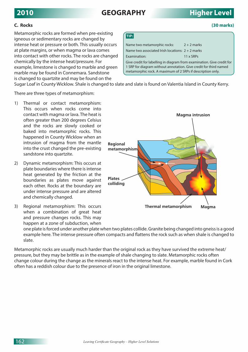
2010 GEOGRAPHY Higher Level
162 Leaving Certificate Geography – Higher Level Solutions
C. Rocks (30 marks)
Metamorphic rocks are formed when pre-existing igneous or sedimentary rocks are changed by intense heat or pressure or both. This usually occurs at plate margins, or when magma or lava comes into contact with other rocks. The rocks are changed chemically by the intense heat/pressure. For example, limestone is changed to marble and green marble may be found in Connemara. Sandstone is changed to quartzite and may be found on the Sugar Loaf in County Wicklow. Shale is changed to slate and slate is found on Valentia Island in County Kerry.
There are three types of metamorphism:
1) Thermal or contact metamorphism: This occurs when rocks come into contact with magma or lava. The heat is often greater than 200 degrees Celsius and the rocks are slowly cooked or baked into metamorphic rocks. This happened in County Wicklow when an intrusion of magma from the mantle into the crust changed the pre-existing sandstone into quartzite.
2) Dynamic metamorphism: This occurs at plate boundaries where there is intense heat generated by the friction at the boundaries as plates move against each other. Rocks at the boundary are under intense pressure and are altered and chemically changed.
3) Regional metamorphism: This occurs when a combination of great heat and pressure changes rocks. This may happen at a zone of subduction, when one plate is forced under another plate when two plates collide. Granite being changed into gneiss is a good example here. The intense pressure often compacts and flattens the rock such as when shale is changed to slate.
Metamorphic rocks are usually much harder than the original rock as they have survived the extreme heat/pressure, but they may be brittle as in the example of shale changing to slate. Metamorphic rocks often change colour during the change as the minerals react to the intense heat. For example, marble found in Cork often has a reddish colour due to the presence of iron in the original limestone.
TIP:
Name two metamorphic rocks: 2 + 2 marks
Name two associated Irish locations: 2 + 2 marks
Examination: 11 x SRPs
Give credit for labelling in diagram from examination. Give credit for 1 SRP for diagram without annotation. Give credit for third named metamorphic rock. A maximum of 2 SRPs if description only.
Regional metamorphism
Platescolliding
Magma intrusion
Thermal metamorphism Magma
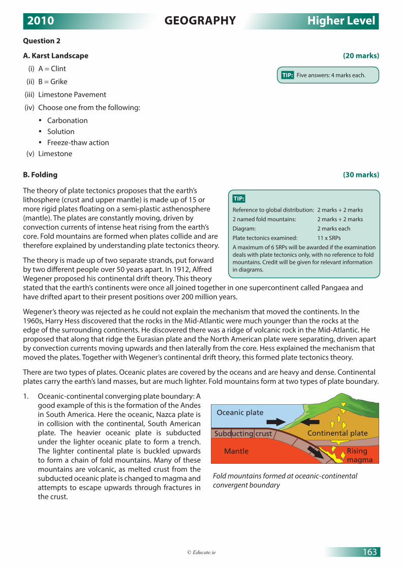
2010 GEOGRAPHY Higher Level
163© Educate.ie
Question 2
A. Karst Landscape (20 marks)
(i) A = Clint
(ii) B = Grike
(iii) Limestone Pavement
(iv) Choose one from the following:
• Carbonation• Solution• Freeze-thaw action
(v) Limestone
B. Folding (30 marks)
The theory of plate tectonics proposes that the earth’s lithosphere (crust and upper mantle) is made up of 15 or more rigid plates floating on a semi-plastic asthenosphere (mantle). The plates are constantly moving, driven by convection currents of intense heat rising from the earth’s core. Fold mountains are formed when plates collide and are therefore explained by understanding plate tectonics theory.
The theory is made up of two separate strands, put forward by two different people over 50 years apart. In 1912, Alfred Wegener proposed his continental drift theory. This theory stated that the earth’s continents were once all joined together in one supercontinent called Pangaea and have drifted apart to their present positions over 200 million years.
Wegener’s theory was rejected as he could not explain the mechanism that moved the continents. In the 1960s, Harry Hess discovered that the rocks in the Mid-Atlantic were much younger than the rocks at the edge of the surrounding continents. He discovered there was a ridge of volcanic rock in the Mid-Atlantic. He proposed that along that ridge the Eurasian plate and the North American plate were separating, driven apart by convection currents moving upwards and then laterally from the core. Hess explained the mechanism that moved the plates. Together with Wegener’s continental drift theory, this formed plate tectonics theory.
There are two types of plates. Oceanic plates are covered by the oceans and are heavy and dense. Continental plates carry the earth’s land masses, but are much lighter. Fold mountains form at two types of plate boundary.
1. Oceanic-continental converging plate boundary: A good example of this is the formation of the Andes in South America. Here the oceanic, Nazca plate is in collision with the continental, South American plate. The heavier oceanic plate is subducted under the lighter oceanic plate to form a trench. The lighter continental plate is buckled upwards to form a chain of fold mountains. Many of these mountains are volcanic, as melted crust from the subducted oceanic plate is changed to magma and attempts to escape upwards through fractures in the crust.
Oceanic plate
Mantle
Subducting crust Continental plate
Rising magma
Fold mountains formed at oceanic-continental convergent boundary
TIP: Five answers: 4 marks each.
TIP:
Reference to global distribution: 2 marks + 2 marks
2 named fold mountains: 2 marks + 2 marks
Diagram: 2 marks each
Plate tectonics examined: 11 x SRPs
A maximum of 6 SRPs will be awarded if the examination deals with plate tectonics only, with no reference to fold mountains. Credit will be given for relevant information in diagrams.

2010 GEOGRAPHY Higher Level
164 Leaving Certificate Geography – Higher Level Solutions
2. Continental-continental convergent boundary: A good example of this is the formation of the Himalayas. In this case, The Indian plate collided with the Eurasian plate about 35 million years ago. The heavier plate was subducted and the lighter plate was folded upwards to form the world’s highest mountain range, which includes Mt Everest and K2. Again, volcanoes may be found in this region. As the heavier plate was forced under the lighter plate, melted crust that was changed to magma tries to escape to the surface.
C. Human Interaction (30 marks)
A major interaction with the rock cycle I have studied is the development of geothermal energy in Iceland. Geothermal energy uses heat from igneous rocks to heat water and generate steam to produce electricity. Many developed countries, such as New Zealand and Japan, are leaders in the development of geothermal energy schemes.
Iceland is on the Mid-Atlantic ridge, a constructive plate boundary where two plates are separating. Molten magma rises close to the surface and very high temperatures occur at or near the surface. This results in the heating of groundwater. Alternatively, cold water can be pumped near the heated rocks and back up to the surface where it is pumped to the capital, Reykjavik. The hot water is used to heat offices, apartments and even footpaths. It may also be used to heat greenhouses and produce fruit and vegetables in this cold Boreal climate, thus reducing Iceland’s imports of food.
At geothermal power plants, the water is at such high temperatures that it turns to steam and is used to generate electricity. Nearly 30 per cent of Iceland’s electricity comes from this cheap, clean, renewable source of energy. Expensive imports of much dirtier fossil fuels have been dramatically reduced and Reykjavik is now the cleanest capital city in the Western world.
Tourism to Iceland has also increased as many visitors come to see the Blue Lagoon, an outdoor geothermal spa. The spa is a man-made lagoon fed by the water output from a nearby geothermal power station. The water is rich in minerals, like sulfur and silica, which are excellent in the treatment of arthritis and psoriasis. Over 400,000 tourists visit the spa annually, bringing revenue to this country of just 320,000 people. Many hotels, providing much needed employment, have been built near the spa to cater for the rapidly growing tourist industry.
Iceland’s balance of payments has been improved dramatically by the development of geothermal energy. It is envisaged that in the future surplus electricity may be exported to the UK, bringing in even more revenue.
Asthenosphere
LithosphereLithosphere
Continental-continental convergence
Mountain rangeHigh plateau
Continental crust
Ancient oceanic crust
Fold mountains formed at continental-continental
convergence
Cold waterpumped down
Steam andhot water
Generating station
Hot rocks in the Earth's crust
TIP:
Interaction identified: 2 marks
Example: 2 marks
Diagram: 2 marks each
Discussion: 13 x SRPs
A second example will be credited for 1 SRP from the discussion, always give at least one example.

2010 GEOGRAPHY Higher Level
165© Educate.ie
Question 3
A. Earthquakes (20 marks)
(i) North American plate and Caribbean plate (3 marks + 2 marks)
(ii) Transform/Transverse/Tear/Passive/Neutral (5 marks)
(iii) The earthquake was caused by a transform/transverse fault where two plates are sliding past each other (3 marks). The plates get locked and when they release suddenly, an earthquake occurs (2 marks).
(iv) The island arc was created by the upwelling of melted crust when one plate is subducted under another plate at a destructive boundary (5 marks).
B. Human Interaction (30 marks)
One way humans attempt to influence or control fluvial processes is through dam construction. The biggest dam project in the world was built on the Yangtze River in China, and is known as the Three Gorges Dam. In Ireland in 1929, the River Shannon was dammed at Ard-na-Crusha near Limerick.
The construction of a dam involves building a wall across a river. The flow of water can then be regulated as the river is forced to flow through tunnels in the dam wall.
Hydro-electric power (HEP) may be created by the water moving through the dam. A vast reservoir or man-made lake is formed upstream of the dam.
The Three Gorges Dam project in China had four main aims:1. Flood control2. The production of HEP3. Improving navigation along the river4. To provide irrigation waters to areas of drought
The project cost US$25 billion and was finished in 2009.
The natural river processes of erosion, transportation and deposition are altered by the human activity of dam building. However, one major natural process the dam controls is flooding. This was the main reason for the project, as flooding along the Yangtze River has claimed 1 million lives in the past 100 years.
Controlling the river’s flooding has had many positive effects for the people in this region. Flood control has improved the living conditions of millions of people along the Yangtze. Farmers are no longer exposed to annual flooding in winter.
The environmental air quality has also been improved as HEP is replacing coal-burning power stations. Water from the winter rains can be stored in the reservoir behind the dam and used for summer irrigation, thus transforming the agriculture of the region.
The project has also had many negative effects. The natural process of river deposition has been affected as fertile alluvium is trapped behind the dam and is no longer deposited on the river’s floodplain. Farmers may now have to buy expensive chemical fertiliser to maintain the soil’s fertility.
Below the dam, the river now flows quite rapidly and erosion has increased.
Due to irrigation, less fresh water now reaches the Yangtze Delta and, as a result, the freshwater ecosystem has been altered. The local fishing industry in the delta has been destroyed, with consequent food shortages, unemployment and poverty. The natural delta habitat is also under threat, as it has become more saline as less freshwater reaches the delta and many species of fish have been wiped out. Behind the dam, a reservoir 630km in length was created and over 1.3 million people had to be relocated.
From using this case study, it is clear that human processes, such as dam building, have had a major impact on natural river processes.
TIP: Four answers: 5 marks each.
TIP:
Influence/Control identified: 2 marks
Named example/Location: 2 marks
Reference to natural processes: 2 marks
Discussion: 12 x SRPs
A maximum of 6 SRPs only will be awarded if the answer does not refer to the human attempts to ‘influence’ or ‘control’ rivers.

2010 GEOGRAPHY Higher Level
166 Leaving Certificate Geography – Higher Level Solutions
C. Karst Landscape (30 marks)
An underground landform of karst regions I have studied is dripstone. Dripstone landforms include stalactites, stalagmites, pillars and curtains.
As rain falls through the atmosphere, it absorbs carbon dioxide to become a weak acid called carbonic acid. Carbonic acid slowly dissolves limestone rock in a chemical process called carbonation. As the weak acid slowly soaks through the soil it absorbs even more carbon from decaying matter. Limestone is jointed and layered, the carbonic acid slowly moves down through the joints and along the bedding planes, all the time removing dissolved limestone in solution. Caves and caverns are created underground in limestone regions by carbonation and solution. When water begins to seep into the caverns through the roof, dripstone features are formed. The water contains dissolved limestone (calcium bicarbonate) and it is constantly dripping through joints into the cave.
Temperatures are warm underground and a tiny amount of water is always evaporating, causing the dissolved limestone particles to reform as calcite, clinging to the roof of the cave. Over many hundreds of years, the calcite grows to form a carrot shaped feature called a stalactite, through which the water continues to drip. Some water splashes to the floor of the cave where a small amount of it evaporates and a mound shaped feature made of calcite begins to form. This feature is called a stalagmite. The features continue to grow and in some cases the stalactite and the stalagmite meet to form a pillar or column. Sometimes, the water flows through a long crack in the roof and a feature resembling a curtain is formed. All of these features may be found in Crag Cave, Castleisland, County Kerry.
TIP:
Named process: 2 marks
Underground landform identified: 2 marks
Irish example: 2 marks
Diagram: 2 marks each
Discussion: 12 x SRPs
If the answer describes the feature only without explaining its formation, it will receive a maximum of 6 SRPs. A simple diagram without annotation will gain 1 SRP. More SRPs may be gained by the use of a good, labelled diagram.
Stalactites, stalagmites and pillars may be amalgamated as one feature and this may make it easier to get the 12 SRPs required.
Swallow hole
PillarStalagmite
Stalactite

2010 GEOGRAPHY Higher Level
167© Educate.ie
REGIONAL GEOGRAPHY QUESTIONS 4 TO 6
Attempt ONE QuestionQuestion 4
A. Irish Regions (20 marks)
B. Economic Activities (30 marks)
I have studied the development of tourism in the Paris Basin region of France. A major factor in the development of tourism in the region is the excellent transport infrastructure in the region. Paris is the focal point of the French road, rail and air transport systems. Autoroutes (motorways) connect Paris to all the other major French cities and to neighbouring countries, like Spain, Germany, Switzerland and Belgium. France has developed a fast rail network, called the TGV, which can travel at speeds of up to 300km per hour. The TGV makes Paris accessible to tourists from all over France and beyond.
Eurostar is a high-speed railway service connecting Paris, London and Brussels through the channel tunnel. Tourists can travel from London to Paris in just over two hours. Paris has two major international airports at Orly and Charles de Gaulle. These airports make Paris accessible to tourists from all over the world. The city itself has an excellent Metro system that can transport tourists quickly and cheaply all over the city.
Another factor in the development of tourism in the Paris region is the many famous tourist attractions that attract visitors to the city. Nearly 10 million tourists visit the city annually. The Louvre art gallery houses the Mona Lisa, a famous painting by Leonardo da Vinci, and is the number-one tourist destination in the city. The Eiffel Tower is another attraction that tourists flock to visit. French cuisine and the fashion industry also attract many visitors to the city. In more recent times, Eurodisney has become an important attraction in the region, while the French themselves prefer to visit Parc Asterix, also located in the region. Beyond the city, the region has many historical and cultural attractions. The medieval cities of Caen and Rouen, the Normandy beaches used in the D-Day landings, and the world-famous French wine industry also attract many visitors to the region.
TIP:
Named tertiary economic activity: 2 marks
Two factors identified: 2 marks + 2 marks
Region named: 2 marks
Examination: 11 x SRPs
Do not use Irish or continental/sub-continental regions.
Discussion without reference to a named or clearly inferred region will result in 0 marks. You must name a region. A country is not acceptable. All further factors require discussion.
Northern Ireland
Irishsea
Dublin-Wicklow Mountains
AtlanticOcean
DublinBray
GDA
BMW
GDA
BMW
BMW
OxMountains
River Moy
Galway
M6 motorway
M1 motorway
BMW = Border, Midlands, West regionGDA = Greater Dublin Area
RiverLiffey
Ballina
TIP:
Map outline: 2 marks graded
Showing and naming region: 2 x (2 marks graded + 1 mark)
Showing and naming urban centres: 2 x (2 marks graded + 1 mark)
Showing and naming physical features: 2 x (2 marks graded + 1 mark)
There are six features required on the sketch. Two clearly shown (with boundaries) and named regions. Two urban centres, one in each region, accurately located and named. Two physical features (rivers or mountain ranges), accurately located and named.

2010 GEOGRAPHY Higher Level
168 Leaving Certificate Geography – Higher Level Solutions
C. Culture (30 marks)
The Gaeltacht region of Ireland is a distinct cultural region because the people of the region are native Irish speakers. The Gaelic language, Gaelic games, Irish music and dance are all very strong in the Gaeltacht regions of Ireland. Thus, this region is distinct and unique from the mainly English-speaking areas of the rest of Ireland.
The Gaeltacht is a fragmented region of nine separate areas stretching from Donegal to Cork along the west coast of Ireland. There is also a Gaeltacht in Ring, County Waterford and in Rath Cairn, County Meath. Before the Great Famine (1845–1849), Irish was the language of the ordinary people in the western seaboard counties. In the east and northeast English was widely spoken. About 2 million people spoke Irish before the Great Famine. The Great Famine was a major factor in the decline of the Irish language. Emigration to the UK, the US, Canada and Australia was the only option to most of the young people of the west of Ireland after the Great Famine. The Irish language would be of little use in those countries. English was seen as a necessity for recruitment and advancement in whatever jobs were available in Ireland. The numbers speaking Irish declined dramatically and today only around 60,000 people are Irish speakers in the Gaeltacht.
The Irish language survives in these remote, scattered communities along the west coast, with the help of the government. The Irish constitution recognises Irish as the official language of the state. The state funds Údarás na Gaeltachta to promote the cultural, social and economic development of the region. Údaras na Gaeltachta provides grants for industrial development in Gaeltacht regions. Grants are also given to native Irish speakers to build houses in the Gaeltacht. In this way, the region is being kept alive.
The state also provides funding to promote a mainstream Irish media. Raidió na Gaeltachta and TG4 are available all over Ireland. TG4 promotes Irish music, Gaelic games and culture. Local authorities now demand that only people with a good command of Irish can build new houses in the Gaeltacht. This is to prevent the language being diluted by English speakers. In 2005, Irish became an official language of the EU and all government publications must now be printed in both Irish and English. The state continues to support the Irish language in the Gaeltacht by awarding students who do their Leaving Cert through Irish an extra 10 per cent in marks. NUIG sets aside places in third-level course for students from the Gaeltacht on lower points, another method of promoting the language.
Question 5
A. Irish Unemployment (20 marks)
(i) 4.6
(ii) 2.6
(iii) 59.7 / 12.6 / 2.0 / 7.2
(iv) August or September
(v) The economic recession that began in 2008 affected men more than women because most job losses occurred in the building sector (2 marks), which is male dominated (2 marks).
B. Urban Regions (30 marks)
The Greater Dublin Area (GDA) is an urban area in an Irish region that I have studied. In the twentieth century, Dublin experienced a phenomenal growth in population and in area. Urban sprawl in the GDA is now a major problem, with the GDA extending into the neighbouring counties of Wicklow, Kildare, Meath and Louth. Dublin is a primate city with its population being over eight times the population of the next city, Cork.
But this was not always the case. Dublin was founded by the Vikings in the ninth century as a trading centre. After the Norman invasion of 1169, Dublin became Ireland’s capital, but was confined within the walls of the medieval town until the seventeenth century. The growth of Dublin was very slow.
TIP: Five answers: 4 marks each.
TIP:
Region named: 2 marks
Aspect of culture identified: 2 marks
Explanation: 13 x SRPs
Other aspects of culture may be credited from the SRPs. A broad interpretation of culture will be accepted such as sports, music, cuisine, etc.

2010 GEOGRAPHY Higher Level
169© Educate.ie
In the eighteenth century, Georgian Dublin began to grow beyond the medieval walls. The GPO, the Four Courts and Leinster House were built at this time. Dublin remained a large town up to the twentieth century. It was in the second half of the twentieth century that Dublin experienced rapid growth.
In the early twentieth century, 1920s and 1930s, old city tenements that housed the inner-city population were replaced by new housing schemes on the edge of the city in suburbs like Ballyfermot and Crumlin.
It was in the 1960s that the real growth of Dublin began. A new era of industrialisation was initiated by the Taoiseach, Seán Lemass. Dublin, as the capital city with the main air and sea ports, benefited most. 70 per cent of Ireland’s major public and private companies are located in the GDA. All the major financial institutions have their headquarters in Dublin. 25 per cent of all manufacturing jobs are in Dublin. Dublin is the capital city with thousands of associated jobs in the civil and public service.
It was for these reasons that Dublin began to grow rapidly in the late twentieth century. Most of this growth happened at first within an 8-km radius of the CBD. Large new apartment blocks were built to house the growing population. The Ballymun tower blocks, since demolished, are a good example of this growth.
In the 1970s, expansion continued beyond the 8-km radius out to 16 km from the CBD. Three new towns were developed at this time, Tallaght, Clondalkin and Blanchardstown. Today about 40 per cent of Dublin’s population live in this zone.
Because of the very high cost of property in the GDA, many people are now forced to live in the many small towns and villages in Dublin’s neighbouring counties. Towns that are linked to Dublin with good road and rail connections have tripled in population.
Today, the GDA has a population of over 1.3 million and contains 30 per cent of Ireland’s population. Urban sprawl is a major problem. High-density new towns like Adamstown are being built along the main transport routes. Decentralisation of civil/public service jobs and industry to other Irish urban areas would reduce the chronic traffic congestion, overcrowding, high property prices and environmental pollution in the GDA.
TIP:
Region named: 2 marks
Urban area named: 2 marks
Examination: 13 x SRPs
Any discussion without reference to a named urban region will result in 0 marks. The discussion can be positive, negative or both. Do not use European or continental urban regions in your answer.

2010 GEOGRAPHY Higher Level
170 Leaving Certificate Geography – Higher Level Solutions
C. Agriculture (30 marks)
Two factors influencing the development of agriculture in Brazil are climate and colonialism.
Climate: Brazil is so big that it experiences three main climate types – equatorial climate in the Amazon Basin, semi-arid climate in the northeast and the rest of the country experiences a mainly tropical climate. These contrasting climates have a major influence on the agriculture practised in each climatic zone. In the Amazon Basin, the climate is very hot and wet all year round. Agriculture is severely limited by the extreme climate and, for the most part, agriculture is subsistent. When the forest cover is cut down, the daily, heavy, convectional rain causes leaching of minerals and nutrients down through the soil. In a few years, the soil becomes infertile and the farmers move on and cut down the trees in another area. This type of agriculture is called shifting cultivation.
The semi-arid climate of the northeast is also unsuited to commercial agriculture. Rainfall here is less than 500mm per year and temperatures are plus 30 degrees Celsius most of the year. Drought is a major problem in this region. The most common type of agriculture practiced here is extensive ranching of cattle.
The climate and soils of the tropical climate region, especially in the southeast, are excellent for the production of coffee, soya beans and sugar cane. Coffee thrives in tropical climates where temperatures average around 20 degrees Celsius, rainfall is over 1500mm per year and there is no frost. Brazil is the biggest producer of coffee in the world.
Colonialism: The Portuguese colonised Brazil in the late 15th century and they found the country inhabited by nomadic tribes of hunter-gatherers. One of the main reasons for the age of exploration was to find new land with a climate suitable to grow sugar cane. Sugar was so rare and expensive in Europe that it could only be afforded by the very wealthy. When the Portuguese colonised Brazil, they found the ideal climate and soil to grow sugar cane. They established massive plantations to grow sugar cane and had to bring 100,000 slaves from West Africa to work on the plantations. Later, the Portuguese colonisers introduced other crops to grow in Brazilian plantations and coffee was soon to become Brazil’s biggest agricultural export. After Brazil gained independence, it remained dependent on Portugal as the Portuguese had only ever developed Brazil as a source of raw materials for Portugal. This is called Neo-Colonialism. Portugal encouraged the monoculture of crops in some of Brazils regions and this had a negative effect on the development of agriculture in Brazil as the prices for these crops fluctuated wildly on the world market. When prices fall Brazilian farmers’ incomes are very badly hit. Today, Brazil is developing other agricultural products, like soya beans, oranges and beef. Brazil is now the world’s biggest producer of beef, coffee, sugar and oranges and has at last emerged from its colonial past.
TIP:
Region named: 2 marks
Two named factors: 2 marks + 2 marks
Examination: 12 x SRPs (6 SRPs for each factor)
Do not discuss the development of agriculture in Irish or European regions in your answer. Any discussion without reference to a specific, appropriate continental/sub-continental region will result in 0 marks.

2010 GEOGRAPHY Higher Level
171© Educate.ie
Question 6
A. European Regions (20 marks)
B. Irish Regions (30 marks)
The region I will examine is the Border Midland Region.
Physical: The climate of the BMW, while being cool, temperate, oceanic like most of Ireland, is much wetter and a little bit cooler than the rest of the country. The prevailing southwesterly winds drive rain-bearing clouds onto the BMW. Average rainfall is about 1700mm per year, but it varies a good deal with relief. Average summer temperatures are 14 degrees Celsius and average winter temperatures are 4.5 degrees Celsius, a little bit cooler than the rest of Ireland. Therefore the climate of the BMW region is a little different from that of the rest of Ireland.
Most of the region is dominated by upland relief. Heavy relief rain causes soil erosion and mass movement throughout the region. The mild, wet climate and upland relief severely limits agriculture in the region. Mechanisation is extremely difficult on the steep slopes and the lowland areas are wet from the run-off from the upland relief. The soils of the region are, for the most part, peats, gleys and podzols. They are leached of their minerals and nutrients by the heavy rain and again severely limit agricultural production.
The River Shannon dominates the drainage of the BMW and some good fertile alluvial soils can be found along its course. Unfortunately, much of the river’s floodplain is flooded in winter and the callows along the Shannon are unsuited to commercial agriculture. The river is a major tourist attraction used for cruise-boating holidays and angling holidays, bringing much-needed revenue into this peripheral region of Ireland.
The interaction of the negative climate, soils, relief and drainage combine to make commercial agriculture very difficult in the region. Agriculture is dominated by the extensive rearing of sheep and cattle. Arable farming is just not possible due to the cold, wet climate, lack of sunshine, poor soils and upland relief. On the few lowland areas, cattle are reared, kept for up to a year and then moved to be fattened for slaughter to the better land in the east. Sheep farming dominates the upland areas to such an extent that overgrazing became a severe problem in counties Mayo and Galway. The setting of coniferous plantations has become popular on some upland areas as agriculture is so poor.
Therefore it is evident that the physical environment of the BMW is unique and has created a distinct region in Ireland with very poor agriculture.
TIP:
Map outline: 4 marks graded
Showing and naming physical features: 2 x (2 marks graded + 2 marks)
Showing and naming urban centres: 2 x (2 marks graded + 2 marks)
Italy is easy to draw. Practise it and learn where to accurately locate the Mezzogiorno region, two physical features (a river and a mountain range), two cities and a transport route.
The boundary of the region must be clearly shown; drawing Italy will not suffice. Sometimes the question looks for a river, so learn the location and shape of one. The River Agri is easily found. A volcano would also do as a physical feature.
Northern Limit
of the Mezzogiorno
Naples
Mt. Etna
Bari
The ApennineMountains
The River Agri
Sardinia
Sicily
Palermo
Brindisi
TIP:
Region named: 2 marks
Examination: 14 x SRPs
European or continental/sub-continental regions will not be accepted.

2010 GEOGRAPHY Higher Level
172 Leaving Certificate Geography – Higher Level Solutions
C. European Regions (30 marks)
I have studied the development of secondary activities in the Paris Basin. Two factors influencing the development of secondary activities in the region are the rich agricultural base and the transport infrastructure and location.
Agricultural base: Regions with a rich agricultural base nearly always have a well-developed manufacturing sector, as the agricultural sector provides the raw materials necessary for industrialisation. The Paris Basin is no exception as the region is one of the most productive agricultural regions in the world. The temperate climate, rich limon soils, flat undulating landscape and large farms produce a diverse supply of high quality raw materials for the manufacturing sector. Normandy’s damp climate favours dairying and most of the milk is processed into Camembert cheese. DANONE processes the milk into yoghurts and cheeses and is a major industry in the region. Cider-making is also an important industry in Normandy.
In the Ile de France, two regions have excellent agriculture. The Brie region is another dairying region and provides the raw material for the manufacturing of the world-famous Brie cheese. The Beauce region specialises in the production of cereals, especially wheat. Wheat is the raw material for the production of flour and the French love their baguettes. Brewing is also very popular in the Paris basin and the industry is supplied with barley and hops from the Beauce tillage region.
Vine cultivation in the famous Champagne region provides grapes, the raw material for France’s world-famous sparkling wine industry. Only sparkling wine from the Champagne region can be labelled champagne.
The productive agricultural sector has created a huge demand for farm machinery, most of which is designed and manufactured in the region.
Transport infrastructure and location: The Paris Basin is centrally located in the North European Plain, close to major affluent markets in Germany, Spain, Italy, Belgium and Switzerland. The region has developed an excellent transport infrastructure that is so vital to attract footloose modern industry. Paris is on the River Seine which is navigable by large barges from Paris to the river’s mouth at Le Havre. This attracts heavy industry. Paris is the focus point of the French road and rail networks. Motorways connect Paris to markets all over France and beyond. The TGV rapid rail system connects all the main French cities to Paris. The Eurostar rail line connects Paris, London and Brussels through the channel tunnel, enabling the rapid transport of executives to and from the Paris region. Paris also has two international airports at Orly and Charles de Gaulle that can be used to transport light manufacturing products. The excellent transport infrastructure and core location has attracted many industries, like Renault and Citröen. Car manufacturers need to transport components from many different locations and require excellent transport systems that are available in Paris.
TIP:
Region named: 2 marks
Two named factors: 2 marks + 2 marks
Examination: 12 x SRPs (6SRPs for each factor)
A discussion without reference to an appropriate European region will receive 0 marks. Irish or continental/sub-continental regions are not acceptable. The question is asking about a European region, not a European country.

2010 GEOGRAPHY Higher Level
173© Educate.ie
SECTION 2 – ELECTIVESQUESTIONS 7 TO 12
Attempt ONE Question
PATTERNS AND PROCESSES IN ECONOMIC ACTIVITIESQUESTIONS 7 TO 9
Question 7
A. Environmental Impact (20 marks)
(i) Carbon dioxide
(ii) 2001
(iii) Increasing/Rising/Growing/Upward
(iv) Ireland should reduce its greenhouse gas emissions, as the emissions are causing air pollution and acid rain (3 marks). Acid rain is harmful to water, fish and trees and leaches the soil of nutrients. (2 marks)
B. Multinational Companies (30 marks)
One reason Carrick-on-Suir would be a suitable location for a multinational company is that the town has a well-developed transport infrastructure. The town is a nodal point, or meeting point, for many types of routeways that would make the transport of goods and people efficient. The N24 national primary road runs west to east through the town and six regional roads radiate out from the town. This would enable raw materials from the surrounding hinterland to be easily transported to the company. The town is also served by rail transport, with a railway station located at S407 220. Rail transport would connect the town with the other major markets of Ireland and with Dublin port for the export of products abroad.
A second reason why Carrick may be a suitable location for an MNC is that the town is quite big and would supply the company with an adequate labour force. In the aerial photograph, there are some large housing estates in the right background and right middle ground. The town would provide the many services that an MNC and its labour force would need. There are schools on the map at S404 221 and S411 223. There is a large shopping centre in the left background of the photograph that would provide retail services to the labour force. The town itself may also provide a market for the goods produced in the MNC.
A final reason why the town may be suitable for the location of an MNC is that there is a large greenfield site available for the construction of a plant in the right background of the photograph. This site is vacant so there would be no need for the costly demolition of buildings. The site is level so construction would be easy and there is plenty of room for expansion and space for car parking. From the map, this site is close to the N24, a national primary road, for the transport of goods and people. The site is not too far from the river and the river would supply the MNC with water, which is very important in the manufacture of most products in the food processing and pharmaceutical sectors.
TIP: Four answers: 5 marks each.
TIP:
Three reasons: 10 marks each
Reason identified: 2 marks
Map/Photograph evidence: 2 marks
Examination: 3 x SRPs
A minimum of one reference to the Ordnance Survey map and one reference to the aerial photograph is required as evidence. All the evidence must not come from one source. Mix and match the sources when explaining your reasons.
The reason will gain you 2 marks straightaway and then the map/photo evidence would gain another 2 marks. If you give three reasons, giving map evidence only, you would only score a maximum of 20 out of 30, as you did not give any photo evidence, as asked for in the question. A maximum of two reasons using transport as the theme will be accepted.

2010 GEOGRAPHY Higher Level
174 Leaving Certificate Geography – Higher Level Solutions
C. Globalisation (30 marks)
Globalisation is the idea that the world is developing into a single economy as a result of the rapid improvements in technology, communications and transport. Brazil is a developing country that has been affected by globalisation. Some of the effects were very positive, while there were also some negative effects. Until 1822, Brazil was a colony of Portugal and, as a colony, its economic development was controlled by Portugal. Portugal used Brazil as a source of raw materials and hindered the development of any industries that would be in competition with Portugal. After independence, the Brazilian economy was still dependent on Portugal as a market for its produce and Brazil found it difficult to develop trade links with other countries. This is called neo-colonialism. Brazil tried to protect its native industry by imposing tariffs and trade barriers on foreign imports and, as a result, native industry became non-competitive. The government in Brazil was a military regime that was corrupt and Foreign Direct Investment (FDI) was not attracted to the country. The 1990s saw a change to democracy in the Brazilian government and FDI was actively encouraged to locate in Brazil. Many MNCs, such as Dell, Fiat, Coca-Cola, Ford and VW, have located branch plants in Brazil. The MNCs are attracted by the low labour costs and the huge Brazilian market of 200 million people. These plants provide much-needed employment in cities of the southeast like São Paulo and Rio de Janeiro. The Brazilian economy has now diversified and no longer depends on the production of raw materials and on Portugal. Globalisation led to Brazil joining Mercosur, a free-trade organisation for South American countries similar to the EU. This has opened up trade links for Brazil with other major South American markets, like Argentina. Brazil is now a rapidly growing, developing economy and the people benefit as they have better access to food products, cars, computers and other electronic products. The cost of many consumer goods has fallen dramatically as now most of these goods are produced in Brazil.
However, there have been some negative impacts of globalisation for Brazil. Many of the MNC food companies that have located in Brazil are growing cash crops for export to the US on the best land, while many Brazilian farmers live in poverty on the marginal land. Native industries that could not compete with the very efficient MNCs closed down, resulting in job losses in some areas. Brazil has now become a branch plant economy as most of its industries are foreign owned. The global recession has lead to many MNCs closing branch plants in countries like Brazil and maintaining the jobs in the countries where the MNCs originated.
TIP:
Named developing country: 2 marks
Effects identified: 2 marks + 2 marks
Examination: 12 x SRPs
A maximum of 2 SRPs for discussion without reference to globalisation. A maximum of 2 SRPs for discussion without reference to named developing country.
Both positive and negative effects of globalisation will be acceptable. Also, credit a third effect from within examination.

2010 GEOGRAPHY Higher Level
175© Educate.ie
Question 8
A. Economic Development (20 marks)
(i)
(ii) Choose any two from the following:
• Life expectancy• Infant mortality• Access to education• Adult literacy rates• Gross domestic product.
TIP: Bar Chart Pie Chart
Title: 2 marks 2 marks
Scaled axis: 2 marks 2 marks (circle and centred)
6 items illustrated: 2 marks each graded 2 marks each graded
Bar charts, histograms, pie charts and divided rectangles are all acceptable to answer this question. However, naming the chart type is not sufficient to gain the marks for the title.
If you do not use graph paper, 2 marks will be deducted from your total marks.
Do not draw a trend/line graph. A trend/line graph is used to show change over time and there is no time element here.
Draw a bar graph, give the graph a suitable title and label both axes. Make sure the units on the vertical axis are evenly spaced and that the bars are of equal width.
0·1
Country
Hu
man
Dev
elo
pm
ent
Ind
ex
0·2
0·3
0·4
0·5
0·6
0·7
0·8
0·9
1·0
Norway Ireland Egypt India Zambia Niger
Bar graph showing human development index in six selected countries

2010 GEOGRAPHY Higher Level
176 Leaving Certificate Geography – Higher Level Solutions
B. Developed Economy (30 marks)
In this answer, I will explain how tourism and financial services have helped the development of the Irish economy.
The financial services sector in Ireland has grown rapidly since 1986. Government grants and a very low corporation tax of just 10% (usually 12.5% in Ireland) were used to attract international banks and insurance companies to the Dublin docklands. The docklands were derelict because of improvements in methods of shipping, such as roll-on/roll-off ferries and the use of containers. There were cheap, vacant sites available in the centre of Dublin. These sites were much cheaper than any sites in Paris or London. American companies that wanted a location in the EU were attracted by the tax incentives and the English speaking, well-educated workforce. The derelict Dublin docklands was transformed as over 450 financial companies were enticed to locate offices in the International Financial Services Centre (IFSC) in the Dublin docklands. The jobs in construction were very important, as they could be taken up by the local people of the area. Over 17,000 jobs were created in the IFSC in the banking and insurance sectors.
The presence of the IFSC has lead to the building of modern apartments, hotels and many other leisure facilities in the area, creating even more employment and wealth in this once poverty-stricken part of the inner city. Many foreign companies have made Dublin their headquarters and, as a result, it is in Ireland that they pay their company tax. The Irish exchequer benefits from the taxes paid by the companies in the IFSC. Financial services are not confined to the IFSC. MBNA, an international credit card company owned by the Bank of America, located an office employing 900 people in Carrick-on-Shannon, County Leitrim. This was a massive boost to Leitrim and MBNA was the biggest employer in the county until the recession, when MBNA sold some of the business to Avantcard. The company still employs 600 people in the town. These jobs are very important for the economy, as they help the growth of rural parts of Ireland that do not have that much native industry.
Tourism also plays a vital part in the growth of the Irish economy. There are over 200,000 people employed in the tourist sector in Ireland and, in 2010, tourism brought €4.6 billion into the Irish economy. Most of the tourists visit Dublin, as it is the main point of entry in to the country and thousands of spin off jobs are created in transport in the Dublin region. Ryanair and Aer Lingus are both profitable airlines that contribute to the economy, as they pay taxes or dividends to the Irish state. Tourists also visit some of the rural, peripheral parts of the country, where they play a vital role in bringing wealth to remote parts of the country where there is very little alternative employment.
The economy grows as the spin-off benefits of tourism are many. Tourists have to be fed and Irish farmers and fishermen benefit as they have a steady market for good-quality Irish beef, lamb and fish. The many jobs in hotels and restaurants have helped the economy to grow all over the country. Tourists spend money on car rental and on fuel as they travel the country buying goods and services and are a vital part of the Irish economy. The construction of holiday homes and holiday villages in places like Killarney creates jobs in the construction and building materials industries. Over 20 per cent of all jobs in Ireland are tourist related.
C. Conflicts of Interest (30 marks)
The Corrib gas conflict is between Shell (an MNC involved in oil and gas production) and the local people in northwest County Mayo, over the processing of natural gas on land at a plant at Bellanaboy. The residents want Shell to process the gas at sea for environmental reasons and Shell want to process the gas on land for economic reasons. It would be far cheaper for Shell to construct the plant on land at Bellanaboy. However, the residents have health and safety concerns for the construction of the gas pipeline near to houses on the pipeline route. Supporters of
TIP:
Developed economy named: 2 marks
Examination 14 x SRPs
A maximum of 7 SRPS for discussion without reference to growth. A maximum of 7 SRPs for discussion without reference to at least one heading.
TIP:
Conflict identified: 2 marks
Resource identified: 2 marks
Reference to one example: 2 marks
Examination: 12 x SRPs
Your example can refer to region or conflict. Remember that the question is not confined to Ireland. A second conflict may be credited from the examination SRPs. A maximum of 6 SRPs will be given for discussion to one side of the argument only. A maximum of 6 SRPs will be given for discussion without reference to economic reason.

2010 GEOGRAPHY Higher Level
177© Educate.ie
the project point to the economic benefits of nearly 700 jobs involved in the construction of the pipeline and plant. After construction, there will be 100 permanent jobs at the plant. The native source of natural gas is valued at €2 billion and would reduce Ireland’s imports and dependence on foreign fossil fuels. The local spin-off industries in providing services to the plant would be of immense benefit to this rural community with little alternative employment. The cost of fossil fuels is rising rapidly as they are non-renewable and a native source of energy would provide electricity and energy to the region’s population for many years to come.
Objectors to the plant see the destruction of the natural beauty of the area as a serious problem. They are worried about the potential for air and water pollution. They are also worried about the presence of a high pressure gas pipeline so close to their houses and farms. At present, the project is going ahead but the locals, with supporters from many other parts of Ireland, continue to object and very strict controls have been imposed by the Environmental Protection Agency on the project.
In Brazil, the Amazon rainforest – ‘the lungs of planet earth’ – is being destroyed by deforestation. The trees are cut down for multiple economic reasons. The hardwood timber, like teak, rosewood and ebony, is used to make furniture for the American and European markets. The cleared forest is used by MNC food companies like McDonald’s and Burger King as cattle ranches. Miners are clearing the forest to search for minerals. The conflict arises as the habitat of the native Amerindian people is being wiped out as the forest is cleared. The native tribes see the forest as a natural resource that sustains them while the loggers, miners and ranchers see the trees as an obstacle to their economic activity. The Brazilian government is finally taking action to prevent the destruction of the rainforest by setting up conservation zones in the rainforest, where the cutting of trees is illegal and the native people can live in peace.
Question 9
A. Ordnance Survey Map and the Transport Network (20 marks)
TIP:
Proportion: 4 marks (graded 4-2-0)
4 features: 4 marks each (shown 2 marks (graded 2/1/0), named 2 marks)
Proportion involves showing correct scale. The required size is 9cm x 12cm (allow for a difference of up to 0.5cm). If sketch is traced or a section of the map is drawn, 4 marks will be lost for proportion and 2 marks for showing per item. For full showing (2 marks) the feature should be correctly located and in proportion.
Sketch map of the transport networkin the Carrick-on-Suir area
Railway line
N24
R69
7
N24
River Suir
Railway line
Built-up area ofCarrick-on-Suir
R69
7
River Suir

2010 GEOGRAPHY Higher Level
178 Leaving Certificate Geography – Higher Level Solutions
B. European Union Policy (30 marks)
The Common Agricultural Policy (CAP) has raised farm incomes, increased food exports and reduced rural poverty in Ireland. The CAP was introduced by the EU after the Second World War. The CAP had three aims:
1. To ensure Europe had a steady supply of good-quality food.
2. To ensure that Europe was self-sufficient in food production.
3. To reduce the imports of foreign food.
This was done by giving farmers subsidy payments, so that they would have a decent income and would remain farming, and by putting import tariffs and quotas on non-EU food imports. Farmers were guaranteed a fair price and a market for their produce. Farming in many parts of Ireland has always been difficult because of the difficult physical landscape, wet climate and peripheral location. Farm sizes were traditionally small and the local market for goods limited. When Ireland joined the EU in 1973, the country’s agriculture was transformed. Irish farmers gained access to the EU market with no trade barriers. More importantly, farmers had access to funding from the EU’s biggest fund, the CAP. The CAP gave funding to farmers to modernise their farms. Grants were available for installing modern milking machinery, bulk storage tanks and slatted units, amongst many other grants. Headage payments were available initially to sheep farmers on the bad, hilly land of the BMW region. The numbers of sheep being kept soared to such an extent that environmental damage was being done to the upland areas of Connemara, as overgrazing caused soil erosion.
Farm productivity tripled in Ireland and the CAP was so successful that overproduction soon became a problem. Quotas had to be introduced to limit production and therefore farm incomes were limited.
Jobs in the food processing industry were created all over the country as agricultural production tripled. Companies like Glanbia and Kerry Group are MNCs that help economic development in the country through the employment they provide and the taxes they pay to the exchequer. Irish food from the farms is now being processed in Ireland instead of being exported raw to the UK. Irish exports to other EU countries also increased as the country became less dependent on the UK as our main market.
The CAP encouraged farmers to diversify their production away from the overproduction in dairy, beef and lamb. Forestry was actively encouraged on the poorer land in the BMW and this also created some employment in the timber-processing industry.
Funds are also available to farmers that farm in an environmentally sustainable fashion through the Rural Environment Protection Scheme (REPS). Farmers are encouraged to keep their hedgerows, use less chemicals and be aware of the environment. As a result, the farmers are less productive, but are rewarded through direct payments from the EU.
Early retirement schemes were introduced to enable farmers on low-incomes to retire on a decent pension and to reduce the overproduction and the high cost of storing surplus farm products. The CAP has increased incomes, created employment, reduced rural poverty and out migration in Ireland.
TIP:
Major European policy named: 2 marks
Influence to Ireland’s economic development: 2 marks
Examination: 13 x SRPs
There is a maximum of 2 SRPs for discussion without a link to the Irish economy. If more than one policy is discussed, both will be marked and the best credited.

2010 GEOGRAPHY Higher Level
179© Educate.ie
C. Sustainable Development (30 marks)
Renewable energy sources, such as wind, solar, HEP and geothermal energy, are infinite sources of energy. They have many economic and environmental benefits over the use of the finite sources of energy, such as oil, gas and coal.
Economic benefits: The use of renewable energy sources in Ireland reduces our imports of very expensive fossil fuels like oil and coal. The cost of oil and gas rises and falls on the international markets and the Irish state has no control over the fluctuating prices of foreign sourced energy. As we develop our capacity to generate more energy from renewable energy, we have less dependence on expensive fossil fuels. Our balance of payments is being reduced as less money leaves the country when we use more native renewable energy. In the future, it is estimated that Ireland will be able to export surplus wind energy to the UK, as we have excellent conditions for the generation of wind energy.
The cost of energy to the ordinary people of Ireland has fallen as now there is competition in the supply of energy to Irish households. Airtricity, an Irish renewable energy company that is developing wind farms in Ireland and Scotland, supplies electricity to 780,000 Irish homes. The company is the cheapest supplier of energy to Irish households. Airtricity employs over 20,000 workers in Ireland and Scotland, often in quite rural, peripheral parts of the country. This is a major economic benefit to Ireland. All over Ireland there are also many jobs being created in the installation of solar panels, wood-burning stoves and wind turbines.
Environmental benefits: Renewable energy sources do not damage the environment. The burning of fossil fuels, especially coal, causes acid rain and does serious damage to the environment. Acid rain pollutes lakes, kills fish and trees and reduces the soil’s natural fertility. As we reduce the amount of fossil fuel we burn and switch to cleaner, renewable energy sources, our environment is cleaner and healthier. Many people that suffer from respiratory problems, such as asthma, now have a better quality of life. Coal is a very dirty source of energy. Switching to cleaner, renewable energy sources could save up to a million lives worldwide every year.
Global warming is a very serious problem created by the burning of fossil fuels. When greenhouse gases are trapped in the atmosphere, the heat from solar radiation cannot escape and planet earth is getting warmer. Sea levels are rising, leading to serious flooding in low-lying areas, such as Bangladesh and the Maldives. The natural habitats of many animals, such as the polar bear, are being destroyed. The problem of global warming may be halted as countries use more renewable and cleaner sources of energy.
The drilling and extraction of oil from the sea bed is a major cause of sea pollution worldwide. The British Petroleum (BP) oil spill in the Gulf of Mexico caused serious pollution and damage to the environment in 2010. A deep-water oil rig exploded and oil gushed out from the site for 87 days until the well could be recapped. All sea life along the Louisiana coastline was wiped out. If countries switch to renewable energy sources, the drilling of oil off-shore may be reduced.
TIP:
Environmental advantage identified: 2 marks
Economic advantage identified: 2 marks
Renewable energy sources: 2 marks + 2 marks
Examination: 11 x SRPs (5 or 6 SRPs for each factor)
Other named advantages will be credited for a maximum of 2 SRPs.

2010 GEOGRAPHY Higher Level
180 Leaving Certificate Geography – Higher Level Solutions
PATTERNS AND PROCESSES IN THE HUMAN ENVIRONMENT QUESTIONS 10 TO 12
Question 10 (20 marks)
A. Population
Population Density
(i)
(ii) Population density means the average number of people (2 marks) living in a square kilometre (2 marks).
10
20
30
40
50
60
70
Country
Bar graph showing the population density in six selected countries in 2007
2Po
pu
lati
on
Den
sity
(km
)
Ireland Brazil Kenya Sweden Mali Mexico
TIP: (i) Bar Chart Pie ChartTitle: 2 marks 2 marksScaled axis: 2 marks 2 marks (circle and centred)6 items illustrated: 2 marks each (graded) 2 marks each (graded)If graph paper is not used, 2 marks will be deducted from your total.It is acceptable to draw a bar chart, histogram, pie chart or divided rectangle – do not draw a line graph, as there is no change through time in this question.
Naming the chart type is not enough to gain marks for giving a title (2 marks). You will also gain marks for showing a scaled axis (2 marks) and showing six items (2 marks for each item, graded).In a bar chart, bar widths should be the same. In the case of the pie chart, the circle with centre and segments must be shown accurately.
If you do draw a line graph, marks will only be given for the title (2 marks) and scaled axis (2 marks), so the maximum for a line graph would be 4 out of 16.(ii) Any valid explanation: 4 marks (2 marks + 2 marks)

2010 GEOGRAPHY Higher Level
181© Educate.ie
B. Migration and Ireland (30 marks)
The 1950s was a decade of constant emigration from Ireland. Ireland was a rural, agricultural economy at this time. The UK was the main market for Irish agricultural produce and most of our exports were unprocessed. Ireland had yet to emerge from its colonial past and was over-dependent on the UK market. This is called neo-colonialism. Successive governments had followed protectionist economic policies that had lead to the stagnation of the Irish economy. There were few jobs available in the secondary or tertiary sectors and the boat to England was the reality for many young Irish adults. After the Second World War, England was booming as labour was needed to rebuild the English cities that had been bombed by Germany during the war. In England, there were jobs for Irish men in construction and jobs for Irish women in service and healthcare. Eamon de Valera, the Taoiseach for most of this period, was a very conservative leader who believed the country should be self-sufficient. However, the economy stagnated and rural poverty was widespread. Over 400,000 people emigrated in the 1950s and the population of the Republic fell to 2.8 million people, the lowest figure ever recorded.
The 1960s saw a dramatic change in migration patterns in Ireland. Many migrants who had left in the 1950s, returned to the country and the population began to increase for the first time since the Great Famine. Eamon de Valera was still Taoiseach, but was in his late seventies and blind when he finally retired, after he won the presidential election in 1959.
Seán Lemass was elected Taoiseach in 1959 and with the help of an economist called T.K. Whitaker, set about modernising the Irish economy. In the First Programme for Economic Expansion, Lemass adopted the slogan ‘a rising tide lifts all boats’, and Ireland moved away from the protectionist policies that had been in place since the 1930s. Tax breaks and grants were available to foreign firms that located in Ireland. As foreign MNCs located in the country, unemployment fell by one third, emigration decreased and the population rose for the first time since the famine of 1845–1849. Many Irish migrants who had left in the 1950s returned, as jobs were finally available in the secondary and tertiary sectors. The population continued to rise steadily and the economy received another boost when Ireland joined the EU in 1973. The trend of young Irish adults being forced to leave for the UK, USA and Canada since the Great Famine seemed to be at an end. Unfortunately, this was not to be the case as economic recessions in the 1980s and since 2008 have seen many Irish forced to emigrate once again.
C. Historic Settlement (30 marks)
Neolithic settlement: There is a megalithic tomb located at S376 200. In fact, there are six megalithic tombs on the map. These tombs were built by neolithic people as burial places for their dead. The neolithic people had developed agriculture and did not move about as much as hunter-gatherers. They may have marked the burial sites of their leaders in these massive tombs made of stone. They often chose upland sites as stone was easier to find, as it was usually loose at the surface. This tomb is at a height of 110 metres. The tombs are usually found near a source of water and on good fertile soil, as the neolithic people were farmers.
There is evidence of Celtic settlement at S368 285 where a hillfort is located. The Celts were also farmers and the ring fort/hillfort is the signature building of the Celts. The hillfort was a defensive building, with a circular wall of earth, or stone if it was plentiful, enclosing the dwellings. Upland sites were chosen for defence as the inhabitants could see their enemies approaching and upland sites were easy to defend. There was also an outer ditch to keep grazing animals from straying and as another layer of defence. The forts sometimes had an underground escape tunnel called a souterrain that could be used as storage, or as an escape route if attacked.
TIP:
Two changes named: 2 marks + 2 marks
Reference to two time periods: 2 marks + 2 marks
Examination: 11 x SRPs (5 or 6 SRPs per change)
TIP:
Three historic settlements: 10 marks each
Settlement identified: 2 marks
Map reference: 2 marks
Examination: 3 x SRPs
Examination must be based on relevant explanation rather than on further map references.
Write three points in three paragraphs here. For each point give a piece of map evidence, i.e. a six-figure grid reference. If you don’t give map evidence, you will lose 6 marks.
If the answer is based on the aerial photograph, marks will be allowed for identifying historic settlement only.

2010 GEOGRAPHY Higher Level
182 Leaving Certificate Geography – Higher Level Solutions
The Normans were the great castle builders and there is a castle located at S405 216. The Normans invaded Ireland in 1169 AD and chose strategic locations, like bridge points, to control the movement of goods and people. This castle is on a bridge point of the River Suir. The river provided the Normans with many advantages. A castle on a river had great defensive advantages, as it could not be easily attacked from the river. The river also provided the inhabitants with a source of fresh water and possibly food. The river could also be used as a method of communication if it was navigable. Towns often grew around castles, as they required a garrison and many services like stonemasons.
Question 11
A. Dynamics of Settlement (20 marks)
TIP:
Outline: 4 marks – frame (2/0 marks) and proportion (2/0 marks)
Each of 4 items: Shown 2 marks (graded) and named 2 marks
Be sure to draw the sketch of the photograph labelled Y. There is no need to reduce this as the photograph is quite small already.
Two land uses that have developed since the 1830s are industrial, in the right foreground, and residential, in the left middleground. When showing the land uses on the sketch, use a boundary around the feature you are attempting to show to gain the full 2 marks.
Residential land use
MarinaIndustrialland use
Coastli
ne
eniltsaoC
Sketch map of a recent photo of Kilrush

2010 GEOGRAPHY Higher Level
183© Educate.ie
B. Urban Problems (30 marks)
(i) Traffic congestion is a condition on road networks that occurs when the number of road users is greater than a road can handle. This results in longer road trips, slower speeds and increased air pollution.
(ii) One method of overcoming traffic congestion is to improve the road networks in a city. This has taken place in Dublin with the help of EU structural funds. Traffic congestion in Dublin was a serious problem due to the dramatic increase in the number of cars and other vehicles that occurred during the Celtic Tiger years (1995–2008). The number of cars in the Dublin area doubled as incomes rose and many families had two or more cars.
The roads could not cope with the increased volume of cars and commercial vehicles. The M50 orbital ring road was jammed during rush hours and action had to be taken to alleviate the problem. One step was to build an extra lane on both sides of the M50, which allowed traffic to move more freely. A second step taken on the M50 was to remove the toll booths as they caused traffic to back up during rush hour. Users of the M50 still have to pay, but they can prepay the toll for a month or, if just using once, they can pay online. Another serious problem in Dublin was the congestion caused by trucks coming and going to Dublin Port through the city centre. This was solved by the construction of the Dublin Port Tunnel. The roads of the inner city were never built to cope with huge trucks. Now the trucks going to the port can go up the M50 northbound, get on the M1 southbound and use the tunnel, which will take the trucks directly to the port.
A second method to reduce traffic congestion is to improve the public transport systems in a city. This has also happened in Dublin. Taking cars off the roads, especially if the cars have just one occupant, is a major aim of urban planners as they try to reduce traffic congestion. Recent developments in Dublin have seen the construction of the Luas light rail system. This light rail system has two lines at present. The red line connects the city centre to Tallaght and this line has been extended up to the 3Arena, a major music venue in the docklands. The green line connects St Stephen’s Green to Sandyford Industrial Estate and farther south. In the future, it is hoped to connect the two lines and improve the service.
New bicycle lanes are being built all the time in Dublin. A bike rental scheme is very successful in Dublin. Bikes can be taken and used by registered users from many drop off points in the city. The city has many designated bus lanes, as the bus remains the workhorse of Dublin’s public transport system. Only buses and taxis can use the bus lanes and private cars have to use the congested, slower lanes.
C. Developing World Cities (30 marks)
São Paulo is a developing world city with very rapid population growth. The population of the city is now over 17 million people and it continues to grow because of very high rural to urban migration and very high birth rates. This rapid urban growth has caused many problems that the Brazilian government is struggling to overcome.
The growth of favelas, or shanty towns, on the edge of the city is the biggest problem the authorities face. Migrants to the city find that they have no place to live so they construct illegal dwellings on any space they can find on the edge of the city. Over 20 per cent of the city’s population live in favelas. The favelas consist of huts made of bits of plywood and corrugated iron roofs, if the inhabitants are lucky. Most favelas have no electricity, running water, sewage or refuse collection. The residents live in extreme poverty where crime, drug abuse and disease are widespread. The authorities tried initially to remove the favelas by demolishing them and building large apartment blocks on their sites. The displaced favela dwellers relocated farther out to the urban fringe, only moving the problem, not solving it. Today, the authorities are trying to upgrade the dwellings, provide water, electricity and sewage schemes. The dwellers are given ownership of their plot and the motivation to self-
TIP:
(i) Explanation: 2 marks graded
(ii) Two named methods: 2 marks + 2 marks
Named examples/places: 2 marks + 2 marks
Examination: 10 x SRPs (5 SRPs per method)
TIP:
Developing world city identified: 2 marks
Two problems identified: 2 marks + 2 marks
Examination: 12 x SRPs
There is a maximum of 2 SRPs if your answer is not tied to a named developing world city. A third named problem would merit 1 SRP from within the examination, if discussed.

2010 GEOGRAPHY Higher Level
184 Leaving Certificate Geography – Higher Level Solutions
improve their dwelling. Dwellers are given building materials by the local authorities so that they can improve their living conditions and eventually the favelas may be changed into good quality housing.
Another serious problem in São Paulo is traffic congestion. The city has grown so rapidly that the roads and public transport system cannot cope with the number of commuters. The public transport system is very poor and residents are forced to use private cars to commute around the city. The air quality in the city is so bad that the city is known as ‘cough city’. It is estimated that around 1,000 new cars are coming onto the roads of São Paulo every day. The local authorities have attempted to reduce the problem by improving the public transport system. A new underground metro has been built to take cars off the congested roads. An orbital ring road has been built so that commuters do not have to go through the city centre on their journeys to and from work. Car owners must leave their car at home one day a week, which has reduced the volume of cars on the roads by 20 per cent.
Question 12
A. Population Change (20 marks)
(i) 5 or 0.5%
(ii) 1979, 1980, 1981 (you could answer ‘1977–1983’)
(iii) The general trend in the birth rate between 1983 and 1995 was that it decreased overall. In 1983, it was twenty births per thousand but by 1995, the birth rate had fallen to around fourteen births per thousand.
(iv) Natural increase occurs when the birth rate of a country (3 marks) is greater than the death rate of the country (2 marks).
B. Migration (30 marks)
The migration of English and Scottish settlers during the Ulster Plantation of 1609 has resulted in serious religious tensions in Ulster from that time right up to the present. Before the plantation, Ulster was the most Gaelic part of Ireland and the majority of the people were Catholic. After the defeat of the native Irish chieftains, Hugh O’Neill and Hugh O’Donnell at the Battle of Kinsale, the Irish were defeated.
To control Ulster, the crown decided to plant Ulster with loyal English and Scottish settlers. A condition of the settlers being granted land was that they be Protestant and English speaking. The native Irish Catholic population was dispossessed of their land and forced to live in poverty. Ulster was now divided along religious lines. The Protestants controlled wealth as they owned the land through which wealth could be created. The Catholic population were seen as second-class citizens and were discriminated against. After partition in 1921, the Protestant community controlled politics, industry and finance and they used this power to keep the Catholic community down.
In the late 1960s, the Catholic community began a series of civil rights marches across Ulster, highlighting the serious discrimination against Catholics in Ulster. The marches were often broken up violently and eventually the British Army were sent for to keep the peace. The situation deteriorated when the British Army shot dead fourteen men as they marched in Derry in 1972. A vicious and violent conflict then broke out between both communities until the Good Friday Peace Agreement was signed by leaders from both sides in 1998. Over 3,500 were killed in the conflict from the late 1960s to 1998.
TIP:
Four answers: 5 marks each
Question (iv) is looking for a brief explanation only and any valid explanation will gain marks.
TIP:
Ethnic issue identified: 2 marks
Religious issue identified: 2 marks
Example: 2 marks
Examination: 12 x SRPs
The best approach here would be to use two case studies to help explain the religious and ethnic issues arising from migration. The issues can be positive or negative. If only one issue is discussed, a maximum of 6 SRPs only can be gained. A second example will be credited for 1 SRP from the examination.

2010 GEOGRAPHY Higher Level
185© Educate.ie
France is a country that has seen the rise of many serious ethnic issues due to the migration of people from former French colonies in northern Africa to France in the 1960s. Most of the migrants came to Paris in search of employment but, as many were unskilled, they found themselves working in low paid, menial jobs. The French government began to house the migrants in large, poor-quality apartment blocks that soon became slums and ghettoes.
The migrants have not been assimilated and do not wish to be assimilated into French culture. Many of the migrants are Muslims and have a very different culture from the majority of the French population. The migrants and their children are discriminated against in employment, as a large percentage of the Muslim community is unemployed. Many of the unemployed are second- and third-generation descendants of migrants, yet they are still discriminated against in many aspects of French society. Since 2004, Muslim children have been banned from wearing veils in schools. This has caused conflict between the Muslim community and French people who believe in the separation of religion from the state. Worse was to happen in 2005 when two Muslim youths were electrocuted as they hid from police in an electricity sub-station near Paris. Riots erupted all over France as the Muslim community took to the streets to protest against the ‘murder’ of the youths.
C. Central Place (30 marks)
A central place is an urban centre that provides services to the people of the urban area and its hinterland. The range and quantity of services that the urban area provides depends on the size of the urban area. Small villages only provide low order services to the local community like groceries, primary schools, filling stations, etc. Larger towns provide all the low order services, but also high order services like second or third level education, hospitals, specialised shops and financial services. High order services require a minimum threshold population to make the provision of a service viable. Carrick-on-Suir, with large housing estates visible on the photograph in the right background and right centre, is a large town with a large population, so would have the required threshold to make the location of high order services in the town viable. Carrick has a very large hinterland, which is evident from the map as there is no other large town indicated. Therefore, it is clear that Carrick is the largest central place on the map and provides services for the people of the town and its hinterland. There are three churches in the town, as proved by studying the map, at S402 218, S397 216 and S398 215. This proves that Carrick provides a religious service to people of different religions.
All the roads in the map converge on Carrick, as it is the central place for the area. The N24 is a national primary route going west to east. Five regional roads focus on the town, making the town a nodal point and enabling easy access to the town for the people living in the hinterland, who wish to avail of the town’s many services. The railway is a high-order service that would enable people to travel well beyond the town. The railway station is at S406 220.
The map shows that the town has two schools, at S404 221 and S411 223. There are only three other schools on the map, for example at S447 263. This school is most likely a small, rural, primary school, as it is in the small village of Owning. The schools in Carrick must be large, as they are providing the education service to the town and a very large hinterland. One of the schools is clearly evident on the photograph in the middle background. It also has a large recreational area in the form of a football pitch. This school is most likely a large secondary school providing high order secondary, and possibly post-Leaving Cert, education services.
Large retail centres are evident on the photograph in the left background, where there is a large single-storey building with good parking space. This is a modern shopping centre and provides the retail services that a large town would have for the residents. The good roads enable people living in the hinterland access to this retail service.
TIP:
Ordnance Survey Map evidence: 2 marks
Aerial photograph evidence: 2 marks
Examination: 13 x SRPs
There is a maximum of 6 SRPs if you reference only the map or photograph. A maximum of 2 SRPs will be gained if the answer is theory based, and without relevant reference to Carrick-on-Suir.

2010 GEOGRAPHY Higher Level
186 Leaving Certificate Geography – Higher Level Solutions
SECTION 3 – OPTIONSQUESTIONS 13 TO 24Attempt ONE Question
N.B. It is better to discuss three or four aspects of the theme in some detail, rather than to give a superficial treatment of a large number of points.
Global Interdependence
14. (80 marks)
Fairtrade is probably the best way of tackling economic inequality as it empowers the receiver by paying the farmer a fair price for his produce. The receiver is the actual producer of the goods, not a corrupt government official or a middleman. The giver of the aid is the ordinary consumer who decides to purchase a fair trade product.
Fairtrade is a global network that organises growers in developing countries into Producer Organisations that sell their produce to buyers at an agreed minimum price. The exploitation of the growers so that MNCs, like Nestle, can reap massive profits has been ended through the ‘Fairtrade Minimum Price’. Fairtrade farmers receive higher prices for their goods when they deal with buyers in the Fairtrade organisation. The farmers receive a price that guarantees the farmer a decent standard of living. The prices no longer fluctuate wildly on the world market and the farmer can plan for the future. The producer organisations are also paid the ‘Fairtrade Premium’. The Fairtrade premium is a sum of money paid on top of the agreed Fairtrade minimum price for investment in social, environmental or economic development projects, decided upon democratically by producers within the farmers’ organisation, or by workers on a plantation. In this way, the quality of life and the standard of living of the grower and his family is improved. Farmers in Costa Rica have been growing coffee for the Fairtrade organisation since 1988. The stable price received for the coffee, even though the price has fluctuated on world markets, allowed the farmers to buy their own land and build schools for their children.
Simply giving aid to developing countries is not a good way to tackle economic inequality, because the aid is often inappropriate and does not reach the people. In the past, a lot of aid donated was tied aid or had strings attached. While NGOs do excellent work throughout the developing world, the fact is that most aid is bilateral aid, from the government of one country to the government of another country. The donating country places conditions on the receiving developing country. Aid given by the US to Peru forced the Peruvian government to allow massive American factory ships to fish in Peruvian waters. The fish stocks in Peru were quickly depleted and the native fishermen lost their livelihood.
US aid often forces developing countries to purchase their military requirements from US companies. The money spent by the developing countries on military weapons is often far greater than the aid they receive from the US. The US supplied Iraq with military aid when it was in a war with Iran. Later, the US invaded Iraq when Iraq started a war with oil-rich Kuwait. This proves a lot of aid given by countries like the US and Russia has been strategic and for the benefit of the giver mainly. Aid does not always reach the poorest people in developing countries and is often misappropriated by corrupt dictators and military regimes. This was the case in Iraq where Saddam Hussein lived in palaces and most of his people lived in extreme poverty.
Another reason that aid is not a good way to tackle economic inequality, often forgotten, is that the most aid has to be paid back with interest. This often impoverishes the receiver as some aid has very high interest rates. The bailout that Ireland received in 2009 from the IMF, EU and ECB will have to be paid back over many years. The situation is much worse for many African and Asian countries. Countries are forced to grow cash crops,
TIP:
Number of aspects: 3 (27 + 27 + 26) (4 at 20 marks each)
Identifying aspect: 4 marks 4 marks
Discussion: 8 x SRPs OR 6 x SRPs
Overall coherence: 6 or 7 marks graded 4 marks graded
Discuss three or four aspects in detail in your answer. In each aspect give a relevant example as up to two examples will be awarded SRPs if they are different examples and in different aspects. You will also be awarded marks for relevant diagrams, different diagrams in different aspects.

2010 GEOGRAPHY Higher Level
187© Educate.ie
like cotton, coffee and peanuts, to repay their foreign debts. Meanwhile the people of the country are starving as not enough food is grown. To repay the debt, more cash crops are grown and, as a result, there is a surplus and the price received for the cash crops falls. More land is then given over to produce the cash crop to make up for the shortfall in export income and less food is produced. Developed countries often use developing world countries as a dumping ground for their surplus food products. While this may seem very generous, it is the giver that benefits the most and native markets are swamped with cheap food. The market for local food produce is distorted as the producers cannot produce food as cheaply and the local economy is destroyed. Fairtrade rules and the elimination (write down) of foreign debt would be an equitable solution to the problem of debt for developing countries. In 2000, to mark the new millennium, France wrote off all foreign debt owed to it by the developing world.
Geoecology
16. (80 marks)
The biome I have studied is the Hot Desert biome. The vegetation within this biome is sparse and only vegetation that has adapted can survive in this harsh climate. The mechanisms that plants adopt to survive are varied. Some plants are ephemerals, like the desert paintbrush; their seeds lie dormant for long periods until it rains. The seeds have a waxy coating that allows them to survive for years if necessary. When it rains the seeds germinate, grow, mature and produce more seeds before the plant dies, all within a very short two- or three-week cycle. The seeds fall to the ground where they again lie dormant until the next rain arrives, sometimes years later.
Other plants are succulents. They have adapted whereby they can store huge quantities of water in their fleshy interiors. The most famous succulent plant is the cactus. The cactus can swell out like an accordion to store water after rain. Many plants of the desert have adapted to their root systems to cope with the arid conditions. The mesquite plant has tap roots that search for water deep under the surface, the roots can be taller than the plant above ground. Other plants, like the cactus, have shallow radial roots that spread extensively just under the surface so that the roots can quickly capture any rain that falls before it is evaporated.
Animals are very scarce in the hot desert and, like the desert flora, only animals that have adapted can survive in the hot desert climate. Desert animals use many different methods to survive the climate. Some species are nocturnal. They burrow into the soil by day to avoid the extreme heat. They emerge at night to hunt for food. The rattlesnake and the kangaroo rat are two nocturnal animals. The elf owl nests in a hole in a cactus and only comes out at night to find food and water.
Some animals hibernate for long periods of time in burrows underground. They only emerge when it rains to eat, mate and reproduce. The desert toad is a hibernator: in a twenty-four-hour span, after rain, toads mate and the female’s eggs will be fertilised and hatched. The eggs develop into tadpoles in the quickly drying pools and in ten to twelve days the tadpoles develop into toads. As the pool disappears, the toads burrow underground to await the next rain, which could be years away.
Some animals of the hot desert are non-drinkers, thus they do not need a regular supply of water. The fennec fox gets moisture from its prey’s blood. The desert gazelle obtains liquid from the vegetation it eats. Instead of urinating, it passes tiny, dry pellets which are made of uric acid.
The camel is the desert animal most famous for its adaptations to the desert climate. The camel can drink more than 100 litres of water at one time. It doesn’t perspire and can last several months without water. It can store fat in its humps as a food reserve. It has got wide, padded hooves so it can walk on the hot sand and its pale colour reflects the sun’s heat.
TIP:
Number of aspects: 3 (27 + 27 + 26) (4 at 20 marks each)
Identifying aspect: 4 marks 4 marks
Examination: 8 x SRPs OR 6 x SRPs
Overall coherence: 7/6 marks graded 4 marks graded
Discuss three or four aspects in detail in your answer. In each aspect give a relevant example, as up to two examples will be awarded SRPs if they are different examples and in different aspects. You will also be awarded marks for relevant diagrams (different diagrams in different aspects).

2010 GEOGRAPHY Higher Level
188 Leaving Certificate Geography – Higher Level Solutions
Desert soils are called aridsols. They are usually coarse textured but rich in minerals and are greatly influenced by the desert climate. The extreme heat in the desert means vegetation is sparse. As a result, there is little or no humus to bind the soil. There is no moisture to dampen the soil so the sun dries the soil and the wind erodes the fine material. As a result, desert soils are gravelly and coarse. The extreme heat also causes exfoliation of the exposed rock. It peels like an onion, making the surface of the desert often rocky and stony.
Two processes are dominant in the formation of desert soils: salinisation and calcification. Salinisation occurs when the heat draws moisture to the surface by capillary action. When the water reaches the surface, it is quickly evaporated and any salts that were dissolved re-crystallise on the surface. Salt Lake City in Utah has extensive salt pans. Calcification is a very similar process, except this time it is dissolved calcium that is pulled to the surface. There it forms a thick crusty hardpan, called a caliche, which plant roots are unable to penetrate. The combination of these two processes and the lack of humus gives desert soils their characteristic white-grey colour. Desert soils are rich in minerals, but lack moisture and humus to make them viable for agriculture. Irrigation schemes can transform desert soils into very productive soils. This has happened in parts of California.
18. (80 marks)
I have studied the brown earth soil. This soil is found in cool temperate climates, between latitudes 30 to 55 degrees north of the equator, where the natural vegetation was or is deciduous woodland. The three headings I will use to describe this climate are:
1. Humus content and colour
2. Texture and structure
3. pH and fertility
1. Humus content and colour: Brown earth soils are very rich in humus, as the natural vegetation of deciduous woodland provides the soil with a heavy leaf fall every autumn. The mild temperature of the cool temperate climate enables the plant litter to be decomposed quickly by bacteria and fungi into humus. This process is called humification. The mild climate means bacteria and fungi, so important in the decay of plant litter, are in abundance and the leaves are quickly broken down into a black/brown gel-like material called humus. This gives the soil its characteristic dark brown colour. The moderate rainfall and the burrowing action of animals mixes the gel-like humus throughout the brown earth’s soil profile so there are no distinct horizons in the soil. The climate is mild and moist all year. There is no major frost, so living organisms can burrow through the soil and decay the plant litter all year round. Another factor determining the colour of the soil is the parent rock material. Brown earths formed on limestone, the most common rock in Ireland, are darker than brown earths formed on sandstone.
2. Texture and structure: Brown earths in Ireland are formed from a wide variety of parent materials, such as limestone, sandstone, alluvium and especially boulder clay. Most of this parent material is easy to weather, or already broken down, in the case of both alluvium and boulder clay. The majority of the brown earths found in low-lying parts of Ireland were formed on glacial till deposits. As the glacier transported the rocky/stony material it eroded from the uplands, it broke it up and mixed the material, enabling a fertile loamy soil to develop. As a result, the texture of brown earths is usually loamy, i.e. near equal parts of sand, silt and clay. The loamy texture gives the soil excellent drainage. The brown earth soil has a good crumby structure. The structure is crumby because of the loamy texture, the near equal parts of sand, silt and clay. The peds of this soil are small rounded clumps that enable the easy movement of water and air through the soil. Therefore, the soil has good drainage and is well aerated. The temperate climate encourages the burrowing action of animals, especially earthworms, as they ingest the soil, which helps to give the soil a crumby structure.
TIP:
Number of aspects: 3 (27 + 27 + 26) 4 at 20 marks each
Identifying aspect: 4 marks 4 marks
Examination: 8 x SRPs OR 6 x SRPs
Overall coherence: 6 or 7 marks (graded) 4 marks (graded)
Discuss three or four aspects in detail in your answer. In each aspect, give a relevant example as up to two examples will be awarded SRPs if they are different examples and in different aspects. You will also be awarded marks for relevant diagrams (different diagrams in different aspects).
Also note how the sample answer amalgamates characteristics into pairs. This is because it would be difficult to write 6–8 SRPs on some of these characteristics individually.

2010 GEOGRAPHY Higher Level
189© Educate.ie
3. pH and fertility: The pH of brown earths varies according to the parent material. Brown earths that form over limestone parent rock are mildly alkaline. Brown earths that form over sandstone are mildly acidic. The pH may also be affected by the decay of organic material, as when rain mixes with humus it forms a weak humic acid. At any rate, the pH does not stray too far from neutral, allowing for the development of a good fertile soil. The pH in general is between 5–7. Living organisms that are responsible for the decay of plant litter into humus thrive on these mild pH ranges. Brown earths are rich in humus and humus enriches the soil. Humus is a dark brown gel-like substance that binds the soil reducing erosion. Humus holds on to moisture and nutrients, making brown earths very fertile and they are excellent for a variety of agricultural activities. Brown earths have a loamy texture and a crumby structure and this combination makes the soil free-draining and suitable for arable farming, where the climate permits. This soil is very easy to work and is very fertile. If the climate is too wet for tillage, brown earths are also very suited to dairy farming. Both of these agriculture types are very profitable.