learning places spring 2016 library / archive report new
TRANSCRIPT

Learning Places Spring 2016
LIBRARY / ARCHIVE REPORT New York Public Library
KYRA CUEVAS
03.02.2016
INTRODUCTION
Upon visiting New York Public Library, we were given the precedent of a Public Library in Brooklyn, or
the Brooklyn Library. The two are different in scale and decoration, but also through organization and
through material. The New York Public Library offers an array of archives for researchers, which is
solely permissible only through contact. While it is a public library, several collections are closed off,
such as the Maps Division. Though we met at the Maps Division, we were given a seminar in the
private wing of the 2nd floor. The archivist gave us a wonderful overview of the collection of maps
through the conception of map making and place naming (mid 18th century) to the mid 20th century.
We then segmented into individual exploration, whereby I was able to carefully look at the maps
created from the City Planning Commision.

PRE-VISIT REFLECTION
I have been here before, actually, numerous times, and I absolutely love the New York Public Library.
It is a quintessential artifact of architectural history, and New York History. Unfortunately, I haven’t
visited the New York Public Library since the fall of 2014. I anticipate visiting the Map Division, and
finding Sanborn Maps based on Vinegar Hill. In tandem with newfound information, I am hoping to
re‐explore and to re‐examine the New York Public library this time around.
SOURCES found
1. Present Zoning Downtown Brooklyn Neighborhood Study, Mayor’s Committee on Property
Improvement, 1941
2. Suggesting Rezoning Downtown Brooklyn Neighborhood Study, Mayor’s Committee on
Property Improvement, 1941
3. Downtown Brooklyn Neighborhood Study, Mayor’s Committee on Property Improvement,
1941
4. Downtown Brooklyn Neighborhood Study, Mayor’s Committee on Property Improvement,
1941
DOCUMENTATION of site & resources (maps/archival documents/photos)
1

The image in the previous page shows the density of residential buildings through Downtown
Brooklyn. In Vinegar Hill, heavily residential neighborhoods are concentrated along major roads, while
other districts are more apparent as they approach the waterfront. The images below will further
describe those types of districts or programs.
These maps describe the Mayor’s
Committee’s plan to rezone Downtown
Brooklyn. The idea of rezoning this area
is the catalyst of urbanization, which
would stimulate both social growth and
change. Prior to urbanization in the
1940’s, most of Downtown Brooklyn
belonged to an unrestricted zoning
groups, which became a key ingredient
for redevelopment.
2
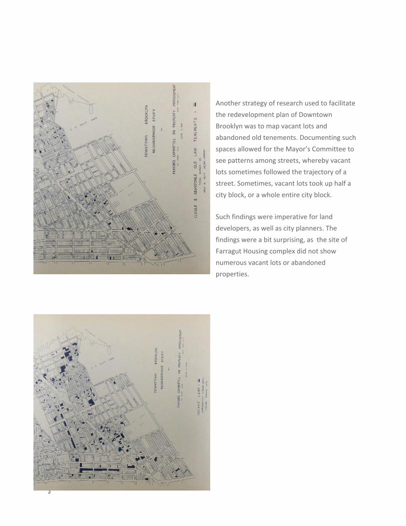
Another strategy of research used to facilitate
the redevelopment plan of Downtown
Brooklyn was to map vacant lots and
abandoned old tenements. Documenting such
spaces allowed for the Mayor’s Committee to
see patterns among streets, whereby vacant
lots sometimes followed the trajectory of a
street. Sometimes, vacant lots took up half a
city block, or a whole entire city block.
Such findings were imperative for land
developers, as well as city planners. The
findings were a bit surprising, as the site of
Farragut Housing complex did not show
numerous vacant lots or abandoned
properties.
3

DISCOVERIES
1. Neighborhood History
a. Vinegar Hill’s Farragut Housing was built in the early 1940’s, as part of the urban
Renewal of New York City.
b. Old Bridge street within Farragut Housing was diminished after the construction of
Farragut Housing. Old Bridge street was a projection based off of the Old Bridge on
Wallabout Bay.
2. Key Events / Historical Dates
a. The mission of Urban renewal was pronounced in the late seasons of 1941. The
mayor’s department devised a field or research through map making.
b. The bridge that was on Wallabout Bay was based off the trajectory of the structures,
which mediate between the U.S COB DOCK. (1776)
c. The conception of the Wallabout Bay Bridge (1820)
3. Key Players
a. The development of Farragut Housing was funded on the idea of rezoning the
community of Vinegar Hill.
b. The diagonal movement within Wallabout Bay, plays as a mysterious and forgotten
chunk of history which was erased from the Farragut Housing Complex.
c. The conception of the Wallabout Bay Bridge.
4. Relationship Key Players
a. The idea of rezoning Downtown Brooklyn was contrived through the discoveries made
from creating the maps. The mayor’s office has discovered the percentage of
programming within the city, as well as vacant lotso and new housing units built since
the early 1900’s. The desire to increase residential properties was swayed by the
overwhelming observation of unrestricted properties.
b. Not only were programmatic elements vital to the planning of Farragut Housing, but
5. Public Perception of Key Events
a. The redevelopment of Downtown Brooklyn has been widely celebrated by Mayor
LaGuardia, although it was highly debated by other professionals. People outside of
the Mayor’s Committee questioned the legitimacy of City Planning.
6. Important Changes to Neighborhood
4

a. The neighborhood was rezoned, whereby the idea of consolidating blocks for
residential use were present through the Farragut Housing Complexes.
b. New types of zoning categories were introduced, such as local retail, and two
additional business zoning districts.
7. Other Observations
a. Most blocks are dense with properties near the Plaza of the Manhattan Bridge. The
density is enclosed between Concord Street and York Street. The issue of density has
changed above York street.
b. The majority of Closed & Abandoned Old Law Tenements are scattered around the
highly dense locations within Vinegar Hill.
c. There’s a thickening of the road on Tillary Street, which is still prevalent today.
However, Sand’s street concurrently exhibits this condition, but did not in the 1940’s.
d. Old Bridge Road in the 1855 map has been renamed Fern street in the 1940’s map.
TOPICS & KEYWORDS
Topics and Keywords relevant to this area of study would be:
“Urban Renewal”, “Housing Complexes”, “Redevelopment of the 1940’s”, “Old Bridge Street”,
“Farragut Housing”, “Schematic Drawing”, “NYCHA”, “NYCDP”.
QUANTITATIVE DATA for Area of Study
Subject Data
Land Ownership Varying, but mostly city property.
Number of Blocks Several, perhaps over one hundred.
# of Buildings on a Typical Block
Varies, between
Materials Varies, mostly brick buildings
# of Stories of Buildings Varying, before the 1940’s most likely no more than 6 buildings
5
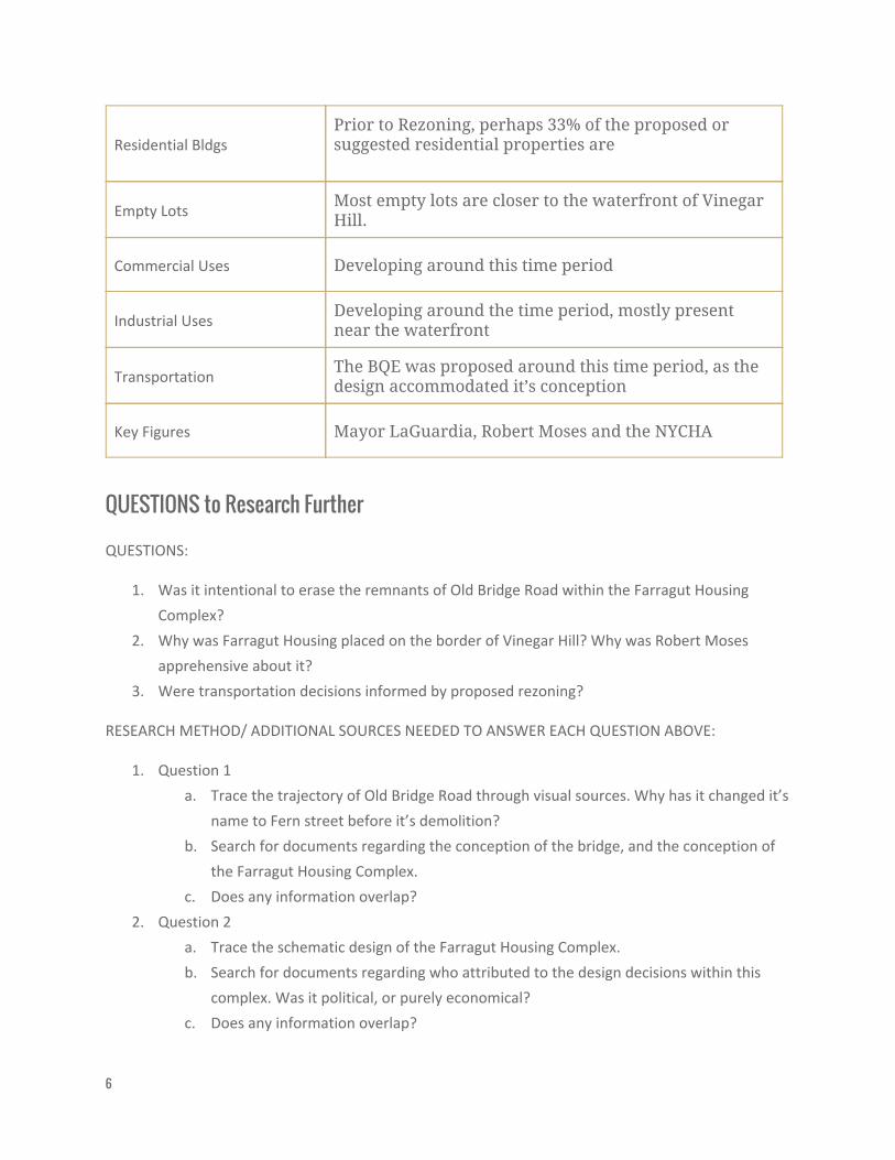
Residential Bldgs Prior to Rezoning, perhaps 33% of the proposed or suggested residential properties are
Empty Lots Most empty lots are closer to the waterfront of Vinegar Hill.
Commercial Uses Developing around this time period
Industrial Uses Developing around the time period, mostly present near the waterfront
Transportation The BQE was proposed around this time period, as the design accommodated it’s conception
Key Figures Mayor LaGuardia, Robert Moses and the NYCHA
QUESTIONS to Research Further
QUESTIONS:
1. Was it intentional to erase the remnants of Old Bridge Road within the Farragut Housing
Complex?
2. Why was Farragut Housing placed on the border of Vinegar Hill? Why was Robert Moses
apprehensive about it?
3. Were transportation decisions informed by proposed rezoning?
RESEARCH METHOD/ ADDITIONAL SOURCES NEEDED TO ANSWER EACH QUESTION ABOVE:
1. Question 1
a. Trace the trajectory of Old Bridge Road through visual sources. Why has it changed it’s
name to Fern street before it’s demolition?
b. Search for documents regarding the conception of the bridge, and the conception of
the Farragut Housing Complex.
c. Does any information overlap?
2. Question 2
a. Trace the schematic design of the Farragut Housing Complex.
b. Search for documents regarding who attributed to the design decisions within this
complex. Was it political, or purely economical?
c. Does any information overlap?
6
3. Question 3
a. Look for transportation plans in the 1940’s.
b. Compare the new found transportation plans to the Farragut Housing Plans. Are there
any direct translations?
SUMMARY / POST VISIT REFLECTION
I found it to be a privilege to be able to access the Map Division in the New York Public Library. I have
always loved maps, and find it to be an incredible experience to hold tangible primary sources in your
hands without the platform of a tablet or a cellphone. Details are made incredibly visible, and the
stroke of the hand is described through line weights and brush strokes. Conversations between the
maps were fluid, as it was easy to access one map to another instead of opening new tabs or
refreshing the internet browers. I was incredibly pleased to have visited the New York Public Library,
as we studied the maps in a room impermissible to the public. I hope to visit again and I look forward
to making new connections and discoveries here.
7