late prehistoric & early historic landscapes of the...
TRANSCRIPT
Late Prehistoric & Early Historic Landscapes of the Tungabhadra Corridor:
Report of the 2009 Season
Kathleen D. MorrisonDepartment of Anthropology1126 E. 59 St.th
University of ChicagoChicago, IL 60605 USA
Carla M. SinopoliMuseum of AnthropologyUniversity of MichiganAnn Arbor, MI 48109 USA
B.R. GopalDirectorate of Archaeology and MuseumsPalace ComplexMysore, Karnataka, India
with contributions by Andrew Bauer, Gwen Kelly, Mudit Trivedi, Kelly Wilcox, and BrianWilson, and with the assistance of Deeksha Bhardwaj, Eduard Fanthhome, Kanika Kalra,and Dr. Sharada Srinivasin
Kadebakale (VMS-530), Koppal District, Karnataka 1
VMS-579, Koppal District, Karnataka, N 15º22’14.4” E76º28’53.6”
VMS-634, Bellary District, Karnataka, N 15º21’25.7” E76º31’32.9”
VMS-541, Koppal District, Karnataka, N 15º22’55.2” E76º30’56.6”
VMS-543, Koppal District, Karnataka, N 15º22’48.1” E76º31’8.6”
AbstractThis report details preliminary results of the 2009 field season of the Late Prehistoric
and Early Historic Landscapes of the Tungabhadra Valley (EHLTC) project, focused ondocumentation and excavation of settlement and mortuary sites located near the TungabhadraRiver in a 38.5 square kilometer region in Koppal and Bellary Districts, Karnataka, India. Ourprimary research efforts focus on the excavation and documentation of five sites and associated1
features initially identified and documented by the Vijayanagara Metropolitan Survey project,directed by Morrison and Sinopoli from 1987-1997 (in collaboration with the KarnatakaDepartment of Archaeology and Museums, and with approval of the Government of India). Thisproject is directed by Gopal, Morrison, and Sinopoli, and is a joint project between theKarnataka State Directorate of Archaeology and Museums (India), the University of Chicago(USA), and the University of Michigan (USA).
In the 2009 season, we continued excavation work at the largest of these five sites, VMS-530 (Kadebakele), a habitation site of more than 40 hectares with an occupation span thatappears to run from the Southern Neolithic to the Middle Period. Most of our work wasconcentrated on Iron Age deposits of the Upper Terrace, though an unexpected large-scaledisturbance of River Terrace deposits prompted us to clean back a deep section there andexcavate a small test unit adjacent to it. Following an introduction to the goals and potentialsignificance of the larger project, this report describes the excavations undertaken in 2009.Artifact, botanical and sedimentological analyses are in progress. Finally, we report on thenewest radiocarbon dates from Kadebakele.
AcknowledgmentsMany thanks to the Government of India, the Archaeological Survey of India, and the
State of Karnataka for permission to carry out research. Research in 2009 was funded by grantsfrom the National Science Foundation and the University of Chicago; many thanks to both. Morrison and Sinopoli extend their thanks to colleagues at the Directorate of Archaeology andMuseums and to the dedicated student volunteers from India who joined the project. Last, butcertainly not least, we thank U.V. Sriniwas and all of the residents of Kadebakele village.
Introduction: Issues, Contexts, Significance
Research IssuesIn this project we examine continuity and change in economic, social, and political
organization in northern Karnataka (India) between c. 1000 BC-AD 300, focusing on materialpatterning at multiple spatial scales. The Iron Age and Early Historic periods marked a time ofremarkable change in peninsular India, changes that included the development and expansion ofregional polities and formalized relations of social inequality as well as the intensification ofspecialized craft production and long distance trade. Around the same time, the introduction andexpansion of rice agriculture and its integration with existing strategies of dry farming, herding,and foraging led to the emergence of complex new agricultural regimes and transformed regionallandscapes. Please note that the following introductory sections can also be found in Morrison,et al. 2005.
While there is no doubt that Early Historic centuries (c. 300 BC-AD 300) differed inimportant ways from the preceding Iron Age (c. 1000-300 BC), existing frameworks which positpopulation replacement and diffusion as primary mechanisms of change ignore continuity inexisting local practices such as megalith-building, dry farming, herding, and stone toolproduction, or of the ways in which both continuity and change were negotiated andmaterialized in settlements, mortuary sites, and regional landscapes. In this project, weinvestigate the ways in which introduced political and religious forms, cultigens, and tradeobjects enlarged and transformed South Indian worlds and, at the same time, how such objectsand organizations were themselves made local.
Although southern India became increasingly integrated with the north at this time,variability in the nature of this integration has not been fully investigated. Buddhism, forexample, never became as important in this area as it did elsewhere in the south in spite of theexpansion of South Asia’s first empire, the Mauryans, into this region. Associated with bothwriting and Buddhism, this polity was based on the distant Gangetic plain and yet made someclaim to authority over our region through the erection of “minor rock edicts,” inscriptionspromoting a vision of both rule and Buddhist dharma. At this same time, both the material andthe new text-based record indicate that the entire peninsula was involved in long-distanceexchange networks extending from the Mediterranean to East Asia. Ultimately, we seek tounderstand both the nature of external political claims as well as the structure of local polities,though in this initial phase of work we begin with more proximate questions of materialproduction, circulation, and consumption: how production of craft goods such as iron andceramics were locally organized and how local residents interacted within larger spheres ofcirculation.
The expansion of rice agriculture, which appears to have begun in earnest during theEarly Historic and perhaps earlier, worked to transform local diets, vegetation dynamics,hydrology, labor organization, ritual practice, and even soil structure. We are investigating theinitiation and nature of rice agriculture, as well as rice consumption patterns and the integrationof paddy production into existing regimes of production and use. Some changes associated withchanging settlement and production regimes were probably unintentional, and we are alsoconcerned with processes of landscape anthropogenesis associated with deforestation and
erosion, two probable consequences of the expansion and intensification of rice farming, ironsmelting, and settlement nucleation.
In addition to our concern with landscape dynamics, we also seek to understand both howproduction of craft goods was organized on local basis—residents of this area seem to haveproduced iron goods, for example—and how local residents interacted within larger spheres ofcraft circulation. We are addressing these concern studying evidence for local productionwherever encountered and by carrying out chemical and mineralogical analyses on artifacts(ceramics, metal, beads) and their raw material sources in order to locate their points of origin.
On a smaller spatial scale, we are interested in documenting aspects of newly-emergingeconomic and social stratification in detail, especially as these relate to people’s everyday lifeand consumption. We are just beginning to accomplish this by intensive spatial analysis ofsettlement surface contexts, close excavation of domestic contexts, evidence for diet and foodprocessing, and by comparing artifact assemblages and layout between houses, between differentareas of larger settlements, and between the residents of larger and smaller settlements occupiedat the same time. Finally, we plan to extend our previous work on the structure of regionallandscapes through additional survey and close documentation of the construction, modificationand use of megaliths and other features. Although we maintain an interest in new and non-localpolitical forms, text, cultigens, artifacts, and religious practices, we are primarily concerned toinvestigate the ways in which these are (or are not) adopted, how such forms and materials areremade and articulated within complex political economies and ecologies such as that of theEarly Historic Tungabhadra corridor.
ContextsAlthough there exists a large body of research in anthropology into issues of state
formation and imperial expansion, social differentiation and its institutionalization, religiousconversion and ritual practice, long-distance exchange and the production and consumption oflocal and exotic goods, agricultural change, and anthropogenic landscape transformation (e.g.Costin and Wright 1998; Ehrenreich et al. 1995; Schopen 1997; Alcock et al. 2001; Melville1997; see reviews by Stein 1998; Sinopoli 2001), few of these concerns have been explicitlyaddressed to the material record of Early Historic Karnataka. As such, we will draw ontheoretical and methodological insights derived from work on other regions and time periods,including our own previous work in the region. At the same time, there is a large body ofsystematic archaeological evidence directly relevant to this investigation. Much of thisinformation is couched in terms of culture-historical frameworks which stress the role ofsouthern India as a passive recipient of cultural ‘influences’ from the north, changes whichderive either through actual populations movement or, less often, through vaguely-defined formsof diffusion (e.g. Agrawal 1982; Allchin and Allchin 1982, Dhavalikar 1988; but see Chakrabarti1999). In this vein, institutionalized religions, states and empires, caste-like forms of socialdifferentiation, rice agriculture, and specific artifact forms have all been represented as northernimports. On the other hand, iron production, some forms of millet farming and cattledomestication, and megalith-building have all been recognized as South Indian practices, someof which moved in the other direction (Allchin 1963; Sharma 1983; Wheeler 1947). One of ourgoals is to help move the interpretation of South Indian history beyond such frameworks. Forexample, we are working to redefine ideas of artifact variation beyond that of the modal ‘type’
seen as ethnic or racial markers. Building on earlier work (Morrison 2005), we are conductingattribute-based artifact analyses that can incorporate variability in specific combinations ofattribute states while at the same time conducting sourcing and technological studies thatestablish the empirical groundwork for basic questions of pattern, process, and the organizationof production and consumption (cf. Inzizan and Lechevallier 1997; Miller 1997; Kenoyer 1989).
Without belaboring the many conceptual problems of culture-historical frameworks, wemight point out that it is also possible, even within this perspective, to view the material recordof the Early Historic Tungabhadra corridor as that of a dynamic junction where, for example, thedistributions of several widely-distributed ceramic types, Northern Black Polished Ware fromthe Gangetic region, Rouletted Ware from Bengal, and Red Polished Ware from Gujarat, overlap(Gogte 1997; Morrison 1997; Orton 1991), suggesting the importance of this region in regionalroutes of movement and exchange. Further, the presence of a cluster of rock edicts powerfullydemonstrates that this region held some interest for the Mauryan empire (Thapar 1997). In spiteof this, there has been no systematic study of local political and economic organization; thus it isdifficult to evaluate any account of either change or stability. In addressing such issues, we alsohope to contribute to the literature on imperial expansion and its local consequences (e.g.Alcock, et al. 2001), as well as to understandings of interregional networks of politics andexchange (e.g. Schortman and Urban 1992; Smith 1999; Stein 1999) and to the small butimportant body of scholarship on the social and political organization of the pre-medieval south(e.g. Begely 1996; Champakalakshmi 1996; Parasher-Sen 1993; Ray 1986, 1994; Ray and Salles1996).
Both regional-scale research programs and horizontal excavation strategies are rare inSouth Asia; important exceptions include Shaw and Sutcliffe (2002), Chakrabarti (2002), andErdosy (1998), among others. Although we have already completed one of the first systematicsurface surveys in India, this project will represent a refinement of our previous regional focus toa smaller spatial scale and to a combination of surface and subsurface distributions. Finally,there exists little paleoenvironmental information on Early Historic South India (but see Caratiniet al. 1991); our work should establish important information on vegetation history, erosionalregimes, and plant and animal use in this period.
SignificanceIn this project we begin to address a series of issues of primary anthropological interest in
a context never before subject to anthropological analysis. Situated in a region between what areusually defined as North and South India, a crossroads of long-distance exchange, and an objectof political interest and religious proselytization, the Tungabhadra region in the Early Historicperiod presents an excellent opportunity to studies processes of change and patterns of stabilityincluding initial state formation, the processes and consequences of imperial expansion, theextension of long-distance exchange, and the development and institutionalization of socialinequalities. In particular, we are interested in the material consequences of these processes at anumber of spatial scales; questions that require the construction of specific links between pastaction and contemporary archaeological patterning. Anthropologists, too, have been criticallyconcerned with relationships between humans and the natural world—in our focus onagricultural change and regional paleoecology we draw on traditions of anthropological andhistorical ecology while at the same time attending to the culturally-inflected political economies
that inform local power dynamics. On a more mundane level, these parameters are key tounderstanding what the opportunities for various people in a complex and changing society willbe—who can grow, process and consume rice or other foodstuffs, the extent to which socialdifferences will be marked in material ways, the forms of production and consumption of exoticand local craft goods. Methodologically, this project represents the extension of certainanalytical strategies and techniques (horizontal excavation, attribute analysis of artifacts,paleoenvironmental analyses, sourcing studies, microspatial study of surfaces) to an area wherethey are not generally practiced, work which we hope will help change basic conceptions of theSouth Asian past (away from typologies which encode ‘race,’ language, and culture, forexample) as well as improve substantive historical understandings of both change and stabilityin this important period.
The Study Area and the Sites
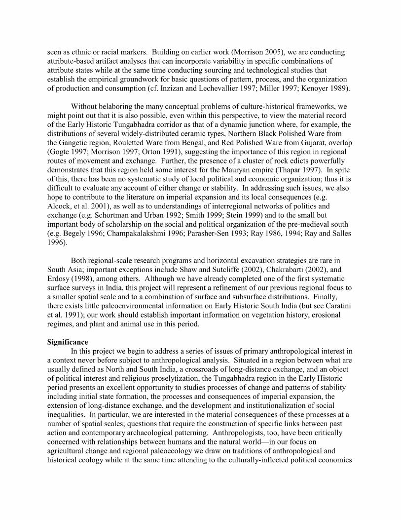
Figure 1: Project Area, showing location of sites
Although northern Karnataka is justly famous for the remains of the fourteenth tosixteenth century Vijayanagara empire, including its eponymous capital city, numerousprehistoric and historic sites have also been identified in Koppal and Bellary Districts over thelast century. In his 1914 catalogue Bruce Foote described fourteen artifacts he collected from“..an old site on the left bank of the Tungabhadra, opposite to Hampasagara, collected by self inOctober 1889.” (1914:187). It is difficult to say if this material is actually from Kadebakale, butit does point to the longstanding awareness of the deep history of the Tungabhadra valley in thisregion. The artifacts in question includes both chipped stone flakes and cores, iron slag, andpolished and unpolished redware sherds.
All of the sites appear, on ceramic evidence, to be at least partly contemporaneous. Oneradiocarbon date from VMS-634 (Morrison et al. 2005), puts it at the very end of the SouthernNeolithic period, in the transition to the Iron Age, which makes it earlier than the portions ofKadebakele so far excavated. Together, these locations provide evidence of a dense andcomplex occupation of this region during the Iron Age and Early Historic. Settlements differedmarkedly in size and complexity. However, all were located on the tops of outcrop hills inprotected locales. All have associated water control facilities, that were likely associated withsecuring drinking water as well as with agricultural activities. Kadebakale was far and away thelargest settlement of the period, several times larger than any of the other sites documented. Ourresearch seeks to explore the economic and social relations among these settlements, and toprovide a detailed fine-scaled reconstruction of chronology, economy, and settlementorganization during the Iron Age and Early Historic periods. Previous reports have described allthe project area sites in detail, so this information will not be repeated here.
The 2009 Excavation Season
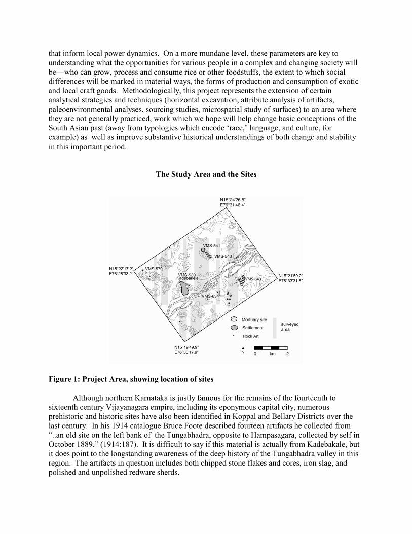
Research carried out in January and February of 2009 represented a continuation of workbegun in 2003 and 2005. Most of our efforts centered on the Upper Terrace of VMS-530 (Figure2), Kadebakele, and all of this was in areas previously excavated. Blocks A and B, opened in2005, were re-opened and a deep 1 by 2 m test unit in the reservoir, quite close to a similar unit(1 by 1 m) excavated in 2003, was completed this season. The unexpected appearance of a large(25 by 30 m , ca. 3 meters deep) machine-cut disturbance trench in the cultural deposits of theKadebakele River Terrace prompted us to clear back a 2.2 m wide section of this trench toprepare a stratigraphic section. We also extended this section just over a meter using a small testunit adjacent to the section. No additional mapping was carried out in 2009.
Figure 1Figure 2: UpperTerrace
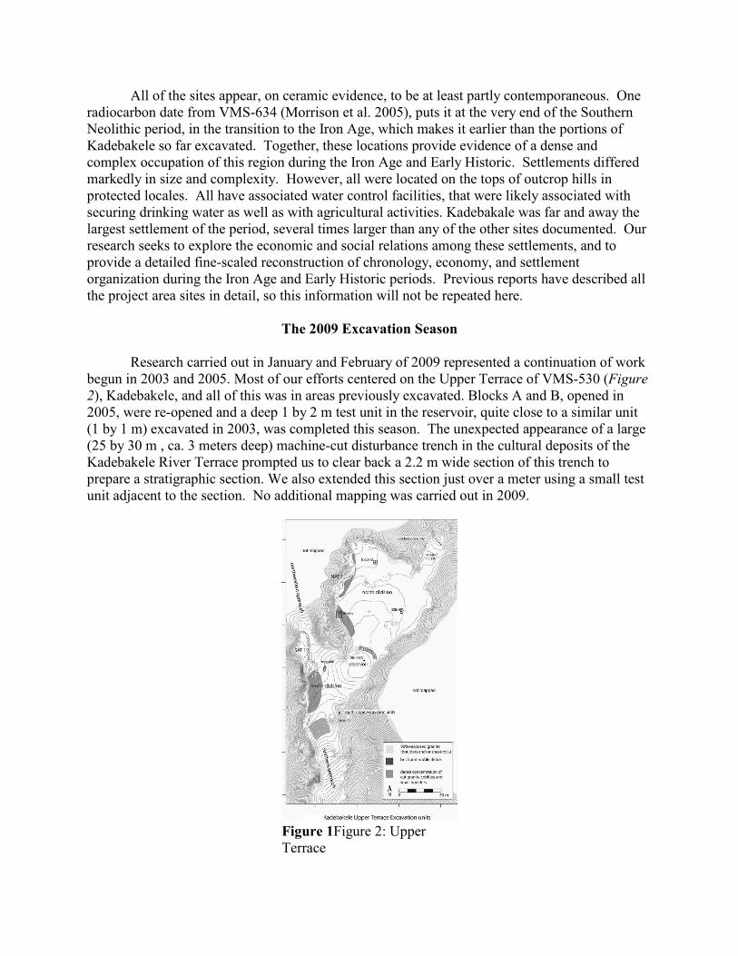
Block A: Upper Terrace Zone of Memorial Features
The 6 x 4 meter excavation area designated as Block A is located on the western edge ofthe Upper Terrace area, in an area of low outcropping boulders and limited sedimentation. Several small wall alignments are visible on the ground surface, and excavations were orientedtoward exposing architectural complexes in this area. Excavations in this area in 2005 and againin 2009 have revealed a complex sequence of small architectural alignments associated withthree major stable ground surfaces and several shorter-term surfaces. Rather than domesticarchitecture, these features were the remains of small ‘megalithic’ alignments – stone circles,lines, and other arrangements of cobbles – that largely post-date the early first millennium BCEhabitation of the Upper Terrace. They appear to be the result of multiple commemorative eventsor activities that occurred on the Upper Terrace after primary habitation had shifted down to thenorthern River Terrace area.
Excavations in 2005 exposed a portion of a large semi-circular alignment (Feature 9) ofmedium to large unmodified and modified boulders that appeared to contain an internal stonecist of fine slab masonry not unlike those found at Brahmagiri. This feature, which had clearlybeen built in multiple episodes, was associated both with surface 2 and the lower surface 3. Onsurface 3 there were also a series of small features, many associated with ash and burning,including a tiny stone oval containing a cow jaw and an iron point. Only half of this feature,down to surface 2 was exposed in 2005, so in 2009 we returned to the area to bring the southernhalf of the feature to the same level.
Figure 1Photo 1: Block A at beginning ofexcavation, facing SE
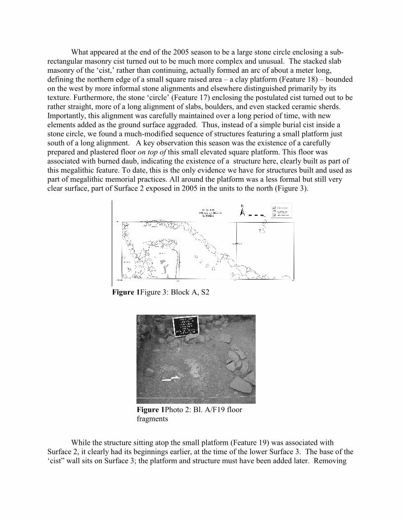
What appeared at the end of the 2005 season to be a large stone circle enclosing a sub-rectangular masonry cist turned out to be much more complex and unusual. The stacked slabmasonry of the ‘cist,’ rather than continuing, actually formed an arc of about a meter long,defining the northern edge of a small square raised area – a clay platform (Feature 18) – boundedon the west by more informal stone alignments and elsewhere distinguished primarily by itstexture. Furthermore, the stone ‘circle’ (Feature 17) enclosing the postulated cist turned out to berather straight, more of a long alignment of slabs, boulders, and even stacked ceramic sherds.Importantly, this alignment was carefully maintained over a long period of time, with newelements added as the ground surface aggraded. Thus, instead of a simple burial cist inside astone circle, we found a much-modified sequence of structures featuring a small platform justsouth of a long alignment. A key observation this season was the existence of a carefullyprepared and plastered floor on top of this small elevated square platform. This floor wasassociated with burned daub, indicating the existence of a structure here, clearly built as part ofthis megalithic feature. To date, this is the only evidence we have for structures built and used aspart of megalithic memorial practices. All around the platform was a less formal but still veryclear surface, part of Surface 2 exposed in 2005 in the units to the north (Figure 3).
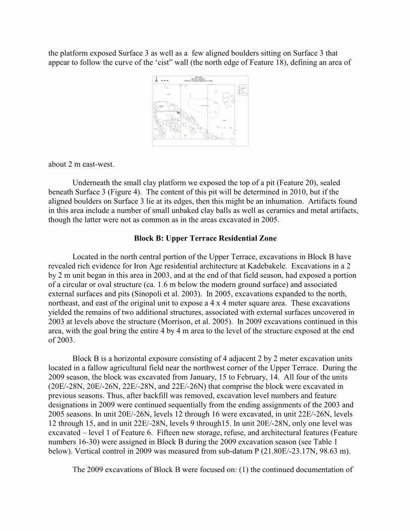
While the structure sitting atop the small platform (Feature 19) was associated withSurface 2, it clearly had its beginnings earlier, at the time of the lower Surface 3. The base of the‘cist” wall sits on Surface 3; the platform and structure must have been added later. Removing
Figure 1Figure 3: Block A, S2
Figure 1Photo 2: Bl. A/F19 floorfragments
the platform exposed Surface 3 as well as a few aligned boulders sitting on Surface 3 thatappear to follow the curve of the ‘cist” wall (the north edge of Feature 18), defining an area of
about 2 m east-west.
Underneath the small clay platform we exposed the top of a pit (Feature 20), sealedbeneath Surface 3 (Figure 4). The content of this pit will be determined in 2010, but if thealigned boulders on Surface 3 lie at its edges, then this might be an inhumation. Artifacts foundin this area include a number of small unbaked clay balls as well as ceramics and metal artifacts,though the latter were not as common as in the areas excavated in 2005.
Block B: Upper Terrace Residential Zone
Located in the north central portion of the Upper Terrace, excavations in Block B have revealed rich evidence for Iron Age residential architecture at Kadebakele. Excavations in a 2by 2 m unit began in this area in 2003, and at the end of that field season, had exposed a portionof a circular or oval structure (ca. 1.6 m below the modern ground surface) and associatedexternal surfaces and pits (Sinopoli et al. 2003). In 2005, excavations expanded to the north,northeast, and east of the original unit to expose a 4 x 4 meter square area. These excavationsyielded the remains of two additional structures, associated with external surfaces uncovered in2003 at levels above the structure (Morrison, et al. 2005). In 2009 excavations continued in thisarea, with the goal bring the entire 4 by 4 m area to the level of the structure exposed at the endof 2003.
Block B is a horizontal exposure consisting of 4 adjacent 2 by 2 meter excavation unitslocated in a fallow agricultural field near the northwest corner of the Upper Terrace. During the2009 season, the block was excavated from January, 15 to February, 14. All four of the units(20E/-28N, 20E/-26N, 22E/-28N, and 22E/-26N) that comprise the block were excavated inprevious seasons. Thus, after backfill was removed, excavation level numbers and featuredesignations in 2009 were continued sequentially from the ending assignments of the 2003 and2005 seasons. In unit 20E/-26N, levels 12 through 16 were excavated, in unit 22E/-26N, levels12 through 15, and in unit 22E/-28N, levels 9 through15. In unit 20E/-28N, only one level wasexcavated – level 1 of Feature 6. Fifteen new storage, refuse, and architectural features (Featurenumbers 16-30) were assigned in Block B during the 2009 excavation season (see Table 1below). Vertical control in 2009 was measured from sub-datum P (21.80E/-23.17N, 98.63 m).
The 2009 excavations of Block B were focused on: (1) the continued documentation of
the interior of Feature 13, a well preserved (ca. 2.4 by. 1.4 m) rectangular wattle-and-daubstructure supported by posts first exposed in 2005; and (2) the removal of exterior Surface 2, alsofirst exposed in 2005, and the documentation of earlier phases of occupation below.
Feature-13, Internal Surfaces. Much of the first half of the 2009 excavation season of in BlockB was spent documenting and removing features associated with external Surface 2 that wereinitially exposed in 2005 but not fully excavated. Chief among these was Feature 13, a wellpreserved (~2.4 x 1.4 m) rectilinear wattle-and-daub structure supported by posts with aninternally plastered floor exposed in excavation units 20E/-26N and 22E-26N. This feature wasencountered in association with Surface 2 toward the end of the 2005 excavation season, atwhich time excavations ceased due to time constraints. The excavations of 2009 documented avery complex use life for this structure, indicated by hundreds of resurfacing episodes and bothsubtle and major changes in the plan of the structure and its internal features. In 2009 threemajor phases of Feature 13 were exposed and assigned -- designated by well-preserved surfacesB, C, and D internal to the structure. The latest internal surface of the structure exposed in 2005was retroactively designated surface A.
Surface A of this structure was exposed in 2005 after the removal of a thick level ofburned and differentially composed structural material. Among the debris removed from thefloor were portions of the structure’s walls, a matting made from woven plant fibers, and whatwas probably portions of the structure’s roof. The plan of the structure exposed at surface A wasevident by 13 post-holes that demarcated the exterior of the feature. Feature 15, a small shallowhearth, was set into the plastered flooring of surface A.
In 2009, Surface A was removed in a thin level of 3-7 cm that exposed a better preserved,more compact underlying flooring of compact fine-sandy silt with a thin overlaying layer offibrous material (possibly dung). This underlying surface, designated surface B, showed asimilar architectural plan to the surface immediately above. However, its exposure andsubsequent removal revealed a long continuous use life for the feature. The removal of surface Boccurred in an excavation level of variable thickness, ranging from 1 to 9 cm, that exposed alower major surface phase of the feature (Surface C). When removed, the surface B compositionshowed a matting of silty and fibrous material, very light in color (10YR 8/1-8/2), overlying acompact floor of fine-sandy silt and plaster (10YR 4/2). In the few centimeters interveningbetween Surface B and Surface C, there were multiple “laminations” of compact earth andplaster representing numerous resurfacing episodes. These multiple surfaces interdigitate witheach other, meaning that the entirety of the area internal to the structure was not always repairedor resurfaced at exactly the same time in the past.
The underlying Surface C was easily followed along its cleavage with the compact baseof Surface B. In following surface C, it became clear that Surface C interdigitated with SurfaceB in the southwestern portion of the feature. In the extreme northeastern exposure of Feature 13,Surface C was followed underneath wall-fall and found to articulate with external Surface 2.Thus, it is clear that internal surfaces B and C of Feature 13 were in use at the same time as theupper portions of external Surface 2.
The exposure of Surface C is also noteworthy for evidence of several minor changes inthe architectural plan of the Feature 13. For example, the removal of Surface B revealed anearlier hearth (Feature 19) that was located about 30 cm west of that associated with the latersurface (Feature 15). This earlier hearth was a shallow pit some 40 cm in diameter and 7 cmdeep containing unconsolidated, dark ashy fill (10YR 4/2). The feature was set into Surface C
but then plastered over in the construction of the later phases of Surface B. In addition to thedifference in hearth location, Surface C also evidenced several additional postholes in thewestern portion of the structure that were later plastered over, indicating minor modifications tothe wattle-daub structure between phases.
The earliest major phase of occupation of Feature 13 was Surface D, situated 3-8 cmbelow Surface C. Similar to the relationship between Surfaces B and C, there were multiple“laminations” or replastering episodes between these major phases. Indeed, an estimated 30interdigitating resurfacing events were visible in the section exposed between surface phases Cand D. Surface D was recognized as the next major phase of Feature 13 by the presence of a wellpreserved plaster surface containing a ceramic-sherd mosaic paving. The mosaic was composedof Black Ware and Red Ware sherds pressed into the plaster floor. Although the ceramic pavingwas not contiguous across the interior of the feature, surface D could be easily followed acrossthe feature. To the East, this surface articulated with the lower portions of external Surface 2,and thus represents the earliest phase of occupation of Feature 13 associated with externalSurface 2. Three soil micromorphology samples were taken from strata of Feature 13 surfaces Athrough D, which will be analyzed to further document the detailed practices that contributed tothis feature’s use life.
Surface D was excavated in a level 10 to 20 cm in depth that entirely removed Feature 13from the excavation block. The removal of plaster Surface D, which was a fibrous, fine sandy-silt matrix when broken up, exposed an exterior surface (Surface 2A; Figure 5) that could befollowed across the block, and was found to be underlying the basal packing of Surface 2elsewhere in the block (see below). Two post-holes were found with adjacent support stones inthe western half of unit 20E/-26N set into Surface 2A. These posts almost certainly belong to anearlier structure that extends into the unexcavated area west or north from unit 20E/-26N.
Exterior Surfaces and Associated Features. In addition to documenting Feature 13, in 2009 wealso continued to document other surfaces and features associated with external Surface 2. Feature 14 was partially exposed in 2005 and characterized as a wattle-and-daub structure builtin association with Surface 2 in unit 22E/-26N, east of Feature 13. Excavations in 2009 sought tomore clearly define the relationship between Feature 14 and Surface 2. Work proceeded byremoving 5 to 10 cm of material from the designated surface stopped at in 2005. The materialremoved was a fine-sandy silt (10YR 5/2-5/3) that showed weakly-developed fine to mediumblocky structure. Although evidencing some blocky structure, the material was not compact orsurface like. Artifacts recovered in this matrix were recognized as a mix of ceramics and fauna,variably sized and at variable orientations (i.e.,g not ‘flat-lying’ material). Thus, this excavatedmaterial was interpreted as a mix of collapse debris and archaeological fill. Underneath theexcavated fill, lower portions of Surface 2 were encountered, which could be followed to thewest and south and were contiguous with portions of the surface elsewhere in the block. Hence,Feature 14 appears to have been built with the latest occupation of Surface 2, and clearly lacksthe long and earlier use life that is evident for Feature 13. Furthermore, Feature 14 appears tohave been an external structure/feature (e.g., sun or wind shade,) associated with the latestoccupation of Surface 2, and not a well maintained domestic structure.
In removing the fill of Feature 14, a small pit (ca. 25 cm in diameter, 10 cm deep) wasencountered at the base of the deposit that was dug into Surface 2. This feature was designatedFeature 18. The fill was an unconsolidated, sandy-silt loam (10YR 4/2). Other features
associated with Surface 2 were Feature 16, an east-west linear trench that cut Surface 2 south ofFeature 13, and Feature 20, a small pit cutting Surface 2. Feature 20 is particularly noteworthybecause it appears to have been a planned feature when Surface 2 was constructed – evidencedby the fact that the pit was built into the prepared clay under-packing of Surface 2 and ringedwith stones at lower levels. The fill matrix of this pit was a loose, single-grain deposit of coarse-sand and small pebbles with occasional concentrations of silt. After documenting featuresassociated with Surface 2, excavation proceeded by removing Surface 2 across all of Block B.Surface 2 was a compact earth surface of fine-sandy silt with occasional concentrations of clay.Plastering episodes gave it a distinctive white color (10YR 8/2-7/2). Its removal in thesoutheastern most unit of the block (22E/-28N) showed an underlying layer of soft,unconsolidated fine-sandy silt – burned and ashy in places – that could be seen intruding into thesurface where several large rodent burrows were present. However, this softer layer ofunderlying ashy fill was not uniformly found across Block B. In unit 22E/-26N, Surface 2 wasunderlain by a fill matrix with a slightly higher clay content, perhaps composed as a deliberatebase-packing for the initial construction of Surface 2. The fill underneath Surface 2 containedvery high artifact densities of ceramic and fauna.
Below the fill underlying Surface 2, excavations in 2009 documented four earlierexternal occupational surfaces of compact earth -- designated 2A, 3, 4, and 5 from latest toearliest. Surface 2A, a compact earthen matrix with traces of lime plaster and dung, had severalfeatures associated with it that are suggestive of occupation similar to that found on Surface 2.
Of particular note are a semi-circular wattle-and-daub structure (Feature 21) exposed in thesoutheast quadrant of the block, a prepared plaster surface with structural posts (Feature 22), andthe partial remains of another wattle-and-daub structure below Feature 13 in the northwestquadrant of the block that was only marginally exposed near the western edge of the excavationunit. In addition, two pits were found cutting Surface 2A but sealed by Surface 2. These features(Feature 24 and Feature 25) were both relatively small and shallow, neither extending more than10 cm in depth. The fills were unconsolidated materials with moderate amounts of ceramic andfaunal remains. Both were probably a deposit of refuse, although some other function – such asstorage – cannot be ruled out. The base of both pits was marked by Surface 3.
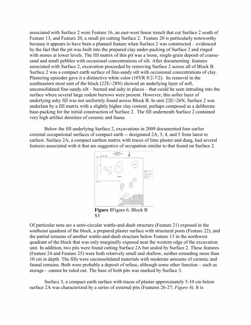
Surface 3, a compact earth surface with traces of plaster approximately 5-10 cm belowsurface 2A was characterized by a series of external pits (Features 26-27; Figure 6). It is
Figure 1Figure 6: Block BS3
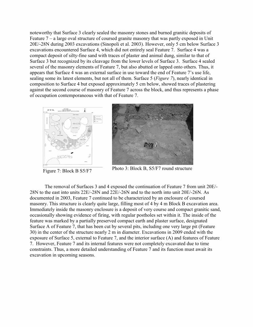
noteworthy that Surface 3 clearly sealed the masonry stones and burned granitic deposits ofFeature 7 – a large oval structure of coursed granite masonry that was partly exposed in Unit20E/-28N during 2003 excavations (Sinopoli et al. 2003). However, only 5 cm below Surface 3excavations encountered Surface 4, which did not entirely seal Feature 7. Surface 4 was acompact deposit of silty-fine sand with traces of plaster and animal dung, similar to that ofSurface 3 but recognized by its cleavage from the lower levels of Surface 3. Surface 4 sealedseveral of the masonry elements of Feature 7, but also abutted or lapped onto others. Thus, itappears that Surface 4 was an external surface in use toward the end of Feature 7’s use life,sealing some its latest elements, but not all of them. Surface 5 (Figure 7), nearly identical incomposition to Surface 4 but exposed approximately 5 cm below, showed traces of plasteringagainst the second course of masonry of Feature 7 across the block, and thus represents a phaseof occupation contemporaneous with that of Feature 7.
The removal of Surfaces 3 and 4 exposed the continuation of Feature 7 from unit 20E/-28N to the east into units 22E/-28N and 22E/-26N and to the north into unit 20E/-26N. Asdocumented in 2003, Feature 7 continued to be characterized by an enclosure of coursedmasonry. This structure is clearly quite large, filling most of 4 by 4 m Block B excavation area. Immediately inside the masonry enclosure is a deposit of very course and compact granitic sand,occasionally showing evidence of firing, with regular postholes set within it. The inside of thefeature was marked by a partially preserved compact earth and plaster surface, designatedSurface A of Feature 7, that has been cut by several pits, including one very large pit (Feature30) in the center of the structure nearly 2 m in diameter. Excavations in 2009 ended with theexposure of Surface 5, external to Feature 7, and the interior surface (A) and features of Feature7. However, Feature 7 and its internal features were not completely excavated due to timeconstraints. Thus, a more detailed understanding of Feature 7 and its function must await itsexcavation in upcoming seasons.
Figure 7: Block B S5/F7 Photo 3: Block B, S5/F7 round structure
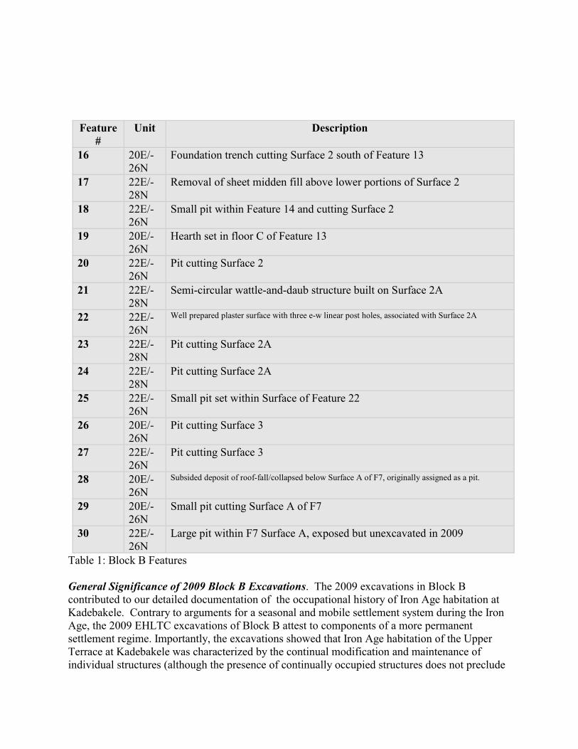
Feature#
Unit Description
16 20E/-26N
Foundation trench cutting Surface 2 south of Feature 13
17 22E/-28N
Removal of sheet midden fill above lower portions of Surface 2
18 22E/-26N
Small pit within Feature 14 and cutting Surface 2
19 20E/-26N
Hearth set in floor C of Feature 13
20 22E/-26N
Pit cutting Surface 2
21 22E/-28N
Semi-circular wattle-and-daub structure built on Surface 2A
22 22E/-26N
Well prepared plaster surface with three e-w linear post holes, associated with Surface 2A
23 22E/-28N
Pit cutting Surface 2A
24 22E/-28N
Pit cutting Surface 2A
25 22E/-26N
Small pit set within Surface of Feature 22
26 20E/-26N
Pit cutting Surface 3
27 22E/-26N
Pit cutting Surface 3
28 20E/-26N
Subsided deposit of roof-fall/collapsed below Surface A of F7, originally assigned as a pit.
29 20E/-26N
Small pit cutting Surface A of F7
30 22E/-26N
Large pit within F7 Surface A, exposed but unexcavated in 2009
Table 1: Block B Features
General Significance of 2009 Block B Excavations. The 2009 excavations in Block Bcontributed to our detailed documentation of the occupational history of Iron Age habitation atKadebakele. Contrary to arguments for a seasonal and mobile settlement system during the IronAge, the 2009 EHLTC excavations of Block B attest to components of a more permanentsettlement regime. Importantly, the excavations showed that Iron Age habitation of the UpperTerrace at Kadebakele was characterized by the continual modification and maintenance ofindividual structures (although the presence of continually occupied structures does not preclude
a subset of mobile strategies and practices as a component of the settlement system). Indeed, tensto hundreds of inter-digitating resurfacing episodes of Feature 13 indicate that the structure waslived in and maintained for much longer than most ephemeral settlement models suggest.Moreover, the presence of multiple contemporaneous structures and habitation features in BlockB suggest that much of the upper terrace of Kadebakele was densely occupied during the IronAge. The excavation results indicate that there was continuity in the use of residential space atKadebakele through time; not only were certain structures regularly maintained (e.g., Feature13), but likewise specific places for settlement within the site were enduring, even in periods ofmore substantial rebuilding. This is attested by the presence of apparently similar (although notfully exposed) wattle-and-daub structures below those associated with Surface 2 and under itsclay base packing. More specifically, Surface 2A shows several features similar to those ofSurface 2, and implies an earlier phase of similar occupation. Lastly, the 2009 excavations didshow a change in architecture and possible use of space in Block B below Surface 3, with theexposure of Feature 7 across much of the block. However, a comprehensive understanding ofFeature 7 and both its function and relationship to the later use of space in the Block B requiresadditional excavation of the structure and its internal features.
Upper Terrace Reservoir Excavation (8E/-145N)
At the center of Kadebakele’s Upper Terrace is a small water catchment feature ca. 30 min diameter consisting of a roughly circular depression augmented by a raised collar of sediment(perhaps from its initial excavation?) revetted with small cobbles and granite slabs. This featurecollects and holds monsoon rainfall and runoff, drying out completely in the winter months butsupporting somewhat more vegetation than the rest of the Upper Terrace. Test excavations inthis area were designed both to document the history of this feature and to collect data onpaleoclimate and land use over the last two millennia. An initial excavation unit was placed inthe center of the feature in 2003; excavations stopped at c. 2.0 meters in depth. Radiocarbonassessments from the 2003 excavations indicated that these excavations had uncovered the last1000 years of deposition in the reservoir. Pollen analysis of this record has been completed,helping to document the vegetation history of the region from A.D. 1000 to the present(Morrison and Bauer in press).
In the 2009 field season, an additional excavation unit was placed in the sedimentedreservoir in order to recover a more complete sequence of samples for analysis. The unit wasexcavated from January 15 to February 3, 2009. The primary objective of the excavation was toobtain a stratigraphic sequence from which pollen, carbon isotope, phytolith, andmicromorphology samples could be collected, and to correlate their analyses with those of anadjacent 1 meter by 1 meter unit excavated during the 2003 field season. The unit excavated in2003 (8E/-142N) documented more than 2 meters of alternating low and high energydepositional events. Radiocarbon assessments indicate that the 2003 excavations uncovered thelast 1000 years of deposition in the reservoir, from which pollen has been analyzed to documentthe vegetation history of the region from ca. A.D. 1000 to the present. The 2009 reservoir unitwas excavated to obtain additional paleoecological proxy datasets from even deeper and olderdeposits, with the hope that basal levels of the reservoir would be reached.
The unit was placed adjacent to the 2003 excavation unit in the reservoir to minimizecomplications with correlating both sedimentation stratigraphy and environmental proxies
between the 2009 and 2003 excavations. The initial size of the unit was 2 by 1m. Because theprimary objective was to obtain sediment samples from a deeply stratified deposit, the unit wasexcavated in relatively coarse 20cm arbitrary levels. To expedite excavation, the unit wasreduced to the southern square meter of the original 2 by 1meter unit at the beginning of level 6(123 cm bsd R). From there, the excavation continued to a final depth of 442.5 cm bsd R,exposing more than 4.10 m of sedimentation in the reservoir feature. Excavation was closed forsafety concerns at this depth. However, the continued presence of cultural materials indicate thatexcavations did not reach sterile soil, nor the base of sedimentation in the reservoir feature. Therecovered artifacts suggest that the lowest levels reached in the excavation probably correspondto the Iron Age, although more definite dates are pending the results of radiocarbon assessments.
Sediment descriptions and interpretations were recorded during the process ofexcavation; however, more detailed description and analysis of the sedimentary/pedogenicsequence evidenced in the unit was reserved until the end of the excavation, when the boundariesbetween the natural depositional and pedogenic strata were obvious in section. Afterdocumenting the stratigraphic profile, soil samples were collected at arbitrary 5 cm intervals andincluded every defined stratum. Three soil micromorphology samples were extracted from thereservoir profile to more fully analyze and document the nature of sedimentation in the feature,as well its potential cultural function. After completing the collection of samples, the unit wasbackfilled.
General Significance of Reservoir Excavations. A total of 18 distinct sediment strata weredefined in the excavated profile. Similar to the 2003 findings, the sedimentation sequenceshowed clay-rich, low-energy standing water deposits punctuated with occasional higher energyflows, represented by poorly-sorted sub-rounded to angular coarser materials (e.g., medium sandto small pebbles) derived from the granitic core stones of the Kadebakele inselberg. The upper~1 m of the sequence shows well developed signs of pedogenic activity (e.g., moderate to welldeveloped sub-angular blocky structure, rootlets, insect burrows), suggesting that sedimentationin the reservoir was likely decreasing in rate, and that the reservoir was more regularly dryingout completely by the mid-2nd millennium AD. However, prior to the mid-2 millennium AD,nd
and potentially as early as the 1 millennium BC, the reservoir feature more regularly held lowst
energy standing water for sustained periods of time. This interpretation of the sediments waspreliminarily corroborated by pollen analysis of sediment samples collected in 2003, whichshowed the highest concentrations of aquatic taxa in the lowest excavated levels of that season.The deeper sediments exposed during the 2009 excavations support this interpretation further byshowing thicker strata of more clay rich textures (e.g., clay as opposed to clayey loams) towardthe base of the excavated unit. Moreover, several of the clay rich strata toward the base of thesequence show faint traces of mottling due to differential oxidation of waterlogged sediments(e.g., Strata 16, Strata 18), providing additional support for the interpretation of more sustainedstanding water in the feature prior to the 2 millennium AD. Three micromorphology samplesnd
were extracted from Strata 16 to more fully analyze and document the nature of sedimentation inthe feature and its potential cultural function (e.g., perhaps it was used to grow irrigatedcultigens such as rice). Phytoliths, carbon isotopes, and pollen samples will also be analyzed tofurther detail the history and use of this feature, as well the relationships between long termhuman habitation and the environmental history of the region.
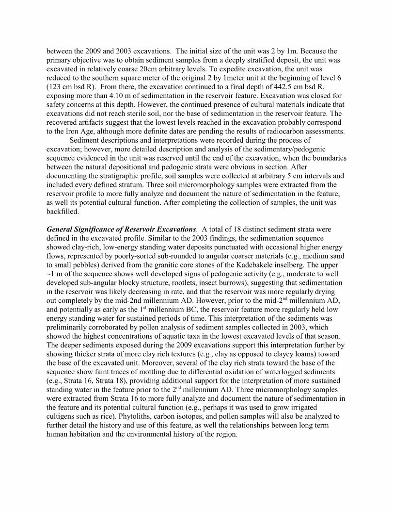
River Terrace: Section Documentation and Test Unit (8.8E/-449.8N)
Partway through the 2009 season, we discovered a large rectangular trench extending atleast 25 by 30 m on the River Terrace of VMS-530, between the Southern Slope and theTungabhadra River. This large excavation, according to local informants, made by residents ofAnagondi without the knowledge or permission of KDAM or the ASI. This large hole, evidentlymeant as the beginning of an irrigation reservoir, has caused very significant damage to the siteof Kadebakele, as evidence by the vast scatter of artifacts and construction debris all around thehole. Ceramics, beads, bones, tiles, and brick fragments lie in untidy heaps, remnants of thenow-destroyed archaeological deposits in this area. We notified the Karnataka Directorate ofArchaeology and Museums of this development.
The ceramics and other artifacts in the spoil heaps included Black-and-Red Ware, Black-and Red-slipped wares, Russet-Coated-Painted Ware, and Medieval earthenwares. Thus, it seemslikely that this area contained both Early Historic, Medieval, and possibly Iron Age deposits. We took the opportunity of this large-scale site destruction to cut back and clean a small areaalong the western side of the rectangular trench, and to extend the depth of the exposed profileby placing an abutting test unit at its base. Because the disturbed area, which had clearly beenmade with heavy machinery, was stepped back, we followed this profile in cleaning the section,an area measuring 2.20 m north to south. This section was drawn and mapped, and severalcharcoal samples were extracted for radiocarbon dating. Excavations and profile cleaningactivities revealed a high density of cultural materials, including ceramics, bone, charcoal, beads,iron, lithics and shell.
Because of the irregular shape of the disturbance trench, our small test unit at the base ofthe cleaned section was trapezoidal, measuring 1 by 2 by 1.74 m with a hypotenuse of 2.14 m. For consistency, the River Terrace unit is identified by its southwest coordinate 8.8E/-449.8N,despite the fact that this point was actually inside the western profile and excavations never fullyextended to this coordinate. Recording and excavation took place between February 3, 2009 andFebruary 13, 2009. We excavated in natural levels, though where there was no clear stratigraphicbreak, we employed arbitrary 20 cm levels. Elevations were measured in cm below sub-datumS, the latter shot into the site grid with a transit. We excavated six levels, each approximately 20cm in depth, noting changes in matrix content and artifact distribution, documenting the presenceany features and other occupationally related structures. All sediment was screened through 1/8”
Photo 4: Disturbance trench,NW corner, showing area ofsection cleaning
mesh, and artifacts were collected and registered for future analysis in the lab season.Levels 1 and 2 were the only levels containing structural features (a prepared floor
surface and a single pit). All levels exhibited a high concentration of cultural materials includingceramics, bone, charcoal, beads, iron, lithics, and shell. Daub and brick fragments were presentat low densities within the first few levels; however, these materials were noticeably absent inthe lower levels. In general, artifact density was high though much of it, especially in the lowestexcavated levels, appears to be occupational debris washing down from the top of the hill. Thedistribution and density of cultural material, as well as alternating layers of compact clay andsub-angular gravel sand, strongly suggests that the materials found within this area of the RiverTerrace were washed down from the hilltop, as opposed to flooding sequences or in proximateoccupational activity.
Level 1. Level 1 began at the base of the disturbed area, and is thus near the base of the recordedprofile. The initial centimeters of Level 1 were very loose and uncompacted, consisting of afine, poorly sorted silty sand (10 YR 5/2) with occasional lenses of gravel and ash. These initialcentimeters of Level 1 may have contained material from the profile cleaning. Grain shapevaried from sub-rounded to sub-angular with sub-rounded sand found within loam and sandy siltmatrices, while sub angular sand characterized the gravel lenses. Sand color ranges from 10YR3/2 (sub rounded sand), 10YR 4/2 and 10YR 4/3 (very coarse sub-angular sand).
Compaction increased at around 8-10cm within Level 1 and matrix changed from a finesilty sand to a medium sub-rounded sand and clay mixture with small lenses of charcoal.Beneath the sandy-clay mixture in the northwest corner, we exposed a light gray, prepared claysurface measuring 40 by 35 cm. The surface was removed and we sampled 100% of it forflotation. Beneath the prepared surface was a very coarse, subangular granite sand similar to thelenses observed throughout previously excavated deposits.
Within sandy-clay matrix, Level 1 continued to have lenses of medium to very coarsesub-angular sand gravel without any silt or clay present. This was consistently observed down tothe base of Level 1. The base of Level 1 was a loosely compact, brown loam (10YR 4/3) withthe lenses of sub-angular granite sand occurring along the 9.8E line and to the West, ultimatelyhitting the unit profile. Artifact density was very high in Level 1.
Feature 1. At the base of level 1, we encountered an ashy pit in the northeast corner of the unit. It contained a soft, very loose mixture of ash and fine sand (10YR 7/1) with a distinctive burnedlayer towards the bottom. Pit fill was screened separately. Charcoal from the pit was sampledfor radiocarbon and a flotation sample was taken. Within the pit, we found the well preservedbase of a Black-and-Red Ware bowl. A large cow bone was also found within the southern edgeof the pit.
Beneath the ashy fill of the pit was a very fine, almost powder-like, dark yellowish-brown sand (10YR 3/4) surrounded by a softer, brown deposit containing well preservedceramics. Initially, this was deemed separate from the pit fill and cut, and was recorded as partof Level 2. However, it was probably the case that this was actually part of the pit and shouldhave been included in the separate removal and screening for Feature 1. As a result, there islikely a slight mixture of contents from Feature 1 within Level 2; however, ceramics removedfor analysis were point provenienced.
Level 2. Level 2 began as a compact medium to fine loam (10YR 4/3), with some clay. Sand
within this matrix was sub-rounded. Clay content increased with depth. After about 5 cm, thematrix became a well-sorted medium sand with a mixture of silt and some clay. This loam(10YR 3/3) included regularly occurring stone chips. The matrix remained fairly consistent;however, towards the base of the level, the sediment became increasingly sandy. Base matrixwas a medium sub-rounded to sub-angular sand with some silt. Within the center of the unit,patches of nearly pure sand lenses emerged and color varied across the base of the unit frombrown to dark brown (10YR 3/3 and 10YR 5/3). Artifact density in Level 2 was high, but lowerthan Level 1. Ceramics and bone were extremely eroded, especially at the base of the level, andriver pebbles were more abundant than in Level 1. Level 3. The initial 10 cm of Level 3 was a compact, clay-rich loam with a mixture of mediumand coarse sub-angular sand (10YR 3/3) and infrequently occurring stone chips.Changes within the bottom 10 cm of level 3 included the occurrence of very coarse sub-angular
| sand gravel lenses, and increasingly frequent granite chips, cobbles, and river pebbles. The baseof Level 3 (10YR 3/3 and 10YR 3/2) was a very compact clay with just a few patches of coarsesub-angular granite sand in the northern part of the unit.Level 3 clearly illustrated the oscillation of clay-rich and of sand deposits, both throughoutexcavation and as observed in profile. Furthermore, it became clear that there was a relationshipbetween sediment type and artifact density, with artifact concentrations very low within clay-richdeposits, and higher in both the loam and the sand-gravel deposits. Level 3 yielded both Black-and-Red Ware with graffiti, as well as RCPW. Level 4. Like Level 3, Level 4 was excavated in two 10 cm sweeps. In the southwest corner,where the unit abuts the western profile, Level 4 began as very coarse sub-angular granite sandwith pebble inclusions. This 5 cm thick layer was clearly represented in profile and sat atop avery compact clay matrix. Clay-rich deposit continued to alternate with pure sub-angular sandgravel layers in thick bands throughout the unit. Consistent with the overall trend, as the depthincreased, artifact density continued to decrease. However, Level 4 produced much larger andmore well-preserved ceramic fragments compared to previous levels. One large brick fragmentwas recovered.
The base of Level 4 (10YR 3/3), was a compact clay containing no sand, but small tracesof silt. Similar to the patterns in upper levels, Level 4 exhibited lenses of very coarse sub-angular granite sand (10YR 4/2) with a higher volume of river pebbles than in any other level. Lenses of fine, sub-rounded sand were also documented in this level. The base of the levelshowed an increasingly compact, dark brown (10YR 2/2) clay content, marbled with a lesscompact clay (10YR 3/3). Level 5. Level 5 maintained the marbled clay-matrix noted at the base of Level 4 forapproximately 5 cm before transitioning to a coarse sub-angular granite sand matrix. At 10 cm,we continued to see the same alternating pattern of clay-rich and pure sand gravel deposits. Artifact concentration was moderate and recovered bone fragments were highly eroded. The first10 cm sweep of Level 5 revealed several lenses of fine sub-rounded sand; along the northwestside of the unit, the clay matrix was very dense and uninterrupted by sand lenses. Within thedense clay matrix in the northwest corner, we recovered a carbonized seed and took an additionalflotation sample in the same area.
The base of Level 5 revealed a very dark (10YR 2/2) compact clay with very low artifact
density. Sand content increased slightly at the base of the level. Deposits ranged from darkyellowish-brown sand lenses (10YR 4/4), to pure clay (10YR 2/2) and sandy clay (10YR 3/3).
Level 6. In this level, we reduced the size of the excavation area of the unit, taking down thetriangular section of the unit (everything from the west of the 9.8E line up to the Westernprofile) to 137cm bsd S. In this level, we recorded a less-compact, black, silty clay (10YR 2/1)in the unit’s northwest corner. Elsewhere, the dark brown compact clay previously recordedabove continued. Large cobbles and river pebbles occurred frequently and the base matrix of thelevel was a compact to moderately-compact dark clay (10YR 2/2) with loam (10YR 3/3) andsand lenses. Excavation ceased due to time constraints; it is not known if earlier intact depositsunderlie the lowest exposed levels. Discussion: River Terrace
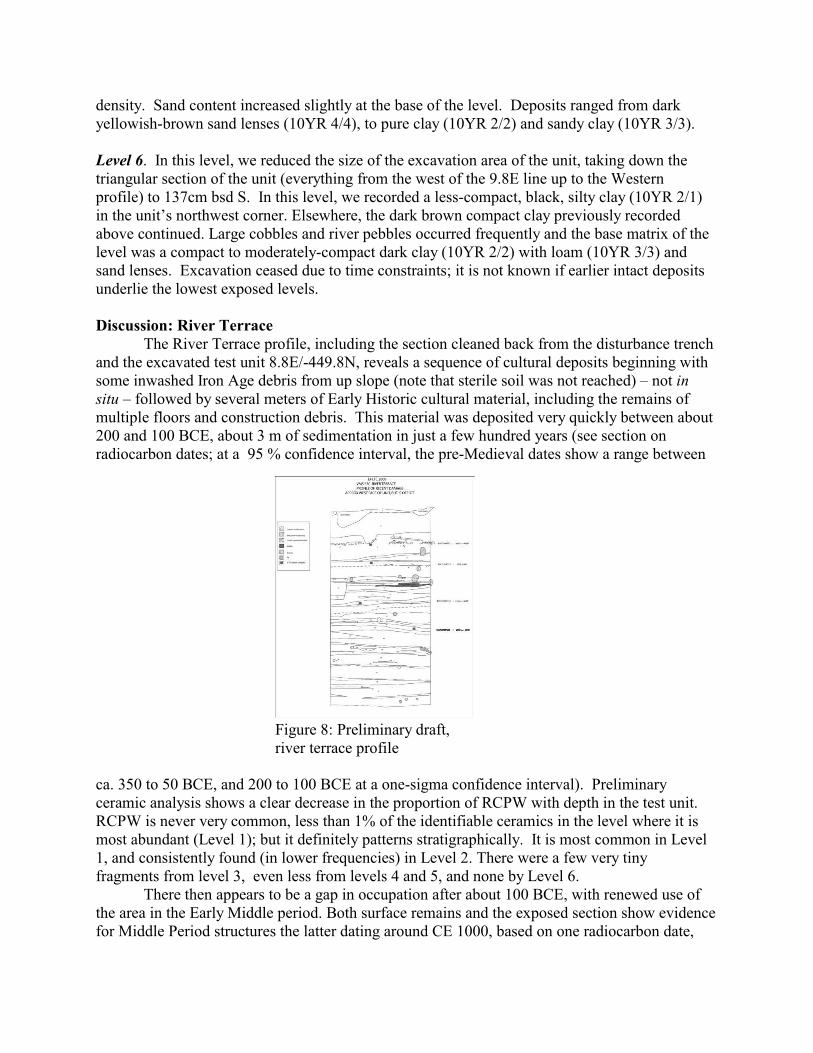
The River Terrace profile, including the section cleaned back from the disturbance trenchand the excavated test unit 8.8E/-449.8N, reveals a sequence of cultural deposits beginning withsome inwashed Iron Age debris from up slope (note that sterile soil was not reached) – not insitu – followed by several meters of Early Historic cultural material, including the remains ofmultiple floors and construction debris. This material was deposited very quickly between about200 and 100 BCE, about 3 m of sedimentation in just a few hundred years (see section onradiocarbon dates; at a 95 % confidence interval, the pre-Medieval dates show a range between
ca. 350 to 50 BCE, and 200 to 100 BCE at a one-sigma confidence interval). Preliminaryceramic analysis shows a clear decrease in the proportion of RCPW with depth in the test unit.RCPW is never very common, less than 1% of the identifiable ceramics in the level where it ismost abundant (Level 1); but it definitely patterns stratigraphically. It is most common in Level1, and consistently found (in lower frequencies) in Level 2. There were a few very tinyfragments from level 3, even less from levels 4 and 5, and none by Level 6.
There then appears to be a gap in occupation after about 100 BCE, with renewed use ofthe area in the Early Middle period. Both surface remains and the exposed section show evidencefor Middle Period structures the latter dating around CE 1000, based on one radiocarbon date,
Figure 8: Preliminary draft,river terrace profile
and somewhat earlier based on the remains of a nearby temple. Given that landscape dynamics and anthropogenesis are among the project’s concerns,
understanding the scope of human and environmental activity on the River Terrace is pivotal.We know areas of the River Terrace would have been subject to flooding prior to theconstruction of the Tungabhadra dam (Morrison, Sinopoli, and Gopal 2005: 5-6, 28). However,the excavation and analysis of unit 8.8E/-449.8N on the River Terrace showed us that we wereworking in an area which may not have been reached by flooding episodes from theTungabhadra River. The sub-angular nature of the matrix, which tended to be mixed with highconcentrations of artifacts, instead suggests that these deposits accumulated as a result of washfrom up slope. By contrast, we would expect to see a higher occurrence of sub-rounded sandymatrices in the event that the area was subject to flooding episodes; however, sub-rounded sandwas only observed in the initial centimeters of Level 1, and in small lenses throughout Levels 2through 6. However, the clay deposits observed throughout potentially suggest that floodingactivity did sometimes reach the base of the hill.
Evidence from this area suggests that our initial notion of an occupational shift down thehill, with Iron Age habitation in the higher areas and Early Historic habitation along the floodplain, appears to be correct. Although the focus of Early Historic settlement was apparently onthe flood plain, residents of the area were clearly using the Upper Terrace for memorial activitiesinvolving Block A. The rate of deposition at the base of the hill during the first few centuriesBCE was very high, suggesting not only intensive settlement, but also accelerated erosion upslope.
Data Analysis
Radiocarbon calibrations. A major effort of the project is to refine the extremely roughchronologies for the South Indian Iron Age period – which now is divided into a single period ofabout a thousand years long. To this end, obtaining a strong suite of radiocarbon dates has beenan important focus of our work. Several more samples were run over the last year, and projectmember Andrew Bauer has applied a Bayesian statistical analysis to attempt to refine the dateranges characteristic of the mid-first millennium BCE calibration curve. Bauer’s efforts in twoexcavation areas of Kadebakele’s upper terrace resulted in such a refinement, and indicate thatthe most intensive occupation of the upper terrace area can bracketed between c. 800 and 550 calBC. Later use of the upper terrace is evident in both the western commemorative (megalithic)activities documented in Block A and deposits in the Southern Slope part of the upper terraceexcavated in 2005. Our current interpretations point to a pattern of shifting settlement atKadebakele, with the earliest occupation focusing on the protected upper terrace region in thefirst half of the first millennium BCE, with settlement shifting downslope to the more open andaccessible river terrace area subsequently.
Artifact Analyses. Analysis of ceramics, beads, clay objects, and stone tools is in progress. Moredetail is given in Morrison et. al. 2005 and Sinopoli et al, in prep. A ceramic chronology iscurrently under development.
Paleoenvironmental Analyses. Pollen analysis of the 2005 reservoir excavations is complete(Morrison and Bauer in press) and phytolith analysis of the Upper Terrace midden depositsexcavation from 2003 are complete. Macrobotanical and stable isotope analyses are in progress.Faunal analyses from all seasons are complete.
Archaeometallurgical Analyses. Project collaborator Dr. Sharada Srinivasan continued her workon the iron artifacts and slag from Kadebakele. Results confirm the presence of medium andhigh carbon scale from early first millennium BCE strata at the site – this is some of the earliestknown steel production in the world. To date however, we have only finished artifacts and noevidence for in-situ production.
APPENDIX 1: ANTIQUITIES REGISTER
APPENDIX 2: LABORATORY CHECK-IN RECORD (all artifacts)
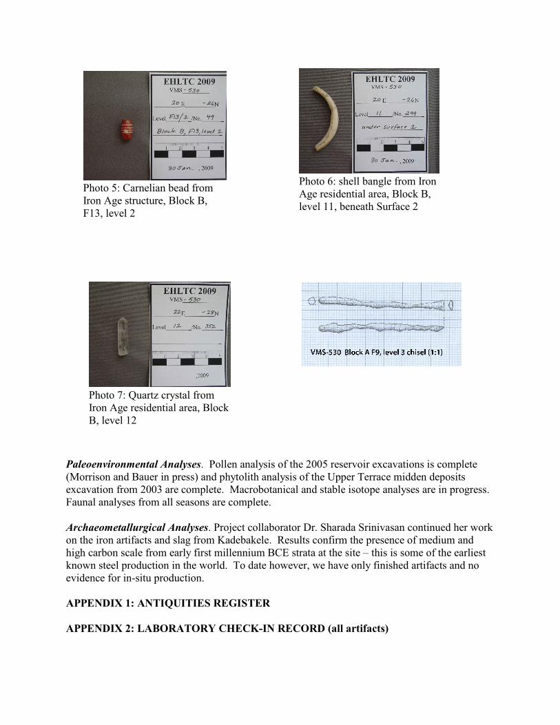
Photo 6: shell bangle from IronAge residential area, Block B,level 11, beneath Surface 2
Photo 5: Carnelian bead fromIron Age structure, Block B,F13, level 2
Photo 7: Quartz crystal fromIron Age residential area, BlockB, level 12