last mile connectivity & multi-modal integration
TRANSCRIPT

LAST MILE CONNECTIVITY & MULTI-MODAL INTEGRATION
PROPOSED ACTION PLAN - PROJECTS & PROGRAMME
UTTIPEC / JULY 2012

The Background – 6 Mandates
1. Multi-modal integration plan
for Metro Stations
2. Pedestrian Crossing facilities at
Vulnerable /accident spots
3. Standard Typical Crossing
Design
4. Synchronization Of Signals,
Signage & Road Markings etc.
5. Street Design Guidelines
6. Cycle sharing & other IPT

The Background – 6 Mandates…still undelivered
1. Multi-modal integration plan
for Metro Stations
2. Pedestrian Crossing facilities at
Vulnerable /accident spots
3. Standard Typical Crossing
Design
4. Synchronization Of Signals,
Signage & Road Markings etc
5. Street Design Guidelines
6. Cycle sharing & other IPT
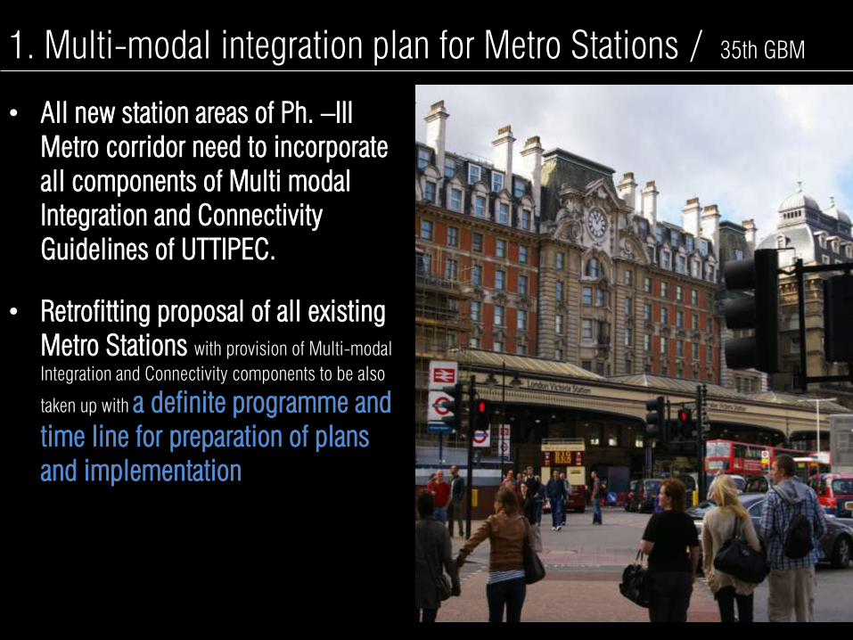
1. Multi-modal integration plan for Metro Stations / 35th GBM
• All new station areas of Ph. –III
Metro corridor need to incorporate
all components of Multi modal
Integration and Connectivity
Guidelines of UTTIPEC.
• Retrofitting proposal of all existing
Metro Stations with provision of Multi-modal
Integration and Connectivity components to be also
taken up with a definite programme and
time line for preparation of plans
and implementation
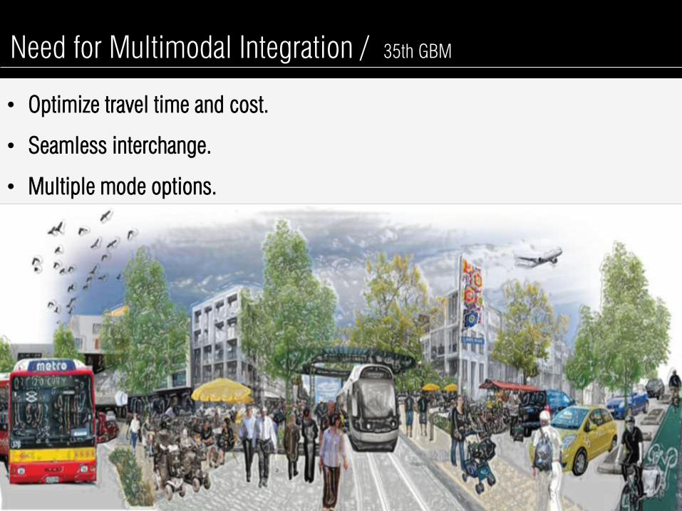
Need for Multimodal Integration / 35th GBM
• Optimize travel time and cost.
• Seamless interchange.
• Multiple mode options.
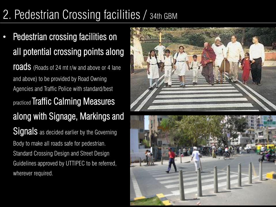
2. Pedestrian Crossing facilities / 34th GBM
• Pedestrian crossing facilities on
all potential crossing points along
roads (Roads of 24 mt r/w and above or 4 lane
and above) to be provided by Road Owning
Agencies and Traffic Police with standard/best
practiced Traffic Calming Measures
along with Signage, Markings and
Signals as decided earlier by the Governing
Body to make all roads safe for pedestrian.
Standard Crossing Design and Street Design
Guidelines approved by UTTIPEC to be referred,
wherever required.

3. Standard Typical Crossing Design / 34th GBM
• Approved the proposal of implementing
fully signalized crossings and
mid-block pedestrian-NMT
crossings as per UTTIPEC
designs even for streets more
than 30M ROW; with the condition
that any retrofitting proposal of the existing
road should be discussed in Working Group
II-B meeting for considering views of Traffic
Police.

3. Synchronization Of Signals, Signage & Road Markings / 33rd
, 31st GBM
• Implementation of fully signalized crossings and
mid-block pedestrian-NMT crossings from now
are to be implemented by Traffic Police, which
will set up its own Engineering Wing. PWD/MES
to be requested to provide necessary man
power/Engineers on deputation to Traffic Police.
• Rate based contract for each of
the listed items for repairing ,
fixing of various types and sizes
of signages and road markings
to be got approved for the
financial year by all agencies.

5. Street Design Guidelines / 33rd, 31
st GBM
• Street Design Guidelines approved for immediate
implementation, enforcement and uniform
adoption by all the road owning agencies.
• Agencies directed to report:
(A) How much Road length in KMs
is under their jurisdiction;
(B) how much road length has
already been constructed/
retrofitted based on Street Design
Guidelines
(C) What is the timeline for
retrofitting of the remaining roads
as per the UTTIPEC Guidelines.
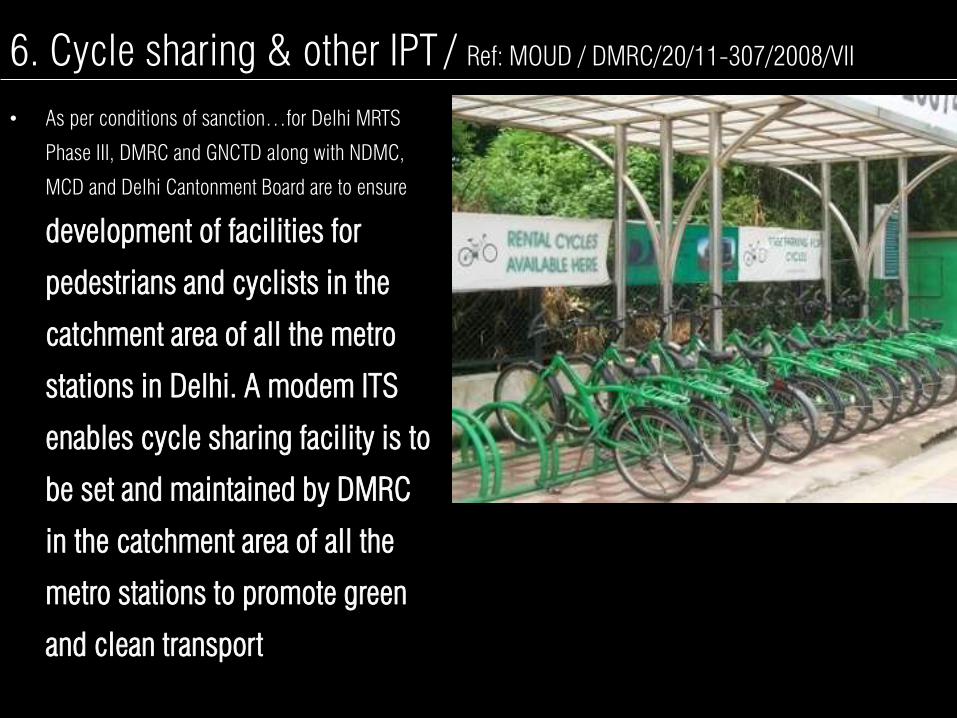
6. Cycle sharing & other IPT / Ref: MOUD / DMRC/20/11-307/2008/VII
• As per conditions of sanction…for Delhi MRTS
Phase III, DMRC and GNCTD along with NDMC,
MCD and Delhi Cantonment Board are to ensure
development of facilities for
pedestrians and cyclists in the
catchment area of all the metro
stations in Delhi. A modem ITS
enables cycle sharing facility is to
be set and maintained by DMRC
in the catchment area of all the
metro stations to promote green
and clean transport

THE PROJECT
To Plan, Design and Retrofit a 2Km Influence Zone
around all Ph III Metro Stations
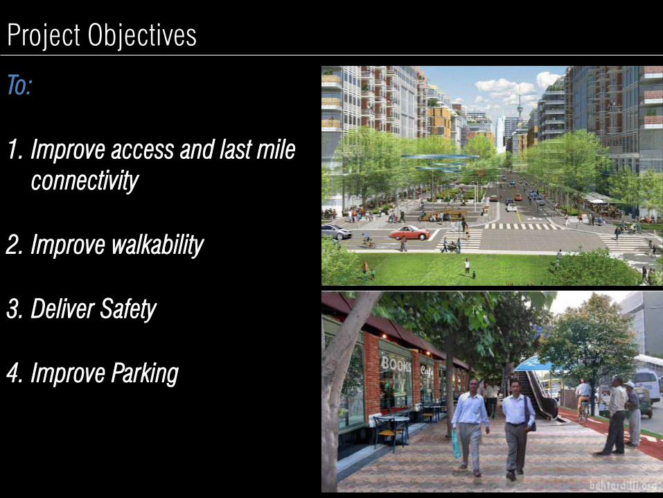
To:
1. Improve access and last mile
connectivity
2. Improve walkability
3. Deliver Safety
4. Improve Parking
Project Objectives

6 KEY OUTPUTS OF THE PROJECT
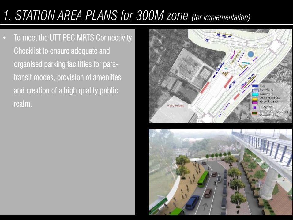
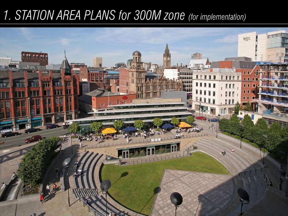
1. STATION AREA PLANS for 300M zone (for implementation)
• To meet the UTTIPEC MRTS Connectivity
Checklist to ensure adequate and
organised parking facilities for para-
transit modes, provision of amenities
and creation of a high quality public
realm.
1. STATION AREA PLANS for 300M zone (for implementation)

1. STATION AREA PLANS for 300M zone (for implementation)

2. CORRIDOR DEVELOPMENT PLAN FOR ROAD LINKING
STATIONS (for implementation)
• To provide high quality road
infrastructure that is convenient and safe
for all modes to use
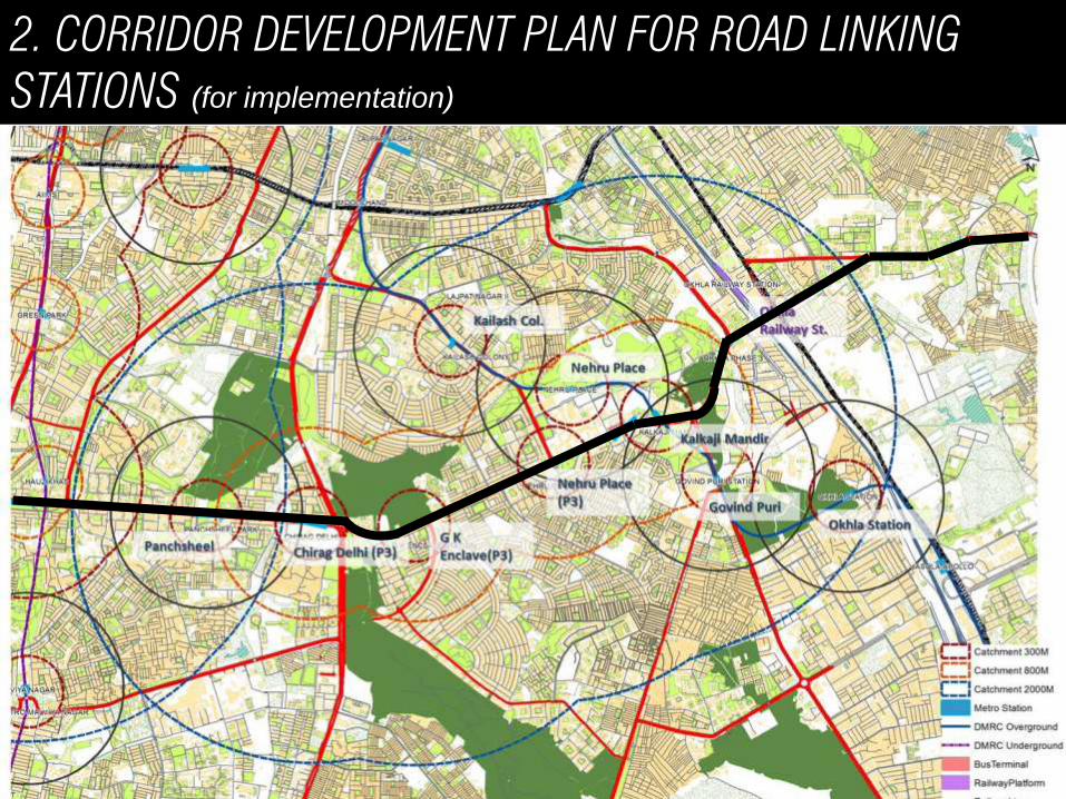
2. CORRIDOR DEVELOPMENT PLAN FOR ROAD LINKING
STATIONS (for implementation)

3. A COMPREHENSIVE PARKING STRATEGY for 800M zone
• For the 800M zone identifying zones for
long-term and short-term parking as
well as appropriate management
regimes for all modes
Laxmi Nagar Nirman vihar
Preet Vihar
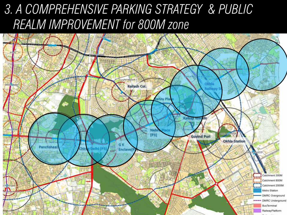
3. A COMPREHENSIVE PARKING STRATEGY & PUBLIC
REALM IMPROVEMENT for 800M zone
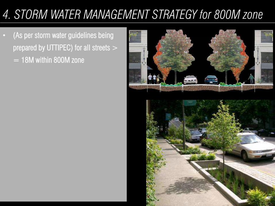
4. STORM WATER MANAGEMENT STRATEGY for 800M zone
• (As per storm water guidelines being
prepared by UTTIPEC) for all streets >
= 18M within 800M zone
akash

4. STORM WATER MANAGEMENT STRATEGY for 800M zone

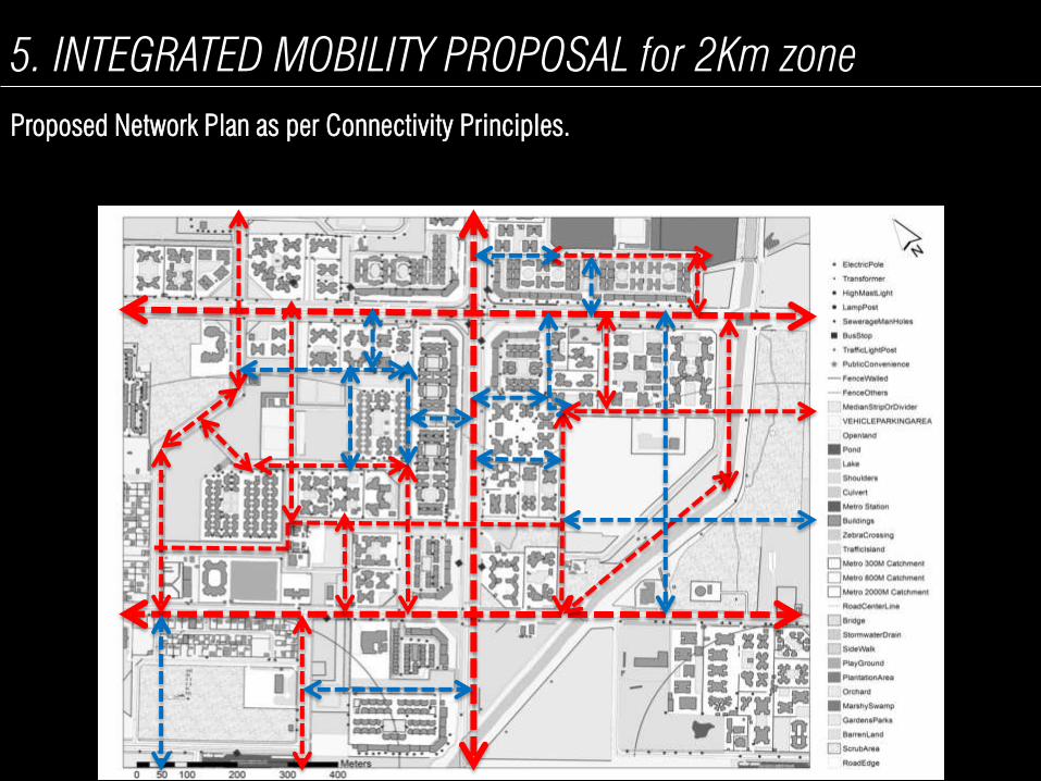
5. INTEGRATED MOBILITY PROPOSAL for 2Km zone
For the 2 km catchment
integrating MRTS, Bus, Para
transit modes including
feeder services, NMT,
pedestrians and the private
car.
To include a comprehensive
signalisation strategy with
synchronisation
5. INTEGRATED MOBILITY PROPOSAL for 2Km zone
Proposed Network Plan as per Connectivity Principles.

• Missing IPT & NMT Network and Facilities.
• Bus routing and service levels.
• NMT and IPT parking
No Parking Space
5. INTEGRATED MOBILITY PROPOSAL for 2Km zone
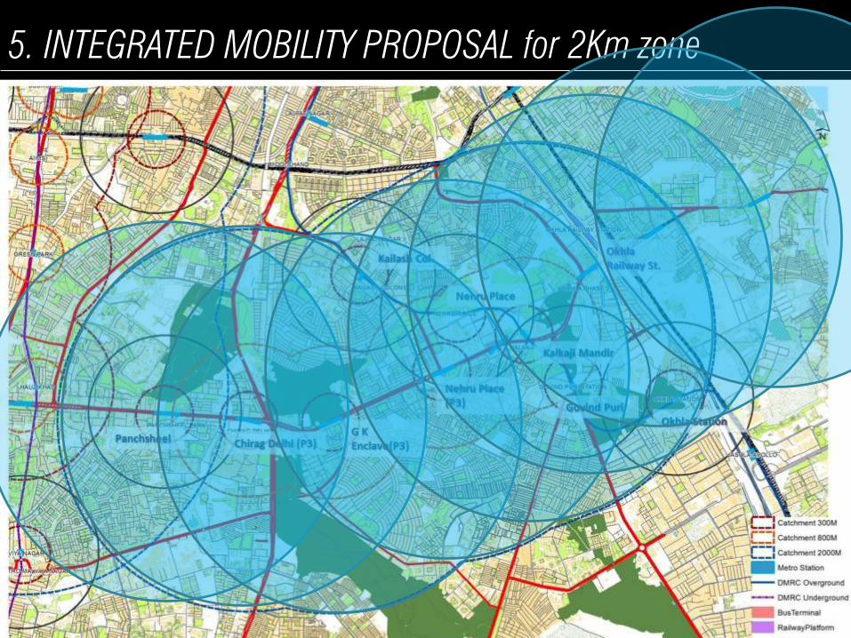
5. INTEGRATED MOBILITY PROPOSAL for 2Km zone

6. Retrofitting proposals for all streets 18M on priority basis
within 2Km zone
• To meet the UTTIPEC Street Design
Guidelines to ensure a safe, comfortable
and convenient environment that meets
the mobility needs of all.

PROPOSED METHODOLOGY
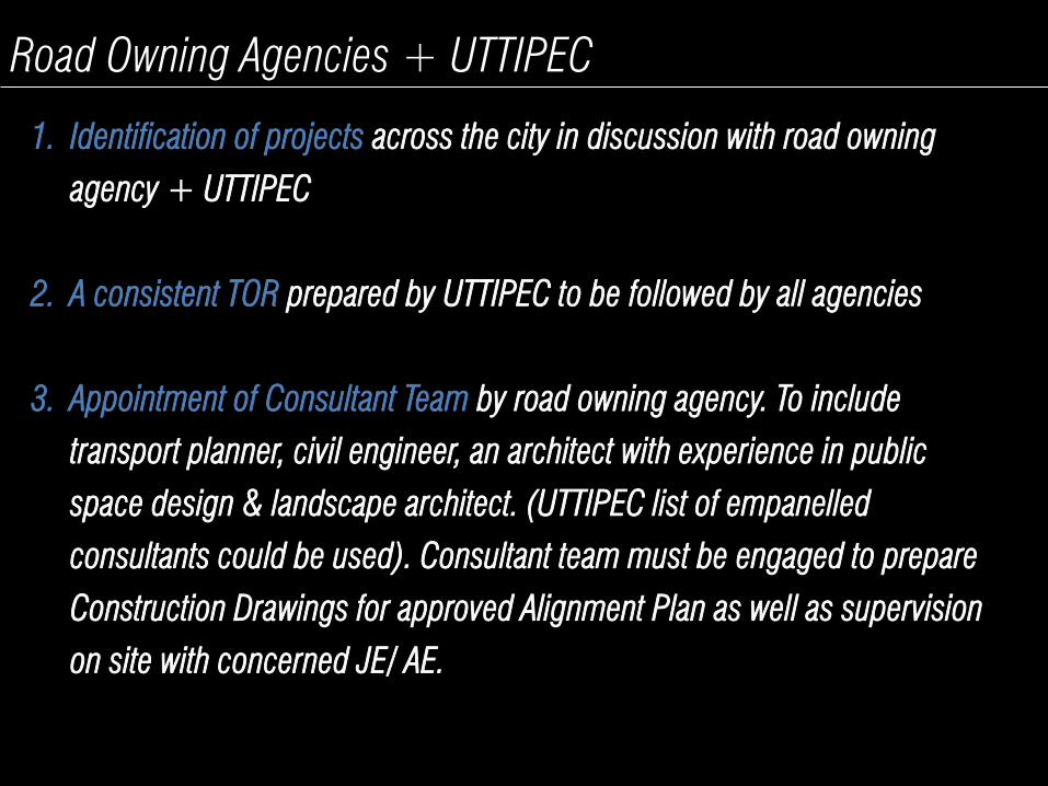
Road Owning Agencies + UTTIPEC
1. Identification of projects across the city in discussion with road owning
agency + UTTIPEC
2. A consistent TOR prepared by UTTIPEC to be followed by all agencies
3. Appointment of Consultant Team by road owning agency. To include
transport planner, civil engineer, an architect with experience in public
space design & landscape architect. (UTTIPEC list of empanelled
consultants could be used). Consultant team must be engaged to prepare
Construction Drawings for approved Alignment Plan as well as supervision
on site with concerned JE/ AE.
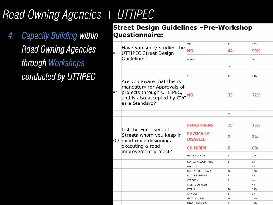
Road Owning Agencies + UTTIPEC
4. Capacity Building within
Road Owning Agencies
through Workshops
conducted by UTTIPEC
Street Design Guidelines –Pre-Workshop Questionnaire:
Q 1
Have you seen/ studied the UTTIPEC Street Design Guidelines?
YES 5 10%
NO 44 90%
MAYBE 0%
49
Q 2
Are you aware that this is mandatory for Approvals of projects through UTTIPEC, and is also accepted by CVC as a Standard?
YES 13 28%
NO 33 72%
46
Q 3
List the End Users of Streets whom you keep in mind while designing/ executing a road improvement project?
PEDESTRIANS 15 15%
PHYSICALLY DISABLED
2 2%
CHILDREN 0 0%
HEAVY VEHICLES 13 13%
MARKET ASSOCIATIONS 1 1%
UTILITIES 4 4%
LIGHT VEHICLES (CARS) 18 17%
AUTO RICKSHAWS 3 3%
VENDORS 4 4%
CYCLE RICKSHAWS 4 4%
CYCLES 10 10%
ANIMALS 1 1%
HAVE NO IDEAS 14 14%
LOCAL RESIDENTS 14 14%
PROJECT METHODOLOGY
APPOINTED CONSULTANT
ROAD OWNING AGENCY UTTIPEC
Internal audit of all streets
=>18M within 2Km zone
as per UTTIPEC Audit Checklist
Draft Mobility Plan for 2km
influence zone
Phase 1 Phase 2 Phase 3
Months 0 – 1.5 Months 1.5 - 3 Months 3 - 4
Final Station Area Plans for all
Ph III Stations
Final Corridor Development
Plan for ORR inc. Parking
Strategy
REV
IEW
GFC Drawings
Identification of Quick Win and
Long term projects within
2km influence zone
REV
IEW
Stakeholder consultation
Parking Strategy for 800 M
influence zone
Storm Water Management
Strategy for influence 800 M
Zone
Design Development of Quick
Win Projects
Conceptual Station Area Plans
(300M) for all Ph III Stations as
per UTTIPEC Checklist
DMRC to plan, design & restore Station
Areas (upto 300M) to deliver IPT and
NMT facilities as per UTTIPEC MRTS
Connectivity Checklist
Conceptual Corridor
Development Plan for ORR as
per UTTIPEC Guidelines inc.
Parking Strategy
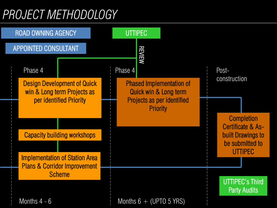
PROJECT METHODOLOGY
APPOINTED CONSULTANT
ROAD OWNING AGENCY UTTIPEC
Phase 4
Months 4 - 6
REV
IEW
Implementation of Station Area
Plans & Corridor Improvement
Scheme
Design Development of Quick
win & Long term Projects as
per identified Priority
Phase 4
Months 6 + (UPTO 5 YRS)
Phased Implementation of
Quick win & Long term
Projects as per identified
Priority
Post-
construction
Completion
Certificate & As-
built Drawings to
be submitted to
UTTIPEC
UTTIPEC’s Third
Party Audits
Capacity building workshops

PROPOSED IMPLEMENTATION STRATEGY

Details for Corridor Improvement
Road Owning Agency DMRC (when restoring Public ROW)
DIMTS/ DTC
Delhi Traffic Police
Service provider
Private stakeholders (other interested parties)
DDA PWD > 18M
MCD < 18M
NDMC (for Central Delhi)
Plaza Design (including Street Retrofitting)
Softscape & Hardscape (other than public ROW)
Street furniture like lighting, dust bins, etc.
Cycle rentals
IPT Stop
Public Amenities
MT & PT/IPT Parking Infrastructure on-street and off-street as per UTTIPEC’s MRTS Connectivity Checklist
Parking Management
Storm Water Management
PROJECT IMPLEMENTATION STRATEGY- Phase-I
1) Station Area for each Metro Station catchment of 300 m
Details for Corridor Improvement
Road Owning Agency DMRC (when restoring Public ROW)
DIMTS/ DTC
Delhi Traffic Police
Service provider
Private stakeholders (other interested parties)
PWD > 18M
MCD < 18M
NDMC (for Central Delhi)
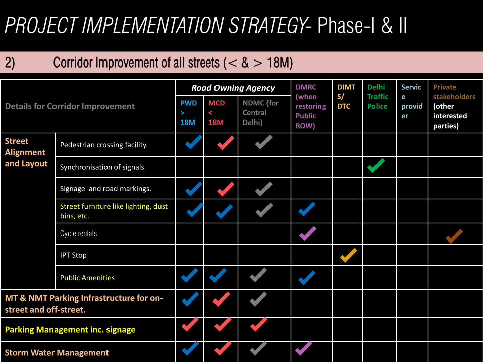
Street Alignment and Layout
Pedestrian crossing facility.
Synchronisation of signals
Signage and road markings.
Street furniture like lighting, dust bins, etc.
Cycle rentals
IPT Stop
Public Amenities
MT & NMT Parking Infrastructure for on-street and off-street.
Parking Management inc. signage
Storm Water Management
PROJECT IMPLEMENTATION STRATEGY- Phase-I & II
2) Corridor Improvement of all streets (< & > 18M)
PROJECT IMPLEMENTATION STRATEGY- Phase-II
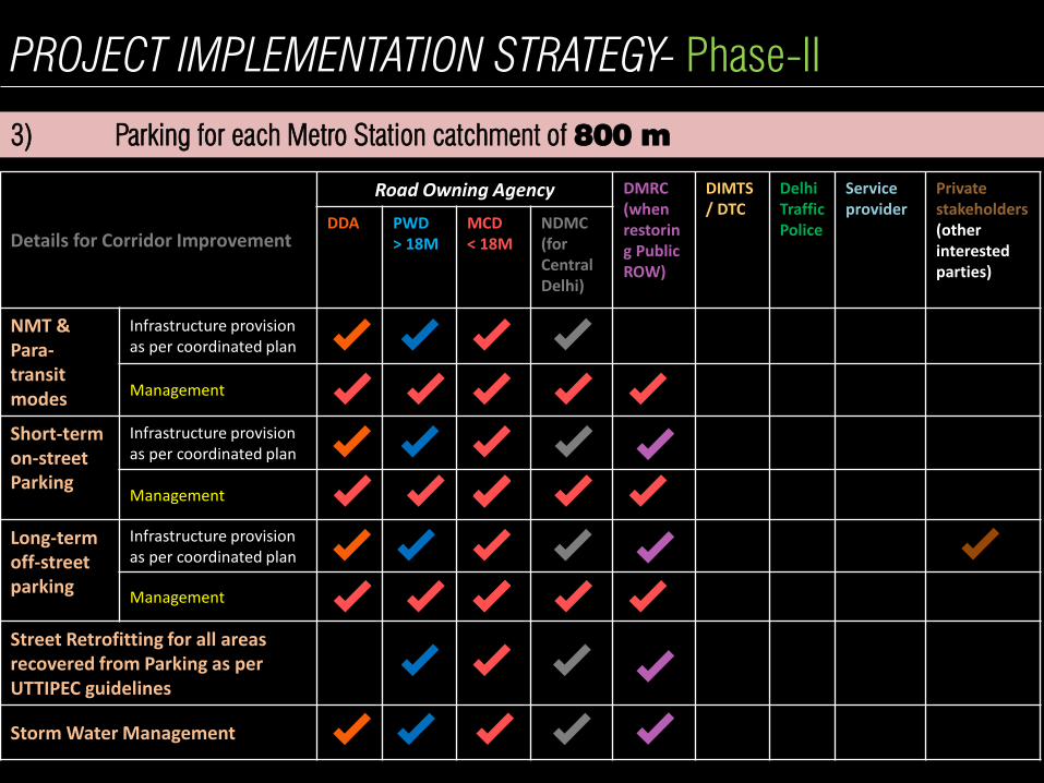
3) Parking for each Metro Station catchment of 800 m
Details for Corridor Improvement
Road Owning Agency DMRC (when restoring Public ROW)
DIMTS/ DTC
Delhi Traffic Police
Service provider
Private stakeholders (other interested parties)
DDA PWD > 18M
MCD < 18M
NDMC (for Central Delhi)
NMT & Para-transit modes
Infrastructure provision as per coordinated plan
Management
Short-term on-street Parking
Infrastructure provision as per coordinated plan
Management
Long-term off-street parking
Infrastructure provision as per coordinated plan
Management
Street Retrofitting for all areas recovered from Parking as per UTTIPEC guidelines
Storm Water Management
Integrated Parking Strategy for
catchment of 800 m zone
Including short term on-
street & long-term off-street
parking facilities,
appropriate management
regimes and pricing
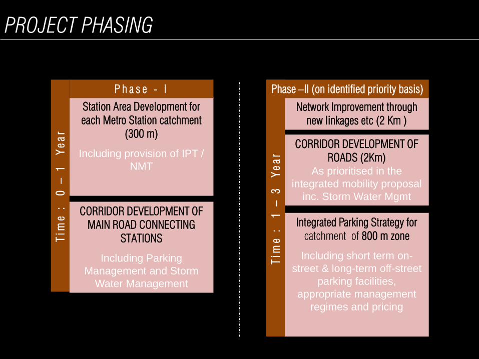
PROJECT PHASING
Corridor Improvement for Road
linking Stations < 18 m ROW
Station Area Development for
each Metro Station catchment
(300 m)
Including provision of IPT /
NMT
Tim
e : 0
–
1
Y
ea
r
P h a s e - I
Network Improvement through
new linkages etc (2 Km )
Tim
e : 1
–
3
Y
ea
r
Phase –II (on identified priority basis)
CORRIDOR DEVELOPMENT OF
MAIN ROAD CONNECTING
STATIONS
Including Parking
Management and Storm
Water Management
CORRIDOR DEVELOPMENT OF
ROADS (2Km)
As prioritised in the
integrated mobility proposal
inc. Storm Water Mgmt
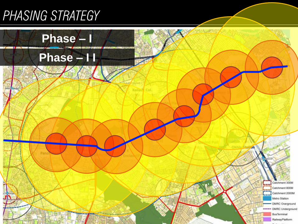
PHASING STRATEGY
Phase – I
Phase – I I
A PROPOSED PILOT – NEHRU PLACE
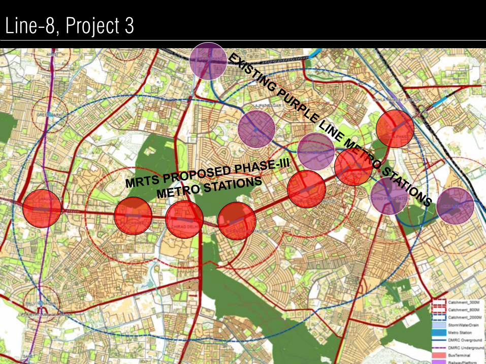
Line-8, Project 3

Greater
Kailash-I
Project Catchment Area
Panchsheel
Park
Asiad
Village
Shahpur
Jat Panchsheel
Enclave
Chitranjan
Park
Saket
Greater
Kailash-II
Kailash
Colony
Garhi
East of Kailash
Okhla
Industrial Area
Govindpuri
Kailash
Hills
Sant Nagar
Okhla
Phase-III
Kalkaji
Chirag
Dilli
Sheikh Sarai
Madangir
Ishwar Nagar
Jamia Nagar
Sukhdev
Vihar
Friends
Colony
Jamia Nagar
Jamia Nagar
1. Lack of Connectivity
2. Restricted Mobility,
particularly for the
vulnerable
3. Parking – demand,
management and
enforcement
4. Safety and sense of safety
5. Drainage
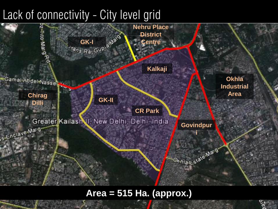
Nehru Place
District
Centre
CR Park
GK-II
Govindpur
i
Kalkaji
Okhla
Industrial
Area
GK-I
Chirag
Dilli
Area = 515 Ha. (approx.)
Lack of connectivity - City level grid

Pedestrian Connectivity • Distance= 900 m
• Travel time= 11 mins
• Cost = Rs. 00.00
No Para-transit connectivity
Lack of connectivity – ORR, a barrier between communities
Car Connectivity • Distance= 1.7 kms
• Travel time= 5 mins
• Cost = Rs. 14.00
Chirag Dilli
Metro Station
(Phase-III
proposal)
Panchsheel
Enclave
Panchsheel
Enclave
Connectivity will take 2 mins walk
Chirag Dilli
Metro Station
(Phase-III
proposal)
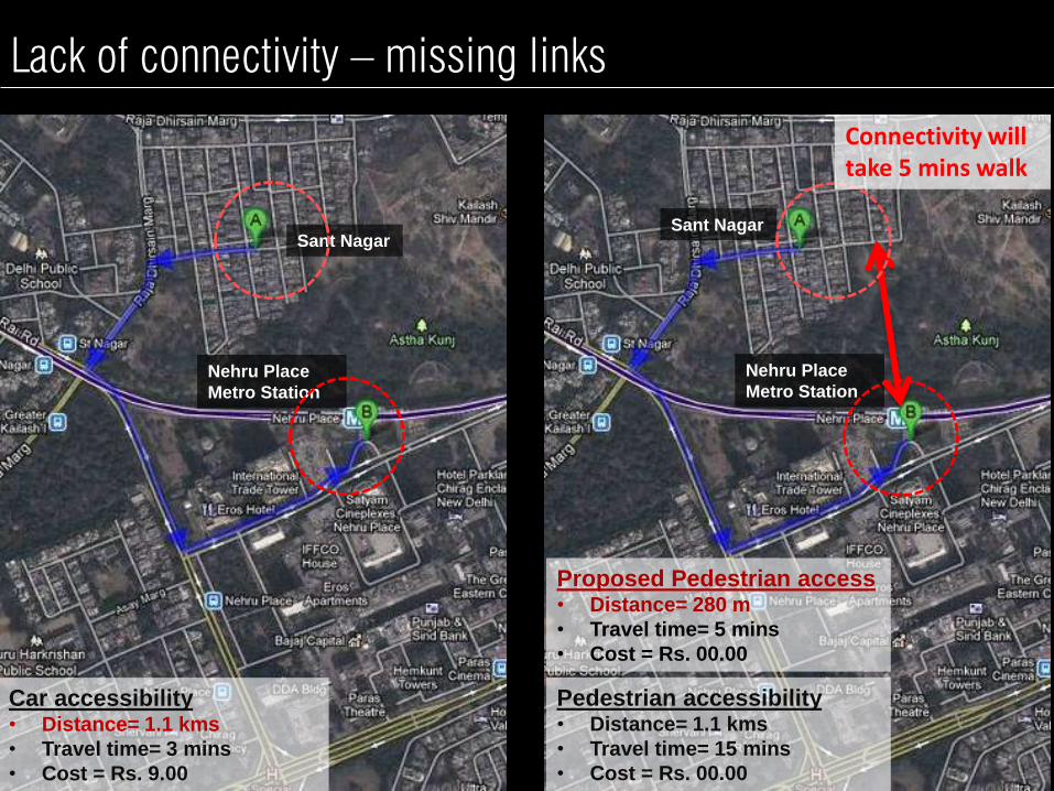
Sant Nagar
Car accessibility • Distance= 1.1 kms
• Travel time= 3 mins
• Cost = Rs. 9.00
Nehru Place
Metro Station Nehru Place
Metro Station
Sant Nagar
Pedestrian accessibility • Distance= 1.1 kms
• Travel time= 15 mins
• Cost = Rs. 00.00
Proposed Pedestrian access • Distance= 280 m
• Travel time= 5 mins
• Cost = Rs. 00.00
Connectivity will take 5 mins walk
Lack of connectivity – missing links
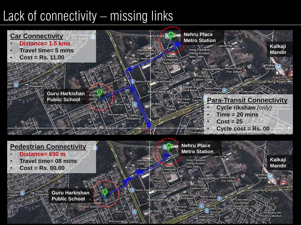
Car Connectivity • Distance= 1.5 kms
• Travel time= 5 mins
• Cost = Rs. 11.00
Pedestrian Connectivity • Distance= 650 m
• Travel time= 08 mins
• Cost = Rs. 00.00
Kalkaji
Mandir
Kalkaji
Mandir
Para-Transit Connectivity • Cycle rikshaw (only)
• Time = 20 mins
• Cost = 25
• Cycle cost = Rs. 00
Nehru Place
Metro Station
Nehru Place
Metro Station
Guru Harkishan
Public School
Guru Harkishan
Public School
Lack of connectivity – missing links

Lack of connectivity - Local barriers

300 M ZONE 800 M ZONE
Park can’t be accessed from anywhere else except Nehru
Place District Centre.
Lack of connectivity - Local barriers
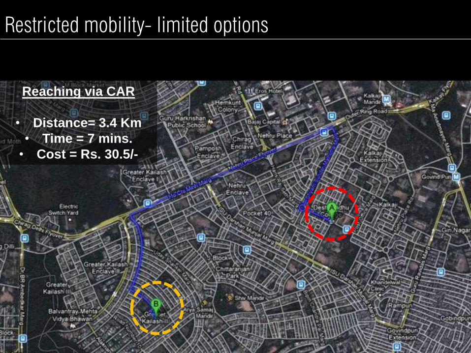
Restricted mobility- limited options
Reaching via CAR
• Distance= 3.4 Km
• Time = 7 mins.
• Cost = Rs. 30.5/-

Reaching via CAR
• Distance= 3.4 Km
• Time = 7 mins.
• Cost = Rs. 30.5/-
Restricted mobility- limited options

Reaching on PUBLIC
TRANSPORT
• Time = 24 mins.
• Cost = Rs. 5/-
Restricted mobility- limited options
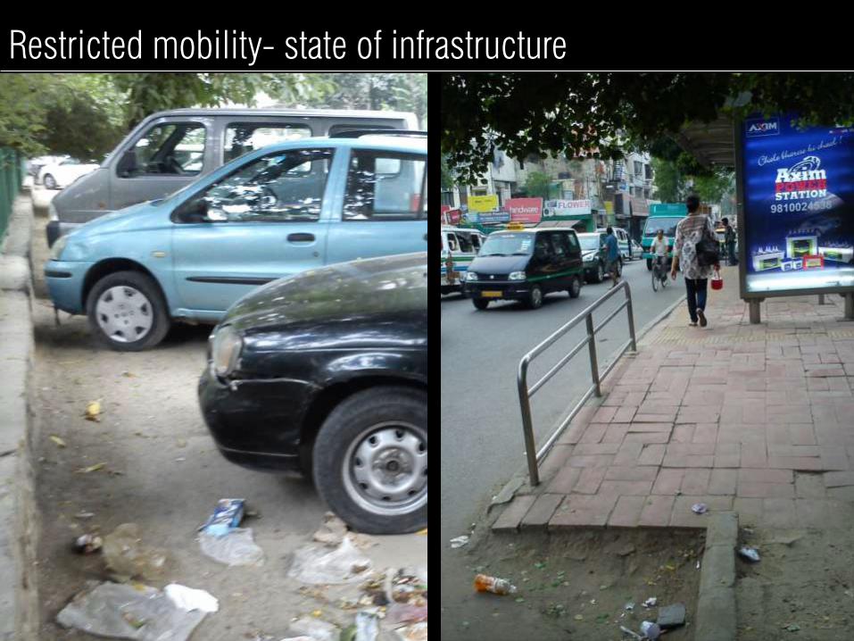
Restricted mobility- state of infrastructure

Restricted mobility- state of infrastructure
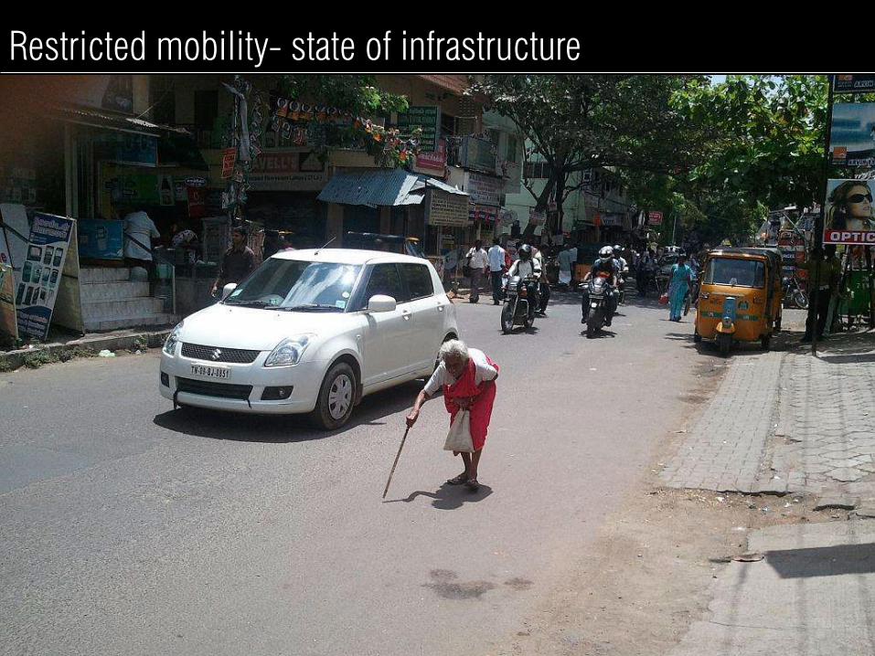
Restricted mobility- state of infrastructure
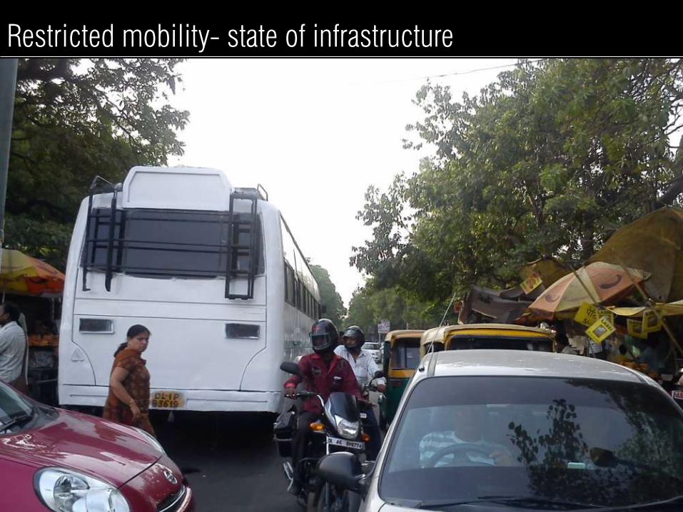
Restricted mobility- state of infrastructure

Safety
Deserted Roads during
evenings/ nights.
300 M ZONE 800 M ZONE
8 pm 8 pm
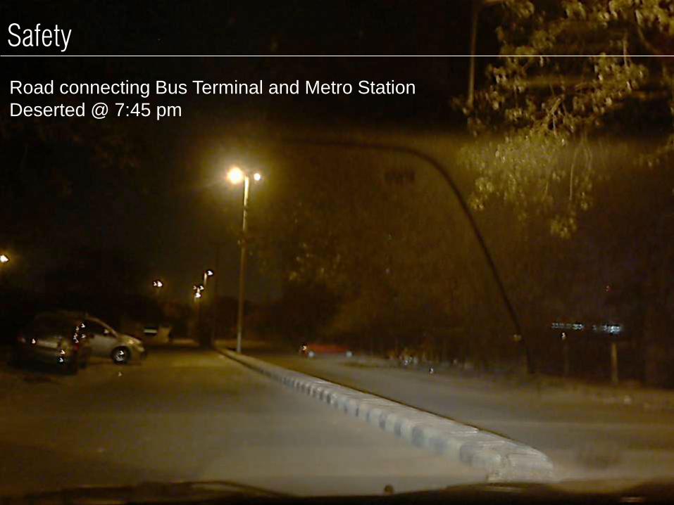
Safety
Road connecting Bus Terminal and Metro Station
Deserted @ 7:45 pm

KALKAJI
BUS
STOP
Parking

PARKING ON
ROW
MOVING
LANE
Parking
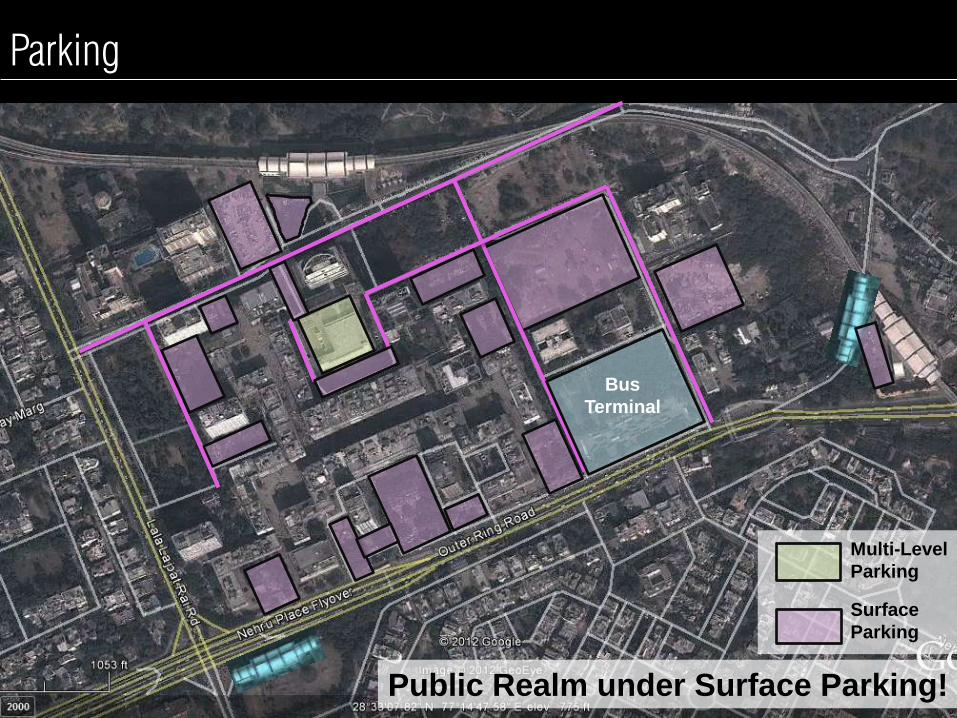
Parking
Bus
Terminal
Multi-Level
Parking
Surface
Parking
Public Realm under Surface Parking!
Fre
e illegal pvt. p
arkin
g
Dis
org
anis
ed P
T p
arkin
g
Parking

Nehru Place Station Area – Public Realm/ Street Design Issue D
edic
ate
d w
alk
ing s
pace?! N
o h
aw
kin
g s
pace!
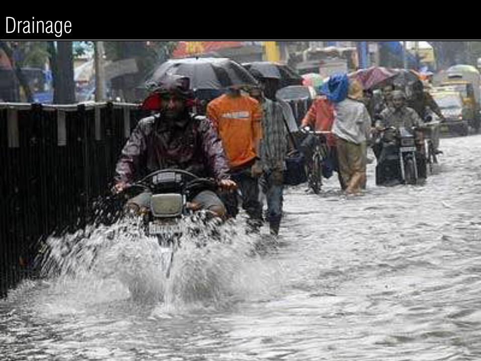
Drainage
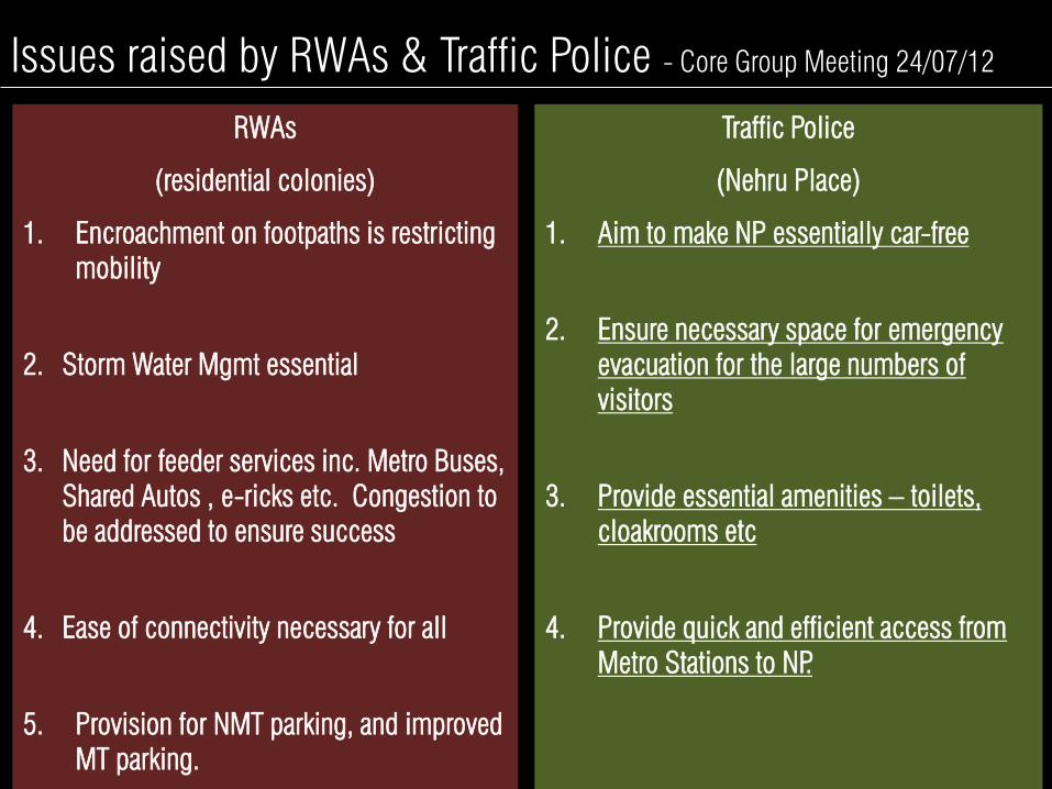
Issues raised by RWAs & Traffic Police - Core Group Meeting 24/07/12
RWAs
(residential colonies)
1. Encroachment on footpaths is restricting
mobility
2. Storm Water Mgmt essential
3. Need for feeder services inc. Metro Buses,
Shared Autos , e-ricks etc. Congestion to
be addressed to ensure success
4. Ease of connectivity necessary for all
5. Provision for NMT parking, and improved
MT parking.
Traffic Police
(Nehru Place)
1. Aim to make NP essentially car-free
2. Ensure necessary space for emergency
evacuation for the large numbers of
visitors
3. Provide essential amenities – toilets,
cloakrooms etc
4. Provide quick and efficient access from
Metro Stations to NP.

Nehru Place Station Area – Solutions
1. Last mile connectivity through energy
efficient modes and improved walkability
2. Pedestrian Crossing facilities at
Vulnerable /accident spots
3. Comfortable and high quality public
realm.
4. Creating Safer streets by providing road
vitality.
5. Provision for NMT parking, and improved
MT parking & better management.
• Immediate Need for Multi
modal integration plans for
Metro Station areas.
• To achieve the objectives &
meet the 6 mandates
THUS…

PROPOSED PROJECT LIST

EAST ZONE
AMITY
NOIDA
Line 7 1. Project-1
i. Yamuna Vihar
ii. Maujpur
iii. Jaffrabad
iv. Welcome
2. Project-2
i. Bholanath
ii. Krishna Nagar
iii. Jagatpuri
iv. Anand Vihar
3. Project-3
i. I.P.Extension
ii. Vinod Nagar
iii. Vinod Nagar East
iv. Trilokpuri
Line 8 1. Project-5
i. Okhla Vihar
ii. Jasola Vihar
iii. Kalindi Kunj
iv. Amity Noida
v. Botanical Garden
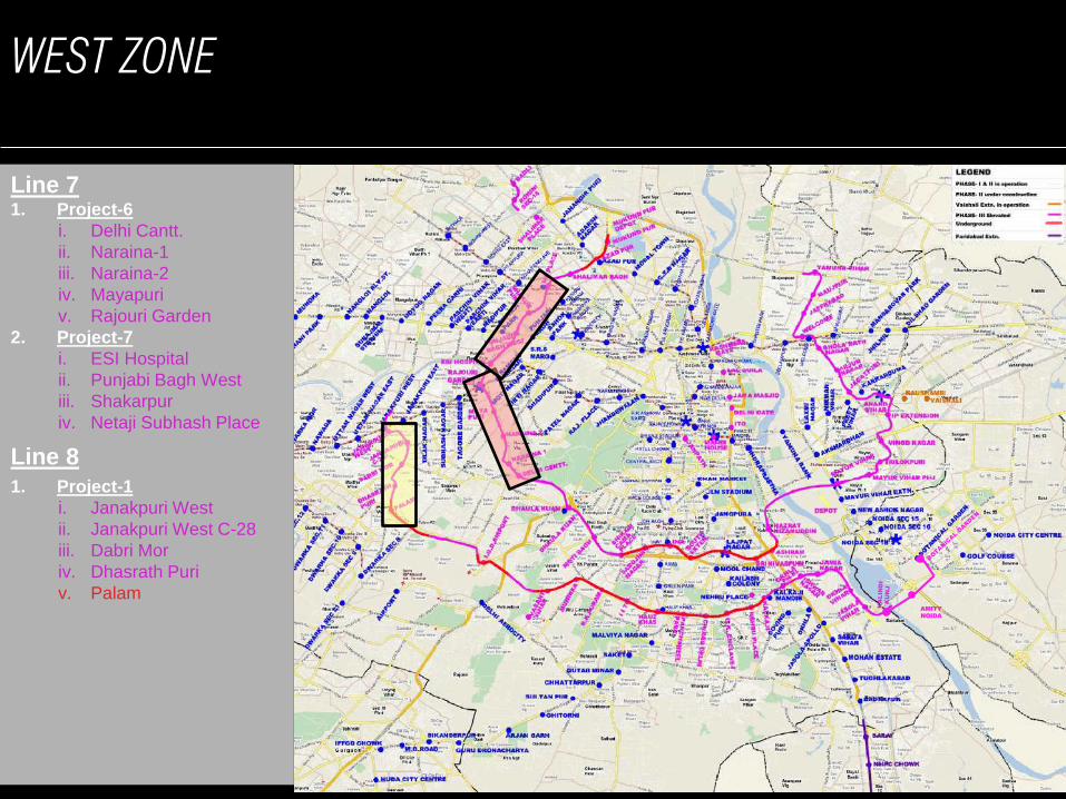
WEST ZONE
AMITY
NOIDA
Line 7 1. Project-6
i. Delhi Cantt.
ii. Naraina-1
iii. Naraina-2
iv. Mayapuri
v. Rajouri Garden
2. Project-7
i. ESI Hospital
ii. Punjabi Bagh West
iii. Shakarpur
iv. Netaji Subhash Place
Line 8
1. Project-1
i. Janakpuri West
ii. Janakpuri West C-28
iii. Dabri Mor
iv. Dhasrath Puri
v. Palam

NORTH ZONE
AMITY
NOIDA
Line 7
1. Project-8
i. Shalimar Bagh
ii. Azadpur
iii. Mukund Pur
2. Project-9
i. Shalimar Place
ii. Rohini Sector-18
iii. Baoli

SOUTH ZONE
AMITY
NOIDA
Line 7 1. Project-4
i. Hazrat Nizamuddin
ii. Ashram
iii. Srinivaspuram
iv. Lajpat Nagar
v. South Extension
2. Project-5
i. INA
ii. Sarojini Nagar
iii. Bhikaji Cama Place
iv. Moti Bagh
v. Dhaula Kuan
Line 8 1. Project-2
i. IGD Airport
ii. Vasant Vihar
iii. Munirka
iv. R.K.Puram
v. IIT
2. Project-3
i. Hauz Khas
ii. Panchsheel Park
iii. Chirag Dilli
iv. G.K.Enclave
v. Nehru Place
i. Kalkaji
ii. Okhla Phase-III
1. Project-4
i. Ishwar Nagar
ii. Jamia Nagar
iii. Okhla Vihar
iv. Jasola Vihar
AMITY
NOIDA
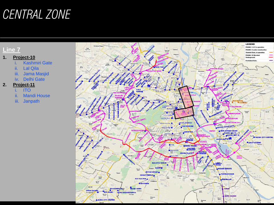
Line 7
1. Project-10
i. Kashmiri Gate
ii. Lal Qila
iii. Jama Masjid
iv. Delhi Gate
2. Project-11
i. ITO
ii. Mandi House
iii. Janpath
CENTRAL ZONE
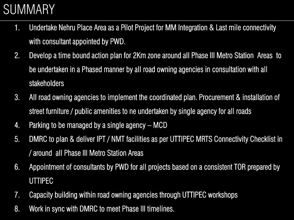
SUMMARY
1. Undertake Nehru Place Area as a Pilot Project for MM Integration & Last mile connectivity
with consultant appointed by PWD.
2. Develop a time bound action plan for 2Km zone around all Phase III Metro Station Areas to
be undertaken in a Phased manner by all road owning agencies in consultation with all
stakeholders
3. All road owning agencies to implement the coordinated plan. Procurement & installation of
street furniture / public amenities to ne undertaken by single agency for all roads
4. Parking to be managed by a single agency – MCD
5. DMRC to plan & deliver IPT / NMT facilities as per UTTIPEC MRTS Connectivity Checklist in
/ around all Phase III Metro Station Areas
6. Appointment of consultants by PWD for all projects based on a consistent TOR prepared by
UTTIPEC
7. Capacity building within road owning agencies through UTTIPEC workshops
8. Work in sync with DMRC to meet Phase III timelines.

THANK YOU!