larc portfolio sampler 6.14.12
DESCRIPTION
A collection of sample work.TRANSCRIPT

Justin HeilLANDscape ARCHitectureportfolio

ITEMUH
ITEILE
PAN
HELRUD
BET
BET
MUHILE
PAN
ERA
HEU
RUDCHAHEL
HEUCAL
RUD
CORVAC
TYPPEL
SCI???
NYM
HIB
ACH
1
Justin R. HeilBLA, University of Maryland 2012
46 Prospect St.West Newbury, MA 01985
email: [email protected]: 978.270.2843
Contact Information

ITEMUH
ITEILE
PAN
HELRUD
BET
BET
MUHILE
PAN
ERA
HEU
RUDCHAHEL
HEUCAL
RUD
CORVAC
TYPPEL
SCI???
NYM
HIB
ACH
1. Archer’s Glen
4. WaterShed
2. GreenwayCommunity Plan
Regional Plan
Solar Decathlon
2
Table of Contents
3. Hill EastUrban Revitalization

ITEMUH
ITEILE
PAN
HELRUD
BET
BET
MUHILE
PAN
ERA
HEU
RUDCHAHEL
HEUCAL
RUD
CORVAC
TYPPEL
SCI???
NYM
HIB
ACH
3
Archer’s Glen
Community PlanFall 2010, Community StudioFocus: Randall Arendt’s Principles (public benefit and conservation subdivision)Programs Used: GIS, AutoCAD, Photoshop, Illustrator, and Freehand

4
Archer’s Glen

5
0 1 2 3 40.5Miles
LegendCMG
Park
Development
greenway features:Reclaiming Brown Station Land�ll and using it as an active athletic �eldand horse training area. Taking a once toxic area and creating a healthy,functional, and inviting area where people can recreate.
Linking loops are spaced between the major park ‘nodes’ in order toencourage people from the developments and future developmentsto enter the greenway.
Upper Marlboro is the major development density of the areaas well as a connection point between a formal loop and themain natural path spine.
The primary spine of the greenway, following the WesternBranch stream valley, is a natural hiker oriented path. While the formal looping extending outward is intendedto invite bikers, joggers, and strollers.
There are several possible extension and expansion points along the greenway. They extend towards other major cities, nodes,parks, and other points of interest in the area.
Environmentally sensitive design,driven by contour trail design, createsa sustainable greenway. For major roads, land bridges span the gapallowing people and fauna to cross.
Upper Marlboro
Enterprise Park
Watkins Park
Brown Staion Land�ll
Patuxent Park
1
1
2
2
3
3
4
5
6
4
5
6
F1
F2
Maryland Greenway
Regional GreenwaySpring 2011, Regional StudioFocus: Heavy GIS research, looking at design through connections at a large scalePrograms Used: GIS, AutoCAD, Photoshop, and Illustrator
0 1 2 3 4 5 60.5Miles
Legend! Rec. Center
Arterial Road
Major Road
POWERRAIL_Clip
¹º School
Opportunities
Constraints
Landuse
Commercial
Industrial
Development Activity
Landfill
Marlboro Clay
Park
Landfill
Wetland
Powerline
Opportunities Constraintsabcdefghi
abcdefg
Enterprise Golf Course/Newton White Mansion provides a tract of land, totaling 586 acres: Includes a golf course and a historic Neo-Georgian-style brick mansion.
Watkins Regional Park is an extensive and comprehensive collection of trails, �elds, educational centers, entertainment, and camping sites.
Major roads provide an opportunity to connect people and wildlife, now disconnected areas, through the use of landbridges or other techniques.
Brown Station Land�ll is undesirable as it is now; however, it's a great chance to educate people by revitilizing a toxic area and reclaiming the land for a great use.
Collington and Western Branch stream valleys provide tremendous opportunities for the natural experience and a set of linear parks up both paths.
Local schools provide a wonderful opportunity for education. The greenway could also serve as a connector between schools to link students easier.
Downtown Upper Marlboro contains numerous historic properties and is located on the line connecting the greenway endpoints, therefore making it a pivotal hub.
Show Place Arena and Equestrian Center is a multifunctional venue atrracting many people holding a wide variety of events ranging from boxing to basketball to equestrian shows, and more.
Jug Bay is a 1,600 acre area comprised of tidal freshwater wetlands, forests, meadows, and �elds along the Patuxent River, on the eastern edge of Prince George’s County.
hijj
Patuxent River Park is the means in which people observe Jug Bay as well as the river itself. Headquarteredon Jug Bay, it provides a pivotal link in educating and preserving the critical and sensitive bay environment.
Distance informs how far and how much the users are willing to walk, ride, or hike. Intervalbetween nodes or trailheads are the way to combat the distance issue.
Powerlines have speci�c restrictions about crossing and should be avoided as much as possible. If neccessary, crossing should be made perpendicular to the line.
Recent development is an eyesore, contributes noise pollution, draws in high volume of construction vehicles and equipment and should be avoided in the greenway.
Marlboro Clay is not desired for trails/structures because of its characteristic to take water and become sloppy and unstable.
Topography prevents land from being developable; steep slopes and terrain should be avoided. Design shouldwork with the existing terrain and avoid the steep slope areas.
Commercial/Industrial Areas are not desired destinations on a greenway, and should be avoided because they are eyesores, polluted, and primarily hardscape.
Contrasting Interest can present a problem with the community acceptance of a design. Bikers may want one thing, hikers want a second option, and joggers want a third. Variety, �exability, and comprise are the solution.
Boundaries serve as limits and constraints as to where the greenway can go. Private property cannot be crossed,and it must be contained within Prince George’s County.
Public Services such as sewage plants, police stations, etc are neccessary parts of communities, butare not good to include in a greenway system.
a
a
b
b
c
c
d
ee
d
f
f
g
g
h
h
i
i j
j
Urban problems are ever close to the general greenway area. Some problems include crime, homelessness, poverty, vandalism,tra�c, congestion, and pollution in all its forms: noise, light, water, and air.
Powerline
prepare
link
revitalize
celebratereclaim
inform
sustain
preserve
identify
establish
cohesive
respond
educaterenewinnovate
leadmotivate
cherish
�exible
restore
reliable
spirit
value
social
teachprevent
natural
spread
wildcommunicate
encourage
teach
commemorate
bond
environmental

1
2
3
4
5
6
1”:50’
features:Outdoor horse riding arena creates aunique riding experience to draw user interest.
Rain garden helps the remidiation of the siteand collects parking lot runo�.
Athletic �elds and basketball court encourage healthy living in the area.
Ornamental grasses throughout help createinteresting views and walking exploration.
Reforestation in the area will help remediatethe area, and claim the once toxic ground.
A small refreshment stand and adjacentpatio for users to take in the games.
3
4
6
5
2
1
a
b
Maryland Greenway
6
features:Rain garden on the southwest corner of thesite collects runo� from the road adjacent.
Sculpture garden creates spatial interest andthe main piece frames the spaces beyond.
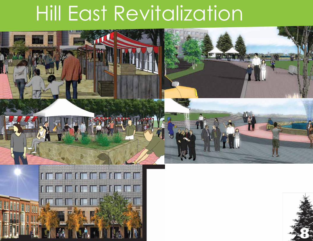
The market area is the main site feature. Itgives ode to the historic commercial buildingsnearby as well as encourages people to usethe space for activity.
The northern most area of the site is a clumpof trees meant to provide shade and a place for sheltered gathering.
Ornamental grass accents the sculpturegarden and the market as a whole, creatingvisual, sound, and texture interest.
The axis running through the space is acontinuation and link from an adjacent platform overlooking the pond.
1
2
1
2
3
3
4
4
5 56
6

Master Plan1”=150’
AB
C
D
E
FG
H
0
150’
300’
450’
600’
Sweeping Roof garden meadowRiverwalk boardwalkResteraunt RowCorner Market [Focus Area 2]Archibald Recreation CenterTransportation SquareCity Public Water ShuttleRiver’s Edge Plaza [Focus Area 1]
A
B
C
D
E
F
G
H
7
HIll East Revitalization
Urban RevitalizationFall 2011, Urban Design StudioFocus: Looked at urban planning and its role in revitalization in neglected areasPrograms Used: GIS, AutoCAD, Photoshop, Illustrator, and SketchUp
Residential
Commercial
Median Stormwater RetentionBus/Car Shared Avenue
Roadside Quick Pace Sidewalk
Planted Sidewalk Median
Commercial Slow Pace Walk
Outdoor Commercial Area
Transportation Diagram
Figure Ground
Green Space Diagram Axes + Nodes Diagram
Building Use
8
Hill East Revitalization

ITEMUH
ITEILE
PAN
HELRUD
BET
BET
MUHILE
PAN
ERA
HEU
RUDCHAHEL
HEUCAL
RUD
CORVAC
TYPPEL
SCI???
NYM
HIB
ACH
Solar Decathlon
9
2011.solarteam.org

ITEMUH
ITEILE
PAN
HELRUD
BET
BET
MUHILE
PAN
ERA
HEU
RUDCHAHEL
HEUCAL
RUD
CORVAC
TYPPEL
SCI???
NYM
HIB
ACH
10
Solar Decathlon

ITEMUH
ITEILE
PAN
HELRUD
BET
BET
MUHILE
PAN
ERA
HEU
RUDCHAHEL
HEUCAL
RUD
CORVAC
TYPPEL
SCI???
NYM
HIB
ACH
Thank you very much for your consideration. Please feel free to contact me with any further questions. _Justin Heil