landslide management on the ugandan national road network
TRANSCRIPT

1 AIPCR/PIARC-AbuDhabi2019
Landslide management on the Ugandan national road network
G Hearn, Hearn Geoserve Ltd., UK, [email protected] A Lekea, Uganda National Roads Authority, [email protected]
E Mbabazi, Uganda National Roads Authority, [email protected] M Ruse, Independent Consultant, Australia, [email protected]
A van Oostenrijk, Independent Software Ltd., Mozambique, [email protected] ABSTRACT
Landslides are recurring natural phenomena that occur frequently in the Ugandan mountain areas of Rwenzori, Mufumbiro and Elgon. In these areas, significant environmental, social and economic losses, such as road infrastructure damage and displaced settlements, have resulted. Despite these impacts, there have been no significant efforts to extensively map landslide-prone areas in relation to the road infrastructure. Maintaining the stability of the road reserve and its associated engineering assets is a priority for the Uganda National Road Authority, and this requires a focus not only on earthworks slopes but also the wider terrain in which the road is constructed. A web-based landslide data inventory has been set up within the Uganda National Road Authority to record landslide events and impacts and this will be combined with other GIS and remote sensing sources to develop a map of hazard-prone areas. The establishment of guidelines to maximise environmental and social benefits through optimum management of the road reserve, integrating engineering with community participation and agricultural extension would also be of benefit to future practice. Community liaison and cross-agency co-ordination on aspects of slope management outside of the road reserve are also critical to road asset management within the road reserve.
INTRODUCTION
With assistance from the Research for Community Access Partnership (ReCAP) programme, funded by DFID (Department for International Development, United Kingdom), the Uganda National Roads Authority (UNRA) is implementing a project that examines the distribution, cause, mechanism and impact of landslides and related slope geohazards on the road network, and examine ways in which the management of the road reserve and adjacent terrain can be optimised in order to avoid, reduce and mitigate these hazards. The project also aims to develop and apply a holistic approach to slope management benefiting road reserve maintenance and the livelihoods of adjacent communities.
BACKGROUND
Geography
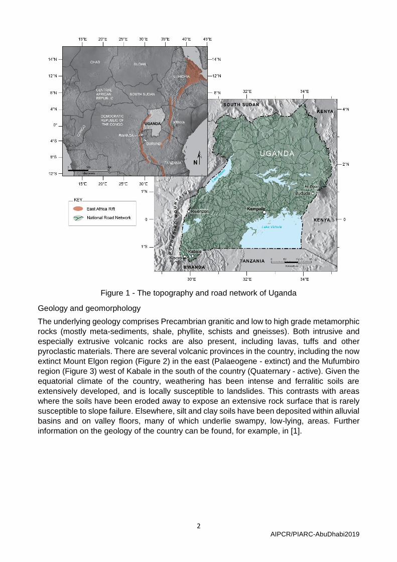
Uganda straddles the Equator in East Africa between the western and eastern branches of
the East African Rift System (Figure 1). It has a surface area of approx. 240,000 km2, the
majority of which is comprised of flat to low relief terrain at an elevation of 1,000-1,500m
a.s.l. However, there are mountains to the west, east and south of the country, reaching
approximately 5,100 m a.s.l on the DR Congo border. Average temperatures range between
16-25oC in Kampala and rainfall is generally between 900mm and 1500mm per annum, with
December to February being the drier months.
2 AIPCR/PIARC-AbuDhabi2019
Figure 1 - The topography and road network of Uganda
Geology and geomorphology
The underlying geology comprises Precambrian granitic and low to high grade metamorphic
rocks (mostly meta-sediments, shale, phyllite, schists and gneisses). Both intrusive and
especially extrusive volcanic rocks are also present, including lavas, tuffs and other
pyroclastic materials. There are several volcanic provinces in the country, including the now
extinct Mount Elgon region (Figure 2) in the east (Palaeogene - extinct) and the Mufumbiro
region (Figure 3) west of Kabale in the south of the country (Quaternary - active). Given the
equatorial climate of the country, weathering has been intense and ferralitic soils are
extensively developed, and is locally susceptible to landslides. This contrasts with areas
where the soils have been eroded away to expose an extensive rock surface that is rarely
susceptible to slope failure. Elsewhere, silt and clay soils have been deposited within alluvial
basins and on valley floors, many of which underlie swampy, low-lying, areas. Further
information on the geology of the country can be found, for example, in [1].

3 AIPCR/PIARC-AbuDhabi2019
Figure 2 - Cliffs and debris slopes formed in lava and pyroclastic materials, Mount Elgon,
where rock falls and toe-slope landslides are common.
Figure 3 - Volcanic terrain around Kisoro (collapsed cones and lava flows are common)

4 AIPCR/PIARC-AbuDhabi2019
Road network
Uganda’s total road network in is estimated to be 129,469 Km long, 50 % of which are community access roads, 26% are district roads, 7% are urban roads and 17% are national roads (www.works.go.ug). UNRA is a semi-autonomous government agency that was created in 2006 and became operational in 2008. It is responsible for the management of the national roads network. At the time of UNRA’s operationalisation, about 10,000km of district roads were reclassified as national roads bringing the national road network to approximately 20,544km. 21% of the national road network is bituminous while the rest are gravel or earth roads.
LANDSLIDE HAZARDS
Landslide impacts on rural communities
There have been major landslides affecting parts of Uganda in recent years, inflicting
considerable loss of life and resulting in the displacement of rural communities. For example,
landslides have struck the district of Bududa, to the south of Mt Elgon (Figure 1), with records
from as early as 1818 and 1933 [2], and key events noted in 1964, 1970 and 1997-1999 [3].
Large events in 2010, 2012, 2013 and, as recently as October 2018, have caused a
significant number of fatalities on each occasion. In 2010, for example, a reported 365
people lost their lives [4]. Up to 3,000 people have been displaced and reports indicate [2]
that up to perhaps 10,000 people may need to be relocated away from high hazard areas.
The landslides have destroyed homes, villages, community centres and large areas of
farmland. Figure 4 shows a rock failure from a cliff face that occurred in October 2018,
causing several fatalities and demolishing part of Lusabe village below.
A large number of research publications and reports have been prepared that examine the
causes and consequences of landslides, especially in the Bududa-Mt Elgon and Rwenzori
regions (e.g. [4], [5], [6], [7], [8], [9], [10], [11] & [12]). Most of these studies focus on the
human losses that accrue from landslide activity and the interaction between land cover
change, population increase and landslide hazard. There are no published studies that
address the interface between these landslides and the stability of the road reserves and
how public sector agencies and affected communities can work together to avoid or mitigate
these hazards.

5 AIPCR/PIARC-AbuDhabi2019
Figure 4 - Rock fall debris in foreground from slide scar in centre of background (Oct 2018)
Landslide impacts on the road network
Sections of the road network are affected periodically by landslides and slope failure, of
which the following are usually the most common:
• Cut slope failures, often involving movement along adversely orientated rock
jointing (Figure 5A)
• Fill slope failures, often involving movement along low-strength clay horizons
beneath (Figure 5B)
• Earth flows from the slopes above the road reserve, often triggered by spring
seepage and irrigation practices (Figure 5C)
• Rock falls from natural cliffs above the road (Figure 5D)
In addition to the above, there are cases where sections of road have been excavated across
large, deep-seated, landslides that have subsequently become reactivated. In the example
shown in Figure 6 more than one kilometre of alignment was constructed across such a
landslide. What was originally a designed vertical and horizontal alignment has now become
an erratic track that requires regular reinstatement to allow traffic to pass.

6 AIPCR/PIARC-AbuDhabi2019
5A Rock failure along adverse joints 5B Fill slope failure with underlying soft clay
5C Slide scar of earth flow that blocked road 5D Rock falls from natural cliffs above road
Figure 5 - Illustrations of earthworks failures and natural slope instability affecting parts of
the Uganda road network
Figure 6 - Horizontal displacement to this originally straight section of road with rotation
and structural damage to adjacent buildings

7 AIPCR/PIARC-AbuDhabi2019
THE UNRA/ReCAP LANDSLIDE AND ROAD RESERVE RESEARCH PROJECT
The overall objective of the research is to improve the resilience of road infrastructure through landslide management and optimisation of road reserve use. Specifically, the research will:
1. Analyse landslide and road reserve use problems in Uganda;
2. Develop a spatially referenced, web-based system for landslide data collection and geographical analysis; and
3. Develop guidelines for the optimum use of the road reserve and adjacent hillsides in terms of land use and slope management.
Road reserve use
The Road Reserve in Uganda is currently nominally 40m either side of the centre-line. In
hilly and mountainous parts of the country this road reserve comprises cut slopes and fill
slopes, with the occasional use of retaining walls (Figure 7). Incursion into the road reserve
for commercial use is commonplace in built-up areas and along the more highly-trafficked
roads, potentially leading to conflicting priorities in the need to preserve rural livelihood while
at the same time maintain the stability and engineering functionality of the road reserve.
Figure 7 - Use of gabion retaining walls to support vulnerable sections of cut slope
In terms of slope stability and landslide risk, encroachment into the road reserve has the
following main elements:

8 AIPCR/PIARC-AbuDhabi2019
1. The construction of roadside structures for commercial use and living accommodation.
This often involves excavation of slopes to provide space, thus reducing the stability of
slopes and placing buildings and their occupants at risk;
2. Excavation of materials from within the road reserve for commercial exploitation, often
removing support to hillsides above and potentially precipitating slope failure;
3. Construction of accesses (paths and farms tracks), usually though excavation; and
4. Farming on slopes adjacent to the road, thus potentially encouraging soil saturation
through irrigation or reduced stability through excavation for agricultural benches.
While all four elements are important, it is the agricultural use of the slopes adjacent to and
within the road reserve that will be one of the prime focuses of this research. Significant
progress has been made by DFID-funded investigations, particularly in Nepal (e.g. [13] &
[14]) and Laos [15], into the use of bio-engineering as an important tool in erosion control
and in assisting with the improved stability of cut slopes and fill slopes. In particular, a
participatory approach, whereby local communities are engaged in slope management
through controlled water use and harvested planting schemes that add engineering value
will also be explored. Low cost techniques of slope stabilisation will also be examined using
engineering approaches in parallel with these initiatives.
Outside the road reserve, there is need to engage with rural communities, government agencies and other stakeholders in order to develop guidelines for sustainable slope management.
Development of a GIS-based landslide susceptibility dataset
Although there are research publications that show landslide locations in specific areas of
the country, notably around Bududa and in Rwenzori, no systematic mapping has been
undertaken. The UNRA/ReCAP study is currently examining stereo aerial photography and
satellite imagery to determine whether they offer any practical basis for landslide mapping.
An alternative, or complementary, approach will be to use a geomorphological terrain
classification to help identify landslide-prone areas, probably along the lines of that
developed by [16] (see Figures 8 and 9). This will enable UNRA to prioritise its investment
in the use of proactive avoidance and mitigation measures.
Figure 8 - Example of Northern Rwenzori Land Unit (from Ollier, 1969) and aerial
photograph of large landslides at the slope-floodplain boundary

9 AIPCR/PIARC-AbuDhabi2019
Figure 9 - Example of Elgon Steps Land Unit [16] and field photograph of terrain with rockfall and earth flow hazard to the adjacent District Road.
Web-based tool for data collection and road reserve management
A key requirement in the management of landslide hazards on the road network is a
knowledge of where the main landslides are and which parts of the network are most
susceptible to future landslide activity. To this end a web-based landslide inventory system
has been established that will enable UNRA’s station managers to enter landslide data for
road sections for which they are responsible. This system has only recently been launched
and it is too early to commence data analysis. Table 1 summarises the data fields that are
required to be completed. The data fields are subdivided into six categories, as indicated in
the column headings of Table 1. The rows below these headings illustrate the main data
fields that have to be completed.
Table 1 - Summary of data fields in the web-based landslide inventory
General Landslide Origin
Impact Land use Reinstate-ment
Other damage
Date of inventory Inside or outside Road
Reserve; On natural
slopes above/below
Blockage (side drain; inside carriageway; entire road)
Land use in the
source area
Reinstate-ment
measures employed/ planned
Buildings, retaining
walls, culverts, bridges, cables, pylons
Location of road Cut slope failure;
Fill slope failure;
Wall failure
Cracking (side drain; inside carriageway; entire road)
Evidence of
change
Reinstate-ment cost
Traffic accidents:
injuries fatalities
Location on road (Km and GPS)
Displacement (inside
carriageway; side drain; entire
road)
Drainage condition
Funding for reinstate-
ment
Cause Road closure period
Road length affected
Volume of debris
Road surfacing
Type of slide (new;
reactivation; extension)

10 AIPCR/PIARC-AbuDhabi2019
DISCUSSION AND CONCLUSIONS
The research project outlined in this paper commenced in early 2019 and is therefore in the process of early development. Its aim is to establish a dataset that can enable UNRA to record, monitor and perhaps anticipate landslide hazards on the road network. It will also investigate and provide guidance on the management and stability of the road reserve and the wider terrain. This will require discussion and co-operation with rural communities and other government agencies who have an interest in maintaining the stability of the natural terrain. Measures to enhance community livelihood through the use of the road reserve as a potential extension for controlled agriculture will also be examined so that both engineering and social benefits can ensue.
ACKNOWLEDGEMENTS
The study described in this paper is being undertaken by a consortium led by Hearn Geoserve Ltd. (HGL), comprising HGL, Living Resources Ltd., Independent Software Ltd, CGG NPA Satellite Mapping Ltd and ICS Engineering & Environment Ltd., in association with the Uganda National Roads Authority (UNRA), as part of the Africa Community Access Partnership (AfCAP) programme, managed by Cardno Emerging Markets Ltd. and funded by a grant from the United Kingdom Government through the Department for International Development (DFID). The authors would like to thank H Nkwanga, M Rubarenzya, J Howell, A Kasekende, R Mugidde, B Kwesiga and H Larkin for their contributions to the project so far. The assistance provided by staff at the Bodleian Library, Oxford, UK in providing access to stereo aerial photographs of Uganda is also gratefully acknowledged.
REFERENCES
1. Westerhof, A. B., Härmä, P., Isabirye, E., Katto, E., Koistinen, T., Kuosmanen, E., Lehto, T., Lehtonen, M. I., Mäkitie, H., Manninen, T., Mänttäri, I., Pekkala, Y., Pokki, J., Saalmann, K. and Virransalo, P. (2014). Geology and geodynamic development of Uganda with explanation of the 1:1,000,000 scale geological map. Geological Survey of Finland, Special Paper 55.
2. Kitutu, M.G. (2004). Local perception of landslide problems in Manjiya County, Mbale District, Eastern Uganda. In: Mountain Ecosystems, Resources and Development in Uganda, Mountina Resource Centre, Department of Geography, Makerere University, pp 94-98.
3. Knapen, A., Kitutu, M.G., Poesen, J., Breugelmans, W., Deckers, J. and Muwanga, A. (2006). Landslides in a densely populated county at the footslopes of Mount Elgon (Uganda): characteristics and causal factors. Geomorphology, 73, 149-165.
4. Kitutu, M.G. (2013). Study of the natural hazards vulnerability and risk profiles in hot spot areas as a support to early warning, disaster preparedness and risk reduction (EWDPRR) measures in Uganda. Uganda National Commission for UNESCO.
5. Ngecu, W.M., Nyamai, C.M. and Erima, G. (2004). The extent and significance of mass movements in eastern Africa: case studies of some major landslides in Uganda. Environmental Geology, 46, 1123-1133.
6. Nakileza, B.R. (2007). Occurrence of landslides and challenges to (the) rehabilitation of scars of landslides for improved human security on Mt Elgon, Uganda. International Journal for Disaster Management and Risk Reduction, 1, 39-44.
7. NEMA. (2010). Landslides in the Bududa District, their causes and consequences, Natural Environmental Management Authority, Kampala.

11 AIPCR/PIARC-AbuDhabi2019
8. NUDC. (2010). Updated landslide assessment for Namasheti and Ulukusi Parish, Uganda. Northern Uganda Data Centre, UN Knowledge Portal.
9. Gorokhovich, Y., Doocy, S and Nardi, F. (2013). Landslides in Bududa, eastern Uganda: preliminary assessment and proposed solutions. In: Landslide Science & Practice, 4, 145-149, Springer Verlag, Berlin Heiderberg.
10. Staudt, M., Kuosmanen, E., Babirye, P. and Lugaizi, I. (2014a). The Bududa landslide of 1 March 2010. Geological Survey of Finland, Special Paper 56, 373-384.
11. Staudt, M., Kuosmanen, E., Babirye, P. and Kedi, V. (2014b). Production of multi geohazard maps for the Uganda Geological Mapping Project. Geological Survey of Finland, Special Paper 56, 361-372.
12. Jacobs, L., Dewitte, O., Poesen, J., Maes, J., Mertens, K., Sekajugo J. and Kervyn, M. (2017). Landslide characteristics and spatial distribution in the Rwenzori Mountains, Uganda. Journal of Africa Earth Sciences, 134, 917-930.
13. Howell, J. (1999a). Roadside Bio-engineering: Site Handbook. Department of Roads, Kathmandu. Available at: http://www.gtkp.com/index.php?id=5&knowledgeid=656
14. Howell, J. (1999b). Roadside Bio-engineering: Reference Manual. Department of Roads, Kathmandu. Available at: http://www.gtkp.com/index.php?id=5&knowledgeid=657
15. Hearn, G., Hunt, T., Carruthers, N. and Howell, J. (2009). Mainstreaming stabilisation trials to strengthen slope management practice in Laos. International Symposium on Geotechnical Engineering, Ground Improvement and Geosynthetics for Sustainable Mitigation and Adaption to Climate Change Including Global Warming, 03-04 December 2009, Bangkok, 161-167.
16. Ollier, C.D. (1969). Land systems of Uganda. University of Oxford, Department of Agriculture, UK.