landslide hazard gis-based mapping using mamdani … of the primary triggers of landslides in the...
TRANSCRIPT

Abstract —Small Scale Mining (SSM) has been a long part
of Surigaonon industry as many SSM operations exist around
the province. SSM activities are not safe as it poses landslide
hazards to small scale miners and the community. Mines and
Geosciences Bureau (MGB) records show no landslide hazard
map of Surigao del Norte. This study wants to address the gap
by employing a fuzzy logic system that runs with multiple
controllers to assess landslide hazard using eight causative
landslide factors namely; slope gradient, vertical displacement,
drainage density, weathering, lithology, ground stability, soil
type and vegetation. Likewise, the study utilizes Geographic
Information System to plot the identified landslide areas. The
study reveals and pinpoints in the map ninety-nine landslide
prone areas in different parts of Surigao del Norte. The
researchers believe that the GIS hazard map as an output is
relevant for local government planning and disaster prevention
programs.
Index Terms— fuzzy logic system, geographic information
system, landslide hazard map, small-scale mining
I. INTRODUCTION
ANDSLIDE is one of the primary natural disasters in the
world. It causes extensive damage to property and
results in loss of life [1], [2]. During the 21st century, many
casualties were reported after heavy rains that resulted to
flooding and landslides. However, landslides are not only
naturally-caused. Most of the time, human activities could
be blamed for causing landslides. In fact, one of the
fundamental human causes of landslides around the world is
mining [3] and as reported [4], Small Scale Mining (SSM) is
one of the primary triggers of landslides in the Philippines.
The geographic location of the Philippines is very
vulnerable to natural disasters particularly typhoons that
could trigger flash floods and landslides [5]. In 2012, for
example, flash floods and landslides because of unregulated
SSM caused the damaged of 844 houses and 1,067
casualties in New Bataan and Moncayo, Compostela Valley,
Davao region in Mindanao [3]. Hence, unregulated SSM
poses risks not only to the workers depending in this
dangerous livelihood but to the community as well.
Manuscript received July 23, 2015; revised August 6, 2015.
M.A. dela Cerna is with the Information Technology Division, Surigao
State College of Technology, Surigao City 8400, Philippines (email:
E.A. Maravillas is with the College of Computer Studies in Cebu
Institute of Technology-University, Cebu City 6000, Philippines (e-mail:
However, SSM activities are very difficult to regulate
because people who are depending in this livelihood are
poor, and their employment opportunities are very scarce
[6].
Surigao, as a province, is not exempted to this
predicament. Poverty and lack of opportunity forced many
local residents to SSM. In fact, the presence of small-scale
gold mining activities could attest, and these activities are
even observed near at the Surigao Watershed Reserve Area
[6].
Meanwhile, the application of Geographic Information
System (GIS) has dramatically increased in the past few
years [1], [7]. GIS is an excellent alternative conventional
mapping technique used in monitoring, investigating,
assessing and mapping geo-hazards areas [14]. Several
researchers have utilized GIS for forecasting landslide
hazard zones and applied probabilistic models. Some
statistical models used are the logistic regression models [2],
fuzzy logic [8], [9], [7], [10] and artificial neural network
models [2] have also applied to landslide hazard. The use of
Fuzzy Logic (FL) gives tremendous impact on the design of
intelligent autonomous systems and becomes an essential
method of solving problems. Fuzzy systems are very
popular nowadays, being used in control, expert systems,
prediction and decision making. The FL method concedes
for more flexible combinations of weighted maps, and could
readily implement with a GIS modeling language [11].
This paper developed a fuzzy logic controller to assess
landslide hazard for small scale mining in areas of Surigao
del Norte province adopting a Mamdani method with the
integration of Geographic Information System application.
The researchers believe that the GIS hazard map as an
output is relevant for local government planning and disaster
prevention programs.
II. THEORETICAL FRAMEWORK
The study anchored on the ‗risk society' theory [12]
which delves on the intellectual mapping of endemic
potentially catastrophic risks. This ‗risk society‘ paradigm
calls for concerted efforts from various fields of discipline in
mitigating the possible effects of risks to the most
vulnerable sector of the society knowing that vulnerability
towards risks is usually inseparable from the issue of
poverty [2].
This theory has bearing on the present study since small-
scale mining activities involve people in the margins and
who are forced to work in this hazardous livelihood due to
poverty. Any measure that could minimize the risk of the
nature of their work is wanting hence this study is
conducted.
Landslide Hazard GIS-based Mapping Using
Mamdani Fuzzy Logic in Small Scale Mining
Areas of Surigao del Norte, Philippines
Monalee A. dela Cerna and Elmer A. Maravillas
L
Proceedings of the World Congress on Engineering and Computer Science 2015 Vol II WCECS 2015, October 21-23, 2015, San Francisco, USA
ISBN: 978-988-14047-2-5 ISSN: 2078-0958 (Print); ISSN: 2078-0966 (Online)
(revised on 15 December 2015) WCECS 2015

The schema shows that the causative indicators are
among the factors that contribute to the hazard of the small-
scale mining areas. There are eight factors namely; slope
gradient, vertical displacement, drainage density, the rate of
weathering, lithology, ground stability, soil type and
vegetation used as crisp inputs to feed into the controllers.
The crisp input values are converted to the fuzzy values by
the input membership function. The two-input single-output
Mamdani fuzzy model is used in this study. Fuzzy Logic
Controllers (FLC) 1, 2, 3, and 4 are the first primary
controllers to fuzzify, and then defuzzify using Centroid
Method. The crisp output of the four controllers used as
input of controllers 5 and 6. The output of the last two FLCs
is used again as crisp input for controller 7. The crisp output
of FLC7 is the rate of landslide hazard within the area. The
data stored in the geodatabase, and the landslide geo-hazard
map created from GIS that could be used for planning and
decision-making processes. Fig. 1 below shows the
framework for landslide hazard assessment using the fuzzy
logic controller.
Fig 1. Framework for landslide hazard mapping
III. METHODS
The study utilized Fuzzy logic algorithm employing
Mamdani method to determine landslide hazard zonation
with the integration of Geographic Information System
(GIS) for mapping landslide hazards.
The researchers implemented the system in the .Net
Framework using Microsoft Visual Studio 2010 as the
integrated development environment (IDE) and running on
Windows 8 Operating System. Visual C# used as the
programming language for implementation. The data set
used to test the algorithm stored in databases in the MySQL
client version 5.0.51a and uses XAMPP control panel
application. The output of the running system is also
exported to Microsoft Excel and interpreted by the MapInfo
and ArcGIS for mapping.
A. Study Area
Surigao del Norte province is located in the Northeastern
part of Mindanao between 125º15' to 126º15' east longitude
and 9º18' to 10º30' north latitude. It is bounded on the north
and east by the Pacific Ocean. The province has abundant
mineral reserves including gold, iron, manganese, silica,
cobalt, copper, chromite, limestone, silver and among the
world's largest nickel deposits [18]. The province falls
under the tropical climate type and prone to brief afternoon
downpours and thunderstorms. The soil in the region is clay
and sandy loam type. In the mainland, the area is classified
as loam soil characterized as permeable, moderately drained
and highly suitable for agriculture. Fig. 2 shows the map of
the Surigao del Norte province.
Fig 2. Location map of the study area
B. Indicators of Landslide Risk Areas
Published literatures about the indicators of landslide risk
areas reveal eight causative factors of landslides [10], [19]
such as slope gradient, vertical displacement, drainage
density, rate of weathering, lithology, ground stability, soil
type and vegetation. During the field surveys conducted by
the researchers in order to gather baseline data for landslide
inventory, September 2013 to February 2014 and December
2014 to January 2015 respectively, reveal the presence of
eight causative factors of landslides in the research site.
These identified causative factors of the landslide are
naturally occurring. One or two factors may be present in an
area, but unregulated SSM activities can make their mining
sites susceptible to landslides as the consequence of their
activities. In fact, unregulated SSM activities can cause the
presence of the eight causative factors of landslides. Table I
shows the rate of landslide hazard parameter with their
corresponding linguistic definitions. Further, the researchers
conducted a geological investigation to prove areas of SSM.
Fig. 3 presents some landslide photos.
Fig 3. Panoramic view of some landslides (the arrow indicates the main
scarp) (a) San Pedro, Alegria; (b) Cansayong, Malimono; (c) Masgad,
Malimono; (d) Nabago, Surigao City
Hazard assessment
(causative factors)
Geodatabase
Landslide
Hazard Map
LITHOLOGY
GROUND STABILITY
SOIL TYPE
VEGETATION
DRAINAGE DENSITY
RATE OF WEATHERING
FLC 5
FLC 7
SLOPE GRADIENT
VERTICAL
DISPLACEMENT
FLC 2
FLC 3
FLC 4
FLC 6
FLC 1
b
c d
a
Proceedings of the World Congress on Engineering and Computer Science 2015 Vol II WCECS 2015, October 21-23, 2015, San Francisco, USA
ISBN: 978-988-14047-2-5 ISSN: 2078-0958 (Print); ISSN: 2078-0966 (Online)
(revised on 15 December 2015) WCECS 2015

TABLE I
RATE OF LANDSLIDE HAZARD PARAMETER
VARIABLE CLASSES RATE
Slope
Gradient
FU Flat and undulating (0° - < 8°)
Moderately sloping (8° - < 18°)
Hilly & Moderately steep (18° -< 26°)
Steep (26° -<= 90°)
1
3
6
9
MS
HS
SP
Vertical
Displacement
SH Shallow (<2 m)
Moderate (2-9 m)
Deep (10-25 m)
Very deep (>25 m)
1
3
6
9
MD
DP
VD
Drainage
Density
LD Low (0-1 drainage)
Moderate (2-4 drainage)
High (5-10 drainage)
Very High (>10 drainages)
1
3
6
9
MD
HD
DD
Weathering
SW Slightly weathered (stain along joints)
Moderately weathered (less than half of
decomposed rock material) [16].
Highly weathered (discolored rock
throughout; more than half of
decomposed rock material)
Completely weathered
1
3
6
9
MW
HW
CW
Lithology
WF
Weakly fractured/weathered (Andesite
Porphyry; Diorite; Agglomerate;
Hydrothermal Breccia)
Moderately fractured/weathered
(Andesite Porphyry; Diorite;
Agglomerate; Siltstone; Hydrothermal
Breccia)
Alluvium; Highly weathered/ fractured
and delighting structure (Siltstone;
Andesite Porphyry; Ultramafic;
Agglomerate; Hydrothermal Breccia)
Highly weathered/Fractured Sandstone;
Terrace Gravel; Highly fractured and
highly weathered (Siltstone; Andesite
Porphyry; Ultramafic; Agglomerate;
Diorite; Hydrothermal Breccia) with
tension cracks/or landslide scarp
1
3
6
9
MF
HF
VF
Ground
Stability
ST Stable with no identified landslide
scars, it is either old, recent or active
[17]
Soil creep and other indications for
possible landslide occurrence are
present [17].
Inactive landslides evident; tension
cracks present[17]
Active landslides are evident with
tension cracks, bulges, terracettes,
seepage present [17].
1
3
6
9
SC
IL
AL
Soil Type
SG
Silts and Clays (50% or more of
material is smaller than No. 200 sieve
size.) Liquid Limit 50% or greater [15].
Silts and Clays (50% or more of
material are smaller than No. 200 sieve
size.) Liquid Limit is less than 50%
[15].
Sands (more than 50% of the material
is larger than No. 200 sieve size), more
than 50% of coarse fraction smaller
than No. 4 sieve size. [15].
Gravels (more than 50% of the material
is larger than No. 200 sieve size), 50%
more than of coarse fraction larger than
No. 4 sieve size.) [15].
1
3
6
9
SL
SD
GV
Vegetation
PG
Primary Growth (Untouched, pristine
forest that exists in its original
condition/characterized by a full ceiling
canopy and usually several layers of
understory)
Secondary Growth (rainforest that has
been disturbed in some way, naturally
or unnaturally/degraded forest
recovering from selective logging to
areas cleared by slash-and-burn
agriculture that have been reclaimed by
forest.)
Tertiary Growth (Vegetation
permanently cultivated land areas such
as coconut trees, bananas, rice, corn,
coffee, palm oil, rubber tree, tobacco,
shrubs/ cogon grasses and fruit trees.)
1
5
9
SG
TG
C. Application of Fuzzy Logic Algorithm for Landslide
Hazard
The theory of fuzzy logic was introduced to the world by
Professor Lotfi A. Zadeh of the University of California at
Berkeley in 1965. Fuzzy logic system (FLS) is a non-linear
mapping of input data set to a scalar output data. In this
study, the fuzzy logic algorithm is employed to determine
landslide hazard zonation. Mamdani method, a fuzzy
inference technique is used to assess landslide rate. The
method performed in four steps: fuzzification of the input
variables, rule evaluation (inference), aggregation of the rule
outputs (composition) and defuzzification. The components
and the general architecture of FLS shown in Fig. 4.
Fig 4. Fuzzy Logic System
Membership Functions
Membership functions are graphically representing a
fuzzy set. The x-axis represents the universe of discourse,
whereas the y-axis represents the degrees of membership (0,
1 interval). Triangular fuzzy numbers represent fuzzy sets
and the firing level of the consequent computed as the
product of firing levels from the antecedents. A triangular
function is specified by three parameters (a, b, c) and
defined as follows: a is a lower limit, c is an upper limit, and
a value b, where a < b < c. Refer to (1) the computation of
the degree of membership μ, with its crisp input x.
𝜇A 𝑥 =
0, 𝑥 ≤ 𝑎. 𝑥−𝑎
𝑏−𝑎, 𝑎 ≤ 𝑥 ≤ 𝑏.
𝑐−𝑥
𝑐−𝑏, 𝑏 ≤ 𝑥 ≤ 𝑐.
0, 𝑐 ≤ 𝑥.
(1)
The same crisp input ranges used for slope gradient,
vertical displacement, drainage density, the rate of
weathering, lithology, ground stability and soil type that
starts from 0-2, 1.5-5, 4-8, and 7-10. For vegetation, there
are only three hedges used (0-3, 2-7 and 6-10). Fig. 5
illustrates the sample of fuzzification method.
Fig 5. Fuzzy Membership Functions for Slope Gradient
μ
x
Proceedings of the World Congress on Engineering and Computer Science 2015 Vol II WCECS 2015, October 21-23, 2015, San Francisco, USA
ISBN: 978-988-14047-2-5 ISSN: 2078-0958 (Print); ISSN: 2078-0966 (Online)
(revised on 15 December 2015) WCECS 2015

Fuzzy Rule Base
The fuzzy rule base describes the operation of the FLC to
perform linguistic computations likewise a repository of the
knowledge of the system. The rules take the form of IF-
Then rules and can obtain from a human expert (heuristics)
that infers the rules from the behavior of the system.
Heuristics guidelines in determining the matrix are the
following statements and their converses:
(1) When the Slope Gradient is Steep, and the Vertical
Displacement is Deep, then Landslide Hazard Rating is
Very High.
or IF SG IS SP AND VD IS DP THEN SET FLC1 TO
VH
( SG VD VH)
(2) When Slope Gradient is Flat and Undulating, and
Vertical Displacement is Shallow, then Landslide
Hazard Rating is Low.
or IF SG IS FU AND VD IS SH THEN SET FLC1 TO
L
( SG VD L)
(3) And so on…
The computation of the degrees of membership of the
antecedent is performed using the fuzzy operator AND (T-
Norm). The triangular membership function of the
intersection defined in minimum criterion using this
equation:
𝜇𝐴 ∩ 𝐵 = min 𝜇𝐴, 𝜇𝐵 (2)
The matrix or rule base represents the antecedents and
consequent. Hedges used for all FLCs to determine the
landslide hazard were (L) for Low Hazard; (M) for
Moderately Hazard; (H) for Highly Hazardous; and (VH)
for Very Highly Hazard. Table II represents the sample
fuzzy rule base.
TABLE II FUZZY RULE BASE FOR FUZZY LOGIC CONTROLLER 7
The test is conducted for each rule base so as to validate
the integrity of the system. Table III shows the result of
system testing. It consists of running several simulations in
which from time to time these functions changed. Results
obtained from the simulations subjected to the statistical
analysis that allowed us to perform a validation of
simulation output data and real information taken from the
landslide inventory.
D. Geographic Information System
The advent of geo-technologies has elevated the
importance of geography to a level unprecedented in the
history of the discipline [13]. Geographic Information
System (GIS) lead a transformation in the meaning of
technology. GIS is a powerful software technology that
allows a virtually unlimited amount of information to link to
a geographic location.
In this study, a detailed geohazard map in 1:10,000 scale
is designed and constructed using GIS technology. Global
Positioning System (GPS) used for getting the exact
coordinates and Google Earth used for tracking the exact
location of the study area. Map Source used to plot the
waypoints. MapInfo Professional 2013 version 12.0,
ArcGIS/Arc Map version 10.1 and Vertical Mapper used as
GIS tools for mapping. Topographic map, Geologic Map
and Mindanao Development Authority Map (MindaMap
unpublished 2007) as based maps used for digitization and
geo-referencing. WGS84 used as a geographic coordinate
system.
Layers of information were overlaid on the base map such
as the locations of potential landslide sites, drifting and
sinking sites, ball mill, open-pit mines, drainage canal,
tension cracks, and creeks. Fig. 6 illustrates digitize
landslide scarp in some areas of SSM.
Fig. 6. Digitize landslide scarp using MapInfo in Malimono, Surigao del
Norte
IV. RESULTS AND DISCUSSION
This paper presented the running output of the landslide
hazard fuzzy logic controller. The controller accepts data,
and an image of a certain area is displayed (Fig. 7). The
result is simulated and viewed in the fuzzy rule base
environment (Fig. 8). The membership functions can make
to overlap which is one of the great strengths of the FLC, as
it gives certain robustness to the controller because for each
possible observation at least one rule is completely fired.
With this, the landslide hazard rate is used to feed data to the
GIS to produce a geo-hazard map.
Fig. 7. IDE of the Landslide Hazard Controller
FLC6 L M H VH
FLC5
L L L L VH
M L M VH VH
H L VH VH VH
VH VH VH VH VH
Proceedings of the World Congress on Engineering and Computer Science 2015 Vol II WCECS 2015, October 21-23, 2015, San Francisco, USA
ISBN: 978-988-14047-2-5 ISSN: 2078-0958 (Print); ISSN: 2078-0966 (Online)
(revised on 15 December 2015) WCECS 2015
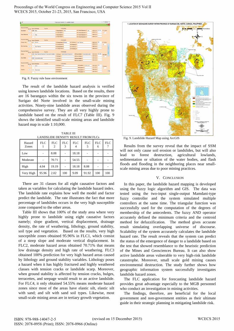
Fig. 8. Fuzzy rule base environment
The result of the landslide hazard analysis is verified
using known landslide locations. Based on the results, there
are 16 barangays within the six towns in the province of
Surigao del Norte involved in the small-scale mining
activities. Ninety-nine landslide areas observed during the
comprehensive survey. They are all very highly prone to
landslide based on the result of FLC7 (Table III). Fig. 9
shows the identified small-scale mining areas and landslide
hazard map in scale 1:10,000.
TABLE III
LANDSLIDE DENSITY RESULT FROM FLCs
Hazard
Zones
FLC
1
FLC
2
FLC
3
FLC
4
FLC
5
FLC
6
FLC
7
Low - 8.08 - 18.18 - - -
Moderate - 70.71 - 54.55 - - -
High 4.04 19.19 - 18.18 8.08 - -
Very High 95.96 2.02 100 9.09 91.92 100 100
There are 31 classes for all eight causative factors and
taken as variables for calculating the landslide hazard index.
The landslide rate explains how well the model and factor
predict the landslide. The rate illustrates the fact that more
percentage of landslides occurs in the very high susceptible
zone compared to the other areas.
Table III shows that 100% of the study area where very
highly prone to landslide using eight causative factors
namely; slope gradient, vertical displacement, drainage
density, the rate of weathering, lithology, ground stability,
soil type and vegetation. Based on the results, very high
susceptible zones obtained 95.96% in FLC1, which consist
of a steep slope and moderate vertical displacement. In
FLC2, moderate hazard areas obtained 70.71% that means
low drainage density and high rate of weathering. FLC3
obtained 100% prediction for very high hazard areas caused
by lithology and ground stability variables. Lithology poses
a hazard when it has highly fractured and highly weathered
classes with tension cracks or landslide scarp. Moreover,
when ground stability is affected by tension cracks, bulges,
terracettes, and seepage would result to an active landslide.
For FLC4, it only obtained 54.55% means moderate hazard
zones since most of the areas have elastic silt, elastic silt
with sand; and silt with sand soil types. Likewise, most
small-scale mining areas are in tertiary growth vegetation.
Fig. 9. Landslide Hazard Map using ArcGIS
Results from the survey reveal that the impact of SSM
will not only cause soil erosion or landslides, but will also
lead to forest destruction, agricultural lowlands,
sedimentation or siltation of the water bodies, and flash
floods and flooding in the neighboring places near small-
scale mining areas due to poor mining practices.
V. CONCLUSION
In this paper, the landslide hazard mapping is developed
using the fuzzy logic algorithm and GIS. The data was
tested using the two-input single-output Mamdani-type
fuzzy controller and the system simulated multiple
controllers at the same time. The triangular function was
successfully used for the computation of the degrees of
membership of the antecedents. The fuzzy AND operator
accurately defined the minimum criteria and the centroid
method for defuzzification. The method gives accurate
result simulating overlapping universe of discourse.
Scalability of the system accurately calculates the landslide
hazard rate. The result reveals that the system can predict
the status of the emergence of danger to a landslide based on
the test that showed resemblance to the heuristic prediction
of the Mines and Geosciences Bureau. It can also show
active landslide areas vulnerable to very high-risk landslide
catastrophe. Moreover, small scale gold mining causes
environmental destruction. The study further shows how
geographic information system successfully investigates
landslide hazard zones.
The FLC application for forecasting landslide hazard
provides great advantage especially to the MGB personnel
who conduct an investigation in mining activities.
The findings, therefore, are beneficial for the local
government and non-government entities as their ultimate
guide in their strategic planning in mitigating landslide risk.
Proceedings of the World Congress on Engineering and Computer Science 2015 Vol II WCECS 2015, October 21-23, 2015, San Francisco, USA
ISBN: 978-988-14047-2-5 ISSN: 2078-0958 (Print); ISSN: 2078-0966 (Online)
(revised on 15 December 2015) WCECS 2015

REFERENCES
[1] J.K. Ghosh, D. Bhattacharya, and S.K. Sharma, ―Fuzzy Knowledge
Based GIS for zonation of Landslide Susceptibility. Applications of
Chaos and Nonlinear Dynamics in Science and Engineering‖,
Understanding Complex Systems, Vol. 2, DOI 10.1007/978-3-642-
29329-0_2. © Springer-Verlag Berlin Heidelberg, 2012.
[2] I. Yilmaz, ―Comparison of landslide susceptibility mapping
methodologies for Koyulhisar, Turkey: conditional probability,
logistic regression, artificial neural networks, and support vector
machine‖, Environmental Earth Science, 61:821–836 DOI 0.1007/
s12665-009-0394-9, 2010.
[3] D. Petley, ―Mining-related landslides in the Philippines‖,
http://blogs.agu.org/landslideblog/2011/04/28/mining-related-
landslides- in-the-philippines/2011.
[4] IRINnews.org, "PHILIPPINES: Artisanal mining compounds landslide
risk", Date of Access: August 9, 2013, Retrieved from
http://www.irinnews.org/report/94629/philippines-artisanal-mining-
compounds- landslide-risk, 2012.
[5] J.L. Mayuga, ―PH topped countries hit by disasters in 2012‖, Date of
Access: September 28, 2013, http://www.abs-cbnnews.com/business
/04/09/13/ph- topped-countries-hit-disaster-2012, 2013.
[6] Surigao City Development Plan (Sectoral Report Y2005-2014) Dec.
2006.
[7] H.R. Pourghasemi, B. Pradhan, and C. Gokceoglu, ―Application of
fuzzy logic and analytical hierarchy process (AHP) to landslide
susceptibility mapping at Haraz watershed, Iran‖, Natural Hazards.
September, Volume 63, Issue 2, pp 965-996. http://link.
springer.com/article/10.1007/s11069-012-0217-2, 2012.
[8] F. Sdao, D.S. Lioi, S. Pascale, D. Caniani, and I.M. Mancini,
―Landslide susceptibility assessment by using a neuro-fuzzy model: a
case study in the Rupestrian heritage rich area of Matera‖, Nat.
Hazards Earth Syst. Sci., 13, 395–407, 2013.
[9] P. Kayastha, ―Application of fuzzy logic approach for landslide
susceptibility mapping in Garuwa sub-basin, East Nepal‖, Front.
Earth Sci. 6(4): 420–432, 2012.
[10] P. Kayastha, S.M. Bijukchhen, M.R. Dhital, and F. De Smedt, ―GIS
Based Landslide Susceptibility Mapping using a Fuzzy Logic
Approach: A Case Study from Ghurmi-Dhad Khola Area, Eastern
Nepal‖, Journal Geological Society of India, Vol.82, September 2013,
pp.249-261.
[11] E.P. Dadios, 2012, ―Fuzzy Logic-Algorithms, Techniques, and
Implementations‖, Retrieved October 13, 2013, from
http://www.intechopen.com/books/fuzzy-logic-algorithms-
techniques- and-implementations.
[12] U. Beck, ―Critical Theory of World Risk Society: A Cosmopolitan
Vision‖, Constellations Volume 16, No 1, The Author, Journal
compilation. Blackwell Publishing Ltd., 2009.
[13] J. Kerski, The Rise of Geographic Tools. Date Accessed: October 8,
2013. Retrieved from http://blogs.esri.com/ esri/gisedcom /
2013/01/11/the-rise-of-geographic-tools/, 2013.
[14] M.O. Arnous, and D.R. Green, ―GIS and remote sensing as tools for
conducting geo-hazards risk assessment along GULF of Aqaba
coastal zone, Egypt‖, Journal of Coastal Conservation, November
2011, Volume 15, Issue 4, pp. 457-475.
[15] Unified Soil Classification System, Date accessed: February 8, 2015,
Retrieved from http://gozips. uakron .edu/~mcbelch/ documents/
UnifiedSoilClassification.pdf.
[16] http://www.myhoa.com/newport/ documents/misc/finalreport.pdf.
Date accessed: July 9, 2015.
[17] Results of the Mines and Geosciences Bureau‘s (MGB) 1:10,000.
http://reliefweb.int/sites/reliefweb.int/files/resources/Results%20of%2
0 the%20Mi.
[18] Philippine Sites, http://www.tourism.gov.ph/SitePages/ Interactive-
SitesPage.aspx?siteID=72
[19] G. Gaprindashvili, ―Landslide hazard assessment in Georgia”, Report
on the 1st project of AES Geohazards Stream, Faculty of Geo-
Information Science and Earth Observation, University of Twente,
7500 AA Enschede, the Netherlands, 2011.
BIBLIOGRAPHY
Monalee A. dela Cerna is an Assistant Professor II
in Surigao State College of Technology, Surigao
City, Philippines. She finished her B.S. degree in
Computer Science from San Nicolas College,
Surigao City, Philippines in 1999 and Master‘s
degree in Science Teaching major in Computer
Science from University of Cebu, Cebu City,
Philippines in 2011. She is a candidate for the
degree Doctor in Information Technology in Cebu
Institute of Technology-University, Cebu City,
Philippines. Her research interests include systems
development, database management, neural
networks, modeling and simulation, and GIS
applications.
Elmer A. Maravillas is a Full Professor in the
College of Computer Studies of Cebu Institute of
Technology-University, Cebu City, Philippines. He
finished his B.S. in Mechanical Engineering from
Western Mindanao State University, Zamboanga
City, Philippines in 1981. He received his M.S.
degree in Computer Science in 1998, and Ph.D. in
Mechanical Engineering in 2006 from De La Salle
University-Manila, Philippines. Currently, he is the
Chair of the Graduate Program in the College of
Computer Studies, Cebu Institute of Technology-
University, Cebu City, Philippines. His research
interests include modeling and simulations, fuzzy
logic systems, neural networks, intelligent systems
and expert systems.
Manuscript modified: December 15, 2015.
In the title, I changed the letter ‗u‘ in ‗using‘ from lowercase to
uppercase, thus from ‗using‘ to ‗Using‘. In the Introduction, the word
‗landslide‘ was misspelled so I corrected it. Also the word ‗Geographical‘
was changed to ‗Geographic‘. Lastly, under Results and Discussion for
better emphasis of ideas sentences were rewritten observing improved
grammar constructions.
Proceedings of the World Congress on Engineering and Computer Science 2015 Vol II WCECS 2015, October 21-23, 2015, San Francisco, USA
ISBN: 978-988-14047-2-5 ISSN: 2078-0958 (Print); ISSN: 2078-0966 (Online)
(revised on 15 December 2015) WCECS 2015