landscapes and natural character 9.2 · openness of outstanding natural landscapes. 9.2.2.2.3...
TRANSCRIPT
9.2 Landscapes and Natural Character
9.2.1 Introduction
a. This introduction is to assist the lay reader to understand how this chapter works and what it applies to. It is not an aid to interpretation in a legal sense.
b. This sub-chapter relates to the management of the Christchurch District’s outstanding natural features and landscapes, significant features, rural amenity landscapes, and the natural character of the coastal environment, wetlands, and lakes and rivers and their margins. The highly-valued features and landscapes of the Christchurch District are identified in a series of schedules appended to this sub-chapter and shown on the Planning Maps.
c. The objectives, policies, rules, standards and matters of discretion in this sub-chapter are intended to provide for the protection of outstanding natural features and landscapes, the maintenance of significant features and rural amenity landscapes, and the preservation of the natural character of the coastal environment, wetlands, and lakes and rivers and their margins.
d. The provisions in this chapter give effect to the Chapter 3 Strategic Directions Objectives.
9.2.2 Objectives and policies
9.2.2.1 Objectives
9.2.2.1.1 Objective - Outstanding natural features
a. The outstanding natural features of the Christchurch District that are listed in Appendix 9.2.9.1.1 are protected.
9.2.2.1.2 Objective - Outstanding natural landscapes
a. The outstanding natural landscapes of the Christchurch District that are listed in Appendix 9.2.9.1.2 are protected.
9.2.2.1.3 Objective - Significant features and rural amenity landscapes
a. The significant features of the Christchurch District that are listed in Appendix 9.2.9.1.3 are maintained.
b. The rural amenity landscapes of the Christchurch District that are listed in Appendix 9.2.9.1.4 are maintained.
9.2.2.1.4 Objective - Natural character
a. The natural character of the Christchurch District’s coastal environment, wetlands, and lakes and rivers and their margins is preserved.

9.2.2.2 Policies
9.2.2.2.1 Policy – Recognising and protecting the qualities of outstanding natural features
a. Recognise the qualities of the identified outstanding natural features described in Appendix 9.2.9.1.1 and protect them from inappropriate subdivision, use and development by:
i. avoiding use and development that detracts from extensive open views, or detracts from or damages the unique landforms and landscape features;
ii. recognising and providing protection for Ngāi Tahu values in locations of special significance to tāngata whenua;
iii. promoting restoration and ecological enhancement initiatives, including through the design of ecological protection measures;
iv. within Pūtarikamotu / Riccarton Bush:
A. restricting new buildings and fencing; and
B. ensuring use and development is managed to retain the intactness, diversity and distinctiveness of the Bush, surrounding park setting and features.
9.2.2.2.2 Policy – Recognising and protecting the qualities of outstanding natural landscapes
a. Recognise the qualities of the identified outstanding natural landscapes described in Appendix 9.2.9.1.2 and protect them from inappropriate subdivision, use and development by:
i. avoiding use and development that breaks the skyline, including the crater rim, ridgelines on Banks Peninsula and the radial spurs of the Port Hills;
ii. avoiding subdivision, use and development in those parts of outstanding natural landscapes with little or no capacity to absorb change, and allowing limited subdivision, use and development in those areas with higher potential to absorb change;
iii. recognising and providing protection for Ngāi Tahu values in locations of special significance to tāngata whenua; and
iv. recognising the existence of working farms and their contribution to the openness of outstanding natural landscapes.
9.2.2.2.3 Policy – Future identification of outstanding natural features and landscapes
a. Only identify other natural features or landscapes as being outstanding by amending Appendix 9.2.9.1 from time to time, via plan change, following assessment.

9.2.2.2.4 Policy – Recognising and maintaining the qualities of significant features
a. Recognise the qualities of the identified significant features described in Appendix 9.2.9.1.3 and maintain them by:
i. restricting visually prominent uses and development;
ii. limiting urban encroachment, particularly on waterway corridors;
iii. recognising Ngāi Tahu values, particularly in relation to mahinga kai, and avoiding disturbance to known pā sites and urupā;
iv. promoting restoration and ecological enhancement initiatives, including appropriately designed ecological protection measures;
v. ensuring activities are carried out in a way that maintains or enhances water quality;
vi. within West Melton Dry Plains / Ōkakea:
A. avoiding development in the areas where the former braids of the Waimakariri River are legible, and within the kōwhai savannah grasslands;
B. enabling extensive pastoral farming activities, while managing more intensive farming activities that would lead to a loss of legibility;
C. recognising the presence of sites of Ngāi Tahu cultural significance in the grasslands area;
D. avoiding the removal of remnant kowhai and limiting the removal of all other indigenous vegetation;
E. ensuring activities are carried out in a way that maintains or enhances ground water quality; and
F. minimising the risk of fire damage.
vii. within Christchurch Coast / Te Tai o Mahaanui, avoiding use and development which would adversely affect the natural landform characteristics of the sand dunes; and
viii. within Ōtākaro /Avon River, ensuring that buildings and structures connected with recovery proposals in the Flat Land Recovery Zone are designed to recognise, maintain and enhance as far as practicable the qualities of the landscape feature.
9.2.2.2.5 Policy – Recognising and maintaining the qualities of rural amenity landscapes
a. Recognise the qualities of the identified rural amenity landscapes described in Appendix 9.2.9.1.4 and maintain them by:
i. avoiding use and development that breaks the skyline, including the crater rim, ridgelines on Banks Peninsula and radial spurs of the Port Hills;
ii. avoiding visually prominent development;
iii. ensuring subdivision, use and development does not result in over

domestication of the landscape;
iv. requiring development to be separated from identified important ridgelines on Banks Peninsula, taking into account visual separation and horizontal and vertical separation; and
v. enabling farming, conservation activites and recreation activities which contribute to rural landscape character of Banks Peninsula.
9.2.2.2.6 Policy — Recognition of natural character
a. Recognise that the following natural elements, patterns, processes and experiential qualities contribute to natural character:
i. areas or waterbodies in their natural states or close to their natural state;
ii. coastal or freshwater landforms and landscapes;
iii. coastal or freshwater physical processes, including the movement of water and sediment;
iv. biodiversity;
v. biological processes and patterns;
vi. water flows and levels, and water quality; and
vii. the experience of the above elements, patterns and processes.
9.2.2.2.7 Policy – Recognising and preserving the natural character qualities of the coastal environment
a. Recognise and preserve the natural character qualities of areas within the coastal environment that have:
i. outstanding natural character as described in Appendix 9.2.9.1.5;
ii. high (and very high) natural character as described in Appendix 9.2.9.1.5; and
iii. other areas with natural character
b. Protect those qualities from inappropriate subdivision, use and development by:
i. managing the adverse effects of subdivision, use and development;
ii. avoiding significant adverse effects of subdivision, use and development;
iii. avoiding subdivision, use and development within areas of outstanding natural character, where it would damage, diminish or compromise natural character;
iv. recognising and providing protection for Ngāi Tahu values in locations of special significance to tāngata whenua;
v. recognising historic farming operations that continue today;
vi. concentrating development within existing settlements to avoid development sprawling along the coastline;

vii. avoiding development in areas of high natural character, except that where development cannot be practicably located outside of an area of high natural character, remedying or mitigating any adverse effects as far as practicable;
viii. avoiding activities that damages the stability of the coastal dune systems;
ix. requiring appropriate setbacks for use and development from riparian and coastal margins;
x. ensuring development is not readily visible from public places and frequently visited viewpoints;
xi. promoting the use of post and wire fencing, and predator proof fencing; and
xii. ensuring activities are carried out in a way that maintains or enhances water quality in the coastal environment.
9.2.2.2.8 Policy - Natural character of wetlands, and lakes and rivers and their margins
a. Recognise and preserve the natural character qualities of wetlands, and lakes and rivers and their margins and their protection from inappropriate subdivision, use and development by:
i. ensuring that location, intensity, scale and form of subdivision, use and development is appropriate;
ii. minimising, to the extent practicable, indigenous vegetation clearance and modification (including earthworks, disturbance and structures);
iii. encouraging any new activities to consolidate within, and around, existing developments or where the natural character and landscape values have already been compromised to avoid development sprawling;
iv. requiring appropriate setbacks of activities from those margins; and
v. ensuring development is not readily visible from public places and frequently visited viewpoints.
9.2.2.2.9 Policy - Cumulative effects on natural character
a. Assessments of effects on the natural character of the coastal environment, wetlands, and lakes and rivers and their margins shall include an assessment of the cumulative effects of:
i. allowing more of the same activity;
ii. allowing more of a particular effect, whether from the same activities or from other activities causing the same or similar effect; and
iii. all activities in the coastal or freshwater environment at the site.
9.2.2.2.10 Policy - Restoration of natural character
a. Promote opportunities to restore and rehabilitate natural character, such as through the removal of plant and animal pests, and supporting initiatives for regeneration of indigenous vegetation.

9.2.2.2.11 Policy - Education and assistance
a. Use education to improve the community’s awareness and understanding of the qualities of outstanding natural features and landscapes, significant features and rural amenity landscapes, and the natural character of the coastal environment, wetlands, and lakes and rivers and their margins.
b. Provide advice and guidelines to landowners to assist in the protection of outstanding natural features and landscapes, the maintenance of significant features and rural amenity landscapes, and the preservation and restoration of the natural character of the coastal environment, wetlands, and lakes and rivers and their margins.
9.2.2.2.12 Policy - Other methods
a. Recognise the effectiveness of other mechanisms such as covenants and conservation trusts in protecting the qualities of outstanding natural features and landscapes, the maintenance of significant features and rural amenity landscapes, and the preservation and restoration of the natural character of the coastal environment, wetlands, and lakes and rivers and their margins.
9.2.2.2.13 Policy – Ngāi Tahu customary use
a. Recognise and provide for Ngāi Tahu customary uses of natural resources, including land, water and other natural resources as an integral part of areas identified in the Plan as outstanding natural features and landscapes, significant features and rural amenity landscapes, and areas of natural character in the coastal environment.
9.2.2.2.14 Policy – Integrated management of the Summit Road Protection Act area
a. To enable and provide for the integrated management of the Summit Road Protection Act area and the adjoining public open spaces and parks along the summit of the Port Hills between Evans and Gebbies Pass, and the protection and enhancement of the landscape qualities, recreation, rural tourism and cultural heritage values of the area.
9.2.3 How to interpret and apply the rules
a. The rules in this sub-chapter apply to the following landscape and natural character overlay areas:
i. outstanding natural features;
ii. outstanding natural landscapes;
iii. significant features (other than SF8.2 Otakaro/Avon River in the Central City);
iv. rural amenity landscapes (other than RAL1.0 Banks Peninsula with rural zoning);
v. natural character in the coastal environment;

vi. high natural character areas in the coastal environment; and
vii. outstanding natural character areas in the coastal environment.
b. For sub-chapter 9.2, the application of rules for Māori Land in the Papakāinga/Kāinga Nohoanga Zone is set out in Chapter 12.
c. The overlay areas are shown on the Planning Maps and listed within the schedules and reference maps in Appendix 9.2.9.2. The Planning Maps show the land parcels which contain overlay areas and a unique identifier. The schedules are ordered by the unique identifier number and contain a name, description by character area, and location. The schedules also provide a cross-reference to the relevant Planning Maps.
d. Specific activities are subject to rules contained in:
i. Rule 9.2.4 Rules - Landscape overlays - outstanding natural features and landscapes;
ii. Rule 9.2.5 Rules - Landscape overlays - significant features and rural amenity landscapes (other than RAL 1.0 Banks Peninsula with a rural zoning);
iii. Rule 9.2.6 Rules - Overlays for areas of natural character in the coastal environment; and
iv. Rule 9.2.7 Rules - Built form standards
e. Activities covered by the rules in this sub-chapter are also subject to the rules in the relevant zone chapters. The activity status tables, rules and standards in the following chapters also apply:
4 Hazardous Substances and Contaminated Land
5 Natural Hazards;
6 General Rules and Procedures;
7 Transport;
8 Subdivision, Development and Earthworks;
9 The other sub-chapters of Natural and Cultural Heritage; and
11 Utilities and Energy.
f. The rural amenity landscape RAL1.0 Banks Peninsula covers the majority of Banks Peninsula, outside the settlements and those areas identified as outstanding natural features and landscapes. Where RAL1.0 has an underlying Rural Banks Peninsula zoning, the rural amenity landscape rules are contained within Chapter 17 Rural.
g. Chapter 7 Transport provides for the maintenance of transport infrastructure in the Transport Zone as a permitted activity (Rule 7.2.5.1 P1). Only new roads have an activity status listed in the rules in this sub-chapter.
h. The rules that relate to utilities in the landscape and natural character overlay areas can be found in Chapter 11 Utilities and Energy. The rules in sub-chapter 9.2 do not

apply to utilities, other than the matters of discretion in Rules 9.2.8.1, 9.2.8.2 and 9.2.8.3.
i. In the Central City, rules to manage effects on SF8.2 Ōtākaro / Avon River are contained in the Avon River Precinct Zone / Te Papa Ōtākaro in Chapter 18.
Advice note:
1. Summit Road (Canterbury) Protection Act 2001 — Any development on land above Summit Road and within 30m vertically below Summit Road and Dyers Pass Road (refer to Summit Road (Canterbury) Protection Act and Gazette Notice) may be affected by the provisions of the Summit Road (Canterbury) Protection Act 2001). You are advised to contact the Summit Road Protection Authority for more information. The extent of the subject area is shown on the Planning Maps.
9.2.4 Rules - Landscape overlays - outstanding natural features and landscapes
9.2.4.1 Activity status table
a. The activities listed in Table 1 below have the activity status listed within each feature and landscape overlay area (as shown on the Planning Maps and listed in the schedules of outstanding natural features and outstanding natural landscapes in Appendix 9.2.9.2).
b. Any building listed as a permitted activity in Table 1 shall meet the built form standards in Rule 9.2.7.
c. The activities are also subject to compliance with any activity status, rules and standards specified elsewhere in the Plan for that activity.
d. Z means Rule 9.2.4 - Landscape overlays - outstanding natural features and landscapes - does not apply to the activity listed. Instead, the rules in the relevant zone chapters, and the activity status tables and standards in the chapters listed in 9.2.3 e. apply.

Table 1: Rules - Landscape overlays - outstanding natural features and landscapes
Activities ONF
31.0 Kaitorete Spit
31.2 Te Waihora/Lake Ellesmere Wairewa/Lake Forsyth
ONF
32.0 Brooklands Lagoon and Spit/Te Riu o Te Aika Kawa
36.0 Te Ihutai/Avon-Heathcote Estuary
37.0 South Brighton Spit/Te Kōrero and Estuary entrance
ONF
33.0 Waimakariri River
ONF
34.0 Travis Wetland/ Ōruapaeroa
ONF
35.0 Riccarton Bush/ Pūtarikamotu
ONL
1.0 to 30.0 Banks Peninsula
ONL
38.1 to 38.3 Port Hills
a. Any building, except as listed below or where specified as “Z ” below.
NC1 NC2 D1 D2 D3 D4 NC3
b. Any residential unit, except as listed below or where specified as “Z” below.
NC4 NC5 NC6 D5 Z NC7 NC8 except as listed in p.
c. A residential unit (including additions of 40 m² or greater) within an identified building area.
RD1 NC9 RD2 D6 Z RD3 RD4
d. A residential unit for caretaker and site management purposes only. Limited to one per site.
D7 NC10 NC11 D8 Z D9 D10
e. A farm building with a footprint ≤100m². Limited to one per site.
P1 Z P2 Z Z P3 P4
f. A recreation facility or park management facility building with a footprint ≤100m². Limited to one per site.
RD5 RD6 P5 P6 Z P7 RD7 except as listed in q.
g. A tramping hut with a footprint RD8 Z Z Z Z P8 Z

Activities ONF
31.0 Kaitorete Spit
31.2 Te Waihora/Lake Ellesmere Wairewa/Lake Forsyth
ONF
32.0 Brooklands Lagoon and Spit/Te Riu o Te Aika Kawa
36.0 Te Ihutai/Avon-Heathcote Estuary
37.0 South Brighton Spit/Te Kōrero and Estuary entrance
ONF
33.0 Waimakariri River
ONF
34.0 Travis Wetland/ Ōruapaeroa
ONF
35.0 Riccarton Bush/ Pūtarikamotu
ONL
1.0 to 30.0 Banks Peninsula
ONL
38.1 to 38.3 Port Hills
≤100m². Limited to one per site
h. A building for public amenities with a footprint ≤ 100m². Limited to one per site.
P9 P10 P11 P12 Z P13 P14
i. An addition to an existing building, where the ground floor area is increased by less than 40 m².
P15 P16 P17 P18 P19 P20 P21
j. New access tracks that have a formed width of 5 m or greater.
RD9 RD10 RD11 RD12 RD13 RD14 RD15
k. Construction of a new road. D11 D12 D13 Z Z D14 Z
l. Plantation forestry. NC12 NC13 NC14 except as listed in r.
NC15 NC16 NC17 NC18
m.
Quarrying activity. NC19 NC20 D15
except as listed in s.
NC21 NC22 NC23 NC24
n. Fences Z Z Z Z D16 Z Z
o. Any building listed as a permitted activity in Table 1 which does not
RD16 RD17 RD18 RD19 RD20 RD21 RD22

Activities ONF
31.0 Kaitorete Spit
31.2 Te Waihora/Lake Ellesmere Wairewa/Lake Forsyth
ONF
32.0 Brooklands Lagoon and Spit/Te Riu o Te Aika Kawa
36.0 Te Ihutai/Avon-Heathcote Estuary
37.0 South Brighton Spit/Te Kōrero and Estuary entrance
ONF
33.0 Waimakariri River
ONF
34.0 Travis Wetland/ Ōruapaeroa
ONF
35.0 Riccarton Bush/ Pūtarikamotu
ONL
1.0 to 30.0 Banks Peninsula
ONL
38.1 to 38.3 Port Hills
meet the built form standard in Rule 9.2.7.1
Geographic specific rules
p. ONL 38.2 Port Hills – Montgomery Spur
One additional residential unit on 315 Port Hills Road (Lots 2 and 5 DP2409)
RD23
q. ONL 38.2 Port Hills – Christchurch Gondola
Where a rural tourism activity is co-located with the Christchurch Gondola on Mount Cavendish Lot 3 DP 619776 or Lot 2 DP 57455, a new building with a footprint ≤100m²
RD24
r. ONF 33.0 Waimakariri River
Plantation forestry located west of Crossbank Road for Waimakairi River management purposes.
P22
s. ONF 33.0 Waimakariri River P23

Activities ONF
31.0 Kaitorete Spit
31.2 Te Waihora/Lake Ellesmere Wairewa/Lake Forsyth
ONF
32.0 Brooklands Lagoon and Spit/Te Riu o Te Aika Kawa
36.0 Te Ihutai/Avon-Heathcote Estuary
37.0 South Brighton Spit/Te Kōrero and Estuary entrance
ONF
33.0 Waimakariri River
ONF
34.0 Travis Wetland/ Ōruapaeroa
ONF
35.0 Riccarton Bush/ Pūtarikamotu
ONL
1.0 to 30.0 Banks Peninsula
ONL
38.1 to 38.3 Port Hills
Quarrying activity located in the bed of the Waimakairi River for river management purposes.

9.2.4.2 Non-notification
a. Any application arising from Rule 9.2.4.1 RD1 to RD23 in Table 1 shall not be limited or publicly notified.
9.2.4.3 Rules - Matters of discretion
a. For applications arising from Rule 9.2.4.1 RD1 to RD24 in Table 1, discretion to grant or decline consent and impose conditions is restricted to the matters of discretion in Rule 9.2.8, as set out in the following table.
Activity The Council’s discretion shall be limited to the following matters:
i. RD1 to RD8 and RD23 to RD24 – Buildings
Rule 9.2.8.1 - Outstanding natural features and outstanding natural landscapes, matters a. to i. and l.
ii. RD9 to RD15 – Access tracks Rule 9.2.8.1 - Outstanding natural features and outstanding natural landscapes, matters a. to j. and l.
iii. RD16 to RD22 Rule 9.2.8.4 – Building reflectivity
9.2.5 Rules — Landscape overlays - significant features and rural amenity landscapes
9.2.5.1 Activity status table
a. The activities listed in Table 2 below have the activity status listed within each feature and landscape overlay area (as shown on the Planning Maps and listed in the schedules of significant features and rural amenity landscapes in Appendix 9.2.9.2).
b. Any building listed as a permitted activity in Table 2 shall meet the built form standards in Rule 9.2.7.
c. The activities are also subject to compliance with any activity status, rules and standards specified elsewhere in the District Plan for that activity.
d. Z means Rule 9.2.5 — Landscape overlays - significant features and rural amenity landscapes - does not apply to the activity listed. Instead, the rules in the relevant zone chapters, and the activity status tables and standards in the chapters listed in 9.2.3 e. apply.

Table 2: Rules — Landscape overlays — significant features and rural amenity landscapes
Activities SF
2.0 Ōtūkaikino Creek
3.0 Styx River/ Pūharakekenui
7.0 Waikākāriki/ Horseshoe Lake
8.1 and 8.3 Ōtākaro/ Avon River
10.0 Heathcote River/ Ōpāwaho
SF
4.0 Styx Mill Reserve
SF
5.0 West Melton Dry Plains/Ōkakea
SF
6.0 Christchurch Coast/Te Tai o Mahaanui
RAL
11.1 to 11.6 Port Hills
RAL
1.0 Banks Peninsula Open Space zones only
a. Any building, except as listed below or specified as “Z” below.
D1 D2 D3 D4 D5 D6
b. Any residential unit, except as listed below or specified as “Z” below.
D7 D8 NC1 Z D9 D10
c. A residential unit (including additions of 40 m² or greater) within an identified building area.
Z Z RD1 Z RD2 RD3
d. A residential unit for caretaker and site management purposes only. Limited to one per site.
D11 D12 NC2 Z D13 P1
e. A farm building with a footprint ≤100m². Limited to one per site.
P2 P3 P4 Z P5 P6
f. A recreation facility or park management facility building with a footprint ≤100m². Limited to one per site.
D14 P7 P8 Z P9 P10
g. A tramping hut with a footprint ≤100m². Limited to one per site.
Z Z Z Z Z P11

Activities SF
2.0 Ōtūkaikino Creek
3.0 Styx River/ Pūharakekenui
7.0 Waikākāriki/ Horseshoe Lake
8.1 and 8.3 Ōtākaro/ Avon River
10.0 Heathcote River/ Ōpāwaho
SF
4.0 Styx Mill Reserve
SF
5.0 West Melton Dry Plains/Ōkakea
SF
6.0 Christchurch Coast/Te Tai o Mahaanui
RAL
11.1 to 11.6 Port Hills
RAL
1.0 Banks Peninsula Open Space zones only
h. A building for public amenities with a footprint ≤ 100m². Limited to one per site.
P12 P13 P14 P15 P16 P17
i. An addition to an existing building, where the ground floor area is increased less than 40 m².
P18 P19 P20 P21 P22 P23
j. New access tracks that have a formed width of 5 m or greater.
RD4 RD5 RD6 RD7 RD8 RD9
k. Construction of a new road. D15 D16 D17 D18 D19 D20
l. Plantation forestry. NC3 NC4 NC5 NC6 D21 D22
m.
Quarrying activity. NC7 NC8 NC9 NC10 NC11 NC12
n. Any building listed as a permitted activity in Table 2 which does not meet the built form standard in Rule 9.2.7.1.
RD10 RD11 RD12 RD13 RD14 RD15
o. Any building listed as a permitted activity in Table 2 which does not meet the built form standard in Rule 9.2.7.2.
Z Z Z Z Z D23

9.2.5.2 Non-notification
a. Any application arising from Rule 9.2.5.1 RD1 to RD15 in Table 2 shall not be limited or publicly notified.
9.2.5.3 Rules - Matters of discretion
a. For applications arising from Rule 9.2.5.1 RD1 to RD15 in Table 2, discretion to grant or decline consent and impose conditions is restricted to the matters of discretion in Rule 9.2.8, as set out in the following table.
Activity The Council’s discretion shall be limited to the following matters:
i. RD1 to RD3 – Buildings Rule 9.2.8.2 - Significant features and rural amenity landscapes, matters - a. to j., o. and p.
ii. RD4 to RD9 – Access tracks Rule 9.2.8.2 - Significant features and rural amenity landscapes, matters - a. to m., o. and p.
iii. RD10 to RD15 Rule 9.2.8.4 - Building reflectivity
9.2.6 Rules - Overlays for areas of natural character in the coastal environment
9.2.6.1 Activity status table
a. The activities listed in Table 3 below have the activity status listed within each natural character overlay area (as shown on the Planning Maps and listed in the schedules of areas of natural character in the coastal environment in Appendix 9.2.9.2).
b. Any building listed as a permitted activity in Table 3 shall meet the built form standards in Rule 9.2.7.
c. The activities are also subject to compliance with any activity status, rules and standards specified elsewhere in the District Plan for that activity.
d. Z means Rule 9.2.6 - Landscape overlays - outstanding natural features and landscapes - does not apply to the activity listed. Instead, the rules in the relevant zone chapters, and the activity status tables and standards in the chapters listed in 9.2.3 e. apply.
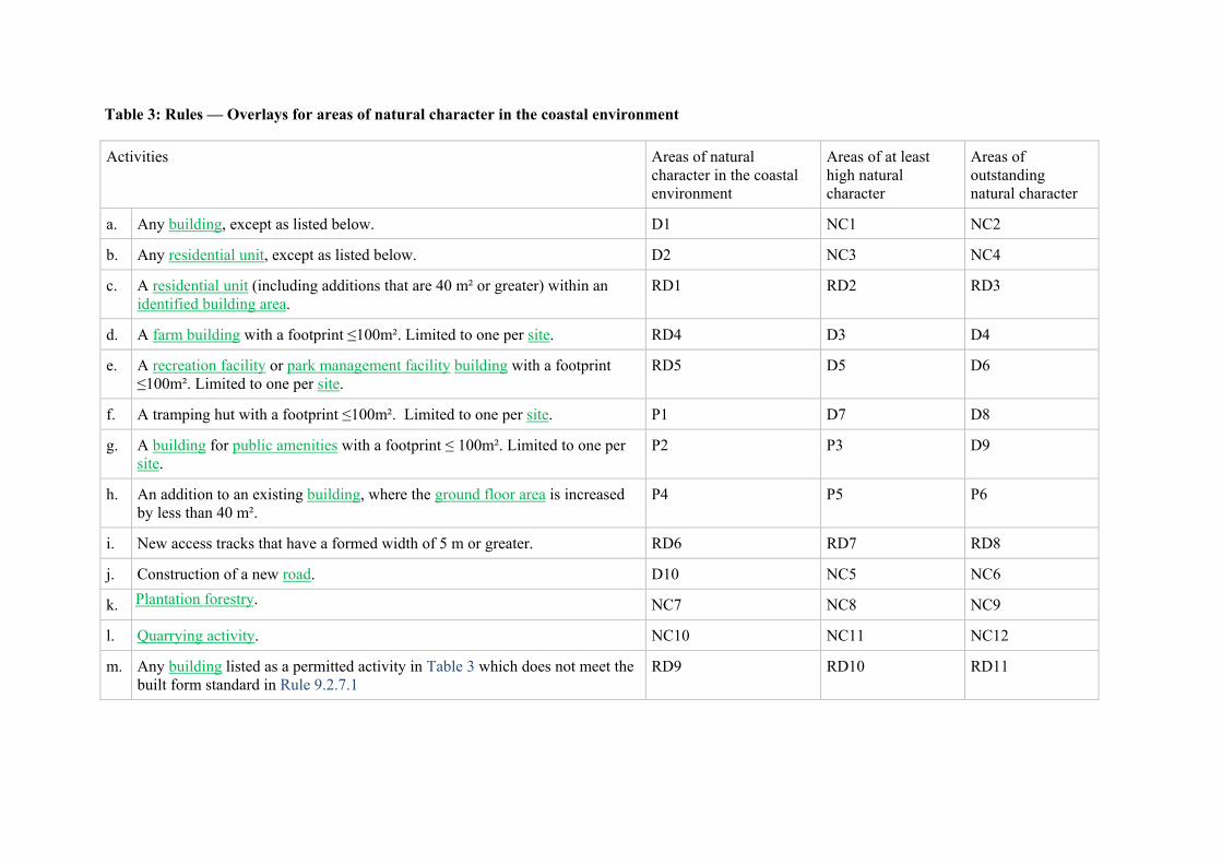
Table 3: Rules — Overlays for areas of natural character in the coastal environment
Activities Areas of natural character in the coastal environment
Areas of at least high natural character
Areas of outstanding natural character
a. Any building, except as listed below. D1 NC1 NC2
b. Any residential unit, except as listed below. D2 NC3 NC4
c. A residential unit (including additions that are 40 m² or greater) within an identified building area.
RD1 RD2 RD3
d. A farm building with a footprint ≤100m². Limited to one per site. RD4 D3 D4
e. A recreation facility or park management facility building with a footprint ≤100m². Limited to one per site.
RD5 D5 D6
f. A tramping hut with a footprint ≤100m². Limited to one per site. P1 D7 D8
g. A building for public amenities with a footprint ≤ 100m². Limited to one per site.
P2 P3 D9
h. An addition to an existing building, where the ground floor area is increased by less than 40 m².
P4 P5 P6
i. New access tracks that have a formed width of 5 m or greater. RD6 RD7 RD8
j. Construction of a new road. D10 NC5 NC6
k. Plantation forestry. NC7 NC8 NC9
l. Quarrying activity. NC10 NC11 NC12
m. Any building listed as a permitted activity in Table 3 which does not meet the built form standard in Rule 9.2.7.1
RD9 RD10 RD11

9.2.6.2 Non-notification
a. Any application arising from Rule 9.2.6.1 RD1 to RD3 and RD6 to RD11 in Table 3 shall not be limited or publicly notified.
9.2.6.3 Rules - Matters of discretion
a. For applications arising from Rule 9.2.6.1 RD1 to RD11 in Table 3, discretion to grant or decline consent and impose conditions is restricted to the matters of discretion in Rule 9.2.8, as set out in the following table.
Activity The Council’s discretion shall be limited to the following matters:
i. RD1 to RD5 – Buildings Rule 9.2.8.3 - Natural character in the coastal environment, matters - a. to k. and n.
ii. RD6 to RD8 – Access tracks Rule 9.2.8.3 - Natural character in the coastal environment, matters - a. to l. and n.
iii. RD9 to RD11 Rule 9.2.8.4 - Building reflectivity
9.2.7 Rules — Built form standards
9.2.7.1 Building reflectivity
a. The reflectivity of any building shall be no greater than 40%.
9.2.7.2 Identified important ridgelines on Banks Peninsula
a. Buildings shall be located at an elevation at least 20 vertical metres immediately below that of any adjoining identified important ridgeline.
9.2.8 Rules - Matters of discretion - Outstanding natural features and landscapes, Significant features and rural amenity landscapes and Natural character in the coastal environment
a. When considering applications for restricted discretionary activities, the Council’s discretion to grant or decline consent, or impose conditions, is restricted to the matters over which discretion is restricted in the relevant rule and as described below.
9.2.8.1 Outstanding natural features and outstanding natural landscapes
a. Whether the proposal is consistent with protecting and enhancing the qualities of the outstanding natural feature and/or landscape;

b. The extent to which the proposal will detract from the naturalness and openness of the landscape;
c. Whether the proposal recognises the context and values of historic and cultural significance and the relationship, culture and traditions of Ngāi Tahu;
d. Whether the proposal will integrate into the landscape and the appropriateness of the scale, form, design and finish (materials and colours) proposed and mitigation measures such as planting. This shall include consideration of any adverse effects of reflectivity, glare and light spill;
e. The proximity and extent to which the proposal is visible from public places and roads (including unformed legal roads), ease of accessibility to that place, and the significance of the view point;
f. The extent to which natural elements such as landforms and vegetation within the site mitigate the visibility of the proposal;
g. The extent to which the proposal will result in adverse cumulative effects;
h. Whether the proposal supports the continuation of farming activities in rural zone;
i. Whether the proposal is connected to reticulated water and the need to provide water supply (for firefighting), and the ability to integrate water tanks into the landscape and mitigate any adverse visual effects;
j. For new access tracks, whether the track supports conservation activiites, farming, recreation activities or rural tourism activities and the ability to integrate with the landscape, follow natural contours and mitigate any adverse effects;
k. The extent to which the proposal has technical or operational needs for its location; and
l. Within a site of Ngāi Tahu Cultural Significance, the matters set out in Rule 9.5.5 as relevant to the site classification:
i. Rule 9.5.5.1 - Wāhi Tapu / Wāhi Taonga, Mahaanui Iwi Management Plan Silent Files and Kaitōrete Spit;
ii. Rule 9.5.5.2 - Ngā Tūranga Tūpuna; and
iii. Rule 9.5.5.3 - Ngā Wai.
9.2.8.2 Significant features and rural amenity landscapes
a. Whether the proposal is consistent with maintaining the qualities of the significant feature and/or rural amenity landscape;
b. Any adverse effects on adjoining outstanding natural features, outstanding natural landscapes or natural character in the coastal environment, and whether there is a sufficient separation to avoid detracting from the qualities of those areas. When assessing separation, account shall be taken of visual separation, vertical and horizontal setback distances and retention of indigenous vegetation;

c. On Banks Peninsula, the extent to which the proposal will detract from visual amenity landscape values. This shall include consideration of the extent to which the proposal is consistent with design guidance;
d. Within greater Christchurch (including the Port Hills), the extent to which the proposal will detract from the natural landscape values;
e. Whether the proposal recognises the context and values of historic and cultural significance and the relationship, culture and traditions of Ngāi Tahu;
f. Whether the proposal will integrate into the landscape and the appropriateness of the scale, form, design and finish (materials and colours) proposed and mitigation measures such as planting. This shall include consideration of any adverse effects of reflectivity, glare and light spill;
g. The proximity and extent to which the development is visible from public places and roads (including unformed legal roads), ease of accessibility to that place, and the significance of the view point;
h. The extent to which natural elements such as landforms and vegetation within the site mitigate the visibility of development;
i. The capacity of the landscape to absorb change and the extent to which opportunity has been taken to cluster built development in areas of existing built development with a higher potential to absorb development while retaining areas which are more sensitive to change;
j. The extent to which the proposal will result in adverse cumulative effects;
k. Whether the proposal supports the continuation of farming activities in rural zones;
l. Whether the proposal is connected to reticulated water and the need to provide water supply (for firefighting), and the ability to integrate water tanks into the landscape and mitigate any adverse visual effects;
m. For new access tracks whether the access supports conservation activities, farming or recreation activities, the ability to integrate with the landscape, follow natural contours and mitigate any adverse visual effects;
n. The extent to which the proposal has technical or operational needs for its location;
o. For proposed activities in connection with a recovery activity in the Flat Land Recovery Zone, the extent to which the qualities of the significant natural feature of the Avon River will be maintained; and
p. Within a site of Ngāi Tahu Cultural Significance, the matters set out in Rule 9.5.5 as relevant to the site classification:
i. Rule 9.5.5.1 - Wāhi Tapu / Wāhi Taonga, Mahaanui Iwi Management Plan Silent Files and Kaitōrete Spit;
ii. Rule 9.5.5.2 - Ngā Tūranga Tūpuna; and
iii. Rule 9.5.5.3 - Ngā Wai.

9.2.8.3 Natural character in the coastal environment
a. Whether the proposal is consistent with preserving the natural character qualities of the coastal environment;
b. Within areas of outstanding natural character in the coastal environment, whether adverse effects are avoided and the proposal does not damage, diminish or compromise natural character;
a. Within areas of at least high natural character, whether development can be practicably located outside the area of high natural character;
b. Whether any restoration or rehabilitation of the natural character of the coastal environment is proposed;
c. Whether the proposal recognises the context and values of historic and cultural significance and the relationship, culture and traditions of Ngāi Tahu;
d. Whether the development will integrate into the landscape and the appropriateness of the scale, form, design and finish (materials and colours) proposed and mitigation measures such as planting. Any adverse effects of reflectivity, glare and light spill;
e. The proximity and extent to which the proposal is visible from public places and roads (including unformed legal roads), ease of accessibility to that place, and the significance of the view point;
f. The extent to which natural elements such as landforms and vegetation within the site mitigate the visibility of development;
g. The capacity of the landscape to absorb change and the extent to which the opportunity has been taken to cluster built development in areas with a higher potential to absorb development while retaining areas which are more sensitive to change;
h. The extent to which the proposal will result in sprawling or sporadic development along the coastline and adverse cumulative effects;
i. Whether the proposal is connected with the need to provide water supply (for firefighting), and the ability to integrate water tanks into the landscape and mitigate any adverse visual effects;
j. For new access tracks, whether the access supports conservation activites, farming or recreation activities that are complementary to natural character, and the ability to integrate with the landscape, follow natural contours and mitigate any adverse visual effects;
k. The extent to which the proposal has technical or operational needs for its location; and
l. Within a site of Ngāi Tahu Cultural Significance, the matters set out in Rule 9.5.5 as relevant to the site classification:
i. Rule 9.5.5.1 - Wāhi Tapu / Wāhi Taonga, Mahaanui Iwi Management Plan Silent Files and Kaitōrete Spit;
ii. Rule 9.5.5.2 - Ngā Tūranga Tūpuna;

iii. Rule 9.5.5.3 - Ngā Wai.
9.2.8.4 Building reflectivity
a. The extent to which the building will give rise to adverse visual effects, taking into account the size of the building and the surface area with high reflectivity;
b. Whether the proposed exterior materials respond to and respect the landscape and natural character; and
c. The extent to which the building is consistent with design guidance.
9.2.9 Appendices
9.2.9.1 Identified Outstanding natural features, Outstanding natural landscapes, Significant features, Rural amenity landscapes and Areas of outstanding and high (and very high) natural character in the coastal environment; and descriptions of their qualities
9.2.9.1.1 Outstanding natural features
a. The following are the Christchurch District’s identified outstanding natural features and their qualities:
i. Kaitorete Spit:
A. The vast, low-lying Kaitorete Spit is a distinctive beach barrier landform separating Te Waihora / Lake Ellesmere from the sea and provides a sense of openness.
B. Contains a large sand dune system with native sand binding plant pingao and herbfield communities.
C. High importance to tāngata whenua, containing numerous archaeological sites, particularly middens and habitation sites.
D. Residential development is confined to the Birdlings Flat / Poranui settlement, which is small in scale and distinctive in character.
ii. Te Waihora / Lake Ellesmere:
A. Important in terms of its geological and coastal landform attributes with the lagoon representing a rare landscape feature.
B. Provides important indigenous fish and bird habitat, and the brackish coastal lagoon, indigenous riparian marshland and wetland plant communities along the lake edge are of ecological significance.
C. Cultural associations are highly important in accordance with tikanga Māori and in respect of Ngāi Tahu history, mahinga kai and customary fisheries.
iii. Wairewa / Lake Forsyth:

A. An inland coastal lake within an ancient harbour eroded between volcanic rock deposits and an outlet impounded by beach gravels.
B. Significant to Ngāi Tahu as a key mahinga kai and associated with tuna (eels) and their harvest during the annual heke (migration) from lake to sea, and number of pā and kāinga and associated urupā in close vicinity to the lake, including Ōruaka and Te Mata Hapuka near the outlet.
C. Notable values associated with the marsh species occurring along the brackish waters and numerous bird species.
iv. Brooklands Lagoon and Spit / Te Riu o Te Aika Kawa:
A. The landform of Brooklands Spit and Lagoon formed behind the dunes barrier are distinctive geomorphological features adjacent to the Waimakariri river mouth.
B. Extensive views and sense of isolation.
C. The saltmarsh and mudflats, lagoon channel, Styx river mouth and banks are important habitats, in particular for plants and bird life.
D. Brooklands Lagoon / Te Riu o Te Aika Kawa and the lower Waimakariri River and mouth are important mahinga kai sites. A number of urupā and archaeological sites, as well as the Pūharakekenui Māori Reserve are significant to Ngāi Tahu.
E. The majority of the area lends itself to quiet recreation, including bird watching and fishing with Spencer and Seafield Parks popular recreational hubs.
v. Waimakariri River:
A. A large braided river, being one of the best examples of a braided riverbed and associated wetland habitat in New Zealand.
B. A distinctive natural feature which defines the northern boundary of the Christchurch District.
C. Important bird habitat and native plant communities in the understorey of surrounding vegetation.
D. Significant to Ngāi Tahu in relation to settlement, migration, cultivations, mahinga kai and associated urupā.
E. European historic heritage values associated with early settlement flood control works.
F. Contemporary recreation, such as watersports and fishing.
vi. Travis Wetland / Ōruapaeroa:
A. The largest remaining freshwater wetland and the best example of its kind in Christchurch City.
B. Provides an important natural contrast with the wider urban environment.

C. Significant to Ngāi Tahu in relation to mahinga kai, settlement and occupation.
D. An area which has undergone and continues to undergo extensive restoration.
E. An important wildlife refuge.
F. An important recreation and education resource for the Christchurch District as a wetland nature heritage park.
vii. Pūtarikamotu / Riccarton Bush:
A. A remnant, largely unmodified area of low-land podocarp forest located within the wider urban environment.
B. A park like landscape setting with significant buildings and trees.
C. A long history and important cultural associations for both Ngāi Tahu and European with the settlement of Ōtautahi/Christchurch.
D. The podocarp forest has important ecological values and a significant traditional mahinga kai of Ngāi Tahu.
E. Important recreational and education values.
viii. Te Ihutai / Avon-Heathcote Estuary:
A. The formative processes, tidal influence and shifting channels of the Ōtākaro / Avon and Heathcote / Ōpāwaho rivers mouths and the adjacent New Brighton sand spit make the estuary a highly legible landscape feature.
B. The series of caves and rocky headlands from the mouth of the Heathcote / Ōpāwaho River to Scarborough Heads are significant geological features with important heritage, archaeological and cultural values.
C. Important bird feeding and breeding site, nationally important for wading birds.
D. Shag Rock / Rapanui, Tuawera / Cave Rock and Clifton Cliffs are of geological interest, visually prominent, and are of significance to Ngāi Tahu
E. Significance in relation to Māori heritage due to extensive settlement, occupation and the use of Te Ihutai / Avon-Heathcote Estuary as a major mahinga kai.
F. Te Ihutai / Avon-Heathcote Estuary and Sumner beach / Matuku-takotako are particularly popular for recreational use.
ix. South Brighton Spit / Te Kōrero Karoro and Estuary entrance:
A. The openness and visual separation of the beach from the adjacent urban environment by sand dunes.
B. The sand dunes are important landform characteristics of the landscape including the indigenous vegetation occurring on them.

C. South Brighton Spit / Te Kōrero Karoro is an important bird habitat and distinctive landscape feature that defines the entrance to Te Ihutai / Avon-Heathcote estuary.
D. An area of significance to Ngāi Tahu in relation to mahinga kai, migration and settlement.
E. High recreational values of the beach and coastal interface due to the proximity to the city.
9.2.9.1.2 Outstanding natural landscapes
a. The following are the Christchurch District’s identified outstanding natural landscapes and their qualities:
i. Banks Peninsula / Te Pātaka o Rākaihautū:
A. Distinctive volcanic landforms with highly legible crater rims, prominent ridgelines and peaks extending to a series of gullies, spurs and lower slopes, and continuity of rock outcrops.
B. The presence of important areas of indigenous vegetation.
C. Important landscapes and features to Ngāi Tahu especially those prominent peaks and passes, streams and vegetation that relate to key tribal origin, migration and settlement traditions, including mahinga kai.
D. A predominance of natural features, processes and patterns and farming with existing development generally well integrated into the landscape.
E. Within the coastal environment, the presence of generally highly legible landforms, visually impressive cliffs, islands and caves.
ii. Port Hills / Ngā Kohatu Whakarakaraka o Tamatea Pōkai Whenua:
A. Distinctive volcanic landform with highly legible crater rim, rocky outcrops, radial spurs and valleys.
B. Skyline forms an important visual backdrop to Otautahi/Christchurch.
C. A natural landscape characterised by openness and a general absence of human-made structures on the upper slopes and ridges, particularly the area east of Dyers Pass Road.
D. The colours of the hills reflect the seasonal changes.
E. A major recreation and rural tourism resource for the city’s residents and visitors.
F. The presence of important areas of indigenous vegetation including remnants and restored bush in gullies / cliffs and tussocks on spurs and slopes.
G. Important to Ngāi Tahu especially those prominent peaks and passes, streams and vegetation that relate to key tribal origin, migration and settlement traditions, including mahinga kai.

H. A predominance of natural features, processes and patterns and farming with existing development generally well integrated into the landscape.
I. The Summit Road Protection Act area with important landscape, recreation, rural tourism and cultural heritage values.
9.2.9.1.3 Significant features
a. The following are the Christchurch District’s identified significant features and their qualities:
i. Ōtūkaikino Creek:
A. A spring-fed stream being an old meander of the Waimakariri.
B. The clear water of the stream and associated wetlands are of high ecological value.
C. Accessible through the Groynes reserve with walkways and recreational facilities.
D. Significant to Ngāi Tahu due to the presence of various wāhi tapu.
ii. Styx River / Pūharakekenui:
A. The Styx River / Pūharakekenui is a spring-fed lowland river being an older meander of the Waimakariri.
B. Its sections of native vegetation and presence of wildlife it contributes to the amenity of the adjoining residential areas.
C. Cultural significance to Ngāi Tahu, particularly relating to mahinga kai and kāinga (settlements). The Pūharakekenui Māori Reserve fronts the river towards its mouth.
iii. Styx Mill Reserve:
A. An important representative area of the former Styx River floodplain and wetlands.
B. Has large areas of indigenous planting and ecological restoration.
C. Associated with an area of importance to Ngāi Tahu in relation to mahinga kai.
D. An area with important historic heritage connected to European settlement and mill industries.
E. An important wildlife refuge.
iv. West Melton Dry Plains / Ōkakea:
A. A predominantly open, rural area where the former braids of the Waimakariri River are legible across large parts of the landscape.
B. An area with important ecological values, including the presence of a large area of the kōwhai savannah grasslands, and other dryland plant communities.

C. An area of importance to Ngāi Tahu associated with a network of settlements and mahinga kai sites located along the former path of the Waimakariri River.
D. The dry appearance maintained by extensive pastoral grazing.
v. Christchurch Coast / Te Tai o Mahaanui:
A. The foreshore and dune between Brooklands Lagoon and South Brighton is an extensive natural feature.
B. A windswept environment with panoramic views, including to the Port Hills.
C. The dune zone is an active, dynamic system dominated by exotic marram grass with smaller areas of native pingao.
D. Native plant communities exist, although the majority of the hinterland is highly modified with pine forest or urban settlement.
E. The coastline is important to Ngāi Tahu as a traditional mahinga kai, as well as in relation to settlement and migration traditions.
F. Spencer Park and other nodes of development contain popular recreation infrastructure, such as surf clubs.
vi. Horseshoe Lake / Waikākāriki:
A. One of the few remaining low-land swamps in the Christchurch District and a unique feature due to its distinctive and original ox-bow shape, being an older meander of Ōtākaro/Avon River.
B. Significant to Ngāi Tahu as a mahinga kai, pā and urupā.
C. An area which has a thick undergrowth of indigenous plants and is an important bird habitat.
vii. Ōtākaro /Avon River and Heathcote River / Ōpāwaho:
A. The rivers provide an important natural contrast with the wider urban environment.
B. Ecologically important, including for indigenous fauna and indigenous vegetation.
C. Historic heritage associated with both early Māori and European settlement.
D. Cultural significance to Ngāi Tahu, particularly relating to mahinga kai and associated pā and kāinga (settlements).
E. The river banks have high amenity values and valued for passive recreation activites.
F. The Ōtākaro / Avon River is an important natural feature in the city, particularly at Mona Vale, Hagley Park, the Botanic Gardens, and Central City, and contains remnant channels, basins, wetlands and springs reflecting the geomorphological history of the city landscape.

G. Heathcote River / Ōpāwaho with its origin in the tributary streams flowing from Port Hills provides a corridor of high amenity values as it meanders through the residential suburbs and has strong historic heritage values, particularly in the industrial area of Woolston and Radley’s wharf where the towpath along the river is now used as a walkway.
9.2.9.1.4 Rural amenity landscapes
a. The following are the Christchurch District’s identified rural amenity landscapes and their qualities:
i. Banks Peninsula:
A. A predominantly farming, rural working landscape.
B. Distinctive volcanic landforms with highly legible crater rims, prominent ridgelines and peaks extending to a series of gullies, spurs and lower slopes, and continuity of rock outcrops.
C. The presence of important areas of indigenous vegetation.
D. Important landscapes and features to Ngāi Tahu especially those prominent peaks and passes, streams and vegetation that relate to key tribal origin, migration and settlement traditions, including mahinga kai.
E. A predominance of natural features, processes and patterns with existing development generally well integrated into the landscape.
F. Within the coastal environment, the presence of generally highly legible landforms, visually impressive cliffs, islands and caves.
ii. Port Hills:
A. An important visual backdrop to Christchurch District.
B. A major recreation resource for the city’s residents and visitors.
9.2.9.1.5 Areas of outstanding and high (and very high) natural character in the coastal environment
a. The following are the Christchurch District’s identified areas of outstanding and high (and very high) natural character in the coastal environment and their natural character qualities:
i. Kaitorete Spit:
A. A unique geological feature, being a distinctive beach barrier and with a long continuous area of outstanding natural character.
B. An expansive, bare windswept environment, with a sense of isolation and extensive views.
C. An area of ecological importance due to its unique wildlife and habitat, such as the indigenous pingao.
D. Extensive cultural and archaeological sites associated with Ngāi Tahu migration, settlement and mahinga kai.

E. Historic farming operations.
ii. Te Waihora / Lake Ellesmere:
A. A significant coastal lake, the only such geological feature within the Christchurch District with an area of continuous outstanding natural character.
B. An open, expansive low-lying landscape with panoramic views.
C. An area with important riparian marshland and wetland, and salt marsh mudflats which provide fish and bird habitat.
D. Holding outstanding values associated with Tikanga Māori in respect of Ngāi Tahu history, mahinga kai and customary fisheries.
iii. Wairewa / Lake Forsyth:
A. An inland coastal lake within an ancient harbour eroded between volcanic rock deposits and an outlet impounded by beach gravels.
B. Marsh species occurring along the brackish waters and numerous bird species.
C. Significant to Ngāi Tahu, associated with settlement and mahinga kai, including the coastal pā and settlements of Ōruaka, Te Mata Hapuka and Poranui.
iv. Southern Bays Coastal Area / Poranui ki Timutimu:
A. An isolated, rugged, coastal landscape with a continuous area of very high natural character.
B. Areas of outstanding natural character comprising freshwater dunes and indigenous vegetation which contrasts to the surrounding more open farmed landscape.
C. Significant Ngāi Tahu coastal settlements and mahinga kai areas including Te Kaio, Pireka and Whakamoa.
v. Eastern Bays Coastal Area / Pohatu ki Panau:
A. A remote, wild landscape with long continuous areas of high natural character and areas of outstanding natural character situated around parts of the coastline.
B. The area includes larger tracts of indigenous and regenerating vegetation than elsewhere in the Christchurch District’s coastal environment, unique flora and fauna, and a sense of interactive coast due to the variety of wildlife.
C. The southern section forms the entrance to Akaroa Harbour, with impressive coastal cliffs, an area of outstanding natural character.
D. Coastal pā, mahinga kai and sites of significance to Ngāi Tahu including Paekaroro, Parakākāriki, Ngā Toko Ono, Ōkaruru, Kawatea and Pānau.

E. Small settlements are nestled in the valley floors at Okains Bay / Ōpara and Le Bons Bay / Ōtauwao and historic farming operations that continue today.
vi. Akaroa and Whakaraupō / Lyttelton Harbours:
A. Long, enclosed, and sheltered harbours distinct from the open coastline.
B. Small settlements dispersed around the inner areas of the harbours, predominantly contained within bays while headlands represent a contrast due to their generally less developed character and open farmed spaces.
C. Akaroa Harbour has areas of high natural character on headlands within the central area of the harbour, at Red Point / Te Pāua Mataotao, Takamatua Hill / Ōtipua, Takamatua Bay, Hammond Point / Te Umu Te Rehua, Petit Carenage Bay / Ōpakia, Tikao Bay / Okoropeke, Te Monene, and Wainui. These areas are very important for their indigenous vegetation, generally unmodified landform, and an absence of development and structures in close proximity to urban settlement. These sites also hold significance to Ngāi Tahu in relation to settlement and mahinga kai.
D. Ōnawe is a significant landscape feature in the upper Akaroa Harbour with regenerating vegetation, habitat for both bush and coastal birds, and an important pā site of Ngāi Tahu.
E. Whakaraupō / Lyttelton Harbour has small sections of high natural character in close proximity to the entrance to the harbour, Purau headland and adjoining settlements in the north of the harbour, including Taukahara and Ōtuherekio near the Ngāi Tahu settlement of Rāpaki. These sites and other places in the harbour hold significance to Ngāi Tahu in relation to settlement and mahinga kai.
F. The mudflats at Teddington, an area of high natural character in the southern point of Lyttelton Harbour traditionally known for the extensive raupō that grew there, hence the Ngāi Tahu name for the harbour - Whakaraupō.
G. Awaroa / Godley Head and Te Piaka /Adderley Head guard and signal the entrance to Whakaraupō / Lyttelton Harbour, with impressive high cliffs, distinctive volcanic features, and important historic heritage and a site of significance to Ngāi Tahu, known as Ōtokitoki.
H. Ōtamahua /Quail Island has important cultural associations, particularly in relation to mahinga kai, and is an important landform in the centre of the harbour together with Moepuku / Moepuku Point and Kaitangata / Mansons Peninsula. Ripapa Island in outer Lyttelton Harbour has a rich history with gun emplacements and its tangata whenua associations.
vii. Northern Bays Coastal Area / Koukourārata ki Whakaroa:
A. Predominantly a rural working landscape.
B. A sense of isolation in close proximity to the urban areas of the Christchurch District.

C. Areas of high natural character at the headlands of the long and narrow bays of Port Levy / Koukourarata, Little Akaloa / Whakaroa and Pigeon Bay / Wakaroa.
D. Koukourārata, also known as Te Ara Whānui o Makawhiua, is a particularly significant bay for Ngāi Tahu associated with both traditional and contemporary settlements, Māori reserves sites, and being known for its mahinga kai.
E. Several small settlements are nestled in the bays to the northern extent of the area.
F. Horomaka Island provides important habitat and a visual attraction in Koukourarata / Port Levy, as well as being of cultural significance.
viii. Avon-Heathcote Estuary/ Te Ihutai:
A. Active estuary with shifting channels and dynamic tidal system with high natural character despite significant modifications along its edges.
B. The saltmarsh areas and mudflats are important habitats.
C. Important bird feeding and breeding site.
D. Ngāi Tahu settlements and mahinga kai sites around the edge of the estuary that made use of the extensive food resources, including Te Kai a Te Kāroro, Ohikuparapara, Raekura and Waipātiki and the former Māori fishing reserve called Te Ihutai.
ix. Christchurch Coast / Te Tai o Mahaanui:
A. Long open coastline, with sandy beaches and larger extent of active dune systems being of high natural character.
B. Remote and windswept environments, with expansive views and sense of remoteness from the nearby urban settlements and modified areas.
C. Southern tip of South Brighton Spit / Te Kōrero Karoro is an area of very high natural character, a geomorphologic feature with important ecological values and provides habitat for bird species such as the godwit.
D. The extensive, open, natural feature of the foredunes to the east of Bottle Lake Forest contrasts with more enclosed nature of the plantation forest at Bottle Lake Forest.
E. Significant to Ngāi Tahu in relation to settlement, migration and mahinga kai, particularly associated with key sites including Ōruapaeroa, Te Kōrero Karoro, Rapanui, Tuawera, Matukutakotako and Te Kai a Te Karoro.
x. Brooklands Lagoon and Spit / Te Riu o Te Aika Kawa (including the Waimakariri River Mouth and lower Styx River/ Pūharakekenui):
A. A dynamic, coastal environment with rare coastal features of the estuary/lagoon and Waimakariri River Mouth representing an area of outstanding natural character.

B. Open, remote, wild environment within Brooklands Lagoon/ Te Riu o Te Aika Kawa from which impressive views are gained to the Waimakariri River Mouth.
C. Significant to Ngāi Tahu in relation to settlement and mahinga kai, particularly associated with the Pūharakekenui Māori Reserve.
D. Native dunelands are found within the Spit.
E. Important habitat values associated with the extensive tidal mudflats and saltmarsh of Brooklands Lagoon/ Te Riu o Te Aika Kawa.
F. Ecological importance of the mouth and lower Styx River/ Pūharakekenui.
Advice note:
1. Appendix 9.2.9.2.12 contains a map showing the location of the southern, eastern, northern bays and harbour areas described above.

9.2.9.2 Schedules and Reference Maps of Outstanding natural features, Outstanding natural landscapes, Significant features, Rural amenity landscapes and Areas of natural character in the coastal environment
a. Explanatory note on naming convention - Character area (inc. Māori name) - sub area - description (e.g. summit etc) – additional or Ngāi Tahu description
Appendix 9.2.9.2.1 Schedule of Outstanding natural features
ID Number Planning Map Number Name and/or Location by Character Area Description
ONF31.0 R4, R6, R7, R8, 78 Kaitorete Spit - Birdlings Flat / Poranui Foreshore, dunes and cliffs.
ONF31.2 R3, R6, R7, R8 Kaitorete Spit – Birdlings Flat / Poranui and Te Waihora / Lake Ellesmere – Coastal Dunes and Margins
Coastal dunes and foreshore, Te Waihora margins.
ONF32.0 2, 6 Brooklands Lagoon & Spit / Te Riu o Te Aika Kawa Lagoon and associated wetlands.
ONF33.0 1, 2, 3, 4, 5, 7, 8, 9, 10, 11, 14
Waimakariri River Open space water and margins on south bank.
ONF34.0 20, 26 Travis Wetland / Oruapaeroa Wetland and associated park
ONF35.0 31 Riccarton Bush / Putarikamotu The bush and associated park
ONF36.0 33, 34, 40, 41, 47, 48 Te Ihutai / Avon-Heathcote Estuary All of the estuary below the mean high water springs (MHWS) and including Sumner beach.
ONF37.0 34, 41 Christchurch Coast / Te Tai o Mahaanui New Brighton - South Brighton Spit / Te Korero Karoro and Estuary Entrance
Southshore spit and entrance to Estuary

Appendix 9.2.9.2.2 Schedule of Outstanding natural landscapes
ID Number
Planning Map Number
Name and/or location by Character Area Description
ONL1.0 R1, 52, 53 Ōhinehou / Lyttelton - Summits – Ō Kete Ūpoko Crater Rim and upper slopes above Ōhinehou / Lyttelton
ONL2.0 51, 52, 57, 60, R1
Rāpaki Ōhinetahi / Governors Bay - Summits – Ōtaranui ki Ōmawete
Crater Rim and upper slopes above Rāpaki and Governors Bay
ONL3.1 R1, 58, 61 Whakaraupō / Upper Lyttelton Harbour Teddington – Ōtamahua / Quail Island
The whole of Ōtamahua/Quail Island
ONL3.2 R1 Whakaraupō / Upper Lyttelton Harbour -Teddington - Summits – Ōmawete ki te Tara o Te Rangihikaia
Crater Rim and upper slopes above Teddington
ONL3.3 R1, R3, R4 Whakaraupō / Upper Lyttelton Harbour -Teddington – Mt Bradley
Crater Rim, upper slopes and summit Mt Bradley
ONL4.1 61, 62, 63, R1 Waipapa / Diamond Harbour - Dip Slope – Te Ahu Pātiki ki Waipapa
Dip slope above the township up to Te Ahu Pātiki / Mt Herbert summit
ONL4.2 59, 62, R1 Waipapa / Diamond Harbour -Purau- Eastern Summits Upper slopes above Purau
ONL5.1 59, 62, R1 Te Piaka / Adderley Head – Mt Evans Upper rocky outcrops and summit of Mt Evans
ONL5.2 54, R1 Te Piaka / Adderley Head – West Coastline and coastal slopes on Western side of Te Piaka / Adderley Head
ONL6.1 54, R1 Port Levy / Koukourārata - Te Piaka / Adderley Head - East Coastline and coastal slopes on Eastern side of Te Piaka / Adderley Head
ONL6.2 R1, 62 Port Levy / Koukourārata - Western Summits Upper slopes and ridgeline
ONL6.3 R1, R4 Port Levy / Koukourārata - Southern Summits – Waipuna Upper slopes and ridgeline
ONL6.4 R1, R2, 64 Port Levy / Koukourārata - Eastern Summits – Kākānui ki Ngārara
Upper slopes and ridgeline

ID Number
Planning Map Number
Name and/or location by Character Area Description
ONL8.1 64, R1, R2 Pigeon Bay / Wakaroa - Western Summits - Wildcattle Hill Upper slopes and ridgeline including Wildcattle Hill, above Kakomutumutu / Holmes Bay
ONL8.2 R1, R4, 67 Pigeon Bay / Wakaroa - South-western Summits - Tarawera / Mount Sinclair
Upper slopes and ridgeline including Tarawera / Mount Sinclair
ONL8.3 R4 Pigeon Bay / Wakaroa - Southern Summits Upper slopes and ridgeline
ONL8.4 65, 67, R2, R4 Pigeon Bay / Wakaroa - Eastern Summits Upper slopes and ridgeline running to the coast
ONL9.1 R2 Kirikiriwarea / Menzies Bay - Coastline – Wakaroa to Whitehead Bay
Fluted headland along the coast of from Wakaroa Point to Whitehead Bay
ONL9.2 R2, R4, Kirikiriwarea / Menzies Bay - Upper Slopes Elevated landform at the summit above the bay
ONL10.0 R2, R4, R5 Little Akaloa / Whakaroa - Summit and Ridgeline Summit, ridgeline and associated spurs
ONL11.1 R2 Pānau / Long Lookout Point - Raupō Bay -Stony Beach – Coastline
Area along the coastline and sea-cliffs from Pānau / Long Lookout Point to West Head
ONL11.2 R2, R5, 68 Pānau / Long Lookout Point - Raupō Bay -Stony Beach Upper Slopes
Upper slopes around Chorlton, between View Hill and West Peak
ONL12.1 R2 Okains Bay / Ōpara – Coastline Area along the coastline and sea-cliffs
ONL12.2 R5, 68 Okains Bay / Ōpara - North-western Upper Slopes and Ridgeline
Summit ridge from West Peak and including eastern face of Maukatai / Duvauchelle Peak
ONL12.3 R5 Okains Bay / Ōpara - – Southern Upper Slopes and Ridgeline – Poaiiha / Okains Peak
Summit ridge, including Poaiiha / Okains Peak
ONL13.1 R2, R5 Te Puke ki Waitaha / Pa Island –Whakarari / Lavericks Bay – Coastline
Area along the coastline, sea-cliffs and bays
ONL13.2 R5 Te Puke ki Waitaha/Pa Island – Whakarari / Lavericks Bay - Summit – Lavericks Peak
Summit and ridgeline above Whakarari / Lavericks Bay, including Lavericks Peak

ID Number
Planning Map Number
Name and/or location by Character Area Description
ONL14.1 71, 72, R5 Le Bons Bay / Ōtauwao - Upper Slopes and Ridgelines Upper slopes and ridgelines, including Le Bons Peak
ONL14.2 72, R5 Le Bons Bay / Ōtauwao - Southern headland – Steep Head Cliffs and coastline towards Steep Head
ONL15.1 R5, 72 Ōtutahuao / Hickory Bay – Ōkaruru / Goughs Bay - Coastline Area along the coastline from the southern head of Le Bons Bay / Ōtauwao to the north head of Ōkaruru / Goughs Bay including sea-cliffs, bays and islands
ONL15.2 R5, 71 Ōtutahuao / Hickory Bay – Ōkaruru / Goughs Bay - Upper Slopes and Ridgelines – Te Hiwiroa
Upper slopes and ridgelines
ONL15.3 R5 Ōtutahuao / Hickory Bay – Ōkaruru / Goughs Bay - Southern Summit
High point between Ōkaruru / Goughs and Tititewhao / Paua Bays
ONL16.1 R5 Hinewai - North – Tititewhao / Paua Bay –Summit High point between Ōkaruru / Goughs and Tititewhao / Paua Bays
ONL16.2 R5, R9 Hinewai - Central – Slopes and Coastline Upper and middle slopes and coast line including sea-cliffs, bays and islands
ONL16.3 R9 Hinewai - South – Akaroa Head to Ōunuhau / Haylocks Bay Akaroa Head coastline to Ōunuhau / Haylocks Bay
ONL17.0 R8, R9 Te Ruahine / Akaroa Head Summit ridge down to coastline and sea-cliffs
ONL18.0 R5, R9 Akaroa - Summits and Ridgeline – Ōteauheke ki Taraterehu Upper slopes and ridgeline, including Ōteauheke / Brasenose and Taraterehu / Purple Peak
ONL19.0 76, R5 Takamatua - Kakakaiau / Robinsons Bay - Summits - Ōtepatatu Upper slopes and ridgeline
ONL20.1 R4, 70, 73 Duvauchelle Bay - Barrys Bay - Ōnawe Peninsula All of Ōnawe Peninsula from the northern point at Onawe Flat Road.
ONL20.2 R4, R5 Duvauchelle Bay - Barrys Bay - North-eastern Summits – Maukatai / Duvauchelle Peak
Upper slopes and ridgeline, including Maukatai / Duvauchelle Peak
ONL20.3 R4 Duvauchelle Bay-Barrys Bay - North-western Summits – Te Upper slopes, ridgeline and summit

ID Number
Planning Map Number
Name and/or location by Character Area Description
Ukura
ONL20.4 R4 Duvauchelle Bay- Barrys Bay South-western Summits – Puha / French Hill
Upper slopes, ridgeline and summit, including Puha / French Hill
ONL21.0 R4 French Farm Bay - Wainui Pass – Puha ki Pūwaitaha Upper slopes and ridgelines, Wainui Pass
ONL22.1 74, R4 Wainui - Upper Slopes and Ridgeline – Pūwaitaha / Saddle Hill Upper slopes and ridgelines including Pūwaitaha / Saddle Hill
ONL22.2 R4, R8 Wainui - Upper Slopes and Ridgeline - Pūwaitaha/Saddle Hill to Tuhiraki / Bossu Peak
Upper slopes and ridgelines from Pūwaitaha / Saddle Hill to Tuhiraki/Bossu Peak
ONL22.3 R8 Wainui - Ōhinepaka Bay – Southern Cliffs Southern coastal slopes of Ōhinepaka Bay
ONL23.0 R8, R9 Timutimu Head Coastal cliffs and slopes from Ōhinepaka Bay to Timutimu Head
ONL24.1 R8 Poranui ki Timutimu / Southern Bays - Peraki - Rora Huruhuru / Squally Bay
Coastal cliffs and slopes above Rora Huruhuru/Squally Bay
ONL24.2 R4, R8 Poranui ki Timutimu / Southern Bays - - Peraki - Upper slopes and Summit – Tuhiraki ki Pūwaitaha
Upper slopes, spurs and ridgelines
ONL25.1 R4, R8, 78 Ōkute / Okuti Valley – Wairewa / Lake Forsyth - Cliffs – Ōtungakau ki Te Oka
Slopes adjacent to the outlet of Wairewa/Lake Forsyth
ONL25.2 R4 Ōkute / Okuti Valley – Summits – Pūwaitaha ki Puha Upper slopes and ridgeline, including Pūwaitaha / Saddle Hill and Puha / French Hill
ONL26.0 R4, 67 Wairewa / Lake Forsyth and Little River - Summits – Puha ki Waipuna
Upper slopes and ridgeline, including Puha / French Hill and Waipuna saddle
ONL28.1 R1, R3, R4 Kaituna Valley - Summits – Te Ahu Pātiki Upper slopes associated with the ridgeline and Te Ahu Pātiki / Mt Herbert
ONL28.2 R3 Kaituna Valley - Western Summit Knob along western ridgeline

ID Number
Planning Map Number
Name and/or location by Character Area Description
ONL29.1 R1 McQueens Valley - Tara o te Rangihikaia / Gebbies Pass – North
Rocky crags along the ridgeline
ONL29.2 R1 McQueens Valley - Tara o te Rangihikaia / Gebbies Pass – South-east Upper
Rocky crags along the ridgeline
ONL29.3 R1 McQueens Valley - Tara o te Rangihikaia / Gebbies Pass – South
Rocky outcrops
ONL30.0 R3 Te Waihora / Lake Ellesmere - Riparian Margin Te Waihora / Lake Ellesmere Riparian Margin around Motumotuao / Kaituna Lagoon
ONL38.1 48, 53, 54, R1 Port Hills / Ngā Kohatu Whakarakaraka o Tamatea Pōkai Whenua - Coast Awaroa / Godley Head
Godley Head and coastal cliffs
ONL38.2 46, 47, 48, 51, 52, 53, 57, R1
Port Hills / Ngā Kohatu Whakarakaraka o Tamatea Pōkai Whenua – Eastern
Central Port Hills
ONL38.3 50, 51, 56, 57, R1
Port Hills / Ngā Kohatu Whakarakaraka o Tamatea Pōkai Whenua - Western
Mid to upper slopes of Western Port Hills

Appendix 9.2.9.2.3 Schedule of Significant features
ID Number Planning Map Number
Name and/or location by Character Area Description
SF10.0 37, 38, 39, 40, 44, 45, 46, 47
Heathcote River / Opawaho Mouth Ferry Road to Nga Puna Wai, Dry Stream and Kahurangi Drainage Reserve
SF2.0 4, 5, 10, 11, 12, 17, 18 Otukaikino Creek Open Space water and margins
SF3.0 2, 6, 12, 13, 18, 19 Styx River / Puharakekenui Open Space water and margins
SF4.0 18 Styx Mill Reserve Styx Mill Reserve and associated open space
SF5.0 15, 16, 21, 22 West Melton Dry Plains / Okakea Dry grasslands and reserves
SF6.0 6, 13, 20, 26, 27, 34 Christchurch Coast / Te Tai o Mahaanui Foreshore and dunes between Brooklands Lagoon and South Brighton.
SF7.0 25, 26 Waikakariki / Horseshoe Lake Wetland and associated open space
SF8.1 26, 32, 33, 34 Otakaro / Avon River - East Open Space water and margins north of Pages Road to Fitzgerald Ave
SF8.2 31, 32, 38, 39 Otakaro / Avon River – City Centre Open Space water and margins
SF8.3 23, 24, 30, 31 Otakaro / Avon River - Wairarapa Stream, Waimairi Stream, Orakipaoa Stream
Open Space water and margins
Advice note:
1. Refer to Figure 1 below for aerial photograph showing the extent of SF8.3 in the grounds of the University of Canterbury, Ilam.
SF9.1 40 Te Ihutai / Avon-Heathcote Estuary – West Section bordered by Charlesworth Street and Humphreys Drive
SF9.2 40, 41, 47, 48 Te Ihutai / Avon-Heathcote Estuary – South Section bordered by McCormacks Bay Road and Main Road.

Figure 1: Aerial Photograph showing extent of Significant Feature 8.3 Otakaro / Avon River in the grounds of University of Canterbury, Ilam

Appendix 9.2.9.2.4 Schedule of Rural amenity landscapes
ID Number Planning Map Number
Name and/or location by Character Area Description
RAL 1.0 All Banks Peninsula Planning Maps
Te Pataka o Rakaihautu / Banks Peninsula Significant Landscape
Areas on Banks Peninsula including Rural Banks Peninsula, Open Space Natural and Pāpakainga / Kāinga Nohoanga Zones that are not identified as outstanding natural features or outstanding natural landscapes.
RAL 11.1 46, 51, R1 Port Hills Eastern / Nga Kohatu Whakarakaraka o Tamatea Pokai Whenua - Rapaki to Cashmere
Mid to lower slopes Rapaki to Cashmere
RAL 11.2 50, 51, R1 Port Hills / Nga Kohatu Whakarakaraka o Tamatea Pokai Whenua - Western Worsley’s Spur
Mid to lower slopes Worsley’s Spur
RAL 11.3 R1, 50, 56 Port Hills Western / Nga Kohatu Whakarakaraka o Tamatea Pokai Whenua – Cashmere Stream
Mid to lower slopes Cashmere Stream
RAL11.4 50, Port Hills Western / Nga Kohatu Whakarakaraka o Tamatea Pokai Whenua – Kennedy’s Bush Spur
Mid to lower slopes Kennedy’s Bush Spur
RAL 11.5 56, Port Hills Western Nga Kohatu Whakarakaraka o Tamatea Pokai Whenua – Lansdowne Valley North
Mid to lower slopes Lansdowne Valley North
RAL11.6 56, R1 Port Hills Western / Nga Kohatu Whakarakaraka o Tamatea Pokai Whenua – Lansdowne Valley South
Mid to lower slopes Lansdowne Valley South

Appendix 9.2.9.2.5 Schedule reference map - Outstanding natural landscapes and features, Significant features and Rural amenity landscapes (Christchurch City)

Appendix 9.2.9.2.6 Schedule reference map — Outstanding natural landscapes and features, Significant features and Rural amenity landscapes (Banks Peninsula)

Appendix 9.2.9.2.7 Schedule of Areas of outstanding natural character in the coastal environment
ID Number Planning Map Number
Name and/or Location by Character Area Description
ONC11.2 R2 Panau / Long Lookout Point - Raupo Bay - Stony Beach – North West Bay Coastal slopes
Western headland of Okains Bay
ONC15.2 R5, 72 Otutahuao / Hickory- Okaruru / Goughs Bay – Steep Head Southern Gully
Gully on the southern side of Steep Head
ONC16.2 R9 Hinewai East - Clay Point to Red Bluff – Nga-toko-ono Coastal slopes, headlands and bays
ONC16.3 R9 Hinewai South-east - Sleepy Bay – Parakakariki Coastal slopes, headlands and bays
ONC16.4 R9 Hinewai South - Redcliffe Point to Pohatu – Coastal Cliffs Coastal slopes, headlands and bays
ONC16.5 R9 Hinewai South - Dyke Head to Damons Bay – Paekaroro ki Manga-rohotu
Coastal cliffs from Dyke Head, including Paekaroro pa to Manga-rohotu / Damons Bay
ONC17.2 R9 Te Ruahine / Akaroa Head / Te Rauhine Point - South South and west facing steep coastal slopes
ONC24.2 R8 Poranui ki Timutimu / Southern Bays - Peraki - South-east – Oanuku / Robinhood Bay
Coastal cliffs and Oanuku / Robinhood Bay foreshore
ONC24.3 R8 Poranui ki Timutimu / Southern Bays - Peraki – South-west – Te Kaio / Tumbledown Bay
Coastal cliffs and Te Kaoi / Tumbledown Bay foreshore
ONC30.0 R3 Te Waihora / Lake Ellesmere - Riparian Margin Te Waihora / Lake Ellesmere Riparian Margin around Motumotuao / Kaituna Lagoon
ONC31.2 R3, R6, R7, R8, 78 Kaitorete Spit - Birdlings Flat / Poranui and Te Waihora / Lake Ellesmere – Coastal Dunes and Margins
Coastal dunes and foreshore, Te Waihora margins
ONC32.0 2, 6 Brooklands Lagoon & Spit / Te Riu o Te Aika Kawa Brooklands Lagoon and margins

Appendix 9.2.9.2.8 Schedule of Areas of high (and very high) natural character in the coastal environment
ID Number Planning Map Number
Name and/or location by Character Area Description
HNC2.0 R1, 57, 58 Rapaki – Ohinetahi / Governors Bay Coastline – Taukahara and Otuherekio
Coastal areas between Rapaki and Ohinetahi / Governors Bay on the northern side of Lyttelton Harbour below the main road, including Taukahara and Otuherekio.
HNC3.0 R1 Whakaraupo / Upper Lyttelton Harbour - Teddington Head of Lyttelton Harbour / Whakaraupo
HNC4.0 R1, 59 Waipapa / Diamond Harbour - Inaina-tu/Pile Bay (Shelley Bay)
Coastal slopes and foreshore Inaina-tu / Pile Bay (Shelley Bay)
HNC5.0 R1, 54, 59 Te Piaka / Adderley Head - Te Pohue / Camp Bay to Te Piaka / Adderley Head - West
Coastal slopes and foreshore from Te Pohue / Camp Bay to Te Piaka / Adderley Head
HNC6.0 R1, 54 Port Levy / Koukourarata - Te Piaka / Adderley Head East to Pukerauaruhe / Browns Island
Coastal cliffs and foreshore from Te Piaka / Adderley Head to Pukerauaruhe / Browns Island
HNC7.0 R1, R2 Big Bay – Te Ruahine ki Wakaroa Coastal margin and lower slopes
HNC9.1 R2 Kirikiriwarea / Menzies Bay - West – Wakaroa/Pigeon Bay to Kirikiriwarea / Menzies Bay
Coastal headland and lower slopes from the eastern head of Wakaroa / Pigeon Bay to the Western head of Kirikiriwarea / Menzies Bay
HNC9.2 R2 Kirikiriwarea / Menzies Bay - East - Te Kakaho / Decanter Bay
Coastal headland and lower slopes on eastern side of Te Kakaho / Decanter Bay
HNC10.0 R2, 66 Little Akaloa / Whakaroa – Western Slopes Coastal slopes on the Western side of Little Akaloa Bay
HNC11.1 R2 Panau / Long Lookout Point - Raupo Bay - Stony Beach - Coastline
Headlands and lower slopes from Panau / Long Lookout Point to Opara / Okains Bay
HNC12.0 R2, R5, 68 Okains Bay / Opara - Western Coastline and Estuary South facing side slopes of Okains Bay / Opara, headland and Estuary

ID Number Planning Map Number
Name and/or location by Character Area Description
HNC13.0 R2, R5, 72 Te Puke ki Waitaha / Pa Island – Whakarari / Lavericks Bay - Coastline
Coastal cliffs, bays and islands
HNC14.0 R5, 72 Le Bons Bay / Otauwao / – Northern and Southern Headlands
Coastal slopes and headlands
HNC15.1 R5, 72 Otutahuao / Hickory Bay – Okaruru / Goughs Bay - North
Coastal cliffs, bays and lower coastal slopes
HNC16.1 R5, R9 Hinewai – Coastline – Tititewhao ki Te Ruahine Coastal cliffs and lower slopes from Tititewhao / Paua Bay to Te Ruahine / Akaroa Head
HNC17.1 R8, R9 Te Ruahine / Akaroa Head / North West facing steep coastal slopes
HNC18.0 R4, R5, 76, 77 Akaroa - Takamatua Hill – Te Paua o Mataotao ki Otahuahua
Headland and lower slopes of Takamatua Hill from Te Paua o Mataotao towards Otahuahua / Childrens Bay
HNC19.0 R5, 76 Takamatua – Kakakaiau / Robinsons Bay – South – Te Umu Te Rehua/Hammond Point
Headland and lower slopes of Te Umu Te Rehua / Hammond Point
HNC21.0 R4, 74 French Farm Bay - Opakia / Petit Carenage Headland and lower slopes of Opakia / Petit Carenage
HNC22.0 R4, R8, 74, 75 Wainui - Coastline Foreshore, lower slopes, headland and islands
HNC23.0 R8, R9 Timutimu Head – Timutimu to Otara / Scenery Nook Coastal cliffs and lower slopes of Timutimu headland to Otara / Scenery Nook
HNC24.1 R4, R8, 78 Peraki - Southern Bays – Poranui ki Timutimu Headlands, cliffs and bays
HNC31.1 R4, R8, 78 Kaitorete Spit – Poranui / Birdlings Flat Foreshore and coastal cliffs
HNC33.0 6, 13, 20, 26, 34, 41, 48
Christchurch Coast / Te Tai o Mahaanui and South Brighton Spit / Te Korero Karoro
Coastal Dunes and Reserve including Spit
HNC34.0 33, 34, 40, 41, 47, 48
Te Ihutai / Avon-Heathcote Estuary Estuary margins

ID Number Planning Map Number
Name and/or location by Character Area Description
HNC35.0 R1, 53, 54 Awaroa / Godley Head Headland and cliffs
HNC35.1 48 Sumner Head to Taylors Mistake Bay Headland and cliffs

Appendix 9.2.9.2.9 Schedule of Other areas of natural character in the coastal environment
ID Number Planning Map Number Name and/or location by Character Area
Description
NCCE 1.0 2, 6, 13, 20, 26, 27, 33, 34, 40, 41, 47, 48, 52, 53, 54, 57, 58, 59, 60, 61, 62, 63, 64, 65, 66, 70, 71, 72, 73, 74, 75, 76, 77, 78 and R1, R2, R3, R4, R5, R6, R7, R8, R9
Natural Character in the Coastal Environment
Within the coastal environment, areas with natural character that are not identified as areas of high (or very high) natural character or outstanding natural character. Excludes areas zoned for urban purposes.

Appendix 9.2.9.2.10 Schedule reference map - Coastal natural character areas (Christchurch City)

Appendix 9.2.9.2.11 Schedule reference map - Coastal natural character areas (Banks Peninsula)

Appendix 9.2.9.2.12 Map showing the location of the southern, eastern, northern bays and harbour areas described in Appendix 9.2.9.1.5
