landscape history and man-induced landscape changes in the
TRANSCRIPT
Geomorphology 122 (2010) 274–282
Contents lists available at ScienceDirect
Geomorphology
j ourna l homepage: www.e lsev ie r.com/ locate /geomorph
Landscape history and man-induced landscape changes in the young morainic area ofthe North European Plain — a case study from the Bäke Valley, Berlin
Margot Böse a,⁎, Arthur Brande b
a Freie Universität Berlin, Institute of Geographical Sciences, Physical Geography, Malteserstr. 74-100, 12249 Berlin, Germanyb Technical University Berlin, Institute of Ecology, Ecosystem Sciences/Plant Ecology, Rothenburgstr.12, 12165 Berlin, Germany
⁎ Corresponding author. Tel.: +49 30 83870373, fax:E-mail addresses: [email protected] (M. Böse), a
(A. Brande).
0169-555X/$ – see front matter © 2009 Elsevier B.V. Adoi:10.1016/j.geomorph.2009.06.026
a b s t r a c t
a r t i c l e i n f oArticle history:Received 12 May 2008Received in revised form 10 February 2009Accepted 16 June 2009Available online 17 July 2009
Keywords:Landscape historyQuaternaryHoloceneMan-induced changesMedieval time
The Bäke creek valley is part of the young morainic area in Berlin. Its origin is related to meltwater flow anddead-ice persistence resulting in a valley with a lake–creek system. During the Late Glacial, the slopes of thevalley were affected by solifluction. A Holocene brown soil developed in this material, whereas parts of thelakes were filled with limnic–telmatic sediments. The excavation site at Goerzallee revealed Bronze Age andIron Age burial places at the upper part of the slope, as well as a fireplace further downslope, but the slopeitself remained stable. Only German settlements in the 12th and 13th centuries changed the processes in thecreek–lake system: the construction of water mills created a retention system with higher ground waterlevels in the surrounding areas. On the other hand, deforestation on the till plain and on the slope triggerederosion. Therefore, in medieval time interfingering organic sediments and sand layers were deposited in thelower part of the slope on top of the Holocene soil. The new soil which formed on top of these sediments wastransformed by ploughing until the 19th century. In 1905/06 the lower part of the slope was reshaped by theconstruction of the Teltow Canal, following the valley of the former Bäke creek. Finally, the whole area waslevelled by infill after World War II.
© 2009 Elsevier B.V. All rights reserved.
1. Introduction
The investigation area is part of the young morainic area of theNorth European Plain and is located on the Teltow till plain in thesouthwestern part of Berlin. This till plain is confined by the Warsaw–
Berlin ice marginal spillway to the north, the Havel river lakes to thewest, the Nuthe–Nieplitz–Notte lowland to the south, and the Dahmelowland to the east (Fig. 1). The main features of the relief wereformed or reshaped about 22 000 BP by theWeichselian ice sheet andits meltwalters. The till plain itself was originally structured by someend-moraine features, branched meltwater channels and partlyaligned dead-ice hollows. In the latter, organic Late Glacial toHolocene infills have repeatedly been found (Pachur and Schulz,1983).
The research area is located at the slope of a small meltwaterchannel paralleling a minor ice retreat marginal position (Pachur andSchulz, 1983; Böse, 1989). Dead-ice blocks, buried in this meltwaterchannel, were melting during the Oldest Dryas/Bölling transition, andlakes came into existence in the deepest depressions (Böse, 1995; agesaccording to Litt et al., 2001). In addition, the slopes of the meltwaterchannel were affected by periglacial gelifluction processes, thus partlyreshaping and smoothing the slopes.
+49 30 [email protected]
ll rights reserved.
The Bäke creek, tributary to the Havel river, flowed in a westerlydirection through these lakes, called Teltower See, Schönower See,and Griebnitz See. Machnower See belonged to the same valley systembut was located in a minor northern branch, and its outflow wastributary to the Bäke creek (Fig. 2).
1.1. The influence of humans since medieval time
The Bäke creek meandered strongly during the Holocene and wasembedded in wetlands in which fens were formed (Brande and Hühn,1988). Substantial human intervention in the fluvial system isevidenced by the construction of three water mills in High Medievaltime. The “Mittel-Mühle” (middle mill) between the villages of Teltowand Kleinmachnow is mentioned in a document of 1289, and is stillrecognisable today as a mill location. The two other mills were locatedat Schönower See and close to the village of Kleinmachnow,respectively (Fig. 2). These mills were barrages and led to waterretention in the creek, inducing a rise in the ground water level of thesurrounding areas followed by increasing wetness in the adjacent lowparts of the valley. The village closest to the excavation site isGiesensdorf on the east bank of the Bäke valley, first mentioned in1299. In the 19th century it became part of Lichterfelde, and then ofBerlin. The Lake “Der Teich”, also mentioned on maps as “Lichter-feldsche See,”was obviously a shallow, temporary lake. On somemapsof the 18th and 19th centuries it is missing or marked as a drained lake

Fig. 1. Location of the Bäke creek in the Berlin-Potsdam area. Dashed line indicates the boundary of Berlin.
275M. Böse, A. Brande / Geomorphology 122 (2010) 274–282
(Rach, 1988; p. 108–109 (map details), Preußische Kartenaufnahme,1831,1835).
Between 1901 and 1905, the limnic and fluvial situation in thevalley was completely changed by the construction of the TeltowCanal for inland navigation: Teltower See was transformed into aharbour area, and the former Schönower See disappeared completelyowing to filling; theMachnower Seewas reshaped by the constructionof a lock (1902–1909, enlargement 1938–1940, new enlargementcurrently under construction) at its western outflow (Pachur andRöper, 1987). Since that time, the Bäke creek has no longer existed as acontinuous watercourse.
2. Field and laboratory methods
Representative profiles of the archaeological excavation betweenGoerzallee and Ortlerweg in Berlin—Lichterfelde were studied withsedimentological and palaeobotanical methods for reconstructinglandscape evolution at different time slices. The profiles and trenchesin the planar excavation field were described after the surface hadbeen carefully cleaned. The profiles were studied in detail in sixexample sections. A first granulometric designation was done in thefield; 33 samples were taken from well determinable horizons ofwhich granulometric analyses by sieving were performed in thelaboratory. The carbonate content was tested in the field by 9.9% HCl(Bär and Böse, 1998; Bär, 1999). The results related to the landscapedevelopment will be summarised in this paper.
Pollen samples were taken mainly from the soil horizons and thelimnic or telmatic deposits and also from a sediment core (Fig. 9, corea). Pollen analyses were made for dating and palaeoecologicalreconstruction, using a reference pollen diagram (Brande et al.,
1990) from a tributary depression to the Bäke valley and others (e.g.Brande, 1985), correlated with the Berlin palynological chronozones(Brande, 1996).
The results of drillings for foundation soil analyses (Baugrund- undGründungsgutachten, 1997) at the study site, as well as a 15 msediment core from the former Teltow Lake were also taken intoconsideration by the reconstruction of the varying processes in time.
Age estimates of the archaeological site, based on radiocarbondating, are published byWagner in Heide (1998) andWagner (2000).
3. Description of the investigation site in the landscape
The Bronze and Iron Age archaeological sites excavated in 1996/97(Hauptmann and Schöneburg, 1998; Heide, 1998; Wagner, 2000) werelocated on the right margin of the Bäke valley at the bay of the formerTeltower See. The bay was originally dammed by a natural sandyprotrusion (Fig. 3), extending from northeast to southwest, from thecourse of the Bäke creek (Berlin-Steglitz und Umgebung, 1850;Geologische Übersichtskarte von Berlin (West), 1971; Geomorpholo-gische Karte der Bundesrepublik Deutschland 1:25.000, GMK Blatt 13,1983). The influence of running water here was therefore only indirect.
The location of the excavation site described in this paper belongsto a transitional zone between erosion in the upper parts of the slopeand accumulation on its lower parts and in the bay. These processeswere very active during the Late Glacial periglacial phase. During theHolocene, several-metre-thick limnic deposits accumulated in the baybefore it developed into a peat bog.
To thewest of the trenches, topographically in higher positions, theIron Age urnfield was excavated, but no traces of a settlement havebeen detected in this specific area until now, though Iron Age

Fig.
2.To
pograp
hicmap
of17
80,m
odified
.
276 M. Böse, A. Brande / Geomorphology 122 (2010) 274–282
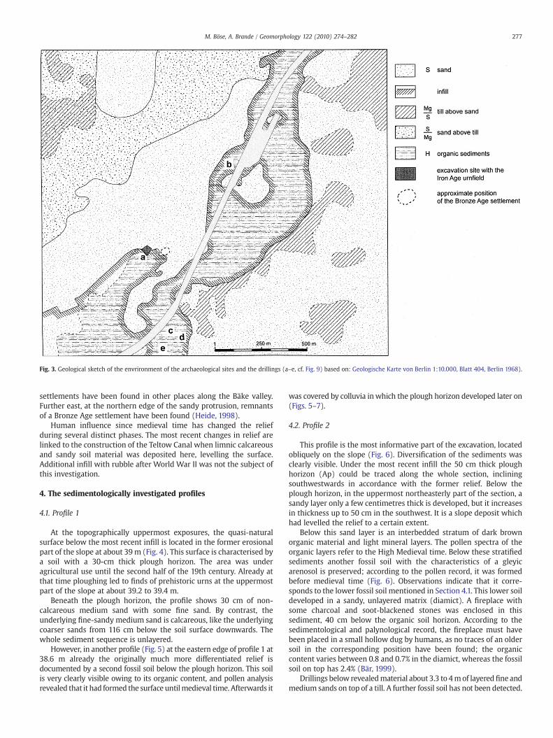
Fig. 3. Geological sketch of the envrironment of the archaeological sites and the drillings (a–e, cf. Fig. 9) based on: Geologische Karte von Berlin 1:10.000, Blatt 404, Berlin 1968).
277M. Böse, A. Brande / Geomorphology 122 (2010) 274–282
settlements have been found in other places along the Bäke valley.Further east, at the northern edge of the sandy protrusion, remnantsof a Bronze Age settlement have been found (Heide, 1998).
Human influence since medieval time has changed the reliefduring several distinct phases. The most recent changes in relief arelinked to the construction of the Teltow Canal when limnic calcareousand sandy soil material was deposited here, levelling the surface.Additional infill with rubble after World War II was not the subject ofthis investigation.
4. The sedimentologically investigated profiles
4.1. Profile 1
At the topographically uppermost exposures, the quasi-naturalsurface below the most recent infill is located in the former erosionalpart of the slope at about 39m (Fig. 4). This surface is characterised bya soil with a 30-cm thick plough horizon. The area was underagricultural use until the second half of the 19th century. Already atthat time ploughing led to finds of prehistoric urns at the uppermostpart of the slope at about 39.2 to 39.4 m.
Beneath the plough horizon, the profile shows 30 cm of non-calcareous medium sand with some fine sand. By contrast, theunderlying fine-sandy medium sand is calcareous, like the underlyingcoarser sands from 116 cm below the soil surface downwards. Thewhole sediment sequence is unlayered.
However, in another profile (Fig. 5) at the eastern edge of profile 1 at38.6 m already the originally much more differentiated relief isdocumented by a second fossil soil below the plough horizon. This soilis very clearly visible owing to its organic content, and pollen analysisrevealed that it had formed the surface untilmedieval time. Afterwards it
was covered by colluvia inwhich the plough horizon developed later on(Figs. 5–7).
4.2. Profile 2
This profile is the most informative part of the excavation, locatedobliquely on the slope (Fig. 6). Diversification of the sediments wasclearly visible. Under the most recent infill the 50 cm thick ploughhorizon (Ap) could be traced along the whole section, incliningsouthwestwards in accordance with the former relief. Below theplough horizon, in the uppermost northeasterly part of the section, asandy layer only a few centimetres thick is developed, but it increasesin thickness up to 50 cm in the southwest. It is a slope deposit whichhad levelled the relief to a certain extent.
Below this sand layer is an interbedded stratum of dark brownorganic material and light mineral layers. The pollen spectra of theorganic layers refer to the High Medieval time. Below these stratifiedsediments another fossil soil with the characteristics of a gleyicarenosol is preserved; according to the pollen record, it was formedbefore medieval time (Fig. 6). Observations indicate that it corre-sponds to the lower fossil soil mentioned in Section 4.1. This lower soildeveloped in a sandy, unlayered matrix (diamict). A fireplace withsome charcoal and soot-blackened stones was enclosed in thissediment, 40 cm below the organic soil horizon. According to thesedimentological and palynological record, the fireplace must havebeen placed in a small hollow dug by humans, as no traces of an oldersoil in the corresponding position have been found; the organiccontent varies between 0.8 and 0.7% in the diamict, whereas the fossilsoil on top has 2.4% (Bär, 1999).
Drillings below revealedmaterial about 3.3 to 4mof layeredfine andmedium sands on top of a till. A further fossil soil has not been detected.

Fig. 4. Former topography, prior to recent infill, of the excavation site and the situation of the described profiles (based on data from Peter Schöneburg) and sediment core a (pollenanalysis).
278 M. Böse, A. Brande / Geomorphology 122 (2010) 274–282
4.3. Profile 3
Profile 3 (Figs. 4 and 7) follows the inclination of the originalnatural surface from the till plain to the former bay of Teltower See.Interbedded organic andminerogenicmaterial as described abovewasalso found in this section, the individual layers increasing in thickness.
In the middle part of the section, the uppermost organic layers arepartly disturbed by protuberances of sand (Fig. 8). Those features arerelated either to more or less the synsedimentary disturbances by cattlein a wet environment or to the density compensation in saturatedmaterial during infilling.
Beneath this medieval sediment sequence and further downslopethe different layers merge into one, which is the Holocene soil formedup to the medieval time.
In the lowest position, the colluvium is underlain by an organicsequence which was formed in the wetlands of the Bäke valley:
• 5 cm of peat with medieval pollen spectra,• 5 cm of decomposed peat with silty fine sand. The material iscarbonised, free of pollen, and has been burnt,
• 10 cm of sand with few organic admixtures, possibly resedimentedduring the medieval time,
• 5 cm of sandy anmoor which was formed from Subboreal to OlderSubatlantic time. This was a phase with increased precipitation,reduced temperature and natural wetland-forming processes.
Older organic layers have not been found, but a till was identifiedat 32.5 m asl.
The adjacent part of profile 3 shows a 2 m broad disturbance by achannel-like structure filled with sands andmudswith shell remnants(Fig. 8). This disturbance represents the infill of fluvio-limnic materialas a result of the excavation of the Teltow Canal in the first decade ofthe 20th century. The material directly overlies the Holocene soil; allmedieval sediments have been removed.
5. Evaluation of the results
According to the interpretation of the previous drillings, the Bäkevalley follows a depression or valley originating in the PenultimateGlacial Stage, the Saalian glaciation. In some places, Eemian peat — a

Fig. 5. Profile 1. Below the post-WorldWar II infill lies the plough horizon (Ap) on top ofthe colluvial sands. These are underlain by the fossil Holocene soil (fAh), which formedthe surface until medieval time. The fireplace is embedded in a diamict of which apollen analytical sequence was taken at the left margin on the photo.
Fig. 7. Profile 3.The profile with remnants of the plough horizon under the artificialabrasional surface. Below the plough horizon is the medieval sand accumulation; belowthese sands lies the medieval peat horizon. In the background the artificial infill isvisible (details see Fig. 8).
279M. Böse, A. Brande / Geomorphology 122 (2010) 274–282
filling of the Last Interglacial — has been found (Brande, 1980; Pachurand Schulz, 1983; Böse, 1989). The Weichselian inland ice depositedfluvioglacial sands and a till cover but preserved themain features of thepreexisting relief. Subglacial meltwaters used the lowlying area, andduring the phase of downmelting, dead ice broke into the subglacialmeltwater channel, thus preserving the deepest parts during thesubaerial meltwater flow.
Permafrost and sparse vegetation characterised the landscape afterdownwasting of the glacier. The periglacial conditions favouredheavier surface runoff of snow meltwater and rainwater because
Fig. 6. Profile 2, detail. The 19th century plough horizon (Ap) is located below the 20th centuhorizon (fAh) was the Holocene surface until medieval time. This soil developed in a diami
infiltration was impeded by the sealing permafrost. In spring andsummer, the active layer was subjected to gelifluction due totemporary oversaturation. These processes are recorded in a corefrom the deepest part of the Bäke valley, where bedded sands, withlayers of coarse sand, pebbles and boulders (Pachur and Schulz, 1983),are evidence of a strong runoff.
The differentiated Late Glacial climate history was best preservedin the up-to-20-m thick limnic sediments in the adjacent bay ofTeltow Lake (Pachur and Schulz, 1983; Pachur and Röper, 1987). TheOldest Dryas (13800–13670 BP) is represented by a silty mud (Brandein: Pachur and Schulz, 1983, p. 56). During the following interstadialBölling-Alleröd complex (13670–12680 BP), including the Laachtephra (12880 BP) as a distinct marker horizon, the solution ofcarbonates in the glacial material increased, resulting in the deposi-tion of a calcareous mud. The Younger Dryas (12680–11590 BP) isdocumented by a silty mud owing to colder climatic conditions withincreased minerogenic transport from the slopes. The correspondingsediment at the excavated slope is considered to be the unbeddedsandy loamy layer with isolated cobbles (diamict).
ry infill, the interbedded stratum of medieval time being clearly visible. The fossil humicct, in which the fireplace is embedded.

Fig. 8. Profile 3, detail of Fig. 7.
Fig. 9. Sediment cores with pollen analytical dates. Site p
280 M. Böse, A. Brande / Geomorphology 122 (2010) 274–282
This development is confirmed by the palynological record of asediment sequence from the Siepegraben (Brande et al., 1990), 3.5 kmwest of the excavation area, a tributary depression to the Bäke valley.
The following Postglacial is characterised by calcareous mudswhich were formed up to the Older Atlantic, about 8000 BP. Somehorizons include detritus, which is attributed to the naturallychanging course of the Bäke creek. Traces of the pre-Neolithic landuseor settlements have not been identified in this area. Nevertheless theBronze Age and Iron Age settlements along the Bäke valley furthernorth of the excavation site (Heide, 1998), which are not located at alake shore, give evidence of the existence of the Bäke as a creek duringthe Holocene. Moreover, the Bäke valley has a continuous inclinationfrom the source to its mouth in the Griebnitz Lake of about 4 m. Thedeeper part of Teltow Lake remained an open water body throughoutthe Holocene until the construction of the Teltow Canal. Overgrowingpeat formation started due to the water depth from the early Atlanticto Subboreal time (Fig. 9, a–d), while on the margins of the valley
ositions see Figs. 3 and 4, b–e from Brande (1983).

281M. Böse, A. Brande / Geomorphology 122 (2010) 274–282
paludification took place only in the later Holocene (Fig. 9,e). Somepeat was dug until the 19th century, peat cuts being documented onold maps (Berlin-Steglitz und Umgebung 1850 (1969); GeologischeKarte von Preußen und benachbarten Bundesstaaten Blatt 44/36Teltow, 1910). Therefore the disturbance of the peat surface at theexcavation site cannot be excluded, and the surface does not representthe end of the peat growth. Both the 2 m of mud above the peat(Fig. 8) and the infill are young sediments related to the constructionactivities in the 20th century.
Near the excavation site, the peat growth started during theYounger Atlantic at about 7000 BP (Fig. 9, core a). During the time ofthe Iron Age burials, revealed in the excavation, this bay of the TeltowLake had already been overgrown by peat. It is strongly decomposedand therefore free of pollen, but belongs to the phase of thedocumented post-Neolithic landuse. However, this peat is free ofsand or silt, which in terms of landscape evolution means that neitherslopewash nor aeolian transport from the nearby area affected peatgrowth; the land surfacewas obviously stable at that time. It cannot beexcluded that the fireplace in profile 2 (Fig. 6) was installed during anongoing colluvial phase, but no ceramics, higher carbon content, orpollen have been found in this diamict, which is completely unlayeredin contrast to the younger colluvial sediments. Moreover, correspond-ing material did not reach the lakeshore between the Bronze and IronAge, as the drillings prove. Therefore the diamict has not beenclassified as a Neolithic to Bronze Age colluvium as observed about3 km NNE on the margin of the Bäke valley at a younger Bronze Agesettlement by Brande and Hühn (1988, p. 24) or by Schatz (2000,
Fig. 10. Idealised profile of the sediments of the slope from the edge of the Teltow til
p. 97) in a different archaeological site in NE Germany, or by Stahr et al.(1983) in a Holocene colluvium in Berlin. The onset of considerablemedieval impact has also been documented by Küster et al. (2008) inthe young morainic area of NE Germany. Differentiated erosionthrough time is presented by Dreibrodt and Bork (2006, p.126) fromthe Belauer See (lake) in North Germany. The times of increasingagricultural activity were distinguished by geochemical methods suchas potassium input into the lake, but little minerogenic material wastransported even during the Neolithic to Bronze Age. Only during theIron Agewas increased colluvial material deposited, but themaximumwas attained here also during medieval time.
These results support the hypothesis of a comparably low erosionrate in NE Germany during prehistoric time (Schatz, 2000, p.103). Thefireplace of the Bronze Age in profile 2 and some other fireplaces at theexcavation site are embedded in a sandy diamict. It is tentativelyinterpreted as Late Glacial gelifluction material, on top of which theHolocene soil has developed.
In summary, the sediment sequence at the archaeological excava-tion site (Fig. 10) comprises a basal layer of Weichselian tilldocumented in drillings, overlain by meltwater sands. On top ofthem is a periglacial diamict in which Holocene soil formation tookplace, predominantly undisturbed until medieval time. Local inter-ference such as fireplace digging during the Bronze Age and urn burialsin the Pre-Roman Iron Age was “healed” by a new soil formation inplaces with a direct lateral connection to the Holocene soil.
With the onset of High to Late Medieval German settlementsconnected with forest clearing, intensified agriculture, and the
l plain to the Bäke valley (concept by M. Böse, R. Bär, A. Brande and M. Müller).
282 M. Böse, A. Brande / Geomorphology 122 (2010) 274–282
construction of mills in the Bäke creek, two interacting processeschanged the environment: first, the rise of the water level in the creekand the groundwater level in the adjacent areas. A rise of the waterlevel during that time has been observed throughout Western andCentral Europe owing to the combination of climatic and humanimpact and fits in locally with the general medieval landscape changes(Bork et al., 1998, pp.185f, pp.221f). The floods provoked thesedimentation of the humic layers. The second process is related tothe slope by erosion, transport and sedimentation of light colouredminerogenic materials. This new surface later became more stableagain and was used for agriculture before being covered by recentinfill.
6. Conclusions
High to Late Medieval German influence in the Berlin area not onlygenerated considerable processes in the Bäke valley but could also bedetected in various places. Rising groundwater levels mainly related towater mills are known at various places in the Havel river system(Böse, 2002; Brande, 1988; Driescher, 2003). Forest clearing on the tillplains, which had been almost free of settlements and agricultureduring the preceding Slavic time, enhanced erosional processes byslopewash, resulting in the formation of small valleys and correspond-ing alluvial fans. On the other hand, wind blown material has played aconsiderable part in landscape changes: cover sands, sand coveringpeat bogs, and even dune formation transformed the relief in higher,edaphically dry positions (Böse and Brande, 1986, 2000; Böse, 2002;Böse et al., 2002). Thus the results from the archaeological excavationsite can be seen in a broader context of relief changes as consequencesof extension and variation of landuse processes in medieval time.
Acknowledgements
Thomas Hauptmann, the head of the archaeological excavation,and Peter Schöneburg enabled us to conduct the field studiesaccompanying the archaeological investigations and gave detailedinformation as well as documents helpful for our interpretation.Marion Müller and Rainer Bär contributed with their field work, grainsize analyses and discussions of the results presented here.
References
Bär, R., 1999. Die Landschaftsgenese des glazial angelegten Bäketales und ihreRahmenbereiche unter Einbeziehung der Siedlungsgeschichte von der Bronzezeitbis zumMittelalter.— Diplomarbeit am Institut für Geographische Wissenschaften,FR Physische Geographie, Freie Universität Berlin; Berlin.
Bär, R., Böse, M., 1998. Geowissenschaftliche Begleituntersuchung zur archäologischenGrabung Goerzallee/Wismarer Str. (Areal 3.1 und 3.2). - Im Auftrag des Land-esdenkmalamtes Berlin, Abt. Archäologische Denkmalpflege, Berlin.
Baugrund- und Gründungsgutachten, 1997. Zum Neubau einer Wohnanlage Goerzallee/Ortlerweg/Wismarerstr., Berlin-Steglitz; Bearbeitet vonDr.-Ing. Elmiger undDipl.-Ing.Gerlach, Berlin.
Böse, M., 1989. Methodisch-stratigraphische Studien und paläomorphologischeUntersuchungen zum Pleistozän südlich der Ostsee. Berliner GeographischeAbhandlungen, vol. 51. Berlin.
Böse, M., 1995. Problems of dead ice and ground ice in the central part of the NorthEuropean Plain. Quaternary International 28, 123–125.
Böse, M., 2002. Sumpf und Dünen – Mittelalterliche Landschaftsveränderungen imBerlin-Potsdamer Raum. Terra Nostra, Mensch – Klima – Landschaft, vol. 2002/6,pp. 46–50.
Böse, M., Brande, A., 1986. Zur Entwicklungsgeschichte des Moores “Alter Hof” amHavelufer (Berliner Forst Düppel). In: Ribbe, W. (Ed.), Berlin-Forschungen, vol. 1,pp. 11–42. Berlin.
Böse, M., Brande, A., 2000. Regional Pattern of Holocene Sand Transport in the Berlin-Brandenburg Area. – In: Dulias, R. & Pelka-Gosciniak, J. (Eds.), Aeolian Processes in
Different Landscape Zones. – University of Silesia, Faculty of Earth Sciences &Association of Polish Geomorphologists, Sosnowiec, pp. 51–58.
Böse, M., Müller, M., Brande, A., Facklam, M., 2002. Jungdünenentwicklung undSiedlungsgeschichte auf der Glindower Platte (Brandenburg). BrandenburgischeGeowissenschaftliche Beiträge 9 (1/2), Kleinmachnow, pp. 45–57.
Bork, H.-R., Bork, H., Dalchow, C., Faust, B., Piorr, H.-P., Schatz, Th, 1998. Land-schaftsentwicklung in Mitteleuropa, Gotha/Stuttgart.
Brande, A., 1980. Die palynologische Erforschung des Quartärs in Berlin (West). ActaBotanica Academiae Scientiarum Hungaricae 26 (1–2), 55–60.
Brande, A., 1983. Pollenanalytische Datierungen von Sedimentfolgen des Bäketals imLSG 27 (Lichterfelde Süd). Im Auftr. des Bezirksamts Berlin-Steglitz (Garten-bauamt), vervielfältigt, Berlin, 3 p.,1 fig.
Brande, A., 1985. Mittelalterlich-neuzeitliche Vegetationsentwicklung am KrummenFenn in Berlin-Zehlendorf. Verhandlungen des Berliner Botanischen Vereins 4,3–65.
Brande, A., 1988. Das Bollenfenn in Berlin-Tegel. Telma 18, 95–135.Brande, A., 1996. Type Region Ds, Berlin. In: Berglund, B.E., Birks, H.J.B., Ralska–
Jasiewiczowa, M., Wright, H.E. (Eds.), Palaeoecological Events During the Last15000 Years: Regional Syntheses of Palaeoecological Studies of Lakes and Mires inEurope. InWiley, Chichester, New York, pp. 518–523.
Brande, A., Hühn, B., 1988. Zur ehemaligen Moorvegetation auf dem Teltow in Berlin(West). Verhandlungen Berliner Botanischer Verein 6, 13–39.
Brande, A., Hoelzmann, Ph., Klawitter, J., 1990. Genese und Paläoökologie einesbrandenburgischen Kesselmoores. Telma 20, 27–54.
Dreibrodt, St., Bork, H.-R., 2006. See-Geheimnisse: das Geschichtsbuch unter demBelauer See (Schleswig-Holstein). In: Bork, H.-R. (Ed.), Landschaften der Erde unterdem Einfluss des Menschen, Darmstadt, pp. 121–128.
Driescher, E., 2003. Veränderungen in Gewässern Brandenburgs in historischer Zeit.Studien und Tagungsberichte/Landesumweltamt Brandenburg, vol. 47. 144 pp.
Hauptmann, Th., Schöneburg, P., 1998. Eisenzeitliche Gräber. Archäologie in Deutsch-land 15 (1), 37–38.
Heide, B. (Ed.), 1998. Spuren der Vorzeit. Archäologie im Bezirk Steglitz. 84 pp., Berlin.Küster, M., Janke, W., Lampe, R., Lorenz, S., Meyer, H., Naumann, M., 2008. Rekonstruk-
tion holozäner Bodenerosion anhand von Kolluvien, Flugsanden und Seesedimen-ten im Sander des Pommerschen Stadiums (NO-Deutschand). – Abhandlungen dergeologischen Bundesanstalt 62, 173–177.
Litt, Th., Brauer, A., Goslar, T., Merkt, J., Bałaga, K., Müller, H., Ralska-Jasiewiczowa, M.,Stebich, M., Negendank, J.F.W., 2001. Correlation and synchronisation of Late Glacialcontinental sequences in northern central Europe based on annually laminatedlacustrine sediments. Quaternary Science Reviews 20 (11), 1233–1249.
Pachur, H.-J., Röper, H.-P., 1987. Zur Paläolimnologie Berlin Seen. Berliner GeographischeAbhandlungen, vol. 44.
Pachur, H.-J., Schulz, G., 1983. Erläuterungen zur Geomorphologischen Karte 1: 25.000der Bundesrepublik Deutschland, GMK Blatt, vol. 13. 3545 Berlin-Zehlendorf.
Rach, H.-J., 1988. Die Dörfer in Berlin, Berlin.Schatz, Th, 2000. Untersuchungen zur holozänen Landschaftsentwicklung Nordost-
deutschlands. ZALF-Bericht Nr, vol. 41.Stahr, K., Böse, M., Brande, A., Gudmundsson, Th., Launhardt, M., 1983. Die Entstehung
und Entwicklung des Lolopfuhls in Berlin-Rudow. - Sitzungsberichte derGesellschaft Naturforschender Freunde zu Berlin NF 23, 95–150.
Wagner, K. 2000. Neuentdeckte jungbronzezeitliche Siedlung in Berlin-Lichterfelde,Bezirk Steglitz. Miscellanea Archaeologica (Festband A. von Müller), pp. 42–70,Berlin.
Maps
Berlin-Steglitz und Umgebung 1850, Maßstab 1:10.000. Ausschnittsvergrößerung derTopographischen Karte 1:50.000; Hrsg.: Bezirksamt Steglitz zum 75-jährigenBestehen des Vermessungsamtes, Berlin 1969.
Geologische Karte von Berlin 1:10.000, Blatt 404, Hrsg.: Der Senator für Bau undWohnungswesen, Berlin 1968.
Geologische Karte von Preußen und benachbarten Bundesstaaten 1:25.000. BlattTeltow, 44/36 Teltow; Geognostisch und agronomisch bearbeitet durch K. Keilhack1907–1908, Lieferung 20, 2. Auflage. Hrsg.: Königliche Preußische geologischeLandesanstalt, Berlin 1910.
Geologische Übersichtskarte von Berlin (West) 1:50.000; Hrsg.: Der Senator für Bauund Wohnungswesen, Berlin 1971.
Geomorphologische Karte der Bundesrepublik Deutschland 1:25.000. GMK Blatt 13,3545 Berlin-Zehlendorf; Hrsg.: Barsch, D., Fränzle, H., Liedtke, H. und Stäblein, G.,GMK - Schwerpunktprogramm der Deutschen Forschungsgemeinschaft, Berlin1983.
Preußische Kartenaufnahme 1:25.000 – Uraufnahme (neu 3545 Teltow), Emphingerund Wolff, Berlin 1831.
Preußische Kartenaufnahme 1:25.000 – Aufnahme (neu 3545 Teltow), Emphinger undWolff 1831, rev. durch Maull, Berlin 1835.