landscape heritage study - georgesriver.nsw.gov.au€¦ · the landscape heritage study was...
TRANSCRIPT
LANDSCAPE HERITAGE STUDY
for
CARSS BUSH PARK (including Todd Park)
Prepared for Kogarah Council
by Mayne-Wilson & Associates
Paddington NSW 2021
February 2002 Updated 2004

Carss Bush Park Landscape Heritage Study
Mayne-Wilson & Associates Conservation Landscape Architects
Executive Summary This Study was commissioned by Kogarah Council to identify and assess those precincts and items within Carss Bush Park and Todd Park which have heritage significance; to address the constraints and opportunities present; and to provide advice for Council officers on future conservation, management and maintenance measures to preserve their heritage values.
Carss Bush Park was created on land granted to Jonathon Croft in 1853 and subsequently purchased by William Carss (cabinet maker turned publican) in 1863. Carss had a sandstone cottage built on the headland of Kogarah Bay and later acquired additional land around it. At Carss’ request, his daughter bequeathed the property after her death to the Sydney Sailors Home, from which it was purchased by Kogarah Council in 1924 in response to community pressures.
The Council subdivided the estate into areas for parkland and a residential ‘garden suburb’, being the first local government in NSW to do so. The parkland contained 10 acres of bushland on the slopes and flats below the ridgetop suburb, and included the foreshores of Kogarah Bay.
Harald Coxhead was appointed the first Park Ranger in 1924, a position he held for almost 30 years, during which time he instigated the construction of many of the sandstone elements and some of the plantings which have heritage value today.
Carr’s cottage, his vault and a small curtilage were heritage-listed in 1987 and protected by a PCO in 1988. However, no other elements in the park were assessed or listed. The cottage is now the headquarters of the Kogarah Historical Society.
Todd Park was established on marshy land to the south, at the head of a small creek that began near Blakehurst, and was long used for market gardens. The land was acquired by Council in the late 1950s and named after a prominent Councillor, Mr W. Todd, who had supported the development of parks. The park land was not part of Carss Bush Park and has no heritage significance.
Carss Bush Park has historical and social significance both as part of the grounds of a mid 19th century private estate and as a regionally important public open space serving a wide community catchment since the mid-1920s. The Park supports a wide range of public recreation and sporting facilities and especially between the 1920s and 1950s was a popular space for large community events, including fetes, concerts and gala days. Its social significance is reinforced by many of its elements having been built and articulated largely by local labour provided under the Unemployment Emergency Relief Scheme during the Depression years.
Its aesthetic significance derives from its setting on the edge of Kogarah Bay, its distinctive framing by the bushland belt to its west, and the excellent views over the Bay gained from the bushland escarpment.
The majority of the park’s built landscape elements are essentially intact and the sandstone walls, pathways and benches contribute substantially to its cultural significance.
The remnant bushland, pre-dating European settlement, is a key landscape unit, with important natural heritage values, and is in fair to good condition. The subsequent cultural plantings complement the remnant vegetation and enhance the appearance of the park.

Carss Bush Park Landscape Heritage Study
Mayne-Wilson & Associates Conservation Landscape Architects
Because Carss Bush Park is a listed heritage place, Council officers managing it are required to adopt management practices derived from the Burra Charter, the NSW Heritage Act, and the Heritage Office’s Manual for the protection and conservation of heritage items and places. Not all elements or precincts within the Park have heritage value, nor the same degree of value. However, although some items have only low heritage value in themselves, collectively they contribute to the overall significance rating of each precinct, and therefore warrant retention, conservation and good maintenance. An illustrated checklist is provided in this report, stating the value of each element and precinct, as well as the action required to conserve and maintain it. It is recommended that the whole Park, with its identified heritage components and native bushland, be formally listed in Council’s LEP. The bushland requires continuing regeneration measures and protection, particularly from illegal cutting of trees and bushes at its interface with residential dwellings on the ridge. This requires continuing education and surveillance measures, and firm prosecution of those responsible. For mature, non-indigenous trees that were deliberate cultural plantings made by persons associated with the early establishment of the park, it is recommended that they be listed on a Significant Tree Register, either individually or in groups. It is recommended that a high quality landscape masterplan be prepared for the re-design of the playing field areas of Carss and Todd Parks, as well as of the environs of the swimming pool, in order to enhance and upgrade their interface with both the adjacent heritage-value precincts and neighbouring residential areas. Finally, this report should be read in conjunction with the Plan of Management for the two parks, to which it is attached. Action taken by Council officers in accordance with the Plan of Management should also take into account the guidelines and recommendations contained in this report.

Carss Bush Park Landscape Heritage Study
Mayne-Wilson & Associates Conservation Landscape Architects
TABLE OF CONTENTS Page no.
1.0 Background 1 1.1 Aims and Scope 1 1.2 The Study Area 1 1.3 Report Structure 1 1.4 Methodology 1 1.5 Authorship 2 1.6 Report Limitations 3 1.7 Acknowledgements 3
2.0 Historical Overview 3 2.1 Carss Cottage 13 2.2 Carss Bush 16
2.3 Todd Park 17 2.4 Development and Improvement of Carss Park 19 3.0 Site Description and Analysis 34 3.1 The Setting and Context 34 3.2 The Precincts – Physical Description 36
4.0 Heritage Significance 41 4.1 Basis of Assessment of Heritage Significance 41 4.1.1 Nature of Significance Criteria 41 4.2 Statement of Significance 42 4.2.1 Historical Themes 42 4.2.2 Nature of Significance 42 4.2.2.1 Assessment according to each SHI criterion 42 4.3 Heritage Significance of each Precinct – General 44 4.3.1 Items of Heritage Significance within each precinct 45 4.4 Items of little or no heritage significance 45
5.0 Management Considerations 64 5.1 Relevant Conservation Issues 64 5.1.1 Council’s Requirements 64 5.2 Constraints 65 5.3 Opportunities 65 5.4 Heritage Provisions 66 5.5 Statutory Requirements 66 5.5.1 The NSW Heritage Act, 1977 66 5.5.2 Kogarah LEP 1998 68 5.5.3 Plan of Management 70 5.6 Non-statutory heritage measures 70 5.6.1 The Burra Charter 70 5.6.2 National Trust of Australia (NSW) 71 5.7 Overlapping or Related Issues 71 5.7.1 Bush Regeneration 71 5.7.2 Significant tree register 71

Carss Bush Park Landscape Heritage Study
Mayne-Wilson & Associates Conservation Landscape Architects
6.0 Conservation Policies 72 6.1 Findings from the Statement of Significance 72 6.2 Conservation policies for precincts 72 6.3 Setting and visual relationships 74 6.4 Curtilages 74 7.0 Management Policies 75 7.1 General measures to manage and conserve heritage items 75 7.2 General guidelines for maintenance 75 7.3 Detailed proposals for items in each precinct 76 8.0 Interpretation 76
Appendix A – Heritage provisions of Kogarah LEP 1998 Appendix B – Burra Charter flowchart
Carss Bush Park Landscape Heritage Study
Mayne-Wilson & Associates 1 Conservation Landscape Architects
1.0 Background This Landscape Heritage Study of Carss Bush Park and Todd Park, which abut Kogarah Bay at Blakehurst, was prepared at the request of Kogarah Council. In September 2001, Council engaged Mayne-Wilson & Associates (MWA), Conservation Landscape Architects of Paddington, to undertake the task. MWA had previously undertaken a heritage study of the H.V. Evatt Memorial Park for Council in June 2000. 1.1 Aims and Scope The Landscape Heritage Study was commissioned to:
i identify and assess those items within the parks (including the bushland) deemed to have heritage significance;
ii identify the constraints and opportunities for the various park precincts and advise on possible conservation, future management, and interpretation of the ‘fabric’ within the park that contributes to its cultural significance;
iii make recommendations on the management of other park assets deemed not to have heritage significance.
1.2 The Study Area Carss Bush Park, Todd Park and the extensive playing fields to the north of the Carss Park Swimming Pool complex form a comprehensive open space network along the western edge of Kogarah Bay. The study area for this project, seen in Fig. 1, includes the above mentioned parks and playing fields, the headland on which Carss Cottage stands (i.e. Carss Point), the tidal baths to the south of the cottage, and the bushland strip abutting Gnarbo Avenue.1 1.3 Report Structure The report provides the history, past uses, setting and context of Carss and Todd Parks. It then describes and analyses the main physical characteristics of the site, including the existing bushland framing it on the west. The report then assesses the significance of the site, and its various precincts and their component elements, before addressing the major conservation issues and making conservation and planning recommendations for the parks’ various precincts. 1.4 Methodology The consultants were first briefed by Council officers Gary Eastman (Open Space Coordinator Planning) and Anthony Fabbro (Senior Planner), who outlined Council’s requirements for the production of this document and for future planning for the park sites. MWA then undertook detailed research on the creation and development of the Park. Once completed, this formed a useful basis for understanding and interpreting the present configuration of the park and its landscape features. The consultants photographically recorded all essential components of the park system, making specific proposals for the boundaries of distinctive precincts within it. Having collected all necessary historical information and contemporary site data, the consultants analysed it and identified the key themes and periods in the development of the parks. This formed the basis for the assessment of the heritage value of the various precincts and their component elements, and for formulating planning recommendations for the future conservation and management of heritage items and precincts.
1 It does not include the Parkside Drive Reserve (formerly Charles Pirie Reserve) nor Harold Fraser Oval, which were included in the 1998 Plan of Management.

Carss Bush Park Landscape Heritage Study
Mayne-Wilson & Associates 2 Conservation Landscape Architects
1.5 Authorship This report was prepared by Warwick Mayne-Wilson (Director of Mayne-Wilson & Associates), with the assistance of Ari Anderson, landscape architect in MWA, who undertook historical research, site recording and report drafting.
Fig. 1 Location Plan – Carss Bush Park and Todd Park.
Carss Bush Park Landscape Heritage Study
Mayne-Wilson & Associates 3 Conservation Landscape Architects
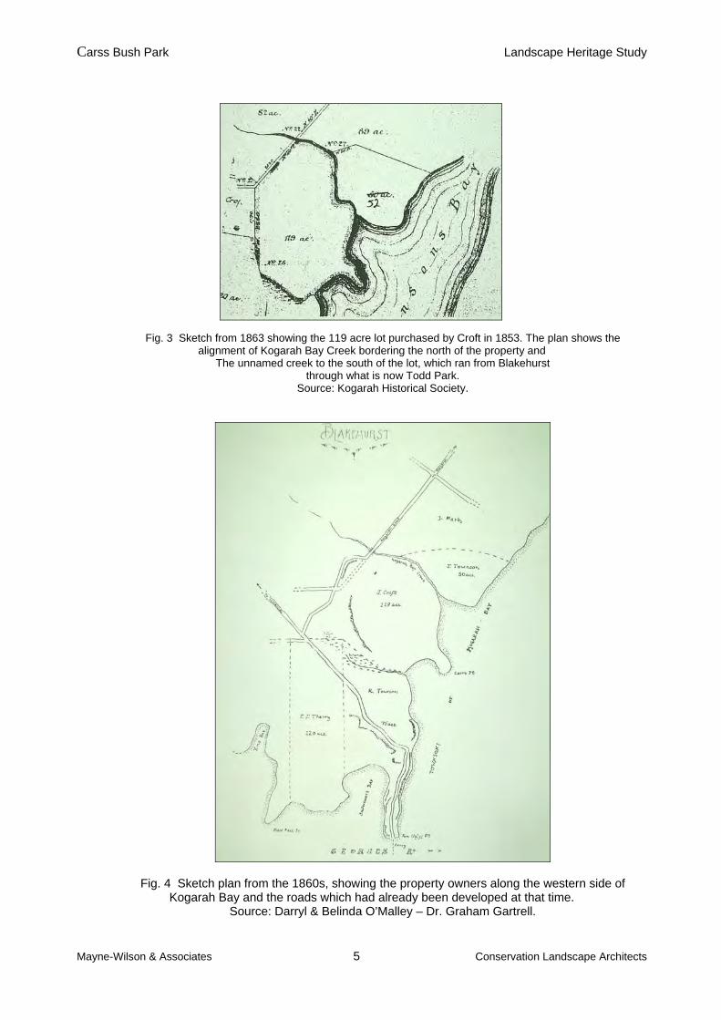
1.6 Report Limitations In the preparation of this study, the consultant’s historical research was limited by the unavailability of Council files from the period of the purchase of the parkland by the Council in 1923 until the 1950s. Council files dating from the early 1920s to the mid-1930s are believed to have been destroyed. However, Council was able to make available Minute Books from 1920 to 1930, which were reviewed by the consultant. Kogarah Local Studies Library was able to provide several useful historic photographs and some background information on the parks although their Carss Park collection is limited. The majority of the historical material about the site has been kindly made available by the Kogarah Historical Society whose members have gathered it over the years from many sources. However, there are still gaps in our knowledge, particularly regarding the date of construction of some park elements and also that of the acquisition and development of Todd Park. 1.7 Acknowledgements The authors would like to acknowledge the assistance of Council officers Gary Eastman and Anthony Fabbro, Kogarah Library local studies librarian Alison Grellis, Council records manager Sandra McLean, the secretary of the Kogarah Historical Society, Dr. Joan Hatton and the former Mayor of Kogarah, Mr. Ken Cavanough. 2.0 Historical Overview Kogarah was said to mean ’place of rushes’ to the first inhabitants of the area – the Cadigal Aboriginal clan, members of the Dharuk language group. The Aboriginal community of the Georges River area was severely dislocated and then decimated by European settlement, although limited records have suggested that Aborigines continued to live in distinct groups along the Georges River until late into the 19th century. Following European settlement, Kogarah’s main industry was lime burning and timber-getting from the turpentine ironbark forests that covered much of the area, followed later in the 19th century by market gardening and orcharding. By the 1860s and 1870s, a small village existed at Kogarah and churches and schools were being established. With the opening of the Illawarra Railway Line in 1884 and the Sans Souci steam tram line in 1887, the district began to develop rapidly into a residential suburb, early land speculation having boomed there during the 1870s. By 1885, the population of Kogarah had reached the minimum of 1,100 needed for a settlement to have its own Council. Accordingly, the Municipality of Kogarah was proclaimed on the 23rd December 1885. Between 1891 and 1901, the population of Kogarah increased from 2,328 to 3,892 and by the early 1930s, approximately 85 per cent of all land capable of subdivision had been subdivided. By 1960, Kogarah’s population had stabilized at around 45,000, its municipal boundaries being the Illawarra Railway Line, Georges River, Rocky Point Road, Princes Highway and Harrow Road. Within those boundaries lies the suburb of Carss Park. The land on which the suburb of Carss Park and Carss Bush Park are now located was a lot of 119 acres, Portion No. 26, in the Parish of St. George purchased by Jonathon Croft on 28 January 1853. Plans showing the extent of the property and its relationship to surrounding land holdings between the 1830s and the 1860s are seen in Figs. 2, 3 & 4. It was bounded on the north by Kogarah Bay Creek, on the west by Kogarah Road, on the south by unnamed creek which flowed into Kogarah Bay, and on the east by Kogarah Bay.

Carss Bush Park Landscape Heritage Study
Mayne-Wilson & Associates 4 Conservation Landscape Architects
Fig. 2 Parish Map of c.1835 showing in green the area of land which was to be purchased by Croft in 1853. Source: Tropman & Tropman Architects, Kogarah Heritage Study, 1994.
Carss Bush Park Landscape Heritage Study
Mayne-Wilson & Associates 5 Conservation Landscape Architects
Fig. 3 Sketch from 1863 showing the 119 acre lot purchased by Croft in 1853. The plan shows the alignment of Kogarah Bay Creek bordering the north of the property and
The unnamed creek to the south of the lot, which ran from Blakehurst through what is now Todd Park.
Source: Kogarah Historical Society.
Fig. 4 Sketch plan from the 1860s, showing the property owners along the western side of Kogarah Bay and the roads which had already been developed at that time.
Source: Darryl & Belinda O’Malley – Dr. Graham Gartrell.
Carss Bush Park Landscape Heritage Study
Mayne-Wilson & Associates 6 Conservation Landscape Architects
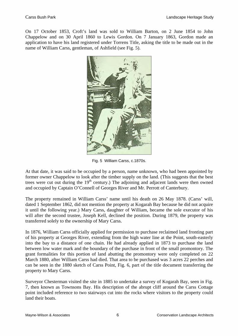
On 17 October 1853, Croft’s land was sold to William Barton, on 2 June 1854 to John Chappelow and on 30 April 1860 to Lewis Gordon. On 7 January 1863, Gordon made an application to have his land registered under Torrens Title, asking the title to be made out in the name of William Carss, gentleman, of Ashfield (see Fig. 5).
Fig. 5 William Carss, c.1870s. At that date, it was said to be occupied by a person, name unknown, who had been appointed by former owner Chappelow to look after the timber supply on the land. (This suggests that the best trees were cut out during the 19th century.) The adjoining and adjacent lands were then owned and occupied by Captain O’Connell of Georges River and Mr. Perrott of Canterbury. The property remained in William Carss’ name until his death on 26 May 1878. (Carss’ will, dated 1 September 1862, did not mention the property at Kogarah Bay because he did not acquire it until the following year.) Mary Carss, daughter of William, became the sole executor of his will after the second trustee, Joseph Kell, declined the position. During 1879, the property was transferred solely to the ownership of Mary Carss. In 1876, William Carss officially applied for permission to purchase reclaimed land fronting part of his property at Georges River, extending from the high water line at the Point, south-easterly into the bay to a distance of one chain. He had already applied in 1873 to purchase the land between low water mark and the boundary of the purchase in front of the small promontory. The grant formalities for this portion of land abutting the promontory were only completed on 22 March 1880, after William Carss had died. That area to be purchased was 3 acres 22 perches and can be seen in the 1880 sketch of Carss Point, Fig. 6, part of the title document transferring the property to Mary Carss. Surveyor Chesterman visited the site in 1885 to undertake a survey of Kogarah Bay, seen in Fig. 7, then known as Townsons Bay. His description of the abrupt cliff around the Carss Cottage point included reference to two stairways cut into the rocks where visitors to the property could land their boats.

Carss Bush Park Landscape Heritage Study
Mayne-Wilson & Associates 7 Conservation Landscape Architects
Fig. 6 Survey of the Carss Estate point from 1880, when the property was transferred to Mary Carss. Note that the plan includes the portion of the land around the point
reclaimed by the Carss family, following government authorization during 1880. Source: Kogarah Historical Society.
Fig. 7 The 1880s sketch of the Carss Cottage property by Surveyor Chesterman. Note the location of the original sundial off the south-eastern façade of the building and the steps down the cliff from the southern and northern ends of the point (both
of which have largely disappeared). Source: Kogarah Historical Society.

Carss Bush Park Landscape Heritage Study
Mayne-Wilson & Associates 8 Conservation Landscape Architects
By 1903, the Carss Estate was one of the few remaining grants that retained its original proportions, most of the others being subdivided to meet the needs of the rapidly expanding population. The property is indicated in green on an original grant/subdivision overlay map, seen in Fig. 8.
Mary Carss made her will in 1897, and died in 1916, being survived by her brother James. Her sister Annie had died in 1915. Mary stated that after her brother’s death, the Carss property was to be released to the Trustees or Directors of “The Sydney Sailors’ Home” for use and benefit of that institution on the conditions that William Carss vault be maintained and that the property be called “The Anchorage”. Two acres of the land were to be selected by the United Presbyterian Church of New South Wales.
The above transfers of land occurred in 1921, following the death of James Carss in 1917. Also arranged was the transfer on 28 December 1923 of the 3 roods 22 perches bought by the Carss family to extend their Kogarah Bay land holding in 1880. It was transferred to The Council of the Municipality of Kogarah for 25 pounds and appears to be the first portion of land under the ownership of Council within this stretch of the Kogarah Bay foreshore.
Local residents were aware that the Sydney Sailors’ Home was planning to put the estate on the market and began to exert pressure on Council to buy the estate. During this period, Amelia Claggett (who was married to James Carss), remained in Carss Cottage. Kogarah Council did take steps to acquire the estate as a public park, starting in 1919, when the local member Mr. T. J. Ley made representations to the Minister for Lands for funds to aid the purchase. The government, however, was unable to provide funds and the matter remained on the drawing board.
Harald Coxhead, from Cleveland Street, Sydney, was at this date living in nearby Blakehurst with his wife Amy Sieben. They became prominent leaders in the fight to ensure the longevity of Carss estate as a public space, initially by enlisting broad support from his Blakehurst neighbours. Harald Coxhead’s community efforts resulted in the formation of the Blakehurst Progress Association in April 1921, to which Coxhead was elected secretary.
Initial efforts by the Progress Association in meetings with local members of State Parliament proved fruitless, with the Minister for Lands placing responsibility for the purchase of the land for public amenity in the lap of Kogarah Council. During 1922, Kogarah Council held a special meeting with a deputation from the Blakehurst Progress Association to consider options for the purchase of the Carss estate. A committee representing Council and the Progress Association was formed to go into negotiations with the Sydney Sailors’ Home, the trustees of the estate.
The years between 1917, when James Carss died, and 1923, when Council finally secured the Carss Estate, was a tumultuous period in the history of this much sought after land. The intent by private consortiums to develop the whole site was recognized by local progress associations soon after the transfer of the Estate to The Sydney Sailors’ Home. Public sentiment for the retention of the Estate as public open space was widespread, exemplified by a letter to the town clerk of Kogarah Council on 28th March 1922 by architect John Sulman (section 2.4 below)
However, even though early intentions were good, Council had gradually lost interest in the proposal by late 1922. Accordingly, in a bold move to ensure the outcome sought by the Progress Association, the latter put up their own candidate in the December 1922 Council elections. The candidate was elected as were two candidates from other progress associations. These new members steered Council into direct negotiations for the purchase of the parklands, stating that resuming a bush park would not financially interfere with other Council public works projects.

Carss Bush Park Landscape Heritage Study
Mayne-Wilson & Associates 9 Conservation Landscape Architects
Fig. 8 A 1903 original grant/subdivision overlay map, showing the Croft grant in green.
On 30 April 1923, the committee in charge of the negotiations reported to Council that the deliberations with the Sydney Sailors’ Home had been completed and that the land would be passed into Council ownership for £12000. It was considered that Council would be able to keep the bulk of the land as a bush park for public purposes while recouping its initial outlay by subdividing and selling parts not required for open space needs. In this way, we see the first instance where a local government obtained a park without cost to the community. Council minutes from 28th May 1923 show receipt of a letter from the Blakehurst Progress Association complimenting Council on the acquisition of Carss Bush. Mr. C.J. Monro of Sutherland, visiting Council for other business, offered to assist Council in the subdivision process as a salesman, whenever lots were to be auctioned off. This service he provided free of charge.
Carss Bush Park Landscape Heritage Study
Mayne-Wilson & Associates 10 Conservation Landscape Architects
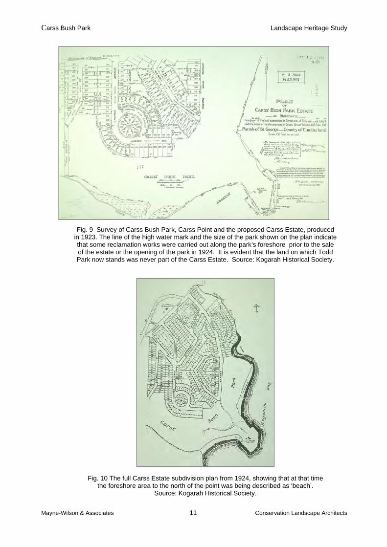
Harald Coxhead was given much of the credit for the success of the project, being the driving force that generated the community groundswell of support. On Boxing Day 1923, the picnic area was opened to the public and at the same time a Park Committee was formed to supervise the lands. The extent of Carss Bush Park and the proposed estate subdivision in 1923 and 1924 can be seen in Figs. 9 & 10. 26th January 1924 marked the opening and dedication of “nature’s beautiful waterside reserve”. An advertisement for the opening celebrations can be seen in Fig. 11. The opening ceremony for the dedication of the approximately 50 acre public park was performed by the local member, Mr. T. J. Ley. This was followed by the auction of 374 homesites by Councillor Joe Monro. In the minutes of Kogarah Council from 4 February 1924, it was stated that 294 lots were sold for £33,800 pounds, therefore providing Council with a £16000 profit. Another auction sale was held on the 25th October 1924 for the remaining 83 lots. The grand gateway into the estate and a photograph of the construction of roads through the subdivision are shown in Figs. 12 & 13 respectively. One interesting aspect of the residential subdivision of Carss Park was the way that Council paid particular attention to the uneven nature of the estate and planned its streets and lot configuration accordingly. It is one of the earliest examples of the creation of a road network through a new residential area that took topographical constraints into account, with Council not suggesting the development of grid system. It was no doubt influenced by proponents of the ‘garden suburb’ movement such as John Sulman, and those who formed the estates of Daceyville and Haberfield. On the 27th September 1926, Council responded to a request for financial expenditure details regarding Carss Park made by the Carss Bush Ratepayers Improvement League. They had requested details of what percentage of the profit generated by Council through the sale of the Estate subdivisions would be expended on the park. Council’s reply indicated that such information was unavailable and that the timing and value of park improvements was to be reviewed from ‘time to time’. Between 1923 and 1926 considerable works to the estate were carried out. With the onset of the Great Depression, many of the land sales of 1924 fell through, and it took many years to sell off the entire estate, with some blocks only sold in 1961. However, the residential suburb of Carss Park is a rare example of a garden suburb developed by a Council during the interwar years.
Carss Bush Park Landscape Heritage Study
Mayne-Wilson & Associates 11 Conservation Landscape Architects
Fig. 9 Survey of Carss Bush Park, Carss Point and the proposed Carss Estate, produced in 1923. The line of the high water mark and the size of the park shown on the plan indicate that some reclamation works were carried out along the park’s foreshore prior to the sale of the estate or the opening of the park in 1924. It is evident that the land on which Todd Park now stands was never part of the Carss Estate. Source: Kogarah Historical Society.
Fig. 10 The full Carss Estate subdivision plan from 1924, showing that at that time the foreshore area to the north of the point was being described as ‘beach’.
Source: Kogarah Historical Society.

Carss Bush Park Landscape Heritage Study
Mayne-Wilson & Associates 12 Conservation Landscape Architects
Fig.11 Copy of an advertisement for the opening of Carss Bush Park in 1924. Source: Kogarah Historical Society.
Fig. 12 The gateway into Carss Estate prior to the first sales of the land subdivision in 1924. Source: Kogarah Historical Society.

Carss Bush Park Landscape Heritage Study
Mayne-Wilson & Associates 13 Conservation Landscape Architects
Fig. 13 The construction of roads through the Carss Estate during 1923. Note that there had obviously been substantial timber getting from it prior to that time. Source: Kogarah Historical Society.
2.1 Carss Cottage Carss Cottage, presumed to have been built for William Carss, is a mid-Victorian single storey stone cottage, now reputed to be the oldest building in the municipality and rare in this part of Sydney. Records indicate that William Carss and his family lived in the Kogarah area from c.1864, possibly at Carss Cottage. (The property’s Certificate of Title held by Carss is from April 1863. Between 1855 and 1863, Carss lived in various suburbs, including Balmain, the city, Liverpool and Burwood. A codicil to his will dated 1865 is from Kogarah, Georges River.) The first record of the Carss Cottage and its outbuildings were on a plan by Surveyor Chesterman in 1885 (see fig.7), although it is believed to have been built by December 1865. The plan showed the position of the house and yard buildings in relation to Carss Point and indicated positions of fences at the rear of the block. The gardens around the house included a stone sundial in front of the residence. Two stone stairways and paved areas are also shown. The house, which was originally named The Anchorage by the Carss family, is reputed to have been constructed by the Scottish stonemasons who had been employed in the construction of Edmund Blacket’s University of Sydney buildings. The stone for the house was reputedly quarried from a huge rock lying within or near the current roundabout at the end of Carwar Avenue. As a skilled cabinet-maker and carpenter, no doubt Carss had good contacts in the tradesmen’s community of the day. The evolution of the built fabric of the cottage and the changes in its form and outbuildings has been thoroughly researched and described in the Kogarah Historical Society’s publication “The Carss Family, Carss Cottage and Carss Park”, written by Dr Joan Hatton, and in the 1993 Conservation Analysis and Guidelines for Carss Cottage prepared by Clive Lucas, Stapleton & Partners Pty Ltd.. It was therefore not considered necessary to reproduce this information here. The location of the property’s outbuildings and the significance of the cottage’s landscape elements are referred to later in this study, as being elements that should be included within the cottage’s previously defined curtilage.
Carss Bush Park Landscape Heritage Study
Mayne-Wilson & Associates 14 Conservation Landscape Architects
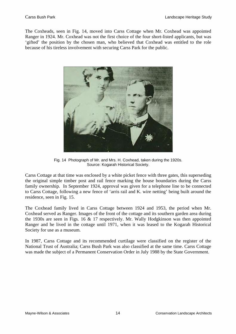
The Coxheads, seen in Fig. 14, moved into Carss Cottage when Mr. Coxhead was appointed Ranger in 1924. Mr. Coxhead was not the first choice of the four short-listed applicants, but was ‘gifted’ the position by the chosen man, who believed that Coxhead was entitled to the role because of his tireless involvement with securing Carss Park for the public.
Fig. 14 Photograph of Mr. and Mrs. H. Coxhead, taken during the 1920s. Source: Kogarah Historical Society.
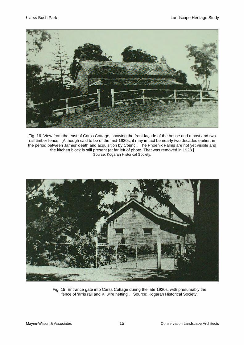
Carss Cottage at that time was enclosed by a white picket fence with three gates, this superseding the original simple timber post and rail fence marking the house boundaries during the Carss family ownership. In September 1924, approval was given for a telephone line to be connected to Carss Cottage, following a new fence of ‘arris rail and K. wire netting’ being built around the residence, seen in Fig. 15. The Coxhead family lived in Carss Cottage between 1924 and 1953, the period when Mr. Coxhead served as Ranger. Images of the front of the cottage and its southern garden area during the 1930s are seen in Figs. 16 & 17 respectively. Mr. Wally Hodgkinson was then appointed Ranger and he lived in the cottage until 1971, when it was leased to the Kogarah Historical Society for use as a museum. In 1987, Carss Cottage and its recommended curtilage were classified on the register of the National Trust of Australia; Carss Bush Park was also classified at the same time. Carss Cottage was made the subject of a Permanent Conservation Order in July 1988 by the State Government.
Carss Bush Park Landscape Heritage Study
Mayne-Wilson & Associates 15 Conservation Landscape Architects
Fig. 16 View from the east of Carss Cottage, showing the front façade of the house and a post and two rail timber fence. [Although said to be of the mid-1930s, it may in fact be nearly two decades earlier, in the period between James’ death and acquisition by Council. The Phoenix Palms are not yet visible and
the kitchen block is still present (at far left of photo. That was removed in 1928.] Source: Kogarah Historical Society.
Fig. 15 Entrance gate into Carss Cottage during the late 1920s, with presumably the fence of ‘arris rail and K. wire netting’. Source: Kogarah Historical Society.

Carss Bush Park Landscape Heritage Study
Mayne-Wilson & Associates 16 Conservation Landscape Architects
Fig. 17 The southern side of the Carss Cottage grounds during the 1930s, looking east towards Kogarah Bay. Note the young Phoenix palms around the house.
Source: Kogarah Historical Society. 2.2 Carss Bush The vegetation within Carss Bush Park is characteristic of that growing on the underlying Hawkesbury sandstone topography. In its virgin state, Carss Bush was a densely timbered area with a variety of Eucalypts and other native trees, shrubs and flowers. Trees which dominated the bush included Red gum, White gum, Blackbutt, Bloodwood, Angophora, Swamp Mahogany, Bangalay, Forest Oak, Swamp Oak and Banksias. Native shrubs such as Christmas Bush, Bottle Brush, Native Rose and Wattles comprised the understorey of the bushland. Over 125 native species of trees and plants have been listed in the park2. The same report also lists 40 weed species, introduced after settlement, but which the bush regeneration contractors have been seeking to remove. This is within only approximately 10 acres of bushland, independent of the thinned out bush for picnic areas. It appears that the bush was first surveyed by H. Griffiths, whose account for the work is noted in Council minutes from 18th February 1924.
2 See Appendix A of “Report on Work – July 1999-June 2000” by Earth Repair & EcoHort for Kogarah Council.
Carss Bush Park Landscape Heritage Study
Mayne-Wilson & Associates 17 Conservation Landscape Architects
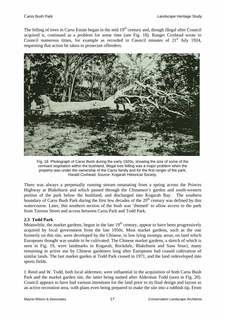
The felling of trees in Carss Estate began in the mid 19th century and, though illegal after Council acquired it, continued as a problem for some time (see Fig. 18). Ranger Coxhead wrote to Council numerous times, for example as recorded in Council minutes of 21st July 1924, requesting that action be taken to prosecute offenders.
Fig. 18 Photograph of Carss Bush during the early 1920s, showing the size of some of the remnant vegetation within the bushland. Illegal tree felling was a major problem when the property was under the ownership of the Carss family and for the first ranger of the park,
Harald Coxhead. Source: Kogarah Historical Society. There was always a perpetually running stream emanating from a spring across the Princes Highway at Blakehurst and which passed through the Chinamen’s garden and south-western portion of the park below the bushland, and discharged into Kogarah Bay. The southern boundary of Carss Bush Park during the first few decades of the 20th century was defined by this watercourse. Later, this southern section of the bush was ‘thinned’ to allow access to the park from Torrens Street and access between Carss Park and Todd Park.
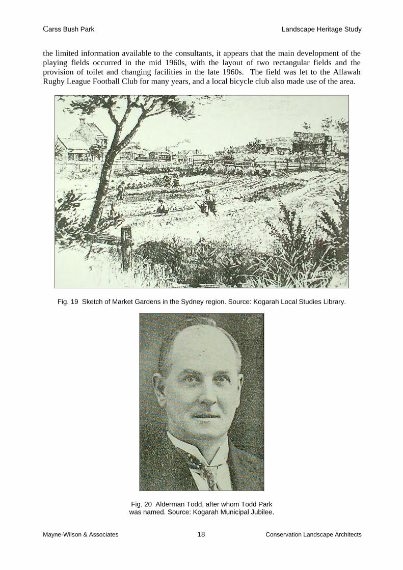
2.3 Todd Park Meanwhile, the market gardens, begun in the late 19th century, appear to have been progressively acquired by local government from the late 1950s. Most market gardens, such as the one formerly on this site, were developed by the Chinese, in low lying swampy areas, on land which Europeans thought was unable to be cultivated. The Chinese market gardens, a sketch of which is seen in Fig. 19, were landmarks in Kogarah, Rockdale, Blakehurst and Sans Souci, many remaining in active use by Chinese gardeners long after Europeans had ceased cultivation of similar lands. The last market garden at Todd Park ceased in 1971, and the land redeveloped into sports fields. J. Reed and W. Todd, both local aldermen, were influential in the acquisition of both Carss Bush Park and the market garden site, the latter being named after Alderman Todd (seen in Fig. 20). Council appears to have had various intentions for the land prior to its final design and layout as an active recreation area, with plans even being prepared to make the site into a rubbish tip. From
Carss Bush Park Landscape Heritage Study
Mayne-Wilson & Associates 18 Conservation Landscape Architects
the limited information available to the consultants, it appears that the main development of the playing fields occurred in the mid 1960s, with the layout of two rectangular fields and the provision of toilet and changing facilities in the late 1960s. The field was let to the Allawah Rugby League Football Club for many years, and a local bicycle club also made use of the area.
Fig. 19 Sketch of Market Gardens in the Sydney region. Source: Kogarah Local Studies Library.
Fig. 20 Alderman Todd, after whom Todd Park was named. Source: Kogarah Municipal Jubilee.

Carss Bush Park Landscape Heritage Study
Mayne-Wilson & Associates 19 Conservation Landscape Architects
2.4 Development and Improvement of Carss Park The stone paths (see Fig. 21), steps, seats throughout the bush, as well as an ornamental wooden bridge, were all initiated by or built under the instruction of Ranger Coxhead. Council engineer Buckham reported on the 13th September 1926 that Coxhead had drawn his attention to a proposal to construct a path through the higher levels of the park for a distance of 10 to 12 chains. Buckham commented that such a pathway through the untamed sections of the park would enable visitors to view ‘beauties of nature which at present pass unobserved’. Even before Council had formally acquired the land for the Park, ideas had been expressed by interested parties as to how it should best be developed. For example, John Sulman expressed two main recommendations in a letter to Council in March 1922 for the use of the prominent site. The first option was to acquire the entire area and the second option was to ensure that the public had access to all the waterfront spaces around Carss Point and along the bays to either side of it.
Fig. 21 Taken in the early 1930s, this photograph shows a section of the path system built by or under the instruction of Harald Coxhead through Carss Bush.
Source: Kogarah Historical Society.
Fig. 22 Taken in the early 1920s, this view looks north towards Carss Point from the southern side of the bay which was later developed into the tidal baths. Note the small creek feeding into the bay in the
foreground (this ran from the market gardens in Todd Park) and the very mature Norfolk Island Pines on Carss Point, probably planted by William Carss. Source: Kogarah Historical Society.

Carss Bush Park Landscape Heritage Study
Mayne-Wilson & Associates 20 Conservation Landscape Architects
In that letter, Sulman also referred to the need to develop a new access road to the south-western portion of the site through the market gardens referred to above.
Council minutes from 10th December 1923 show that a Carss Park Committee had been formed by interested residents and that the organization began liaising with Council regarding improvements for the park. This committee, which comprised members of the Blakehurst and Kogarah Bay Progress Associations, was to aid in the control and management of Carss Bush Park and other reserves. The Committee, the Progress Associations individually, and Harald Coxhead were all in regular correspondence with Council, as can be seen by the numerous applications made to Council between 1923 and 1930. Applications ranged in scale from the development of new services and facilities for the park to a letter by Coxhead in June 1924 seeking approval to graze a cow in the park. On the 4th February 1924, Council decided that as the park was a public space, it should be fully assessed. It approved the sum of £5000 for undertaking this task. [It is not known if this was done, and if so, where the report is located.] Engineer’s reports to Council during 1924 show that construction work on new roads servicing the park was well advanced. A general report to the town clerk from Council’s Engineers office on the 15th April 1924 suggested that the Council should approach the director of the Botanic Gardens for expert advice on the most suitable trees for planting on the flats behind the present-day tidal baths. The original area of Carss Park Reserve (or pleasure grounds, as they were often referred to) was 43 acres, which included the bushland zone. The first increase to this area occurred on 2nd June 1924, when the Council purchased part of the Blink Bonnie Estate on the south of the park. In 1929, the park itself was deemed to have a value of £5000. Built stone elements The construction of the park’s rustic stone seats, stairs, paths and bandstand were undertaken at the initiative of Harald Coxhead during his 29 year term as ranger of the park. Gwen Coxhead, Harald Coxhead’s daughter, said that her father not only planned, but also built all these stonework features. However, this proposition cannot be verified. As Council minutes show numerous general entries for unemployment relief works in the park from as early as 1925, it seems unlikely that Coxhead would have constructed all of these elements single-handedly. The tidal baths The retaining sea wall and outer barrier walls for the tidal baths were constructed under an unemployment relief work program during the early 1930s. Various schemes had been submitted for the bath’s construction, with estimated costs for the development ranging between £3950 in a proposal from 1927, and £500, a sum provided to Council by its engineer Mr. Brewer in June 1934. Unlike the scheme from 1934, the 1927 proposal considered factors of erosion and material longevity. Interestingly, the 1927 proposal sought to enclose the baths from the bay using a series of turpentine pickets. In the 1934 plan, £300 were designated for a shark net (instead of pickets) which was to be a length of 600 feet and a depth of up to 12 feet, and £200 were designated for the construction of the proposed boundary walls on the outer edges of the baths. It is unclear which components of these two proposals and others were used in the final design and development of the baths.
Carss Bush Park Landscape Heritage Study
Mayne-Wilson & Associates 21 Conservation Landscape Architects
Rock for the promenade retaining wall along the back of the baths was obtained from the area behind the original first aid station. The tidal baths were officially opened in mid-March 1936 by then Mayor Battye, who at the same occasion laid the foundation stone of the new dressing sheds for the park. Alderman Ferry, on behalf of the Blakehurst Progress Association, requested that Council lay a tablet in commemoration of the opening of the shark-proof enclosure, but it is unclear if this occurred. The development of the shark-proof enclosure was largely due to the efforts of the then president of the Blakehurst Parents’ and Citizens’ Association, Mr. Ken Cavanough. Mr. Cavanough was later to become Mayor of Kogarah Council. In 1928, it was deemed necessary to have a rescue service for the tidal baths, the Kogarah Bay football team being asked to form a life-saving team. Accordingly, in 1929, the Carss Park Lifesaving and Athletic Club was formed. The clubhouse for the organization was built in 1934 by voluntary labour, concurrent with the construction of a formal access between the clubhouse and the first aid station (subsequently known as the ambulance station). A series of historic photographs showing the bay to the south of Carss point prior to, during and after the construction of the sandstone walls and promenade of the tidal baths can be seen in Figs. 23 to 33. Roadway construction The increase in park usage led Council to approve the widening of Carwar Avenue late in 1925, at a cost of approximately £50. Additional land was reserved for widening the access road into the park in August 1926. In September 1926, the Carwar Avenue access to Carss Park was 12 feet wide and did not adequately support two way traffic. A sum of £100 was approved for the widening of the road to 20 feet, though it meant the removal of a mature tree. A further £50 was approved for the development of a formal turning circle at the end of Carwar Avenue and for the expansion of the vehicle parking area. It was intended that the turning circle be planted with creepers around its edges and that the existing handrail along the stretch of road towards Carss Cottage be re-erected around the edge of the turn. A photograph of the Carwar Avenue turning circle during the 1930s can be seen in Fig. 34. It was recommended that all suitable stone cleared during the construction of the expanded parking area should be stacked behind the beach, a possible indication of the future intent to build a promenade wall. The special report by Engineer Buckham from September 1926 indicates that Coxhead managed the construction of the turning circle and road extensions, possibly with the aid of unemployment relief workers. On 26th June 1929, a sum of £60 was made available for the widening of the access road to the beach from Carwar Avenue, after requests from the Carss Bush Park Ratepayers Improvement League. A works committee inspection report to Council in March 1930 shows that consideration was being given to the construction of a road cutting through Carss Park linking Carlton Crescent to Beach Street. This proposal was thought to be beneficial for access to the site. Immediate protests from the Carss Park Improvement League regarding the scheme were received by Council in June 1930. A report submitted by Engineer Harding in Nov. 1930 referred to a previously mentioned proposal to extend a road through the middle of the park. Harding approved of the idea, envisaging a road 24 feet wide and costing £1,880 pounds. The continuous opposition of the local community associations would have no doubt been the deterrent for Council pursuing this road development proposal. The inclusion of Carss Park in a grant application to the
Carss Bush Park Landscape Heritage Study
Mayne-Wilson & Associates 22 Conservation Landscape Architects
Unemployed Relief Council of November 1930 for £10,000 would have been viewed by the local community organizations as funds which, when granted, would be best spent on improvements to facilities within the park and not for the development of roads. The original entry timber gateway into the residential estate from the highway still stood at the beginning of Carwar Avenue at the end of the 1930s, as shown in Fig. 35.
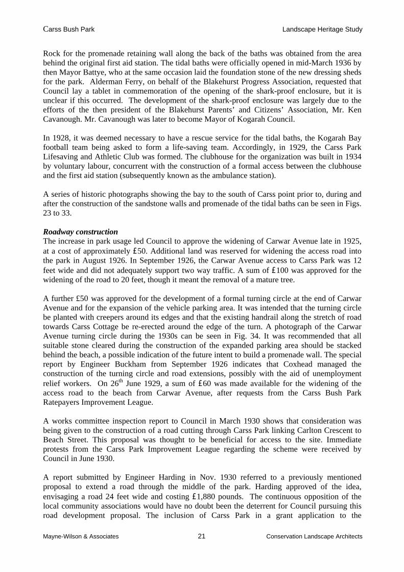
Fig. 23 The bay to the south of Carss point, during the mid-1920s, prior to the development of the tidal baths and the promenade around the point. Source: Kogarah Historical Society.
Fig. 24 Taken in the mid to late 1930s, this photograph shows the reclamation undertaken on the southern side of Carss Point and the promenade built upon this reclaimed land.
Source: Kogarah Historical Society.
Carss Bush Park Landscape Heritage Study
Mayne-Wilson & Associates 23 Conservation Landscape Architects
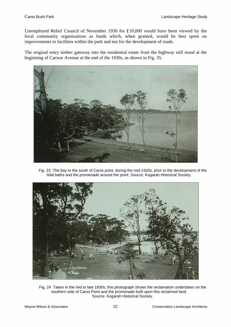
Fig. 25 Taken in the mid-1920s, after the opening of the park for public use, this photograph shows early attempts at stabilizing the sand along the beach of what was to become the
tidal baths. Source: Kogarah Historical Society.
Fig. 26 Looking across the southern end of the tidal baths during the late 1930s, following the construction of the sandstone promenade along the bath’s beach and the outer arms of the
enclosure, one of which can be seen in the right middle-ground of the image. Note that at this time, the shark-proof net for the baths was suspended by a series of
timber posts, also seen in the middle-ground of this view, and that the Norfolk Island Pines along the beachfront had only been planted a short while.
Source: Kogarah Historical Society.

Carss Bush Park Landscape Heritage Study
Mayne-Wilson & Associates 24 Conservation Landscape Architects
Fig. 27 View to the south-west along the beach adjoining Carss Point during the mid-1920s, following the opening of the park to the public. Source: Kogarah Historical Society.
Fig. 28 The same view taken during the late 1930s, showing the finished promenade behind the beach and the concrete archway (‘folly’) at left, already constructed between
the beach and Carss Cottage. Source: Kogarah Historical Society.

Carss Bush Park Landscape Heritage Study
Mayne-Wilson & Associates 25 Conservation Landscape Architects
Fig. 29 Photograph from 1934 showing the promenade along the back of the tidal baths and along the southern edge of Carss Point under construction. Source: Kogarah Historical Society.
Fig. 30 Looking north towards Carss Point from the beach of the tidal baths during their construction in 1934. Note the mature Norfolk Island Pines along the Carwar Avenue
access to Carss Cottage and the concrete archway below them, in the centre distance. Source: Kogarah Historical Society.
Carss Bush Park Landscape Heritage Study
Mayne-Wilson & Associates 26 Conservation Landscape Architects
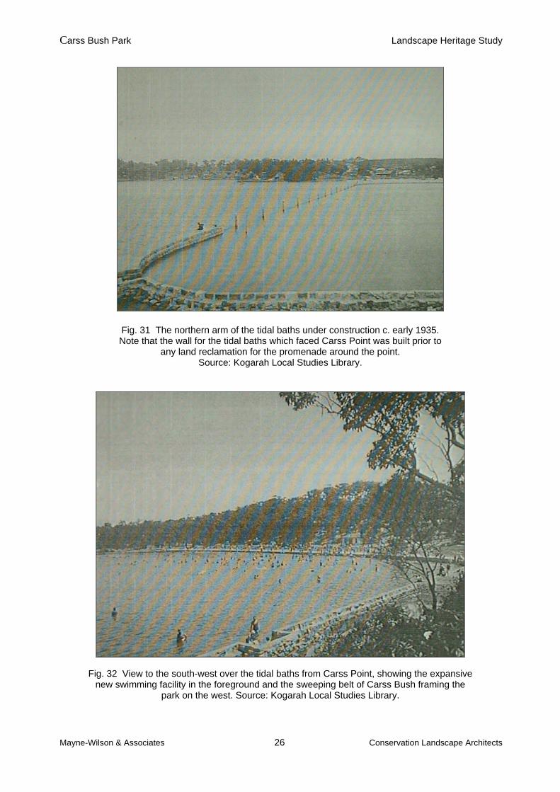
Fig. 31 The northern arm of the tidal baths under construction c. early 1935. Note that the wall for the tidal baths which faced Carss Point was built prior to
any land reclamation for the promenade around the point. Source: Kogarah Local Studies Library.
Fig. 32 View to the south-west over the tidal baths from Carss Point, showing the expansive new swimming facility in the foreground and the sweeping belt of Carss Bush framing the
park on the west. Source: Kogarah Local Studies Library.

Carss Bush Park Landscape Heritage Study
Mayne-Wilson & Associates 27 Conservation Landscape Architects
Fig. 33 Looking north towards Carss Point, c. late 1930s, from the outer southern arm of the tidal baths. Note the pontoon which used to sit within the baths and the lack of significant
vegetation around the end of Carss Point. Source: Kogarah Historical Society.
Fig. 34 The roundabout at the end of Carwar Avenue during the 1930s. Source: Kogarah Historical Society.

Carss Bush Park Landscape Heritage Study
Mayne-Wilson & Associates 28 Conservation Landscape Architects
Fig. 35 Photograph of the Princes Highway in 1937, showing the original entry arch into the Carss Estate on the far right of the image, at the present junction of the Highway and Carwar Avenue. At this time, the archway plaque read ‘Carss Park, Pleasure Resort’.
Source: Kogarah Local Studies Library. Bridging the Creek By June of 1924, the Kogarah Bay Progress Association had approached Council regarding the proposal to build a bridge over the creek for access into the park from the south. It would appear that this proposal had been discussed from the time of the earliest attempts to secure the park for public purposes. General reports from the Council’s Engineers office of 2nd and 16th February 1925 show that the pathway into the park from Torrens Street was under construction. It would appear, however, that by May 1926, a bridge over the creek to service the pathway from the south of the park (from what is now the barbecue zone) had still not been built. A report from a Council works inspection committee from the 21st August 1926 recommended that Council not take any action in regard to the drain (former creek) running through Carss Park from the Chinamen’s Garden (now Todd Park). This inspection may have been subsequent to community concern about the unsanitary condition of the drain. Such concern was again raised in September 1928, with requests for cleaning works to be undertaken. As mentioned in section 2.3 above, the last Chinamen’s Garden existed until 1971, by which time the site was being converted by Council into a parkland. Council minutes from 19th July 1926 indicate that there was an early move by local residents to formalize the link between Carlton Crescent to the north of the park and the public reserve. This is evidenced by the request to Council for the construction of a concrete and wooden footbridge and graveled path linking Carwar Avenue and Carlton Crescent. The request for such a long and deliberate pedestrian accessway from this direction, prior to the reclamation of the land abutting Carlton Crescent, indicates that a large local residential catchment from the north of the park frequented the site.
Carss Bush Park Landscape Heritage Study
Mayne-Wilson & Associates 29 Conservation Landscape Architects
In September 1926, the Carss Bush Ratepayers Improvement League proposed that when the footbridge was built, it should be constructed to service vehicles, an idea not favoured or pursued in the future by Council. A letter from the Blakehurst Progress Association received by Kogarah Council on 26th September 1927 expressed thanks to Ranger Coxhead and Council for improvements made to the park via footpaths and a rustic bridge, presumed to be that sought by local residents to access Torrens Street. Land Reclamation The earliest reference to the possible reclamation of the land abutting the northern side of Carwar Avenue appears to be from July 1927, when the Carss Bush Ratepayers Improvement League corresponded with Council proposing such works. In August of that year, Council responded by saying that no firm decisions regarding reclamation works on the northern side of Carss Point had been made, but that the Council did have the matter in mind. In September 1927, Council addressed a proposal that the north-western portion of Carss Park be used for the burial of nightsoil. Whilst an amendment was moved by two aldermen to have night-pans flattened out and buried at the depot, it appears that pans may have been brought to the park and used to fill-up low lying areas, covered with garbage and street clippings. It is unclear if this was a process used during the eventual reclamation of the land north of Carss Point. Council received a letter from the Middle Ward Ratepayers and Citizens Association on the 12th March 1928 requesting that no garbage, rubbish or offensive matter be used in the reclaiming of low lying land within and around Carss Park. By 21st May 1928, however, Council was dumping garbage at Carss Park, the Carss Bush Park Ratepayers Improvement League commenting that insufficient topsoil and chloride of lime were being deposited on top of the dumped material. Similar residents concerns are recorded in the Council minutes from 4th April 1929. Council minutes from 1929 indicate that extensive reclamation of land around the southern side of the park was being considered. A special report written by Council Engineer Harding on 5th November 1930 identified what he considered to be the main improvements required to enhance the character of Carss Park. His initial recommendation referred to the desirability of reclamation to the north of Carss Point for the purposes of creating an area of 18 acres for sports fields. He acknowledged that the works would be a major undertaking and that the filling would take a number of years, but concluded that this work would greatly increase the value and popularity of Carss Park. It would appear that prior to World War II, priority was given to reclamation works at Beverly Park, at the head of Kogarah Bay. In 1946, however, Council decided to continue with its earlier plans for the Oatley Bay reclamation scheme and for similar works at Carss Park, borrowing £40,000 to finance the projects. Ensuing reclamations and resumptions around the Bay expanded the park to 66 acres by 1954, 5 ¾ acres of which comprised the tidal baths area. Early reclamation works off Carss Point can be seen in Fig. 36, whilst the use of the filled lands to the north of the point as sports fields during the 1940s is evident in Fig. 37.

Carss Bush Park Landscape Heritage Study
Mayne-Wilson & Associates 30 Conservation Landscape Architects
Fig. 36 This undated photograph, assumed to have been taken during the mid-1940s, shows the reclamation works undertaken by Council off the north-east end of Carss Point. It is believed that many trees along this section of the point were
cut down during these works. Source: Kogarah Historical Society.
Fig. 37 This undated photograph, assumed to have been taken during the late 1930s, shows Carss Point from the open sports fields to its north. It is unclear how much of
the reclamation work to the north of the point had been carried out by this stage. The photograph illustrates that this north-west section of Carss Park has a long history
of usage as playing fields. Source: Kogarah Historical Society.

Carss Bush Park Landscape Heritage Study
Mayne-Wilson & Associates 31 Conservation Landscape Architects
Park Amenities Tap water was available at the site from 1925, the park supporting three bubblers by the end of that year. Temporary toilets were built in the mid-1920s, a sum a £200 being approved for the construction of men’s lavatories on 12th September 1927. It appears that these were demolished soon after, following much public criticism of their poor state. New facilities were made available in the recent dressing sheds. The drinking fountain near the Lifesaving clubhouse was built in 1934 and officially unveiled on the 14th October that year. It was specifically intended for the use of school children visiting the tidal baths for swimming classes. The fountain, originally erected to mark the commencement of the shark-proof enclosure, was dedicated to the memory of Alderman J. J. Nichols.
In 1928 the first public pavilion was opened, along the northern edge of the Carwar entry road. This was later to receive an upper deck (subsequently demolished), with part of the lower part closed in to make public toilets. Change rooms for the rugby union ‘Royals’ club were added
In 1929 a first aid dressing station was opened. This structure began its second life in 1971, when a flat for the ranger was built above it, providing them with a residence following the vacation of Carss Cottage. Council minutes show that six additional seats were provided within Carss Park during early 1928, upon the request of the Kogarah Bay Progress Association and that in February 1929 approval was given for the erection of a ‘fingerpost’ at the main entrance to Carss Park showing the direction of the beach.
In June 1930 the Carss Park Improvement League addressed the continuing issue of tree felling in Carss Bush, street lighting around the park and the necessity for further ground to be leveled behind the beachfront.
In November 1930 Council Engineer Harding recommended the pedestrianisation of the area on the immediate south of Carss Point, between the beachfront and the point itself. His report provided sums for the construction of a masonry retaining wall along this zone and extending around behind the beach and the filling of the areas behind the new wall, most of which was at the time of his report covered by mangroves. It would seem it was this advice and proposal that was followed by Council as part of the construction of the shark-proof baths in 1934 and 1935.
An image of the public path, which extended during the 1930s around the top edge of the present front lawn of Carss Point, can be seen in Fig. 38. It is assumed this pathway was built by Coxhead to enable people to more comfortably experience views from the top of the promontory.
Fig. 38 Carss Point during the 1930s, showing the sparse vegetation around the end of the promontory and the pathway which once extended around the top of the cliff. Source: Kogarah Historical Society.

Carss Bush Park Landscape Heritage Study
Mayne-Wilson & Associates 32 Conservation Landscape Architects
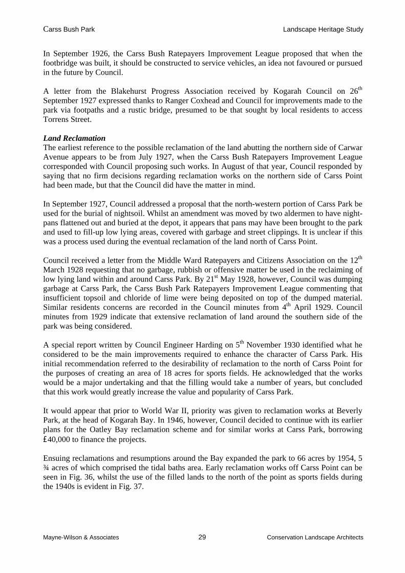
Refreshment facilities With the increase in popularity of the park and the tidal baths, the refreshment facilities, which had been opened by the Coxhead family in Carss Cottage in early 1924, soon became insufficient. Accordingly, a small kiosk was opened on the western edge of the park, incorporating dressing sheds. Plans and estimates for this structure were prepared and submitted to Council on the 12th October 1925 and accordingly adopted with small modifications. The present kiosk is on the same site as this original one. Entertainment From 1924, Carss Park was a favoured destination for concert performances by local bands, with several concerts held each year in the park during the summer months. This would suggest that the bandstand on the northern edge of the park would have been constructed during the mid to late 1920s to support these events. Sea Scouts Building The 1st Kogarah Bay Sea Scouts was the first body of sea scouts in the St. George district, formed in 1931. Their hall was built between 1933 and 1934 to the north of Carss Cottage (which at this time was bordered by a post and two-rail fence). It was extended twice and was originally sited just above the waterline, prior to reclamation around Carss Point. Olympic Pool In the 1960s, the Carss Park Olympic Pool was mooted as the Kogarah War Memorial Pool. The present complex eventuated from the first basic structure of 1966. A copy of the original plan delineating the land release for the development of the complex is shown in Fig. 39 and a photograph of the emptied pool from the 1970s in Fig. 40.
Fig. 39 This survey from 1977 was produced with the release of land within Carss Park for the development of the Olympic Swimming complex.
It shows the original intended dimensions of the pool complex and its relationship with high water mark and the alignment of the sea wall.
Source: Kogarah Council.
Carss Bush Park Landscape Heritage Study
Mayne-Wilson & Associates 33 Conservation Landscape Architects
Fig. 40 Photograph looking across the Carss Park Olympic swimming pool and sports fields during the late 1970s. Source: Kogarah Local Studies Library.
Camping In April 1924, Council informed the local progress associations that campers’ permits would be available through the ranger for periods of up to two weeks. Pine Trees Newspaper articles from 1934 indicate that the avenue of Norfolk Island Pines behind the tidal baths promenade was planted on 13th October 1934, prior to the completion of the construction works on the shark-proofing enclosure, but more than a decade after the issue of planting behind the baths was first raised by Council’s Engineers office. The specimens were donated and the first one planted by Mrs. J. Stuart of Blakehurst. The aforementioned articles stress the personal involvement of Ranger Coxhead in park upgrades and improvements.

Carss Bush Park Landscape Heritage Study
Mayne-Wilson & Associates 34 Conservation Landscape Architects
3.0 Site Description and Analysis 3.1 The Setting and Context Carss Bush Park and Todd Park form an extensive open space network around part of the western side of Kogarah Bay, within the Georges River catchment area. Whilst the Harold Fraser Oval and the Parkside Drive Reserve are not included in the study area for this report, they abut Carss Park on the north, collectively forming the largest and most important public open space within the Kogarah and Blakehurst area. The study area is characterized by dramatic topographical changes, some of these being the key determinants for the boundaries of internal precincts. Extensive flat lands, much of which were originally swamps and mangroves merge into large rock outcrops, steep slopes and lush bushland gullies. The long promontory of Carss Point provides sweeping 360 degree views, encompassing Kogarah Bay and the majority of the park. Some of these features are evident in the photo below. Analysing the topographical units, historical land use patterning and usage of the site, the parklands can be broadly categorized into 7 precincts: Carss Point, the core of Carss Park, the tidal baths, the bushland, Todd Park, the Carwar Avenue entry to the park, and the playing fields north of Carss Point.
Fig. 41 Aerial photograph of Carss Bush Park and the entire Carss Estate c.1937. The circle at the centre of the photograph indicates the core of the 1924 residential subdivision, while to the left of it are the market gardens. Note the thinness of the tree canopy in the bushland area, the tidal baths, and the
recessive foreshore line above and below Carss Point (at right), before much land reclamation occurred.
Carss Bush Park Landscape Heritage Study
Mayne-Wilson & Associates 35 Conservation Landscape Architects
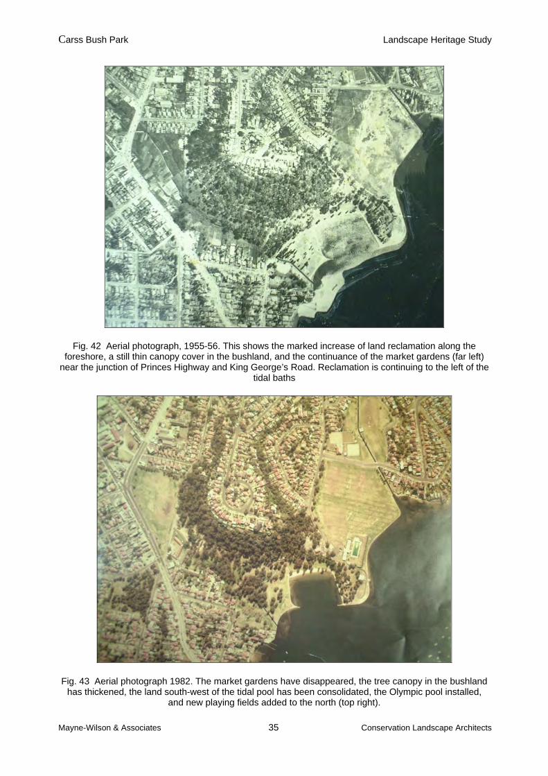
Fig. 42 Aerial photograph, 1955-56. This shows the marked increase of land reclamation along the foreshore, a still thin canopy cover in the bushland, and the continuance of the market gardens (far left)
near the junction of Princes Highway and King George’s Road. Reclamation is continuing to the left of the tidal baths
Fig. 43 Aerial photograph 1982. The market gardens have disappeared, the tree canopy in the bushland has thickened, the land south-west of the tidal pool has been consolidated, the Olympic pool installed,
and new playing fields added to the north (top right).

Carss Bush Park Landscape Heritage Study
Mayne-Wilson & Associates 36 Conservation Landscape Architects
3.2 The Precincts – Physical Description
Fig. 44 Study area and precinct map.
Precinct 1 – Carss Point
This precinct contains Carss Cottage and its subsidiary built structures and landscape elements. It is defined by the sea wall framing the reclaimed land around Carss Point, the landward edge of the promenade facing the tidal baths, the access road to the Sea Scouts building and the edge of
Carss Bush Park Landscape Heritage Study
Mayne-Wilson & Associates 37 Conservation Landscape Architects
the Carwar Avenue roundabout. The Sea Scouts building also lies within this precinct. The base of the original sandstone cliff/rockbench edge of Carss Point is now bordered by a broad grassed platform on reclaimed land, widest off the eastern side of the point. Carss Point is a promontory which, together with the Carwar Avenue access road to the cottage, provides a visual and physical screen between the sports fields to the north of the point and the flat zone through the centre of Carss Park, south of the point. It also provides an excellent viewing platform both to Kogarah Bay and to most of the other precincts within the Park. Precinct 2 – The core of Carss Park
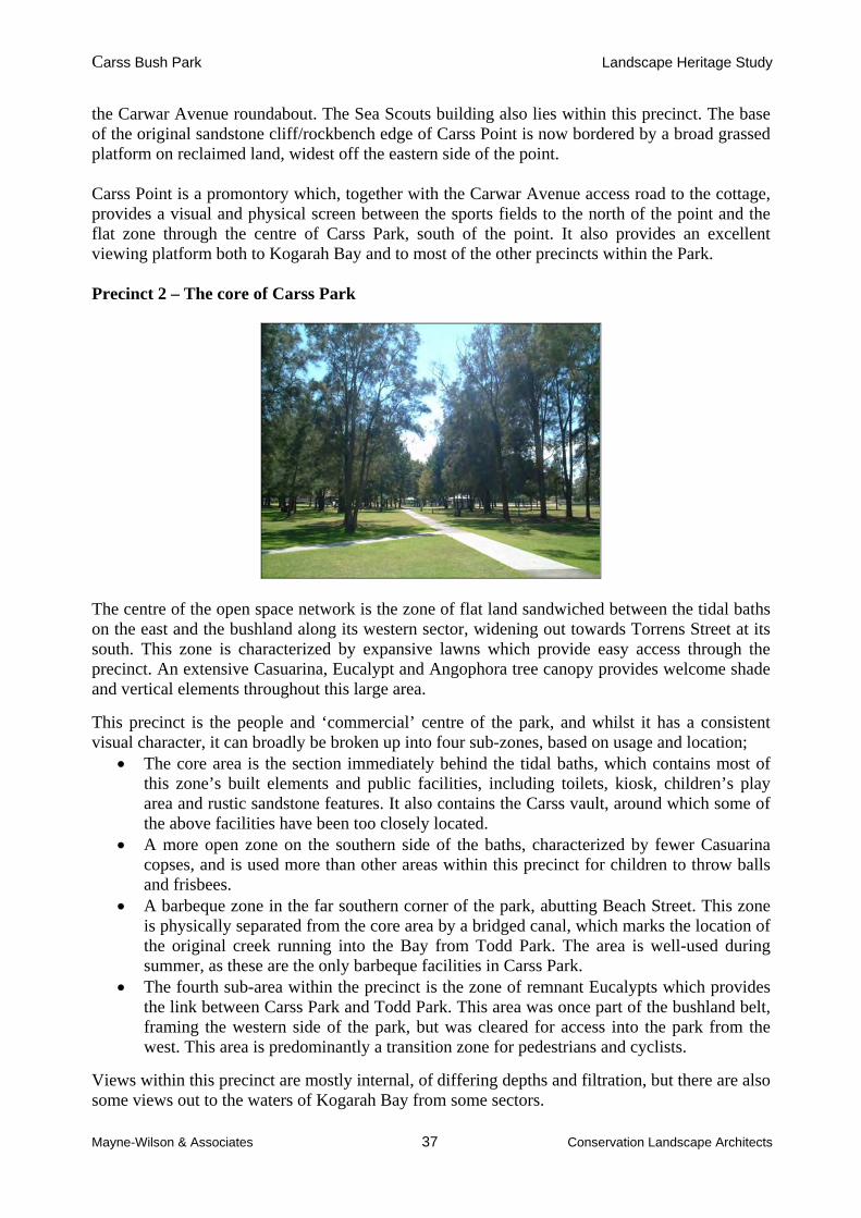
The centre of the open space network is the zone of flat land sandwiched between the tidal baths on the east and the bushland along its western sector, widening out towards Torrens Street at its south. This zone is characterized by expansive lawns which provide easy access through the precinct. An extensive Casuarina, Eucalypt and Angophora tree canopy provides welcome shade and vertical elements throughout this large area.
This precinct is the people and ‘commercial’ centre of the park, and whilst it has a consistent visual character, it can broadly be broken up into four sub-zones, based on usage and location;
The core area is the section immediately behind the tidal baths, which contains most of this zone’s built elements and public facilities, including toilets, kiosk, children’s play area and rustic sandstone features. It also contains the Carss vault, around which some of the above facilities have been too closely located.
A more open zone on the southern side of the baths, characterized by fewer Casuarina copses, and is used more than other areas within this precinct for children to throw balls and frisbees.
A barbeque zone in the far southern corner of the park, abutting Beach Street. This zone is physically separated from the core area by a bridged canal, which marks the location of the original creek running into the Bay from Todd Park. The area is well-used during summer, as these are the only barbeque facilities in Carss Park.
The fourth sub-area within the precinct is the zone of remnant Eucalypts which provides the link between Carss Park and Todd Park. This area was once part of the bushland belt, framing the western side of the park, but was cleared for access into the park from the west. This area is predominantly a transition zone for pedestrians and cyclists.
Views within this precinct are mostly internal, of differing depths and filtration, but there are also some views out to the waters of Kogarah Bay from some sectors.

Carss Bush Park Landscape Heritage Study
Mayne-Wilson & Associates 38 Conservation Landscape Architects
Precinct 3 – Carss Park Tidal Baths
The tidal baths precinct is defined by the landward edge of the promenade that stretches around the northern and eastern sides of the baths and the sandstone retaining wall, which runs along its south-western edge. The baths are approximately 120 metres wide south from Carss Point, and 90 metres across between the beach and the outer sandstone arms. Whilst the promenade around the tidal baths beach and that portion leading around Carss Point are also important boundary components of Precincts 1 & 4, their construction in conjunction with the baths provides a historical rationale for their inclusion in this precinct. With the development of the Olympic pool, the greater mobility of the young combined with their preference for open sea beaches (which are perceived as less polluted than riverside beaches), the tidal baths have been less used in recent decades. However, they were popular between the mid 1930s up to about 1980, and were supported by a local life saving club. There are, however, attractive views outward to Kogarah Bay from this precinct, with the cottage on Carss Point forming a picturesque focal point. Precinct 4 – The Bushland

Carss Bush Park Landscape Heritage Study
Mayne-Wilson & Associates 39 Conservation Landscape Architects
The bushland is a long belt that stretches between Carwar Avenue in the north-east and Todd Park in the south-west. It provides the backdrop to Carss Park in views of the site from Kogarah Bay, and separates the public open space around the foreshore from residential development on the ridge above the park, within the original Carss Park Estate subdivision. The bushland sits astride and below steep Hawkesbury sandstone cliffs and rockbenches, the majority of the bush zone facing south-east over Kogarah Bay. The bushland slopes more gently to the south-west and north-east. The majority of the bushland in Carss Park is in good or fair condition, with the most degraded areas on the edges of the bushland, adjacent to the residences. However, it should be noted that the bushland was logged during the 19th and early 20th centuries, the results being evident in photographs of the subdivision area taken in the 1920s and in the aerial photographs in figures 41 to 43. The open woodland zone at the western end of the park’s core area was originally part of the dense bushland belt. The understorey was cleared following the ‘opening’ of this section to allow access into the park from Bunyala Avenue and the Princes Highway. The impressive Eucalypts and Angophoras dotted through the expansive lawns provide a sense of the former extent and lushness of the bush on the flatter land below the sandstone cliffs. Not many trees present today can be said to be genuine remnant vegetation. Rather, most would be regrowth from a relatively undisturbed seedbank. Fortunately, quite a wide variety of typical Hawkesbury sandstone vegetation has survived – estimated to be over 125 species. Bush regeneration work by volunteers and the National Trust, and subsequently by paid contractors, has helped to control weed infestations and facilitate the regrowth of native species, but further work needs to be done. Some very attractive views towards the Bay can be gained from Carss Park Lookout on the edge of the mini-escarpment, filtered and framed by the native eucalypts and angophoras. There are also some attractive, unfolding views within the bushland gained by persons following the winding paths through it. Precinct 5 – Todd Park
The perimeters of Todd Park are clearly defined by the Princes Highway on the west and south, residential blocks to the north, and Bunyala Avenue, a large carpark and Carss Bush on the east. The bicycle track which skirts the base of the bushland through Carss Park extends around the
Carss Bush Park Landscape Heritage Study
Mayne-Wilson & Associates 40 Conservation Landscape Architects
northern and western sides of Todd Park. The majority of the park is a sports field, presumably used for school rugby and cricket. New children’s play equipment has been placed in a moderately secluded zone at the southern tip of the park. A toilet block on the eastern side of the park, abutting the carpark, is the only structure in the precinct. The zone is devoid of significant trees and is only partially screened from the Highway by a broken line of maturing Eucalypts. Its views are mostly internal or to the Highway, with none towards the waters of Kogarah Bay. Precinct 6 – Carwar Avenue entry to Carss Park
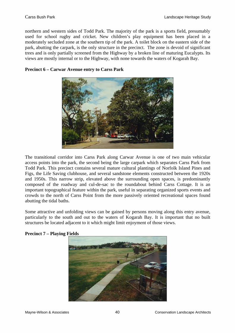
The transitional corridor into Carss Park along Carwar Avenue is one of two main vehicular access points into the park, the second being the large carpark which separates Carss Park from Todd Park. This precinct contains several mature cultural plantings of Norfolk Island Pines and Figs, the Life Saving clubhouse, and several sandstone elements constructed between the 1920s and 1950s. This narrow strip, elevated above the surrounding open spaces, is predominantly composed of the roadway and cul-de-sac to the roundabout behind Carss Cottage. It is an important topographical feature within the park, useful in separating organized sports events and crowds to the north of Carss Point from the more passively oriented recreational spaces found abutting the tidal baths. Some attractive and unfolding views can be gained by persons moving along this entry avenue, particularly to the south and out to the waters of Kogarah Bay. It is important that no built structures be located adjacent to it which might limit enjoyment of those views. Precinct 7 – Playing Fields

Carss Bush Park Landscape Heritage Study
Mayne-Wilson & Associates 41 Conservation Landscape Architects
The precinct is bordered by Parkside Drive on the north, the outlet of Kogarah Creek on the north-east, Carwar Avenue on the west, Carss Point on the south and Kogarah Bay on the east. At its widest and longest points, the sports fields are over 200 metres across, in an east-west direction and 180 metres long in a north-south direction. This expansive platform of sports fields, built on predominantly reclaimed land, provides a broad open space for views towards Carss Cottage and Carss Point from the north. The precinct is largely devoid of trees, the only significant plantings being several mature Eucalypts lining the western boundary of the zone and some Casuarinas in front of the park’s change room and store building. Some recent plantings have been undertaken in the precinct, Phoenix palms have been put in along the outlet of Kogarah Creek in the north of the zone, and a mix of plants along the eastern bank of the pool complex facing the Bay. The Olympic swimming pool complex, approximately 50 metres wide and 75 metres long, is part of this precinct. As the pool is an active recreation space within a larger sports zone, it has been deemed to be part of this precinct, despite being fenced off from the rest of the playing fields. Whilst it is a self-contained element within the zone, its development, like the remainder of the sports fields, was made possible by the massive reclamation project undertaken by Council to the north of Carss Point from the late 1940s. 4.0 Heritage Significance 4.1 Basis of Assessment of Heritage Significance To determine the heritage significance of the site it is necessary to identify, discuss and assess the significance of all the components present and then the contribution which they make collectively to it. This process will allow for the analysis of the site’s manifold values. These criteria are part of the system of assessment which is based on the Burra Charter of Australia ICOMOS. The Burra Charter principles are important to the assessment, conservation and management of sites and relics. The assessment of heritage significance is enshrined through legislation in the NSW Heritage Act 1977 (as amended in 1999) and implemented through the NSW Heritage Manual and the Archaeological Assessment Guidelines. The revised guidelines, Assessing Heritage Significance, issued in 2001, have been used in the following assessment. 4.1.1 Nature of Significance Criteria The various nature of heritage values and the degree of this value will be appraised according to the following criteria:3
Criterion (a): importance in the course, or pattern, of NSW's or the local area’s cultural or natural history;
Criterion (b): strong or special association with the life or works of a person, or group of persons, of importance in the cultural or natural history of NSW or the local area;
Criterion (c): importance in demonstrating aesthetic characteristics and/or a high degree of creative or technical achievement in NSW or the local area;
Criterion (d): strong or special association with a particular community or cultural group in NSW or the local area for social, cultural or spiritual reasons;
Criterion (e): potential to yield information that will contribute to an understanding of NSW's or the local area’s cultural or natural history;
3 NSW Heritage Assessment Criteria, as adopted from April 1999.

Carss Bush Park Landscape Heritage Study
Mayne-Wilson & Associates 42 Conservation Landscape Architects
Criterion (f): possession of uncommon, rare or endangered aspects of the cultural or natural history of NSW or the local area;
Criterion (g): importance in demonstrating the principal characteristics of a class of NSW’s or the local area’s cultural or natural places or environments.
To be assessed as having heritage significance, an item or place must: o meet at least one or more of the nature of significance criteria; and o retain the integrity of its key attributes.
Items may also be ranked according to their heritage significance as having: o Local Significance o State Significance
It should be noted that different components of a place may make a different relative contribution to its heritage value. Loss of integrity or condition may diminish significance, although actions such as replacing fabric (especially organic) such as roofing materials, posts, flooring, or missing stones with identical or closely similar fabric as part of continuing maintenance and repair does not usually diminish significance: rather, it may maintain or possibly enhance it. 4.2 Statement of Significance 4.2.1 Historical Themes: S.H.I. Themes Local Themes
(a) Land tenure/closer settlement Opportunities for smaller settler to acquire land with the break up the larger estates. (b) Growth of democratic government Activities of local progress associations who
obliged Council to purchase the Carss Estate. (c) Leisure & sport Carss Park as a public reserve, baths, pools, playing fields. (d) Environment – natural & modified Timber getting, clearing, public open space (e) Townships First Council-developed garden suburb in NSW 4.2.2 Nature of Significance Summary Statement of Cultural Significance Carss Park has historical and social significance both as part of the grounds of an early private estate and as a regionally important public open space serving a wide community catchment since the mid-1920s. The Park supports a wide range of public recreation and sporting facilities and especially between the 1920s and 1950s was a popular space for large community events, including fetes, concerts and gala days. Its social significance is reinforced by many of its elements having been built with the assistance of local labour provided under the Unemployment Emergency Relief Scheme, and by the presence of the Carss vault, one of the very few solitary vaults in the Sydney region. Its aesthetic significance largely derives from its setting on the edge of Kogarah Bay, its distinctive framing by the bushland belt to its west and the excellent views over the Bay gained from the bushland escarpment. The majority of the park’s built landscape elements are essentially intact and the sandstone walls, pathways and benches contribute

Carss Bush Park Landscape Heritage Study
Mayne-Wilson & Associates 43 Conservation Landscape Architects
substantially to its appeal. The remnant bushland, some of it pre-dating European settlement, is a key landscape zone with important natural heritage values, and is in fair to good condition. The subsequent cultural plantings complement the remnant vegetation and enhance the appearance of the park. The park is of State significance, was the subject of a Permanent Conservation Order in 1988 and is now listed as SHI item 00587 on the NSW State Register. 4.2.2.1 Assessment according to each SHI criterion Criterion (a): Carss Park is important both as part of the grounds of an early private estate and as a regionally important public open space serving a wide community catchment since the mid-1920s. It is also important because it was purchased by a local council in response to vigorous community representations and its establishment was financed through the sale by that council of residential blocks created from the other part of the original estate. Criterion (b): The park is associated both with William Carss, a cabinet maker who later became a publican and who built the sandstone cottage known as Carss Cottage, and with the park’s first ranger, Harald Coxhead, under whose initiative and supervision many of its key elements were built. Criterion (c): Carss Cottage and to a lesser degree its associated pathways and staircases demonstrate the use of locally quarried sandstone by skilled masons who had participated in the construction of buildings at the University of Sydney. The siting of the cottage on the headland created an aesthetically pleasing, picturesque composition and enabled its occupants to enjoy wide-ranging views of Kogarah Bay. Park users can also enjoy similar views from the extensive waterfront and from the heights of the bushland reserve Criterion (d): The park has had a long association with local progress and community associations and, since 1971, with the Kogarah Historical Society. The park has additional social significance because many of its built sandstone elements such as park benches, bandstands, retaining walls, and staircases were constructed using emergency unemployment relief labour between 1925 and 1935, the period in which many other parks in NSW benefited from such labour. Criterion (e): The park has potential to yield information on
o the presence and use of the area by local Aboriginal communities (e.g. middens); o the precise location of earlier outbuildings to Carss Cottage; and o on the pre-settlement vegetation and topography of the area. o
However, much of this information is already available, and such items are representative rather than rare.
Carss Bush Park Landscape Heritage Study
Mayne-Wilson & Associates 44 Conservation Landscape Architects
Criterion (f): The location of a well-built sandstone cottage using stone from the site and placed on a headland with wide-ranging views is uncommon and becoming increasingly rare (as was recognised in the PCO). So, too, is the survival of approximately 10 acres of natural bushland within a recreational park, in close proximity to tidal baths established in the mid 1930s. The presence of a vault within the park is also uncommon, being one of the very few solitary vaults in the Sydney region. Criterion (g): The park’s bushland precinct demonstrates the principal characteristics of Sydney’s Hawkesbury sandstone topography and associated natural vegetation, while the park as a whole demonstrates a range of recreational facilities which are typically found in major regional parks in the Sydney metropolitan area, although in this case the range is unusually broad. 4.3 Heritage Significance of each Precinct – General Precinct 1 - Carss Point This has a high degree of heritage significance, principally as the site of Carss’ 1860s cottage but also as the site of a substantial Aboriginal midden (yet to be fully identified, documented and assessed). The headland has aesthetic value as a focal point of Kogarah Bay and surrounding foreshore land, and provides a viewing platform to expansive views out to the Bay. Precinct 2 – The Core Area This has a moderate to high degree of significance, arising from its long establishment, community use and esteem, aesthetic qualities, depression-labour-built elements, and the presence of the Carss vault. Precinct 3 - The tidal baths These have a moderate degree of heritage significance because of their long establishment and community use. However, this significance is not such as to prevent some well-considered modification to them in future should this prove desirable and acceptable to the local community. Precinct 4 - Bushland This has a moderate degree of natural significance, plus some aesthetic value, being a relatively intact unit of Hawkesbury sandstone topography and its associated natural vegetation. Precinct 5 - Todd Park This has negligible heritage significance, its present configuration and use paying no heed to the marshes and market gardens which preceded it and which have not yet been researched. Precinct 6 - The Carwar Avenue entry This has a low to moderate degree of heritage significance, being the traditional access avenue to Carss Cottage and the park and containing some mature cultural plantings, as well as the Life Saving Club building. Precinct 7 - The playing fields and Olympic pool complex This has negligible heritage value, save perhaps for a certain degree of esteem by some members of the local sporting community who have used the facilities over several decades, and whose efforts have led to periodic upgrading of the facilities.

Carss Bush Park Landscape Heritage Study
Mayne-Wilson & Associates 45 Conservation Landscape Architects
4.3.1 Items of Heritage Significance within each precinct A comprehensive list of landscape items that have been assessed for their heritage value is contained in the following pages. See the plan in Fig. 45 below for the location of assessed items. 4.4 Items of little or no heritage significance Non-significant structures in the park include the ranger’s flat, kiosk, swimming pool, picnic pavilions, the four toilet blocks, the utilities building in the playing fields, the sports fields of Todd Park and Carss Park and the children’s playgrounds.
Fig. 45 Item location plan. Prepared by Mayne-Wilson & Associates, 2001.
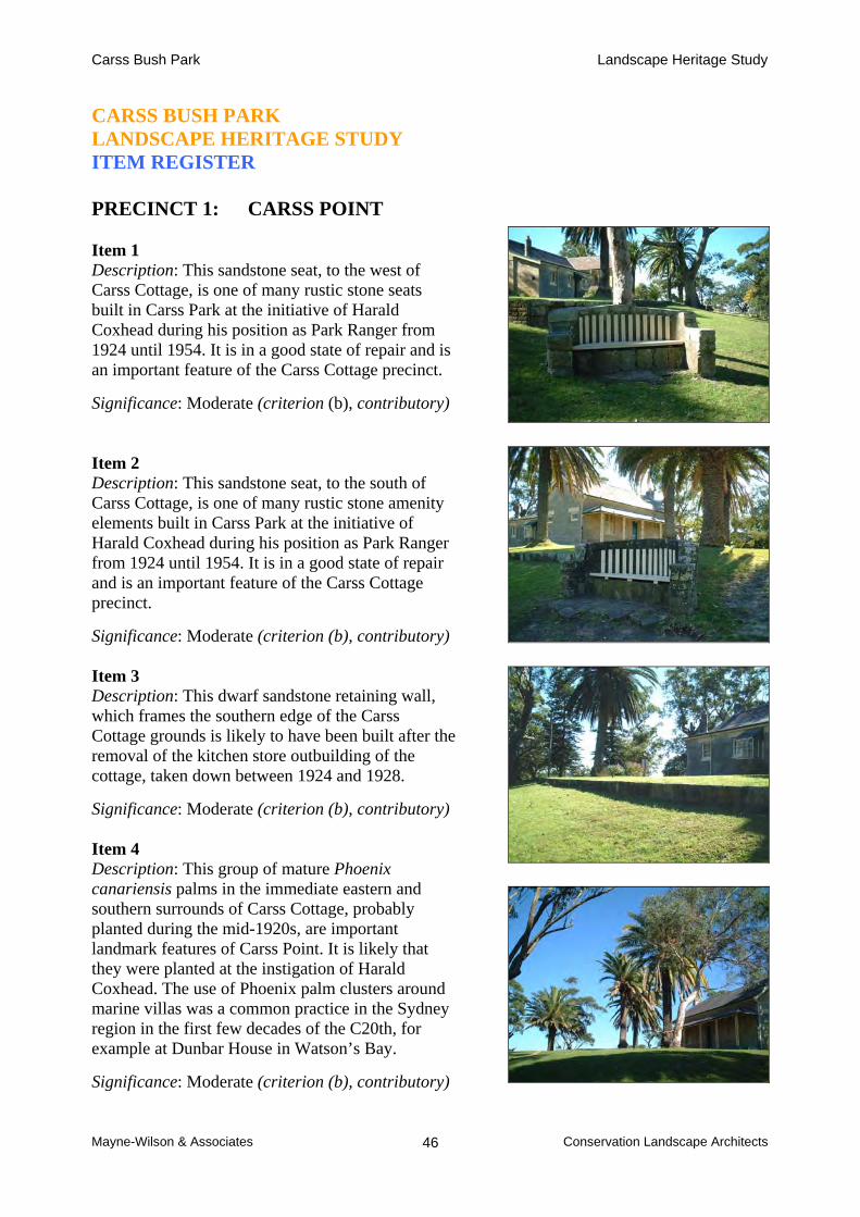
Carss Bush Park Landscape Heritage Study
Mayne-Wilson & Associates Conservation Landscape Architects 46
CARSS BUSH PARK LANDSCAPE HERITAGE STUDY ITEM REGISTER
PRECINCT 1: CARSS POINT Item 1 Description: This sandstone seat, to the west of Carss Cottage, is one of many rustic stone seats built in Carss Park at the initiative of Harald Coxhead during his position as Park Ranger from 1924 until 1954. It is in a good state of repair and is an important feature of the Carss Cottage precinct.
Significance: Moderate (criterion (b), contributory) Item 2 Description: This sandstone seat, to the south of Carss Cottage, is one of many rustic stone amenity elements built in Carss Park at the initiative of Harald Coxhead during his position as Park Ranger from 1924 until 1954. It is in a good state of repair and is an important feature of the Carss Cottage precinct.
Significance: Moderate (criterion (b), contributory) Item 3 Description: This dwarf sandstone retaining wall, which frames the southern edge of the Carss Cottage grounds is likely to have been built after the removal of the kitchen store outbuilding of the cottage, taken down between 1924 and 1928.
Significance: Moderate (criterion (b), contributory) Item 4 Description: This group of mature Phoenix canariensis palms in the immediate eastern and southern surrounds of Carss Cottage, probably planted during the mid-1920s, are important landmark features of Carss Point. It is likely that they were planted at the instigation of Harald Coxhead. The use of Phoenix palm clusters around marine villas was a common practice in the Sydney region in the first few decades of the C20th, for example at Dunbar House in Watson’s Bay.
Significance: Moderate (criterion (b), contributory)

Carss Bush Park Landscape Heritage Study
Mayne-Wilson & Associates Conservation Landscape Architects 47
Item 5 Description: Sandstone block pathway leading from the lawn slope on the north of Carss Cottage to the flat reclaimed land on the east of the original homestead headland. The stairs are in fair condition and may have been partly reconstructed by Harald Coxhead. It seems likely that this stairway existed from the 1880s, developed by the Carss family to gain access to the 3 roods 22 perches of land which they bought and filled to extend their property around Carss Point. Significance: High (criterion (b), contributory) Item 6 Description: This dwarf sandstone retaining wall, whilst not appearing to be recorded on any historic plan or photograph, would have been built either for Carss or Coxhead during their respective occupation of the property as the eastern boundary marker for the homestead garden and edge to the rockbenches around the Point. It did not continue around to the southern side of the house grounds. Significance: Moderate (criterion (b), contributory) Item 7 Description: These stairs at the end of Carss Point, cut out of the sandstone rockbenches (the base of which was once the high water mark) were the original accessway to Carss Cottage from Kogarah Bay. They appear on Surveyor Chesterman’s sketches of the property in the 1880s and would have been well used by visitors to the property and by the Carss family for their enjoyment of the Bay. Significance: High (criterion (b), contributory)
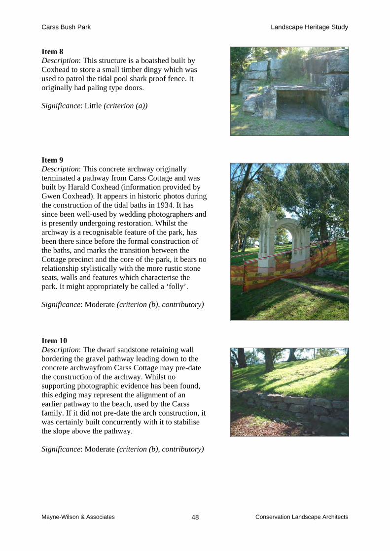
Carss Bush Park Landscape Heritage Study
Mayne-Wilson & Associates Conservation Landscape Architects 48
Item 8 Description: This structure is a boatshed built by Coxhead to store a small timber dingy which was used to patrol the tidal pool shark proof fence. It originally had paling type doors. Significance: Little (criterion (a)) Item 9 Description: This concrete archway originally terminated a pathway from Carss Cottage and was built by Harald Coxhead (information provided by Gwen Coxhead). It appears in historic photos during the construction of the tidal baths in 1934. It has since been well-used by wedding photographers and is presently undergoing restoration. Whilst the archway is a recognisable feature of the park, has been there since before the formal construction of the baths, and marks the transition between the Cottage precinct and the core of the park, it bears no relationship stylistically with the more rustic stone seats, walls and features which characterise the park. It might appropriately be called a ‘folly’. Significance: Moderate (criterion (b), contributory) Item 10 Description: The dwarf sandstone retaining wall bordering the gravel pathway leading down to the concrete archwayfrom Carss Cottage may pre-date the construction of the archway. Whilst no supporting photographic evidence has been found, this edging may represent the alignment of an earlier pathway to the beach, used by the Carss family. If it did not pre-date the arch construction, it was certainly built concurrently with it to stabilise the slope above the pathway. Significance: Moderate (criterion (b), contributory)

Carss Bush Park Landscape Heritage Study
Mayne-Wilson & Associates Conservation Landscape Architects 49
Item 11 Description: The sandstone block steps, to the west of Carss Cottage, leading onto the gravel pathway towards the concrete archway, is likely to pre-date the construction of the latter. These stairs may have been part of the track which the Carss family used to gain access to the beach. Significance: Moderate (criterion (b), contributory) Item 12 Description: This sandstone block retaining wall, which frames the western edge of the Carss Cottage grounds is likely to have been built only after the removal of the kitchen store outbuilding of the cottage, taken down between 1924 and 1928. The wall joins item 3, running perpendicular to it. Significance: Little-moderate (criterion (b), contributory) Item 13 Description: The Carss Cottage Conservation Analysis and Conservation Guidelines by Lucas, Stapleton and Partners, 1993, concluded that this sandstone block wall on the north of Carss Cottage was built during the 1920s, probably from blocks taken from the deconstructed former kitchen/store building to the south of the house. The wall provides a clearly identifiable boundary marking the northern extent of the homeyard to the cottage since the 1920s. Significance: Little-moderate (criterion (b), contributory)
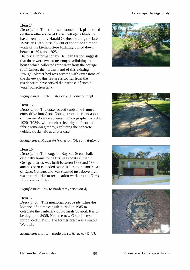
Carss Bush Park Landscape Heritage Study
Mayne-Wilson & Associates Conservation Landscape Architects 50
Item 14 Description: This small sandstone block planter bed on the southern side of Carss Cottage is likely to have been built by Harald Coxhead during the late 1920s or 1930s, possibly out of the stone from the walls of the kitchen/store building, pulled down between 1924 and 1928. Historical information by Dr. Joan Hatton suggests that there were two stone troughs adjoining the house which collected rain water from the cottage roof. Unless the northern end of this existing ‘trough’ planter bed was severed with extensions of the driveway, this feature is too far from the residence to have served the purpose of such a water collection tank. Significance: Little (criterion (b), contributory) Item 15 Description: The crazy-paved sandstone flagged entry drive into Carss Cottage from the roundabout off Carwar Avenue appears in photographs from the 1920s/1930s, with much of its original form and fabric remaining today, excluding the concrete vehicle tracks laid at a later date. Significance: Moderate (criterion (b), contributory) Item 16 Description: The Kogarah Bay Sea Scouts hall, originally home to the first sea scouts in the St. George district, was built between 1933 and 1934 and has been extended twice. It lies to the north-east of Carss Cottage, and was situated just above high water mark prior to reclamation work around Carss Point since c.1946. Significance: Low to moderate (criterion d) Item 17 Description: This memorial plaque identifies the location of a time capsule buried in 1985 to celebrate the centenary of Kogarah Council. It is to be dug up in 2035. Note the new Council crest introduced in 1985. The former crest was a simple Waratah. Significance: Low – moderate (criteria (a) & (d))
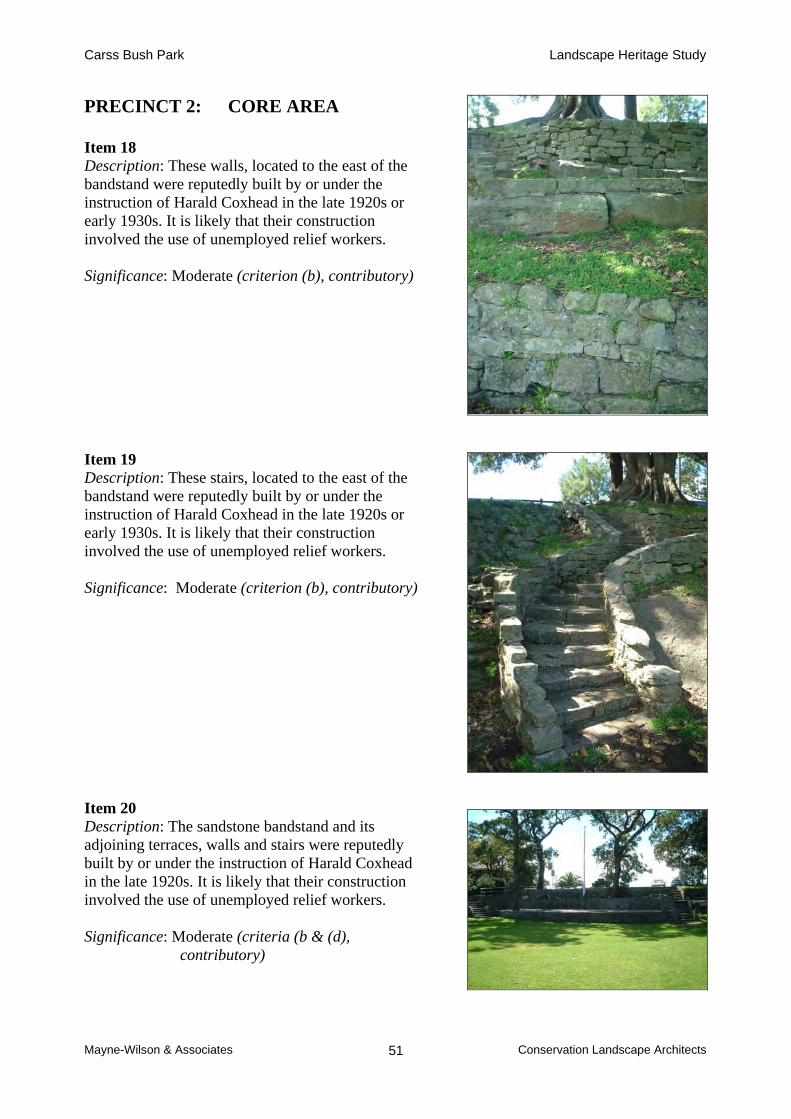
Carss Bush Park Landscape Heritage Study
Mayne-Wilson & Associates Conservation Landscape Architects 51
PRECINCT 2: CORE AREA
Item 18 Description: These walls, located to the east of the bandstand were reputedly built by or under the instruction of Harald Coxhead in the late 1920s or early 1930s. It is likely that their construction involved the use of unemployed relief workers. Significance: Moderate (criterion (b), contributory) Item 19 Description: These stairs, located to the east of the bandstand were reputedly built by or under the instruction of Harald Coxhead in the late 1920s or early 1930s. It is likely that their construction involved the use of unemployed relief workers. Significance: Moderate (criterion (b), contributory) Item 20 Description: The sandstone bandstand and its adjoining terraces, walls and stairs were reputedly built by or under the instruction of Harald Coxhead in the late 1920s. It is likely that their construction involved the use of unemployed relief workers. Significance: Moderate (criteria (b & (d),
contributory)

Carss Bush Park Landscape Heritage Study
Mayne-Wilson & Associates Conservation Landscape Architects 52
Item 21 Description: The sandstone seats and stairs on the south of the bandstand were reputedly built by or under the instruction of Harald Coxhead in the late 1920s or early 1930s. It is likely that their construction involved the use of unemployed relief workers. Significance: Moderate (criterion (b), contributory) Item 22 Description: The sandstone stairs leading to the former Lifesaving clubhouse are likely to have been built in 1934 to provide access to the building from the tidal baths. The sandstone seats and rockery features which lie between these stairs and the Ranger’s residence were reputedly built by or under the instruction of Harald Coxhead in the late 1920s or 1930s. It is likely that their construction involved the use of unemployed relief workers. Significance: Moderate (criterion (b), contributory)
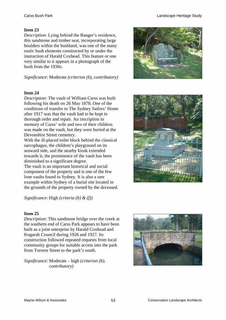
Carss Bush Park Landscape Heritage Study
Mayne-Wilson & Associates Conservation Landscape Architects 53
Item 23 Description: Lying behind the Ranger’s residence, this sandstone and timber seat, incorporating large boulders within the bushland, was one of the many rustic bush elements constructed by or under the instruction of Harald Coxhead. This feature or one very similar to it appears in a photograph of the bush from the 1930s. Significance: Moderate (criterion (b), contributory) Item 24 Description: The vault of William Carss was built following his death on 26 May 1878. One of the conditions of transfer to The Sydney Sailors’ Home after 1917 was that the vault had to be kept in thorough order and repair. An inscription in memory of Carss’ wife and two of their children was made on the vault, but they were buried at the Devonshire Street cemetery. With the ill-placed toilet block behind the classical sarcophagus, the children’s playground on its seaward side, and the nearby kiosk extended towards it, the prominence of the vault has been diminished to a significant degree. The vault is an important historical and social component of the property and is one of the few lone vaults found in Sydney. It is also a rare example within Sydney of a burial site located in the grounds of the property owned by the deceased. Significance: High (criteria (b) & (f)) Item 25 Description: This sandstone bridge over the creek at the southern end of Carss Park appears to have been built as a joint enterprise by Harald Coxhead and Kogarah Council during 1926 and 1927. Its construction followed repeated requests from local community groups for suitable access into the park from Torrens Street to the park’s south. Significance: Moderate – high (criterion (b), contributory)
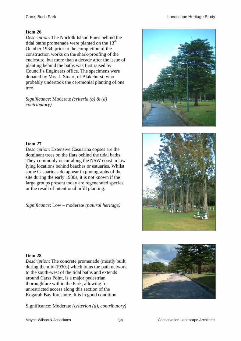
Carss Bush Park Landscape Heritage Study
Mayne-Wilson & Associates Conservation Landscape Architects 54
Item 26 Description: The Norfolk Island Pines behind the tidal baths promenade were planted on the 13th October 1934, prior to the completion of the construction works on the shark-proofing of the enclosure, but more than a decade after the issue of planting behind the baths was first raised by Council’s Engineers office. The specimens were donated by Mrs. J. Stuart, of Blakehurst, who probably undertook the ceremonial planting of one tree. Significance: Moderate (criteria (b) & (d) contributory) Item 27 Description: Extensive Casuarina copses are the dominant trees on the flats behind the tidal baths. They commonly occur along the NSW coast in low lying locations behind beaches or estuaries. Whilst some Casuarinas do appear in photographs of the site during the early 1930s, it is not known if the large groups present today are regenerated species or the result of intentional infill planting. Significance: Low – moderate (natural heritage) Item 28 Description: The concrete promenade (mostly built during the mid-1930s) which joins the path network to the south-west of the tidal baths and extends around Carss Point, is a major pedestrian thoroughfare within the Park, allowing for unrestricted access along this section of the Kogarah Bay foreshore. It is in good condition. Significance: Moderate (criterion (a), contributory)

Carss Bush Park Landscape Heritage Study
Mayne-Wilson & Associates Conservation Landscape Architects 55
Item 29 Description: Originally the First Aid Dressing Station for the tidal baths. In 1971 the single storey building had its roof and clock tower removed to add another storey for the Ranger’s flat, following the Historical Society taking over Carss Cottage for their headquarters. Significance: Moderate (Criterion (d)) Item 30 Description: When the Park was opened to the public in 1924, refreshments were being sold by the Coxhead family out of Carss Cottage. This service soon proved inadequate in meeting the needs of park users, and a small wooden kiosk was opened behind the tidal baths. This structure was subsequently replaced by a brick building on the same site, which has since undergone substantial extensions. Significance: Negligible

Carss Bush Park Landscape Heritage Study
Mayne-Wilson & Associates Conservation Landscape Architects 56
PRECINCT 3: TIDAL BATHS
Item 31 Description: The outer barrier walls for the tidal baths, the sandstone walls around the sides of the baths and the footpath running around the southern side of Carss Point were constructed under an unemployment relief work program during the early 1930s. The tidal baths were officially opened in mid-March 1936 by then Mayor Battye, who at the same occasion laid the foundation stone of the new dressing sheds for the park. The development of the shark-proof enclosure was largely due to the efforts of then president of the Blakehurst Parents’ and Citizens’ Association, Mr. Ken Cavanough. Mr. Cavanough was later to become Mayor of Kogarah Council. Significance: High (criteria (b) & (d))
Item 32 Description: The sandstone retaining sea wall along the promenade abutting the beachfront of the tidal baths was built under an unemployment relief work program between 1934 and 1935. Rock for the promenade wall was obtained from the area behind the original first aid station. Significance: High (criteria (a) & (d))

Carss Bush Park Landscape Heritage Study
Mayne-Wilson & Associates Conservation Landscape Architects 57
PRECINCT 4: BUSHLAND Please see the following description and assessment prepared in accordance with the Natural Heritage Charter.
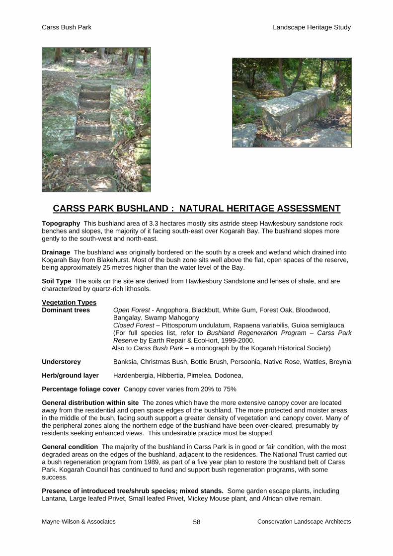
Carss Bush Park Landscape Heritage Study
Mayne-Wilson & Associates Conservation Landscape Architects 58
CARSS PARK BUSHLAND : NATURAL HERITAGE ASSESSMENT Topography This bushland area of 3.3 hectares mostly sits astride steep Hawkesbury sandstone rock benches and slopes, the majority of it facing south-east over Kogarah Bay. The bushland slopes more gently to the south-west and north-east.
Drainage The bushland was originally bordered on the south by a creek and wetland which drained into Kogarah Bay from Blakehurst. Most of the bush zone sits well above the flat, open spaces of the reserve, being approximately 25 metres higher than the water level of the Bay. Soil Type The soils on the site are derived from Hawkesbury Sandstone and lenses of shale, and are characterized by quartz-rich lithosols.
Vegetation Types Dominant trees Open Forest - Angophora, Blackbutt, White Gum, Forest Oak, Bloodwood,
Bangalay, Swamp Mahogony Closed Forest – Pittosporum undulatum, Rapaena variabilis, Guioa semiglauca
(For full species list, refer to Bushland Regeneration Program – Carss Park Reserve by Earth Repair & EcoHort, 1999-2000.
Also to Carss Bush Park – a monograph by the Kogarah Historical Society) Understorey Banksia, Christmas Bush, Bottle Brush, Persoonia, Native Rose, Wattles, Breynia Herb/ground layer Hardenbergia, Hibbertia, Pimelea, Dodonea, Percentage foliage cover Canopy cover varies from 20% to 75% General distribution within site The zones which have the more extensive canopy cover are located away from the residential and open space edges of the bushland. The more protected and moister areas in the middle of the bush, facing south support a greater density of vegetation and canopy cover. Many of the peripheral zones along the northern edge of the bushland have been over-cleared, presumably by residents seeking enhanced views. This undesirable practice must be stopped. General condition The majority of the bushland in Carss Park is in good or fair condition, with the most degraded areas on the edges of the bushland, adjacent to the residences. The National Trust carried out a bush regeneration program from 1989, as part of a five year plan to restore the bushland belt of Carss Park. Kogarah Council has continued to fund and support bush regeneration programs, with some success. Presence of introduced tree/shrub species; mixed stands. Some garden escape plants, including Lantana, Large leafed Privet, Small leafed Privet, Mickey Mouse plant, and African olive remain.
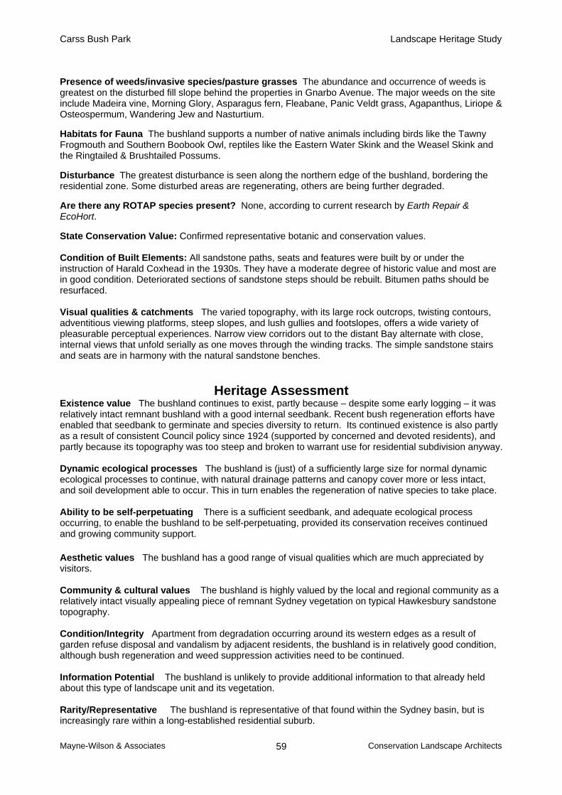
Carss Bush Park Landscape Heritage Study
Mayne-Wilson & Associates Conservation Landscape Architects 59
Presence of weeds/invasive species/pasture grasses The abundance and occurrence of weeds is greatest on the disturbed fill slope behind the properties in Gnarbo Avenue. The major weeds on the site include Madeira vine, Morning Glory, Asparagus fern, Fleabane, Panic Veldt grass, Agapanthus, Liriope & Osteospermum, Wandering Jew and Nasturtium. Habitats for Fauna The bushland supports a number of native animals including birds like the Tawny Frogmouth and Southern Boobook Owl, reptiles like the Eastern Water Skink and the Weasel Skink and the Ringtailed & Brushtailed Possums. Disturbance The greatest disturbance is seen along the northern edge of the bushland, bordering the residential zone. Some disturbed areas are regenerating, others are being further degraded. Are there any ROTAP species present? None, according to current research by Earth Repair & EcoHort. State Conservation Value: Confirmed representative botanic and conservation values. Condition of Built Elements: All sandstone paths, seats and features were built by or under the instruction of Harald Coxhead in the 1930s. They have a moderate degree of historic value and most are in good condition. Deteriorated sections of sandstone steps should be rebuilt. Bitumen paths should be resurfaced. Visual qualities & catchments The varied topography, with its large rock outcrops, twisting contours, adventitious viewing platforms, steep slopes, and lush gullies and footslopes, offers a wide variety of pleasurable perceptual experiences. Narrow view corridors out to the distant Bay alternate with close, internal views that unfold serially as one moves through the winding tracks. The simple sandstone stairs and seats are in harmony with the natural sandstone benches.
Heritage Assessment Existence value The bushland continues to exist, partly because – despite some early logging – it was relatively intact remnant bushland with a good internal seedbank. Recent bush regeneration efforts have enabled that seedbank to germinate and species diversity to return. Its continued existence is also partly as a result of consistent Council policy since 1924 (supported by concerned and devoted residents), and partly because its topography was too steep and broken to warrant use for residential subdivision anyway. Dynamic ecological processes The bushland is (just) of a sufficiently large size for normal dynamic ecological processes to continue, with natural drainage patterns and canopy cover more or less intact, and soil development able to occur. This in turn enables the regeneration of native species to take place. Ability to be self-perpetuating There is a sufficient seedbank, and adequate ecological process occurring, to enable the bushland to be self-perpetuating, provided its conservation receives continued and growing community support. Aesthetic values The bushland has a good range of visual qualities which are much appreciated by visitors. Community & cultural values The bushland is highly valued by the local and regional community as a relatively intact visually appealing piece of remnant Sydney vegetation on typical Hawkesbury sandstone topography. Condition/Integrity Apartment from degradation occurring around its western edges as a result of garden refuse disposal and vandalism by adjacent residents, the bushland is in relatively good condition, although bush regeneration and weed suppression activities need to be continued. Information Potential The bushland is unlikely to provide additional information to that already held about this type of landscape unit and its vegetation. Rarity/Representative The bushland is representative of that found within the Sydney basin, but is increasingly rare within a long-established residential suburb.

Carss Bush Park Landscape Heritage Study
Mayne-Wilson & Associates Conservation Landscape Architects 60
Degree and level of significance The bushland has a moderate to high degree of natural significance at the local level.
PRECINCT 5: TODD PARK No heritage items found

Carss Bush Park Landscape Heritage Study
Mayne-Wilson & Associates Conservation Landscape Architects 61
PRECINCT 6: THE CARWAR AVENUE ENTRY Item 33 Description: Sandstone block terracing constructed across the north-eastern cliff of the bushland facing the Carwar Avenue carpark. These stone retaining walls appear in photographs of the Life Saving clubhouse from the 1950s and were built as part of ‘beautification’ works around this entry to the park. Significance: Low (criterion (d), contributory) Item 34 Description: This low sandstone wall around the base of the large Fig tree in Carwar Avenue is likely to have been built around (??…), following extensions to the carparking at the end of Carwar Avenue. Significance: Little - none Item 35 Description: The drinking fountain near the Lifesaving clubhouse was built in 1934 and officially unveiled on the 14th October that year. It was specifically intended for the use of school children visiting the tidal baths for swimming classes. The fountain, originally erected to mark the commencement of the shark-proof enclosure, was dedicated to the memory of Alderman J. J. Nichols. Significance: Moderate – high (criterion (d)

Carss Bush Park Landscape Heritage Study
Mayne-Wilson & Associates Conservation Landscape Architects 62
Item 36 Description: The sandstone kerbing in the roundabout at the end of Carwar Avenue is likely to have been laid at the instigation of Harald Coxhead in late 1926 following a grant from Council for the widening of this section of the road and the development of a formal turning circle. Significance: Little (but should be retained). (Contributory) Item 37 Description: The mature Norfolk Island Pines, at the end of the roundabout in front of Carss Cottage and the Figs which abut or lie within the carriageway leading to the roundabout are plantings made by the Carss family after 1865. The trees along this entry road are already mature in photos of Carss Point during the early 1930s. Significance: High (criterion (b), contributory) Item 38 Description: The clubhouse for the Carss Park Lifesaving and Athletic Club was built in 1934 to service the needs of swimmers in the tidal baths. By 1980, the services which the club provided were deemed unnecessary and the building became used for a variety of other purposes, most recently as a child minding facility. Significance: Moderate – high (Criterion (d))

Carss Bush Park Landscape Heritage Study
Mayne-Wilson & Associates Conservation Landscape Architects 63
PRECINCT 7: PLAYING FIELDS AND OLYMPIC POOL COMPLEX
Item 39 Description: Built in 1927/28 as an open pavilion protected from southerly winds. It later received an upper deck (demolished in the 1960s) and toilets underneath. The ground floor was ‘bricked in’ in the 1970s to make the Rugby Union “Royals” club change room. The top of the present structure was made into a railed viewing deck after the upper structure was demolished. Significance: Little Item 40 Description: The Carss Park Swimming Pool complex lies to the north of Carss Cottage, below the roundabout at the end of Carwar Avenue. Situated as it is, it bears little physical or visual relationship to the main precincts of Carss Park, south of Carss Point. In the 1960s, the Carss Park Olympic Pool was mooted as the Kogarah War Memorial Pool. The present complex eventuated from the first basic structure built in 1966. Significance: Little (Criterion (d)) Item 41 Description: This toilet block was built c.1980 for about $50,000 to service organised sports events within the playing fields. (It is an intrusive, detracting and ugly structure which should be removed and replaced by a less dominant facility in a more concealed location.) Significance: None.
Carss Bush Park Landscape Heritage Study
Mayne-Wilson & Associates Conservation Landscape Architects 64
5.0 Management Considerations 5.1 Relevant Conservation Issues Because Carss Park is listed as a heritage place on Council’s heritage schedule, the officers managing it are required to apply particular criteria and management practices which derive from the Burra Charter and the NSW Heritage Manual for the protection and conservation of heritage items and places. When applied to Carss Park these can provide constraints on the management and maintenance of heritage items within it, or at least uncertainties as to whether proposed actions would be permissible and would not harm their presumed heritage value. Commonsense suggested that not all the items or precincts within Carss Park – and by extension, adjacent Todd Park – were likely to have heritage value, and that even those that may have some value, were not likely to have the same degree of value. This is because Carss Park, and to a much lesser extent Todd Park, have evolved over a period of many decades, with some elements or facilities having been established as recently as the 1960s and after. The situation is somewhat confusing because the initial heritage listing arose out of a desire to protect Carss’ cottage and its curtilage on the headland, and to a lesser degree Carss Bush Park (its remnant bushland). This tended to suggest that the place derived its principal heritage value from the cottage’s architecture and its association with William Carss, and that anything not directly associated with him (or his heirs) would probably have little heritage value. While Carss’ estate certainly provided the basis for the creation of Carss Park, the story does not end there. Apart from the cottage and some staircases cut into the surrounding sandstone rockbenches, and the Carss vault, the elements present within the overall park today have little to do with Carss and his family. They are the result more from actions of local progress associations, Kogarah Council and its first ranger, Harald Coxhead. Indeed, the creation of the Bush Park and the garden suburb-style residential subdivision on the plateau behind it, were undertaken by Council, while the construction of the sandstone elements, pathways, bridges, benches and band platform were the result of Coxhead’s initiatives. The tidal baths were created through the combined initiatives of Coxhead, Council, and local residents, while the plantings that are maturing today were the result of efforts by successive rangers and their staff over several decades – prompted or assisted sometimes by local societies or clubs such as the Life Saving Club. It is therefore not accurate to assume that only those items directly attributable to Carss and his family are of heritage value, and that those constructed or provided after his estate was acquired by Council are not. 5.1.1 Council’s Requirements Because of these uncertainties, Council engaged the present consultants to identify those items within Carss Park and Todd Park have a clear heritage value - and hence need to be protected and conserved - and which do not. This report has been prepared to meet that request. Council officers managing the parks are required to observe the Plan of Management prepared in 1998. However, this does not advise which particular precincts or items within them have heritage value, and what that may mean, as a consequence, for daily management practices. Of course, not every item within a heritage-listed park necessarily has heritage value, particularly if they were simply contributory items or relatively new ones. As is evident from section 4 above, the consultants have found that while there is a number of items – and precincts – within the two parks that do have heritage value, there are some that do not. Moreover, as section 4 has shown, not all the identified heritage items have the same degree of value. The situation is somewhat complicated by the fact that, while some of these items do

Carss Bush Park Landscape Heritage Study
Mayne-Wilson & Associates Conservation Landscape Architects 65
not have more than a low to moderate degree of value in themselves, collectively they have value as contributory items which help generate the overall rating of a precinct as being of ‘high’ or ‘exceptional’ heritage value or cultural significance. Accordingly, section 4.3 has been designed to provide Council officers with a quick, ready reference to the heritage value or otherwise both of precincts and of items within the two parks. This constitutes a simple checklist as to whether heritage protection and conservation measures should be applied or not. However, it does not necessarily follow that those items which are not identified as having some heritage value can or should be modified, removed or replaced without the consequences on the heritage items or precincts first being carefully considered. See the discussion on ‘in the vicinity’ below. 5.2 Constraints Apart from the usual annual budgetary constraints, there appear to be few customary constraints on the implementation of the findings and recommendations contained in this report. Matters which may be considered as constraints are:
a. The requirement to maintain intact the remnant bushland within Carss Bush Park, to foster natural regeneration, and prevent weed infestation and general degradation.
b. The requirement to protect and conserve the headland and all the identified heritage elements within the curtilage of Carss cottage.
c. The presence of the Carss vault in the middle of the most popular and used precinct of the park (precinct 2).
d. The existence of tidal baths which, while having some heritage value, have been largely superseded by other more popular swimming venues and facilities elsewhere.
e. The controls and procedures arising from the application of provisions within the heritage legislation of NSW, the NSW Heritage Manual, and the principles of Burra Charter (for which see below). These may constrain the construction of new works within a particular precinct, or the demolition of existing ones deemed to be ‘obsolete’ or worn out.
5.3 Opportunities In general terms, it is considered that most of the opportunities which the natural capabilities of the parks present have already been taken up. Full advantage has already been taken of the bushland, the water and beach along the edge of the Bay, the opportunities to reclaim land north of Carss Point, and the exploitation of the flat lands between the Bay and the mini-escarpment. However, there appear to be opportunities to:
a. restore the original creek and drainage channels by returning portions of them to natural creeks and wetlands;
b. Prepare an inspirational landscape masterplan for Todd Park which would both recognize and interpret its earlier role as a market garden site, and foster a character that related it more harmoniously with adjacent Carss Park and the Bush Park.
c. Prepare a landscape masterplan for the surrounds of the playing fields and Olympic Pool which integrated them more sympathetically with Carrs Park and with the lands along their boundaries.
d. Continue with bush regeneration programs within Precinct 4 (the remnant bushland) and install sufficient formal trails through it to reduce the random criss-cross of tracks through it which are serving to degrade it.
e. Develop a significant tree register for all trees within the Carss Park Area.

Carss Bush Park Landscape Heritage Study
Mayne-Wilson & Associates Conservation Landscape Architects 66
5.4 Heritage Provisions Carss Cottage was the subject of a Permanent Conservation Order issued on 22 July 1988 and was listed as item 00587 on the State Heritage Register on 2 April 1999. The heading in the State Heritage Office database is “Carss Cottage”. The listing does not extend either to the remnant bushland (precinct 4) nor to any other precinct of Carss Park. This reflects the earlier pre-occupation of heritage assessors with architectural heritage, not landscape. . However, the subsequent study undertaken by Clive Lucas, Stapleton & Partners in 1993 did extend their assessment to the land surrounding the cottage (the curtilage), stating that:
“Situated on a knoll close to Kogarah Bay and through its largely unspoilt setting, it plays an integral role in the aesthetic and architectural quality of the Bay.”
That study also noted the landscaping works around the cottage that included the construction of stone walling, the arbor and stone seats. In Kogarah Local Environmental Plan (LEP) 1998, there are two listings in Schedule 3 ‘Heritage Items’. The first is Carss Cottage (no doubt deriving from the PCO of 1988) and the second is Carss Bush Park. It is not clear from this latter heading whether this includes all the other precincts identified in section 3.2 above, or whether it was intended only to refer to the remnant bushland. The terms ‘Carss Bush Park’ and ‘Carss Park’ (perhaps just an abbreviation) appear often to be used interchangeably, although they can, in practice, have quite different meanings. If, in fact, the intention of the second listing was to limit the extent of the area to the bushland only, then it means that the other five precincts are not regarded as having heritage value. This is perhaps where some of the uncertainties arise in the minds of the Council officers managing the parks. As our assessments in section 4 above show, however, we consider that some of these other precincts do have heritage value. This extends to some of the items within them that contribute to the overall heritage rating of the particular precinct. For this reason our preference would be that:
1. The title in the LEP heritage schedule – “Carss Bush Park” – be regarded as covering the other 5 precincts as well (or 6 if Todd Park is also included);
2. However, for the sake of simplicity, the two heritage listings in schedule 3 be amalgamated, and changed to “Carss Park”, which would include both the cottage and the other 5 precincts.
3. Todd Park remain outside the heritage listing, since it has very little heritage value and was not historically part of Carss Bush Park.
5.5 Statutory Requirements As Carss Park is not listed on the Register of the National Estate by the Australian Heritage Commission, it is not subject to federal statutory requirements. It is, however, listed on the NSW Heritage Register, and on the Kogarah LEP 1998, as well as on the register of the National Trust of Australia. 5.5.1 The NSW Heritage Act, 1977 As stated above, precinct 1 was covered by a Permanent Conservation Order (PCO), under the Heritage Act 1977, which was established to conserve the environmental heritage of the State. This includes buildings, works, relics, trees or places which satisfy the criteria listed in section 4 above. PCOs have recently been transformed into formal listings on the State Heritage Register,

Carss Bush Park Landscape Heritage Study
Mayne-Wilson & Associates Conservation Landscape Architects 67
and no longer described as PCOs. Section 57 of the revised Heritage Act spells out the effect of interim heritage orders and listing of places in the State Heritage Register:
“ 57. (1) When an interim heritage order or listing on the State Heritage Register applies to a place, building, work, relic, moveable object, precinct, or land, a person must not do any of the following things except in pursuance of an approval granted by the approval body under Subdivision 1 of Division 3: (a) demolish the building or work, (b) damage or despoil the place, precinct or land, or any part of the place, precinct or land, (c) move, damage or destroy the relic or moveable object, (d) excavate any land for the purpose of exposing or moving the relic, (e) carry out any development in relation to the land on which the building, work or relic is situated, the land that comprises the place, or land within the precinct, (f) alter the building, work, relic or moveable object,
(g) display any notice or advertisement on the place, building, work, relic, moveable object or land, or in the precinct, (h) damage or destroy any tree or other vegetation on or remove any tree or other vegetation from the place, precinct or land.
(2) The Minister, on the recommendation of the Heritage Council may, by order published in the Gazette, grant an exemption from subsection (1) or such of the provisions of that subsection as are specified in the order in respect of the engaging in or carrying out of such activity or class of activities by such person or class of persons in such circumstances as may be so specified. The Minister's power under this subsection extends to apply in respect of interim heritage orders made by councils. (3) A council may, by order published in the Gazette, grant an exemption from subsection (1) or such of the provisions of that subsection as are specified in the order in respect of the engaging in or carrying out of such activity or class of activities by such person or class of persons in such circumstances as may be so specified. Such an exemption has effect only in respect of an interim heritage order made by the council concerned.”
Once the heritage value of particular items and precincts has been identified, Council can take advantage of the exemptions under the above sections, which allows ordinary, everyday maintenance to occur if the relevant authority has agreed to such exemptions. (If Council officers need more specific guidance, they should consult the NSW Heritage Office document Standard Exemptions for Works Requiring Heritage Council Approval, issued in 1999.) Section 118 of the Heritage Act, as amended, goes on to deal with the protection of heritage items and places by referring to minimum standards of maintenance and repair. It states that the regulations may impose minimum standards with respect to the maintenance and repair of a building, work or relic that is listed or within a precinct that is listed on the State Heritage Register, but those standards can only relate to the following matters:
Carss Bush Park Landscape Heritage Study
Mayne-Wilson & Associates Conservation Landscape Architects 68
(a) the protection of the building, work or relic from damage or deterioration due to weather (including such matters as the weatherproofing of roof, doors and windows),
(b) the prevention of and the protection of the building, work or relic from damage or destruction by fire,
(c) security (including fencing and surveillance measures to prevent vandalism),
(d) essential maintenance and repair (being maintenance and repair necessary to prevent serious or irreparable damage or deterioration).
Section 119 deals with the offence of not maintaining and repairing in accordance with minimum standards
(1) The owner of a building, work or relic listed or within a precinct listed on the State Heritage Register must ensure that the building, work or relic is maintained and repaired to standards that are not less than the minimum standards imposed by the regulations.
(2) Proceedings for an offence against this Act in respect of a contravention of this section cannot be instituted without the written consent of the Minister.
Comment: It is for these reasons that Council officers require clarification and certainty about which precincts and items within them do, or do not, have heritage value. 5.5.2 Kogarah LEP 1998 The heritage provisions of Kogarah LEP 1998 are set out in its section 17. For convenience, these are attached as Appendix A. They are similar in intent and language to the provisions of the Heritage Act of 1977, as amended, but provide greater detail in certain respects. In other respects, such as ‘development in the vicinity of a heritage item or place’, the Heritage Office, in August 2000, provided an elaboration of this in its ‘Model Provisions’: (1) Before granting consent to development in the vicinity of a heritage item, the consent authority must assess the impact of the proposed development on the heritage significance of the heritage item and of any heritage conservation area within which it is situated. (2) This clause extends to development: (a) that may have an impact on the setting of a heritage item, for example, by affecting a significant view to or from the item or by overshadowing, or (b) that may undermine or otherwise cause physical damage to a heritage item, or (c) that will otherwise have any adverse impact on the heritage significance of a heritage item or of any heritage conservation area within which it is situated. (3) The consent authority may refuse to grant any such consent unless it has considered a heritage impact statement that will help it assess the impact of the proposed development on the heritage significance, visual curtilage and setting of the heritage item. (4) The heritage impact statement should include details of the size, shape and scale of, setbacks for, and the materials to be used in, any proposed buildings or works and details of any modification that would reduce the impact of the proposed development on the heritage significance of the heritage item.
Comment: It is, of course, up to the discretion of Council whether it decides to adopt this fuller and more current version. It does, however, have particular resonance for development in such large areas of land as those of the two parks, both of which are totally within Council ownership and control.
Carss Bush Park Landscape Heritage Study
Mayne-Wilson & Associates Conservation Landscape Architects 69
Another potentially useful elaboration of Council’s responsibilities in assessing development proposals – including those from its park management officers – is contained in the Model Provisions. It refers specifically to the need for the preparation of ‘heritage impact statements’:
Heritage Impact Statements What must be included in assessing a development application?
(1) Before granting a consent required by this clause, the consent authority must assess the extent to which the carrying out of the proposed development would affect the heritage significance of the heritage item or heritage conservation area concerned.
What extra documentation is needed?
(2) The assessment must include consideration of a heritage impact statement that addresses at least the following issues - see (3) below - (but is not to be limited to assessment of those issues, if the heritage significance concerned involves other issues). The consent authority may also decline to grant such a consent until it has considered a conservation management plan, if it considers the development proposed should be assessed with regard to such a plan.
(3) The minimum number of issues that must be addressed by the heritage impact statement are: (a) for development that would affect a heritage item: (i) the heritage significance of the item as part of the environmental heritage of
[name of local government area], and (ii) the impact that the proposed development will have on the heritage significance of the
item and its setting, including any landscape or horticultural features, and (iii) the measures proposed to conserve the heritage significance of the item and its setting,
and (iv) whether any archaeological site or potential archaeological site would be adversely
affected by the proposed development, and (v) the extent to which the carrying out of the proposed development would affect the form
of any historic subdivision. There are other provisions concerning a heritage conservation area, which would be useful if Council were to decide that the Carss Park Area should not be treated as a heritage place but rather as a conservation area. These can be obtained from the text of the Model Provisions. Aboriginal sites Before leaving the Model Provisions, it is worth noting that there some concerning places or sites of known or potential Aboriginal heritage significance. These state that: “Before granting consent for development that is likely to have an impact on a place of Aboriginal
heritage significance or a potential place of Aboriginal heritage significance, or that will be carried out on an archaeological site of a relic that has Aboriginal heritage significance, the consent authority must:
(a) consider a heritage impact statement explaining how the proposed development would affect the conservation of the place or site and any relic known or reasonably likely to be located at the place or site, and
(b) except where the proposed development is integrated development, notify the local Aboriginal communities (in such way as it thinks appropriate) and the Director-General of National Parks and Wildlife of its intention to do so and take into consideration any comments received in response within 28 days after the relevant notice is sent.
The Model Provisions then go on to address development affecting known or potential archaeological sites of relics of non-Aboriginal heritage significance “Before granting consent for development that will be carried out on an archaeological site or a
potential archaeological site of a relic that has non-Aboriginal heritage significance (whether or not it

Carss Bush Park Landscape Heritage Study
Mayne-Wilson & Associates Conservation Landscape Architects 70
is, or has the potential to be, also the site of a relic of Aboriginal heritage significance), the consent authority must:
(a) consider a heritage impact statement explaining how the proposed development will affect the conservation of the site and any relic known or reasonably likely to be located at the site, and
(b) notify the Heritage Council of its intention to do so and take into consideration any comments received in response within 28 days after the notice is sent.
This clause does not apply if the proposed development: (a) does not involve disturbance of below-ground deposits and the consent authority is of the
opinion that the heritage significance of any above-ground relics would not be adversely affected by the proposed development, or
(b) is integrated development.” These provisions are cited here because, although aboriginal heritage will be the subject of a separate, complementary report, there are important aboriginal middens and shelter caves within the park area. It needs to be remembered that they are an integral part of the broader cultural landscape heritage of the study area and must be treated in accordance with statutory protection and conservation provisions. 5.5.3 Plan of Management A Plan of Management was prepared in 1998 for the Carss Park Area1, which “looked at this important resource as a whole and set planning objective and goals for the area using a holistic approach”. Preparation of the Plan was required under the provisions of the Local Government Act of 1993, and involved a considerable amount of community consultation, including workshops. It is understood that this Plan is currently being revised, and that the present landscape heritage study/report will be used as a complementary document to it, as will a proposed report on Aboriginal heritage. The purpose of the landscape heritage report is to provide supplementary guidance to the Plan of Management on the protection and conservation of those precincts and elements within the parks that have identified heritage values. It should be read in conjunction with the revised Plan of Management, while at the same time, the latter should contain cross-references to this report, so that heritage precincts and places will be correctly managed in accordance with it. 5.6 Non-statutory heritage measures 5.6.1 The Burra Charter This Charter, prepared by Australia ICOMOS, was first prepared in 1977-78 for the conservation and management of places of cultural significance, and was revised in 1999. It sets a standard of practice for those – including owners, managers and custodians - who provide advice, make decisions about, or undertake works to places of cultural significance. Its use and application are further explained in Guidelines to the Charter, including those dealing with conservation policy. Its basic premise is that places of cultural significance – including natural indigenous and historical places – must be preserved for future generations. Generally, it advocates a cautious approach to change, its motto being: “do as much as necessary to care for the place and to make it useable, but otherwise change it as little as possible so that its cultural significance is retained”. The Charter provides a set of conservation principles (articles 2 to 13), conservation processes (articles 14 to 25) and conservation practices (articles 26 to 34). A flowchart of the sequences of investigations, decisions and actions is contained in Appendix B. All Council officers who have
1 This included Carss Bush Park, Todd Park, Carss Park Playing Fields, Parkside Drive reserve and Harold Fraser Oval.

Carss Bush Park Landscape Heritage Study
Mayne-Wilson & Associates Conservation Landscape Architects 71
responsibilities for the management and maintenance of items and precincts of cultural/heritage significance should familiarize themselves with the provisions and guidelines of that Charter. It should be noted that article 16 of the Charter states that “maintenance is fundamental to conservation and should be undertaken where fabric is of cultural significance and its maintenance is necessary to retain that significance”. The previous article (no.15) recognizes that change may be necessary to retain cultural significance, but is undesirable where it reduces it. The amount of change should be guided by a place’s cultural significance and its appropriate interpretation. Changes which reduce cultural significance should be reversible, and be reversed when circumstances permit. Demolition of a significant place is generally not acceptable. 5.6.2 National Trust of Australia (NSW) Both Carss Cottage and Carss Bush Park are classified in the register of the National Trust. (For details of that listing, see the attachments to item 55 of the 1993 Kogarah Heritage Study.) Although inclusion of places in the Register does not have any legal effect, it is widely recognized as being an authoritative statement on the significance of a place. The purpose of the Register is to alert responsible authorities, property owners and the public so that those concerned may adopt measures to preserve the special qualities which prompted the listing. When the significance of a place is under threat, the Trust will take whatever action is deemed appropriate to ensure its protection, including giving advice to the property owner and seeking the use of the State Heritage Act of the planning powers of the local authority. It is desirable that Council officers responsible for the management and maintenance of the parks bear this in mind. 5.7 Overlapping or Related Issues 5.7.1 Bush Regeneration Bushland regeneration and the removal of exotic plants, especially woody weeds, from the remnant bushland has been an on-going process since 1989, and is consistent with the protection and conservation of the natural heritage values of the bushland, as identified earlier in this report. It was undertaken first by teams under the auspices of the National Trust (NSW), subsequently by Urban Bushland Management, and recently by the firm Earth Repair & EcoHort for the Council. The continuance of this activity is supported. It is noted, however, that if the natural heritage values of the bushland are to restored and maintained into the future, it needs to be supplemented by the range of measures outlined in section 5.1 of the 1998 Plan of Management. 5.7.2 Significant tree register The proposal to establish this register was made in the 1998 Plan of Management, and would be of particular importance for the protection and conservation of mature cultural plantings made by persons associated with the early establishment of the parks. While it is usually difficult, and not entirely appropriate, to prepare separate heritage inventory sheets on individual trees – especially if they are basically contributory items to the heritage value of a precinct – it is desirable to register their value in some way. This may be in the form of groups or copses of trees, or of important individual ones such as late 19th century or early 20th century plantings of Norfolk Island Pines or Fig Trees at the end of Carwar Avenue.. Use of a significant tree register is not recommended as a means of protecting individual trees within the bushland itself; these are better protected in terms of being members of a particular plant community such as the woodlands and closed forests found on Hawkesbury sandstone formations in the Sydney region.
Carss Bush Park Landscape Heritage Study
Mayne-Wilson & Associates Conservation Landscape Architects 72
A significant tree register does, however, need to be fully supported by Councillors and Council officers, and firmly policed by a diligent tree preservation officer if it is to have any real effectiveness. Prosecutions may need to be publicized to serve as a deterrent to those tempted to remove trees to enhance their views or for ‘safety’ reasons.
6.0 Conservation Policies 6.1 Findings from the Statement of Significance Because some of the precincts within the Carss Park Area have been identified as having
heritage values/cultural significance, they must be protected and conserved in accordance with statutory instruments, and desirably also by the precepts and guidelines of the Burra Charter.
Items within the various precincts which either have heritage value in their own right, or which, while being individually of low to moderate significance, nevertheless contribute to the overall significance of a precinct, should also be protected and conserved.
Heritage significance is not limited to works or places associated with the Carss family, but includes some items or places established by Council and its first ranger, Harald Coxhead. These should also be protected and conserved.
The bushland precinct of the Area contains some natural heritage values, even though some sectors been somewhat degraded. There is believed to be a sufficient seed bank still within these sectors to enable regeneration and recovery to occur. Bush regeneration and conservation policies should therefore continue to be pursued.
6.2 Conservation policies for precincts Precinct 1: Carss Point As this precinct has been assessed as having exceptional heritage significance, and has been listed on State, local and National Trust registers, it is essential that it be protected and conserved in accordance with measures stipulated in the Heritage Act 1977, the NSW Heritage Manual, and the Burra Charter. The principal measures of the latter are identified in section 5.6.2 above. Items which contribute to the significance of that precinct include the cottage itself, the sandstone stairways and retaining walls, the four Phoenix palms, and the two stone garden seats. Precinct 2. The Core Area Being the most intensively used precinct of the Park, but nevertheless containing a large number of items which contribute to its heritage significance, the conservation policy towards it requires particular care and sensitivity. The contributions which each of these items contributes to the cultural significance of this place should be respected. As the Burra Charter says2,
“if a place includes fabric, uses, associations or meanings of different periods, or different aspects of cultural significance, emphasizing or interpreting one period or aspect at the expense of another can only be justified when what is left out, removed or diminished is of slight cultural significance and that which is emphasized or interpreted is of much greater cultural significance.”
In the context of Precinct 2, because items such as the Carss vault have high significance, and the stone stairways, benches, walls, bandstand and pathways of the 1930s have moderate significance, it is important that they all be conserved. At the other extreme, the toilet block near the vault is intrusive and ugly, and should be removed.
2 Article 15.4 of the Burra Charter, 1999.

Carss Bush Park Landscape Heritage Study
Mayne-Wilson & Associates Conservation Landscape Architects 73
Items such as the ranger’s flat, kiosk, children’s playground, barbecue area and shelter pavilions have little or no heritage value, and because they have been modified from time to time, can accordingly be adaptively re-used, relocated or removed. The kiosk now extends too close to the Carss vault, and should be remodeled so that it is further to the north of it. Precinct 3: Tidal Baths Although the baths in this precinct have been assessed as having moderate heritage significance, this does not mean that no change or adaptive re-use can occur, particularly in circumstances where their usage rate is now lower than in earlier decades. While the sandstone walls that surround the baths and the adjacent paved promenade should be retained, since they serve to define them and were constructed by relief labour in the 1930s, more ephemeral or organic items such as nets or stakes could be replaced by more modern and durable types of enclosure and safety devices. Any proposed redevelopment in this precinct should take in consideration the likely impact on the setting to Carss Point and the views out to, and in from, Kogarah Bay, since these form part of the heritage significance of this precinct. Precinct 4: Bushland Being an area with natural heritage values, and listed on the schedule to Kogarah LEP 1998, it is important that this bushland be protected and conserved. This has already recognized through the sustained attempts at bush regeneration made over the last decade or so. However, a broader spectrum of protective measures are required to reverse the pattern of degradation occurring around its edges and even within. This is where environmental protection and heritage protection coincide, in that the provisions in the Plan of Management would, if effectively applied, achieve the parallel goal of protecting the natural heritage values of the precinct. Precinct 5: Todd Park As this has negligible heritage value, the provisions of the statutory heritage instruments do not apply. However, an effort could be made to provide signage, or other forms of interpretation, to inform users of the previous history of use of the site as a Chinese market garden, and the presence of the creek and adjacent marshes that once provided water for them. Precinct 6: Carwar Avenue Entry Being a mixed precinct containing a few elements of low to moderate significance – such as mature cultural plantings (Moreton Bay Figs and Norfolk Island Pines), the Life Saving Club building, and some built sandstone elements – some flexibility in approach is desirable. Some of the cultural plantings warrant being placed on a special tree register, while the Clubhouse building should be retained but allowed to be adapted for a different use. In that case, the core of the original building should be retained, but extensions or adjacent pavilions could be permitted if sensitively designed and constructed. Articles 21 and 22 of the Burra Charter are relevant in this regard:
“Adaptation is acceptable only where the adaptation has minimal impact on the cultural significance of the place. It should involve minimal change to significant fabric, achieved only after considering alternatives.” New work such as additions to the place may be acceptable where it does not distort or obscure the cultural significance of the place, or detract from its interpretation and appreciation. New work should be readily identifiable as such.”

Carss Bush Park Landscape Heritage Study
Mayne-Wilson & Associates Conservation Landscape Architects 74
Precinct 7: Playing Fields As this precinct has no identifiable heritage value, there is no requirement to observe the measures stipulated in the various heritage instruments cited above. However, attention is drawn to the provisions concerning ‘development in the vicinity of a heritage item or place’, because Precinct 7 directly abuts Precinct 1. Insensitive development in Precinct 7 could adversely affect the setting and visual/aesthetic values of Precinct 1. 6.3 Setting and visual relationships These are factors of a perceptual and visual nature, and are not as susceptible to statutory regulation or controls as built fabric. Article 8 of the Burra Charter states that:
“Conservation requires the retention of an appropriate visual setting and other relationships that contribute to the cultural significance of the place. New construction, demolitions, intrusions or other changes which would adversely affect the setting or relationships are not appropriate.” The commentary adds that: “Aspects of the visual setting may include use, siting, bulk, form, scale, character, colour, texture and materials. Other relationships, such as historical connections, may contribute to interpretation, appreciation, enjoyment or experience of the place.”
It needs to be borne in mind that the setting of a place is the available area of land – and water, if appropriate - in which it sits and from which it may be viewed. The setting is usually the area which is contained within a person’s cone of vision, and will change as a person moves around a place, so that it has no finite boundaries that one could put on a map. It can also include elements quite unrelated to the heritage place and which have no heritage value within themselves. While sometimes a place, such as Carss Point, may be viewed ‘in the round’, in the majority of cases the principal public viewing point is from a road, pathway or landscaped forecourt in front of the place. There may sometimes be other sides or other properties from which the place may be viewed, but in yet other cases the setting may simply be the land entirely within the property boundary. As already described in section 3.2, the settings and/or visual catchments vary from precinct to precinct, and even within different sectors of one precinct. In some cases there are broad visual catchments or well defined visual corridors out from, or leading to, a particular item or place, and considerable care needs to be taken when designing a new development to ensure that these important settings, corridors and catchments are not interfered with by distracting or detracting new elements. This includes the protection of public viewing points. 6.4 Curtilages A heritage curtilage is defined as the area or land (including land covered by water) surrounding an item or area of heritage significance which is essential for retaining and interpreting its heritage significance. It can apply, in this case, to a precinct which includes buildings, works, relics, trees or places and their setting. A ‘curtilage’ differs from the ‘setting’ because it can - and must - be defined by a line on a plan or map, for legal purposes. This means that all the elements within a curtilage fall within the provisions of statutory heritage instruments, and hence should be protected and conserved. To clarify matters, such elements can be enumerated and ranked according to their degree of heritage value.

Carss Bush Park Landscape Heritage Study
Mayne-Wilson & Associates Conservation Landscape Architects 75
In the case of Carss Point, the cottage is the central element, and the outbuildings (or their footprints), pathways, retaining walls and plantings are elements which contributed to the enjoyment of the cottage and fulfillment of its purposes. These have been identified in the Lucas, Stapleton study as belonging within the curtilage. This was an appropriate decision, leaving only the question as to whether the curtilage should stop at the top of the dwarf retaining wall around the garden, or be defined as the foot of the rockbenches of the headland. The consultants prefer the latter choice, since historically the base of the headland was surrounded by water, which defined the limits of the precinct. (The present strip of land around the base derives from subsequent reclamation works.) With regard to the tidal baths and the bushland, which are single, coherent entities, de facto curtilages already exist because the boundaries of these two precincts are obvious and have been previously defined on plans. For other precincts, however, there does not appear to be much point in attempting to define curtilages, because of their heterogeneous nature and somewhat seamless boundaries. While the boundaries selected in this report to define the various precincts could be used as a basis for determining curtilages for them, this would have the disadvantage that all elements within those of them that have heritage value would fall within the provisions of statutory heritage instruments. 7.0 Management Policies 7.1 General measures to manage and conserve heritage items The consultants were impressed by the current standard of management of all the precincts within Carss Park, and by the comprehensive studies, workshops and recommendations contained in the covering Plan of Management. Being a park of regional importance, and so long established, it is not surprising that the management policies and techniques applied to it have been well developed and refined over time. It is recommended that this heritage landscape plan be made an integral part of the overall Plan of Management for the park currently under revision, and that Council officers managing and maintaining the park are thoroughly familiar with section 4.2, section 5 and section 6 of this report. Sections 5.5.1, 5.5.2 and 5.6.1 are of particular relevance to those making decisions about the management of heritage items and places. Although not essentially a heritage matter, the design and location of toilet blocks has in many instances adversely affected the setting and enjoyment of heritage items. The present toilet blocks are mostly visually intrusive, brutally designed, and constructed from materials whose colour and texture are totally unsympathetic with the surrounding heritage items and the precinct in which they are located. 7.2 General guidelines for maintenance As mentioned above, careful and sensitive maintenance is an essential activity for the conservation of heritage items. However, both this and ‘repair’ or ‘restoration’ should be governed by the Burra Charter injunction:
“Do as much as necessary to care for the place and to make it useable, but otherwise change it as little as possible so that its cultural significance is retained”.
Particular care is required for the conservation of built sandstone items, especially with regard to the replacement of mortar in fretted joints. Generally, the mortar should have a relatively high degree of cement so that it will withstand weathering, and will match the dark grey colour of the weathered sandstone blocks which it is binding together. However, the mortar joints should be
Carss Bush Park Landscape Heritage Study
Mayne-Wilson & Associates Conservation Landscape Architects 76
lightly raked, so that the mortar finish is just below the surface of the adjacent sandstone blocks. It must not be allowed to smear the surface of the adjacent blocks, nor should it be tuck-pointed. Where sandstone blocks or paving needs to be replaced, it is important that only weathered sandstone is used, and that new, striped sandstone is not used. Generally, the use of endemic native plants in the park is appropriate, with cultural plantings of Norkfolk Island Pines, Figs and Phoenix Palms limited to precinct 1 and the northern section of precinct 2. Care needs to be taken to ensure that self-seeded Phoenix Palms now appearing within those precincts are carefully removed, since they are adventitious and not cultural plantings with a deliberate design intent. It is desirable that the treed parkland of the southern sector of precinct 2, leading into the adjacent car park near Todd Park, is maintained as such, and that when existing trees die or become so senescent that they need to be removed, they are replaced with semi-advanced trees of the same species. Because of the regular mowing of this extensive parkland, natural regeneration cannot occur, so that deliberate and continuing replacement is carried out. The annual program of bush regeneration, which has produced some good results, needs to be continued well into the future. Determined and sustained efforts should be made to educate residents of dwellings abutting the edges of the bushland about the importance of not cutting down trees in the vicinity of their properties and generally dumping their garden refuse there. Persistent behaviour of this kind should be prosecuted. 7.3 Detailed proposals for items in each precinct For the benefit of park managers, a simple table has been prepared showing the condition of existing heritage items and what maintenance, repair or restoration is required. This is set out on the following page. 8.0 Interpretation Following public exhibition of this report, and Council consideration and adoption of it, it would be desirable to have signage and other interpretative devices prepared to draw attention to, and explain the origins and the heritage value of the landscape items within the park. This would be particularly appropriate for precincts 1 to 4.
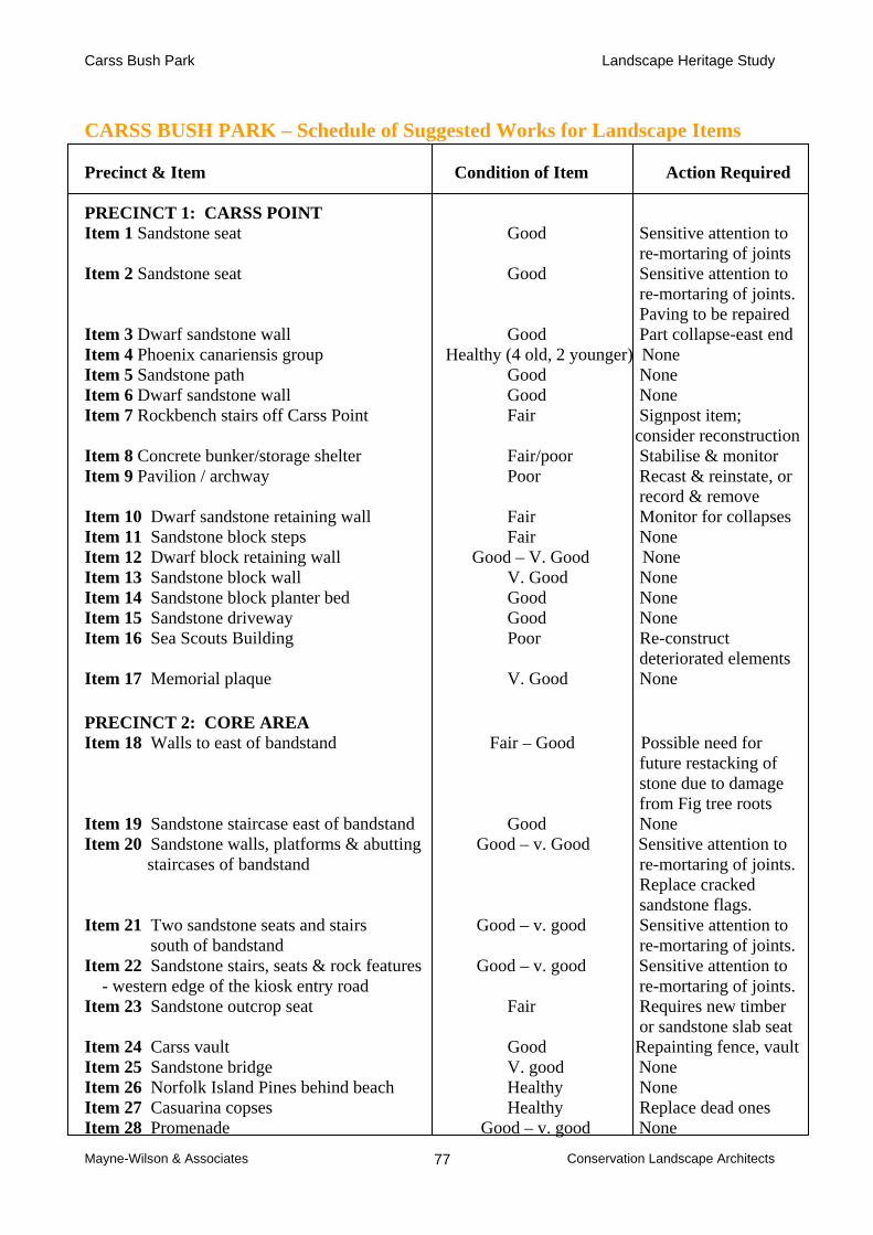
Carss Bush Park Landscape Heritage Study
Mayne-Wilson & Associates Conservation Landscape Architects 77
CARSS BUSH PARK – Schedule of Suggested Works for Landscape Items
Precinct & Item Condition of Item Action Required PRECINCT 1: CARSS POINT Item 1 Sandstone seat Good Sensitive attention to
re-mortaring of joints Item 2 Sandstone seat Good Sensitive attention to re-mortaring of joints. Paving to be repaired Item 3 Dwarf sandstone wall Good Part collapse-east end Item 4 Phoenix canariensis group Healthy (4 old, 2 younger) None Item 5 Sandstone path Good None Item 6 Dwarf sandstone wall Good None Item 7 Rockbench stairs off Carss Point Fair Signpost item;
consider reconstruction Item 8 Concrete bunker/storage shelter Fair/poor Stabilise & monitor Item 9 Pavilion / archway Poor Recast & reinstate, or
record & remove Item 10 Dwarf sandstone retaining wall Fair Monitor for collapses Item 11 Sandstone block steps Fair None Item 12 Dwarf block retaining wall Good – V. Good None Item 13 Sandstone block wall V. Good None Item 14 Sandstone block planter bed Good None Item 15 Sandstone driveway Good None Item 16 Sea Scouts Building Poor Re-construct deteriorated elements Item 17 Memorial plaque V. Good None PRECINCT 2: CORE AREA Item 18 Walls to east of bandstand Fair – Good Possible need for future restacking of stone due to damage from Fig tree roots Item 19 Sandstone staircase east of bandstand Good None Item 20 Sandstone walls, platforms & abutting Good – v. Good Sensitive attention to
staircases of bandstand re-mortaring of joints. Replace cracked sandstone flags.
Item 21 Two sandstone seats and stairs Good – v. good Sensitive attention to south of bandstand re-mortaring of joints. Item 22 Sandstone stairs, seats & rock features Good – v. good Sensitive attention to - western edge of the kiosk entry road re-mortaring of joints. Item 23 Sandstone outcrop seat Fair Requires new timber
or sandstone slab seat Item 24 Carss vault Good Repainting fence, vault Item 25 Sandstone bridge V. good None Item 26 Norfolk Island Pines behind beach Healthy None Item 27 Casuarina copses Healthy Replace dead ones Item 28 Promenade Good – v. good None
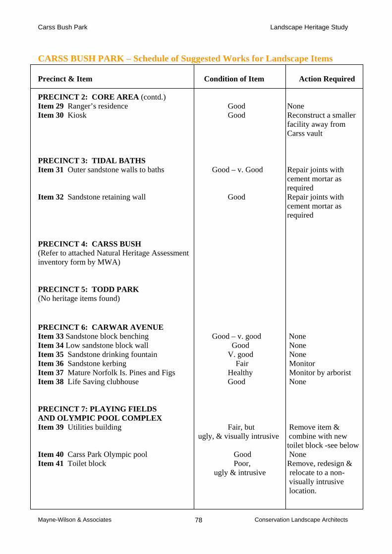
Carss Bush Park Landscape Heritage Study
Mayne-Wilson & Associates Conservation Landscape Architects 78
CARSS BUSH PARK – Schedule of Suggested Works for Landscape Items
Precinct & Item Condition of Item Action Required
PRECINCT 2: CORE AREA (contd.) Item 29 Ranger’s residence Good None Item 30 Kiosk Good Reconstruct a smaller facility away from Carss vault PRECINCT 3: TIDAL BATHS Item 31 Outer sandstone walls to baths Good – v. Good Repair joints with cement mortar as required Item 32 Sandstone retaining wall Good Repair joints with cement mortar as required PRECINCT 4: CARSS BUSH (Refer to attached Natural Heritage Assessment inventory form by MWA) PRECINCT 5: TODD PARK (No heritage items found) PRECINCT 6: CARWAR AVENUE Item 33 Sandstone block benching Good – v. good None Item 34 Low sandstone block wall Good None Item 35 Sandstone drinking fountain V. good None Item 36 Sandstone kerbing Fair Monitor Item 37 Mature Norfolk Is. Pines and Figs Healthy Monitor by arborist Item 38 Life Saving clubhouse Good None PRECINCT 7: PLAYING FIELDS AND OLYMPIC POOL COMPLEX Item 39 Utilities building Fair, but Remove item &
ugly, & visually intrusive combine with new toilet block -see below
Item 40 Carss Park Olympic pool Good None Item 41 Toilet block Poor, Remove, redesign &
ugly & intrusive relocate to a non- visually intrusive location.

Carss Bush Park Landscape Heritage Study
Mayne-Wilson & Associates Conservation Landscape Architects 79
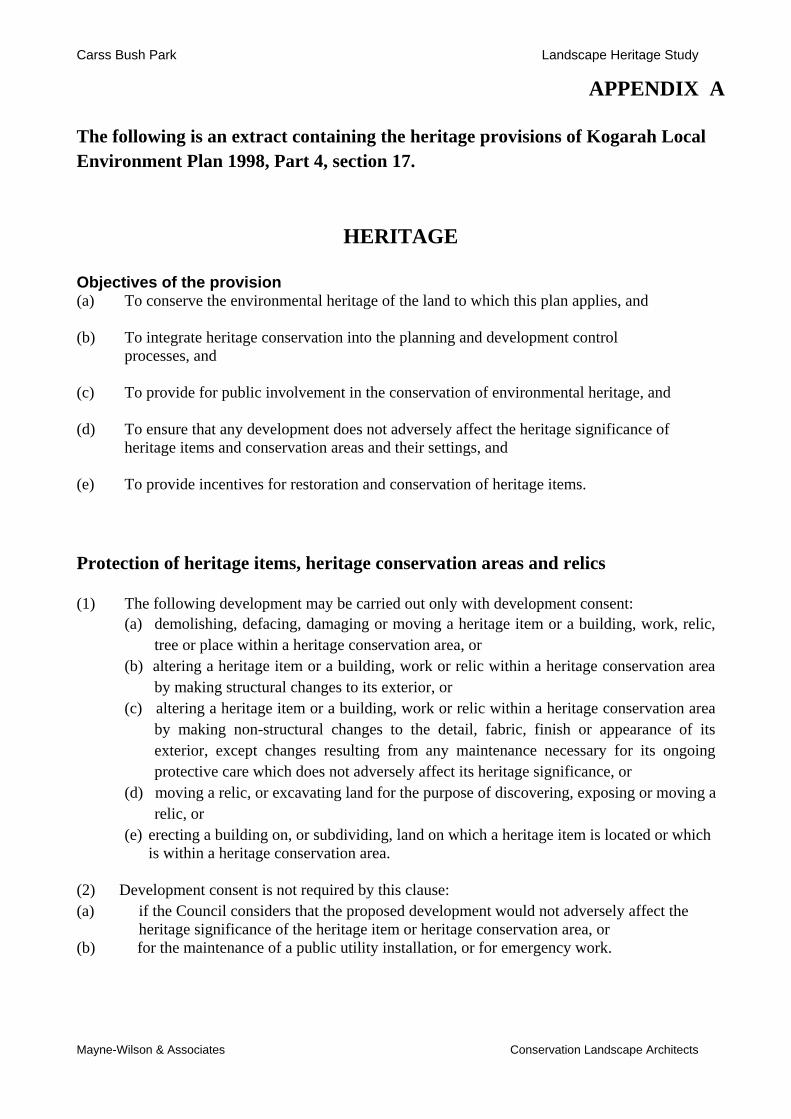
Carss Bush Park Landscape Heritage Study
Mayne-Wilson & Associates Conservation Landscape Architects
APPENDIX A
The following is an extract containing the heritage provisions of Kogarah Local Environment Plan 1998, Part 4, section 17.
HERITAGE Objectives of the provision (a) To conserve the environmental heritage of the land to which this plan applies, and
(b) To integrate heritage conservation into the planning and development control processes, and
(c) To provide for public involvement in the conservation of environmental heritage, and (d) To ensure that any development does not adversely affect the heritage significance of
heritage items and conservation areas and their settings, and
(e) To provide incentives for restoration and conservation of heritage items.
Protection of heritage items, heritage conservation areas and relics
(1) The following development may be carried out only with development consent: (a) demolishing, defacing, damaging or moving a heritage item or a building, work, relic,
tree or place within a heritage conservation area, or (b) altering a heritage item or a building, work or relic within a heritage conservation area
by making structural changes to its exterior, or (c) altering a heritage item or a building, work or relic within a heritage conservation area
by making non-structural changes to the detail, fabric, finish or appearance of its exterior, except changes resulting from any maintenance necessary for its ongoing protective care which does not adversely affect its heritage significance, or
(d) moving a relic, or excavating land for the purpose of discovering, exposing or moving a relic, or
(e) erecting a building on, or subdividing, land on which a heritage item is located or which is within a heritage conservation area.
(2) Development consent is not required by this clause: (a) if the Council considers that the proposed development would not adversely affect the
heritage significance of the heritage item or heritage conservation area, or (b) for the maintenance of a public utility installation, or for emergency work.

Carss Bush Park Landscape Heritage Study
Mayne-Wilson & Associates Conservation Landscape Architects
(3) When determining a development application required by this clause, the Council: (a) must take into consideration the extent to which the carrying out of the proposed
development would affect the heritage significance of the heritage item or heritage conservation area, including any stylistic or horticultural features of its setting, and
(b) may decline to grant consent unless it has considered a conservation plan, a statement of heritage significance or a statement of heritage impact prepared in respect of the proposed development to enable the Council to fully consider the heritage significance of a heritage item or heritage conservation area and the impact of the proposed development on the significance of the item or area and its setting, and
(c) must not grant consent unless the Council is satisfied that the proposed development will not detrimentally affect the heritage significance of the heritage item or heritage conservation area.
Development in the vicinity of heritage items or potential archaeological sites (4) The Council must take into consideration the likely effect of the proposed development on
the heritage significance of a heritage item or potential archaeological site, and on its setting, when determining an application for consent to carry out development on land in its vicinity.
Notice of certain heritage development applications (5) A proposal to carry out development involving demolition of, or damaging or defacing a
heritage item, or use of a heritage item as allowed by subclause (9), must be advertised in a local newspaper before consent is granted for the proposed development.
Notification to the Heritage Council (6) Before granting development consent to the demolishing, defacing or damaging of a heritage
item that is classified in Schedule 3 as being of State or regional significance, the Council must notify the Heritage Council of its intention to do so and take into consideration any comments received from the Heritage Council within 28 days after the notice is sent.
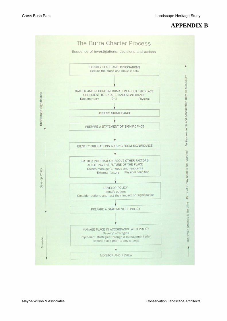
Carss Bush Park Landscape Heritage Study
Mayne-Wilson & Associates Conservation Landscape Architects
APPENDIX B