landscape fragmentation in the lake champlain basin charlotte low matt gustafson walker brown...
Post on 19-Dec-2015
218 views
TRANSCRIPT

Landscape Fragmentation in the Lake Champlain Basin
Charlotte LowMatt GustafsonWalker Brown
Photograph: Caldwell Clark 2010 (Mt. Philo)

Problem Statement
Land Fragmentation, resulting from agriculture, industry, urban development, and transportation networks, in the Lake Champlain Basin, has a dramatic effect on the function, value, and quality of wetlands, forests, and herbaceous landscapes through disrupting the natural dynamics of these systems.

Connections Matrix
Urban Development
Industry Landscape Fragmentation
Herbaceous
Wetlands
ForestsAgriculture
Roads

Goals• Develop an assessment
of land fragmentation and its effects on habitats
• Construct a relative risk ranking system and link/importance matrices Objectives
• Research previous studies
• Develop a diagram illustrating the existing connections
• Create GIS maps analyzing land use and transportation networks
• Assign risk rankings by sub-watershedPhotograph: http://img5.visualizeus.com/thumbs/df/9c/eden,animals,bear,forest,road,funny-df9ceec4b92e8091ca15aa48d791f795_h.jpg
Photograph: http://farm5.static.flickr.com/4153/5051555848_10a02fbe4e.jpg

Effects of Fragmentation
• Habitat Loss, Isolation,Separation
• Edge Effects• Decreased Connectivity– Biogeography
• Loss of Biodiversity– Genetic, Species, Ecological
• Increased Mortality― Predation, Collisions, Exposure
Photograph: http://3.bp.blogspot.com/_ey0cXXT2kz8/TTN8AzmashI/AAAAAAAAFNk/5Ammw0HXRtQ/s400/EasterBunnyRoadKill4406.jpg

Approach• 2 Phase Approach– 1st – Literature Review to direct
link and importance matrix's
– 2nd – GIS Analysis• Unique approach for land
fragmentation as a stressor


Findings
Impact Link
Stressor of Habitat
Open Water
>6'
Open Water <6' Developed Forest Herbaceous Agriculture Wetlands
Fragmentation 0 0 0 1 .5 0 1
Impact Importance
Fragmentation 0 0 0 2 1 0 2
Effect Link Source of StressorAg Urb WWTP Dams Roads Fisheries Marinas Forest Industrial Parks External
Fragmentation 1 1 0 0 1 0 0 0 1 .5 0Effect Importance
Fragmentation 2 2 0 0 2 0 0 0 2 1 0

Connections MatrixUrban Development
IndustryLandscape Fragmentation
Herbaceous
Wetlands
Forests
Agriculture
Roads

Watershed/Risk RegionPercent Habitat
Cover TypesFragmentation
Index ScoreFinal Index Score (F)
Risk Rank
Burlington Bay 0.15 23.70 3.63 6St. Albans Bay 0.31 96.50 30.33 6Shelburne Bay 0.38 131.30 50.55 6
Lake Champlain (direct) 0.48 197.80 94.95 6Northeast Arm 0.46 213.40 98.91 6South Lake B 0.69 320.20 220.12 6Otter Creek 0.60 395.10 237.65 6Port Henry 0.51 514.10 264.03 6Mallets Bay 0.76 411.20 311.02 4
Isle La Motte 0.74 426.00 316.54 4Main Lake VT 0.80 405.30 324.38 4South Lake A 0.70 548.30 381.72 4
Missisqoui Bay 0.68 725.80 495.42 4Cumberland Bay 0.87 926.40 802.87 2
Main Lake NY 0.89 950.90 843.29 2
Risk Rank F Stat Range Note: Fragmented Cover Types include Brush, Forest, Wetland6 0 - 281
4 282 - 5632 564 - 844
Table 1: Summary of Fragmentation Index and Relative Risk Ranks by Watershed
Burlingto
n Bay
St. Alban
s Bay
Shelb
urne B
ay
Lake C
hamplai
n (dire
ct)
Northea
st Arm
South La
ke B
Otter Cree
k
Port Hen
ry
Mallets
Bay
Isle La
Motte
Main La
ke VT
South La
ke A
Missisq
oui Bay
Cumberlan
d Bay
Main La
ke NY
0.00100.00200.00300.00400.00500.00600.00700.00800.00900.00
Relative Risk by Sub-Watershed
Sub-Watershed
Fina
l Fra
gmen
tatio
n In
dex

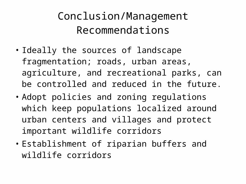
Conclusion/Management Recommendations
• Ideally the sources of landscape fragmentation; roads, urban areas, agriculture, and recreational parks, can be controlled and reduced in the future.
• Adopt policies and zoning regulations which keep populations localized around urban centers and villages and protect important wildlife corridors
• Establishment of riparian buffers and wildlife corridors

Questions?