landscape - hammervideo.minpress.gr/.../aboutgreece_landscape.pdf · aboutgreece 51 landscape...
TRANSCRIPT
about GREECE50
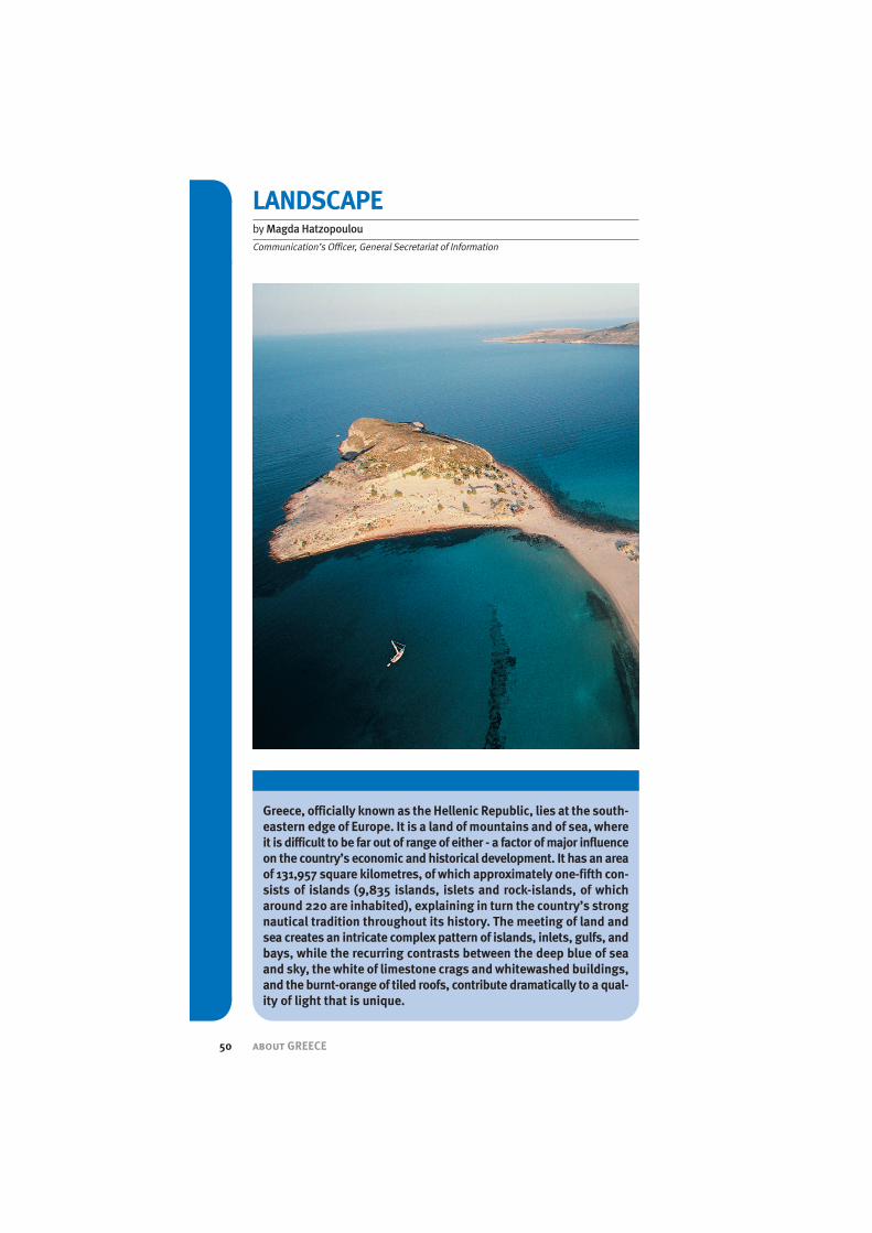
Greece, officially known as the Hellenic Republic, lies at the south-eastern edge of Europe. It is a land ofmountains and of sea, whereit is difficult to be far out of range of either - a factor ofmajor influenceon the country’s economic and historical development. It has an areaof 131,957 square kilometres, of which approximately one-fifth con-sists of islands (9,835 islands, islets and rock-islands, of whicharound 220 are inhabited), explaining in turn the country’s strongnautical tradition throughout its history. The meeting of land andsea creates an intricate complexpattern of islands, inlets, gulfs, andbays, while the recurring contrasts between the deep blue of seaand sky, the white of limestone crags and whitewashed buildings,and the burnt-orange of tiled roofs, contribute dramatically to a qual-ity of light that is unique.
LANDSCAPEbyMagda Hatzopoulou
Communication’s Officer, General Secretariat of Information

about GREECE 51
LANDSCAPE
The Greekmainland is bordered bythe Ionian Sea to the west, by theAegean Sea to the east and by theMediterranean Sea to the south. Tothe north and northeast of thecountry lay its land borders, whichrun from west to east with Albania(247 kilometres), the Former Yu-goslav Republic of Macedonia (FY-ROM - 256 kilometres), Bulgaria(475 kilometres), and Turkey (203kilometres), totalling altogether(1,181 kilometres).
Greece is divided into several re-gions, very much along the samelines since antiquity. The provincesof Macedonia and Thrace lie alongthe northern coast of the AegeanSea; to the west lies Epirus,whichforms the northern boundary withAlbania; east of Epirus and southof Macedonia is Thessaly; thesouthern half of Greece consists ofthe provinces of Central Greeceand Euboea and the Peloponnese.The islands of Greece are dividedinto the Aegean Islands, includingthe Sporades, the Cyclades, andthe Dodecanese; the island ofCrete; and the Ionian Islands offthe west coast.
The Greek landscape is conspicu-ous not only for its beauty but alsofor its complexity and variety,where three elements dominate.The first is the sea: arms andinlets of the sea penetrate deeply,and the rocky headlands andpeninsulas extend out to sea as is-land arcs and archipelagos. Thesouthernmost part of mainlandGreece, the Peloponnese Peninsu-la, is joined to the mainland onlyby the narrow Isthmus at the headof the Gulf of Corinth.The country’ssecond landscape element is itsmountainousness: roughly three
quarters of Greece is mountain ter-rain, much of it deeply dissected.A series of mountain chains on theGreek mainland, aligned north-west-southeast, enclose narrowparallel valleys and numeroussmall basins that once held lakes.River and coastal plains, interiorvalleys and basins, account for thethird dominant feature of the Greeklandscape, the lowland.
The country’s highest mountain, at2,917 metres, is Mount Olympus inThessaly. There are several ranges,with the most important being thePindus Mountains,which form thebackbone of the Greek mainland,dividing Epirus from Thessaly.These mountains reappear in thesouth on the large peninsula of thePeloponnese, where they divideinto several smaller ranges. One ofthese ranges vanishes under thesea but appears again in the eastas the mountains of the islands ofCrete, Karpathos, and Rhodes.
Between the main ranges there arevalleys and depressions, somequite large. The largest plains arefound in Macedonia and Thrace,while the Plains of Thessaly formthe second largest lowland area.
The islands form complex patternsthat generally follow the trends ofthe mainland mountain ranges.The Ionian Islands lie along thewest coast. To the east in theAegean Sea, the largest island isEuboea, with the Sporades, agroup of smaller islands, locatedto its north. To the east are the is-lands of Lemnos, Lesbos, andChios,which lie close to the coastof Turkey. The large group of is-lands to the southeast, known asthe Cyclades, is of volcanic origin,
about GREECE52
THE COUNTRY
and farther east lie the islands ofthe Dodecanese group. The coun-try’s largest island, Crete, is itssouthernmost area.
The rivers of Greece have a com-plex pattern. The northern rivers -the Axios, Strymon, Nestos, andEvros - rise in the mountains of Bul-garia and FYROM and flow ontoGreek territory until they reachthe Aegean Sea. The longest riverin Greece is the Aliakmon, whichbegins in the Pindus Mountainsand flows eastward for 298 kilome-tres into the Aegean Sea, as do thetwo major rivers of Central Greeceand Thessaly - the Peneos and theSperchios. Several smaller riversflow westward from the PindusMountains to the Ionian Sea. Therivers of the Peloponnese flowoutward to the coast from thecentral mountains.
ClimateThe climate of Greece is typicallyMediterranean, i.e. mostly dry andtemperate, with hot, dry summersand mild, rainy winters, althoughthere is snowfall in the north andnorth-western mountainous areas.Northern Greece has a more con-tinental climate than the south,with lower winter temperaturesand some rain in summer. In thecoastal regions, including Attica,and on the islands, summer tem-peratures average around 27° C,and winter temperatures rarelydrop below 10° C.
In the mainland interior, includingcentral Peloponnese, winters arecolder and snow can lie on themountains for several months. Inthe northern area of Nevrokopi,near the city of Drama, tempera-tures could drop as low as -200C in
February, while on the southern is-land of Gavdos, southwest ofCrete, temperatures rarely fall bel-low +100C.
Flora and FaunaGreece, with some 5,500 speciesof identified flora, is endowedwith a variety unrivalled in Europe.Wild flowers, including poppies,anemones, gladioli, cyclamens,irises, tulips, lilies, camomilesand many others, create spectac-ular colour palettes, especially inspringtime, when flowers carpethillsides and fields, spring under-neath rocks and perfume the airwith breathtaking aromas.
The largest forests are found inNorthern Greece, in the mountainsof Thrace, Macedonia and Epirus.Furthermore, the islands in theNorthern and Eastern Aegean Sea,as those of the Ionian Sea, are, to alarge extent, covered with pines,aspen, as well as other foresttrees. In total, the county has over200 species of tree and largeshrub and its forests consist, pri-marily, of conifers,with deciduoustrees, such as beeches and chest-nuts, coming second.
Numerous protected areas exist inGreece, via commitments at inter-national conventions. NationalParks include Olympus (on theborders of Thessaly and Macedo-nia), Parnassus and Iti (centralGreece), Prespes and Vikos-Aoos(Epirus), Parnitha (Attica) andSamaria (Crete). There are also 11wetlands, 51 preserved naturalmonuments, 113 important birdsanctuaries and 300 biotopes.
Moreover, 900 species of fauna livein Greece. The country is a refuge for

about GREECE 53
LANDSCAPE
many endangered species that areprotected through specific actionprogrammes, aiming at the man-agement and protection of bio-di-versity. Rare marine species such asthe Mediterranean Sea Turtle (Caret-ta-caretta) and the Monk Seal(Monachus-monachus) living main-ly in the seas surrounding the is-lands of Zakynthos, Kefalonia,Creteand the Peloponnese, are protect-ed. The dense forests and rocky out-crops of the Dadia Forest River(upstream on the Evros River) inThrace, as well as the wetlands atthe Evros delta, are shelter to thelargest range of birds of prey in Eu-rope. Lake Mikri Prespa, in Macedo-nia, has the richest colony of fish-eating birds in Europe, includingcormorants, ibises, egrets andherons.Moreover, the brown bear- Europe’s largest land mammal -survives in the Pindus massif andon the mountains along the borderswith Albania, FYROM and Bulgaria.Finally, the northern forests arehome to wildcat, marten, roedeer,occasionally wolf and lynx,whereasjackals, wild goats and hedgehogslive in the south.
CoastlineAlthough a relatively small country,Greece boasts an astonishing va-riety of alternating landscapes,ranging from legendary mountainssuch as Olympus, Pindus and Par-nassus, to rugged hills and fertilevalleys, stretching onto miles ofpristine coastline, engulfing numer-ous clusters of sun-soaked islands.
It is due to its large number of is-lands that Greece boasts the mostextensive (18,400 km) coastline ofall Mediterranean countries and itscoastal waters penetrate far inland.Greece also has good natural har-bours and the Saronic Gulf boastsgreat anchorages, notably in the nat-ural harbour of Piraeus, which is theport of the Greek capital, Athens. Intotal, there are 1,354 gulfs, bays,coves and inlets, 161 straits andchannels, and 520 harbours.
NORTHERN GREECEThraceThis region, known as WesternThrace, with an area of 8,200 km²and a population of approximately

about GREECE54
THE COUNTRY
370.000, constitutes the north-eastern part of continental Greece,located between the Rivers Nestosand Evros.East of the Evros lies theEastern part of Thrace, which is theEuropean part of Turkey, while thearea to the north in Bulgaria is re-ferred to as Northern Thrace.
The Nestos River flows into theAegean Sea, near the island of Tha-sos, spreading over the coastalplain of Chrysoupolisand expand-ing as a system of freshwater lakesand ponds forming the NestosDelta, where swamplands, wet-lands and a lagoon once existedand many rare species find refuge.The total length of the river is 230km, of which 126 km is withinBulgaria.
The Evros, with a length of 480 km,is the longest river running solelywithin the Balkans. It has its originin Western Bulgaria, flowing south-east towards the sea. The lowercourse of the river forms part of theGreek-Bulgarian border and itsmarshy valley most of the Greek-Turkish border.
Western Thrace - and in particularthe Rodopi Mountains,which formthe natural border with Bulgariaand are covered by dense forest -is home to one of the two survivingbrown bear (Ursus arctos) popula-tions in Greece (the other is in thePindus mountains, in centralGreece).
MacedoniaMacedonia, with an area of some34,231 km² and a population of ap-proximately three million, is thelargest and second most populousregion of Greece, and together withThrace and Epirus, it is often, unof-
ficially, referred to as NorthernGreece. Its territory covers most ofthe region of ancient Macedonia; itsname was later imparted to a widerBalkan region that became knownin modern times as Macedonia, ofwhich it forms 52.4% of the landand 52.9% of the population.
Its capital, Thessaloniki, with apopulation of around one million,is Greece’s second largest cityand a major economic, industrial,commercial and cultural centre. Athriving, vibrant city, with a strate-gically located commercial port,Thessaloniki is a gateway and atransportation hub in southeasternEurope. The city also hosts a largestudent population and it is widelyrenowned for its large number ofByzantine monuments.
The region is bordered to thesouth by the Aegean Sea andThessaly, to the east by WesternTrace, west by Epirus and north byFYROM. It is traversed by the val-leys of the Aliakmon, Axios,Nestos, and Strymon rivers, all ofwhich drain into the Aegean andalso account for the odd three-pronged shape of the ChalcidicePeninsula, on whose easternmostprong Mount Athos, the famoussite of Greek Orthodox monasticcommunities, is located. The lakesof Koronia and Volvi separate Chal-cidice from the rest of the coastalregion. Farther west, the largeplain drained by the Axios and low-er Aliakmon rivers is being contin-ually extended, as the river deltaspush out into the Gulf of Ther-maikos, while from the lower Stri-mon River extends a succession ofplains. The forested VermionMountains and the barren inlandbasins around Lakes Vegoritisand

about GREECE 55
LANDSCAPE
Kastoria mark the boundary withthe Pindus Mountains.
ThessalySituated in the middle-upper partof the mainland, Thessaly bordersMacedonia on the north, Epirus onthe west, Central Greece on thesouth and the Aegean Sea on theeast. Its geography consists of aring of mountains surrounding acentral fertile plain, colloquiallyknown as the breadbasket ofGreece. The Chasia and CambunianMountains lie to the north, MountOlympus to the northeast, the Pin-dus Range to the west, and thecoastal mountain ranges of Ossaand Pelion to the southeast.
Lying on the border between Mace-donia and Thessaly, and approxi-mately 80 km from Thessaloniki, isMount Olympus, whose cloud-topped and snow-capped summitrises to 2,917 metres, making it thehighest point in Greece and one ofthe highest in Europe. In ancientGreece, it was regarded as theabode of the gods and the site of
the throne of Zeus. Mount Olympusis also noted for its sumptuous flo-ra with several endemic species.
The Vale of Tempe is a narrow, 10-km long valley running betweenMount Olympus and Mount Ossa,in northeastern Thessaly, with thePeneos River flowing through it, be-fore emptying into the AegeanSea. The glen, believed to havebeen formed 1.6 million years ago,is lined by cliffs that rise to 500 mon the south, and in places it isonly 25 to 50 m wide. It was dedi-cated by the ancient Greeks tothe cult of Apollo. Known to theByzantines as Lykostomo (“Wolf’sMouth”)because it provides accessfrom the mainland coast to theThessalian Plain, it has been atraditional invasion route, andruins of castles and fortifications,from the Roman period to the Mid-dle Ages, mark its strong points.
Several tributaries of the PeneosRiver flow through the region, cre-ating a large delta, well-knownfor its many animal species, pro-

about GREECE56
THE COUNTRY
tected by international environ-mental treaties. Its total length is216 km and it begins in the northat the Pindus ranges, east ofMetsovo; the Meteora region andthe cities of Trikala and Larissa liealong the Pineios.
Known for its dramatic landscape,lush vegetation, striking beacheswith crystal clear waters, the MountPelionpeninsula also boasts someof the best hiking trails and skiingin the country, as well as some ofthe most picturesque, beautifullypreserved traditional villages in allof Greece, with many clinging ontowooded slopes, perching on steepbluffs, or hiding away in verdantravines.
WESTERN & CENTRAL GREECEEpirusSituated in northwestern Greece, ithas an area of about 9,200 km² anda population of about 350,000. Itborders West Macedonia and Thes-saly to the east, Central Greece tothe south, the Ionian Sea and Is-
lands to the west, and Albania tothe north. The landscape is ruggedand mountainous, and most ofEpirus lies on the windward side ofthe Pindus range, with the windsfrom the Ionian Sea offering the re-gion more rainfall than any otherpart of Greece. The climate of Epirusis mainly alpine, and the area is richwith forests and animal life.
The Vikos-Aoos National Park innortheastern Epirus, covering anarea of 126 km², is an area of daz-zling beauty, as well as home to awide range of flora and fauna. Nu-merous species of mammals, in-cluding bears, wolves, foxes, lynx-es and deer, fish and birds couldbe found in this park, which en-compasses the Vikosand the AoosGorge, Mount Timfi (with Gamila asits highest peak, at 2,497 m) andseveral of the renowned Zagoria vil-lages. The 12 km Vikos Gorge,with walls of up to 1,040 metresdeep, is listed by the GuinessBook of Records as the deepest (inproportion to its width) canyon inthe world. Its ecosystem is varied

about GREECE 57
LANDSCAPE
and it is a refuge for many endan-gered animal species, while greatvarieties of wildflowers, includinghuge expanses of purple crocusflowerbeds on the Timfi, cover thisspectacular landscape.
The Aoos River has a total lengthof about 272 km, of which 80 kmare in Greece. Its source is in thePindus Mountains and it formsimpressive canyons as it flowsthrough the National park.
Central Greece is one of the mostmountainous areas in the country,with a temperate climate along itscoastlines and dry one in its inte-rior. It is the central region ofGreece, lying to the north of Atticaand Peloponnese, to the east ofWestern Greece and to the southof Thessaly and Epirus. The area in-cludes Euboea, the second largestisland of Greece in area and pop-ulation (after Crete).
The continental heartland of thecountry contains a number of lakesand wetlands and it is dominated
by the Pindus Mountains Range;roughly 160 km long, with MountSmolikas as its maximum eleva-tion at 2,637 metres, it is the sec-ond highest mountain in Greece,after Mount Olympus. This ruggedrange forms the core of mainlandGreece, and following the generalnorthwest-southeast trend of theBalkan Peninsula Mountains, itsweeps down from the country’snorth-western frontiers.
Because it runs along the border ofThessaly and Epirus, Pindus is of-ten called the “spine of Greece”:stretching from near the Albanianborder in northern Greece to thenorth of the Peloponnese, it con-tinues through the western Pelo-ponnese, crosses the islands ofKythera and Antikythera and findits way into the southwesternAegean Sea, in the island of Crete,where it eventually ends; the is-lands of the Aegean are in effectpeaks of underwater mountainsthat once constituted an extensionof the mainland. Pindus is charac-terized by its high, steep peaks, of-

about GREECE58
THE COUNTRY
ten dissected by numerouscanyons and a variety of otherkarstic landscapes.
On the east coast of central Greece(136 km northwest of Athens, nearthe Gulf of Maliakos), lies the nar-row pass of Thermopylae pass,scene of the famous battle of an-tiquity. The pass, whose namemeans “hot gates” (derived fromits hot sulphur springs) is some 6km long; its cliffs in antiquity wereby the sea, but silting has widenedthe distance to more than a mile.
To the southeast, Mount Parnas-sus, a limestone spur of the PindusMountains, rises to 2,457 metres.Extending to Cape Opus on theGulf of Corinth,and towering abovethe legendary archaeological siteDelphi, it is the mythical home ofthe Muses.
The range continues as the back-bone of the peninsula lying be-tween the Gulf of Euboea and theGulf of Corinth, and it reaches asfar as Mount Parnitha, just to thenorth of Athens.
The island of Euboea is separatedfrom the mainland by the EuripusStrait, a narrow channel of watersubject to strong tidal currentschanging direction several times aday, and, on the other, connectedto the mainland by two roadbridges across the strait: a cable-stay suspension bridge (opened in1993) with a span of 215m, runningover a 160m wide opening; and a“sliding bridge”, which can beopened to allow boat trafficthrough the strait, running over itsnarrowest point (38m wide). TheStrait had been bridged as early as411 BC with a wooden bridge.
Attica RegionThis region includes the metropol-itan area of Athens – capital city ofGreece since 1834, the country’slargest city and its main adminis-trative centre; the seat of govern-ment, higher courts, head officesof financial institutions, shippingand industry headquarters, majorcultural and educational institu-tions, etc are concentrated in thecapital area. With a population ofaround 4 million, Attica is themost populous region of Greece;moreover, Athens attracts daily asignificant population of com-muters who work in the capital, aswell as an abundance of touristswho visit the Acropolis, the coun-try’s foremost cultural symbol.The region enjoys a mild climate,with sunshine averaging 260 daysa year.
With important historical and ar-chaeological sites, unique Byzan-tine monuments, mountains, fer-tile plains and clean beaches, At-tica has been, since antiquity, themost important cultural centre ofGreece. Mount Parnitha (1,400m),a National Park, is located 30kmnorthwest of Athens; it has anarea of over 300 square km, witha variety of more than 800 herbsand plants. Mount Penteli is adensely vegetated mountain withsprings, while Mount Hymettos islinked to the city’s history, as mar-ble from its mines was used for theconstruction of monuments in theHellenistic and Roman periods.Cape Sounion is the most impor-tant sanctuary in Attica, wherethe Temple of Poseidon is located.Lavrion, located approximately9km northeast of Sounio, is asmall picturesque town, famous inantiquity for its mines.
about GREECE 59
LANDSCAPE
The PeloponneseThe Peloponnese is a large penin-sula in southern Greece, coveringan area of some 21,549 km2; it con-stitutes the southernmost part ofmainland Greece. The peninsulahas mountainous interior anddeeply indented coasts, withMount Taygetus as its highestpoint. Two groups of islands lie offthe Peloponnesean coast: theArgo – Saronic Islands to the east,and the Ionian Islands to the west.Although technically an island,since the construction of theCorinth Canal in 1893, the penin-sula is linked to the mainland viaa narrow stretch of land, the Isth-mus of Corinth, as well the Rio-An-tirio Bridge,which was completedin 2004.
The Corinth Canal, a waterway un-derlying the Isthmus, joins theGulf of Corinth in the northwestwith the Saronic Gulf in the south-east. Constructed in order to short-en the Italy to Athens sea route,the Canal is 6.3 km long, 8m deepand 25m wide.
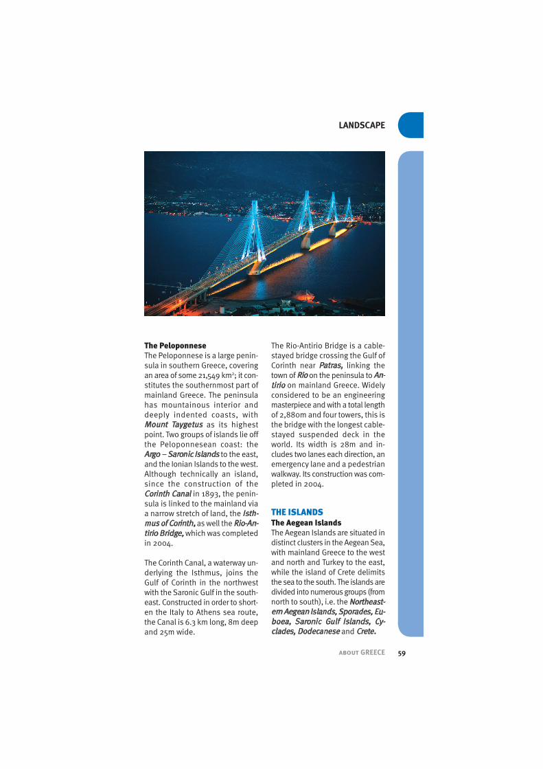
The Rio-Antirio Bridge is a cable-stayed bridge crossing the Gulf ofCorinth near Patras, linking thetown of Rioon the peninsula to An-tirio on mainland Greece. Widelyconsidered to be an engineeringmasterpiece and with a total lengthof 2,880m and four towers, this isthe bridge with the longest cable-stayed suspended deck in theworld. Its width is 28m and in-cludes two lanes each direction, anemergency lane and a pedestrianwalkway. Its construction was com-pleted in 2004.
THE ISLANDS The Aegean IslandsThe Aegean Islands are situated indistinct clusters in the Aegean Sea,with mainland Greece to the westand north and Turkey to the east,while the island of Crete delimitsthe sea to the south. The islands aredivided into numerous groups (fromnorth to south), i.e. the Northeast-ern Aegean Islands, Sporades, Eu-boea, Saronic Gulf Islands, Cy-clades, Dodecanese and Crete.

about GREECE60
THE COUNTRY
In the north-Aegean, off Thrace, lieThasos and Samothrace, whileLemnos is situated midway be-tween Asia Minor and the MountAthos peninsula.
To the southeast, the rocky butsheltered islands of Lesbos, Chios,and Samos also lie close to theTurkish coast. Across the centralAegean, near northern Euboea, liethe Sporades (“Scattered Islands”),whose crystalline rocks are similarto those of the Greek mainland. Far-ther south, in the heart of theAegean, are the Cyclades (“Islandsin a Circle)”; these roughly centreon Delos and represent the tips ofdrowned mountain ridges, contin-uing the structural trends of Euboeaand the region around Athens.
Between the Cyclades and theTurkish coast, the Dodecanesegroup (“twelve islands”, withRhodes as the largest of thedozen), has a varied geologicstructure ranging from the greylimestones of Kalimnos, Simi andChalki to the complete ancientvolcanic cone that forms Nisiros.
CreteFinally, the long narrow shape ofCrete stands at the southernmostentrance of the Aegean. It is thefifth largest island in the Mediter-ranean and the largest of all Greekislands, home to 650,000 peopleand several million olive trees.Crete claims to have the oldest liv-ing olive tree, though two trees -both over 2,000 years old - on ei-ther side of the island vie for thetitle. Branches from both treeswere collected to make the wreathsawarded to winning athletes in theAthens 2004 Olympics. Its majorcities are Chania, Rethymno, Her-aklio and Aghios Nikolaos.
Its climate is primarily temperate,with fairly mild winters and hotsummers, although its southernshore is the warmest area inGreece. With its fertile coastalplains and rugged barren moun-tains, Crete is geologically linkedto the south and west of mainlandGreece. Its steep and asymmetricallimestone massif, falling steeply tothe south, is divided by the LefkaOri (“White Mountains”), Psiloritis
about GREECE 61
LANDSCAPE
Mountains, Dikti Mountains, ThriftiMountains and the AsterousiaRange.
The most prominent gorge in theWhite Mountains is the SamariaGorge, located 43 klm from Chania,in the South West of Crete. It wascreated by a small river running be-tween the Lefka Ori and MountVolakias; at 18 km long, it is thesecond longest in Europe. Themost famous part of the gorge isthe narrow entrance known as the“Iron Gates”, where the sidesclose to about 4 metres in andreach up to 500 metres high. Thenorthern entrance to the gorge is1,250 m above sea level. The gorgebecame a national park in 1962,particularly as a refuge for therare Kri-kri (Cretan goat), which islargely restricted to the park and asmall island just off the shore ofAghia Marina.
The Ionian IslandsThe group of islands off the west-ern coast of Greece in the IonianSea, collectively referred to as theIonian Islands, are traditionally
known as the Seven Islands (Ep-tanisa); the group, however, in-cludes many smaller islands, aswell as the principal seven, withthe best known ones being Kerkyra(also known as Corfu), Lefkada,Ithaca, Zakynthos (sometimesknown as Zante), and Kythera.The Ionian Sea is an arm of theMediterranean Sea, lying southof the Adriatic, and it is bound bysouthern Italy to the west and bysouthwestern Albania.
The Ionian Islands structurally re-semble the folded mountains ofEpirus, in the same way that theAegean Islands exhibit the charac-teristic landforms of the mainland.The islands’ climate is mild and rel-atively humid, with considerablyhigh rainfall and abundant vegeta-tion, with tropical flora and denseforests as a result.
This region forms the smallest ge-ographical area of Greece
World Heritage SitesArchaelogical, Byzantine, OldChristian and numerous other his-
about GREECE62
THE COUNTRY
toric and prehistoric sites litterthe Greek landscape from North toSouth and East to West, many ofwhich are renowned UNESCOWorld Heritage Sites:
Mount Athos, (the AutonomousMonastic State of the Holy Mountain,or Aghion Oros, as it is known inGreece), is home to 20 Eastern Or-thodox monasteries and forms asemi-autonomous monastic state.Spiritually, Athos comes under thedirect jurisdiction of the EcumenicalPatriarchate of Constantinople.Bothmountain and peninsula, it coversan area of about 390 km, with theactual Mount Athos and its steep,densely forested slopes reaching upto 2,033 metres.
Vergina, where the burial site ofthe kings of Macedonia was un-earthed in 1977, including the tombof Philip II, father of Alexander theGreat, is situated in Central Macedo-nia of Northern Greece, about 80kmsouth-west of Thessaloniki.
The impressive Meteora (meaning“suspended in the air”) formation issituated at the northwestern edge ofthe Plain of Thessaly, near the Pe-neos River and the Pindus Moun-tains, in central Greece. It consists ofhigh, steep boulders, which appearto be hanging in mid-air; built onthese spectacular natural sandstonerock pillars is one of the largest andmost important monastery com-plexes in Greece, second only toMount Athos, which served as idealrefuge for hermit monks over cen-turies of Othoman rule.
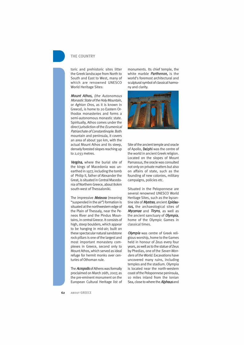
The Acropolisof Athens was formallyproclaimed on March 26th, 2007, asthe pre-eminent monument on theEuropean Cultural Heritage list of
monuments. Its chief temple, thewhite marble Parthenon, is theworld’s foremost architectural andsculptural symbol of classical harmo-ny and clarity.
Site of the ancient temple and oracleof Apollo, Delphi was the centre ofthe world in ancient Greek religion.Located on the slopes of MountParnassus, the oracle was consultednot only on private matters but alsoon affairs of state, such as thefounding of new colonies, militarycampaigns, policies etc.
Situated in the Peloponnese areseveral renowned UNESCO WorldHeritage Sites, such as the byzan-tine site of Mystras, ancient Epidau-rus, the archaeological sites ofMycenae and Tiryns, as well asthe ancient sanctuary of Olympia,home of the Olympic Games inclassical times.
Olympia was centre of Greek reli-gious worship, home to the Gamesheld in honour of Zeus every fouryears, as well as to the statue of Zeusby Phedias, one of the Seven Won-ders of the World.Excavations haveuncovered many ruins, includingtemples and the stadium. Olympiais located near the north-westerncoast of the Peloponnese peninsula,10 miles inland from the IonianSea, close to where the Alpheus and

about GREECE 63
LANDSCAPE
Cladeus Riversmeet. Epidaurus, in the Northeastern Pelo-ponnese, was an important commer-cial centre in ancient Greece, famedfor its 4th-century-BC temple of As-clepius, the god of healing. Excava-tions of the sacred precinct revealedthat it contained temples to Ascle-pius and Artemis, a theatre, stadium,gymnasiums, baths, a tholos and ahospital. The theatre is still used forperformances.
Mycenae, also in the NortheasternPeloponnese, is the site of the an-cient city and legendary capital ofAgamemnon. A natural rock citadel,it flourished during the Bronze Age,building the distinctive Myceneancivilization.Ruins unearthed on siteinclude the Lion Gate, acropolis,granary, and several royal tombs.
Tiryns is the site of a prehistoric cityin the eastern Peloponnese, notedfor its architectural remains of theHomeric period. Excavations showthe area to have been inhabited fromthe Neolithic Age.
Mystras, a fortified town, on Mt.Taygetos,near ancient Sparta,wasthe last centre of Byzantine scholar-ship and became in the 13th centurythe second most important city inthe empire after Constantinople.
One of the smallest of the Cycladesislands, Deloswas an ancient centreof religious, political, and commer-
cial life in the Aegean, and legendarybirthplace of Apollo and Artemis. Itsimpressive ruins have been exten-sively excavated.
Of immense historic as well as reli-gious significance is the Historiccentre (Chora) of the island of Pat-mos, with the Monastery of St Johnand the Cave of the Apocalypse,wherein St. John is said to have writ-ten the Book of Revelation.
The Medieval City of the island ofRhodes (Old Town) sits close toother wonders on the island, includ-ing the Acropolis of Lindos and theAcropolis of Rhodes,while its mostfamous monument was the Colos-sus of Rhodes,a large bronze statuestanding in the harbour - depictedas one of the Seven Wonders of theAncient World - that was toppled byan earthquake c. 224 B.C.
The Old Christian and Byzantinemonuments of Thessaloniki, theMonasteries of Daphni, HossiosLoukas and Nea Moni on Chios, allmonuments of Byzantine Art, arealso amongst the most noted UN-ESCO preserved sites in Greece.
TransportationGreece has extensive road networkscrossing the country and covering anarea of over 116,470 km, of whichmany are national motorways con-necting the country’s main cities aswell as small and remote towns andvillages.
The main national routes are thoseof Athens - Thessaloniki (Ε 75),Athens - Corinth (Ε94), Corinth - Patra(Ε 65), Patra - Olympia (Ε 55), Thes-saloniki - Alexandroupolis (Ε 90),Igoumenitsa - Alexandroupolis (Eg-natia Odos), Chania - Aghios Niko-

about GREECE64
THE COUNTRY
laos (Crete - Ε 75).In most Greek towns and cities, ringroads provide motorists with efficienttraffic-avoiding links between townsand suburbs.
Public transport is extensive, withbuses, trains and airplanes con-necting the mainland to the islandsand the world. The Athens Metro,which opened early 2000, alongwith the tram and suburban rail,which began service in time for theAthens Olympics, have extendedthe capital’s public transport system.
The largest international airport inGreece is the Eleftherios VenizelosAir-portat Spata,near Athens, which be-gan operating in 2001, followed by theMacedonia Airport at Thessaloniki.
The state-run railroad system, albeitsmall, connects major cities on themainland, with lines totaling 2,449 km.
Greece, with 8.5% of the world’sships and 16.5% of global capacity,has the largestmerchant marine inthe world and numerous port-cities:leading seaports include Piraeus(near Athens), Thessaloniki, Patra,Lavrion, Volos, Corfu, Alexandroupo-
lis, Elefsina, Igoumenitsa, Kavalaand Heraklion. A ship canal cutsthrough the Isthmus of Corinth,which connects the Peloponese tomainland Greece. A network of ferrieslinks Piraeus and other mainlandports with the country’s numerous is-lands.
Numerous ferry lines,offering com-binations of conventional ships and“flying dolphins” (fast sea vessels),connect the mainland to the islands.
USEFUL LINKS
Hellenic National Meteorological Service
www.hnms.gr
Greek Coasts On-linewww.thalassa.gr
Hellenic Centre for Marine Research
www.hcmr.gr
Biodiversity of Greecewww.cc.uoa.gr/biology/zoology/biodiven.htm
Hellenic Ornithological Societywww.ornithologiki.gr
Arcturos - A non-profit civil company, focus-ing on the Brown Bearwww.arcturos.gr
Greek Biotope/Wetland Centrewww.ekby.gr
UNESCO World Heritage Centre - Greece
http://whc.unesco.org/en/statesparties/gr
Distance (km) ATH AP VL IG TH IO KV KO LM PA HA
Athens (ATH) 850 310 560 520 455 685 82 220 220 88
Alexandroupolis (AP) 850 580 800 330 705 170 880 630 830 795
Volos (VL) 310 580 375 245 410 410 380 132 330 215
Igoumenitsa (IG) 560 800 375 470 370 635 475 370 355 530
Thessaloniki (TH) 520 330 245 470 370 165 545 300 500 460
Ioannina (IO) 455 705 410 104 370 535 570 270 250 435
Kavala (KV) 685 170 410 635 165 535 710 465 660 625
Corinth (KO) 82 880 380 475 545 370 710 245 139 140
Lamia (LM) 220 630 132 370 300 270 465 245 200 165
Patra (PA) 220 830 330 355 500 250 660 139 200 270
Halkida (HA) 88 795 215 530 460 435 625 140 165 270
Average distance between major Greek cities is as follows: