land, water and biodiversity resources
TRANSCRIPT

Department of Forestry and Environmental ScienceSchool of Earth and Environmental Science
Uttarakhand Open University
EVS 502
Land, Water and Biodiversity Resources
Land, Water and Biodiversity Resources
EVS 502
Department of Forestry and Environmental ScienceSchool of Earth and Environmental Science
Uttarakhand Open University
Board of Studies
Prof. Jeetram, Department of Forestry and Environmental Science,
Kumaun University, Nainital (U.K.)
Late Prof. P.C. Joshi, Department of Zoology and Environmental Science,
Gurukul Kangri, University, Haridwar (U.K.)
Dr. Sachi Sah, Department of Environmental Science
Indira Gandhi Open University, New Delhi
Prof. P.D. Pant, Director, School of Earth and Environmental Science,
Uttarakhand Open University, Haldwani (U.K.)
Dr. H.C. Joshi, Department of Forestry and Environmental Science,
SoEES, Haldwani, Nainital (U.K.)
Unit Writer Unit Nos.
Dr. Sudhanshu Kausik, Department of Environmental Science, Dev
Sanskriti University, Haridwar
1, 2, 4
Dr. Sushil Bhadula, Department of Environmental Science, Dev Sanskriti
University, Haridwar
5, 6, 9, 10, 11
Dr. Anil Bisht, Department of Zoology, Uttaranchal College of Biomedical
Sciences & Hospital, Dehradun
3,7,8
Editorial Team
Professor Uma Melkania, Former Dean (CBSH), G.B. Pant University of Agriculture and
Technology Pantnagar, Uttarakhand
Dr. S.S. Samant, Director, Himalayan Forest Research Institute (HFRI), Conifer campus,
Panthaghati, Shimla, Himachal Pradesh
Cover page Design and Format Editing
Dr. H.C. Joshi, Department of Forestry and Environmental Science, SoEES, Haldwani, Nainital (U.K.)
TITLE Land, Water and Biodiversity Resources
ISBN XXXX XXXX XXXX
Copyright Uttarakhand Open University
Publication Uttarakhand Open University
First Edition July, 2021
i
Table of Contents
Unit 1: The Land Resources: Characteristics Pattern and Importance 1.0 Learning Objectives 1 1.1 Introduction 2 1.2 Definition of Land Resources 4 1.3 Land Utilization and Classification 5 1.4 Types of Land resources 7 1.5 History of land resources on earth 18 1.6 Land Resources in India 18 1.7 Importance of land resources 19
1.8 Threat to land resources 23
Summary 24 Unit 2: The Mineral Resources
2.0 Learning Objectives 28 2.1 Introduction 29
2.2 Definition of Mineral Resources 29
2.3 Origin of Mineral Resources 31
2.4 Types of Mineral resources 33
2.5 How mineral resources are mined 34
2.6 Mineral resources in India 36
2.7 Importance & Uses of Mineral resources 42
Summary 46
Unit 3: The Wetland Case Study: The Sundarbans and The Bharatpur Sanctuary 3.0 Learning Objectives 50 3.1 Introduction 50
3.2 Types and characteristics of wetlands 53
3.3 Importance and Functions of Wetlands 57
3.4 Wetlands in India 60
3.5 Ramsar Convention 62
Summary 69
Unit 4: The Land Cover changes 4.0 Learning Objectives 73 4.1 Introduction 73 4.2 Definition of Land cover change 75 4.3 Land Cover change in India 77 4.4 Reasons of land cover change 79 4.5 Effects of Land cover change 86 Summary 89
Unit 5 Causes and Consequences of Land Degradation
5.0 Learning Objectives 92 5.1 Introduction 92 5.2 Definitions of Land Degradation 94 5.3 Causes of Land Degradation 95 5.4 Natural Causes of Land Degradation 95 5.5 Manmade or Anthropogenic Causes of Land Degradation 97
ii
5.6 Consequences of Land Degradation 110 Summary 114
Unit 6 Wasteland Genesis: Types, Extent, Conservation and Management 6.0 Learning Objectives 117 6.1 Introduction 117 6.2 Definitions of Waste Land 118 6.3 Types of Waste Lands 119 6.4 Waste Land in India 121 6.5 Wasteland Genesis 124 6.6 Conservation of Land 127 6.7 Management of Wasteland 129 Summary 133
Unit 7 Land Related Hazards and Mitigation: Landslides, Landslips, Earthquake, Droughts
7.0 Learning Objectives 137 7.1 Introduction 138 7.2 Land Related Hazards 139 7.2.1 Landslide / Landslips 139 7.2.2 Earthquakes 144 7.2.3 Drought 151 Summary 156
Unit 8 Land Husbandry: Soil Amelioration; Rehabilitation; Restoration of Wasteland 8.0 Learning Objectives 160 8.1 Introduction 160 8.2 Land Husbandry 161 8.3 Methods of Land Husbandry 162 8.4 Soil Amelioration 163 8.5 Rehabilitation of Soil and Wasteland 166 8.6 Restoration of Wasteland 169 Summary 174
Unit 9 Water and Water Resources: An Introduction, Status, Characteristics and Utilization
9.0 Learning Objectives 178 9.1 Introduction 178 9.2 Water at Glance 179 9.3 Water and Water Resources 180 9.4 Status of Water Resources at Global Level 182 9.5 Status of Water Resources at National Level 188 9.6 Utilization of Water Resources 202 Summary 206
Unit 10 Water Resource Development: Dams-The Necessary Evil 10.0 Learning Objectives 208 10.1 Introduction 208 10.2 Water Resource Development 209 10.3 Dams at Global Level 212 10.4 Dams at National Level 213
iii
10.5 Positive Impacts of Dam 215 10.6 Negative Impacts of Dams 218 10.7 Dams- the Necessary Evil 221 Summary 223
Unit 11 Water Resource Conservation Watershed Management, Rain Water Harvesting, Micro-Irrigation
11.0 Learning Objectives 227 11.1 Introduction 227 11.2 Water Resource Conservation 228 11.3 Watershed Management 231 11.4 Rain Water Harvesting 234 11.5 Micro-Irrigation 241 11.6 Case Study-The Pani Panchayat 246 Summary 248
LAND, WATER AND BIODIVERSITY RESOURCES EVS 502
1
Unit 1: The Land Resources: Characteristics Pattern and Importance
Unit Structure
1.0 Learning Objectives
1.1 Introduction
1.2 Definition of Land Resources
1.3 Land Utilization and Classification
1.4 Types of Land resources
1.4.1 Forest resources
1.4.1.3 Types of Forests
1.4.2 Mineral Resources
1.4.3 Cropland/Agricultural resources
1.4.4 Water resources
1.4.5 Soil resources
1.5 History of land resources on earth
1.6 Land Resources in India
1.7 Importance of land resources
1.7.1 Agriculture
1.7.2 Minerals
1.7.3 Biomass
1.7.4 Water 1.7.5 Culture
1.7.6 Biodiversity
1.7.7 Other importance
1.8 Threat to land resources
1.8.1 Conditions of worlds land surface
Summary
1.0 Learning Objectives
After studying this unit you will shall have answer of the following:
What is Land?
What is the utilization and classification of land?
What are land resources?
What are the types of Land resources?
What is the significance of land resources?
What is the demand and supply of land resources?
How can we conserve the land resources?
LAND, WATER AND BIODIVERSITY RESOURCES EVS 502
2
1.1 Introduction
In this unit, we shall study of different types of land and its resource. As we are all dependent
on natural resources, land is one of the most important resources from these natural
resources. In this unit we discussed about the land resources, its characteristic pattern and
importance. All resources have been sharply declined due to various man made activities.
We have also discussed about the solution of these problems too in this chapter. Land is
most important asset which supports natural vegetation, wildlife, human activities, transport
and communication systems.
be classified majorly into aquatic (Water) and non-aquatic (Terrestrial). Land is a naturally
occurring limited resource & it provides the base for survival of living world. It holds
everything that constitutes terrestrial ecosystems. The Increasing demand of land resources
in modern times due to the rise in human population and modern life style has resulted in
degradation of land quality and quantity, decline in crop production, and competition for land.
Land is an area of terrestrial surface of the earth, all the attributes of the biosphere
immediately above or below this surface including those of the near-surface.
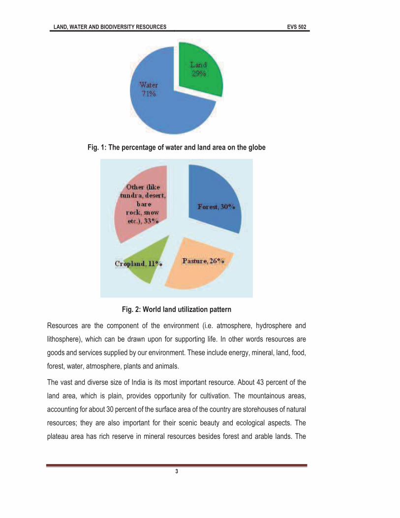
Food and Agriculture Organization (FAO) estimate the worlds land area as of 1994 to be
144.8 million sq km (or about 29% of the surface of the globe) (Fig 1), of which forest and
woodland account for 30%.Thousands of years ago, before large scale human disturbances
of the world began, forest and woodlands probably covered nearly 6.0 billion hectares. Since
then, about 16% of that area has been converted to croplands, pasture, settlements or
unproductive wastelands.
LAND, WATER AND BIODIVERSITY RESOURCES EVS 502
3
Fig. 1: The percentage of water and land area on the globe
Fig. 2: World land utilization pattern
Resources are the component of the environment (i.e. atmosphere, hydrosphere and
lithosphere), which can be drawn upon for supporting life. In other words resources are
goods and services supplied by our environment. These include energy, mineral, land, food,
forest, water, atmosphere, plants and animals.
The vast and diverse size of India is its most important resource. About 43 percent of the
land area, which is plain, provides opportunity for cultivation. The mountainous areas,
accounting for about 30 percent of the surface area of the country are storehouses of natural
resources; they are also important for their scenic beauty and ecological aspects. The
plateau area has rich reserve in mineral resources besides forest and arable lands. The
LAND, WATER AND BIODIVERSITY RESOURCES EVS 502
4
mountains and plateau also have fertile river valley offering favorable location for human
concentration.
The heavy burden of the population and increasing demand of the same have been created
a lot of burden on land resources as in 1951 per capita availability of land was 0.89 per
hectare, but it has been sharply declined with time, the per capita availability of land was
only 0.37 ha. In the availability of land area, there is about 60% declination. So this is clearly
shown that the growing population is inversely proportion to the availability of land. As the
population will be rise the land availability will be decrease and vice versa.
1.2 Definition of Land Resources
The resources available from land are known as land resources, thus, the agricultural land
which contains natural fertilizer for growth of the products sown, the underground water, the
various minerals like coal, bauxite, gold and other raw materials. Land resource refers to the
land available for exploitation, like non-agricultural lands for buildings, developing townships
etc.
Land resources (natural resources) (economically referred to as land or raw materials) occur
naturally within environments that exist relatively undisturbed by mankind, in a natural form.
FAO/UNEP (1997) defined land and land resources as,
surface, encompassing all attributes of the biosphere immediately above or below this
surface, including those of the near-surface climate, the soil and terrain forms, the surface
hydrology (including shallow lakes, rivers, marshes, and swamps), the near-surface
sedimentary layers and associated groundwater and geo-hydrological reserve, the plant and
animal populations, the human settlement pattern and physical results of past and present
human activity (terracing, water storage or drainage structures, roads, buildings, etc.) .
According to the FAO and UNEP (1999), the basic functions of land in supporting human
and other terrestrial ecosystems can be summarized as follows:
A store of financial growth for individuals, groups, or a community
Support the production of food, fiber, fuel, or other biotic materials for human use
Provide biological habitats for plants, animals, and microorganisms
LAND, WATER AND BIODIVERSITY RESOURCES EVS 502
5
Working as a determinant in global energy balance and the global hydrological
cycle, Regulation of the storage and flow of surface water and groundwater
Fulfill the need of minerals and raw material for human being
Working as a filter for pollutant remover, modifier or as a buffer
Provide physical space for industries, recreation and other developmental activities
Storage and protection of evidence from the historical or prehistorically record
(fossils, evidence of past climate, archeological remains, etc.)
Provide an area for movement of animals, plants, and people from one area to
another.
Based on the vital role of land understanding and using, it becomes the crucial responsibility
of land users, authorities, scientists, and planners. From all appearances, people had used
land resource naturally for their purposes to exist. Therefore, land use is a product of
interaction between the biophysical and human driving forces (Weng, 2010). The ways of
using land resources have been changed from traditional to modern methods throughout
different periods of time. In actual development, an emerging issue is how to use land
resources to meet the needs of present and future generations. Moreover, land use is
characterized by the arrangements, activities, and through the people to produce, change,
or maintain a certain land-cover type (FAO, 2005). Land use defined in this way establishes
a direct linkage between land cover an
can be defined as the human use of land that involves both the manner of including
biophysical attributes of land and purposes for use of land (Weng, 2010).
1.3 Land Utilization and Classification
One of the most significant features of land use in India is the large proportion of area
suitable for agriculture that has already been brought under cultivation. Land utilization
statistics are available for about 93% of the total geographic area of 3287.3 lakh hectare.
Classification of land basically depends on whether an area is grazed, cultivated or forested.
The land area in India is classified into following categories
Net sown area
Forest
LAND, WATER AND BIODIVERSITY RESOURCES EVS 502
6
Current fallow
Other Fallows land
Cultivable wasteland
Miscellaneous tree crops and groves
Permanent pasture and grazing land
Land under non-agricultural use
Barren and uncultivable land
Net Sown area: Net sown area refers to the net area utilized for growing crops and
maintaining orchard. The net sown area has increased considerably in recent years due to
reclamation of barren and uncultivable land.
Forests: The group of trees in majority is known as forest. On the land where the majority
of trees on a particular land, known as forest land.
Current fallow: This class comprises cropped areas, which are kept crop-free during the
current year only. For example, if any seedling area is not cropped again in the same year,
it may be treated as current fallow.
Other fallow land: other fallow land include the temporarily cultivated for 1-5 years. Such
fallows land result from inadequate water supply, silting of river and canals and found in
Tamil nadu, Bihar, Meghalaya, Mizoram, Andhra Pradesh, Karnatka, Delhi and Rajasthan
state of India.
Cultivable wasteland: This type of land either fallow or covered with shrubs or jungles
which are not of any utilization. Lands once cultivated but not cultivated for five years in
succession are also included under this category after five years. In India, the state of Uttar
Pradesh, Haryana, Punjab and in several states have Reh, Bhur, Usar, and Khola area was
cultivated in past but abandoned due to certain soil deficiencies come under this class.
Miscellaneous tree crops and groves: This class has included all cultivable land which is
not included under the area sown but it put to some agriculture use. Such lands occupy
1.21% of the reporting area of the country. At the state level, the proportion of land under
miscellaneous tree crops and groves is high in Tripura.
Permanent pasture and grazing land: This category include all grazing lands-meadows,
village commons etc. about 4% of the reporting area comprises such lands.

LAND, WATER AND BIODIVERSITY RESOURCES EVS 502
7
Land under non-agricultural use: This class includes all lands covered by buildings roads
and railways or land under water that is rivers and canals and other lands put to uses other
than agricultural.
Barren and uncultivable land: Barren and uncultivable land covers all those lands which
cannot be brought under cultivation except at a high coast. Such land may be isolated blocks
or within cultivated property. Mostly they are mountainous or arid.
1.4 Types of Land resources
On the basis of availability of forest, minerals, cropland, water and soil etc the land resources
may be classified as below:
- Forest Resources
- Mineral Resources
- Cropland resources
- Water resources
- Soil resources
1.4.1 Forest resources
Forest resources are very important resource of land and perform the ecological duties with
fulfillment for the need of people. Forest provides various services to the ecosystem like
providing food, shelter, cover, fodder, wood fiber to the human society. The word forest is
natural resources
forests. The forest cover in India is about 21.02% of the total geographical area (as per 2009
data). The total forest cover in India is 6, 90, 899km2.
Forest cover in India is defined as all lands with more than one hectare in area with a tree
canopy density of more than 10%".
forestland resources are all those attributes of forests that have any kind of present or
potential value to people. The available resources are continuously changing because
culture and knowledge change and evolve. Some resources become obsolete, and on the
other hand, some resources emerge and develop with new needs and knowledge. The UN
Conference on Environment and Development held in Rio de Janeiro in 1992 has given
LAND, WATER AND BIODIVERSITY RESOURCES EVS 502
8
forests an increasingly important role in the context of sustainable development and
environmental conservation. The concept of sustainable forest management has been
recognized as a fundamental guiding principle by all participating countries. Forests play an
important role in maintaining fertility of soil by shedding their leaves which contain many
nutrients. Forests are also helpful in binding up of soil particles with the help of roots of
Definition of forests
All lands which are more than 1 hectare in area and with a canopy density of more than 10%
irrespective of the ownership and legal status is called Forest Cover.
The resources make sense only when the human interest gave them that role. Thus forest
land resources are all those attributes of forest that have any kind of present or potential
values to the people. No doubt, forest plays a key role in providing an number of resources
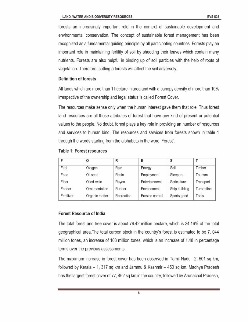
and services to human kind. The resources and services from forests shown in table 1
through the words starting from the alphabets in the word F .
Table 1: Forest resources
F O R E S T
Fuel
Food
Fiber
Fodder
Fertilizer
Oxygen
Oil seed
Oiled resin
Ornamentation
Organic matter
Rain
Resin
Rayon
Rubber
Recreation
Energy
Employment
Entertainment
Environment
Erosion control
Soil
Sleepers
Sericulture
Ship building
Sports good
Timber
Tourism
Transport
Turpentine
Tools
Forest Resource of India
The total forest and tree cover is about 79.42 million hectare, which is 24.16% of the total
geographical area.The
million tones, an increase of 103 million tones, which is an increase of 1.48 in percentage
terms over the previous assessments.
The maximum increase in forest cover has been observed in Tamil Nadu 2, 501 sq km,
followed by Kerala 1, 317 sq km and Jammu & Kashmir 450 sq km. Madhya Pradesh
has the largest forest cover of 77, 462 sq km in the country, followed by Arunachal Pradesh,
LAND, WATER AND BIODIVERSITY RESOURCES EVS 502
9
with a forest cover of 67, 248 sq km and Chhattisgarh 55, 586 sq km. Mizoram, with 88.93
percentage of forest cover has the highest forest cover in percentage terms, followed by
Lakshadweep with 84.56 per cent.The states where forest cover has decreased substantially
are Mizoram ,Telangana, Uttarakhand, Nagaland, Arunachal Pradesh.
1.4.1.3 Types of Forests
Forest resources play an important role in the economy of any country. It is highly complex,
changing environment made up of a living and nonliving things. Living things include trees,
shrubs, wildlife etc. and non-living things include water, nutrients, rocks, sunlight and air.
Forest vary a great deal in composition and density and are distinct from meadows and
pastures. Forest is important to humans and the natural world. For humans, they have many
aesthetics, recreational, economic, historical, cultural and religious values. Forest provides
fuel, wood, timber, wildlife, habitat, industrial, forest products, climate regulations, medicinal
etc. On the basis of geographic structure the forest may be classified into the following:
A. Tropical Wet Evergreen forests
These are the typical rain forests of India, where the annual rainfall is above 250 cm. and
mean annual temperature is 27°C.Dry season is very brief.Some part like Western Ghats,
parts of Karnataka (Anamalai Hills, Coorg, Mysore Plateau), Cachar and Brahmaputra valley
of Assam and Andaman-Nicobar islands of India will be consider in this category.
B. Tropical Moist Semi-evergreen forests
These forests are intermediate between the evergreen and the deciduous forms where the
annual rainfall is between 200-250 cm. and mean annual temperature is 26°C.Some trees
shed their leaves for brief periods in winter and spring. Some parts of India like Western
Ghats, parts of upper Assam, Bengal, Bihar, Orissa and Andaman falls in this category.
C. Tropical Moist Deciduous forests
Tropical moist deciduous forest found on those places where the annual rainfall is 150-200
cm.and drought period is for 1-2 months.These forests distributed at Eastern side of Western
Ghats, Chhota Nagpur, Khasi Hills and a narrow belt along the foothills of Himalayas. On
the basis of dominant species, they are generally of 3 types: Sandal, Teak and Sal forests.
D. Littoral and Swamp forests

LAND, WATER AND BIODIVERSITY RESOURCES EVS 502
10
These forests may be subdivided into 3 categories: beach, tidal and fresh water swamp
forests.
(a) Beach forests
These are distributed nearby the sandy sea beaches and sandy flats of river deltas.
(b) Tidal forests
These grow over the deltas of various rivers, creeks along the coast and swampy margins
of islands.
(c) Fresh Water Swamp forests
They grow in depressions where rain-water or swollen river-water collects for some period.
Elephant grass (Typha species) is quite common in these forests.
E. Tropical Dry Deciduous forests
They cover about 40% of total land in India, where the Annual rainfall is found 75-125 cm.Dry
season extends for about 6 months.They spread from foot of Himalayas to extreme South
(except Western Ghats, Rajasthan, Kashmir, Bengal and other Eastern States).
F. Tropical Thorn forests
They occur on rocky substrata & Annual rainfall is 25-75 cm.In these areas the vegetation is
dominated by Acacia and Euphorbia (thorny plants). These forests found in plenty at Punjab,
Haryana, Rajasthan, Gujarat, Delhi, Bundelkhand part of Uttar Pradesh, parts of Madhya
Pradesh, Maharashtra and Tamil Nadu.
G. Tropical Dry Evergreen forests:
They receive rain from retreating monsoon. Found in Parts of Andhra Pradesh and Tamil
Nadu.
H. Montane Subtropical forests:
These are intermediate between tropical and temperate forest and therefore, exhibit mixed
vegetation of both types.They are divisible into three sub-types:
(a) Broad-leaved hill forests: Nilgiri and Palni Hills of South, Mahableshwar and other
areas of Maharashtra, Mout Abu, Pachmarhi in M.P., Parasnath in Bihar, kalimpong and
Darjeeling.

LAND, WATER AND BIODIVERSITY RESOURCES EVS 502
11
(b) Pine forests: Foothills of Himalayas and in the East over Khasi, Naga, Manipur and
Lushai hills.
(c) Dry evergreen forests: Shiwalik Hills, Punjab, Haryana, Himachal Pradesh and Jammu
and Kashmir.
I. Montane Temperate forests
These forests develop at a height of 1700 metres in the hills of both North and South.They
are not humid. They are of three types:
(a) Montane wet temperate forests: these are found in both North and South region. The
Southern wet temperate forests are called Shoals. They occur in Nilgiris, Annamalai,
Palni, Tinnevelly hills of both Tamil Nadu and Kerala.
(b) Himalayan moist temperate Forests: Western and central Himalayas.
(c) Himalayan Dry temperate Forests: Inner Himalayas.
J. Sub-Alpine forests
They are found throughout Himalayas till the timber line.It spreads from Ladakh in west to
Arunachal Pradesh in East.Annual rainfall is less than 65 cm. Snowfall occurs for several
weeks in a year.It has two types of forests: Silver fir-Birch Forest and Birch-Rhododendron
Forest.
K. Alpine forest
These are found above the timber line and upto snow line in Himalayas.Rainfall is almost
absent. Snowfall is common.The vegetation is commonly known as elfin scrub (short stems;
branches come out of soil and creep along the ground and form tangled masses).This
vegetation is divided into four types: moist alpine scrub, dry alpine scrub, alpine stony
deserts and alpine meadows.
L. Desert Vegetation
Rainfall is scanty, infrequent and irregular (10cm) The vegetation cover is sparse.Vegetation
is of thorn forest type. Natural vegetation contributes to productivity of trees like Khejri
(Prosopis cineraria).

LAND, WATER AND BIODIVERSITY RESOURCES EVS 502
12
1.4.2 Mineral Resources
As we know that mineral are the most important land resources available in nature, which
not only the essential part of earth but an excellent source of energy for different biota.
Without minerals there will be no life on this planet. Mineral resources are broadly defined
as elements, chemical compounds, minerals or rock concentrated in a form that can
be extracted to obtain a sustainable commodity. The origin and distribution of minerals
is intimately related to the history of the biosphere and to the entire geologic cycle. Almost
every aspects and process of the geologic cycle is involved to some extent in producing
local concentrations of minerals.Some mineral elements are essential for the formation and
functioning of the body of all organisms, plants as well asanimals including human beings.
You will study the mineral resources in unit 2 in detail.
1.4.3 Cropland/Agricultural resources
Another most important land resource is cropland, which is fulfilling the need of million
peoples. The peoples are directly dependent on crops for food, fodder and economic growth.
Cropland includes areas used for the production of adapted crops for harvest. Cropland may
be divided into: cultivated and non-cultivated. Cultivated cropland comprises land in row
crops or close-grown crops and also other cultivated cropland, for example, hay land or
pastureland that is in a rotation with row or close-grown crops. Non-cultivated cropland
permanent fodder land and horticultural cropland. As Per the 2007 National Resources
Inventory there are 357, 023,500 acres of cropland in the United States. The cropland acres
produce most of the food and fiber production for the US and an export to other countries.
About 80% of mankind's diet is provided by the seeds of less than a dozen plant species."
Over the years man has invented new machines and techniques to increase the amount and
variety of crop production. As per the availability of land resources, the land can be classified
on the basis of their quality as following.
Table 2: Global availability & quality of land resources suitable for crop production
Sl. No.
Land Quality Cultivated land
(billion hectare)
Grassland & Woodland ecosystem
(b. hectare)
Forest land
(billion hectare)
Other land
(billion hectare)
Total
(billion hectare)
Prime land 0.4 0.4 0.5 0.0 1.3
Good land 0.8 1.1 1.1 0.0 3.1
LAND, WATER AND BIODIVERSITY RESOURCES EVS 502
13
Marginal land 0.3 0.5 0.3 0.0 1.1
Not suitable 0.0 2.6 1.8 3.4 7.8
Total 1.5 4.6 3.7 3.4 13.3
In Indian context during 2004-2010, out of total GDP, agriculture contributed 15.90% in 2004-
05, 15.30% in 2005-06, 14.50% in 2006-07, 13.90% in 2007-08, 13.20% in 2008-09 and
12.80% in 2009-10. So the agricultural system shows a large contribution in GDP of India.
According to the survey of Government of India there was 127 million cultivators in 2001
(Agriculture statistics at a glance-2000, Directorate of Economics & Statistics, Ministry of
Agriculture, Govt. of India, New Delhi, April 2000).
On the other hand about 106 million people worked as a laborer in cropland/agricultural
resources. According to estimation out of total population, about 58% are dependent on
cropland resources for their financial growth.
1.4.4 Water resources
As we all know that water is essential source of life, human body contain about 70%. Water
is elixir of life and in the present context, there is a lot of crisis on water resources. Drinkable
water is not in plenty on this planet. So the water is most important thing of land resources.
Land is providing a substratum to all living and nonliving components, all the living
component has been establishes in the form of families, group and clusters and use the
surrounding land absolutely free of cost. Nobody pay the charges of natural land resources.
With providing the surface area to the living beings, the land contain different types of
resources in her lap like as water, minerals, soil etc. as a non living component, the water
resources are present in plenty on the land surface as well as inner side of the land in the
form of ground water. All the rivers are flowing freely due to the existence of land on this
planet. As we know very well that very little amount of water is present in form of fresh water,
which directly consumed by human beings. Approximately 70.8% of the earth surface is
covered with water mainly in the form of ocean. It is estimated that the hydrosphere contain
about 1360 million cubic km of water. Of this about 97% is in the oceans and inland seas,
where the high
Water flows through the landscape. The condition of the land surface affects the flow and
quality of water. Land surface condition can be characterized at any location by the type of

LAND, WATER AND BIODIVERSITY RESOURCES EVS 502
14
land use, soils, and climate and terrain conditions prevailing there. The effects on water
resources can be measured by the water yield (mean annual flow), flooding (peak
discharges and water surface elevations), groundwater (recharge and pumping), pollution
(constituent concentrations and loads), and sediment (rate of erosion, sediment transport
and deposition).
The connection between land and water resources can thus be viewed on two axes, for land
and water characteristics respectively. Land and water characteristics are connected. Land
characteristics tend to be relatively fixed in time, and spatially extensive. Water
characteristics vary much more in time but tend to be spatially concentrated, such as at
points of measurement of stream flow or water quality.
1.4.5 Soil resources
A substratum is important because it provide space for living, attachment, feeding grounds,
shelter places etc. The substratum influences coloration causing mimicry an eco-protective
phenomenon.
It is matter of common observation that the living organism show a very specific liking,
disliking, preferences or sort of repulsion towards a particular type of Substratum. It is mainly
because in most of the cases the substratum is the fundamental part of the habitat of the
organism, hence the substratum is deeply associated with most of organism, hence the
substratum is deeply associated with most of the biological and behavioral activities of the
organism. It is not a mere base for standing, but basis of existence in general.
Soil is a common name for a highly generalized uppermost surface or layer of the earth,
which comes in most intimate contact of all living terrestrial biotic components. It is a dynamic
system which is capable of sustaining the producers and consumers of the biosphere in
particular, as an integral part of our ecosphere.
a) DEFINITION: The soil is the upper most layer of our terrestrial environment, which is
formed due to weathering of rocks and is an admixture of humus, inorganic contents
and organic debris which provides a surface over the land for the growth of vegetations
and habitat for living animals and comes in immediate contact of biotic and abiotic
factors. According to a famous Russian soil scientist / Pedologist DOKUCHAYEV (1889)
"The soil is a result of action and reciprocal influences of parent rocks, climate,
LAND, WATER AND BIODIVERSITY RESOURCES EVS 502
15
topography, plants, animals and age of the land." It can be represented by the following
formula:
Soil = (Geology + Environment + Biological actions) x Time
b) Soil Formation: It takes nature about two hundred years to make one inch of the Top
layer of the soil, from the parent rock system. Soil formation is quite a complex process.
It is shared by both biotic and Abiotic components; the later factors play a major role in
it. The co-action and inter action on the land surface by light, temperature, water, air,
wear and tear, geological activities cumulatively lead to the process of Fragmentation.
This can be added by growing vegetation, fauna, their decay, and succession these all
lead to the formation of soil. This second step is called as corrosion. This is the process
of oxidation, reduction, hydrolysis, hydration, sulfonation, carbonation etc. Third step is
addition of organic matter to it. Thus gradually the soil attains its best form.However,
systematically speaking the process of soil formation is usually divided in two major
steps:
c) Weathering- That is break down of large complex rocks into smaller units and dust. The
weathering process can bephysical as well as chemical and in fact combination of
cooling, freezing and glaciation, erosion and corrosion and dissolution. These activities
are side by side helped by the chemical processes like hydration, hydrolysis, oxidation-
reduction, carbonation, chelation etc.
d) Pedogenesis or Soil Development This includes changes in raw forms of the rock
material due to combined effect of climatologically, biological and other abiotic factors,
through various types of actions, co-actions, interactions and reactions. In fact
pedogenesis is basically on account of biological activities of lichens, algae, fungi,
bacteria, protozoan, insects, mollusks, annelids etc. which use larges parent rock
material or their parts for various of their biological requirements, varying from habitat,
niche and substratum to food synthesis, derivation of trace or micronutrients to
reproductive activities. All these activities gradually change the physical and chemical
nature of the raw soil ingredients.
Add ultimately through the processes like humus formation addition of organic matter to
the soil converts it into a perfect balanced soil as we require for our basic agricultural
LAND, WATER AND BIODIVERSITY RESOURCES EVS 502
16
purpose. Colloidal complex addition is the phenomena in soil formation which is carried
out by the living organisms in it. During this course partially decomposed material known
as HUMUS is formed and gets homogeneously mixed with the land surface. According
to Waksman (1936), as a result of addition of humus and colloidal complexes the soil is
formed in its best form. It is therefore that the humus and the colloidal complexes of soil
are called as the Heart and Soul of the soil.
All these activities make the colloidal soil complex. The different constituents of soil
complex can be grouped as:
i. Minerals (ii) Soil water (iii) Soil air (iv) Soil organic matter and (v) soil organisms (biota
of the soil)
The Physical Nature of soil depends on the size of the constituents its texture and
structure. Teture is determined by the size of particles & structure is attributed to the
aggregation of these particles and their distribution. On the basis of the size and soil
contains basically following types of particulates:
Table 3: Soil particulates with their size
Sl. No. Particulates Particle size
1 Stones and gravels size More than2.0 mm
2 Coarse sand 0.20 2.00 mm
3 Fine sand 0.02 0.20 mm
4 Silt 0.002 0.02 mm
SOIL PROFILE: The makeup of the soil as observed in its habitable area in a vertical section
is studied as SOIL PROFILE. This shows the various layers / strata of the soil at varying
depths. This process of layer / profile formation may be of recent origin, few decades or very
ancient say thousands of years. It is chiefly affected by the climate, specific geological up-
levels and activities of its biotic communities.
The soil profile is only few feet deep layer system of varying coloration and sometimes
components also. Soil profile is the sequence and nature of the various soil layers (horizons)
covered. The soil profile is generally divided in the following FIVE horizons:
O- Horizon Fresh material
A-Ozone Un-decomposed matter

LAND, WATER AND BIODIVERSITY RESOURCES EVS 502
17
A- O zone Partly decomposed
A- zone I- Mineral Soil layer
A 1- zone Dark & rich with Humus
A 2- zone Soil Raw Material
B- Horizon Mineral Strata
C- Horizon Weathered /broken Rock
R- Horizon Parent Rock
O-Horizon consists of the fresh or only partially decomposed organic matter and is highly
variable in various of its physico-chemical characteristics. This horizon is very dynamic and
full of biotic activities. The O-horizon is consists of the following sub divisions:
(AO) region / zone: This is the uppermost layer consisting of the freshly fallen
leaves, dead animals, fruits etc. It does not contain any decomposed material.
(AO) region / zone: It is just below the 01 zone, in which decomposition of organic
matter has set in. Hence this layer contains partially decomposed organic matter
and biotic populations of small insects, fungi, and bacteria etc. which play important
role in decomposition of organic matter. This layer is thus composed of detritus and
Duffy substances at various stages of decomposition.
A-Horizon is the first mineral layer and is rich in accumulated organic matters. This zone
also shows a downward loss of various soluble salts, clay, iron etc. and usually lower layers
of this zone being richer in components like silica. This layer is also called as zone of
or the layer of downward loss. This zone is further sub-divide in the following
two sub zones:
A1 region: This layer is dark and rich in organic matter, amorphous and finely
divided organic matter becomes mixed with mineral matter in this zone. This is the
zone of richest HUMUS matter. Sometimes it is also called HUMIC layer.
A2 region: In this zone usually raw mineral material of light colors is found and has
less amount of the organic material.

LAND, WATER AND BIODIVERSITY RESOURCES EVS 502
18
B-Horizon is the mineral strata of the soil, immediately below the A Horizon and is rich in
iron, aluminium compounds etc along with clay and humus.
C-Horizon is mainly composed of weathered or broken down parental rock material in loose
texture.
R-Horizon is the parent rock zone from which that particular soil has been formed. Soil in
relation to animals: Great diversity in the animal distribution and their adaptation is mainly
attributed to soil nature. For example a hard substratum requires strong and smaller feet,
offers better running ground, but inhibits burrowing, such as for rodents, rat, rabbits,
earthworms etc. It has low water retention capacity and poor humus.
1.5 History of land resources on earth
According to Rig Veda there is two types of soil on the basis of fertility first productive and
second is non-productive soil (Sharma, 1991). The Amarakosha (c. 400 BC) (Jha, 1999)
described 12 types of lands in its content on Bhumivargaha, depending upon the fertility of
the soil, irrigation, and physical characteristics. Amarkosha classified the soil as urvara
(fertile), ushara(barren), maru (desert), aprahata (fallow), shadvala (grassy), pankikala
(muddy), jalaprayah (watery), kachchaha (land contiguous to water), sharkaravati (sandy),
sharkara (full of pebbles and pieces of limestone), nadimatruka (land watered from a river),
and devamatruka (rainfed). In the chapter on Vaisyavargaha, soils based on suitability for
mentions three types of land jangala (arid), anupa (marshy), and samanya (ordinary)
further subdivided by color into black, white, pale, dark red, red, and yellow and by taste into
sweet, sour, salty, pungent, bitter, and astringent. It is important to note that one of the most
sustained land use practices, since the days of Kautilya has been the use of river beds for
raising cucurbits throughout India.
1.6 Land Resources in India
The total geographical area of India is 328 mha. According to a survey report about 305.67
mha has been reported. Out of the 305.67 mha land 69.63 mha declared as a forestland,
43.22 mha (25.92 mha for non-agricultural use and 17.29 mha barren and uncultivable land)
is not available for cultivation. In other uncultivated land excluding fallow land is 26.82 mha
LAND, WATER AND BIODIVERSITY RESOURCES EVS 502
19
(10.39 mha permanent pasture and other grazing land and 3.31 mha using for miscellaneous
tree crops and grooves left 13.12 mha for cultural waste land). Fallow land is available 25.15
mha, out of this land area 10.34 mha land used as a fallow land other than current fallow
and 14.81 mha used as a current fallow and the 140.86 mha is a net sown area and used
directly for crop production.
India has a total land area of 2.4% of the world total, but supports a population over 17% of
the world. Thus the per capita land availability was only 0.48 ha. as against 8.43 ha in former
USSR and 0.98ha in china. The major land use categories and aerial estimation of wasteland
is following:
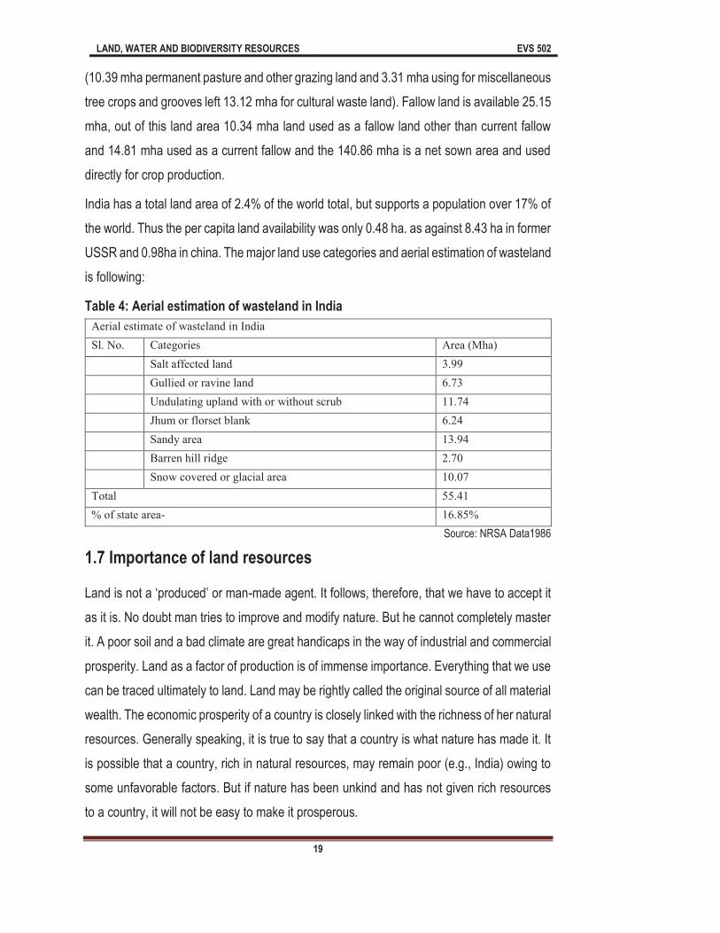
Table 4: Aerial estimation of wasteland in India
Aerial estimate of wasteland in India
Sl. No. Categories Area (Mha)
Salt affected land 3.99
Gullied or ravine land 6.73
Undulating upland with or without scrub 11.74
Jhum or florset blank 6.24
Sandy area 13.94
Barren hill ridge 2.70
Snow covered or glacial area 10.07
Total 55.41
% of state area- 16.85%
Source: NRSA Data1986
1.7 Importance of land resources
-made agent. It follows, therefore, that we have to accept it
as it is. No doubt man tries to improve and modify nature. But he cannot completely master
it. A poor soil and a bad climate are great handicaps in the way of industrial and commercial
prosperity. Land as a factor of production is of immense importance. Everything that we use
can be traced ultimately to land. Land may be rightly called the original source of all material
wealth. The economic prosperity of a country is closely linked with the richness of her natural
resources. Generally speaking, it is true to say that a country is what nature has made it. It
is possible that a country, rich in natural resources, may remain poor (e.g., India) owing to
some unfavorable factors. But if nature has been unkind and has not given rich resources
to a country, it will not be easy to make it prosperous.
LAND, WATER AND BIODIVERSITY RESOURCES EVS 502
20
Obviously, the quality and quantity of agricultural wealth in a country depends on the nature
of the soil, climate, and rainfall. Agricultural products, in their turn, form the very basis of
trade and industry. Industrial prosperity further depends on the presence of rich coal-mines
or waterfalls from which electricity can be generated. Localization of industry depends on
the proximity of power and raw materials and they are largely determined by nature. The
presence of cheap and efficient means of transport is largely conditioned by the topography
of a country. Thus, all aspects of economic life-agriculture, trade and industry are generally
determining influence in moulding the life, occupations and standard of living of a people.
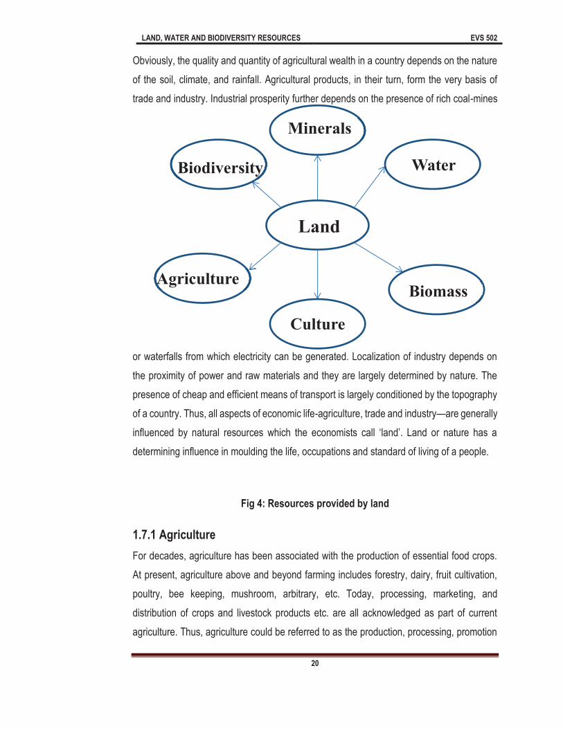
Fig 4: Resources provided by land
1.7.1 Agriculture
For decades, agriculture has been associated with the production of essential food crops.
At present, agriculture above and beyond farming includes forestry, dairy, fruit cultivation,
poultry, bee keeping, mushroom, arbitrary, etc. Today, processing, marketing, and
distribution of crops and livestock products etc. are all acknowledged as part of current
agriculture. Thus, agriculture could be referred to as the production, processing, promotion

LAND, WATER AND BIODIVERSITY RESOURCES EVS 502
21
and distribution agricultural products. Agriculture plays a critical role in the entire life of a
given economy. Agriculture is the backbone of the economic system of a given country. In
addition to providing food and raw material, agriculture also provides employment
opportunities to very large percentage of the population. Below are the values of agriculture
as a land resource:
Source of Livelihood
Contribution to National revenue and GDP.
Supply of Food as well as Fodder
Significance to the International Trade
Marketable Surplus
Source of Raw Material
Foreign Exchange Resources
Great Employment Opportunities
Food Security
1.7.2 Minerals
Mineral resources are amongst the most important natural resources that dictate the
Industrial and economic development of a country because they provide raw materials to
the primary, secondary and tertiary sectors of the economy. The use of mineral is as old as
civilization. Minerals provide the basic needs food, clothing, shelter and energy to
mankind. "Minerals are indispensable to man. The food he eats, the clothes he wears, nay
even his own body are all constituted a variety of minerals and or of their salts. You will study
the mineral resources in unit II in detail.
1.7.3 Biomass
largest consumer of biomass energy. The reliance on biomass energy, especially for cooking
and heating, is strongest in sub-Saharan Africa where the majority of the population has no
access to, or cannot afford to pay for, alternatives such as modern fossil fuels or electricity.
While biomass plays a vital role in meeting basic energy needs and has the potential to
contribute to sustainable development and rural livelihoods, itis often used in efficiently with
adverse impacts on the environment and the health of women and children. Moreover, in
many areas the sustainable supply of biomass energy is at risk because of poor resource

LAND, WATER AND BIODIVERSITY RESOURCES EVS 502
22
management and the excessive clearing of forests and woodlands through logging activities
and agricultural expansion.
1.7.4 Water
Water is another very important resource of land. It is important because it is needed for life
to exist. Many uses of water include agricultural, industrial, household, recreational and
environmental activities. Virtually all of these human uses require fresh water. Only 2.5% of
water on the Earth is fresh water, and over two thirds of this is frozen in glaciers and polar
ice caps. Water demand already exceeds supply in many parts of the world, and many more
areas are expected to experience this imbalance in the near future. It is estimated that 70%
of world-wide water use is for irrigation in agriculture. Climate change will have significant
impacts on water resources around the world because of the close connections between the
climate and hydrologic cycle. Due to the expanding human population competition for water
pollutants threaten water supplies, but the most widespread, especially in underdeveloped
countries, is the discharge of raw sewage into natural waters.
1.7.5 Culture
The culture of any place always dependent on the land resources availablity as the
resources will be available in aand around of any society , the culture will be develop on the
basis of these resources. There is agreat relationship between Land resources and social,
mental, emotional, physical, spiritual wellness of human being. These all thing provide
harmony and balance in the society which is the main cause of culture formation.
1.7.6 Biodiversity
Biodiversity is another very important resource of land. Biodiversity may be defines as variety
and variability among the living organism. These varieties and variability playing an
important role to maintain the ecosystem. As various component of ecosystem are doing
their professional work and without them there is no possibilities to run the natural cycles.
Biodiversity has various importance in nature, some of them are following:
Biodiversity supports food security, dietary health, livelihood sustainability.
LAND, WATER AND BIODIVERSITY RESOURCES EVS 502
23
Biodiversity provides important resources for medical research.
Biodiversity plays a role in the regulation and control of infectious diseases.
Biodiversity has social, cultural and spiritual importance within the communities.
1.7.7 Other importance
The land area of the earth about 140 million sq km, occupies less than a third of its surface
yet, it is vital to our existence since it is land that:
Preserve terrestrial biodiversity and the genetic pool
Regulates the water and carbon cycle
Acts as the store of basic resources like groundwater, minerals and fossil fuels
Becomes a dump for solid and liquid waste
Forms the basis for human settlements and transport activities
Even more important, the topsoil, just a few centimeter thick, support all plant growth
and is hence the life support system for all organisms, including humankind.
1.8 Threat to land resources
Land provides us various types of resources to fulfill our daily needs but in overloaded
desires, we forgot that land has a specific carrying capacity. We are consuming all the
resources carelessly without thinking about the degradation of land resources. In Leopold
land ethics, Leopold said that the earth planet is working as a boat and in this there are two
types of boats, rich and poor. These boats are the rich and poor countries and people are
moving from one side to another on the basis of carrying capacity of the boat/country.
1.8.1 Conditions of worlds land surface
UN studies estimate that 23% of all usable land (excluding mountains and desert) has been
degraded to such an extent that is productivity is affected. The main causes of this
degradation are deforestation, fuel wood consumption, overgrazing agricultural
mismanagement (planting unsuitable crops, poor crop rotation, poor soil and water
management, excessive use of chemicals, frequent use of heavy machineries like tractor
etc.) the establishment of industries and urbanization.

LAND, WATER AND BIODIVERSITY RESOURCES EVS 502
24
Soil erosion and degradation, which occurs due to loss of green cover, strong winds,
chemical pollutio
to act as a buffer and a filter of pollutants, regulator of water and nitrogen cycles, habitat for
biodiversity etc.
About one quarter land highly degraded. Another 8 percent are moderately degraded, 36
by inland water bodies (around 2%). Large parts of all continents are experiencing land
degradation, with particularly high incidences down the west coast of the Americas, across
Mediterranean region of Southern Europe and North Africa, across the Sahel and the Horn
of Africa, and throughout Asia. The greatest threat is the loss of soil quality, followed by
most productive lands are currently used to grow crops. Parts of these land areas are being
degraded through farming practices that result in water and wind erosion, the loss of organic
matter, topsoil compaction, salinization and soil pollution, and nutrient loss.
Summary
surface, encompassing all attributes of the biosphere immediately above or below this
surface, including those of the near-surface climate, the soil and terrain forms, the
surface hydrology (including shallow lakes, rivers, marshes, and swamps), the near-
surface sedimentary layers and associated groundwater and geo-hydrological reserve,
the plant and animal populations, the human settlement pattern and physical results of
past and present human activity (terracing, water storage or drainage structures, roads,
buildings, etc.).
Land use defined in this way establishes a direct linkage between land cover and the
that involves both the manner of including biophysical attributes of land and purposes
for use of land (Weng, 2010).
On the basis of use land may be classified as Net sown area, Forest, Current fallow,
Other Fallows land, Cultivable wasteland, Miscellaneous tree crops and groves,

LAND, WATER AND BIODIVERSITY RESOURCES EVS 502
25
Permanent pasture and grazing land, Land under non-agricultural use and Barren and
uncultivable land.
On the basis of availability, land resources may be classified as Forest Resources,
Mineral Resources, Cropland resources, Water resources and Soil resources.
Forest resources are very important resource of land and perform the ecological duties
with fulfillment for the need of peoples. Forest provides various services to the
ecosystem with giving the food, shelter, cover, fodder, wood fiber to the human society.
The word forest is derived from a La
All lands which are more than 1 hectare in area and with a Canopy density of more than
10% irrespective of the ownership and legal status is called Forest Cover.
Mineral resources are broadly defined as elements, chemical compounds, minerals or
rock concentrated in a form that can be extracted to obtain a sustainable commodity.
Cropland includes areas used for the production of adapted crops for harvest. Cropland
may be divided into: cultivated and non-cultivated.
Water is essential source of life, human body contain about 70%. Water is elixir of life
and in the present context, there is a lot of crisis on water resources. Drinkable water is
not in plenty on this planet. So the water is most important thing of land resources. Land
is providing a substratum to all living and nonliving components.
The soil is the upper most layer of our terrestrial environment, which is formed due to
weathering of rocks and is an admixture of humus, inorganic contents and organic debris
which provides a surface over the land for the growth of vegetations and habitat for living
animals and comes in immediate contact of biotic and abiotic factors.
Amarkosha classified the soil as urvara (fertile), ushara(barren), maru (desert), aprahata
(fallow), shadvala (grassy), pankikala (muddy), jalaprayah (watery), kachchaha (land
contiguous to water), sharkaravati (sandy), sharkara (full of pebbles and pieces of
limestone), nadimatruka (land watered from a river), and devamatruka (rainfed). In the
chapter on Vaisyavargaha, soils based on suitability for specific crops are mentioned.
The total geographical area of India is 328 mha. According to a survey report about
305.67 mha has been reported. Out of the 305.67 mha land 69.63 mha declared as a

LAND, WATER AND BIODIVERSITY RESOURCES EVS 502
26
forestland, 43.22 mha (25.92 mha for non agricultural use and 17.29 mhabaren and
uncultivable land) is not available for cultivation.
In other uncultivated land excluding fallow land is 26.82 mha (10.39 mha permanent
pasture and other grazing land and 3.31 mha using for miscellaneous tree crops and
grooves left 13.12 mha for cultural waste land). Fallow land is available 25.15 mha, out
of this land area 10.34 mha land used as a fallow land other than current fallow and
14.81 mha used as a current fallow and the 140.86 mha is a net sown area and used
directly for crop production.
-made agent. It follows, therefore, that we have to accept
it as it is. No doubt man tries to improve and modify nature. But he cannot completely
master it. A poor soil and a bad climate are great handicaps in the way of industrial and
commercial prosperity. Land as a factor of production is of immense importance.
1.10 Terminal question
1 (a) Fill in the blank spaces with appropriate words.
area, which is plain, provides opportunity for cultivation. The mountainous areas, accounting ral resources;
y burden of the population and increasing demand of the same have been created a lot of burden on land
sharply declined with time, the per capita availability of land was only
the growin population is inversely proportion to the availability of land. As the population will be rise the land availability will be decrease and vice versa.
2. (a) What do you understand by land resources?
(b) Describe the classification and utilization pattern of land.
3. (a) Describe the forest resources of India.
(b) Discuss the cropland resources of India.
4. What are soil resources? Explain the soil profile with suitable diagram?
5. (a) Explain the quantity and quality of land resources with special reference of India.
(b)Discuss the importance of land resources at global level.
(c) Describe the benefits of agriculture provided by land.
LAND, WATER AND BIODIVERSITY RESOURCES EVS 502
27
6. (a) Fill the blank spaces with appropriate words.
uncultivable land) is not available for cultivation. In other uncultivated land excluding
mha using for miscellaneous tree crops and grooves left 13.12 mha for cultural waste
fallow land other than current fallow and 14.81 mha used as a current fallow and the
(b) In 1951 per capita availability of land was 0.89 per hectare (Yes/No)
(c) The category of include all grazing lands-meadows; village commons etc. about 4% of the reporting area comprises such lands known as. (Permanent pasture and grazing land/other fallow land)
(d) Which state of India has the largest forest cover? (Madhya Pradesh/Tamilnadu)
(e) Explain the condition of world land surface?
7. (a) Describe the waste land.
(b) Write a short note on history of land resources.
Answers of Terminal question
1(a) 43 %/30 percent/ ecological aspects / mineral resources / human concentration / 1951 / 0.89 per hectare / 0.37 ha / 60%
2 (a) See section 1.2
(b) See section 1.1
3 (a) See section 1.3.1
(b) See section 1.3.3
4 (a) See section 1.3.5
5 (a) See section 1.5
(b) See section 1.6
(c) See section 1.6.1
6 (a) 328 mha./305.67 mha /69.63 mha /43.22 mha /17.29 mha / fallow land /
permanent pasture /25.15 mha / 140.86 mha
(b) Yes
(c) Permanent pasture and grazing land
(d) Madhya Pradesh
(e) See section 1.1
7 (a) See section 1.5
(b) See section 1.4
LAND, WATER AND BIODIVERSITY RESOURCES EVS 502
28
UNIT 2. The Mineral Resources
Unit Structure
2.0 Learning Objectives
2.1 Introduction
2.2 Definition of Mineral Resources
2.3 Origin of Mineral Resources
2.4 Types of Mineral resources
2.4.1 Metallic mineral resources
2.4.2 Nonmetallic mineral resources
2.4.3 Fuel mineral resource
2.5 How mineral resources are mined
2.5.1 Environmental problem due to the mining
2.6 Mineral resources in India
2.6.1 Mineral Belts of India
2.7 Importance & Uses of Mineral resources
2.7.1. Global Mineral Needs
2.7.2 Threat to mineral resources
2.7.3 Problems posed by mineral resources
2.7.4 Sustainable minerals mining
2.8 Summary
2.9 Terminal question
2.0 Learning Objectives
After studying this unit you will be able to find the answers of following:
What is mineral?
What is the utilization and classification of minerals?
What are mineral resources?
What are the types of mineral resources?
What is the significance of mineral resources?
What are the threats to mineral resources?
How can we conserve the mineral resources?

LAND, WATER AND BIODIVERSITY RESOURCES EVS 502
29
2.1 Introduction
As you know from your study of unit 1 that the land resources are very important for human
survival and the minerals are inseparable part of land resources. The mineral resources are
found at different places of land and play a key role to maintain the life standard for human
being. In this unit you would find the certain terms and concept about the mineral resources.
Minerals are valuable natural resources. They constitute the vital raw materials for many
basic industries and are a major resource for development. The history of mineral extraction
in India dates back to the days of the Harappan civilization. The wide availability of the
minerals provides a base for the growth and development of the mining sector in India. The
country is endowed with huge resources of many metallic and nonmetallic minerals. Mining
sector is an important segment of the Indian economy. Since independence, there has been
a pronounced growth in the mineral production both in terms of quantity and value.
Almost all Earth materials are used by humans for something. We require metals for making
machines, sands and gravels for making roads and buildings, silicon, nickel for making
computer chips, limestone and gypsum for making concrete, clays for making ceramics,
gold, silver, copper and aluminum for making electric circuits, and diamonds and corundum
(sapphire, ruby, emerald)for abrasives and jewelry.
A mineral resource is a volume of rock enriched in one or more useful materials. In this
sense a mineral refers to a useful material, here the word mineral can be any substance that
comes from the Earth.
2.2 Definition of Mineral Resources
As you have studied in unit first various types of land resources and their importance, mineral
resources are one of them and very important to fulfill the need of human society as human
being has been more civilized. Some minerals are essential for the formation and functioning
context, humans use a wide variety of minerals, many in large amount to sustain his industry
based civilization. Availability of mineral resources directly dependent on Modern society
depends on the, which can be considered a nonrenewable heritage from the geologic past.
Although new deposits are still forming from earth processes, but these processes are

LAND, WATER AND BIODIVERSITY RESOURCES EVS 502
30
producing new minerals deposit too slowly to be of use to us today. However large the
deposit of a given mineral is, continuous mining will exhaust the ores, so minerals are thus
a finite and declining resource.
A solid naturally occurring inorganic substance known as mineral
from animal or vegetable matter. In recent time the planet earth was going through various
geologicalprocesses. These processes formed the minerals in over millions to billions of year
and hence they are nonrenewable. Mining is the process of extracting and processing
minerals. Over 100 minerals are mined and these include metals like gold, iron, copper and
aluminum and nonmetals such as stone, sand and salt. Apart from minerals, another major
material that mined is coal.
Mineral resources are essential natural occurring materials or commodity found on or in the
earth in such small amounts which are mined for their potential uses or their intrinsic values.
Minerals resources come in different shapes and sizes and are divided into two major
categories such as Metallic and Nonmetallic mineral resources. Examples of Metallic
resources include minerals like Gold, Silver, Tin, Copper, Lead, Zinc, Iron, Nickel,
Chromium, and Aluminium. Examples of Nonmetallic resources include minerals like sand,
gravel, gypsum, halite, Uranium, and dimension stone.
Table 1: Contribution and rank of India in world production of principal minerals and metals, 2014.
Commodity Unit of quantity Production Contribution
(%)
World India
Mineral fuels
Coal and Lignite Million tones 8,085 659 8.0 3rd
Petroleum crude Million tones 4197 38 0.9 24th
Metallic minerals
Bauxite 000 tones 2,60,000 22,226 8.5 4th
Chromites 000 tones 30,000 2164 7.2 4th
Iron ore Million tones 3378 129 3.8 4th
Manganese ore 000 tones 54,700 2,345 4.3 7th
Industrial mineral
Barites 000 tones 9,300 910 9.8 3rd
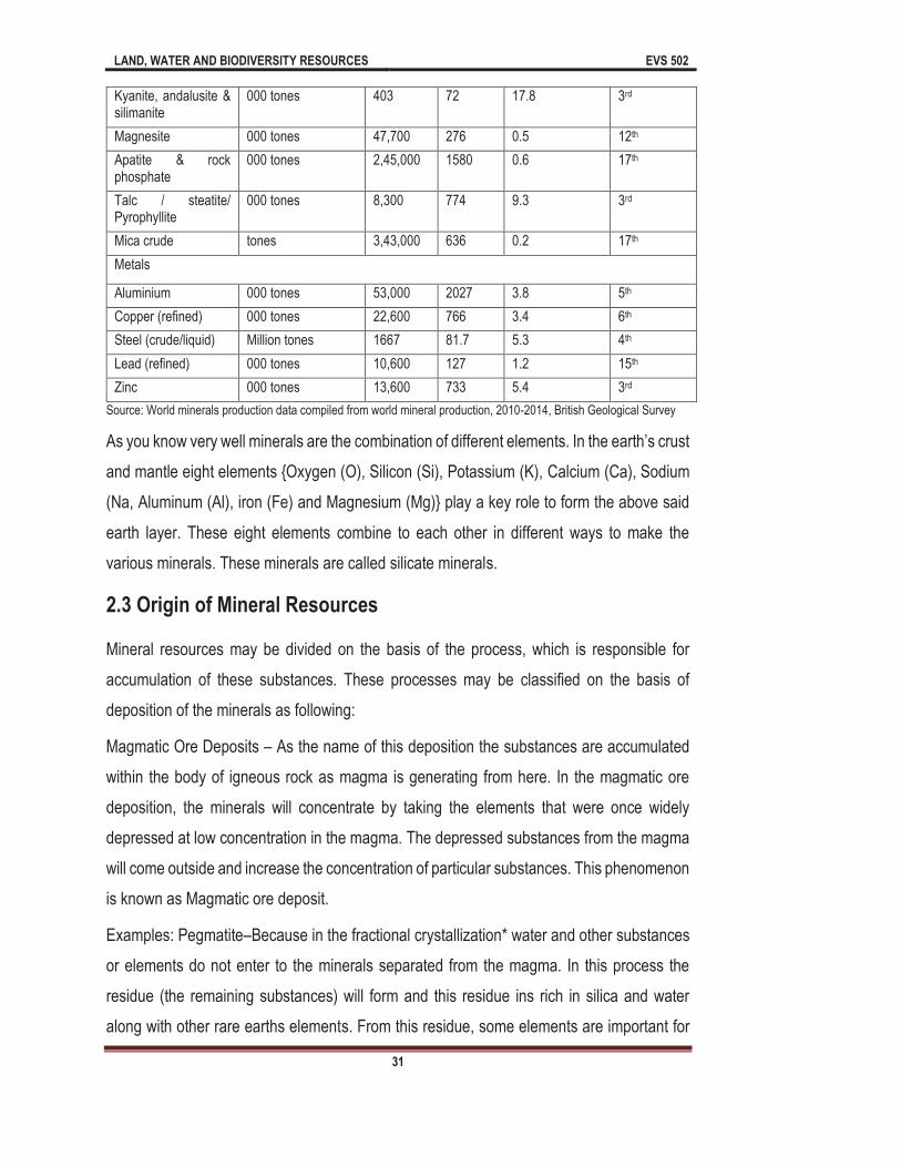
LAND, WATER AND BIODIVERSITY RESOURCES EVS 502
31
Kyanite, andalusite & silimanite
000 tones 403 72 17.8 3rd
Magnesite 000 tones 47,700 276 0.5 12th
Apatite & rock phosphate
000 tones 2,45,000 1580 0.6 17th
Talc / steatite/ Pyrophyllite
000 tones 8,300 774 9.3 3rd
Mica crude tones 3,43,000 636 0.2 17th
Metals
Aluminium 000 tones 53,000 2027 3.8 5th
Copper (refined) 000 tones 22,600 766 3.4 6th
Steel (crude/liquid) Million tones 1667 81.7 5.3 4th
Lead (refined) 000 tones 10,600 127 1.2 15th
Zinc 000 tones 13,600 733 5.4 3rd
Source: World minerals production data compiled from world mineral production, 2010-2014, British Geological Survey
and mantle eight elements {Oxygen (O), Silicon (Si), Potassium (K), Calcium (Ca), Sodium
(Na, Aluminum (Al), iron (Fe) and Magnesium (Mg)} play a key role to form the above said
earth layer. These eight elements combine to each other in different ways to make the
various minerals. These minerals are called silicate minerals.
2.3 Origin of Mineral Resources
Mineral resources may be divided on the basis of the process, which is responsible for
accumulation of these substances. These processes may be classified on the basis of
deposition of the minerals as following:
Magmatic Ore Deposits As the name of this deposition the substances are accumulated
within the body of igneous rock as magma is generating from here. In the magmatic ore
deposition, the minerals will concentrate by taking the elements that were once widely
depressed at low concentration in the magma. The depressed substances from the magma
will come outside and increase the concentration of particular substances. This phenomenon
is known as Magmatic ore deposit.
Examples: Pegmatite Because in the fractional crystallization* water and other substances
or elements do not enter to the minerals separated from the magma. In this process the
residue (the remaining substances) will form and this residue ins rich in silica and water
along with other rare earths elements. From this residue, some elements are important for
LAND, WATER AND BIODIVERSITY RESOURCES EVS 502
32
making phosphorus in the picture tube of color T.V. These are lithium, Tantalum, Niobium,
Boron, Beryllium, Gold and Uranium.
*Crystallization: Minerals will crystallize from a magma body due to heavy weight, some
heavy minerals sink to the bottom of magma chamber. So these elements will attain higher
concentration in the layer, which has been formed at the bottom of magma chamber.
Hydrothermal Ore Deposits Through the fracture and pore space in rocks, the concentrated
hot aqueous (water rich) fluid flows. When the ground water circulates to depth and heats
up by coming in contact with igneous body, the hydrothermal ore deposit on a particular
place may be occurred. By coming in contact with igneous body, if the cooling take place
rapidly resulting the accumulation of elements in the rocks.
Examples:
Massive sulfide deposits: This deposition takes place at oceanic spreading centers. In earth
hot fluids circulating above the magma chamber at oceanic ridge and can remove various
elements like Cu, S. Zn, etc. from the rocks through which they pass. These hot fluids as
coming back to the seafloor and come into contact with cold groundwater or oceanic water
and suddenly precipitate the metals like as sulfide minerals (Zinc sulfide) and Chalcopyrite
(Cu, Fe and Sulfide)
Strata bound ore deposits:This type of deposition found in lakes and oceanic sediments.
Such type of mineral may contain lead, zinc and copper in higher concentration. This concept
is known as strata bound deposition.
Sedimentary Ore Deposits In lake or seawater, substances are concentrated by chemical
precipitation, known as sedimentary ore deposition.
Examples
Evaporite Deposits As you know that evaporation is the process in which the water
vaporized from its natural place. The evaporate deposition is the result of evaporation of
waterfrom lake or sea. After evaporation of water, the remaining substance will be
concentrate or deposit on a particular place. This process is known as evaporate deposition.
Halite (table salt), gypsum (Used in plaster and wall board) and borex (used in soap).
LAND, WATER AND BIODIVERSITY RESOURCES EVS 502
33
Placer Ore Deposits This type of deposition found in flowing water either of stream or along
coastline.
In this deposition, the deposition will be according to the velocity of water, if the speed is
slow the large minerals or the minerals of higher density are deposited. Thus the heavy
minerals will be deposited in lower current velocity of water. This concept is known as placer
ore deposit.
Residual Ore Deposits residual known as remaining part. After the weathering process a
large part of substances will remove and the remaining substance is in concentrated form
this concept is known as residual ore deposition.
During chemical weathering and original body of rock is greatly reduced in volume by the
process of leaching, which removes ions from the original rock. Elements that are not
leached form the rock thus occur in higher concentration in the residual rock. The most
important ore of Aluminum, bauxite, forms in tropical climates.
2.4 Types of Mineral resources
Mineral resources are classified into three major classes such as:
Metallic Mineral Resources
Nonmetallic Mineral Resource
Fuel/Energy Mineral Resource
2.4.1 Metallic mineral resources
Metallic mineral resources are minerals resources that contain metal in raw form, their
appearances have metallic shine and they can be melted to obtain new products. They also
contain metals in their chemical composition, the only way you can extract them is through
mining some examples of metallic mineral resource include Gold, Silver, Copper, Tin, Iron,
Lead, Zinc, Nickel, Chromium, and Aluminium.
2.4.2 Nonmetallic mineral resources
Nonmetallic mineral resources are minerals that do not contain extractable metals in their
chemical composition; they contain nonmetallic shine or luster in their appearance.

LAND, WATER AND BIODIVERSITY RESOURCES EVS 502
34
Examples of nonmetallic mineral resource include sand, stone, gravel, clay, gypsum halite,
and Uranium. These minerals can be reprocessed through grinding, mixing, cutting, shaping
for intermediate use.
2.4.3 Fuel mineral resource
Fuel mineral resource are the basic mineral resources in the world, some examples of these
include fossil fuels such as coal, crude oil (petroleum) and natural gas; these are primarily
gotten from the remains of dead plant and animal, they are often referred to as fossil fuels
and are formed from hydrocarbon. When fossil fuels are burned, they particularly give rise
to a great source of heat energy. The proper use of fossil fuels has enabled large-scale
industrial development and largely supplanted water-driven mills, as well as the combustion
of wood or peat for heat.
2.5 How mineral resources are mined
Mineral resources are mined once the deposit has been discovered in the ground or in the
sea; this process is usually done by different methods most times using the opencast
quarrying or underground mining method or by pumping. The mining process depends on
the type of mineral discovered. For instance, salt is usually extracted by pumping; in this
case, the salt is dissolved in water and pumped from underground just like in the case of oil
and gas.
After these minerals have been extracted from the ground, they are processed and purified
to a form useful material in which we use on a daily basis. The mining process usually
involves the removing any unwanted impurities and further processing to increase the
concentration of the economic mineral. Metallic minerals may be smelted or refined to
produce metal close to the mine, or the concentrate may be transported to another site for
further processing.
Oil and gas are also further refined before use. Finally, once a mineral deposit has been
found it has to be extracted from the ground to access the valuable minerals it contains. The
way minerals are transported from one place to another depends on their value and
bulkiness. It is not economic to transport heavy low-cost minerals like aggregates over long

LAND, WATER AND BIODIVERSITY RESOURCES EVS 502
35
distances, whereas expensive minerals like metals or oil can be transported internationally
using ship (water transport) or air transport.
2.5.1 Environmental problem due to the mining
Surface mining destroy all vegetation in the area and pollutes the landscape with the dust
that is thrown up. Once the available material is mined out, large craters are left behind.
When hills that act as watershed are mined away, the water table goes down as in the case
of Aravallis in Rajasthan.
The Rajasamand Lake in Rajasthan had not dried up for at least 300 years. However, this
did finally happen in 2001. The likely reason: a decade of marble mining in the Rajnagar
area. The aravalli hills, spread across Haryana, Rajasthan and Gujarat are the lifeline of the
three states as they control the climate and drainage system of the region. The hills act as
a watershed for the region. Unfortunately the hills are also repositories of immense mineral
wealth, including talc, marble and granite. Mining and other related industries employ about
1,75,000 workers and 600,000 others are indirectly dependent on mining operations. In
Rajasthan alone 9700 industrial units are connected with mining.
Forest cover has been depleted by 90% over the past 20 years since large scale mining
began. When the mines reach below the underground water level, a cone of depression is
formed that sucks water from the surrounding areas, drying up well and affecting agriculture.
Several studies have pointed out that the natural drainage system and the ground water
table of the entire region has been badly affected over the years. Pollution level has also
increased.
The processing of the mined material often done onsite, using in many cases mercury,
cyanide, and large quantities of water, pollutes river and other water bodies. The waste
material like slag is often far greater in quantity than what is usable and is left behind as
unsightly unstable and dangerous heaps. The mining of precious metals is today more
intense and widespread than in centuries past with far reaching consequences. Of particular
concern is heap leach gold mining, in which rivers of cyanide are poured over huge piles of
low grade ore to extract the metal.
Heap leach mining is on the increase and has already caused several serious accidents.
Two examples are:

LAND, WATER AND BIODIVERSITY RESOURCES EVS 502
36
In 1984 on the OK Tedi Island in new Guenia, 1000 cu.m of concentrated cyanide were
released into a river and the ecosystem was devastated. This gold and copper project, which
is tearing down a whole mountain, has already caused extensive environmental damage. It
has also destroyed the culture and lifestyle of the native people.
In 2000, at the Baia Mare gold mine in Romania, the dam holding the heap leach waste
broke, releasing 80 million liter of cyanide into the Tisza river. The cyanide flowed 500 km
into Hungary and Serbia.
Mineral resources are useful and natural materials for making valuable goods; these
resources play an important role in our economic sector, majority of the countries in the
world solely depend on mineral resources for their economic growth and development.
Minerals are refined into finished goods for making most of the industrial products which we
use in our society such as railways, roads, cars, computers, plastics, pots, cans, metals,
coins, and fertilizers etc. Minerals resources are found in different parts of the world in the
earth's crust but usually in such small amount and they can only be extracted where they
are found with the help of certain geological processes.
However, mineral resources are categorized based on their chemical composition, color,
hardness, affiliation and elemental. Different minerals resources are extracted from the earth
differently and certain activities are usually done in the soil or in the water to survey certain
mineral deposits and availability before exploration can take place; such activities include
remote sensing (aerial photography and satellite imagery), gravity meters, magnetometers
and geochemical surveys.
2.6 Mineral resources in India
As you know that India is a mega diversity nation in context of plants, animals and minerals,
so we can say India is a rich nation naturally. In the country, there are various languages,
cultural and other social activities. All the state shows the variation in mineral resources and
contributes in mineral production differently. As Andhra Pradesh, Assam, Chhattisgarh,
Gujarat, Jharkhand, Madhya Pradesh, Odisha, Rajasthan, Other state and offshore area
contribute 4%, 8%, 7%, 7%, 6%, 12%, 13%, 16% and 21% respectively in case of production
of mineral resources (Fig: 1).

LAND, WATER AND BIODIVERSITY RESOURCES EVS 502
37
Fig 1: Share of state in mineral production during 2016-17
(Source: Ministry of mines, Annual report 2016-17)
India is endowed with huge resource of many metallic and nonmetallic minerals. Mining
sector is playing an important role in the Indian economy. There has been a pronounced
growth in the mineral production both in terms of quantity and value, since independence.
The country produces as many as 95 minerals, which includes 4 fuels, 10 metallic, 23
nonmetallic, 3 atomic and 55 minor minerals (including building and other materials). Indian
mining industries are characterized by a large number of small operational mines. The
number of mines which reported mineral production (excluding atomic, fuel and minor
minerals) in India was 1531 in 2017-18 as against 1508 in previous year. Out of 1531
reporting mines, 230 were located in Tamilnadu, followed by Madhya Pradesh (197) Gujarat
(191) Karnataka (142), Odisha (132), Andhra Pradesh (129), Chhattisgarh (112), Goa (87),
Rajasthan (85), Maharashtra (75) and Jharkhand (58). These 10 states together accounted
for 94% of total number of mining in the country in 2017-18. The numbers of reporting mine
are following:
Table 2: The number of reporting mines in India during 2015-2018
Sl. No. Sector 2015-16 2016-17 2017-18
1 All minerals 1619 1508 1531
2 Metallic minerals 715 644 657
3 Nonmetallic minerals 904 864 874
India has a rich variety of mineral resources due to its varied geological structure. On the
basis of chemical and physical properties, minerals can be classified under two main
categories (i) metallic and (ii) non-metallic. Metallicminerals are the sources of metals. Iron
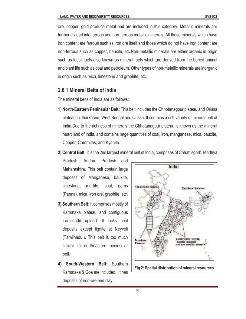
LAND, WATER AND BIODIVERSITY RESOURCES EVS 502
38
ore, copper, gold produce metal and are included in this category. Metallic minerals are
further divided into ferrous and non-ferrous metallic minerals. All those minerals which have
iron content are ferrous such as iron ore itself and those which do not have iron content are
non-ferrous such as copper, bauxite, etc.Non-metallic minerals are either organic in origin
such as fossil fuels also known as mineral fuels which are derived from the buried animal
and plant life such as coal and petroleum. Other types of non-metallic minerals are inorganic
in origin such as mica, limestone and graphite, etc.
2.6.1 Mineral Belts of India
The mineral belts of India are as follows:
1) North-Eastern Peninsular Belt: This belt includes the Chhotanagpur plateau and Orissa
plateau in Jharkhand, West Bengal and Orissa. It contains a rich variety of mineral belt of
India.Due to the richness of minerals the Chhotanagpur plateau is known as the mineral
heart land of India, and contains large quantities of coal, iron, manganese, mica, bauxite,
Copper, Chromites, and Kyanite.
2) Central Belt: It is the 2nd largest mineral belt of India, comprises of Chhattisgarh, Madhya
Pradesh, Andhra Pradesh and
Maharashtra. This belt contain large
deposits of Manganese, bauxite,
limestone, marble, coal, gems
(Panna), mica, iron ore, graphite, etc.
3) Southern Belt: It comprises mostly of
Karnataka plateau and contiguous
Tamilnadu upland. It lacks coal
deposits except lignite at Neyveli
(Tamilnadu.). This belt is too much
similar to northeastern peninsular
belt.
4) South-Western Belt: Southern
Karnataka & Goa are included. It has
deposits of iron-ore and clay.
Fig 2: Spatial distribution of mineral resources
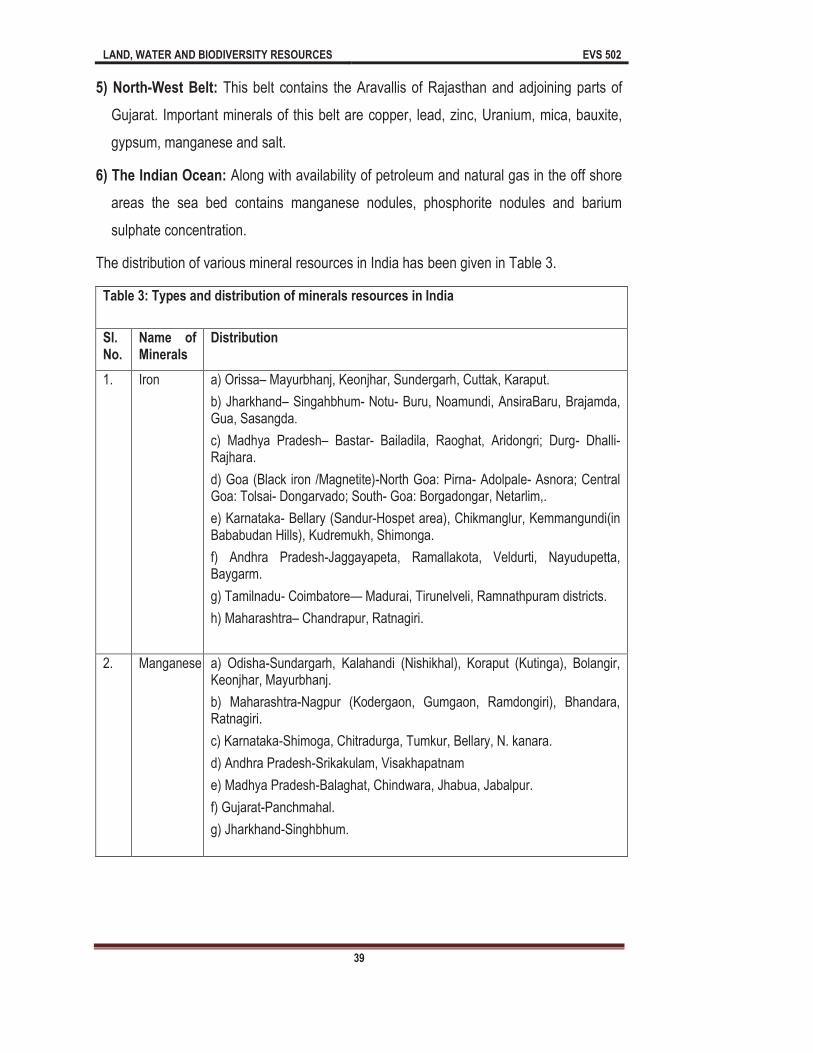
LAND, WATER AND BIODIVERSITY RESOURCES EVS 502
39
5) North-West Belt: This belt contains the Aravallis of Rajasthan and adjoining parts of
Gujarat. Important minerals of this belt are copper, lead, zinc, Uranium, mica, bauxite,
gypsum, manganese and salt.
6) The Indian Ocean: Along with availability of petroleum and natural gas in the off shore
areas the sea bed contains manganese nodules, phosphorite nodules and barium
sulphate concentration.
The distribution of various mineral resources in India has been given in Table 3.
Table 3: Types and distribution of minerals resources in India
Sl. No.
Name of Minerals
Distribution
1. Iron a) Orissa Mayurbhanj, Keonjhar, Sundergarh, Cuttak, Karaput.
b) Jharkhand Singahbhum- Notu- Buru, Noamundi, AnsiraBaru, Brajamda, Gua, Sasangda.
c) Madhya Pradesh Bastar- Bailadila, Raoghat, Aridongri; Durg- Dhalli-Rajhara.
d) Goa (Black iron /Magnetite)-North Goa: Pirna- Adolpale- Asnora; Central Goa: Tolsai- Dongarvado; South- Goa: Borgadongar, Netarlim,.
e) Karnataka- Bellary (Sandur-Hospet area), Chikmanglur, Kemmangundi(in Bababudan Hills), Kudremukh, Shimonga.
f) Andhra Pradesh-Jaggayapeta, Ramallakota, Veldurti, Nayudupetta, Baygarm.
g) Tamilnadu- Coimbatore Madurai, Tirunelveli, Ramnathpuram districts.
h) Maharashtra Chandrapur, Ratnagiri.
2. Manganese a) Odisha-Sundargarh, Kalahandi (Nishikhal), Koraput (Kutinga), Bolangir, Keonjhar, Mayurbhanj.
b) Maharashtra-Nagpur (Kodergaon, Gumgaon, Ramdongiri), Bhandara, Ratnagiri.
c) Karnataka-Shimoga, Chitradurga, Tumkur, Bellary, N. kanara.
d) Andhra Pradesh-Srikakulam, Visakhapatnam
e) Madhya Pradesh-Balaghat, Chindwara, Jhabua, Jabalpur.
f) Gujarat-Panchmahal.
g) Jharkhand-Singhbhum.

LAND, WATER AND BIODIVERSITY RESOURCES EVS 502
40
3 Chromite a) Orissa- centers are Sukinda (between Daiteri&Mahagiri Range) in cuttak, Nausahi in Keonjhar.
b) Karnataka-2nd largest producer.
c) Maharashtra
d) Jharkhand-Singhbhum
e) Tamilnadu- 96% of chromite is exported to Japan and the rest to Australia.
4 Pyrite a) Jharkhand-Sahabad (Amjhor, Kasisiyakoh, Kurriari). b) Tamilnadu Arcot (Polur), Nilgiri (Pandalur- Devala- Nadghani region). c) Karnataka N. Kanara (Kaiga), Chittradurga (Indldhal). d) Himachal Pradesh Ashmi river. e) Rajasthan-Sikar. f) Meghalaya-Khasi, Jaintia.
5 Nickel
a) Cuttak & Mayurbhanj districts of Orissa have the major reserves of Nickel. The total reserves is of 5.8% croretonnes of which 4.08 croretonnes are in Kausa block and 1.5% crore tonnes in Saruabil Sukaragi area. Sirkinda is another famous mine.
b) Some amount is also produced in Maharashtra, Jammu &Kashmir, Madhya Pradesh
c) India imports nickel to fulfill its domestic demand.
6 Tungsten
Deganal near Rawat Hills in Rajasthan.
a) Madhya Pradesh-Amarkantak Plateau- Sargujar, Raigarh, Bilaspur; Maikala Range Balaghat; Katni Range Jabalpur.
b) Jharkhand- Palamu, Lohardagga, Ranchi, Sahabad (Netarhat Plateau).
c) Gujarat- Jamnagar, Khaira, Kutch.
d) Maharashtra- Kolhapur, Kolaba, Satara, Ratnagiri,
e) Karnataka- Belgaum (Karle Hills, Jamboti, Bakur- Navge- Ridge)
f) Tamilnadu- Salem, Nilgiri, Madurai ( Palni Hills, Kodaikanal Hills), Coimbatone (Sandabkuli).
g) Goa-Quepem, Canacora.
7 Bauxite
8 Copper Jharkhand- Rakha, Dhobani, Rajdah, Surdah, Pathargara, Tamapahar, Turamdih), Lota- pahar- Fault.
Rajasthan- Khetri- Singhana Area (Kolihan, Mandhan, Akwali, Berkhera), Kho- Dariba Area, Delwara- Kerovle Area.
Madhya Pradesh- Balaghat (Malanjkhand, Madarkhand)
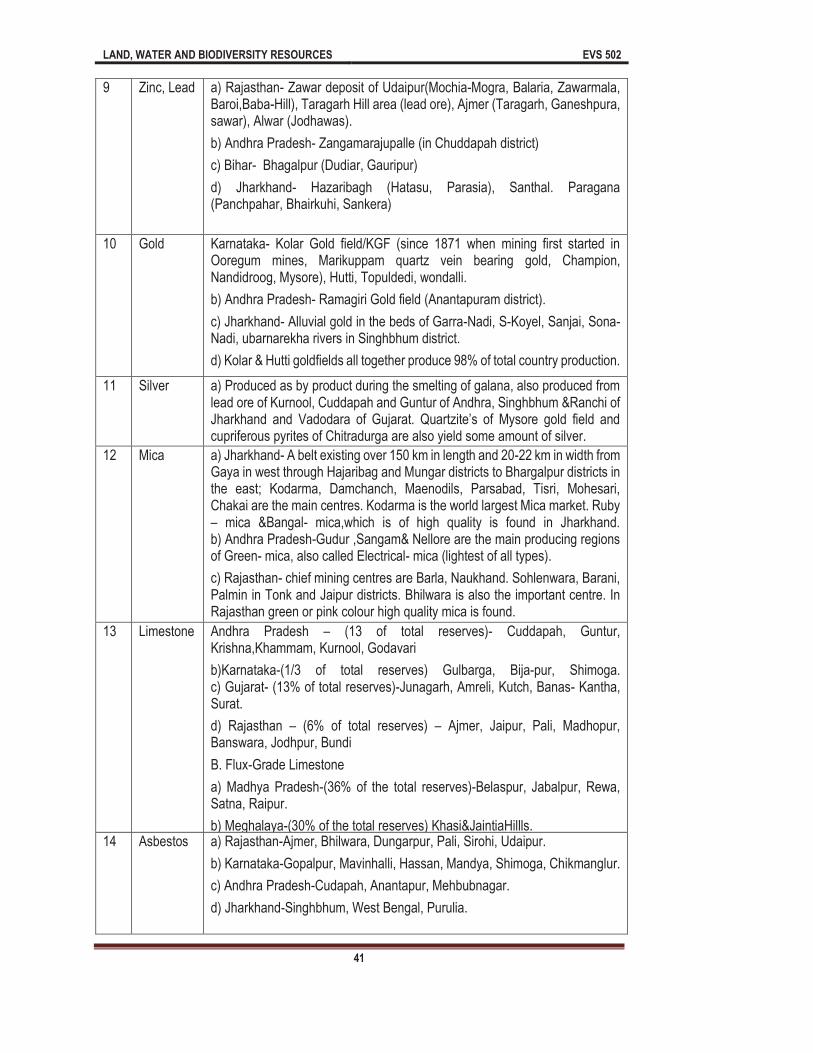
LAND, WATER AND BIODIVERSITY RESOURCES EVS 502
41
9 Zinc, Lead a) Rajasthan- Zawar deposit of Udaipur(Mochia-Mogra, Balaria, Zawarmala, Baroi,Baba-Hill), Taragarh Hill area (lead ore), Ajmer (Taragarh, Ganeshpura, sawar), Alwar (Jodhawas).
b) Andhra Pradesh- Zangamarajupalle (in Chuddapah district)
c) Bihar- Bhagalpur (Dudiar, Gauripur)
d) Jharkhand- Hazaribagh (Hatasu, Parasia), Santhal. Paragana (Panchpahar, Bhairkuhi, Sankera)
10 Gold Karnataka- Kolar Gold field/KGF (since 1871 when mining first started in Ooregum mines, Marikuppam quartz vein bearing gold, Champion, Nandidroog, Mysore), Hutti, Topuldedi, wondalli.
b) Andhra Pradesh- Ramagiri Gold field (Anantapuram district).
c) Jharkhand- Alluvial gold in the beds of Garra-Nadi, S-Koyel, Sanjai, Sona-Nadi, ubarnarekha rivers in Singhbhum district.
d) Kolar & Hutti goldfields all together produce 98% of total country production.
11 Silver a) Produced as by product during the smelting of galana, also produced from lead ore of Kurnool, Cuddapah and Guntur of Andhra, Singhbhum &Ranchi of Jharkhand and cupriferous pyrites of Chitradurga are also yield some amount of silver.
12 Mica a) Jharkhand- A belt existing over 150 km in length and 20-22 km in width from Gaya in west through Hajaribag and Mungar districts to Bhargalpur districts in the east; Kodarma, Damchanch, Maenodils, Parsabad, Tisri, Mohesari, Chakai are the main centres. Kodarma is the world largest Mica market. Ruby
mica &Bangal- mica,which is of high quality is found in Jharkhand. b) Andhra Pradesh-Gudur ,Sangam& Nellore are the main producing regions of Green- mica, also called Electrical- mica (lightest of all types).
c) Rajasthan- chief mining centres are Barla, Naukhand. Sohlenwara, Barani, Palmin in Tonk and Jaipur districts. Bhilwara is also the important centre. In Rajasthan green or pink colour high quality mica is found.
13 Limestone Andhra Pradesh (13 of total reserves)- Cuddapah, Guntur, Krishna,Khammam, Kurnool, Godavari
b)Karnataka-(1/3 of total reserves) Gulbarga, Bija-pur, Shimoga. c) Gujarat- (13% of total reserves)-Junagarh, Amreli, Kutch, Banas- Kantha, Surat.
d) Rajasthan (6% of total reserves) Ajmer, Jaipur, Pali, Madhopur, Banswara, Jodhpur, Bundi
B. Flux-Grade Limestone
a) Madhya Pradesh-(36% of the total reserves)-Belaspur, Jabalpur, Rewa, Satna, Raipur.
b) Meghalaya-(30% of the total reserves) Khasi&JaintiaHillls. 14 Asbestos a) Rajasthan-Ajmer, Bhilwara, Dungarpur, Pali, Sirohi, Udaipur.
b) Karnataka-Gopalpur, Mavinhalli, Hassan, Mandya, Shimoga, Chikmanglur.
c) Andhra Pradesh-Cudapah, Anantapur, Mehbubnagar.
d) Jharkhand-Singhbhum, West Bengal, Purulia.

LAND, WATER AND BIODIVERSITY RESOURCES EVS 502
42
15 Sillimanite a) Meghalaya-Sonapahar, Nagpur, Nangbain in the Nongtoin area.
b) Madhya Pradesh.-Sidhi & Reewa.
c) Maharashtra-Bhawara, Nagpur.
d) Tamilnadu-Coimbatore, South Arcot.
e) Kerala-Palghat, Kottayam.
16 Kyanite a) Jharkhand-A belt extending from Lapsa Buru to Kharasawan in Saraikala. with the important mines at Lapsa-Buru, Ghagidih, Bachia- Bakro & Mauyaluka.
b) Maharashtra-Pahergaon & Pipalgaon in Sakohi Tehsil and Gorkha- Buranga and Asvalpain in Bhandara districts.
17 Salt a) Sea-salt- Mithapur, Jamnagar, Dharsana, Okha, Bulsar in Gujarat; Bhandrup, Uran, Bhayandar in Maharashtra; Madras & Taticorin in Tamilnadu.
b) Salt- lake- Sambhar, Didwana, Pachbhadra, Lankaesara lakes in Rajasthan. c) Rock-salt- mined at present in Mandi District at Drang &Guna in Himachal Pradesh.
18 Rare-
Earths In the South-west tip of India on the Kerala and Tamilnadu cost, an extremely rich minerals like Ilmenite and Monazite.
Ilmenite- from Quilon to Kanyakumari
2.7 Importance & Uses of Mineral resources
As you know that the minerals are playing very important role in survival of human being.
On the basis of their chemical composition and uses, the mineral may be classified into three
categories - Metallic, Nonmetallic and Energy resources (as explained in 2.4 in this chapter).
The metallic minerals are very important and using in different manner, like as aluminum,
copper, gold, iron, lead, nickel, thorium, uranium, zinc etc. are using in building material,
alloys and electrical product, Monetary purposes, jewelry, Nuclear bombs, electricity
generation etc. The nonmetallic group contain Asbestos, Corundum, Feldspar, Fluorspar,
Nitrates, Phosphates, sulfur etc. using in Roofing, insulation, Abrasives, Fertilizers,
Chemicals, steel industry etc. Minerals are using as energy resource as Diesel, Petrol,
compressed natural gas (CNG) fuel for different vehicles. Coal is using for power generation
and steel production, oil for heating, electricity generation and for vehicles (Table 4).

LAND, WATER AND BIODIVERSITY RESOURCES EVS 502
43
Table 4: Important minerals and their uses
Mineral Resources Uses
A) Metallic Resources
Aluminum Building materials, electrical wiring, utensils, aircrafts, rocket
Beryllium Refractories, Copper alloys
Chromium Refractory, metallurgy, chemicals
Cobalt Alloys, radiography, catalysts, therapeutics
Columbium Stainless steel, nuclear reactor
Copper Alloys and electrical products
Gold Monetary purposes, jewelry, dentistry
Iron Steel, building materials, numerous industrial uses
Lead Batteries, paints, alloys, public health fitting, gasoline
Magnesium Structural refractories
Manganese Alloy steels, disinfectants
Molybdenum Alloy steel
Nickel Used in over 8000 alloys
Thorium Nuclear bombs, electricity generation
Tin Soldering, chemicals, tin plate
Tungsten Alloys, chemicals
Titanium Alloys, Pigments and aircraft
Uranium Nuclear bomb, Electricity generation
Vanadium Alloys
Zinc Gal vanishing, chemicals, soldering and die casting
B) Non Metallic Resource
Asbestos Roofing, insulation, ceramics, textile, gasoline
Corundum Abrasives
Feldspar Ceramic flux, artificial teeth
Fluorspar Flux, refrigerants, Propellants, acid
Nitrates Fertilizers, Chemicals
Phosphates Fertilizers, Chemicals
Potassium Fertilizers, Chemicals
Salt Chemicals, glass, metallurgy
Sulfur Fertilizers, acid, iron and steel industry
C) Energy Resources
Coal Power generation, steel production
Oil For heating, Electricity generation and for vehicle
Natural gas Vehicles as CNG, cooking, heating
The mineral resources have a lot of importance as we have discussed above, with all the
importance, mineral resources contribute to the economy of the country and definitely
enhance the financial status of the country. As you can clearly see in (table 5), the increasing
trend of financial support by different states of India. Chhattisgarh, Odisha and Rajasthan
are the major contributor during 2013-2017 as these states have the contribution of
Rupees1, 07,364/-, 3, 41,343/-, and 1, 86,575/- in the year of 2015-16.
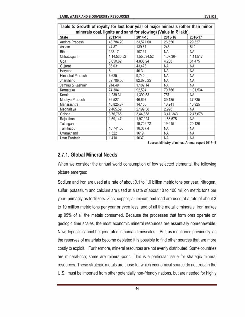
LAND, WATER AND BIODIVERSITY RESOURCES EVS 502
44
Source: Ministry of mines, Annual report 2017-18
2.7.1. Global Mineral Needs
When we consider the annual world consumption of few selected elements, the following
picture emerges:
Sodium and iron are used at a rate of about 0.1 to 1.0 billion metric tons per year. Nitrogen,
sulfur, potassium and calcium are used at a rate of about 10 to 100 million metric tons per
year, primarily as fertilizers. Zinc, copper, aluminum and lead are used at a rate of about 3
to 10 million metric tons per year or even less; and of all the metallic minerals, iron makes
up 95% of all the metals consumed. Because the processes that form ores operate on
geologic time scales, the most economic mineral resources are essentially nonrenewable.
New deposits cannot be generated in human timescales. But, as mentioned previously, as
the reserves of materials become depleted it is possible to find other sources that are more
costly to exploit. Furthermore, mineral resources are not evenly distributed. Some countries
are mineral-rich; some are mineral-poor. This is a particular issue for strategic mineral
resources. These strategic metals are those for which economical source do not exist in the
U.S., must be imported from other potentially non-friendly nations, but are needed for highly
Table 5: Growth of royalty for last four year of major minerals (other than minor minerals coal, lignite and sand for stowing) (Value in lakh).
State 2013-14 2014-15 2015-16 2016-17
Andhra Pradesh 48,784.20 33,571.00 26,650 29,527
Assam 44.87 139.67 248 512
Bihar 128.17 107.31 NA NA
Chhattisgarh 1,14,535.52 1,55,634.52 1,07,364 1,11,517
Goa 3,650.62 4,838.24 4,288 31,475
Gujarat 35,031 43,476 NA NA
Haryana 8 40.3 NA NA
Himachal Pradesh 6,625 9,740 NA NA
Jharkhand 62,706.56 82,870.25 NA NA
Jammu & Kashmir 914.49 1,182.14 NA NA
Karnataka 74,304 92,594 79,766 1,01,534
Kerala 1,239.31 1,390.53 757 NA
Madhya Pradesh 36,527 46,697 39,185 37,735
Maharashtra 16,825.87 14,100 16,241 16,925
Meghalaya 2,465.59 2,199.58 2,998 NA
Odisha 3,76,765 3,44,338 3,41, 343 2,47,678
Rajasthan 1,59,147 1,97,024 1,86,575 NA
Telangana -- 19,702.72 19,015 20,126
Tamilnadu 16,741.50 18,087.4 NA NA
Uttarakhand 1,522 1619 NA NA
Uttar Pradesh 1,410 1037 NA NA

LAND, WATER AND BIODIVERSITY RESOURCES EVS 502
45
specialized applications such as national security, defense, or aerospace
applications. These metals include Manganese, Cobalt, Platinum, and Chromium, all of
which are stockpiled by the U.S. government in case supplies are cut off.How long current
mineral resources will last depends on consumption rates and reserve amounts.Some
mineral resources will run out soon, for example global resources of Pb, Zn, and Au will likely
run out in about 30 years. U.S. resources of Pt, Ni, Co, Mn, Cr less than 1 year. Thus,
continued use of scarce minerals will require discovery of new sources, increase in price to
make hard-to-obtain sources more profitable, increased efficiency, conservation, or
recycling, substitution of new materials, or doing without.
2.7.2 Threat to mineral resources
At first glance, sustainability and mineral resource development appear to be in conflict.
Mining depletes finite resources and in a strict sense, therefore, is inherently unsustainable.
unit of
copper extracted increases the fraction of the total copper resource base that is in use. Thus,
it can be argued that if we continue to mine we will eventually exhaust the available supply
of minerals. This perspective, however, ignores the dynamics of mineral supplies. In practice
the non-renewable character of minerals may be less constraining than it might seem. Five
factors make the benefits from mining much more sustainable than they initially appear to
be. First, through the process of exploration and development, mining companies continually
lead to the discovery and proving up of previously unknown mineral deposits and perhaps
just as important additional reserves at existing mines and known deposits. Technological
improvements in exploration increase the discovery rate of mineral deposits and at the same
time reduce discovery costs. Predictive models for massive sulfide deposits, for example,
allow targeting of completely buried deposits by using the combination of structural
projections and favorable stratigraphic horizons in volcanic rocks.
2.7.3 Problems posed by mineral resources
Depletion of Mineral
LAND, WATER AND BIODIVERSITY RESOURCES EVS 502
46
Rapidly growing mining activity has rendered large agricultural tracts almost
useless.
Miners have to work under most hazardous conditions.
Many mineral producing areas lead to air and water pollution.
Huge displacement of tribal people.
2.7.4 Sustainable minerals mining
environmentally, technically and scientifically sound; with a long term view of development;
uses mineral resources optimally; and, ensures sustainable post-closure land uses. Also
one based on creating long-term, genuine, mutually beneficial partnerships between
It includes:
Mining operations that have a broad-based social license to operate- creating
lasting social and economic wealth which will outlast the life of the mine.
Environmentally, technically and scientifically sound implying proper management
of natural resources. And the last one uses mineral resources optimally.
2.8 Summary
In this unit we have examined various aspects of mineral resources so far you have
learnt that A mineral resource is a volume of rock enriched in one or more useful
materials. In this sense a mineral refers to a useful material, here the word mineral
can be any substance that comes from the Earth.
formed from animal or vegetable matter.
Metallic mineral resources- are minerals resources that contain metal in raw form,
their appearances have metallic shine and they can be melted to obtain new
products.
LAND, WATER AND BIODIVERSITY RESOURCES EVS 502
47
Nonmetallic mineral resources are minerals that do not contain extractable metals
in their chemical composition; they contain nonmetallic shine or luster in their
appearance.
Fuel mineral resources are the basic mineral resources in the world, some
examples. These include fossil fuels such as coal, crude oil (petroleum) and natural
gas.
Mineral resources are mined once the deposit has been discovered in the ground
or in the sea; this process is usually done by different methods most times using the
opencast quarrying or underground mining method or by pumping. The mining
process depends on the type of mineral discovered. For instance, salt is usually
extracted by pumping; in this case, the salt is dissolved in water and pumped from
underground just like in the case of oil and gas.
Surface mining destroy all vegetation in the area and pollutes the landscape with
the dust that is thrown up. Once the available material is mined out, large craters
are left behind. When hills that act as watershed are mined away, the water table
goes down as in the case of Aravallis in Rajasthan.
In Andhra Pradesh, Assam, Chhattisgarh, Gujarat, Jharkhand, Madhya Pradesh,
Odisha, Rajasthan, Other state and offshore area contribute 4%, 8%, 7%, 7%, 6%,
12%, 13%, 16% and 21% respectively in case of production of mineral resources
(Fig: 1).
The number of mines which reported mineral production (excluding atomic, fuel and
minor minerals) in India was 1531 in 2017-18 as against 1508 in previous year. Out
of 1531 reporting mines, 230 were located in Tamilnadu, followed by Madhya
Pradesh (197) Gujarat (191) Karnataka (142), Odisha (132), Andhra Pradesh (129),
Chhattisgarh (112), Goa (87), Rajasthan (85), Maharashtra (75) and Jharkhand
(58). These 10 states together accounted for 94% of total number of mining in the
country in 2017-18.
The metallic minerals are very important and using in different manner, like as
aluminum, copper, gold, iron, lead, nickel, thorium, uranium, zinc etc.

LAND, WATER AND BIODIVERSITY RESOURCES EVS 502
48
The nonmetallic group contain Asbestos, Corundum, Feldspar, Fluorspar, Nitrates,
Phosphates, sulfur etc. using in Roofing, insulation, Abrasives, Fertilizers,
Chemicals, steel industry etc.
Minerals are using as energy resource as Diesel, Petrol, compressed natural gas
(CNG) fuel for different vehicles.
Mining depletes finite resources and in a strict sense, therefore, is inherently
unsustainable. For instance, there
crust, and each unit of copper extracted increases the fraction of the total copper
resource base that is in use.
2.9 Terminal question
1. (a) Fill in the blank spaces with appropriate words.
India is endowed with huge resource of many metallic and nonmetallic minerals. Mining sector is playing an important role in the Indian economy. There has been a pronounced growth in the mineral production both in terms of quantity and value, since independence. The cou
(including building and other materials). Indian mining industries are characterized by a mines which reported mineral
-
Pradesh (197) Gujarat (191) Karnataka (142), Odisha (132), Andhra Pradesh (129),
the country in 2017-18.
2. (a) Discuss the types of mineral resources.
(b) How mineral resources are mined?
3. (a) Describe the environmental problems due to the mining.
(b) Discuss the mineral belts of India.
4. a) What do you meant by distribution of mineral resources? Explain the types and distribution of minerals resources in India?
5. (a) Explain the role of mineral resources in financial growth.
(b) Discuss the need of mineral resources at global level?
(c) Discuss the threat to mineral resources.
6. (a) Fill the blank spaces with appropriate words.
When we consider the annual world consumption of few selected elements, the following
LAND, WATER AND BIODIVERSITY RESOURCES EVS 502
49
consumed. Because the processes that form ores operate on geologic time scales, the
be generated in human timescales. But, as mentioned previously, as the reserves of materials become depleted it is possible to find other sources that are more costly
mineral-rich; some are mineral-poor. This is a particular issue for
cal source -friendly nations,
but are needed for highly specialized applications such as national security, defense, or aerospace applications.
(b) Minerals will crystallize from a magma body due to heavy weight(Yes/No)
(c) Deposition found in flowing water either of stream or along coastline.is called (Placer Ore Deposits /Strata ore deposit)
(d) Which one mineral heart land of India (Chhotanagpur/ Neyveli/Jharkhand)
(e) What do you understand by Mining?
7. (a) Describe the metallic and nonmetallic mineral resources.
(b) Give the use and distribution of Gold, Mica, Asbestos, Silver and Bauxite in India
Answers to the Terminal questions
1 (a) 95 minerals, 4 fuels, 10 metallic, 55 minor operational mines. 1531 230, (85), (58), 94% 2 (a) See section 2.4
(b) See section 2.5 3 (a) See section 2.5.1
(b) See section 2.6.1 4 (a) See section 2.6 (Table 1) 5 (a)See section 2.7
(b) See section 2.7.1 (c) See section 2.8
6 (a) 0.1 to 1.0 billion/ sulfur, / 10 to 100 million / Zinc, copper, aluminum / 3 to 10 / 95% nonrenewable/ Exploit. Mineral resources, /mineral resources./ U.S.
(b) Yes (c) Placer ore deposit (d) Chhotanagpur (e) See section 2.5
7 (a) See section 2.7 (b) See section 2.6 (table)

LAND, WATER AND BIODIVERSITY RESOURCES EVS 502
50
UNIT 3. The Wetland Case Study: The Sundarbans and The Bharatpur Sanctuary
Unit Structure
3.0 Learning Objectives
3.1 Introduction
3.2 Types and characteristics of wetlands
3.2.1 Natural Wetlands
3.2.1 Peat Land Classification
3.3 Importance and Functions of Wetlands
3.4 Wetlands in India
3.5 Ramsar Convention
3.5.1 A Case Study of Sundarbans
3.5.2 Case Study: Bharatpur Sanctuary
3.8 Summary
3.0 Learning Objectives
After studying this unit you will be able to:
Define Wetland
What are the Characteristic features of wetlands?
Describe about Wetlands in India
What is Ramsar Convention?
How may Ramsar conservation sites in India
About Sundarbans
Flora and Fauna of Sundarbans
About Bharatpur Sanctuary
Flora and Fauna of Bharatpur Sanctuary
3.1 Introduction
A there are various natural resources on land such as forest resources, water resource, land
resource, mineral resource, energy resource etc. Water resource is one of the greatest
resources among all resources and it is not only important to human being but also for all
living creatures, and all ecosystems. About 97.5% of water occurs in sea and oceans which

LAND, WATER AND BIODIVERSITY RESOURCES EVS 502
51
is called salt water on the other hand remaining 2.5% regarded as freshwater. Most of the
freshwater acts as water sources and these resources include Rivers, lakes, Ponds,
wetlands, groundwater etc. Wetland is a land area which is saturated with water. Wetlands
are found on every part of earth except Antarctica. These wetlands are ecologically, socially
and economically very important. Wetlands recharge the ground water, act as flood
controlling wall, increase biological diversity etc. Therefore, it is necessary to conserve,
protect, and preserve, these wetlands at local, national and global levels. World Wetlands
Day celebrated on February 2 of every year to spread mass awareness about the importance
of wetlands. Wetland are very important reservoir not only for human being but for the
ecological sustainability. In this unit you will learn about various aspects of wetlands, wetland
in India, the case studies of Sundarbans and Bharatpur Sanctuary.
Definitions
Man has long history wetlands. Human civilization developed near the water bodies or
wetlands. Most of these civilizations were established on the coasts, along rivers or in prime
agricultural lands and rich forests, all of which possess areas which can be called "wetlands."
In more recent years, especially about 1960, the term "wetlands" has come into widespread
usage and means all types of land areas which are characteristically high in water content.
Various agencies have defined wetlands, some of the important definitions of wetland are
given below:
According to Ramsar Convention wetlands may be defined as
peatland or water, whether natural or artificial, permanent or temporary, with water that
is static, flowing, fresh, brackish or salt, including areas of marine water, the depth of
According to Tidal Wetlands Act (1969), "wetlands" defined as: "Wetland" means those
areas which border on or lie beneath tidal waters, such as, but not limited to, banks,
bogs, salt marshes, swamps, meadows, flats or other lowlands subject to tidal action,
including those area snow or formerly connected to tidal waters, and whose surface is
at or below an elevation of one foot above local extreme high water; and upon which
may grow, or be capable of growing, some, but not necessarily all of the following.
LAND, WATER AND BIODIVERSITY RESOURCES EVS 502
52
adjacent to wetlands and islands or bodies of marine water deeper than 6 meters at low
According to Inland Wetlands and Watercourses
land which consists of any of the soil types designated as poorly drained, very poorly
drained, alluvial and flood plain.
Terms related to "Wetlands"
Bog: Bog is wet, spongy ground in which soil made up of decayed vegetable matter; an area
or stretch of such ground. Bog has a poorly drained usually acid area rich in plant
residues, frequently surrounding a body of open water, and has characteristic flora.
Main flora in bog are sedges, heaths and sphagnum.
Bottom: The ground below any aquatic body; usually Bottoms, also called Bottom land.
Everglade: Everglade is swampy land characterized by clumps of tall grass and numerous
branching waterways. Everglade usually containing saw-grass and at least seasonally
covered by slowly moving water.
Fen: Fen is lowland completely or partially covered with water.
Fenland: A low area of marshy ground.
Heath: Health is a tract of open and uncultivated land, waste land over-grown with shrubs.
A tract of wasteland; an extensive area of rather level open uncultivated land usually with
poor coarse soil, inferior drainage, and a surface rich in peat or peaty humus.
Marsh: Marsh is a tract of low wet land, generally treeless and periodically inundated:
characterized by grasses, sedges and rushes.
Marshland: A region, area, district, etc. characterized by marshes, swamps, bogs or the
like.
Meadow: Meadows are tracts of grassland used for pasture. These are tracts of grassland
in an upland area near the timber line. These meadows are predominantly in grass;
especially a tract of moist low-lying usually level grassland.
Mire: Mire is a section of wet, swampy ground; bog; marsh; ground of this type as wet, slimy
soil of some depth; deep mud, etc.

LAND, WATER AND BIODIVERSITY RESOURCES EVS 502
53
Moor: Moor is a tract of open, peaty, waste land, often overgrown with heath, common in
high latitudes and altitudes where drainage is poor. These are usually peaty and dominated
by grasses and sedges.
Moorland: It is an area of moors, especially country abounding in heather.
Morass: Morass is a tract of low, soft wet land; a marsh or bog; marshy ground.
Muskeg: A bog of northern North America, commonly having sphagnum mosses, sedge
and sometimes stunted black spruce and tamarack trees.
Quagmire: An area of miry or boggy ground whose surface yields under the tread;
Quicksand: Quicksand is a bed of soft or loose sand saturated with water and having
considerable depth, yielding underweight and therefore apt to engulf persons, animals, etc.,
coming upon it.
Salt marsh: Salt marsh is a marshy tract that is wet with salt water or flooded by the oceans
or seas.
Slough: Slough is an area of soft, muddy ground; muddy ground; swamp or swamp like
region.
Sump: Sump is a swamp, bog or muddy pool.
Swale: Swale is a low place in a tract of land, usually moister and often having a ranker
vegetation than the adjacent higher land.
Swamp: Swamp is a tract of wet, spongy land; marshy ground, a tract of soft, wetground
having a growth of certain types of trees and other vegetation, but unfit for cultivation.
Swampland: Swampland is a land or an area covered with swamps.
Wetland: Wetland is generally, wetlands a tract of land having wet and spongy soil, as a
marsh, swamp or bog.
3.2 Types and characteristics of wetlands
3.2.1 Natural Wetlands
There are various natural wetlands which are described below:
LAND, WATER AND BIODIVERSITY RESOURCES EVS 502
54
i) Marine: Marine and coastal wetlands are generally found in regions between land and
sea. These wetlands are not influenced by rivers. The examples of marine wetlands are
open Ocean, continental shelf, including beaches, rocky shores, lagoons, and shallow
coral reefs. These marine wetlands have hyper-saline water chemistry and minimal
influence from rivers or estuaries. Mangroves, mudflats or sabkhas may be present in
these wetlands.
ii) Estuarine: Estuarine wetlands are found where freshwater (especially rivers) meets with
and mixes with salt water from the sea. Eastuarine wetlands include mangroves,
saltmarsh wetland etc. There are deep-water tidal habitats with a range of fresh-brackish-
marine water chemistry and daily tidal cycles. The examples of estuarine wetlands are:
Salt and brackish marshes, intertidal mudflats, mangrove swamps, bays, sounds, and
coastal rivers.
iii) Riverine: Riverine wetlands are associated with running water such as rivers and
streams. Freshwater, perennial streams comprised of the deep-water habitat contained
within a channel, this restrictive system excludes floodplains adjacent to the channel as
well as habitats with more than 0.5% salinity.
iv) Lacustrine: Lacustrine wetlands are related with lakes and ponds. These wetlands are
dominantly occupied by submerged macrophytes, diatoms, algae, herbs and floating
ferns. These wetlands include inland water bodies that are situated in topographic
depressions, lack emergent trees and shrubs, have less than 30% vegetation cover, and
occupy at least 20 acres (8 ha). The examples of this type of wetlands are lakes, larger
ponds, sloughs, lochs, bayous, etc.
v) Palustrine:
Marsh. Palustrine wetlands may include any inland wetland that lacks running water.
These wetlands contains ocean derived salts (less than 0.5 ppm). These wetlands are
non-tidal wetlands that are substantially covered with emergent vegetations such as:
trees, shrubs, moss, etc. Most bogs, swamps, floodplains and marshes categorized as
Palustrine wetlands. Water chemistry of these wetlands is normally fresh but may range
to brackish and saline.
LAND, WATER AND BIODIVERSITY RESOURCES EVS 502
55
All of the above wetlands may interface with each other, so that an environmental continuum
exists across the surface of earth. There are various types of terms related to wetlands and
their characteristics are given in Table-1.
Table 1. Showing different types of wetlands and their characteristics
(Mitsch and Gosselink (1993)
Type of Wetland Characteristics
Bog Peat generally dominated by moss. Bog receives only direct rainfall/precipitation; characterized by acid water, low alkalinity and low nutrients.
Fen In fen peat accumulation dominated by sedge, reed, shrub or forest. Fen receives some surface runoff and ground water. Fen has neutral pH and contains moderate to high nutrients.
Mire This term is mainly used in Europe to include any peat-forming wetland (bog or fen).
Marsh Permanently or periodically inundated site characterized by nutrient-rich wetlands.
Playa Playa are shallow, ephemeral ponds or lagoons that experience significant seasonal changes in semi-arid to arid climates. Generally they have high salinity. They may be completely dry.
Slough This term is used for wetland environment in a channel or series of shallow lakes. Water is stagnant or may flow slowly on a seasonal basis.
Swamp Swamp is characterized by forest, shrub and reed cover. These are particularly a forested wetland in North America. Depends on nutrient-rich ground water derived from mineral soils.
Wet Meadows Wet Meadows are grassland or savannah with waterlogged soils. These are without standing water for most of the year.
Open Water Deeper, normally perennial pools within wetlands and shallow portions of lakes and rivers. Typically provide habitats to submerged macrophytes.
3.2.1 Peat Land Classification
According to Charman (2002) the term peatland indicates those wetlands in which
substantial peat accumulation-at least one foot (30 cm)--has taken place (Charman 2002).
The peatland substrate is an organic structure built by biological activity. Peat is intrinsic to
many wetlands around the world. Peat is partly decomposed plant remains that consist of
more than 65% organic matter. Moss, grass, herbs, shrubs and trees may contribute to the
buildup of organic remains. Through time, the accumulation of peat creates the substrate,
influences ground-water conditions, and modifies surface morphology of the wetland.
According to (Charman 2002), several factors are considered important for classification of
peatland types. These characteristics are Floristics, physiognomy, morphology, hydrology,
stratigraphy, chemistry and peat characters. These characters are described below:

LAND, WATER AND BIODIVERSITY RESOURCES EVS 502
56
Floristics: Floristic characters include: Plant composition of vegetation
communities, which may be used as substitute or indicators for environmental
factors.
Physiognomy: Physiogamy is generally structure, morphology of the dominant
plants.
Morphology: This is also important characters in peat character. This is three-
dimensional shape of the peat deposit and geomorphology of the wetland surface.
Hydrology: Hydrology consists the source of the supply and flow regime for surface
and ground water.
Stratigraphy: This is vertical layering, composition, and nature of underlying peat
deposits.
Chemistry: Chemical characteristics of surface water, particularly acidity and
nutrients in water bodies.
Peat characteristics: This includes: botanical composition, nutrient content and
structure. This is also important character for human applications.
On the basis of factors, the water supply and nutrient concentration are the most
fundamental elements for classifying peatlands. According to Charman 2002, peatlands are
divided in to two classes:
a) Ombrotrophic: Ombrotrophic receive all water and nutrients from direct precipitation.
Neither ground water nor runoff from surrounding land reaches the surface of the bog.
Rain and snow provide the water source, and nutrients are derived from whatever blows
in--dust, leaves, bird droppings and feathers, spider webs, animal fur, etc. Water
chemistry tends to be acidic, and nutrients for plant growth are in short supply. Few plants
can survive such extreme conditions, namely Sphagnum and pine.
b) Minerotrophic: Fens located in depressions that receive surface runoff and/or ground-
water recharge from surrounding mineral-soil sources. Nutrients are more abundant and
water is more alkaline--conditions that are suitable for a wide range of plants and which
give rise to greater floralistic diversity as compared to ombrotrophic.

LAND, WATER AND BIODIVERSITY RESOURCES EVS 502
57
Wetlands are wet, and since they are wetlands because of the position of the water table
relative to the ground surface, it follows that sub-surface water flow. According to
a generic term for water bodies of various types, and includes
diverse hydro-logical entities, namely, lakes, marshes, swamps, estuaries, tidal flats, river
flood plains, and mangroves. Fresh water which holds the life-line for human beings, and
for that matter for all living organisms is a rapidly shrinking resource, and is likely to be
the cause of competing claims and resultant conflicts.
3.3 Importance and Functions of Wetlands
Wetlands are important ecosystems that provide numerous beneficial benefits for people
and for fish and wildlife. Some of these functions include protecting and improving water
quality, provides habitats to wildlife, storing water, flood control and recharge groundwater
etc. These valuable functions are the result of the unique and specific characteristics of
wetlands.
On the other hand wetlands are among the most productive ecosystems in the world.
These wetlands are comparable to rain forests and coral reefs. A great variety of
species of microbes, plants, insects, amphibians, reptiles, birds, fish and mammals may be
part of these wetland ecosystems. Climate, landscape shape, geology and the movement
and abundance of water help to determine the plants and animals that inhabit each wetland.
The complex, dynamic relationships among the organisms inhabiting the wetland
environment are called food webs.
Wetlands can be regarded as "biological supermarkets" They provide food that attract
many animal species. These animals use wetlands for part of or all of their life-cycle. Dead
plant leaves and stems break down in the water to form small particles of organic material
called "detritus." This enriched material feeds by aquatic insects, shellfish and small fish that
are food for higher trophic level animals such as predatory fishes, amphibians, reptiles,
aquatic birds and mammals.
The functions of a wetland and the values of these functions to humans depend on a
complex set of relationships between the wetland and the other ecosystems in the
watershed. A watershed is a geographic area in which water, sediments and dissolved
LAND, WATER AND BIODIVERSITY RESOURCES EVS 502
58
materials drain from higher elevations to a common low-lying outlet or basin a point
on a river, lake, underlying aquifer or estuary.
Wetlands are very important and play a vital role in the ecology of the watershed. The
combination of stagnant water, high concentrations of nutrients and primary productivity is
important for the growth of plants and animals that form the basis of the food. Many species
of birds and mammals depend on wetlands for food, water and shelter especially during
breeding seasons, they migrate towards these wetlands.
Microbial diversity, plant diversity and animal diversity are part of global cycles for water,
nitrogen and sulfur. Scientists discovered that atmospheric maintenance may be an
additional function of wetlands. As it is earlier mentioned wetlands store carbon within
their plant communities and soil instead of releasing it to the atmosphere as carbon dioxide.
Thus wetlands help to reduce global warming. .
There are very importance on account of their diversity of services and functions. A summary
of functions of wetlands is summarized in Table 2, Fig 1 and Fig 2.
Table 2. Showing the importance and functions of wetlands
Function Definition
Recharge Ground Water
The capacity of processes in a wetland to influence the volume of water and the rate at which it moves between the ground water and surface water system
Flood Control The capacity of wetland to store large volumes of water especially during floods. Wetlands modify the flow in streams by decreasing peak discharge and increasing time of concentration (time between rainfall/flood event and release of water to streams)
Improved Water Quality
Removal of total dissolved and nutrients from and conversion into other less toxic forms, such as plant and animal biomass or gases.
Sediment Stabilization and Retention
The capability in a wetland to cause the deposition and retention of inorganic and organic sediments from the water through physical processes.
Provide Habitat to Aquatic organisms
The capability of a wetlands to produce diversity of hydrophytic floral species and communities, and aquatic habitats for animals
Wildlife Diversity and Habitat
Wetlands provide habitats to animal species and communities that spend some part or whole part of their life cycle in wetlands

LAND, WATER AND BIODIVERSITY RESOURCES EVS 502
59
Water Purification: Wetlands are variable to human being because they have greatly
influence the water quality. Literally, the wetlands are Kidneys of Earth Ecosystem. They
recharge the ground water through leaching, percolation etc. Wetlands are act as water
filtration, these wetlands also intercepting surface runoff and removing the toxic substances
from the water.
Water storage and supply: Wetlands provide water supply to local communities. As you
know these wetlands are natural ecosystems and stores sufficient amount of water. The
water quality of the wetlands is good and used for different purposes such as drinking,
irrigation, hydropower generation etc. The wetlands release the water and retain the water
from precipitation or rainfall.
Flood Control: Wetlands store huge amount of water and slowly release the water on
Vegetation of wetland slows down the speed of water and distribute and
channelize the water more slowly over flood plains. Therefore, these wetlands are very
important in flood control.
Habitats for plants and animals: Many species of fish, birds and other wild animals are
depending of wetland ecosystems. Wetland provides different macro and microhabitats,
foods, water, cover and other vital components to wild animals. Many species such as
migratory waterfowl, wood duck, cattail swamp, song birds, beaver, muskrat, geese, swans
etc. are main inhabitants of wetlands.
Fig:-1: Showing different functions of wetlands Fig:-2: Showing Benefits of wetlands

LAND, WATER AND BIODIVERSITY RESOURCES EVS 502
60
Recreation, Research and tourism: Wetlands provides recreational and research
opportunities to local people and researchers. Wetlands are beautiful ecosystems of earth
therefore; these ecosystems are attraction points to tourists. As you know that tourism
industry is fastest growing industry of the world. Eco-friendly or natural based recreation is
fastest growing activity in tourism industry. Therefore, Wetlands are also important for
economical point of view.
Food resource: Wetlands are important sources of food. These wetland ecosystems
provide food not only to wild species but to the human being. Many freshwater fish species
such as Labeo rohita, Catla catla, Cirrhinus mrigala, Channa punctatus, Channa marulius,
Heteropneusteus fossils, Mystus cavasius, Mystus aor, Mystus, tengara, Mystus mystus,
Clarias batrachus, Rita rita, Xenetodon cancilla, are main edible fish species of these
ecosystems. On the other hand many marine species are also found in wetlands. These
species also edible and being used as food in many parts of the world.
3.4 Wetlands in India
India is also endowed with numerous wetlands. The important character of wetland is
vegetation in and around the aquatic body. The water in wetlands may be freshwater,
brackish water or saltwater. There are about 94 wetlands in India which are given below in
Table-3
Table-3: State wise list of wetlands in India (Source: MoEFCC)
States Name of Wetland
Andhra Pradesh Kolleru
Assam Deepar Beel, Urpad Beel
Bihar Kabar, Barilla, Kusheshwar Asthan
Gujarat Nalsarovar, Great Rann of Kachh, Thol Bird Sanctuary, Khijadiya Bird Sanctuary, Little Rann of Kachh, Pariej, Wadhwana, Nanikakrad
Haryana Sultanpur, Bhindawas
Himachal Pradesh Renuka, Pong Dam, Chandratal, Rewalsar, Khajjiar
Jammu & Kashmir Wullar lake, Tso Morari, Tisgul Tso & Chisul Marshes, Hokersar, Mansar-Surinsar, Ranjitsagar, Pangong Tsar
Jharkhand Udhwa, Tilaiya Dam
Karnataka Magadhi, Gudavi Bird Sanctuary, Bonal, Hidkal & Ghataprabha, Heggeri, Ranganthittu, K.G. Koppa wetland
Kerala Ashtamudi, Sasthamkotta, Kottuli, Kadulandi, Vembnad Kol

LAND, WATER AND BIODIVERSITY RESOURCES EVS 502
61
Madhya Pradesh Barna, Yashwant Sagar, Wetland of Ken River, National Chambal Sanct., Ghatigaon, Ratapani, Denwa Tawa wetland, Kanha Tiger Reserve, Pench Tiger Reserve, Sakhyasagar, Dihaila, Govindsagar
Maharashtra Ujni, Jayakawadi, Nalganga wetland
Manipur Loktak
Mizoram Tamdil, Palak
Orissa Chilka lake, Kuanria wetland, Kanjia wetland, Daha wetland
Punjab Harike, Ropar, Kanjli
Rajasthan Sambhar
Sikkim Khechuperi Holy Lake, Tamze Wetland, Tembao Wetland Complex, Phendang Wetland Complex, Gurudokmar Wetland, Tsomgo wetland
Tamil Nadu Point Calimer, Kaliveli, Pallaikarni
Tripura Rudrasagar
Uttar Prdaesh Nawabganj, Sandi, Lakh Bahoshi, Samaspur, Alwara Wetland, Semarai Lake-Nagaria lake Complex Keetham Lake, Shekha wetland, Saman Bird Sanctuary & Sarsai Nawar Complex
Uttarakhand Ban Ganga Jhilmil Tal
West Bengal East Calcutta Wetland, Sunderbans, Ahiron Beel, Rasik Beel, Santragachi
UT (Chandigarh) Sukhna
India is also a signatory of the Ramsar Convention. As you know Ramsar Convention is an
international treaty for the conservation of wetlands at global level. Ramsar convention on
Wetlands of International importance specially as water fowl habitat is international treaty for
conservation of wetlands. Ramsar is named after Ramsar City, Iran. This convention was
signed in the year 1971. There are 26 Ramsar wetland sites are located in India which are
listed in Table-4.
Table-4: List of Ramsar Sites in India State/UT Name of Ramsar Site Total
Number of Sites
Andhra Pradesh Kolleru lake 1
Assam Deepar Beel 1
Gujarat Nalsarovar Bird Sanctuary 1
Himachal Pradesh Pong Dam, Renuka Lake, Chandratal
3
Jammu & Kashmir Wullar, Tso Morari, Hokersar, Surinsar Mansar lake
04
Kerala Ashtamudi lake, Sasthamkotta lake, Vembanad kol
03
Madhya Pradesh Bhoj wetland 01
Manipur Loktak lake 01
Orissa Chilka lake, Bhtarkanika mangrove 02
Punjab Harike, Kanjli, Ropar wetland 03
LAND, WATER AND BIODIVERSITY RESOURCES EVS 502
62
Rajasthan Sambhar lake, Keoladeo National Park
02
Tamil Nadu Point Calimere wildlife and bird sanctuary
01
Tripura Rudra Sagar lake 01
Uttar Pradesh Uppar Ganga (Brijghat to Narora (U.P))
01
West Bengal East Kolkata wetland 01
Total Ramsar Convention Sites in India 26
3.5 Ramsar Convention
Ramsar Convention is an Inter-governmental treaty which provides framework for the
conservation of wetlands. This convention also emphasized on the use of wetlands in
sustainable ways. It is global nature conservation treaty started in 1971, came into force
1975. The Ramsar Convention was adopted in the Iranian city of Ramsar. It is the oldest
inter-governmental conservation convention. It came into being due to serious decline in
population of waterfowl and need for conservation of habitats of migratory waterfowl. The
convention provides the framework for national action and international cooperation for the
conservation and wiseuse of wetlands and its resources including biodiversity. Ramsar
natural or artificial, permanent or temporary with water that is static or flowing, fresh, brackish
3.5.1 A Case Study of Sundarbans
Mangroves are one of the diverse and highly productive ecological communities. These
mangroves provide various ecosystem functions. These are located at the land, sea and
land-sea interface. They also act as barrier against natural hazards such as cyclones and
tsunamis. They retain terrestrial sediment and recycle nutrients, thus supporting clear
offshore waters, which in turn favors the photosynthetic activity of phytoplankton as well as
growth and robustness of coral reefs. They serve as an important habitat, providing food for
many organisms including men. These ecosystems are also act as carbon sinks, either
storing carbon Because of these collective ecosystem services, mangroves are also of great
economic value. Due to both anthropogenic and natural factors, mangroves the world over
are severely threatened, and, with current global annual loss rates of 1% 2%.

LAND, WATER AND BIODIVERSITY RESOURCES EVS 502
63
The Sundarbans is a great forest in the region of the Bay of Bengal. and regarded as one of
the , natural wonders of the world. Sundarbans located in the delta region of Ganga, Meghna
and Brahmaputra river systems. This special forest extends across districts of Bangladesh
and districts of West Bengal in India. The Sundarbans are located on the delta made by the
River Ganga, Brahmaputra and Meghna rivers in the Bay of Bengal. It consists of a network
of mudflats and islands created by accumulated sediment loads that these rivers carry from
their Himalayan headwaters separated by anastomotic channels and tidal waterways. The
Sundarbans, lies at coordi
cover an area of 10,000 km2, of which 62% lies within Bangladesh and 38% in India, The
Sundarbans is characterized by a tropical climate with a dry season between November and
April. The total annual amount of precipitation of Sundarbans is between 1500 and 2000
mm. During the monsoon season, tropical cyclones and smaller tidal events regularly hit the
area, causing severe flooding and wind damage. Seasonal mean minimum and maximum
temperatures vary from 12°C to 35°C, respectively.
Flora and Fauna of Sundarbans: The Sundarbans is the largest Halophytic mangrove
forest in the world. Literally, The Sundarban can be translated as "beautiful jungle" or
"beautiful forest". The name may have been derived from the Sundari trees that are found
in Sundarbans in large numbers. The Sundarban forest lies at the feet of the River Ganga
and is spread across areas of Bangladesh and India, forming the seaward fringe of the delta.
The seasonally-flooded Sundarbans lie inland from the mangrove forests. The Sundarbans
forest covers 10,000 km of which about 6,000km are in Bangladesh and 4000km are in India.
The Sundarbans was designated a Ramsar Convention Site on 21 May 1992.
The Sundarbans designated as a UNESCO world heritage site in 1997. Sundarbans of both
the countries (Bangladesh and India) are separately listed in the UNESCO world heritage
sites. The main and important characteristic tree of the forest is the Sundari (Heritiera
littoralis), from which the name of the Sundarbans had probably been derived. The
Sundarbans flora is characterized by the large numbers of Heritiera fomes, Excoecaria
agallocha, Ceriopus decandra and Sonneratia apetala. David Prain (1903) documented
245 genera and 334 species of plants in the Sundarbans. Since the 1903 the considerable
changes occurred in the Sundarbans however very few exploration of plant diversity of
Sundarbans has been made to keep up with these changes. Sundarbans also provides great
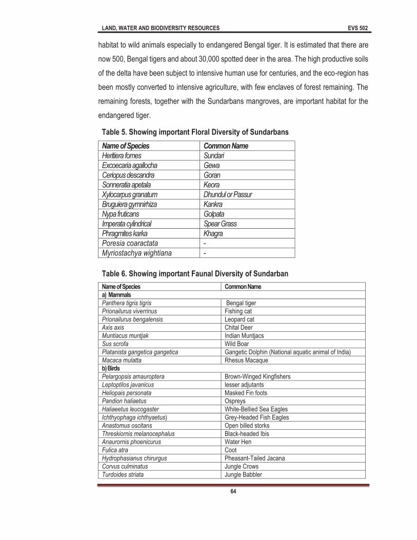
LAND, WATER AND BIODIVERSITY RESOURCES EVS 502
64
habitat to wild animals especially to endangered Bengal tiger. It is estimated that there are
now 500, Bengal tigers and about 30,000 spotted deer in the area. The high productive soils
of the delta have been subject to intensive human use for centuries, and the eco-region has
been mostly converted to intensive agriculture, with few enclaves of forest remaining. The
remaining forests, together with the Sundarbans mangroves, are important habitat for the
endangered tiger.
Table 5. Showing important Floral Diversity of Sundarbans
Name of Species Common Name
Heritiera fomes Sundari
Excoecaria agallocha Gewa
Ceriopus descandra Goran
Sonneratia apetala Keora
Xylocarpus granatum Dhundul or Passur
Bruguiera gymnirhiza Kankra
Nypa fruticans Golpata
Imperata cylindrical Spear Grass
Phragmites karka Khagra
Poresia coaractata -
Myriostachya wightiana -
Table 6. Showing important Faunal Diversity of Sundarban
Name of Species Common Name
a) Mammals
Panthera tigris tigris Bengal tiger
Prionailurus viverrinus Fishing cat
Prionailurus bengalensis Leopard cat
Axis axis Chital Deer
Muntiacus muntjak Indian Muntjacs
Sus scrofa Wild Boar
Platanista gangetica gangetica Gangetic Dolphin (National aquatic animal of India)
Macaca mulatta Rhesus Macaque
b) Birds
Pelargopsis amauroptera Brown-Winged Kingfishers
Leptoptilos javanicus lesser adjutants
Heliopais personata Masked Fin foots
Pandion haliaetus Ospreys
Haliaeetus leucogaster White-Bellied Sea Eagles
Ichthyophaga ichthyaetus) Grey-Headed Fish Eagles
Anastomus oscitans Open billed storks
Threskiornis melanocephalus Black-headed Ibis
Anaurornis phoenicurus Water Hen
Fulica atra Coot
Hydrophasianus chirurgus Pheasant-Tailed Jacana
Corvus culminatus Jungle Crows
Turdoides striata Jungle Babbler
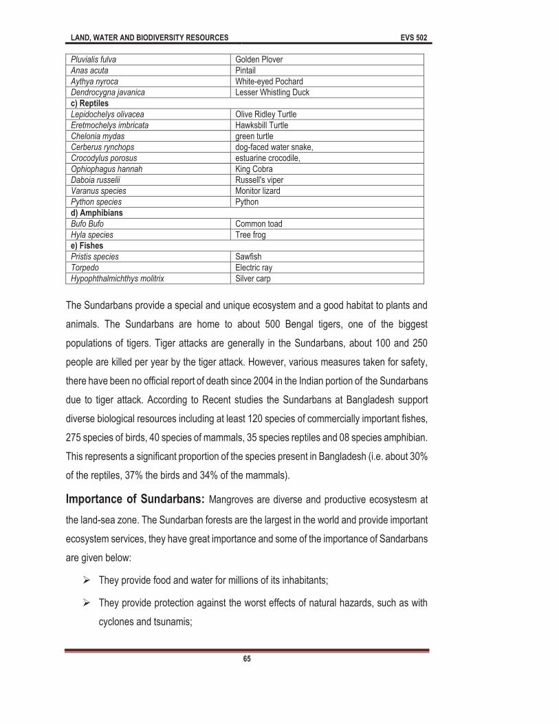
LAND, WATER AND BIODIVERSITY RESOURCES EVS 502
65
Pluvialis fulva Golden Plover
Anas acuta Pintail
Aythya nyroca White-eyed Pochard
Dendrocygna javanica Lesser Whistling Duck
c) Reptiles
Lepidochelys olivacea Olive Ridley Turtle
Eretmochelys imbricata Hawksbill Turtle
Chelonia mydas green turtle
Cerberus rynchops dog-faced water snake,
Crocodylus porosus estuarine crocodile,
Ophiophagus hannah King Cobra
Daboia russelii Russell's viper
Varanus species Monitor lizard
Python species Python
d) Amphibians
Bufo Bufo Common toad
Hyla species Tree frog
e) Fishes
Pristis species Sawfish
Torpedo Electric ray
Hypophthalmichthys molitrix Silver carp
The Sundarbans provide a special and unique ecosystem and a good habitat to plants and
animals. The Sundarbans are home to about 500 Bengal tigers, one of the biggest
populations of tigers. Tiger attacks are generally in the Sundarbans, about 100 and 250
people are killed per year by the tiger attack. However, various measures taken for safety,
there have been no official report of death since 2004 in the Indian portion of the Sundarbans
due to tiger attack. According to Recent studies the Sundarbans at Bangladesh support
diverse biological resources including at least 120 species of commercially important fishes,
275 species of birds, 40 species of mammals, 35 species reptiles and 08 species amphibian.
This represents a significant proportion of the species present in Bangladesh (i.e. about 30%
of the reptiles, 37% the birds and 34% of the mammals).
Importance of Sundarbans: Mangroves are diverse and productive ecosystesm at
the land-sea zone. The Sundarban forests are the largest in the world and provide important
ecosystem services, they have great importance and some of the importance of Sandarbans
are given below:
They provide food and water for millions of its inhabitants;
They provide protection against the worst effects of natural hazards, such as with
cyclones and tsunamis;
LAND, WATER AND BIODIVERSITY RESOURCES EVS 502
66
They provide the ability to act as a giant long-term carbon sink; the retention of
terrestrial sediments; and as a habitat for many species, including for the rare and
protected Royal Bengal tiger.
The importance of the Sundarbans extends from the local to the global level.
During the last 2-3 centuries, the Sundarban has been impacted by anthropogenic activities,
climatic change and extreme weather events. Human activities in the Sundarbans have a
greater incremental impact on forests. Such activities can increase the salinity, rise sea level,
land degradation etc. Conservation of Sundarbans is extremely complicated because of the
influence of climatic factors, path-dependent development regimes and environmental
components.
The Sundarbans are not only ecologically important but they are socio-economically very
important to Nation. It is the single largest source of forest resource in the country. As you
know the forest provides raw materials for industries. In addition to traditional forest produce
like timber, fuelwood, pulpwood etc., large-scale harvest of non-wood forest products such
as thatching materials, honey, beeswax, fish, and crustacean and mollusc resources of the
Sundarbans takes place regularly. The vegetated tidal lands of the Sundarbans function as
an essential habitat, produce nutrients and purifies water. The forest also traps nutrient and
sediment, acts as a storm barrier, shore stabilizer and energy storage unit. Last but not the
least, the Sundarbans provide an aesthetic attraction for tourists at local, National and global
level.
A number of industries such as: newsprint mill, match factory, hardboard, boat building,
furniture making are entirely based on raw materials obtained from the Sundarbans
ecosystem. The various products help to generate significant employment and income
opportunities for about half million poor coastal people.
3.5.2 Case Study: Bharatpur Sanctuary
The Bharatpur Sanctuary or Keoladeo National Park, popularly known as the Bharatpur Bird
Sanctuary is located in the Bharatpur district of Indian state of Rajasthan, The origin of this
Bharatpur Sanctuary is due to artificial flooding of a natural depression. The development of
Ajan Bandh, a temporary reservoir, approximately 1 km from the Bharatpur Sanctuary 250
years ago led to the flooding of this depression creating a waterfowl habitat. Subsequently,
LAND, WATER AND BIODIVERSITY RESOURCES EVS 502
67
a number of earthen bunds and sluice gates were developed to regulate the water. The
Bharatpur Sanctuary receives water through a canal from the dam. It has been recognized
as a World Heritage site in 1985. This wetland became a Ramsar Site on 1st October, 1981.
There are the three criteria of Bharatpur sanctuary and on the basis of these criteria this
Sanctuary became Ramsar Convention site in 1981. These criteria are as:
It supports threatened ecological communities.
Bharatpur Sanctuary regularly supports about 20, 000 waterbirds.
Bharatpur Sanctuary regularly supports 1 % of the individuals in a population of one
species or subspecies.
The Bharatpur Sanctuary lies at coordinates at 27°10'N, 77°31'E is a World Heritage Site
situated in Rajasthan. The Bharatpur Sanctuary is 2 km south-east of Bharatpur and 55 km
west of Agra. The Bharatpur Sanctuary is spread over approx 29 sq km area. The Bharatpur
Sanctuary is part of the Keoladeo National Park habitat is wetland systems with varying
types of microhabitats having trees, mounds, dykes and open water with or without
submerged or emergent plants.
The Bharatpur Sanctuary was established as a national park on 10 March 1982. Earlier it
was the private duck shooting preserve of the Maharaja of Bharatpur since the 1850s, the
area was designated as a bird sanctuary on 13 March 1976 and a Ramsar Convention site
under the Wetland Convention in October 1981. The It is also a reserve forest under the
Rajasthan Forest Act, 1953 and therefore, is the property of the State of Rajasthan. In 1982,
grazing was totally prohibited in the Bharatpur Sanctuary, this led to violent clashes between
farmers and the government.
Keoladeo National Park or Bharatpur Sanctuary is a man-managed wetland and one of the
great National parks of country. This Bharatpur Sanctuary protects Bharatpur from floods,
provides grazing for village cattle. The 29 km2 reserve is locally known as Ghana, and is a
mosaic of dry grasslands, woodlands, woodland swamps and wetlands. These diverse
habitats provide home to 366 bird species, 379 floral species, 50 species of fish, 13 species
of snakes, 5 species of lizards, 7 amphibian species, 7 turtle species, and a variety of other
invertebrates. Every year thousands of migratory birds visit the park for wintering and
breeding. The sanctuary is one of the richest bird areas in the world and is known for nesting

LAND, WATER AND BIODIVERSITY RESOURCES EVS 502
68
of resident birds and visiting migratory birds including water birds. The rare Siberian cranes
used to winter in this park but this central population is now extinct. According to founder of
the World Wildlife Fund Peter Scott, Bharatpur Sanctuary is one of the best bird areas in the
world.
The sanctuary was established 250 years ago and it is named after a Keoladeo (Lord Shiva)
temple within its boundaries. Initially, it was a natural depression; and was flooded after the
Ajan Bund was constructed by King Suraj Mal. This ajan bund established at the confluence
of two rivers namely: Gambhir and Banganga. It is also a big tourist spot.
The Bharatpur Sanctuary supports about 400 species of birds. The Sanctuary also supports
enormous flocks of migratory birds specially in winter. More than 25 species of ducks and
goose such as coots, greylag goose, mallard, pintail duck, shoveller, brahminy duck, gadwal,
wigeon, bar-headed goose, and others are known to winter here yearly The Sanctuary is the
only wintering ground for the Siberian crane. Other important fauna in the Sanctuary are the
Sambhar, Cheetal, blue bull, golden jackel, wild boar etc. Besides, from the aquatic
vegetation that flourishes during monsoon season, the other vegetation is characteristic of
semi-arid zone dominated by Acacia nilotica, Zyziphus mauritiana, Prosopis cineraria,
Salvadora etc. The Bharatpur Sanctuary also provides habitat to Cynodon dactylon and
Dicanthium annulatum. Woodlands with thickets of huge Neolamarckia cadamba (Kadam
trees) are distributed in scattered patches. The Sanctuary is covered with tropical dry
deciduous forests intermixed with dry grasslands. In the places where forest has degraded,
the greater part of the region is covered with shrubs and medium-sized plants.
Flora And Fauna Of Bharatpur Sanctuary: A semi-arid biotype, the park is the only area
with significant vegetation, hence the term 'Ghana' meaning 'thicket'. The principal
vegetation types are tropical dry deciduous forest, intermixed with dry grassland in areas
where forest has been degraded. Apart from the artificially managed marshes; much of the
area is covered by medium-sized trees and shrubs.
Table-6: Important flora of Bharatpur Sanctuary Name of Species Common Name
Mitragyna paryifolia Kalam or kadam
Syzygium cumini Jamun
Acacia nilotica Babul
Prosopis cineraria Kandi
Zizyphus Ber

LAND, WATER AND BIODIVERSITY RESOURCES EVS 502
69
Capparis decidua Kair
Salyadora oleoides Piloo
Bharatpur Sanctuary is dominated by ber and kair. It is unlikely that the site would support
such numbers of waterfowl as it does without the addition of water from Ajan Bund. Soil of
the Sanctuary is predominantly alluvial. The mean annual rainfall/precipitation of Bharatpur
Sanctuary is about 662 mm.
3.8 Summary
In this unit we have discussed various aspects of types and importance of wetlands
degradation. So far you have learnt that:
natural or artificial,
permanent or temporary, with water that is static, flowing, fresh, brackish or salt,
including areas of marine water, the depth of which at low tide does not exceed six
On the basis of unique characters the important terms related to wetlands are Bog,
Bottom, Everglade, Fen, Fenland, Heath, Marsh, Marshland, Meadow, Mire,
Moorland, Morass, Muskeg, Quagmire, Quicksand, Salt marsh, Slough, Sump,
Swale, Swamp and Swampland.
There are various types of wetlands such as Marine and coastal wetlands, Estuarine
wetlands, Riverine wetlands, Lacustrine wetlands and Palustrine wetlands.
According to (Charman 2002), several factors are considered important for
classification of peatland types. These characteristics are Floristics, physiognomy,
morphology, hydrology, stratigraphy, chemistry and peat characters.
There are various functions and importance of wetlands such as Recharge Ground
Water, Flood Control, improved water quality, Sediment stabilization and retention,
provide habitat to aquatic and riparian organisms.
In India various wetlands are found some of the important wetlands of India are
Deepar Beel, Urpad Beel, Thol Bird Sanctuary, Khijadiya Bird Sanctuary, Little Rann
of Kachh, Pariej, Wadhwana, Nanikakrad, Wullar lake, Bonal, Hidkal &
Ghataprabha, Heggeri, Ranganthittu, K.G. Koppa wetland, Tamze Wetland,
LAND, WATER AND BIODIVERSITY RESOURCES EVS 502
70
Tembao Wetland Complex, Phendang Wetland Complex, Gurudokmar Wetland,
Tsomgo wetland, Ban Ganga Jhilmil Tal, Loktal lake, Sukhna lake etc.
India is also a signatory of the Ramsar Convention. There are 26 Ramsar
Convention sites in India and these are Kolleru lake, Deepar Beel Nalsarovar Bird
Sanctuary Pong Dam Renuka Lake Chandratal, Wullar, Tso Morari, Hokersar,
Surinsar Mansar lake, Ashtamudi lake, Sasthamkotta lake, Vembanad kol wetland,
Bhoj wetland, Loktak lake Chilka lake, Bhtarkanika mangrove, Harike, Kanjli, Ropar
wetland, Sambhar lake, Keoladeo National Park, Point Calimere wildlife and bird
sanctuary, Rudra Sagar lake, Uppar Ganga (Brijghat to Narora (U.P) and East
Kilkata wetland.
The Sundarbans is a great and located in the delta region of Ganga, Meghna and
Brahmaputra river systems. This special forest extends across districts of
Bangladesh and districts of West Bengal in India. The Sundarbans are located on
the delta made by the River Ganga, Brahmaputra and Meghna rivers in the Bay of
Bengal.
The main floral diversity of Sundarbans are Heritiera fomes, Excoecaria agallocha,
Ceriopus descandra, Sonneratia apetala, Xylocarpus granatum, Bruguiera gymnirhiza, Nypa
fruticans, Imperata cylindrical, Phragmites karka, Poresia coaractata, Myriostachya
wightiana.
The main faunal diversity of Sundarbans are Panthera tigris tigris, Prionailurus
viverrinus, Prionailurus bengalensis, Axis axis, Muntiacus muntjak, Sus scrofa,
Platanista gangetica gangetica, Macaca mulatta, Pelargopsis amauroptera,
Leptoptilos javanicus, Heliopais personata , Pandion haliaetus, Haliaeetus
leucogaster, Ichthyophaga ichthyaetus, Anastomus oscitans, Threskiornis
melanocephalus, Anaurornis phoenicurus, Fulica atra, Hydrophasianus chirurgus,
Corvus culminatus , Turdoides striata, Pluvialis fulva, Anas acuta, Aythya nyroca,
Dendrocygna javanica, Lepidochelys olivacea, Eretmochelys imbricate, Chelonia
mydas, Cerberus rynchops, Crocodylus porosus, Ophiophagus Hannah, Daboia
russelii, Varanus species, Bufo Bufo, Hyla species, Pristis species, Torpedo,
Hypophthalmichthys molitrix

LAND, WATER AND BIODIVERSITY RESOURCES EVS 502
71
The Bharatpur Sanctuary or Bharatpur Sanctuary or Keoladeo National Park,
popularly known as the Bharatpur Bird Sanctuary is located in the Bharatpur district
of Indian state of Rajasthan, The origin of this Bharatpur Sanctuary is due to artificial
flooding of a natural depression.
The main floral diversity of Bharatpur Sanctuary are: Mitragyna paryifolia, Syzygium
cumini, Acacia nilotica, Prosopis cineraria, Zizyphus, Capparis deciduas, Salyadora
oleoides.
Terminal Questions
1 (a) Fill in the blank spaces with appropriate words.
is located in Sanctuary is due to artificial flooding of a natural depression. The development of Ajan Bandh, a temporary reservoir, approximately 1 km from the Bharatpur Sanctuary 250 years ago led to tnumber of earthen bunds and sluice gates were developed to regulate the water. The Bharatpur Sanctuary receives water through a canal from the dam. It has been recognized as a World Heritage s
these criteria this Sanctuary became Ramsar Convention site in 1981.
2 (a) Define the wetland.
(b) Give the terms related to wetland
3 (a) Describe the types and characteristic features of wetlands.
(b) Give the peat land classification of wetlands
4 (a) Describe the importance and functions of wetlands.
5 (a) Give the list of wetlands in India.
(b) Write about Ramsar Convention.
(c) Write about the Sundarbans.
6 (a) Fill the blank spaces with appropriate words.
The Literally, The Sundarban been derived from the
feet of the River Ganga forming the seaward fringe of the delta. The seasonally-flooded Sundarbans lie inland from the
The Sundarbans was designated a Ramsar

LAND, WATER AND BIODIVERSITY RESOURCES EVS 502
72
1997. Sundarbans of both the countries are separately listed in the UNESCO world heritage sites. The main and important characteristic tree of the forest is the Sundari (Heritiera littoralis), from which the name of the Sundarbans had probably been derived. The Sundarbans flora is characterized by the large numbers of Heritiera fomes, Excoecaria agallocha, Ceriopus decandra and Sonneratia apetala. David Prain (1903) documented 245 genera and 334 species of plants in the Sundarbans.
(b) World Wetland Day celebrated on (2nd February/5th June/21 May/21 June)
(c) Loktak Lake is located in the Indian state (Manipur/Mizoram /Uttarakhand/Uttar Pradesh)
(d) Maximum Ramsar Conservation sites are located at (Jammu and Kshmir/Uttarakhand/Punjab/Bihar)
(e) Write about the flora and Fauna of Sundarbans?
7 (a) Write the descriptive essay on Bharatpur Sanctuary
(b) Give the list of Ramsar Convention sites in India
Answers to terminal questions
1 (a) Keoladeo National Park, Bharatpur, Rajasthan, waterfowl habitat, 1985, 1st October, 1981
2 (a) see section 3.2
(b) See section 3.2
3 (a) See section 3.3.
(b) See section 3.3
4 (a) See section 3.4., Table-2, Fig-1 and Fig-2
5 (a) See the section 3.5 and Table-3
(b) see the section 3.6
(c) See section 3.7.
6 (a) Halophytic mangroves, beautiful jungle, Sundari trees, Bangladesh India, 10,000km,
6,000km, 4000km, 21 May 1992, UNESCO world heritage site
(b) 2nd February
(c) Manipur
(d) Jammu & Kashmir
(e) See the section 3.7.1
7 (a) See the section 3.8
(b) See the section 3.5 and Table-4
LAND, WATER AND BIODIVERSITY RESOURCES EVS 502
73
Unit 4 The Land Cover changes
Unit Structure
4.0 Learning Objectives
4.1 Introduction
4.2 Definition of Land cover change
4.2.1 What is land cover change?
4.3 Land Cover change in India
4.4 Reasons of land cover change
4.4.1 Urbanization
4.4.2 Industrialization
4.4.3 Agriculture
4.4.4 Increasing population
4.5 Effects of Land cover change
4.5.1 Biodiversity
4.5.2 Climate change
4.5.3 Pollution
4.5.4 Ozone layer 4.5.5 Other effects
Summary
4.0 Learning Objectives
After studying this unit you will be able to find answer of the following:
What is land cover change?
What are the reasons of land cover change?
What is the relation between increasing population and land cover change?
How can we do more sustain to land cover change?
What is the relation between Land cover and climate change?
4.1 Introduction
As we have learnt in previous chapter, land resources are very essential for human being
and from the beginning of civilization, human carried out a lot of activities on land and now
we can see the result in form of dam, building, and road construction. As human population
increasing various land use planning was made to fulfil the human need to provide them
LAND, WATER AND BIODIVERSITY RESOURCES EVS 502
74
basic amenities. Human are directly or indirectly dependent on natural resources by using
these resources in different manner. But in the series of rapid development man forgotten
his moral duty and doing all the activities of his welfare, therefore all these activities have
been created a lot of burden on this planet and now there is a diversity of concrete jungle, if
cover. The land was
using for agriculture forest colonies, orchard etc. Due to heavy demand of big population,
we have exhausted the land resources very fast and now the situation is very worst as we
have converted a big part of agriculture land into constructional activities for human welfare.
In this phenomenon we have degraded very fertile land without future planning. Now a days
Infrastructure across the country must expand rapidly. Industrialisation, especially based on
manufacturing has also to accelerate. Urbanisation is inevitable. Land is an essential
requirement for all these processes. Government also needs to acquire land for a variety of
public purposes.
The world population grew by four times from 1.6 billion to 6.1 billion persons during 1900
to 2000 (United Nations, 2001). Decreases in famine related deaths and infant mortality
rates are partially responsible for this rapid population growth. In addition, advances in public
health and medicine have increased the life expectancy of countries worldwide.
Industrialization has provided for better economies and has sustained human development.
However, this rapid population growth and development has occurred unevenly throughout
the world
resources and its adverse impact on environment. Land uses are primarily the result of
human actions and decisions on land. In fact human activities arising from a multiplicity of
social objectives are the immediate source of land cover change. To understand these social
objectives one needs to analyse the underlying driving forces that motivate or constrain the
associated human activities. Biophysical driving forces and shocks (such as geomorphic
processes, global and local climate change/ variability, etc.) are also responsible for changes
in land cover and ultimately the land use.
During the last two decades there has been a rapid economic and industrial development in
Delhi. Delhi, being the National Capital Territory (NCT), is one of the important centres for
LAND, WATER AND BIODIVERSITY RESOURCES EVS 502
75
commerce, trade and industries in northern India. In fact industrial development in Delhi and
adjoining areas has emerged in somewhat haphazard and unplanned manner thereby
leading to increased population and environmental problems of concern. In fact about 60%
of its most productive agricultural land has been transformed into non-agricultural uses. It is
estimated that between 1970 1971 and 1993-94, industrial units have increased from about
26,000 to 93,000 while net sown area has decreased from 85,000 ha to 46,000 ha. In order
to take care of these problems, the Government of India carved out an inter-state National
Capital Region (NCR) comprising NCT-Delhi (in centre) and the surrounding six districts of
Haryana, three districts of Uttar Pradesh and Alwar district of Rajasthan. The prime objective
of this regional plan was to locate economic activities associated with large scale population
and environmental problems outside the NCT region.
4.2 Definition of Land cover change
s biotic and abiotic resources. The cumulative impacts of land use
change have global consequences, altering the structure and functioning of ecosystem,
which in turn can influence the climate system due to the strong linkages between land cover
energy exchange and biogeochemical cycles. Because of the long time scale dynamics of
ecosystem process, land disturbances can affect ecosystem and climate processes for
years to centuries.
n have led to
eliminated forest in Iceland and a previous lush green landscape became the now arid region
of Sahara desert 6000 years ago. On shorter time scale severe weather events fires,
ecosystem. The impact of ancient human activities on the landscape is well known including
the use of fires to maintain open landscape and the extinction of large Pleistocene mammals
after the arrival of human in North America.
More recently, over the last 300 years, human influence on the land has become globally
extensive and intensive. Deforestation, agriculture expansion are all significant global
environmental issue today. Nearly 40% of the global land surface is exploited for agriculture
LAND, WATER AND BIODIVERSITY RESOURCES EVS 502
76
and tropical deforestation continuous unabated especially in the Amazon basin and
Southeast Asia. Such large scale changes in land use and land cover can modify regional
and global climate, degraded fresh water resources cause air pollution, fragments habitat
cause species extinction and biodiversity loss and lead to the emergence of infectious
a major driver to global
change.
Land cover refers to the physical characteristics of Earth's surface, captured in the
distribution of vegetation, water, soil and other physical features. Land use refers to
the way in which land has been used by humans and their habitats. Although land use
is generally inferred based on the cover, yet both the terms land use and land cover being
closely related are interchangeable.
Land use/cover and its dynamics are important factors that affect ecosystem conditions and
functions. In the past 40 years, land use cover change dynamics has been considerably
changing the biogeochemical cycling leading to changes in surface atmospheric energy
exchanges, carbon and water cycling, soil quality, biodiversity, ability of biological systems
to support human needs and, ultimately the climate at all. Land cover consisting- roofs,
pavement, grass and trees. For a hydrologic study of rainfall-run off Characteristics, it would
be important to know the amount and distribution of roofs, pavement, grass and trees.
Land cover change (LCC) also known as land change) is a general term for the human
modification of Earth's terrestrial surface. The intensity of land cover change directly linked
with the development of human civilization. Human has modified a large part of land to gain
edibles and other essentials with having the effect on environment (increasing population,
climate change, Biodiversity loss and soil, water and air pollution).
4.2.1 What is land cover change?
Land cover: Vegetation and structure that cover land area is known as land cover.
Land use: Human activities that occur on land known as land use.
Human changes land cover, especially in urban area. These changes have environment and
economic effect. The land cover may be classified into six categories i.e., Rangeland, forest
land, cropland, parks and preserves, wetland mountain desert, and urban land, and these
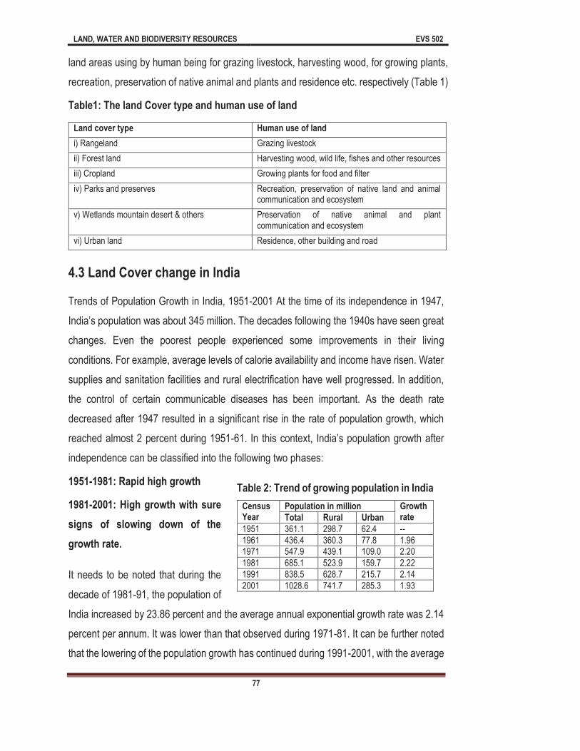
LAND, WATER AND BIODIVERSITY RESOURCES EVS 502
77
land areas using by human being for grazing livestock, harvesting wood, for growing plants,
recreation, preservation of native animal and plants and residence etc. respectively (Table 1)
Table1: The land Cover type and human use of land
Land cover type Human use of land
i) Rangeland Grazing livestock
ii) Forest land Harvesting wood, wild life, fishes and other resources
iii) Cropland Growing plants for food and filter
iv) Parks and preserves Recreation, preservation of native land and animal communication and ecosystem
v) Wetlands mountain desert & others Preservation of native animal and plant communication and ecosystem
vi) Urban land Residence, other building and road
4.3 Land Cover change in India
Trends of Population Growth in India, 1951-2001 At the time of its independence in 1947,
changes. Even the poorest people experienced some improvements in their living
conditions. For example, average levels of calorie availability and income have risen. Water
supplies and sanitation facilities and rural electrification have well progressed. In addition,
the control of certain communicable diseases has been important. As the death rate
decreased after 1947 resulted in a significant rise in the rate of population growth, which
reached almost 2 percent during 1951-
independence can be classified into the following two phases:
1951-1981: Rapid high growth
1981-2001: High growth with sure
signs of slowing down of the
growth rate.
It needs to be noted that during the
decade of 1981-91, the population of
India increased by 23.86 percent and the average annual exponential growth rate was 2.14
percent per annum. It was lower than that observed during 1971-81. It can be further noted
that the lowering of the population growth has continued during 1991-2001, with the average
Table 2: Trend of growing population in India
Census Year
Population in million Growth rate Total Rural Urban
1951 361.1 298.7 62.4 --
1961 436.4 360.3 77.8 1.96
1971 547.9 439.1 109.0 2.20
1981 685.1 523.9 159.7 2.22
1991 838.5 628.7 215.7 2.14
2001 1028.6 741.7 285.3 1.93

LAND, WATER AND BIODIVERSITY RESOURCES EVS 502
78
annual exponential growth rate being 1.93 percent per annum. The population of rural India
increased around two and half times from 298.7 million in 1951 to 741.7 million in 2001,
whereas the urban population has grown more than fourfold during the same period, which
is from only 62.4 million in 1951 to 285.3 million in 2001. The density of population has
increased from 117 in 1951 to 312 persons in 2001. Despite the fall in the growth rate; the
absolute addition to the population is quite high over the decades, because of the age
structure of the population, which is still fairly young. According to (Dyson, 2004) the
standard projection, India's population will increase from 1027 million to 1419 million during
2001-26, a total rise of 38 percent or 1.3 percent per year. The projections also suggest that
by 2026 the average population density of India will be 448 persons per square kilometre.
States like Bihar and Uttar Pradesh are projected to be well over 900 persons per square
kilometre, greater than the density of both Kerala and West Bengal in 2001.
In 1950-51 the reporting area for land was 284.32 mha, out of the total area 14.21% area
was covered by forest, 16.7% area was not available for cultivation, and 17.39% was
available as other uncultivated land, 9.9% area as a fallow land and net area sown was
41.77%. On the other hand in 2000-2001the values are different in comparison of 1950. In
2001 there was 306.54 m ha land area was reported, which was 22.22 m ha more than the
previously reported area. The land covered by forest was 22.51%, (28.54 m ha more than
1950), 13.83% land was not available for cultivation. Other uncultivated land was found
9.29% out of the total area of 2000-2001. Fallow land and net area sown was available
8.12% and 46.07%, respectively. As you can see clearly in the study of India during 1950 -
2000, there is a significant change in land use pattern and land cover. In India, the forest are
increasing with time as various efforts are made to conserve the forest area while the barren
land was observed less either due to human activities or other reasons and non-agriculture
land increased as human population is growing day by day due to the extension of facilities
for the human being in form of house, medical, education, entertainment etc.
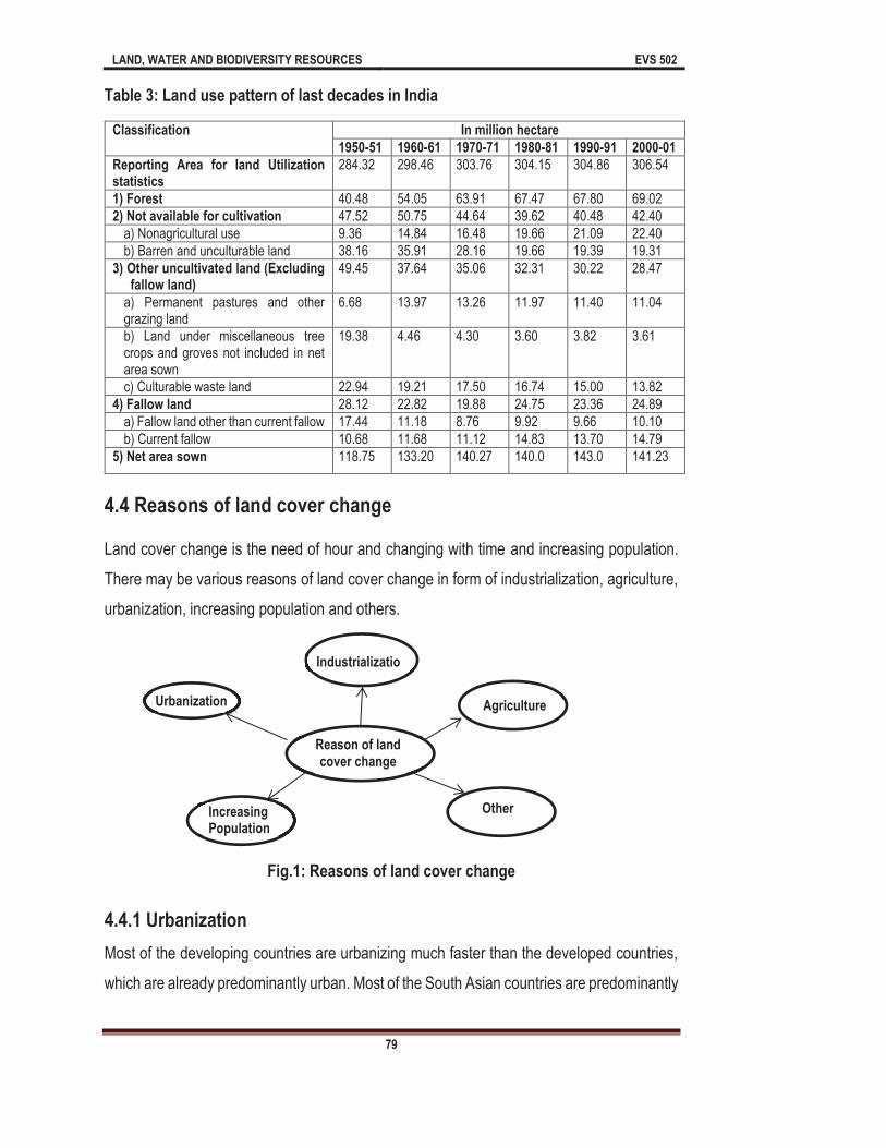
LAND, WATER AND BIODIVERSITY RESOURCES EVS 502
79
Table 3: Land use pattern of last decades in India
Classification In million hectare
1950-51 1960-61 1970-71 1980-81 1990-91 2000-01
Reporting Area for land Utilization statistics
284.32 298.46 303.76 304.15 304.86 306.54
1) Forest 40.48 54.05 63.91 67.47 67.80 69.02
2) Not available for cultivation 47.52 50.75 44.64 39.62 40.48 42.40
a) Nonagricultural use 9.36 14.84 16.48 19.66 21.09 22.40
b) Barren and unculturable land 38.16 35.91 28.16 19.66 19.39 19.31
3) Other uncultivated land (Excluding fallow land)
49.45 37.64 35.06 32.31 30.22 28.47
a) Permanent pastures and other grazing land
6.68 13.97 13.26 11.97 11.40 11.04
b) Land under miscellaneous tree crops and groves not included in net area sown
19.38 4.46 4.30 3.60 3.82 3.61
c) Culturable waste land 22.94 19.21 17.50 16.74 15.00 13.82
4) Fallow land 28.12 22.82 19.88 24.75 23.36 24.89
a) Fallow land other than current fallow 17.44 11.18 8.76 9.92 9.66 10.10
b) Current fallow 10.68 11.68 11.12 14.83 13.70 14.79
5) Net area sown 118.75 133.20 140.27 140.0 143.0 141.23
4.4 Reasons of land cover change
Land cover change is the need of hour and changing with time and increasing population.
There may be various reasons of land cover change in form of industrialization, agriculture,
urbanization, increasing population and others.
Fig.1: Reasons of land cover change
4.4.1 Urbanization
Most of the developing countries are urbanizing much faster than the developed countries,
which are already predominantly urban. Most of the South Asian countries are predominantly
Reason of land cover change
Urbanization
Increasing Population
Industrialization
Agriculture
Others
LAND, WATER AND BIODIVERSITY RESOURCES EVS 502
80
rural in character and are experiencing rapid urbanization, particularly related to metropolitan
cities.
According to Squires (2002) and Yuan (2005) the Rapid urbanization, therefore, brings
opportunities for new urban development; however, it has also brought serious losses of
arable land, forest land and water bodies. Urban growth, particularly the movement of
residential and commercial land to rural areas at the periphery of metropolitan areas, has
long been considered a sign of regional economic vitality. But, its benefits are increasingly
balanced against ecosystem impacts, including degradation of air and water quality and loss
of farmland and forests, and socioeconomic effects of economic disparities, social
fragmentation and infrastructure costs.
Urbanization is the process of movement from the rural areas to urban areas to attain more
facilities, which are not available in nearby periphery of rural area. No doubt urban areas are
a gift to the human society if it is in controlled manner, coordinated and well planned.
However, the unplanned urbanization may cause the serious threats to the environment. In
is expected to reach 81% by 2030. Due to the acceleration of the global urbanization in both
intensity and area, there is a growing interest in understanding its implications with respect
to a broad set of environmental factors including loss of arable land, habitat destruction,
decline in natural vegetation cover and climate at local, regional, and global scales. The
developmental activities has converted either the rural areas in urban or attract the peoples
of rural area to come in the urban areas. Both situations are dangerous for the environment
as the peoples are leaving their houses in villages and constructed new house in urban
areas, sometimes the left houses of village not in use. Ultimately the huge pressure of
population gave birth to the urbanization; the peoples have been created a lot of burden to
even for survival as the level of pollution increasing rapidly and the groundwater drained at
very fast rate.
So the ecosystems in urban areas are strongly influenced by anthropogenic activities,
considerably more attention is currently being directed towards monitoring changes in urban
land use/ land cover (LULC). LULC change due to human activities is currently proceeding

LAND, WATER AND BIODIVERSITY RESOURCES EVS 502
81
more quickly in developing countries than in the developed world, and it has been projected
developing countries, where urbanisation rates are high, urban sprawl is a significant
contributor of the land use change. In the fast developing countries like India, there is a mass
migration of people from rural to urban and also from smaller to bigger urban areas and then
to metropolises like Delhi, Bangalore, Mumbai etc. The process of urbanization in India
gained momentum with the start of industrial revolution way back in 1970s followed
by globalization in 1990s. Forests were cleared, grasslands ploughed or razed, wetlands
drained and croplands encroached upon under the influence of expanding cities, yet never
as fast as in the last decade. In 1991, there were 23 metropolitan cities in India, which
increased to 35 in 2001.Some of the prominent ones are Delhi (13.82 million), Mumbai
(11.90 million) and Chennai (4.21 million) with Delhi being the most populated megacity
(competing with Mumbai) in the country in terms of human population and vehicular traffic
density.
Delhi is one of the many metropolitan cities struggling with rapid urbanization and higher
levels of pollution from industrial, residential and transportation sources. According to
Census of India 2001, the population of Delhi has increased by 47.02% in the decade 1991-
2001 (from 9.4 million in 1991 to 13.82 million in 2001). The up rise in the population of Delhi
is mainly due to the migration of people to the capital in search of better living standard. The
population of Delhi has reached to 21.7 million in 2009 (increased by 57% from 2001-2008).
After independence, when Delhi witnessed a large influx of migrants, within a very short time
the population of Delhi was approximately doubled. To house such a large migrating
population, city has expanded in a very unplanned and uncontrolled manner. Such types of
unplanned expansions have a direct impact on quality of urban environment affecting the
efficiency of the people and their productivity in the overall socio-economic development. In
the light of its past experiences and current trends of development, emerging future of Delhi
is one of the most important issue gaining focus from the authorities to improve the overall
quality of life. Land use which is highly dynamic entity in nature is one of the key parameters
to quantify development.
Fifty percent of the world population lives in urban areas and this figure is expected to go
up. Urban areas constantly need more land for settlements infrastructure, industries, and

LAND, WATER AND BIODIVERSITY RESOURCES EVS 502
82
leisure activities etc. which increase the pressure on land. More and more agricultural land
gets converted into urban colonies. Larger cities affect even larger areas surrounding them,
thanks to their widening ecological footprint.
We see solid waste piled up on many urban streets. Outside cities, there are large dump of
waste brought from the city. It is estimated that about 2 million hectare of land have been
degraded due to waste disposal and landfills.
Urban agriculture has been expanding globally over the past 25 years. In Sau Paulo in Brazil
and Havana in Cuba, for example urban home gardens have been very successful. While
urban agriculture provides locally grown food and help recycle organic matter, it can also
cause soil and water pollution if chemicals are used.
4.4.2 Industrialization
According to Kuskovaa, Gingrichb, & Kraus (2008) Industrialization goes along with
sweeping changes in society's interrelations with its environment. The transition from an
agrarian to an industrial society leads to fundamentally new patterns in social metabolism, a
process which has been described as socio-metabolic transition. Industrialization has been
one of the major factors in the development of the countries, and has caused a population
increase in cities, resulting in urban sprawl. According to Kavzo lu (2008) Because
industrialization and urbanization often advance in an uncontrolled or unorganized way in
developing countries, they can have destructive effects on the environment, particularly on
basic ecosystems, wildlife habitat, and global biodiversity. Land use change does not occur
evenly, neither temporarily nor spatially. In fact, it has become clear that in some parts of
the world, the process of massive conversion of natural land cover has stopped, or has even
been reversed, the so-
4.4.3 Agriculture
According to Makowski (2013) globally, agriculture is facing an increasing demand for food,
bio-based energy and fiber products. Numerous studies predict that agricultural techniques
will adapt to the increasing demand. However, adaptation poses challenges for the
adaptation to the increasing demand may include changes in the choice of crops, crop
LAND, WATER AND BIODIVERSITY RESOURCES EVS 502
83
rotations, utilization of crops, and intensification of production. Trends include technical
solutions to remove yield limiting factors, such as water availability for crops, and increasing
use of agricultural biomass as a source of renewable energy. The latter is often supported
by government legislation. For example, in Germany, the introduction of the Renewable
Energy in 2000 resulted in threefold increase of the area of maize (Zea maize) and of rape
seed (Brassica napus) for bio-energy, reaching 17.5% of the German cropland area in 2012
(FNR, 2012). Also, the use of irrigation to increase and stabilize crop yields is becoming
more attractive, especially in areas with limited rainfall and with soils with limited water
holding capacity. Additional reasons for these changes are related to an increasing water
demand of new, more productive cultivars, and the prospect of more irregular precipitation
patterns due to climatic change. For example, at the current market prices for agricultural
goods, irrigation in the German federal state of Brandenburg is already on the verge of
becoming economically viable (Münch et al., 2014). Also, a connection between the
production of bio-energy and irrigation exists: as farmers become fuel suppliers for power
plants, it becomes more important to achieve stable yields even in dry years. Agriculture is
multifunctional. This means that in addition to (private) economic production, it contributes
to public goods such as the character of rural landscapes and its ecosystem services
(Wiggering et al., 2006; Van Zanten et al., 2013). A simple focus of agricultural management
aimed solely at maximizing economic returns can lead to depletion of groundwater
resources, erosion, loss of water quality, biodiversity loss and a reduction of sociocultural
services. Although these services become evident at landscape level, which has a spatial
scale larger than a farm, it is the decision-making at farm level that affects these services.
Sustainable development therefore requires consideration of the balance between the
economic production functions of agriculture and environmental and social services. Policies
are implemented to incentivize farmers to respect this balance by remunerating for the
provision of public goods.
4.4.4 Increasing population
Linkages between population growth, socioeconomic development and agricultural
intensification are examined using district level data for India for 1951, 1961, 1971, 1981 and
1991. Results clearly indicate that population pressure has positive and significant effects

LAND, WATER AND BIODIVERSITY RESOURCES EVS 502
84
on each dimension of agricultural intensification (cropping frequency, artificial irrigation and
chemical fertilizer use) for each census year between 1951 and 1991. Results of a analysis
for 1961 91 indicate that population growth has a positive effect on changes in each of the
three intensification dimensions. The results hold even after controlling for the effects of
regional differences in agro climatic conditions and levels of social and economic
development. The effects of socioeconomic variables are generally insignificant and do not
alter the effects of population growth. Global land use has significantly changed during the
past decades. Population growth is often used as a proxy for land use change, but at lower
scales, a set of complex drivers are important too. Increasing demand on food as a result of
population growth has created more pressure on land resources.
Overpopulation, an unwanted condition where the ever increasing human population exist
affects the carrying capacity of Earth. Overpopulation is the difference between natality and
mortality in populations. Environmental degradation occurs not only due to population growth
but also on other impacts that contribute to environmental degradation. The results of such
population growth for developing countries like India span in three areas;
Changes in land use,
Disposal of harmful waste to the environment and
Depletion of natural resources.
As growth of population occurs, this extended growth begins to alter our environment. This
concept draws upon the idea that every individual has certain basic needs. As natural
resources are used, wastes are generated and disposed of. Thus, the misuse of resources,
generation of waste and environmental damage
of consumption. Population growth is determined by number of individuals added to the
population by birth (natality) and immigration from other area and subtracted by the
population decreases by death rate (mortality) and emigration to other area. It increases the
size of population and population lost by deaths (mortality) and emigration, reduces the
population size.
As per Indian census 2011, the density of Indian population has increased from 325 persons
per square kilometres in 2001 to 382 persons/square kilometres. It may occur by rural to
urban migration. Environmental stress, biodiversity loss, change in climate and pressure on

LAND, WATER AND BIODIVERSITY RESOURCES EVS 502
85
natural resources strongly distress the population of any area and various survey shows that
the population of all countries in total is already overpopulated. But population of human are
still increasing. World population counted 6.8 billion in 2009, and are predictable to climb to
9.2 billion in 2050. According to Prospects of World Population, this growth will take place in
the developing countries (United Nations, Department of Economic and Social Affairs,
Population Division (2015). The ease of use of sustainable resources which is placing
competitive stress on the basic resources support to biodiversity and reduces the way of life,
do not affect the population growth. Overpopulation influences land use patterns with
consumption behaviou
far exceeded resources available for every individual on land and requires 1/3 of land more
Population Development and Environmental Exploitation
Below are listed a number of the effects of population development and environmental
exploitation by human populations.
Loss of crop lands, forest lands, wetlands for industrial expansion and extraction of
minerals use.
Fragmenting diversity and wildlife habitats.
Increasing impermeable surfaces means more flooding.
More resources extraction, manufacturing and consumption.
Destruction of habitat due to change of temperature and adaptation in food chain.
Extinction of different flora and fauna of different area and some species become
endangered due to loss of habitat and disturbance in their food chain and
environmental benefits like availability of medicinal plants, fire wood, sandal wood,
etc.
Change in global climate leads to increase the temperature of earth which in turn
leads to polar ice melting, rise in sea level, ice cap melting, decrease in biodiversity,
change in temperature of earth, etc.
Burning of fossil fuel leads to air pollution and overexploitation of available
resources.
LAND, WATER AND BIODIVERSITY RESOURCES EVS 502
86
4.5 Effects of Land cover change
As you know that land cover is the phenomenon related to physical and biological changes
as the population of human being is growing the pattern of use is also changing. Land is the
direct sufferer of changing pattern of land by human being. The land cover will be affected
basic facilities to provide the food, clothes and houses for the human being. Changes in land
use and land cover date to prehistory and are the direct and indirect consequence of human
actions to secure essential resources. This may first have occurred with the burning of areas
to enhance the availability of wild game and accelerated dramatically with the birth of
terrestrial surface that continues today. Due to industrialization the concentration of human
population has been increased on earth in general and in urban areas particular. As the
population increasing the land cover changing very fast and have various effects on land
cover.
4.5.1 Biodiversity
Biodiversity is the phenomenon of variety and variability of living organism. As the land has
been converted into concrete jungle, a major part of land area has lost the biodiversity.
Habitat destruction and habitat degradation are the main effects of land cover change.
Human being made a drastic change to the land cover as he occupies the different area of
land surface. The forest land has been converted into either farm land or residential
purposes. Diverse flora and fauna have been houseless due to the habitat distraction.
Increasing population is the main cause of biodiversity loss, because the human being
required basic facilities to survive on this planet and all these requirements fulfilling by using
the biodiversity. The habitat suitability of forests and other ecosystems surrounding those
under intensive use are also impacted by the fragmenting of existing habitat into smaller
pieces (habitat fragmentation), which exposes forest edges to external influences and
decreases core habitat area. Smaller habitat areas generally support fewer species (island
biogeography), and for species requiring undisturbed core habitat, fragmentation can cause
local and even general extinction.

LAND, WATER AND BIODIVERSITY RESOURCES EVS 502
87
4.5.2 Climate change
Land Cover Change (LCC) plays a major role in climate change at global, regional and local
scales. At global scale, LCC is responsible for global warming as the Land Cover Change
releasing greenhouse gases to the atmosphere. LCC can increase the release of carbon
dioxide to the atmosphere by disturbance of terrestrial soils and vegetation, and the major
driver of this change is deforestation, especially when followed by agriculture, which causes
the further release of soil carbon in response to disturbance by tillage. Land cover change
also behind the major changes in terrestrial emissions of other greenhouse gases, especially
nitrous oxide (agriculture: input of inor
Land cover change also disturb the reflection of sunlight from land surface (known as albedo)
another an important changer of global climate. Basically, this phenomenon directly
dependent on land covers. If the land is covered by vegetation, water, buildings and other
constructional activities. The concern area reflect a different albedo as the vegetation will
give a different albedo in comparison of water and other barren land. These changes made
a significant change in surface heat balance not only by changing surface albedo, but also
by altering evaporative heat transfer caused by evapotranspiration from vegetation (highest
in closed canopy forest), and by changes in surface roughness, which alter heat transfer
troposphere. An example of this is the warmer temperatures observed within urban areas
versus rural areas, known as the urban heat island effect.
4.5.3 Pollution
Pollution Changes in land use and land cover are important drivers of water, soil and air
pollution. Perhaps the oldest of these is land clearing for agriculture and the harvest of trees
and other biomass. Vegetation removal leaves soils vulnerable to massive increases in soil
erosion by wind and water, especially on steep terrain, and when accompanied by fire, also
releases pollutants to the atmosphere. This not only degrades soil fertility over time, reducing
the suitability of land for future agricultural use, but also releases huge quantities of
phosphorus, nitrogen, and sediments to streams and other aquatic ecosystems, causing a

LAND, WATER AND BIODIVERSITY RESOURCES EVS 502
88
variety of negative impacts (increased sedimentation, turbidity and eutrophication). Mining
can produce even greater impacts, including pollution by toxic metals exposed in the
process. Modern agricultural practices, which include intensive inputs of nitrogen and
phosphorus fertilizers and the concentration of livestock and their manures within small
areas, have substantially increased the pollution of surface water by runoff and erosion and
the pollution of groundwater by leaching of excess nitrogen (as nitrate). Other agricultural
chemicals, including herbicides and pesticides are also released to ground and surface
waters by agriculture and in some cases remain as contaminants in the soil. The burning of
vegetation biomass to clear agricultural fields (crop residues, weeds) remains a potent
contributor to regional air pollution wherever it occurs, and has now been banned in many
areas.
4.5.4 Ozone layer
The ozone layer found in stratosphere and the occurrence of this layer is from 20-50 km. As
you know the ozone layer destruction is the major area to concern nowadays. This layer is
in danger by the presence of CFC, nitrous oxide etc. Nitrous oxide is releasing from
agricultural land and altered regional and local hydrology (dam construction, wetland
drainage, irrigation projects, increased impervious surfaces in urban areas), which are the
ultimately result of land cover change.
4.5.5 Other effects
threat to future production of food and other essentials by the transformation of productive
land to non-productive uses, such as the conversion of agricultural land to residential use
and the degradation of rangeland by overgrazing. Land-use is a process of turning natural
ecosystem into social ecosystem. The process is a complicated procedure by the synthetic
effect from nature, economy and society. The manner, degree, structure, area distributing
and benefit of land-use are not only affected by natural condition but also restricted by
diversified natural, economic and technologic condition. Land-use is the most direct and
leading driving factor to the land-cover change. With an increasing world population, there
will be intense pressure on land, particularly in Africa and Asia. More intensive land use will

LAND, WATER AND BIODIVERSITY RESOURCES EVS 502
89
be needed to feed the people. More land will also be brought under agriculture by the
conversion of forest and grasslands.
Summary
In this unit we have examined various aspects of land cover change. So far you have learnt
that
Land cover refers to the physical characteristics of Earth's surface, captured in the
distribution of vegetation, water, soil and other physical features. Land use refers to
the way in which land has been used by humans and their habitats.
Trends of Population Growth in India, 1951-2001 At the time of its independence in
have seen great changes. Even the poorest people experienced some
improvements in their living conditions.
In 1950-51 the reporting area for land was 284.32 mha, out of the total area 14.21%
area was covered by forest, 16.7% area was not available for cultivation, and
17.39% was available as other uncultivated land, 9.9% area as a fallow land and
net area sown was 41.77%. On the other hand in 2000-2001the values are different
in comparison of 1950.
In 2001 there was 306.54 m ha land area was reported, which was 22.22 m ha more
than the previously reported area. The land covered by forest was 22.51%, (28.54
m ha more than 1950), 13.83% land was not available for cultivation. Other
uncultivated land was found 9.29% out of the total area of 2000-2001. Fallow land
and net area sown was available 8.12% and 46.07%, respectively.
Land cover change is the need of hour and changing with time and increasing
population. There may be various reasons of land cover change in form of
industrialization, agriculture, urbanization, increasing population and others.
The process of urbanization in India gained momentum with the start of industrial
revolution way back in 1970s followed by globalization in 1990s. Forests were
cleared, grasslands ploughed or razed, wetlands drained and croplands encroached
upon under the influence of expanding cities, yet never as fast as in the last decade.
LAND, WATER AND BIODIVERSITY RESOURCES EVS 502
90
According to Squires (2002) and Yuan (2005) the Rapid urbanization, therefore,
brings opportunities for new urban development; however, it has also brought
serious losses of arable land, forest land and water bodies.
According to Kavzo lu (2008) Because industrialization and urbanization often
advance in an uncontrolled or unorganized way in developing countries, they can
have destructive effects on the environment, particularly on basic ecosystems,
wildlife habitat, and global biodiversity. Land use change does not occur evenly,
neither temporarily nor spatially.
Linkages between population growth, socioeconomic development and agricultural
intensification are examined using district level data for India for 1951, 1961, 1971,
1981 and 1991. Results clearly indicate that population pressure has positive and
significant effects on each dimension of agricultural intensification (cropping
frequency, artificial irrigation and chemical fertilizer use) for each census year
between 1951 and 1991.
Terminal question
1 (a) Fill in the blank spaces with appropriate words.
struggling with rapid urbanization and higher levels of pollution from industrial, residential and transportation sources. According to
1991-
by 57% from 2001-2008). After independence, when Delhi witnessed a large influx of within a very short time the population of Delhi was approximately doubled. To house such
ions have a direct impact on quality of affecting the efficiency of the people and their productivity in the overall
2 (a) Discuss the concept of land cover change.
(b) What do you understand by land cover and land use?
3 (a) Describe the land cover change with special reference of India.
(b) Discuss the forest and fallow land of India.
4. Explain the reasons of land cover change.
5 (a)What is the role of urbanization in land cover change? Explain!
LAND, WATER AND BIODIVERSITY RESOURCES EVS 502
91
(b)Explain the role of agriculture in land cover change.
6 (a) Fill the blank spaces with appropriate words.
In 1950-
ultivated land, 9.9% area as a fallow land and net area -2001the values are different in
a. The land covered by forest
cultivation. Other uncultivated land was found 9.29% out of the total area of
s you can see clearly in the study of India during
(b) 1981-2001: High growth with sure signs of slowing down of the growth rate. (Yes/No)
Physical characteristics of Earth's surface, captured in the distribution of vegetation, water, soil and other physical features. Land use refers to the way in which land has been used by humans and their habitats. (Land cover /land use)
(d) The land with growing plants for food/fodder (cropland/ rangeland/fallow land)
(e) What is the effect of land cover change on climate change?
(a) What is the linkage between pollution and land cover change?
Answers to terminal questions
1 (a) metropolitan cities, 47.02%, 13.82 million, migration of people, population, 21.7 million, migrants, migrating population, uncontrolled manner, urban environment, socio-economic.
2 (a) See section 4.1, (b) See section 4.2.1
3 (a) See section 4.3, (b) See section 4.3
4 See section 4.4
5 (a)See section 4.4.1, (b) See section 4.4.3
6 (a) 284.32 mha, 14.21% area, cultivation, 17.39%, 41.77%, 1950, 306.54 mha, 22.22 mha, 22.51%, 13.83%, 2000-2001, 8.12% and 46.07%, 1950 -2000.
(b) Yes, (c) Land cover, (d) Cropland, (e) See section 4.5.2
7 (a) See section 4.4.4

LAND, WATER AND BIODIVERSITY RESOURCES EVS 502
92
Unit 5 Causes and Consequences of Land Degradation
Unit Structure
5.0 Learning Objectives
5.1 Introduction
5.2 Definitions of Land Degradation
5.3 Causes of Land Degradation
5.4 Natural Causes of Land Degradation
5.5 Manmade or Anthropogenic Causes of Land Degradation
5.5.1 Deforestation
5.5.2 Desertification
5.5.3 Over-Grazing
5.5.4 Dumping of Solid Waste
5.5.5 Agricultural Practices
5.5.7 Urbanization and Industrialization
5.5.8 Mining
5.6 Consequences of Land Degradation
Summary
5.0 Learning Objectives
After studying this unit you will be able to find answer of the following:
Define Land degradation and explain
Explain the causes of land degradation
Explain the relationship between deforestation and land degradation
Discuss desertification and land degradation
How overgrazing leads in to land degradation?
How dumping of solid waste responsible for land degradation?
How agricultural practices lead in to land degradation?
How soil erosion contributes to land degradation?
How landslides can cause land degradation?
How Urbanization and Industrialization lead in to land degradation?
How mining is responsible for land degradation?
Consequences of land degradation
5.1 Introduction
As you know nature has been so kind to man since prehistoric times, the varieties of natural
resources such as: forest, land, water, mineral, energy etc. on this earth provide everything
for survival of human beings. These natural resources are not only beneficial to human being

LAND, WATER AND BIODIVERSITY RESOURCES EVS 502
93
but also provide home to millions of species. Water, Land, minerals, energy, wind, forest and
wildlife were exist much before the evolution of man on the earth. Therefore, Human being
used these natural resources right from their existence in the nature.
Land has been a very important resource for human and other species of earth. Land
resource may occur in the form of forest, agriculture, mountainous, hilly, plains, plateau etc.
Land resources are important for human beings and it provides agricultural land, forest land,
which are being used for agriculture, minerals extraction etc. Besides these, land also
provides food and shelter to other plants and animals, it is used as watershed or reservoir,
land also acts as reservoir for solid wastes created by the human activities, and also used
for construction of buildings, industries, roads and other infrastructures.
On the basis of ecological condition land may categorized as: crop land, barren land,
wetland, arid dry land, range land, grass land, snowy land and wasteland. In India, land
degradation, loss of biodiversity, environmental pollution and solid waste generation are very
important environmental issues. Land degradation is one of the serious issues at
international level and it will remain an important international issue for the upcoming times.
Land resources are not only economically important but ecologically and socially also very
important. As you know that many important biogeochemical cycles such as carbon,
nitrogen, sulphur, phosphorus, calcium, magnesium etc. are completed in land. But in the
last few decades land has been overexploited by human being.
Due to manmade or anthropogenic activities the land is being degraded and these activities
may include: deforestation, mining, agricultural practices, population explosion,
urbanization, industrialization, dumping of solid waste etc. Land degradation also happens
due to natural hazards such as earthquake, landslides, floods and forest fires. Overgrazing,
desertification, water logging also contribute to land degradation. Total geographical area of
out of this
304.89 million hectare comprises the reporting area and 264.5 million hectare only is under
use for different purposes. As you know that India is country of villages and country supports
approximately 16% of human population and 20% of the livestock population of world. Out
of the total geographical area of India (328.73 million hectare) about 178 million hectares
(54%) is already converted into wastelands. This also includes about 40 million hectares of
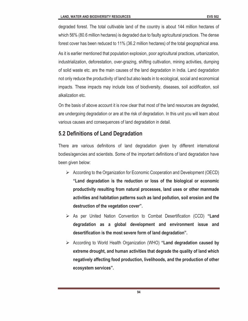
LAND, WATER AND BIODIVERSITY RESOURCES EVS 502
94
degraded forest. The total cultivable land of the country is about 144 million hectares of
which 56% (80.6 million hectares) is degraded due to faulty agricultural practices. The dense
forest cover has been reduced to 11% (36.2 million hectares) of the total geographical area.
As it is earlier mentioned that population explosion, poor agricultural practices, urbanization,
industrialization, deforestation, over-grazing, shifting cultivation, mining activities, dumping
of solid waste etc. are the main causes of the land degradation in India. Land degradation
not only reduce the productivity of land but also leads in to ecological, social and economical
impacts. These impacts may include loss of biodiversity, diseases, soil acidification, soil
alkalization etc.
On the basis of above account it is now clear that most of the land resources are degraded,
are undergoing degradation or are at the risk of degradation. In this unit you will learn about
various causes and consequences of land degradation in detail.
5.2 Definitions of Land Degradation
There are various definitions of land degradation given by different international
bodies/agencies and scientists. Some of the important definitions of land degradation have
been given below:
According to the Organization for Economic Cooperation and Development (OECD)
productivity resulting from natural processes, land uses or other manmade
activities and habitation patterns such as land pollution, soil erosion and the
destructio
As per United Nation Convention to Combat Desertification (CCD)
degradation as a global development and environment issue and
According to World Health Organization (WHO)
extreme drought, and human activities that degrade the quality of land which
negatively affecting food production, livelihoods, and the production of other

LAND, WATER AND BIODIVERSITY RESOURCES EVS 502
95
Land degradation may be defined as "the collective reduction of the productive
potential of the land, including its major uses, its farming systems and its
value as an economic resource."
In other words land degradation may defined as
of soil or loss of fertility of soil in which physical, chemical and biological
5.3 Causes of Land Degradation
There are different causes of land degradation, but first of all you should understand the
categories of land degradation. In this list first category is physical degradation which refers
to deterioration in physical properties of soil. Physical properties of land include landscape,
moisture contents, water holding capacity of soil etc. Second category is chemical
degradation which is basically due to the nutrient depletion. Chemical properties of land
include chlorides, nitrates, phosphates, magnesium, zinc, calcium etc. Third category of land
degradation refers to biological degradation in which soil organic matter and biodiversity of
soil degraded. Biological properties of land include all the flora and fauna which are inhabited
in land ecosystems.
5.4 Natural Causes
of Land
Degradation
The causes of land
degradation may be
categorized as: Natural
and manmade or
anthropogenic. There are
various natural causes of
land degradation which are described below:
1) EARTHQUAKE:
Fig 1: Showing Natural Causes of Land Degradation
EARTHQUAKE
FOREST FIRE
LANDSLIDE
FLOOD NATURAL CAUSES OF
LAND DEGRADATION
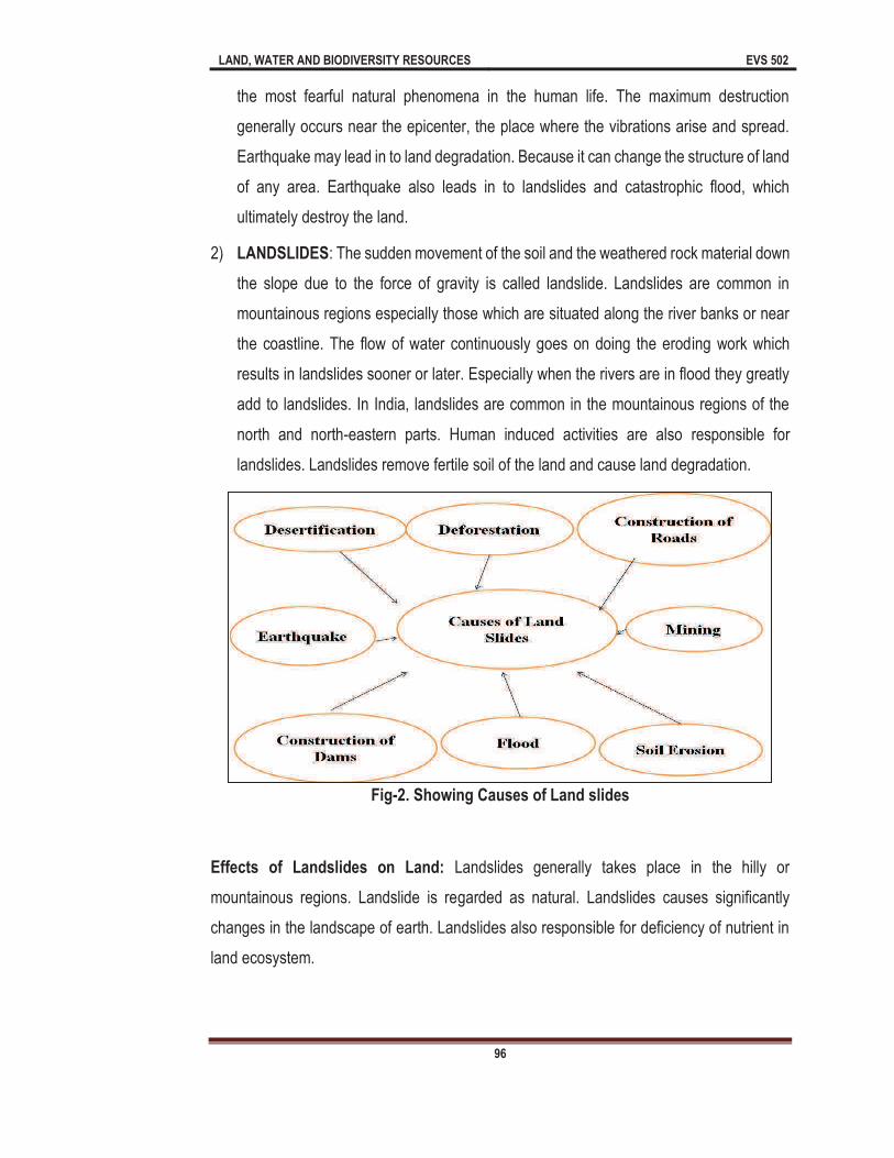
LAND, WATER AND BIODIVERSITY RESOURCES EVS 502
96
the most fearful natural phenomena in the human life. The maximum destruction
generally occurs near the epicenter, the place where the vibrations arise and spread.
Earthquake may lead in to land degradation. Because it can change the structure of land
of any area. Earthquake also leads in to landslides and catastrophic flood, which
ultimately destroy the land.
2) LANDSLIDES: The sudden movement of the soil and the weathered rock material down
the slope due to the force of gravity is called landslide. Landslides are common in
mountainous regions especially those which are situated along the river banks or near
the coastline. The flow of water continuously goes on doing the eroding work which
results in landslides sooner or later. Especially when the rivers are in flood they greatly
add to landslides. In India, landslides are common in the mountainous regions of the
north and north-eastern parts. Human induced activities are also responsible for
landslides. Landslides remove fertile soil of the land and cause land degradation.
Fig-2. Showing Causes of Land slides
Effects of Landslides on Land: Landslides generally takes place in the hilly or
mountainous regions. Landslide is regarded as natural. Landslides causes significantly
changes in the landscape of earth. Landslides also responsible for deficiency of nutrient in
land ecosystem.

LAND, WATER AND BIODIVERSITY RESOURCES EVS 502
97
Fig-3. Showing effects of landslides on land
3) FLOOD: A flood is an overflow of water that submerges land that is generally dry.
According to European Union Floods Directives
. According to Central Water Commission,
Ministry of water resources, Government of India flood affects about 7.351 million
hectare area of country. Flood also responsible for trouble 40.96 million population,
1800 number human live lost, 85599 number cattle Lost, 14 Lakh House damaged,
Crop area damaged 3.7 million hectare, Public utility damaged 1186.45 crore.
Therefore, flood is responsible for land degradation.
5.5 Manmade or Anthropogenic Causes of Land Degradation
There are various manmade or
anthropogenic causes of land
degradation and some of the
important manmade or
anthropogenic causes of land
degradation are summarized in
Fig.1 and Table 1 and also
described below.
Fig-4: Manmade causes of land degradation

LAND, WATER AND BIODIVERSITY RESOURCES EVS 502
98
Table-1: Important manmade causes of land degradation and their impacts
Causes of land degradation Impacts
Deforestation
Soil quality degradation
Landslides
Loss of biodiversity
desertification
Desertification
Loss moisture content
Loss water holding capacity of soil
Loss biodiversity
Low productivity of land
Overgrazing
Desertification
Loss biodiversity
Low productivity
Dumping of Solid waste
Waste land
Low productivity
Diseases
Agricultural Practices
Water logging
Soil erosion
Loss valuable nutrients from soil
Deforestation
Toxic nature of soil
Loss biodiversity
Soil Erosion
Loss of fertile soil
Loss of agricultural land
Low productivity of land
Landslides
Loss of fertile soil
Loss of agricultural land
Low of forest land
Urbanization and Industrialization
Soil degradation
Loss of agricultural land
Low of forest land
High toxic chemicals in land
Mining
Loss of valuable nutrients
Soil erosion
Land degradation
5.5.1 Deforestation
As you know forests are very important resource which are not only responsible for
purification of air but also play an important role in keeping fertility of land by shedding their
leaves which contain many valuable nutrients. Forest Survey of India (FSI) defines a forest

LAND, WATER AND BIODIVERSITY RESOURCES EVS 502
99
According to the State of Forest Report (2011) produced by FSI, area under forests in India
is estimated to be 69.20 m ha, making up 21.02% of the total geographical area of the
country.
Forests are helpful in binding up of soil particles with the help of their roots. The areas of
root (rhizospheres) also keep the soil moist and full with nutrients. Rhizosphere also contains
many valuable microbes (bacteria, algae and fungi) which are important biotic communities
responsible for recycling of nutrients in soil. The term refers to the loss of
tree cover. Deforestation is conversion of forest land in to non-forest for different
purposes such as agricultural pasture, urbanization, industrialization, commercial
products etc.
According to United Nations Environment Programme (UNEP) about 7.3 million hectares
of rich tropical forests every year and about 14 hectare of closed forest every minute are
lost. Therefore, deforestation will affect the land adversely. The deforestation may be
anthropogenic or natural.
According to United Nations Framework Convention on Climate Change (UNFCCC, 2010)
subsistence farming is responsible for 48% of deforestation, commercial agriculture is
responsible for 32% of deforestation, water logging is responsible for 14% of deforestation
and fuel wood gathering make up 5% of deforestation.
Causes of Deforestation: There are
several causes of deforestation; these
causes may include urbanization,
industrialization, agricultural practices,
over exploitation etc. As population
rises, demand for food, infrastructure,
transportation etc. also increases.
Many forests of world have eroded
due to the constructional activities. For
the fulfillment of demand of foods, forest land also converting in to agricultural land.
Fig-5: Showing causes of Deforestation
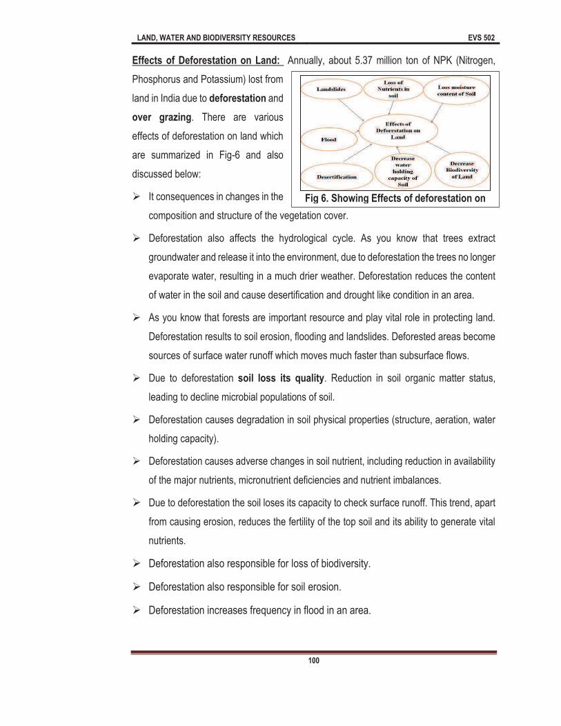
LAND, WATER AND BIODIVERSITY RESOURCES EVS 502
100
Effects of Deforestation on Land: Annually, about 5.37 million ton of NPK (Nitrogen,
Phosphorus and Potassium) lost from
land in India due to deforestation and
over grazing. There are various
effects of deforestation on land which
are summarized in Fig-6 and also
discussed below:
It consequences in changes in the
composition and structure of the vegetation cover.
Deforestation also affects the hydrological cycle. As you know that trees extract
groundwater and release it into the environment, due to deforestation the trees no longer
evaporate water, resulting in a much drier weather. Deforestation reduces the content
of water in the soil and cause desertification and drought like condition in an area.
As you know that forests are important resource and play vital role in protecting land.
Deforestation results to soil erosion, flooding and landslides. Deforested areas become
sources of surface water runoff which moves much faster than subsurface flows.
Due to deforestation soil loss its quality. Reduction in soil organic matter status,
leading to decline microbial populations of soil.
Deforestation causes degradation in soil physical properties (structure, aeration, water
holding capacity).
Deforestation causes adverse changes in soil nutrient, including reduction in availability
of the major nutrients, micronutrient deficiencies and nutrient imbalances.
Due to deforestation the soil loses its capacity to check surface runoff. This trend, apart
from causing erosion, reduces the fertility of the top soil and its ability to generate vital
nutrients.
Deforestation also responsible for loss of biodiversity.
Deforestation also responsible for soil erosion.
Deforestation increases frequency in flood in an area.
Fig 6. Showing Effects of deforestation on
LAND, WATER AND BIODIVERSITY RESOURCES EVS 502
101
5.5.2 Desertification
by Aubreville (1949) to show excessive soil erosion due to deforestation. Desertification is a
process of land degradation in arid, semiarid, and dry sub-humid areas. The UNO
duced biological productivity
with reduction in plant diversity, in the lands, carrying capacity for livestock, in crop yields,
degradation in arid, semi-arid, and dry sub-humid areas, resulting from various factors,
as rapid soil erosion by wind and water, a reduction in species diversity and a reduction in
the overall productivity of land ecosystems.
United Nation Environment Programme (UNEP) classified desertification as:
None to slight: Biological production largely not altered.
Moderate: Loss of production up to 25% of that expected
Severe: Loss of Production between 25% and 50% of that expected
Very severe: loss of production more that 50% of that expected
Besides biological production, relevant criteria of ground cover, salinization, soil status and
cost of reclamation also used in each of the land categories.
Effects of Desertification
Desertification may leads in to floods, environmental pollution, storms and several
other natural disasters, which can contaminate the land.
Due to desertification soil becomes unsuitable for agriculture, and there may be a
huge loss of food.
Desertification leads to water scarcity and human, as well as animal life is
endangered due to shortage of water.
LAND, WATER AND BIODIVERSITY RESOURCES EVS 502
102
Due to desertification, the soil changes and the rain no more penetrate the soil. As
a result, plants don't receive the required amount of water for proper development.
One or two seasons of infertile land can be tackled, but if the land experiences
repeated spells of desertification, it may lose its fertility completely.
Desertification causes aridity of soil.
It decreases the moisture content of land. As you know that moisture is very
important for survival of organisms. Many species of earthworms, bacteria, fungi
etc. live in moist land; moisture also provides water to plants and other biological
communities. Due to desertification all the moisture evaporate from the land.
It causes biodiversity degradation of land. Organisms such as bacteria, fungi,
molluscs, annelids, arthropods etc. are live in land and some of them play important
role in enhancing the productivity of land
survive in land.
It decreases the productivity of land.
5.5.3 Over-Grazing
Overgrazing refers to excessively feeds on pasture. It is also the practice of grazing
livestock on vegetation before it has recovered from a former grazing state. It is also called
intensive grazing . Overgrazing takes place when vegetation or pasture is continuously
removed from the land.
Tremendous growth in livestock population results in overexploitation of pastures. Due to
this, grass and other types of vegetation are unable to survive, and lack of vegetation cover
leads to soil erosion. It has many effects on the environment and specifically on vegetation
and soil parameters. Over grazing is considered to be the major cause of soil degradation
worldwide. According to Oldemann (1991) overgrazing accounted for 35.8% of all forms
of degradation. It is observed that the first signs of overgrazing is a decrease in legumes
and an increase in forbs.
Increased livestock numbers in arid regions cause overgrazing which results in reduced
infiltration and accelerated runoff and soil erosion. Soil microorganisms play significant role
in developing soil fertility. The dominant characteristics influencing the existence and activity

LAND, WATER AND BIODIVERSITY RESOURCES EVS 502
103
of soil microbes are soil water content and storing capacity, texture, size etc. Heavy grazing
can cause grassland degradation because of heavy defoliation and treading, and is often
used for herb control. Overgrazing is responsible for removal of natural vegetation.
Animal grazing is a natural process of forage utilization, because herbivores produce in the
environment where evolution formed them. This is the most appropriate, low cost tool for
meat production at global level. A large portion of grasslands are utilized by livestock
population. Overgrazing has detrimental effects on soil and vegetation but changes are
reversible. High grazing pressure decreases plant density, and often enhances the invasion
of unpalatable species. However, all these negative impacts can be prevented by proper
management practices.
Effects of Overgrazing on land:
There are various effects of
overgrazing on land which are
summarized in Fig-7 and also
discussed below:
1. Soil erosion: As you know that
soil erosion is process in which
top soil remove from land. One
of the most severe impacts of
overgrazing is soil erosion. Trampling of numerous animals in a land will act to enhance
the death of plants and vegetation cover, because the animals graze even on the
slightest, finest and smallest shoots of new plants. Due to complete degradation of
plants, the land is left bare and exposed to harsh weather such high temperatures which
disintegrates the rocks and carries the top soil away. Animals also prefer gathering at
specific areas, like near to water sources, and such areas can get degraded.
2. Land degradation: The acts of soil erosion as a result of overgrazing can cause land
degradation. In drier areas, the experience is even bad as a large percentage of pasture
and land cover is destroyed, contributing to relentless progression of desertification and
overgrazing has led to desertification. Overgrazing combined with overstocking has the
most damaging results to the natural environment. Intensive or over grazing disrupts the
Fig-7: Effects of Over Grazing on land

LAND, WATER AND BIODIVERSITY RESOURCES EVS 502
104
water cycle and diminishes the replenishment capability of ground water resources. In
the some areas of earth, overgrazing is associated with nitrogen and phosphorous
contamination.
3. Loss of valuable species: The composition of plant and their regeneration capacity is
affected by overgrazing. The original pasture vegetations are composed of high quality
pastures and herbs with great nutritional value. When animals excessively graze on
such pastures, even the root stocks which contain the reserve food or regeneration
capacity get eroded. Therefore, some other more adaptable species such as weeds and
unpalatable plants take up their place. These secondary plant species have low
nutritional values and because they are highly adaptive, they replace the
native/endemic/useful species thereby causing the loss of valuable plant diversity.
4. Food shortage/famine: As earlier stated, overgrazing is a main contributor to
desertification because it converts arable or pasture land into unproductive land. The
overgrazed soil is thus not suitable for growing food because it loses its essential
nutrients. The loss of land productivity directly results in the loss of food available for
consumption. Overgrazing also leads in to economical loss.
5. Death of people and livestock: The long term effects of overgrazing are shortage of
food which can make man and cattle die of starvation. In the absence of sufficient
pasture for livestock grazing, cattle lack the vital nutrients for survival. The nutrient
deficiencies make the animals unable to gain weight appropriate to life which lowers
their chances of survival. Human survival levels, and health are as well affected when
there is inadequate food supply for consumption.
5.5.4 Dumping of Solid Waste
Dumping of Solid waste is another important cause of land degradation. Due to rapid growth
in developmental activities such as urbanization and industrialization millions of tons solid
wastes are being dumped in and around the land. Dumping of solid wastes on land is a
common waste disposal method and practiced almost by all the cities around the world.
Solid waste may occur in form of biodegradable and non-biodegradable in which non-
biodegradable waste is regarded as more harmful as compare to biodegradable waste.
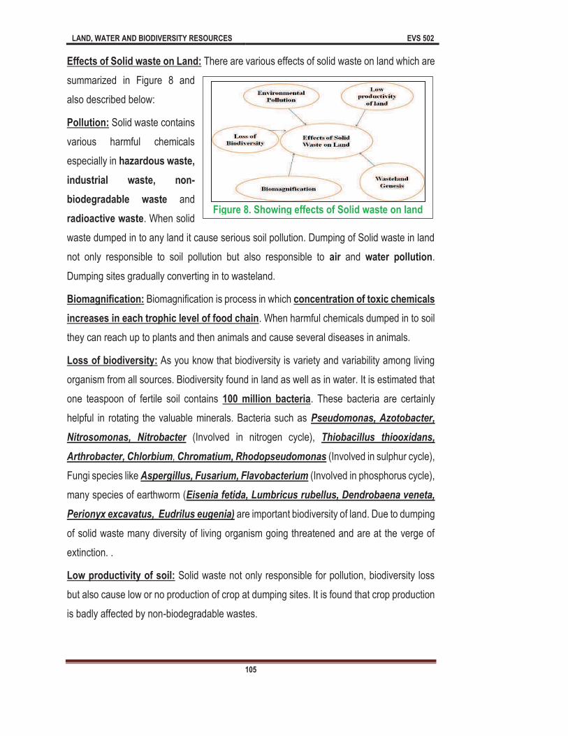
LAND, WATER AND BIODIVERSITY RESOURCES EVS 502
105
Effects of Solid waste on Land: There are various effects of solid waste on land which are
summarized in Figure 8 and
also described below:
Pollution: Solid waste contains
various harmful chemicals
especially in hazardous waste,
industrial waste, non-
biodegradable waste and
radioactive waste. When solid
waste dumped in to any land it cause serious soil pollution. Dumping of Solid waste in land
not only responsible to soil pollution but also responsible to air and water pollution.
Dumping sites gradually converting in to wasteland.
Biomagnification: Biomagnification is process in which concentration of toxic chemicals
increases in each trophic level of food chain. When harmful chemicals dumped in to soil
they can reach up to plants and then animals and cause several diseases in animals.
Loss of biodiversity: As you know that biodiversity is variety and variability among living
organism from all sources. Biodiversity found in land as well as in water. It is estimated that
one teaspoon of fertile soil contains 100 million bacteria. These bacteria are certainly
helpful in rotating the valuable minerals. Bacteria such as Pseudomonas, Azotobacter,
Nitrosomonas, Nitrobacter (Involved in nitrogen cycle), Thiobacillus thiooxidans,
Arthrobacter, Chlorbium, Chromatium, Rhodopseudomonas (Involved in sulphur cycle),
Fungi species like Aspergillus, Fusarium, Flavobacterium (Involved in phosphorus cycle),
many species of earthworm (Eisenia fetida, Lumbricus rubellus, Dendrobaena veneta,
Perionyx excavatus, Eudrilus eugenia) are important biodiversity of land. Due to dumping
of solid waste many diversity of living organism going threatened and are at the verge of
extinction. .
Low productivity of soil: Solid waste not only responsible for pollution, biodiversity loss
but also cause low or no production of crop at dumping sites. It is found that crop production
is badly affected by non-biodegradable wastes.
Figure 8. Showing effects of Solid waste on land
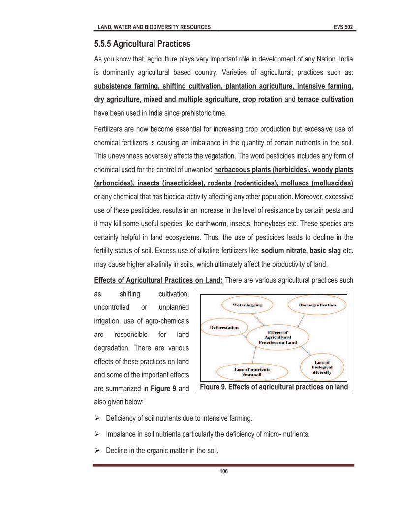
LAND, WATER AND BIODIVERSITY RESOURCES EVS 502
106
5.5.5 Agricultural Practices
As you know that, agriculture plays very important role in development of any Nation. India
is dominantly agricultural based country. Varieties of agricultural; practices such as:
subsistence farming, shifting cultivation, plantation agriculture, intensive farming,
dry agriculture, mixed and multiple agriculture, crop rotation and terrace cultivation
have been used in India since prehistoric time.
Fertilizers are now become essential for increasing crop production but excessive use of
chemical fertilizers is causing an imbalance in the quantity of certain nutrients in the soil.
This unevenness adversely affects the vegetation. The word pesticides includes any form of
chemical used for the control of unwanted herbaceous plants (herbicides), woody plants
(arboncides), insects (insecticides), rodents (rodenticides), molluscs (molluscides)
or any chemical that has biocidal activity affecting any other population. Moreover, excessive
use of these pesticides, results in an increase in the level of resistance by certain pests and
it may kill some useful species like earthworm, insects, honeybees etc. These species are
certainly helpful in land ecosystems. Thus, the use of pesticides leads to decline in the
fertility status of soil. Excess use of alkaline fertilizers like sodium nitrate, basic slag etc.
may cause higher alkalinity in soils, which ultimately affect the productivity of land.
Effects of Agricultural Practices on Land: There are various agricultural practices such
as shifting cultivation,
uncontrolled or unplanned
irrigation, use of agro-chemicals
are responsible for land
degradation. There are various
effects of these practices on land
and some of the important effects
are summarized in Figure 9 and
also given below:
Deficiency of soil nutrients due to intensive farming.
Imbalance in soil nutrients particularly the deficiency of micro- nutrients.
Decline in the organic matter in the soil.
Figure 9. Effects of agricultural practices on land
LAND, WATER AND BIODIVERSITY RESOURCES EVS 502
107
Deforestation and overgrazing.
Decline in underground water due to over exhaustion for high water using crops.
Loss of valuable species.
Excessive uses of nitrogen and water have caused percolation of nitrogen up to water
table thus polluting it even for men and other species.
Biomagnification
5.5.6 SOIL EROSION
It is just displacement of upper layer of soil. Soil erosion may be due to high rain fall, wind
flow, animal and human activities. The top layer of soil is vital because all the essential
nutrients required by plants are present in this layer.
According to Rama Rao (1962) soil erosion is creeping death of soil. Soil erosion depends
on various factors like topography, rainfall, gravity, nature of soil etc. Accelerated soil erosion
by water and wind is the major land degradation process and this is a consequence of
changed relationship between environmental factors which occur as a result of human
activities. Out of total geographical area (328.7 million hectare), about 43% of land (141.3
million hectare) subject to water and wind erosion, water logged area about 2.6% (8.5 million
hectare), alkali soils about 1.1% (3.6 million hectare), acidic soils 1.4% (4.5 million hectare),
saline soils including coastal sandy areas 1.7% (5.5 million hectare), ravine and gullies 1.2%
(4.0 million hectare), area subject to shifting cultivation 1.5% (4.9 million hectare), riverine
and torrents 0.8% (2.7 million hectare). In USA over 77 million acres of land has become
seriously eroded.
Types and causes of soil erosion:
As it is earlier mentioned that soil erosion means the removal of top fertile layer of the soil.
Soil erosion by wind and water is the most common. There are various types of soil erosion
which are given below:
A) Soil erosion by Water: This type of soil erosion may categorized as followings:
Sheet Erosion: In this type of soil erosion, the layer of fertile soil removed by
running water. It is severe type of soil erosion because in this erosion finer fertile
layer of soil is removed.
LAND, WATER AND BIODIVERSITY RESOURCES EVS 502
108
Rill erosion: This is second type of sheet erosion, in this erosion small finger like
rills begin
to appear
on land.
Gradually
these fine
rills
increase in
number
and also
become
deeper
and wider
which makes the land unculturable or unproductive.
Gully Erosion: In this type of soil erosion water flowing along with definite path
downs. Gully erosion also makes land unfit for cultivation.
River stream erosion: In this category the soil erosion take place at the river bed
and banks. This type of soil erosion generally occurs through rivers, streams and
tributaries.
Shore Erosion: This type of erosion also called coastal erosion, in which the
wearing away of material from a coastal profile including the removal of beach, sand
dunes, or sediment by wave action, tidal currents, wave currents, or high winds.
B) Soil erosion by wind: In this type of erosion wind is responsible for displacement
of soil. This type of erosion usually takes place in bare, drier areas of land. It is regarded
as less harmful as compared to soil erosion by water.
Effects of Soil Erosion on Land: Soil erosion has various harmful effects on land which
are summarized in Fig-11 and also given below:
F
B
Fig 10. Types of soil erosion A-Sheet Erosion B-Rill Erosion C-Gullies Erosion D-Slip Erosion E-Stream Erosion F-Shore Erosion G-Wind Erosion
A
C
D
E
G
LAND, WATER AND BIODIVERSITY RESOURCES EVS 502
109
As you have learnt about the sheet erosion in which finer and fertile soil eroded due to water.
In this erosion many valuable
nutrients like phosphorus,
nitrates, calcium, magnesium,
chlorides etc. are lost from the
soil. Therefore, loss of nutrients is
one of the major impacts of soil
erosion.
Continuous erosion from the river
banks reduces the agricultural lands. Various rivers of India like Ganga, Yamuna,
Brahmaputra, Kaveri, Krishna, Kosi etc. degraded large amount of land from their banks.
Stream erosion leads in to loss of agricultural land especially in hilly regions of earth.
5.5.7 Urbanization and Industrialization
There are various effects of
urbanization and industrialization
on land which are summarized in
Fig-12 and also discussed below:
Urbanization and industrialization
are also important causes of land
degradation. As it is mentioned
32% of Indian population lives in
urban area. Urbanization is process in which rural area convert in to urban area. Urban
area is that area where population of human being has more density and most of the persons
have non-agricultural occupation. Urbanization increasing day by day and leads in to several
environmental problems including land fragmentation and land degradation. Urbanization
alters the physical, chemical and biological properties of the land and thereby degrading the
quality of land. Urbanization leads in to loss of vegetation, generation of solid waste,
excessive water runoff, soil erosion. These factors affect the land significantly.
Industrialization is just development of industry in an area. Rapid growth in industries
ultimately leads in to air, water and soil pollution. Besides this, industrialization requires more
Fig-11: Effects of Soil Erosion on Land
Fig-12: Effects of Urbanization and Industrialization on land
LAND, WATER AND BIODIVERSITY RESOURCES EVS 502
110
and more land to establishment of industries which change the structure as well as quality
of land. Many industries such as leather industries, paper and pulp industries, agricultural
industries, battery recycling industries produce large amount of solid waste on land and
degrade quality of soil, significantly.
5.5.8 Mining
Mining is extraction of valuable minerals from the earth. Mining can affect land in various
ways in the form of soil erosion, sinkholes, loss of biodiversity, contamination of soil etc.
Impacts of mining on land get reflected in land use pattern of area because land gets
exposed to erosion by losing its vegetation cover. According to Department of
Environment, Govt. of India mining of certain minerals such as coal, iron ores, zinc, lead,
copper, gold, limestone manganese, rock phosphates, chromites, silica are mostly
responsible for land degradation in India.
5.6 Consequences of Land Degradation
As you know that Land degradation apparent itself in many forms such as soil erosion,
increased sediment loading of water bodies, desertification etc. If we conclude the
consequences of land degradation we will find land degradation is serious issue at
international level. There are various consequences and outcomes of land degradation,
some of the important consequences of land degradation are described below:
1. Effect on Human Health
It is one of the important consequences of land degradation. As you know that we are entirely
depends on land resources not only for transportation, forests but also for the food and fruits.
Human being added various types of toxic chemicals in land. Such wastes contain toxic
chemicals, and metals that have adverse effects on humans. Plastic waste, for instance,
might contain acrylic, polyvinyl chloride, polycarbonate, and phthalates that are
associated with cancers, skin diseases, respiratory disorders, and birth defects.
Chemical components such as cadmium, arsenic, mercury, cyanide and chromium
commonly found in pharmaceutical, pesticides, and fertilizer industrial wastes also have
devastating effects on human health. They have cancer causing elements and can also lead
to lung and kidney disease as well as liver damage. Many toxic chemicals which are being

LAND, WATER AND BIODIVERSITY RESOURCES EVS 502
111
released in to land ecosystems can reach up to higher trophic level through
biomagnification and cause certain diseases in human being. Whenever land is polluted
with agricultural and industrial waste, it leads to increase in dumping sites. These dumping
sites also become breeding grounds for mice, flies, mosquitoes and birds that can
transmit diseases. Therefore, land pollution may lead in to epidemic diseases such as
cholera, typhoid, amoebiasis etc. These dumping sites are contaminated with such kind
of toxic chemicals that they can accumulate in human body via vegetables and foods that
are grown in polluted lands.
Pollution
It is also one of the major consequences of land degradation. Soil Pollution is categorized
under land pollution. Hence, when there is overuse of fertilizer chemicals or lands are
degraded through toxic chemical and solid waste, the upper layer of the soil is degraded,
causing soil pollution. The effects of agricultural and chemical wastes are the principal land
pollution aspects cause soil pollution. Ultimately, the land losses its fertility and vegetation
cover.
Land degradation may lead in to other types of pollutions. Landfills and dump sites generate
appalling smells and odour in the areas which they are located which cause air pollution. In
cities and towns located near huge dump sites and landfill areas, residents have experienced
high scores of pungent smell. On the other hand, burning of solid waste contributes to air
pollution. Land pollution can spread in all directions so that it results in an adverse impact
on the immediate environments. It can contaminate water and significantly reduce its quality.
It happens when the chemicals and other toxic substances from the landfills and solid wastes
are mostly carried into waterways by surface rainwater runoff. At the same time, leaching
takes place which makes the toxic chemicals to infiltrate into aquifers and water bodies.
Also, the contaminated water evaporates and falls back as precipitation with the lot of
impurities and contamination. In marine ecosystems, coastal zones are the most
susceptible to pollution-related impacts arising from land degradation. There is evidence
of global impacts as large stretches of coast can be affected, extending to reef and large
marine ecosystems. The contamination of water, ecosystems and food-chains by agro-
chemicals (chemicals used in agriculture such as insecticides, pesticides etc.) applied to

LAND, WATER AND BIODIVERSITY RESOURCES EVS 502
112
or accumulating in soil is the huge impact associating land degradation with organic
pollutants.
2. Loss Biodiversity
During last few decades, the biodiversity have tremendously affected as they have
persistently faced a serious threat regarding the loss of their natural habitat. As you know
that habitat loss is major threats to biological diversity. The constant human economic
activities on land have increasingly left the lands degraded forcing wildlife to move away and
adapt to new areas. Consequently, many species have died while trying to adapt, some have
gone extinct, and several are presently on the verge of extinction. As you know that land is
home to millions of species, many organisms such as plants (algae, fungi, bryophytes,
Pteridophytes, gymnosperm and angiosperm), bacteria and animals (nematodes,
earthworms, arthropods (butterflies, moths, honeybees, dragon flies, amphibians, reptiles,
birds and mammals) are live on land ecosystems. These life diversities are certainly helpful
to land ecosystem. Discharge of toxic chemicals on land makes the ecosystem unpleasant
to the survival of plants and animals within their interactive food chain. The chemicals
contaminate plants and waters which are then consumed by lower animals, and the food
chain continues up the ladder in the ecosystem. The process is known as biomagnification
and is reported to be a serious threat to ecological sustainability. Disruption to land
ecosystem functions unavoidably diminishes the diversity of above and below-ground
biodiversity, as well as affecting aquatic milieu.
3. Loss of Nutrients and Land Productivity
It is estimated 6,000 Mt of soil is lost annually from the Indian subcontinent. This eroded
material carries several valuable nutrients along with it, which are lost forever. Several
nutrients are lost due to surface runoff and also due to leaching. In the areas where water
percolation is high, the potentiality for leaching is also high. Soil properties also have a
definite effect on nutrient-leaching losses. There is a greater nutrient loss in sandy soil than
clay, because of higher rate of percolation and lower nutrient absorbing power of the sandy
soil. Therefore, in sandy soil, the nutrients in the top soil are lost due to wind erosion and
also due to more rapid leaching.
LAND, WATER AND BIODIVERSITY RESOURCES EVS 502
113
There are several other things lost due to land degradation and it is difficult to assess their
economic value. These are:
Loss of fodder and forage production, decline in production of timber.
Loss of species of flora and fauna.
Loss of water resource points as evident by drying up of springs and natural water
bodies, and lowering of water level in wells.
When the land is lost due to wind erosion or water erosion, apart from-physical,
chemical and biological degradation, there is loss of employment opportunities. This
leads to migration towards cities and towns, causing social problems related to
unplanned urbanization.
4. Economic loss
As you know land is economically very important. Land degradation causes loss of million
dollars at global level. Landfills and dump sites also reduce air quality and can potentially
threaten human health. Besides the loss of agriculture, land degradation also responsible
for loss of biodiversity, diseases and deforestation etc. The cost of curing diseases, forests,
biodiversity is immeasurable. Some studies showed that land degradation is directly
correlated with tourism industry. Land degradation declines the numbers of visitors in an
area. Therefore, land degradation put extra burden not only on local communities but on the
economy of the Nation.
5. Natural Disasters:
Land degradation may leads in to different types of natural disasters such as Earthquake,
flood, landslides, landslips etc. Flood is most occurring disaster of India. Due to land
degradation, water runoff also increases which lead in to flood like conditions in an area.
Floods may basically be due to unusually heavy rainfall, but intensity, frequency and severity
of flood generally in land degraded area. However, many of the anthropogenic activities, that
negatively affect the ability of land surface and soil profile to absorb, hold and utilize rain
water. Land degradation also responsible for landslide, this is because land degradation
reduces the water holding capacity of soil which cause landslips or landslides. You will find
the details of land related hazards in unit-7 of this course.
LAND, WATER AND BIODIVERSITY RESOURCES EVS 502
114
Summary
In this unit we have discussed various aspects of various causes and consequences of land
degradation. So far you have learnt that:
Land is useful resource and may occur in the form of crop land, barren land, grass
land, range land, snowy land, arid land and waste land.
Land degradation is process in which land loss it production capacity.
Sources of land degradation may categorized as Natural causes and anthropogenic
or manmade causes.
Natural causes of land degradation include earthquake, landslides, land slips and
flood
Anthropogenic causes of land degradation may include deforestation,
desertification, overgrazing, soil erosion, several agricultural practices, urbanization
& industrialization, mining etc.
There are various impacts of deforestation such as loss of nutrients in soil,
landslides, loss moisture content of soil, decrease water holding capacity of land,
flood, desertification etc.
There are various impacts of desertification such as flood, landslides, loss moisture
content of soil, loss of biodiversity etc.
Overgrazing may lead to desertification, low production, loss of valuable species,
soil erosion etc. on the other hand solid waste also affected land and the main
impacts of solid waste on land are: soil pollution, loss of biodiversity,
biomagnification, wasteland genesis etc.
Various agricultural practices such as shifting cultivation, improper irrigation, water
logging, and excessive use of agro-chemicals are also responsible for land
degradation.
Soil erosion may be categorized erosion by water (sheet erosion, rill erosion, gully
erosion, river stream erosion, and shore erosion) and erosion by wind.
Loss of fertile soil is the main impact of soil erosion.
LAND, WATER AND BIODIVERSITY RESOURCES EVS 502
115
Urbanization and industrialization also leads in to land degradation. There are
various impacts of Urbanization and industrialization on land such as deforestation,
loss of vegetation cover, change the sol quality, dumping of solid waste, reduced
agriculture land, land fragmentation etc.
Main consequences of land degradation are diseases, low production, loss of
biological diversity, economic loss and natural disasters.
Terminal Questions
1 a) Fill in the blank spaces with appropriate words.
As you know that forests are very important resource which are not only responsible for purification of air but also play an important role in keeping fertility of land by shedding
According to the State of Forest Report (2011) produced by FSI, area under forests in India is estimated to be 69.20 m ha, making up 21.02% of the total geographical area of the country. Forests are helpful in binding up of soil particles with the help of their roots.
biotic communities responsible
different purposes such as agricultural pasture, urbanization, industrialization, commercial products etc.
lost. Therefore, deforestation will affect the land adversely. The term deforestation means removal of vegetative cover in the forest which may be anthropogenic or natural.
2 (a) Discuss the causes of land degradation.
(b) What are the impacts of desertification?
3 (a) Describe the causes and impacts of deforestation.
(b) Give the types of soil erosion
4 a) Define land degradation? Write about causes and impacts of agricultural practices on land?
5 (a) Discuss the impacts of urbanization and industrialization on land.
(b) What are the effects of solid waste on land?
(c) What are the natural causes of land degradation?
6 (a) Fill the blank spaces with appropriate words.
required by plants are present in this layer. According to Rama Rao (1962) soil erosion
LAND, WATER AND BIODIVERSITY RESOURCES EVS 502
116
degradation process and this is a consequence of changed relationship between environmental factors which occur as a result of human activities. Out of total
subject to water and wind erosion, water logg
soils including coastal sandy areas 1.7% (5.5 million hectare), ravine and gullies 1.2% (4.0 million hectare), area subject to shifting cultivation 1.5% (4.9 million hectare), riverine and torrents 0.8% (2.7 million hectare).
(b) Total geographical area of India is about 328.73 million hectare (Yes/No)
(c) Excessive feeds on pasture is called (desertification/overgrazing)
(d) Which one is severe form of soil erosion (Sheet erosion/rill erosion/gully erosion/shore erosion)
(e) What do you understand by biomagnification?
7. (a) Describe the consequences of land degradation
(b) give the definitions of land degradation according to OECD, CCD and WHO
Answers to Terminal Questions
1 (a) valuable nutrients, one hectare, 10%, rhizosphere, bacteria, algae and fungi,
non-forest use, United Nations Environment Programme, minute, space, air,
fire, water and earth.
2 (a) see section 5.3, 5.4. and 5.5, (b) See section 5.5.2
3 (a) See section 5.5.1, (b) See section 5.5.6
4 (a) See section 5.2. and 5.5.5
5 (a) See the section 5.5.7, (b) see the section 5.5.4
(c) See section 5.4.
6 (a) Displacement of upper layer of soil, essential nutrients, death, topography,
rainfall, gravity, water and soil, 43%, 2.6%, 1.1%,
(b) Yes, (c) Overgrazing, (d) Sheet erosion
(e) See the effect of solid waste on land in section 5.5.4
7 (a) See the section 5.6, (b) See the section 5.2.

117
Unit 6 Wasteland Genesis: Types, Extent, Conservation and Management
Unit Structure
6.0 Learning Objectives
6.1 Introduction
6.2 Definitions of Waste Land
6.3 Types of Waste Lands
6.3.1 Categories of wasteland for Identification
6.4 Waste Land in India
6.5 Wasteland Genesis
6.5.1 Genesis of wasteland
6.5.2 Extent of Wasteland
6.6 Conservation of Land
6.7 Management of Wasteland
Summary
6.0 Learning Objectives
After studying this unit you will be able to find answer of the following:
Define waste land
Types of Wasteland
Wasteland in India
Factors are responsible genesis of wasteland
Describe conservational methods of Wasteland
Describe management of Wasteland
6.1 Introduction
You have learnt various causes and consequence of land resource in Unit-5 of this course.
As you know land is terrestrial bio-productive ecosystem. It comprises of soil, water, plants
and other biotic communities. On the basis of ecological conditions land may be as:
cropland, barren land wetland, arid dry land, range land, grassland, snowy land and
wasteland. Cropland is type of land in which crops are regularly planted and harvested.
118
Barren land is areas characterized by exposed bed rocks, talus and other accumulation of
rock without vegetative cones. Wetland is an area of land where soil is saturated with
moisture either seasonally or permanently. Wetland includes swamps, marshes, bogs etc.
Various natural and anthropogenic causes are responsible for wasteland genesis. Land may
be converted in wasteland by naturally or by anthropogenic activities. According to Food &
Agriculture Organization of United Nations (FAO) 33% of land is covered by forest, 26%
by grassland and pasture and 20% area is desert, 10% is covered by wetlands, 10%
cropland and 20% is urban land. Wasteland is that land which has been used for production
but which has been abandoned and not suitable for cultivation. In this unit you will learn
about definitions, types and genesis of waste land. You will also learn about the conservation
and management of land.
6.2 Definitions of Waste Land
important definitions of wasteland are given below:
previously used, but which has been abandoned, and for which no further use has
Wasteland Survey and Reclamation Committee, Ministry of food and Agriculture,
Govt. of Ind
ecologically unstable (b) whose top soil has nearly been completely lost (c) land
which have developed toxicity in the root zones (rhizosphere) or growth of most
as
can be reclaimed with reasonable effort, and which is currently under utilized /land
119
which is deteriorating for lack of appropriate water and soil management or on
account of natural causes.
In the other words "Wastelands are those miscellaneous land types which are
presently not suitable for, or capable of, producing materials or services of value
due to some constraints ranging from geo-environmental to socio-economic
causes".
Wasteland which is lying unproductive or which is not being utilized to its potential.
According to Ameri
producing material or services of value.
Waste land is that lands which are ecologically unstable badly eroded and
degraded.
6.3 Types of Waste Lands
Wastelands may include degraded forests, overgrazed land, eroded land, hilly slopes,
waterlogged marshy lands, barren land etc. The types of wasteland created due to the
natural and anthropogenic factors. Wasteland may also be valuable, however some of
serious categories of wasteland are:
Degraded land
Salinized land
Waterlogged land
Desert land and
Soil eroded land
The causative factors responsible for the development of wastelands are numerous. An
analysis o f the factors reveals that the development of wasteland occur through an
unhealthy interaction of three forces, viz. man, nature and technology. Though the natural
factors are of importance, man's ability to utilize land with the help of technological
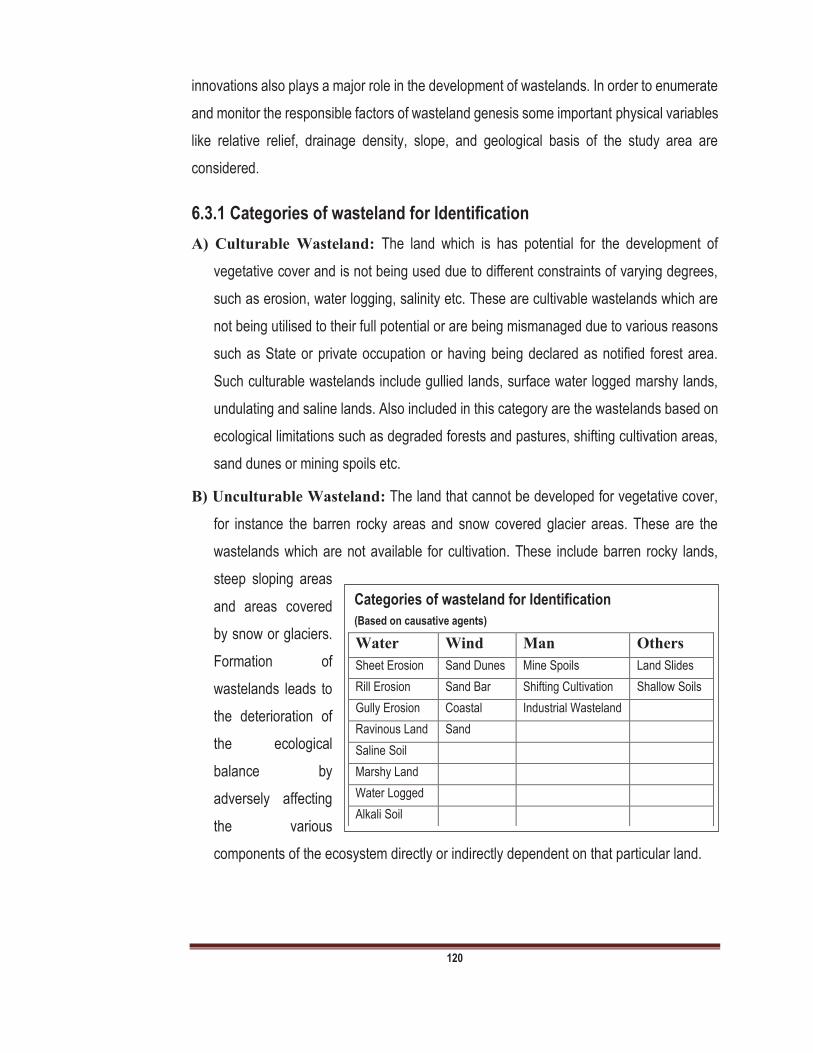
120
innovations also plays a major role in the development of wastelands. In order to enumerate
and monitor the responsible factors of wasteland genesis some important physical variables
like relative relief, drainage density, slope, and geological basis of the study area are
considered.
6.3.1 Categories of wasteland for Identification
A) Culturable Wasteland: The land which is has potential for the development of
vegetative cover and is not being used due to different constraints of varying degrees,
such as erosion, water logging, salinity etc. These are cultivable wastelands which are
not being utilised to their full potential or are being mismanaged due to various reasons
such as State or private occupation or having being declared as notified forest area.
Such culturable wastelands include gullied lands, surface water logged marshy lands,
undulating and saline lands. Also included in this category are the wastelands based on
ecological limitations such as degraded forests and pastures, shifting cultivation areas,
sand dunes or mining spoils etc.
B) Unculturable Wasteland: The land that cannot be developed for vegetative cover,
for instance the barren rocky areas and snow covered glacier areas. These are the
wastelands which are not available for cultivation. These include barren rocky lands,
steep sloping areas
and areas covered
by snow or glaciers.
Formation of
wastelands leads to
the deterioration of
the ecological
balance by
adversely affecting
the various
components of the ecosystem directly or indirectly dependent on that particular land.
Categories of wasteland for Identification
(Based on causative agents)
Water Wind Man Others
Sheet Erosion Sand Dunes Mine Spoils Land Slides
Rill Erosion Sand Bar Shifting Cultivation Shallow Soils
Gully Erosion Coastal Industrial Wasteland
Ravinous Land Sand
Saline Soil
Marshy Land
Water Logged
Alkali Soil

121
6.4 Waste Land in India
In India, the total area under degraded and wasteland as 114.01Mha. There are various
types of wasteland. Extend of area
under water erosion is 23.61 Mha
and under wind erosion is about
8.89 Mha. There are various types
of wasteland such as gullied or
ravenous, water logged, land
affected by salinity, shifting
cultivation land, over grazed land,
sandy land, wasteland due to
mining and industrial activities,
snowy land and barren land found
in India which are summarized
Table-2.
In India, the total area under degraded and wastelands as 114.01Mha. Water eroded area
formed due to localized overland flow of water. Flow of water can degrade/erode the soil and
formed channels called Gullies. M.P, Rajasthan are the states of India having more ravine
land followed by Uttar Pradesh (Fig-2). The land with or without scrub maximum in Madhya
Pradesh (19%) followed by
Maharashtra (16%), Rajasthan
(14%) and Gujarat (11%) (Fig-
3). This type of land eroded
due to erosion.
Water logged area mostly
covered by wetlands. This
water logged land is
ecotone/transitional zone
between aquatic and terrestrial
ecosystems. The highest water
Table 2. Different types of waste land created due to limiting factors
Type of waste land Area in Mha
Percentage
Gullied or ravenous land 2.06 0.65
Land with\ without scrub 19.40 6.13
Water logged\marshy land 1.66 0.52
Land affected by salinity 2.04 0.65
Shifting cultivation land 3.51 1.11
Degraded notified forest land 14.07 4.44
Degrading grazing land 2.60 0.82
Degraded land under plantation 0.58 0.18
Sandy area 5.00 1.58
Mining industrial waste land 0.12 0.04
Stony land/barren rocky/sheet rocky land
6.46 2.04
Steep sloping area 0.77 0.24
Snow covered glacier area 5.58 1.76
Total 63.84 20.16
Fig-2: Showing percentage of water eroded area in
different states of India
MP
37%
Rajasthan
24%
UP
14%
Bihar
3%
Gujarat
5%
Andhra
Pradesh
3%
Other
5%
Karnataka
1%
Maharasht
ra
8%
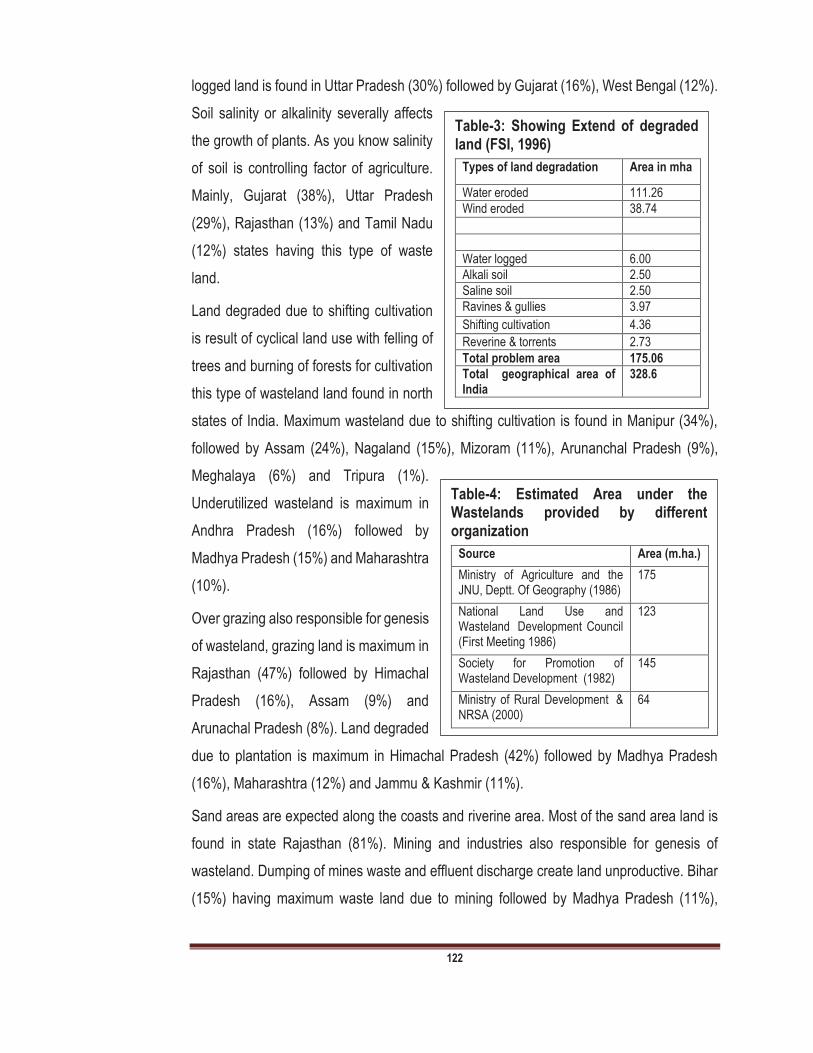
122
logged land is found in Uttar Pradesh (30%) followed by Gujarat (16%), West Bengal (12%).
Soil salinity or alkalinity severally affects
the growth of plants. As you know salinity
of soil is controlling factor of agriculture.
Mainly, Gujarat (38%), Uttar Pradesh
(29%), Rajasthan (13%) and Tamil Nadu
(12%) states having this type of waste
land.
Land degraded due to shifting cultivation
is result of cyclical land use with felling of
trees and burning of forests for cultivation
this type of wasteland land found in north
states of India. Maximum wasteland due to shifting cultivation is found in Manipur (34%),
followed by Assam (24%), Nagaland (15%), Mizoram (11%), Arunanchal Pradesh (9%),
Meghalaya (6%) and Tripura (1%).
Underutilized wasteland is maximum in
Andhra Pradesh (16%) followed by
Madhya Pradesh (15%) and Maharashtra
(10%).
Over grazing also responsible for genesis
of wasteland, grazing land is maximum in
Rajasthan (47%) followed by Himachal
Pradesh (16%), Assam (9%) and
Arunachal Pradesh (8%). Land degraded
due to plantation is maximum in Himachal Pradesh (42%) followed by Madhya Pradesh
(16%), Maharashtra (12%) and Jammu & Kashmir (11%).
Sand areas are expected along the coasts and riverine area. Most of the sand area land is
found in state Rajasthan (81%). Mining and industries also responsible for genesis of
wasteland. Dumping of mines waste and effluent discharge create land unproductive. Bihar
(15%) having maximum waste land due to mining followed by Madhya Pradesh (11%),
Table-4: Estimated Area under the Wastelands provided by different organization
Source Area (m.ha.)
Ministry of Agriculture and the JNU, Deptt. Of Geography (1986)
175
National Land Use and Wasteland Development Council (First Meeting 1986)
123
Society for Promotion of Wasteland Development (1982)
145
Ministry of Rural Development & NRSA (2000)
64
Table-3: Showing Extend of degraded land (FSI, 1996)
Types of land degradation Area in mha
Water eroded 111.26
Wind eroded 38.74
Water logged 6.00
Alkali soil 2.50
Saline soil 2.50
Ravines & gullies 3.97
Shifting cultivation 4.36
Reverine & torrents 2.73
Total problem area 175.06
Total geographical area of India
328.6

123
Rajasthan (10%) and Tamil Nadu (10%), Goa (9%), Maharashtra (8%) and Andhra Pradesh
(8%).
Barren lands exposed to
rocks and stones. This type of
wasteland mostly found in
states like Jammu & Kashmir
(51%), Andhra Pradesh (8%),
Rajasthan (7%), Himachal
Pradesh (6%), Gujarat (5%),
Madhya Pradesh (5%),
Karnataka (4%) and Maharashtra (4%). Steep slopes also responsible for wasteland
genesis. Landslides may not
allow any production in this
type of land. Generally this
type of land found in hilly
states of India. This types of
wasteland is maximum in
Jammu & Kashmir (20%)
followed by Himachal
Pradesh (18%), Maharashtra
(16%) and UP & Uttrakhand (12%).
Land also covered by snow
which is also regarded as
wasteland. This type of
wasteland is maximum in
Jammu & Kashmir (38%)
followed by Uttrakhand (24%),
Himachal Pradesh (23%),
Arunachal Pradesh (12%) and
Sikkim (3%). The data
collected can be Climatic (rainfall, temperature, wind velocity,); Topography (angle of slope,
Fig-3: Showing percentage of land with or without scrub area in different states of India
Madhya
Pradesh
19%
Maharash
Rajasthan
14%Gujarat
11%
Andhra
Pradesh
10%
Karnataka
5%
Orissa
4%
Other
21%
Fig-5: State wise saline land (%) in different states of India
Gujarat
38%
Uttar
Pradesh
29%
Rajasthan
13%
Tamil Nadu
12%
Andhra
Pradesh
3%
Haryana
1%
Maharasht
ra
1%
Other
3%
Fig-4: Water logged area (%) in different states of India
Uttar
Pradesh
30%
Gujarat
16%West
Bengal
12%
Assam
10%
Bihar
7%
Andhra
pradesh
6%
Maharastra
3%
Tamil Nadu
3%Other
13%
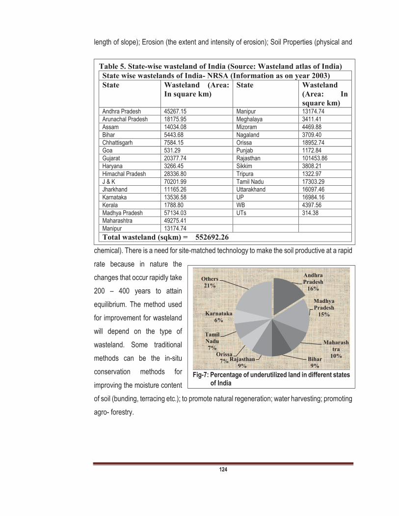
124
length of slope); Erosion (the extent and intensity of erosion); Soil Properties (physical and
chemical). There is a need for site-matched technology to make the soil productive at a rapid
rate because in nature the
changes that occur rapidly take
200 400 years to attain
equilibrium. The method used
for improvement for wasteland
will depend on the type of
wasteland. Some traditional
methods can be the in-situ
conservation methods for
improving the moisture content
of soil (bunding, terracing etc.); to promote natural regeneration; water harvesting; promoting
agro- forestry.
Table 5. State-wise wasteland of India (Source: Wasteland atlas of India)
State wise wastelands of India- NRSA (Information as on year 2003)
State Wasteland (Area:
In square km)
State Wasteland
(Area: In
square km)
Andhra Pradesh 45267.15 Manipur 13174.74
Arunachal Pradesh 18175.95 Meghalaya 3411.41
Assam 14034.08 Mizoram 4469.88
Bihar 5443.68 Nagaland 3709.40
Chhattisgarh 7584.15 Orissa 18952.74
Goa 531.29 Punjab 1172.84
Gujarat 20377.74 Rajasthan 101453.86
Haryana 3266.45 Sikkim 3808.21
Himachal Pradesh 28336.80 Tripura 1322.97
J & K 70201.99 Tamil Nadu 17303.29
Jharkhand 11165.26 Uttarakhand 16097.46
Karnataka 13536.58 UP 16984.16
Kerala 1788.80 WB 4397.56
Madhya Pradesh 57134.03 UTs 314.38
Maharashtra 49275.41
Manipur 13174.74
Total wasteland (sqkm) = 552692.26
Fig-7: Percentage of underutilized land in different states
of India
Andhra
Pradesh
16%
Madhya
Pradesh
15%
Maharash
tra
10%Bihar
9%
Rajasthan
9%
Orissa
7%
Tamil
Nadu
7%
Karnataka
6%
Others
21%
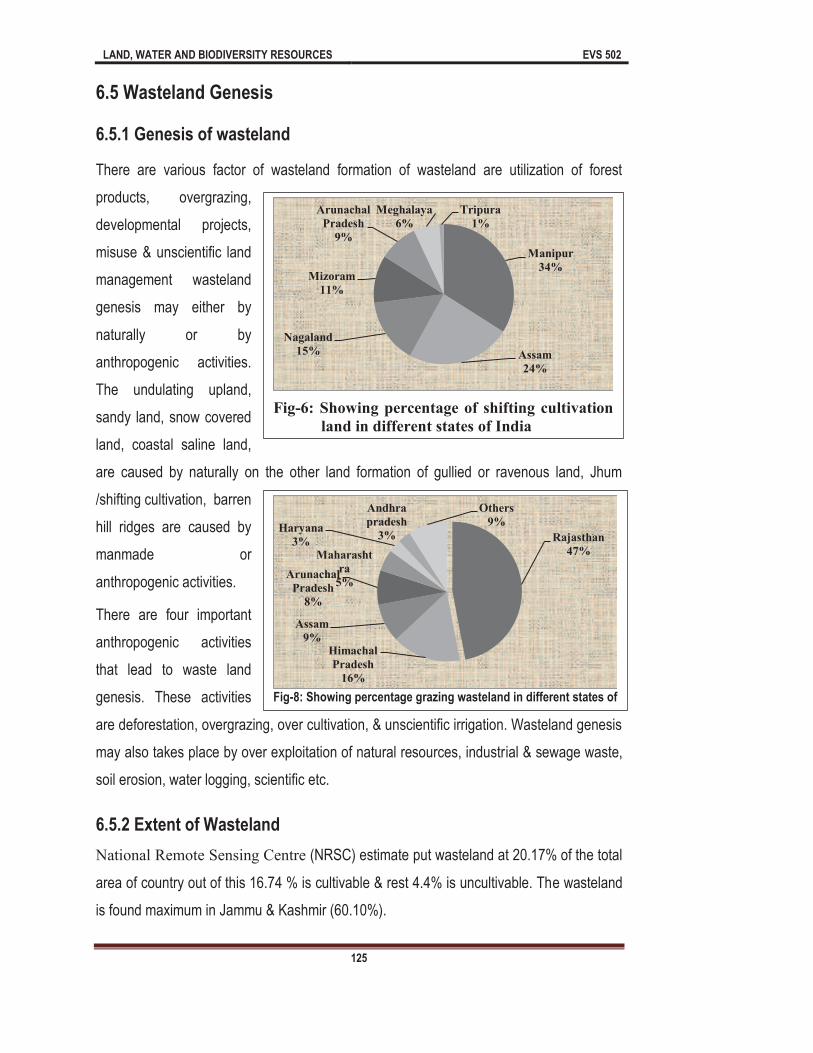
LAND, WATER AND BIODIVERSITY RESOURCES EVS 502
125
6.5 Wasteland Genesis
6.5.1 Genesis of wasteland
There are various factor of wasteland formation of wasteland are utilization of forest
products, overgrazing,
developmental projects,
misuse & unscientific land
management wasteland
genesis may either by
naturally or by
anthropogenic activities.
The undulating upland,
sandy land, snow covered
land, coastal saline land,
are caused by naturally on the other land formation of gullied or ravenous land, Jhum
/shifting cultivation, barren
hill ridges are caused by
manmade or
anthropogenic activities.
There are four important
anthropogenic activities
that lead to waste land
genesis. These activities
are deforestation, overgrazing, over cultivation, & unscientific irrigation. Wasteland genesis
may also takes place by over exploitation of natural resources, industrial & sewage waste,
soil erosion, water logging, scientific etc.
6.5.2 Extent of Wasteland
National Remote Sensing Centre (NRSC) estimate put wasteland at 20.17% of the total
area of country out of this 16.74 % is cultivable & rest 4.4% is uncultivable. The wasteland
is found maximum in Jammu & Kashmir (60.10%).
Fig-6: Showing percentage of shifting cultivation
land in different states of India
Manipur
34%
Assam
24%
Nagaland
15%
Mizoram
11%
Arunachal
Pradesh
9%
Meghalaya
6%
Tripura
1%
Fig-8: Showing percentage grazing wasteland in different states of
Rajasthan
47%
Himachal
Pradesh
16%
Assam
9%
Arunachal
Pradesh
8%
Maharasht
ra
5%
Haryana
3%
Andhra
pradesh
3%
Others
9%

LAND, WATER AND BIODIVERSITY RESOURCES EVS 502
126
1. Salinity: Improper irrigation and high rainfall in the absence of proper drainage can leads
to salinization of soil. Salinization can cause high concentration of salts in soil profile.
Salinity of soil is also
responsible for
genesis of
wasteland. Seepage
from canals high
underground water
level, saline ground
water also
responsible for
salinity. Salinity
makes the land unproductive & unculturable.
2. Water logged Areas: About 6 million hectare area of India is water logged. Water logging
restricts the normal circulation of air in soil. The water logging also responsible for high
salinity in soil. Water logging also leads in to genesis of wasteland.
3. Shifting Cultivation: Shifting cultivation is type of agriculture in which dense forest
cleared for the cultivation of crops. After using the fertile soil of forests farmers look for
another forest & practiced similar activity in another part of forest. This type of agriculture
practice also responsible for genesis of wasteland. In India this type of agriculture practice
mainly takes place in North-East states. Shifting cultivation or jhuming is a primitive form
of cultivation practised in north-eastern states of India or in regions where land is not a
limiting factor. The dense forest and other vegetation on the slopping or other land is
cleared and crops raised without any management. For management of jhumed land the
suitable land for intensive cultivation have to be identified. Depending on the climatic
factors, soil characters and other related features intensive system of land use and
cropping pattern will have to be evolved for each specific site without being damaging to
environment.
Fig-14: Showing factors contributing to wasteland genesis

LAND, WATER AND BIODIVERSITY RESOURCES EVS 502
127
4. Deforestation: Due to rapid destruction of forest, huge amount of land converted is to
waste land. As you know forest are important to maintain of fertility of soil, but due to high
demands of infrastructure, food the forest land converting is to wasteland. Forests are
also home to many species, these species also helpful in maintaining soil fertility. Due to
deforestation these valu
deforestation is also important factor of wasteland genesis.
5. Excessive use of Agro-chemicals: Agro chemicals refer to chemicals which are used
in the agriculture. These chemical may include fertilizers and pesticides. Excessive use
of these agrochemicals not only responsible for extinction of valuable species of land but
also responsible for genesis of wasteland.
6. Industrial activities: Various types of industries release their effluent on land
ecosystem, sometimes industrial effluent contains very toxic chemical which destroy the
overall biodiversity of land. Industrial waste material makes land unproductive and
infertile and cause genesis of wasteland.
7. Landslide: The problem of landslides and landslips is common especially in the hilly
areas posing threat to agricultural lands, highways and village habitants. The main
causes for land-slides are weak geological formations, seismic disturbances, improper
land use, deforestation, mining etc. Landslides and landslips may change the structure
of landscape, and responsible for wasteland genesis.
6.6 Conservation of Land
Land conservation may comprise as preservation, restoration, remediation & mitigation.
In preservation process
the land and their related
resources, not are
exploited by man and
should instead by
maintained is their natural
form. Restoration involves
the process is which land
ecosystems & related
Fig-15. Showing different steps in Land conservation
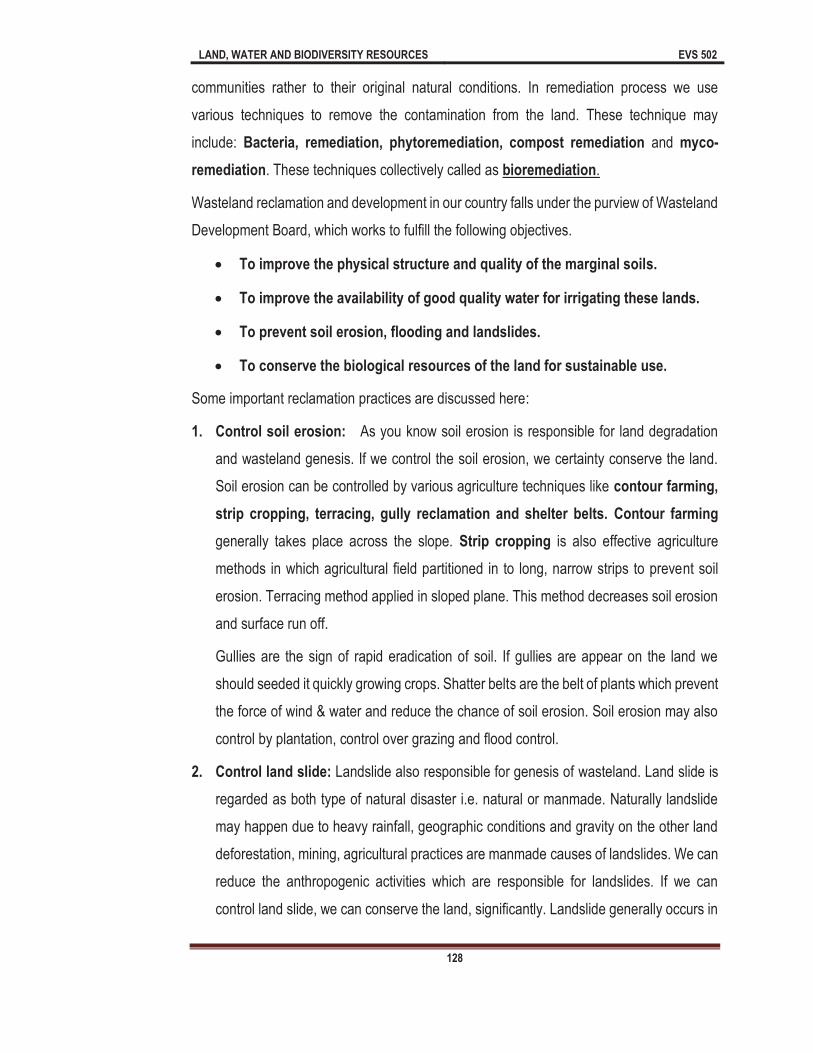
LAND, WATER AND BIODIVERSITY RESOURCES EVS 502
128
communities rather to their original natural conditions. In remediation process we use
various techniques to remove the contamination from the land. These technique may
include: Bacteria, remediation, phytoremediation, compost remediation and myco-
remediation. These techniques collectively called as bioremediation.
Wasteland reclamation and development in our country falls under the purview of Wasteland
Development Board, which works to fulfill the following objectives.
To improve the physical structure and quality of the marginal soils.
To improve the availability of good quality water for irrigating these lands.
To prevent soil erosion, flooding and landslides.
To conserve the biological resources of the land for sustainable use.
Some important reclamation practices are discussed here:
1. Control soil erosion: As you know soil erosion is responsible for land degradation
and wasteland genesis. If we control the soil erosion, we certainty conserve the land.
Soil erosion can be controlled by various agriculture techniques like contour farming,
strip cropping, terracing, gully reclamation and shelter belts. Contour farming
generally takes place across the slope. Strip cropping is also effective agriculture
methods in which agricultural field partitioned in to long, narrow strips to prevent soil
erosion. Terracing method applied in sloped plane. This method decreases soil erosion
and surface run off.
Gullies are the sign of rapid eradication of soil. If gullies are appear on the land we
should seeded it quickly growing crops. Shatter belts are the belt of plants which prevent
the force of wind & water and reduce the chance of soil erosion. Soil erosion may also
control by plantation, control over grazing and flood control.
2. Control land slide: Landslide also responsible for genesis of wasteland. Land slide is
regarded as both type of natural disaster i.e. natural or manmade. Naturally landslide
may happen due to heavy rainfall, geographic conditions and gravity on the other land
deforestation, mining, agricultural practices are manmade causes of landslides. We can
reduce the anthropogenic activities which are responsible for landslides. If we can
control land slide, we can conserve the land, significantly. Landslide generally occurs in

LAND, WATER AND BIODIVERSITY RESOURCES EVS 502
129
hill region. Landslides cab be controlled by plantation, we should maintain the vegetation
as much as possible on slopes. In addition to that uncontrolled or excessive irrigation
must be avoided in landslide prone area.
3. Afforestation: Forest play very important role in conservation of land. Forest maintains
the fertility of land, and keeps the soil moist and fertile. Afforestation also contributes to
sustainable management of land. Ministry of Environment, Forest and Climate Change
(MoEFCC) has target at 5 million hectare wasteland recovery through afforestation.
4. Improve agriculture practices: Conservation of land can be done with modern,
sustainable and appropriate agricultural practices. In these sustainable agricultural
practices farmers use bio-fertilizers, bio-insecticides, bio-pesticides, micro-irrigation
techniques.
5. Solid Waste management: For the conservation of land we should manage the solid
waste. As you know solid waste is responsible for genesis of wasteland and it contains
very harmful chemicals, which gradually degrade the quality of soil. If we can manage
the solid waste of the cities and industries then we can conserve the land resources
significantly.
6.7 Management of Wasteland
Management of land is process in which we can manage the land resource and also can
develop land
resources for this
generation as well as
for future generations.
Land management
can be done if we
consider the factors
responsible for
wasteland generics.
There are various
methods which are
certainly helpful in land management. These methods are described below:
Fig-15- Showing different methods in Land Managem

LAND, WATER AND BIODIVERSITY RESOURCES EVS 502
130
ent
1. Forest Conservation: Forest conservation is best tool to conserve land resources.
Increasing degradation of forests specially, in the hilly regions contribute to heavy soil
erosion. It cause acute shortage of firewood and loss of productivity due to degraded
land. The National Forest Policy clearly identified the various use of forests, rights of
communities, including the inadvisability of protecting forest resources without their
active participation, and the role that forests play in the survival strategies of the poor.
The major systems in the Wildlife division focus on conservation, protection and
development of wildlife and their habitat. The main strategy for conversation of bio-
diversity is protection of variable habitats in representative ecosystems. A wide network
of 103 National Parks, 503 Wildlife Sanctuaries, 30 Tiger reserves and 18 Biosphere
reserves have contributed towards conservation of these species and forest resources
too. Finally, environmental resource management must be seen as a measure for the
optimum utilization of the scarce natural resources available in India and to safeguard
and preserve the environment around us. It is well observed that a large area in the
country is eroded due to soil erosion by water. The causes of this erosion are mainly
lack of vegetative cover, slope, nature of soil, rainfall, and its intensity, cropping system
and land management. Depending upon intensity soil erosion it may be categorized into
i) Sheet erosion
ii) Gully erosion
iii) Ravines.
Appropriate measures based on these categories may be suggested to check runoff and
loss of soil. Cultural practices used for checking runoff and soil loss include planting
erosion-resistant crops, like legumes and grasses, adopting suitable cropping system,
management and use of mulches. Mechanical measures involving some degree of earth
movement like bunding terracing etc. are found effective in checking runoff and soil loss
by increasing the time of concentration and reducing velocity of runoff. Contour
cultivation and graded trenching (diversion) are also effective for erosion control.

LAND, WATER AND BIODIVERSITY RESOURCES EVS 502
131
2. Grassland development: Development of grassland ecosystem also important aspect
to manage the land resources. Grass binds the soil particles and prevents the soil
erosion. Grasses like Cenchrus ciliaris, Lasiurus sindicus etc. were found effective in
arresting drifting of soil. It is suggesting that degraded lands in wind erosion prone areas
may be kept back under the grasses. If we develop grassland ecosystem then we can
manage the land resources significantly.
3. Strip Cropping: Strip cropping is also effective methods in land management. The field
strip cropping of grain legumes or cereals in grass strips developed at the Central Arid
Zone Research Institute (CAZRI) is very effective tool for controlling wind erosion.
4. Mulching: Mulching is found very effective in reducing the wind erosion.
5. Agro-horticultural forestry in Wasteland: This system is the combination of food and
vegetable crops with related to horticultural crops. This system is noticed more common
in the developing orchards in which trees have not started fruiting. Most commonly
legumes and oil seeds are grown in such fields/orchards. The tall growing fruit trees are
pruned in such a way to facilitate easy cultural operations and any seasonal crop like
wheat, gram etc. is cropped in inter-row space. These crops not only enhance per unit
land income but also manage the land by covering the field.
6. Agro forestry: Agroforestry is effective method for the management of land. Indeed it
is land management system in which trees or plants are grown within pasture land. It is
a self sustaining land management system which combines production of agricultural
crops with trees, livestock and plants simultaneously or consequently on the same area
of land. This type of approach increases the biodiversity, soil productivity and economy.
7. Agronomic Approach for vegetative Cover: As it is earlier mentioned that plants,
trees and grasses play very significant role in land management. Bringing the land
resources under proper vegetation check or prevent most of the degradation of the land.
The vegetative cover may be for various uses like for forage and fuel, sustained crop
production, pasture, silviculture and other socio-economic uses.
8. Forage and fuel production: As you know that the degraded lands and wastelands
are ecologically unbalanced and have lost their top fertile soils and have developed
toxicity which hinders growth of the plants, crops and trees. Under managed conditions
LAND, WATER AND BIODIVERSITY RESOURCES EVS 502
132
with basic inputs, it has been found possible to grow high-yielding grasses, legumes and
trees for forage and fuel purposes. The suggested species of trees, grasses and
legumes are: Acacia tortilis, A. lebbek, Herdwzoka binata, Leucaena leucocaphale,
Dalbergza sissoo, D. latifolia, Azadirachta indica, Cenchrus ciliaris, Sehima nervosum,
Stylosanthes hamata, Phaseolus atropurpureaus etc.
9. Sustained Land use: Human being entirely depends on land resources for their daily
needs. Unfortunately, human being over exploited these resources. If we can reduce
the extra needs and greed of human being then we can manage the natural resources.
We should minimize the burden on fuel, fodder, food etc. Excessive use of chemicals
(pesticides, insecticides, rodenticides, molluscides, herbicides, chemical fertilizers)
should avoid.
10. Pasture Management: By pasture management technology we can manage the
land resource. This It involves a combination of number of steps, package of practices
and inputs like renovation of degraded range lands and their restructuring with mosaic
flora or species or cultivars of grasses and legumes in pure and mixed stand and
upgrading the soil and plant nutrients through fertilizer application. In this technology
pasture kept free from unwanted weeds, toxic substances, solid waste etc. Various
types of plants are also grown in pasture management technology. The desirable
species for pasture management are Conchrus setigerus, C. ciliaris, Lasiurus sindicu,
Panicum antidetab etc.
11. Silvipasture Management: Greater demand for fuel wood and small timber for human
consumption and the forage and fodder for livestock and wildlife and also contribute the
land degradation. Silvipasture seems to be the best system for economic utilization of
degraded or waste lands. Silvipasture system of land management covers three major
items:
Trees valuable in themselves as conserver of land and for improve of climate
specially in arid and semi-arid zones besides their fuel and timber values.
Animals grazing on the pasture and feeding on the leaves of nutritious trees and
shrubs.
LAND, WATER AND BIODIVERSITY RESOURCES EVS 502
133
Occasional production of cash crops. In this system the plant components chosen
are trees, shrubs, grasses and legumes.
12. Socio-economic consideration for optimum land use: Land management can be
done with optimum use of land. For a balanced ecological system it is a well
established fact that 33% total geographical area should be under forest. To a big
amount farmers are choosing cash crops like wheat and paddy to get more profit but
still there is a gap between the production and requirement of oilseeds pulses and forage
crops. Depending upon the suitability and other regional factors like soil, available
facilities and need, growing oilseeds, forage and pulses on partially degraded land may
balance the social and economic aspects of human life. While bringing the uncultivable
land under forest will definitely improve our ecology and environment.
Summary
In this unit we have discussed types, genesis, conservation and management of Wasteland.
So far you have learnt that:
Land is useful resource and may occur in the form of crop land, barren land, grass
land, range land, snowy land, arid land and waste land.
Land is terrestrial bio-productive ecosystem. It comprises of soil, water, plants and
other biotic communities. On the basis of ecological conditions land may be as:
Cropland, Barren land, wetland, arid dry land, Range land, Grassland, Snowy land
and Wasteland.
previously used, but which has been abandoned, and for which no further use has
Wasteland Survey and Reclamation Committee, Ministry of food and Agriculture,
Govt. of India (1961) has defined wastelands as those lands which are either not
available for cultivation or left out without being cultivated for some reason or other.
soil has nearly been completely lost, and (c) which have developed toxicity in the
root zones or growth of most plants, both annu
LAND, WATER AND BIODIVERSITY RESOURCES EVS 502
134
Wasteland may as culturable Wasteland which is has potential for the development
of vegetative cover and is not being used due to different constraints of varying
degrees, such as erosion, water logging, salinity etc. and Unculturable Wasteland,
which land that cannot be developed for vegetative cover, for instance the barren
rocky areas and snow covered glacier areas.
There are various types of wasteland found in India, wasteland land of India may
categorized as Gullied or ravenous land, Land with\ without scrub, Water
legged\marshy land, Land affected by salinity, Shifting cultivation land, Degraded
notified forest land, Degrading grazing land, Degraded land under plantation, Sandy
area, Mining industrial waste land, Stony land/barren rocky/sheet rocky land, Steep
sloping area, Snow covered glacier area. About 63 million hectare area of India
regarded as wasteland.
Genesis of wasteland may cause naturally or by anthropogenic activities. The
causes od wasteland genesis are : Salinity, Water logging, Shifting Cultivation,
Deforestation, Excessive use of fertilizers, Industrial activities, Water logging,
Landslide,
Land conservation may be done through various process such as Control soil
erosion, Control land slide, Afforestation, Improve agriculture practices, Solid Waste
management, Control Water Logging etc.
Management of land may be done through forest conservation, grassland
development. strip cropping, mulching, Agro-horticultural forestry in wasteland, agro
forestry, agronomic approach for vegetative Cover, Forage and fuel production,
sustained land use, pasture management, silvi-pasture management, socio-
economic consideration for optimum land use etc.
Terminal Questions
(a) Fill in the blank spaces with appropriate words.
In
and formed channels called Gullies. The land with or without scrub maximum in llowed by Maharashtra (16%), Rajasthan (14%) and Gujarat (11%). This
LAND, WATER AND BIODIVERSITY RESOURCES EVS 502
135
highest water logged lanBengal (12%). Soil salinity or alkalinity severally affects the growth of plants. Soil salinity or alkalinity severally affects the growth of plants. As you know salinity of soil is controlling factor
2 (a) Give the definitions of wasteland.
(b) What are the types of wasteland? Explain
3 (a) Differentiate between culturable and unculturable wasteland.
(b) Give a note on wasteland of India
4 a) Define wasteland genesis. Write about factors which are responsible for wasteland genesis.
5 (a) Write about steps involved in land conservation.
(b) Write a note on Land Conservation.
(c) What are objectives of Wasteland Development Board?
6 (a) Fill the blank spaces with appropriate words.
of forests for cultivation this type of was
Tripura (1%). Underutilized wasteland is maximum in Andhra Pradesh (16%) followed by Madhya Pradesh (15%) and Maharashtra (10%). Over grazing also responsible for
(16%), Assam (9%) and Arunachal Pradesh (8%). Land degraded due to plantation is maximum in Himachal Pradesh (42%) followed by Madhya Pradesh (16%), Maharashtra (12%) and Jammu & Kashmir (11%). Land also covered by snow which is also regarded
%), Himachal Pradesh (23%), Arunachal Pradesh (12%) and Sikkim (3%).
(b) Which part of Country has maximum wasteland due to shifting cultivation? (North-East/South-West/Eastern Part/Northern Part)
(c) Which state of India has maximum wasteland? (Jammu & Kashmir/Gujarat/ Uttarakhand/ Madhya Pradesh)
(d) Which one is not responsible for wasteland genesis? (Bioremediation/Deforestation/Overgrazing/Water logging)
(e) What do you understand by shifting cultivation?
7 (a) Write a detailed essay on Land management.
Answers to the terminal questions

LAND, WATER AND BIODIVERSITY RESOURCES EVS 502
136
1 (a) 114.01Mha, water, Madhya Pradesh, wetlands, aquatic, terrestrial, Uttar Pradesh, 38%, Uttar Pradesh
2 (a) See the section 6.2, (b) See the section 6.3.
3 (a) See the section 6.3, (b) See section 6.4
4 (a) See section 6.5 and Fig. 14
5 (a) See the section 6.6 and Fig.15, (b) See the 6.6, (c) See section 6.6
6 (a) Shifting cultivation, North-East states, 34%, Assam, 15%, wasteland, Rajasthan, Jammu & Kashmir, Uttrakhand, (b) North-East, (c) Jammu & Kashmir, (d) Bioremediation, (e) See the section 6.5 (Shifting Cultivation)
7 (a) See the section 6.7.
LAND, WATER AND BIODIVERSITY RESOURCES EVS 502
137
Unit 7 Land Related Hazards and Mitigation: Landslides, Landslips, Earthquake, Droughts
Unit Structure
7.0 Learning Objectives
7.1 Introduction
7.2 Land Related Hazards
7.2.1 Landslide / Landslips
7.2.1.1 Types of Landslides/Landslips
7.2.1.2 Causes of Landslides/Landslips
7.2.1.3 Impacts of Land Slides
7.2.1.4 Mitigation Measures of Landslide/Landslips
7.2.2 Earthquakes
7.2.2.1 Types of Earthquakes
7.2.2.2 Causes of Earthquake
7.2.2.3 Impacts of Earthquakes
7.2.2.3 Mitigation Measures of Earthquake
7.2.3 Drought 7.2.3.1 Types of Drought 7.2.3.2 Causes of Drought 7.2.3.3 Impacts of Drought 7.2.3.4 Mitigation Measures of Drought
Summary
7.0 Learning Objectives
After studying this unit you will be able to:
describe land related hazards
define landslides, landslips, earthquake and drought
discuss the types of landslides, landslips and drought
discuss the causes, impacts and mitigation measures of Landslides
discuss the causes, impacts and mitigation measures of Earthquake
discuss the causes, impacts and mitigation measures of drought.
LAND, WATER AND BIODIVERSITY RESOURCES EVS 502
138
7.1 Introduction
The solid Earth is the repository of the raw materials that support life. Our natural resources
and habitat are ultimately the result of dynamic processes within our planet, processes that
are also source of natural disasters. According to estimation thousands of people will be
lost in the upcoming times from catastrophic earthquakes, droughts, floods, and landslides.
Billions or millions of dollars will be needed to mitigate losses from these natural disasters
as well as from slower ongoing processes such as land subsidence, soil and water
contamination, and erosion. Basic scientific advances are needed to inform these
investments to protect life and infrastructure. Landslides, earthquakes and droughts are
regarded and classified as natural disasters. These are natural phenomena that might have
great negative impacts on ecology and socio-economy on any Nation. Natural disasters
mainly categorized as two broad types. First category is Geophysical disaster and these
may include earthquake, drought, landslides, volcanic eruption, flood, forest fires etc.
Second category of natural hazard is biological hazard which may include diseases and
manm
hazard may be categorized as:
On the basis of source of energy these may be biological (energy source are living
organisms example are: diseases and infections) chemical (energy source are chemical
components) physical (energy sources are physical activities of earth examples:
Earthquake, cyclones). On the basis of origin these may be natural (Earthquake, floods,
Tsunamis) and Manmade (Chemical hazards, industrial hazards etc). There are various land
related hazards which are originate on land and can affect the ecological, social and
economical conditions of the area. You know that earthquake, landslides, landslips, droughts
are the natural disasters which happen in land ecosystem. The causes and effect of land
related hazards are enormous and uncountable. In this unit you will learn about land related
hazards and their mitigation measure with special reference to landslides, landslips,
earthquake and drought.
LAND, WATER AND BIODIVERSITY RESOURCES EVS 502
139
7.2 Land Related Hazards
Land related hazards are those natural hazards which happened in land and destroy the
land ecosystems. There are various types of land related hazards such as landslides,
landslips, earthquake, drought, flood, volcanic eruption etc. These land related hazards
caused by natural and manmade activities. There are various types of Land related hazards
such as Landslide / Landslips, Earthquake and droughts. They are described in the following
subheads.
7.2.1 Landslide / Landslips
Landslides/ landslips are defined as, Landslide is a general term for a wide variety of down
slope movements of earth materials that results in downward and outward movement of soil,
Landslide is a general term for a wide variety of down slope movements of earth materials
that results in downward and outward movement of soil, rock and vegetation under the
influence of gravity. Some landslides are rapid, occurring in seconds, whereas other may
take hour, weeks or even longer time. Debris flows are fluid mass of rock, earth and other
debris saturated with water. Mudflows or debris flows are characters of steep, scanty
vegetated slopes on which heavy rainfall initiates movement in thick layer of weathered
material. They develop when water rapidly accumulates in the ground, such as during heavy
rainfall or rapid snowmelt, changing the earth into a flowing river of mud or slurry. Slurry can
flow rapidly down slopes or through channels, and can strike with little or no warning at
avalanche speeds.
The landslides occur in mountainous hilly regions of Himalaya or at the western ghat.
However, landslides occur more frequently in Himalayan region due to their fragile nature.
7.2.1.1 Types of Landslides/Landslips
As per Varnes (1978) landslides may be of following types:
1. Falls: It is huge movement of materials that become detached from steep slopes or
cliffs, moving by free fall, bouncing and rolling.
2. Flows: In this type many types of mass movement takes place such as creep, debris
flow, debris avalanches and mudflow.

LAND, WATER AND BIODIVERSITY RESOURCES EVS 502
140
3. Creep: In this types slow steady down slope movement of soil or rocks.
4. Debris flow: In this type of landslide rapid mass movement, in which loose soils,
rocks and organic matters combine with entrained air and water to form slurry that
then flows down slope, usually associated with steep gullies.
5. Debris avalanches: A variety of very rapid to extremely rapid debris flow.
6. Lahar: Mudflow or debris flow that originates on the slope of a volcano, usually
triggered by heavy rainfall eroding volcanic deposits, sudden melting of snow and
ice due to heat from volcano vents or the breakout of water from glaciers, crater
lakes or lakes dammed by volcanic eruption.
7. Mudflow: Rapidly flowing mass of wet material that contains at least 50% sand, silt
and clay sized particles.
Lateral Spreads: Often occur on very gentle slopes and result in nearly horizontal
movement of earth materials. Lateral spreads usually are caused by liquefaction, where
saturated sediments (usually sand and silts) are transformed from a solid into a liquefied
state, usually triggered by an earthquake.
7.2.1.2 Causes of Landslides/Landslips
Many factors such as geography, gravity, weather, ground water, wave action, type of soil,
wave action and human activities are responsible for landslides. Although landslides usually
occur on steep slopes, they also can occur in areas of low relief. Landslides can occur as
ground failure of river bluffs, cut and fill failures that may accompany highway and building
excavation, collapse of mine waste piles and slope failures associated with quarries and
open pit mines. Underwater landslide usually involves areas of low relief and small slope
gradients in lakes and reservoirs or in offshore marine settings. The causes of landslides
may be natural or anthropogenic as follows:
A) Natural causes Landslides/Landslips: The natural causes of landslides include:
1. Gravity: Gravity works more effectively on steeper slopes, but more gradual slopes
may also be vulnerable.
2. Geological factors: many slides occur in geological setting that places permeable
sands and gravel above impermeable layer of silt and clay or bedrock. Water seeps

LAND, WATER AND BIODIVERSITY RESOURCES EVS 502
141
downward through the upper materials and accumulates on the top of the underlying
units, forming a zone of weakness.
3. Heavy and Prolonged rainfall: Water is commonly the primary factor triggering a
landslide. Slides often occur following intense rainfall, when storm water runoff
saturates soils on steep slopes or when infiltration causes a rapid rise in ground
water levels. Ground water may rise as a result of heavy rains or a prolonged we
spell. As water tables rise, some slopes become unstable.
4. Earthquake: Seismic activities have always been a main cause of landslides
throughout the world. Any time tectonic plates move the soil that covers moves with
it. When earthquakes occur on areas with steep slopes, many times the soil slips
causing landslides. Furthermore, ashen debris flows caused by earthquakes can
also trigger mass movement of soil.
5. Forest fires: Forest fires cause soil erosion and induce floods and landslides due
to the destruction of natural vegetation.
6. Volcanoes: Strato volcanoes are prone to sudden collapse, specially during wet
conditions. The conditions commonly prevail after volcanic eruption that kill
vegetation over extensive areas and spread loose volcanic rocks over the
landscape. During subsequent rainy seasons, swollen rivers will erode the new
deposits and sometimes generates lahars that are dangerous to people
downstream.
7. Waves: Wave action can erode the beach or the toe of a bluff, cutting into the slope
and setting the stage for future slide.
B) Anthropogenic causes of landslides/landslips: Human actions most notably those
that affect drainage or groundwater can trigger landslides. Some of the important manmade
actions which are responsible for landslides are described below:
1. Inappropriate drainage system: Natural drainage lines on slopes are blocked by
terracing/contour bounding adopted to prevent soil erosion and enhance percolation
during dry season for cultivation, without adequate provision for surface drainage of
excess storm water during high intensity rains increase the landslide vulnerability.
LAND, WATER AND BIODIVERSITY RESOURCES EVS 502
142
2. Deep Excavation on slopes for buildings roads, canals and mining:
Developmental activities like construction of buildings, roads, embankment,
cut and fill structures cause modification of natural slopes. These types of
activities are highly responsible for landslides.
3. Change in slope/land use pattern, deforestation, agricultural practices on
steep slopes: Deforestation and cultivation of seasonal crops and increase
in settlement. Improper land use practices such as heavy tilling, agricultural
practices and settlement patterns have contributed to creep and withdrawal
of toe support in many cases.
7.2.1.3 Impacts of Land Slides
There are various effect of landslides which are given below:
1. Change the shape of land: Landslides can change the whole structure of
landscape. It completely abrupt the structure of mountains and hilly area. Many
beautiful ecosystems such as ponds, lakes, forest etc. may damage and loss their
structure due to heavy landslides. Uttarakhand, Jammu and Kashmir, Himachal
Pradesh, Manipur Mizoram are prone to land slides. Landslides frequently occur in
hilly regions.
2. Loss of human life: Landslide is type of natural disaster which may lead in to loss
of human life. People who are living in the foot of hills and mountainous region are
at great risk of death due to landslides.
3. Ecosystem Impacts: Landslides can impact the forest, land and aquatic
ecosystems. The debris can find way in the natural rivers and springs and block
their natural ecological flow. Many water parameters such as transparency, turbidity,
total solids, total dissolved solids, dissolved oxygen can be affected due to
landslides.
4. Economical impacts: Landslides can damage the infrastructure of schools,
educational institutions, hospitals, industries, roads and other transport systems.
The repairing of these things are very costly and disturb the economy of the states
or countries.
LAND, WATER AND BIODIVERSITY RESOURCES EVS 502
143
7.2.1.4 Mitigation Measures of Landslide/Landslips
A landslide is caused by combination of various factors (topography, geology, geological
structure, ground water etc). Accordingly, measures to be taken for landslide prevention
come in a variety of types. Landslides can be controlled by following preventive measures.
Before Landslide/Disaster
Identify the area here you live and note the frequencies of landslide in your area.
Plantation should be done over slope therefore roots can stabilize the soil.
Cover slope with concrete, while putting pipes in it to let the water from the top out.
dslide hazard area.
Make sure that all water pipes do not leak.
Make a strong wall in front of the bottom of the slope to prevent any lahars or flow
to run rapidly, which also change the direction of flow.
Make sure to stay indoors when the landslide warning is given
Stay away from mountainous area where there is heavy rain.
Water pipes could also be put in to slope so the water can be taken out, preventing
it from flowing too high which provides a slimmer chance of a landslide.
During landslide/Disaster
Stay alert and awake, many debris flows occur when people are sleeping. Listen to
a weather radio or portable radio or television for warnings of intense rain fall. Be
aware that intense, short burst of rain may be particularly dangerous, specially after
long period of heavy rainfall and damp weather.
If you are in area at risk to landslides and debris flows, consider leaving if it is safe
to do so. Remember that driving during heavy rain can be hazardous. If you remain
at home, move to a second story if possible.
Listen for any unusual sounds that might indicate moving debris, such as trees
cracking or boulders knocking together. A trickle of flowing or falling mud or debris

LAND, WATER AND BIODIVERSITY RESOURCES EVS 502
144
may precede larger landslides. Moving debris can flow quickly and sometimes
without warning.
If you are near a stream or river, be alert for any sudden increase or decrease in
water flow and for a change from clear to muddy water. Such changes may
indicate landslides in upstream.
Be especially alert when driving. Embankments along roadsides are particularly
susceptible to landslides. Watch the road for collapsed pavement, mud, fallen rocks
and other indication of possible debris flow.
After the landslide
Keep yourself and family members away from the landslide area. There may be
danger of further landslide.
Check for injured and trapped person near the landslide, without entering the direct
slide area.
Help a neighbor who may require special assistance-infants, elderly people, and
people with disabilities.
Listen or watch to local radio or television stations for the latest emergency
information.
Watch for flooding and heavy rain, which may occur after a landslide or debris flow.
Flood and heavy rain sometimes follow landslides and debris flows because they
may both be started by the same event.
Check the foundations of building, chimney and surrounding land for damage.
Damage to foundations, chimney or surrounding land may help to assess the safety
of the area.
7.2.2 Earthquakes
Earthquakes are most dangerous and devastating form of natural disaster it can destroy
millions of life, building, infrastructure within few minutes. Therefore, Earthquake is the most
fearful natural phenomena in the human life. It is more so because it is unpredictable and
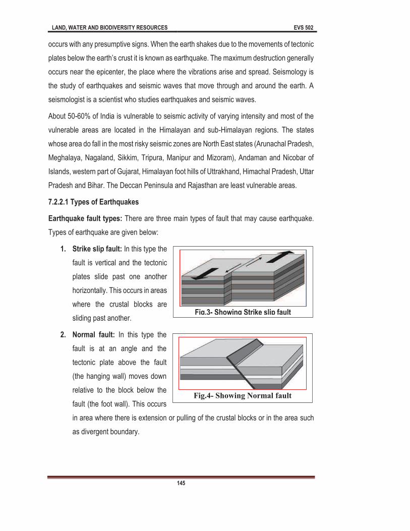
LAND, WATER AND BIODIVERSITY RESOURCES EVS 502
145
occurs with any presumptive signs. When the earth shakes due to the movements of tectonic
occurs near the epicenter, the place where the vibrations arise and spread. Seismology is
the study of earthquakes and seismic waves that move through and around the earth. A
seismologist is a scientist who studies earthquakes and seismic waves.
About 50-60% of India is vulnerable to seismic activity of varying intensity and most of the
vulnerable areas are located in the Himalayan and sub-Himalayan regions. The states
whose area do fall in the most risky seismic zones are North East states (Arunachal Pradesh,
Meghalaya, Nagaland, Sikkim, Tripura, Manipur and Mizoram), Andaman and Nicobar of
Islands, western part of Gujarat, Himalayan foot hills of Uttrakhand, Himachal Pradesh, Uttar
Pradesh and Bihar. The Deccan Peninsula and Rajasthan are least vulnerable areas.
7.2.2.1 Types of Earthquakes
Earthquake fault types: There are three main types of fault that may cause earthquake.
Types of earthquake are given below:
1. Strike slip fault: In this type the
fault is vertical and the tectonic
plates slide past one another
horizontally. This occurs in areas
where the crustal blocks are
sliding past another.
2. Normal fault: In this type the
fault is at an angle and the
tectonic plate above the fault
(the hanging wall) moves down
relative to the block below the
fault (the foot wall). This occurs
in area where there is extension or pulling of the crustal blocks or in the area such
as divergent boundary.
Fig.3- Showing Strike slip fault
Fig.4- Showing Normal fault
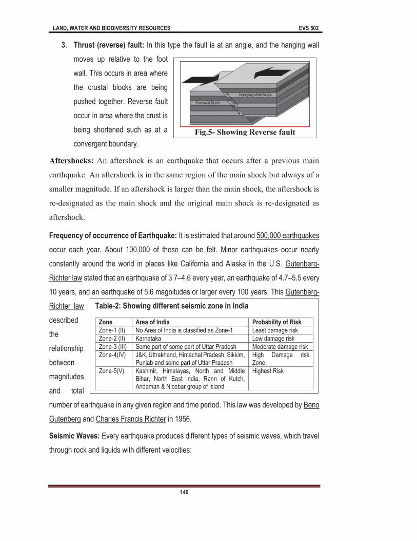
LAND, WATER AND BIODIVERSITY RESOURCES EVS 502
146
3. Thrust (reverse) fault: In this type the fault is at an angle, and the hanging wall
moves up relative to the foot
wall. This occurs in area where
the crustal blocks are being
pushed together. Reverse fault
occur in area where the crust is
being shortened such as at a
convergent boundary.
Aftershocks: An aftershock is an earthquake that occurs after a previous main
earthquake. An aftershock is in the same region of the main shock but always of a
smaller magnitude. If an aftershock is larger than the main shock, the aftershock is
re-designated as the main shock and the original main shock is re-designated as
aftershock.
Frequency of occurrence of Earthquake: It is estimated that around 500,000 earthquakes
occur each year. About 100,000 of these can be felt. Minor earthquakes occur nearly
constantly around the world in places like California and Alaska in the U.S. Gutenberg-
Richter law stated that an earthquake of 3.7 4.6 every year, an earthquake of 4.7 5.5 every
10 years, and an earthquake of 5.6 magnitudes or larger every 100 years. This Gutenberg-
Richter law
described
the
relationship
between
magnitudes
and total
number of earthquake in any given region and time period. This law was developed by Beno
Gutenberg and Charles Francis Richter in 1956.
Seismic Waves: Every earthquake produces different types of seismic waves, which travel
through rock and liquids with different velocities:
Fig.5- Showing Reverse fault
Table-2: Showing different seismic zone in India
Zone Area of India Probability of Risk
Zone-1 (II) No Area of India is classified as Zone-1 Least damage risk
Zone-2 (II) Karnataka Low damage risk
Zone-3 (III) Some part of some part of Uttar Pradesh Moderate damage risk
Zone-4(IV) J&K, Uttrakhand, Himachal Pradesh, Sikkim, Punjab and some part of Uttar Pradesh
High Damage risk Zone
Zone-5(V) Kashmir, Himalayas, North and Middle Bihar, North East India, Rann of Kutch, Andaman & Nicobar group of Island
Highest Risk
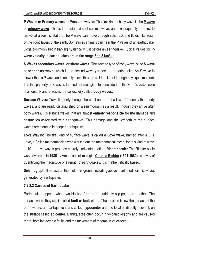
LAND, WATER AND BIODIVERSITY RESOURCES EVS 502
147
P Waves or Primary waves or Pressure waves: The first kind of body wave is the P wave
or primary wave. This is the fastest kind of seismic wave, and, consequently, the first to
'arrive' at a seismic station. The P wave can move through solid rock and fluids, like water
or the liquid layers of the earth. Sometimes animals can hear the P waves of an earthquake.
Dogs commonly begin barking hysterically just before an earthquake. Typical values for P-
wave velocity in earthquakes are in the range 5 to 8 km/s.
S Waves secondary waves, or shear waves: The second type of body wave is the S wave
or secondary wave, which is the second wave you feel in an earthquake. An S wave is
slower than a P wave and can only move through solid rock, not through any liquid medium.
It is this property of S waves that led seismologists to conclude that the Earth's outer core
is a liquid. P and S waves are collectively called body waves.
Surface Waves: Travelling only through the crust and are of a lower frequency than body
waves, and are easily distinguished on a seismogram as a result. Though they arrive after
body waves, it is surface waves that are almost entirely responsible for the damage and
destruction associated with earthquakes. This damage and the strength of the surface
waves are reduced in deeper earthquakes.
Love Waves: The first kind of surface wave is called a Love wave, named after A.E.H.
Love, a British mathematician who worked out the mathematical model for this kind of wave
in 1911. Love waves produce entirely horizontal motion. Richter scale: The Richter scale
was developed in 1935 by American seismologist Charles Richter (1891-1989) as a way of
quantifying the magnitude or strength of earthquakes. It is mathematically based.
Seismograph: It measures the motion of ground including above mentioned seismic waves
generated by earthquake.
7.2.2.2 Causes of Earthquake
Earthquake happens when two blocks of the earth suddenly slip past one another. The
surface where they slip is called fault or fault plane. The location below the surface of the
earth where, an earthquake starts called hypocenter and the location directly above it, on
the surface called epicenter. Earthquakes often occur in volcanic regions and are caused
there, both by tectonic faults and the movement of magma in volcanoes.
LAND, WATER AND BIODIVERSITY RESOURCES EVS 502
148
Earthquakes are caused mostly by rupture of geological faults, but also by volcanic activity,
landslides, mine blasts and nuclear experiments.
7.2.2.3 Impacts of Earthquakes
The effects of earthquakes include, but are not limited to, the following:
It destroys the life of human.
It destroys infrastructure of school, educational institutions, hospitals, industries and
other personal/private properties.
It destroys the Hydropower Projects or Dams.
It may leads in to landslides, flood cyclones etc.
It may leads to catastrophic flood.
It is responsible for great social and economical losses.
It may cause epidemic diseases by destruction of sewage line systems.
It completely destroys the electrical system and communication system.
It destroys agricultural land.
Sometimes earthquake causes complete separation of family members, community
and society.
7.2.2.3 Mitigation Measures of Earthquake
As you know that earthquake is fastest, quickest and sudden disaster and during the disaster
we cannot do so effective methods. Therefore, it is necessary to follow the rules and
regulation before the disaster by which we can minimize the impacts of earthquake. There
are various mitigation measures of earthquake and some important measures which are
certainly helpful to minimize the impacts of earthquake are summarized below:
Before Earthquake: As you know that earthquakes occurs very fast without giving any
signal and if we wait until the earth is start to shake it may be too late. Following point should
be kept in mind before earthquake especially in earthquake prone areas.
Identify the zone and frequency of earthquake in area where you live.
Follow the rules and regulations prescribed by governments. Government of India
prescribed various rules for construction of buildings in different seismic zones.

LAND, WATER AND BIODIVERSITY RESOURCES EVS 502
149
Disaster management training for people/communities must be organized at regular
basis.
Keep the phone numbers of media and official of National Disasters Response
Force (NDRF) etc.
Always keep the following in a designated place: drinking water bottles, dry food.
First aid kits, torchlight and battery operated radio.
Identify place in the house that can provide cover during earthquake.
It may be easier to make log distance calls during an earthquake. Identify an out of
separated after the disaster and are not able to contact each other, they should
contact the designated relative/friend. The address and phone number of the
contact person should be with all the family members.
During Earthquake: Earthquakes give no warning at all. Sometimes, a loud rumbling sound
might signals its arrival a few sounds ahead of time. Those few seconds could give us a
chance to move to a safer location. Here are some important tips for keeping safe during a
earthquake.
Take cover, go under a table or other solid furniture, kneel, sit or stay close to the
floor. Hold on to furniture legs for balance. Be prepared to move if your cover moves.
Do not stand in doorways. Violent motion cause serious injury.
Move away from windows, mirrors, bookcases and other unsecured heavy objects.
Do not run outside the buildings if you are deep inside in room
Never use the lift.
If you are living in a house which is not far from the open area, the best thing to do
is to move an open area where there are no trees, electric or telephone wires.
If you then move outside into open, away from buildings, streetlights and utility wires.
Once in the open, stay there until the shaking stops. Avoid place where there are
loose wires and do not touch metal objects that are in touch with the loose wire.
Stay away from badly damaged structures.

LAND, WATER AND BIODIVERSITY RESOURCES EVS 502
150
If you are in vehicle, then move to clear area from buildings, trees, overpasses.
Avoid bridges or ramp that might have been damaged by the earthquake.
After Earthquake: Here are a few things to keep in mind after an earthquake. The cautions
you display in the aftermath can be essential for your personal safety.
Wear shoes to protect feed from debris and other hazardous substances.
After the earthquake, be prepared for aftershocks. Aftershock cause additional
damages and may bring down weakened structures. Aftershocks can occur in the
first hours, day, weeks or even months after the earthquakes.
Check for fire hazards and use torch lights instead of candles or lanterns.
If the building you live in is in a good shape after the earthquake, stay inside and
listen for radio advices. If you are not certain about the damage to your building,
evacuate carefully.
Help injured or trapped persons and give first aid. Do not move seriously injured
persons unless they are in immediate danger of further injury.
Remember to help your neighbours who may require special assistance infant, the
elderly, and people with disabilities.
Listen to a radio for the latest emergency information.
Stay out of damaged buildings.
Return home only when authentic agencies say it is safe. Clear up spilled medicines,
bleaches or gasoline or other flammable liquids immediately. Leave the area if you
smell gas or fumes from other chemicals.
If you smell gas open windows and quickly leave the building. Turn off the switch on
the top of the gas cylinder.
Look for electrical system damages if you see sparks, broken wires, or if you smell
burning of amber, turn off the electricity at the main fuse box. Check for sewage and
water lines damage. If you suspect sewage lines are damaged, avoid using the
toilets. If water pipes are damaged, avoid using water from the tap.
Use the telephone only for emergency calls.

LAND, WATER AND BIODIVERSITY RESOURCES EVS 502
151
In case family members are separated from one another during an earthquake
develop a plan for reuniting after the disaster. Make sure everyone in the family
know the name, address, and phone numbers of the contact person.
7.2.3 Drought
A drought occurs when precipitation is lower than average, usually more than a season. It
generally comes with higher temperatures than normal. It can also be caused by people
overusing or over-populating an area to the point where the water available is outstripped
by what people need. Drought is widespread meteorological syndrome of prolonged period
of water scarcity.
7.2.3.1 Types of Drought
Meteorological drought: It is specific to different regions. Meteorological drought is simply
period of time. The amount of rainfall/precipitation and
duration are specific to region.
Agricultural drought: It accounts for the water needs of crops during different growing
stages. Agricultural drought link the characteristics of both meteorological and hydrological
drought. This type of drought impacts the crops, live stock and forestry.
Hydrological drought: It refers to persistently low water volumes in streams, rivers and
reservoirs. Various anthropogenic activities such as: drawdown of reservoirs can worsen
hydrological droughts. Hydrological drought is often linked with meteorological droughts.
These types of droughts characterized by changes in surface water supplies.
Socioeconomic drought: It happens when the demand of water exceeds the water supply.
Examples of socio-economical drought include too much irrigation or when low river flow
forces hydroelectric power plant operators to reduce energy production.
7.2.3.2 Causes of Drought
Drought has many causes. There are various natural and manmade causes of droughts
which are given below:
Natural and Human Causes of Drought
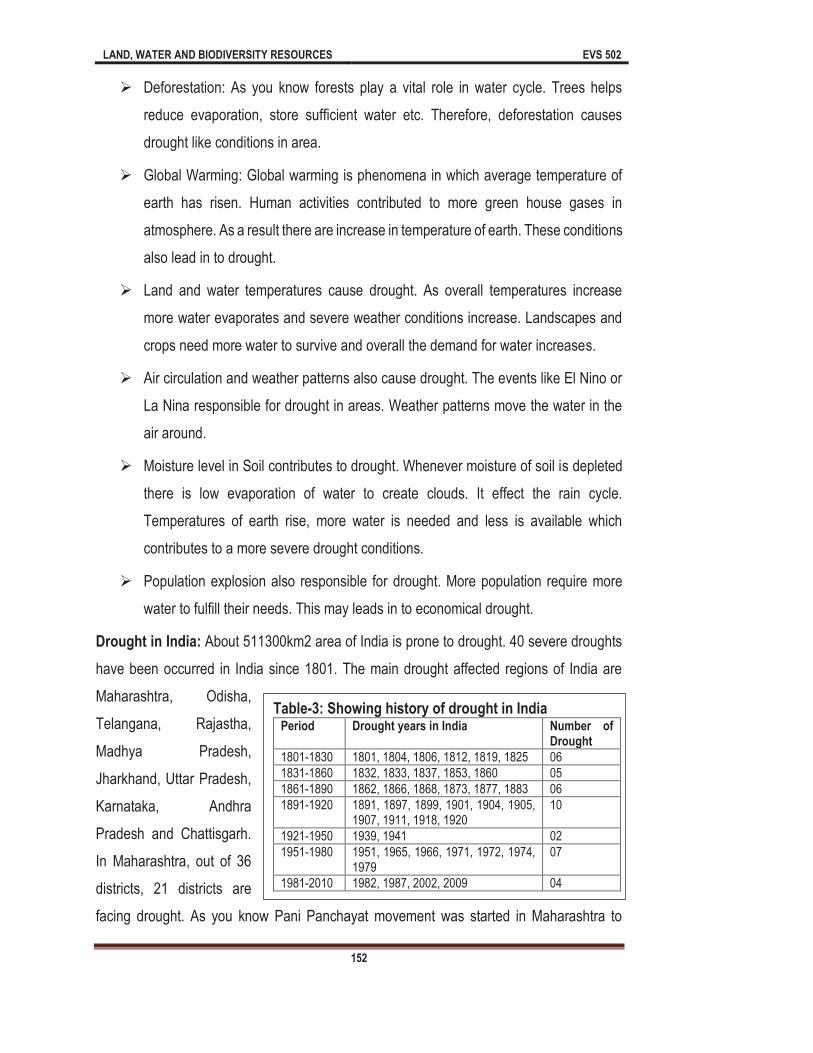
LAND, WATER AND BIODIVERSITY RESOURCES EVS 502
152
Deforestation: As you know forests play a vital role in water cycle. Trees helps
reduce evaporation, store sufficient water etc. Therefore, deforestation causes
drought like conditions in area.
Global Warming: Global warming is phenomena in which average temperature of
earth has risen. Human activities contributed to more green house gases in
atmosphere. As a result there are increase in temperature of earth. These conditions
also lead in to drought.
Land and water temperatures cause drought. As overall temperatures increase
more water evaporates and severe weather conditions increase. Landscapes and
crops need more water to survive and overall the demand for water increases.
Air circulation and weather patterns also cause drought. The events like El Nino or
La Nina responsible for drought in areas. Weather patterns move the water in the
air around.
Moisture level in Soil contributes to drought. Whenever moisture of soil is depleted
there is low evaporation of water to create clouds. It effect the rain cycle.
Temperatures of earth rise, more water is needed and less is available which
contributes to a more severe drought conditions.
Population explosion also responsible for drought. More population require more
water to fulfill their needs. This may leads in to economical drought.
Drought in India: About 511300km2 area of India is prone to drought. 40 severe droughts
have been occurred in India since 1801. The main drought affected regions of India are
Maharashtra, Odisha,
Telangana, Rajastha,
Madhya Pradesh,
Jharkhand, Uttar Pradesh,
Karnataka, Andhra
Pradesh and Chattisgarh.
In Maharashtra, out of 36
districts, 21 districts are
facing drought. As you know Pani Panchayat movement was started in Maharashtra to
Table-3: Showing history of drought in India Period Drought years in India Number of
Drought
1801-1830 1801, 1804, 1806, 1812, 1819, 1825 06
1831-1860 1832, 1833, 1837, 1853, 1860 05
1861-1890 1862, 1866, 1868, 1873, 1877, 1883 06
1891-1920 1891, 1897, 1899, 1901, 1904, 1905, 1907, 1911, 1918, 1920
10
1921-1950 1939, 1941 02
1951-1980 1951, 1965, 1966, 1971, 1972, 1974, 1979
07
1981-2010 1982, 1987, 2002, 2009 04
LAND, WATER AND BIODIVERSITY RESOURCES EVS 502
153
mitigate the impacts of drought. In Odisha about 16 districts are prone to drought. Chief
Minister of Odisha Sh. Naveen Patnaik recently announced 100 crore rupees to farmers
which were affected by drought. Almost all the district of Telangana except Adilabad and
Kamman have affected by drought. Nineteen districts of Rajasthan also affected by drought.
Out of 52 districts in Madhya Pradesh 46 are drought affected. In Jharkhand 22 districts are
facing drought like conditions. In Uttar Pradesh 50 districts are affected by drought. On the
other hand 27 districts of Karnataka are facing drought. Gujarat, West Bengal, Haryana and
Bihar states are also drought affected states of India.
7.2.3.3 Impacts of Drought
There are various effects of economical, environmental and social impacts of drought which
are given below:
Economic Impacts
Farmers and people may lose money if a drought diminishes their vegetables, grains
and other crops.
If water supply is too low, the farmer may have to spend more money on irrigation.
Ranchers may have to paid more cost on feed and water for their livestock.
Commercialization that depends on farming, like industries that make tractors and
food, may lose business when drought damages crops or livestock.
People who work in the timber industry may be affected when wildfires destroy
stands of timber.
Works that rely on boats and fishing equipment may not be able to sell some of their
goods because drought has dried up lakes and other aquatic bodies.
Hydro-power companies that normally rely on hydroelectric power may have to pay
out more money on other fuel sources if drought dries up too much of the water
supply.
Water consuming companies may have to spend money on new or additional water
supplies.
LAND, WATER AND BIODIVERSITY RESOURCES EVS 502
154
Navigation become difficult in rivers due to low quantity of water. Ships may have
difficulty navigating streams, rivers, and canals because of low water levels, which
would also affect economy that depend on water transportation.
Communities might have to pay more for food items.
Environmental Impacts: Drought also impacts the environment conditions in many different
ways. As you know plants and animals depend on aquatic habitat or water. When a drought
happens, food supply of animals can shrivel and their habitat can be eroded. Sometimes the
harm is only momentary and their habitat and food return to normal level when the drought
is over. But sometimes drought's impact on the environment can last a long time, maybe
forever. There are various environmental impacts of drought which are given below:
Destruction of fish and wildlife habitat
Lack of food and drinking water for wild animals
Increase in disease in wild animals, because of reduced food and water supplies
Migration of wildlife
Enhance the stress on endangered species.
Low water levels in reservoirs, lakes, and ponds
Wetlands degradation
Drought enhances the chances of forest fire.
Soil erosion by water and wind.
Poor soil quality
Social Impacts: Social impacts of drought include public safety, health, conflicts between
people when there isn't enough water to go around, and changes in lifestyle. Social impacts
of drought may as following:
Depression regarding economic losses caused by drought
Human health problems related to low water flows and deprived water quality
Human health problems related to dust
Loss of human life
Threat to public safety from an increased number of forest and range fires
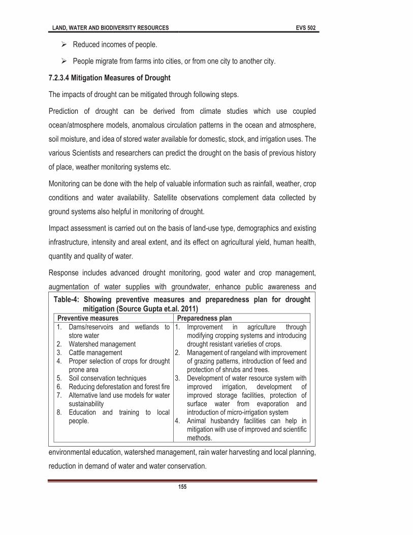
LAND, WATER AND BIODIVERSITY RESOURCES EVS 502
155
Reduced incomes of people.
People migrate from farms into cities, or from one city to another city.
7.2.3.4 Mitigation Measures of Drought
The impacts of drought can be mitigated through following steps.
Prediction of drought can be derived from climate studies which use coupled
ocean/atmosphere models, anomalous circulation patterns in the ocean and atmosphere,
soil moisture, and idea of stored water available for domestic, stock, and irrigation uses. The
various Scientists and researchers can predict the drought on the basis of previous history
of place, weather monitoring systems etc.
Monitoring can be done with the help of valuable information such as rainfall, weather, crop
conditions and water availability. Satellite observations complement data collected by
ground systems also helpful in monitoring of drought.
Impact assessment is carried out on the basis of land-use type, demographics and existing
infrastructure, intensity and areal extent, and its effect on agricultural yield, human health,
quantity and quality of water.
Response includes advanced drought monitoring, good water and crop management,
augmentation of water supplies with groundwater, enhance public awareness and
environmental education, watershed management, rain water harvesting and local planning,
reduction in demand of water and water conservation.
Table-4: Showing preventive measures and preparedness plan for drought mitigation (Source Gupta et.al. 2011)
Preventive measures Preparedness plan
1. Dams/reservoirs and wetlands to store water
2. Watershed management 3. Cattle management 4. Proper selection of crops for drought
prone area 5. Soil conservation techniques 6. Reducing deforestation and forest fire 7. Alternative land use models for water
sustainability 8. Education and training to local
people.
1. Improvement in agriculture through modifying cropping systems and introducing drought resistant varieties of crops.
2. Management of rangeland with improvement of grazing patterns, introduction of feed and protection of shrubs and trees.
3. Development of water resource system with improved irrigation, development of improved storage facilities, protection of surface water from evaporation and introduction of micro-irrigation system
4. Animal husbandry facilities can help in mitigation with use of improved and scientific methods.

LAND, WATER AND BIODIVERSITY RESOURCES EVS 502
156
Before Drought
Identify the history of drought in your area.
Monitor the weather reports regularly.
Crop management should include following points
o Plant the trees which can hold the sufficient amount of water.
o Crop rotation should be done in drought prone area.
o Crop should be drought and flood resistant.
Land management should include following points
o Maintain the healthy soil
o Do not allow over grazing
o Establish the riparian vegetations around the land and water bodies
Weed and unwanted crops should be controlled.
Minimize the loss of water during agriculture.
Identify the alternate water sources in drought prone area.
After Drought
Regular testing of soil should be done during and after drought.
Test the harvested crops and forages for nutrient quality.
Summary
In this unit we have discussed various aspects of land related hazards. So far you have
learnt that:
manmade or natural activities by event originating in nature. Literally, hazard means
y be
biological (energy source are living organisms example are: diseases and
infections) chemical (energy source are chemical components) physical (energy
sources are physical activities of earth examples: Earthquake, cyclones). On the

LAND, WATER AND BIODIVERSITY RESOURCES EVS 502
157
basis of origin these may be natural (Earthquake, floods, Tsunamis) and Manmade
(Chemical hazards, industrial hazards etc).
There are various land related hazards which are originate on land and can effect
the ecological, social and economical conditions of the area. You know that
earthquake, landslides, landslips, droughts are the natural disasters which happen
in land ecosystem. The causes and effect of land related hazards are enormous and
uncountable. In this unit you will learn about land related hazards and their mitigation
measure with special reference to landslides, landslips, earthquake and drought.
Landslide is a general term for a wide variety of down slope movements of earth
materials that results in downward and outward movement of soil, rock and
vegetation under the influence of gravity. Some landslides are rapid, occurring in
seconds, whereas other may take hour, weeks or even longer time. Debris flows are
fluid mass of rock, earth and other debris saturated with water.
There are various types of landslides such as Falls, Flows, , Creep, Debris flow,
Debris avalanches, Lahar, Mudflow, Lateral Spreads.
The causes of landslides and landslips may be Natural causes such as Gravity,
Geological factors, Heavy and Prolonged rainfall, Earthquake, Forest fires,
Volcanoes, Waves.
Anthropogenic causes of landslides may include: Inappropriate drainage system,
Deep Excavation on slopes for buildings roads, canals and mining, Change in
slope/land use pattern, deforestation, agricultural practices on steep slopes.
The landslides may affect the structure of land, cause loss of human being,
economical losses etc.
the earth, resulting from the sudden release of energy in the lithosphere that create
Reverse Fault.
Earthquake happens when two blocks of the earth suddenly slip past one another.
The surface where they slip is called fault or fault plane.
LAND, WATER AND BIODIVERSITY RESOURCES EVS 502
158
Drought a long period when precipitation is lower than average, usually more than
a season. The drought may categorized as Meteorological drought, Agricultural
drought, Hydrological drought and Socioeconomic drought.
Terminal Questions
1 (a) Fill in the blank spaces with appropriate words.
nd devastating form of natural disaster it can destroy millions of life, building, infrastructure within few minutes. Therefore, Earthquake is the most fearful natural phenomena in the human life. It is more so because
tive signs. When the earth shakes due to the
is the study of earthquakes and seismic waves that move
seismic waves. About 50-60% of India is vulnerable to seismic activity of varying intensity and most of the vulnerable areas are located in the Himalayan and sub-Himalayan regions.
2 (a) What are land related hazards? (b) Give the types of landslides
3. (a) Define the landslide. Describe the natural and anthropogenic causes of landslides. (b) What are the impacts of landslides. 4. Describe the mitigation measures against landslides. 5 (a) Define earthquake. What are the types of Earthquake (b) Write about seismic waves of Earthquake. (c) Describe the impacts of earthquake. 6 (a) Fill the blank spaces with appropriate words.
any Nation. Natural disasters mainly categorized as two broad types. First category is
reat potential posed to manmade or natural activities by
organisms example are: diseases and infections) chemical (energy source are chemical components) physical (energy sources are physical activities of earth examples:
Tsunamis) and Manmade (Chemical hazards, industrial hazards etc). (b) Which waves are the fastest waves in Earthquake (P-waves/S-waves/surface waves/love
waves)
LAND, WATER AND BIODIVERSITY RESOURCES EVS 502
159
(c) Uttarakhand is lies under the seismic zone (Seismic zone-I/ Seismic zone-II / Seismic zone-III/ Seismic zone-IV)
(d) In India maximum drought happened during the period of (1801-1830/1831-1860/1981-2010/1891-1920)
7 (a) Define the drought. Describe the causes and impacts of drought (b) Write about the mitigation measures against drought. (c) Write about the drought in India
Answers to Terminal Questions
1 (a) Tremor, temblor, energy, seismic wave, unpredictable, epicenter, Seismology, seismologist
2 a) see section 7.2 and Table-1.
(b) See section 7.3.1
3 (a) See section 7.3 and 7.3.2
(b) See section 7.3.3
4 (a) See section 7.3.4
5 (a) See the section 7.4 and 7.4.1
(b) see the section 7.4.1 (seismic waves)
(c) See section 7.4.3
6 (a) Natural disasters, negative, socio-economy, Geophysical disaster, biological hazard, , (b) P-waves, (c) Seismic zone-IV, (d) 1891-1920
7 (a) See the section 7.5, 7.5.2 and 7.5.3, (b) See the section 7.5.4, (c) See the section 7.5.2 (Drought in India).

LAND, WATER AND BIODIVERSITY RESOURCES EVS 502
160
Unit 8 Land Husbandry: Soil Amelioration; Rehabilitation; Restoration of Wasteland
Unit Structure
8.0 Learning Objectives
8.1 Introduction
8.2 Land Husbandry
8.3 Methods of Land Husbandry
8.4 Soil Amelioration
8.5 Rehabilitation of Soil and Wasteland
8.6 Restoration of Wasteland
Summary
8.0 Learning Objectives
After studying this unit you will be able to:
What is concept of land husbandry
What is Soil amelioration?
Why soil amelioration is important?
What are the techniques in soil amelioration
How we can rehabilitate soil
Methods of restoration of wasteland
8.1 Introduction
As you know soil erosion has been perceived as the main cause of land degradation, yet the
limited effectiveness and poor uptake of widely promoted physical and biological anti-erosion
methods challenges this fact. As you know that various anthropogenic activities and natural
activities lead in to land degradation. Excessive use of fertilizers, dumping of hazardous
material in and around the land, deforestation and desertification are main causes of land
degradation. These factors are responsible for low production in land ecosystems. Many
hazardous materials such as mercury, arsenic, cadmium, chromium, nickel, zinc reach the

LAND, WATER AND BIODIVERSITY RESOURCES EVS 502
161
land ecosystem and can reach up to higher trophic level through bioaccumulation. These
toxic substances can cause several diseases in human being as well as in other animals.
Therefore it is necessary to manage and conserve the land ecosystems for this generation
as well as for future generations.
According to Francis Shaxson (2014) land husbandry is active process of managing land
use systems and production in such ways that there will be increase productivity. There are
various methods to improve land, soil and wasteland which are certainly helpful to increase
productivity of land. Various methods of land husbandry may include soil amelioration,
rehabilitation and restoration of soil. Land husbandry includes the active management
primarily of rain water, vegetation, soil and slopes. The land husbandry technique, which
takes place at variety of scales from the field to landscape and soil. Land improvement and
vegetation output are the two main ways of land husbandry. In this unit you will learn about,
land husbandry, soil amelioration, rehabilitation of soil and restoration of soil.
8.2 Land Husbandry
Hugh Hammond Bennett is the father of soil conservation, the world has seen a host of
erosion control manuals and describing practical experience, technical principles,
mechanical methods to be used, and a series of practical recipes that have been adopted
with varying degrees of success in
was then applied, with no prior testing, in totally different circumstances with the very
indifferent results that have been seen by all. The environmental deprivation is closely bound
up with the growth of civilizations. They are of equal interest to Ecologists, foresters,
According to Shaxson, Douglas and Downes, 2005
of implementing and managing preferred systems of production in such ways that
there will be increase or at worst, no loss of productivity, of stability or of
usefulness for the chosen purpose; also, in particular situations: existing uses or
management may need to be changed so as to halt rapid degradation and to return
LAND, WATER AND BIODIVERSITY RESOURCES EVS 502
162
Hazards of local climate such as: Rainfall: high intensities; drought; excess rainfall volumes;
Temperature: maximum, minimum, fluctuations; Wind: velocity are responsible for land
degradation. On the other hand Hazards of landscape include: Slope, as affecting velocity
of any runoff; Past erosion effects as affecting quality of remaining topsoil; Inherent wetness,
as limiting aeration in root-zone; Parent materials of soils: chemical limitations.
Effective rooting-depth; Surface hindrances
rocks, etc.; Topsoil texture (sand through to clay); Upper subsoil texture (sand through to
clay); Subsoil permeability (excessively-free through to restricted); Material (if any) limiting
rooting-depth: chemical, hydrologic or physical restrictions.
Land degradation may result due to degradation in physical, chemical and biological
parameters of the soil. These parameters may include organic-matter content, organisms,
acidification, loss of porosity, loss of soil particles, nutrients and water in runoff and erosion.
Conversely, improvements to any, some, or all of these features will contribute to greater
stability, conservation and sustainability of the affected land. Land husbandry is practice of
cultivating the land or raising live stock.
8.3 Methods of Land Husbandry
The use of heavy construction machinery or the improper treatment of soils often results in
soil compaction. This leads, on the one hand, to a pore volume too low for plant growth and
on the other hand to too little oxygen content in the soil. Soils with low structure stability are
especially vulnerable to damages by compaction, particularly to exposures in connection
with unfavorable soil water content. The first step to re-cultivate compressed soils is
physical soil amelioration, which primarily aims at improving air and water balance of the
soil.
Soil improvements influencing the substantial properties of soils are summarized under the
term chemical soil amelioration. Those are primarily measures for increasing or decreasing
the soil pH, for optimizing the nutrition contents and reducing or eliminating harmful
substantial influences like salinization or contaminations. These interventions improve the
substantial prerequisites in soils extremely acid, extremely alkaline, and poor in nutrients
or contaminated, such that sound plant growth is possible with reclamation and erosion
control measures. Chemical amelioration measures are dominantly requisite in mining areas

LAND, WATER AND BIODIVERSITY RESOURCES EVS 502
163
(liming of acid soils), on raw soils lacking humus, in salinated sites (reduction of ion activity)
and the decontamination of contaminated, hazardous sites
8.4 Soil Amelioration
Soil amelioration is technique in which we can improve the quality of soil. The word "melior"
better,".
As you know soil is made up of clay, silt and sand. Besides these components humus,
microbes, earthworms are essential part of soil. The functions of abiotic and biotic factors
are different in land ecosystem. A Clay soil is responsible for soil amendments improve the
soil aggregation, increase porosity and permeability, and improve aeration, drainage, and
rooting depth. On the other hand Sandy soils increase the water and nutrient holding
capacity. Manure-based compost are readily available in soil. These are often high in salts,
limiting application rates. Plant-based composts are low in salt, these may be applied at
higher application rates, more effectively improving the soil - typically higher cost. There are
various reasons which cause soil degradation. Salinity of land may harmful to growth of
crops and it may increase due to excessive and uncontrolled irrigation, water logging,
excessive use of fertilizers, poor drainage systems etc.
Indicators of Soil Productivity: There are various indications by which we can determine
the soil is polluted, water logged or higher salinity etc. Drainage of water is indication in
which we can observe the amount of water flowing slowly or quickly over soil. This may
indicate saturated or unsaturated soil conditions. This can also cause erosion. Water left
standing after a rain may also indicate excessive moisture in the soil. Edges of leaves turning
brown may indicator of too much soil moisture. We can identify the roots of plants; decayed
roots are also indicator of waterlogged soils. The type of soil at a site influences moisture
conditions. Sandy soils generally have a high infiltration rate with water moving quickly
through, while clay soils be likely to retain water. pH is the scale to determine acidic or basic
nature of any solution. It is a measure of the concentration of hydrogen ions in the solution.
It is also indicator of soil productivity. The lower the pH of soil, the greater the acidity, pH of
4 has 10 times more acid than a pH of 5 and 100 times more acid than a pH of 6. Acidity
caused by natural process, accelerated by agriculture, inefficient use of nitrates, followed by
the export of alkalinity in produce. Microbial biodiversity is also indicator of soil productivity.

LAND, WATER AND BIODIVERSITY RESOURCES EVS 502
164
As you know most of the biological activity in the soil occurs in the top 10 cm. Farmers
generally do not realise the amount of life and what type of organisms live in soil, because
we do not see their activities. Many farmers do not understand the diversity of organisms
present in the soil and their function. Microorganisms play various functions in soil. These
functions may include: Nutrient recycling, maintaining soil structure, suppression of plant
disease and soil detoxification
Amelioration Techniques for Saline soil: There are various methods of soil amelioration
for saline soil which are given below:
1. Scraping: It is just removal of salt content by mechanically. This technique has
limited success.
2. Leaching: This is the most effective management technique for removing salts from
root zone of soil (rhizosphere). Stagnation of freshwater can dissolve the salt in
agriculture field. Leaching should be done when soil moisture content is low and
ground water is deep.
3. Drainage: Drainage is also effective method to minimize salt content in soil.
4. Irrigation methods: More frequent irrigation prevents the salt accumulation by
keeping the soil at higher soil moisture content. Therefore, crops grow in high salinity
must be irrigated more frequently.
5. Irrigated methods: Sprinklers or drip irrigation or micro-irrigation or drop irrigation
is good method for irrigating frequently and with small quantity of water at a time.
Leaching of soluble salts is also accomplished more efficient when water application
rate are lower than the infiltration capacity of soil and such capacity cannot be
achieved by flood irrigation method.
6. Proper use of Irrigation: Salt free or less saline (if salt free water is not available)
water only to be used. Moisture should be kept at optimum field capacity to check
the salt accumulation. Management of soil fertility through proper fertilizers
application. Generally saline soils are low in fertility status. Response of nitrogen is
good when it is applied with green manures. However, an excessive fertilizer on a
highly saline soil is of no value. Use of acid forming fertilizers such as ammonical
and amide form help to below the pH level of soil.

LAND, WATER AND BIODIVERSITY RESOURCES EVS 502
165
7. Mulching: Soil salinization is particularly high when water table is shallow and
salinity of ground water is high. Mulching can reduced evaporation from soil surface
and encourage downward flow of soil water thereby check the accumulation of salts
on soil surface.
Saline soils are barren but potentially productive soil. All the problematic soils are needed to
be rectified and made to be productive to ensure the food supply/security of ever increasing
population. Soluble salt concentration of saline soil can be minimized by the above
mentioned amelioration technique and made in to productive.
There are various reasons to avoid Soil Compaction because soil compaction causes
nutrient deficiencies, Reduces crop productivity, Restricts root development, Reduces soil
aeration, Decreases soil available water, Reduces infiltration rate, Increases surface runoff,
Increases sediment and nutrient losses, Damages soil structure. Soil compaction can be
managed through Deep Tillage, Crop residue, addition of organic matter, vermicompost etc.
Compaction can correct with the help of adding gypsum or any chemical to a landscape,
have soil analysis performed to identify texture, mineral deficiencies, toxicities, etc. Gypsum
can improve heavy clay soil structure and remove sodium from saline soils. But on the other
Table:-1: Showing saline concentration and suitable crops
Highly salt content crops Sugarcanes, Barley, Sesbania, Oats
and Barley
Moderately salt content
crops
Millets, Pearl, maize, Wheat, Rice and
Cotton
Low salt content crops Pulses, White clover, radish, beans,
peas and seasam
Saline sensitive crops Onion, Tomato, Potato and Carrot
Table-2: Showing role of organisms in soil
Microbes Role of Microbes
Microfauna Breaking down organic matter in soil
Microfauna Recycling of nutrients and release of nutrients
for further biological transformation in soil
Mesofauna Regulating and distributing microbes in soil.
They also fragment OM in the soil, making it
easier for microbes to decompose
Macrofauna They are soil engineer as they are able to
move soil particles
LAND, WATER AND BIODIVERSITY RESOURCES EVS 502
166
hand addition of gypsum to sandy soils can be a waste of money, natural resources, and
can have negative impacts on plant, soil, and ecosystem health.
8.5 Rehabilitation of Soil and Wasteland
it does not mean to restore the ecosystem to its pre-existing condition. Soil and wasteland
rehabilitation is the process of returning the land in a given area to some degree of its former
state, after some process has resulted in its damage. Various developmental projects such
as mining, agricultural practices etc. are responsible for land degradation.
Land rehabilitation is an interference intended to make a land improvement of land
ecosystems. In most situations, this engages the mitigation of land degradation caused by
poor land husbandry practices, especially agricultural practices. The important issues in land
rehabilitation concern to what degree the land should be rehabilitated to self-sustaining
natural control and to what degree to a sustainable economic after-use, where future land
quality is sustained by careful management and repair. In many contexts, land rehabilitation
works involve countering the physical symptoms of land degradation, which include losses
of soil quality due to soil compaction, and also accelerated runoff and erosion on hill slopes
and in watercourse. In other contexts the interventions include the mitigation of soil erosion
and pollution.
Soil Rehabilitation
The soil is a important component in land rehabilitation. The soil controls growth of crops on
the land and it determines land infiltrates into the soil, runs off as surface flow remains stored
at the surface in ponds or in the soil attached to the soil particles through
evaporation/transpiration of water into the atmosphere. Directly or indirectly, through the
vegetative cover, the soil also regulates the rate at which soil is removed by water or wind
erosion. Soil is a living resource; it is a living ecosystem, complex dynamic, evolving,
biologically modulated open system.
The soil may be defined as As you
know soil is important factor in bio-geochemical cycles. It is where the crucial links in most
land-based biogeochemical cycles churn. Soil biological processes organize nutrient supply,
LAND, WATER AND BIODIVERSITY RESOURCES EVS 502
167
chemical buffering, soil density, porosity, aeration, and water holding capacity. These factors
affect soil structural stabilization, detoxification, and soil self-creation. Soil biology controls
the quality of that soil and, in general, it makes the soil a better place for living organisms.
This is why, in land rehabilitation, the central emphasis rests on the situation and vivacity of
the soil.
Soils develop in a range of characteristic as the result of the vertical and horizontal
movements of organisms, organic materials, water, chemicals, and soil particles.
The self-development and evolution of soils is conditioned by following factors:
Biological processes, the activities of organisms that develop on or in the soil, together
with the enzymatic impacts of their secretions and waste products. Geological conditions,
which through weathering, determine the character, availability and amount of the material
from which the soil skeleton is created. Geomorphological and hydrological processes,
determined by the position of the soil in the land ecosystem, which influence the amount of
erosion, drainage or deposition it has experienced. Climatic and microclimatic processes
that control the activities of the biological system and that encourage physical processes
through wetting/drying.
Human impacts, because most soils have been distorted by land-use, in many cases, these
disturbing activities, including cultivation, forest farming and grazing, have been sustained
for many decades or centuries. Most of the soils that are found on land scheduled for
rehabilitation have been damaged by inappropriate land use poor land husbandry.
Frequently, the solution to their problems and, by extension that of land degradation is simply
to change the way they are managed.
Soil Qualities to be addressed in Land Rehabilitation: Shaxson (FAO, 1999) described
the seven soil quality factors may be tackled during land rehabilitation these characters are:
Rate of soil formation
Bio-productivity (soil fertility)
Rainwater infiltration
Moisture and biodiversity of Soil.
Water loss from the soil through evaporation
LAND, WATER AND BIODIVERSITY RESOURCES EVS 502
168
Soil rhizosphere
Toxicity of soil.
Enhance Soil Depth: Land rehabilitation needs the occurrence of a self-sustaining soil,
which means that there must be a balance between soil development and soil loss. This can
be attained in two ways, by reducing the rate of soil erosion, the traditional soil conservation
approach, or by enhancing soil formation. Scientists emphasize the function of organic acids
in accelerating the weathering of bedrock as plants mine for the minerals they need and, in
the process, accelerating soil formation. In recent time, there has been much success using
Mucuna beans to regenerate soils in tropical steep lands. Mucuna is able of generating 100
tonnes ha of green manure each year and has been used to rehabilitate lands that were
almost devoid of cultivatable soil. However, increasing effective soil depth can be achieved
in many ways besides the incorporation of organic matter. On the other hand, soil depth can
be changed by the physical collection of soils, as during the creation of agricultural terraces
by cut and fill from hillsides. In industrial land reclamation, many sites are finished with topsoil
imported from other sites. Agricultural equivalent is to make a site, such as a dam, which
collects the soil mobilized by wind and soil erosion and converts it into a flat depositional
terrace that can be used for cultivation.
Rehabilitation of Wasteland: According to Dudley Stamp (1954)
which has been previously used, but which has been abandoned, and for which no further
land is land which was previously used for
cultivation but due to low productivity it has been abandoned. According to Vohra (1978)
about 6000 million tones of fertile soil containing 5 million tonnes of NPK are displaced per
year. Various developmental activities such as industries, urbanizations, agricultural
practices etc. are leading to wasteland genesis. The rehabilitation of wasteland through the
soil management of soil and vegetation would minimize siltation and enhance the water yield
in catchment areas. It depends on the soil capability, climatic conditions and plant species.
Deforestation is mainly responsible for genesis of waste land. Plants play very important role
in rehabilitation of wasteland. But selection of plant species is most important aspect.
Selection of plant species is based on local weather condition, adaptability, productivity and
survivorship. The basic factors for the plant species are as following:

LAND, WATER AND BIODIVERSITY RESOURCES EVS 502
169
Plant should survive at nursery and growth level on wasteland.
Plant should have high reproductive fertility.
Plant species should have high establishment rate.
Plants should have good regeneration power.
Species should meet the local need of fuel, food and fodder.
Beside the basic factors, the
decisive factors in selection of
species for wasteland
rehabilitation are as followings:
Local species should
be site specific.
Potential and
utilization of species
should be identified.
Invasive species
should be avoided as
far as possible.
Afforestation should
involve multi-specific
approach. This is
helpful to generation of soil.
Silvi-characteristics of species should be cultured
8.6 Restoration of Wasteland
ystem that has been
damaged, degraded, or destroyed maybe because of soil erosion or human interference.
Restoration of an ecosystem is an attempt to return it to its historical trajectory. The process
of restoring an area of land back to its original state following disruption or damage to it. This
process entails the removal of toxins and other dangerous substances, the removal of other
Table:3- Plant species suggested for rehabilitation of wasteland (Source: Ramachandra and Kumar, 2003)
Scientific Name Local Name
Acacia catechu Kher
Acacia concinna Shikakai
Butea monosperma Palash
Pogamia pinnata Karanja
Schleichera oleasa Kusum
Madhuca latifolia Mahua
Emblica officinalis Amla
Cassia fistula Amaltash
Aegle marmelos Bel Patthar
Sapindus laurifolius Soap nut
Spondias mangifera Wild mango
Mangifera indica Mango
Dendrocalamus strictus Male bamboo, solid bamboo
Bambusa arundinaceae Bans
Strychnos nux vomica Poison nut
LAND, WATER AND BIODIVERSITY RESOURCES EVS 502
170
structures, and improvement of the soil. This process is typically used for rectifying issues
that have been caused by processes such as drilling for oil, coal mining, and other activities,
as well as for improving land following a natural disaster.
Many of our important resources, including those that are essential such as bricks or coal,
come from the ground. As a result, land is destroyed even for the basic processes of living.
This has gone on ever since civilization began. But the pace of this destruction has
depended on the pace of living, on both the type and the level of the activities which have
contributed to a civilized existence.
Land restoration is the process of ecosystem restoration of a site to a natural ecosystem
and habitat of microbe, plants and animals. As you know ecological destruction is generally
the effect of pollution, deforestation and other human activities.
Methods of Wasteland Restoration:A degraded soil typically loses its ability to produced
crops, food and habitation to living organisms, in its surroundings. When this situation cause
negative impact of ecology and socio-economy of area. Therefore, effort is made to restore
the soil back to its natural state. Characteristics of a degraded soil include: high salinity,
decline in fertility, and decline in organic matter, soil erodibility, and increase in alkalinity and
acidity. Soil degradation can be caused by man. For example, agricultural activities can
disturb the soil structure and its drainage capacity; chemical use can increase soil salinity or
alkalinity. It can also be of a natural cause like salinization or erosion
There are various ways of restoring damaged soil include:
Use of organic farming techniques: It involves the application of natural means in
agricultural farming, to reduce harmful effect to the environment. Some organic farming
techniques that help restore the soil include use of green manure, cover crops, crop rotation
and organic compost. This is one of the best techniques of restoration of wasteland. As you
know that chemical fertilizers are responsible for land degradation therefore, organic farming
is good for restoration of wasteland.
Green manure and cover crops: These manures and crops provide as mulch to the soil
preventing the soil from erosion and moisture loss. They also increase the soil organic matter
content as they decompose in the soil. Green manure and cover crops that are have nitrogen
fixing ability. The nitrogen fixing bacteria in their root nodules help capture nitrogen from the

LAND, WATER AND BIODIVERSITY RESOURCES EVS 502
171
atmosphere. These manure and crops suppress weed growth. It is a inexpensive and natural
method of controlling weeds and restoration of wasteland.
Organic compost: It is a generally cheaper method of fertilizing the soils compared to
inorganic fertilizers. The compost is a combination of decomposed plant and animal waste.
The main benefit of composting is that it increases soil organic matter content. As you know
organic matter improves the soil fertility, the soil structure and its water holding capacity of
soil. It also appropriate aspect of carbon in the soil. The compost reduces use of chemical
fertilizers which if applied inappropriately can contaminate rivers, tributaries, streams and
ground water.
Crop rotation: It is an agricultural practice which involves growing different types of crops
in one location in succession. This agricultural practice reduces soil erosion, increases the
soil fertility and subsequently crop yield.
Soil remediation: This is best technique of wasteland restoration. It includes the removal
of contaminants such as, heavy metals, sewage sludge, carcinogenic hydrocarbons, liquors
and petroleum from soils. Soil remediation can achieve using biological techniques. This
method is also called bioremediation.
Bioremediation: Bioremediation is technique in which microorganisms are used for the
degradation of hazardous substances in soil, sediments, water or other contaminated
matters. Certain species of bacteria fungi, algae and plants have used for bioremediation.
Bioaugmentation is process in which microorganisms are imported to polluted site to
enhance degradation of hazardous material. On the basis of degradation procedure
bioremediation may be of following types:
1. Biotransformation: It is alteration of contaminants in to less or non-hazardous
substances.
2. Biodegradation: It is the breakdown of organic substances in smaller organic or
inorganic molecules.
3. Mineralization: It is the complete biodegradation of organic material in to inorganic
substances such as CO2 or H2O4
On the basis of type of organisms used, bioremediation may be of following types:

LAND, WATER AND BIODIVERSITY RESOURCES EVS 502
172
1. Bacterial Remediation: It is the process of using bacteria to breakdown molecular
contaminants like hydrocarbons in to simpler and safer components. Deinococcus
radiodurans is genetically modified bacteria which can breakdown the heavy metals
as well as toluene. Geobacter sufurreducens can turn uranium in to non-soluble
form. Bacteria namely Thermus brockianus breaks down hydrogen peroxide 8000
times faster than current chemicals in use. Alcaligenes eutrophus another type of
bacteria can degrade 2-4-D (Herbicide used in United States)
2. Mycoremediation: It is the process of using fungi to breakdown molecular
contaminants in to simpler and safer components.
3. Phyto-remediation: It is the process of using plant species to breakdown molecular
contaminants to simpler and safer components.
Many plants are used in bioremediation in which Transgenic Arabidopsis can transforms
mercury in to gaseous state, Bamboo can accumulates silica, Indian mustard (Brassica
juncea) can accumulates sulphur, lead, selenium, chromium, cadmium, nickel, zinc and
copper, Chinese ladder fern (Pteris vittata) can accumulates arsenic, cottonwood can
accumulates mercury, tomato and alpine can accumulate lead, zinc and cadmium.
4. Compost bioremediation: In this process large number of beneficial bacteria can
be introduced in to soil by brewing something called compost tea. Compost tea is
water based, oxygen rich culture containing large population of beneficial aerobic
bacteria, nematodes, fungi and protozoa which can be used to bioremediate toxins.
This brew is applied to contaminated sites where microbial population breakdown
the toxic substances.
0Table-5: Sowing different phytoremediation techniques
Technique Plant mechanism Medium
Phytoextraction Uptake and concentration of metal via direct uptake in to plant with subsequent removal of the plants
Soil
Phytotransformation Plant uptake and degradatyion of organic compounds
Surface water and Ground water
Phytodegradation Enhance microbial degradation in rhiosphere
Soil, ground water within rhizosphere
Rhizofilteration Uptake of metals in to plant roots Surface water and water punped
LAND, WATER AND BIODIVERSITY RESOURCES EVS 502
173
In Situ Bioremediation: In situ bioremediation techniques are those technique in
It is t
These techniques are the most desirable options due to lower cost and lesser
disturbance since they provide the treatment in place avoiding excavation and
transport of contaminants.
Ex Situ Bioremediation: These are the bioremediation technologies that require
removal of contaminated matrix by excavation so it can be manipulated in some way
through the use of slurry reactors, compositing, biopiles etc. in this technique the
contaminants degraded our site of the contaminated place.
Advantages of Bioremediation:
Bioremediation is natural process and has no harmful impacts on local communities
or population. Various advantages of bioremediation are given below:
Bioremediation is useful for the complete destruction of a wide variety of toxic
substances. By using this technique many substances that are legally regarded as
hazardous can be transferred in to harmless compounds.
Bioremediation can be used on site (in situ) or off site (ex situ).
Bioremdiation is less expensive than other technologies that are used for cleanup
of hazardous waste.
Bioremediation is fully based on natural microbes therefore it has no side effect on
plants, animals and human being.
Disadvantages of Bioremediation:
Bioremediation generally takes longer time as compare to other technologies.
It may be possible that product of bioremediation may high toxic as compared to
parental product.
Bioremediation is limited to biodegradable compounds.
Bioaugmentation: This is the introduction of genetically modified micro organisms into
contaminated soils with the aim of degrading contaminants. The efficiency of this technique
depends on a number of factors, some of which are the physico-chemical properties of the

LAND, WATER AND BIODIVERSITY RESOURCES EVS 502
174
soil and the ability of the introduced micro organisms to compete successfully with the
indigenous soil microflora.
Summary
In this unit we have discussed various aspects of land husbandry, soil amelioration,
rehabilitation and restoration of soil and wasteland. So far you have learnt that:
According to Francis Shaxson (2014) land husbandry is active process of managing
land use systems and production in such ways that there will be increase
productivity. There are various methods to improve land, soil and wasteland which
are certainly helpful to increase productivity of land. Various methods of land
husbandry may include soil amelioration, rehabilitation and restoration of soil. Land
husbandry includes the active management primarily of rain water, vegetation, soil
and slopes.
Hugh Hammond Bennett, the father of soil conservation, the world has seen a host
of erosion control manuals and describing practical experience, technical principles,
mechanical methods to be used, and a series of practical recipes that have been
adopted with varying degrees of success in specific regions.
process of implementing and managing preferred systems of production in such
ways that there will be increase or at worst, no loss of productivity, of stability or
of usefulness for the chosen purpose; also, in particular situations: existing uses or
management may need to be changed so as to halt rapid degradation and to return
the land to a condition where g
Soil amelioration is technique in which we can improve the quality of soil. The word
There are various indications by which we can determine the soil is polluted, water
logged or higher salinity etc. Drainage of water is indication in which we can observe
the amount of water flowing slowly or quickly over soil. This may indicate saturated
or unsaturated soil conditions.
LAND, WATER AND BIODIVERSITY RESOURCES EVS 502
175
Amelioration Techniques for Saline soil includes Scraping, Leaching, Drainage,
Irrigation methods, Irrigated methods, Proper use of Irrigation, Mulchingetc.
The soil is a important component in land rehabilitation. The soil controls growth of
crops on the land and it determines land infiltrates into the soil, runs off as surface
flow remains stored at the surface in ponds or in the soil attached to the soil particles
through evaporation/transpiration of water into the atmosphere. Directly or indirectly,
through the vegetative cover, the soil also regulates the rate at which soil is removed
by water or wind erosion. Soil is a living resource; it is a living ecosystem, complex
dynamic, evolving, biologically modulated open system.
Shaxson (FAO, 1999) described the seven soil quality factors may be tackled during
land rehabilitation these characters are: Rate of soil formation, Bio-productivity (soil
fertility), Rainwater infiltration, Moisture and biodiversity of Soil, Water loss from the
soil through evaporation, Soil rhizosphere and Toxicity of soil.
The basic factors for the plant species in wasteland rehabilitation are as Plant
should survive at nursery and growth level on wasteland, Plant should have high
reproductive fertility, Plant species should have high establishment rate, Plants
should have good regeneration power and Species should meet the local need of
fuel, food and fodder.
has been damaged, degraded, or destroyed maybe because of soil erosion or
human interference. Restoration of an ecosystem is an attempt to return it to its
historical trajectory.
There are various ways of restoring damaged soil include, Use of organic farming
techniques, Green manure and cover crops, Organic compost, Crop rotation
and Soil remediation.
Bioremediation is technique in which microorganisms are used for the degradation
of hazardous substances in soil, sediments, water or other contaminated matters.
Certain species of bacteria fungi, algae and plants have used for bioremediation.
Bioaugmentation is process in which microorganisms are imported to polluted site
to enhance degradation of hazardous material.
LAND, WATER AND BIODIVERSITY RESOURCES EVS 502
176
There are various types of bioremediation such as Bacterial Remediation,
Mycoremediation, Phyto-remediation and Compost bioremediation.
Various advantages of bioremediation are: Bioremediation is useful for the complete
destruction of a wide variety of toxic substances. By using this technique many
substances that are legally regarded as hazardous can be transferred in to harmless
compounds, Bioremediation can be used on site (in situ) or off site (ex situ),
Bioremdiation is less expensive than other technologies that are used for cleanup
of hazardous waste, Bioremediation is fully based on natural microbes therefore it
has no side effect on plants, animals and human being.
There are various disadvantages of Bioremediation such as: Bioremediation
generally takes longer time as compare to other technologies, It may be possible
that product of bioremediation may high toxic as compared to parental product and
Bioremediation is limited to biodegradable compounds
Terminal Questions 1 (a) Fill in the blank spaces with appropriate words.
control manuals and describing practical experience, technical principles, mechanical methods to be used, and a series of practical recipes that have been adopted with varying
applied, with no prior testing, in totally different circumstances with the very indifferent results that have been seen by all. The environmental deprivation is closely bound up with the
(b) Write about land husbandry. (c) Give the techniques of soil amelioration for saline soil 3 (a) Describe the rehabilitation of soil and wasteland. (b) What is restoration? Describe the restoration of waste land 4 (a) Describe the types of bioremediation. 5 (a) Give the advantages and disadvantages of bioremediation. (b) Differentiate between ex-situ and in-situ bioremediation. 6 (a) Fill the blank spaces with appropriate words.
(1954) but know that wasteland is land which was previously used for cultivation but due to low
soil co
LAND, WATER AND BIODIVERSITY RESOURCES EVS 502
177
activities such as industries, urbanizations, agricultural practices etc. are leading to wasteland genesis. The rehabilitation of wasteland through the soil management of soil and vegetation would minimize siltation and enhance the water yield in catchment areas.
responsible for genesis of waste land. Plants play very important role in rehabilitation
local weather condition, adaptability, productivity and survivorship. (b) Myco-remediation is related with (Fungi/algae/protozoans/bacteria)
(c) Which is saline sensitive crop? (Wheat/Rice/Tomato/Oats)
(d) Hugh Hammond Bennett is regarded as father of soil conservation (Yes/No)
6 (a) Give the list of plant species which are used in wasteland rehabilitation.
Answers to Terminal Questions 1 (a) Soil conservation, civilization, social economists, land,
2 (a) see section 8.2, (b) See section 8.4
3 (a) See section 8.5, (b) See section 8.6
4 (a) See section 8.6. (types of bioremediation)
5 (a) See the section 8.6 (Advantages and disadvantages of bioremediation)
(b) see the section 8.6 (Ex-situ and In-Situ bioremediation)
6 (a) Dudley Stamp, used, 6000 million tones, NPK, Deforestation, wasteland, plant
species, plant species, (b) Fungi, (c) Tomato, (d) Yes
7 (a) See the section 8.5 (Table-3)

178
Unit 9 Water and Water Resources: An Introduction, Status, Characteristics and Utilization
Unit Structure
9.0 Learning Objectives
9.1 Introduction
9.2 Water at Glance
9.3 Water and Water Resources
9.4 Status of Water Resources at Global Level 9.4.1 Freshwater 9.4.2 Salt-Water
9.5 Status of Water Resources at National Level 9.6 Utilization of Water Resources
9.6.1 Domestic use
9.6.2 Irrigation
9.6.3 Hydroelectric Power 9.6.4 Industrial Purposes
9.6.5 Aquaculture
9.6.6 Recreational 9.6.7 Navigation
Summary
9.0 Learning Objectives
After studying this unit you will be able to explain:
What are Water Resources?
Why water resources are important?
The types of water resources
The Water Resources at Global and national level
How humans Utilized water Resources?
9.1 Introduction
Water is one of the most important natural resources and regarded as elixir of life. We can
179
said that Pure Water is the First and Foremost Medicine. Almost all of the water on Earth,
more than 97.5 % of water, is seawater in the oceans. The rest water is called freshwater,
because it does not have a high salt content. Most of the freshwater is frozen solid in large
glaciers in Antarctica and Greenland. Almost all of the fresh water that is available for human
use is either contained in soil and rock below the surface, called groundwater, or in rivers,
streams and lakes called surface water. Water is most precious gift provided by nature,
without water we cannot imagine the life on this planet. As you know man used of water
resources for the purpose of agricultural, industrial, household, recreational and
environmental activities. Only 2.5% of water on the Earth is fresh water, and over two thirds
of this is frozen in glaciers and polar ice caps. It is estimated that 70% of world-wide water
use is for irrigation in agriculture. Climate change will have significant impacts on water
resources around the world because of the close relations between the climate and
hydrologic cycle. Average runoff in the river system of the India is about 1869km3 and out
of this; the utilizable portion is predictable to be about 690 km3. Due to various manmade or
anthropogenic activities, this precious resource is depleting and contaminating at very fast
rate. Various anthropogenic or manmade activities such as domestic sewage, industrial
effluent, excessive use of chemical fertilizers, improper management of solid waste leading
in to serious damage to water resource. As you know we celebrate World Water Day on
22nd March every year to conserve this precious natural resource. In this unit you will learn
about water resources at global and National level, characteristics and utilization of water
resources.
9.2 Water at Glance
Water is transparent, odourless, tasteless and inorganic compound.
Its Chemical formula is H2O
It is used for drinking, cleaning, agriculture, transportation, industry, recreation, and
animal husbandry, producing electricity for domestic, industrial and commercial use.
About 70% of earth is covered by water.
1386 million cubic km water is available at global level.
97.5% water is marine or salt water.
180
Hydrology is study of movement, distribution and quality of water.
The cycle of water is called hydrological cycle. In this cycle evaporation,
precipitation, transpiration & runoff are common steps.
freshwater
glaciers and icecaps.
Water is found in all three stages viz. liquid, solid and gas.
About 70% of freshwater is used for irrigation in agriculture.
In fact, only about 9000-14 000 cubic km are economically available for human use
- a mere teaspoon in a full bathtub when compared to the total amount of water on
earth.
The water needed for crops amounts to 1000-3000 cubic meters per ton of cereal
harvested. It means it takes 1-3 tonnes of water to grown 1kg of cereal.
The daily drinking-water requirements per person are 3-5 liters.
However, it takes 2 000 -
9.3 Water and Water Resources
Water resource is most precious resource among other natural resources. Water is the most
widely distributed substance on our planet. Human life itself is impossible without it because
it can be substituted by nothing else. Men have always consumed fresh water for different
purposes. Water resources are sources of generally freshwater that are useful, or
possibly useful, to human being, for example for domestic, agricultural and industrial
use.
In many parts of the earth water resources have become much polluted that they are already
unable to meet the ever increasing demands. This has become the main factor hindering
economic development and population growth. Water occur in three states: liquid, solid,
and gas. It forms the oceans, seas, lakes, rivers and the underground waters, water
snow cover in Polar Regions. A certain amount of water is contained in the air as water
vapor, water droplets and ice crystals, as well as in the biosphere (In living organisms).
181
To monitor the total water storage on the Earth reliably is a complicated task
because water is very-very dynamic. It is in permanent motion, constantly changing
from liquid to solid or gaseous phase or vice versa. It is usual to estimate the
quantity of water found in the hydrosphere.
It is estimated that the hydrosphere contains a huge amount of water about 1386 million
cubic kilometers. However, 97.5% of this amount is saline waters and only 2.5% is fresh
water.
The greater portion of this fresh water (68.7%) is in the form of ice and permanent snow
cover in the Antarctic, the Arctic, and in the mountainous regions, 29.9% exists as fresh
groundwater and only 0.26% of the total amount of fresh waters at global level is
concentrated in lakes, reservoirs and river systems where they are most easily accessible
for our economic needs and vital for water ecosystems.
As it is earlier mentioned that, water is dynamic and moves from one phase to another
phase. Heat of Sun evaporates water into the atmosphere from the surface of earth. Land,
lakes, rivers and oceans send up a steady stream of water vapors; this spreads over the
surface of the planet before falling down again as precipitation/rainfall. Precipitation falling
on land is the main source of the formation of the waters found on land: rivers, lakes,
groundwater, and glaciers. A portion of atmospheric precipitation evaporates; some of it
penetrates and recharges groundwater, while the rest runs as river flow and returns to the
oceans where it evaporates: this process repeats continuously. On the other hand, some
groundwater by passes river systems altogether and may goes directly to the ocean or may
evaporates in atmosphere.
These are the fundamental sources of fresh water to support life and as well as to
economical activities. River water is of great importance in the hydrological cycle and for the
supply of water to mankind. The time for complete recharge of sea water takes about 2500
years, for permafrost and ice about 10,000 years and for deep groundwater and
mountainous glaciers takes about 1500 years. Water storage in lakes is fully refilled over
about 17 years and in rivers about 16 days. Based on water exchange characteristics, two
concepts are often used in hydrology, first is the static storage component and second is the
renewable water. The static storage conventionally includes freshwater with a period of
complete renewal taking place over many years or decades such as large lakes,
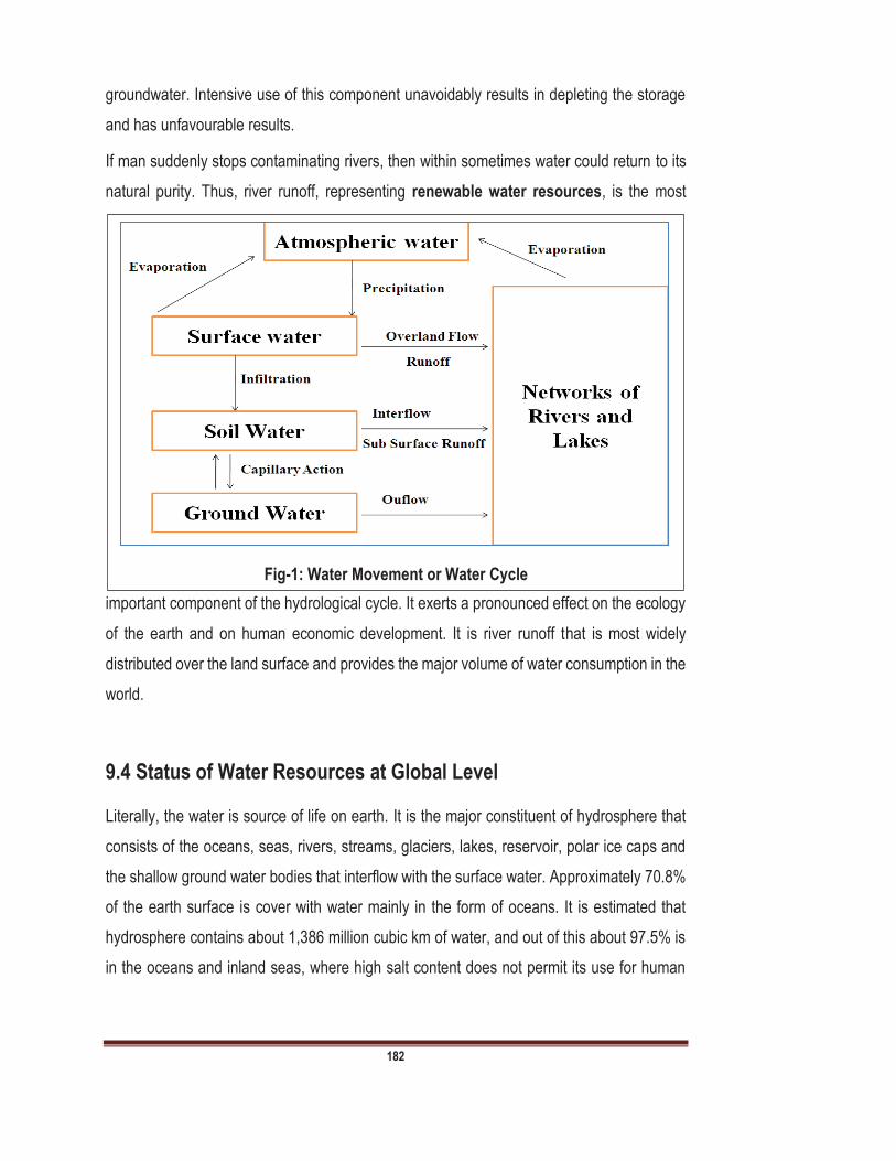
182
groundwater. Intensive use of this component unavoidably results in depleting the storage
and has unfavourable results.
If man suddenly stops contaminating rivers, then within sometimes water could return to its
natural purity. Thus, river runoff, representing renewable water resources, is the most
important component of the hydrological cycle. It exerts a pronounced effect on the ecology
of the earth and on human economic development. It is river runoff that is most widely
distributed over the land surface and provides the major volume of water consumption in the
world.
9.4 Status of Water Resources at Global Level
Literally, the water is source of life on earth. It is the major constituent of hydrosphere that
consists of the oceans, seas, rivers, streams, glaciers, lakes, reservoir, polar ice caps and
the shallow ground water bodies that interflow with the surface water. Approximately 70.8%
of the earth surface is cover with water mainly in the form of oceans. It is estimated that
hydrosphere contains about 1,386 million cubic km of water, and out of this about 97.5% is
in the oceans and inland seas, where high salt content does not permit its use for human
Fig-1: Water Movement or Water Cycle
183
consumption. About 2.5% of the water resource is locked in the glaciers and ice caps, rivers,
streams, lakes and reservoir and as ground water sources.
The stock of salt water and freshwater has been fairly steady right through history. But the
small portion between sea water and freshwater has always changed according to climatic
circumstances. Temperature plays very important role in hydrological cycle. You can
understand this phenomenon by following example. Whenever the climate is very cold, much
of sea water is absorbed by glaciers and ice caps and freshwater increases at the expense
of the sea water. On the other hand the in hot climate glaciers and ice caps melt and sea
water gains at the cost of fresh water. Sea level observations during the last 100 years
indicate that the sea level is rising, which means, the global climate is getting warmer
continuously.
9.4.1 Freshwater
Fresh water is naturally found in form of ice caps, ponds, lakes, rivers, streams, and
groundwater. It has low concentration of dissolved salts and TDS. About 2.5% water of this
planet is freshwater. It is also called . The main source of freshwater is
precipitation/rainfall. Fresh water is a renewable and variable, but limited natural resource.
Fresh water only is recharged through the process of the hydrological cycle, in which water
from seas, lakes, forests, land, rivers etc. evaporates, forms clouds, and returns as
precipitation. Freshwater may classified as surface water (Ponds, lakes, rivers, streams, and
reservoir) and Ground water.
9.4.2 Salt-Water
Saline water is that which contains a huge concentration of salts. About 97.5 % of the
total water of the world is salt water. On the basis of salt concentration saltwater may be
categorized as following.
Slightly saline water: In this category salinity is about 1,000 to 3,000 ppm or 0.1
0.3%.
Moderately saline water: In this type of salt water salinity is about 3,000 to 10,000
ppm or 0.4 1%.
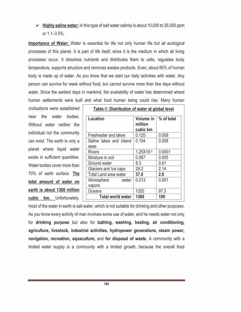
184
Highly saline water: In this type of salt water salinity is about 10,000 to 35,000 ppm
or 1.1 3.5%.
Importance of Water: Water is essential for life not only human life but all ecological
processes of this planet. It is part of life itself, since it is the medium in which all living
processes occur. It dissolves nutrients and distributes them to cells, regulates body
temperature, supports structure and removes wastes products. Even, about 60% of human
body is made up of water. As you know that we start our daily activities with water. Any
person can survive for week without food, but cannot survive more than few days without
water. Since the earliest days in mankind, the availability of water has determined where
human settlements were built and what food human being could rise. Many human
civilizations were established
near the water bodies.
Without water neither the
individual not the community
can exist. The earth is only a
planet where liquid water
exists in sufficient quantities.
Water bodies cover more than
70% of earth surface. The
total amount of water on
earth is about 1360 million
cubic km. Unfortunately,
most of the water in earth is salt water, which is not suitable for drinking and other purposes.
As you know every activity of man involves some use of water, and he needs water not only
for drinking purpose but also for bathing, washing, heating, air conditioning,
agriculture, livestock, industrial activities, hydropower generations, steam power,
navigation, recreation, aquaculture, and for disposal of waste. A community with a
limited water supply is a community with a limited growth, because the overall food
Table-1: Distribution of water at global level
Location Volume in million cubic km
% of total
Freshwater and lakes 0.125 0.009
Saline lakes and inland seas
0.104 0.008
Rivers 1.25X10⁻³ 0.0001
Moisture in soil 0.067 0.005
Ground water 8.3 0.61
Glaciers and Ice caps 29.2 2.14
Total Land area water 37.0 2.8
Atmosphere water vapors
0.013 0.001
Oceans 1320 97.3
Total world water 1360 100
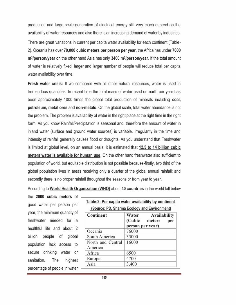
185
production and large scale generation of electrical energy still very much depend on the
availability of water resources and also there is an increasing demand of water by industries.
There are great variations in current per capita water availability for each continent (Table-
2). Oceania has over 70,000 cubic meters per person per year, the Africa has under 7000
m3/person/year on the other hand Asia has only 3400 m3/person/year. If the total amount
of water is relatively fixed, larger and larger number of people will reduce total per capita
water availability over time.
Fresh water crisis: If we compared with all other natural resources, water is used in
tremendous quantities. In recent time the total mass of water used on earth per year has
been approximately 1000 times the global total production of minerals including coal,
petroleum, metal ores and non-metals. On the global scale, total water abundance is not
the problem. The problem is availability of water in the right place at the right time in the right
form. As you know Rainfall/Precipitation is seasonal and, therefore the amount of water in
inland water (surface and ground water sources) is variable. Irregularity in the time and
intensity of rainfall generally causes flood or droughts. As you understand that Freshwater
is limited at global level, on an annual basis, it is estimated that 12.5 to 14 billion cubic
meters water is available for human use. On the other hand freshwater also sufficient to
population of world, but equitable distribution is not possible because-firstly, two third of the
global population lives in areas receiving only a quarter of the global annual rainfall; and
secondly there is no proper rainfall throughout the seasons or from year to year.
According to World Health Organization (WHO) about 40 countries in the world fall below
the 2000 cubic meters of
good water per person per
year, the minimum quantity of
freshwater needed for a
healthful life and about 2
billion people of global
population lack access to
secure drinking water or
sanitation. The highest
percentage of people in water
Table-2: Per capita water availability by continent
(Source: PD. Sharma Ecology and Environment)
Continent Water Availability
(Cubic meters per
person per year)
Oceania 76000
South America 35000
North and Central
America
16000
Africa 6500
Europe 4700
Asia 3,400
186
poor countries are in Africa and Middle East. Unfortunately, growing population and stagnant
economies meant that most countries only kept even or fall behind in the proportion of their
people with acceptable water supplies. For conservation of water resources there are
various strategies have made at global level.The UN proclaimed year 2003 as the
Water Resources at Global level: There are various forms of water resources at global
level which are described below and also summarized in Table-4:
Freshwater resources are unevenly distributed, with much of the water located far
away from human beings. Most of the larger river basins of World run through thinly
populated areas. There are an estimated 263 major international river basins in the
world, covering 231 059 898 km2 or 45.3% of the Earth's land surface area
(excluding Antarctica).
Groundwater represents about 90% of the available freshwater resources, and
some 1.5 billion people depend upon groundwater for their drinking water.
Agricultural water use accounts for about 70% of total global consumption, mainly
through crop irrigation, industrial use accounts for about 20%, and 5% is used for
domestic purposes and remaining 5% used for other purposes.
It is estimated that two out of every three people will live in water-stressed areas by
the year 2025.
About 20% of the global population lacking access to safe drinking water. Water-
borne diseases from fecal pollution of surface waters continue to be a major cause
of illness in developing countries. Polluted water is estimated to affect the health of
1.2 billion people, and contributes to the death of 15 million children annually.
Impacts of climate change may comprise a significant rise in the level of the oceans.
This may cause some coastal areas to become completely submerged, and
increase human vulnerability in other areas. Because human populations are highly
dependent upon marine resources, small island developing states (SIDS) are
especially vulnerable, due to both the effects of sea level rise and to changes in
marine ecosystems.

187
According to the United States Geological Survey
(USGS), 96% of the freshwater is frozen at the
South and North poles, with the remaining 4%
spread over 550 000 km2 of glaciers and
mountainous icecaps measuring about 180 000
km3. Ground water is by far the most abundant and
readily available source of freshwater, followed by
lakes, reservoirs, rivers and wetlands (surface
water). According to Boswinkel (2000) Groundwater
represents over 90% of the readily available
freshwater resource
at global level.
According to World
Resource Institution
(WRI), United
Nations
Environment
Program (UNEP),
United Nations
Development
Program (UNDP),
and World Bank
(1998) 1.5 billion
People depend
upon groundwater for their drinking water supply. According to Gleick, (1993) and
Table-3: Fresh water distribution and their percentage at global level Polar ice 68.6
Ground water 30.1
Other ice and snow 0.97
Lakes 0.26
Soil Moisture 0.047
Atmospheric water 0.037
Marshes 0.33
Rivers 0.006
Biological Water 0.003
Table 4: Showing total water stock at global level
(Shiklomanov, 1993)
Volume 1000km3
Percentage of Total Water
Percentage of Total Freshwater
Salt Water
Oceans 1338000 96.54
Saline/Brackish/Ground Water
12870 0.93
Salt Water Lakes 85 0.006
Inland Water
Glaciers, Permanent snow cover
24064 1.74 68.7
Fresh Ground water 10530 0.76 30.06
Ground Ice/Permafrost 300 0.022 0.86
Freshwater Lakes 91 0.007 0.26
Soil Moisture 16.5 0.001 0.05
Atmospheric water vapours
12.9 0.001 0.04
Marshes/Wetlands 11.5 0.001 0.03
Rivers 2.12 0.0002 0.006
Incorporated in Biota 1.12 0.0001 0.003
Total Water 1386000 100
Total Water 35029 100
Fig 2. A- Showing percentage of Salt water and Freshwater at Global level;
B. Showing percentage of Freshwater at Global level
A B

188
Shiklomanov, (1999) the volume of freshwater resources is about 35 million km3, or about
2.5% of the total volume. Out of these freshwater resources, 24 million km3 (68.9%) is in the
form of ice and permanent snow cover in mountainous regions, the Antarctic and Arctic
regions. Freshwater lakes and rivers contain an estimated 105 000 km3 (0.3%) of the
freshwater at global level. The total usable freshwater supply for ecosystems and humans
is 200 000 km3 of water (< 1%) of all freshwater resources.
Most freshwater occurs in the form of permanent ice or snow, locked up in Antarctica and
Greenland, or in deep groundwater aquifers. The principal sources of water for human use
are lakes, rivers, soil moisture and relatively shallow groundwater basins. The replenishment
of freshwater depends on evaporation from the surface of the oceans. About 505 000 km3,
evaporates from the oceans annually. Another 72 000 km3 evaporates from the land. About
80% of all precipitation, or about 458 000 km3/year, falls on the oceans and the remaining
119 000 km3/year on land.
9.5 Status of Water Resources at National Level
India has about 4% of freshwater resources of world and ranking it among the top ten water
rich countries. However, India has current utilizable freshwater 1122 cubic meter per person
per year and per capita while international standards for this utilization is as 1700 cubic
meter per person per year.
In future, at the current rate it is expected that India with high demands will be termed a
as utilizable freshwater falls below the international standard of 1000
cu m per year and per capita. Water demand is on a high due to rapid urbanization and
industrialization along with the demand for agriculture. Overall, every year, precipitation in
the form of rain and snowfall provide over 4000 cu km of freshwater to India, of which
2047 cu km return to oceans or is precipitated.
In India, rivers have been the lifelines of development and culture. India is drained by twelve
major river systems with a number of smaller rivers and streams. The main river systems
of North India are Ganga, Yamuna, Indus and Brahmaputra. The South India has Krishna,
Godavari, and Cauvery while central India has the Narmada, Mahanadi and Tapti river
system. Over 70% of rivers drain into the Bay of Bengal, mostly as part of the Ganges-
189
Brahmaputra system. The Arabian Sea receives 20% of the total drainage from the Indus,
Tapti. The remaining 10% drains into interior basins and natural lakes.
Besides, the floods and droughts, most Indian rivers are cesspools of waste dumped from
various urban and industrial centres. According to the Central Pollution Control Board 18
major rivers are severely polluted. 44 rivers in State Kerala losing their quality through
deforestation, sand mining, riverbank brick making and pollution.
As you know, the rivers are the sources of drinking water for urban and rural areas, raw
water for industries, and irrigation. Many rivers of India suffer from silt deposition in its bed
reducing flow, and disturbing the ecosystem. Deforestation at the riparian zone of the rivers,
is leading to soil erosion, landslide, floods, silt formation etc. In rivers of India, siltation rate
is among the highest in the world. It has been predicted that about 135 thousand million
metric tonnes of sediment load and 32 thousand million tonnes of soluble matter enter
into ocean through various rivers. Numbers of large dams and barrages have been built
on these rivers. We will discuss the various dams of India and their impacts in Unit-10 of this
course.
India is also home to most beautiful lakes of the world. They are there in the high Himalayan
regions under the ice sheath, in northeast, semi-arid deserts of Rajasthan, coastal zones,
small towns and villages.
In India, lakes are important source of water for drinking, agriculture, and industries
purposes. These lakes act as sewage absorbers, flood controller and recharger of
groundwater. These are important ecosystems where a variety of birds and animals make
their habitats. Lakes also provide pisciculture, and aquaculture which thrives leading to a
source of income for people. In India, there are urban and rural lakes which have been
categorized under the Ramsar Convention on Wetlands (1971) and are important mostly
from ecological sustainability and as a source of livelihood for many communities. Water
shortages in these lakes, which sources of replenishment are seriously impaired due to
manmade activities. However water resources of India mainly categorized as surface water
and ground water.
A. Surface water resources: As you know surface water is type of water which occur on
the surface of earth. This water present in the form of river, lake, wetlands or even ocean.
190
The main source of surface water is rainfall or precipitation. After the rainfall, a sizable
portion is captured by the vegetation, or temporarily detained in surface depressions. When
soil become fully saturated the remaining water begins flow. This water reaches the rivers,
streams, lakes, surface reservoirs, etc. Agriculture mainly depends on surface water
resources. Water runoff from streams and rivers is stored in reservoirs or diverted through
canal system for irrigation. Surface run-off generated by rainfall and snowmelt is estimated
to be about 1869 billion cubicmeter (BCM) in India. However, it is estimated that only about
690 billion cubic meter (BCM) or 37% of the surface water resources can actually be
mobilized. Because Over 90% of the annual flow of the Himalayan Rivers occurs over a four
month period and potential to capture such resources is complicated by limited suitable
storage reservoir site. The average annual rainfall in India is about 1170 mm. Most rain falls
in the monsoon season (June-September), necessitating the creation of large storages for
maximum utilization of the surface run-off. However, it is possible to have both situations of
drought and of floods in the same region. India has great variation in rainfall, ranging from a
low value of 100 mm in Western Rajasthan to over 11,000 mm in Meghalaya. The
Krishna basin leads in term of storage capacity (41.80 km3) followed by Godavari basin
(25.12 km3) and Narmada basin (16.98 km3). The various water resources of India are
discussed below:
B) River systems in India (Characterization of Rivers): The main character of river is the
ability erodes and transport sediment is affected by many factors. The velocity of the water,
gradient of river, discharge, and the shape of river are main characters of river. The
velocity of water in a river is the distance that water travels in a given amount of time. The
velocity of the water in a river is related to the amount of energy of water. As you know
fast-moving River can erode materials more rapidly and can carry larger particles as
compare to slow-moving River. Many factors affect a velocity, including the steepness of
the slope, the amount of water traveling downstream, and shape of the path where water
travels. The steepness of the slope of a stream or river is called its gradient.
The discharge of river is the volume of water that passes a certain point in a given amount
of time. Discharge is not always constant throughout the length of a river. In most of the
rivers, discharge increases downstream because many tributaries continuously add more
water in river. During monsoon increased precipitation or at the times when snow is melting,

191
more water runs into rivers. The velocity of the water also increases and river becomes wider
and deeper and cause flood. Ganga river has width about 700 meters at Haridwar and its
width is about 5km at Patna.
Rivers are important sources of water supply, even though the water from these sources is
generally more variable in quality. The water quality in rivers depends on various factors like
geology and topography, seasonal variation, disposal of sewage etc.
Rivers are the main source of surface water. A river basin has well defined watershed
boundary and also has relationship with ground water resources. India has various river
systems. On the basis of their path these river may as followings:
1. Flowing into the Bay of Bengal: Ganga, Mahanadi, Krishna, Kaveri, Godavari, and
Brahmaputra.
2. Flowing into the Arabian Sea: Indus, Narmada, Tapti etc.
There are various river systems of India which are discussed below and also
summarized in Table-1.
Indus River: Indus River is one of the longest rivers in the world, which originates from
Mount Kailash in Tibet. It has total length of the river is 3,199 km. It flows through the
regions of Ladakh, Baltistan and Gilgit and runs between the Ladakh Range and the Zaskar
Range. Total length of the river in India is about 1,114 km. The main tributaries of the Indus
River in India are Jhelum, Chenab, Ravi, Beas and Sutlej. Its catchment area is about
1,165,500 km2. Its drainage area lying in India is 321,289 km2. In India, the Indus basin lies
in the States of Jammu and Kashmir, Himachal Pradesh, Punjab, Rajasthan, Haryana and
Union Territory of Chandigarh.
Brahmaputra River System: River Brahmaputra originates from Angsi glacier. The river
flows through China, India and Bangladesh. In India, it enters in the Arunachal Pradesh
where it is called Siang. It flows through Arunachal Pradesh and Assam, and is joined by
several tributaries. Its catchment area is about 580000km2.
Ganga River: The Ganga rises from the Gangotri Glacier in the Garhwal Himalayas,
Uttarakhand at an elevation of some 4100 metres above the sea level. The main tributaries
of the Ganga are Yamuna, Ram Ganga, Gomati, Ghaghara, Son, Damodar and Sapt Kosi.
The river after traversing a distance of 2525 kms from its source meets the Bay of Bengal.
192
The major cities along its course are Haridwar, Kanpur, Varanasi, Patna, Bhagalpur,
Sahibganj, Farakka and Haldia. About 40% of India population depends on Ganga river
Basin. The total catchment area of Ganga river is about 1186000km2. This is longest river
of India and regarded as
National River of India.
Yamuna River: The River Yamuna originates from the Yamunotri glacier, 6387m above
mean sea level, at the Banderpoonch peak in the Uttarkashi district of Uttarakhand. The
catchment of the river extends to states of Uttar Pradesh, Himachal Pradesh, Haryana,
Rajasthan and Madhya Pradesh and the entire union territory of Delhi. The river flows 1367
km from here to its confluence with the River Ganga at Allahabad (Uttar Pradesh). The other
main tributaries of the Yamuna river are: Hindon, Chambal, Sind, Betwa and Ken.
Narmada River: Narmada is a river in central India and it is also called Rewa river. It forms
the traditional boundary between North and South India, The total length of river is about
1289 km. It originates from the peak of Amarkantak in Madhya Pradesh. It flows through
the states of Madhya Pradesh, Maharashtra, and Gujarat and it empties into the Arabian
Sea in Indian State Gujarat. Its total catchment area is about 98796km2 . Sher, Skakkar,
Dudhi, Tawar are the main tributaries of Narmada river.
Tapti River: The Tapti is also river of central India and one of the major rivers of peninsular
India. Its total length is about 724 km. This river is also mythologically very important and
regarded as daughter of Sun. It originates in Muttai Satpura Range at Betul district of
Madhya Pradesh The Tapi or Tapti River basin lies mostly in northern and eastern districts
Maharashtra state. It flows in the states viz. Madhya Pradesh, Maharashtra and Gujarat.
The Total catchment area of Tapti River is about 65145 km2.
Godavari River:
Godavari is second
longest river of
India after Ganga.
This river flows
about 1,465 km and originates from Trimbakeshwar, near Nasik in Maharashtra around 380
km distance from the Arabian Sea and empties into the Bay of Bengal. It travels through
Table-5 Water resources of India (source: Water Resource information System of India)
Estimated annual precipitation (including snowfall) 4000 km3
Average annual potential in rivers 1869 km3
Estimated utilisable water 1123 km3
634 km3

193
various different states such as Maharashtra, Telangana, Andhra Pradesh, Chattisgarh,
M.P., Orrisa, Karnataka and Puduchery. In Puduchery this river is known as Yaman. The
Important tributaries of Godavari river are Indravati River, Manjira, Bindusara and Sabari. Its
total catchment area is about 312812 km2. It empties in to Bay of Bengal.
Krishna River: Krishna River is one of the longest rivers of India and it travels 1300 km in
length. It originates at Mahabaleswar (ancient temple of Lord Shiva) in Maharashtra. This
River flows through the states of Maharashtra, Karnataka and Andhra Pradesh. The main
Table-6: The details of water resources potential of river basins in India
River Basin Catchment area(km2)
Average annual potential (km3)
Utilisable surface water resources (km3)
Indus (up to Border) 321289 (1165500) 73.31 46.00
a) Ganga 861452 (1186000) 525.02 250.00
b) Brahmaputra 194413 (580000) - -
c) Barak and others 41723 585.60 24.00
Godavari 312812 110.54 76.30
Krishna 258948 78.12 58.00
Cauvery 81155 21.36 19.00
Subernarekha 29196 12.37 6.81
Brahmani & Baitarni 51822 28.48 18.30
Mahanadi 141589 66.88 49.99
Pennar 55213 6.32 6.86
Mahi 34842 11.02 3.10
Sabarmati 21674 3.81 1.93
Narmada 98796 45.64 34.50
Tapi 65145 14.88 14.50
WFR from Tapi to Tadri 55940 87.41 11.94
WFR from Tadri to Kanyakumari
56177 113.53 24.27
EFR between Mahanadi & Pennar
86643 22.52 13.11
EFR between Pennar & Kanyakumari
100139 16.46 16.73
WFR of Kutch & Saurashtra including Luni
321851 15.10 14.98
Area of Inland drainage in Rajasthan
- Negligible Not applicable
Minor Rivers draining into Myanmar & Bangladesh
36202 31.00 Not applicable
Total - 1869.35 690.31
(Source: Water Resource information System of India)

194
tributary of the river is Tungabhadra River Other tributaries of river are: Koyna, Bhima,
Mallaprabha, Ghataprabha, Yerla, Warna, and Dudhganga rivers. Its total catchment area
is about 258948km2.
Cauveri River: The Cauveri is one of the great rivers of India and flows through states of
Karnataka and Tamil Nadu. It supported agriculture for centuries, and the Cauveri has been
the lifeblood of South India. The source of the river is Talakaveri located in the Western
Ghats. It flows generally south and east for around 765 km. The main tributaries of river are
Shimsha, Arkavathy, Kapila, Lakshmana Tirtha, Kabini, Bhavani, Noyyal and Amaravati. Its
total catchment area is about 81155km2. It empties in to Bay of Bengal.
Mahanadi River System: The Mahanadi River is the third largest in the peninsula of India
and the largest river of Orissa state. The total length of Mahanadi river is about 851 km. The
main branches of Mahanadi meet Bay of Bengal at Paradip and Nuagarh. Its total catchment
area is about 141589km2.
Lakes: There are various lakes are also located in India. Lakes are formed by backrest of
glaciers, blocked rivers etc. In lakes the soil is supersaturated with water, and there are small
areas of still or slow moving water. In lakes, the water is standing, not flowing, which is called
lentic ecosystem. The water in lakes, stratified according to temperature, oxygen and
biotic components. Lakes are inland depression that holds standing freshwater throughout
the year. Lakes are generally larger than the ponds and water of lakes generally more
accessible than ground water or glaciers, they are considered as an important source of
freshwater supply. Water from these sources is more in equity, in quality than the water from
rivers and streams. There are various characteristics of lakes which are given below:
Lakes are usually stratified because they stand relatively still, compared with streams and
rivers. If you swim in a lake where the surface water warm but you will feel the cooler water
when you swim in deeper side of the lake. Typically the coldest layers are found at the
bottom. Changing temperatures in the spring and fall prevent stratification during those
seasons, and the bottom waters rising to the top stir up nutrients. During the summer, ice
warms and melts and this water warms from 00C to 40C, it becomes denser and sinks. This
causes the layers to mix. In the fall the waters become colder. As the water temperatures
drop below 40C, the colder layers rise to the top, and again the whole body of water is mixed.
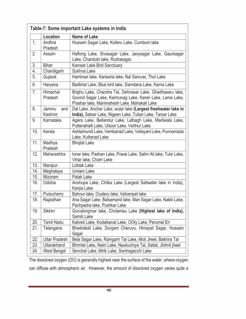
195
The dissolved oxygen (DO) is generally highest near the surface of the water, where oxygen
can diffuse with atmospheric air. However, the amount of dissolved oxygen varies quite a
Table-7: Some important Lake systems in India
Location Name of Lake
1. Andhra Pradesh
Hussain Sagar Lake, Kolleru Lake, Cumbum lake
2. Assam Haflong Lake, Sivasagar Lake, Jaoysagar Lake, Gaurisagar Lake, Chandubi lake, Rudrasagar,
3. Bihar Kanwar Lake Bird Sanctuary
4. Chandigarh Sukhna Lake
5. Gujarat Hamirsar lake, Kankaria lake, Nal Sarovar, Thol Lake
6. Haryana Badkhal Lake, Blue bird lake, Damdana Lake, Karna Lake
7. Himachal Pradesh
Brighu Lake, Chandra Tal, Dehnasar Lake, Ghadhasaru lake, Govind Sagar Lake, Kamrunag Lake, Kareri Lake, Lama Lake, Prashar lake, Manimahesh Lake, Mahakali Lake
8. Jammu and Kashmir
Dal Lake, Anchar Lake, wular lake (Largest freshwater lake in India), Satsar Lake, Nigeen Lake, Tulian Lake, Tarsar Lake
9. Karnataka Agara Lake, Bellandur Lake, Lalbagh Lake, Madiwala Lake, Puttenahalli Lake, Ulsoor Lake, Varthur Lake
10. Kerala Ashtamundi Lake, Vembanad Lake, Vellayani Lake, Punnamada Lake, Kuttanad Lake
11. Madhya Pradesh
Bhojtal Lake
12. Maharashtra lonar lake, Pashan Lake, Powai Lake, Salim Ali lake, Tulsi Lake, Vihar lake, Chatri Lake
13. Manipur Loktak Lake
14. Meghalaya Umiam Lake
15. Mizoram Palak Lake
16. Odisha Anshupa Lake, Chilka Lake (Largest Saltwater lake in India), Kanjia Lake
17. Puducherry Bahour lake, Oustery lake, Velrampet lake
18. Rajasthan Ana Sagar Lake, Balsamand lake, Man Sagar Lake, Nakki Lake, Pachpadra lake, Pushkar Lake
19. Sikkim Gurudongmar lake, Cholamau Lake (Highest lake of India), Samiti Lake
20. Tamil Nadu Kaliveli Lake, Kodaikanal Lake, OOty Lake, Perumal Eri
21. Telangana Bhadrakali Lake, Durgam Cheruvu, Himayat Sagar, Hussain Sagar
22. Uttar Pradesh Bela Sagar Lake, Ramgarh Tal Lake, Moti Jheel, Bakhira Tal
23. Uttarakhand Bhimtal Lake, Naini Lake, Naukuchiya Tal, Sattal, Jhilmil jheel
24. West Bengal Senchal Lake, Mirik Lake, Santragacchi Lake
196
bit as the result of differences in temperature, sunlight, wind and the number of plants at
various depths.
Some fish are bio-indicators of the amount of oxygen in the lake. Fishes such as trout (fast
moving fish) need more oxygen; while fishes such as catfish (slow moving fish) can survive
in areas with low dissolved oxygen.
In lake you will find more producers (green plants) are found near the top, and more
consumers (animals) near the bottom of the lake. Producers require sunlight near the
surface of the water for process of photosynthesis. The bottom layers contain consumers
such as anaerobic bacteria and decomposers (fungi and bacteria). The biotic stratification
consists of three zones.
Limnetic Zone: This zone is inhabited by photosynthesizers, including phytoplankton
(diatoms, chlorophyceae, bacillariophyceae etc) and zooplankton (rotifers, copepods,
Cyclops, cladocerans and others).
Profundal Zone: This zone is too deep for photosynthesis to occur and this zone has limited
life.
Benthic Zone: This region is inhabited by decomposers and anaerobic bacteria. As lakes
age, organic materials builds up on the bottom, the organic material causes
eutrophification. The older lakes take on swamp like characteristics and produce methane.
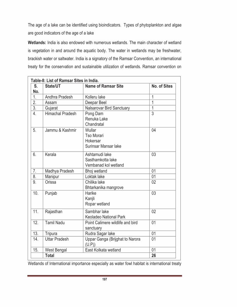
197
The age of a lake can be identified using bioindicators. Types of phytoplankton and algae
are good indicators of the age of a lake
Wetlands: India is also endowed with numerous wetlands. The main character of wetland
is vegetation in and around the aquatic body. The water in wetlands may be freshwater,
brackish water or saltwater. India is a signatory of the Ramsar Convention, an international
treaty for the conservation and sustainable utilization of wetlands. Ramsar convention on
Wetlands of International importance especially as water fowl habitat is international treaty
Table-8: List of Ramsar Sites in India.
S. No.
State/UT Name of Ramsar Site No. of Sites
1. Andhra Pradesh Kolleru lake 1
2. Assam Deepar Beel 1
3. Gujarat Nalsarovar Bird Sanctuary 1
4. Himachal Pradesh
Pong Dam Renuka Lake Chandratal
3
5. Jammu & Kashmir
Wullar Tso Morari Hokersar Surinsar Mansar lake
04
6. Kerala
Ashtamudi lake Sasthamkotta lake Vembanad kol wetland
03
7. Madhya Pradesh Bhoj wetland 01
8. Manipur Loktak lake 01
9. Orissa Chilika lake Bhtarkanika mangrove
02
10. Punjab
Harike Kanjli Ropar wetland
03
11. Rajasthan
Sambhar lake Keoladeo National Park
02
12. Tamil Nadu Point Calimere wildlife and bird sanctuary
01
13. Tripura Rudra Sagar lake 01
14. Uttar Pradesh Uppar Ganga (Brijghat to Narora (U.P))
01
15. West Bengal East Kolkata wetland 01
Total 26

198
for conservation of wetlands. Ramsar is named after Ramsar City, Iran. 26 Ramsar wetland
sites are located in India (Table-8). This convention was signed in the year 1971.
Glaciers: Five states of India have glaciers and these glaciers are source of several rivers.
Main characteristic feature of glaciers is ability to flow. When sufficient ice gets piled up, it
exerts substantial pressure on the ice in the lower layers and it acquires plastic properties
which enable the ice-mass to move outward or downhill and thus an active glacier comes
into being. When there is thick accumulation of ice on a slope the glacier under the influence
of gravity begin to flow slowly down a valley until it reaches a point where the rate of melting
exactly balances the increment of ice. A glacier may extend far below the snow-line. As you
know, the accumulation of snow is more in the central part of the glacier and there is a
decrease in the thickness of ice near the marginal parts. The rate of movement depends on
a number of factors, such as: Thickness of the glacier; Gradient of the slope which it covers;
Temperature of the ice; Rate of evaporation and melting and the intensity of retarding friction
along the slope, etc. The rate of movement of the Himalayan glaciers varies from 2 to 4
metres per day. The glaciers of the Alps move at the rate of 0.1 -0.4 metres per day. Some
of the glaciers of Greenland move at a rate of about 20 metres a day. There are various
glaciers in India which are listed in Table-9:
The Indian Ocean: The Indian Ocean is the third largest oceanic division of the world. It
covering 70,56, 0000 km2. Various seas, gulfs, bays and straits of Indian Ocean are
Andaman Sea, Arabian Sea, Bay of Bengal, Gulf of Mannar, Gulf of Kutch, Gulf of Khambat,
Persian Gulf Red Sea etc.
Table-9:- List of Important glaciers of India
State Name of Glaciers
Arunachal Pradesh
Bichom, Kangto Glaciers
J & K Nun Kun Massif, Machoi, Nubra, Sgataf glaciers
Himachal Pradesh
Bara Shigri Glacier, Chandra Glacier, Chandra Nahan Glacier, Chhota Shigri, Dhaka Glacier, Mukkila Glacier, Sonapani
Uttarakhand Gangotri, Kalabaland, Namik, Panchchuli, Pindari, Sunderdhunga, Milam, Sona, Chorabari, Satopanth glaciers.
Sikkim Zemu, Rathong, Lonak Glaciers
199
B. Ground Water Resources: As you know that ground water is that water which found
below the surface of earth. After Glacier, ice caps and snow fields, ground water is the next
largest fresh water resource. When rainfall/precipitation that does not evaporate back in to
atmosphere or runoff over the surface percolates through the soil and either accumulates in
an underground. Ground water source can be relatively simple to develop. Generally ground
water is clear and colourless but harder than the surface water. The quality of ground water
is generally uniform quality. Groundwater is the major source of freshwater for agriculture
and domestic use in many areas of the world, particularly where surface water is insufficient.
The main source of ground water is Rainfall/Precipitation. However, ground water
recharge is supplemented by other sources such as seepage from canals and field channels,
ponds, tanks, deep percolation from irrigated fields, etc. A part of any of these water sources
that infiltrates into surface soil may continue to move laterally at a shallow depth. This water
which flows below the soil surface may eventually reach the stream channel.
The total run-off in the rivers includes melted snow, surface run-off, sub surface runoff and
ground water runoff. Portion of run-off water, after infiltration reaches the ground water,
together with the contribution made to ground water from a neighbouring basins, effluent
rivers, natural lakes, ponds, artificial storage reservoirs accounts ground water resources.
On the basis of geological consideration the ground water in India mainly categorized as
following three categories:
a. Unconsolidated rocks: This region includes vast alluvial plains of the North India, from
the West to East and between the Himalayan foot hills on the north and the peninsular to
the south. The sediments carried out by the Indus, Ganga, and Brahmaputra are the most
important rivers of unconsolidated rocks.
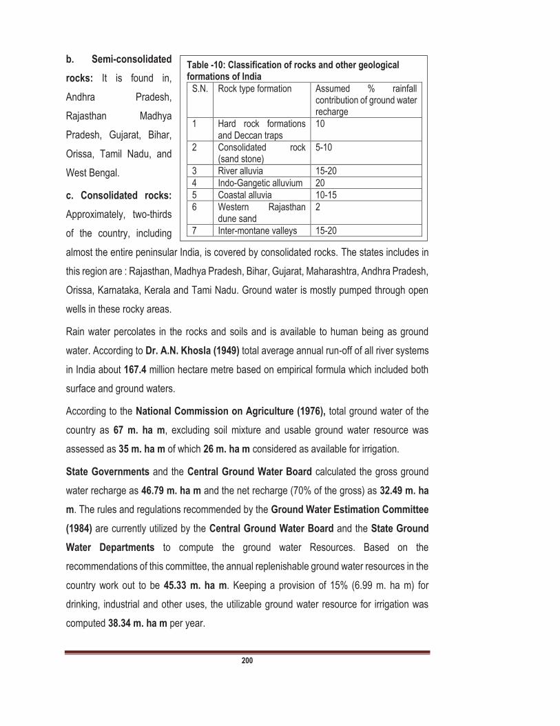
200
b. Semi-consolidated
rocks: It is found in,
Andhra Pradesh,
Rajasthan Madhya
Pradesh, Gujarat, Bihar,
Orissa, Tamil Nadu, and
West Bengal.
c. Consolidated rocks:
Approximately, two-thirds
of the country, including
almost the entire peninsular India, is covered by consolidated rocks. The states includes in
this region are : Rajasthan, Madhya Pradesh, Bihar, Gujarat, Maharashtra, Andhra Pradesh,
Orissa, Karnataka, Kerala and Tami Nadu. Ground water is mostly pumped through open
wells in these rocky areas.
Rain water percolates in the rocks and soils and is available to human being as ground
water. According to Dr. A.N. Khosla (1949) total average annual run-off of all river systems
in India about 167.4 million hectare metre based on empirical formula which included both
surface and ground waters.
According to the National Commission on Agriculture (1976), total ground water of the
country as 67 m. ha m, excluding soil mixture and usable ground water resource was
assessed as 35 m. ha m of which 26 m. ha m considered as available for irrigation.
State Governments and the Central Ground Water Board calculated the gross ground
water recharge as 46.79 m. ha m and the net recharge (70% of the gross) as 32.49 m. ha
m. The rules and regulations recommended by the Ground Water Estimation Committee
(1984) are currently utilized by the Central Ground Water Board and the State Ground
Water Departments to compute the ground water Resources. Based on the
recommendations of this committee, the annual replenishable ground water resources in the
country work out to be 45.33 m. ha m. Keeping a provision of 15% (6.99 m. ha m) for
drinking, industrial and other uses, the utilizable ground water resource for irrigation was
computed 38.34 m. ha m per year.
Table -10: Classification of rocks and other geological formations of India
S.N. Rock type formation Assumed % rainfall contribution of ground water recharge
1 Hard rock formations and Deccan traps
10
2 Consolidated rock (sand stone)
5-10
3 River alluvia 15-20
4 Indo-Gangetic alluvium 20
5 Coastal alluvia 10-15
6 Western Rajasthan dune sand
2
7 Inter-montane valleys 15-20

201
As per the the Planning Commission, the total water resources are about 178 million
hectare metres water resources are available but because of limitations of physiography,
geology, dependability, quality and the present state of technology, only a small portion of it
could be used. The demand od water for irrigation is increasing day to day due to population
explosion and therefore, there is need of implementation of new technology which will have
to be implemented for making appropriate use of the water resources.
According to the Central Ground Water Board in 2003, the total replenishable ground water
resource in the country is more than 443 BCM/year and out of this, the ground water
available for irrigation is about 362.4 BCM/year and for other uses including domestic and
industrial purposes is about 71.2 BCM/year.
Some large states of India such as Uttar Pradesh, Andhra Pradesh, Madhya Pradesh and
Maharashtra have total replenishable ground water resource more than 30 BCM/year.
States are Assam, Bihar, Gujarat, Orissa, Tamil Nadu and West Bengal which have 20
BCM/year or more replenishable ground water resource.
Ground water resource of less than 1 BCM/year are Goa, Himachal Pradesh, Meghalaya,
Nagaland, Tripura, Sikkim, Andaman & Nicobar Islands, Chandigarh, Dadra and Nagar
Haveli, Daman and Diu, Delhi, Lakshadweep and Pondicherry. Uttar Pradesh has the largest
ground water resources for irrigation which is as much as 68.95 BCM/year. Andhra Pradesh,
Assam, Bihar, Madhya Pradesh, Maharashtra and Tamil Nadu have more than 20
BCM/year ground water resources for irrigation.

202
9.6 Utilization of Water Resources
As you know water is an essential requirement
of all living beings and indispensable for many
human related activities. In nature it transports
eroded material from mountains and forests to
the plains and to the sea. Man uses water to
carry away his wastes, generate hydro-electric
power, for navigation, industrial purposes and
also as a source of recreation. Due to change in
lifestyle of people, water consumption increases dramatically specially during summer
period.
Water resources have
been utilized by human
being since their
existence on this earth.
There are several
utilizations of water
resources which are
summarized in fig-3 and
also described below:
9.6.1 Domestic use
Domestic use of water may include drinking, washing, cleaning, bathing, cocking etc.
Community water supply is the most important requirement and it is about 5% of the total
water use. About 7km3 of surface water and 18 km3 of groundwater being used for
community water supply in urban and rural areas. Due to increase in population, another
important change from the point of view of water supply is higher rate of urbanization. The
higher is the economic growth, urbanization also increases. It is expected that nearly 61%
of the population will be living in urban areas by the year 2050 in high-growth scenario as
against 48% in low growth scenario.
Table 11. Showing water demand in next thirty years (km3)
Purpose Year
2000 2025 2050
Domestic 42 73 102
Irrigation 541 910 1072
Industrial 8 22 63
Hydropower 2 15 130
Others 41 72 80
Total 634 1092 1447
Fig 3. Showing different utilization of water resources

203
The figure adopted by the National Commission on Integrated Water Resources
Development (NCIWRD) was 220 litre per capita per day (lpcd) for class I cities. For the
cities other than class I, the norms are 165 for the year 2025 and 220 lpcd for the year 2050.
For rural areas, 70 lpcd and 150 lpcd have been recommended for the years 2025 and 2050,
respectively. Based on these norms and projection of population, it is estimated that by 2050,
water requirements per year for domestic use will be 90 km3 for low demand scenario and
111 km3 for high demand scenario. It is expected that about 70% of urban water requirement
and 30% of rural water requirement will be met by surface water sources and the remaining
from groundwater.
9.6.2 Irrigation
As it is earlier mentioned about 70% of water resource utilized in agricultural sector. In India
irrigated area is about 22.6 million hectare (Mha) in 1950 51. Since the food production was
much below the requirement of the country, due attention was paid for expansion of
irrigation. The ultimate irrigation potential of India has been estimated as 140Mha out of
this, 76Mha would come from surface water and 64Mha from groundwater sources. Water
used for irrigation by the last century was of the order of 300 km3 of surface water and 128
km3 of groundwater, total 428km3. The estimates indicate that by the year 2025, the water
requirement for irrigation would be 561 km3 for low-demand scenario and 611 km3 for high-
demand scenario. These requirements are likely to further increase to 628km3for low-
demand scenario and 807 km3 for high-demand scenario by 2050.
As you know, India has been an agriculture-based economy; development of irrigation to
increase agricultural production for making the country self-sustained has been of crucial
importance for the planners. Accordingly, the irrigation sector was assigned a very high
priority in the 5-year plans. The schemes like the Bhakra Nangal, Hirakud, Damodar
Valley, Nagarjuna sagar, Rajasthan Canal project etc. were taken up to increase irrigation
potential and maximize agricultural production. Long-term planning has to account for the
growth of population. According to National Water Policy, the production of food grains has
increased from around 50 million tonnes in the 1950s to about 203 million tonnes in the
year 1999 2000. According to the National Commission on Integrated Water Resources
Development (NCIWRD) by the year 2025, the population is expected to be 133 million in

204
high-growth scenario and 1286 million in low growth scenario. For the year 2050, high rate
of population growth is likely to result in about 1581 million people while the low growth
projections place the number at nearly 1346 million.
9.6.3 Hydroelectric Power
Water resources have been used to generate hydro-electric power since prehistoric times.
The hydropower potential of India has been estimated at 84,044MW at 60% load factor. At
the time of independence, the installed capacity of hydropower projects was 508MW. In the
year 1998, the installed hydropower capacity was about 22,000MW. The status of
hydropower development in major basins is highly uneven.
According to an estimate, India has plans to develop 60,000MW additional hydropower by
the twelfth five-year plan. It includes 14,393MW during the tenth five-year plan (2002 2007);
20,000MW during eleventh (2007 2012) and 26,000 MW during the twelfth (2012 2017)
five-year plans. A potential of the order of 10,000MW is available for development of small
hydropower projects in the Himalayan and sub-Himalayan regions of the country. Therefore,
it is not only desirable but also a pressing need of time to draw a master plan for development
of small, me-dium and large hydro-schemes for power generation. Indian rivers have fairly
good hydro power potential when they descend from their source mountains (Himalayan
region, Western Ghat, Eastern Ghat, Vindhya Mountains, Aravali Range) before the water
consumption or flowing to the sea.
9.6.4 Industrial Purposes
Water also used in various industrial processes, such processes may include: fabricating,
washing, processing, diluting, cooling etc. Agricultural industry is larger user of water in
India, about 90% of water resource used by agriculture and livestock. Average industrial
use of water resource is about 19% at global level. United state uses 5% of water resource
for industrial purpose. The surface water (41%) is major source for industrial purpose
followed by ground water (35%) and municipal water (24%). The industries that produce
metals, wood, paper products, chemicals, oil etc. are major users of water resources. Rough
estimates indicate that the present water use in the industrial sector is of the order of 15km3.
The water use by thermal and nuclear power plants with installed capacities of 40,000MW

205
and 1500MW respectively, is estimated to be about 19km3. If the present rate of water uses
continues, the water requirement for industries in 2050 would be 103km3; this is likely to be
nearly 81km3 if water saving technologies are adopted on a large scales.
9.6.5 Aquaculture
As you know that aquaculture is the cultivation of aquatic animals specially fishes for food.
Aquaculture is also known as aqua-farming. Aquaculture is farming of fish, crustaceans,
molluscs, aquatic plants, algae, etc. Therefore, aquaculture required water resources
such as ponds, rivers and lakes. In India, annual aquaculture production is about 9.6 million
tones. In the production of aquaculture, India is second in position after China. As you
know India is blessed with huge water resources, therefore, aquaculture is common
practiced in India. According to S. Ayappan Inland water resource in India as 2900 kms of
rivers, 0.3 million hectare of estuaries, 0.19 million hectare of brackish water & lagoons, 3.15
million hectare of reservoir, 0.2 million hectare of food plain, wetland & 0.72 million hectare
upland lakes. Fisheries, prawn culture, integrated fish farming, mariculture, pearl culture,
mussel culture, seaweed culture etc. are entirely based on water resources.
9.6.6 Recreational
Recreational is an essential and growing activity at global level. It is activity that a people do
for enjoyment, generally fresh the body and mind. Various studies showed that water based
activities such a river rafting, bathing, swimming are among the most popular activities.
Certain land area around water bodies are open for recreational uses such as hiking,
hunting, snow skiing etc. water resources also used for water skiing, swimming, fishing.
Recreational uses of water resources may categorized as
I. Primary body contact
(i) Skiing (ii) Swimming (iii) Tubing (iv) Wind surfing
II. Secondary body contact
(i) Aesthetic values (ii) Boating (iii) Canoeing
(iv) Hunting

LAND, WATER AND BIODIVERSITY RESOURCES EVS 502
206
9.6.7 Navigation
Water bodies also used as transportation by human beings since time immemorial. Various
aquatic bodies such as Ganga river, Hoogly, Brada, Vistula also used for navigation.
Summary
In this unit we have discussed various aspects of water resources, their characteristics and
utilization of water resources. So far you have learnt that:
Water is one of the most important natural resource among all the natural resources.
About 97.5% water on land is salt water and 2.5% water is regarded as freshwater.
Salt water found in seas, oceans and other wetlands. On the other hand freshwater
found in glaciers, ice caps, snow, rivers, streams, lakes, reservoirs, ponds, ground
water etc.
Oceania continent has maximum water availability (70000 cubic meter per person
per year) on the other hand Asia continent has minimum (3400 cubic meter per
person per year).
About 263 major international river basins are found in the world.
In India there are various water resources are found in different forms. Major rivers
of India include Ganga, Yamuna, Brahmaputra, Krishna, Cauvery, Godavari, Indus,
Mahanadi.
Five states of India have glaciers and these states are Jammu & Kashmir, Arunachal
Pradesh, Uttarakhand, Himachal Pradesh and Sikkim.
There are various lakes are also found in India such as : Hussain Sagar Lake,
Kolleru Lake, Cumbum lake, Haflong Lake, Sivasagar Lake, Jaoysagar Lake,
Gaurisagar Lake, Chandubi lake, Rudrasagar, , Kanwar Lake Bird Sanctuary,
Sukhna Lake Dal Lake, Anchar Lake, wular lake (Largest freshwater lake in India),
Satsar Lake, Anshupa Lake, Chilka Lake (Largest Saltwater lake in India), Kanjia
Lake, Pushkar Lake, Gurudongmar lake, Cholamau Lake (Highest lake of India),
Samiti Lake, Kaliveli Lake, Kodaikanal Lake, OOty Lake, Perumal Eri, Bhimtal Lake,
Naini Lake, Naukuchiya Tal, Sattal, Jhilmil jheel.

LAND, WATER AND BIODIVERSITY RESOURCES EVS 502
207
There are various utilization of water resources such as Irrigation, domestic
purposes, hydropower generation, aquaculture, industrial processes, recreational
purposes, navigation etc.
Most of the water resources are utilized in agriculture
Terminal Questions
1(a) Fill in the blank spaces with appropriate words. Freshwater resources are unevenly distributed, with much of the water located far away from human beings. Most of the larger river basins of World run through thinly populated areas. There are an estimated ,
45.3% of the Earth's land surface area (excluding Antarctica). Groundwater represents about 90% of the available freshwater resources, and some
use accounts for about , mainly through crop irrigation, is used for domestic purposes and remaining 5% used for other purposes.
2 (a) Discuss the types of water resources. (b) Differentiate between Ground water and Surface water?
3 (a) Describe the different rivers of India. (b) Give the note on lakes of India
4 (a) Define water resource? Write about causes water resources at global level 5 (a) Differentiate between salt water and freshwater.
(b) Give the status of ground water resource in India? (c) What are the surface water resources in India?
6 (a) Fill the blank spaces with appropriate words.
molluscs, aquatic plants, algae, etc. Therefore, aquaculture required water resources
. As you know India is blessed with huge water resources, therefore, aquaculture is common practiced
0.3 million hectare of estuaries, 0.19 million hectare of brackish water & lagoons, 3.15 million hectare of reservoir, 0.2 million hectare of food plain, wetland & 0.72 million hectare upland lakes. Fisheries, prawn culture, integrated fish farming, mariculture,
(b) Total salt water at global level is about 97.5% (Yes/No) (c) Largest freshwater lake of India is (Chilka Lake/Wular Lake) (d) Pushkar lake is located in (Rajasthan/Madhya Pradesh/ Jammu & Kashmir / H.P.)
(f) Give the per capita water availability in different continent?
7 (a) Describe the Characteristics of river and lake. (b) Describe the utilizations of water resources.
LAND, WATER AND BIODIVERSITY RESOURCES EVS 502
208
Unit 10 Water Resource Development: Dams-The Necessary Evil
Unit Structure
10.0 Learning Objectives
10.1 Introduction
10.2 Water Resource Development 10.3 Dams at Global Level 10.4 Dams at National Level 10.5 Positive Impacts of Dam
10.6 Negative Impacts of Dams
10.7 Dams- the Necessary Evil Summary
10.0 Learning Objectives
After studying this unit you will be able to explain:
What is Water resource development?
the meaning of Dams and Hydropower Projects
dams of International level
dams at National level
what are positive impacts of Dams
what are negative Impacts of Dams
why Dams are necessary evil?
10.1 Introduction
As you have learnt about the water resources in the Unit-9 of this course, in which we
described the utilization of water resources. Water resource is the best resource of the world.
But, unfortunately this resource is not equally distributed and most of the water occurs in
seas and oceans as salt water. As you know 2.5% freshwater is available in world, out of
2.5% most of the water locked in glaciers and ice caps. Therefore, human being depends
LAND, WATER AND BIODIVERSITY RESOURCES EVS 502
209
on surface water and groundwater. Undoubtedly river basins have played and will play very
important role. Man uses water resources in various ways and developed the water
resources accordingly. Water resources development may be understand as being the
endeavourer actions intended at improving the beneficial use of water for human
society. All possible uses of water may be categorized as consumptive (water supply,
irrigation) or non consumptive (Hydropower, navigation). Water development may
interesting for the environmentalists who seeks sustainable development, habitat
deterioration, pollution, deforestation, destruction of wetland, for lawyers who observed
water rights, legislation, and for the economists who emphasize on economic growth,
mitigation of poverty etc. Engineering works for development of water, they modified water
as dams, canals, hydropower stations, etc. intended to develop a precise water potential.
Man used water resources for different purposes since time immemorial. As we have
discussed about utilization of water in unit-9 of this course and have emphasized the various
utilizations of water such as, domestic utilization, irrigation, aquaculture, hydropower
generation etc. Human being modified the water resources in various ways and dams are
the perfect example of development of water resources. If we want sustainable and
appropriate use of water we should develop the water in sustainable ways. In this unit you
learn about water development, concept of dam, dams at International and National levels,
positive and negative impacts of dam and why dams are regarded as necessary evil.
10.2 Water Resource Development
Water resources development has been regarded as a method of economical and social
development in different parts of world. Water development receives the attentions from
ecologists, environmentalist, hydrologists, sociologists and economists. Water resource
development may involve irrigation techniques, development of dams, recreational methods
etc.
Water Development or
Preferably, water resource development planning has regard to all the demands for water
and seeks to assign water on an equitable basis to fulfill all utilizations and demands of
human beings.

LAND, WATER AND BIODIVERSITY RESOURCES EVS 502
210
As you know India is an ancient rural and agricultural based country which is rapidly
urbanizing. India receives a good share of its annual precipitation in monsoon season, with
high inter-annual variations. In many parts of country, therefore, India needs to store a large
proportion of its annual runoff in reservoirs for different uses in non-monsoon months. In
country, per capita reservoir storage is comparably small, and water use efficiency also
remains low. Water required for growing crops in a scientific manner in areas even with
deficit rainfall. Navigation possibility in rivers may be enhanced by increasing the flow,
increasing the depth of water required to allow larger vessels to move. India has long history
of water development; however, water development at large scale was started in 19th
Century. Initially a large number of types of diversion project for irrigation
got built as the foot hills of Himalayas. After 1975 a very large ground water development
took
place. As per the data of Central Water Commission, India a live storage of about 220Km3
has been built in various places exclusion minor, small and medium storage.
At local level we can develop water resources through various methods. Human being
modified the water resources in various ways. Some of the indigenous methods of water
resource development are given below and also summarized in Figure 1.
Fig 1. Indigenous methods of water resource development
LAND, WATER AND BIODIVERSITY RESOURCES EVS 502
211
Seasonal check bunds are good sources of water. Rivulets and gullies, which carry water
for 4-6 months during and after the rainy season, are good sources of water. Development
of checkbunds with soil or cement across rivulets is not generally advisable as the rivulets
are prone to heavy flooding, and the catchment suffers heavy siltation. Instead, temporary
checkbunds are constructed by placing sand bags across rivulets in the end of the rainy
season. The water is used to cultivate rabi crops and irrigate fruit orchards. Temporary
check bunds/dams can be built by local communities. In many villages, farmers have built
bunds without finacial support. Water stored behind check bunds can be channelized by
gravity to plots at lower elevations. In most cases, water is pumped and used by farmers.
The structure is usually washed away in the monsoon season and has to be rebuilt. Earthen
dams can be constructed to plug gullies and use the catchment area as a percolation tank.
A critical prerequisite is that beneficiary farmers should have ownership and control over the
catchment area. Lift irrigation is used to distribute water collected in percolation tanks,
behind check dams, as well as water flowing through rivers. Water is lifted and transported
to farm ponds and tanks constructed by farmers. Development of natural springs/Rivers is
also very important method of water development. The main purpose of development of
natural spring or rivers is to provide drinking water, irrigation etc. In the areas where forest
cover is high, natural springs are common. Special efforts are made to collect water from
these springs, to use for drinking purpose, irrigate agricultural land and nursery plants, and
to protect the catchment area from deforestation. Farm ponds developed in plots where
percolation of rainwater is low, trapezoidal farm ponds of various sizes are dug to store
rainwater. The water is used to irrigate fruit trees, food crops and vegetables. Pond size may
vary from 5m x 5m to 10m x 10m.
Jalkunds are low-cost water tanks built in orchards. These are small rectangular ponds,
with capacity to hold 2000-5000 litres of rainwater, are dug and all the sides are covered
with a plastic sheet to prevent seepage. A jalkund with 4000 litres capacity can provide 10
litres of water every week to 10 trees of mango. Group wells developed in area where
ground water resources are available, and there is no other water source available, open
wells are constructed. These methods are very useful specially in rural areas. The water
from theses sources may used for drinking, washing, cooking cleaning, irrigation and flood
control. It is also observed that human being firstly modified or developed water resources
LAND, WATER AND BIODIVERSITY RESOURCES EVS 502
212
by these methods. Human being developed in 7th century to grind grains wheat,
rice and maize and also occasionally to extract oil. Gharats (Watermill) generally developed
near the river in which small amount of energy generated through the water current.
Although, these have been replaced by electricity run mills.
10.3 Dams at Global Level
Dam is just like a barrier that restricts the natural flow of water, specially in stream and river.
Dams not only suppress flood but also provide water for several activities such as irrigation,
hydropower generation, human consumption, industrial purposes, aquaculture etc.
The first ever dam was built in 1890. In 1950 the world had 5000 large dams. According to
the World Commission on Dam Report-2000 there are 45000 large dams in 140 countries
in world. Out of these, 22000 are in China, in USA 6390, India has about 4291 dams (9%
of the total of World), Japan has about 1200 dams, Spain has about 100 dams.
According to an estimate, 160-320 new large dams are built every year worldwide to trap
runoff with dams and storage reservoirs so as to impound huge amount of rain water.
However, large dams can only be built in certain areas because these require space, water,
money. Purposes of dam also vary according to country; some countries built dams for
irrigation and some for generation of hydropower energy. For example: Europe developed
most of dams for HEP and Africa and Asia most dams for irrigation purpose. It is also
important to know that very few dams help in flood control- only do flood control if dams at
low level. There are various facts about dams at International level which are given below:
Hydropower is the leading renewable source for electricity generation at global level.
It is supplying 71% of all renewable electricity. It has 1,064 GW of installed capacity
Significant new development is concentrated in China, Latin America and Africa.
Asia has the largest unutilized potential, estimated at 7,195 TWh/year, making it the
likely leading market for future development.
China accounted for 26% of the global installed capacity in 2015, on the other hand
USA accounted for 8.4%, Brazil accounted for 7.6% and Canada for 6.5%.

LAND, WATER AND BIODIVERSITY RESOURCES EVS 502
213
Significant advances in sustainable development practices in the sector through the
Hydropower Sustainability Assessment Protocol.
As you know hydropower has good synergies with all generation technologies, its
role is expected to increase in importance in the electricity systems of the future.
There is an
increasing trend
towards building
climate resilience
and potential climate
change impacts into
decision-making
processes for
hydropower owners
and operators.
Greater
consideration of water management benefits offered by hydropower facilities: flood
control, water conservation during droughts or arid seasons.
Significant new development is concentrated in the markets of Asia (particularly
China), Latin America and Africa. In these regions, hydropower offers an opportunity
to supply electricity to under-served populations and a growing industrial base, while
at the same time providing a range of other benefits related with multi-dimensional
projects.
10.4 Dams at National
Level
As you have learnt in Unit-9
India is fully endowed with
various natural resources
and several rivers flowing
across the country. Various
Table-1: Showing largest dams at international level Name of Dam Generation
Capacity Name of River on which dam constructed
Name of Country
Three Gorges Dam
22.5GW Yangtze River China
Itai Pu Dam 14 GW Parana River Brazil
Xiluodu Dam 13860 MW Jinsha River China
Guri Dam 10235 MW Caroni River Venezuela
Tucurui Dam 8370 MW Tocantins River Brazil
Xingjiaba Dam 6400 MW Jinsha River China
Grand Colie Dam
6809 MW Columbia River United State
Long Tan Dam 6426 MW Hongshui River China
Krasnoyarsk Dam
6000 MW Yenisei River Russia
Robert Bourassa
5616 MW La Grande River
Canada
Table-2: Showing number of Large Dams in India
(Source Central Water Commission)
NUMBER OF DAMS
Time Period >15m high
10-15m High
Total
Up to 1900 28 14 42
1901-1950 118 133 251
1951-1970 418 277 695
1971-1989 1187 1069 2256
1990 and beyond 56 60 116
Details are not available
74 162 236
Under Construction 461 234 695
Total 2342 1949 4291
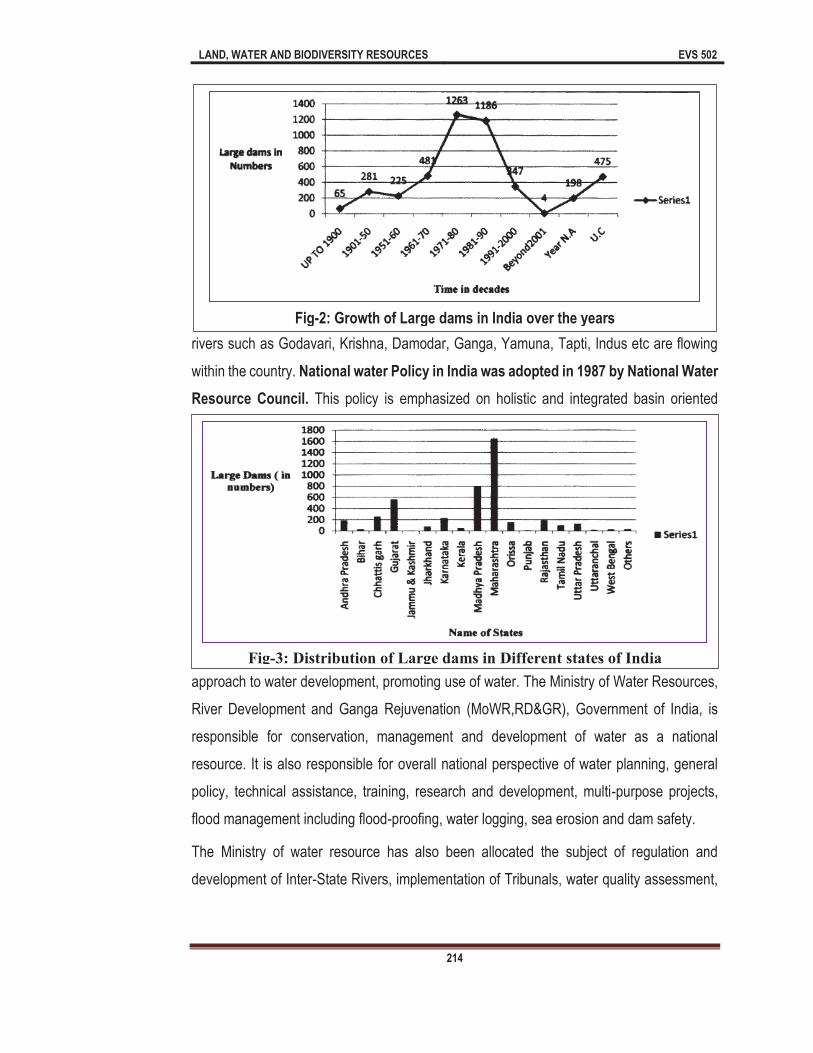
LAND, WATER AND BIODIVERSITY RESOURCES EVS 502
214
rivers such as Godavari, Krishna, Damodar, Ganga, Yamuna, Tapti, Indus etc are flowing
within the country. National water Policy in India was adopted in 1987 by National Water
Resource Council. This policy is emphasized on holistic and integrated basin oriented
approach to water development, promoting use of water. The Ministry of Water Resources,
River Development and Ganga Rejuvenation (MoWR,RD&GR), Government of India, is
responsible for conservation, management and development of water as a national
resource. It is also responsible for overall national perspective of water planning, general
policy, technical assistance, training, research and development, multi-purpose projects,
flood management including flood-proofing, water logging, sea erosion and dam safety.
The Ministry of water resource has also been allocated the subject of regulation and
development of Inter-State Rivers, implementation of Tribunals, water quality assessment,
Fig-2: Growth of Large dams in India over the years
Fig-3: Distribution of Large dams in Different states of India
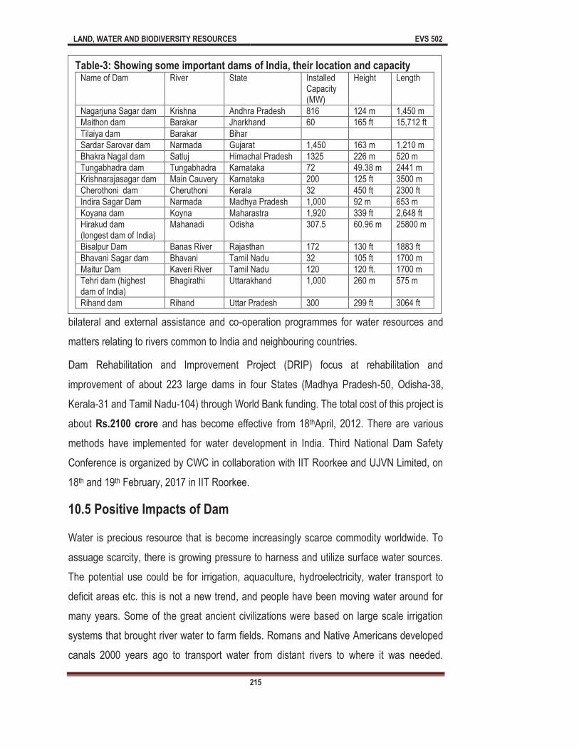
LAND, WATER AND BIODIVERSITY RESOURCES EVS 502
215
bilateral and external assistance and co-operation programmes for water resources and
matters relating to rivers common to India and neighbouring countries.
Dam Rehabilitation and Improvement Project (DRIP) focus at rehabilitation and
improvement of about 223 large dams in four States (Madhya Pradesh-50, Odisha-38,
Kerala-31 and Tamil Nadu-104) through World Bank funding. The total cost of this project is
about Rs.2100 crore and has become effective from 18thApril, 2012. There are various
methods have implemented for water development in India. Third National Dam Safety
Conference is organized by CWC in collaboration with IIT Roorkee and UJVN Limited, on
18th and 19th February, 2017 in IIT Roorkee.
10.5 Positive Impacts of Dam
Water is precious resource that is become increasingly scarce commodity worldwide. To
assuage scarcity, there is growing pressure to harness and utilize surface water sources.
The potential use could be for irrigation, aquaculture, hydroelectricity, water transport to
deficit areas etc. this is not a new trend, and people have been moving water around for
many years. Some of the great ancient civilizations were based on large scale irrigation
systems that brought river water to farm fields. Romans and Native Americans developed
canals 2000 years ago to transport water from distant rivers to where it was needed.
Table-3: Showing some important dams of India, their location and capacity Name of Dam River State Installed
Capacity (MW)
Height Length
Nagarjuna Sagar dam Krishna Andhra Pradesh 816 124 m 1,450 m
Maithon dam Barakar Jharkhand 60 165 ft 15,712 ft
Tilaiya dam Barakar Bihar
Sardar Sarovar dam Narmada Gujarat 1,450 163 m 1,210 m
Bhakra Nagal dam Satluj Himachal Pradesh 1325 226 m 520 m
Tungabhadra dam Tungabhadra Karnataka 72 49.38 m 2441 m
Krishnarajasagar dam Main Cauvery Karnataka 200 125 ft 3500 m
Cherothoni dam Cheruthoni Kerala 32 450 ft 2300 ft
Indira Sagar Dam Narmada Madhya Pradesh 1,000 92 m 653 m
Koyana dam Koyna Maharastra 1,920 339 ft 2,648 ft
Hirakud dam (longest dam of India)
Mahanadi Odisha 307.5 60.96 m 25800 m
Bisalpur Dam Banas River Rajasthan 172 130 ft 1883 ft
Bhavani Sagar dam Bhavani Tamil Nadu 32 105 ft 1700 m
Maitur Dam Kaveri River Tamil Nadu 120 120 ft. 1700 m
Tehri dam (highest dam of India)
Bhagirathi Uttarakhand 1,000 260 m 575 m
Rihand dam Rihand Uttar Pradesh 300 299 ft 3064 ft
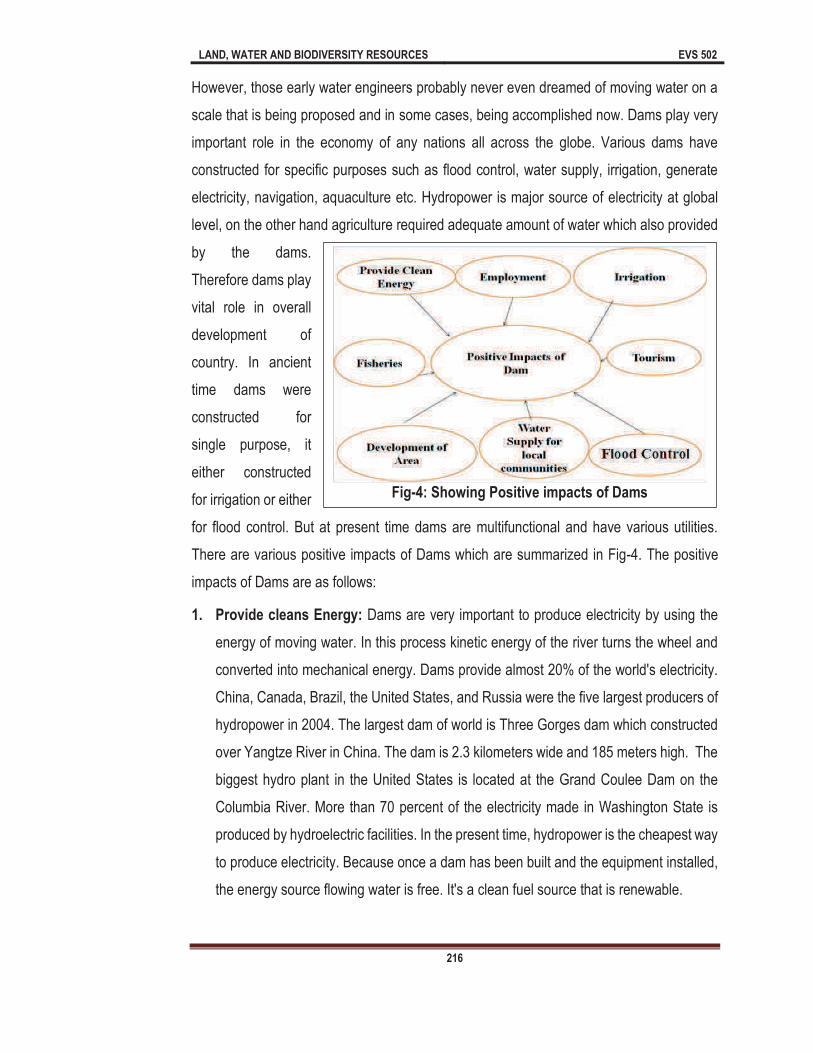
LAND, WATER AND BIODIVERSITY RESOURCES EVS 502
216
However, those early water engineers probably never even dreamed of moving water on a
scale that is being proposed and in some cases, being accomplished now. Dams play very
important role in the economy of any nations all across the globe. Various dams have
constructed for specific purposes such as flood control, water supply, irrigation, generate
electricity, navigation, aquaculture etc. Hydropower is major source of electricity at global
level, on the other hand agriculture required adequate amount of water which also provided
by the dams.
Therefore dams play
vital role in overall
development of
country. In ancient
time dams were
constructed for
single purpose, it
either constructed
for irrigation or either
for flood control. But at present time dams are multifunctional and have various utilities.
There are various positive impacts of Dams which are summarized in Fig-4. The positive
impacts of Dams are as follows:
1. Provide cleans Energy: Dams are very important to produce electricity by using the
energy of moving water. In this process kinetic energy of the river turns the wheel and
converted into mechanical energy. Dams provide almost 20% of the world's electricity.
China, Canada, Brazil, the United States, and Russia were the five largest producers of
hydropower in 2004. The largest dam of world is Three Gorges dam which constructed
over Yangtze River in China. The dam is 2.3 kilometers wide and 185 meters high. The
biggest hydro plant in the United States is located at the Grand Coulee Dam on the
Columbia River. More than 70 percent of the electricity made in Washington State is
produced by hydroelectric facilities. In the present time, hydropower is the cheapest way
to produce electricity. Because once a dam has been built and the equipment installed,
the energy source flowing water is free. It's a clean fuel source that is renewable.
Fig-4: Showing Positive impacts of Dams
LAND, WATER AND BIODIVERSITY RESOURCES EVS 502
217
2. Irrigation: This is one of the most important positive impacts of dams. Most of the rivers
of India flow in more than one state and hence irrigation is a controversial aspect in
India. But irrigation in India has been dominated by construction of major and medium
projects. In the present time, water scarcity is common problem for farmers of all around
globe. Dams provide adequate amount of water for irrigation. This water generally used
during the drier period. As you know dams store large amount of water, then in the
summer or drier period, it may be released dam and distributed in agricultural land
through different channels/canals. As you know about 70% of water resources have
been used for irrigation purpose. Several irrigation projects such as Bargi project
(Madhya Pradesh), Beas Project (Haryana, Punjab, and Rajasthan), Bhadra Project
(Karnataka) have been implemented in India.
3. Aquaculture: As you know aquaculture is cultivation of aquatic organisms specially
fishes. Since, dams provide sufficient amount of water (stagnant), high plankton
diversity, sufficient water depth and other suitable conditions to the fishes. Therefore
dams also provide aquaculture opportunities to communities. Aquaculture has proven
to be a viable operation in multi-used irrigation Many studies found that the fitness-for-
use of these dams for both net cage culture of fish. However, practicing intensive fish
farming in existing open water bodies can increase the nutrient levels of the water
through organic loading, originating from uneaten feeds and fish metabolic wastes.
4. Navigation: Population explosion certainly leads in to high pressure on roads, therefore
many Governments of World looking for their alternative. As you known the condition of
rivers are very dangerous, due to erosion, sedimentation etc. The rivers that have been
developing with dams provide suitable condition for navigation. Dams provide stable
water system of river transportation.
5. Recreation: Dams also provide prime recreational facilities throughout the world.
Boating, skiing, camping, boat launch facilities are all supported by dams. There are
various dams which are also used as recreational purpose, such dams are Nagarjuna
Sagar Dam, Iddukki Dam, Tehri Dam, Hirakund Dam, Bhakra Nagal Dam, Sardar
Sarovar Dam etc.
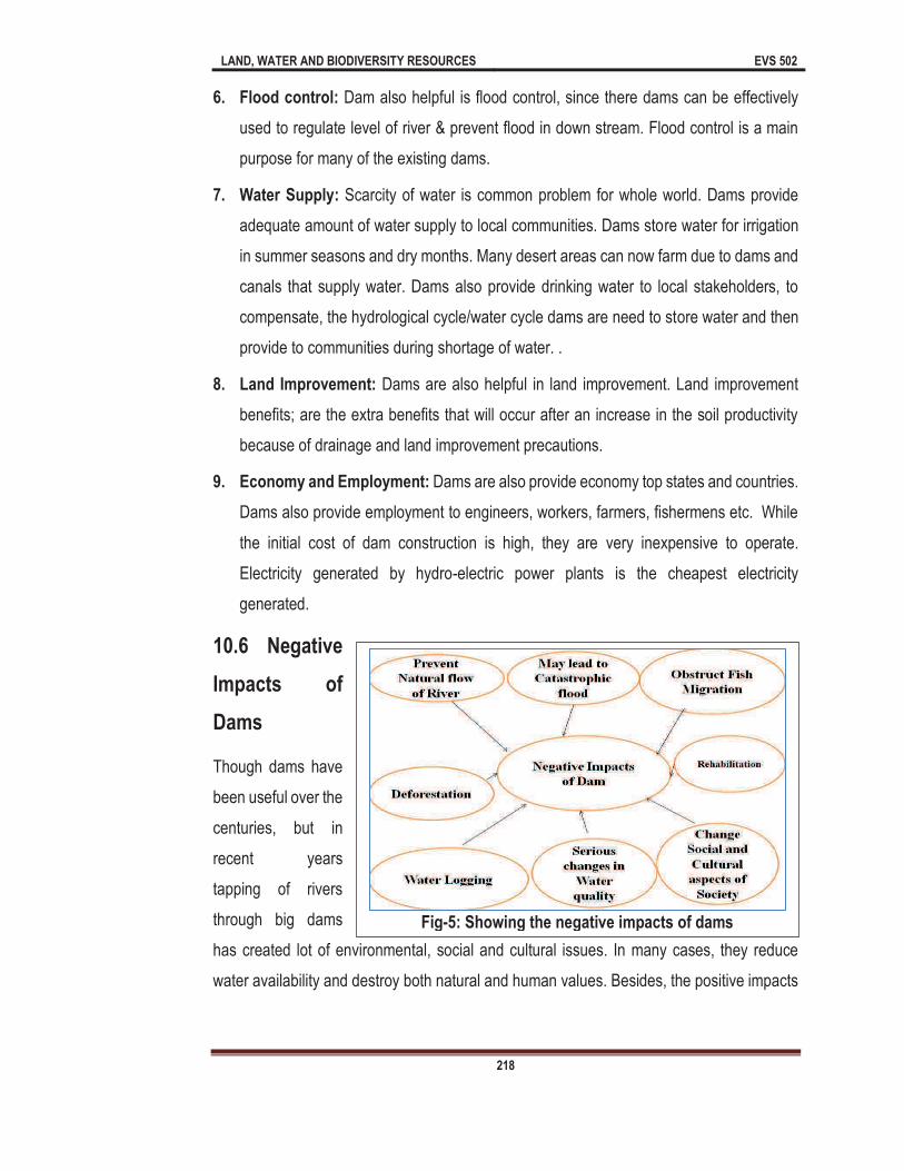
LAND, WATER AND BIODIVERSITY RESOURCES EVS 502
218
6. Flood control: Dam also helpful is flood control, since there dams can be effectively
used to regulate level of river & prevent flood in down stream. Flood control is a main
purpose for many of the existing dams.
7. Water Supply: Scarcity of water is common problem for whole world. Dams provide
adequate amount of water supply to local communities. Dams store water for irrigation
in summer seasons and dry months. Many desert areas can now farm due to dams and
canals that supply water. Dams also provide drinking water to local stakeholders, to
compensate, the hydrological cycle/water cycle dams are need to store water and then
provide to communities during shortage of water. .
8. Land Improvement: Dams are also helpful in land improvement. Land improvement
benefits; are the extra benefits that will occur after an increase in the soil productivity
because of drainage and land improvement precautions.
9. Economy and Employment: Dams are also provide economy top states and countries.
Dams also provide employment to engineers, workers, farmers, fishermens etc. While
the initial cost of dam construction is high, they are very inexpensive to operate.
Electricity generated by hydro-electric power plants is the cheapest electricity
generated.
10.6 Negative
Impacts of
Dams
Though dams have
been useful over the
centuries, but in
recent years
tapping of rivers
through big dams
has created lot of environmental, social and cultural issues. In many cases, they reduce
water availability and destroy both natural and human values. Besides, the positive impacts
Fig-5: Showing the negative impacts of dams

LAND, WATER AND BIODIVERSITY RESOURCES EVS 502
219
dams have various negative especially on environment. The negative impacts of dams are
summarized in Fig-5. The negative impacts are described as follows:
1. Obstruct/Prevent Ecological flow of River: Dams obstruct the natural ecological
flow of river. As you know that natural ecological flow of river is responsible for
sustainability of river. Due to obstruction in ecological flow many biodiversity of river
going to threatened or are verge at extinction. Ecological flow maintains the
biodiversity and water of riverine ecosystem. development of dam on river can
change the species composition and water quality of river.
2. Enhance the chances of catastrophic flood: The enormous weight of water
behind the dam could trigger seismic activity that might damage the dam and can
lead in to catastrophic flood. As you know that catastrophic flood are more
dangerous as compared to alluvial flood, coastal flood and other forms of flood.
Catastrophic flood can submerge the cities within few hours.
3. Prevent fish migration: As a result of dam construction and holding of sediments
in reservoirs, sediment feeding of downstream channel or shore beaches is
prevented. As the transfer of sediments is avoided by this way, the egg lying zone
of the fishes living in the riverine ecosystem is eroded, too. Normal passing ways of
territorial animals are hindered since the dam acts as a barrier. The fishes can be
damaged while passing through the floodgates, turbines and pumps of the high
bodied dams. There will be serious changes in the water quality as a result of
drainage water returning from irrigation that was done based on the irrigation
projects. The species may change parallel to the erosion caused by the human
activities or the permanent increase in the water turbidity as an outcome of the dam
construction. Migration is typical character of some migratory fishes is which fish
moves from one place to another place for different purposes (food, reproduction,
etc) especially for breeding purpose. Due to construction of dams many Diadromous
fishes (fish which moves from fresh water to sea water or vice versa) cannot migrate.
Due to construction of dam the fish movement may be stopped or delayed. The Dam
prevents migration of fishes between feeding & breeding zones. This type of
LAND, WATER AND BIODIVERSITY RESOURCES EVS 502
220
prevention can lead in to extinction of species. For example Hilsa ilisha a fish of
Ganga river ecosystem, were abundantly found in regions of Patna, Bhagalpur,
Varanasi but after the construction of Farrakka b
these places & now restricted to some regions of West Bengal.
4. Climate Change: Climate of regions may also affect due to construction and
development of dams. Microclimatic and even local climate changes may be
observed due to construction of dams.
5. Change in Water Quality: Some dams loose so much water through evaporation
and seepage into porous rock beds that they waste more water than they make
available. Salt left behind by evaporation increase the salinity of the river and make
its water unusable when it reaches the downstream. Accumulating sediments in the
storage reservoir not only makes dams useless but also represents a loss of
valuable nutrients to the downstream agricultural lands. Growth of snail populations
in shallow permanent canals that distribute water to fields may lead to an epidemic
of schistosomiasis. A number of water related diseases have been casually lined
with creation of reservoir and the resettlement of population when dams are built.
The greatest concern has been significant increase in the transmission of
schistosomiasis and malaria, specially where water impoundments provide
breeding-sites for the vectors. The spread of onchocerciasis in population living near
dam spillways and downstream has also been reported. According to International
River Network, 2001; Canadian Dam Associa-tion, 2001, temperature of water, salt
and oxygen distribution may change vertically as a consequence of dam formation.
This may cause the generation of new undesirable species.
6. Water logging: Water logging is the saturation of soil with water. Soil may water
logged due to high water level. Water logged can reduce air in soil and increase in
soil salinity, loss of useful biological community etc. According to Indian Institute of
Science, about 40% of command area of Sardar Sarovar Dam will be water logged.
7. Social and Cultural impacts: Dams also affect the social, cultural aspects of the
concern region considerably, specially forcing people, whose settlement areas and
lands remain under water to migrate. Dams affect their psychology negatively. It is
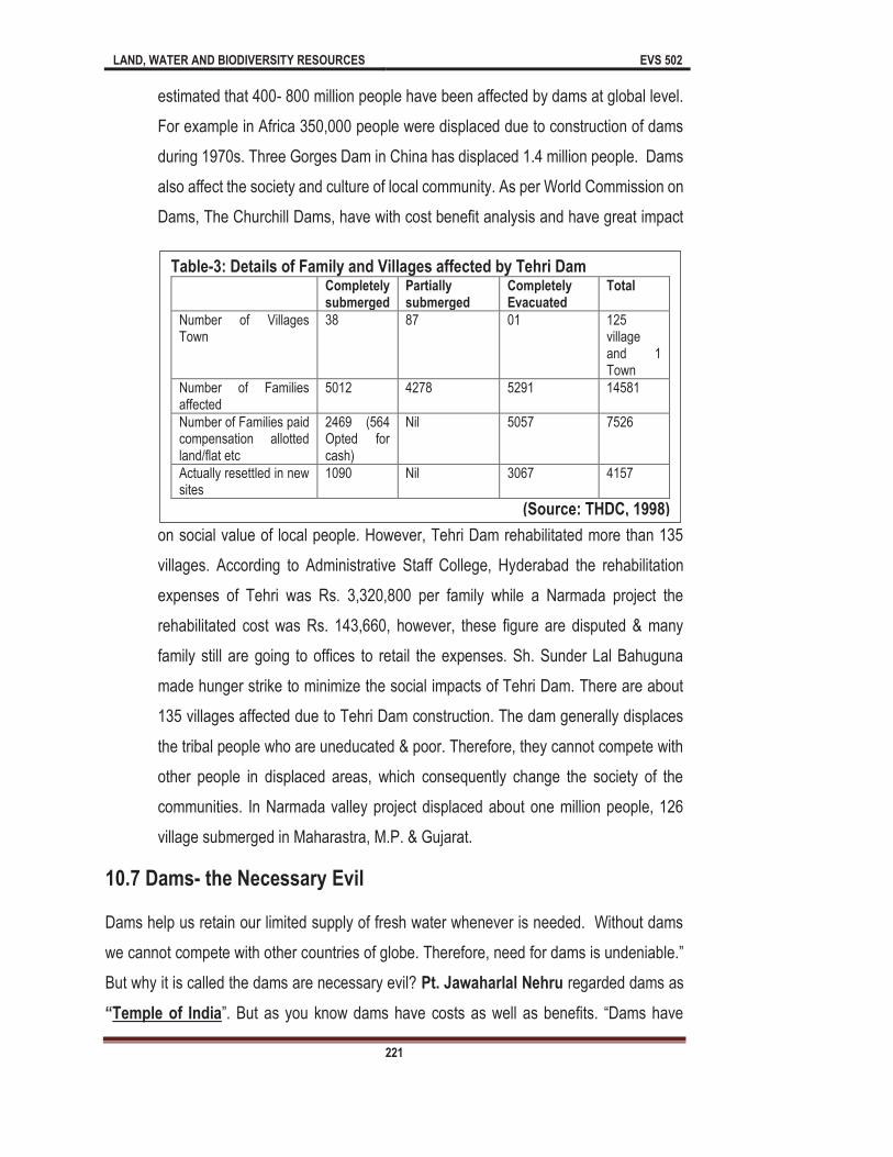
LAND, WATER AND BIODIVERSITY RESOURCES EVS 502
221
estimated that 400- 800 million people have been affected by dams at global level.
For example in Africa 350,000 people were displaced due to construction of dams
during 1970s. Three Gorges Dam in China has displaced 1.4 million people. Dams
also affect the society and culture of local community. As per World Commission on
Dams, The Churchill Dams, have with cost benefit analysis and have great impact
on social value of local people. However, Tehri Dam rehabilitated more than 135
villages. According to Administrative Staff College, Hyderabad the rehabilitation
expenses of Tehri was Rs. 3,320,800 per family while a Narmada project the
rehabilitated cost was Rs. 143,660, however, these figure are disputed & many
family still are going to offices to retail the expenses. Sh. Sunder Lal Bahuguna
made hunger strike to minimize the social impacts of Tehri Dam. There are about
135 villages affected due to Tehri Dam construction. The dam generally displaces
the tribal people who are uneducated & poor. Therefore, they cannot compete with
other people in displaced areas, which consequently change the society of the
communities. In Narmada valley project displaced about one million people, 126
village submerged in Maharastra, M.P. & Gujarat.
10.7 Dams- the Necessary Evil
Dams help us retain our limited supply of fresh water whenever is needed. Without dams
we cannot compete with other c
But why it is called the dams are necessary evil? Pt. Jawaharlal Nehru regarded dams as
Temple of India
Table-3: Details of Family and Villages affected by Tehri Dam Completely
submerged Partially submerged
Completely Evacuated
Total
Number of Villages Town
38 87 01 125 village and 1 Town
Number of Families affected
5012 4278 5291 14581
Number of Families paid compensation allotted land/flat etc
2469 (564 Opted for cash)
Nil 5057 7526
Actually resettled in new sites
1090 Nil 3067 4157
(Source: THDC, 1998)
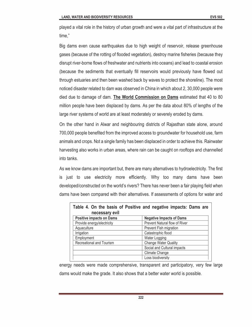
LAND, WATER AND BIODIVERSITY RESOURCES EVS 502
222
played a vital role in the history of urban growth and were a vital part of infrastructure at the
Big dams even cause earthquakes due to high weight of reservoir, release greenhouse
gases (because of the rotting of flooded vegetation), destroy marine fisheries (because they
disrupt river-borne flows of freshwater and nutrients into oceans) and lead to coastal erosion
(because the sediments that eventually fill reservoirs would previously have flowed out
through estuaries and then been washed back by waves to protect the shoreline). The most
noticed disaster related to dam was observed in China in which about 2, 30,000 people were
died due to damage of dam. The World Commission on Dams estimated that 40 to 80
million people have been displaced by dams. As per the data about 80% of lengths of the
large river systems of world are at least moderately or severely eroded by dams.
On the other hand in Alwar and neighbouring districts of Rajasthan state alone, around
700,000 people benefited from the improved access to groundwater for household use, farm
animals and crops. Not a single family has been displaced in order to achieve this. Rainwater
harvesting also works in urban areas, where rain can be caught on rooftops and channelled
into tanks.
As we know dams are important but, there are many alternatives to hydroelectricity. The first
is just to use electricity more efficiently. Why too many dams have been
dams have been compared with their alternatives. If assessments of options for water and
energy needs were made comprehensive, transparent and participatory, very few large
dams would make the grade. It also shows that a better water world is possible.
Table 4. On the basis of Positive and negative impacts: Dams are necessary evil
Positive impacts on Dams Negative Impacts of Dams
Provide energy/electricity Prevent Natural flow of River
Aquaculture Prevent Fish migration
Irrigation Catastrophic flood
Employment Water Logging
Recreational and Tourism Change Water Quality
Social and Cultural impacts
Climate Change
Loss biodiversity

LAND, WATER AND BIODIVERSITY RESOURCES EVS 502
223
Various other impacts can be added to this list. The most important point is that we should
distinguish the temporary benefits and the long term harms clearly. It must be compulsory
that the groups engineers, hydrologists, social scientists and other profession groups attend
the environmental impact assessment and that the alternatives do their duty in the
estimation of environmental effects.
Dams, which contribute to the national economy from many aspects like irrigation, drinking
water supply, flood control, electricity generation, fishing, tourism, are also important.
Meanwhile, the new environment created by the dam also supports the arrival of different
species to the area. Dams are not only important in economical growth, but also in overall
economical and moral development. In many developed countries, dams have performed a
key role in the development of the underdeveloped regions.
We need electricity, we need aquaculture we need agriculture, we need recreation & we
need to control flood but on the cost of environmental (Habitat destruction, water change
quality, water logging, deforestation) social impacts (poverty, rehabilitation) therefore, dam
as necessary evil at the present scenario. We should focus on economy but on the other
hand we must think about the negative impacts of Dam. Large Dams are certain harmful to
human being as compared to their benefits. Therefore, we should develop small dams which
may as good and cause minimum damage.
Summary
In this unit we have discussed various aspects of water resources development, dams and
their positive and negative impacts. So far you have learnt that:
Water development is the set of activities of planning, developing, distributing and
managing the best use of water resources.
Seasonal check bunds, Temporary check bunds/dams Earthen dams Lift irrigation
Farm ponds Jalkunds Group wells are common methods of water resource
development
Hydropower is the leading renewable source for electricity generation at global level.
It is supplying 71% of all renewable electricity. It has 1,064 GW of installed capacity
LAND, WATER AND BIODIVERSITY RESOURCES EVS 502
224
China accounted for 26% of the global installed capacity in 2015, on the other hand
USA accounted for 8.4%, Brazil accounted for 7.6% and Canada for 6.5%.
Largest dams of world are Three Gorges Dam, Itai Pu Dam, Xiluodu Dam, Guri
Dam, Tucurui, Dam, Xingjiaba Dam, Grand Colie Dam, Long Tan Dam, Krasnoyarsk
Dam and Robert Bourassa
Over 4000 large dams also constructed over the Indian rivers, examples of dams
are Nagarjuna Sagar dam, Maithon dam, Tilaiya dam, Sardar Sarovar dam, Bhakra
Nagal dam, Tungabhadra dam, Krishnarajasagar dam, Cherothoni dam, Indira
Sagar Dam, Koyana dam, Hirakud dam, (longest dam of India), Bisalpur Dam,
Bhavani Sagar dam, Maitur Dam, Tehri dam (highest dam of India), Rihand dam
There are various positive impacts of dams such as: cleans energy, irrigation,
aquaculture, navigation, recreation, flood control, water supply, land improvement,
economy and Employment.
Besides the positive impacts dams have some negative impacts such as Prevent
Ecological flow of River, enhance the chances of catastrophic flood, Prevent fish
migration, Climate Change, Change in Water Quality, Water logging, Social and
Cultural impacts.
Terminal Questions
1. (a)
not only suppress flood but also provide water for several activities such as irrigation,
was built in 1890 and in 1950 t World Commission on Dam Report-2000
has about 100 dams. According to an estimate, 160-
reservoirs so as to impound huge amount of rain water. However, large dams can only be built in certain areas because these require space, water, money. Purposes of dam also
example: Europe developed most of dams for HEP and Africa and Asia most dams for irrigation purpose. It is also important to know that very few dams help in flood control- only
2 (a) Discuss the indigenous methods of water resources development.
LAND, WATER AND BIODIVERSITY RESOURCES EVS 502
225
(b) Describe the dams at global level.
3 (a) Describe the dams at national level.
(b) Give the list of important dams in India.
4 (a) Write about positive impacts of dams
5 (a) What are the negative impacts of dams.
(b) Give the Social and cultural impacts of dams
(c) Why dam is necessary evil? Explain
6 (a) Fill the blank spaces with appropriate words.
high weight of
-borne flows of freshwater and nutrients into oceans) and lead to coastal erosion (because the sediments that eventually fill reservoirs would previously have flowed out through estuaries and then been washed back by waves to protect the shoreline). The most noticed disaster related to dam was observed in China in
The World Commission on Dams 80% of lengths of the large river systems of world are at least moderately or severely eroded by dams.
(b) Three Gorges dam constructed over (Yangtze river/Parana River/Jinsha River/Ganga River)
(c) Longest dam of India is (Hirakund Dam/Tehri dam/Sardar Sarovar Dam/Nagarjuna Sagar Dam)
(d) Rihand dam is located in (Rajasthan/Uttar Pradesh/Jammu &
Kashmir/Himachal Pradesh)
(e) Tehri dam constructed over (Alaknanda / Bhagirathi /Song /Yamuna Rivers)
(f) What is the impact of dams on fish?
7 (a) Give the graph of distribution of large dams in different states on India.
Answers to Terminal Questions
1 (a) Barrier, natural flow, hydropower generation, 5000 large dams, 45000, China, 6390, 9%, 1200, every year, irrigation, generation of hydropower energy, low level
2 (a) (section-10.2 and fig-1), (b) See the section 10.3
3 (a) See the section 10.4, (b) See section 10.4 (Table-3)
4 (a) See section 10.5;
5 (a) See the section 10.6, (b) see section 10.6 (Social & cultural impacts), (c) See section 10.7
6 (a) Temple of India, earthquakes, greenhouse gases, marine fisheries, 2, 30,000, 40 to 80 million,

LAND, WATER AND BIODIVERSITY RESOURCES EVS 502
226
(b) Yangtze river, (c) Hirakund Dam, (d) Uttar Pradesh (e) Bhagirathi River
(f) See the section 10.6 (Prevent fish migration)
7 (a) See the section 10.4 (Fig-3).

LAND, WATER AND BIODIVERSITY RESOURCES EVS 502
227
Unit 11 Water Resource Conservation Watershed Management, Rain Water Harvesting, Micro-Irrigation: a case study-The Pani Panchayat
Unit Structure
11.0 Learning Objectives
11.1 Introduction
11.2 Water Resource Conservation
11.3 Watershed Management 11.4 Rain Water Harvesting
11.5 Micro-Irrigation
11.6 Case Study-The Pani Panchayat Summary
11.0 Learning Objectives
After studying this unit you will be able to explain:
· What is water resource management
· What is Watershed management
· What is rain water harvesting?
· Advantages and disadvantages of rain water harvesting
· What is micro-irrigation?
· Methods of micro-irrigation
· Importance of micro-irrigation
· About case study of Pani Panchayat
11.1 Introduction
Conserving our natural resources is critical issue at international level. As you know water
is most valuable resource on earth and vital component to sustain life. As you now well
acquainted with importance of water resources, its utilization and water resource
development. First of all, it is a responsibility of the humanity to save water resources for the

LAND, WATER AND BIODIVERSITY RESOURCES EVS 502
228
future generations. Besides, it helps to reduce the level of used energy because water
management consumes a huge amount of electricity. In conclusion, water is a habitat for the
different wildlife. Therefore, the world community tries to prevent water resources from their
complete disappearing. As you have learned about water resources, importance of water
resources and water resource development in unit-9 and unit-10, in these units we have
discussed various aspects of water resources. Water resources are depleting very fast than
usual. Demand of water also increases with population explosion. Various anthropogenic
activities such as deforestation, dumping of solid waste, excessive use of agrochemicals,
urbanization, industrialization, mining etc. are responsible for water resources depletion. The
water quality data of different rivers of word showed that the man made activities certainly
responsible for water resources depletion. Even our ocean are depleting due to dumping of
solid waste. Industries releasing their effluent directly in to the water bodies which is
responsible for serious water pollution. Domestic sewage is one of the greatest sources of
water pollution in India. According to World Health Organization (WHO) 3119 towns of
India out of this figure, only 209 have partial sewage treatment systems & only 8 town &
cities have full sewage treatment facilities.
The human activities make the water unfit for utilization. Water is not only useful to human
being but it is home to millions of species. Many species (aquatic species) have become
extinct or verge large at extinction due to water resources depletion. Therefore, it is our duty
to conserve this precious resource at all possible level. Conserving water resources can help
save water for upcoming generations. As population rises more demand will be placed on
water supplies to provide water for human being, food and fodder production, manufacturing
and recreational activities. To conserve water resources we should remember that water is
most valuable and limited resource. In this unit you will learn about various techniques of
water resources conservation such as watershed management, Rain Water Harvesting,
micro-irrigation and concept of Pani Panchayat.
11.2 Water Resource Conservation
Water is an integral part of land/soil productivity base. There are various methods of water
conservation and water management like watershed management, rain water harvesting,
micro-irrigation etc. As you know that water is not only essential to sustain life, but to

LAND, WATER AND BIODIVERSITY RESOURCES EVS 502
229
support ecosystems, economic development, community well-being and cultural values.
Therefore, it is necessary to conserve water resources for upcoming generation. As you
know freshwater is limited and unevenly distributed around world. The water available for
use in any place is not equal but varies widely overtime due to both natural and
anthropogenic activities.
Using the measure, any increase in population will lead to a decrease in per capita water
availability, which has usually being assumed implicitly to be bad. A better definition of
sustainable water use is the maintenance of a desired flow of benefits to a particular group,
undiminished overtime. According to World Commission on Environment and
Development, 1987 �Humanity has the ability to make development sustainable to ensure
that it meets the need of the present without compromising the availability of future
generations to meet their needs. The desired sets of benefits provided by water does not
have to be, and is unlikely to be, the same across different user of periods of time. Indeed,
such benefits vary widely given political, religious, cultural and technological differences. But
in any realistic discussion of sustainability, the benefits to be provided must be explicitly
evaluated. Using the definition about, water use is unsustainable is survives provided by
water resources and desired by the society diminish over time. Equity requirement would
also required that a reduction of services over time to one user group be declared
�unsustainable� even if other user are able to maintained the desired services.
There are various conservational strategies for conserve water resources & such strategies
may include rainwater harvesting, improve agricultural practices, use of geothermal water,
increase forest cover, renovation & traditional water resources, micro irrigation, etc.
Conservation of water is now become very important challenge to world, because scarcity
of water increasing day to day. There are various conservational strategies for conserve
water resources and such strategies are rain water harvesting, improved agricultural
practices, use of geothermal water, increase forest cover, renovation of traditional water
resources, micro irrigation, watershed management etc. conservation of water resource is
one of the most important challenges at global level, due to high demand of water. We can
conserve water resource at our personal level. Because large amount of percentage of water
used in our daily needs. Excessive amount of water used in our bathrooms, toilets, kitchen
etc. There are various eco-friendly devices such as toilet dams, water saving showers,
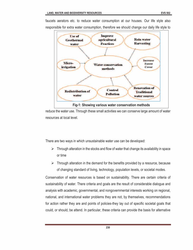
LAND, WATER AND BIODIVERSITY RESOURCES EVS 502
230
faucets aerators etc. to reduce water consumption at our houses. Our life style also
responsible for extra water consumption, therefore we should change our daily life style to
reduce the water use. Through these small activities we can conserve large amount of water
resources at local level.
There are two ways in which unsustainable water use can be developed:
Ø Through alteration in the stocks and flow of water that change its availability in space
or time
Ø Through alteration in the demand for the benefits provided by a resource, because
of changing standard of living, technology, population levels, or societal modes.
Conservation of water resources is based on sustainability. There are certain criteria of
sustainability of water. There criteria and goals are the result of considerable dialogue and
analysis with academic, governmental, and nongovernmental interests working on regional,
national, and international water problems they are not, by themselves, recommendations
for action rather they are and points of policies-they lay out of specific societal goals that
could, or should, be attend. In particular, these criteria can provide the basis for alternative
Fig-1: Showing various water conservation methods

LAND, WATER AND BIODIVERSITY RESOURCES EVS 502
231
�viscous� for further water management and conservation. Following are the different
sustainability criteria.
Ø A minimum water requirement will be guaranteed to all human to maintenance
human health.
Ø Sufficient water will be granted to restore and maintain the health of ecosystems.
Specific amounts will vary depending on climate and other conditions. Setting these
amounts will require flexible and dynamic management.
Ø Water quality will be maintained to meet certain minimum standards. These
standards will vary depending on location and water use.
Ø Human actions will not impair the long-term renewability of freshwater stocks and
flows.
Ø Data of water resources availability, use, and quality will be collected and made
accessible to all parties.
Ø Institutional mechanisms will be set up to prevent and resolve conflicts over water.
Ø Water plan and decision making will be democratic, ensuring representation of all
participations of affected interests.
11.3 Watershed Management
Literally watershed means Boundary. All the aquatic bodies have a watershed. The
watershed is the area of land that drain water in to water bodies (lakes, river, streams, ponds
etc.). The term �watershed� introduced in 1920 & was used for boundaries. A watershed is
an area of earth bounded by drainage, watershed management technology generally used
in areas where rainfall is high. Watershed management is term to describe the process of
implementing water use method to protect/preserve/conserve water resources.
Types of watershed management: On the basis of size, shape, drainage & land use
pattern watershed may be as following.
Ø Macro watershed � 1000-10,000 hectare
Ø Micro watershed- 100-1000 hectare
Ø Mini watershed-10-100 hectare

LAND, WATER AND BIODIVERSITY RESOURCES EVS 502
232
Ø Mille watershed-1-10 hectare
Objectives/aims of water shed management- There are various objectives/aims of
watershed management which are summarized in Fig-2.
LAND, WATER AND BIODIVERSITY RESOURCES EVS 502
233
Importance of Watershed Management: As you know that runoff is the draining
away of water. Various forms of runoff like runoff from rain, agricultural land, and
glaciers can lead in to aquatic pollution in lakes, rivers, ponds and other aquatic
bodies. Watershed management helps to control pollution in aquatic bodies.
Watershed management identified the various activities such as gardening, water
release from septic tanks, agricultural runoff that affect the water quality of
watershed. Watershed management makes the recommendation to resolve adverse
impacts of these activities on watershed, therefore adverse impacts or negative
impacts of pollution can be minimized. Watershed management also effective
where water resources are limited. Watershed management can protect land, water
and vegetation.
Steps in watershed management: There are mainly four phases in watershed
management namely recognition phase, restoration phase, protection phase,
and improvement phase. These four phases are described below:
1. Recognition phase: Recognition phase comprises in three important steps Such as
i) Recognition of problems: In this phase problems of watershed identified
these problems may include entry of pesticides from agricultural runoff or entry
of pollutants from industries.
ii) Monitoring of course at problem & its impact: This phase is emphasized
on monitoring of analysis of watershed. Through the monitoring we can
recognize the absence or presence of toxic chemicals in and around watershed.
iii) Implementation of alternative solution of problems: In the phase remedial
measure for the problem implemented to resolve the adverse impacts of related
problem.
2. Restoration phase: This phase involved two steps.
i) Select best soil to identification.
ii) Apply appropriate solution to problem to land.

LAND, WATER AND BIODIVERSITY RESOURCES EVS 502
234
3) Protection phase: In this phase we generally protect the health (water quality) of
watershed and make sure that normal functioning of watershed. Normal functioning of
watershed includes: water quality other abiotic factors, vegetation cover etc.
4) Improvement phase: This phase emphasized on overall improvement of
watershed. In this phase generally focus at agriculture, forest land & protection.
Socio-economic condition also consider during this phase.
Program related to Watershed Management
1) Drought prone areas programme: It was launched by Central Government (Ministry
of Rural Areas & Employment) in 1973-74 to tackle the special drought related
problems. This program was launched for hot desert region of Rajasthan, Haryana, cold
desert of Jammu & Kashmir & Himachal Pradesh and Gujarat. The main purpose of
program is ecological balance. This program also focused on appropriate use of water,
land, livestock, and mitigate the effect of drought.
2) National Watershed Development Program for Rain-fed Agriculture: This program
was launched by Ministry of Rural Areas & Employment in the year 1986-87. The main
purpose of this program is to enhance the productivity of land and enhance the production
of fruits, food, fodder and fuel resources. The program also focused on conservation and
utilization of water resources on watershed basis.
11.4 Rain Water Harvesting
Meaning of rainwater harvesting is collection of rainwater and to store it in different
containers for different uses. As you know rain water is primary source of surface and
ground water. The rain may fall every on the earth, but proper use of rain water is difficult
due to its uncertainty.
Rain water harvesting (RWH) is a technique used for collecting and storing rainwater by
using various means in different resources for the different purposes (for livestock
production, drinking, irrigation, etc). Water of rain can be collected into artificial tanks.
Rooftop harvesting is also a method to collect rainwater. RWH is useful to the communities
living in the low rainfall areas. They can continue seasonal crop harvesting by using collected
rain water in the scarcity of water supply.

LAND, WATER AND BIODIVERSITY RESOURCES EVS 502
235
Rainwater harvesting may also refers to the collecting and storing of rainwater, therefore
that it can be utilized. As the rain falls, water is directed to a suitable collection point. Rain
water harvesting is a practice that has been around for a long time. The difference is that
now demand of water is so high therefore, rainwater harvesting ensures the supply of water
especially in drier months. Modern technologies have established and are now making the
process simplest and more efficient.
Methods: There are various methods for Rain water harvesting.
Ø Rain water can be stored in a reservoir or under the surface. This stored water is
finally taken to places with the help of pipes.
Ø Rainwater can be collected in treated containers that can be used in emergency for
different purposes.
There are several ways in which water can be harvested. These methods are very effective
for commercial activities while some methods are only suitable for domestic use. There are
the common methods of rainwater harvesting which are discussed below and also
summarized in Fig-3.
1) Surface Water Collection Systems: As you know surface water is found above the
earth surface. When rain falls on the surface, it generally flows down slopes as it moves
towards a point of depression. Surface water collection systems allow the collection of
Fig-3: Showing different methods of rainwater harvesting
LAND, WATER AND BIODIVERSITY RESOURCES EVS 502
236
rainwater before it flows to other areas. Examples of surface water collection systems
include rivers, ponds, and wells. Pipes can be used to direct water into these systems.
This water can use for different purposes.
2) Rooftop system: This technique is very important because every house can collect the
rain water by this method. Rooftop system method of rainwater harvesting is well
accepted because the collected water is clean, pure and needs no treatment to make it
fit for human consumption. In this method, a cemented tank developed on the roof of
house, school and any buildings, the rain water collected in second tank with the help of
pipes, the second tank should be developed under ground for sufficient storage of rain
water.
3) Dams: As you know dams are barriers that are designed to collect water. Rainwater can
collect directly in these dams. Rainwater collected and stored in dams is mostly used for
irrigation purposes and may used for domestic use after treatment. Dams can also be
used to harvest a lot of rain water because of the way in which they are constructed.
4) Underground Tanks: Underground tanks are also important and significant for
accumulate and storing rainwater. These tanks are developed by digging into the ground
and then cemented to reduce water infiltration. Top portion of tanks is also sealed. This
method also valuable because rate of evaporation is too low, since they tanks are located
below the surface where sunlight does not really penetrate.
5) Rain saucer: These techniques are applicable where roof top is not suitable or
applicable. The rain saucers look like umbrellas. These saucers generally attached to
pipes, where rain water collected. These rain saucers cover large area as compare to
roof top methods.
6) Water Collection Reservoirs: This method is not really safe and rain water may get
polluted. However, collected water through this method may be used for irrigation. In this
method, rainwater is harvested from roads or footpaths.
7) Trenches: In this method the rainwater directed to the agricultural land through trenches.
This is one of the best traditional methods of rainwater harvesting that is still very much
use in present time.

LAND, WATER AND BIODIVERSITY RESOURCES EVS 502
237
8) Barrage: In this method a dam that has many openings which can be closed or opened
to control the water that passes through it. It is generally large and can be used to collect
sufficient amount of water.
9) Slopes: In this method rainwater tends to collect at the base of slopes when it runs on
the ground. When it rains heavily, water levels can rise to the hill top. This method is the
simple and natural way to rainwater harvesting.
10) Rain Barrels: Rain barrels are also used to harvest rainwater. They are specially
designed for collecting water and can be purchased from stores. These rain barrels are
used for rainwater which falls on rooftops.
Advantages of Rainwater Harvesting: As you know rain water has minimum impurities,
therefore rain water can be used for different purposes. There are various advantages of
rainwater harvesting which are summarized in Fig-4 and also discussed below:
1) Water for Domestic Use: RWH is beneficial because it provides a source of water for
domestic use. The collected and stored water can be used for cleaning purposes,
washing and for cooking food. After treatment rainwater also may be used for drinking
purpose too. It is simplest way of getting water for use in the houses. Rain water can be
Figure 4: Showing advantages of Rain Water Harvesting

LAND, WATER AND BIODIVERSITY RESOURCES EVS 502
238
used in toilets instead of clean water. RWH saves drinkable/potable water which would
be used for cooking and drinking only.
2) Water for Industrial Use: Various industries can also emphasize on rainwater harvesting
for use in different industrial processes. Rainwater meant for industrial use is normally
harvested in large scale. Such industries can develop their own dams or underground
tanks to store rainwater. For the industrial purpose generally rain water harvesting should
be done at large scales.
3) Supplementary Water Source: As you know that various regions have water shortages
specially during dry period or summer period, because improper rain and due to high rate
of evaporation. It may be hard to get a source of water during dry periods. Water prices
also increases with demand of water. Therefore, rainwater harvesting is seen as a way
of preparing for the dry periods
4) Irrigation: As you know that agriculture of India entirely depend on rain water. Whenever
rain falls generally low, it consequently leads in to low production of crops. Rainwater
harvesting is very important to agriculture for farming because once rain water harvested,
it can be utilized for specifically during dry periods. Farmers can get good production rate
due to rain water harvesting.
5) Cost Effective: Rain occurs in every part of the world. As you know it is natural process
and it is a gift of nature to earth. If we store enough water during the rainy season, we
may never have to pay for water again because we will have enough water supplies
throughout the summer. RWH saves our money and expenditure on water.
6) Reliable Flow of Harvested Water: Although rainwater harvesting depends on
precipitation or rainfall, but once rain water stored, the supply of water is guaranteed.
RWH can provide a reliable flow of water from the place of storage as long as the amount
harvested has not been finished.
7) Mitigates/Reduces the Impacts of Floods: Rainwater harvesting also plays an
important role in mitigating or reducing the impacts of floods. Whenever rainwater is
flooded to agricultural land through trenches, we can control its movement through rain
water harvesting technique. RWH obstructs the flood in an area. As you know the adverse
impacts of floods are too dangerous, costly and enormous. Therefore, rainwater

LAND, WATER AND BIODIVERSITY RESOURCES EVS 502
239
harvesting technique is an effective and appropriate way to reducing the impacts of flood
in an area.
8) Construction of Infrastructure: RWH can be used constructional activities. As you
know constructional activities required lot of water, rain water harvesting ensures the
availability of water for these activities.
Precautions: Rain water harvesting is important technique to collect and store rain water
for further use. However, we should take following precautions during rain water harvesting.
Ø Rain water should pre-filtered to remove impurities/contamination would make
rainwater safe.
Ø The rainwater may also be boiled to kill any pathogen before drinking it.
Ø Rainwater should be collected in containers. These containers should be free from
any toxic substances or chemicals.
Ø Identify the collection points before it starts raining. Rain water harvesting generally
performed during monsoon period, and this season is prone to several diseases.
Therefore, don�t use the fresh rain water for drinking purpose.
Disadvantages of Rainwater Harvesting: Besides the advantages of Rain water
harvesting, there are various disadvantages of Rain water harvesting which are summarized
in Fig-5 and also discussed below:
Fig-5: Showing disadvantages of Rain Water Harvesting

LAND, WATER AND BIODIVERSITY RESOURCES EVS 502
240
1) Extra Expenditure: For the rain water harvesting we require extra expenditure.
Treatment of rainwater also requires extra costs. This expenditure not required when we
use the water supplied by municipality. In rainwater harvesting method there will be
required extra costs for cleaning and maintaining the reservoirs. Maintaining and
Cleaning of underground water tank is not an easy task, even maintaining a dam is very
costly. Extra cost for cleaning and maintenance makes the thought of harvesting
rainwater unattractive.
2) Required Huge Efforts and Resources: Building a dam and underground tank is not an
easy task. When we begin harvesting rainwater, we will have spent a significant amount
of resources. Although there are various cheap methods are also available but these
methods are not sufficient to store sufficient amount of rainwater.
3) Depend on Rainfall: As you know that rain water harvesting is entirely depends on rain.
Therefore, this method is unreliable and only possible during rain.
4) Limited Storage: In rain water harvesting we can only store limited amount of water,
even if it rains for three months, we cannot harvest all that water even if we wanted to,
because there is limited storage capacity of reservoir.
5) Risk of Contamination: Rainwater may be contaminated, if not collected and stored with
care. Contaminated water can cause various diseases especially the water is used
without treatment. As you know treatment of waterborne diseases is very costly. On the
other hand some rooftops of houses may have chemicals and contaminants that may mix
with the rainwater, consuming this water can affect health. It is also observed that various
industrial activities (generally due to emission of NO2 and SO2) are responsible for
formation of acid rain. Collecting rainwater with low pH may cause several health
problems in human being as well as in plants. By using acidic rainwater for irrigation it
can also cause the death of crops because it corrodes the soil and makes conditions
unfavorable for plant growth.
6) Lack of Water for Wildlife: As you know wild animals drink water from natural sources
such as rivers, streams, ponds etc. wild animals also use these water bodies for cooling
in the hot and harsh weather. RWH reduces the amount of water in these aquatic bodies.
Therefore, many wild animals may die due to shortage of water.
LAND, WATER AND BIODIVERSITY RESOURCES EVS 502
241
As you know rainfall is an important weather phenomenon. It is a source of surface and
ground water and is very important for the growth of crops, recharge of ground water etc.
RWH is a practice that has been implementing on for a while. Many villages practiced this
method to conserve and store the water. As you know that change in climatic conditions and
human activities certainly lead in to scarcity of water at global level. Rainwater harvesting
method is an appropriate way of preparing for such period when the conventional water
sources dry up, we can still use the stored water for many purposes. The best thing in
rainwater harvesting is stored water by this process is natural. However we should take
some important precautions during rain water harvesting. When we apply innovation and
technology, scientists/researchers can come up with better methods of rainwater harvesting
and improve the conservational method.
11.5 Micro-Irrigation
As you know most of the freshwater resources are used for irrigation purpose, if we can
develop different techniques in agriculture sector to conserve the water, then we can
preserve or conserve this natural resource. Micro irrigation may be defined as the recurrent
application of low volume of water directly above and below the soil; generally as discrete
drops, continuous drops and small streams through emitters placed along a water delivery
line.
Micro-irrigation also known as localized irrigation or low volume irrigation or low-flow
irrigation, or trickle irrigation. This is an irrigation method with lesser pressure and flow
than a traditional method. Micro- irrigation is used generally in agriculture for row crops,
orchard, vineyards etc. This technique also used in horticulture in nurseries, commercial,
and private gardens etc. It is the method of irrigation which saves the water and fertilizers.
In this technique water and fertilizers are applied in the root of plants gently. This technique
involves network of pipes, controlling valves, drippers and tubes.
Sometimes you see the land with full of water and sometime you observe the land is
completely dry. This types of irregularity makes the agriculture very difficult. This uneven
distribution of water cause great harm to crops. Therefore, there is urgent need of
appropriate technique in which farmers can use the sustainable use of water for irrigation
purpose.
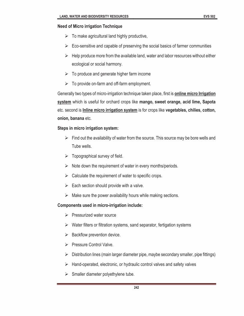
LAND, WATER AND BIODIVERSITY RESOURCES EVS 502
242
Need of Micro irrigation Technique
Ø To make agricultural land highly productive,
Ø Eco-sensitive and capable of preserving the social basics of farmer communities
Ø Help produce more from the available land, water and labor resources without either
ecological or social harmony.
Ø To produce and generate higher farm income
Ø To provide on-farm and off-farm employment.
Generally two types of micro-irrigation technique taken place, first is online micro Irrigation
system which is useful for orchard crops like mango, sweet orange, acid lime, Sapota
etc. second is Inline micro irrigation system is for crops like vegetables, chilies, cotton,
onion, banana etc.
Steps in micro irrigation system:
Ø Find out the availability of water from the source. This source may be bore wells and
Tube wells.
Ø Topographical survey of field.
Ø Note down the requirement of water in every months/periods.
Ø Calculate the requirement of water to specific crops.
Ø Each section should provide with a valve.
Ø Make sure the power availability hours while making sections.
Components used in micro-irrigation include:
Ø Pressurized water source
Ø Water filters or filtration systems, sand separator, fertigation systems
Ø Backflow prevention device.
Ø Pressure Control Valve.
Ø Distribution lines (main larger diameter pipe, maybe secondary smaller, pipe fittings)
Ø Hand-operated, electronic, or hydraulic control valves and safety valves
Ø Smaller diameter polyethylene tube.
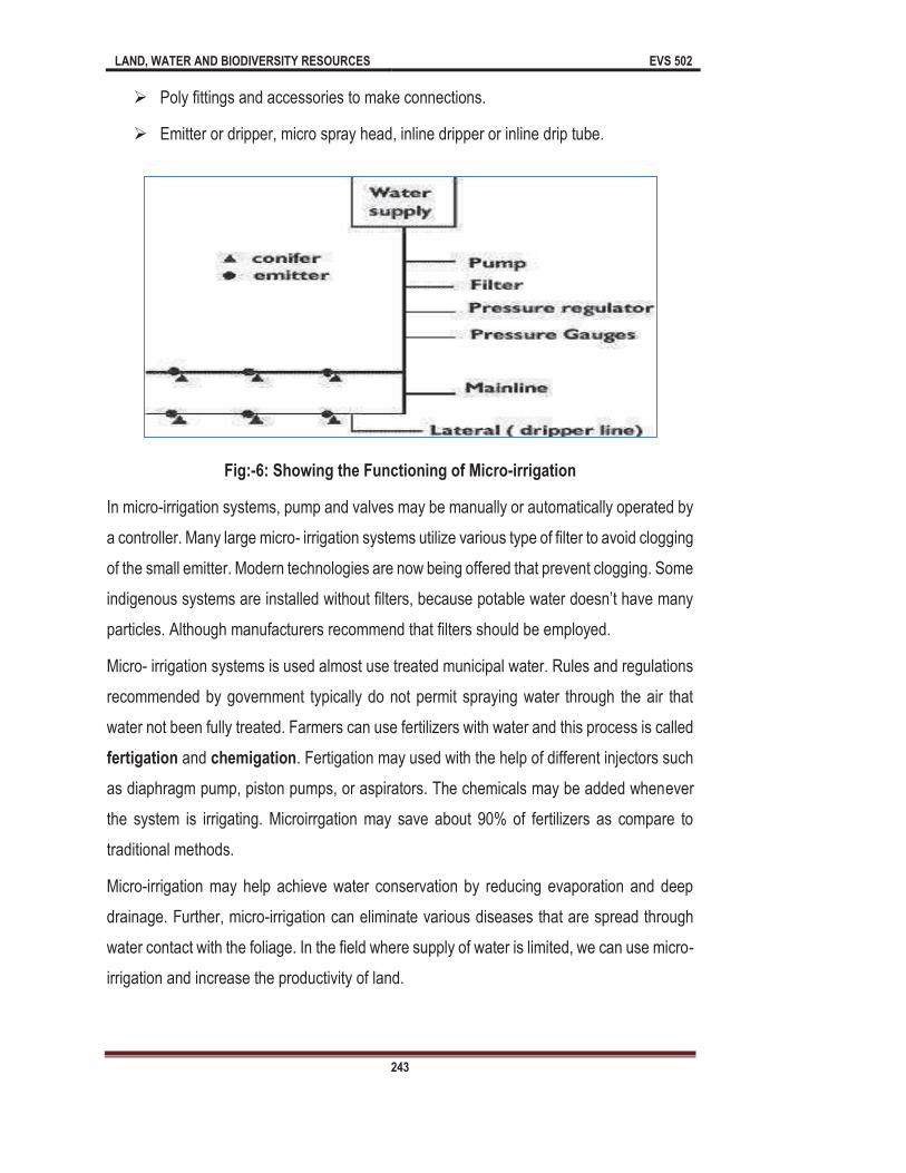
LAND, WATER AND BIODIVERSITY RESOURCES EVS 502
243
Ø Poly fittings and accessories to make connections.
Ø Emitter or dripper, micro spray head, inline dripper or inline drip tube.
Fig:-6: Showing the Functioning of Micro-irrigation
In micro-irrigation systems, pump and valves may be manually or automatically operated by
a controller. Many large micro- irrigation systems utilize various type of filter to avoid clogging
of the small emitter. Modern technologies are now being offered that prevent clogging. Some
indigenous systems are installed without filters, because potable water doesn�t have many
particles. Although manufacturers recommend that filters should be employed.
Micro- irrigation systems is used almost use treated municipal water. Rules and regulations
recommended by government typically do not permit spraying water through the air that
water not been fully treated. Farmers can use fertilizers with water and this process is called
fertigation and chemigation. Fertigation may used with the help of different injectors such
as diaphragm pump, piston pumps, or aspirators. The chemicals may be added whenever
the system is irrigating. Microirrgation may save about 90% of fertilizers as compare to
traditional methods.
Micro-irrigation may help achieve water conservation by reducing evaporation and deep
drainage. Further, micro-irrigation can eliminate various diseases that are spread through
water contact with the foliage. In the field where supply of water is limited, we can use micro-
irrigation and increase the productivity of land.

LAND, WATER AND BIODIVERSITY RESOURCES EVS 502
244
In micro-irrigation technology, the water applies in roots of plants at ultra-low flow rates, i.e.
less than 1.0 liter/hour.
The advantages of micro-irrigation: There are various advantages of micro-irrigation
which are summarized in Fig-7 and also discussed below:
Fig-7: Showing advantages of micro-irrigation
Ø Fertilizer and nutrient loss is minimized due to localized application and reduced
leaching.
Ø Increased productivity.
Ø No need of field leveling
Ø Save 95% water.
Ø Moisture within the rhizosphere (area of root) can be maintained.
Ø Prevent soil erosion.
Ø Prevent weed growth.
Ø Low labour cost.
Ø Fertigation can be done with minimal waste of fertilizers.
Ø Foliage remains dry which reduces the chances of diseases in crops.
Ø Increased Fertilizer efficiency and Save fertilizers
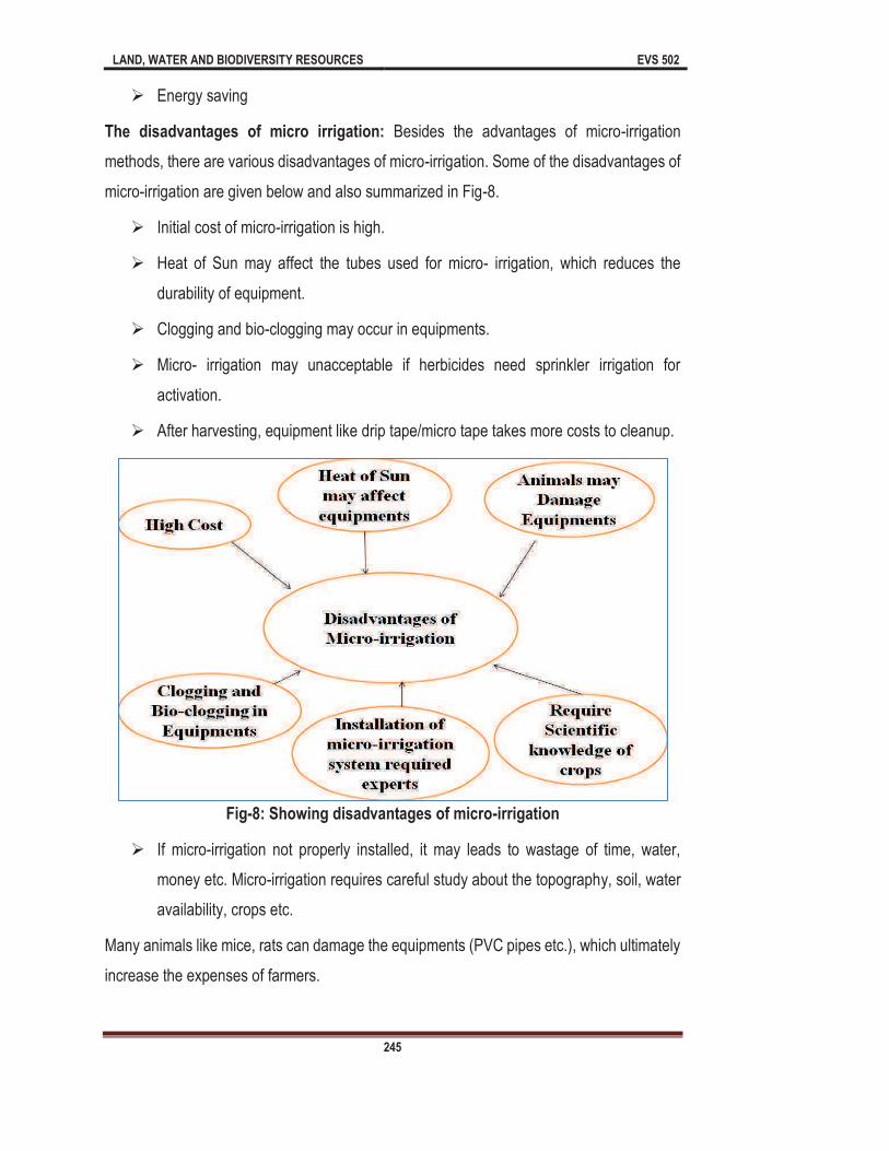
LAND, WATER AND BIODIVERSITY RESOURCES EVS 502
245
Ø Energy saving
The disadvantages of micro irrigation: Besides the advantages of micro-irrigation
methods, there are various disadvantages of micro-irrigation. Some of the disadvantages of
micro-irrigation are given below and also summarized in Fig-8.
Ø Initial cost of micro-irrigation is high.
Ø Heat of Sun may affect the tubes used for micro- irrigation, which reduces the
durability of equipment.
Ø Clogging and bio-clogging may occur in equipments.
Ø Micro- irrigation may unacceptable if herbicides need sprinkler irrigation for
activation.
Ø After harvesting, equipment like drip tape/micro tape takes more costs to cleanup.
Fig-8: Showing disadvantages of micro-irrigation
Ø If micro-irrigation not properly installed, it may leads to wastage of time, water,
money etc. Micro-irrigation requires careful study about the topography, soil, water
availability, crops etc.
Many animals like mice, rats can damage the equipments (PVC pipes etc.), which ultimately
increase the expenses of farmers.
LAND, WATER AND BIODIVERSITY RESOURCES EVS 502
246
11.6 Case Study-The Pani Panchayat
Pani Panchayat movement was started in the drought prone region in Purandhar Taluk,
Pune district of Maharashtra in the year 1974. This movement was started by Sh. Vilasrao
Salunke. Sh. Vilasrao Salunke Pani Baba was born on 18 February 1937 in Sangali
district of Maharashtra. His was focused on simple concept of equitable distribution of
water. He promoted education and mass awareness among one and all about the
importance of water and equity of water resource. He was deeply concerned about natural
resource management issues in rural areas. He visited many drought affected villages
during severe drought in 1972-73, in Maharashtra. After monitoring the situation, He
suggested the Government of Maharashtra to implement the water resource development
activities.
Gram Gaurav Pratishthan: Gram Gaurav Pratishthan (GGP) is a charitable
trust and it was established, at village Naigaon, which lies in the severely drought-
prone in Maharashtra, where Vilasrao Salunkhe had begun the work.
Sh. Vilasrao Salunkhe had experimented the equitable water distribution with active
involvement and participation of local communities. Through this voluntary organization the
movement of equitable water rights, this was popularly termed as �Pani Panchayat�,
spread all over Maharashtra.
Revolutionary concept of Vilasrao Salunkhe of Pani Panchayat worked on one very simple
and important principle i.e. water is a common property resource and must, therefore,
be accessible to all. Movement of The pani Panchayat completely transformed the village;
where once there was barren lands, there now stands a prosperous and plentiful resources.
Principles of Pani Panchayat: Equity is one of the most important principle of Pani
Panchayat. Pani Panchayat also seeks the demand management, community participation,
rights of landless and sustainability of the resource. Pani Panchayat believes that every
family member should be allowed water for cultivation. There are various principles of Pani
Panchayat, which are summarized below:
Ø Water should be shared by members on the basis of family size and not on the basis
of land holding.
Ø Crops which have more demand of water should not be grown.

LAND, WATER AND BIODIVERSITY RESOURCES EVS 502
247
Ø Mutual consultation of the group decided the agricultural pattern.
Ø Rights of water are not attached to rights of land.
Ø Land for which the water is obtained under this project cannot be sold without the
permission of the "Pani Panchayat".
Ø Irrigation schemes are built by joint efforts of farmers for common benefit.
Ø Taxes for water taxes must be paid in two installments in each year within stipulated
time fixed by Pani Panchayat.
Ø All equipments required during this project should be kept with the "Pani
Panchayat". "Pani Panchayat" paid all the claims related to project.
Ø The "Pani Panchayat" has the right to appoint workers. Salary/honorarium to the
workers also fixed by Pani Panchayat.
Ø Two meetings in a month conducted by Pani Panchayat. In the meeting of Pani
Panchayat all the problems of farmers noted down for further action.
Ø The membership of a member who causes a grave problem in the working of the
project and disobeys the "Pani Panchayat" be cancelled.
Ø The construction and management of the project and distribution of water and
monitoring of crops is the joint responsibility of the members.
It ensures equable distribution of water to all of its village through Sustainable development.
Pani Panchayat conducts various trainings, campaigning and active participation in
sustainable production activities.
Mission of Pani Panchayat: The mission of Pani Panchayat is to develop holistic farming
system through the use of organic farming based on scientific techniques. As you know
world is facing lot of economic and ecological problems created by anthropogenic activities
specially in agriculture sector. These activities may include excessive use of fertilizers,
pesticides etc. Pani Panchayat also assured water for Population who are depending on
Land for livelihood. Another mission of Pani Panchayat is to protect and conserve natural
resource Protection especially water resources. Pani Panchayat also charges water rights
for weaker people of the society. They also focus on safeguarding agricultural income and

LAND, WATER AND BIODIVERSITY RESOURCES EVS 502
248
provide alternate livelihood support to the people. Pani Panchayat also focuses on organic
farming for sustainable development.
Vision of Pani Panchayat: The vision of Pani Panchayat is to promote harmony among
the people and the environment. Pani Panchayat also vision to develop a watershed
model. This model will be based on water equity. This watershed model will transfer
philosophy and technology at national and international level in the field of agricultural and
resource conservation
Summary
In this unit we have discussed various aspects of water resource conservation, water shed
management, rain water harvesting, micro-irrigation and about the Pani Panchayat. So far
you have learnt that:
Ø There are two ways in which unsustainable water use can developed, first through
alteration in the stocks and flow of water that change its availability in space or time
and second is through alteration in the demand for the benefits provided by a
resource, because of changing standard of living, technology, population levels, or
societal modes.
Ø The term �watershed� introduced in 1920 & was used for boundaries. A watershed
is an area of earth bounded by drainage, watershed management technology
generally used in rainy areas.
Ø On the basis of size, shape, drainage & land use pattern watershed may be as
Macro watershed � 1000-10,000 hectare, Micro watershed- 100-1000 hectare, Mini
watershed-10-100 hectare and Mille watershed-1-10 hectare
Ø There are various objectives of watershed management which are Production of
food/fodder/fuel, Mitigate pollution, Flood control, water storage, Wildlife
conservation, Prevent soil erosion, Conservation of soil, Fisheries development,
Ground water recharge.
Ø There are main four Steps in watershed management: Recognition phase,
Restoration phase, Protection phase and Improvement phase.

LAND, WATER AND BIODIVERSITY RESOURCES EVS 502
249
Ø Rain water harvesting (RWH) is a technique used for collecting and storing rainwater
by using various means in different resources for the different purposes (for livestock
production, drinking, irrigation, etc). Water of rain can be collected into artificial
tanks. Rooftop harvesting is also a method to collect rainwater.
Ø There are several ways in which water can be harvested. These methods are
Surface Water Collection Systems, Rooftop system, Dams, Underground
Tanks, Rain saucer, Water Collection Reservoirs, Barrage, Slopes, Trenches
and Rain Barrels.
Ø There are various advantages of rainwater harvesting such as Water for Domestic
Use, Water for Industrial Use, Supplementary Water Source, Irrigation, Cost
Effective, Reliable Flow of Harvested Water, Mitigates/Reduces the Impacts of
Floods and construction of Infrastructure.
Ø There are various disadvantages of Rain water harvesting such as Extra
Expenditure, Required Huge Efforts and Resources, Depend on Rainfall,
Limited Storage, Risk of Contamination, Extra cost for Cleaning and
Maintenance and Lack of Water for Wildlife
Ø Micro-irrigation also known as localized irrigation or low volume irrigation or low-flow
irrigation, or trickle irrigation.
Ø Components used in micro-irrigation include: Pressurized water source, Water
filters or filtration systems: sand separator, Fertigation systems (Venturi injector)
and chemigation equipment, backflow prevention device, pressure control Valve,
main larger diameter pipe, maybe secondary smaller, pipe fittings, smaller diameter
polyethylene tube, poly fittings and accessories to make connections etc.
Ø There are various advantages of micro-irrigation Fertilizer and nutrient loss is
minimized due to localized application and reduced leaching, Increased productivity,
No need of field leveling, prevent soil erosion, prevent weed growth, low labour cost,
fertigation can be done with minimal waste of fertilizers, foliage remains dry which
reduces the chances of diseases in crops, increased Fertilizer efficiency and Save
fertilizers, energy saving etc.

LAND, WATER AND BIODIVERSITY RESOURCES EVS 502
250
Ø Some of the disadvantages of micro-irrigation are Initial cost of micro-irrigation is
high, heat of Sun may affect the tubes used for micro- irrigation, which reduces the
durability of equipments, Clogging and bio-clogging may occur in equipments,
micro- irrigation may unacceptable if herbicides need sprinkler irrigation for
activation, micro tape takes more costs to cleanup and like mice, rats can damage
the equipments
Ø Pani Panchayat movement was started in the drought prone region in Purandhar
Taluk, Pune district of Maharashtra in the year 1974.
Ø There are various principles of Pani Panchayat, which are as: water should be
shared by members on the basis of family size and not on the basis of land holding,
crops which have more demand of water should not be grown, mutual consultation
of the group decided the agricultural pattern, rights of water are not attached to rights
of land, land for which the water is obtained under this project cannot be sold without
the permission of the "Pani Panchayat".
Terminal Questions
1 (a) Fill in the blank spaces with appropriate words.
Pani Panchayat movement was started in the drought prone region in ���district of Maharashtra in the year���. This movement was started by Sh. Vilasrao Salunke. Sh. Vilasrao Salunke popularly known as ���was born on ����in Sangali district of���.. He was focused on simple concept of equitable distribution of��.. He promoted education and mass awareness among one and all about the importance of water and equity of water resource. He was deeply concerned about natural resource management issues in���... He visited many drought affected villages during severe drought in 1972-73, in Maharashtra. After monitoring the situation, He suggested the Government of Maharashtra to implement the ����.development activities.
2 (a) Why water conservation is important? Explain.
(b) What is watershed management?
3 (a) Describe the Objectives of watershed management.
(b) Give the steps of watershed management.
4 a) Define rain water harvesting? Write about common methods of rain water
harvesting?
5 (a) Discuss the advantages and disadvantages of rain water harvesting.
(b) Describe the advantages of micro-irrigation.
(c) What are the disadvantages of micro-irrigation?

LAND, WATER AND BIODIVERSITY RESOURCES EVS 502
251
6 (a) Fill the blank spaces with appropriate words.
As you know most of the freshwater resources are used for ����purpose, if we can develop different ���in agriculture sector to conserve the���.., then we can preserve or conserve this natural resource. Micro irrigation may be defined as the frequent application of ����of water directly above and below the soil; generally as����, ���and small streams through emitters placed along a water delivery line. Micro-irrigation also known as ���.or low volume irrigation or low-flow irrigation, or trickle irrigation. This is an irrigation method with lesser pressure and flow than a �����. Micro- irrigation is used generally in agriculture for row crops, orchard, vineyards etc. This technique also used in horticulture in nurseries, commercial, and private gardens etc. It is the method of irrigation which saves the ����and���.
(b) Macro-watershed should have an area about 1000-10000 (Yes/No)
(c) Fertigation is advantage of (Micro-irrigation/Rain water harvesting)
(d) Vilasrao Salunke who is popularly known as Pani baba associated with (Pani Panchayat/Watershed Management/Chipko Movement/Appikko Movement)
7 (a) Write about components used in micro-irrigation
(b) Write about principles, mission and vision of Pani Panchayat.
Answers to Terminal Questions
1 (a) Puran dhar Taluk, 1974, Pani Baba , 18 February 1937, Maharashtra, water, rural areas, water resource
2 (a) See the section 11. And 11.2, (b) See the section 11.3
3 (a) See the section 11.3 (Fig-2), (b) See section 11.3 (Steps in watershed management)
4 (a) See section 11.4,
5 (a) See the section 11.4 and Fig-4 and Fig-5 (Advantages and disadvantages of rain water harvesting), (b) See section 11.5 (Advantages of micro-irrigation) (c) See section 11.5 (Disadvantages of Micro-irrigation)
6 (a) Irrigation, techniques, water, low amount, discrete drops, continuous drops, localized irrigation, localized irrigation, water, fertilizers (b) Yes, (c) Micro-irrigation (d) Pani Panchayat
7 (a) See the section 11.5 (components used in micro-irrigation), (b) See the section 11.6 (Case study of Pani Panchayat)